Embed Size (px)
Citation preview

!(
!(!(
!(
!(
!(!(
!(
!(
NE-25-16-28-W
SE-25-16-28-W
NW-25-16-28-W
SW-25-16-28-W SW-30-16-27-W
NW-30-16-27-W
Eco-102
Eco-101
Wild-306
Soils-300
Wild-103
Hert-104
Hert-116
Aqua-105
3233
34
35
3637
L7
L8
Coordinate System: UTM Zone 14N NAD83Data Source: MB Hydro, ProvMB, NRCANDate Created: January 10, 2018 Version: Draft
±
1:5,000
0 100 20050
Metres
Map 8
Birtle Transmission ProjectConstruction Environmental Protection Plan
Environmentally Sensitive Site (ESS) Locations
MANI
TOBA
Land BaseLand Parcel
Local Road / Trail
Project InfrastructureFinal Preferred Route
Project Right Of Way
Heritage ESSArchaeological
Water ESS!( Water Crossing
Wildlife ESSBirds and Habitat
Ecosystem ESSHabitat
Soil ESSErosion
Wildlife ESSReptiles/Amphibians Habitat
ESS Start Stop!( Start/Stop Point

Map Number: 8
Version: Draft
ESS Group: Archaeological
*Features represented as points
ESS ID ESS Name Location
Hert-104 Area of HeritagePotential
E-343438 - N-5584825
Hert-116 Area of HeritagePotential
E-343313 - N-5585122
Potential Effects:Impact to a potential heritage resource
Specific Mitigation (ID #322):● Carry out construction activities on frozen or dry ground to minimize surface damage, rutting and erosion.
Construction matting will be used to protect the area from rutting and exposure to mineral soil duringnonfrozen ground conditions
● Confine traffic to established trail● Hand-clearing or other low disturbance clearing approved by the Project Archaeologist within the area● Identify and flag a 30m buffer around site, if not within designated riparian buffer● In the event of a discovery stop work in area and contact the Project Archaeologist immediately. Refer to
Cultural and Heritage Resources Protection Plan for further guidance● Should heritage resources be discovered during a pre-construction survey the project Archaeologist may
prescribe additional mitigation measures
ESS Group: Birds and Habitat
*Features represented as lines
ESS ID ESS Name Site Start Stop Distance (m)
Wild-103 Bird diverter installationarea
L7 to L8 E-343463N-5584766
E-343315N-5585117
381
Potential Effects:Higher risk of wire collision, Risk of wire collision is localized to the right-of-way
Specific Mitigation (ID #827):● As per industry standards, bird diverters will be installed in a manner to maximize visibility by alternating
between reflective and spiral diverters along the two skywires● Install bird diverter with spacing as per Transmission Line Design specifications for these spans
ESS Group: Erosion
*Features represented as polygons
ESS ID ESS Name Site Start Stop Distance (m)
Soils-300 Steep terrain 33 to 34 E-343460N-5584772
E-343311N-5585127
384
Potential Effects:Potential impact to soil structure and increased soil erosion on disturbed surfaces due to steep terrain
Specific Mitigation (ID #606):● Carry out construction activities on frozen or dry ground to minimize surface damage, rutting and erosion● Maintain shrub and herbaceous vegetation to the extent possible● Confine vehicle traffic to established trails to the extent possible● Implement erosion protection before commencing construction in accordance with Erosion and Sediment
Control Management Plan● Stabilize sites immediately after construction and re-vegetate disturbed areas in accordance with the
Rehabilitation and Invasive Species Management Plan
ESS Group: Habitat
*Features represented as polygons
ESS ID ESS Name Site Start Stop Distance (m)
Eco-101 Grassland habitat 31 to 32 E-343572N-5583376
E-343457N-5584779
1432
Eco-102 Grassland habitat 37 to 38 E-343319N-5585108
E-343186N-5585375
299
Potential Effects:Potential impact and disruption to rare plant habitat
Specific Mitigation (ID #217):● Marshalling yards, borrow sites and worker accommodations will not be developed within the grassland
habitat areas● Conduct site investigation with vegetation specialist prior to construction to verify the existence of natural
grassland habitat

Map Number: 8
Version: Draft
ESS Group: Reptiles/Amphibians Habitat
*Features represented as polygons
ESS ID ESS Name Site Start Stop Distance (m)
Wild-306 Northern leopard frog site 35 to 36 E-343452N-5584790
E-343317N-5585113
350
Potential Effects:Habitat loss and contamination from structure foundations & installations; wetland contamination and loss ofbreeding and summering habitat from loss/deterioration of riparian vegetation
Specific Mitigation (ID #832):● Carry out construction activities on frozen or dry ground to minimize surface damage, rutting and erosion.
Construction matting will be used to protect the area from rutting and exposure to mineral soil duringnonfrozen ground conditions
● Identify and flag buffer by follwing the edge of agricultural crop● Remove trees by low ground disturbance methods within buffer● The application of herbicides is prohibited● Maintain shrub and herbaceous vegetation to the extent possible● If construction activity is required within this area between April 15 to June 1st all lifestages of amphibian
will be captured and removed during a sweep survey● If construction activity is required within this area between April 15 to June 1st exclusion fencing needs to
be installed around the site after a sweep survey and prior to work taking place
ESS Group: Water Crossing
*Features represented as points
ESS ID ESS Name Location ChannelWidth (m)
WetWidth (m)
HabitatSensitivity
Aqua-105 Snake Creek E-343389N-5584942
8.0 3.5 H
Potential Effects:Increased erosion and sedimentation; rutting of floodplains; loss of riparian vegetation; potential impact to reptileand amphibian habitat
Specific Mitigation (ID #710):● Carry out construction activities on frozen or dry ground to minimize surface damage, rutting and erosion● Use existing trails, roads or cut lines whenever possible as access routes● Identify and flag buffers and no machine zones prior to start of work● Riparian Buffers shall be a minimum of 30m and increase in size based on slope of land entering
waterway with shrub and herbaceous understory maintained along with trees that do not violate ManitobaHydro's vegetation clearance requirements
● 7m no machine zone will prohibit equipment in close proximity to the waterbody except at the trailcrossing

This page was left intentionally blank.

!(
¾À568
SW-36-16-28-WSE-36-16-28-WSE-35-16-28-W
NE-25-16-28-W
NE-26-16-28-WNW-25-16-28-W Eco-102
38
Coordinate System: UTM Zone 14N NAD83Data Source: MB Hydro, ProvMB, NRCANDate Created: January 10, 2018 Version: Draft
±
1:5,000
0 100 20050
Metres
Map 9
Birtle Transmission ProjectConstruction Environmental Protection Plan
Environmentally Sensitive Site (ESS) Locations
MANI
TOBA
Land BaseLand Parcel
Highway
Local Road / Trail
Project InfrastructureFinal Preferred Route
Project Right Of Way
Sensitive Sites!! Sensitive Site (Point)
Ecosystem ESSHabitat
ESS Start Stop!( Start/Stop Point

Map Number: 9
Version: Draft
ESS Group: Habitat
*Features represented as polygons
ESS ID ESS Name Site Start Stop Distance (m)
Eco-102 Grassland habitat 37 to 38 E-343319N-5585108
E-343186N-5585375
299
Potential Effects:Potential impact and disruption to rare plant habitat
Specific Mitigation (ID #217):● Marshalling yards, borrow sites and worker accommodations will not be developed within the grassland
habitat areas● Conduct site investigation with vegetation specialist prior to construction to verify the existence of natural
grassland habitat
!(
!(
¾À568
SE-1-17-28-W
SW-36-16-28-W SE-36-16-28-W
NE-36-16-28-WNW-36-16-28-W
SE-35-16-28-W
SW-1-17-28-W
NE-35-16-28-W
SE-2-17-28-W
Aqua-306
3940
Coordinate System: UTM Zone 14N NAD83Data Source: MB Hydro, ProvMB, NRCANDate Created: January 10, 2018 Version: Draft
±
1:5,000
0 100 20050
Metres
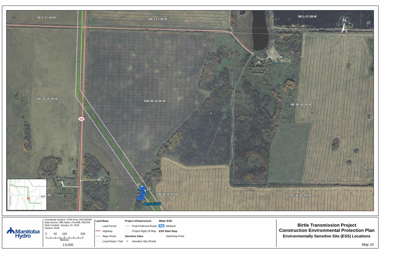
Map 10
Birtle Transmission ProjectConstruction Environmental Protection Plan
Environmentally Sensitive Site (ESS) Locations
MANI
TOBA
Land BaseLand Parcel
Highway
Major Road
Local Road / Trail
Project InfrastructureFinal Preferred Route
Project Right Of Way
Sensitive Sites!! Sensitive Site (Point)
Water ESSWetland
ESS Start Stop!( Start/Stop Point

Map Number: 10
Version: Draft
ESS Group: Wetland
*Features represented as polygons
ESS ID ESS Name Site Start Stop Distance (m)
Aqua-306 Wetland 39 to 40 E-342401N-5586513
E-342385N-5586537
29
Potential Effects:Increased erosion and sedimentation; rutting of floodplains; loss of riparian vegetation
Specific Mitigation (ID #218):● Carry out construction activities on frozen or dry ground to minimize surface damage, rutting and erosion.
Construction matting will be used to protect the area from rutting and exposure to mineral soil duringnonfrozen ground conditions
● Identify and flag buffer by follwing the edge of agricultural crop● Remove trees by low ground disturbance methods within buffer● The application of herbicides is prohibited within buffer

¾À568
SE-1-17-28-W
NE-1-17-28-WNW-1-17-28-W
SW-1-17-28-W
NE-2-17-28-W
SE-2-17-28-W
Coordinate System: UTM Zone 14N NAD83Data Source: MB Hydro, ProvMB, NRCANDate Created: January 10, 2018 Version: Draft
±
1:5,000
0 100 20050
Metres
Map 11
Birtle Transmission ProjectConstruction Environmental Protection Plan
Environmentally Sensitive Site (ESS) Locations
MANI
TOBA
Land BaseLand Parcel
Highway
Local Road / Trail
Project InfrastructureFinal Preferred Route
Project Right Of Way
Sensitive Site (Polygon)

No specific mitigation measures for this map, page intentionally left blank

!(
!(
!(
[\42
¾À568
NE-1-17-28-WNW-1-17-28-W
SE-12-17-28-WSW-12-17-28-W
SE-11-17-28-W
NE-2-17-28-W
Aqua-307
Wild-
104
41
42
L9
Coordinate System: UTM Zone 14N NAD83Data Source: MB Hydro, ProvMB, NRCANDate Created: January 10, 2018 Version: Draft
±
1:5,000
0 100 20050
Metres
Map 12
Birtle Transmission ProjectConstruction Environmental Protection Plan
Environmentally Sensitive Site (ESS) Locations
MANI
TOBA
Land BaseLand Parcel
Highway
Major Road
Local Road / Trail
Project InfrastructureFinal Preferred Route
Project Right Of Way
Sensitive Site (Polygon)
Wildlife ESSBirds and Habitat
Water ESSWetland
ESS Start Stop!( Start/Stop Point

Map Number: 12
Version: Draft
ESS Group: Birds and Habitat
*Features represented as lines
ESS ID ESS Name Site Start Stop Distance (m)
Wild-104 Bird diverter installationarea
L9 to L10 E-342115N-5589556
E-342148N-5590684
1127
Potential Effects:Higher risk of wire collision, Risk of wire collision is localized to the right-of-way
Specific Mitigation (ID #827):● As per industry standards, bird diverters will be installed in a manner to maximize visibility by alternating
between reflective and spiral diverters along the two skywires● Install bird diverter with spacing as per Transmission Line Design specifications for these spans
ESS Group: Wetland
*Features represented as polygons
ESS ID ESS Name Site Start Stop Distance (m)
Aqua-307 Wetland 41 to 42 E-342107N-5589290
E-342108N-5589306
15
Potential Effects:Increased erosion and sedimentation; rutting of floodplains; loss of riparian vegetation
Specific Mitigation (ID #218):● Carry out construction activities on frozen or dry ground to minimize surface damage, rutting and erosion.
Construction matting will be used to protect the area from rutting and exposure to mineral soil duringnonfrozen ground conditions
● Identify and flag buffer by follwing the edge of agricultural crop● Remove trees by low ground disturbance methods within buffer● The application of herbicides is prohibited within buffer

!(
!(
!(
NE-12-17-28-W
SE-12-17-28-WSW-12-17-28-W
NW-12-17-28-W
SE-13-17-28-WSW-13-17-28-W
NE-11-17-28-W
SE-11-17-28-W
SE-14-17-28-W
Wild-307
Wild-
104
43
44
L10
Coordinate System: UTM Zone 14N NAD83Data Source: MB Hydro, ProvMB, NRCANDate Created: January 10, 2018 Version: Draft
±
1:5,000
0 100 20050
Metres
Map 13
Birtle Transmission ProjectConstruction Environmental Protection Plan
Environmentally Sensitive Site (ESS) Locations
MANI
TOBA
Land BaseLand Parcel
Major Road
Local Road / Trail
Project InfrastructureFinal Preferred Route
Project Right Of Way
Sensitive Site (Polygon)
Wildlife ESSBirds and Habitat
Wildlife ESSReptiles/Amphibians Habitat
ESS Start Stop!( Start/Stop Point

Map Number: 13
Version: Draft
ESS Group: Birds and Habitat
*Features represented as lines
ESS ID ESS Name Site Start Stop Distance (m)
Wild-104 Bird diverter installationarea
L9 to L10 E-342148N-5590684
E-342115N-5589556
1127
Potential Effects:Higher risk of wire collision, Risk of wire collision is localized to the right-of-way
Specific Mitigation (ID #827):● As per industry standards, bird diverters will be installed in a manner to maximize visibility by alternating
between reflective and spiral diverters along the two skywires● Install bird diverter with spacing as per Transmission Line Design specifications for these spans
ESS Group: Reptiles/Amphibians Habitat
*Features represented as polygons
ESS ID ESS Name Site Start Stop Distance (m)
Wild-307 Northern leopard frog site 43 to 44 E-342126N-5589929
E-342132N-5590122
193
Potential Effects:Habitat loss and contamination from structure foundations & installations; wetland contamination and loss ofbreeding and summering habitat from loss/deterioration of riparian vegetation
Specific Mitigation (ID #831):● Carry out construction activities on frozen or dry ground to minimize surface damage, rutting and erosion.
Construction matting will be used to protect the area from rutting and exposure to mineral soil duringnonfrozen ground conditions
● Identify and flag a 30 m vegetated (shrub and herbaceous) buffer around site● Remove trees by low ground disturbance methods within buffer● The application of herbicides is prohibited● Maintain shrub and herbaceous vegetation to the extent possible● If construction activity is required within this area between April 15 to June 1st all lifestages of amphibian
will be captured and removed during a sweep survey● If construction activity is required within this area between April 15 to June 1st exclusion fencing needs to
be installed around the site after a sweep survey and prior to work taking place
!(
!(
SE-13-17-28-WSW-13-17-28-W
NE-13-17-28-WNW-13-17-28-W
NE-14-17-28-W
SE-14-17-28-W
NW-14-17-28-W
Aqua-308
45
46
Coordinate System: UTM Zone 14N NAD83Data Source: MB Hydro, ProvMB, NRCANDate Created: January 10, 2018 Version: Draft
±
1:5,000
0 100 20050
Metres
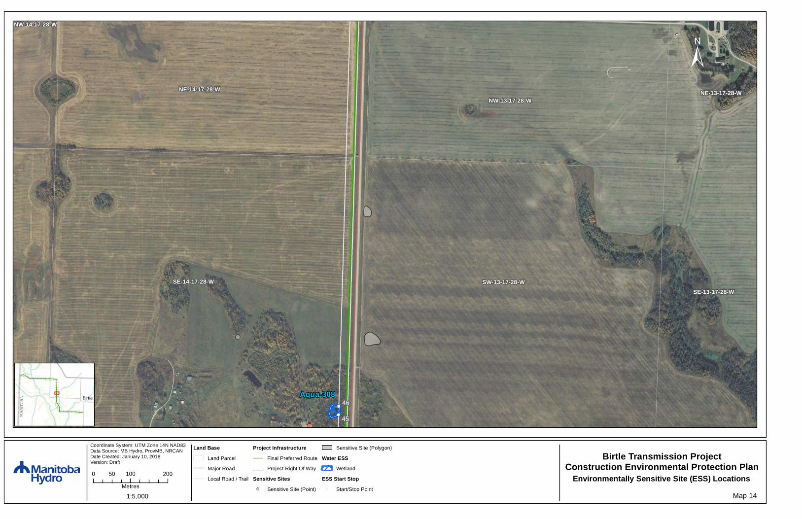
Map 14
Birtle Transmission ProjectConstruction Environmental Protection Plan
Environmentally Sensitive Site (ESS) Locations
MANI
TOBA
Land BaseLand Parcel
Major Road
Local Road / Trail
Project InfrastructureFinal Preferred Route
Project Right Of Way
Sensitive Sites!! Sensitive Site (Point)
Sensitive Site (Polygon)
Water ESSWetland
ESS Start Stop!( Start/Stop Point

Map Number: 14
Version: Draft
ESS Group: Wetland
*Features represented as polygons
ESS ID ESS Name Site Start Stop Distance (m)
Aqua-308 Wetland 45 to 46 E-342132N-5590817
E-342132N-5590840
22
Potential Effects:Increased erosion and sedimentation; rutting of floodplains; loss of riparian vegetation; potential impact to reptileand amphibian habitat
Specific Mitigation (ID #205):● Carry out construction activities on frozen or dry ground to minimize surface damage, rutting and erosion.
Construction matting will be used to protect the area from rutting and exposure to mineral soil duringnonfrozen ground conditions
● Identify and flag a 30 m vegetated (shrub and herbaceous) buffer around site● Remove trees by low ground disturbance methods within buffer● The application of herbicides is prohibited● Maintain shrub and herbaceous vegetation to the extent possible

!(
SE-23-17-28-W
SW-23-17-28-W
NE-13-17-28-WNW-13-17-28-W
SW-24-17-28-WSE-24-17-28-W
NE-14-17-28-WNW-14-17-28-W
Aqua-106
Coordinate System: UTM Zone 14N NAD83Data Source: MB Hydro, ProvMB, NRCANDate Created: January 10, 2018 Version: Draft
±
1:5,000
0 100 20050
Metres
Map 15
Birtle Transmission ProjectConstruction Environmental Protection Plan
Environmentally Sensitive Site (ESS) Locations
MANI
TOBA
Land BaseLand Parcel
Major Road
Local Road / Trail
Project InfrastructureFinal Preferred Route
Project Right Of Way
Sensitive Site (Polygon)
Water ESS!( Water Crossing
Map Number: 15
Version: Draft
ESS Group: Water Crossing
*Features represented as points
ESS ID ESS Name Location ChannelWidth (m)
WetWidth (m)
HabitatSensitivity
Aqua-106 Unnamed Tributary ofSnake Creek(Ephemeral)
E-342183N-5591915
N/A N/A L
Potential Effects:Increased erosion and sedimentation; rutting of floodplains; loss of riparian vegetation; potential impact to reptileand amphibian habitat
Specific Mitigation (ID #710):● Carry out construction activities on frozen or dry ground to minimize surface damage, rutting and erosion● Use existing trails, roads or cut lines whenever possible as access routes● Identify and flag buffers and no machine zones prior to start of work● Riparian Buffers shall be a minimum of 30m and increase in size based on slope of land entering
waterway with shrub and herbaceous understory maintained along with trees that do not violate ManitobaHydro's vegetation clearance requirements
● 7m no machine zone will prohibit equipment in close proximity to the waterbody except at the trailcrossing

Available in accessible formats upon request