Embed Size (px)
Citation preview

As the Nation’s principal , the Department of the Interiorhas responsibility for most of our nationally owned public lands and natural and cultural resources. This includes fostering sound use of our land and waterresources; protecting our fish, wildlife, and biological diversity; preserving theenvironmental and cultural values of our national parks and historical places;and providing for the enjoyment of life through outdoor recreation. TheDepartment assesses our energy and mineral resources and works to ensure that
their development is in the best interests of all our people by encouraging stewardship and citizen par-ticipation in their care. The Department also has a major responsibility for American Indian reservationcommunities and for people who live in island territories under U.S. administration.
Printed on recycled paper
conservation agency
U.S. Geological Survey U.S. Department of the Interior
Birth of the Mountains The Geologic Story of the Southern Appalachian Mountains
VA
NC
WVA
KY
TN
AL GA
Atlanta
SC
Roanoke
Asheville
Knoxville
Chattanooga
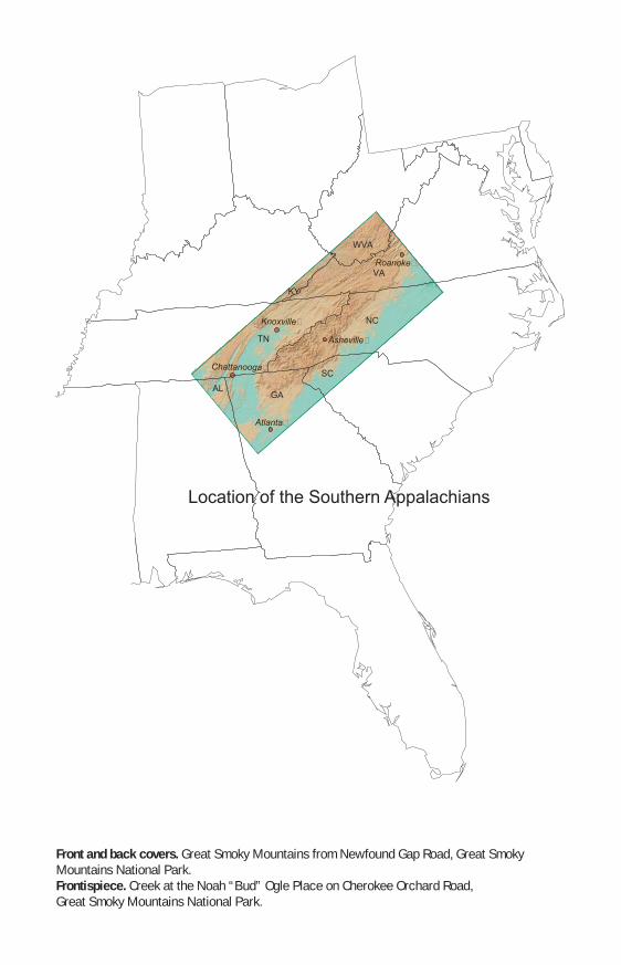
Location of the Southern Appalachians
Front and back covers. Great Smoky Mountains from Newfound Gap Road, Great SmokyMountains National Park.Frontispiece. Creek at the Noah “Bud” Ogle Place on Cherokee Orchard Road, Great Smoky Mountains National Park.

Birth of the MountainsThe Geologic Story of the Southern Appalachian Mountains By Sandra H.B. Clark
is to know ourselves. To
The mountains are the soul of the region. understand the mountains

Introduction
The Southern Appalachian Mountains include the Great Smoky Mountains National Park, the Blue Ridge Parkway, several National Forests, and numerous State and
Great Smoky Mountains NP
Pisgah NF
Nantahala NF
Cherokee NF
Chattahoochee NF
Jefferson NF
TN
KY
SC
VA
GA
WV
Cherokee NF Blue Ridge Parkway
NC
Sumter NF
privately owned parks and recreation areas (fig. 1). The region is known worldwide for its great beauty and biological diversity. Why does this area have Figure 1. Location of the Great Smoky Mountains National Park such beautiful scenery (NP) and National Forests (NF) in the Southern Appalachian
and a diversity of plants Mountains.
and animals that is greater than in all of Northern Europe? How do themountains, and the rocks and minerals of which they are made, affect thelives of people? How do people affect the mountains? To address thesequestions, we need to understand the geologic events that have shaped this region. We need to know how events that took place millions of years ago have influenced the landscape, climate, soils, and living things we see today (figs. 2 and 3).
Figure 2. Rhododendron blossoms at Figure 3. Locations of the Valley and Ridge, Piedmont, Craggy Gardens north of Asheville, and Appalachian Plateaus physiographic provinces N.C., near Milepost 364, Blue Ridge relative to the Southern Appalachian Mountain Parkway. ranges.
2
Reading the Rocks
In the course of a lifetime, we see little or no change in the physical features of our planet. When we die, the mountains will still be where they were when we were born and seem just as high, the oceans will lap onto the same shores, and rivers will follow much the same courses to the sea. If early man had our global perspective and could be brought back for a moment, the only changes that he might note are that the deltas of some rivers have grown and that some new volcanoes have erupted. The mountains and rivers would appear much the same.
The history recorded by humans spans only the past several thousand years on a planet that is 41 ⁄
2 billion years old. Although we know little of earliest time, the history of the last billion years is well recorded in the rocks, much like pages in a book. Geologists read these pages with careful research and painstaking observations worldwide. The record is not one of permanence and stability, but one of continual change. On a scale of millions of years, continents and oceans form and disappear, change in shape, and move. Mountains rise out of the sea and later wear down to their roots.
To understand how the landscape developed, we must look at some of the events that shaped the mountainous area extending from Virginia to Alabama, and not only at the mountains themselves, but also at the Piedmont lowlands on the east and the Valley and Ridge province and Appalachian Plateaus to the west (fig. 3).
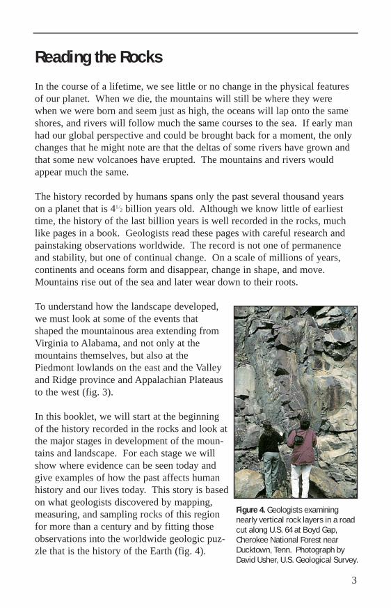
In this booklet, we will start at the beginning of the history recorded in the rocks and look at the major stages in development of the mountains and landscape. For each stage we will show where evidence can be seen today and give examples of how the past affects human history and our lives today. This story is based on what geologists discovered by mapping, measuring, and sampling rocks of this region for more than a century and by fitting those observations into the worldwide geologic puzzle that is the history of the Earth (fig. 4).
Figure 4. Geologists examining nearly vertical rock layers in a road cut along U.S. 64 at Boyd Gap, Cherokee National Forest near Ducktown, Tenn. Photograph by David Usher, U.S. Geological Survey.
3

A Supercontinent Forms
The rocks at the core of the Appalachian Mountains formed more than a billion years ago. At that time, all of the continents were joined together in a single supercontinent surrounded by a single ocean. Remnants of the supercontinent make up much of the North American core and are composed of minerals that are more than a billion years old. We can see fragments of the billion-year-old supercontinent (shown in red, fig. 5) at the surface in many places in the Appalachian Mountains. Examples include Blowing Rock in northern North Carolina and Red Top Mountain in northern Georgia.
Figure 5. The location of rocks over 1.1 billion years old (red) in southeastern Canada and the eastern United States. These rocks are remnants of an ancient supercontinent. From Rankin and others, 1989.
The SupercontinentBreaks Up About 750 million years ago, the supercontinent began to thin and pull apart like warm taffy because of expansion of the continental crust (fig. 6). Then, about 540 million years ago, the continental crust split into pieces that drifted away from each other. Seawater spread into low areas between crustal plates and, in time, formed new oceans.
Figure 6. The formation of the Ocoee basin by faulting and subsidence caused by expansion of the continental crust. Sediments from the surrounding areas filled the basin as it continued to subside.
4

The Ocoee Basin
margin of the supercontinent inwhat is now the western Carolinas,eastern Tennessee, and northernGeorgia (fig. 6). Seawater filledthe basin. Rivers from the surrounding countryside carried clay,silt, sand, and gravel to the basin,much as rivers today carry sediment from the midcontinent regionto the Gulf of Mexico. The sediment spread out in layers on thebasin floor. The basin continued to subside, and over a long periodof time, probably millions of years, a great thickness of sediment accumulated.
The sediments of the Ocoee basinnow form the bedrock of the GreatSmoky, Unicoi, and Plott BalsamMountains. The layers in whichthese sediments were deposited onthe ancient sea floor can still beseen in outcrops of the bedrock. In Figure 7. Layering in metamorphosed sandstone in
some rocks, even the pebbles and outcrops along the Newfound Gap Road, Great
During the early part of the expansion of the continental crust (about 750 million years ago), a deep basin, known as the Ocoee basin, formed on the
Smoky Mountains National Park. Enlargementgrains of sand are preserved. shows sand grains.
The rocks that formed from coarse sediments, such as pebbles and sand, are very hard and are resistant to weathering and erosion. They form the high peaks and ridges of today. Rocks composed of fine-grained sediments, such as clay and silt, are softer and break down more easily. These rocks can be found in the lower areas. Erosion of the alternating layers of hard and soft rocks makes many of the landforms that we see today. As rivers cut their way through the layers, hard rocks form ledges that make waterfalls, and alternating layers of hard and soft rock make the riverbeds that produce whitewater rapids.
5
From Ocoee Basin to Copper Basin
The rocks of the Ocoee basin contained some of the most important deposits of copper, zinc, iron, and sulfur in the eastern United States.
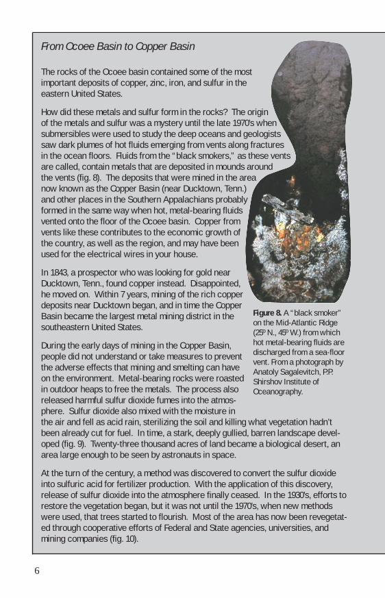
How did these metals and sulfur form in the rocks? of the metals and sulfur was a mystery until the late 1970’s when submersibles were used to study the deep oceans and geologists saw dark plumes of hot fluids emerging from vents along fractures in the ocean floors. are called, contain metals that are deposited in mounds around the vents (fig. 8). now known as the Copper Basin (near Ducktown, Tenn.) and other places in the Southern Appalachians probably formed in the same way when hot, metal-bearing fluids vented onto the floor of the Ocoee basin. vents like these contributes to the economic growth of the country, as well as the region, and may have been used for the electrical wires in your house.
In 1843, a prospector who was looking for gold near Ducktown, Tenn., found copper instead. he moved on. deposits near Ducktown began, and in time the Copper Basin became the largest metal mining district in the southeastern United States.
During the early days of mining in the Copper Basin, people did not understand or take measures to prevent the adverse effects that mining and smelting can have on the environment. in outdoor heaps to free the metals. released harmful sulfur dioxide fumes into the atmos
the air and fell as acid rain, sterilizing the soil and killing what vegetation hadn’t been already cut for fuel. oped (fig. 9). wenty-three thousand acres of land became a biological desert, an area large enough to be seen by astronauts in space.
phere.
At the turn of the century, a method was discovered to convert the sulfur dioxide into sulfuric acid for fertilizer production. , release of sulfur dioxide into the atmosphere finally ceased. s, efforts to restore the vegetation began, but it was not until the 1970’s, when new methods were used, that trees started to flourish. ed through cooperative efforts of Federal and State agencies, universities, and mining companies (fig. 10).
Figure 8. A “black smoker” on the Mid-Atlantic Ridge (25º N., 45º W.) from which hot metal-bearing fluids are discharged from a sea-floor vent. From a photograph by Anatoly Sagalevitch, P.P. Shirshov Institute of Oceanography.
The origin
Fluids from the “black smokers,” as these vents
The deposits that were mined in the area
Copper from
Disappointed, Within 7 years, mining of the rich copper
Metal-bearing rocks were roasted The process also
Sulfur dioxide also mixed with the moisture in
In time, a stark, deeply gullied, barren landscape develT
With the application of this discoveryIn the 1930’
Most of the area has now been revegetat
6

When ores were deposited in rocks of the Copper Basin, small amounts of metal-bearing minerals spread out widely on the sea floor. pyrite, also known as fool’s gold (fig. 11). places in the Southern Appalachians. , it breaks down into its components—iron and sulfur that forms sulfuric acid. construction disturbs pyrite-bearing rocks, the amount of pyrite exposed to air and water increases and can produce runoff that is acidic enough to kill aquatic life in streams. , potential acid drainage from pyrite or other sulfide minerals can be addressed. used in the 1996 Olympic Games, limestone, which neutralizes acid, was added to the pyrite-bearing rocks of the streambed.
Scientific studies can help to improve design strategies for the future. Mapping the rocks helps us to predict where pyritic layers occur below the surface. water chemistry help us understand the environmental behavior of sulfide minerals
and determine the sources of acid—whether it is from bedrock or the atmosphere. mation allows us to plan for development and, at the same time, to protect the quality of water and life in an area.
Figure 11. Pyrite in rocks in a roadcut along U.S. 64 near Maddens Branch, Cherokee National Forest. Photograph by David Usher, U.S. Geological Survey.
Figure 9. View of U.S. 64 through the Copper Basin before revegetation. Photograph taken in 1955 by Walter Cline and published as a postcard by Aerial Photography Services, Inc., of Charlotte, N.C.
Figure 10. View of the Copper Basin in 1997 with U.S. 64 in the distance. Photograph taken from an unrestored historic site near the Ducktown Basin Museum, Ducktown, Tenn.
The most common of these is Pyrite can be seen in rocks at many
When pyrite weathers naturallyWhen road
HoweverFor example, in the construction of the Ocoee whitewater course
Studies of
This infor
7
Volcanoes
At the time that sediments were being deposited and mineral deposits were forming in the Ocoee basin, volcanoes were erupting in areas that are now Virginia, the Carolinas, and Georgia. Lava from some volcanoes flowed in slow-moving sheets like lava from the Hawaiian volcanoes, but other eruptions were explosive, like Mount St. Helens. Although volcanic activity ended hundreds of millions of years ago, rocks that formed from these ancient volcanoes are still visible. Fragments that erupted from ancient volcanoes and minerals that filled holes where gas bubbles had escaped can be seen in some rocks at White Top Mountain in the Mount Rogers National Recreation Area of southern Virginia.
An Inland Sea
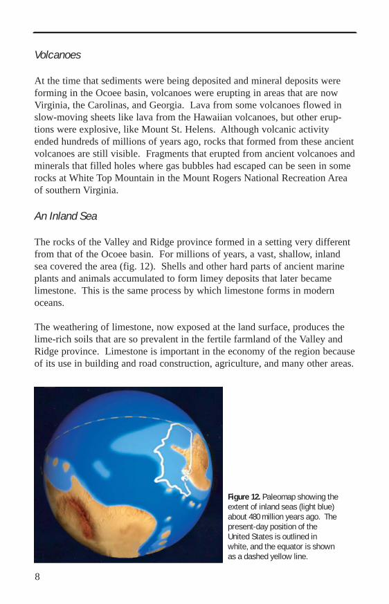
The rocks of the Valley and Ridge province formed in a setting very different from that of the Ocoee basin. For millions of years, a vast, shallow, inland sea covered the area (fig. 12). Shells and other hard parts of ancient marine plants and animals accumulated to form limey deposits that later became limestone. This is the same process by which limestone forms in modern oceans.
The weathering of limestone, now exposed at the land surface, produces the lime-rich soils that are so prevalent in the fertile farmland of the Valley and Ridge province. Limestone is important in the economy of the region because of its use in building and road construction, agriculture, and many other areas.
Figure 12. Paleomap showing the extent of inland seas (light blue) about 480 million years ago. The present-day position of the United States is outlined in white, and the equator is shown as a dashed yellow line.
8

Continental Collision A Change in Direction
How did rocks that formed on sea floors and islands become the mountains and valleys of today? The ocean that formed during the continental breakup about 540 million years ago continued to expand. During that time bacteria, algae, and many species of invertebrates flourished in the oceans, but there were no plants or animals on land. Then, about 470 million years ago, the motion of the crustal plates changed, and the continents began to move toward each other (fig. 13). As the continental plates moved closer together, fragments of oceanic crust, islands, and other continental masses collided with the eastern margin of ancestral North America. By this time, plants had appeared on land, followed by scorpions, insects, and amphibians. The ocean continued to shrink until, about 270 million years ago, the continents that were ancestral to North America and Africa collided. Huge masses of rocks were pushed west-ward along the margin of North America and piled up to form the mountains that we now know as the Appalachians.
Molten Rocks
As blocks of continental crust rode across one another, some rocks became so hot that they melted. Molten rock at the Earth’s
Figure 13. Stages of movement of continental plates beginning about 470 million years ago and culminating in the collision of the eastern ancestral North American continent with ancestral Africa about 270 million years ago.
NorthNorth AmericaAmerica
Africa
A
frica
9

surface erupts to form either volcanoes or quiet lava flows. When molten rockremains deep below ground, it cools andcrystallizes to form bodies of rock that arecalled igneous plutons (fig. 14).
Plutons are scattered throughout theSouthern Appalachians like plums in a pudding. Some plutons are now exposed at theland surface due to erosion of overlyingrock; they weather to form unusual,smooth-sided domes like Looking GlassRock, south of Asheville, N.C. (fig. 15).The plutons are composed of granite andsimilar rocks. People use granite that has auniform texture and few fractures, such asthe Mount Airy granite, in buildings,bridges, statues, and monuments. The nexttime you visit a cemetery, you may seegranite that formed millions of years agofar below the land surface.
Some molten granitic rock cools very slowly and forms coarse-grained veins calledpegmatites. These have been the source ofhigh-purity minerals, such as feldspar,quartz, and mica, and gemstones, such asemerald and beryl. The main uses of Figure 14. Emplacement of an igneous
pluton (top three diagrams, progressive-ly closer views), followed by erosion to feldspar are in glass, pottery, and ceramics. produce a dome-shaped feature.
Figure 15. Looking Glass Rock, Pisgah National Forest, as seen from the Blue Ridge Parkway south of Asheville, N.C., Milepost 413.1 (Pounding Mill Overlook).
10

Quartz has many uses, including as gemstones and in high-quality optical lenses. Native Americans used mica for ornaments, and now it is used as an insulator in electronic and electrical equipment.
Solid Rocks Flow
When continental masses, islands, and the sea floor collided with the margin of ancestral North America, they were subjected to intense pressure and heat at depth. Where the temperature is high but below the melting point of the rocks, the
Figure 16. Folded gneiss in Yellowstone Prong ofrocks deform and recrystallize in a the East Fork of the Pigeon river below Graveyard solid state to become metamorphic Fields Overlook at Milepost 418.8 of the Blue rocks. The components separate Ridge Parkway.
into bands, and some flow with a consistency like that of toothpaste. In many places along the Blue Ridge Parkway, there are metamorphic rocks with bands of light- and dark-colored minerals, which in some places look like the folds and swirls in a marble cake (fig. 16).
Original layers are partly retained if metamorphic temperature and pressure are low, as happened with some of the sediments that were deposited in the Ocoee basin. During metamorphism, minerals recrystallized in sheets to form rocks (slate or schist) that split easily into thin, smooth layers. When these rocks are near rivers or creeks, they make excellent skipping stones (fig. 17).
Figure 17. Children skipping rocks on the Little River at Townsend Wye, Great Smoky Mountains National Park.
11

The smooth surfaces are also excellent slip planes. This can cause serious problems, especially when the layers are steeply inclined. Rocks overlying smooth, inclined surfaces are very prone to sliding downslope, especially when heavy rainfall lubricates the surfaces (fig. 18).
Faults and Earthquakes
The collision of continental plates is also expressed in the rocks by folds (bends) and faults (breaks). Earthquakes happen because of slippage along a fault. Although earthquakes are now rare in the Southern Appalachians, during the time of continental collision, earth-quakes were a common occurrence.
One place where the effects of the faulting can be seen is in Cades Cove in the Great Smoky Mountains National Park. In a normal sequence, younger rocks are deposited on top of older ones. However, in Cades Cove, the lime-stone that makes up the floor of the cove is younger than the rocks in the surrounding mountains. The older rocks of the surrounding mountains moved over the lime-stone on a low-angle fault (fig. 19). Erosion made an opening to expose younger rocks below the fault, in a feature called a window. The rocks that we see through the Cades Cove window formed in the inland sea that once covered this area.
Figure 18. Rockfall near Gatlinburg, Tenn.
Younger rocks
Younger rocks
Younger rocks
Younger rocks
Older rocks
Older rocks
Older rocks
Older rocks
Figure 19. Stages in the development of a geologic window.
12

Many faults have been identified throughout the Southern Appalachian Mountains and the Valley and Ridge province. Huge masses of rock moved along these faults for distances of 60 miles or more. A major fault area can be seen at Linville Falls, north of Asheville, N.C. (fig. 20). The rocks that make up the mountains above the falls are older than the resistant ledges that form the falls. Ground-up rocks of the fault zone are between the older rocks above and the younger rocks below the falls in Linville Gorge.
Faults, Gold, and the Cherokee Removal
Faults act as channels for migration of fluids and were a key factor in localizing gold in certain zones. Although the date that white settlers discovered gold in the Southern Appalachians is Figure 20. Linville Falls from Chimney View.
uncertain, there is no doubt that gold Trailhead at Linville Falls Visitor Center, Milepost caused profound changes in the human 316.3 of the Blue Ridge Parkwaynorth of Asheville, N.C.
history of the area. The Cherokees living in the region knew about the gold, but it did not have the same significance for them as it did for the new settlers.
In 1829, newspaper articles described vast riches of gold in Cherokee land in North Georgia. Thousands of miners quickly flocked to the area with dreams of quick riches. They washed gravel from banks of the streams to search for gold (fig. 21). Figure 21. Gold miners in Georgia. From Harpers
Magazine, 1879.
13

Figure 22. Cherokees on the route to the west. From the painting, “The Trail of Tears,” by Robert Lindneux.
The frenzy caused by the discovery of gold hastened the removal of the Cherokees by a forced march to Oklahoma during the winter of 1837–38. More than one-third of the Cherokee people who started the march died along the way, on what is now known as the Trail of Tears (fig. 22).
The Framework for Travel and Biodiversity
The collision of continents hundreds of millions of years ago also set the stage for the patterns of human settlement, travel, and transportation routes in the region. When the continents collided, folds and faults formed with north-east-southwest alignments. These structures are the framework that controls the ridges and valleys of today. The northeast-southwest-trending ridges and valleys were both the main routes of travel for people and ideas and, at the same time, barriers to travel.
A less obvious result of the collision was a telescoping of contrasting rock types. The juxtaposition of rocks that had formed in diverse environments set the stage for the diversity of landscape, habitat, and life forms that characterizes the Southern Appalachians today. Differences in underlying rocks also influenced profoundly the patterns of regional development. Some land and soils were better suited for farming, mining, or timber than others. The location of industry, and subsequently, the location of population centers, was based on availability of raw materials and transportation routes.
14

Sand, clay, and interlayered limeyooze that formed on the floor of theshallow, inland sea became thebedrock of the Valley and Ridgeprovince. The resistant sandstone layers now cap ridges and form cliffs(fig. 23). Limestone, on the otherhand, erodes more readily, formingvalleys. Limestone provides nutrientsfor crops and is also conducive to Figure 23. Sandstone ridges of Lookout
Mountain above Moccasin Bend,Chickamauga and Chattanooga NationalMilitary Park, Chattanooga, Tenn.
forming caves and sinkholes, which contain unique living communities. The occurrence of iron ore, which was deposited in the inland sea along with limestone and nearby coal deposits inthe Valley and Ridge province and the Appalachian Plateaus, formed a basisfor early economic development. The limestone also contained major zincdeposits in some places, further enhancing the economic development of theregion. However, the value of the metals mined has been far exceeded by thetotal value of the industrial minerals extracted. These minerals include thelimestone itself, which is used for making cement and concrete for roads andbuildings.
The pebbles, sand, and clay that were deposited in the deep Ocoee basinbecame the bedrock of the Great Smoky Mountains. The hard, metamorphosed sandstone forms outcrops and cliffs that are habitats for scattered communities of rare plants and animals (fig.24). Metal-rich layers produce the acidic soilsthat some species, such as red spruce, need toflourish (fig. 25).
Figure 24. Metamorphosed sandstone in the Cling-man’s Dome parking area, Great Smoky Mountains Figure 25. Red spruce near Alum Cave,National Park. Great Smoky Mountains National Park.
15

Figure 26. Oak forest on metamorphosed volcanic rock at Mount Jefferson State Park in north-western North Carolina.
Lava and sediments that were deposited on the ocean floor form the bedrock of the Blue Ridge Mountains, to the east and north of the Great Smokies. Some of these rocks produce soils that are favorable for timber and for farming in the narrow valleys between ridges. However, like the Great Smoky and Unicoi Mountains, the special value of the area is as a recreational area. Some of the rock types form highly specialized habitats, such as balds, high-elevation rocky summits, and granite domes. Some volcanic rocks produce soils that favor oak forests (fig. 26). Some fragments of crust from deep beneath the ocean floor were caught in the continental collision. These fragments of rock lack nutrients and produce soils that have sparse or stunted vegetation. Such areas form habitats for some rare plant communities. Islands and continental masses that were offshore before the collision of the ancestral North American and African continents were accreted to the North America during the collision. They now form the bedrock of the Piedmont province, which slopes gradually southeastward from the Blue Ridge.
Another Continental Break Up
Although a collision of continents caused the formation of the Appalachian Mountains, the present-day margin of North America is the result of a reversal in crustal plate movement. After the continents collided, the continental mass began to pull apart. About 240 million years ago, at the beginning of the age of the dinosaurs, a new ocean basin began to form—the present-day
16

17
Atlantic (fig. 27). The Atlantic Oceanis still widening today, with the oceancrust pulling apart at the mid-AtlanticRidge.
Carving the Mountains
While the Atlantic Ocean was still inits infancy, the Appalachians werealready being attacked by erosion. Atthe time they formed, the Appalachianswere much higher than they are now—more like the present-day RockyMountains. For the last 100 millionyears, erosion has carved away themountains, leaving only their coresstanding in the ridges of today.
The Ice Age
Four times during the past 2 to 3 mil-lion years, great sheets of ice advancedsteadily southward from the polarregion (fig. 28). The glaciers did notextend as far south as the SouthernAppalachians, but the resulting changein climate did. Animals and plantsmigrated southward. Species morecommon to northern climates, such asthe saw-whet owl, established them-selves in the Southern Appalachians
Figure 27. The Atlantic Ocean formed asthe North American and African continentsmoved apart (position of present-dayUnited States outlined in white).
Figure 28. Diagram showing the extent ofPleistocene glaciation in North America.

and persist to this day at high elevations. Hunters who were ancestors to the Cherokees also migrated to the east and south during the most recent ice age.
Effects of the ice age also can be seen in the rocks. When water freezes in cracks or between rock layers, it gradually wedges the rocks apart. With repeated freeze and thaw in extremely cold climates, boulders accumulate on treeless slopes and at the base of cliffs or ledges. In the Southern Appalachians, concentrations of boulders can be seen in the present-day forested mountainsides at many places (fig. 29). They are silent testimonies to the ice age.
Figure 29. Blockfields along Cove Hardwood Nature Trail at Chimneys Picnic Area, Great Smoky Mountains National Park.
18

Erosion and a Return to the Sea
Even though glaciers have retreated, the process of erosion continues (fig. 30). Mosses and lichens grow on rocks and begin the process of breaking them down. Plants grow in fractures, slowly widening them and enhancing the process of soil development (fig. 31). Rock layers slip along inclined surfaces, break off, and produce landslides. Wind and water continue the process of breaking down the rocks and returning them to the ocean (fig. 32). The sediments from the Southern Appalachians move toward the Atlantic Ocean and the Gulf of Mexico where they are, once again, deposited on the ocean floor (fig. 33).
Figure 31. Ferns growing in fractures in rock outcrops along U.S. 64 near Maddens Branch, Cherokee National Forest. Photograph by David Usher, U.S. Geological Survey.
Figure 30. Runoff water dripping from rocks in the early spring, Alum Cave Trail, Great Smoky Mountains National Park.
Figure 32. Creek by Alum Cave Bluffs Trail, Great Smoky Mountains National Park.
19

Figure 33. Wax Lake and Lower Atchafalaya deltas, Mississippi River delta area, Louisiana.
What Next?
Today, the age-old processes continue. Long after we have lived our lives, these sediments will become layers of rock that might again be uplifted into new mountains. At some time in the far future, they may become the host rock for new mineral deposits, or they may be invaded by molten rock itself. Processes acting upon these materials may move them great distances from their place of origin.
While we don’t know the fate of rocks not yet formed, we do know that on this dynamic Earth, the one characteristic that we can count on, even though we may not perceive it in our lifetime, is change.
Acknowledgments
The material presented here is a general summary of commonly accepted geological concepts and is based on the work of the many people who contributed to the understanding of the geology of the region. The presentation has benefited from helpful comments and suggestions of colleagues, reviewers, and editors from both the U.S. Geological Survey and the National Park Service.
20
Suggested Reading
General
Carpenter, P.A., III, 1989, A geologic guide to North Carolina’s State Parks: North Carolina Geological Survey Bulletin 91, 69 p.
Cox, W.E., 1998, Great Smoky Mountains: The story behind the scenery (6th printing): Las Vegas, Nev., K.C. Publications, 48 p.
Daniels, Karen, 1992, Tennessee’s historic Copper Basin area: An overview: Benton, Tenn., Polk County Publishing, 20 p.
DeLaughter, Jerry, 1986, Mountain roads and quiet places—A complete guide to the roads of Great Smoky Mountains National Park: Gatlinburg, Tenn., Great Smoky Mountains Natural History Association, 96 p.
Ehle, John, 1988, Trail of Tears—The rise and fall of the Cherokee Nation: New York, Anchor Books, Doubleday, 420 p.
Logue, Frank, Louge, Victoria, and Blouin, Nicole, 1997, A guide to the Blue Ridge Parkway: Birmingham, Ala., Menasha Ridge Press, 154 p.
Moore, H.L., 1992, A roadside guide to the geology of the Great Smoky Mountains National Park: Knoxville, Tenn., University of Tennessee Press, 178 p.
King, D.H., comp., 1988, Cherokee heritage: Cherokee, N.C., Cherokee Communications, 128 p.
Perdue, Theda, 1989, The Cherokee: New York/Philadelphia, Chelsea House Publishers, 111 p. Rona, P.A., 1992, Deep-sea geysers: National Geographic, v. 182, no. 4, p. 104-109. Rouse, Parke, Jr., 1995, The great wagon road from Philadelphia to the South: Richmond,
Va., The Dietz Press, 292 p. Schultz, A.P., 1998, Geologic map of the Mount Le Conte 7.5-minute quadrangle, Great
Smoky Mountains National Park, Tennessee and North Carolina: U.S. Geological Survey Open-File Report 98-32, 10 p. and map, scale 1:24,000.
Schultz, A.P., and Seal, R.R., II, 1997, Geology and geologic history of Great Smoky Mountains National Park—A simple guide for the interpretive program: U.S. Geological Survey Open-File Report 97-510, 5 p.
Schultz, Art, and Southworth, Scott, 2000, Geology, Great Smoky Mountains National Park: Great Smoky Mountains Natural History Association, geologic map and text.
Shelton, Napier, 1981, Great Smoky Mountains National Park, North Carolina and Tennessee: National Park Service Handbook 112, 125 p.
Walker, S.L., 1991, Great Smoky Mountains: The splendor of the Southern Appalachians: Charlottesville, Va., Elan Publishing, 63 p.
Williams, David, 1993, The Georgia gold rush: Columbia, S.C., University of South Carolina Press, 178 p.
Technical
Clark, S.H.B., Spanski, G.T., Hadley, D.G., and Hofstra, A.H., 1993, Geology and mineral resource potential of the Chattanooga 1° x 2° quadrangle, Tennessee and North Carolina: U.S. Geological Survey Bulletin 2005, 35 p.
Hatcher, R.D., Jr., Merschat, C.E., Milici, R.C., and Wiener, L.S., 1978, A structural transect in the Southern Appalachians, Tennessee and North Carolina, in Milici, R.C., chairman, Field trips in the Southern Appalachians: Tennessee Division of Geology Report of Investigations No. 37, p. 6-51.
21
Hatcher, R.D., Jr., Thomas, W.A., and Viele, G.W., eds., 1989, The Appalachian-Ouachita Orogen in the United States; The geology of North America, v. F-2: Boulder, Colo., Geological Society of America, 767 p.
Horton, J.W., Jr., and Zullo, V.A., eds., 1991, The geology of the Carolinas: Knoxville, Tenn., The University of Tennessee Press, 406 p.
King, P.B., Neuman, R.B., and Hadley, J.B., 1968, Geology of the Great Smoky Mountains National Park, Tennessee and North Carolina: U.S. Geological Survey Professional Paper 587, 23 p.
Koschmann, A.H., and Bergendahl, M.H., 1968, Principal gold-producing districts of the United States: U.S. Geological Survey Professional Paper 610, 283 p.
Rankin, D.W., Drake, A.A., Jr., and Ratcliffe, N.M., 1989, Geologic map of the U.S. Appalachians showing the Laurentian Margin and the Taconic Orogen, in Hatcher, R.D., Jr., Thomas, W.A., and Viele, G.W., eds., The Appalachian-Ouachita Orogen in the United States; The geology of North America, v. F-2: Boulder, Colo., Geological Society of America, pl. 2.
Rast, Nicholas, 1989, The evolution of the Appalachian chain, in Bally, A.W., and Palmer, A.R., eds., The geology of North America—An overview; The geology of North America, v. A: Boulder, Colo., Geological Society of America, p. 323-348.
Robinson, G.R., Jr., Lesure, F.G., Marlow, J.I., Foley, N.K., and Clark, S.H.B., 1991, Bedrock geology and mineral resources of the Knoxville 1° x 2° quadrangle, Tennessee, North Carolina, and South Carolina: U.S. Geological Survey Bulletin 1979, 73 p.
Southern Appalachian Man and the Biosphere Cooperative, 1996, The Southern Appalachian assessment, summary report: U.S. Department of Agriculture, v. 1, 118 p.
Southworth, Scott, 1995, Preliminary geologic map of the Great Smoky Mountains National Park within the Fontana Dam and Tuskeegee quadrangles, Swain County, North Carolina: U.S. Geological Survey Open-File Report 95-264, 33 p.
Speed, R.C., ed., 1994, Phanerozoic evolution of North American continent-ocean transitions: Boulder, Colo., Geological Society of America, 504 p.
U.S. Geological Survey and U.S. Bureau of Mines, 1968, Mineral resources of the Appalachian region: U.S. Geological Survey Professional Paper 580, 492 p.
22

To find out about available USGS products, go to the USGS home page at http://www.usgs.gov/
Free on application to
USGS Information ServicesBox 25286Denver Federal CenterDenver, CO 80225
or call1-888-ASK-USGS
23

U.S. Department of the InteriorU.S. Geological Survey
Birth of the MountainsThe Geologic Story of the Southern Appalachian Mountains
As the Nation’s principal conservation agency, the Department of the Interior has responsibility for most of our nationally owned public lands and natural and cultural resources. This includes fostering sound use of our land and water resources; protecting our fish, wildlife, and biological diversity; preserving the environmental and cultural values of our national parks and historical places; and providing for the enjoyment of life through outdoor recreation. The Department assesses our energy and mineral resources and works to ensure that
their development is in the best interests of all our people by encouraging stewardship and citizen participation in their care. The Department also has a major responsibility for American Indian reservation communities and for people who live in island territories under U.S. administration.