Embed Size (px)
Citation preview
BIOTIC EVALUATION SARGENT RANCH QUARRY
SANTA CLARA COUNTY, CALIFORNIA
By:
LIVE OAK ASSOCIATES, INC.
Rick Hopkins, Ph.D., Principal, Senior Ecologist Pamela Peterson, Sr. Project Manager, Plant and Wetland Ecologist
For:
Verne Freeman Freeman Associates
994 San Antonio Road Palo Alto, CA 94303
March 12, 2015 Project No. 662-02

ii
TABLE OF CONTENTS
1.0 INTRODUCTION................................................................................................................... 4 Figure 1. Vicinity map .............................................................................................................................................. 5 Figure 2. USGS ......................................................................................................................................................... 6
1.1 Project Description ............................................................................................................................................. 9
2.0 EXISTING CONDITIONS .................................................................................................. 15 Table 1. Descriptions of soil mapping units of the study area (USDA NRCS Web Soil Survey). ........................ 16
2.1 BIOTIC HABITATS/LAND USES .................................................................................................................... 19 Table 2: Habitats and Land Uses of the Project Site by Project Phase ................................................................... 19 Figure 4. Habitats of the Study Area ....................................................................................................................... 20 2.1.1 California Annual Grassland .......................................................................................................................... 21 2.1.2 Coast Live Oak Forest and Woodland ........................................................................................................... 23 2.1.3 Grain, Row-crop, Hay & Pasture, Disked/Short-term Fallowed .................................................................... 23 2.1.4 Ephemeral Drainages and Sargent Creek ...................................................................................................... 23
2.2 MOVEMENT CORRIDORS ............................................................................................................................. 25
2.3 SPECIAL STATUS PLANTS AND ANIMALS ............................................................................................... 28 Figure 5. Special Status Species ............................................................................................................................. 30 Table 3: Special status species that could occur in the project vicinity .................................................................. 32 California Tiger Salamander (Ambystoma californiense). Federal Listing Status: Threatened; State Listing Status: Threatened. .................................................................................................................................................. 41 Figure 6. CTS and CRLF Occurrences ................................................................................................................... 43 California Red-legged Frog (Rana draytonii). Federal Listing Status: Threatened; State Listing Status: Species of Special Concern. ................................................................................................................................................. 44 Western Pond Turtle (Actinemys marmorata). Federal Listing Status: None; State Listing Status: Species of Special Concern. ..................................................................................................................................................... 47 Burrowing Owl (Athene cunicularia). Federal Listing Status: None; State Listing Status: Species of Concern. .. 48 American Badger (Taxidea taxus). Federal Listing Status: None; State Listing Status: Species of Special Concern. .................................................................................................................................................................. 49
3.0 IMPACTS AND MITIGATIONS ....................................................................................... 52
3.1 SIGNIFICANCE CRITERIA ............................................................................................................................. 52
3.2 RELEVANT GOALS, POLICIES, AND LAWS .............................................................................................. 53 3.2.1 Threatened and Endangered Species .............................................................................................................. 53 3.2.2 Migratory Birds .............................................................................................................................................. 54 3.2.3 Birds of Prey .................................................................................................................................................. 54 3.2.4 The Bald and Golden Eagle Protection Act ................................................................................................... 54 3.2.5 Bats ................................................................................................................................................................ 55 3.2.6 Wetlands and Other Jurisdictional Waters ..................................................................................................... 55 3.2.7 Santa Clara County Tree Ordinance .............................................................................................................. 57 3.2.8 Heritage Trees in Santa Clara County ............................................................................................................ 58 3.2.9 The Santa Clara Valley Habitat Conservation Plan ....................................................................................... 58
iii
3.3 ENVIRONMENTAL IMPACT/MITIGATION ............................................................................................... 64 3.3.1 Conflict with an Adopted Habitat Conservation Plan .................................................................................... 64 3.3.2 Potential Impacts to California Tiger Salamander Habitat and Individuals ................................................... 65 3.3.3 Potential Impacts to California Red-Legged Frog Habitat and Individuals ................................................... 68 3.3.4 Potential Impacts to Western Pond Turtles .................................................................................................... 70 3.3.5 Potential Impacts to Burrowing Owls ............................................................................................................ 71 3.3.6 Disturbance to Nesting Raptors and Nesting Migratory Birds ....................................................................... 74 3.3.7 Potential Impacts to American Badgers ......................................................................................................... 75 3.3.9 Potential Impact to Special Status Plant Species ........................................................................................... 76 3.3.10 Potential Impacts to Riparian Habitat and Other Sensitive Natural Communities, Including Federally Protected Wetlands ................................................................................................................................................. 79 3.3.11 Potential Impacts to Western Red Bat, Pallid Bat, and Other Special Status and Non-special Status Roosting Bats .......................................................................................................................................................... 83 3.3.12 Potential Impacts to Special Status Animal Species .................................................................................... 84 3.3.13 Loss of Habitat for Native Wildlife ............................................................................................................. 85 3.3.14 Interference with the Movement of Native Wildlife .................................................................................... 87 3.3.15 Conflict with Local Policies or Ordinances ................................................................................................. 87 3.3.16 Degradation of Water Quality in Seasonal Creeks, Reservoirs and Downstream Waters ........................... 87
LITERATURE CITED .............................................................................................................. 89
APPENDIX A: VASCULAR PLANTS OF THE STUDY AREA .......................................... 92
APPENDIX C: MINIMIZATION MEASURES FOR CALIFORNIA RED-LEGGED FROG AND CALIFORNIA TIGER SALAMANDER ......................................................... 111
4
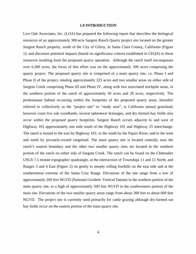
1.0 INTRODUCTION
Live Oak Associates, Inc. (LOA) has prepared the following report that describes the biological
resources of an approximately 300-acre Sargent Ranch Quarry project site located on the greater
Sargent Ranch property, south of the City of Gilroy, in Santa Clara County, California (Figure
1); and discusses potential impacts (based on significance criteria established in CEQA) to these
resources resulting from the proposed quarry operation. Although the ranch itself encompasses
over 6,300 acres, the focus of this effort was on the approximately 300 acres comprising the
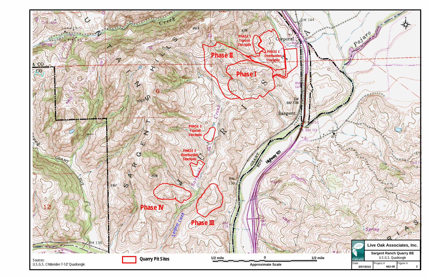
quarry project. The proposed quarry site is comprised of a main quarry site, i.e. Phase I and
Phase II of the project, totaling approximately 225 acres and two smaller areas on either side of
Sargent Creek comprising Phase III and Phase IV, along with two associated stockpile areas, in
the southern portion of the ranch of approximately 50 acres and 28 acres, respectively. The
predominant habitat occurring within the footprints of the proposed quarry areas, hereafter
referred to collectively as the “project site” or “study area”, is California annual grassland;
however coast live oak woodlands, several ephemeral drainages, and dry-farmed hay fields also
occur within the proposed quarry footprints. Sargent Ranch occurs adjacent to and west of
Highway 101 approximately one mile south of the Highway 101 and Highway 25 interchange.
The ranch is bound to the east by Highway 101; to the south by the Pajaro River; and to the west
and north by privately-owned rangeland. The main quarry site is located centrally near the
ranch’s eastern boundary and the other two smaller quarry sites are located in the southern
portion of the ranch on either side of Sargent Creek. The ranch can be found on the Chittenden
USGS 7.5 minute topographic quadrangle, at the intersection of Townships 11 and 12 North, and
Ranges 3 and 4 East (Figure 2) on gently to steeply rolling foothills on the east side and at the
southernmost extreme of the Santa Cruz Range. Elevations of the site range from a low of
approximately 200 feet NGVD (National Geodetic Vertical Datum) in the northern portion of the
main quarry site, to a high of approximately 500 feet NGVD in the southwestern portion of the
main site. Elevations of the two smaller quarry areas range from about 200 feet to about 600 feet
NGVD. The project site is currently used primarily for cattle grazing although dry-farmed oat
hay fields occur on the eastern portion of the main quarry site.

5 miles
approximate scale
0
QuarrySites
N
Site Location Map
Vicinity Map Regional Map
See Site Location Map (above)
See Vicinity Map
(left)
Not to scale
San Jose
San Francisco
Live Oak Associates, Inc.
Site / Vicinity Map
Project #Date Figure #1
Project location
5 miles
San Jose
Santa Cruz
SanBenitoCo.
SantaClaraCo.
MontereyCo.
101
M o n t e r e y Ba
y
3/07/2015 662-08
Sargent Ranch Quarry BE
Phase II
Sarg
ent
Cree
k
Highway
101
Phase IV
Phase III
Phase I
PHASE IOverburden
Stockpile
PHASE ITopsoil
Stockpile
PHASE 3Topsoil
Stockpile
PHASE 3Overburden
Stockpile
1/2 mile0
Approximate Scale
Live Oak Associates, Inc.
Project #Date Figure #3/07/2015 662-08
Sargent Ranch Quarry BEU.S.G.S. Quadrangle
Sources:U.S.G.S. Chittenden 7-1/2' Quadrangle
2
Quarry Pit Sites 1/2 mile

7
This report analyzes potential impacts of future site development by the proposed Sargent Ranch
Quarry mining operations on sensitive biotic resources, significant biotic habitats, regional fish
and wildlife movement corridors, and existing local, state, and federal natural resource protection
laws regulating land use. Provisions of the California Environmental Quality Act (CEQA), the
federal Clean Water Act (CWA), the state and federal endangered species acts (CESA and
FESA, respectively), California Fish and Wildlife Code, and California Water Code could
greatly affect project costs, depending on the natural resources present on the site. The primary
objectives of this report are as follows:
Summarize all site-specific information related to existing biological resources;
Make reasonable inferences about the biological resources that could occur on the site based on habitat suitability and the proximity of the site to a species’ known range;
Summarize all state and federal natural resource protection laws that may be relevant to possible future site development;
Identify and discuss biological resource issues specific to the site that could constrain future development; and
Identify potential avoidance, minimization and mitigation options that could significantly reduce the magnitude of any likely impacts to biological resources associated with future site development.
Natural resource issues related to these state and federal laws have been identified in past
planning studies conducted in the general project area, and it is reasonable to presume that such
issues could be relevant to the subject parcels examined in this report. A number of state and
federally listed animals, as well as other special status animal species (i.e., candidate species for
listing and California species of special concern), have been documented within 20 miles of the
project site. These species include state and/or federally listed species such as the California red-
legged frog and California tiger salamander as well as California species of special concern
including the burrowing owl. This report evaluates the site’s suitability for these and other
species.
CEQA is also concerned with project impact on riparian habitat, wildlife movement corridors,
fish and wildlife habitat, and jurisdictional wetlands, as well as project compliance with special
ordinances and state laws protecting regionally sensitive biotic resources, and approved habitat
conservation plans. Therefore, this report addresses the relevance of each of these issues to
eventual site development.

8
Jurisdictional wetlands cannot be graded or filled without a Clean Water Act permit issued by
the USACE. Furthermore, many seasonal wetlands occurring in the area support plant and
animal species that have been listed as threatened or endangered by the U.S. Fish and Wildlife
Service (USFWS) and California Department of Fish and Wildlife (CDFW). Such habitats
supporting populations of federally listed animal species cannot be filled without a “take” permit
issued by the USFWS.
CEQA is also concerned with a project’s impacts on riparian habitat, wildlife movement
corridors, fish and wildlife habitat, and jurisdictional wetlands, as well as project compliance
with special ordinances and state laws protecting regionally sensitive biotic resources, and
approved habitat conservation plans. Therefore, this report addresses the relevance of each of
these issues to eventual site development.
The impact analysis discussed in Section 3.0 of this report, is based on the known and potential
biotic resources of the study area as discussed in Section 2.0 of this report. The evaluation of
resources of the site is largely based on survey work conducted on the site by Pacific North
Western Biological (PNWB) during the period from June 2000 to May 2001 (PNWB 2001) and
by LOA during the period from July 2004 through June 2014. However, other important sources
of information used in the preparation of this analysis included: (1) the California Natural
Diversity Data Base (CDFW 2014); (2) the Online Inventory of Rare and Endangered Vascular
Plants of California (CNPS 2014); (3) current listings from Special Plants and Animals (CDFW
2014); (4) numerous planning documents and biological studies for projects in the area, some of
which have been prepared by LOA; and (5) manuals and references related to plants and animals
of the region.
A number of state and federally listed species, as well as other special status species (i.e.,
candidate species for listing and California Species of Special Concern) have been documented
in the vicinity of the project site; and some of these species are known to occur on Sargent Ranch
itself, based on surveys completed by PNWB and LOA. These include animals such as the
steelhead (Oncorhynchus mykiss), California tiger salamander (Ambystoma californiense),
California red-legged frog (Rana draytonii), western pond turtle (Actinemys marmorata), bald
eagle (Haliaeetus leucocephalus), white-tailed kite (Elanus leucurus), prairie falcon (Falco

9
mexicanus), long-eared owl (Asio otus), burrowing owl (Athene cunicularia), least Bell’s vireo
(Vireo bellii pursillus), and American badger (Taxidea taxus); and plants such as saline clover
(Trifolium hydrophilum), pink creamsacs (Castilleja rubicundula ssp. rubicundula), and
Hoover’s button-celery (Eryngium aristulatum var. hooveri). This report evaluates the quarry
project site’s suitability as habitat for these and other species; impacts that may occur to these
resources as a result of the project; and, where potentially significant impacts are identified,
includes mitigations to lessen such impacts on these resources to a less-than-significant level
where possible.
1.1 Project Description
The proposed project, Sargent Ranch Quarry, is a pit mining operation that would occur on
approximately 300 acres of the approximately 6300-acre Sargent Ranch property. The following
project description is based on a draft project description provided by Verne Freeman (Freeman
Associates 2015).
Of the site’s approximately 300 acres, approximately 214 acres comprise the area of proposed
mining. The proposed processing plant site is located near Highway 101 and is roughly 14 acres
in size. The balance of the project’s acreage consists of haul roads and overburden stockpile
areas. Reclamation activities would be conducted on mining phases that are completed. The
remaining portions of the site would not be utilized for mining, processing, or reclamation
activities and would be maintained in their current conditions.
Sand and gravel would be extracted from within the 214-acre mining area in four phases.
Mining will be done in an open pit fashion with 2:1 side slopes with 10-foot benches every 30
vertical feet. Finishes slopes will then be backfilled to 3:1 and revegetated. No underground
mining will be necessary for this project. Mining is proposed to occur year round. The total
volume of material to be mined annually would be determined by the market demand. However,
in the absence of other limitations, a maximum of 1,000,000 cubic yards of material would be
mined in any single year.
The targeted materials to be mined are alluvial deposits of sand and gravel. Mined materials
would be hauled to the proposed on-site aggregate processing plant for screening and limited
crushing. The material would then be sold for a variety of construction related uses. Waste

10
materials (e.g., silts and clays) not suitable for construction or concrete uses would make up
approximately 25 percent of the mined materials by volume. These materials would be separated
and stockpiled in the two berms depending on the phase of mining.
Phase I Mining
In Phase I mining, material would be mined from the designated pit areas. Scrapers or haul
trucks will be used to transport the material to the processing plant site. Any visible hills would
be mined from the backside to the front (west to east), giving the perception of a disappearing
ridgeline when viewed from Highway 101 and hiding much of the active mining as much as
possible.
There are two berms that will serve as overburden stockpile and storage areas, and one separate
location to be used for topsoil storage. Overburden or unsuitable materials from Phase I would
be used to build the berm located to the east of the property boundary closest to Highway 101.
At its highest point the berm will be 50 feet high and will serve to largely shield the processing
plant site and operations from view from Highway 101. Once the front berm is built, the back
berm will be constructed with the additional overburden. Topsoil will be kept separately and
stockpiled in the areas shown on Figure 9. Phase I pit will be constructed with side slopes of 2/1
with 10-foot benches every 40 vertical feet, resulting in an overall angle of 2.3/1 for the
temporary slope. Roughly 10,600,000 cubic yards will be excavated during Phase I. The highest
elevation of mining in the Phase I mining area is 503 above mean sea level. The bottom of the
lowest pit elevation will be 130 above mean sea level resulting in a maximum excavation depth
of 373 feet.
Once Phase I is excavated the majority of the Phase I overburden stockpile area will be
revegetated. The topsoil stockpile used for Phase I will be used for the stockpile of the Phase II
topsoil also. Complete reclamation of the Phase I mining area will be completed once Phase II
excavation is completed. Some of the overburden from Phase II will be used to reconstruct the
excavated slopes in Phase I to a 3:1 permanent slope. Once completed Phase I and the Phase II
areas will be reclaimed completely.
11
Portions of Phase I mining will be visible from Highway 101. In order to minimize visual
impacts, landscaped berms will be constructed adjacent to the highway and the disappearing
hillside mining method will be used to minimize impact.
Phase II Mining
Material for Phase II will be mined in a similar manner as Phase I, from the west side of the hills
to the east. Overburden and topsoil from Phase II will be used to reclaim portions of Phase I.
The westerly portion of Phase II will be excavated first starting at the highest elevation of 600
feet above sea level to a minimum pit level of 200 feet. Once this upper slope has been
excavated, revegetation will start to minimize the time that visible slopes do not blend in with the
natural ones. Phase II will produce approximately 20 million cubic yards or 23,000,000 tons of
aggregates after processing from this portion of the mining site.
Phase III and IV Mining
Phase III and IV deposits are in two hills on both the east and west side the Sargent Creek. An
access road will be constructed through the Sargent Valley from the Phase I and Phase II area,
primarily staying on the west side of the creek. Any bridges across Sargent Creek, and any
riparian impacts associated with them, will be determined as the timing on Phase III and IV
mining comes closer. Based on initial sales estimates, Phase III and IV mining will not occur for
approximately 25 years after operational start up.
Overburden from Phase III mining will be placed in the Phase II pit and will also be used to
reconstruct the Phase II slopes to 3:1. A topsoil stockpile will be created to store topsoil due to
stripping of Phases III and IV. An approximate total of 7,500,000 cubic yards will be excavated
from Phases III and IV. No visual impacts will occur from these phases as they are located in a
region of the mining site which is entirely hidden from view from other neighboring properties.
Sand and gravel would be mined using conventional equipment, including excavators and
scrapers. Excavated material would be hauled by truck, scraper, or overland conveyor to the
processing plant site. There the material would be sized, washed, and sorted into stockpiles.
Some materials may also be crushed and sorted into stockpile via radial stacker and conveyers.
12
Materials would be kept wet to minimize dust emissions. Sprinklers would be used to control
dust at multiple locations at the processing plant and on stockpiles.
Access to the site would be from Old Monterey road and through the gated entrance. Access
roads may be paved and would be maintained for Project operations. Trucks leaving the site
traveling southbound would continue back along Old Monterey Road and then onto southbound
Highway 101 via the stacking lane already in place. Trucks traveling northbound would travel
under the Sargent undercrossing and onto northbound Highway 101 via a new acceleration lane
installed by the quarry operator.
During mining, runoff from quarry work areas would drain by sheet flow into drainage swales
along the perimeter of the work area. Storm drainage from the site would be conveyed to settling
ponds. Storm water in the settling pond would ultimately percolate on-site or be reused for plant
operations. Swales will buffer the overburden stockpiles and the plant area from Tar Creek to
the west, and contain storm water from entering the creek.
Aggregate processing would require water throughput of approximately 800 gallons per minute
(384,000 gallons per day); however, 80 percent of the water would be recycled. Thus, 76,800
gallons would be pumped from the ground each day the plant is operating (up to approximately
200 days per year). A process water pond would be constructed within the processing plant site
and would be used to retain water for reuse in aggregate processing.
A new onsite well will provide water for operations and dust control. A water truck would be
used as needed to control dust on access roads and processing areas within the site.
Approximately 86,000 gallons of water per day, or 17,000,000 gallons per year, would be used to
control dust.
Existing electric power and telephone lines would be used for power needs for the Project or new
service may be brought in to the site. Water will be obtained from a new on-site well, for both
plant operations and drinking water for employees. A new private septic system will provide
sanitary sewer facilities for the Project site. The septic system will be designed for a daily
wastewater generation of 400 gallons per day. This is based on the Uniform Plumbing Code
estimated wastewater generation of 25 gallons per day per employee.
13
Most mining will occur during the day and no lighting will be installed in the pit areas. Lights
will be installed at the plant site, per MSHA regulations. Lighting may be on in the early
morning and later evening hours during the winter months if production is required.
Mining equipment includes scrapers, excavators, dozers, loaders, and dump haul trucks.
Scrapers would be used to remove the surface material. Scrapers collect material into their
hoppers by lowering their blades as they traverse the site. When their hoppers are full, the
scrapers would transport the material via the designated access routes from the mining area to the
processing area located outside of the mining area. If mined material is too wet to be handled
with a scraper, an excavator may be used to remove material and deposit it onto a small
temporary stockpile, where any dewatering would occur by infiltration. Scrapers, or a loader,
would be used to place the material onto haul trucks for transport to the processing site.
Sources of noise from the project will be primarily the washing and screening plant and the
construction equipment used for mining. There will be no blasting required for the mining and
very little, if any, crushing done at the processing plant. The plant’s main function is to screen
the material by size using screens and to wash the material of its silts and clays. Rubber screens
are used to minimize noise from the sizing operation and, in general, washing creates little noise.
Noise from the back up horns and engines of the mining equipment does create noise that can
carry.
Portions of the project will be visible from both southbound and northbound Highway 101 at
Sargent overcrossing. The visual impact to drivers can be seen for a few seconds while looking
to the west from Highway 101. In order to minimize these impacts, two berms will be
constructed to shield both the processing plant and the mining areas. The front berm will be built
at the start of operations. This berm will be 50 feet high and serve to block both the views as
well as dust and storm water runoff from the Highway 101, Tar Creek undercrossing. The rear
berm will serve to block the views into the mining area from Highway 101. Both these berms
will serve as overburden stockpile areas and will be seeded to blend in with the surround natural
landscape.
Water will be the primary means of dust control at the quarry. Two water trucks will be used to
keep both exposed areas of mining and the plant areas wet to contain dust. The prevailing wind
14
is from the west to the east, so the buffer hills between the mining areas and the eastern edge of
the Sargent Ranch boundary may be impacted on windy days. Measures to control dust in
addition to the use of water include keeping the mining areas limited to only the working area
and using early revegetation to cover up previously mined areas. Use of dust palliatives may
also be considered on haul roads and unpaved plant areas.
To the greatest extent possible, the Project has been designed to conform to the standards
outlined in the Santa Clara Valley Habitat Conservation Plan (hereafter referred to as the
“HCP”). For example, an150-foot buffer has been maintained between the Project boundaries
and the edge of Tar Creek, which is considered a Category 1 stream by the HCP. Biological
impacts are proposed to be mitigated by the dedication of a conservation easement area on the
east side of the Sargent Valley.

15
2.0 EXISTING CONDITIONS
The approximately 300-acre Sargent Ranch Quarry study area is located on the greater,
approximately 6300-acre Sargent Ranch property, south of the City of Gilroy in Santa Clara
County, California within foothills on the east side of the Santa Cruz Mountains. The proposed
quarry site is comprised of quarry plant facilities, a main quarry pit site (Phase I and II), and two
smaller quarry pit areas on either side of Sargent Creek in the southern portion of the ranch
(Phase III and IV), as described previously in the project description. Open rangeland borders the
proposed project areas.
Elevations of the project site range from a high of approximately 600 feet National Geodetic
Vertical Datum (NGVD) to a low of approximately 200 feet NGVD (Figure 2). Habitats of the
project site are comprised primarily of California annual grassland; however, coast live oak
woodland and dry-farmed hay fields also occur on the site. The primary use of the habitats of the
project site is cattle grazing. The habitats of the site are described in detail in Section 2.1 of this
report.
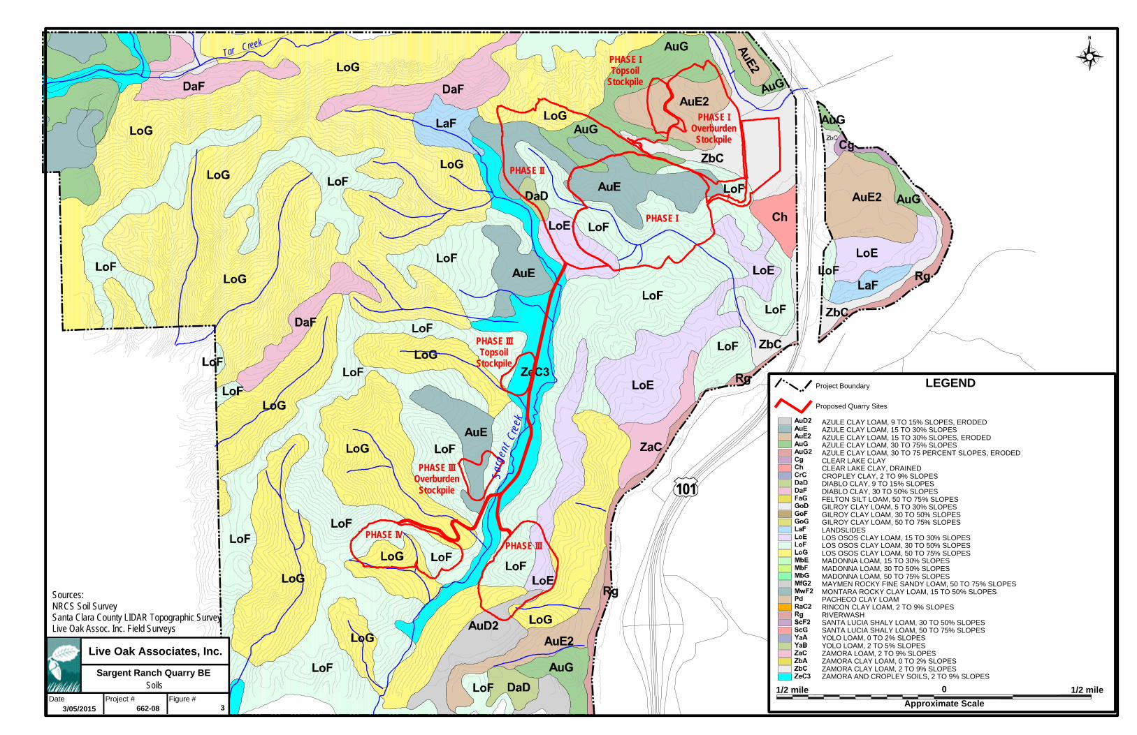
Nine soil-mapping units have been identified on the site and these soils are described in greater
detail in Table 1 and depicted in Figure 3. None of the soils of the site are considered hydric
soils, i.e. soils that under appropriate hydrological conditions may support wetlands, however,
hydric inclusions may occur. All of the soil types are considered well-drained. None of these
soils is a serpentine or alkaline soil, therefore, they would not be expected to support special
status plant species that are endemic to serpentine or alkaline soils.

16
Table 1. Descriptions of soil mapping units of the study area (USDA NRCS Web Soil Survey).
Soil Series/Soil Map Unit Symbol
Parent Material Drainage Class
% Hydric Composition
ZAMORA SERIES Zamora clay loam, 2-9%
slopes
ZbC Alluvium Well-drained 0
AZULE SERIES Azule clay loam, 15-30%
slopes, eroded AuE2 Alluvium Well-drained 0
Azule clay loam, 15-30% slopes
AuE Alluvium Well-drained 0
Azule clay loam, 9-15% slopes, eroded
AuD2 Alluvium Well-drained 0
Azule clay loam, 30-75% slopes
AuG Alluvium Well-drained 0
LOS OSOS SERIES Los Osos clay loam, 15-
30% slopes LoE
Residuum weathered from sandstone and
shale
Well- drained
0
Los Osos clay loam, 30-50% slopes
LoF
Residuum weathered from sandstone and
shale
Well-drained 0
Los Osos clay loam, 50-75% slopes
LoG
Residuum weathered from sandstone and
shale
Well- drained
0
DIABLO SERIES Diablo clay, 9-15% slopes
DaD Residuum
weathered from sandstone
Well-drained 0
http://soils.usda.gov/technical/classification/osd/index.html and USDA Soil Conservation Service Soil Survey – Santa Clara County California
Tar Creek
Sarg
ent
Cree
k
PHASE I
PHASE II
PHASE IIIPHASE IV
PHASE IOverburden
Stockpile
PHASE ITopsoil
Stockpile
PHASE IIITopsoil
Stockpile
PHASE IIIOverburden
Stockpile 101
Live Oak Associates, Inc.
Project #Date Figure #3
Soils
Sources:NRCS Soil SurveySanta Clara County LIDAR Topographic SurveyLive Oak Assoc. Inc. Field Surveys
3/05/2015 662-08
Sargent Ranch Quarry BE
1/2 mile 0
LEGENDProject Boundary
Approximate Scale
AZULE CLAY LOAM, 9 TO 15% SLOPES, ERODEDAZULE CLAY LOAM, 15 TO 30% SLOPESAZULE CLAY LOAM, 15 TO 30% SLOPES, ERODEDAZULE CLAY LOAM, 30 TO 75% SLOPESAZULE CLAY LOAM, 30 TO 75 PERCENT SLOPES, ERODEDCLEAR LAKE CLAYCLEAR LAKE CLAY, DRAINEDCROPLEY CLAY, 2 TO 9% SLOPESDIABLO CLAY, 9 TO 15% SLOPESDIABLO CLAY, 30 TO 50% SLOPESFELTON SILT LOAM, 50 TO 75% SLOPESGILROY CLAY LOAM, 5 TO 30% SLOPESGILROY CLAY LOAM, 30 TO 50% SLOPESGILROY CLAY LOAM, 50 TO 75% SLOPESLANDSLIDESLOS OSOS CLAY LOAM, 15 TO 30% SLOPESLOS OSOS CLAY LOAM, 30 TO 50% SLOPESLOS OSOS CLAY LOAM, 50 TO 75% SLOPESMADONNA LOAM, 15 TO 30% SLOPESMADONNA LOAM, 30 TO 50% SLOPESMADONNA LOAM, 50 TO 75% SLOPESMAYMEN ROCKY FINE SANDY LOAM, 50 TO 75% SLOPESMONTARA ROCKY CLAY LOAM, 15 TO 50% SLOPESPACHECO CLAY LOAMRINCON CLAY LOAM, 2 TO 9% SLOPESRIVERWASHSANTA LUCIA SHALY LOAM, 30 TO 50% SLOPESSANTA LUCIA SHALY LOAM, 50 TO 75% SLOPESYOLO LOAM, 0 TO 2% SLOPESYOLO LOAM, 2 TO 5% SLOPESZAMORA LOAM, 2 TO 9% SLOPESZAMORA CLAY LOAM, 0 TO 2% SLOPESZAMORA CLAY LOAM, 2 TO 9% SLOPESZAMORA AND CROPLEY SOILS, 2 TO 9% SLOPES
Proposed Quarry Sites
1/2 mile

18
Annual precipitation in the general vicinity of the study area is 13-18 inches, most of which falls
between the months of October and April. Virtually all precipitation falls in the form of rain.
Storm water runoff readily infiltrates the soils of the site, but when field capacity has been
reached, gravitational water drains into ephemeral drainages on the site and is eventually carried
into the Pajaro River, which drains to Monterey Bay to the west of the site.
19
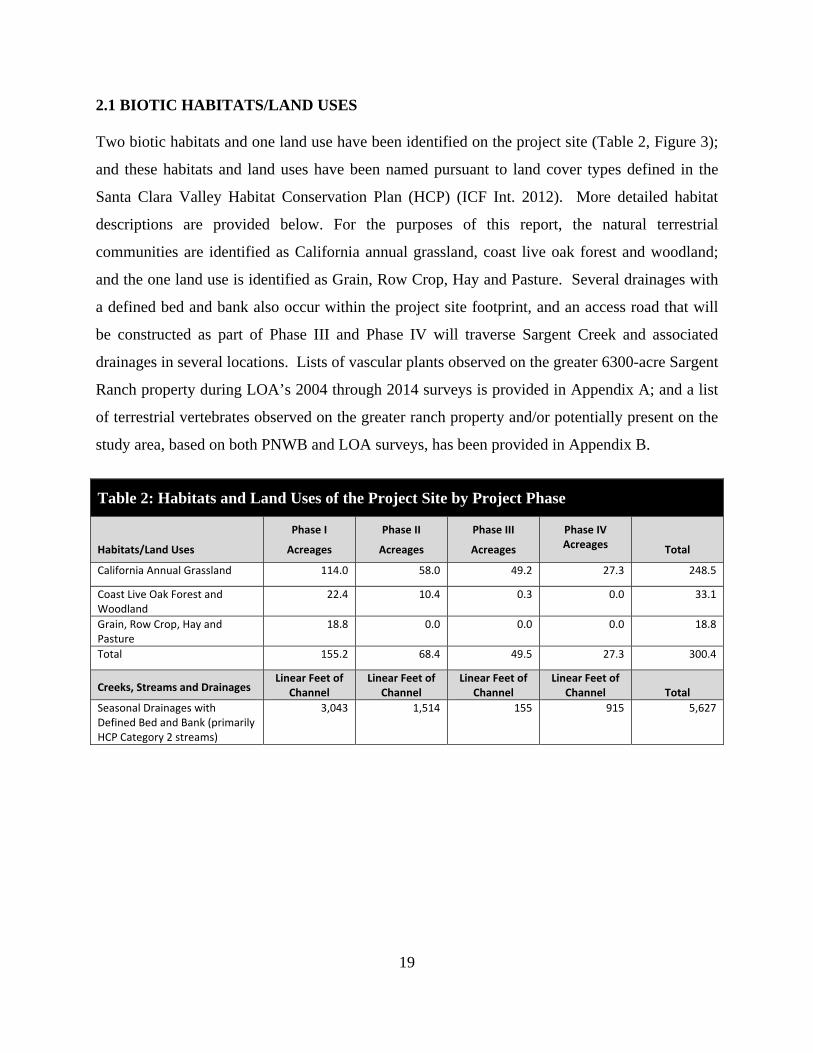
2.1 BIOTIC HABITATS/LAND USES Two biotic habitats and one land use have been identified on the project site (Table 2, Figure 3);
and these habitats and land uses have been named pursuant to land cover types defined in the
Santa Clara Valley Habitat Conservation Plan (HCP) (ICF Int. 2012). More detailed habitat
descriptions are provided below. For the purposes of this report, the natural terrestrial
communities are identified as California annual grassland, coast live oak forest and woodland;
and the one land use is identified as Grain, Row Crop, Hay and Pasture. Several drainages with
a defined bed and bank also occur within the project site footprint, and an access road that will
be constructed as part of Phase III and Phase IV will traverse Sargent Creek and associated
drainages in several locations. Lists of vascular plants observed on the greater 6300-acre Sargent
Ranch property during LOA’s 2004 through 2014 surveys is provided in Appendix A; and a list
of terrestrial vertebrates observed on the greater ranch property and/or potentially present on the
study area, based on both PNWB and LOA surveys, has been provided in Appendix B.
Table 2: Habitats and Land Uses of the Project Site by Project Phase
Habitats/Land Uses
Phase I
Acreages
Phase II
Acreages
Phase III
Acreages
Phase IV Acreages Total
California Annual Grassland 114.0 58.0 49.2 27.3 248.5
Coast Live Oak Forest and Woodland
22.4 10.4 0.3 0.0 33.1
Grain, Row Crop, Hay and Pasture
18.8 0.0 0.0 0.0 18.8
Total 155.2 68.4 49.5 27.3 300.4
Creeks, Streams and Drainages Linear Feet of
Channel Linear Feet of
Channel Linear Feet of
Channel Linear Feet of
Channel Total
Seasonal Drainages with Defined Bed and Bank (primarily HCP Category 2 streams)
3,043 1,514 155 915 5,627

Sarg
ent
C ree
k
Highway
101
PHASE I
PHASE II
PHASE III
PHASE IV
PHASE IOverburden
Stockpile
PHASE ITopsoil
Stockpile
PHASE 3Topsoil
Stockpile
PHASE 3Overburden
Stockpile
2,500' 2,500 feet0
LEGEND
Approximate Scale
Live Oak Associates, Inc.
Project #Date Figure #3/05/2015 662-08
Sargent Ranch Quarry BEBiotic Habitats
Sources: Santa Clara County HCP Land Cover, Santa Clara County LIDAR Topographic Survey, Live Oak Assoc. Inc. Field Surveys, Triad/Holmes Associates
Drainages within Quarry Pit Sites (length in feet)
4
Biotic Habitats (acreage by phase)
Quarry Pit Sites, Overburden, and Topsoil Disturbance Limits
Drainages outside of Quarry Pit Sites
California Annual Grassland
Coast Live Oak Forest and Woodland
Grain, Row-crop, Hay & Pasture, Disked / Short-term Fallowed
Pond
I II III IV113.82
22.39
18.81
N/A
3,046
58.07
10.38
N/A
N/A
1,514
49.23
0.32
N/A
0.01
155
27.30
N/A
N/A
N/A
915
21
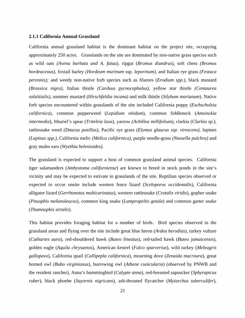
2.1.1 California Annual Grassland
California annual grassland habitat is the dominant habitat on the project site, occupying
approximately 250 acres. Grasslands on the site are dominated by non-native grass species such
as wild oats (Avena barbata and A. fatua), ripgut (Bromus diandrus), soft chess (Bromus
hordeaceous), foxtail barley (Hordeum murinum ssp. leporinum), and Italian rye grass (Festuca
perennis); and weedy non-native forb species such as filarees (Erodium spp.), black mustard
(Brassica nigra), Italian thistle (Carduus pycnocephalus), yellow star thistle (Centaurea
solstitialis), summer mustard (Hirschfeldia incana) and milk thistle (Silybum marianum). Native
forb species encountered within grasslands of the site included California poppy (Eschscholzia
californica), common pepperweed (Lepidium nitidum), common fiddleneck (Amsinckia
intermedia), Ithuriel’s spear (Triteleia laxa), yarrow (Achillea millifolium), clarkia (Clarkia sp.),
rattlesnake weed (Daucus pusillus), Pacific rye grass (Elymus glaucus ssp. virescens), lupines
(Lupinus spp.), California melic (Melica californica), purple needle-grass (Nassella pulchra) and
gray mules ears (Wyethia helenioides).
The grassland is expected to support a host of common grassland animal species. California
tiger salamanders (Ambystoma californiense) are known to breed in stock ponds in the site’s
vicinity and may be expected to estivate in grasslands of the site. Reptilian species observed or
expected to occur onsite include western fence lizard (Sceloporus occidentalis), California
alligator lizard (Gerrhonotus multicarinatus), western rattlesnake (Crotalis viridis), gopher snake
(Pituophis melanoleucus), common king snake (Lampropeltis getula) and common garter snake
(Thamnophis sirtalis).
This habitat provides foraging habitat for a number of birds. Bird species observed in the
grassland areas and flying over the site include great blue heron (Ardea herodias), turkey vulture
(Cathartes aura), red-shouldered hawk (Buteo lineatus), red-tailed hawk (Buteo jamaicensis),
golden eagle (Aquila chrysaetos), American kestrel (Falco sparverius), wild turkey (Meleagris
gallopavo), California quail (Callipepla californica), mourning dove (Zenaida macroura), great
horned owl (Bubo virginianus), burrowing owl (Athene cunicularia) (observed by PNWB and
the resident rancher), Anna’s hummingbird (Calypte anna), red-breasted sapsucker (Sphyrapicus
ruber), black phoebe (Sayornis nigricans), ash-throated flycatcher (Myiarchus tuberculifer),
22
western kingbird (Tyrannus verticalis), violet-green swallow (Tachycineta thalassina), cliff
swallow (Petrochelidon pyrrhonota), scrub jay (Aphelocoma coerulescens), yellow-billed
magpie (Pica nuttalli), common raven (Corvus corax), wrentit (Chamaea fasciata), plain
titmouse (Parus inornatus), chestnut-backed chickadee (Parus rufescens), bushtit (Psaltriparus
minimus), Bewick’s wren (Thryomanes bewickii), western bluebird (Sialia mexicana), California
thrasher (Toxostoma redivivum), phainopepla (Phainopepla nitens), spotted towhee (Pipilo
erythrophthalmus), dark-eyed junco (Junco hyemalis), western meadowlark (Sturnella neglecta),
Brewer’s blackbird (Euphagus cyanocephalus), Bullock’s oriole (Icterus galbula), and house
finch (Carpodacus mexicanus). Other resident and migratory avian species expected to occur in
this habitat include common poorwill (Phalaenoptilus nuttallii), loggerhead shrike (Lanius
ludovicianus), American crow (Corvus brachyrhynchos), Say’s phoebe (Sayornis saya),
American robin (Turdus migratorius), savannah sparrow (Passerculus sandwichensis), song
sparrow (Melospiza melodia), red-winged black bird (Agelaius phoeniceus), brown-headed
cowbird (Molothrus ater), purple finch (Carpodacus purpureus), lesser goldfinch (Carduelis
psaltria), American goldfinch (Carduelis tristis), and house sparrow (Passer domesticus).
Small mammalian species that are known to occur, or would be expected to occur, in the
grassland habitat include the California ground squirrel (Spermophilus beecheyi), Botta’s pocket
gopher (Thomomys bottae), deer mouse (Peromyscus maniculatus), house mouse (Mus
musculus), pocket mouse (Chaetodipus californicus), western harvest mouse (Reighrodontomys
megalotis), California vole (Microtus californicus), and the ornate shrew (Sorex ornatus).
Medium-sized and larger mammals that have been observed on the site include cottontail
(Sylvilagus audubonii), black-tailed hare (Lepus californicus), coyote (Canis latrans), native
gray fox (Urocyon cinereoargenteus), American badger (observed by PNWB and the resident
rancher), striped skunk (Mephitis mephitis), cougar (Puma concolor) (a large cougar was
observed by LOA biologists in 2004), bobcat (Felis rufus), wild pig (Sus scrofa), and black-
tailed deer (Odocoileus hemionus columbianas). Other medium-sized and larger mammals that
might also be expected to occur on the site but that have not been directly observed include the
Virginia opossum (Didelphis virginiana), raccoon (Procyon lotor), and introduced red fox
(Vulpes vulpes).
23
2.1.2 Coast Live Oak Forest and Woodland
Oak woodlands dominated by coast live oak (Quercus agrifolia) occupy approximately 33 acres
of the site’s Phase I and Phase II areas. This habitat type is primarily associated with an
ephemeral drainage in the southern portion of Phase I and with a deep ravine in the central
portion of Phase I and northeastern portion of Phase II. Coast live oak woodlands of the site
generally have a relatively closed canopy and an understory that is either barren or covered by
dense leaf litter, with very little herbaceous vegetation present.
Oak woodlands provide extremely important foraging, denning, nesting, cover, and roosting
habitat for a variety of wildlife species. Root systems and woody debris contributes to the
structural complexity of the woodland floor and provide foraging areas for small mammals, as
well as microclimates suitable for a variety of amphibians and reptiles. Acorns are a valuable
food source for many animal species, including the acorn woodpecker (Melanerpes
formicivorus), California quail, wild turkey, western gray squirrel (Sciurus griseus), and black-
tailed deer. Representative animal species of oak-dominated forests include arboreal salamander
(Aneides lugubris), southern alligator lizard, common kingsnake, ringneck snake (Diadophis
punctatus), western screech owl (Otus kennicottii), scrub jay, acorn woodpecker, western
bluebird, opossum, and a variety of bat species including long-legged myotis (Myotis volans),
hoary bat (Lasiurus cinereus), pallid bat (Antrozous pallidus), and western mastiff bat (Eumops
perotis).
2.1.3 Grain, Row-crop, Hay & Pasture, Disked/Short-term Fallowed
Dry-farmed oat hay fields occur in the footprint of the proposed plant area in the eastern portion
of the main quarry site near Highway 101. Vegetation similar to that occurring in annual
grasslands as described above was observed to grow along the disturbed edges of the fields.
Wildlife using adjacent habitats would be expected to also use this habitat for foraging and
movement activities.
2.1.4 Ephemeral Drainages and Sargent Creek
Ephemeral drainages that would be considered HCP Category 2 streams occur on all four phases
of the proposed quarry project. These drainages were mapped by LOA during a delineation effort
24
that was conducted on the greater Sargent Ranch property in 2007 but which was never verified
by USACE. For the most part, these ephemeral drainages were not observed to support wetland
vegetation, but did exhibit a defined bad and bank and evidence of an Ordinary High Water mark
on opposing banks, and, as such, would likely be considered jurisdictional by USACE, RWQCB
and CDFW. Vegetation within ephemeral drainages of the site was observed to be generally
similar to that found in the surrounding upland California annual grassland habitats and species
utilizing drainages of the site would also be similar to those using grasslands of the site. These
drainages would only have water present during and immediately after rainstorm events and
would not be a significant source of seasonal water for native plants and wildlife; and they would
not likely provide habitat values in excess of those provided by surrounding upland habitats.
The alignment of the access road that will be constructed for Phase III and IV, as currently
planned, will traverse Sargent Creek in three locations, as well as traverse several associated
ephemeral drainages. Sargent Creek is considered a Category 1 stream under the HCP. Sargent
Creek does not support significant stands of woody riparian vegetation except at the very lowest
reaches near the southern boundary of the greater Sargent Ranch property; however, discrete
stands of red and arroyo willows (Salix laevigata and S. lasiolepis, respectively) and mulefat
(Baccharis salicifolia) do occur at various locations along the middle and upper reaches of the
creek and the creek channel was observed to support herbaceous wetland vegetation throughout
most of its reach on the Sargent Ranch property, including but not limited to, Mediterranean
barley (Hordeum marinum ssp. gussoneanum), slough sedge (Carex obnupta), spike rush
(Eleocharis macrostachya), and tall flat sedge (Cyperus eragrostis).
Amphibian species observed within Sargent Creek during LOA surveys included Pacific tree
frogs (Hylla regilla), California red-legged frogs (Rana draytonii) and western toads (Anaxyrus
boreas). California red-legged frogs are known to breed in stock ponds within the creek’s
watershed on the greater Sargent Ranch property. Although California tiger salamanders have
not been observed within the Sargent Creek watershed during surveys, they are known to breed
in stock ponds to the north of Tar Creek, and stock ponds within the Sargent Creek watershed
appear to support appropriate hydrology to function as breeding habitat for this species.
Although western pond turtles have never been documented in Sargent Creek or nearby stock
ponds, potentially western pond turtles may occur in the creek during the wet season.
25
Avian species observed in Sargent Creek during LOA surveys foraging for amphibian and
invertebrate prey during the wet season include great blue herons (Ardea herodias), great egrets
(Ardea alba), and snowy egrets (Egretta thula).
The creek likely functions as an important movement corridor for several mammal species that
have been observed within its vicinity during LOA surveys, including but not limited to, striped
skunks, gray fox, bobcat, cougar, wild pig and black-tailed deer. The creek likely also provides
an important seasonal supply of water for local wildlife.
2.2 MOVEMENT CORRIDORS
Ecologists and conservation biologists have expended a great deal of energy since the early
1980’s advocating the protection and restoration of landscape linkages among suitable habitat
patches. Movement corridors or landscape linkages are usually linear habitats that connect two
or more habitat patches (Harris and Gallager 1989), providing assumed benefits to the species by
reducing inbreeding depression, and increasing the potential for recolonization of habitat
patches. Some researchers have even demonstrated that poor quality corridors can still provide
some benefit to the species that use them (Beier 1996).
Beier and Noss (1998) evaluated the claims of the efficacy of wildlife corridors of 32 scientific
papers. In general, these authors believed that the utility of corridors was demonstrated in fewer
than half of the reviewed papers, and they believed that study design played a role in whether or
not given corridors were successful. Examples of well-designed studies supported the value of
corridors. They believed, however, that connectivity questions make sense only in terms “of a
particular focal species and landscape.” For example, volant (flying) species are less affected by
barriers then small, slow moving species such as frogs or snakes (Beier and Noss 1998). In
addition, large mammals such as carnivores that can move long distances in a single night (e.g.,
cougars) are more capable of making use of poor quality or inhospitable terrain than species that
move more slowly and can easily fall prey to various predators or that are less able to avoid
traffic or other anthropogenic effects (Beier 1996). Therefore, it is reasonable to conclude that
landscape linkages, even poor ones, can be and are useful, especially for terrestrial species.

26
Therefore, while the importance of landscape linkages is well demonstrated in the scientific
literature, the cautionary note of Beier and Noss (1998) that consideration of context and
ecological scale are also of critical importance in evaluating linkages.
Habitat corridors are vital to terrestrial animals for connectivity between core habitat areas (i.e.,
larger intact habitat areas where species make their living). Connections between two or more
core habitat areas help ensure that genetic diversity is maintained, thereby diminishing the
probability of inbreeding depression and geographic extinctions. This is especially true in
fragmented landscapes and the surrounding urbanized areas as found in the rural/urban matrix
along the edges of the City of San Jose.
The quality of habitat within the corridors is important: “better” habitat consists of an area with
a minimum of human interference (e.g., roads, homes, etc.) and is more desirable to more species
than areas with sparse vegetation and high-density roads. Movement corridors in California are
typically associated with valleys, rivers and creeks supporting riparian vegetation, and ridgelines.
With increasing encroachment of humans on wildlife habitats, it has become important to
establish and maintain linkages, or movement corridors, for animals to be able to access
locations containing different biotic resources that are essential to maintaining their life cycles.
Healthy riparian areas (supporting structural diversity, i.e., understory species to saplings to
mature riparian trees) have a high biological value as they not only support a rich and diverse
wildlife community but have also been shown to facilitate regional wildlife movement. Riparian
areas can vary from tributaries winding through scrubland to densely vegetated riparian forests.
A riparian zone can be defined as an area that has a source of fresh water (e.g., rill, stream,
river), a defined bank, and upland areas consisting of moist soils (e.g., wetter than would be
expected simply do to seasonal precipitation). These areas support a characteristic suite of
vegetative species, many of which are woody, that are adapted to moister soils. Such vegetation
in hills surrounding San Jose include California buckeye (Aesculus californica), dogwood
(Cornus sp.), California hazelnut (Corylus cornuta var. californica), elderberry (Sambucus sp.),
Oregon ash (Fraxinus latifolia), walnut (Juglans sp.), California laurel (Umbellularia
californica), toyon (Heteromeles arbutifolia), oaks (Quercus sp.), and willow (Salix sp.).
27
Beier and Loe (1992) noted five functions of corridors (rather than physical traits) that are
relevant when conducting an analysis regarding the value of linkages. The following five
functions should be used to evaluate the suitability of a given tract of land for use as a habitat
corridor:
1.) Wide ranging mammals can migrate and find mates; 2.) Plants can propagate within the corridor and beyond; 3.) Genetic integrity can be maintained; 4.) Animals can use the corridor in response to environmental changes or a catastrophic
event; 5.) Individuals can recolonize areas where local extinctions have occurred.
A corridor is “wide enough” when it meets these functions for the suite of animals in the area. It
is important to note that landscape linkages are used differently by different species. For
instance, medium to large mammals (or some bird species) may traverse a corridor in a matter of
minutes or hours, while smaller mammals or other species may take a longer period of time to
move through the same corridor (e.g., measured in days, weeks and even years). For example,
an individual cougar may traverse the entire length of a long narrow corridor in an hour while
travel of smaller species (such as rodent or rabbit species) may best be measured as gene flow
within regional populations. These examples demonstrate that landscape linkages are not simply
highways that animals use to move back and forth. While linkages may serve this purpose, they
also allow for slower or more infrequent movement. Width and length must be considered in
evaluating the value of a landscape linkage. A long narrow corridor would most likely only be
useful to wide ranging animals such as cougars and coyotes when moving between core habitat
areas.
To the extent practicable, conservation of linkages should address the needs of “passage species”
(those species who typically use a corridor for the express purpose of moving from one intact
area to another) and “corridor dwellers” (slow moving species such as plants and some
amphibians and reptiles that require days or generations to move through the corridor).
While no detailed study of animal movements has been conducted for the study area, knowledge
of the site, its habitats, and the ecology of the species potentially occurring onsite permits

28
sufficient predictions about the types of movements occurring in the region and whether or not
proposed development would constitute a significant impact to animal movements.
As noted in Section 2.1, a number of reptiles, birds, and mammals may use the project site as
part of their home range and dispersal movements. Creeks and drainages are known to facilitate
wildlife movement, and the two creek corridors that occur in proximity to portions of the project
site, i.e. Sargent Creek and Tar Creek, likely provide important movement habitat for many
native wildlife species travelling north-south and east-west, respectively. Ephemeral drainages
occurring within the footprints of the project, however, generally support vegetation that is
undifferentiated from surrounding upland grassland habitats and are not likely to function as
anything but marginal movement corridors due to lack of significant woody vegetation cover.
2.3 SPECIAL STATUS PLANTS AND ANIMALS
Several species of plants and animals within the state of California have low populations, limited
distributions, or both. Such species may be considered “rare” and are vulnerable to extirpation
as the state’s human population grows and the habitats these species occupy are converted to
agricultural and urban uses. As described more fully in Section 3.2, state and federal laws have
provided the California Department of Fish and Wildlife (CDFW) and the U.S. Fish and Wildlife
Service (USFWS) with a mechanism for conserving and protecting the diversity of plant and
animal species native to the state. A sizable number of native plants and animals have been
formally designated as threatened or endangered under state and federal endangered species
legislation. Others have been designated as “candidates” for such listing. Still others have been
designated as “species of special concern” by the CDFW. The California Native Plant Society
(CNPS) has developed its own set of lists of native plants considered rare, threatened, or
endangered (CNPS 2014). Collectively, these plants and animals are referred to as “special
status species.”
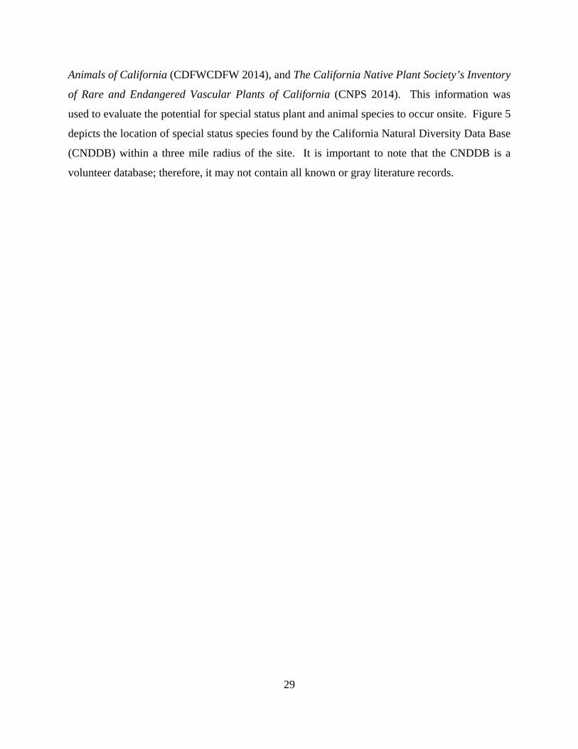
A number of special status plants and animals occur in the vicinity of the site (Figure 5). These
species and their potential to occur in the study area are listed in Table 2 on the following pages.
Sources of information for this table included California’s Wildlife, Volumes I, II, and III (Zeiner
et. al 1988), California Natural Diversity Data Base (CDFW 2014), Endangered and Threatened
Wildlife and Plants (USFWS 2014), State and Federally Listed Endangered and Threatened
29
Animals of California (CDFWCDFW 2014), and The California Native Plant Society’s Inventory
of Rare and Endangered Vascular Plants of California (CNPS 2014). This information was
used to evaluate the potential for special status plant and animal species to occur onsite. Figure 5
depicts the location of special status species found by the California Natural Diversity Data Base
(CNDDB) within a three mile radius of the site. It is important to note that the CNDDB is a
volunteer database; therefore, it may not contain all known or gray literature records.
Five
Kilo
met
er (3
.1 mile) ra
dius
Phase II
Phase I
Phase IIIPhase IV
Sources:California Dep. of Fish & Wildlife Natural Diversity DatabaseU.S. Fish & Wildlife Service
LEGEND
2 miles 2 miles
approximate scale
0
Live Oak Associates, Inc.
Project #Date Figure #
Special-status Species
5
American badgerCalifornia red-legged frogCalifornia tiger salamanderHoover's button-celeryBank swallowBurrowing OwlLeast Bell's vireoMost beautiful jewelflowerPallid batPink creamsacsSaline cloverSteelheadTricolored blackbirdWestern pond turtle 3/05/2015 662-08
Sargent Ranch Quarry BE

31
A search of published accounts for all relevant special status plant and animal species was
conducted for the Chittenden USGS 7.5” quadrangle in which the project site occurs and for the
eight surrounding quadrangles (Gilroy, Gilroy Hot Springs, San Felipe, Hollister, San Juan
Bautista, Prunedale, Watsonville East and Mount Madonna) using the California Natural
Diversity Data Base (CNDDB) Rarefind 5 (CDFW 2014). All species listed as occurring in
these quadrangles on CNPS Lists 1A, 1B, 2, or 4 were also reviewed (Table 3).
Special status species with potential to occur on the project site itself or in the immediate
surrounding vicinity are discussed further below.
32
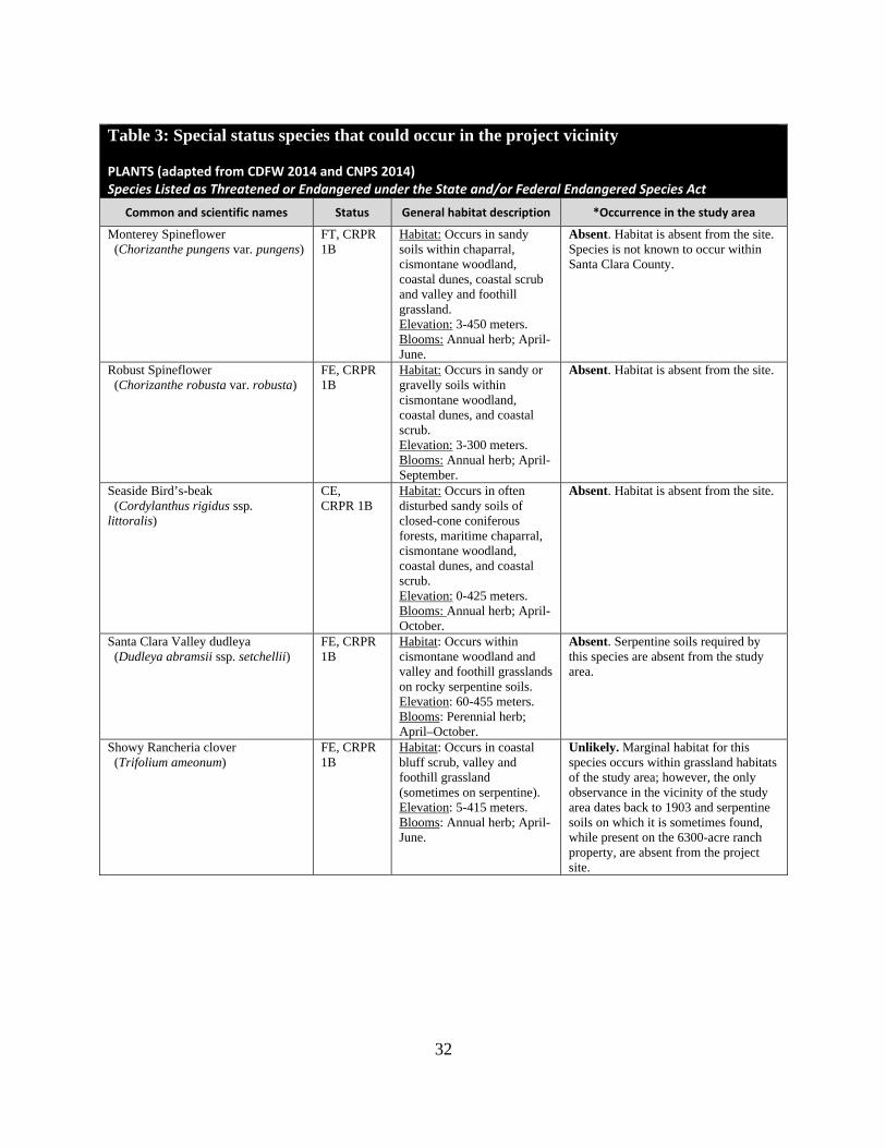
Table 3: Special status species that could occur in the project vicinity
PLANTS (adapted from CDFW 2014 and CNPS 2014) Species Listed as Threatened or Endangered under the State and/or Federal Endangered Species Act
Common and scientific names Status General habitat description *Occurrence in the study area
Monterey Spineflower (Chorizanthe pungens var. pungens)
FT, CRPR 1B
Habitat: Occurs in sandy soils within chaparral, cismontane woodland, coastal dunes, coastal scrub and valley and foothill grassland. Elevation: 3-450 meters. Blooms: Annual herb; April-June.
Absent. Habitat is absent from the site. Species is not known to occur within Santa Clara County.
Robust Spineflower (Chorizanthe robusta var. robusta)
FE, CRPR 1B
Habitat: Occurs in sandy or gravelly soils within cismontane woodland, coastal dunes, and coastal scrub. Elevation: 3-300 meters. Blooms: Annual herb; April-September.
Absent. Habitat is absent from the site.
Seaside Bird’s-beak (Cordylanthus rigidus ssp. littoralis)
CE, CRPR 1B
Habitat: Occurs in often disturbed sandy soils of closed-cone coniferous forests, maritime chaparral, cismontane woodland, coastal dunes, and coastal scrub. Elevation: 0-425 meters. Blooms: Annual herb; April-October.
Absent. Habitat is absent from the site.
Santa Clara Valley dudleya (Dudleya abramsii ssp. setchellii)
FE, CRPR 1B
Habitat: Occurs within cismontane woodland and valley and foothill grasslands on rocky serpentine soils. Elevation: 60-455 meters. Blooms: Perennial herb; April–October.
Absent. Serpentine soils required by this species are absent from the study area.
Showy Rancheria clover (Trifolium ameonum)
FE, CRPR 1B
Habitat: Occurs in coastal bluff scrub, valley and foothill grassland (sometimes on serpentine). Elevation: 5-415 meters. Blooms: Annual herb; April-June.
Unlikely. Marginal habitat for this species occurs within grassland habitats of the study area; however, the only observance in the vicinity of the study area dates back to 1903 and serpentine soils on which it is sometimes found, while present on the 6300-acre ranch property, are absent from the project site.
33
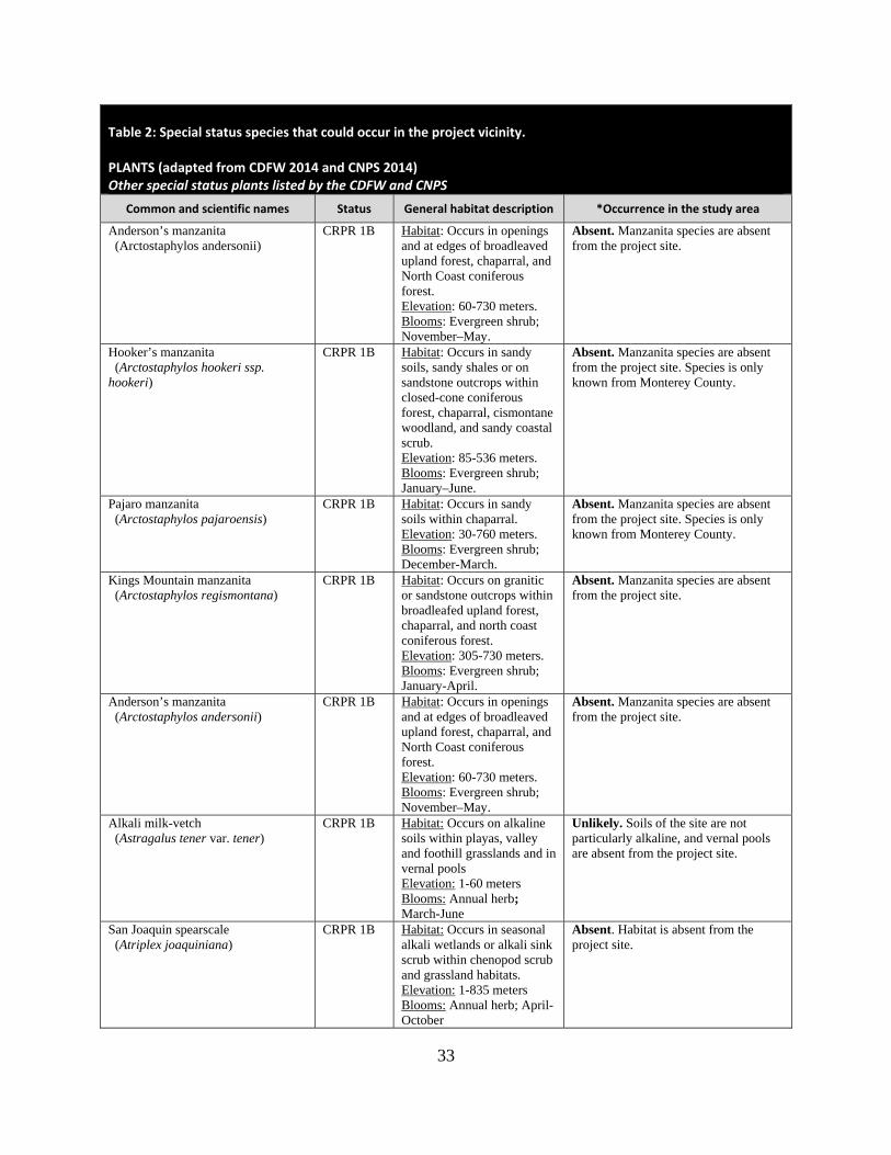
Table 2: Special status species that could occur in the project vicinity.
PLANTS (adapted from CDFW 2014 and CNPS 2014) Other special status plants listed by the CDFW and CNPS
Common and scientific names Status General habitat description *Occurrence in the study area
Anderson’s manzanita (Arctostaphylos andersonii)
CRPR 1B Habitat: Occurs in openings and at edges of broadleaved upland forest, chaparral, and North Coast coniferous forest. Elevation: 60-730 meters. Blooms: Evergreen shrub; November–May.
Absent. Manzanita species are absent from the project site.
Hooker’s manzanita (Arctostaphylos hookeri ssp. hookeri)
CRPR 1B Habitat: Occurs in sandy soils, sandy shales or on sandstone outcrops within closed-cone coniferous forest, chaparral, cismontane woodland, and sandy coastal scrub. Elevation: 85-536 meters. Blooms: Evergreen shrub; January–June.
Absent. Manzanita species are absent from the project site. Species is only known from Monterey County.
Pajaro manzanita (Arctostaphylos pajaroensis)
CRPR 1B Habitat: Occurs in sandy soils within chaparral. Elevation: 30-760 meters. Blooms: Evergreen shrub; December-March.
Absent. Manzanita species are absent from the project site. Species is only known from Monterey County.
Kings Mountain manzanita (Arctostaphylos regismontana)
CRPR 1B Habitat: Occurs on granitic or sandstone outcrops within broadleafed upland forest, chaparral, and north coast coniferous forest. Elevation: 305-730 meters. Blooms: Evergreen shrub; January-April.
Absent. Manzanita species are absent from the project site.
Anderson’s manzanita (Arctostaphylos andersonii)
CRPR 1B Habitat: Occurs in openings and at edges of broadleaved upland forest, chaparral, and North Coast coniferous forest. Elevation: 60-730 meters. Blooms: Evergreen shrub; November–May.
Absent. Manzanita species are absent from the project site.
Alkali milk-vetch (Astragalus tener var. tener)
CRPR 1B Habitat: Occurs on alkaline soils within playas, valley and foothill grasslands and in vernal pools Elevation: 1-60 meters Blooms: Annual herb; March-June
Unlikely. Soils of the site are not particularly alkaline, and vernal pools are absent from the project site.
San Joaquin spearscale (Atriplex joaquiniana)
CRPR 1B Habitat: Occurs in seasonal alkali wetlands or alkali sink scrub within chenopod scrub and grassland habitats. Elevation: 1-835 meters Blooms: Annual herb; April-October
Absent. Habitat is absent from the project site.

34
Table 2: Special status species that could occur in the project vicinity.
PLANTS (adapted from CDFW 2014 and CNPS 2014) Other special status plants listed by the CDFW and CNPS
Common and scientific names Status General habitat description *Occurrence in the study area
Big-scale balsamroot (Balsamorhiza macrolepis var. macrolepis)
CRPR 1B Habitat: Chaparral, cismontane woodlands, and valley and foothill grasslands (sometimes on serpentine) Elevation: 90-1400 meters Blooms: Perennial herb; March-June
Unlikely. Grasslands of the site are not serpentine and provide marginal habitat for this species.
Round-leaved filaree (California macrophylla)
CRPR 1B Habitat: Occurs on clay soils within cismontane woodlands and valley and foothill grasslands. Elevation: 15-1200 meters. Blooms: Annual herb; March-May.
Possible. Grasslands of the site provide potential habitat for this species.
Chaparral harebell (Campanula exigua)
CRPR 1B Habitat: Rocky chaparral, often on serpentine Elevation: 275-1250 meters Blooms: Annual herb; May-June
Absent. Habitat is absent from the site
Pink creamsacs (Castilleja rubicundula ssp. rubicundula)
CRPR 1B Habitat: Occurs on serpentine soils within chaparral, cismontane woodland, meadows and seeps, and valley and foothill grasslands. Elevation: 20- 900 meters. Blooms: Annual herb; April– June.
Unlikely. This species was documented on Sargent Ranch in 1992 and CNDDB shows the location of the occurrence to the north of Tar Creek within a seep spring in non-serpentine grasslands. As this species is considered serpentine endemic, it appears that the location in CNDDB may have been misrepresented and that possibly the population was further north within serpentine grasslands. Grasslands of the project site are not serpentine and would provide marginal habitat for this species.
Congdon’s tarplant (Centromadia parryi ssp. congdonii)
CRPR 1B Habitat: Occurs on alkaline soils within valley and foothill grasslands. Elevation: 1-230 meters Blooms: Annual herb; May-November.
Possible. Marginal habitat for this species occurs within grasslands of the project site.
Eastwood’s goldenbush (Ericameria fasciculata)
CRPR 1B Habitat: Occurs in sandy openings within closed-cone coniferous forest, maritime chaparral, coastal dunes, and coastal scrub. Elevation: 30-275 meters. Blooms: Evergreen shrub; July-October.
Absent. Habitat is absent from the project site. Species only known from Monterey County.
Hoover’s button-celery (Eryngium aristulatum var. hooveri)
CRPR 1B Habitat: Occurs in vernal pools. Elevation: 3-45 meters Blooms: Annual/perennial herb; July
Absent. Vernal pools are absent from the project site.
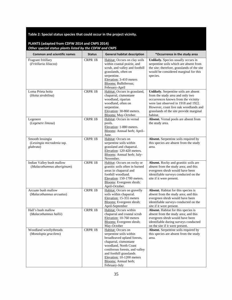
35
Table 2: Special status species that could occur in the project vicinity.
PLANTS (adapted from CDFW 2014 and CNPS 2014) Other special status plants listed by the CDFW and CNPS
Common and scientific names Status General habitat description *Occurrence in the study area
Fragrant fritillary (Fritillaria liliacea)
CRPR 1B Habitat: Occurs on clay soils within coastal prairie, and scrub, and valley and foothill grasslands, often on serpentine. Elevation: 3-410 meters Blooms: Bulbiferous; February-April
Unlikely. Species usually occurs in serpentine soils which are absent from the site; therefore, grasslands of the site would be considered marginal for this species.
Loma Prieta hoita (Hoita strobilina)
CRPR 1B Habitat: Occurs in grassland, chaparral, cismontane woodland, riparian woodland, often on serpentine. Elevation: 30-860 meters. Blooms: May-October.
Unlikely. Serpentine soils are absent from the study area and only two occurrences known from the vicinity were last observed in 1918 and 1922. However, coast live oak woodlands and grasslands of the site provide marginal habitat.
Legenere (Legenere limosa)
CRPR 1B Habitat: Occurs in vernal pools. Elevation: 1-880 meters. Blooms: Annual herb; April–June.
Absent. Vernal pools are absent from the study area.
Smooth lessingia (Lessingia micradenia ssp. glabrata)
CRPR 1B Habitat: Occurs on serpentine soils within grassland and chaparral. Elevation: 120-420 meters. Blooms: Annual herb; July-November.
Absent. Serpentine soils required by this species are absent from the study area.
Indian Valley bush mallow (Malacothamnus aboriginum)
CRPR 1B Habitat: Occurs on rocky or granitic soils often in burned areas in chaparral and foothill woodland. Elevation: 150-1700 meters. Blooms: Evergreen shrub; April-October.
Absent. Rocky and granitic soils are absent from the study area; and this evergreen shrub would have been identifiable surveys conducted on the site if it were present.
Arcuate bush mallow (Malacothamnus arcuatus)
CRPR 1B Habitat: Occurs on gravelly soils within chaparral. Elevation: 15-355 meters Blooms: Evergreen shrub; April-September
Absent. Habitat for this species is absent from the study area; and this evergreen shrub would have been identifiable surveys conducted on the site if it were present.
Hall’s bush mallow (Malacothamnus hallii)
CRPR 1B Habitat: Occurs within chaparral and coastal scrub Elevation: 10-760 meters Blooms: Evergreen shrub; May-October
Absent. Habitat for this species is absent from the study area; and this evergreen shrub would have been identifiable during surveys conducted on the site if it were present.
Woodland woollythreads (Monolopia gracilens)
CRPR 1B Habitat: Occurs on serpentine soils within broadleaved upland forests, chaparral, cismontane woodland, North Coast coniferous forests, and valley and foothill grasslands Elevation: 10-1200 meters Blooms: Annual herb; February-July
Absent. Serpentine soils required by this species are absent from the study area.
36
Table 2: Special status species that could occur in the project vicinity.
PLANTS (adapted from CDFW 2014 and CNPS 2014) Other special status plants listed by the CDFW and CNPS
Common and scientific names Status General habitat description *Occurrence in the study area
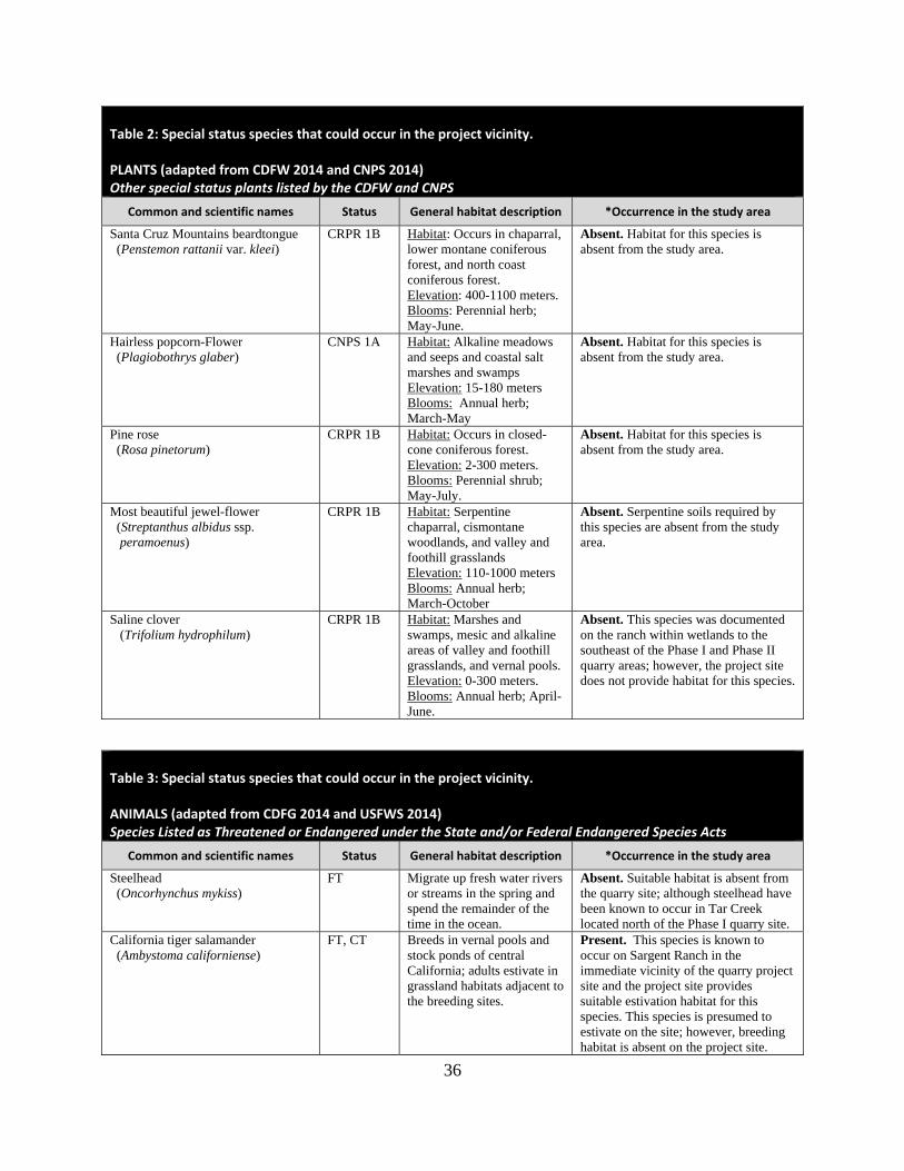
Santa Cruz Mountains beardtongue (Penstemon rattanii var. kleei)
CRPR 1B Habitat: Occurs in chaparral, lower montane coniferous forest, and north coast coniferous forest. Elevation: 400-1100 meters. Blooms: Perennial herb; May-June.
Absent. Habitat for this species is absent from the study area.
Hairless popcorn-Flower (Plagiobothrys glaber)
CNPS 1A Habitat: Alkaline meadows and seeps and coastal salt marshes and swamps Elevation: 15-180 meters Blooms: Annual herb; March-May
Absent. Habitat for this species is absent from the study area.
Pine rose (Rosa pinetorum)
CRPR 1B Habitat: Occurs in closed-cone coniferous forest. Elevation: 2-300 meters. Blooms: Perennial shrub; May-July.
Absent. Habitat for this species is absent from the study area.
Most beautiful jewel-flower (Streptanthus albidus ssp. peramoenus)
CRPR 1B Habitat: Serpentine chaparral, cismontane woodlands, and valley and foothill grasslands Elevation: 110-1000 meters Blooms: Annual herb; March-October
Absent. Serpentine soils required by this species are absent from the study area.
Saline clover (Trifolium hydrophilum)
CRPR 1B Habitat: Marshes and swamps, mesic and alkaline areas of valley and foothill grasslands, and vernal pools. Elevation: 0-300 meters. Blooms: Annual herb; April-June.
Absent. This species was documented on the ranch within wetlands to the southeast of the Phase I and Phase II quarry areas; however, the project site does not provide habitat for this species.
Table 3: Special status species that could occur in the project vicinity.
ANIMALS (adapted from CDFG 2014 and USFWS 2014) Species Listed as Threatened or Endangered under the State and/or Federal Endangered Species Acts
Common and scientific names Status General habitat description *Occurrence in the study area
Steelhead (Oncorhynchus mykiss)
FT Migrate up fresh water rivers or streams in the spring and spend the remainder of the time in the ocean.
Absent. Suitable habitat is absent from the quarry site; although steelhead have been known to occur in Tar Creek located north of the Phase I quarry site.
California tiger salamander (Ambystoma californiense)
FT, CT Breeds in vernal pools and stock ponds of central California; adults estivate in grassland habitats adjacent to the breeding sites.
Present. This species is known to occur on Sargent Ranch in the immediate vicinity of the quarry project site and the project site provides suitable estivation habitat for this species. This species is presumed to estivate on the site; however, breeding habitat is absent on the project site.
37
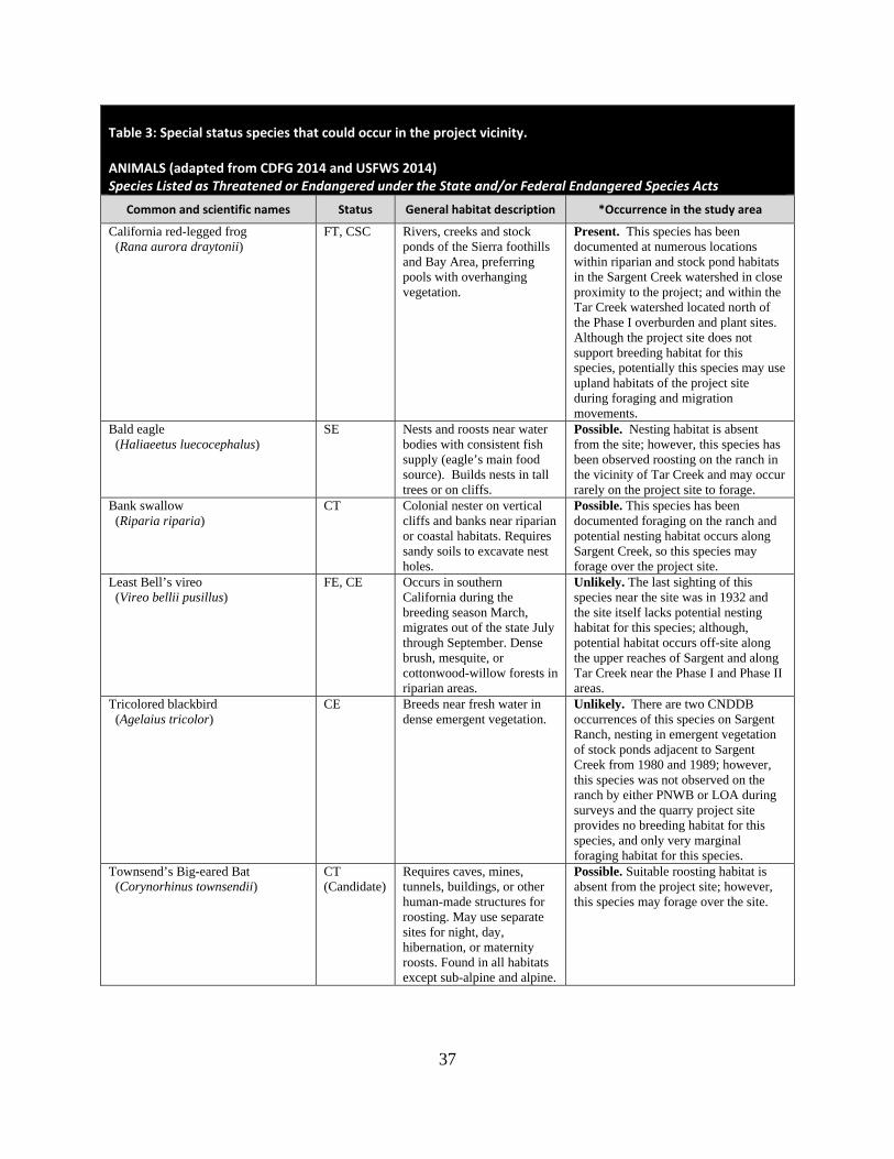
Table 3: Special status species that could occur in the project vicinity.
ANIMALS (adapted from CDFG 2014 and USFWS 2014) Species Listed as Threatened or Endangered under the State and/or Federal Endangered Species Acts
Common and scientific names Status General habitat description *Occurrence in the study area
California red-legged frog (Rana aurora draytonii)
FT, CSC Rivers, creeks and stock ponds of the Sierra foothills and Bay Area, preferring pools with overhanging vegetation.
Present. This species has been documented at numerous locations within riparian and stock pond habitats in the Sargent Creek watershed in close proximity to the project; and within the Tar Creek watershed located north of the Phase I overburden and plant sites. Although the project site does not support breeding habitat for this species, potentially this species may use upland habitats of the project site during foraging and migration movements.
Bald eagle (Haliaeetus luecocephalus)
SE Nests and roosts near water bodies with consistent fish supply (eagle’s main food source). Builds nests in tall trees or on cliffs.
Possible. Nesting habitat is absent from the site; however, this species has been observed roosting on the ranch in the vicinity of Tar Creek and may occur rarely on the project site to forage.
Bank swallow (Riparia riparia)
CT Colonial nester on vertical cliffs and banks near riparian or coastal habitats. Requires sandy soils to excavate nest holes.
Possible. This species has been documented foraging on the ranch and potential nesting habitat occurs along Sargent Creek, so this species may forage over the project site.
Least Bell’s vireo (Vireo bellii pusillus)
FE, CE Occurs in southern California during the breeding season March, migrates out of the state July through September. Dense brush, mesquite, or cottonwood-willow forests in riparian areas.
Unlikely. The last sighting of this species near the site was in 1932 and the site itself lacks potential nesting habitat for this species; although, potential habitat occurs off-site along the upper reaches of Sargent and along Tar Creek near the Phase I and Phase II areas.
Tricolored blackbird (Agelaius tricolor)
CE Breeds near fresh water in dense emergent vegetation.
Unlikely. There are two CNDDB occurrences of this species on Sargent Ranch, nesting in emergent vegetation of stock ponds adjacent to Sargent Creek from 1980 and 1989; however, this species was not observed on the ranch by either PNWB or LOA during surveys and the quarry project site provides no breeding habitat for this species, and only very marginal foraging habitat for this species.
Townsend’s Big-eared Bat (Corynorhinus townsendii)
CT (Candidate)
Requires caves, mines, tunnels, buildings, or other human-made structures for roosting. May use separate sites for night, day, hibernation, or maternity roosts. Found in all habitats except sub-alpine and alpine.
Possible. Suitable roosting habitat is absent from the project site; however, this species may forage over the site.

38
Table 3: Special status species that could occur in the project vicinity.
ANIMALS (adapted from CDFW 2014 and USFWS 2014) California Species of Special Concern and Protected Species
Common and scientific names Status General habitat description *Occurrence in the study area
Foothill yellow-legged frog (Rana boylii)
CSC Occurs in swiftly flowing streams and rivers with rocky substrate with open, sunny banks in forest, chaparral, and woodland habitats, and can sometimes be found in isolated pools.
Absent. Suitable habitat is absent from the site and its immediate vicinity, and this species has never been documented on the greater Sargent Ranch property despite numerous herpetological surveys.
Western spadefoot (Spea hammondii)
CSC Primarily occurs in grasslands, but also occurs in valley and foothill hardwood woodlands. Requires vernal pools or other temporary wetlands for breeding.
Unlikely. PNWB biologists tentatively identified this species by vocalization on the greater Sargent Ranch property during 2000-2001 surveys, however, the project site provides no breeding habitat for this species, and they have never been directly observed in the project site vicinity during many surveys for CTS and CRLF.
Western pond turtle (Emys marmorata)
CSC Open slow-moving water of rivers and creeks of central California with rocks and logs for basking.
Possible. Potential habitat for this species occurs during the wet season within Sargent Creek in the vicinity of the Phase III and IV access road, and it may occasionally use upland habitats of the site in proximity to the creek; however, there are no documented occurrences of turtles in the immediate project vicinity.
Coast horned lizard (Phrynosoma blainvillii)
CSC Grasslands, scrublands, oak woodlands, etc. of central California. Common in sandy washes with scattered shrubs.
Unlikely. Habitat is marginal on the site for this species as open sandy areas are absent, and this species has never been observed on Sargent Ranch or documented in CNDDB within a three-mile radius.
White-tailed kite (nesting) (Elanus leucurus)
CP Open grasslands and agricultural areas throughout central California.
Possible. Suitable breeding habitat exists on the site for this species within oak woodland habitat, and grasslands and agricultural areas on the project site provide suitable foraging habitat.
Peregrine Falcon (Falco peregrinus anatum)
CP Requires cliffs for nesting and forages in a variety of habitats.
Possible. PNWB observed falcons foraging over Sargent Ranch during 2000 and 2001 surveys and the project site provides potential foraging habitat for this species; however, nesting habitat is absent from the project site.
Golden eagle (nesting & nonbreeding/wintering) (Aquila chrysaetos)
CP Typically frequents rolling foothills, mountain areas, sage-juniper flats and desert.
Present. Woodlands on the project site provide only marginal nesting habitat for this species; however, golden eagles have been observed on numerous occasions foraging over the ranch and are presumed to forage on the project site on a regular basis.
Northern Harrier (Circus cyaneus)
CSC Frequents meadows, grasslands, open rangelands, freshwater emergent wetlands; uncommon in wooded habitats.
Present. This species has been observed foraging over grasslands of the site and potential nesting habitat occurs adjacent to Sargent Creek.
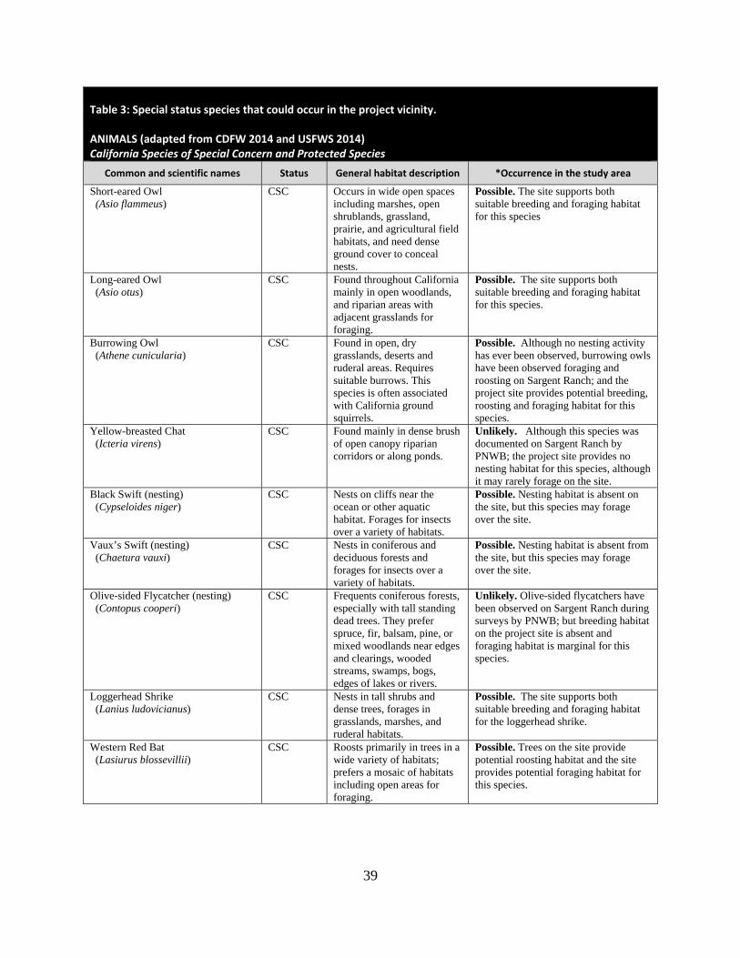
39
Table 3: Special status species that could occur in the project vicinity.
ANIMALS (adapted from CDFW 2014 and USFWS 2014) California Species of Special Concern and Protected Species
Common and scientific names Status General habitat description *Occurrence in the study area
Short-eared Owl (Asio flammeus)
CSC Occurs in wide open spaces including marshes, open shrublands, grassland, prairie, and agricultural field habitats, and need dense ground cover to conceal nests.
Possible. The site supports both suitable breeding and foraging habitat for this species
Long-eared Owl (Asio otus)
CSC Found throughout California mainly in open woodlands, and riparian areas with adjacent grasslands for foraging.
Possible. The site supports both suitable breeding and foraging habitat for this species.
Burrowing Owl (Athene cunicularia)
CSC Found in open, dry grasslands, deserts and ruderal areas. Requires suitable burrows. This species is often associated with California ground squirrels.
Possible. Although no nesting activity has ever been observed, burrowing owls have been observed foraging and roosting on Sargent Ranch; and the project site provides potential breeding, roosting and foraging habitat for this species.
Yellow-breasted Chat (Icteria virens)
CSC Found mainly in dense brush of open canopy riparian corridors or along ponds.
Unlikely. Although this species was documented on Sargent Ranch by PNWB; the project site provides no nesting habitat for this species, although it may rarely forage on the site.
Black Swift (nesting) (Cypseloides niger)
CSC Nests on cliffs near the ocean or other aquatic habitat. Forages for insects over a variety of habitats.
Possible. Nesting habitat is absent on the site, but this species may forage over the site.
Vaux’s Swift (nesting) (Chaetura vauxi)
CSC Nests in coniferous and deciduous forests and forages for insects over a variety of habitats.
Possible. Nesting habitat is absent from the site, but this species may forage over the site.
Olive-sided Flycatcher (nesting) (Contopus cooperi)
CSC Frequents coniferous forests, especially with tall standing dead trees. They prefer spruce, fir, balsam, pine, or mixed woodlands near edges and clearings, wooded streams, swamps, bogs, edges of lakes or rivers.
Unlikely. Olive-sided flycatchers have been observed on Sargent Ranch during surveys by PNWB; but breeding habitat on the project site is absent and foraging habitat is marginal for this species.
Loggerhead Shrike (Lanius ludovicianus)
CSC Nests in tall shrubs and dense trees, forages in grasslands, marshes, and ruderal habitats.
Possible. The site supports both suitable breeding and foraging habitat for the loggerhead shrike.
Western Red Bat (Lasiurus blossevillii)
CSC Roosts primarily in trees in a wide variety of habitats; prefers a mosaic of habitats including open areas for foraging.
Possible. Trees on the site provide potential roosting habitat and the site provides potential foraging habitat for this species.

40
Table 3: Special status species that could occur in the project vicinity.
ANIMALS (adapted from CDFW 2014 and USFWS 2014) California Species of Special Concern and Protected Species
Common and scientific names Status General habitat description *Occurrence in the study area
Pallid Bat (Antrozous pallidus)
CSC Most common on dry, open habitats with rocks for roosting. May also use hollows of trees in addition to caves for roosting.
Possible. The site offers suitable foraging habitat for this species, and oak trees may provide cavities for roosting.
California Mastiff Bat (Eumops perotis californicus)
CSC Forages over many habitats, requires tall cliffs or buildings for roosting.
Possible. Suitable foraging habitat occurs on the site, but roosting habitat is absent.
San Francisco Dusky-footed Woodrat (Neotoma fuscipes annectens)
CSC Found in hardwood forests, oak riparian and shrub habitats.
Unlikely. Oak woodlands on the Phase I and II quarry sites provide marginal habitat for this species; however, no woodrat nests have ever been observed on Sargent Ranch by PNWB or LOA biologists.
Ringtail (Bassariscus astutus)
CP Occurs mainly in riparian and heavily wooded habitats near water.
Unlikely. Although woodlands occur on the Phase I and II project areas, these woodlands would provide only marginal habitat for this species, although it may occur in riparian habitat of Tar Creek and rarely occur on areas of the site in proximity to Tar Creek.
American Badger (Taxidea taxus)
CSC Occurs in grasslands, and open areas of scrubland and forests with friable soils that are uncultivated.
Likely. Grasslands of the project site provide suitable habitat for this species and it is known to occur on the greater Sargent Ranch property.
Present: Species observed on the sites at time of field surveys or during recent past. Likely: Species not observed on the site, but it may reasonably be expected to occur there on a regular basis. Possible: Species not observed on the sites, but it could occur there from time to time. Unlikely: Species not observed on the sites, and would not be expected to occur there except, perhaps, as a transient. Absent: Species not observed on the sites, and precluded from occurring there because habitat requirements not met. STATUS CODES
FE Federally Endangered CE California Endangered FT Federally Threatened CT California Threatened FPE Federally Endangered (Proposed) CR California Rare FC Federal Candidate CP California Protected
CSC California Species of Special Concern
CNPS California Native Plant Society Listing 1A Plants Presumed Extinct in California 3 Plants about which we need more 1B Plants Rare, Threatened, or Endangered in information – a review list
California and elsewhere 4 Plants of limited distribution – a watch list 2 Plants Rare, Threatened, or Endangered in California, but more common elsewhere
Most of the special status plant and animal species listed in Table 3 are either absent or may
occur rarely or occasionally onsite and sufficient information exists to evaluate the potential
impacts the project may or may not have on them. However, a number of other special status
species have been documented on Sargent Ranch in the immediate vicinity of the project site and
41
are assumed present or are considered likely or possibly to occur on the site. A few of these latter
species warrant further discussion and include the California tiger salamander (CTS), California
red-legged frog (CRLF), burrowing owl (BUOW), and American badger.
California Tiger Salamander (Ambystoma californiense). Federal Listing Status: Threatened; State Listing Status: Threatened.
Life History and Ecology. The California tiger salamander (CTS) is a large terrestrial
salamander, with adults attaining a total length of over 8 inches (203 millimeters) [Stebbins
1951]. Dorsally, the background color appears to be jet black, and normally with an overlain
pattern of white or yellow spots, or bars (Stebbins 1985; Petranka 1998). Adult California tiger
salamanders breed from late November through February, following the onset of winter rains
(Storer 1925; Barry and Shaffer 1994). Both males and females travel up to 1 mile (1.6 km) or
more during nocturnal breeding migrations from subterranean refuge, or aestivation, sites (i.e.,
small mammal burrows) to egg deposition sites in long-lasting, rain-filled vernal pools (Twitty
1941; Loredo et al. 1961; Andersen 1968; Austin and Shaffer 1992).
Embryos of California tiger salamanders hatch in approximately 14-28 days after being laid and
the resulting gilled, aquatic larvae [0.41-0.43 inches (10.5-11 mm) in length] require a minimum
of about 10-12 weeks to complete development through metamorphosis (Storer 1925; Twitty
1941). Following metamorphosis (normally from early May through July), juveniles emigrate en
masse at night into small mammal burrows or deep cracks in the soil, which they use as refugia
during the hot summer and fall months (Shaffer et al. 1993; Loredo et al. 1996).
Anecdotal evidence indicates that salamanders have a high degree of site fidelity to their
breeding ponds and also to the small mammal burrows they use for refugia (Shaffer et al. 1993).
Sites used for reproduction are typically natural pools that fill with rainwater and artificial stock
ponds; however, salamanders have also been observed to breed in springs, wells, artificial
reservoirs, quarry ponds, man-made canals, and rarely, in the slack waters of oxbows in small- to
medium-sized streams. Such sites may, or may not contain dense amounts of aquatic and
streamside vegetation. The highest numbers of larvae appear to occur in aquatic habitats that are
largely devoid of any vegetation and contain very turbid water. Salamanders may also turn up in
certain man-made structures (e.g. wet basements, wells, swimming pools, underground pipes,
42
and septic tank drains), sometimes many years after their local breeding site has been destroyed
by urbanization (Storer 1925; Pickwell 1947).
Juvenile and adult salamanders typically use the burrows of California ground squirrels and
pocket gophers as underground refugia (Storer 1925; Jennings and Hayes 1994; Jennings 1996;
Loredo et a1. 1996) but may use a variety of burrows including cracks within the soil that may
extend up to 15 feet (4.6 m) deep from the soil surface (Jennings, unpub. data). Juvenile and
adult salamanders are especially common in situations where piles of concrete, rock, or other
rubble are mixed with dirt and are located near breeding sites (Jennings, unpub. data). Findings
from the limited research on the species suggest that 95% of a CTS population estivates within
2,000 feet of a breeding pond and that 99% of the breeding population estivates within 0.7 miles
of a breeding pond; however, the USFWS considers suitable habitat within 1.3 miles of a known
breeding pool to constitute potential upland habitat for the salamander.
Occurrence on the Site. PNWB confirmed the presence of breeding populations of CTS in three
locations on Sargent Ranch during their 2000-2001 surveys (Figure 6). These include the
pond/seasonal wetland complex in the very northeastern corner of the ranch near Tick Creek.
The latter location was also confirmed to support introduced eastern tiger salamanders
(Ambystoma tigrinum) and hybrids of the two species (confirmed via genetic analysis by UC
Davis). The other two observances were within a pond adjacent to Sycamore Creek, a tributary
of Tar Creek, and an isolated drainage in the western portion of the ranch near the Phase I and II
quarry areas. CTS in the latter two locations appeared to be non-hybrid populations. Although
the project site supports no breeding habitat for this species, based on the USFWS’ 1.3 mile
radius for estivation habitat, it appears the vast majority of grasslands of the ranch could be
considered estivation habitat for this species, including grasslands of the project site; therefore, it
is assumed that CTS estivate on the project site.
Potential CTS predators were found in other stock ponds of the ranch, including blue gill
(Lepomis machrochirus) and bullfrogs (Lithobates catesbiana), and this may be why CTS do not
occur in these other ponds, although many, in years of normal and above-normal rainfall, would
appear to support a suitable hydrologic regime to provide breeding habitat for this species.
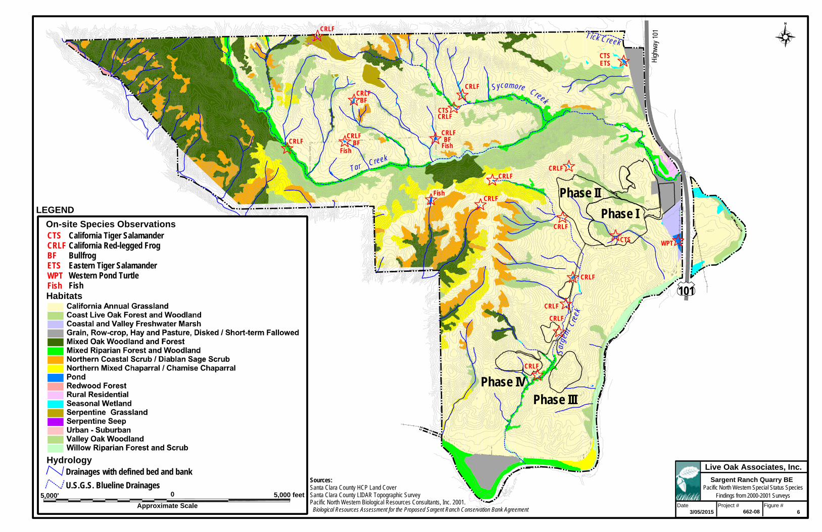
High
way
101
Tar Creek
Sycamore Creek
Tick Creek
Sarg
ent
Cree
k
CRLF
CTSETS
WPT
CRLF
CRLF
CRLF
CRLF
CRLF
CRLFCRLF
CTS
CRLFFish
CRLFCRLF
CRLF
CRLFBF
Fish
CTSCRLF
CRLF
BF
BFFish
101
Phase IIIPhase IV
Phase I
Phase II
5,000' 5,000 feet0
Habitats
Approximate Scale
Live Oak Associates, Inc.
Project #Date Figure #
U.S.G.S. Blueline Drainages Pacific North Western Special Status Species Findings from 2000-2001 Surveys
Sources:Santa Clara County HCP Land CoverSanta Clara County LIDAR Topographic SurveyPacific North Western Biological Resources Consultants, Inc. 2001. Biological Resources Assessment for the Proposed Sargent Ranch Conservation Bank Agreement
Drainages with defined bed and bank
6
LEGEND
Hydrology
On-site Species ObservationsCalifornia Tiger SalamanderCalifornia Red-legged FrogBullfrogEastern Tiger SalamanderWestern Pond TurtleFish
CTSCRLFBFETSWPTFish
3/05/2015 662-08
Sargent Ranch Quarry BE
44
During the January 2014 site visit to confirm existing conditions on the ranch, ponds were
completely dry or almost completely dry due to two years of drought conditions in the region.
While it is highly unlikely that CTS breeding would have occurred over the past two years, per
Dr. Jennings, the drought may benefit CTS by killing off fish and knocking down bullfrog
populations, and therefore make these other ponds more suitable for CTS breeding habitat in the
future (although bullfrogs would be expected to recolonize these ponds rather rapidly).
California Red-legged Frog (Rana draytonii). Federal Listing Status: Threatened; State Listing Status: Species of Special Concern.
Life History. The California red-legged frog (CRLF) is the largest native frog in California, with
adults attaining a length of 3.4-5.4 inches (85-138 mm) snout-to-vent length (SVL) (Jennings
and Hayes 1994). On the dorsal surface, the background color varies from brown to gray to
reddish-brown, normally with some dark mottling peppered around spots with light-colored
centers (Stebbins 1985). The distribution of reddish pigment is highly variable, but is usually
restricted to the groin and undersurfaces of the thighs, legs, and feet (Jennings and Hayes 1994).
This red coloration is not diagnostic for species identification. Two distinctive, prominent folds
of skin (“dorsolateral folds”), run in a complete line from the rear of the eyes to the groin. The
groin has a distinctly mottled pattern of black on a light-colored background. Juvenile frogs
range from 1.5-3.4 inches (40-84 mm) SVL and have the same coloration as adults except that
the dorsolateral folds are normally yellow or orange colored (Stebbins 1985). This coloration is
distinct even at a distance. Larval frogs range from 0.6-3.1 inches (14-80 mm).
Adult California red-legged frogs have been observed breeding from late November through
early May after the onset of warm rains (Storer 1925, Jennings and Hayes 1994). Male frogs
typically attract females by emitting low short calls in small mobile groups of 3-7 individuals
(Jennings and Hayes 1994). Females move toward the calling groups and amplex a male.
Following amplexus, the females move to chosen oviposition sites where they attach an egg
mass of 2,000-6,000 moderate-sized (2.0-2.8 mm diameter) eggs to an emergent vegetation brace
such as tule stalks, grasses, or willow roots located just below the water surface (Storer 1925,
Livezey and Wright 1947). Once laid, the egg mass will swell with water for about 24 hours,
finally reaching the size of a softball. Males usually remain at the breeding sites for several
45
weeks after reproduction before moving to foraging habitats, while females immediately remove
to foraging habitats.
California red-legged frog embryos hatch about 6-14 days following fertilization. The resulting
larvae (8.8-10.3 mm) require 14-28 weeks to reach metamorphosis, which usually occurs
between July and September, although there are scattered observations of overwintering larvae in
perennial ponds such as at the arboretum at Golden Gate Park in San Francisco (Jennings, pers.
obs). Tadpoles generally metamorphose at 65-85 mm total length (Storer 1925) and the newly
emerged juvenile frogs are generally 25-30 mm SVL. Larvae are thought to graze on algae, but
they are rarely observed in the field because they spend most of their time concealed in
submergent vegetation, algal mats or detritus (Jennings and Hayes 1994). Post-metamorphic
frogs grow rapidly feeding on a wide variety of invertebrates.
Males typically reach sexual maturity at 2 years and females at 3 years; however, frogs of both
sexes may reach sexual maturity in a single year if resources are sufficient (Jennings, unpub.
data). Conversely, frogs may take 3-4 years to reach maturity during extended periods of
drought (Jennings and Hayes 1994). Based on limited field data, California red-legged frogs
appear to live up to 10 years in the wild (Jennings, unpub. data). Adult frogs apparently eat a
wide variety of animal prey including invertebrates, small fishes, frogs, and small mammals.
California red-legged frogs have been observed in a number of aquatic and terrestrial habitats
throughout their historic range. Larvae, juveniles, and adult frogs have been collected from
natural lagoons, dune ponds, pools in or next to streams, streams, marshlands, sag ponds, and
springs, as well as human-created stock ponds, secondary and tertiary sewage treatment ponds,
wells, canals, golf course ponds, irrigation ponds, sand and gravel pits (containing water), and
large reservoirs (Jennings 1988). The key to the presence of frogs in these habitats is the
presence of perennial (or near perennial) water and the general lack of introduced aquatic
predators such as largemouth bass (Micropterus salmoides), green sunfish (Lepomis cyanellus),
and bluegill (L. macrochirus), crayfish (Pacifastacus leniusculus and Procambarus clarkii), and
bullfrogs (Rana catesbeiana).
The habitats observed to contain the largest densities of red-legged frogs are associated with
deep-water pools (27 inches [>0.7 meters] deep) with stands of overhanging willows (Salix spp.)
46
and an intermixed fringe of cattails (Typha spp.), tule (Scirpus spp.), or sedges (Carex sp.)
(Hayes and Jennings 1988). However, California red-legged frogs have also been observed to
inhabit stock ponds, sewage treatment ponds, and artificial (e.g., concrete) pools completely
devoid of vegetation (Storer 1925; Jennings, pers. comm.). Continued survival of frogs in all
aquatic habitats seems to be based on the continued presence of ponds, springs, or pools that are
disjunct from perennial streams. Such habitats provide the continued basis for successful
reproduction and recruitment year after year into nearby drainages that may lose frog populations
due to stochastic events such as extreme flooding or droughts. Juvenile frogs are often observed
sunning themselves during the day in the warm, surface-water layer associated with floating and
submerged vegetation (Hayes and Tennant 1986). Adult frogs are largely nocturnal and are
known to sit on stream banks or on the low-hanging limbs of willow trees over pools of water
where they can detect small mammal prey (Hayes and Tennant 1986; Jennings and Hayes 1994).
Adult red-legged frogs will move within the riparian zone from well-vegetated areas to pools of
water to hydrate during periods of time when many of the streams are dry except for isolated
pools (Rathbun et al. 1993). During wet periods (especially in the winter and early spring
months), red-legged frogs can move long distances (e.g., 1 mile) between aquatic habitats, often
over areas that are considered to be unsuitable for frogs (e.g., roads, open fields, croplands, etc.).
Such activities can result in frogs ending up in isolated aquatic habitats well away from the
nearest known frog populations.
Occurrence on the Site. CRLF have been confirmed to be present in ponds and tributaries of
the Tick Creek, Tar Creek, Sycamore Creek, Pescadero Creek and Sargent Creek watersheds of
the ranch during PNWB’s 2000 and 2001 surveys and LOA’s 2004 and 2005 surveys (Figure 6).
During surveys in January 2014 to confirm existing conditions on the ranch; LOA Associate
Herpetologist Dr. Mark Jennings confirmed that even with two years of drought conditions, and
despite most of the creeks and ponds of the site being completely or nearly dry, refugia for CRLF
and other terrestrial amphibians was present on the site within still persistent ponds in the Tar
Creek drainage and also potentially within stock troughs. Similar to the situation for CTS, the
drought conditions may have even temporarily favored CRLF by killing off CRLF predators
within ponds of the site, such as non-native bullfrogs and non-native fish species; although,
47
again, bullfrogs would be expected to eventually re-colonize these ponds as previously
discussed.
Although no CRLF have been directly observed on the project site, and the project site provides
no suitable breeding habitat for this species, they have been found in numerous locations
throughout the Sargent Creek and Tar Creek watersheds in the immediate vicinity of the project
site, and individual frogs may occasionally forage on or move through the project site from time
to time.
Western Pond Turtle (Actinemys marmorata). Federal Listing Status: None; State Listing Status: Species of Special Concern.
The western pond turtle is the only native aquatic, freshwater turtle in California and normally
associates with permanent or nearly permanent aquatic habitats, including streams, lakes, and
ponds. Historically, this species occurred in Pacific Coast drainages from Washington to
Mexico. This species occurs in aquatic habitats with 1) basking sites such as rocks and logs, 2)
dense stands of submergent or emergent vegetation, 3) abundant aquatic invertebrate resources,
4) suitable nearby nesting sites, and 5) the lack of native and exotic predators (Bury 1972;
Jennings and Hayes 1994; Bury and Holland, in press). This species can move along streams up
to 3.1 miles (5 kilometers) in a short period of time, and they can tolerate at least 7 days without
water (Jennings and Hayes 1994; Bury and Holland, in press).
Occurrence on the Site. The only observance of pond turtles on the greater ranch property was
by PNWB biologists in a pond along the eastern boundary of the property near Highway 101,
approximately 1500 feet southeast of the Phase I quarry site. This occurrence is not recorded in
the CNDDB. There are only three other occurrences recorded in CNDDB within a three-mile
radius: one mile north of Sargent Ranch, approximately 0.5 miles southeast of the ranch, and on
just the other side of Highway 101 from the northeastern boundary of the ranch. Pond turtles
have never been observed on the project site or in the Sargent or Tar Creek watersheds adjacent
to the project site, although in wet years, these would appear to provide habitat for the species.
However, the vast majority of the project site, outside of potential crossings for the Phase III and
IV access road, does not support habitat for this species, although turtles may rarely occur in
these areas during movements between suitable aquatic habitats.

48
Burrowing Owl (Athene cunicularia). Federal Listing Status: None; State Listing Status: Species of Concern.
The burrowing owl is considered a California species of special concern. This decision was
based on the fact that the burrowing owl’s population levels were decreasing due to habitat
destruction, roadside nesting (vulnerability to human interference) and indirectly as a result of
ground squirrel poisoning.
The burrowing owl is a small, long-legged, semi-fossarial bird that averages a height of 9.5
inches, has an average wingspan of 23 inches, and weighs an average of 5.25 ounces. Burrowing
owls are unique, as they are the only owl that regularly lives and breeds in underground nests. In
California, these birds typically occur in the Central and Imperial Valleys, primarily utilizing
ground squirrel burrows (or the burrows of other animals, e.g., badgers, prairie dogs and
kangaroo rats) found in grasslands, open shrub lands, deserts, and to a lesser extent, grazing and
agricultural lands. Burrowing owls in this region are typically found in lower elevations, and
have strong site fidelity. Pairs have been known to return to the same area year after year, and
some pairs are known to utilize the same burrow as the previous year.
Life History. Burrowing owls feed on various small mammals including deer mice, voles, and
rats. They also prey on various invertebrates including crickets, beetles, grasshoppers, spiders,
centipedes, scorpions and crayfish. Peak hunting periods occur around dusk and dawn.
The breeding season for the burrowing owl runs from February to August, with a peak between
April and July. Clutch size varies from six to 12 eggs, with an average of seven to nine eggs.
Females generally produce only one clutch per year. The female incubates the eggs for a month,
while the male provides her food. The male continues to provide food during the brooding
period. The young remain in their burrow for approximately two weeks after hatching, and
become fully independent of their parents between eight to ten weeks of age. Burrowing owls
are a fairly short-lived species, with an average life expectancy of 4.8 years. The oldest known
wild burrowing owl was eight years and eight months old at the time of its death.
Burrowing owls are subject to predation by larger mammals (e.g., feral cats, bobcats, fox and
coyotes). They are also susceptible to anthropogenic effects such as collisions with automobiles,
and destruction or disruption of their nests, especially during the breeding season. The
49
burrowing owl may also be affected by ground squirrel eradication efforts. Burrowing owl
numbers have been in decline over the past 30 to 40 years, in California. The decline in numbers
is due mainly to habitat destruction by way of development and agricultural practices.
Occurrence on the Site. A burrowing owl was observed on the site during PNWB surveys
immediately to the north of the wetland/pond complex near Tick Creek in the northeastern
portion of the greater Sargent Ranch property although the owl was confirmed to be gone from
that area by the nesting season. The resident rancher also reports seeing burrowing owls during
the summer perched on serpentine rock outcrops in the northern portion of the ranch. Since this
latter area does not support ground squirrel burrows, it is likely the owls were only foraging, and
not roosting or nesting, in this location. Although burrowing owls have never been observed
nesting on the site, the grasslands of the site would appear to provide good potential breeding
habitat for this species.
American Badger (Taxidea taxus). Federal Listing Status: None; State Listing Status: Species of Special Concern.
The American badger is considered a California species of special concern. This decision was
based on the fact that the badger’s population levels were decreasing, mainly as a result of the
conversion of open grassland habitats to agriculture and urban uses, trapping for fur, poisoning,
and indirect poisoning as a result of consuming poisoned rodents. Rodents are the main food
source for the badger.
The American badger measures 520 to 875 mm (20 to 34 inches) from head to tail, with the tail
making up only about 1/5 of this length. Badgers weigh between 4 and 12 kg (approximately 9
to 26 pounds). The badger has a flattened body with short, stocky legs, and feet with strong
claws that are up to 4-inches long. The fur on the back and flanks of the badger varies from
brownish gray to a reddish color, with a buff colored underside. The face of the badger is distinct
with several black patches on either side of its long snout. A white dorsal stripe extends back
over the head from the nose. In northern populations, the dorsal stripe ends near the shoulders,
while in southern populations it continues over the back to the rump. Male badgers are
significantly larger than the females (Kurta, 1995; Long, 1999). Badgers are primarily solitary,
coming together only for breeding purposes. Badgers are generally found throughout
50
California’s arid grasslands and scrublands with friable soils from sea level to 12,000 feet, except
in the northern North Coast area (Grinnell et al, 1937). Badgers are primarily nocturnal and are
rarely seen during the day.
Life History. The main food source for badgers is ground squirrels and pocket gophers;
however, they also are known to feed on a variety of other small- to medium-sized mammals
including deer mice, voles, and rats; on plant roots; on reptiles and their eggs; and on birds and
their eggs. Badgers are opportunistic foragers and their food sources shift seasonally with
availability.
Badgers generally breed in late summer or early fall, experiencing a delayed implantation.
Although the badger female is technically pregnant for seven months, actual gestation takes 6
weeks. Most cubs (pups or kits) are born in March or April and litter size ranges from 1 to 5
with an average of 3 (Long 1973). Females can breed as young as 4 to 6 months of age;
however, their first litter usually occurs after one year of age. Males do not usually breed until
after their second year. Badger cubs are born blind, furred and helpless (ibid). Their eyes open
between 4 and 6 weeks of age, and they are nursed for approximately 2 months. After 2 months
of age the mother starts supplementing their diet with solid food, usually small rodents. Most
young disperse shortly after weaning, while some remain in their natal area until the next
breeding season. They may roam up to 100 km (62 miles) to find their own home range. The
average life of badgers in the wild is between 8 and 12 years.
The home range size for badgers varies by sex, season and prey base, with males having larger
home ranges than females. One study indicated males had an average home range of 2,100
acres, while one radio collared female had a home range of 1,790 acres in summer, 131 acres in
fall, and only 5 acres during the winter (Sargeant and Warner 1972). Another study indicated a
home range size between 667 and 1,550 acres for both sexes (Lindzey 1978).
Badgers often hunt for prey by digging into fossorial mammal burrows. Coyotes have been
known to follow badgers to take advantage of an easy meal as rodents are flushed from their
burrows. Badgers may enlarge hunting burrows for sleeping and protection from weather.
During the summer months, they dig new resting burrows nearly every day; these burrows are

51
usually only a few feet deep. Their natal dens are more permanent and may be as much as 30
feet long and 10 feet deep (Banfield 1974).
Badgers are ferocious animals and have few natural predators, though they can be preyed upon
by bear (Ursus americanus), bobcat, and cougar. As discussed above, the main threat to badgers
comes from anthropogenic effects.
Occurrence on the site. Habitat is present on the project site and this species has been observed
on the ranch during PNWB surveys and by the resident rancher.
2.4 JURISDICTIONAL WATERS
Jurisdictional waters include rivers, creeks, and drainages that have a defined bed and bank and
which, at the very least, carry ephemeral flows. Jurisdictional waters also include lakes, ponds,
reservoirs, and wetlands. Such waters may be subject to the regulatory authority of the U.S.
Army Corps of Engineers (USACE), the California Department of Fish and Wildlife (CDFW),
and the California Regional Water Quality Control Board (RWQCB). See Section 3.2.4 of this
report for additional information.
A wetland delineation was conducted on the entire Santa Clara County portion of the Sargent
Ranch property in 2005 which included the project site. Per the delineation, seasonal drainage
channels with a defined bed and bank and evidence of an Ordinary High Water mark were found
to occur on all phases of the project site. None of these drainages supported wetland or riparian
vegetation in 2005; however, they may be considered jurisdictional by USACE and RWQCB to
the extent of the Ordinary High Water mark on opposing banks and may also be considered
jurisdictional by CDFW to the top of bank. No other potential waters of the U.S. or state were
identified on the project site during site surveys. The 2005 delineation was never submitted to
and verified by USACE; therefore, the extent to which the USACE may claim jurisdiction over
hydrologic features on the project site could not be fully determined at the time this report was
prepared. As the prior delineation field survey is now 10 years old, it may also not reflect
existing conditions with regard to jurisdictional waters on the site and a new delineation is
warranted.

52
3.0 IMPACTS AND MITIGATIONS
3.1 SIGNIFICANCE CRITERIA
General plans, area plans, and specific projects are subject to the provisions of the California
Environmental Quality Act (CEQA). The purpose of CEQA is to assess the impacts of proposed
projects on the environment before they are constructed. For example, site development may
require the removal of some or all of its existing vegetation. Animals associated with this
vegetation could be destroyed or displaced. Animals adapted to humans, roads, buildings, pets,
etc. could potentially replace those species formerly occurring on a site. Plants and animals that
are state and/or federally listed as threatened or endangered may be destroyed or displaced.
Sensitive habitats such as wetlands and riparian woodlands may be altered or destroyed. These
impacts may be considered significant or not. According to Guide to the California
Environmental Quality Act, “Significant effect on the environment” is interpreted as a
substantial, or potentially substantial, adverse change in any of the physical conditions within the
area affected by the project including land, air, water, minerals, flora, fauna, ambient noise, and
objects of historic or aesthetic interest. Specific project impacts to biological resources may be
considered “significant” if they will:
have a substantial adverse effect, the directly or through habitat modifications, on any species
identified as a candidate, sensitive, or special status species in local or regional plans,
policies, or regulations, or by the California Department of Fish and Wildlife or U.S. Fish
and Wildlife Service;
have a substantial adverse effect on any riparian habitat or other sensitive natural community
identified in local or regional plans, policies, regulations or by the California Department of
Fish and Wildlife or U.S. Fish and Wildlife Service;
have a substantial adverse effect on federally protected wetlands as defined by Section 404 of
the Clean Water Act (including, but not limited to, marsh, vernal pool, coastal, etc.) through
direct removal, filling, hydrological interruption, or other means;

53
interfere substantially with the movement of any native resident or migratory fish or wildlife
species or with established native resident or migratory wildlife corridors, or impede the use
of native wildlife nursery site;
reduce substantially the habitat of a fish or wildlife species, including causing a fish or
wildlife population to drop below self-sustaining levels or threaten to eliminate an animal
community;
conflict with any local policies or ordinances protecting biological resources, such as a tree
preservation policy or ordinance;
conflict with the provisions of an adopted Habitat Conservation Plan, or other approved
local, regional, or state habitat conservation plan.
Furthermore, CEQA Guidelines Section 15065 states that a project may trigger the requirement
to make a “mandatory findings of significance” if “the project has the potential to subsequently
degrade the quality of the environment, substantially reduce the habitat of a fish or wildlife
species, cause a fish or wildlife population to drop below self-sustaining levels, threaten to
eliminate a plant or animal community, reduce the number or restrict the range on an
endangered, rare or threatened species, or eliminate important examples of the major periods of
California history or prehistory.”
3.2 RELEVANT GOALS, POLICIES, AND LAWS
3.2.1 Threatened and Endangered Species
State and federal “endangered species” legislation has provided the California Department of
Fish and Wildlife (CDFW) and the U.S. Fish and Wildlife Service (USFWS) with a mechanism
for conserving and protecting plant and animal species of limited distribution and/or low or
declining populations. Species listed as threatened or endangered under provisions of the state
and federal endangered species acts, candidate species for such listing, state species of special
concern, and some plants listed as endangered by the California Native Plant Society are
collectively referred to as “species of special status.” Permits may be required from both the
CDFW and USFWS if activities associated with a proposed project will result in the “take” of a
54
listed species. “Take” is defined by the state of California as “to hunt, pursue, catch, capture, or
kill, or attempt to hunt, pursue, catch, capture or kill” (California Fish and Wildlife Code,
Section 86). “Take” is more broadly defined by the federal Endangered Species Act to include
“harm” (16 USC, Section 1532(19), 50 CFR, Section 17.3). Furthermore, the CDFW and the
USFWS are responding agencies under the California Environmental Quality Act (CEQA). Both
agencies review CEQA documents in order to determine the adequacy of their treatment of
endangered species issues and to make project-specific recommendations for their conservation.
3.2.2 Migratory Birds
State and federal laws also protect most birds. The Federal Migratory Bird Treaty Act (16
U.S.C., scc. 703, Supp. I, 1989) prohibits killing, possessing, or trading in migratory birds,
except in accordance with regulations prescribed by the Secretary of the Interior. This act
encompasses whole birds, parts of birds, and bird nests and eggs.
3.2.3 Birds of Prey
Birds of prey are also protected in California under provisions of the State Fish and Wildlife
Code, Section 3503.5, which states that it is “unlawful to take, possess, or destroy any birds in
the order Falconiformes or Strigiformes (birds of prey) or to take, possess, or destroy the nest or
eggs of any such bird except as otherwise provided by this code or any regulation adopted
pursuant thereto.” Construction disturbance during the breeding season could result in the
incidental loss of fertile eggs or nestlings, or otherwise lead to nest abandonment. Disturbance
that causes nest abandonment and/or loss of reproductive effort is considered “taking” by the
CDFW.
3.2.4 The Bald and Golden Eagle Protection Act
The Bald Eagle Protection Act of 1940 (16 U.S.C. 668, enacted by 54 Stat. 250) protects bald
and golden eagles by prohibiting the taking, possession, and commerce of such birds and
establishes civil penalties for violation of this Act. Take of bald and golden eagles is defined as
follows: “disturb means to agitate or bother a bald or golden eagle to a degree that causes, or is
likely to cause, based on the best scientific information available, (1) injury to an eagle, (2) a
decrease in its productivity, by substantially interfering with normal breeding, feeding, or
55
sheltering behavior, or (3) nest abandonment, by substantially interfering with normal breeding,
feeding, or sheltering behavior’’ (72 FR 31132; 50 CFR 22.3).
3.2.5 Bats
Section 2000 and 4150 of the California Fish and Wildlife Code states that it unlawful to take or
possess a number of species, including bats, without a license or permit as required by Section
3007. Additionally, Title 14 of the California Code of Regulations states it is unlawful to harass,
herd, or drive a number of species, including bats. To harass is defined as “an intentional act
which disrupts an animal's normal behavior patterns, which includes, but is not limited to,
breeding, feeding or sheltering”.
3.2.6 Wetlands and Other Jurisdictional Waters
Natural drainage channels and adjacent wetlands may be considered “Waters of the United
States” (hereafter referred to as “jurisdictional waters”) subject to the jurisdiction of the U.S.
Army Corps of Engineers (USACE). The extent of jurisdiction has been defined in the Code of
Federal Regulations but has also been subject to interpretation of the federal courts.
Jurisdictional waters generally include:
All waters which are currently used, or were used in the past, or may be susceptible to
use in interstate or foreign commerce, including all waters which are subject to the
ebb and flow of the tide;
All interstate waters including interstate wetlands:
All other waters such as intrastate lakes, rivers, streams (including intermittent
streams), mudflats, sandflats, wetlands, sloughs, prairie potholes, wet meadows, playa
lakes, or natural ponds, the use, degradation or destruction of which could affect
interstate or foreign commerce;
All impoundments of waters otherwise defined as waters of the United States under
the definition;
Tributaries of waters identified in paragraphs (a)(1)-(4) (i.e. the bulleted items above).
56
As recently determined by the United States Supreme Court in Solid Waste Agency of Northern
Cook County v. U.S. Army Corps of Engineers (the SWANCC decision), channels and wetlands
isolated from other jurisdictional waters cannot be considered jurisdictional on the basis of their
use, hypothetical or observed, by migratory birds. However, the U.S Supreme Court decisions
Rapanos v. United States and Carabell v. U.S. Army Corps of Engineers impose a "significant
nexus" test for federal jurisdiction over wetlands. In June 2007, the USACE and Environmental
Protection Agency (EPA) established guidelines for applying the significant nexus standard.
This standard includes 1) a case-by-case analysis of the flow characteristics and functions of the
tributary or wetland to determine if they significantly affect the chemical, physical, and
biological integrity of downstream navigable waters and 2) consideration of hydrologic and
ecologic factors (EPA and USACE 2007).
The USACE regulates the filling or grading of such waters under the authority of Section 404 of
the Clean Water Act. The extent of jurisdiction within drainage channels is defined by “ordinary
high water marks” on opposing channel banks. Wetlands are habitats with soils that are
intermittently or permanently saturated, or inundated. The resulting anaerobic conditions select
for plant species known as hydrophytes that show a high degree of fidelity to such soils.
Wetlands are identified by the presence of hydrophytic vegetation, hydric soils (soils saturated
intermittently or permanently saturated by water), and wetland hydrology according to
methodologies outlined in the 1987 Corps of Engineers Wetlands Delineation Manual (USACE
1987).
All activities that involve the discharge of fill into jurisdictional waters are subject to the permit
requirements of the USACE (Wetland Training Institute, Inc. 1991). Such permits are typically
issued on the condition that the applicant agrees to provide mitigation that result in no net loss of
wetland functions or values. No permit can be issued until the Regional Water Quality Control
Board (RWQCB) issues a certification (or waiver of such certification) that the proposed activity
will meet state water quality standards. The filling of isolated wetlands, over which the USACE
has disclaimed jurisdiction under the SWANCC decision, is regulated by the RWQCB. It is
unlawful to fill isolated wetlands without filing a Notice of Intent with the RWQCB. The
RWQCB is also responsible for enforcing National Pollution Discharge Elimination System
57
(NPDES) permits, including the General Construction Activity Storm Water Permit. All projects
requiring federal money must also comply with Executive Order 11990 (Protection of Wetlands).
The California Department of Fish and Wildlife (CDFW) has jurisdiction over the bed and bank
of natural drainages according to provisions of Section 1601 and 1602 of the California Fish and
Game Code (2003). Activities that would disturb these drainages are regulated by the CDFW via
a Streambed Alteration Agreement. Such an agreement typically stipulates that certain measures
will be implemented which protect the habitat values of the drainage in question.
3.2.7 Santa Clara County Tree Ordinance
Santa Clara County has relevant ordinances in the Municipal Code under Division C16 “Tree
Preservation and Removal”.
“it shall be unlawful for any person to remove any protected tree on
any private or public property in designated areas of the County without having first obtained an administrative permit [(a) through (e) below] from the County Planning Office or an encroachment permit [(f) below] from the Department of Roads and Airports.”
“A protected tree shall consist of any of the following:
(a) Any tree having a main trunk or stem measuring 37.7 inches or greater in circumference (12 inches or more in diameter) at a height of 4½ feet above ground level, or in the case of multi-trunk trees a total of 75.4 inches in circumference (24 inches or more of the diameter) of all trunks in the following areas of the County:
(1) Parcels zoned "Hillsides" (three acres or less); (2) Parcels within a "-d" (Design Review) combining zoning district; (3) Parcels within the Los Gatos Hillside Specific Plan Area.
(b) Any tree within the "-h1" Historic Preservation zoning district for New Almaden having a main trunk or stem measuring six inches or more in diameter (18.8 inches or greater in circumference) at a height of 4.5 feet above ground level, or in the case of multi-trunk trees, a total of 12 inches in diameter (37.7 inches in circumference) of all trunks at 4.5 feet above ground. For parcels having a base zoning district of "HS, Hillside" within the "-h1" combining zoning district, this provision supersedes C16-3(a)(1).
58
(c) Any heritage tree, as that term is defined in Section C16-2. (d) Any tree required to be planted as a replacement for an unlawfully removed tree, pursuant to Section C16-17(e) of this division. (e) Any tree that was required to be planted or retained by the conditions of approval for any use permit, building site approval, grading permit, architectural and site approval (ASA), design review, special permit or subdivision. (f) On any property owned or leased by the County, any tree which measures over 37.7 inches in circumference (12 inches or more in diameter) measured 4.5 feet above the ground, or which exceeds 20 feet in height. (g) Any tree, regardless of size, within road rights-of-way and easements of the County, whether within or without the unincorporated territory of the County.”
3.2.8 Heritage Trees in Santa Clara County Under Municipal Code Section C16-12, a Heritage Tree is defined as:
“Any tree which, because of its history, girth, height, species, or other unique quality, has been recommended by the Historical Heritage Commission (HHC) and found by the Board of Supervisors to have a special significance to the community shall be designated a heritage tree. Such trees shall be listed individually on the heritage resource inventory, adopted by resolution of the Board of Supervisors. Such resolution may be amended as necessary to add or delete trees from the inventory.”
A permit is required for the removal of Heritage Trees. 3.2.9 The Santa Clara Valley Habitat Conservation Plan
Six local partners (the County of Santa Clara, Santa Clara Valley Transportation Authority,
Santa Clara Valley Water District, and the Cities of San Jose, Gilroy, and Morgan Hill) along
with two wildlife agencies, the California Department of Fish and Wildlife and the U.S. Fish
and Wildlife Service, prepared and adopted the multi-species Santa Clara Valley Habitat
Conservation Plan (SCVHP) which primarily covers southern Santa Clara County, as well as the
City of San Jose with the exception of the bayland areas. The SCVHP addresses listed species
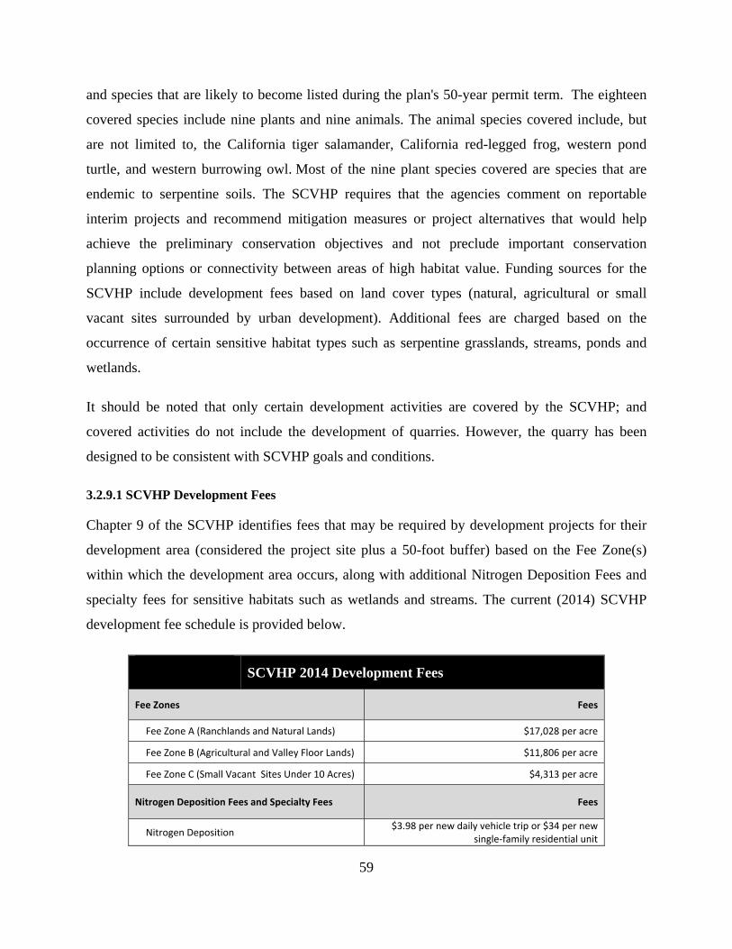
59
and species that are likely to become listed during the plan's 50-year permit term. The eighteen
covered species include nine plants and nine animals. The animal species covered include, but
are not limited to, the California tiger salamander, California red-legged frog, western pond
turtle, and western burrowing owl. Most of the nine plant species covered are species that are
endemic to serpentine soils. The SCVHP requires that the agencies comment on reportable
interim projects and recommend mitigation measures or project alternatives that would help
achieve the preliminary conservation objectives and not preclude important conservation
planning options or connectivity between areas of high habitat value. Funding sources for the
SCVHP include development fees based on land cover types (natural, agricultural or small
vacant sites surrounded by urban development). Additional fees are charged based on the
occurrence of certain sensitive habitat types such as serpentine grasslands, streams, ponds and
wetlands.
It should be noted that only certain development activities are covered by the SCVHP; and
covered activities do not include the development of quarries. However, the quarry has been
designed to be consistent with SCVHP goals and conditions.
3.2.9.1 SCVHP Development Fees
Chapter 9 of the SCVHP identifies fees that may be required by development projects for their
development area (considered the project site plus a 50-foot buffer) based on the Fee Zone(s)
within which the development area occurs, along with additional Nitrogen Deposition Fees and
specialty fees for sensitive habitats such as wetlands and streams. The current (2014) SCVHP
development fee schedule is provided below.
SCVHP 2014 Development Fees
Fee Zones Fees
Fee Zone A (Ranchlands and Natural Lands) $17,028 per acre
Fee Zone B (Agricultural and Valley Floor Lands) $11,806 per acre
Fee Zone C (Small Vacant Sites Under 10 Acres) $4,313 per acre
Nitrogen Deposition Fees and Specialty Fees Fees
Nitrogen Deposition $3.98 per new daily vehicle trip or $34 per new
single‐family residential unit
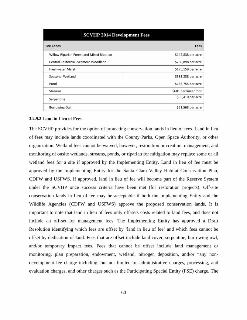
60
SCVHP 2014 Development Fees
Fee Zones Fees
Willow Riparian Forest and Mixed Riparian $142,838 per acre
Central California Sycamore Woodland $260,898 per acre
Freshwater Marsh $175,159 per acre
Seasonal Wetland $383,238 per acre
Pond $156,755 per acre
Streams $601 per linear foot
Serpentine $55,410 per acre
Burrowing Owl $51,568 per acre
3.2.9.2 Land in Lieu of Fees
The SCVHP provides for the option of protecting conservation lands in lieu of fees. Land in lieu
of fees may include lands coordinated with the County Parks, Open Space Authority, or other
organization. Wetland fees cannot be waived, however, restoration or creation, management, and
monitoring of onsite wetlands, streams, ponds, or riparian for mitigation may replace some or all
wetland fees for a site if approved by the Implementing Entity. Land in lieu of fee must be
approved by the Implementing Entity for the Santa Clara Valley Habitat Conservation Plan,
CDFW and USFWS. If approved, land in lieu of fee will become part of the Reserve System
under the SCVHP once success criteria have been met (for restoration projects). Off-site
conservation lands in lieu of fee may be acceptable if both the Implementing Entity and the
Wildlife Agencies (CDFW and USFWS) approve the proposed conservation lands. It is
important to note that land in lieu of fees only off-sets costs related to land fees, and does not
include an off-set for management fees. The Implementing Entity has approved a Draft
Resolution identifying which fees are offset by ‘land in lieu of fee’ and which fees cannot be
offset by dedication of land. Fees that are offset include land cover, serpentine, burrowing owl,
and/or temporary impact fees. Fees that cannot be offset include land management or
monitoring, plan preparation, endowment, wetland, nitrogen deposition, and/or “any non-
development fee charge including, but not limited to, administrative charges, processing, and
evaluation charges, and other charges such as the Participating Special Entity (PSE) charge. The
61
dollar total of fees that cannot be offset (Land Management or monitoring, Plan Preparation and
Endowment) is approximately 35 percent of a site’s total land cover fees.
3.2.9.3 Conditions on Covered Activities
The SCVHCP sets forth twenty conditions for covered activities under the SCVHCP.
Potentially applicable conditions for this project can be found in Chapter 6 of the SCVHCP
(Appendix D) and are listed below:
Condition 1 (page 6-7). Avoid Direct Impacts on Legally Protected Plant and Wildlife Species- Condition 1 instructs developers to avoid direct impacts on legally protected plant and wildlife species, including federally endangered Contra Costa goldfields and fully protected wildlife species including the golden eagle, bald eagle, American peregrine falcon, southern bald eagle, white-tailed kite, California condor, and ring-tailed cat. Several of these species have either been documented on the Sargent Ranch property and likely to occur on or forage over the project site, or they have not been observed, but the project site provides potential habitat for them (golden eagle, bald eagle, American peregrine falcon, white-tailed kite). Condition 1 also protects bird species and their nests that are protected under the Migratory Bird Treaty Act (MBTA); additionally, golden eagles and bald eagles are protected under the Bald and Golden Eagle Protection Act. Additionally, page 6-94 and Table 6-8 identify required surveys for breeding habitat of select covered wildlife species; of the species noted, the project will likely be required to conduct species-specific surveys for the western burrowing owl.
Condition 2 (page 6-9). Incorporate Urban-Reserve System Interface Design Requirements- Condition 2 provides design requirements for the urban-reserve system interface. Some of the design requirements included in Condition 2 are installing non-permeable fences between urban and reserve areas, fencing public roads that run adjacent to reserve areas, minimizing the length of shared boundaries between urban and reserve areas, outdoor lighting limitations, and landscaping requirements.
Condition 3 (page 6-12). Maintain Hydrologic Conditions and Protect Water Quality- Condition 3 applies to all projects. This condition identifies avoidance and minimization measures, performance standards, and control measures to minimize increases of peak discharge of stormwater and to reduce runoff of pollutants to protect water quality during construction and operation. A complete list of aquatic avoidance and minimization measures can be found in Table 6-2 of the plan.
Condition 4 (page 6-14). Avoidance and Minimization for In-Stream Projects- Condition 4 minimizes impacts on riparian and aquatic habitat through appropriate design requirements and construction practices and provides avoidance and minimization measures for in-stream projects that may impact stream morphology, aquatic and riparian habitat, flow conditions, covered species, natural communities, and wildlife movement.

62
Condition 5 (page 6-18). Avoidance and Minimization Measures for In-Stream Operations and Maintenance- Condition 5 provides avoidance and minimization measures for in-stream operations and maintenance activities, which includes, but is not limited to trail, bridge, road, and culvert maintenance, bank stabilization, removal of debris, and vegetation management.
Avoidance and minimization measures for Conditions 3-5 can be located in Table 6-2 of the SCVHP; these measures relate to stormwater runoff, in-stream channel and floodplain impacts, vegetation control and/or maintenance, materials a project should and should not use, landscaping and revegetation, free-span bridges at stream crossings, culverts, trails, levees, erosion control, and construction requirements and timing.
Condition 6 (Page 6-21) Design and Construction Requirements for Covered
Transportation Projects. Condition 6 provides requirements for rural development design, construction, and post-construction. Types of projects that Condition 6 includes highway projects, mass transit projects, roadway projects and interchange upgrades, road safety and operational improvements, and dirt road construction.
Condition 7 (page 6-28) Rural Development Design and Construction Requirements. Condition 7 provides requirements for development design and construction of new development outside of the urban service area including requirements relating to site hydrology, vineyards, private rural roads, vegetation management, soils, and lighting.
Condition 8 (page 6-35) Implement Avoidance and Minimization Measures for Rural Road Maintenance. Condition 8 provides requirements for rural roads, road median, and barrier maintenance including requirements regarding riparian setbacks, erosion measures, herbicide and pesticide use, seasonal restrictions, mower cleaning, revegetation, ground-disturbing road maintenance, and flow lines.
Condition 9 (page 6-37) Prepare and Implement a Recreation Plan. Condition 9 requires providing public access to all reserve lands owned by a public entity; each reserve land must provide a recreation plan.
Condition 10 (page 6-42) Fuel Buffer. Condition 10 provides requirements for fuel buffers between 30 and 100 feet of structures. Requirements include measures relating to fuel buffers near structures and on reserve lands; the most notable measure is the requirement for nesting bird surveys prior to any fuel buffer maintenance during the nesting season.
Condition 11 (page 6-44) Stream and Riparian Setbacks. Condition 11 provides
requirements for stream and riparian setbacks; as the development area is outside the Urban Service Area, stream setbacks measured from the top of the stream bank should be 35 to 250 feet depending on the category rating of the stream and the slope class. Setbacks for Category 1 streams with 0-30% slopes should be at least 150 feet, and with >30% slopes should be at least 200 feet. Category 2 streams should have a setback of 35 feet.
63
Condition 12 (page 6-56) Wetland and Pond Avoidance and Minimization. Condition
12 provides measures to protect wetlands and ponds, including planning actions, design, and construction actions. The project would complete a wetland delineation to confirm the distribution and condition of the wetlands onsite.
Condition 13 (page 6-58) Serpentine and Associated Covered Species Avoidance and
Minimization. Condition 13 requires surveys for special status plants and the Bay checkerspot butterfly as well as its larval host plant in areas that support serpentine bunchgrass grassland, serpentine rock outcrops, serpentine seeps, and serpentine chaparral. Fees apply for impacts to serpentine habitat.
Condition 14 (page 6-60) Valley Oak and Blue Oak Woodland Avoidance and
Minimization. Condition 14 provides requirements for project planning and project construction, including avoidance of large oaks, guidance on irrigation near oak trees, and a buffer around the root protection zone, roads and pathways within 25 feet of the dripline of an oak tree, trenching, and pruning activities.
Condition 15 (page 6-62) Western Burrowing Owl. Condition 15 requires
preconstruction surveys for burrowing owls in appropriate habitat prior to construction activities, provides avoidance measures for owls and nests in the breeding season and owls in the non-breeding season, and requirements for construction monitoring.
Condition 16 (page 6-68) Least Bell’s Vireo. Condition 16 requires preconstruction
surveys in appropriate habitat for the least Bell’s vireo prior to construction activities, and provides avoidance and construction monitoring measures.
Condition 17 (page 6-69) Tricolored Blackbird. Condition 17 requires preconstruction surveys in appropriate habitat for the tricolored blackbird prior to construction activities, and provides avoidance and construction monitoring measures.
Condition 18 (page 6-71) San Joaquin Kit Fox. Condition 18 requires preconstruction surveys in appropriate habitat for the San Joaquin kit fox prior to construction activities, and provides avoidance and construction monitoring measures.
Condition 19 (page 6-74) Plant Salvage when Impacts are Unavoidable. Condition 19
provides salvage guidance and requirements for covered plants.
Condition 20 (page 6-76) Avoid and Minimize Impacts to Covered Plant Occurrences. Condition 20 provides requirements for preconstruction surveys for appropriate covered plants (per habitat).
3.2.9.4 SCVHP Biological Goals, Objectives, and Conservation Actions
Tables 5-1a, b, c, and d of the SCVHCP provides information about the biological goals,
objectives, and conservation actions of the SCVHCP including landscape level goals (Table 5-
64
1a), natural community level goals (Table 5-1b), wildlife goals (Table 5-1c), and plant goals
(Table 5-1d) (ICF International 2012).
3.3 ENVIRONMENTAL IMPACT/MITIGATION
The potential impacts to sensitive biological resources resulting from the development of the
quarry, and mitigations that would be required to lessen these impacts to a less-than-significant
level are discussed further below.
3.3.1 Conflict with an Adopted Habitat Conservation Plan
Potential Impact. The project site is within the area covered by the Santa Clara Valley Habitat
Conservation Plan (SCVHP) (ICF 2012) as already discussed above; however, quarry projects
are not considered covered activities under the SCVHP, and therefore the project will not be
subject to the fees and conditions of the SCVHP directly. Nonetheless, we have used the SCVHP
as a framework for our evaluation and mitigation of biological impacts, and have ensured that
mitigations are consistent with the goals and objectives of the SCVHP. A more detailed
discussion of the SCVHP including all conditions on covered activities is provided in Section
3.2.9 of this report, above. The SCVHP requires the payment of development fees based on land
cover types within the development area for covered activities. For projects occurring outside the
SCVHP’s Urban Service Area (USA), the development area includes the project footprint plus a
50-foot buffer for permanent impacts. Per the SCVHCP Geobrowser, the approximately 300-acre
project site primarily consists of lands considered to be Zone A Lands (Ranchlands and Natural
Lands) and the current 2014 fees for Zone A lands are $17,028 per acre. Additionally, the project
site supports drainages that would be considered Category 2 streams under the SCVHP; and the
access road for Phase III and IV will traverse Sargent Creek, which is considered a Category 1
stream; and the Phase I quarry area occurs in proximity to Tar Creek, also considered a Category
1 stream. The SCVHP requires that projects be set-back 35 feet from Category 2 streams and 150
feet from Category 1 streams to avoid stream specialty fees. The current 2014 specialty fees for
these stream habitats are $601 per linear foot.
In lieu of the payment of some or all development fees, the SCVHP Entity may accept “land in-
lieu” in exchange for development fees and specialty fees for impacts to all land cover types with
the exception of wetland specialty fees. The decision to accept land-in-lieu is currently
65
negotiated on a case by case basis with the SCVHCP Entity. In addition to the payment of fees or
provision of “land in lieu”; the project would be required to comply with SCVHCP conditions
that are applicable to the project.
Mitigation. Although the project would not be considered a covered activity under the SCVHP
and is not subject to the fees and conditions of the plan, aspects of the project have been
designed to be consistent with the goals and objectives of the plan. For instance, the project
includes minimum 150 foot setbacks from Tar Creek and Sargent Creek, with the exception of
the Phase III and IV access road crossings of Tar Creek. In situations where the project will
result in a significant impact on biological resources, mitigations are provided further on in this
section, such as the establishment of a conservation easement and pre-construction surveys that
would be consistent with requirements and conditions of the SCVHP.
3.3.2 Potential Impacts to California Tiger Salamander Habitat and Individuals
Potential Impact. The presence of the California tiger salamander (CTS) on the Sargent Ranch
property is well-documented. Grasslands occurring within all four phases of the project provide
suitable estivation habitat for this species and it is assumed to estivate in these habitats on the
site; therefore, the project would result in the loss of estivation habitat and in harm or mortality
to individual CTS estivating on the site during project implementation. Additionally, although
CTS have not been confirmed to breed in ponds that are immediately adjacent to the proposed
Phase III and Phase IV road and the northernmost Phase III topsoil stockpile, these ponds appear
to support a suitable hydrologic regime to function as breeding habitat for this species, and the
proximity of these proposed project features to these ponds could result in indirect impacts to
this species and to California red-legged frogs which are known to breed in these features, such
as through degradation of water quality and noise disturbance. Vehicle traffic on the road may
also result in harm or mortality to individual CTS during movements between breeding and
estivation habitats. The direct loss of estivation habitat and the loss of individual CTS, as well as
indirect impacts on potential breeding habitat for this species, would be considered a significant
impact under CEQA. Mitigations are provided below to reduce these impacts to a less-than-
significant impact.

66
Mitigation. These measures would reduce impacts to CTS to a less-than-significant level. These
measures would also be consistent with the goals and objectives of the SCVHP.
The primary approach to mitigate impacts to CTS would be based upon 1) avoidance of wetland
and other aquatic resources to the maximum extent possible, 2) implementation of minimization
measures, 3) compensation for impacts to suitable upland and aquatic habitats via the
preservation of open space lands that contain similar or higher quality suitable upland and
aquatic habitats.
Avoidance. Avoidance of a sensitive resource is usually considered the preferred mitigation for
any project. Therefore, from a standpoint of avoiding impacts to CTS, the project has been
designed in ways that generally avoid direct impacts to riparian and aquatic habitats, and
immediately adjacent upland habitats. For instance, no seasonal wetlands or ponds providing
potential breeding habitat for this species will be directly impacted, and the project includes
setbacks from aquatic resources of the site including a minimum 150 foot setback from Tar
Creek and Sargent Creek (with the exception of the Sargent Creek access road crossings). As
currently designed, however, potential indirect impacts may occur to ponds that provide potential
suitable breeding habitat, and to the extent possible, Phase III and Phase IV roads and stockpiles
should be set back minimum of 100 feet from these ponds. However, the avoidance of CTS
estivation habitat will not be possible while meeting project objectives.
Minimization. The project will be designed, built, and operated in ways that minimize both
direct and indirect impacts to CTS. Implementation of the following measures, partially
summarized below and described more fully in Appendix C, should be taken during any
construction related to the development of the quarry facilities and roads occurring within 100
feet of any riparian or aquatic resource.
Prior to the start of construction, a qualified biologist will train all construction personnel regarding habitat sensitivity, identification of special status species potentially occurring on the site, and required practices.
Pre-construction surveys will be conducted to ensure that CTS are absent from the construction area. If CTS are present, they should be relocated by a qualified biologist.
The construction zone should be cleared, and silt fencing should be erected and maintained around construction zones to prevent CTS from moving into these areas.
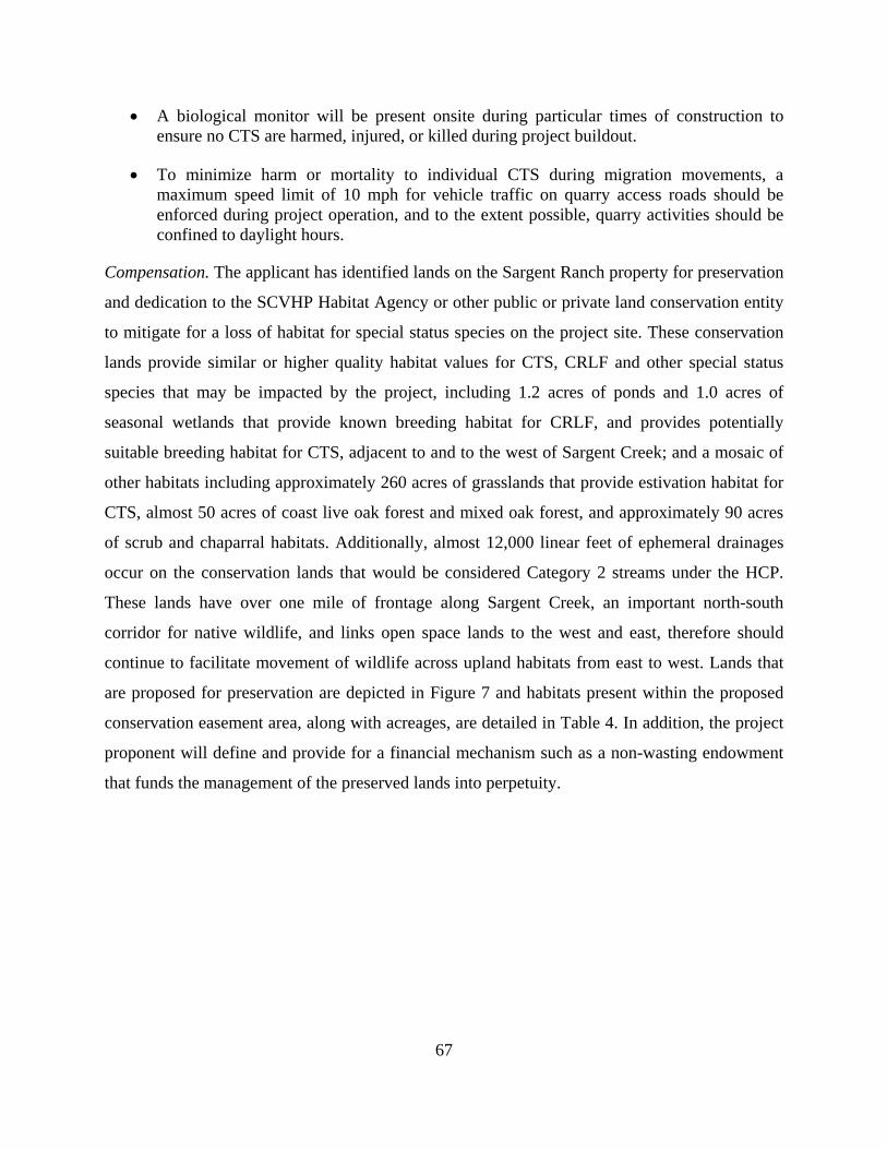
67
A biological monitor will be present onsite during particular times of construction to ensure no CTS are harmed, injured, or killed during project buildout.
To minimize harm or mortality to individual CTS during migration movements, a maximum speed limit of 10 mph for vehicle traffic on quarry access roads should be enforced during project operation, and to the extent possible, quarry activities should be confined to daylight hours.
Compensation. The applicant has identified lands on the Sargent Ranch property for preservation
and dedication to the SCVHP Habitat Agency or other public or private land conservation entity
to mitigate for a loss of habitat for special status species on the project site. These conservation
lands provide similar or higher quality habitat values for CTS, CRLF and other special status
species that may be impacted by the project, including 1.2 acres of ponds and 1.0 acres of
seasonal wetlands that provide known breeding habitat for CRLF, and provides potentially
suitable breeding habitat for CTS, adjacent to and to the west of Sargent Creek; and a mosaic of
other habitats including approximately 260 acres of grasslands that provide estivation habitat for
CTS, almost 50 acres of coast live oak forest and mixed oak forest, and approximately 90 acres
of scrub and chaparral habitats. Additionally, almost 12,000 linear feet of ephemeral drainages
occur on the conservation lands that would be considered Category 2 streams under the HCP.
These lands have over one mile of frontage along Sargent Creek, an important north-south
corridor for native wildlife, and links open space lands to the west and east, therefore should
continue to facilitate movement of wildlife across upland habitats from east to west. Lands that
are proposed for preservation are depicted in Figure 7 and habitats present within the proposed
conservation easement area, along with acreages, are detailed in Table 4. In addition, the project
proponent will define and provide for a financial mechanism such as a non-wasting endowment
that funds the management of the preserved lands into perpetuity.
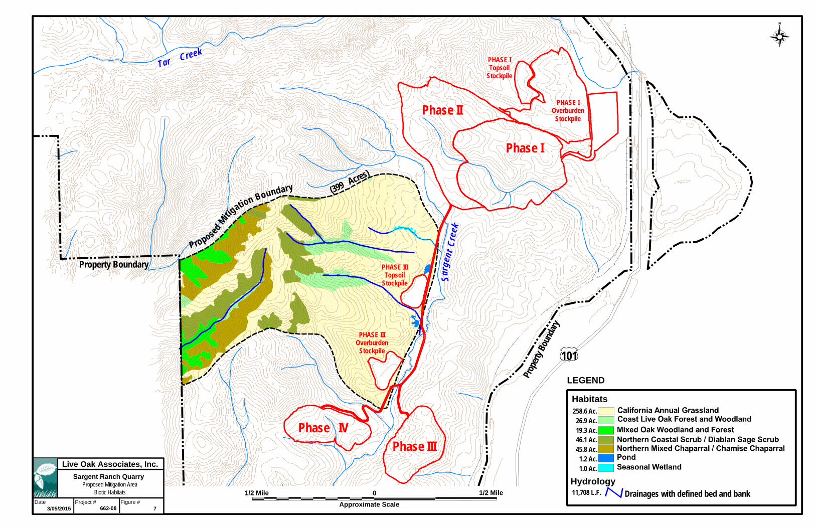
Tar Creek
Sarg
ent
Cre
ek
101
Proposed M
it igation Boundary
Property Boundary
Prop
erty
Boun
dary
(399 Acres)
Phase II
Phase III Phase IV
Phase I
PHASE IOverburden
Stockpile
PHASE ITopsoil
Stockpile
PHASE IIITopsoil
Stockpile
PHASE IIIOverburden
Stockpile
1/2 Mile0
Habitats
Approximate Scale
Live Oak Associates, Inc.
Project #Date Figure #
Proposed Mitigation AreaBiotic Habitats Drainages with defined bed and bank
7
LEGEND
Hydrology
3/05/2015 662-08
Sargent Ranch Quarry
258.6 Ac.26.9 Ac.19.3 Ac.46.1 Ac.45.8 Ac.
1.2 Ac.1.0 Ac.
11,708 L.F.1/2 Mile
68
Table 4. Habitats of the Conservation Easement Area
Habitats Acreages Value
California Annual Grassland 258.6 California tiger salamander estivation habitat; potential burrowing owl habitat; American badger habitat; foraging habitat for many special status birds.
Coast Live Oak Forest and Woodland 26.9 Nesting, roosting, and foraging habitat for many common and special‐status birds and other animals.
Mixed Oak Woodland and Forest 19.3 Nesting, roosting, and foraging habitat for many common and special‐status birds and other animals.
Northern Coastal Scrub/Diablan Sage Scrub 46.1 Nesting, roosting, and foraging habitat for many common and special‐status birds and other animals.
Northern Mixed Chaparral/Chamise Chaparral 45.8 Nesting, roosting, and foraging habitat for many common and special‐status birds and other animals.
Pond 1.2 Known California red‐legged frog breeding habitat; potential California tiger salamander breeding habitat. Seasonal source of drinking water for many common and special‐status animals. USACE and RWQCB jurisdictional habitat.
Seasonal Wetland 1.0 Known CRLF breeding habitat; potential CTS breeding habitat. Seasonal source of drinking water for many common and special‐status animals. USACE and RWQCB jurisdictional habitat.
Total 398.9
Creeks, Streams and Drainages Linear Feet of Channel Value
Seasonal Drainages with Defined Bed and Bank (primarily HCP Category 2 streams)
11,708 Potential CDFW, USACE and RWQCB jurisdictional habitat.
Regulatory issues. In addition to mitigating for project impacts to CTS under CEQA, the applicant
would need to comply with provisions of the federal and state Endangered Species Acts and
would need to seek take authorization from both the USFWS and CDFW for project-related
losses as required by law. To obtain a federal take permit, consultation with the U.S. Fish and
Wildlife Service would need to be initiated either through a federal nexus (i.e., Section 7
consultation through the USACE) or through the HCP process (i.e., Section 10 consultation).
3.3.3 Potential Impacts to California Red-Legged Frog Habitat and Individuals
Potential Impact. The presence of CRLF has been confirmed throughout the greater Sargent
Ranch property in close proximity to the proposed quarry sites. The proposed Phase III and
Phase IV road along the west side of Sargent Creek, as well as the northernmost Phase III topsoil
stockpile occur immediately adjacent to ponds within the conservation easement area that are
known to provide CRLF breeding habitat. Indirect impacts to these sensitive habitats could

69
include impacts to water quality and disturbance as a result of noise; and could also result in
harm or mortality to individual frogs as a result of vehicle traffic. The project would also result
in the direct loss of suitable upland habitat for this species in the form of grassland and woodland
habitat; and could result in harm or mortality to individual CRLF should they occur in these
habitats during project implementation. Additionally, as indicated above, riparian habitats
associated with Sargent and Tar Creeks occur in proximity, i.e. within 200 feet, of project
footprints. These riparian habitats likely provide foraging and movement habitat for CRLF.
Direct and indirect impacts to CRLF breeding, foraging and movement habitat, as well as harm
or mortality to individual CRLF, would be considered a significant impact under CEQA.
Mitigation. Implementation of the following mitigation measures would reduce impacts to
CRLF to a less-than-significant level.
The primary approach to mitigate impacts to CRLF would be based upon 1) avoidance of
riparian and aquatic resources of the site to the maximum extent possible, 2) implementation of
minimization measures, 3) compensation for impacts to suitable upland and aquatic habitats via
the preservation of open space lands that contain higher quality suitable upland and aquatic
habitats.
Avoidance. Avoidance of a sensitive resource is usually considered the preferred mitigation for
any project. Therefore, from a standpoint of avoiding impacts to CRLF, the project should be
designed in ways that avoid impacts to riparian and aquatic habitats, and their immediately
adjacent upland habitats, to the maximum extent practicable. Except for the Phase III and Phase
IV access road which will traverse Sargent Creek in three locations, the project as currently
designed avoids direct impacts to riparian resources of the site; and the project avoids indirect
impacts to such habitat via a minimum of a 150 foot setback from Sargent and Tar Creeks. To
avoid indirect impacts to sensitive CRLF breeding habitat that is proposed for preservation in the
conservation easement area, the Phase III and Phase IV road and topsoil stockpiles should be set
back a minimum of 100 feet from these areas, as already discussed previously in Section 3.3.2 .
Minimization. The project should be designed, built, and operated in ways that minimize both
direct and indirect impacts to the CRLF. Implementation of the following measures, partially
summarized below and described more fully in Appendix C, should be taken during any
70
construction of quarry facilities and roads occurring within 100 feet of any riparian or aquatic
resource.
Prior to the start of construction, a qualified biologist approved should train all construction personnel regarding habitat sensitivity, identification of special status species, and required practices.
Pre-construction surveys should be conducted to ensure that CRLF are absent from the construction area. If CRLF are present, they should be relocated by a qualified biologist.
The construction zone should be cleared, and silt fencing should be erected and maintained around construction zones to prevent CRLF from moving into these areas.
A biological monitor should be present onsite during particular times of construction to ensure no CRLF are harmed, injured, or killed during project buildout.
To minimize harm or mortality to individual CRLF during migration movements, a maximum speed limit of 10 mph for vehicle traffic on quarry access roads should be enforced during project operation, and to the extent possible, quarry activities should be confined to daylight hours.
Compensation. Compensation measures included in Mitigation Measure 3.3.2 for CTS would
also compensate for a loss of suitable habitat for CRLF.
Regulatory issues. In addition to mitigation for potential project impacts to CRLF under CEQA,
the applicant would need to comply with provisions of the federal Endangered Species Act and
would need to seek take authorization from the USFWS for project-related losses as required by
law. To obtain a take permit, consultation with the U.S. Fish and Wildlife Service would need to
be initiated either through a federal nexus (i.e., Section 7 consultation, usually through the
USACE or the Bureau of Land Management) or through the HCP process (i.e., Section 10
consultation).
3.3.4 Potential Impacts to Western Pond Turtles
Potential Impact. Western pond turtles (WPT) have been documented in the pond
approximately 1500 feet southeast of Phase I of the project. Although there are no known
occurrences of WPT within Sargent or Tar Creeks, in wet years, both of these creeks may
provide foraging and movement habitat for this species. Although the project has been designed
to be set back 150 feet from these aquatic resources, the access road for Phase III and IV of the
project will require construction of crossings over Sargent Creek. Should this work commence
71
during the dry season when Sargent Creek is dry, then it would not be expected that turtles would
be in or near Sargent Creek; however, any activities within 150 feet of the creek during the wet
season when the creek is inundated could result in harm or mortality to individual western pond
turtles should they be present, and this may be considered a significant impact under CEQA.
Mitigation Measure 3.3.4. Implementation of the following measures would reduce impacts to
WPT to a less-than-significant level.
Avoidance, minimization and compensation measures included in Mitigation Measures 3.3.2 and
3.3.3 for CTS and CRLF, respectively, would also reduce impacts to individual WPT to a less-
than-significant level. These measures would also be consistent with the goals and objectives of
the SCVHP.
3.3.5 Potential Impacts to Burrowing Owls
Impact. Burrowing owls have been observed foraging on the greater Sargent Ranch property;
however, no nesting activity has ever been observed. The project site provides potential foraging,
roosting, and nesting habitat for this species. Project activities could result in a loss of habitat for
this species and in impacts to individual owls should they nest or roost on the site and this would
be considered a potentially significant impact. Construction activities that adversely affect the
nesting success of BUOW or result in mortality of individual owls that are nesting or roosting on
the site would constitute a violation of state and federal laws and would be considered a
significant impact under CEQA.
Mitigation Measure 3.3.5. Implementation of the following measures would reduce impacts to
BUOW habitat and to individual BUOW to a less-than-significant level. These measures would
also be consistent with the goals and objectives of the SCVHCP.
Compensation measures included in Mitigation Measures 3.3.2 and 3.3.3 for CTS and
CRLF would also compensate for the loss of BUOW foraging, roosting and nesting
habitat.
The following additional measures have been taken from SCVHP Condition 15 to ensure
that individual BUOW are not harmed or killed as a result of project activities, and to
72
ensure that the project is consistent with the goals and objectives of the SCVHP, which
considers the burrowing owl a “no take” species:
SCVHP Condition 15. Prior to any ground disturbance related to covered activities, a qualified biologist will conduct preconstruction surveys in all suitable habitat areas as identified during habitat surveys. The purpose of the preconstruction surveys is to document the presence or absence of burrowing owls on the project site, particularly in areas within 250 feet of construction activity. To maximize the likelihood of detecting owls, the preconstruction survey will last a minimum of three hours. The survey will begin 1 hour before sunrise and continue until 2 hours after sunrise (3 hours total) or begin 2 hours before sunset and continue until 1 hour after sunset. Additional time may be required for large project sites. A minimum of two surveys will be conducted (if owls are detected on the first survey, a second survey is not needed). All owls observed will be counted and their location will be mapped. Surveys will conclude no more than 2 calendar days prior to construction. Therefore, the project proponent must begin surveys no more than 4 days prior to construction (2 days of surveying plus up to 2 days between surveys and construction). To avoid last minute changes in schedule or contracting that may occur if burrowing owls are found, the project proponent may also conduct a preliminary survey up to 14 days before construction. This preliminary survey may count as the first of the two required surveys as long as the second survey concludes no more than 2 calendar days in advance of construction. Should the pre-construction survey determine the presence of burrowing owls on the site during the pre-construction surveys, then the following avoidance measures will be implemented as per Condition 15 of the SCVHP: Avoidance During the Breeding Season. If evidence of western burrowing owls is found during the breeding season (February 1–August 31), the project proponent will avoid all nest sites that could be disturbed by project construction during the remainder of the breeding season or while the nest is occupied by adults or young (occupation includes individuals or family groups foraging on or near the site following fledging). Avoidance will include establishment of a 250-foot non-disturbance buffer zone around nests. Construction may occur outside of the 250-foot non-disturbance buffer zone. Construction may occur inside of the 250-foot non-disturbance buffer during the breeding season if the nest is not disturbed, and the project proponent develops an avoidance, minimization, and monitoring plan that will be reviewed by the Implementing Entity and the Wildlife Agencies prior to project construction based on the following criteria.
The Implementing Entity and the Wildlife Agencies approves of the avoidance and minimization plan provided by the project applicant.
A qualified biologist monitors the owls for at least 3 days prior to construction to determine baseline nesting and foraging behavior (i.e., behavior without construction).
The same qualified biologist monitors the owls during construction and finds no change in owl nesting and foraging behavior in response to construction activities.

73
If there is any change in owl nesting and foraging behavior as a result of construction activities, these activities will cease within the 250-foot buffer. Construction cannot resume within the 250-foot buffer until the adults and juveniles from the occupied burrows have moved out of the project site.
If there is any change in owl nesting and foraging behavior as a result of construction activities, these activities will cease within the 250-foot buffer. Construction cannot resume within the 250-foot buffer until the adults and juveniles from the occupied burrows have moved out of the project site.
Avoidance During the Non-Breeding Season. During the non-breeding season (September 1–January 31), the project proponent will establish a 250-foot non-disturbance buffer around occupied burrows as determined by a qualified biologist. Construction activities outside of this 250-foot buffer are allowed. Construction activities within the non-disturbance buffer are allowed if the following criteria are met in order to prevent owls from abandoning important overwintering sites.
A qualified biologist monitors the owls for at least 3 days prior to construction to determine baseline foraging behavior (i.e., behavior without construction).
The same qualified biologist monitors the owls during construction and finds no change in owl foraging behavior in response to construction activities.
If there is any change in owl nesting and foraging behavior as a result of construction activities, these activities will cease within the 250-foot buffer.
If the owls are gone for at least one week, the project proponent may request approval from the Implementing Entity that a qualified biologist excavate usable burrows to prevent owls from re-occupying the site. After all usable burrows are excavated, the buffer zone will be removed and construction may continue. Monitoring must continue as described above for the non-breeding season as long as the burrow remains active.
Construction Monitoring. Based on the avoidance, minimization, and monitoring plan developed (as required in the above section), during construction, the non-disturbance buffer zones will be established and maintained if applicable. A qualified biologist will monitor the site consistent with the requirements described above to ensure that buffers are enforced and owls are not disturbed. The biological monitor will also conduct training of construction personnel on the avoidance procedures, buffer zones, and protocols in the event that a burrowing owl flies into an active construction zone. Passive Relocation. Passive relocation would not be allowed under the Plan until the positive growth trend described in Section 5.4.6 is achieved. Once this occurs, passive owl relocation may be allowed, with the approval of the Wildlife Agencies, on project sites in the non-breeding season (September 1–January 31) if the other measures described in this condition do not allow work to continue. Passive relocation would only be proposed if the burrow needed to be removed, or had the potential of collapsing (e.g., from construction activities), as a result of the covered activity. If passive relocation is eventually allowed, a qualified biologist can passively exclude birds from their burrows during non-breeding season only by installing one-way doors in burrow
74
entrances. These doors will be in place for 48 hours to ensure owls have left the burrow, and then the biologist will excavate the burrow to prevent reoccupation. Burrows will be excavated using hand tools. During excavation an escape route will be maintained at all times. This may include inserting an artificial structure into the burrow to avoid having the overburden collapse into the burrow and trapping owls inside. Other methods of passive relocation, based on best available science, may be approved by the Wildlife Agencies during Plan implementation. Exceptions to Passive Relocation Prohibition. Due to the relatively low numbers of burrowing owls in the study area, it is not expected that the prohibition of passive relocation will result in project delays. However, it is possible that a covered activity could not proceed due to avoidance measures for burrowing owl in this condition if owls continually persist on a site where avoidance is not feasible. In such cases, a project proponent may apply for an exception based on the following process. For this condition, the term exception means an allowance to conduct passive relocation of burrowing owls during the non-breeding season only when this activity is not otherwise allowed. This exception process is necessary to allow reasonable use and development of a property based on the variety of constraints and factors that may affect the property. In situations where exceptions are granted, other portions of this condition may still apply. Exceptions will be used in a minority of cases with special circumstances that limit or restrict the ability of a landowner to fully apply the condition.
The measures above designed to ensure no harm or mortality occur to individual BUOW would
be applicable to each new phase of the project. Full implementation of the measures identified
above would mitigate impacts to the burrowing owl to a less-than-significant level.
3.3.6 Disturbance to Nesting Raptors and Nesting Migratory Birds
Potential Impact. Habitats within the footprints of the proposed quarry project provide nesting
and/or foraging habitat for a number of special status and migratory birds, including raptors.
Additionally, there are known occurrences of special status birds such as tri-colored blackbird in
very close proximity to the site, although the site itself lacks suitable nesting habitat for this
species. Project activities including noise, ground disturbance and vegetation removal that
commence during the nesting season (February 1 through August 31) could result in adult birds
within the project site and its immediate vicinity abandoning their nests and result in mortality to
their unfledged young. This would constitute a violation of state and federal law and would be
considered a significant impact under CEQA.
Mitigation Measure. Implementation of the following mitigation measures would reduce
impacts to nesting birds to a less-than-significant level.
75
To the maximum extent practicable, trees and other vegetation planned for removal should be
removed during the non-breeding season (September 1 through January 31). If it is not possible
to avoid tree or vegetation removal or other disturbances during the breeding season (February 1
through August 31), then a qualified biologist will conduct a pre-construction survey for tree-
and ground-nesting raptors and migratory birds in all potential nesting habitat within the
construction footprint and within 250 ft. of the footprint. This survey should be conducted no
more than 14 days prior to the initiation of demolition/construction activities during the early
part of the breeding season (February through April) and no more than 30 days prior to the
initiation of these activities during the later part of the breeding season (May through August). If
nesting raptors or migratory birds are detected on the site during the survey, a suitable
construction-free buffer will be established around all active nests. The precise dimension of the
buffer (up to 250 ft.) would be determined by the qualified biologist at that time and may vary
depending on location and species. Buffers will remain in place for the duration of the breeding
season or until it has been confirmed by the qualified biologist that all chicks have fledged and
are independent of their parents. Pre-construction surveys during the non-breeding season are
not necessary (with the exception of burrowing owls, see Impact 3.3.5, above), as adult birds
would be expected to abandon their roosts during project implementation activities and therefore,
would not be expected to be harmed or killed.
Implementation of the above measures would be applicable to all four phases of the project and
would mitigate impacts to nesting raptors and other birds to a less-than-significant level.
3.3.7 Potential Impacts to American Badgers
Impact. Badgers have been documented on the greater Sargent Ranch property by both PNWB
and by the resident rancher. Although badgers and their dens have not been documented on the
project site, grasslands of the project site provide potential foraging and breeding habitat for this
species, and the loss of denning and foraging habitat for this species may be considered a
significant impact under CEQA. Additionally, should badgers occur on the site during project
implementation, this may result in harm or mortality to individual badgers, and this would be
considered a significant adverse impact under CEQA.

76
Mitigation. Implementation of the following mitigation measures would reduce impacts to the
American badger to a less-than-significant level.
Avoidance. Pre-construction surveys that will be conducted for burrowing owls will also be used
to determine the presence or absence of badgers in the development footprint, as well as within
300 feet of development.
If an active badger den is identified during pre-construction surveys within or immediately
adjacent to the construction envelope, a construction-free buffer of up to 300 ft. (or distance
specified by the resource agencies, i.e., CDFW) will be established around the den. Because
badgers are known to use multiple burrows in a breeding burrow complex, a biological monitor
should be present on the site during project development activities to ensure the buffer is
adequate to avoid direct impact to individuals or den abandonment. The monitor would be
necessary on the site until it is determined that young are of an independent age and project
development activities would not harm individual badgers.
Once it has been determined that badgers have vacated the site, the burrows can be collapsed or
excavated, and ground disturbance can proceed.
Pre-construction surveys and avoidance measures to ensure that badgers are not harmed or killed
would be applicable to all project phases.
Compensation. Compensation measures included in Mitigation Measures 3.3.2 and 3.3.3 for
CTS and CRLF would also compensate for the loss of American badger foraging and denning
habitat on the project site.
The above mitigation measures will lessen potential impacts to badgers to a less-than-significant
level.
3.3.9 Potential Impact to Special Status Plant Species
Potential Impact. Of the special status plant species potentially occurring in the region (Table
3, Figure 5), most are considered absent from the site due to a lack of suitable habitat such as
serpentine grasslands, wetlands, or vernal pools. It should be noted that there is a documented
occurrence in the CNDDB of one of these species, i.e. saline clover (CRPR 1B) occurring in
77
wetlands of the greater ranch property; however, habitat for this species is absent on the project
site due to a lack of wetland or vernal pool habitats within the project boundary. Six other special
status plant species are considered unlikely to occur on the project site because habitat is
marginal on the site for these species and/or because the species has not been observed in the
region for many decades. The latter species include showy Rancheria clover (FE, CRPR 1B),
alkali milk-vetch (CRPR 1B), fragrant fritillary (CRPR 1B), Loma Prieta hoita (CRPR 1B), big-
scale balsamroot (CRPR 1B), and pink creamsacs (CRPR 1B). As with saline clover, it should be
noted that there is a CNDDB-documented occurrence of pink creamsacs on the greater Sargent
Ranch property outside of the project site; however, the project site provides marginal habitat for
these species due to the absence of serpentine soils on which this species typically occurs. The
grasslands of the site provide suitable potential habitat for two special status plant species, both
annual species, and these species include round-leaved filaree (CRPR 1B) (annual species;
blooms March-May) and Congdon’s tarplant (CRPR 1B) (annual species; blooms May-
November); and appropriately timed botanical surveys in grassland habitats that will be impacted
by the project would need to be conducted to rule out their presence on the site. Three botanical
surveys (March, May and late September-early October) conducted within the grassland habitats
of the site would be sufficient to confirm the absence of these species on the site. Should these
species occur on the project site, impacts to populations as a result of the project would need to
be evaluated by a qualified botanist or plant ecologist to determine whether impacts would be
considered significant. If the project would result in the loss of a significant portion of the
regional population of these species, impacts may be considered significant under CEQA.
Mitigation. Should the botanical surveys confirm that special status plants are absent from the
site, then no mitigation would be required. If populations of these species are present, and if it is
determined by a qualified botanist or plant ecologist that project impacts to these species are
significant under CEQA, then the following mitigations will be impelented which will reduce
impacts to a less-than-significant level.
Avoidance. In consultation with a botanist or plant ecologist, and to the maximum extent
feasible, the project will be designed to avoid substantial direct and indirect impacts (e.g. the
establishment of an appropriate sized buffer) to these species.
78
Compensation. If the project cannot be designed to avoid significant impacts to special status
plant populations, then the following compensatory measures will be implemented.
Onsite Preservation. The onsite conservation easement area should be surveyed during the
appropriate blooming season to determine whether populations of the species being significantly
impacted by the project are also present within areas that will be preserved. If populations of the
species are present on the conservation easement, it should be determined by a qualified botanist
or plant ecologist whether these populations to be preserved would adequately compensate, or
partially compensate, for lost populations on the project site. If this is the case, then a
Management Plan for populations occurring on the conservation easement shall be developed as
part of the greater long-term management plan for the conservation easement as required under
Mitigation Measure 3.3.2, above.
Development of a Site Restoration Plan. If the project cannot be designed to avoid significant
impacts to special status plants (as discussed above) and the easement area does not support
adequate populations of the impacted species to compensate for project impacts, then a Site
Restoration Plan must be developed for the significantly impacted species by a qualified botanist
or plant ecologist and approved by the County prior to the start of project development. The
objective of this mitigation measure would be to replace the special status plants and habitat lost
during project implementation. The proposed restoration program should be monitored for a
period of five years from the date of site grading. The restoration plan should contain at a
minimum the following:
Identification of appropriate locations on the conservation easement area as determined
by the botanist or plant ecologist (i.e., areas with suitable soils, aspect, hydrology, etc.) to
restore lost plant populations.
A description of the propagation and planting techniques to be employed in the
restoration effort. Perennial plants to be impacted by site grading should be salvaged and
raised in a greenhouse for eventual transplanting within the restoration areas. Annual
plants can best be established by collecting seeds of onsite plants prior to project
implementation and then directly seeding into suitable habitat on the conservation
easement.

79
A timetable for implementation of the restoration plan.
A monitoring plan and performance criteria.
A description of remedial measures to be performed in the event that initial restoration
measures are unsuccessful in meeting the performance criteria.
A description of site maintenance activities to follow restoration activities. These may
include weed control, irrigation, and control of herbivory by livestock and wildlife.
Off-site Mitigation. If an onsite restoration plan is not feasible, mitigation for impacted special
status plant species could be accommodated through restoration or preservation at an off-site
location. Any off-site restoration plan would be subject to the same minimum requirements as
indicated above for an onsite restoration plan.
If off-site preservation is the mitigation alternative chosen, then the mitigation site must be
confirmed to support populations of the impacted species and must be established as a
conservation easement to be preserved in perpetuity. A qualified botanist or plant ecologist
should prepare a Preservation Plan for the site containing, at a minimum, the following elements:
A monitoring plan and performance criteria for the preserved plant population.
A description of remedial measures to be performed in the event that performance criteria
are not met.
A description of maintenance activities to be conducted on the site including weed con-
trol, trash removal, irrigation, and control of herbivory by livestock and wildlife.
The project proponent will be responsible for funding the development and implementation of
any onsite or off-site Preservation Plan.
3.3.10 Potential Impacts to Riparian Habitat and Other Sensitive Natural Communities,
Including Federally Protected Wetlands
Potential Impact. A wetland delineation was conducted on the Sargent Ranch property,
including the quarry project site, in 2004 by LOA; however, the delineation was never submitted
to USACE for verification. Although areas meeting the criteria of jurisdictional wetlands appear
80
to be absent from the project site based on findings of the 2004 delineation, several ephemeral
drainages occur on the site which have a defined bed and bank and evidence of an Ordinary High
Water (OHW) mark. These drainages may be considered jurisdictional by both USACE and
RWQCB to the extent of the OHW mark on opposing banks; and the CDFW may also consider
the ephemeral drainages jurisdictional to the top of the bank. A preliminary estimate, based on
the 2004 delineation, is that approximately 5600 linear feet of such ephemeral drainages would
be impacted by the proposed project, with the majority, i.e. approximately 3,000 linear feet,
being impacted as a result of Phase I of the project, followed by Phase II at approximately 1500
linear feet, Phase IV at approximately 900 linear feet, and Phase III at approximately 150 linear
feet. These ephemeral drainages were not observed to support woody riparian vegetation or
wetland vegetation during the 2004 delineation effort and in most cases the vegetation present
within drainages was undifferentiated from that of surrounding upland habitats. These features
appear to only carry water during or directly after large storm events. Therefore, these drainages
do not appear to provide biological functions and values in excess of similar surrounding upland
habitats; however, most if not all of these features are likely to be considered jurisdictional by
the USACE, RWQCB and/or CDFW and therefore, their loss would be considered significant
under CEQA. The limit of jurisdiction of the USACE and RWQCB would be the Ordinary High
Water (OHW) mark on opposing banks. Most of the ephemeral drainages of the site are narrow,
with an average width of OHW of approximately two feet; therefore, the total acreage of
potential impact to USACE and RWQCB jurisdiction would be estimated at 0.26 acre. The limit
of jurisdiction of the CDFW would be the bed and bank; therefore, with an average channel
width of about six feet, the estimated total of areas of CDFW jurisdiction within impacted
ephemeral drainages would be estimated at 0.8 acre.
In addition to the direct impacts to ephemeral drainages, the construction of the access road for
Phase III and Phase IV of the project will likely result in minor impacts to Sargent Creek as a
result of three creek crossings. It is assumed that these impacts will be less than 0.1 acre of areas
under the jurisdiction of USACE and RWQCB and less than 0.5 acres of areas under the
jurisdiction of CDFW, although specific bridge detail plans have not been prepared as these two
phases may not be implemented for at least 20 years into the future. Therefore, in total, impacts
81
to USACE and RWQCB from all phases of the project are estimated at 0.36 acres and impacts to
CDFW jurisdiction are estimated at 1.3 acre.
The loss of Waters of the U.S. and State would be considered a significant impact under CEQA.
The following mitigations are designed to reduce these impacts to a less-than-significant level.
Mitigation. The project proponent should implement avoidance, minimization, and/or
compensation measures to reduce impacts to jurisdictional waters and riparian habitats to a less-
than-significant level.
Avoidance. The preferred method of mitigation would be avoidance of all waters of the U.S. and
State by designing the project so that it avoids the placement of fill within potentially-
jurisdictional waters. As the last wetland delineation was prepared over 10 years ago and was
never verified by USACE, and, as it is likely site conditions have changed since that delineation
effort, a formal wetland delineation should be prepared for the project site and conservation
easement area, and the delineation should be submitted to USACE for verification so that the
extent of jurisdictional waters that will be both impacted and preserved can be determined.
Based on the 2004 delineation, the project has been designed to avoid direct and indirect impacts
to the most sensitive aquatic features on the Sargent Ranch property by ensuring that they have
avoided jurisdictional wetlands and other aquatic features that support important habitat for
special status species as well as avoiding Sargent Creek and Tar Creek with a minimum 150 foot
setback, both of which are considered Category 1 streams by the SCVHP. However, the project
cannot avoid impacts to all ephemeral drainage channels and still meet project objectives.
Minimization. Because full avoidance is not possible, actions should be taken to minimize
impacts to aquatic and riparian habitats. Measures taken during construction activities should
include placing construction fencing around any aquatic features or riparian areas to be preserved
that occur within 100 feet of project construction activities to ensure that these activities do not
inadvertently impact sensitive habitats. Sargent Creek access road crossings shall be designed to
minimize impacts to the most sensitive aquatic habitats, such as through the use of clear-span
structures, and in such a way to ensure that they do not result in barriers to wildlife that use the
Sargent Creek corridor.

82
As part of project build-out, all proposed lighting should be designed to avoid light and glare
impacts to the riparian corridor. Light sources should not be visible from riparian areas and
should not illuminate riparian areas or cause glare on the opposite side of the creek.
Additionally, proposed development activities should be designed and situated to avoid the loss
of trees within the riparian area of Sargent Creek to the maximum extent practicable.
Preservation. The project includes the preservation of an estimated 11,700 linear feet of
ephemeral drainages (including approximately 0.5 acres of channels under the jurisdiction of the
USACE and RWQCB, and approximately 1.6 acres of channel under the jurisdiction of CDFW);
1.2 acres of pond which, as previously described provides known breeding habitat for CRLF; and
1.0 acres of seasonal wetlands, within a conservation easement. The ponds and wetlands
preserved would also be likely to be considered jurisdictional by USACE and RWQCB.
Compensation. In addition to the preservation of ephemeral channel habitat and other aquatic
habitat as discussed above, the project will compensate for a loss of ephemeral channel habitat
and a small amount of riparian habitat along Sargent Creek riparian through onsite creation of
similar or higher quality habitat within the conservation easement area or via the purchase of
mitigation credits, or some combination of these two approaches, at a minimum of a 1:1
replacement-to-loss ratio for “in kind” habitat or minimum 1.5:1 replacement-to-loss ratio for
different but higher quality habitat (such as the onsite creation of wetland habitat or the purchase
of wetland habitat credits).
Should habitat be created onsite, an onsite habitat mitigation and monitoring plan (HMMP)
would need to be developed. At a minimum, the HMMP will:
• Define the location of all restoration/creation activities;
• Provide evidence of a suitable water budget to support any created aquatic and riparian
habitats;
• Identify the species, amount, and location of plants to be installed in the created habitats;
• Identify the time of year for planting and method for supplemental watering during the
establishment period;
• Identify the monitoring period. This should be not less than 5 years.
• Define success criteria that will be required for restoration efforts to be deemed a success;
83
• Identify adaptive management procedures that accommodate the uncertainty that comes
with restoration projects. These include, but are not limited to, measures to address
colonization by invasive species, unexpected lack of water, and excessive foraging of
installed plants by native wildlife;
• Define management and maintenance activities (weeding of invasive plants, providing
for supplemental water, repair of water delivery systems, etc.); and
• Provide for surety in funding the monitoring and ensuring that the created aquatic and
riparian habitats fall within lands to be preserved and managed into perpetuity.
Regulatory issues. The applicant will also need to comply with all state and federal regulations
related to construction work that will impact aquatic habitats occurring on the site. The applicant
will be required to obtain a Section 404 Clean Water Act permit from the USACE (because of
the extent of the impact, i.e. more than 300 linear feet of jurisdictional channel, an Individual
Section 404 permit will be required), Section 401 Water Quality Certification from the RWQCB,
and Section 1600 Streambed Alteration Agreement from the CDFW prior to initiating any
impacts within these habitats.
These minimization and compensation measures will reduce impacts to waters of the U.S. and
state and to sensitive riparian habitats to a less-than-significant level.
3.3.11 Potential Impacts to Western Red Bat, Pallid Bat, and Other Special Status and Non-special Status Roosting Bats
Potential Impact. A number of special status and non-special status bat species my roost and/or
forage on the project site. Oak trees of the site provide potential roosting habitat for foliage- and
cavity-roosting bats including special status bats such as the western red bat and pallid bat, and
several other non-special status bat species. The project site provides suitable foraging habitat,
but no suitable roosting habitat for other special status bats such as Townsend’s big-eared bat
and California mastiff bats. While the loss of foraging and roosting habitat for bat species would
be considered a less than significant impact of the project due to availability of such habitat
regionally, tree removal could result in the loss of individual special status bats or the loss of
maternal colonies of either special status or non-special status bat species, and this would be
considered a significant impact of the project.
84
Mitigation. A qualified biologist shall conduct a habitat assessment in the woodland habitat of
the site for bats prior to any activities that will result in the removal of trees from the project site.
Should the habitat assessment conclude that any trees proposed for removal provide potential
roosting, hibernation and/ or maternity habitat for special status bats, tree removal shall only be
conducted during season al periods of bat activity, i.e. September through mid-October and
March through mid- April, under the supervision of a qualified biologist. Tree removals shall
occur via a two-phased removal conducted over two consecutive days. In the afternoon of the
first day, limbs and branches will be removed by a tree cutter using chainsaws only . Limbs with
cavities, crevices or deep bark fissures shall be avoided, and only branches or limbs without
those features shall be removed. On the second day, the entire tree shall be removed.
3.3.12 Potential Impacts to Special Status Animal Species
Impact. In addition to CTS, CRLF, WPT, BUOW, American badger and the special status bat
species already discussed above, the project site provides potential habitat for several other
special status animals that occur, or once occurred, in the project region (Table 3, Figure 5).
The site provides potential foraging and nesting habitat for eight special status bird species,
including four raptor species: bank swallow, loggerhead shrike, black swift, Vaux’s swift, white-
tailed kite, northern harrier, short-eared owl and long-eared owl. Additionally, although nesting
habitat is absent or extremely marginal on the site for these species, the site provides potential
foraging habitat for another three special status raptor species: bald eagle, peregrine falcon, and
golden eagle. All of these latter species have been observed in the past to be present on the
greater Sargent Ranch property. Bald eagles have apparently been observed roosting on the
Sargent Ranch property near Tar Creek during winter months by PNWB biologists; however,
this species has not been observed on the ranch since LOA began surveys in 2004. Peregrine
falcons were observed foraging on the site by PNWB biologists and while potential nesting
habitat is absent from the quarry project area, suitable potential nesting habitat does occur on the
greater Sargent Ranch property for this species. Golden eagles were observed on numerous
occasions to forage over the grasslands of the ranch by both PNWB and LOA biologists and are
assumed to be regular foragers on the quarry project site; however, no nesting activity has ever
85
been observed on the ranch despite numerous various biological surveys of the site, many of
which occurred during the nesting season.
While breeding habitat for the tri-colored blackbird is absent from within the quarry footprints,
as previously discussed, there are two documented occurrences in the CNDDB of tri-colored
blackbirds within ponds on the west side of Sargent Creek in the immediate vicinity of the
proposed Phase III and Phase IV access road and the northernmost topsoil stock pile location.
These occurrences date back to 1980 and 1989. This species was never observed during surveys
conducted by PNWB and LOA, and it seems unlikely the species still occurs there, although the
ponds were observed to still support potential nesting habitat for this species in the form of
emergent vegetation such as cattails. If the species does still occur on the ranch property, the
project site would provide marginal foraging habitat for this species, and it would be unlikely to
forage there.
All other special status species known to occur in the project region are considered absent from
or unlikely to occur on the project site or its immediate vicinity due to the lack of suitable
habitat.
The loss of nesting, roosting and foraging habitat for special status animals would be a less-than-
significant impact of the project as this habitat would remain regionally abundant.
Approximately 400 acres of similar habitat would also be preserved within the conservation
easement area on the site.
Mitigation. None warranted.
3.3.13 Loss of Habitat for Non-special Status Native Wildlife
Potential Impact. The habitats of the proposed quarry site are likely to comprise only a portion
of most native wildlife’s entire home range or territory. As such, some species may disperse
through the site, but most wildlife presently using the site do so as part of their normal
movements for foraging, mating, and caring for young. Wildlife species presently occupying the
site would be displaced or lost from the proposed development areas.
86
Mining of the site will occur in four phases, with the last two phases probably not occurring until
25 or more years into the future, and continuing to provide habitat for native wildlife in the
interim. As new quarry phases are mined, past phases will be reclaimed and revegetated to be
returned to a state as closely as possible reflecting their pre-project state. The greatest impacts to
habitat will occur as a result of Phase I. This phase of the project will result in impacts to a total
of approximately 155 acres, which includes approximately 114 acres of annual grasslands, 22
acres of oak woodlands, and 19 acres of hay fields. Phase I will also directly impact
approximately 3000 linear feet of ephemeral drainages that primarily support herbaceous upland
vegetation undifferentiated from surrounding upland habitats. Phase I of the project will not
impact, either directly or indirectly, any sensitive riparian habitats or wetland habitats, as no such
habitats occur within 150 of the Phase I project. Incrementally, over the span of many decades,
the quarry project will impact a total of approximately 248 acres of grasslands, 33 acres of
woodlands, and 19 acres of agricultural land. Additionally, a small amount of riparian habitat
associated with Sargent Creek as a result of the Phase III and Phase IV access road crossings will
be impacted.
Annual grasslands and oak woodlands do provide important habitat for many native species;
however, these habitats are still abundant regionally and a total of approximately 400 acres will
be preserved in-perpetuity on the conservation easement, including approximately 258 acres of
grasslands and 50 acres of woodlands. As habitat for native wildlife, this preserved open space is
of higher quality than the area proposed for development because it is composed of a mosaic of
different habitats including grasslands, woodlands, chaparral/scrub habitats, seasonal wetlands,
ponds that provide breeding habitat for special status species and drinking water for native
species, and almost 12,000 linear feet of ephemeral drainages. Additionally, the conservation
easement will preserve linkages between undeveloped lands occurring to the east and west of the
easement, and the eastern boundary, more than a mile in length, is adjacent to Sargent Creek, a
riparian corridor which connects open space areas occurring to the north and south as well.
Impacts to native wildlife due to the loss of habitat resulting from the proposed project are
considered less than significant under CEQA.
Mitigation. Mitigation measures are not warranted.

87
3.3.14 Interference with the Movement of Native Wildlife Potential Impacts. The quarry project is unlikely to result in a significant impact to the
movements of native wildlife. Although some native wildlife would be expected to move
through habitats within the quarry footprints, the project will be set back by 150 or more from
the most important movement corridors within the project vicinity, i.e. Tar Creek and Sargent
Creek, with the exception of crossings of Sargent Creek for access to Phase III and Phase IV of
the project. Wildlife currently moving through the habitats of the quarry site to access open space
lands to the east and west will be able to use the conservation easement area to continue to do so,
or the Tar Creek corridor to the north of the quarry site. Open space lands and the Sargent Creek
corridor remain available to the west of the quarry area that will continue to provide linkage
between open space areas to the south and north of the project.
Therefore, impacts to wildlife movements are considered less-than-significant under CEQA. Mitigation. Mitigation measures are not warranted.
3.3.15 Conflict with Local Policies or Ordinances Potential Impact. There are two County policies or ordinances that the project will need to
abide by are the Santa Clara County Tree Ordinance and Heritage Trees in Santa Clara County
Ordinance. The applicant will be responsible for conforming to these two ordinance
requirements and applying for any necessary permits for removal of ordinance or heritage trees.
Mitigation. None warranted.
3.3.16 Degradation of Water Quality in Seasonal Creeks, Reservoirs and Downstream Waters
Potential Impact. The development of quarry facilities and on-going quarry operations will
require grading, excavation, and vegetation removal, thereby resulting in the project site
becoming vulnerable to sheet, rill or gully erosion. Eroded soil is generally carried as sediment
in surface runoff to be deposited in natural creek/river beds, canals, and adjacent wetlands.
To avoid or minimize sedimentation to offsite waters the quarry will be set back a minimum of
100 feet from any aquatic features. During the development of quarry facilities, including roads,
88
the applicant will be required to develop an erosion control plan. The applicant must also comply
with standard erosion control measures that employ best management practices (BMPs), develop a
SWPPP per State Water Quality Control Board Stormwater Permit, and conform with Santa Clara
County’s stormwater and grading requirements. If the applicant abides by the above requirements
and obtains the required permits prior to starting the project, impacts to downstream waters from
erosion and polluted stormwater runoff will be reduced to a less than significant level.
During project operation phase, runoff from quarry work areas would drain by sheet flow into
drainage swales along the perimeter of the work area. Storm drainage from the site would be
conveyed to settling ponds. Storm water in the settling pond would ultimately percolate on-site
or be reused for plant operations. Swales will buffer the overburden stockpiles and the plant area
from Tar Creek to the west, and contain storm water from entering the creek
Mitigation. Practices incorporated into the project description, as well as minimum setback
reqquirements, will ensure that runoff from the quarry does not enter into creeks in the vicinity
of the project. During the development of quarry facilities, the applicant must comply with the
provisions of a County grading permit, including standard erosion control measures that employ
best management practices (BMPs). Projects involving the grading of large tracts of land must
also be in compliance with provisions of a General Construction permit (a type of NPDES
permit) available from the California Regional Water Quality Control Board. Compliance with
the above permits should result in no impact to water quality in seasonal creeks, reservoirs, and
downstream waters from the proposed project.
89
LITERATURE CITED Austin, C. C., and H. B. Shaffer. 1992. Short-, medium-, and long-term repeatability of
locomotor performance in the tiger salamander Ambystoma californiense. Functional Ecology, 6(2):145-153.
Baldwin, B. G. D. H,. Goldman, D. J. Keil, R. Patterson, T. J. Rosatti, and D. H. Wilken, editors. 2012. The Jepson Manual: vascular plants of California, second edition. University of California Press, Berkeley.
Barry, S. J., and H. B. Shaffer. 1994. The status of the California tiger salamander (Ambystoma californiense) at Lagunita: A 50-year update. Journal of Herpetology, 28(2):159-164.
California Department of Fish and Game. 2011. California fish and game code. Gould Publications. Binghamton, NY.
________. 2014. State and federally listed endangered and threatened animals of California. The Resources Agency, Sacramento, CA.
________. 2014. California natural diversity database. The Resources Agency, Sacramento, CA.
California Native Plant Society (CNPS). 2014. Inventory of Rare and Endangered Vascular Plants of California (7th Edition). Rare Plant Scientific Advisory Committee, David P. Tibor, Convening Editor. California Native Plant Society. Sacramento, CA.
EPA and USACE. 2007. Clean Water Act Jurisdiction Following the U.S. Supreme Court’s Decision in Rapanos v. United States & Carabell v. United States. Environmental Protection Agency and U.S. Army Corps of Engineers. Washington, D.C.
Freeman Associates. 2015. Sargent Ranch Quarry Draft Project Description.
ICF International. 2012. Final Santa Clara Valley Habitat Conservation Plan.
Jennings, M. R. 1988. Natural history and decline of native ranids in California. Pages 61-72 In: H. F. De Lisle, P. R. Brown, B. Kaufman, and B. McGurty (editors). Proceedings of the Conference On California Herpetology. Southwestern Herpetologists Society, Special Publication (4):1-143.
________. 1996. Natural history notes: Ambystoma californiense (California tiger salamander). Burrowing ability. Herpetological Review, 27(4):194.
Jennings, M. R. and M. P. Hayes. 1994. Amphibian and Reptile Species of Special Concern in California. California Department of Fish and Game, Final Report.
90
Livezey, R. L., and A. H. Wright. 1947. A synoptic key to the salientian eggs of the United States. The American Midland Naturalist, 37(1):179-222.
Loredo, I., D. Van Vuren, and M. L. Morrison. 1961. Habitat use and migration behavior of the California tiger salamander. Journal of Herpetology, 30(2):282-285.
Loredo, I., and D. Van Vuren. 1996. Reproductive ecology of a population of the California tiger salamander. Copeia, 1996(4):895-901.
Natural Resource Conservation Service. 2014. Web Soil Survey. USDA.
Petranka, J. W. 1998. Salamanders of the United States and Canada. Smithsonian Institution Press, Washington and London.
Pickwell, G. 1947. Amphibians and reptiles of the Pacific States. Stanford University Press, Stanford, CA.
Shaffer, H. B., R. N. Fisher, and S. E. Stanley. 1993. Status report: the California tiger salamander (Ambystoma californiense). Final report to the California Department of Fish and Game, Inland Fisheries Division, Rancho Cordova, California, under contracts (FG 9422 and FG 1383). 93 p.
Stebbins, R. C. 1951. Amphibians of western North America. University of California Presss, Berkeley, California.
________. 1985. A field guide to western reptiles and amphibians. Second edition, revised. Houghton Mifflin Company, Boston, Massachusetts. xiv+336 p.
Storer, T. I. 1925. A synopsis of the amphibia of California. University of California Publications in Zoology, 27:1-1-342.
Twitty, V. C. 1941. Data on the life history of Ambystoma californiense Gray. Copeia, 1941(1):1-4.
U.S. Army Corps of Engineers (USACE). 1987. Corps of Engineers wetlands delineation manual. Department of the Army.
________. 2001. Minimum standards for acceptance of preliminary wetland delineations. U.S. Army Corps of Engineers Regulatory Branch. November 30.
________. 2008. Regional Supplement to the Corps of Engineers Wetland Delineation Manual: Arid West Region (Version 2.0). Engineer Research and Development Center.
U. S. Fish and Wildlife Service. 2009. Endangered and threatened wildlife and plants.
Wetland Training Insitute, Inc. 1991. Federal Wetland Regulation Reference Manual. B.N. Goode and R.J. Pierce (eds.) WTI 90-1. 281pp.

91
Zeiner, David C., William F. Laudenslayer, Kenneth E. Mayer and Marshal White. Ed. 1988. California’s wildlife, volume I, amphibians and reptiles. Department of Fish and Game. Sacramento, CA. 272 pp.
________. 1988. California’s wildlife, volume II, birds. Department of Fish and Game. Sacramento, CA. 731 pp.
________. 1988. California’s wildlife, volume III, mammals. Department of Fish and Game. Sacramento, CA. 407 pp.

92
APPENDIX A: VASCULAR PLANTS OF THE STUDY AREA
The plant species listed below have been observed on the approximately 6300-acre Sargent Ranch study area during the surveys conducted by Live Oak Associates on July 30, August 3 and 4, 2004; June 9 and 10, July 13, 20, 21, and 27, and October 6, 2005; March 28 and 29, 2007; May 29-31, 2007; August 1, 2007; and September 24, 2007. All plants have been named according to The Jepson Manual (Hickman 1993). The U.S. Fish and Wildlife Service indicator status of each plant has been shown following its common name. Many, although not all, of these species may also be reasonably expected to occur on the Sargent Ranch Quarry project site. OBL - Obligate FACW - Facultative Wetland FAC - Facultative FACU - Facultative Upland UPL - Upland +/- - Higher/lower end of category NR - No review NA - No agreement NI - No investigation
ACERACEAE – MAPLE FAMILY Acer macrophyllum Big-leaf Maple FAC Acer negundo Boxelder FACW
ANACARDIACEAE – SUMAC FAMILY Schinus molle Peruvian Pepper Tree UPL Toxicodendron diversilobum Poison Oak UPL
APIACEAE – CARROT FAMILY Anthriscus caucalis Bur-chervil UPL Berula erecta Cut-leaved Water Parsnip OBL Conium maculatum Poison Hemlock FACW Daucus pusillus Rattlesnakeweed UPL Eryngium vaseyi Coyote Thistle OBL Foeniculum vulgare Fennel FACU Heracleum lanatum Cow Parnsip FACU Hydrocotyle ranunculoides Marsh Pennywort OBL Lomatium sp. Lomatium - Oenanthe sarmentosa Water Parsley OBL Osmorhiza chilensis Sweet-cicely UPL Perideridia kelloggii Kellogg’s Yampah UPL Sanicula bipinnata Poison Sanicle UPL Sanicula bipinnatifida Purple Sanicle UPL Sanicula crassicaulis Snakeroot UPL Sanicula laciniata Coast Sanicle UPL Torilis arvensis Field Hedge Parsley UPL Torilis nodosa Knotted Hedge Parsley UPL
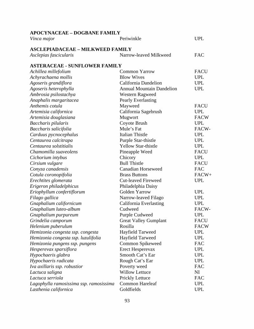
93
APOCYNACEAE – DOGBANE FAMILY Vinca major Periwinkle UPL
ASCLEPIADACEAE – MILKWEED FAMILY Asclepias fascicularis Narrow-leaved Milkweed FAC
ASTERACEAE - SUNFLOWER FAMILY Achillea millefolium Common Yarrow FACU Achyrachaena mollis Blow Wives UPL Agoseris grandiflora California Dandelion UPL Agoseris heterophylla Annual Mountain Dandelion UPL Ambrosia psilostachya Western Ragweed Anaphalis margaritacea Pearly Everlasting Anthemis cotula Mayweed FACU Artemisia californica California Sagebrush UPL Artemisia douglasiana Mugwort FACW Baccharis pilularis Coyote Brush UPL Baccharis salicifolia Mule’s Fat FACW- Carduus pycnocephalus Italian Thistle UPL Centaurea calcitrapa Purple Star-thistle UPL Centaurea solstitialis Yellow Star-thistle UPL Chamomilla suaveolens Pineapple Weed FACU Cichorium intybus Chicory UPL Cirsium vulgare Bull Thistle FACU Conyza canadensis Canadian Horseweed FAC Cotula coronopifolia Brass Buttons FACW+ Erechtites glomerata Cut-leaved Fireweed UPL Erigeron philadelphicus Philadelphia Daisy Eriophyllum confertiflorum Golden Yarrow UPL Filago gallica Narrow-leaved Filago UPL Gnaphalium californicum California Everlasting UPL Gnaphalium luteo-album Cudweed FACW- Gnaphalium purpureum Purple Cudweed UPL Grindelia camporum Great Valley Gumplant FACU Helenium puberulum Rosilla FACW Hemizonia congesta ssp. congesta Hayfield Tarweed UPL Hemizonia congesta ssp. luzulifolia Hayfield Tarweed UPL Hemizonia pungens ssp. pungens Common Spikeweed FAC Hesperevax sparsiflora Erect Hesperevax UPL Hypochaeris glabra Smooth Cat’s Ear UPL Hypochaeris radicata Rough Cat’s Ear UPL Iva axillaris ssp. robustior Poverty weed FAC Lactuca saligna Willow Lettuce NI Lactuca serriola Prickly Lettuce FAC Lagophylla ramosissima ssp. ramosissima Common Hareleaf UPL Lasthenia californica Goldfields UPL
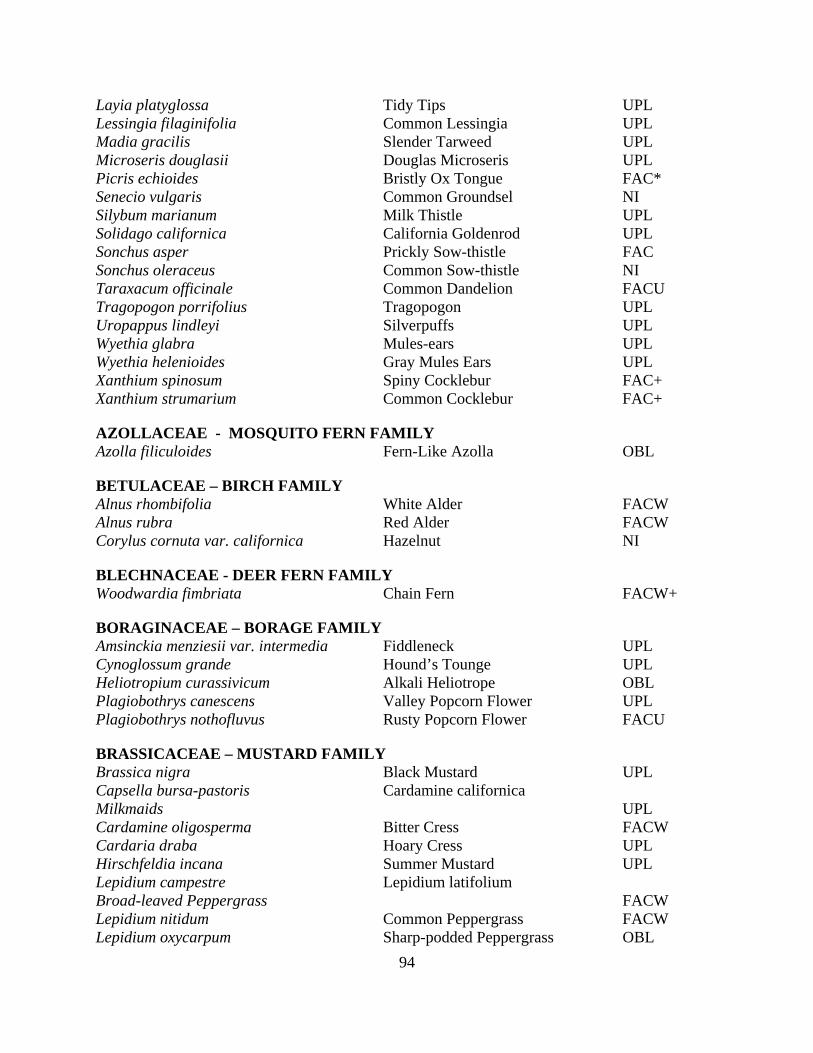
94
Layia platyglossa Tidy Tips UPL Lessingia filaginifolia Common Lessingia UPL Madia gracilis Slender Tarweed UPL Microseris douglasii Douglas Microseris UPL Picris echioides Bristly Ox Tongue FAC* Senecio vulgaris Common Groundsel NI Silybum marianum Milk Thistle UPL Solidago californica California Goldenrod UPL Sonchus asper Prickly Sow-thistle FAC Sonchus oleraceus Common Sow-thistle NI Taraxacum officinale Common Dandelion FACU Tragopogon porrifolius Tragopogon UPL Uropappus lindleyi Silverpuffs UPL Wyethia glabra Mules-ears UPL Wyethia helenioides Gray Mules Ears UPL Xanthium spinosum Spiny Cocklebur FAC+ Xanthium strumarium Common Cocklebur FAC+
AZOLLACEAE - MOSQUITO FERN FAMILY Azolla filiculoides Fern-Like Azolla OBL
BETULACEAE – BIRCH FAMILY Alnus rhombifolia White Alder FACW Alnus rubra Red Alder FACW Corylus cornuta var. californica Hazelnut NI
BLECHNACEAE - DEER FERN FAMILY Woodwardia fimbriata Chain Fern FACW+
BORAGINACEAE – BORAGE FAMILY Amsinckia menziesii var. intermedia Fiddleneck UPL Cynoglossum grande Hound’s Tounge UPL Heliotropium curassivicum Alkali Heliotrope OBL Plagiobothrys canescens Valley Popcorn Flower UPL Plagiobothrys nothofluvus Rusty Popcorn Flower FACU
BRASSICACEAE – MUSTARD FAMILY Brassica nigra Black Mustard UPL Capsella bursa-pastoris Cardamine californica Milkmaids UPL Cardamine oligosperma Bitter Cress FACW Cardaria draba Hoary Cress UPL Hirschfeldia incana Summer Mustard UPL Lepidium campestre Lepidium latifolium Broad-leaved Peppergrass FACW Lepidium nitidum Common Peppergrass FACW Lepidium oxycarpum Sharp-podded Peppergrass OBL
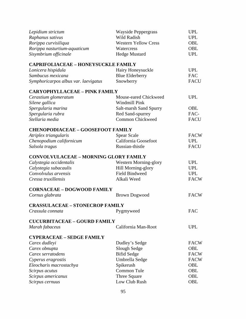
95
Lepidium strictum Wayside Peppergrass UPL Raphanus sativus Wild Radish UPL Rorippa curvisiliqua Western Yellow Cress OBL Rorippa nasturtium-aquaticum Watercress OBL Sisymbrium officinale Hedge Mustard UPL
CAPRIFOLIACEAE – HONEYSUCKLE FAMILY Lonicera hispidula Hairy Honeysuckle UPL Sambucus mexicana Blue Elderberry FAC Symphoricarpos albus var. laevigatus Snowberry FACU
CARYOPHYLLACEAE – PINK FAMILY Cerastium glomeratum Mouse-eared Chickweed UPL Silene gallica Windmill Pink Spergularia marina Salt-marsh Sand Spurry OBL Spergularia rubra Red Sand-spurrey FAC- Stellaria media Common Chickweed FACU
CHENOPODIACEAE – GOOSEFOOT FAMILY Atriplex triangularis Spear Scale FACW Chenopodium californicum California Goosefoot UPL Salsola tragus Russian-thistle FACU
CONVOLVULACEAE – MORNING GLORY FAMILY Calystegia occidentalis Western Morning-glory UPL Calystegia subacaulis Hill Morning-glory UPL Convolvulus arvensis Field Bindweed UPL Cressa truxillensis Alkali Weed FACW
CORNACEAE – DOGWOOD FAMILY Cornus glabrata Brown Dogwood FACW
CRASSULACEAE – STONECROP FAMILY Crassula connata Pygmyweed FAC
CUCURBITACEAE – GOURD FAMILY Marah fabaceus California Man-Root UPL
CYPERACEAE – SEDGE FAMILY Carex dudleyi Dudley’s Sedge FACW Carex obnupta Slough Sedge OBL Carex serratodens Bifid Sedge FACW Cyperus eragrostis Umbrella Sedge FACW Eleocharis macrostachya Spikerush OBL Scirpus acutus Common Tule OBL Scirpus americanus Three Square OBL Scirpus cernuus Low Club Rush OBL
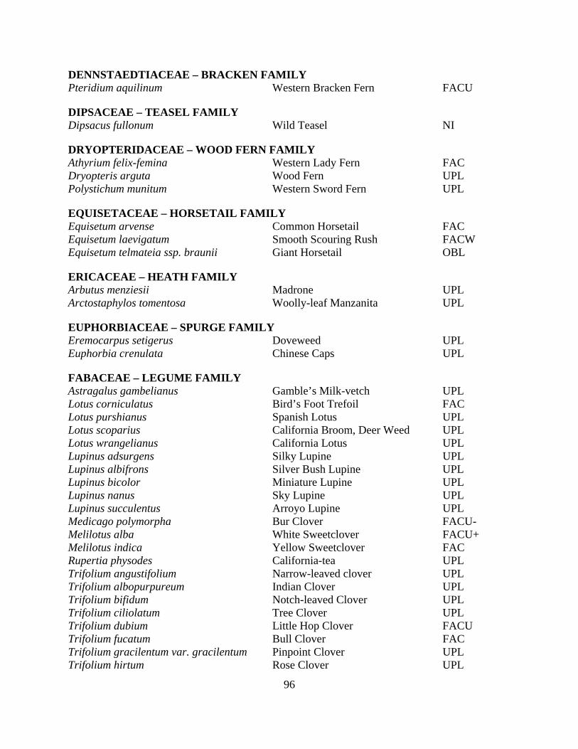
96
DENNSTAEDTIACEAE – BRACKEN FAMILY Pteridium aquilinum Western Bracken Fern FACU
DIPSACEAE – TEASEL FAMILY Dipsacus fullonum Wild Teasel NI
DRYOPTERIDACEAE – WOOD FERN FAMILY Athyrium felix-femina Western Lady Fern FAC Dryopteris arguta Wood Fern UPL Polystichum munitum Western Sword Fern UPL
EQUISETACEAE – HORSETAIL FAMILY Equisetum arvense Common Horsetail FAC Equisetum laevigatum Smooth Scouring Rush FACW Equisetum telmateia ssp. braunii Giant Horsetail OBL
ERICACEAE – HEATH FAMILY Arbutus menziesii Madrone UPL Arctostaphylos tomentosa Woolly-leaf Manzanita UPL
EUPHORBIACEAE – SPURGE FAMILY Eremocarpus setigerus Doveweed UPL Euphorbia crenulata Chinese Caps UPL
FABACEAE – LEGUME FAMILY Astragalus gambelianus Gamble’s Milk-vetch UPL Lotus corniculatus Bird’s Foot Trefoil FAC Lotus purshianus Spanish Lotus UPL Lotus scoparius California Broom, Deer Weed UPL Lotus wrangelianus California Lotus UPL Lupinus adsurgens Silky Lupine UPL Lupinus albifrons Silver Bush Lupine UPL Lupinus bicolor Miniature Lupine UPL Lupinus nanus Sky Lupine UPL Lupinus succulentus Arroyo Lupine UPL Medicago polymorpha Bur Clover FACU- Melilotus alba White Sweetclover FACU+ Melilotus indica Yellow Sweetclover FAC Rupertia physodes California-tea UPL Trifolium angustifolium Narrow-leaved clover UPL Trifolium albopurpureum Indian Clover UPL Trifolium bifidum Notch-leaved Clover UPL Trifolium ciliolatum Tree Clover UPL Trifolium dubium Little Hop Clover FACU Trifolium fucatum Bull Clover FAC Trifolium gracilentum var. gracilentum Pinpoint Clover UPL Trifolium hirtum Rose Clover UPL
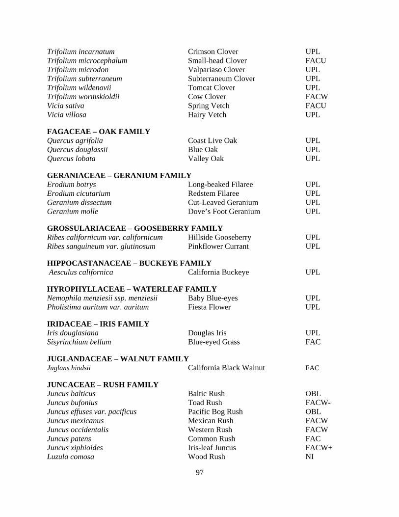
97
Trifolium incarnatum Crimson Clover UPL Trifolium microcephalum Small-head Clover FACU Trifolium microdon Valpariaso Clover UPL Trifolium subterraneum Subterraneum Clover UPL Trifolium wildenovii Tomcat Clover UPL Trifolium wormskioldii Cow Clover FACW Vicia sativa Spring Vetch FACU Vicia villosa Hairy Vetch UPL
FAGACEAE – OAK FAMILY Quercus agrifolia Coast Live Oak UPL Quercus douglassii Blue Oak UPL Quercus lobata Valley Oak UPL
GERANIACEAE – GERANIUM FAMILY Erodium botrys Long-beaked Filaree UPL Erodium cicutarium Redstem Filaree UPL Geranium dissectum Cut-Leaved Geranium UPL Geranium molle Dove’s Foot Geranium UPL
GROSSULARIACEAE – GOOSEBERRY FAMILY Ribes californicum var. californicum Hillside Gooseberry UPL Ribes sanguineum var. glutinosum Pinkflower Currant UPL
HIPPOCASTANACEAE – BUCKEYE FAMILY Aesculus californica California Buckeye UPL
HYROPHYLLACEAE – WATERLEAF FAMILY Nemophila menziesii ssp. menziesii Baby Blue-eyes UPL Pholistima auritum var. auritum Fiesta Flower UPL
IRIDACEAE – IRIS FAMILY Iris douglasiana Douglas Iris UPL Sisyrinchium bellum Blue-eyed Grass FAC
JUGLANDACEAE – WALNUT FAMILY Juglans hindsii California Black Walnut FAC
JUNCACEAE – RUSH FAMILY Juncus balticus Baltic Rush OBL Juncus bufonius Toad Rush FACW- Juncus effuses var. pacificus Pacific Bog Rush OBL Juncus mexicanus Mexican Rush FACW Juncus occidentalis Western Rush FACW Juncus patens Common Rush FAC Juncus xiphioides Iris-leaf Juncus FACW+ Luzula comosa Wood Rush NI

98
LAMIACEAE – MINT FAMILY Lepichinia calycina Pitcher Sage UPL Marrubium vulgare Horehound FAC Mentha pulegium Pennyroyal OBL Pogogyne serpylloides Thyme-leaved Pogogyne FACW Salvia mellifera Black Sage UPL Stachys ajugoides var. rigida Rigid Hedge Nettle OBL Stachys bullata Wood Mint UPL Stachys pycnantha Short-spiked Hedge Nettle FACW Trichostemma lanceolatum Vinegar Weed UPL
LAURACEAE – LAUREL FAMILY Umbellularia californica California Bay FAC
LEMNACEAE – DUCKWEED FAMILY Lemna gibba Inflated Duckweed OBL Lemna minor Duckweed OBL
LILIACEAE – LILY FAMILY Brodiaea elegans Harvest Brodiaea UPL Calochortus luteus Yellow Mariposa Lily UPL Calochortus venustus Mariposa Lily UPL Chlorogalum pomeridianum Soap Plant UPL Dichelostemma capitatum ssp. capitatum Blue Dicks UPL Muilla maritima Common Muilla UPL Trillium chloropetalum Giant Trillium UPL Triteleia laxa
LINACEAE – FLAX FAMILY Linum bienne Narrowleaf Flax UPL
LYTHRACEAE – LOOSESTRIFE FAMILY Lythrum hyssopifolia Hyssop Loosestrife FACW
MALVACEAE – MALLOW FAMILY Malva neglecta Common Mallow, Cheeses UPL Malvella leprosa Alkali Mallow FAC Sidalcea diploscypha Fringed Sidalcea Sidalcea malvaeflora ssp. laciniata Checker Bloom, Wild Hollyhock UPL
MYRTACEAE – MYRTLE FAMILY Eucalyptus globulus Blue Gum UPL
OLEACEAE – OLIVE FAMILY Fraxinus dipetala California Ash UPL
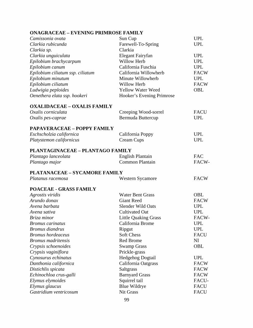
99
ONAGRACEAE – EVENING PRIMROSE FAMILY Camissonia ovata Sun Cup UPL Clarkia rubicunda Farewell-To-Spring UPL Clarkia sp. Clarkia Clarkia unguiculata Elegant Fairyfan UPL Epilobium brachycarpum Willow Herb UPL Epilobium canum California Fuschia UPL Epilobium ciliatum ssp. ciliatum California Willowherb FACW Epilobium minutum Minute Willowherb UPL Epilobium ciliatum Willow Herb FACW Ludwigia peploides Yellow Water Weed OBL Oenethera elata ssp. hookeri Hooker’s Evening Primrose
OXALIDACEAE – OXALIS FAMILY Oxalis corniculata Creeping Wood-sorrel FACU Oxalis pes-caprae Bermuda Buttercup UPL
PAPAVERACEAE – POPPY FAMILY Eschscholzia californica California Poppy UPL Platystemon californicus Cream Cups UPL
PLANTAGINACEAE – PLANTAGO FAMILY Plantago lanceolata English Plantain FAC Plantago major Common Plantain FACW-
PLATANACEAE – SYCAMORE FAMILY Platanus racemosa Western Sycamore FACW
POACEAE - GRASS FAMILY Agrostis viridis Water Bent Grass OBL Arundo donax Giant Reed FACW Avena barbata Slender Wild Oats UPL Avena sativa Cultivated Oat UPL Briza minor Little Quaking Grass FACW- Bromus carinatus California Brome UPL Bromus diandrus Ripgut UPL Bromus hordeaceus Soft Chess FACU Bromus madritensis Red Brome NI Crypsis schoenoides Swamp Grass OBL Crypsis vaginiflora Prickle-grass Cynosurus echinatus Hedgehog Dogtail UPL Danthonia californica California Oatgrass FACW Distichlis spicata Saltgrass FACW Echinochloa crus-galli Barnyard Grass FACW Elymus elymoides Squirrel tail FACU- Elymus glaucus Blue Wildrye FACU Gastridium ventricosum Nit Grass FACU

100
Hordeum brachyanthurumCalifornia Barley FACW Hordeum marinum ssp. gussoneanum Mediterranean Barley FAC Hordeum murinum ssp. leporinum Barnyard Barley NI Lamarkia aurea Goldentop UPL Leymus triticoides Creeping Wildrye FAC+ Lolium multiflorum Ryegrass FAC Lolium perenne Perennial Rye FAC Melica torreyana Melic Grass UPL Nassella cernua Nodding Needle Grass Nassella pulchra Purple Needle Grass UPL Paspalum distichum Knotgrass OBL Phalaris aquatica Harding Grass FAC+ Poa annua Annual Bluegrass FACW- Poa secunda Oneside Blue Grass UPL Polypogon monspeliensis Annual Beardgrass FACW Vulpia bromoides Six-week Fescue FACW Vulpia microstachys Pacific Fescue UPL
POLEMONIACEAE – PHLOX FAMILY Navarretia sp. Navarretia
POLYGONACEAE - BUCKWHEAT FAMILY Eriogonum nudum var.nudum Naked-stemmed Buckwheat UPL Polygonum amphibium var. emersum Swamp Knotweed OBL Polygonum arenastrum Common Knotweed FAC Polygonum hydropiperoides Water-pepper OBL Polygonum persicaria Lady’s Thumb FACW Pterostegia drymarioides Pterostigia UPL Rumex acetosella Sheep Sorrel FAC_ Rumex crispus Curly Dock FACW Rumex pulcher Fiddle Dock FAC+ Rumex salicifolius Willow Dock OBL
POLYPODIACEAE – POLYPLODY FAMILY Polypodium californicum California Polypody UPL
PORTULACACEAE – PURSLANE FAMILY Calandrinia ciliata Red Maids FACU Claytonia gypsophiloides Coast Claytonia UPL Claytonia parviflora ssp. parviflora Small-leaved Claytonia UPL Claytonia perfoliata ssp. perfoliata Miner’s Lettuce FAC Portulaca oleracea Common Purslane FAC
POTAMOGETONACEAE - PONDWEED FAMILY Potamogeton nodosus Long-leaved Pondweed OBL
PRIMULACEAE – PRIMROSE FAMILY
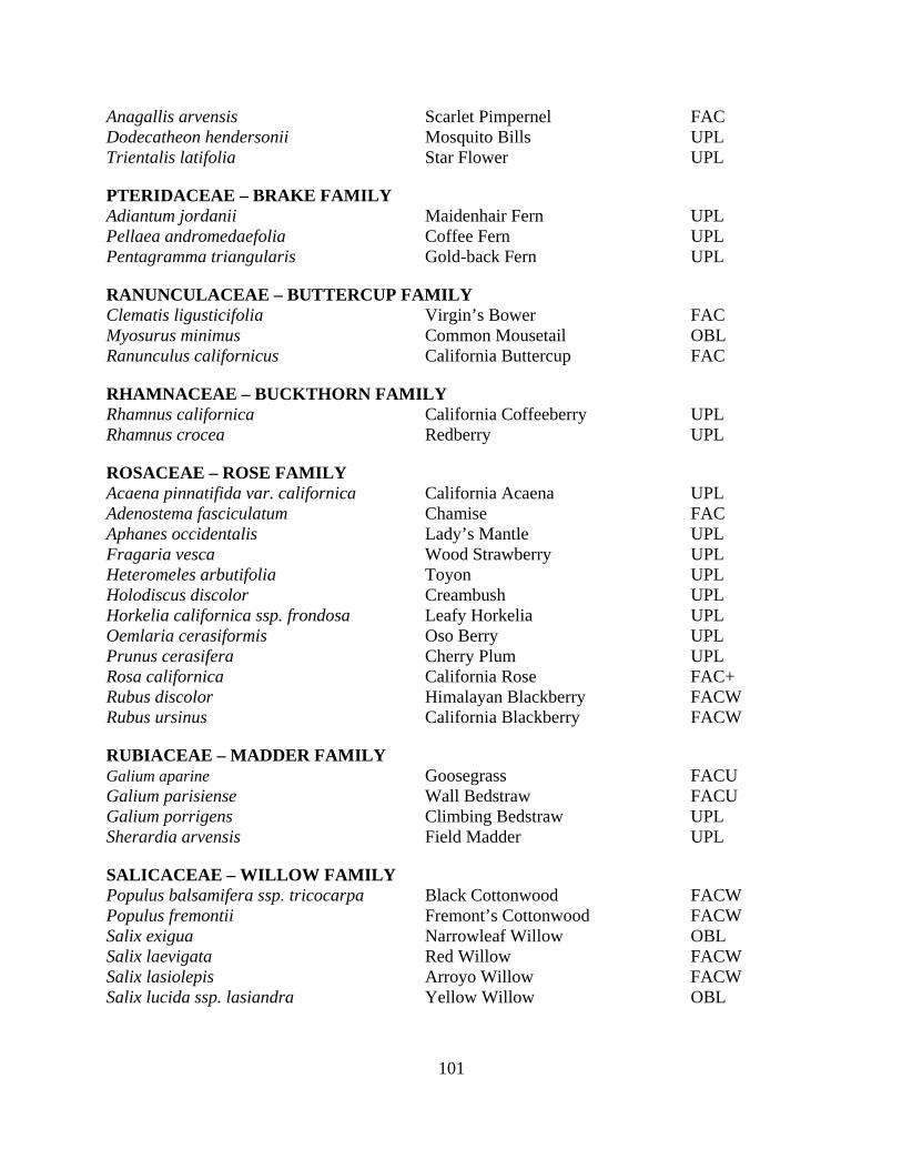
101
Anagallis arvensis Scarlet Pimpernel FAC Dodecatheon hendersonii Mosquito Bills UPL Trientalis latifolia Star Flower UPL
PTERIDACEAE – BRAKE FAMILY Adiantum jordanii Maidenhair Fern UPL Pellaea andromedaefolia Coffee Fern UPL Pentagramma triangularis Gold-back Fern UPL
RANUNCULACEAE – BUTTERCUP FAMILY Clematis ligusticifolia Virgin’s Bower FAC Myosurus minimus Common Mousetail OBL Ranunculus californicus California Buttercup FAC
RHAMNACEAE – BUCKTHORN FAMILY Rhamnus californica California Coffeeberry UPL Rhamnus crocea Redberry UPL
ROSACEAE – ROSE FAMILY Acaena pinnatifida var. californica California Acaena UPL Adenostema fasciculatum Chamise FAC Aphanes occidentalis Lady’s Mantle UPL Fragaria vesca Wood Strawberry UPL Heteromeles arbutifolia Toyon UPL Holodiscus discolor Creambush UPL Horkelia californica ssp. frondosa Leafy Horkelia UPL Oemlaria cerasiformis Oso Berry UPL Prunus cerasifera Cherry Plum UPL Rosa californica California Rose FAC+ Rubus discolor Himalayan Blackberry FACW Rubus ursinus California Blackberry FACW
RUBIACEAE – MADDER FAMILY Galium aparine Goosegrass FACU Galium parisiense Wall Bedstraw FACU Galium porrigens Climbing Bedstraw UPL Sherardia arvensis Field Madder UPL
SALICACEAE – WILLOW FAMILY Populus balsamifera ssp. tricocarpa Black Cottonwood FACW Populus fremontii Fremont’s Cottonwood FACW Salix exigua Narrowleaf Willow OBL Salix laevigata Red Willow FACW Salix lasiolepis Arroyo Willow FACW Salix lucida ssp. lasiandra Yellow Willow OBL
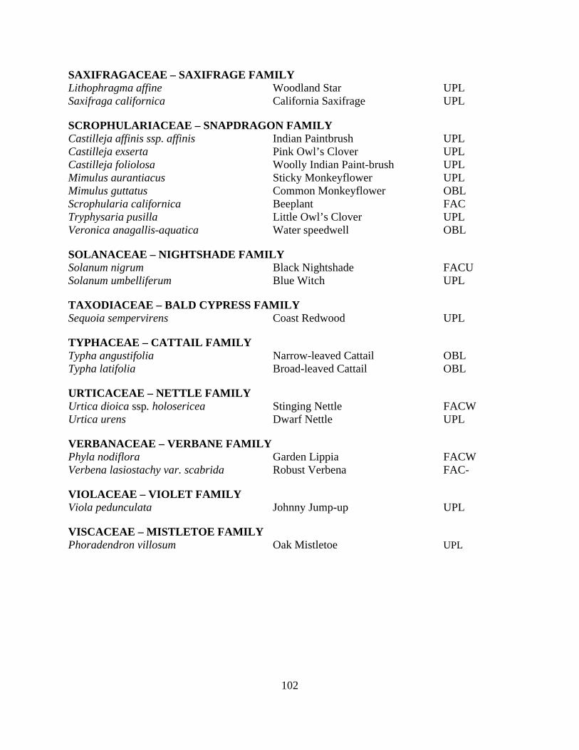
102
SAXIFRAGACEAE – SAXIFRAGE FAMILY Lithophragma affine Woodland Star UPL Saxifraga californica California Saxifrage UPL
SCROPHULARIACEAE – SNAPDRAGON FAMILY Castilleja affinis ssp. affinis Indian Paintbrush UPL Castilleja exserta Pink Owl’s Clover UPL Castilleja foliolosa Woolly Indian Paint-brush UPL Mimulus aurantiacus Sticky Monkeyflower UPL Mimulus guttatus Common Monkeyflower OBL Scrophularia californica Beeplant FAC Tryphysaria pusilla Little Owl’s Clover UPL Veronica anagallis-aquatica Water speedwell OBL
SOLANACEAE – NIGHTSHADE FAMILY Solanum nigrum Black Nightshade FACU Solanum umbelliferum Blue Witch UPL
TAXODIACEAE – BALD CYPRESS FAMILY Sequoia sempervirens Coast Redwood UPL
TYPHACEAE – CATTAIL FAMILY Typha angustifolia Narrow-leaved Cattail OBL Typha latifolia Broad-leaved Cattail OBL
URTICACEAE – NETTLE FAMILY Urtica dioica ssp. holosericea Stinging Nettle FACW Urtica urens Dwarf Nettle UPL
VERBANACEAE – VERBANE FAMILY Phyla nodiflora Garden Lippia FACW Verbena lasiostachy var. scabrida Robust Verbena FAC-
VIOLACEAE – VIOLET FAMILY Viola pedunculata Johnny Jump-up UPL
VISCACEAE – MISTLETOE FAMILY Phoradendron villosum Oak Mistletoe UPL
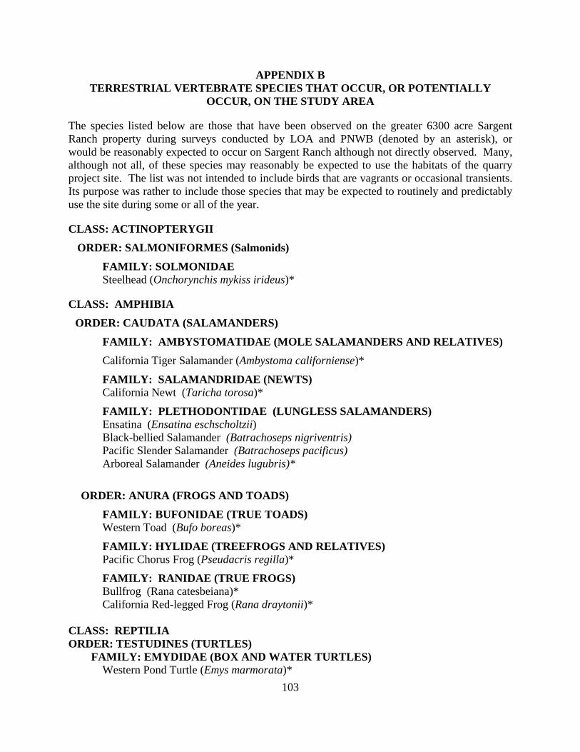
103
APPENDIX B TERRESTRIAL VERTEBRATE SPECIES THAT OCCUR, OR POTENTIALLY
OCCUR, ON THE STUDY AREA
The species listed below are those that have been observed on the greater 6300 acre Sargent Ranch property during surveys conducted by LOA and PNWB (denoted by an asterisk), or would be reasonably expected to occur on Sargent Ranch although not directly observed. Many, although not all, of these species may reasonably be expected to use the habitats of the quarry project site. The list was not intended to include birds that are vagrants or occasional transients. Its purpose was rather to include those species that may be expected to routinely and predictably use the site during some or all of the year.
CLASS: ACTINOPTERYGII
ORDER: SALMONIFORMES (Salmonids)
FAMILY: SOLMONIDAE Steelhead (Onchorynchis mykiss irideus)*
CLASS: AMPHIBIA
ORDER: CAUDATA (SALAMANDERS)
FAMILY: AMBYSTOMATIDAE (MOLE SALAMANDERS AND RELATIVES)
California Tiger Salamander (Ambystoma californiense)*
FAMILY: SALAMANDRIDAE (NEWTS) California Newt (Taricha torosa)*
FAMILY: PLETHODONTIDAE (LUNGLESS SALAMANDERS) Ensatina (Ensatina eschscholtzii) Black-bellied Salamander (Batrachoseps nigriventris) Pacific Slender Salamander (Batrachoseps pacificus) Arboreal Salamander (Aneides lugubris)*
ORDER: ANURA (FROGS AND TOADS)
FAMILY: BUFONIDAE (TRUE TOADS) Western Toad (Bufo boreas)*
FAMILY: HYLIDAE (TREEFROGS AND RELATIVES) Pacific Chorus Frog (Pseudacris regilla)*
FAMILY: RANIDAE (TRUE FROGS) Bullfrog (Rana catesbeiana)* California Red-legged Frog (Rana draytonii)* CLASS: REPTILIA ORDER: TESTUDINES (TURTLES) FAMILY: EMYDIDAE (BOX AND WATER TURTLES) Western Pond Turtle (Emys marmorata)*

104
ORDER: SQUAMATA (LIZARDS AND SNAKES)
SUBORDER: SAURIA (LIZARDS)
FAMILY: PHRYNOSOMATIDAE Western Fence Lizard (Sceloporus occidentalis)*
FAMILY: SCINCIDAE (SKINKS) Gilbert Skink (Eumeces gilberti)
FAMILY: ANGUIDAE (ALLIGATOR LIZARDS AND RELATIVES) Southern Alligator Lizard (Elgaria multicarinata)*
SUBORDER: SERPENTES (SNAKES)
FAMILY: BOIDAE (BOAS) Rubber Boa (Charina bottae)
FAMILY: COLUBRIDAE (COLUBRIDS) Racer (Coluber constrictor)* Gopher Snake (Pituophis melanoleucus)* Common Kingsnake (Lampropeltis getulus) Common Garter Snake (Thamnophis sirtalis) Western Aquatic Garter Snake (Thamnophis couchi)*
FAMILY: VIPERIDAE Western Rattlesnake (Crotalus viridis)* CLASS: AVES
ORDER: CICONIIFORMES (HERONS, STORKS, IBISES, AND RELATIVES) FAMILY: PODICIPEDIDAE Pied-billed Grebe (Podilymbus podiceps)*
FAMILY: ARDEIDAE (HERONS AND BITTERNS) GREAT BLUE HERON (ARDEA HERODIAS)* BLACK-CROWNED NIGHT HERON (NYCTICORAX NYCTICORAX) GREAT EGRET (ARDEA ALBA)* SNOWY EGRET (EGRETTA THULA)*
FAMILY: CATHARTIDAE (AMERICAN VULTURES) Turkey Vulture (Cathartes aura)* California Condor (Gymnogyps californianus)
ORDER: ANSERIFORMES (SCREAMERS, DUCKS AND RELATIVES)
FAMILY: ANATIDAE (SWANS, GEESE AND DUCKS) MALLARD (ANAS PLATYRHYNCHOS)* CANADA GOOSE (BRANTA CANADENSIS)* WOOD DUCK (AIX SPONSA)*
ORDER: FALCONIFORMES (VULTURES, HAWKS, AND FALCONS)
FAMILY: ACCIPITRIDAE (HAWKS, OLD WORLD VULTURES, AND HARRIERS)
105
White-tailed Kite (Elanus caeruleus)* Bald Eagle (Haliaeetus leucocephalus)* Northern Harrier (Circus cyaneus)* Sharp-shinned Hawk (Accipiter striatus)* Cooper’s Hawk (Accipiter cooperi)* Northern Goshawk (Accipiter gentilis) Red-shouldered Hawk (Buteo lineatus)* Red-tailed Hawk (Buteo jamaicensis)* Ferruginous Hawk (Buteo regalis)* Rough-legged Hawk (Buteo lagopus) Golden Eagle (Aquila chrysaetos)*
FAMILY: FALCONIDAE (CARACARAS AND FALCONS) American Kestrel (Falco sparverius)* Merlin (Falco columbarius)* Peregrine Falcon (Falco peregrinus)* Prairie Falcon (Falco mexicanus)*
ORDER: GALLIFORMES (Megapodes, Currassows, Pheasants, and Relatives)
FAMILY: PHASIANIDAE (QUAILS, PHEASANTS AND RELATIVES)
Wild Turkey (Meleagris gallopavo)*
FAMILY: ODONTOPHORIDAE (NEW WORLD QUAIL) California Quail (Callipepla californica)*
FAMILY: LARIDAE (GULLS AND TERNS) California Gull (Larus californicus)
ORDER: CHARADRIIDAE (SHOREBIRDS, GULLS AND RELATIVES)
FAMILY: CHARADRIIDAE (PLOVERS AND RELATIVES)
KILLDEER (CHARADRIUS VOCIFEROUS)*
ORDER: COLUMBIFORMES (PIGEONS AND DOVES)
FAMILY: COLUMBIDAE (PIGEONS AND DOVES) Rock Dove (Columba livia)* Band-tailed Pigeon (Columba fasciata)* Mourning Dove (Zenaida macroura)* Eurasian Collared-dove (Streptopelia decaocto)*
ORDER: STRIGIFORMES (OWLS)
FAMILY: TYTONIDAE (BARN OWLS) Common Barn Owl (Tyto alba)*
FAMILY: STRIGIDAE (TYPICAL OWLS) Short-eared Owl (Asio flammeus) Great Horned Owl (Bubo virginianus)* Northern Saw-whet Owl (Aegolius acadicus)* Burrowing Owl (Athene cunicularia)*
106
Long-eared Owl (Asio otus) Western Screech Owl (Megascops kennicottii)*
ORDER: CAPRIMULGIFORMES (GOATSUCKERS AND RELATIVES)
FAMILY: CAPRIMULGIDAE (GOATSUCKERS) Common Nighthawk (Chordeiles minor)
ORDER: APODIFORMES (SWIFTS AND HUMMINGBIRDS)
FAMILY: TROCHILIDAE (HUMMINGBIRDS) Anna's Hummingbird (Calypte anna)* Rufous Hummingbird (Selasphorus rufus)* Allen’s Hummingbird (Selasphorus sasin)*
ORDER: CORACIIFORMES (KINGFISHERS AND RELATIVES)
FAMILY: ALCEDINIDAE (KINGFISHERS)
BELTED KINGFISHER (CERYLE ALCYON)*
ORDER: PICIFORMES (WOODPECKERS AND RELATIVES)
FAMILY: PICIDAE (WOODPECKERS AND WRYNECKS) Acorn Woodpecker (Melanerpes formicivorous)* Red-breasted Sapsucker (Sphyrapicus rubber)* Northern Flicker (Colaptes auratus)* Hairy Woodpecker (Picoides villosus)* Nuttall’s Woodpecker (Picoides nuttallii)* Downy Woodpecker (Picoides pubescens)*
ORDER: PASSERIFORMES (PERCHING BIRDS)
FAMILY: TYRANNIDAE (TYRANT FLYCATCHERS) Olive-sided Flycatcher (Contopus borealis)* Western Wood-Pewee (Contopus sordidulus) Dusky Flycatcher (Empidonax oberholseri) Pacific Slope Flycatcher (Empidonax difficilis)* Black Phoebe (Sayornis nigricans)* Say’s Phoebe (Sayornis saya)* Ash-throated Flycatcher (Myiarchus cinerascens)* Western Kingbird (Tyrannus verticalis)*
FAMILY: LANIIDAE (SHRIKES) Loggerhead Shrike (Lanius ludovicianus)*
FAMILY: VIREONIDAE (TYPICAL VIREOS) Cassin’s Vireo (Vireo cassinii) Hutton’s Vireo (Vireo huttoni)*
FAMILY: CORVIDAE (JAYS, MAGPIES, AND CROWS) Scrub Jay (Aphelocoma coerulescens)* Yellow-billed magpie (Pica nuttalli)* American Crow (Corvus brachyrhynchos)*

107
Common Raven (Corvus corax)*
FAMILY: ALAUDIDAE (LARKS) Horned Lark (Eremophila alpestris)*
FAMILY: HIRUNDINIDAE (SWALLOWS) Tree Swallow (Tachycineta bicolor)* Violet-green Swallow (Tachycineta thalassina)* Cliff Swallow (Hirundo pyrrhonota) Barn Swallow (Hirundo rustica) Bank Swallow (Riparia riparia)*
FAMILY: PARIDAE (TITMICE) Oak Titmouse (Parus inornatus)* Chestnut-backed chickadee (Parus rufescens)*
FAMILY: AEGITHALIDAE (BUSHTIT) Bushtit (Psaltriparus minimus)*
FAMILY: SITTIDAE (NUTHATCHES) White-breasted Nuthatch (Sitta carolinensis)*
FAMILY: TROGLODYTIDAE (WRENS) Bewick’s Wren (Thryomanes bewickii)* House Wren (Troglodytes aedon)
FAMILY: REGULIDAE (KINGLETS) Golden-crowned Kinglet (Regulus regulus)* Ruby-crowned Kinglet (Regulus calendula)*
FAMILY: TURDIDAE (THRUSHES) Western Bluebird (Sialia currucoides)* Hermit Thrush (Catharus guttatus)* American Robin (Turdus migratorius)* Varied Thrush (Ixoreus naevius)
FAMILY: TIMALIIDAE (BABBLERS) Wrentit (Chamaea fasciata)*
FAMILY: MIMIDAE (MOCKINGBIRDS AND THRASHERS) Northern Mockingbird (Mimus polyglottos)* California Thrasher (Toxostoma redivivum)*
FAMILY: STURNIDAE (STARLINGS) European Starling (Sturnus vulgaris)*
FAMILY: MOTACILLIDAE (WAGTAILS AND PIPITS) American Pipit (Anthus rubescens)*
FAMILY: BOMBYCILLIDAE (WAXWINGS) Cedar Waxwing (Bombycilla cedrorum)
FAMILY: PTILOGONATIDAE (SILKY FLYCATCHERS) Phainopepla (Phainopepla nitens)
108
FAMILY: PARULIDAE (WOOD WARBLERS AND RELATIVES) California Yellow Warbler (Dendroica petechia brewsteri) Yellow-rumped Warbler (Dendroica coronata)* Townsend’s Warbler (Dendroica townsendi)* Wilson’s Warbler (Wilsonia pusilla)* Orange-crowned Warbler (Vermivora celata)* Common Yellowthroat (Geothlypis trichas)*
FAMILY: EMBERIZIDAE (EMBERIZINES) Spotted towhee (Pipilo maculates)* California towhee (Pipilo crissalis)* Rufous-crowned Sparrow (Aimophila ruficeps) Chipping Sparrow (Spizella passerina)* Black-chinned Sparrow (Spizella atrogularis) Savannah Sparrow (Passerculus sandwichensis) Song Sparrow (Melospiza melodia)* Lincoln’s Sparrow (Melospiza lincolnii)* Golden-crowned Sparrow (Zonotrichia atricapilla)* Dark-eyed Junco (Junco hyemalis)* Lark Sparrow (Chondestes grammacus)* Sage Sparrow (Amphispiza belli)* Grasshopper Sparrow (Ammodramus savannarum)*
FAMILY: CARDINALIDAE (CARDINALS, GROSBEAKS AND ALLIES) Black-headed Grosbeak (Pheucticus melanocephalus)* Lazuli Bunting (Passerina amoena)*
FAMILY: ICTERIDAE (BLACKBIRDS, ORIOLES AND ALLIES) Red-winged Blackbird (Agelaius phoeniceus)* Western Meadowlark (Sturnella neglecta)* Brewer's Blackbird (Euphagus cyanocephalus)* Brown-headed Cowbird (Molothrus ater)* Bullocks oriole (Icterus bullockii)*
FAMILY: FRINGILLIDAE (FINCHES) Purple Finch (Carpodacus purpureus)* House Finch (Carpodacus mexicanus)* Lesser Goldfinch (Carduelis psaltria)* American Goldfinch (Carduelis tristis)*
FAMILY: PASSERIDAE (OLD WORLD SPARROWS) House Sparrow (Passer domesticus)* CLASS: MAMMALIA
ORDER: DIDELPHIMORPHIA (MARSUPIALS)
FAMILY: DIDELPHIDAE (OPOSSUMS) Virginia Opossum (Didelphis virginiana)*
ORDER: INSECTIVORA (SHREWS AND MOLES)
109
FAMILY: SORICIDAE (SHREWS) Ornate Shrew (Sorex ornatus) Trowbridge’s Shrew (Sorex trowbridgii)
FAMILY: TALPIDAE (MOLES) Broad-footed Mole (Scapanus latimanus)
ORDER: CHIROPTERA (BATS)
FAMILY: VESPERTILIONIDAE (VESPERTILIONID BATS) Little Brown Myotis (Myotis lucifugus) California Myotis (Myotis californicus) Western Pipistrelle (Pipistrellus hesperus) Big Brown Bat (Eptesicus fuscus) Townsend's Big-eared Bat (Plecotus townsendii) Pallid Bat (Antrozous pallidus)
FAMILY: MOLOSSIDAE (FREE-TAILED BAT) Brazilian Free-tailed Bat (Tadarida brasiliensis) Western Mastiff Bay (Eumops perotis)
ORDER: LAGOMORPHA (RABBITS, HARES, AND PIKAS)
FAMILY: LEPORIDAE (RABBITS AND HARES) Desert Cottontail (Sylvilagus audubonii) Black-tailed Hare (Lepus californicus)* Brush Rabbit (Sylvilagus bachmani)*
ORDER: RODENTIA (SQUIRRELS, RATS, MICE, AND RELATIVES)
FAMILY: SCIURIDAE (SQUIRRELS, CHIPMUNKS, AND MARMOTS) California Ground Squirrel (Spermophilus beecheyi)* Western Gray Squirrel (Sciurus griseus)
FAMILY: GEOMYIDAE (POCKET GOPHERS) Botta’s Pocket Gopher (Thomomys bottae)*
FAMILY: HETEROMYIDAE (POCKET MICE AND KANGAROO RATS) California Pocket Mouse (Perognathus californicus)*
FAMILY: MURIDAE (MICE, RATS AND VOLES) Western Harvest Mouse (Reithrodontomys megalotis)* California Mouse (Peromyscus californicus)* Deer Mouse (Peromyscus maniculatus)* California Vole (Microtus californicus)*
ORDER: CARNIVORA (CARNIVORES)
FAMILY: CANIDAE (FOXES, WOLVES, AND RELATIVES) Coyote (Canis latrans)* Red Fox (Vulpes vulpes) Gray Fox (Urocyon cinereoargenteus)* Domestic Dog (Canis familiaris)*
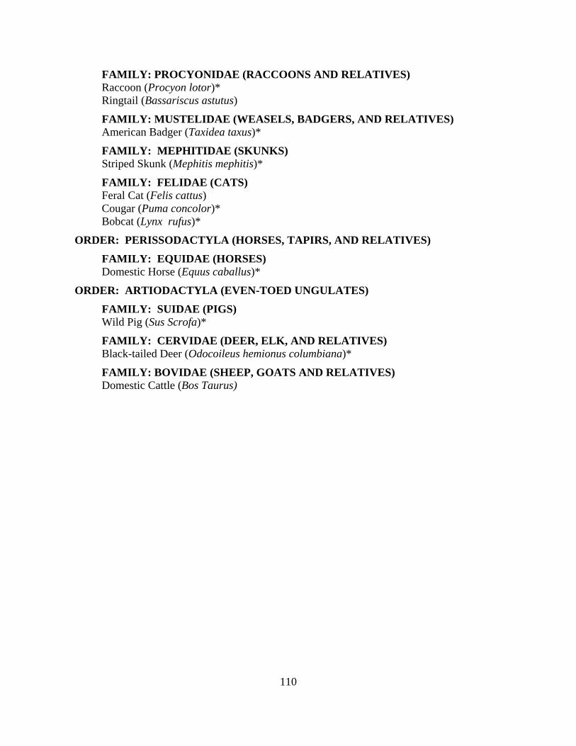
110
FAMILY: PROCYONIDAE (RACCOONS AND RELATIVES) Raccoon (Procyon lotor)* Ringtail (Bassariscus astutus)
FAMILY: MUSTELIDAE (WEASELS, BADGERS, AND RELATIVES) American Badger (Taxidea taxus)*
FAMILY: MEPHITIDAE (SKUNKS) Striped Skunk (Mephitis mephitis)*
FAMILY: FELIDAE (CATS) Feral Cat (Felis cattus) Cougar (Puma concolor)* Bobcat (Lynx rufus)*
ORDER: PERISSODACTYLA (HORSES, TAPIRS, AND RELATIVES)
FAMILY: EQUIDAE (HORSES) Domestic Horse (Equus caballus)*
ORDER: ARTIODACTYLA (EVEN-TOED UNGULATES)
FAMILY: SUIDAE (PIGS) Wild Pig (Sus Scrofa)*
FAMILY: CERVIDAE (DEER, ELK, AND RELATIVES) Black-tailed Deer (Odocoileus hemionus columbiana)*
FAMILY: BOVIDAE (SHEEP, GOATS AND RELATIVES) Domestic Cattle (Bos Taurus)

111
APPENDIX C: MINIMIZATION MEASURES FOR CALIFORNIA RED-LEGGED FROG AND CALIFORNIA TIGER SALAMANDER
The following measures will minimize direct and indirect impacts to California red-legged frogs and California tiger salamanders.
Prior to the start of construction, a qualified biologist will train all project staff regarding habitat sensitivity, identification of special status species, and required practices. The training shall include the general measures that are being implemented to conserve these species as they relate to the project, the penalties for non-compliance, and the boundaries of the project area. A fact sheet or other supporting materials containing this information should be prepared and distributed. Upon completion of training, employees will sign a form stating that they attended the training and understand all the conservation and protection measures.
A qualified biologist will survey the project site prior to, and be present to monitor,
construction activities during any initial ground disturbance or vegetation clearing or other periods during construction, as necessary. The biologist will capture and relocate any California red-legged frogs and California tiger salamanders that are discovered during the surveys or construction monitoring. Any individuals that are captured should be held for the minimum amount of time necessary to release them to suitable habitat outside of the work area.
A qualified biologist will stake and flag exclusion zones around all known locations of
CRLF and CTS breeding and upland refugia areas in the construction zone. These areas will be avoided during construction activities to the maximum extent practicable. All construction areas will be flagged, and all activity will be confined to these areas.
If a CRLF or CTS is encountered during construction work, activities will cease until the
animal is removed and relocated by a qualified biologist.
Construction activities should be limited to the period from May 1 through October 31.
Permanent and temporary construction disturbances and other types of project-related disturbances to CRLF or CTS habitat shall be minimized to the maximum extent practicable and confined to the project site. To minimize temporary disturbances, all project-related vehicle traffic shall be restricted to established roads, construction areas, designated cross-country routes, and other designated areas. These areas also should be included in preconstruction surveys and, to the maximum extent possible, should be established in locations disturbed by previous activities to prevent further adverse effects. Sensitive habitat areas shall be delineated with high visibility flagging or fencing to prevent encroachment of construction personnel and equipment into any sensitive areas during project work activities. At no time shall equipment or personnel be allowed to adversely affect areas outside the project site without authorization from the Service.

112
Because dusk and dawn are often the times when CRLF and CTS are most actively foraging and dispersing, all construction activities should cease one half hour before sunset and should not begin prior to one half hour before sunrise.
No canine or feline pets or firearms (except for federal, state, or local law enforcement
officers and security personnel) shall be permitted at the project site to avoid harassment, killing, or injuring of CRLF or CTS.
A representative shall be appointed by the applicant who will be the contact source for
any employee or contractor who might inadvertently kill or injure a CRLF or CTS or who finds a dead, injured or entrapped individual. The representative shall be identified during the tailgate/training session. The representative’s name and telephone number shall be provided to the Service prior to the initiation of ground disturbance activities.
Tightly woven fiber netting or similar material shall be used for erosion control or other
purposes at the project site to ensure that CRLF and CTS do not get trapped.
A litter control program shall be instituted at the entire project site. All construction personnel should ensure that food scraps, paper wrappers, food containers, cans, bottles, and other trash from the project area are deposited in covered or closed trash containers. The trash containers should be removed from the project area at the end of each working day.