Embed Size (px)
Citation preview

Biological Evaluation of the Proposed Marina at Scorpion Bay, Lake Pleasant, Maricopa County, Arizona
Prepared for
Terracon
Prepared by
SWCA Environmental Consultants
November 2005
BIOLOGICAL EVALUATION OF THE PROPOSED MARINA AT SCORPION BAY, LAKE PLEASANT, MARICOPA COUNTY, ARIZONA
Prepared for
Terracon Attn: Mr. Dave Matson
4685 S. Ash Avenue, Suite H4 Tempe, AZ 85282
(480) 897-8200
Prepared by
Olivia M. Munzer
SWCA Environmental Consultants 2120 North Central Avenue, Suite 130
Phoenix, AZ 85004 (602) 274-3831
Project No. 10458-107
November 30, 2005
TABLE OF CONTENTS
Executive Summary ......................................................................................................................... v
Introduction...................................................................................................................................... 1 Project Description....................................................................................................................... 1
Methods ........................................................................................................................................... 1
Results ............................................................................................................................................ 4 Affected Environment .................................................................................................................. 4
Ecological Overview ................................................................................................................ 4 Vegetation Communities .......................................................................................................... 4 Upland Vegetation Communities ............................................................................................. 4 Xeroriparian Vegetation Communities..................................................................................... 4 Lentic Vegetation Communities ............................................................................................... 5 State Protected Native Plants.................................................................................................... 5
Federally Listed Species............................................................................................................... 6
Other Special Status Species ........................................................................................................ 9 Hohokam Agave ....................................................................................................................... 9 Longfin dace ............................................................................................................................. 9 Arizona Toad .......................................................................................................................... 10 Lowland Leopard Frog ........................................................................................................... 10 Bald Eagle............................................................................................................................... 10 Southwestern Willow Flycatcher............................................................................................ 11 Sonoran Desert Tortoise ......................................................................................................... 11 Western Red Bat ..................................................................................................................... 11
Recommendations.......................................................................................................................... 12
Additional Information .................................................................................................................. 13
Signatures....................................................................................................................................... 13
Literature Cited .............................................................................................................................. 14
Appendix A Wildlife Observed In The Project Area..................................................................A-1
Appendix B Plant Species Observed In The Project Area.......................................................... B-1
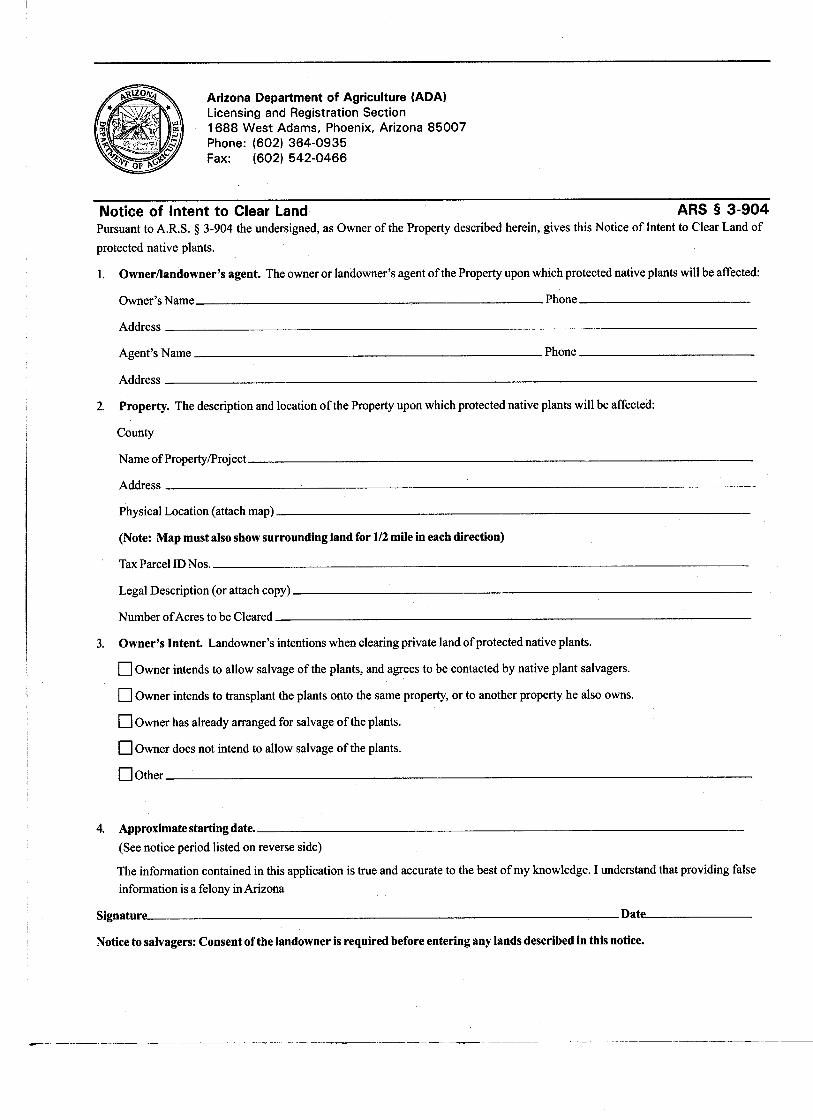
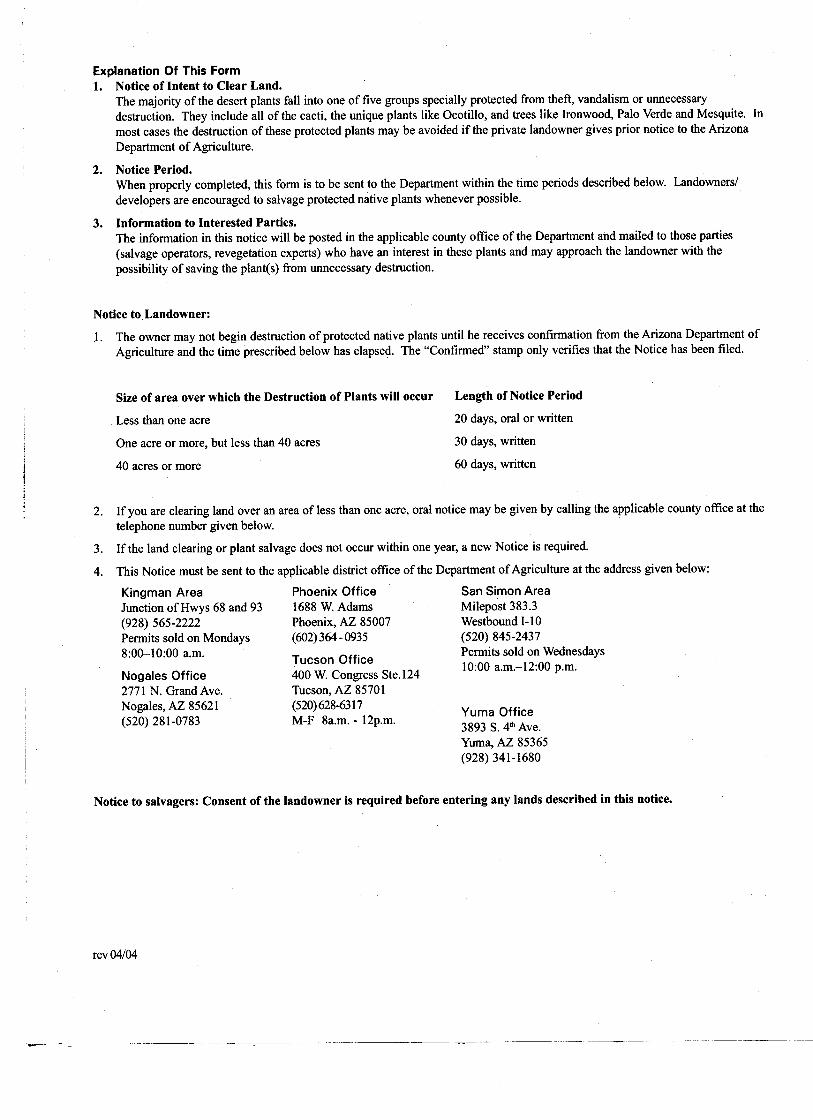
Appendix C ADA Notice Of Intent To Clear Land Form .......................................................... C-1
Appendix D AGFD Correspondence ..........................................................................................D-1
Appendix E Guidelines For Handling Sonoran Desert Tortoises ............................................... E-1
iii
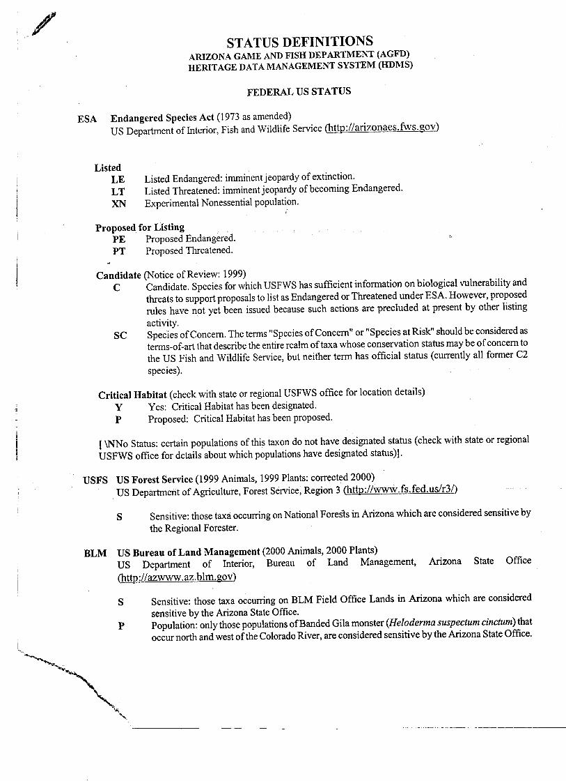
LIST OF FIGURES
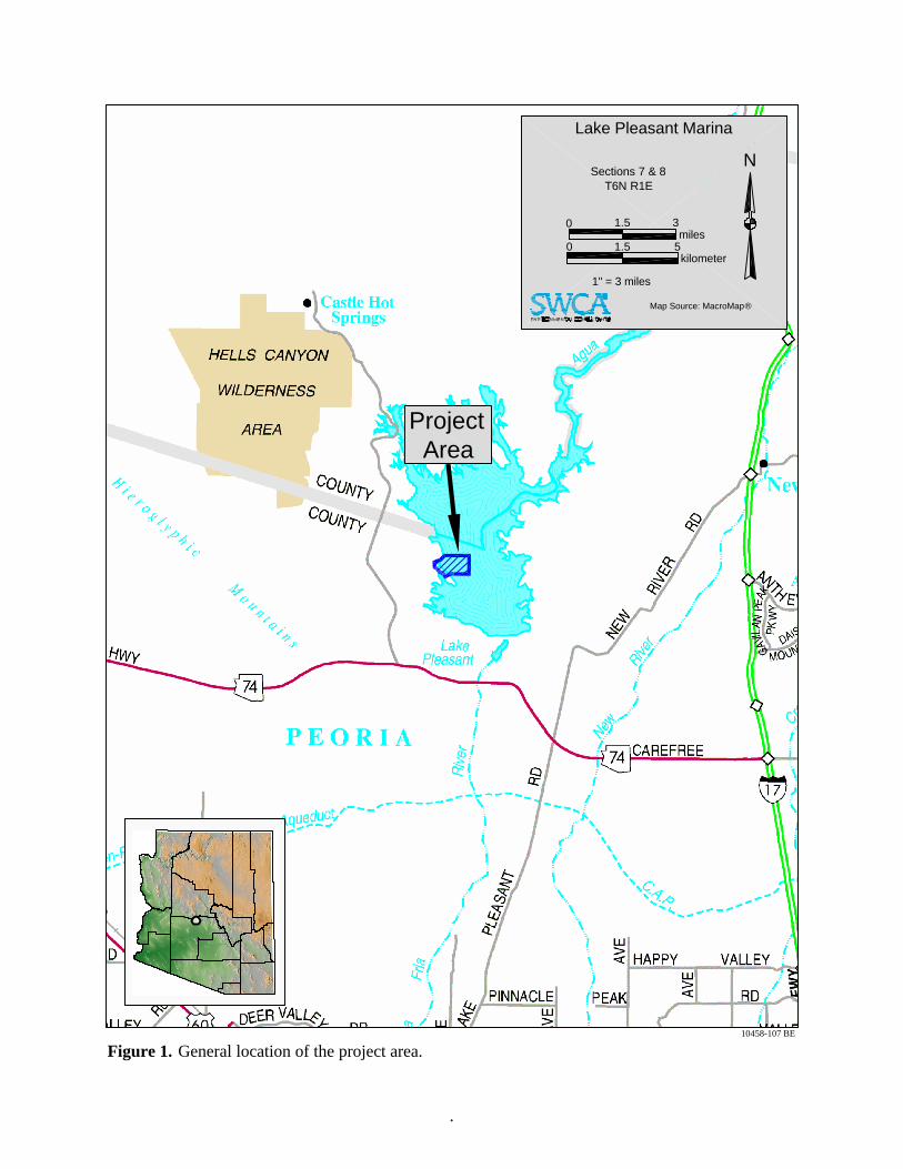
Figure 1. General location of the project area................................................................................. 2
Figure 2. Project area location. ....................................................................................................... 3
LIST OF TABLES
Table 1. Plants Observed Within the Project Area That are Protected Under the Arizona Native Plant Law ............................................................................................................................ 6
Table 2. Summary of Federally Listed Species, Proposed Endangered Species, and Candidate Species and Their Habitat Needs and Potential to Occur Within the Project Area ............ 7
iv
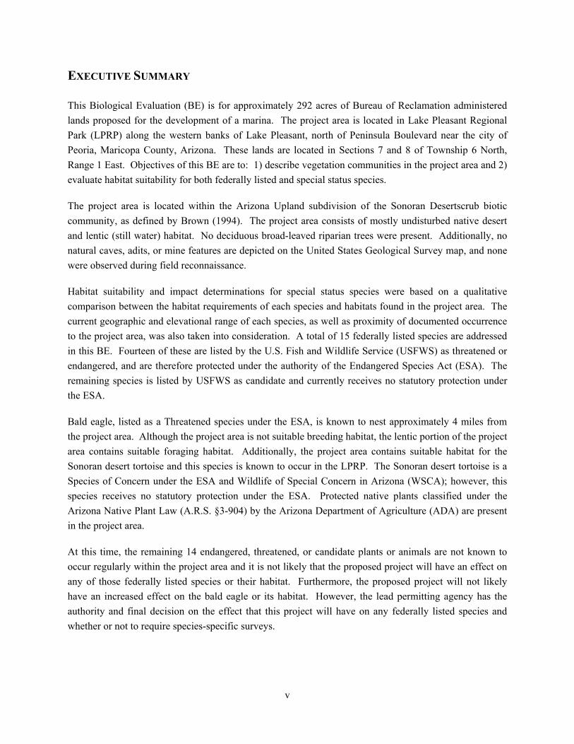
EXECUTIVE SUMMARY
This Biological Evaluation (BE) is for approximately 292 acres of Bureau of Reclamation administered lands proposed for the development of a marina. The project area is located in Lake Pleasant Regional Park (LPRP) along the western banks of Lake Pleasant, north of Peninsula Boulevard near the city of Peoria, Maricopa County, Arizona. These lands are located in Sections 7 and 8 of Township 6 North, Range 1 East. Objectives of this BE are to: 1) describe vegetation communities in the project area and 2) evaluate habitat suitability for both federally listed and special status species.
The project area is located within the Arizona Upland subdivision of the Sonoran Desertscrub biotic community, as defined by Brown (1994). The project area consists of mostly undisturbed native desert and lentic (still water) habitat. No deciduous broad-leaved riparian trees were present. Additionally, no natural caves, adits, or mine features are depicted on the United States Geological Survey map, and none were observed during field reconnaissance.
Habitat suitability and impact determinations for special status species were based on a qualitative comparison between the habitat requirements of each species and habitats found in the project area. The current geographic and elevational range of each species, as well as proximity of documented occurrence to the project area, was also taken into consideration. A total of 15 federally listed species are addressed in this BE. Fourteen of these are listed by the U.S. Fish and Wildlife Service (USFWS) as threatened or endangered, and are therefore protected under the authority of the Endangered Species Act (ESA). The remaining species is listed by USFWS as candidate and currently receives no statutory protection under the ESA.
Bald eagle, listed as a Threatened species under the ESA, is known to nest approximately 4 miles from the project area. Although the project area is not suitable breeding habitat, the lentic portion of the project area contains suitable foraging habitat. Additionally, the project area contains suitable habitat for the Sonoran desert tortoise and this species is known to occur in the LPRP. The Sonoran desert tortoise is a Species of Concern under the ESA and Wildlife of Special Concern in Arizona (WSCA); however, this species receives no statutory protection under the ESA. Protected native plants classified under the Arizona Native Plant Law (A.R.S. §3-904) by the Arizona Department of Agriculture (ADA) are present in the project area.
At this time, the remaining 14 endangered, threatened, or candidate plants or animals are not known to occur regularly within the project area and it is not likely that the proposed project will have an effect on any of those federally listed species or their habitat. Furthermore, the proposed project will not likely have an increased effect on the bald eagle or its habitat. However, the lead permitting agency has the authority and final decision on the effect that this project will have on any federally listed species and whether or not to require species-specific surveys.
v

INTRODUCTION
PROJECT DESCRIPT ON I
This Biological Evaluation (BE) is for approximately 292 acres of Bureau of Reclamation administered lands proposed for the development of a marina. The project area is located in the Lake Pleasant Regional Park (LPRP) along the western banks of Lake Pleasant, north of Peninsula Boulevard near the city of Peoria, Maricopa County, Arizona (Figure 1). The legal description of this project area is Sections 7 and 8 of Township 6 North, Range 1 East (Figure 2). These lands are described in detail under the “Affected Environment” section of this report. This BE is being completed as a requirement for compliance with the regulations of the Endangered Species Act (ESA).
METHODS
The objectives of this BE are to: 1) describe vegetation communities and 2) evaluate habitat suitability for federally listed plant and animal species. SWCA field biologist Olivia Munzer surveyed the project area described above on November 17, 2005 to collect the data necessary to complete this BE. A United States Geological Survey (USGS) 7.5-minute topographical map (Governors Peak and Baldy Mountain, AZ), maps provided by the client, and a Phoenix metro area street map were used for locating project boundaries and for general orientation. Vegetation types were classified and described according to Brown (1994).
The potential for occurrence of special status species was evaluated based on: 1) existing information, and 2) qualitative comparisons between the known habitat requirements of each species and the vegetation communities and conditions found in the project area. We agree with Hall, et al. (1997) that habitat is organism-specific and thus not synonymous with vegetation community. However, the U.S. Fish and Wildlife Service (USFWS) has expanded upon the definition of habitat to include the entire area that is occupied by a specific species, as well as unoccupied areas that may only be used by that species for a portion of the year, such as migratory birds. According to the USFWS, habitat may also include areas that are never directly occupied by the species. Species occupying a specific habitat can be affected by disturbance impacts in adjacent or nearby unoccupied habitats. Therefore, the species is dependent on these unoccupied areas for its existence. In the field, habitat is operationally defined by SWCA by the presence or absence of species. However, areas that appear potentially suitable for a species (i.e., vegetation is similar to areas where the species is known to occur), but which have not yet been surveyed specifically for that species, are considered possible habitat for that species.
1
Project Area
0
0
kilometer1.5 5
miles1.5 3
1" = 3 miles
Map Source: MacroMap®
N
Figure 1. General location of the project area.10458-107 BE
.
Lake Pleasant Marina
Sections 7 & 8T6N R1E

BA
LDY
MO
UN
TA
IN Q
UA
D.
GO
VE
RN
OR
S P
EA
K Q
UA
D.
RoadTortoise
Desert
Boule
vard
Peninsula
Project Area
10458-107 BE
.
Lake Pleasant Marina
0
0
meter250 500
feet1000 2000
1 inch = 2000 feet
N
Figure 2. Project area location.
Sections 7 & 8T6N R1E
USGS 7.5' Quads:Governors Peak & Baldy Mountain

RESULTS
AFFECTED ENV RONMENT I
Ecological Overview
Elevations within the project area range from approximately 1,500 feet above mean sea level (msl) to 1,800 feet above msl. The eastern portion of the project area is characterized by hilly terrain dissected by ephemeral washes, and Lake Pleasant comprises the western portion of the project area. There are no stands of deciduous broad-leaved riparian trees. Additionally, no natural caves, crevices, or mines suitable for bat roosts were observed in the project area. Evidence of off-road vehicle use and recreation was present in the project area.
The vegetation present consists primarily of undisturbed native vegetation typical of the Arizona Upland subdivision of the Sonoran Desertscrub biotic community (Brown 1994) and vegetation associated with a lentic (still water) environment. State protected native plants were documented within the project area; however, no federally listed wildlife species or suitable breeding habitat was observed. A list of all wildlife detected in the project area during the site visit, either directly (i.e., by sight) or indirectly (i.e., through sound or sign), is included in Appendix A.
Vegetation Communities
The project area is located within the Arizona Upland subdivision of the Sonoran Desertscrub biotic community. Within the project area, three main types of vegetation communities exist: upland, xeroriparian, and lentic. These communities are described in detail below. Appendix B contains a complete list of all the plant species observed in the project area during field reconnaissance.
Upland Vegetation Communities
The upland vegetation of the project area consists of species typically found in the Arizona Upland subdivision of the Sonoran Desertscrub biotic community. The common plant species found in this zone included: brittlebush (Encelia farinosa), creosotebush (Larrea tridentata var. tridentata), foothill paloverde (Parkinsonia microphylla), desert ironwood (Olneya tesota), Mediterranean grass (Schismus sp.), plantain (Plantago sp.), and triangle leaf bursage (Ambrosia deltoidea). The cacti species observed in the project area were barrel cactus (Ferocactus sp.), buckhorn cholla (Opuntia acanthocarpa), fishhook cactus (Mammillaria microcarpa), teddybear cholla (Opuntia bigelovii), saguaro (Carnegia gigantea), and strawberry hedgehog (Echinocereus engelmannii).
Xeroriparian Vegetation Communities
The xeroriparian vegetation communities of the project area also contained species typically found in undisturbed areas of the Arizona Upland subdivision of the Sonoran Desertscrub biotic community. Xeroriparian vegetation is associated with an ephemeral water supply (ephemeral washes typically flow only briefly, usually in direct response to significant precipitation in the immediate vicinity).
4
Plant species observed in this community included foothill paloverde, desert ironwood, Mediterranean grass, and wolfberry (Lycium sp.).
Lentic Vegetation Communities
The lentic vegetation community of the project area contains similar species found in other lentic communities in Arizona. Lentic refers to aquatic environments with still, non-flowing waters (lakes and ponds) such as Lake Pleasant. The dominant plants observed in the lentic vegetation community within the shallow portions of the project area were Canada cockleburr (Xanthium strumarium var. canadense) and Bermudagrass (Cynodon dactylon). Plants observed along the shoreline of Lake Pleasant included: Canada cockleburr, Bermudagrass, seaside heliotrope (Heliotropium curassavicum var. oculatum), saltcedar (Tamarix sp.), and prickly Russian thistle (Salsola tragus).
State Protected Native Plants
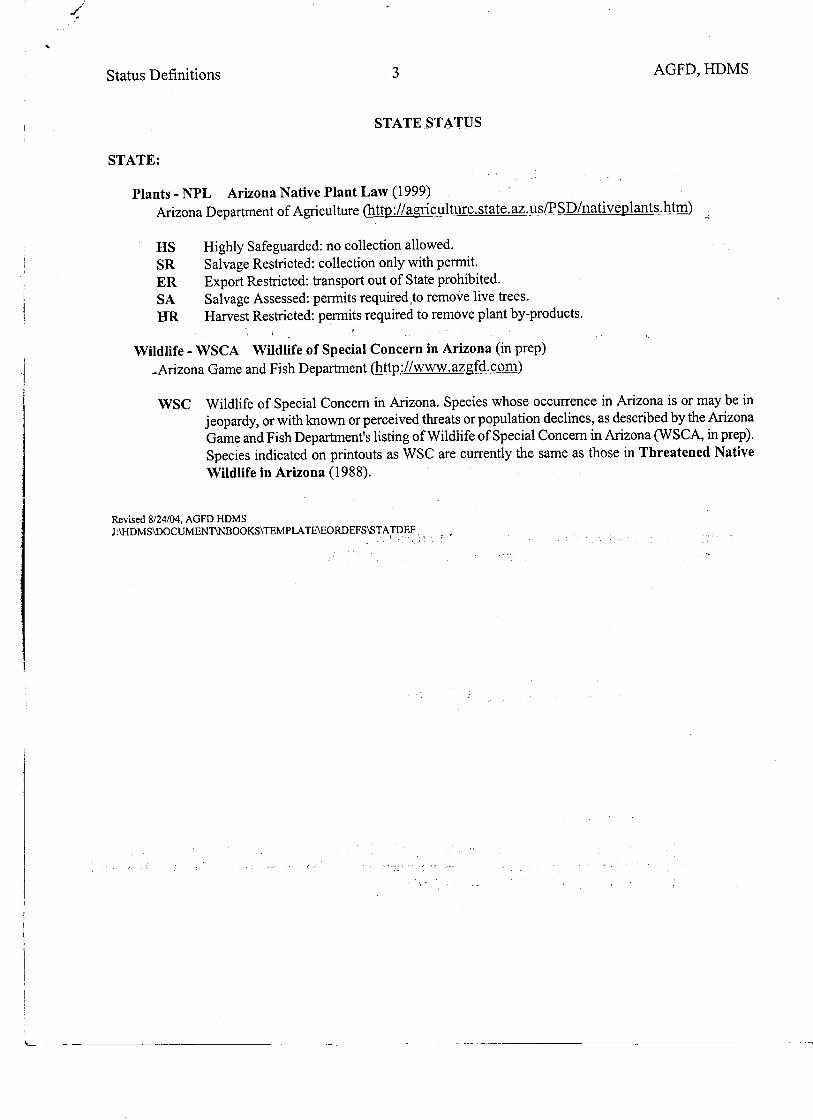
Protected native plants classified under the Arizona Native Plant Law (A.R.S. §3-904) by the Arizona Department of Agriculture (ADA) are present in the project area. This Law states that protected plants cannot be removed from any lands, including private lands, without permission and a permit from the ADA. No Highly Safeguarded plants (no collection allowed) are known to exist or were observed in the project area. All cacti present in the project area are Salvage Restricted plants. Table 1 lists the ADA protected plant species found in the project area and the type of protection they are afforded under the Law.
The ADA Notice of Intent to Clear Land form is included in Appendix C. It is recommended that these forms be filled out and submitted to ADA at least 60 days prior to vegetation removal activities. If native plants will be salvaged and replanted in the project area, then the applicant needs to include this information with the Notice of Intent to Clear Land form at the time of its submittal and request salvage permits.
5
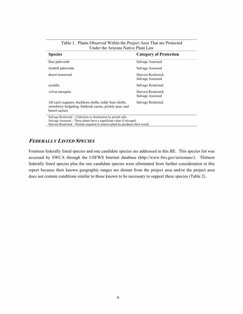
Table 1. Plants Observed Within the Project Area That are Protected Under the Arizona Native Plant Law
Species Category of Protection
blue paloverde Salvage Assessed
foothill paloverde Salvage Assessed
desert ironwood Harvest Restricted; Salvage Assessed
ocotillo Salvage Restricted
velvet mesquite Harvest Restricted; Salvage Assessed
All cacti (saguaro, buckhorn cholla, teddy bear cholla, strawberry hedgehog, fishhook cactus, prickly pear, and barrel cactus)
Salvage Restricted
Salvage Restricted – Collection or destruction by permit only. Salvage Assessed – These plants have a significant value if salvaged. Harvest Restricted – Permits required to remove plant by-products (fuel wood)
FEDERALLY LISTED SPECIES
Fourteen federally listed species and one candidate species are addressed in this BE. This species list was accessed by SWCA through the USFWS Internet database (http://www.fws.gov/arizonaes/). Thirteen federally listed species plus the one candidate species were eliminated from further consideration in this report because their known geographic ranges are distant from the project area and/or the project area does not contain conditions similar to those known to be necessary to support these species (Table 2).
6

Table 2. Summary of Federally Listed Species, Proposed Endangered Species, and Candidate Species and Their Habitat Needs and Potential to Occur Within the Project Area
Species Status Known Distribution and Habitat Needs
Likelihood of Occurrence in Project Area
Arizona agave Agave arizonica
E HS
Transition zone of oak-juniper woodland and mountain mahogany-oak scrub, usually steep rocky slopes from 3,000 to 6,000 feet (AGFD 1997)
Unlikely to occur – no oak-juniper or mountain mahogany-oak woodlands occur in the project area or in the vicinity of the project area. The project area is below the elevational range of this species.
Arizona cliffrose Purshia subintegra
E HS
Rolling limestone hills within Sonoran desertscrub from 2,500 to 4,000 feet (AGFD 2001a)
Unlikely to occur – no limestone hills are present in the project area, and the project area is below the lower elevational limits of this species.
Bald eagle Haliaeetus leucocephalus
T WSCA
Large trees or cliffs near creeks, lakes, and rivers with abundant prey, i.e., fish (AGFD 1996)
Likely to occur – Suitable foraging habitat occurs within the project area; fish that inhabit Lake Pleasant provide bald eagles with a primary food source. No large trees or cliffs occur within the project area to provide suitable breeding habitat; however, bald eagles are known to breed approximately four miles northwest of the project area (J. Driscoll, pers. comm.).
California brown pelican Pelecanus occidentalis californicus
E S
Shore bird usually found near sandy beaches and lagoons. Nests along coastal islands with shrubby vegetation and small trees. In AZ, this species can be found at large inland lakes (Monson and Phillips 1981)
Unlikely to occur – There are no known historic occurrences on the project area. The project area does contain deep-water habitat similar to areas where these birds have been found in Arizona; however, the California brown pelican is an uncommon transient in inland Arizona. Most records have been from the Colorado and Gila River Valleys (Rosenberg et al. 1991).
Cactus ferruginous pygmy-owl Glaucidium brasilianum cactorum
E WSCA
Mature cottonwood/willow riparian forest, mesquite bosques, and dense desert scrub with saguaros at elevations of 4,000 feet or less (AGFD 1996)
Unlikely to occur – There are no known historic occurrences on the property and the project area is located outside of the USFWS recommended survey zones. Therefore, species-specific surveys are not recommended.
Desert pupfish Cyprinodon macularius macularius and eremus
E WSCA
Permanent water in shallow springs, streams, and marshes (AGFD 2001b)
Unlikely to occur – aquatic habitat in the project area is not similar to where this species is known to inhabit. There are no known natural or translocated populations present in the project area.
Gila chub Gila intermedia
E WSCA
Small headwater streams, springs, cienegas, and marshes of the Gila River basin (AGFD 2001c)
Unlikely to occur – aquatic habitat in the project area is not similar to where this species is known to inhabit. There are no known natural or translocated populations present in the project area.
Gila topminnow Poeciliopsis occidentalis occidentalis
E WSCA
Permanent water in small streams, springs, and cienegas (AGFD 2001d)
Unlikely to occur – aquatic habitat in the project area is not similar to those known to support this species and gila topminnow is not known to occur in the LPRP boundary (USBR 1996). There are no known natural or translocated populations present in the project area.
7
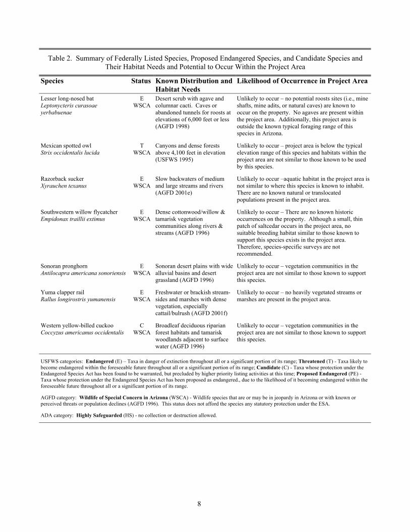
Table 2. Summary of Federally Listed Species, Proposed Endangered Species, and Candidate Species and Their Habitat Needs and Potential to Occur Within the Project Area
Species Status Known Distribution and Habitat Needs
Likelihood of Occurrence in Project Area
Lesser long-nosed bat Leptonycteris curasoae yerbabuenae
E WSCA
Desert scrub with agave and columnar cacti. Caves or abandoned tunnels for roosts at elevations of 6,000 feet or less (AGFD 1998)
Unlikely to occur – no potential roosts sites (i.e., mine shafts, mine adits, or natural caves) are known to occur on the property. No agaves are present within the project area. Additionally, this project area is outside the known typical foraging range of this species in Arizona.
Mexican spotted owl Strix occidentalis lucida
T WSCA
Canyons and dense forests above 4,100 feet in elevation (USFWS 1995)
Unlikely to occur – project area is below the typical elevation range of this species and habitats within the project area are not similar to those known to be used by this species.
Razorback sucker Xyrauchen texanus
E WSCA
Slow backwaters of medium and large streams and rivers (AGFD 2001e)
Unlikely to occur –aquatic habitat in the project area is not similar to where this species is known to inhabit. There are no known natural or translocated populations present in the project area.
Southwestern willow flycatcher Empidonax traillii extimus
E WSCA
Dense cottonwood/willow & tamarisk vegetation communities along rivers & streams (AGFD 1996)
Unlikely to occur – There are no known historic occurrences on the property. Although a small, thin patch of saltcedar occurs in the project area, no suitable breeding habitat similar to those known to support this species exists in the project area. Therefore, species-specific surveys are not recommended.
Sonoran pronghorn Antilocapra americana sonoriensis
E WSCA
Sonoran desert plains with wide alluvial basins and desert grassland (AGFD 1996)
Unlikely to occur – vegetation communities in the project area are not similar to those known to support this species.
Yuma clapper rail Rallus longirostris yumanensis
E WSCA
Freshwater or brackish stream-sides and marshes with dense vegetation, especially cattail/bulrush (AGFD 2001f)
Unlikely to occur – no heavily vegetated streams or marshes are present in the project area.
Western yellow-billed cuckoo Coccyzus americanus occidentalis
C WSCA
Broadleaf deciduous riparian forest habitats and tamarisk woodlands adjacent to surface water (AGFD 1996)
Unlikely to occur – vegetation communities in the project area are not similar to those known to support this species.
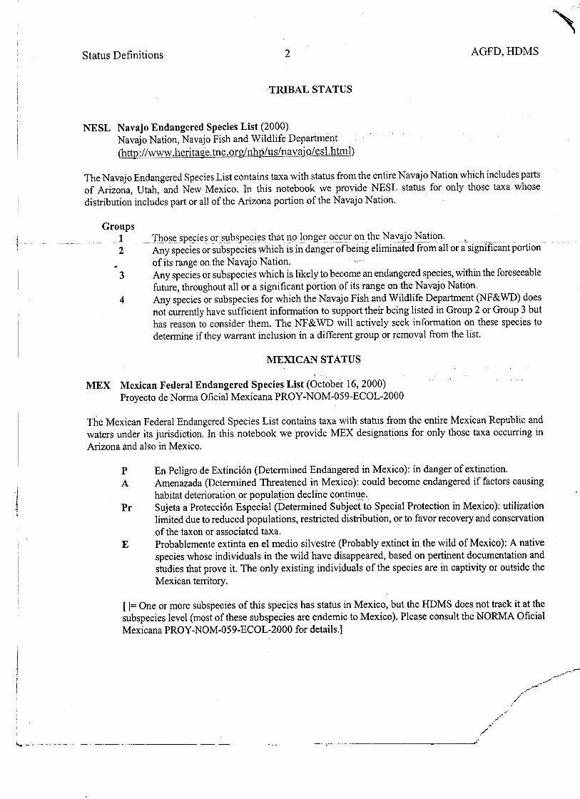
USFWS categories: Endangered (E) – Taxa in danger of extinction throughout all or a significant portion of its range; Threatened (T) - Taxa likely to become endangered within the foreseeable future throughout all or a significant portion of its range; Candidate (C) - Taxa whose protection under the Endangered Species Act has been found to be warranted, but precluded by higher priority listing activities at this time; Proposed Endangered (PE) - Taxa whose protection under the Endangered Species Act has been proposed as endangered., due to the likelihood of it becoming endangered within the foreseeable future throughout all or a significant portion of its range.
AGFD category: Wildlife of Special Concern in Arizona (WSCA) - Wildlife species that are or may be in jeopardy in Arizona or with known or perceived threats or population declines (AGFD 1996). This status does not afford the species any statutory protection under the ESA.
ADA category: Highly Safeguarded (HS) - no collection or destruction allowed.
8
OTHER SPEC AL STATUS SPECIES I
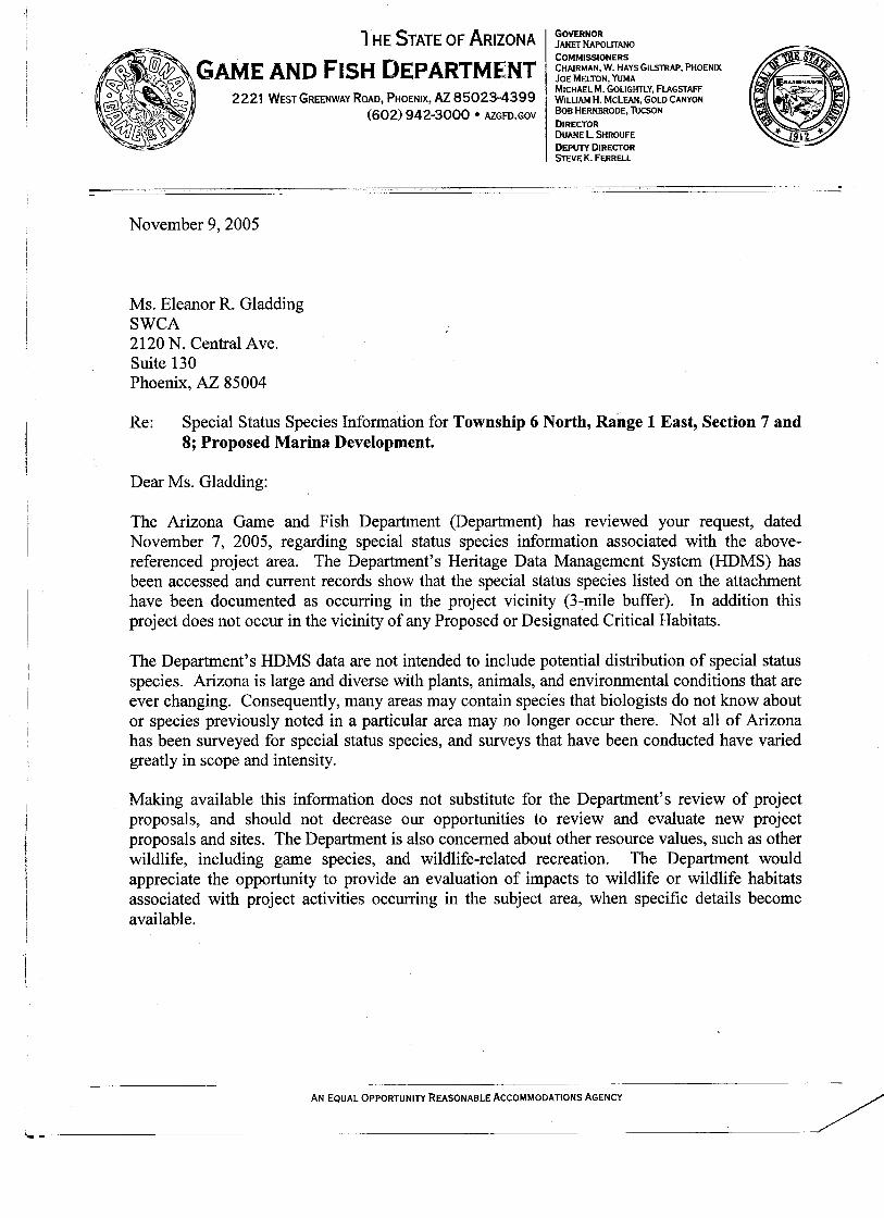
The Arizona Game and Fish Department (AGFD) also maintains a statewide database, known as the Heritage Data Management System (HDMS), which tracks records for federally listed species or other species of special concern. At the request of SWCA, the AGFD searched this database for any Proposed or Designated Critical Habitats and for occurrence records of special status species within the vicinity of the project area. The AGFD response letter indicated the project area does not occur in the vicinity of Proposed or Designated Critical Habitats; however, there are records of occurrence for eight special status species within a 3-mile buffer of the project area. These eight species, Hohokam agave (Agave murpheyi), longfin dace (Agosia chrysogaster), Arizona toad (Bufo microscaphus), lowland leopard frog (Rana yavapaiensis), southwestern willow flycatcher (Empidonax traillii extimus), bald eagle (Haliaeetus leucocephalus), Sonoran desert tortoise (Gopherus agassizii [Sonoran population]), and western red bat (Lasiurus blossevillii) are discussed in further detail below. A copy of SWCA’s request letter and the AGFD response letter are included in Appendix D.
Hohokam Agave
The Hohokam agave is listed as a Species of Concern under the ESA, as Sensitive by the U.S. Forest Service (USFS) when occurring on USFS-administered lands and the Bureau of Land Management (BLM) when occurring on BLM administered lands, and as a Highly Safeguarded plant by the ADA. However, these listings do not give this species any statutory protection. Hohokam agave occurs at elevations from 1,300 to 3,200 feet above msl (AGFD 2003) in central Arizona in the Lower Colorado River Valley and the Arizona upland subdivisions of the Sonoran desertscrub biotic community (Brown 1994). It is usually found on benches, terraces, or gentle bajada slopes (not steep slopes or drainage bottoms) above major drainages with well-drained soils and is often associated with prehistoric habitations and/or agricultural sites suggesting tending (AGFD 2003). It is possible that this species could occur in the project area; however, no Hohokam agaves were observed during the site visit by SWCA and no known historic human habitation has been documented within the project area. The closest known location of this species to the project area is a group of agave that was relocated to the overlook facility approximately 2 miles southeast of the project area (USBR 1996). It is not likely that any Hohokam agaves exist within the project area.
Longfin dace
The longfin dace is listed as a Species of Concern under the ESA and as Sensitive by the BLM when occurring on BLM administered lands. However, these listings do not give this species any statutory protection. Longfin dace is known to inhabit a wide range of small streams from desertscrub up to coniferous woodlands. The elevational range for the longfin dace is from 1,360 to 6,740 feet above msl (AGFD 2002a). The closest known location of this species is within a 3-mile buffer of the project area, according to the AGFD’s HDMS report. The occurrence record is most likely from an intermittent stream approximately 1 mile north of the project area and from perennial portions of tributaries to the Aqua Fria River north of the project area (USBR 1996). Additionally, longfin dace is not known to occur within the
9

LPRP boundaries (USBR 1996). This project area is within the elevational range of the longfin dace; however, no small streams are present within the project area. Therefore, no suitable habitat for the longfin dace is located within the project area.
Arizona Toad
The Arizona toad is listed as a Species of Concern under the ESA and as Sensitive by the USFS when occurring on USFS-administered lands. However, these listings do not give this species any statutory protection. The Arizona toad occurs in the eastern to west-central portions of Arizona, in canyons and floodplains south of the Mogollon Rim, and north of the Mogollon Rim in East Clear Creek (AGFD 2002h). The preferred habitat of the Arizona toad includes rocky streams and canyons from the pine-oak belt to the lower deserts from about 480 feet to 8,400 feet above msl (AGFD 2002b). The AGFD record of location in the project vicinity is most likely along the Aqua Fria River northeast of the project area. Although the project area is located within the elevational and geographic range of this species, the project area does not contain rocky streams or canyons with suitable habitat. In addition, no amphibians were observed during the field reconnaissance.
Lowland Leopard Frog
The lowland leopard frog is currently listed as Species of Concern under the ESA, as Sensitive by the USFS when occurring on USFS-administered lands, and as Wildlife of Special Concern in Arizona (WSCA) by the AGFD. However, these listings do not give this species any statutory protection. The range of the lowland leopard frog within Arizona includes the Colorado River near Yuma, west, central, and southeast Arizona, south of the Mogollon Rim. This species inhabits permanent rivers, streams, and ponds in a variety of habitats at elevations from 800 to 5,500 feet above msl (AGFD 2001g). The AGFD occurrence record is most likely from Pipeline Canyon approximately 0.5 miles north of the project area. This project area is within the geographic and elevational range of the lowland leopard frog; however, the project area does not contain habitat to support this species. In addition, no amphibians were observed during dip netting and field reconnaissance.
Bald Eagle
The bald eagle is listed as Threatened and Proposed for Delisting under the ESA, Sensitive by the USFS when occurring on USFS-administered lands, and as WSCA by the AGFD. The nearest recently documented breeding pair of bald eagles to this project area are those along the upper arm of the Aqua Fria approximately 4 miles northeast of the project area (J. Driscoll, pers. comm.). The project area is within the elevational range of the bald eagle in Arizona and does contain suitable foraging habitat; however, the project does not contain suitable breeding habitat. USBR (1996) states that the construction of the recreations sites, including the marina, will likely not increase the impacts to the bald eagle; however, USBR projects a rise in recreational use of the LPRP, which will likely increase the number of entries into restricted areas (bald eagle nesting enclosure). See bald eagle in Table 2 for additional information.
10

Southwestern Willow Flycatcher
The southwestern willow flycatcher is listed as Endangered under the ESA, Sensitive by the USFS when occurring on USFS-administered lands, and as WSCA by the AGFD. The nearest occurrences record of this species was documented in 2004 south of the project area near Waddell Dam. The project area does contain a small, thin patch of saltcedar; however, the habitat structure, density, and size are not suitable for southwestern willow flycatcher breeding habitat. See southwestern willow flycatcher in Table 2 for additional information.
Sonoran Desert Tortoise
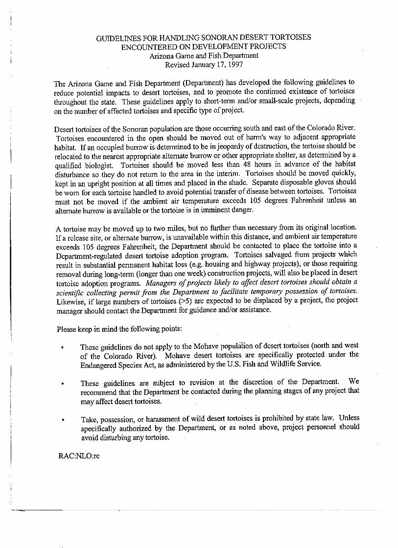
The Sonoran desert tortoise is listed as a Species of Concern under the ESA and as WSCA by the AGFD. However, these status listings do not give this species any statutory protection. Sonoran desert tortoise habitat occurs primarily in the hills and rocky mountainous terrain of Arizona Upland Sonoran Desertscrub communities. Desert tortoise habitat can also be found along washes in more level terrain adjacent to hills and desert mountain ranges (AGFD 1996). Desert tortoises typically forage on plants, plant litter, cactus fruit, and arthropods. They are most typically found along washes and rocky areas, building their shelter sites in rocky areas or along the banks of washes. They have also been known to burrow under vegetation or rest directly underneath live or dead vegetation (AGFD 2001h). The AGFD response letter indicated an occurrence record for this species within the vicinity of the project area. Although no individuals of this species were observed during the field visit, desert tortoises are known to occur in the LPRP (USBR 1996), and it is possible that this species would occur in the project area. If desert tortoises are encountered within the project area during construction, it is recommended that the AGFD Guidelines for the Handling Sonoran Desert Tortoises Encountered on Development Projects (Appendix E) be followed by personnel with an AGFD Scientific Collection Permit.
Western Red Bat
The western red bat is listed as WSCA by the AGFD. However, this listing does not give this species any statutory protection. The range of the western red bat is throughout Arizona from 2,400 to 7,200 feet above msl (AGFD 2003b). These insectivores are typically found in broad-leaved riparian forests and woodlands. Their roost sites are typically trees, but can also be found roosting in saguaros and caves (AGFD 2003b). This species has been documented within 3 miles of the project area. The AGFD occurrence record for this species is most likely from the Hieroglyphic Mountains, west of the project area. No cave features, or riparian or woodland trees suitable for roosting were observed within the project area. In addition, the project area is below the elevahonal range for the western red bat; therefore, the project area does not contain suitable habitat for this species.
11

RECOMMENDATIONS
Since protected native plants are present in the project area, it is recommended that the Notice of Intent to Clear Land form (Appendix C) be submitted to the ADA at least 60 days prior to vegetation removal activities, in accordance with the Arizona Native Plant Law (A.R.S. §3-904). No suitable breeding habitat for the bald eagle occurs in the project area; however, the lentic habitat in the project area provides suitable foraging habitat for the bald eagles. Although it is anticipated by USBR (1996) that the construction of the marina will not likely increase impacts to the bald eagles that breed four miles northwest of the project area, a rise in recreation in the LRPR may occur. Implementing mitigation measures, such as enforcing the bald eagle closure and increasing public awareness of the bald eagle, could allay any potential impacts to the bald eagle. It is possible that the Sonoran desert tortoise could be encountered in the project area during construction activities. In the event that tortoises are seen, the AGFD Guidelines for the Handling Sonoran Desert Tortoises Encountered on Development Projects in Appendix E should be followed. This species is not currently protected under the ESA; therefore, no further surveys are recommended for the Sonoran desert tortoise. It is not likely that the proposed project will have an adverse effect on any federally listed species or their habitat. However, any federal lead permitting agency responsible for issuing a permit or providing authorization for this project has the authority and final decision on the effect that this project will have on any federally listed species and whether or not to require species-specific surveys.
12

LITERATURE CITED
Arizona Game and Fish Department. 2003a. Agave murpheyi. Unpublished abstract compiled and edited by the Arizona Game and Fish Department, Phoenix, AZ. 7 pp.
Arizona Game and Fish Department (AGFD). 2003b. Lasiurus blossevilli. Unpublished abstract compiled and edited by the Arizona Game and Fish Department, Phoenix, AZ. 7 pp.
Arizona Game and Fish Department (AGFD). 2002a. Agosia chryogaster. Unpublished abstract compiled and edited by the Arizona Game and Fish Department, Phoenix, AZ. 5 pp.
Arizona Game and Fish Department (AGFD). 2002b. Bufo microscaphus. Unpublished abstract compiled and edited by the Arizona Game and Fish Department, Phoenix, AZ. 4 pp.
Arizona Game and Fish Department (AGFD). 2001a. Purshia subintegra. Unpublished abstract compiled and edited by the Arizona Game and Fish Department, Phoenix, AZ. 6 pp.
Arizona Game and Fish Department (AGFD). 2001b. Cyprinodon macularius macularius. Unpublished abstract compiled and edited by the Arizona Game and Fish Department, Phoenix, AZ. 3 pp.
Arizona Game and Fish Department (AGFD). 2001c. Gila intermedia. Unpublished abstract compiled and edited by the Arizona Game and Fish Department, Phoenix, AZ. 6 pp.
Arizona Game and Fish Department (AGFD). 2001d. Poeciliopsis occidentalis occidentalis. Unpublished abstract compiled and edited by the Arizona Game and Fish Department, Phoenix, AZ. 5 pp.
Arizona Game and Fish Department (AGFD). 2001e. Xyrauchen texanus. Unpublished abstract compiled and edited by the Arizona Game and Fish Department, Phoenix, AZ. 4 pp.
Arizona Game and Fish Department (AGFD). 2001f. Rallus longirostris yumanensis. Unpublished abstract compiled and edited by the Arizona Game and Fish Department, Phoenix, AZ. 7 pp.
Arizona Game and Fish Department (AGFD). 2001g. Rana yavapaiensis. Unpublished abstract compiled and edited by the Arizona Game and Fish Department, Phoenix, AZ. 6 pp.
Arizona Game and Fish Department (AGFD). 2001h. Gopherus agassizii. Unpublished abstract compiled and edited by the Heritage Data Management System, Arizona Game and Fish Department, Phoenix, AZ. 11 pp.
Arizona Game and Fish Department (AGFD). 1998. Leptonycteris curasoae yerbabuenae. Unpublished abstract compiled and edited by the Arizona Game and Fish Department, Phoenix, AZ. 6 pp.
Arizona Game and Fish Department (AGFD). 1997. Agave arizonica. Unpublished abstract compiled and edited by the Arizona Game and Fish Department, Phoenix, AZ. 4 pp.
Arizona Game and Fish Department (AGFD). 1996. Wildlife of special concern in Arizona. Nongame and Endangered Wildlife Program, Arizona Game and Fish Department, Phoenix, AZ. 40 pp.
Brown, D.E. (ed.). 1994. Biotic Communities: Southwestern United States and Northwestern Mexico. University of Utah Press, Salt Lake City. 342 pp.
14

Hall, L.S., P.R. Krausman, and M.L. Morrison. 1997. The habitat concept and a plea for standard terminology. Wilson Society Bulletin 25:173-182.Monson, G., and A.R. Phillips. 1981. Annotated Checklist of the Birds of Arizona. The University of Arizona Press, Tucson, Arizona. 172 pp.
Monson, G., and A.R. Phillips. 1981. Annotated Checklist of the Birds of Arizona. The University of Arizona Press, Tucson, Arizona. 172 pp.
Rosenberg, K. V., R. D. Ohmart, W. C. Hunter, and B. W. Anderson. 1991. Birds of the lower Colorado River valley. The University of Arizona Press, Tucson.
U.S. Bureau of Reclamation (USBR). 1996. New Waddell Dam Lake Pleasant Regional Park Master Recreation Plan, Draft Environmental Assessment. Phoenix, Arizona. 60 pp.
U.S. Fish and Wildlife Service (USFWS). 1995. Determination of critical habitat for the Mexican Spotted Owl; Final Rule. June 6, 1995. Federal Register 60(108): 29914-29951.
15

APPENDIX A
WILDLIFE OBSERVED IN THE PROJECT AREA
A-1

This list includes those species detected directly (i.e., by sight) or indirectly (i.e., through sound or sign) during the site visit. However, this list does not represent a comprehensive summary of all species that may occur in the project area.
Common Name Scientific Name BIRDS
American pipit Anthus rubescens
black-tailed gnatcatcher Polioptila melanura
Gambel’s quail Callipepla gambelii
gilded flicker Colaptes chrysoides
great blue heron Ardea herodias
house finch Carpodacus mexicanus
rock wren Salpinctes obsoletus
sandpiper Calidris sp.
MAMMALS
woodrat Neotoma sp.
REPTILES
speckled rattlesnake Crotalus mitchellii
A-2
B-1
APPENDIX B
PLANT SPECIES OBSERVED IN THE PROJECT AREA
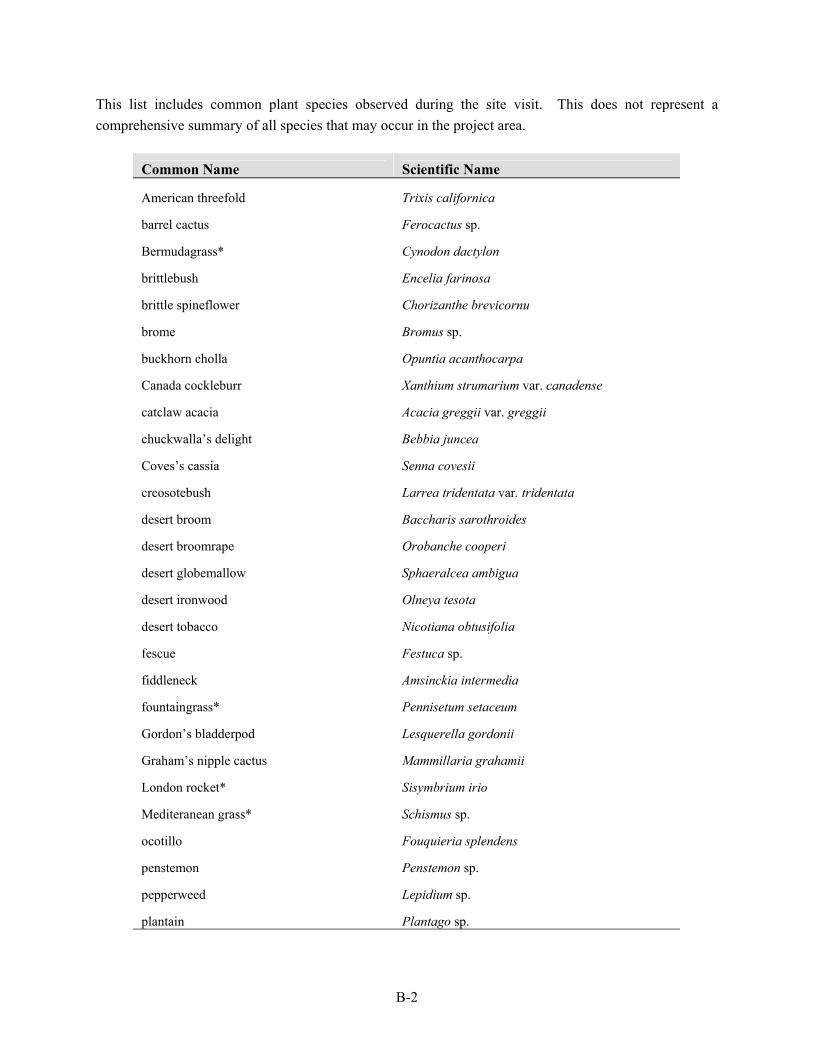
This list includes common plant species observed during the site visit. This does not represent a comprehensive summary of all species that may occur in the project area.
Common Name Scientific Name
American threefold Trixis californica
barrel cactus Ferocactus sp.
Bermudagrass* Cynodon dactylon
brittlebush Encelia farinosa
brittle spineflower Chorizanthe brevicornu
brome Bromus sp.
buckhorn cholla Opuntia acanthocarpa
Canada cockleburr Xanthium strumarium var. canadense
catclaw acacia Acacia greggii var. greggii
chuckwalla’s delight Bebbia juncea
Coves’s cassia Senna covesii
creosotebush Larrea tridentata var. tridentata
desert broom Baccharis sarothroides
desert broomrape Orobanche cooperi
desert globemallow Sphaeralcea ambigua
desert ironwood Olneya tesota
desert tobacco Nicotiana obtusifolia
fescue Festuca sp.
fiddleneck Amsinckia intermedia
fountaingrass* Pennisetum setaceum
Gordon’s bladderpod Lesquerella gordonii
Graham’s nipple cactus Mammillaria grahamii
London rocket* Sisymbrium irio
Mediteranean grass* Schismus sp.
ocotillo Fouquieria splendens
penstemon Penstemon sp.
pepperweed Lepidium sp.
plantain Plantago sp.
B-2

Common Name Scientific Name
prickly pear Opuntia sp.
prickly Russian thistle* Salsola tragus
saguaro Carnegiea giganteus
seaside heliotrope Heliotropium curassavicum var. oculatum
star-thistle* Centaurea sp.
strawberry (Engelmann's) hedgehog cactus Echinocereus engelmannii
teddybear cholla Opuntia bigelovii
triangle-leaf bursage Ambrosia deltoidea
velvet mesquite Prosopis velutina
whitemargin sandmat Chamaesyce albomarginata
wolfberry Lycium sp.
* indicates a non-native species
B-3

APPENDIX C
ADA NOTICE OF INTENT TO CLEAR LAND FORM
C-1
APPENDIX D
AGFD CORRESPONDENCE
D-1


E-1
APPENDIX E
GUIDELINES FOR HANDLING SONORAN DESERT TORTOISES