Embed Size (px)
Citation preview

BIOLOGICAL CONDITION OF NON-
PERENNIAL STREAMS AND SPRING-FED
OASES Colorado River Basin Region
Prepared by: Andrew C. Rehn, Aquatic Bioassessment Lab, CA Dept. of
Fish and Wildlife
SWAMP-MR-RB7-2017-0001
Final Report February 2017

Biological Condition of Non-Perennial Streams and
Spring-Fed Oases in the Colorado River Basin Region
Prepared in collaboration with the Region 7 SWAMP Program by:
Andrew C. Rehn
California Dept. of Fish and Wildlife
Aquatic Bioassessment Lab
August 22, 2014

Preface This study would not have been possible without the kind assistance of many parks and reserves who
graciously allowed us access to streams on their properties for bioassessment sampling and deployment of data
loggers to better understand the ecology and hydrology of these unique desert habitats.
We sincerely thank the following:
Anza-Borrego State Park for access to Borrego Palm Canyon, Cougar Canyon, Indian Canyon and Coyote
Creek.
The Big Morongo Canyon Preserve for access to Big Morongo Canyon.
The Center for Natural Lands Management for access to Thousand Palms Oasis.
The County of Riverside for allowing us to access sites on US Forest Service property (Twin Pines Creek and
Browns Creek) via the Twin Pines Ranch.
The Palm Springs Aerial Tramway for access to Chino Canyon.
The University of California Reserve System for access to Boyd Deep Canyon and Lambs Creek at Oasis de
los Osos.
The Wildlands Conservancy for access to the Whitewater Preserve, Mission Creek Preserve and Pipes Canyon
in the Pioneertown Mountains Preserve.

Executive Summary
The Colorado River Basin Regional Water Board conducted bioassessment sampling at high-quality
(i.e., “reference”) streams in their region during 2013-2015. The purpose of the study was to characterize the
biological condition of these streams, which had never been done before, and to expand ongoing research as to
whether existing biological indices, developed primarily for perennial streams, apply in nonperennial streams.
The latter are usually excluded from bioassessment surveys, but make up the majority of stream length in the
most arid parts of the state like the Colorado River Basin, leaving stream condition assessments in such regions
largely incomplete. The indices evaluated were the California Stream Condition Index (CSCI) based on
benthic macroinvertebrates and the first to have statewide applicability in perennial streams, and the D18 and
S2 indices for diatoms and soft algae, respectively, developed for use in perennial streams of southern coastal
California. Sixteen sites were sampled during the 3-year period, and data loggers that measure water depth
were deployed for 2 of the 3 years to characterize the hydrologic regime at each site. Most sites were
nonperennial, but a few were spring-fed perennial oases. Fourteen of the sites passed formal reference
screening criteria developed by statewide programs.
The CSCI and S2 indices had generally good applicability in the region, with most samples from
reference sites indicated either good or fair (i.e., non-degraded) biological condition. The mean CSCI score at
regional reference sites was slightly lower than the statewide mean (i.e., 0.90 vs. 1.0, respectively), but the
difference could be an artifact of a relatively small regional data set. The fact that CSCI and S2 performed as
well as they did in a region, and in a set of stream types, largely excluded from their development indicates
that the indices can be used in nonperennial streams (and spring-fed oases) in the Colorado River Basin as long
as certain minimum flow conditions are met, such as sustained flow for several weeks prior to sampling and
sufficient wetted width to employ existing protocols developed for perennial streams. By contrast, the D18
index did not perform well in the region. A majority of samples from reference sites indicated poor or very
poor biological condition when condition thresholds based on statewide data sets were used, but even when
more relaxed thresholds based on just south coast reference sites were applied, the number of reference sites in
good or fair condition was still much lower than expected. This was not a result of regional reference sites
being of low quality, but was most likely an artifact of applying the index to a set a stream types unintended for
its use. Development of statewide algal indices is underway, which may improve the performance of diatom
indices in the southern desert.

Introduction
Bioassessment is widely used in California to evaluate the ecological condition, or health, of streams
and rivers throughout the state. Since 1994, many different regional, state and federal monitoring programs
have collectively sampled thousands of stream sites statewide. However, the emphasis of these various
programs has been perennial, wadeable streams. As a result, relatively few sites have been sampled in the
most arid parts of the state where a majority of mapped stream length is nonperennial. This is especially true
in the Colorado River Basin. For example, in a recent report from the Perennial Streams Assessment (a
program that randomly selects sampling sites to provide unbiased estimates of statewide and regional stream
condition), results were based on over 1300 sites, only 4 of which were from the Colorado River Basin (Rehn
2015). A similarly small number of sites from the region was used in development of the California Stream
Condition Index (CSCI; Mazor et al. 2016), a recent biological index based on benthic macroinvertebrates
(BMIs), and the first to have statewide applicability in perennial streams. Because nonperennial streams are
so often excluded from bioassessment programs, it remains unclear whether biological indices developed for
perennial streams apply in nonperennial settings.
A continuum of hydrologic conditions exists in nonperennial streams, from those that flow for only a
few hours or days after rainfall events, to those that flow for several weeks or months during and after a typical
rainy season. In recent years, efforts have begun in order to determine whether existing biological indices
developed for perennial streams are applicable in nonperennial settings, and if so, to determine how far along
the nonperennial continuum they can be used to assess stream conditions. For example, between 2013 and
2016, the San Diego Regional Water Board (whose jurisdiction also encompasses a large proportion of
nonperennial stream length) sampled approximately 25 nonperennial reference sites1 that represented a natural
range of hydrologic conditions in that region. Data loggers that measured water depth at regular time intervals
were deployed at each site to quantify duration of periods of flow and periods of drying. Preliminary results
based on a subset of study sites have shown that, in general, the CSCI can be used in nonperennial streams in
the San Diego region as long as certain minimum flow conditions are met, such as sustained flow for several
weeks prior to sampling and sufficient wetted width to employ existing protocols developed for perennial
streams (Rehn 2014).2
Concurrent with the pilot study of nonperennial reference streams in the San Diego Region, the
Colorado River Basin Regional Water Board (CRBRWB) also conducted bioassessment at reference sites in
their region, where few had previously been sampled or their ecological condition characterized. Most
candidate reference sites selected for sampling were nonperennial, although some were perennial, including a
few isolated spring-fed streams that represent a unique desert stream setting not typically sampled by statewide
programs. The purpose of this report is to summarize results from bioassessment of reference streams in the
Colorado River Basin, a study which marks an important contribution to, and expansion of, ongoing research
in California as to whether existing biological indices developed for perennial streams are applicable in
nonperennial (or extreme desert) settings. Analyses were based on the CSCI, and indices for diatoms and soft
algae developed primarily for use in southern coastal California (Fetscher et al. 2014).
Methods
Site Selection, Sampling Events and Deployment of Data Loggers
In spring of 2013, 8 candidate reference sites were sampled using standard bioassessment protocols
(Ode et al. 2016a). Sites were selected for sampling if observed to have limited land use in the upstream
watershed as qualitatively determined from topographic maps and subsequent ground truthing based on site
visits, and/or if sites were located in protected areas such as ecological reserves or state parks. Data loggers
1 Reference sites establish a benchmark of expected biological, chemical and physical conditions when human disturbance in the environment is absent or minimal, and have been prioritized in pilot studies of nonperennial streams to avoid confounding stress caused by human disturbance and stress caused by drying of the channel. 2 Mazor et al. (2012) provided preliminary evidence that the Southern California Index of Biotic Integrity (Ode et al. 2005), a regional
precursor to the statewide CSCI, also can be used in nonperennial streams in the San Diego region, but that study was limited to 12 sites that represented the “wetter” end of the hydrologic continuum, only 3 of which were in reference condition.

that record water depth and temperature were not deployed prior to the initial sampling in spring 2013, so flow
data were unavailable for that sampling event. In November 2013, an additional 8 candidate reference sites
were identified, and all 16 sites (Figure 1, Table 1) were visited so that Onset HOBO® U20 data loggers that
record water depth and temperature at pre-set time intervals could be deployed. The goal of deploying data
loggers in the fall, when many candidate sites were dry, was to capture the onset of flow during the winter
rainy season and to quantify the flow regime at each site for several months prior to subsequent bioassessment
sampling in spring of 2014 and 2015. All 16 sites were eventually screened for reference site status using
quantitative criteria (Ode et al. 2016b, Appendix 1) based on upstream land use measures calculated from GIS
layers and on-site measures of human disturbance in the riparian zone made by field crews at time of
sampling.
Figure 1. Map of 16 stream locations where BMI and algae samples were collected in 2013-2016.

Table 1. Location, ownership, dates of sampling and biological index scores for 16 sites where bioassessment was conducted in spring 2013-2015.
Letters in parentheses after index scores indicate biological condition category: G = good; F = fair; P = poor; VP = very poor. Sites were originally selected
qualitatively, but were subsequently screened using quantitative criteria defined by Ode et al. (2016b) for identifying reference sites, mostly based on upstream and
local land use. Big Morongo Cyn failed screens for urban land use and road density in the watershed, and for in situ conductivity. Thousand Palms Preserve
failed screens for number of paved road crossings in the watershed, and for in situ conductivity. For Reference Status, R= reference and NR = non-reference. For
Flow Status, NP = nonperennial and P = perennial.
Station Code
Station Name
(and ownership) Lat Long elev (ft)
Reference
Status
Flow
Status
Sample
Date Rep
BMI
Count
CSCI
Score
D18
Score
S2
Score
705PCCPCP Pipes Canyon 34.166 -116.572 4768 R NP 5/21/2013 1 624 0.80 (F) 68 (F) 57 (F)
(Pioneertown Mtns Preserve) DRY 2014 -- -- -- --
DRY 2015 -- -- -- --
719BMCPRE Big Morongo Canyon 34.036 -116.567 2306 NR NP 5/22/2013 1 554 0.93 (G) 20 (VP) 100 (G)
(Big Morongo Preserve) 4/7/2014 1 588 0.74 (P) 30 (VP) 60 (G)
4/6/2015 1 586 0.76 (P) 16 (VP) 85 (G)
719HOTCPF Horsethief Creek 33.575 -116.416 3470 R NP 5/14/2013 1 580 0.87 (F) 84 (G) 82 (G)
(US Forest Service) 4/15/2014 1 633 0.95 (G) 70 (F) 85 (G)
4/9/2015 1 562 0.88 (F) 44 (P) 75 (G)
4/9/2015 2 544 0.90 (F) -- --
719MISSCK Mission Creek 34.007 -116.622 2278 R NP 5/21/2013 1 583 0.95 (G) 88 (G) 82 (G)
(Mission Creek Preserve) DRY 2014 -- -- -- --
4/6/2015 1 57 0.62 (VP) 92 (G) 57 (F)
719NP7AZC Azalea Creek 33.856 -116.805 3892 R NP 4/9/2014 1 391 0.94 (G) 56 (P) 85 (G)
(US Forest Service) 4/7/2015 1 571 0.85 (F) 72 (F) 83 (G)
719NP7BNC Browns Creek 33.868 -116.772 3573 R NP 4/9/2014 1 586 1.00 (G) 64 (P) 82 (G)
(US Forest Service) 4/7/2015 1 545 0.83 (F) 62 (P) 83 (G)
719NP7DPC Deep Canyon 33.633 -116.391 1303 R NP 4/8/2014 1 618 1.01 (G) 62 (P) 55 (F)
(UC Boyd Reserve) DRY 2015 -- -- -- --
719NP7LBC Lambs Creek 33.891 -116.694 1588 R P 4/14/2014 1 586 0.99 (G) 58 (P) 60 (G)
(UC Oasis de los Osos Reserve) 3/31/2015 1 569 0.93 (G) 64 (P) 53 (F)
719NP7TWP Twin Pines Creek 33.855 -116.780 3933 R NP 4/9/2014 1 295 0.89 (F) 60 (P) 70 (G)
(US Forest Service) 4/7/2015 1 589 0.89 (F) 72 (F) 83 (G)
719TPPSQH Thousand Palms 33.830 -116.311 487 NR P 5/15/2013 1 600 0.95 (G) 60 (P) 85 (G)
Preserve 4/10/2014 1 605 0.89 (F) 62 (P) 72 (G)
4/10/2014 2 576 0.93 (G) -- --
4/14/2015 1 564 0.92 (G) 60 (P) 67 (G)
4/14/2015 2 603 0.91 (F) -- --

Table 1, continued.
Station Code Station Name Lat Long elev (ft)
Reference
Status
Flow
Status
Sample
Date Rep
BMI
Count
CSCI
Score
D18
Score
S2
Score
719TRMDSS Chino Canyon at Tramway 33.840 -116.613 2447 R P 5/15/2013 1 588 1.11 (G) 90 (G) 50 (F)
(Palm Springs Aerial Tramway) 4/8/2014 1 549 1.02 (G) 86 (G) 63 (G)
3/31/2015 1 604 0.90 (F) 68 (F) 75 (G)
719WWRPUS Whitewater River 33.989 -116.659 2229 R NP 5/13/2013 1 478 0.73 (P) 94 (G) 98 (G)
(Whitewater Preserve) 5/13/2013 2 133 0.59 (VP) -- --
DRY 2014 -- -- -- --
3/30/2015 1 20 0.50 (VP) 94 (G) 88 (G)
722ABSPPC Borrego Palm Canyon 33.278 -116.429 1121 R NP 5/20/2013 1 559 1.00 (G) 56 (P) 67 (G)
(Anza-Borrego State Park) 4/21/2014 1 616 0.94 (G) 36 (P) 52 (F)
4/13/2015 1 560 0.93 (G) 42 (P) 65 (G)
722NP7CGC Cougar Canyon 33.354 -116.482 1868 R NP 4/16/2014 1 460 0.92 (G) 76 (F) 85 (G)
(Anza-Borrego State Park) 4/8/2015 1 122 0.81 (F) 66 (P) 78 (G)
722NP7IDC Indian Canyon 33.347 -116.478 1952 R NP 4/16/2014 1 467 0.76 (P) 24 (VP) 68 (G)
(Anza-Borrego State Park) 4/8/2015 1 624 0.74 (P) 52 (P) 55 (F)
†722PS0535 Coyote Creek 33.369 -116.422 1154 R P 5/26/2009 1 593 0.76 (P) 42 (P) 63 (G)
(Anza-Borrego State Park) 4/16/2014 1 473 0.84 (F) 22 (VP) 32 (P)
4/16/2014 2 564 0.95 (G) -- --
4/8/2015 1 583 0.89 (F) 48 (P) 40 (F)
† Coyote Creek was originally sampled by the Perennial Streams Assessment Program in 2009. Results from the earlier sampling were included here for comparison.

At each site, a data logger (approximately 7 inches long and 1 inch in diameter) was installed in the
channel thalweg (the deepest part of the channel at base flow), although thalweg location was sometimes
difficult to infer when channels were dry during deployment (Figure 2). Pools were deliberately avoided
because they can retain stagnant water for months when the remainder of the channel is dry and do not
provide an accurate characterization of overall aquatic conditions in nonperennial streams. Each logger was
placed in a protective PVC housing before deployment. Once a precise location for deployment had been
selected within the stream channel, the logger in its protective housing was anchored to the channel bottom by
driving either a 2-foot steel stake (i.e., a concrete stake) or a 4-inch arrowhead anchor with attached steel cable
(typically used to stabilize landscaping) as deeply as possible into the substrate or nearby stream bank with a
mini sledge hammer. Each logger was then tethered to the stake or anchor with steel cable (1/16th-inch
diameter) and was camouflaged from view by tucking it under rocks and/or nearby vegetation as appropriate.
Figure 2. Photo of logger in protective case deployed in a dry stream channel.
An additional “dry” logger was placed away from the stream channel, and in a concealed area to
prevent tampering, at 6 of the 16 sites so that in-channel measurements of water depth could be compensated
for barometric pressure. Barometric compensation loggers were deployed at sites ranging from the lowest to
the fourth highest in elevation, and were fairly well-distributed geographically, although none was deployed in
the northernmost part of the study area (Figure 1). Atmospheric pressure recorded by barometric
compensation loggers differed only because of the different elevation at each site (Figure 3). Otherwise, all 6
sites experienced the same atmospheric events, i.e., rising and falling barometric pressures were the same
across sites over time. Therefore, custom calibrations were developed for the 10 sites where no compensation
loggers were deployed in November 2013 based on the observation that, on average, barometric pressure
changed by 0.025 mm Hg for every foot of change in elevation. This approach produced slightly more “noise”
in the resulting hydrographs than placement of a barometric compensation logger at every site, but was worth
the cost savings attained by deployment of fewer loggers. Data loggers were set to record data every 6 hours,
were left on-site to continue recording data for the duration of the study, and were downloaded when the sites
were revisited for bioassessment sampling in spring 2014 and 2015. Hydrographs were plotted for each site
using Onset HOBOware® Pro software version 3.6.2.

Figure 3. Plots of atmospheric pressure at 4 of the 6 sites where barometric compensation loggers were deployed in November 2013.
Biological Indices The California Stream Condition Index (CSCI, Mazor et al. 2016) was used to score BMI samples.
Developed for perennial streams statewide, the CSCI combines two separate types of index that each provides
unique information about biological condition at a stream: a multi-metric index (MMI) that measures
ecological structure and function, and an observed-to-expected (O/E) index that measures taxonomic
completeness. The CSCI was calibrated during its development so that the mean score of reference sites = 1.
Scores that approach 0 indicate great departure from reference condition and degraded biological condition.
Scores > 1 are interpreted to indicate greater taxonomic richness and more complex ecological function than
predicted for a site given its natural environmental setting. In practice, CSCI scores observed from nearly 2000
unique sites sampled across California range from about 0.1 to 1.4 (unpublished). For the purpose of making
statewide and regional assessments, three condition thresholds were established based on the 30th; 10th; and 1st
percentiles of CSCI scores at perennial reference sites, thus dividing the CSCI scoring range into 4 categories
of biological condition as follows: ≥0.92 = good condition; 0.91 to 0.79 = fair condition; 0.78 to 0.63 = poor
condition; ≤0.62 = very poor condition, with biological degradation defined as CSCI scores ≤ 0.78.
The “D18” index for diatoms and the “S2” index for soft algae (Fetscher et al. 2014) were used to
score algae samples. The algae indices were not calibrated to have a particular mean score at reference sites,
and both are scored on a 0-100 scale with higher scores indicating better condition. Fetscher et al. (2014)
provided no condition thresholds for the D18 or S2 indices, so using the same approach as for CSCI,
thresholds were developed here based on the 30th; 10th; and 1st percentiles of index scores from nearly 300
statewide reference sites sampled 2008-2012. Condition thresholds for the D18 index were as follows: ≥78 =
good condition; 77 to 68 = fair condition; 67 to 34 = poor condition; ≤33 = very poor condition, with
biological degradation defined as D18 scores ≤ 67. Condition thresholds for the S2 index were as follows: ≥58
= good condition; 57 to 40 = fair condition; 39 to 18 = poor condition; ≤17 = very poor condition, with
biological degradation defined as S2 scores ≤ 39.
Evaluation of CSCI applicability in the Colorado River Basin was made by 1) determining whether
reference sites in the region have a mean score of 1; 2) by calculating the percentage of reference sites in the
region that score in either good or fair biological condition (i.e., above the degradation threshold of 0.78), and
3) by using analysis of variance (ANOVA) to compare the mean score from reference sites in the region to the
mean score from reference sites in neighboring southern coastal California (a region in close geographic
proximity and well-represented in development of existing biological indices). Data from southern coastal
California were compiled from reference sites sampled 2000-2015 by various programs and were divided into
“xeric” and “mountain” subsets. Within the xeric subset, sites were further divided into a pre-drought
perennial group (sampled 2000-2011), a drought-period perennial group (sampled 2012-2015), and a
nonperennial group (San Diego region sites sampled 2010-2015). The mountain subset was divided into the
same perennial site groups, but had no nonperennial group. Similar evaluations were made for D18 and S2,

except that the earliest available samples were from 2008, and evaluation of their mean score within in the
Colorado River Basin was not performed since algae indices were not calibrated to have a particular mean
score at reference sites.
Results
Screening sites for reference status
Fourteen of the16 candidate reference sites passed all reference site screening criteria (Table 1,
Appendix 1). Big Morongo Canyon failed screens for urban land use and road density in the upstream watershed, and for in situ conductivity measured at the sampling site. Thousand Palms Preserve failed screens
for number of paved road crossings in the upstream watershed, and for in situ conductivity measured at the
sampling site. Samples from those sites were omitted from evaluations of whether the CSCI is applicable in the
Colorado River Basin region to maintain consistency with previous statewide analyses of CSCI performance at
reference sites.
Hydrographs and Biological Index Scores
Four of the 16 sites were perennial (Appendix 2, Figures i-iv); all others were nonperennial (Appendix
2, Figures v-xvi). The Whitewater River data logger was lost to high flows during the first winter of
deployment (i.e., 2013-2014). A few sites went dry before field crews could visit in 2014 and 2015, so not every
site was sampled during each sampling event (Table 1). Also, specimen counts were low3 in a few BMI
samples (Table1). Low count samples were omitted from evaluations of whether the CSCI is applicable in the
Colorado River Basin region.
The mean CSCI score of reference site samples with sufficient BMI counts (n = 28, Table 1) was 0.90,
slightly lower than the 0.92 threshold between good and fair biological condition. Half of those samples
indicated good biological condition, and 24 of them (86%) indicated either fair or good condition, i.e., they
scored above the degradation threshold of 0.78 (note that 70% of reference site samples with sufficient BMI
counts would be expected to indicate good biological condition, and 90% would be expected to score higher
than the degradation threshold, if the distribution of CSCI scores from Colorado Basin reference sites were
equal to the statewide reference pool used to establish thresholds). The mean CSCI score of Colorado River
Basin reference site samples with sufficient counts was significantly lower than for nonperennial sites in the
San Diego region, and both pre-drought and drought-period southern coastal mountain sites (Figure 4a,b).
These regional differences were driven by the MMI component of the CSCI; preliminary analyses indicated
that the metrics Percent Clinger Taxa, Percent EPT Taxa, and Percent Intolerant Individuals had significantly
lower mean scores in the Colorado River Basin than in southern coastal California (data not shown)4.
For algae indices there are no issues with low sample counts (unless algae are completely absent from
a sample, which did not occur in this data set), so all samples from Colorado River Basin sites that passed
reference screens were used in algae evaluations (n =30, Table 1). For D18, only 7 of the 30 samples (23%)
indicated good biological condition, and only 13 of the samples (43%) indicated either fair or good condition,
i.e., they scored above the degradation threshold of 67. The mean D18 score of Colorado River Basin
reference site samples was significantly lower than for pre-drought southern coastal mountain sites (Figure 4b).
Results were very different for S2: 21 of the 30 samples (70%) indicated good biological condition, and 29 of
the samples (97%) indicated either fair or good condition, i.e., they scored above the degradation threshold of
39. Oddly, and despite the good performance of S2 in terms of the number of samples indicating good or fair
biological condition, the mean S2 score of Colorado River Basin reference site samples was significantly lower
than for nonperennial reference sites in the San Diego Region sampled 2010-2015 (Figure 4a).
3 The MMI component of the CSCI requires a minimum count of 450 specimens per sample while the O/E component requires a minimum count of 360 specimens per sample. CSCI scores for samples with fewer than ~300 specimens should be interpreted with caution. 4 The MMI component of the CSCI is based on six metrics. In addition to the three metrics listed above, Percent Coleoptera Taxa, Taxonomic Richness and Shredder Taxa Richness are also included. EPT = Ephemeroptera, Plecoptera and Trichoptera.

Figure 4. Box plots comparing the distribution of biological index scores at reference sites in the Colorado River Basin sampled 2013-2015 (group D in all plots) with the distribution of index scores in a) xeric south coast reference sites, and b) mountain south coast reference sites. In all plots, group A = perennial sites sampled pre-drought (2000-2011 for CSCI; 2008-2011 for D18 and S2) and group B = perennial sites sampled during drought (2012-2015). In panel a (upper 3 plots), group C = nonperennial reference sites in the San Diego Region sampled 2010-2015. P-values are from ANOVA. Post-hoc analysis showed that the mean CSCI score from Colorado River Basin sites was significantly lower than for nonperennial San Diego sites (panel a, left plot) and both pre-drought and drought-period southern coastal mountain sites (panel b, left plot). The mean D18 score from Colorado Basin sites was significantly lower than for pre-drought southern coastal mountain sites (panel b, center plot), and the mean S2 score was significantly lower than for nonperennial reference sites in the San Diego Region (panel a, right plot).
Discussion
Overall, the CSCI showed fairly good applicability in nonperennial streams and spring-fed perennial
oases in the Colorado River Basin, with most sites showing good, or at least fair (i.e., non-degraded),
biological condition during most sampling events. However, the CSCI did show some minor performance
issues in the region that warrant discussion. The issues to consider are: 1) the mean CSCI score of regional
reference site samples was 0.90, when ideally it would be 1.0; 2) 50% of reference site samples indicated good
biological condition, when 70% would be expected to indicate good biological condition if the distribution of
CSCI scores from regional reference sites were equal to the statewide reference pool, and 3) the mean CSCI
score of regional reference site samples was significantly lower than for some subsets of southern coastal sites.
Taken together, these factors may indicate that sites in the Colorado River Basin are marginally outside of the
experience of the predictive models underlying the CSCI5, but given the relatively small regional data set (only
28 samples from 14 sites), that conclusion cannot be made with great confidence. Until more data become
available, the fact that the CSCI performs as well as it does in a region, and in a set of stream types, largely
5 SWAMP has produced a fact sheet and a technical memo to help familiarize users with development of the CSCI, including the statistical modeling component. Both resources are available on the SWAMP bioassessment website: http://www.waterboards.ca.gov/water_issues/programs/swamp/bioassessment/

excluded from its development indicates that the index can be used in nonperennial streams and spring-fed
oases in the Colorado River Basin as long as certain minimum flow conditions are met, such as sustained flow
for several weeks prior to sampling and sufficient wetted width to employ existing protocols developed for
perennial streams.
As for the algae indices, it would be hard to argue that the D18 index based on diatoms is applicable
in the Colorado River Basin given that a majority of samples from reference sites indicated poor or very poor
biological condition. Part of the poor performance of D18 may have resulted from use of a statewide data set
to establish condition thresholds for an index developed for southern coastal California. For example, Rehn
(2016) demonstrated that the “H20” algae index, which is a hybrid index based on both of diatoms and soft
algae, tends to score significantly higher at reference sites in northern California than in southern California.
Even so, recalculation of condition thresholds for D18 based on just the subset of southern coastal reference
sites for which that index best applies still resulted in only 37% of Colorado River Basin reference sites being in
good condition (should be 70%), and 73% of Colorado River Basin sites being above the degradation
threshold (should be 90%). By contrast, the S2 index seemed to work well in the region, even using condition
thresholds derived from statewide data sets. Finally, it is worth noting that development of statewide algal
indices is underway, which may help improve the performance of diatom indices in the southern desert.

References Fetscher, A.E., R. Stancheva, J.P. Kociolek, R.G. Sheath, E.D. Stein, R.D. Mazor, P.R. Ode and L.B. Busse.
2014 Development and comparison of stream indices of biotic integrity using diatoms vs. non-diatom algae vs.
a combination. Journal of Applied Phycology 26: 433-450.
Kaufmann, P.R., P. Levine, E.G. Robinson, C. Seeliger, and D.V. Peck. 1999. Quantifying
physical habitat in wadeable streams. EPA/620/R-99/003. U.S. Environmental Protection
Agency. Washington, D.C.
Mazor, R.D., K. Schiff, P.R. Ode and E.D. Stein. 2012. Final Report on Bioassessment in Nonperennial
Streams: Report to the State Water Resources Control Board. Southern California Coastal Water Research
Project Technical Report 695. Available at:
http://ftp.sccwrp.org/pub/download/DOCUMENTS/TechnicalReports/695_NonperennialStreamsSanDieg
o.pdf
Mazor, R.D., A.C. Rehn, P.R. Ode, M. Engeln, K.C. Schiff, E.D. Stein, D.J. Gillett, D.B. Herbst and C.P.
Hawkins. 2016. Bioassessment in complex environments: designing an index for consistent meaning in
different settings. Freshwater Science 35(1): 249-271.
Ode, P.R., A.C. Rehn, and J.T. May. 2005. A quantitative tool for assessing the integrity of southern coastal
California streams. Environmental Management 35: 493-504.
Ode, P.R., A.E. Fetscher, and L.B. Busse. 2016a. Standard Operating Procedures for the Collection of Field
Data for Bioassessments of California Wadeable Streams: Benthic Macroinvertebrates, Algae, and Physical
Habitat. California State Water Resources Control Board Surface Water Ambient Monitoring Program
(SWAMP) Bioassessment SOP 004. Available at:
http://www.waterboards.ca.gov/water_issues/programs/swamp/bioassessment/docs/combined_sop_2016.p
df
Ode, P.R., A.C. Rehn, R.D. Mazor, K.C. Schiff, E.D. Stein, J.T. May, L.R. Brown, D.B. Herbst, D.J. Gillett,
K. Lunde and C.P. Hawkins. 2016b. Evaluating the adequacy of a reference-site pool for ecological
assessments in environmentally complex regions. Freshwater Science 35(1) 237-248.
Rehn, A.C. 2014. Biological Condition of Nonperennial Streams in the San Diego Region. Unpublished report
to the San Diego Regional Water Quality Control Board.
Rehn, A.C. 2015. The Perennial Streams Assessment (PSA): An Assessment of Biological Condition Using
the New California Stream Condition Index (CSCI). SWAMP-MM-2015-0001. Available at:
http://waterboards.ca.gov/water_issues/programs/swamp/bioassessment/docs/psa_memo_121015.pdf
Rehn, A.C. 2016. Using Multiple Biological and Habitat Condition Indices for Bioassessment of California
Streams. SWAMP Technical Memorandum SWAMP-TM-SB-2016-0003. Available at:
http://www.waterboards.ca.gov/water_issues/programs/swamp/bioassessment/docs/multiple_indices_tech
_memo.pdf

Appendix 1: Stressor and human activity gradients
used to identify reference sites
(see Ode et al. 2016b for additional information on development of reference criteria). Sites that did not exceed listed thresholds were used as
reference sites. WS: Watershed. 5 km: Watershed clipped to a 5-km buffer upstream of the sample point. 1 km: Watershed clipped to a 1-km buffer
upstream of the sample point. W1_HALL: proximity-weighted riparian disturbance index (Kaufmann et al. 1999). Data sources are as follows: A:
National Landcover Data Set. B: Custom roads layer. C: National Hydrography Dataset Plus. D: National Inventory of Dams. E: Mineral Resource Data
System. F: Predicted specific conductance (Olson and Hawkins 2012). G: Field-measured variable. Code 21 is a land use category that corresponds to
managed vegetation, such as roadsides, lawns, cemeteries, and golf courses.
Variable Scale Threshold Unit Data source
% Agriculture 1 km, 5 km, WS <3 % A
% Urban 1 km, 5 km, WS <3 % A
% Ag + % Urban 1 km, 5 km, WS <5 % A
% Code 21 1 km and 5 km <7 % A
WS <10 % A
Road density 1 km, 5 km, WS <2 km/km2 B
Road crossings 1 km <5 crossings/ km² B, C
5 km <10 crossings/ km² B, C
WS <50 crossings/ km² B, C
Dam distance WS <10 km D
% Canals and pipelines WS <10 % C
Instream gravel mines 5 km <0.1 mines/km C, E
Producer mines 5 km 0 mines E
Specific conductance Site 99/1** prediction interval F
W1_HALL Sample reach <1.5 NA G
** The 99th and 1st percentiles of predictions were used to generate site-specific thresholds for specific conductance. Because the model was observed to under-predict at higher levels of specific conductance (data not shown), a threshold of 2000 µS/cm was used as an upper bound if the prediction interval included 1000 µS/cm.

Appendix 2: Hydrographs of study sites indicating
sampling events, associated biological index scores,
and the biological condition those scores represent. Note that the diatom index D18 did not perform well in the Colorado River Basin Region (see main text) and
rarely indicated regional reference sites to be in good biological condition; D18 scores are included here for
completeness but cannot be considered to accurately reflect the biological condition of a site. Also presented
are photographs of each site that were taken during logger deployment in November 2013 and, where
available, during sampling in spring of 2015 and 2016.

Figure i. Lambs Creek.
Lambs Creek drainage November 2013.
Lambs Creek during March 31, 2015 sampling.
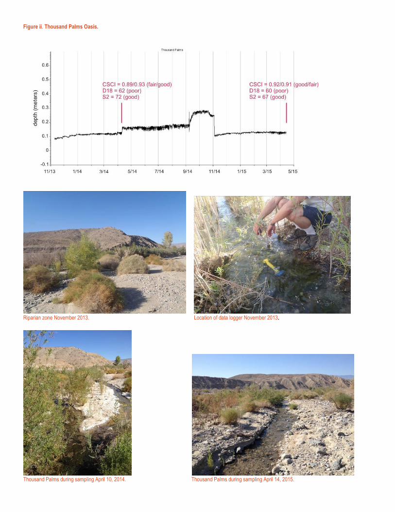
Figure ii. Thousand Palms Oasis.
Riparian zone November 2013. Location of data logger November 2013.
Thousand Palms during sampling April 10, 2014. Thousand Palms during sampling April 14, 2015.

Figure iii. Chino Canyon at Tramway.
Chino Canyon during logger deployment November 2013.
Chino Canyon during sampling April 8, 2014. Chino Canyon during sampling March 31, 2015.

Figure iv. Coyote Creek.
Coyote Creek during logger deployment November 2013
Coyote Creek during sampling April 16, 2014. Coyote Creek during sampling April 8, 2015.

Figure v. Pipes Canyon.
Pipes Canyon during logger deployment November 2013
Pipes Canyon (dry) during attempt to sample in spring 2014.

Figure vi. Big Morongo Canyon.
Big Morongo during logger deployment November 2013. Big Morongo during sampling April 7, 2014.
Big Morongo during sampling April 6, 2015.

Figure vii. Horsethief Creek.
Horsethief Creek during logger deployment November 2013. Horsethief Creek during sampling April 15, 2014.
Horsethief Creek during sampling April 9, 2015.

Figure viii. Mission Creek.
Mission Creek during logger deployment November 2013.
Mission Creek during sampling April 6, 2015.

Figure ix. Azalea Creek.
Azalea Creek during logger deployment November 2013.
Azalea Creek during sampling April 9, 2014. Azalea Creek during sampling April 7, 2015.

Figure x. Browns Creek.
Browns Creek during logger deployment November 2013.
Browns Creek during sampling April 9, 2014. Browns Creek during sampling April 7, 2014.

Figure xii. Twin Pines Creek.
Twin Pines Creek during logger deployment November 2013.
Twin Pines Creek during sampling April 9, 2014. Twin Pines Creek during sampling April 7, 2015.

Figure xi. Deep Canyon.
Deep Canyon during logger deployment November 2013.
Deep Canyon during sampling April 9, 2014. Deep Canyon (dry) during attempt to sample in spring 2015.

Figure xiii. Borrego Palm Canyon.
Borrego Palms Canyon during logger deployment November 2013.
Borrego Palms Canyon during sampling April 21, 2014. Borrego Palms Canyon during sampling April 13, 2015.

Figure xiv. Cougar Canyon.
Cougar Canyon during logger deployment November 2013. Cougar Canyon during sampling April 16, 2014.
Cougar Canyon during sampling April 8, 2015.

Figure xv. Indian Canyon.
Indian Canyon during logger deployment November 2013.
Indian Canyon during sampling April 16, 2014. Indian Canyon during sampling April 8, 2015.

Figure xvi. Whitewater River (no hydrograph available).
Whitewater River during logger deployment November 2013. Excavating for lost data logger in dry channel, spring 2014.
Whitewater River during sampling March 30, 2015.

![Research Journal of Pharmaceutical, Biological and ...rjpbcs.com/pdf/2017_8(3)/[116].pdf · Research Journal of Pharmaceutical, Biological and Chemical ... production condition which](https://img.dokumen.tips/doc/110x75/5a7333487f8b9a9d538e6565/research-journal-of-pharmaceutical-biological-and-3116pdfaa-research.jpg)