Embed Size (px)
Citation preview

Biodiversity assessment handbookPermitted clearing of native vegetation
May 2015 – Version 1.0

© The State of Victoria Department of Environment, Land, Water and Planning 2015
This work is licensed under a Creative Commons Attribution 3.0 Australia licence. You are free to re-use the work under that licence, on the condi-tion that you credit the State of Victoria as author. The licence does not apply to any images, photographs or branding, including the Victorian Coat of Arms, the Victorian Government logo and the Department of Environment, Land, Water and Planning logo. To view a copy of this licence, visit http://creativecommons.org/licenses/by/3.0/au/deed.en
ISBN 978-1-74146-417-7 (pdf)
Accessibility If you would like to receive this publication in an alternative format, please telephone DELWP Customer Service Centre 136 186, email [email protected] or via the National Relay Service on 133 677 www.relayservice.com.au. This document is also available in on the internet at www.delwp.vic.gov.au
Disclaimer This publication may be of assistance to you but the State of Victoria and its employees do not guarantee that the publication is without flaw of any kind or is wholly appropriate for your particular purposes and therefore disclaims all liability for any error, loss or other consequence which may arise from you relying on any information in this publication.
Cover image: Native grassland with pasture and scattered trees behind

Permitted clearing of native vegetation - Biodiversity assessment handbook 3
Contents1 Introduction 4
2 Requirement for a permit to remove native vegetation 6
3 Application verification 8
4 Low risk-based pathway – Biodiversity assessment 16
5 Moderate and high risk-based pathway – additional application requirements 19
6 Moderate risk-based pathway – Biodiversity assessment 24
7 High risk based pathway – Biodiversity assessment 31
8 Non DELWP referred applications 35
9 Referred applications 37
10 Ensuring compliance with permit conditions 39
Appendix A: Definition and category of native vegetation 41
Appendix B: Accounting for past permitted clearing 44
Appendix C: Tools for applicants and assessors 48
Appendix D: Application checklists 50
Appendix E: Calculate offset requirements 52
Appendix F: Standard permit conditions 56
This handbook may be updated periodically in response to emerging issues associated with implementing the native vegetation permitted clearing regulations gazetted on 20 December 2013. Check the Department of Environment, Land, Water and Planning website to ensure the most current version is being used. The Victorian Government announced in their November 2014 election commitments, Our Environment, Our Future, a review of the current native vegetation permitted clearing regulations. This handbook will be updated to reflect any changes that arise through the review.
Any queries should be submitted to: [email protected]
Permitted clearing of native vegetation - Biodiversity assessment handbook 4
1. Introduction
1.1 What is the handbook for?This handbook guides the biodiversity assessment of applications for a planning permit to remove, destroy or lop native vegetation (referred to as ‘remove’ native vegetation in this handbook) under Clauses 52.16 and 52.17 of planning schemes in Victoria.
This handbook replaces the Native vegetation – Guide for assessment of referred planning permit applications (Department of Sustainability and Environment, April 2007), associated Technical Information Sheets and other Department of Sustainability and Environment (DSE) updates. DSE became the Department of Environment and Primary Industries (DEPI) in 2013 and the Department of Environment, Land, Water and Planning (DELWP) in January 2015.
1.2 Who should use this handbook?Responsible authority planners and staff of DELWP fulfilling the referral authority role should use this handbook:
• when assessing Clause 52.16 or 52.17 planning permit applications
• when providing information to applicants about requirements under the Permitted clearing of native vegetation – Biodiversity assessment guidelines (the Guidelines).
This handbook may be helpful when assessing other applications to remove native vegetation.
Applicants and consultants may find this handbook helpful when compiling an application for a permit to remove native vegetation.
Users of this handbook should be familiar with:• The Planning and Environment Act 1987
• Clause 12.01-2 Native vegetation management of the State Planning Policy Framework
• Particular Provisions and relevant schedules of planning schemes – Clause 52.16 Native Vegetation Precinct Plan and Clause 52.17 Native Vegetation
• Permitted clearing of native vegetation – Biodiversity assessment guidelines, DEPI 2013, an incorporated document in all planning schemes
• Native vegetation gain scoring manual, DEPI 2013, that explains how gain at an offset site is calculated
• Biodiversity information tools for use in native vegetation decisions – explanatory document, DEPI 2013, and Biodiversity information tools used in Victoria’s native vegetation permitted clearing regulations – Fact sheet, DEPI 2014, that explains the information tools used in the permitted clearing regulations
• First party general offset kit and calculator, DEPI 2014.
1.3 Scope of this handbookThe scope of this handbook is limited to guidance on assessing, as required under Clauses 52.16 and 52.17, the impacts on Victoria’s biodiversity from the removal of native vegetation.
It does not address:
• consideration of impacts relating to other objectives of managing native vegetation included in Clauses 52.16 and 52.17, specifically landscape value, land and water protection, Aboriginal heritage, and bushfire risk
• requirements of other clauses that require a planning permit to remove vegetation, including Environmental Significance Overlay, Vegetation Protection Overlay and Significant Landscape Overlay
• requirements of the State or Local Planning Policy Framework, other than Clause 12.01-2.

Permitted clearing of native vegetation - Biodiversity assessment handbook 5
1.4 How to use this handbook The sections in this handbook describe steps in assessing planning permit applications under Clauses 52.16 and 52.17 (refer Table 1). Permit assessors should work through relevant sections when processing an application.Table 1: Summary of the handbook sections
Section Purpose
Section 1: Introduction Background information regarding the permitted clearing regulations.How and when to use this handbook.
Section 2: Requirement for a permit to remove native vegetation
Determining if a planning permit to remove native vegetation is required under Clause 52.16 or 52.17.
Section 3: Application verification
Checking if an application is complete and determining if referral to DELWP is required.
Section 4: Low risk-based pathway – Biodiversity assessment
Assessing biodiversity considerations of applications in the low risk-based pathway.
Section 5: Moderate and high risk-based pathway – additional application requirements
Checking and verifying the additional application requirements for applications in the moderate and high risk-based pathway.
Section 6: Moderate risk-based pathway – Biodiversity assessment
Assessing biodiversity considerations of applications in the moderate risk-based pathway.
Section 7: High risk-based pathway – Biodiversity assessment
Assessing biodiversity considerations of applications in the high risk-based pathway.
Section 8: Non-DELWP referred applications
Determining an application that has not been referred to DELWP.
Section 9: Referred applications Preparing a response to an application that has been referred to DELWP. Determining an application.
Section 10: Compliance with permit conditions
Checking whether a planning permit holder has complied with the permit conditions.
Appendices Supporting information and tools.(Relevant appendices are referred to in each section.)
This handbook references DELWP as the statutory referral authority under Clause 66 Referral and Notice Provisions, unless otherwise stated.
DELWP is a recommending referral authority for Native vegetation under sub-Clause 66.02-2.
This handbook, the Guidelines, and the biodiversity information tools they reference, may be helpful when assessing biodiversity impacts of removing native vegetation under alternative (that is, non-Planning and Environment Act 1987) statutory processes. This may include assessments under Agreements, Memoranda of Understanding, Codes of Practice, the Environmental Effects Act 1978, the Minerals Resources (Sustainable Development) Act 1990, the Pipelines Act 2005, or similar instruments that require the consideration of State government biodiversity policy.

Permitted clearing of native vegetation - Biodiversity assessment handbook 6
2. Requirement for a permit to remove native vegetationNative vegetation is defined in Clause 72 of the Victoria Planning Provisions (VPP) as Plants that are indigenous to Victoria, including trees, shrubs, herbs and grasses.
A planning permit may be required to remove native vegetation under Clause 52.16 or 52.17. This includes the removal of dead native vegetation. A permit is not required if:
• the removal of native vegetation has been approved in a Native Vegetation Precinct Plan (NVPP) listed in the schedule to Clause 52.16 (see section 2.3)
• the removal of native vegetation is exempt from requiring a permit under relevant clauses (see section 2.4)
• the native vegetation to be removed is listed in the schedule to Clause 52.17 (see section 2.5).
2.1 Is native vegetation removal proposed?Consider the proposal and all buildings and works that will impact on existing native vegetation. Include any ancillary uses, utilities, access and earthworks associated with the use or development and any defendable space requirements. If native vegetation will be removed, a planning permit may be required under Clause 52.16 or 52.17.
2.2 Does Clause 52.16 or 52.17 apply? Clause 52.16 applies to land if an NVPP corresponding to that land is incorporated into the planning scheme. Otherwise Clause 52.17 applies. Application requirements and decision guidelines differ under each clause.
Decision Point – Responsible authority
✔ There is an incorporated NVPP corresponding to the land, Clause 52.16 applies. Proceed to section 2.3.
✔ There is no NVPP corresponding to the land, Clause 52.17 applies. Proceed to section 2.4.
2.3 Removal of native vegetation within a NVPPA planning permit is not required if the proposed native vegetation removal is specified to be removed in the NVPP. The offset arrangements specified in the NVPP must be secured before clearing takes place. A planning permit is required under Clause 52.16 if the native vegetation proposed to be removed is specified for protection in the NVPP.
Decision Point – Responsible authority
✔ The proposed native vegetation removal is not specified for removal in the NVPP. Proceed to section 2.4.
❖ A planning permit is not required under Clauses 52.16 or 52.17 if:• the proposed native vegetation removal is specified for removal in the NVPP, and• it complies with any conditions in the NVPP.
There are a number of factors that negate the need for a planning permit under Clauses 52.16 and 52.17. The remainder of this section will confirm if a permit to remove native vegetation is required.

Permitted clearing of native vegetation - Biodiversity assessment handbook 7
2.4 Is the removal of native vegetation exempt?Clauses 52.16 and 52.17 contain tables of exemptions that allow the removal of native vegetation without a permit. All exemptions operate on the basis that the removal, destruction or lopping of native vegetation is done to the minimum extent necessary.
Bushfire protection exemptions listed in Clause 52.48 may also apply. A planning permit is not required under Clause 52.16 or 52.17 if the native vegetation removal is covered by an exemption under Clause 52.48.
Decision Point – Responsible authority
✔ The native vegetation removal is not exempt and Clause 52.17 applies. Proceed to section 2.5.
✔ The native vegetation removal is not exempt and Clause 52.16 applies, a planning permit is required. Proceed to section 3.
❖ A planning permit is not required under Clauses 52.16 or 52.17 for any native vegetation removal that is covered by an exemption.
2.5 Is native vegetation specified in the schedule to Clause 52.17? In the schedule to Clause 52.17, responsible authorities can list species, types of native vegetation, or specific areas, to exempt the requirement for a planning permit. This may include native plants that are not indigenous to the local area and have become environmental weeds. It may also include areas that have been assessed under other statutory processes, such as a planning scheme amendment.
Decision Point – Responsible authority
✔ The native vegetation to be removed is not specified in the schedule to Clause 52.17. A planning permit is required. Proceed to section 3.
❖ A planning permit is not required under Clause 52.17 if: • the native vegetation to be removed is specified in the schedule to Clause 52.17, and• all applicable schedule requirements are met.
Removal of native vegetation may be covered by an existing use rightIn some cases, confirmed existing use rights may mean that a planning permit is not required for the removal of native vegetation. The responsible authority is responsible for providing advice to landowners and for making decisions that acknowledge or certify existing use of land in specific cases.
A permit to remove native vegetation may be required under another clauseIf the removal of native vegetation is exempt under Clauses 52.16 or 52.17, a permit to remove the vegetation may still be required under another clause in the scheme – for example, Environmental Significance Overlay. In these cases the decision guidelines of the relevant clause must be applied.

Permitted clearing of native vegetation - Biodiversity assessment handbook 8
3. Application verificationBefore assessing or referring an application for a planning permit to remove native vegetation, the responsible authority must take these steps:
• verify the category of the native vegetation to be removed (see section 3.1)
• verify the extent of the native vegetation to be removed (see section 3.2)
• verify the risk-based pathway of the application (see section 3.3)
• ensure application requirements of Clause 52.16 or 52.17, and the Guidelines have been met (see section 3.4)
• determine if the application requires referral to DELWP (see section 3.5).
At the end of each step the responsible authority may determine that more information is required. The responsible authority must ensure all application requirements are adequately met or seek more information in accordance with section 54 of the Planning and Environment Act 1987.
3.1 Verify the category of vegetationThe application will include a description and maps of all native vegetation to be removed. Further to the VPP definition of native vegetation, section 2.2 of the Guidelines defines native vegetation, including dead native vegetation, in two categories:
• remnant patch
• scattered tree.
Refer to Appendix A for further information on classifying native vegetation.
Note: In circumstances of severe temporary change in native vegetation condition (such as during a declared drought, or following fire, flooding, slashing or unusually intense grazing), the Native vegetation extent map1 should be used to determine if vegetation is native as set out in the definitions. If the vegetation is included in the Native vegetation extent map it should be regarded as being a remnant patch of native vegetation. This map is not used at any other time to determine if vegetation to be removed is native, this must be done using site observations.
Remnant patchA remnant patch of native vegetation is either:
• an area of vegetation where at least 25 per cent of the total perennial understorey plant cover is native2, or
• any area with three or more native canopy trees3 where the canopy foliage cover4 is at least 20 per cent of the area.
Scattered tree A scattered tree is a native canopy tree that does not form part of a remnant patch.
Native vegetation that is neither a remnant patch nor a scattered treeExamples of native vegetation that will not meet the Guidelines definition may include isolated native shrubs or areas where native vegetation has largely been replaced by exotic species (for example, pasture grasses).
1 This map can be viewed in the DELWP mapping products; Native Vegetation Information Management (NVIM) system and Biodiversity Interactive Map (BIM).
2 ‘Native’ as defined in the Victoria Planning Provisions.3 A native canopy tree is a mature tree that is greater than 3 metres in height and is normally found in the upper layer of a vegetation type – that
is, Ecological Vegetation Class (EVC).4 Foliage cover is the proportion of the ground that is shaded by vegetation foliage when lit from directly above.
Permitted clearing of native vegetation - Biodiversity assessment handbook 9
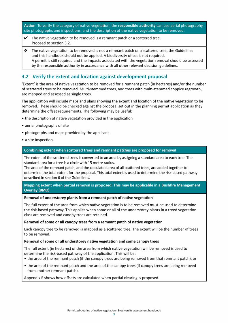
Action: To verify the category of native vegetation, the responsible authority can use aerial photography, site photographs and inspections, and the description of the native vegetation to be removed.
✔ The native vegetation to be removed is a remnant patch or a scattered tree. Proceed to section 3.2.
❖ The native vegetation to be removed is not a remnant patch or a scattered tree, the Guidelines and this handbook should not be applied. A biodiversity offset is not required. A permit is still required and the impacts associated with the vegetation removal should be assessed by the responsible authority in accordance with all other relevant decision guidelines.
3.2 Verify the extent and location against development proposal‘Extent’ is the area of native vegetation to be removed for a remnant patch (in hectares) and/or the number of scattered trees to be removed. Multi-stemmed trees, and trees with multi-stemmed coppice regrowth, are mapped and assessed as single trees.
The application will include maps and plans showing the extent and location of the native vegetation to be removed. These should be checked against the proposal set out in the planning permit application as they determine the offset requirements. The following may be useful:
• the description of native vegetation provided in the application
• aerial photographs of site
• photographs and maps provided by the applicant
• a site inspection.
Combining extent when scattered trees and remnant patches are proposed for removal
The extent of the scattered trees is converted to an area by assigning a standard area to each tree. The standard area for a tree is a circle with 15 metre radius. The area of the remnant patch, and the calculated area of all scattered trees, are added together to determine the total extent for the proposal. This total extent is used to determine the risk-based pathway described in section 6 of the Guidelines.
Mapping extent when partial removal is proposed. This may be applicable in a Bushfire Management Overlay (BMO)
Removal of understorey plants from a remnant patch of native vegetation
The full extent of the area from which native vegetation is to be removed must be used to determine the risk-based pathway. This applies when some or all of the understorey plants in a treed vegetation class are removed and canopy trees are retained.
Removal of some or all canopy trees from a remnant patch of native vegetation
Each canopy tree to be removed is mapped as a scattered tree. The extent will be the number of trees to be removed.
Removal of some or all understorey native vegetation and some canopy trees
The full extent (in hectares) of the area from which native vegetation will be removed is used to determine the risk-based pathway of the application. This will be: • the area of the remnant patch (if the canopy trees are being removed from that remnant patch), or
• the area of the remnant patch and the area of the canopy trees (if canopy trees are being removed from another remnant patch).
Appendix E shows how offsets are calculated when partial clearing is proposed.

Permitted clearing of native vegetation - Biodiversity assessment handbook 10
The responsible authority needs to ensure the mapped extent includes the full footprint of the native vegetation loss associated with the use or development, including consequential losses. This includes but is not limited to:
• the need for firebreaks
• defendable space to reduce bushfire risk (note that in some zones within a BMO clearing for defendable space is exempt)
• installation of services and utilities
• ongoing access
• vehicle access for, and impacts of, construction activities
• indirect impacts of the development that destroy native vegetation, such as:
– changes to hydrology
– effluent discharge
– stormwater runoff
– compaction and excavation.

Permitted clearing of native vegetation - Biodiversity assessment handbook 11
Assumed losses of native vegetation
Protecting trees• Construction projects involving earthworks can cause indirect losses of native vegetation due to
compaction and excavation in close proximity to tree roots. The Australian standard AS 4970-2009 – Protection of trees on development sites is helpful. This standard specifies Tree Protection Zones5 (TPZ) and Structural Root Zones6 (SRZ) that should be protected. Unless an arborist report indicates otherwise, the tree, or trees within a remnant patch of treed native vegetation to be retained, will be assumed lost if the encroachment into the TPZ is greater than 10 per cent, or is inside the SRZ.
• Lopping of canopy trees in excess of what is provided for in the ‘lopping and pruning for mainte-nance exemption in Clause 52.17’ is treated as assumed loss, unless an arborist report concludes that the tree will survive.
Vegetation around dwellingsVegetation modifications required to mitigate bushfire means that within 10 metres of a building, flammable objects (such as plants, mulches and fences) must not be located close to vulnerable parts of the building (such as windows, decks and eaves). DELWP assumes that 100 per cent loss of native vegetation will occur within this 10 metre area as a result of fuel reduction and ancillary works required around a new dwelling. This 10 metre area may be part of the defendable space and may be exempt from requiring a permit is some zones.
Subdivisions and exemptions triggered by their approval• The 2005 Villawood VCAT decision7 concludes that when dealing with subdivisions, the retention
of vegetation on site (within a lot with a development zone) should not be regarded as being re-tained when calculating the native vegetation loss or offset requirements. Significant native vegeta-tion on the site that should or can be retained, should be reflected in the design of the subdivision. Such vegetation should be included in public open space or other types of landholdings where its retention and ongoing management is assured.
• Assume all native vegetation within lots smaller than 0.4 hectares will be lost when subdivisions are created. Also consider the future construction of boundary fences between properties in different ownerships. This is because of exemptions under Clause 52.17.
Subdivisions in a BMOThe Victorian Planning Provisions seek to ensure that subdivision design and layout addresses bushfire hazard. Lots in residential and rural-residential subdivisions approved after 31 July 2014 must have bushfire protection measures specified at the subdivision stage. Native vegetation removal required to create defendable space for lots in new subdivisions must be assessed and offsets determined at the time of the subdivisional approval.
Action: Responsible authority checks that the extent of the native vegetation to be removed is consistent with the proposed use or development plan
✔ The extent of native vegetation to be removed is correct. Proceed to section 3.3.
❖ The extent is different to the expected extent of the native vegetation removal, complete the pre-assessment verification to check for other errors. Request outstanding information from the applicant.
5 A Tree Protection Zone is an area around the trunk of the tree which has a radius of 12 x the diameter at breast height to a maximum of 15 metres but no less than 2 metres. Dead trees should be protected with a radius of 15 metres from the base.
6 The Structural Root Zone is the area required for tree stability. A larger area is required to maintain a viable tree.7 Victorian Civil and Administrative Tribunal decision – Villawood Properties v Greater Bendigo CC (Red Dot) [2005] VCAT 2703
(20 December 2005).
Permitted clearing of native vegetation - Biodiversity assessment handbook 12
3.3 Verify the risk-based pathway of the applicationThe risk-based pathways, as established under Clauses 52.16 and 52.17 and described in section 6 of the Guidelines, determine the application requirements and the decision guidelines that are applied when assessing the application. The risk-based pathway is informed by location risk and extent risk.
3.3.1 Location riskThe location risk is determined from the Native vegetation location risk map8. All locations in Victoria fall into one of three location risk categories: A, B or C. The risk category relates to the area of the native vegetation to be removed, not the risk category of a property. If two or more risk categories are present, the letter furthest from A is used. For example, if part of the area is in Location A and part in Location C, Location C is used as the location risk.
3.3.2 Extent risk Extent risk is determined from the extent of the native vegetation to be removed, expressed as number of trees or hectares of remnant patch(es). If scattered trees and remnant patch(es) are being removed, the area of scattered trees is added to the area of remnant patch(es) to calculate total extent used to determine the risk-based pathway.
For partial clearing:
• The full extent of the area from which native vegetation is to be removed must be mapped if removal of understorey plants from a remnant patch is proposed.
• Any canopy trees removed from a remnant patch of native vegetation must be mapped as a scattered tree (circle with a 15 metre radius).
Location and extent risk for applications with past permitted clearing
The location and extent used to determine the risk-based pathway of the application must include any clearing that has taken place, or could still take place, under any permit granted in the five years before the application was lodged for the same property with the same ownership.
If the risk-based pathway moves from low to either moderate or high when the past permitted clearing location and extent is added, the application must include all the application requirements of this new risk-based pathway, including:
• the habitat hectare assessment report
• a minimisation statement
• an assessment of the impact on Victoria’s biodiversity
• an offset strategy.
The decision guidelines of the higher pathway will apply. If the application contains only ‘General application requirements’, more information must be requested in the form of the ‘Moderate and high risk-based pathway application requirements’. The application must demonstrate that past clearing has been correctly accounted for Appendix C describes how to do this.
Notes:
• Appendix B explains how past permitted clearing is accounted for.
• Offset requirements are specified only for the proposed clearing. Past clearing extent does not require an offset. See Appendix E for more details.
8 This map can be viewed in the DELWP mapping products; Native Vegetation Information Management (NVIM) system and Biodiversity Interactive Map (BIM).

Permitted clearing of native vegetation - Biodiversity assessment handbook 13
Location and extent risk for large projects that may be multi-staged or cross jurisdictional boundaries
The location and extent of the entire project must be taken into account when determining the risk-based pathway of the application and the offset requirements. Offset requirements can be apportioned, if required, to a number of permit applications by using habitat zone information. Refer to Appendix B for more details.
3.3.3 Verify risk-based pathway The location and extent9 of the native vegetation to be removed is combined to determine the risk-based pathway for the application. Refer to Table 3 in the Guidelines.
Action: Responsible authority checks permit records and verifies that the application has accounted for past permitted clearing when applicable, and checks that the native vegetation to be removed has been mapped in the correct location.
✔ The location and extent of proposed native vegetation removal is correct (including past clearing as applicable). Proceed to section 3.4.
❖ The location and extent of proposed native vegetation removal is incorrect (or past clearing has been excluded), complete the pre-assessment verification. Request outstanding information from the applicant.
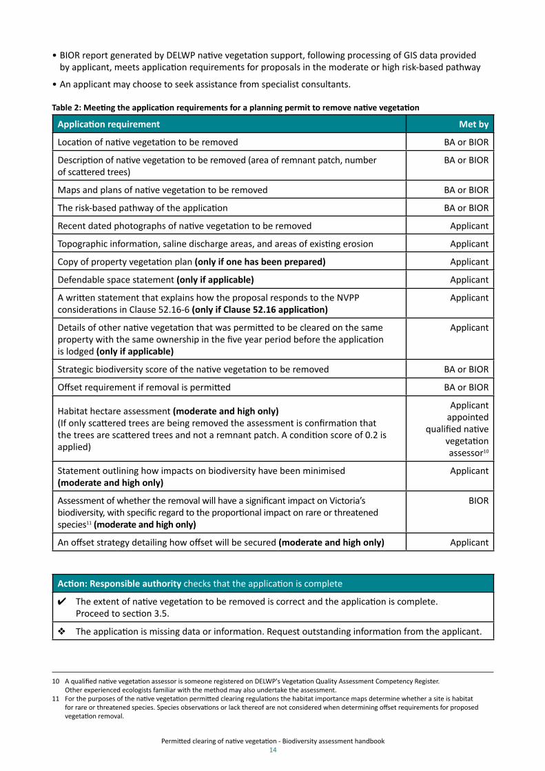
3.4 Ensure that the application is completeThe responsible authority must check that all required information is included in the application. Table 2 details what application requirements are met by the Biodiversity Assessment (BA) report or the Biodiversity Impact and Offset Requirements (BIOR) report.
Applications in the low risk-based pathway that include past clearing must include two BA reports. See Appendix C for details.
The checklist in Appendix D can assist when checking that the application is complete.
Note that in the following table:
• BA report generated by the NVIM tool meets application requirements for proposals in the low risk-based pathway
9 Includes any clearing that has taken place, or could still take place, under any permit granted in the five years before the application was lodged for the same property with the same ownership.
Tools to assist applicants and assessors
DELWP has developed the native vegetation permitted clearing regulations tool in the Native Vegetation Information Management (NVIM) system. This NVIM tool determines the risk-based pathway of an application and determines offset requirements for applications in the low risk-based pathway. Applicants can download a Biodiversity Assessment report after marking all the native vegetation they propose to remove.
Currently, DELWP native vegetation support uses the EnSym tool to determine offset requirements for applications in the moderate and high risk-based pathway. Applicants or their consultants submit shapefiles to DELWP. The shapefiles are analysed in the EnSym tool and a Biodiversity Impact and Offset Requirements report is provided back.
Refer to Appendix C for more details.
Permitted clearing of native vegetation - Biodiversity assessment handbook 14
• BIOR report generated by DELWP native vegetation support, following processing of GIS data provided by applicant, meets application requirements for proposals in the moderate or high risk-based pathway
• An applicant may choose to seek assistance from specialist consultants.
Table 2: Meeting the application requirements for a planning permit to remove native vegetation
Application requirement Met by
Location of native vegetation to be removed BA or BIOR
Description of native vegetation to be removed (area of remnant patch, number of scattered trees)
BA or BIOR
Maps and plans of native vegetation to be removed BA or BIOR
The risk-based pathway of the application BA or BIOR
Recent dated photographs of native vegetation to be removed Applicant
Topographic information, saline discharge areas, and areas of existing erosion Applicant
Copy of property vegetation plan (only if one has been prepared) Applicant
Defendable space statement (only if applicable) Applicant
A written statement that explains how the proposal responds to the NVPP considerations in Clause 52.16-6 (only if Clause 52.16 application)
Applicant
Details of other native vegetation that was permitted to be cleared on the same property with the same ownership in the five year period before the application is lodged (only if applicable)
Applicant
Strategic biodiversity score of the native vegetation to be removed BA or BIOR
Offset requirement if removal is permitted BA or BIOR
Habitat hectare assessment (moderate and high only)(If only scattered trees are being removed the assessment is confirmation that the trees are scattered trees and not a remnant patch. A condition score of 0.2 is applied)
Applicant appointed
qualified native vegetation assessor10
Statement outlining how impacts on biodiversity have been minimised (moderate and high only)
Applicant
Assessment of whether the removal will have a significant impact on Victoria’s biodiversity, with specific regard to the proportional impact on rare or threatened species11 (moderate and high only)
BIOR
An offset strategy detailing how offset will be secured (moderate and high only) Applicant1011
Action: Responsible authority checks that the application is complete
✔ The extent of native vegetation to be removed is correct and the application is complete. Proceed to section 3.5.
❖ The application is missing data or information. Request outstanding information from the applicant.
10 A qualified native vegetation assessor is someone registered on DELWP's Vegetation Quality Assessment Competency Register. Other experienced ecologists familiar with the method may also undertake the assessment.
11 For the purposes of the native vegetation permitted clearing regulations the habitat importance maps determine whether a site is habitat for rare or threatened species. Species observations or lack thereof are not considered when determining offset requirements for proposed vegetation removal.

Permitted clearing of native vegetation - Biodiversity assessment handbook 15
3.5 Determine referral requirementsClause 66.02-2 of the Victoria Planning Provisions specifies when an application for a planning permit to remove native vegetation must be referred to the Secretary to the DELWP. DELWP is a recommending referral authority for applications to remove native vegetation.
Note that some moderate risk-based pathway applications for permits are not referred to DELWP, while some low risk-based pathway applications are referred to DELWP.
One referral trigger is the removal of 0.5 hectares or more. This is the area of a remnant patch, or the combined area of scattered trees and remnant patches. This trigger does not apply if the proposal is only for scattered tree removal.
Referred applications:
• DELWP and the responsible authority assess the impact of the proposal to Victoria’s biodiversity in accordance with Clause 52.16 or 52.17, and the Guidelines. DELWP provides recommendations to the responsible authority.
• The responsible authority ensures all requirements of the planning scheme are met.
Non-referred applications:
• The responsible authority completes the assessment of the application.
Decision Point – Responsible authority
✔ The application triggers a referral under Clause 62.02-2, refer the application to DELWP. Proceed with the assessment using this handbook and any relevant local council guidelines. Ensure all planning scheme requirements are met.
❖ The application does not trigger a referral to DELWP. Proceed with the assessment using this handbook and any relevant local council guidelines. Ensure all planning scheme requirements are met.
3.6 DELWP receives the referralWhen an application is referred to DELWP, verify that the application is complete and contains all required information. The location and extent of proposed native vegetation removal should be reconfirmed, as detailed in section 3.2.
Decision Point – Referral Authority
✔ The application is complete, begin the biodiversity assessment.
❖ The application does not contain all the required information. Request the missing information.
Low risk-based pathway applications – proceed to section 4
Moderate and high risk-based pathway applications – proceed to section 5

Permitted clearing of native vegetation - Biodiversity assessment handbook 16
4. Low risk-based pathway – Biodiversity assessment
4.1 Verify offset requirementsVerify the offset requirements in the application against section 9 of the Guidelines, which requires that general offsets:
• are located in the same Catchment Management Authority (CMA) boundary or municipal district area as the clearing, and
• have a strategic biodiversity score of at least 80 per cent of the strategic biodiversity score of the clearing site.
If clearing crosses two or more CMAs or municipal areas the offset can be provided in any of the CMAs or municipal areas where removal takes place.
The NVIM tool calculates the offset requirements from the location and extent of native vegetation marked to be removed , and the modelled condition score depicted in the Native vegetation condition map. The offset requirements are detailed in the BA report included in the application.
Manually amend the BA report if the application is for partial vegetation removal – for example, removal of understorey plants. Also amend the BA report if a habitat hectare assessment has been included or a qualified native vegetation assessor has determined that trees being removed are scattered trees.
Appendix E:
• shows how NVIM calculates general offset requirements for low risk-based pathway applications
• explains how to adjust the scores in the BA report to account for partial clearing or the submission of a habitat hectare assessment.
Action: Responsible authority/Referral authority – if the application includes partial clearing, or a habitat hectare assessment report, check that the offset amounts have been adjusted correctly
✔ The offset amount required is correct. Proceed to section 4.2.
❖ The offset amount is incorrect. This should only apply for non-standard applications as NVIM calculates requirements for standard applications. Request more information.
4.2 Apply the biodiversity considerations detailed in the decision guidelines Clauses 52.16 and 52.17, and section 8 of the Guidelines, require the following be considered when deciding an application to remove native vegetation in the low risk-based pathway:
• the contribution that native vegetation to be removed makes to Victoria’s biodiversity, as determined by the extent, condition and the biodiversity value, including whether the native vegetation is important habitat for rare or threatened species
• whether the application is in the low risk-based pathway
• whether the proposed development is in accordance with any property vegetation plan that applies to the site (Guideline requirement).

Permitted clearing of native vegetation - Biodiversity assessment handbook 17
What determines the contribution native vegetation makes to Victoria’s biodiversity
Sections 2.4 and 3 of the Guidelines note that site-based and landscape scale characteristics determine the contribution native vegetation makes to Victoria’s biodiversity. Site-based characteristics include extent and condition. Landscape scale information includes the strategic biodiversity score (this incorporates condition, connectivity, species habitat, and rarity and depletion of vegetation types) and the habitat importance score for rare or threatened species habitat.
Contribution and risk-based pathway
When the native vegetation to be removed makes a low contribution to Victoria’s biodiversity, applications for removal follow the low risk-based pathway. Given this low contribution, the loss of native vegetation is acceptable provided conditions to secure a commensurate offset are specified and met.
Property vegetation plan
A property vegetation plan (PVP) is a plan which relates to managing native vegetation within a property over a specified time period – usually 10 years. The PVP must be contained within an agreement made pursuant to section 69 of the Conservation, Forests and Lands Act 1987. If a PVP is included, ensure permit conditions detailed at Clause 52.17-4 are included.
4.3 Decision making – biodiversity considerations
The biodiversity assessment of applications in the low risk-based pathway is restricted to verifying that the information presented by the applicant is accurate and complies with the application requirements. The planning permit should not be objected to or refused on the basis of the biodiversity considerations in Clause 52.16 or 52.17. A compliant offset must be secured, to the satisfaction of DELWP or the responsible authority, before the native vegetation is removed. A planning permit condition must specify this requirement. Refer to Appendix F for standard conditions.
Native vegetation that is neither a remnant patch nor a scattered treeIf the native vegetation to be removed is not a remnant patch or a scattered tree, the biodiversity considerations in Clause 52.17 are not applied. DELWP will not object, and the application should not be refused on the basis of the biodiversity considerations in Clause 52.17 or 52.16. No biodiversity offset is required for the removal of this native vegetation.
Figure 1 shows a flow chart for considering biodiversity when assessing a planning permit application to remove native vegetation under the low risk-based pathway.

Permitted clearing of native vegetation - Biodiversity assessment handbook 18
Figure 1: Biodiversity considerations for low risk-based pathway applications.
Biodiversity considerations
Request moreinformation
The extent and category of native vegetationproposed to be removed is correct
The offset requirements are correct
A property vegetation plan applies
Do not object or refuse permit based on biodiversity
considerations, include offset requirements
as permit conditions.
Yes
No
No
Yes
Yes, and clearing accords
No, or clearing does not accord
The responsible authority must consider other matters (see
sections 8 and 9 of this handbook) contained in sub-clauses 52.16-6 and
52.17-5 when deciding to grant or refuse to grant a permit
Do not object or refuse permit based on biodiversity
considerations of clause, include offset requirements as permit conditions and PVP conditions
as per sub-clause 52.17-4.
Decision Point: Biodiversity considerations
✔ Do not object to (or refuse to grant) a permit on the basis of the biodiversity considerations in Clause 52.17.
✔ Draft offset requirement conditions (refer to Appendix F). Proceed to section 8 if the application was not referred to DELWP. Proceed to section 9 if it was referred to DELWP.

Permitted clearing of native vegetation - Biodiversity assessment handbook 19
5. Moderate and high risk-based pathway – additional application requirements
Before applying the decision guidelines contained in Clause 52.16 or 52.17, and section 8 of the Guidelines, the permit assessor should ensure that the additional application requirements have been met.
Applications in the moderate and high risk-based pathway must include the following additional application requirements:
• habitat hectare assessment report of the native vegetation to be removed
• statement outlining steps taken to minimise the impact of the removal of native vegetation on Victoria’s biodiversity
• assessment of whether the proposed removal of native vegetation will have a significant impact on Victoria’s biodiversity, specifically habitat for rare or threatened species
• offset strategy that details how a compliant offset will be secured.
A qualified native vegetation assessor is required to do the habitat hectare assessment. NVIM does not currently calculate offset requirements for clearing proposals in the moderate or high risk-based pathway. At this time, this is done by DELWP native vegetation support and detailed in the BIOR report. This report also includes the assessment of the impact on habitat for rare or threatened species.
5.1 Review habitat hectare assessment report The site-based habitat hectare assessment must be prepared by a qualified native vegetation assessor in accordance with the method published on the DELWP website. No other vegetation assessment methodology, including the Index of Wetland Condition, is acceptable for the purposes of the permitted clearing regulations.
Consider the following when reviewing the habitat hectare assessment report:
• Is the native vegetation assessor qualified to undertake an assessment? This means either they are registered on the DELWP Vegetation Quality Assessment Competency Register, or they are an experienced ecologist familiar with the method.
• Has the assessment has been done in accordance with the habitat hectare method?
• Does the extent of native vegetation shown in the report account for the full development footprint, including consequential and assumed losses (refer to section 3.2)?
• Have scattered trees been assigned the standard area and condition score of 0.2? This results in a standard habitat hectares amount of 0.014 habitat hectares per tree.
• Have canopy trees being removed from a remnant patch been assigned the standard area of a scattered tree and given the condition score of the remnant patch – the minimum possible condition score being 0.2?
If the native vegetation assessor is unable to assess condition of the native vegetation
In circumstances of severe temporary change in native vegetation condition (such as during a declared drought, following fire, flooding, slashing, accidental herbicide impact or unusually intense grazing), the Native vegetation extent map should be used to determine if vegetation is native, and the condition score should be taken from the Native vegetation condition map.
All mapped wetlands are considered a remnant patch
Wetlands can be difficult to map and assess accurately as they respond quite quickly to changes in environmental condition, especially rainfall. After a period of no or low rainfall they can disappear or appear very degraded. They do, however, recover rapidly after periods of increased rainfall. All mapped wetlands (see Current wetland layer in BIM) that will be impacted must be included in the extent of native vegetation removal. The modelled condition score is assigned to them.

Permitted clearing of native vegetation - Biodiversity assessment handbook 20
If the report does not comply with the habitat hectares method, and/or the assessed habitat hectares amount determined by the assessor appears inaccurate, request additional information from the applicant. Do this once all outstanding matters are identified. Consider a site inspection to aid the verification process.
Assessment point
✔ The habitat hectare assessment report is in accordance with the current method and is acceptable. Proceed to section 5.2.
❖ The habitat hectare assessment report is not in accordance with the current method, or the information appears incorrect. Request further information after reviewing the rest of the application.
5.2 Review minimisation statementThe minimisation statement must:
• describe the steps taken to minimise the impact on biodiversity from the removal of native vegetation, and
• include an explanation of how further minimisation would compromise the proposed use or development.
Section 8 of the Guidelines states that these minimisation steps have regard to the contribution to Victoria’s biodiversity made by:
• the native vegetation to be removed, and
• the native vegetation to be retained.
Minimisation should target native vegetation that makes the greatest contribution to Victoria’s biodiversity – that is, areas of better condition, higher strategic biodiversity score, and/or higher habitat importance scores.
The minimisation statement could state that minimisation was achieved by a past strategic planning exercise or by site interventions, or that it is not achievable or desirable on site for specific reasons. Whether this statement is acceptable or not will be determined during the decision making process: see section 6 or section 7 of this handbook.
Assessment point
✔ A minimisation statement is included and it complies with requirements. Proceed to section 5.3.
❖ A minimisation statement is not included, or it does not comply with the requirements. Request further information after reviewing the rest of the application.
5.3 Review assessment of the impact on Victoria’s biodiversitySection 7 of the Guidelines notes that the assessment should indicate whether the proposed removal of native vegetation will have a significant impact on Victoria’s biodiversity, with specific regard to the proportional impact on habitat for any rare or threatened species.
For the purposes of the native vegetation permitted clearing regulations, the habitat importance maps determine whether a site is habitat for rare or threatened species. Species observations or lack thereof are not considered when determining: • the impact on rare or threatened species, and • the offset requirements for proposed vegetation removal.

Permitted clearing of native vegetation - Biodiversity assessment handbook 21
The BIOR report includes information that can be used for this assessment and fulfils this application requirement, although applicants may submit supplementary information. The BIOR report includes the proportional impact for all rare or threatened species that require a specific offset and notes if a species is highly localised or dispersed. The BIOR report also has a list of all other rare or threatened species habitat mapped on the site.
Assessment point
✔ The BIOR report is included. Proceed to section 5.4.
❖ The BIOR report is not included, or the area of native vegetation to be removed is not accurately depicted on the images. Request further information after reviewing the rest of the application.
5.4 Verify offset requirementsClauses 52.16 and 52.17 state that the biodiversity impacts from the removal of native vegetation are required to be offset in accordance with the Guidelines. Only the DELWP native vegetation support team can currently calculate the offset requirements using the location, extent and condition of native vegetation mapped by the applicant in a Geographic Information System (GIS).
Offset requirements are detailed in the BIOR report that must be included with the application. If clearing crosses two or more CMAs or municipal areas the offset can be provided in any of the CMAs or municipal areas where removal takes place.
Appendix E explains how offset requirements are calculated. The specific-general offset test is applied using the mapped native vegetation sent to DELWP native vegetation support. This test determines if a specific or general offset is required by measuring the proportional impact on all mapped rare or threatened species habitat on site. A specific offset will be required for a species when the proportional impact is above the specific offset threshold. General offsets will be required when the proportional impact is below this threshold for all species within a habitat zone.
The process described in section 3.2 enables verification of the location and extent of native vegetation to be removed. The process described in section 5.1 enables verification of the condition score. If these are correct, the offset requirements in the BIOR report are correct.
Check that the BIOR report has accounted for any partial or past12 clearing if the application includes this.
• Partial clearing: Condition scores are halved and this adjusts offset requirements. The condition scores used are shown in the BIOR report habitat hectares table.
• Past clearing: The map in the BIOR report will show past and proposed clearing. Areas of past permitted clearing are used when running the specific-general offset test. However, the offset requirements are only for proposed clearing.
Assessment point
✔ The BIOR report values are correct. Proceed to section 5.5.
❖ The BIOR report requires amendment. Request further information after reviewing the rest of the application.
12 Includes any clearing that has taken place, or could still take place, under any permit granted in the five years before the application was lodged for the same property with the same ownership.

Permitted clearing of native vegetation - Biodiversity assessment handbook 22
5.5 Review offset strategyThe offset strategy must detail how an eligible13 offset that satisfies the offset requirements14 will be secured. Offsets can be provided by purchasing an existing native vegetation credit, or securing a new first party or third party offset site. A new third party offset site will become a native vegetation credit once registered in the Native Vegetation Credit Register. The type of offset to be secured will determine the contents of the offset strategy.
a) Existing native vegetation credit
An acceptable offset strategy must include one of the following:
• a letter from an offset broker confirming they have available credits to meet requirements
• a copy of the spreadsheet of currently available credits from the DELWP website with the matching credits highlighted
• a recently dated credit statement that meets the offset requirements.
The permit application assessor should check the spreadsheet of available credits on the DELWP website. If concerned that the credits are no longer be available, contact [email protected].
b) New first party general offset site to be secured
The First party general offset kit and calculator must be used by landowners to determine gain in general biodiversity equivalence units. If a qualified native vegetation assessor is preparing the security agreement and management plan they use the Native vegetation gain scoring manual and Gain calculator.
The offset strategy for a first party general offset site must include the following information:
• map of the property showing the proposed offset site
• a statement detailing how the site(s) meets the offset eligibility criteria set out in the First party general offset kit or Native vegetation gain scoring manual
• a statement noting agreement to and understanding of the required management actions and security agreement, including cost implications
• the calculated gain resulting from the management and security commitments using the appropriate calculator
• the attributes of the offset site(s) determined from NVIM or using the First party general offset kit.
c) New first party specific offset sites or third party (general or specific) offset site to be securedA qualified native vegetation assessor must prepare the management plan using the Native vegetation gain scoring manual and Gain calculator.
The offset strategy for applications proposing to secure a first party specific offset or any third party offset must include the following information:
• map of the property showing the proposed offset site
• a statement detailing how the site(s) meets the offset eligibility criteria set out in the Native vegetation gain scoring manual
• a statement from the landowner(s) that confirms they are willing to register the offset site in the Native Vegetation Credit Register and commit to the required management actions
• the calculated gain resulting from the management and security commitments using the Native vegetation gain calculator or Native vegetation gain scoring manual
• the attributes of each offset site determined by DELWP native vegetation support and detailed in the Offset site report.
13 Eligibility criteria are detailed in the Native vegetation gain scoring manual.14 Offset requirements are detailed in the Biodiversity impact and offset requirements report provided by DELWP.

Permitted clearing of native vegetation - Biodiversity assessment handbook 23
Managing bushfire threatAn area of native vegetation can only be eligible as an offset if the management commitments do not contribute to the bushfire hazard for dwellings on, and adjacent to the property.
• Within the BMO an offset site must be outside the defendable space zone of a dwelling, and can only be within 150 metres of a dwelling (including adjacent properties) if it will not affect fuel load, structure or continuity in a way that will increase fire intensity and behaviour.
• Outside a BMO an offset site must be at least 50 metres from a dwelling.
The likelihood of a fire prevention notice being issued on the proposed offset site should be considered prior to accepting the proposed offset.
Assessment point
✔ The application is in the moderate risk-based pathway, and the offset strategy meets these requirements. Proceed to section 6.
✔ The application is in the high risk-based pathway, and the offset strategy meets these requirements. Proceed to section 7.
❖ The offset strategy does not meet these requirements. Request further information after reviewing the rest of the application.
All application requirements have now been verified. Request any additional information such as updates to the habitat hectare assessment, further minimisation or an acceptable offset strategy before progressing to the decision making stage.
Moderate risk-based pathway application – proceed to section 6
High risk-based pathway application – proceed to section 7

Permitted clearing of native vegetation - Biodiversity assessment handbook 24
6. Moderate risk-based pathway – Biodiversity assessmentClauses 52.16 and 52.17, and section 8 of the Guidelines, require consideration of the following when deciding an application to remove native vegetation that is in the moderate risk-based pathway:
• whether the vegetation is native (completed – refer to section 3.1)
• whether the application is correctly placed in the moderate risk-based pathway (completed, refer to section 3.3)
• whether the proposed development is in accordance with any property vegetation plan that applies to the site (refer to section 6.1)
• the contribution that native vegetation to be removed makes to Victoria’s biodiversity as determined by the extent, condition, and biodiversity value (refer to section 6.2)
• whether reasonable steps have been taken to minimise impacts on biodiversity (refer to section 6.3)
• whether a compliant offset has been identified (refer to section 6.4).
6.1 Property vegetation plan A property vegetation plan (PVP) is a plan which relates to the management of native vegetation within a property, and which is contained within an agreement made pursuant to section 69 of the Conservation, Forests and Lands Act 1987.
A PVP may be included in the application for a planning permit to remove native vegetation. Do not object to the application when the native vegetation to be removed is in accordance with the PVP. Ensure any relevant conditions in the PVP, including offset arrangements, are complied with. Include permit conditions detailed at Clause 52.17-4.
Consider the implications of the clearing for the implementation of the PVP when the native vegetation to be removed is not in accordance with the PVP. The PVP may require amendment, or it may be nullified when the native vegetation to be removed has a significant impact on the PVP.
Assessment point
✔ There is no PVP included in the application. Proceed to section 6.2.
✔ The native vegetation to be removed is not in accordance with the PVP. Assess the implications for the validity of the PVP and whether it is necessary to amend or nullify the PVP. Proceed to section 6.2.
❖ The native vegetation to be removed is in accordance with the PVP. Draft relevant permit conditions detailed at Clause 52.17-4. No further biodiversity assessment is required. Proceed to section 8 if not referred to DELWP. Proceed to section 9 if referred to DELWP.
6.2 Consider the contribution that the native vegetation makes to Victoria’s biodiversity
Sections 2.4 and 3 of the Guidelines note that site-based and landscape scale characteristics determine the contribution native vegetation makes to Victoria’s biodiversity. Site-based characteristics include extent and condition. Landscape scale information includes:
• the strategic biodiversity score (this incorporates condition, connectivity, species habitat and rarity and depletion of vegetation types), and
• the habitat importance score for rare or threatened species habitat.

Permitted clearing of native vegetation - Biodiversity assessment handbook 25
Table 3 describes relevant available information when considering the contribution the identified native vegetation makes to Victoria’s biodiversity.
Table 3: Information to consider when determining the contribution native vegetation makes to Victoria’s biodiversity
What is the extent and condition of the native vegetation?
Habitat hectares assessment report
The habitat hectares assessment report contains site-based information on the condition and extent of the native vegetation proposed to be removed. Large areas of native vegetation with a high habitat score (condition) contribute more to Victoria’s biodiversity than a small area with a low habitat score. Habitat scores are usually from 0.2 to 1. The higher the value the greater the contribution to Victoria’s biodiversity. Scores above 0.8 indicate very good condition.
What is the landscape biodiversity value of the native vegetation?
The strategic biodiversity score of the native vegetation
The BIOR report includes the average strategic biodiversity score of all native vegetation proposed to be removed. Strategic biodiversity scores for habitat zones that do not require a specific offset are also included. The strategic biodiversity score will be from 0.1 to 1 and is depicted in the Strategic biodiversity map15. The higher the score the greater the contribution to Victoria’s biodiversity. Scores above 0.8 are very important sites.
Is the native vegetation important habitat for rare or threatened species?
The number of rare or threatened species habitats impacted should the native vegetation be removed
All rare or threatened species for which the native vegetation provides suitable habitat are included in the BIOR report. The more species listed, the greater the contribution the native vegetation makes to Victoria’s biodiversity. The application may include site observations that may also be considered here.
The number of rare or threatened species habitats impacted above the specific offset threshold (that is, requiring a specific offset)
The BIOR report includes species that are impacted above the specific offset threshold. The more species requiring a specific offset, the greater the contribution to Victoria’s biodiversity.
The proportional impact for species requiring a specific offset.
The proportional impact will be shown in the BIOR report. The higher the proportional impact, the more important that site is for that particular species.
The habitat importance score for impacted species
Habitat importance maps for rare or threatened species contain the habitat importance score. This score will usually be from around 0.5/0.7 to 1. The higher this score, the more important that site is for that particular species. The habitat importance score is included in the BIOR report when a specific offset is required.
Impact on highly localised habitat
When a specific offset is required, the BIOR report includes information on whether a species habitat is highly localised or dispersed. Native vegetation that provides habitat for species with highly localised habitat is very important vegetation. Highly localised habitat is very limited in extent and any loss needs to be carefully considered.
15 This map can be viewed in the DELWP mapping products; Native Vegetation Information Management (NVIM) system and Biodiversity Interactive Map (BIM).

Permitted clearing of native vegetation - Biodiversity assessment handbook 26
6.3 Consider the minimisation statementConsider whether reasonable steps have been taken to minimise the impact of native vegetation removal on biodiversity. These steps should have regard to the contribution to biodiversity made by the native vegetation to be removed and the native vegetation to be retained. Areas of native vegetation to be retained should continue making the same contribution to Victoria’s biodiversity in the future – that is, they should not be degraded by the proposed development.
Determine if the site was subject to an acceptable strategic planning exercise (see section 6.3.1) that minimised impacts to biodiversity. If so, adequate minimisation has taken place. If not, reasonable steps should be taken at the site level.
6.3.1 Strategic planningStrategic planning processes include planning scheme amendments, precinct planning, regional growth plans and strategic environmental assessments incorporated into the relevant planning scheme. Strategic planning must comply with the following criteria to meet the requirement of this decision guideline:
• The strategic plan includes an assessment of the contribution native vegetation makes to Victoria’s biodiversity, using up-to-date DELWP landscape scale information in addition to any site-based information.
• The strategic plan has been incorporated or is reflected in the relevant planning scheme.
• Development and land use has been directed to areas of native vegetation that contributes least to Victoria’s biodiversity.
• Native vegetation that makes a significant contribution to Victoria’s biodiversity has been protected and conserved. Significant native vegetation on multi-lot subdivisions that should or can be retained, should be reflected in the design of the subdivision. Such vegetation should be included in public open space or other types of land holding where its retention and ongoing management is assured.
• Development and land use is planned in a way that ensures the retained native vegetation continues to make a significant contribution to Victoria’s biodiversity in the future by ensuring land use or development is compatible with the remaining biodiversity values (for example, siting developments that are likely to have off site impacts away from sensitive or high value native vegetation).
• Offsets to address any native vegetation that will be removed are available and have been secured.
• DELWP has supported the process by participating, reviewing, or providing comments that have been incorporated.
6.3.2 Site level minimisation Locating, designing and managing the proposed use or development within a property can minimise the biodiversity impact of the proposal. This can be achieved by:
• Locating or designing the use or development to avoid areas of native vegetation that contribute more to Victoria’s biodiversity.
• Managing the use or development to ensure that impacts on biodiversity are minimised. This may be achieved via engineering solutions to reduce run-off, waste water treatment, tree protection etc.
The application will include a statement outlining the steps taken to minimise impacts on biodiversity from the removal of native vegetation. The statement must explain how further minimisation would compromise the use or development. Consider the statement, and decide if reasonable steps have been taken to minimise impacts. Minimisation should be targeted towards native vegetation that makes the greatest contribution to biodiversity:
• areas of native vegetation in good condition (with high condition scores)
• areas of native vegetation with a higher strategic biodiversity score than other areas
• areas of native vegetation that support more rare or threatened species habitats than other areas, especially when the proportional impact to a species is above the threshold and a specific offset is required

Permitted clearing of native vegetation - Biodiversity assessment handbook 27
• areas of habitat for a particular rare or threatened species that have higher habitat importance scores than other areas
• areas of native vegetation that are suitable habitat for species with highly localised habitat requirements.
Habitat importance maps and the information included in the BIOR report contain relevant information. Areas of native vegetation to be retained should be able to continue to provide the biodiversity value that it currently provides. Condition should be maintained and there should be no increase in threats.
Consider minimisation
✔ Consider whether relevant strategic planning has occurred.✔ Consider the location and size of any site minimisation effort. Have impacts been minimised on areas
of native vegetation that contribute more to Victoria’s biodiversity? This is more important when specific offsets are required, especially when multiple specific offsets are required.
✔ Consider the prognosis of the native vegetation to be retained. Will retained native vegetation continue to provide the biodiversity value it currently provides?
✔ Consider the impact of further minimisation on the project. Will further minimisation make the proposal unviable? If so, this should be described in the statement.
Minimisation effort should be commensurate with the contribution that the native vegetation makes to Victoria’s biodiversity. Minimum effort can be considered reasonable when the native vegetation contributes lower value to Victoria’s biodiversity – for example, only general offsets are required, strategic biodiversity score is low, the native vegetation is limited in extent and isolated from other remnant patches of native vegetation. Clear minimisation effort should be demonstrated if the native vegetation makes a greater contribution – for example, specific offsets are required, some of these are for highly localised species, the habitat importance scores are high and the vegetation is connected.

Permitted clearing of native vegetation - Biodiversity assessment handbook 28
6.4 Consider the offset(s) identified in the offset strategyThe proposed offset site(s) should be identified in the offset strategy. The contents of the offset strategy are detailed in section 5.5. The proposed offset(s) must meet the offset requirements16 for the removal of native vegetation, including the amount of gain required and the offset attributes. The offset(s) must meet the offset eligibility criteria detailed in the Native vegetation gain scoring manual.
Consider the offset identified
✔ Consider the amount of gain in specific or general biodiversity equivalence units that are provided by proposed offset(s), and the offset attributes. Do they meet the requirements?
✔ Consider the viability of the site to conserve biodiversity into the future. Is it a viable offset in the long term? Does it meet all eligibility criteria?
✔ Consider the level of confidence in securing the required offset. If a new site, has the landowner agreed to the security and management arrangements17?
✔ If a third party offset is registered on the DELWP Native Vegetation Credit Register, assume it is secured and managed appropriately. Check the amount of units on the credit statement to ensure it meets the offset requirements.
Offsets are required to compensate for the biodiversity loss associated with the proposed clearing. It is important that suitable offsets will be secured if a permit is granted. Check with the Native Vegetation Credit Register if unsure that an offset is available.
6.5 Decision making – moderate risk-based pathwayDecision makers need to weigh up a range of considerations when deciding whether to object or not to object (with conditions) to, or to grant or refuse to grant, a permit to remove native vegetation on the basis of the biodiversity considerations in Clause 52.16 or 52.17.
Applications in the moderate risk-based pathway could result in a significant impact on Victoria’s biodiversity. When deciding on an application in the moderate risk-based pathway, consider:
• the contribution that native vegetation to be removed makes to Victoria’s biodiversity (see section 6.2)
• whether reasonable steps have been taken to minimise the impacts on biodiversity from the removal of native vegetation (see section 6.3)
• whether an offset that meets the requirements has been identified (see section 6.4).
Applications are not likely to be objected to or refused when the following both apply:
• native vegetation to be removed makes limited contribution to Victoria’s biodiversity
• offset strategy identifies how the required offset will be secured.
Applications are likely to be objected to or refused when the following apply:
• native vegetation to be removed makes a substantial contribution to Victoria’s biodiversity, with specific offset requirements, and
• no reasonable steps to minimise impacts are included, and/or
• offset strategy does not show how the required offset will be secured.
16 Detailed in the BIOR report.17 These are detailed in the Gain scoring manual.

Permitted clearing of native vegetation - Biodiversity assessment handbook 29
Applications that fall between the two outcomes outlined above need to be carefully considered.
Table 4 may assist in decision making. It is not prescribed but can be used as a guide when considering applications. Decision makers should ensure they can justify their decision based on the information provided and the decision guidelines.
The amount and type of offset required is an indication of the contribution that native vegetation makes to Victoria’s biodiversity. A specific offset is required when the removal of native vegetation results in a significant impact on a rare or threatened species. Generally, native vegetation requiring a specific offset makes a greater contribution than native vegetation that only requires a general offset.
Decisions should be made following a request for further information and assessment of additional information provided by the applicant. Table 4 assumes that all opportunity has been given to the applicant to satisfy requirements.
Table 4: Decision making matrix for moderate risk-based pathway applications
Guidance for decision making for applications in the moderate risk-based pathway
Contribution to Victoria’s biodiversity
Low, with only general
offsetsHigher, with specific offset requirements
Has the applicant demonstrated minimisation? Yes1 Yes1 No2
Has a suitable offset that will be secured been identified? Yes3 Yes No Yes No
POSSIBLE COMMENTS (DELWP) No objection4 No
objection4 Object5 May object6 Object7
POSSIBLE DECISION (Responsible Authority) Grant permit4 Grant
permit4
Refuse to grant permit5
May refuse to grant permit6
Refuse to grant permit7
1. Statement describes what has been done to reduce impacts to biodiversity. This applies when the native vegetation makes a high enough contribution and retained areas can continue to provide biodiversity benefits.
Statement can describe that minimisation is unreasonable at the site level because the native vegetation makes a very low contribution to biodiversity (such as no species offset required, low strategic biodiversity score) or because retained native vegetation would have limited long term prospect of retaining biodiversity value. This would be an acceptable statement.
2. This may occur when there is a significant impact on habitat for rare or threatened species (that is, specific offsets are required), and it appears feasible that native vegetation could be retained and would continue to provide habitat in the future, and no details of minimisation have been provided after requests have been made.
3. General offsets are likely to be easily sourced in all cases.
4. Ensure required offset conditions are included in permit.
5. Object or refuse to grant a permit on grounds that no suitable offset has been identified and there are impacts to rare or threatened species.
6. May object or refuse to grant a permit on grounds that appropriate minimisation has not been demonstrated or documented and it is feasible to reduce the impacts on Victoria’s biodiversity. May grant a permit on the balance of the impact to biodiversity and the security of offsets.
7. Object or refuse to grant a permit on grounds that appropriate minimisation has not taken place, a suitable offset has not been identified, and the clearing impacts on habitat for rare or threatened species.

Permitted clearing of native vegetation - Biodiversity assessment handbook 30
Biodiversity Decision
✔ No objection or refusal on basis of biodiversity considerations in Clause 52.16 or 52.17.✔ Draft offset requirements for permit conditions. Appendix F contains standard conditions.
Proceed to section 8 if the application was not referred to DELWP. Proceed to section 9 if the application was referred to DELWP.
❖ Object or refuse to grant a permit on basis of biodiversity consideration in Clause 52.16 or 52.17.❖ Describe grounds for objecting or refusal. It is important that the grounds are explained in sufficient
detail and specifically refer to the decision guidelines.

Permitted clearing of native vegetation - Biodiversity assessment handbook 31
7. High risk-based pathway – Biodiversity assessmentSection 6 of this handbook should be used in addition to this section when deciding a permit application in the high risk-based pathway.
Clauses 52.16 and 52.17, and section 8 of the Guidelines, require the consideration of the following when deciding on an application for a permit to remove native vegetation that is in the high risk-based pathway:
• whether the vegetation is native (completed – refer to section 3.1)
• whether the application is correctly placed in the high risk-based pathway (completed – refer to section 3.3)
• whether the development is in accordance with a property vegetation plan (refer to section 6.1)
• the contribution that the native vegetation makes to Victoria’s biodiversity (refer to section 6.2)
• whether reasonable steps have been taken to minimise impacts on biodiversity (refer to section 6.3)
• whether the native vegetation to be removed makes a significant contribution to Victoria’s biodiversity (refer to section 7.1)
• whether a compliant offset has been identified (refer to section 6.4).
7.1 Consider if the native vegetation makes a significant contribution to Victoria’s biodiversity
Section 8.4.2 of the Guidelines notes that assessing whether native vegetation makes a significant contribution to Victoria’s biodiversity includes considering:
• impacts on important habitat for rare or threatened species, particularly highly localised habitats
• proportional impacts on remaining habitat for rare or threatened species
• if the removal will contribute to a cumulative impact that poses a significant threat to the persistence of rare or threatened species
• the availability of and potential for gain from offsets.
The application will include a BIOR report that lists all rare or threatened species that the native vegetation provides habitat for (as per habitat importance maps). The specific-general offset test is done for each of these species. When a specific offset is required, the BIOR report will also include the proportional impact and the habitat importance score for that species.
How important is the habitat for rare or threatened species?
• The more rare or threatened species that the native vegetation provides habitat for, the more important the native vegetation is for rare or threatened species.
• Native vegetation that provides highly localised habitat may be more important than native vegetation that provides habitat for dispersed species as there are limited sites of highly localised habitat.
• The higher the habitat importance score of the native vegetation the more important that native vegetation is for that particular rare or threatened species.
The application may include species data that differs from the data in the habitat importance maps. This information cannot be used to amend the habitat importance scores or the offset requirements for the application. It may be used in addition to the mapped and modelled data when considering if the native vegetation makes a significant contribution to Victoria’s biodiversity.

Permitted clearing of native vegetation - Biodiversity assessment handbook 32
What is the proportional impact on remaining habitat?
The specific-general offset test determines the proportional impact on a rare or threatened species:
• A proportional impact below the threshold does not require a specific offset for that particular rare or threatened species habitat. The proposed removal is unlikely to impact species persistence.
• A proportional impact above the threshold requires a specific offset for that particular rare or threatened species habitat. Consider how much above the threshold the impact is: the greater the proportional impact, the more caution required in decision making.
Will the clearing contribute to a cumulative impact?
Considering the proportional impact on the remaining habitat for rare or threatened species outlined above, takes into account past cumulative impacts by considering the removal in relation to what habitat remains for that species.
The availability of, and potential for gain from offsets
• Consider if the no net loss objective will be met by the offset proposed in the offset strategy.
• A high level of confidence in securing an offset that meets the offset requirements is required for applications with specific offset requirements.
Considering contribution to Victoria’s biodiversity
✔ How many species habitats will be affected?✔ Is the species habitat highly localised or dispersed?✔ What is the habitat importance score for each species habitat?✔ What is the proportional impact on habitat for rare or threatened species?✔ How many species require a specific offset?✔ Have other permits been granted that will also impact on the relevant species habitat?✔ Are there other factors that will impact the species?✔ Can a suitable offset be secured?
7.2 Decision making – high risk-based pathwayPermit assessors need to weigh up a range of considerations when deciding whether to object or not object (with conditions) to an application for a permit to remove native vegetation on the basis of the biodiversity considerations in Clauses 52.16 and 52.17.
Applications in the high risk-based pathway could result in a significant impact on Victoria’s biodiversity. When deciding on an application in the high risk-based pathway, consider:
• the contribution that native vegetation to be removed makes to Victoria’s biodiversity and whether the contribution is significant
• whether reasonable steps have been taken to minimise the impacts on biodiversity from the removal of native vegetation
• whether an offset that meets the requirements has been identified.
Applications are not likely to be objected to or refused when the following both apply:
• native vegetation to be removed makes limited contribution to Victoria’s biodiversity
• offset strategy identifies how the required offset will be secured.
Applications are likely to be objected to or refused when the following apply:
• native vegetation to be removed makes a substantial contribution to Victoria’s biodiversity, with specific offset requirements, and
• no reasonable steps to minimise impacts are included, and/or
• offset strategy does not show how the required offset will be secured.

Permitted clearing of native vegetation - Biodiversity assessment handbook 33
Applications that fall between the two outcomes outlined above need to be carefully considered.
Table 5 may assist in decision making. It is not prescribed but can be used as a guide when considering applications. Decision makers should ensure they can justify their decision based on the information provided and the decision guidelines.
The amount and type of offset required is an indication of the contribution that native vegetation makes to Victoria’s biodiversity. A specific offset is required when the removal of native vegetation is significant for a rare or threatened species. Generally, native vegetation requiring a specific offset makes a greater contribution than native vegetation that only requires a general offset.
Clause 12.01-2 and section 2.3 of the Guidelines require decision makers to avoid, by not permitting, the removal of native vegetation that makes a significant contribution to biodiversity. In addition to the impact considered in section 7.1, it may be appropriate to consider the national and international significance of the native vegetation. This may include sites of national or international significance including:
• areas designated under the Ramsar convention
• sites used by species designated under the Japan-Australia Migratory Birds Agreement or the China-Australia Migratory Birds Agreement.
Decisions should be made following a request for further information and assessment of additional information provided by the applicant. Table 5 assumes that all opportunity has been given to the applicant to satisfy requirements.
Biodiversity Decision
✔ No objection or refusal on basis of biodiversity considerations in Clause 52.16 or 52.17.✔ Draft offset requirement permit conditions. Appendix F contains standard conditions.
Proceed to section 9.
❖ Object to or refuse to grant a permit on basis of biodiversity consideration in Clause 52.16 or 52.17.❖ Describe grounds for objecting/refusal. It is important that the grounds are explained in sufficient
detail and that they specifically refer to the decision guidelines.

Permitted clearing of native vegetation - Biodiversity assessment handbook 34
Table 5: Decision making matrix for high risk-based pathway applications
Guide for decision making for applications in the high risk-based pathway
Contribution to Victoria’s biodiversity
Low, with only general offset
Higher, with specific offset requirements
Has the applicant demonstrated minimisation?
Yes1 Yes1 No2
Does native vegetation make a significant contribution to Victoria’s biodiversity?
No3 Yes, significant No, only limited significance Yes, significant No, only limited
significance
Has a suitable offset that will be secured been identified?
Yes4 Yes No Yes No Yes No Yes No
POSSIBLE COMMENTS (DELWP)
No objection5
May object6 Object7 Do not
object5 Object7 Object8 Object9Consider
not objecting10
Object9
POSSIBLE DECISION (Responsible Authority)
Grant permit5
May refuse
to grant permit6
Refuse to grant permit7
Do not object5
Refuse to grant permit7
Refuse to grant permit8
Refuse to grant permit9
Consider granting pemit10
Refuse to grant permit9
1. Statement describes what has been done to reduce impacts to biodiversity. This applies when the native vegetation makes a high enough contribution and retained areas can continue to provide biodiversity benefits.
Statement can describe that minimisation is unreasonable at the site level because the native vegetation makes a very low contribution to biodiversity (such as no specific offset required, low strategic biodiversity score) or because retained native vegetation would have limited long term prospect of retaining biodiversity value. This would be an acceptable statement.
2. This may occur when there is a significant impact on habitat for rare or threatened species (that is, specific offset is required), and it appears feasible that native vegetation could be retained and would continue to provide habitat in the future, and no details of minimisation have been provided after requests have been made.
3. If only a general offset is required, the site does not make significant contribution to Victoria’s biodiversity.
4. General offsets are likely to be easily sourced in all cases.
5. Ensure required offset conditions are included in permit.
6. May object or refuse to grant a permit if the proposed clearing results in a significant impact to Victoria’s biodiversity, especially if the site is of national significance or under international treaty or agreement. May decide to grant a permit if such factors are not applicable, the site is at the lower end of significance, and the offset is suitable.
7. Object or refuse to grant a permit on grounds that no suitable offset has been identified, and if applicable because the native vegetation makes a significant contribution to Victoria’s biodiversity.
8. Object or refuse to grant permit on grounds that no minimisation has taken place and impact to biodiversity is significant. Offset should not be the first option when native vegetation makes a significant contribution to Victoria’s biodiversity.
9. Object or refuse to grant a permit on grounds that (as relevant) minimisation has not taken place, no suitable offset has been identified, and the impact to Victoria’s biodiversity is significant.
10. Consider not objecting and consider granting a permit because the contribution the native vegetation makes to Victoria’s biodiversity is limited and appropriate offsets will be secured, even if some further minimisation could be done. If more minimisation is required and the applicant has not responded after requesting modifications to the proposal consider objecting or refusing to grant a permit.

Permitted clearing of native vegetation - Biodiversity assessment handbook 35
8. Non DELWP referred applications
8.1 Biodiversity considerations and related conditionsThis handbook helps responsible authorities complete the biodiversity assessment of a permit application to remove native vegetation under Clause 52.16 or 52.17. If the decision is to grant a permit, conditions must specify the offset requirements – that is, type, amount, and attributes. The conditions must also specify how and when a compliant offset must be secured. Appendix F contains standard conditions that may be used.
Decision Point: Biodiversity considerations
✔ After applying the relevant decision guidelines, the biodiversity impact is acceptable. Consider granting a permit with required conditions.
❖ After applying the relevant decision guidelines, the biodiversity impact is unacceptable. Refuse to grant a permit on the basis of the biodiversity consideration in Clause 52.16 or 52.17.
8.2 Native vegetation precinct plan considerations This consideration is only applicable for Clause 52.16 applications to remove native vegetation. The responsible authority must consider the native vegetation precinct plan (NVPP) decision guidelines under Clause 52.16. Consider:
• the purpose and objectives of the NVPP
• the effect on native vegetation identified for protection in the NVPP
• the potential for the effectiveness of the NVPP to be undermined
• the potential for the proposed development to lead to the loss or fragmentation of native vegetation identified for protection in the NVPP
• offset requirements in the NVPP.
Consider the important role and purpose of strategic planning and the impact that the proposed native vegetation removal will have on the NVPP. Proposals to remove significant areas of native vegetation defined as retained need careful consideration.
Decision Point: Native vegetation precinct plan considerations
✔ After applying the relevant decision guidelines, the impact to the NVPP is acceptable. Consider granting a permit with required conditions.
❖ After applying the relevant decision guidelines, the proposed removal of native vegetation is unacceptable. Refuse to grant a permit on the basis of the NVPP impacts.

Permitted clearing of native vegetation - Biodiversity assessment handbook 36
8.3 Prepare Decision A responsible authority will need to consider a number of decision guidelines when determining if a permit that includes native vegetation removal should be granted or not. These may include:
• the non-biodiversity decision guidelines at Clause 52.16 or 52.17
• decision guidelines at the relevant zone (these may include environmental issues)
• decision guidelines at any applicable overlay
• decision guidelines at Clause 65.
Final Application Decision
✔ After considering all the relevant decision guidelines, grant a permit with required conditions.
❖ After considering all the relevant decision guidelines, refuse to grant a permit. Describe the grounds for refusal.

Permitted clearing of native vegetation - Biodiversity assessment handbook 37
9. Referred applicationsThe following steps are undertaken by DELWP (as a recommending referral authority) and the responsible authority, to finalise applications for permits to remove native vegetation that are referred to DELWP. DELWP will focus on the biodiversity considerations in Clause 52.16 or 52.17.
9.1 Recommending referral authority responds
Permit under Clause 52.17 or 52.16 only DELWP completes the biodiversity assessment of the application in accordance with the biodiversity considerations in Clause 52.16 or 52.17 and the Guidelines. The Guidelines state that the responsible authority will consider decision guidelines related to other matters at these clauses. DELWP may provide comments to the responsible authority on these other decision guidelines.
Other permits that may include the removal of native vegetationDELWP may provide comments to the responsible authority when considering a permit application under other clauses that also includes native vegetation removal, for example an overlay. This handbook does not provide guidance related to decision guidelines in other clauses.
Final referral authority comment
✔ After applying all the relevant decision guidelines there is no objection to the proposed removal of native vegetation. Do not object to the granting of a permit, include required conditions.
❖ After applying all the relevant decision guidelines there is an objection to the proposed removal of native vegetation. Object to the granting of a permit on the basis of the relevant decision guidelines. Describe grounds for objecting in sufficient detail.
9.2 Responsible authority considers recommendationsThe responsible authority considers DELWP’s recommendations. The responsible authority is not bound to make a decision about granting a permit that is consistent with DELWP’s response. Neither is the responsible authority bound to include any condition that DELWP provides.
DELWP will make its decision to object or not object to the granting of a permit, and draft conditions in accordance with the biodiversity considerations in Clause 52.16 or 52.17, and the Guidelines. The responsible authority’s decision to grant or refuse to grant a permit, and the conditions on the permit, must also comply with these clauses and the Guidelines.
9.3 Responsible authority considers precinct plan considerations This consideration is only applicable for Clause 52.16 applications to remove native vegetation. The responsible authority must consider the native vegetation precinct plan (NVPP) decision guidelines under Clause 52.16. Consider:
• the purpose and objectives of the NVPP
• the effect on native vegetation identified for protection in the NVPP
• the potential for the effectiveness of the NVPP to be undermined
• the potential for the proposed development to lead to the loss or fragmentation of native vegetation identified for protection in the NVPP
• offset requirements in the NVPP.
Consider the important role and purpose of strategic planning and the impact that the proposed native vegetation removal will have on the NVPP. Proposals to remove significant areas of native vegetation defined as retained should be carefully considered.

Permitted clearing of native vegetation - Biodiversity assessment handbook 38
Decision Point: Native vegetation precinct plan considerations
✔ After applying the relevant decision guidelines, the impact to the NVPP is acceptable. Consider granting a permit with required conditions.
❖ After applying the relevant decision guidelines, the impact to the NVPP is unacceptable. Refuse to grant a permit on the basis of the NVPP impact.
9.4 Responsible authority prepares the decisionThe responsible authority completes the assessment of the application (with or without referral to other referral authorities) in relation to all relevant matters in the planning scheme. These may include:
• the biodiversity decision guidelines at Clause 52.16 or 52.17
• the non-biodiversity decision guidelines at Clause 52.16 or 52.17
• decision guidelines at the relevant zone (these may include environmental issues)
• decision guidelines at Clause 65
• any other relevant matters in the planning scheme.
Final Application Decision
✔ After considering all the relevant decision guidelines, grant a permit with required conditions.
❖ After considering all the relevant decision guidelines, refuse to grant a permit. Describe the grounds for refusal.

Permitted clearing of native vegetation - Biodiversity assessment handbook 39
10. Compliance with permit conditionsPlanning permit conditions must state that an offset that meets the offset requirements be secured before the native vegetation is removed.
10.1 Verifying evidence of a compliant offsetEvidence that an offset has been secured must be provided to the responsible authority before native vegetation is removed. This evidence is either an allocated credit extract, or a security agreement and management plan, as specified below.
1. An allocated credit extract from the Native Vegetation Credit Register administered by DELWP. The allocated credit extract must be in the correct form that includes where the credits are being allocated, and what the credits are. Check that:• it is an allocated credit extract issued from the Native Vegetation Credit Register
• the credits are allocated to the correct planning permit or planning scheme amendment number
• the offset type, amount, and attributes meet the offset requirements in the permit.
2. A security agreement and management plan for an offset site not yet registered on the Native Vegetation Credit Register, signed by both parties (that is the statutory body and the offset site owner). The responsible authority should check (in consultation with DELWP as required) that:• The proposed offset site meets the eligibility requirements set out in the Native vegetation gain
scoring manual, including that the security agreement: > contains legally enforceable provisions > has no termination date.
• The management plan states the landowner commitments from the Native vegetation gain scoring manual and has a 10 year schedule of actions that are appropriate and achievable.
• The calculation of gain aligns with the Native vegetation gain scoring manual.
• The offset type, amount and attributes meet the offset requirements in the permit.
The statutory body signing the security agreement is responsible for monitoring the implementation of the offset management plan. Implementing the management plan will deliver the gains at the offset site. Implementation is critical to ensure the no net loss objective is achieved.
If evidence of a compliant offset is provided before the native vegetation is removed no further action is required.
10.2 When no offset evidence is providedAfter a planning permit is granted the responsible authority should contact the permit holder if no offset evidence is provided within a reasonable time, as determined by the responsible authority. The permit holder can be contacted and asked if the removal of native vegetation has commenced. If it has, the permit holder must provide evidence that an offset has been secured. If it has not, they should provide an indication of when this may take place and indicate progress made in securing the required offset.
If removal of native vegetation has taken place and no offset evidence is provided, the permit holder is in breach of their permit conditions and enforcement measures should be considered.

Permitted clearing of native vegetation - Biodiversity assessment handbook 40
10.3 Monitoring offset sites that are not native vegetation creditsAny statutory body that signs an agreement relating to an offset site should undertake appropriate monitoring and compliance to ensure that the management actions are implemented and predicted gains achieved. Monitoring reports should be required and reviewed to determine if the management actions are being done.
10.4 Proposed and actual native vegetation removal differsFor some industries it is standard practice to identify all native vegetation that may potentially be removed when the project is delivered. Offset requirements included in permit conditions would be for this worst case scenario. During construction the amount of native vegetation actually removed may be less. This results in offsets being secured in excess of what is required.
Minimisation of native vegetation removal during construction is encouraged. Offsets can be reconciled at the end of a project so that any excess credits can be unallocated and banked or sold on. This can be applied when a qualified native vegetation assessor provides suitable evidence to DELWP and the responsible authority showing the difference in proposed and actual native vegetation removal.
An alternative is to secure offsets in phases. This could apply for large projects which have clearly identified stages that occur over an extended period of time.
Administrative steps:• Project has been approved and native vegetation credits have been allocated to it.
• Applicant reduces the extent of native vegetation removed during construction and decides there are benefits of reconciling the offset requirements.
• Qualified native vegetation assessor confirms the extent of native vegetation that was removed. The removed native vegetation is provided as a GIS shapefile to DELWP’s native vegetation regulation team at [email protected].
• DELWP re-processes the data and a new BIOR report is created and returned.
• Applicant compares the approved BIOR report with the reconciled BIOR report and confirms whether they want to proceed with the reconciliation.
• Applicant approaches the approval authority and requests an amendment to the offset conditions included in the original approval. The new offset requirements are included in the new BIOR report.
• If agreed, responsible authority amends the offset condition and/or issues a new approval.
• Applicant provides evidence of new offset condition to DELWP’s Native Vegetation Credit Register ([email protected]) and requests the excess native vegetation credits be unallocated from the project.
• Native Vegetation Credit Register unallocates excess credits from the project and registers them as unallocated (available) credits owned by the applicant. Native Vegetation Credit Register reissues an allocated credit extract for the project and issues a credit statement to the applicant listing the available credits.
The applicant has available credits registered to their name which can be allocated to a future project or sold on the credit market.

Permitted clearing of native vegetation - Biodiversity assessment handbook 41
Appendix A: Definition and category of native vegetation
Definition of native vegetation The planning scheme defines native vegetation as plants that are indigenous to Victoria, including trees, shrubs, herbs and grasses. Plants from other states or overseas are not native and the permitted clearing regulations do not apply if they are being removed.
The Guidelines defines native vegetation in two categories, remnant patch and scattered tree.
Remnant patchA remnant patch of native vegetation is either:
• an area of vegetation where at least 25 per cent of the total perennial understorey plant cover is native18
• any area with three or more native canopy trees where the canopy foliage cover19 is at least 20 per cent of the area.
Note: • Mapped20 wetlands should be treated as a remnant patch. This does not apply if they are covered
by a hardened, man-made surface, for example, a roadway. If covered by any vegetation including crops, or bare soil, treat a mapped wetland as a remnant patch.
• Areas that include non-vascular vegetation (such as mosses and lichens) but otherwise support no native vascular vegetation, are not considered a remnant patch for the purposes of the Guidelines. Non-vascular vegetation does contribute cover when determining the percentage perennial understorey plant cover.
Scattered tree A scattered tree is a native canopy tree that does not form part of a remnant patch.
Note: • A native canopy tree is a mature tree that is greater than three metres in height and is normally found
in the upper layer of a vegetation type, that is the Ecological Vegetation Class (EVC). Canopy trees that are less than three metres or have not yet reached maturity, that is they are unable to flower, are considered part of the understorey. EVC descriptions provide a list of typical canopy species but a native vegetation assessor should determine (using site-based information, EVC descriptions and other published data) whether a particular species is a native canopy tree in a particular location. If there is doubt, assume the tree is a native canopy tree.
• A standing dead tree with a trunk diameter of 40 centimetres or more at a height of 1.3 metres above the ground should be treated as a scattered tree (unless it is included within the boundary of a remnant patch).
Native vegetation that is neither a remnant patch nor a scattered treeExamples of native vegetation that will not meet the Guidelines definition may include isolated native shrubs or areas where native vegetation has largely been replaced by exotic species (for example pasture grasses). A permit is required to remove this native vegetation but the biodiversity considerations are not applied and no offset is required.
18 Native as defined in the Victoria Planning Provisions.19 Foliage cover is the proportion of the ground that is shaded by vegetation foliage when lit from directly above.20 Mapped in the current wetlands layer in the BIM. All wetlands mapped under this layer are to be considered remnant patches.

Permitted clearing of native vegetation - Biodiversity assessment handbook 42
Determining the category of native vegetation 21 Are plants that are indigenous to Victoria present?
• Yes – continue to the questions below.
• No – not native vegetation, a permit is not required for the removal of the vegetation under Clause 52.16 or 52.17.
• Unsure – assume yes and continue to the questions below.
Question 1: Is at least 25 per cent of the total perennial understorey plant cover native?Understorey refers to the lower layers of vegetation, including immature canopy trees, the shrub layer, grass layer, ground layer and non-vascular plants. It may comprise native and non-native species. It does not include mature canopy trees.
Perennial plants normally live for more than two years. Perennials include species that are always visible such as shrubs and trees, but also include species that are not always visible above the ground. Annual plants die after releasing seeds that will germinate and grow the next season. They may not be visible at all times.
To answer this question, identify any annual plants, and exclude them from the vegetation being assessed. Exclude mature canopy trees and then determine what percentage of the remaining vegetation (i.e. perennial understorey plants) cover is native. If at least 25 per cent of the total perennial understorey plant cover is made up of native species, it is a remnant patch.
Examples of when the total perennial cover of native plants could be less than 25 per cent include:
• fallow crop lands and other areas that have been significantly modified
• native vegetation that has been exposed to high levels of fertilisers and pasture improvement methods and is now dominated by non-native species
• exotic pastures
• sites of severe weed infestation.
Is at least 25 per cent of the total perennial understorey plant cover native? • Yes – it is a remnant patch.
• No – continue to next question.
• Unsure – assume that it is a remnant patch.
Note when making a calculations of per cent perennial understorey
1. Remove all figures pertaining to bare ground and annuals (weeds and natives).
2. The remaining perennial cover becomes the 100% that calculations relate to.
For example, an area with 80% cover of weedy annual grasses, 15% native perennial, and 5% weedy perennial: a. 80% weedy annuals are ignored b. 15% native perennial + 5% weedy perennial = 20 % (becomes the new 100% value) c. 15/20 = 0.75, therefore = 75% native perennial understorey. Area is a remnant patch.
21 This map can be viewed in the NVIM system or in the BIM.
In circumstances of severe temporary change in native vegetation condition, this includes during a declared drought, following fire, flooding, slashing or unusually intense grazing, the Native vegetation extent map21 should be used to determine if vegetation is native per the definition. If the vegetation is included in the Native vegetation extent map it should be regarded as being a remnant patch of native vegetation.

Permitted clearing of native vegetation - Biodiversity assessment handbook 43
Question 2: Are native canopy trees present?A native canopy tree is a mature tree that is greater than three metres in height and is normally found in the upper layer of a vegetation type i.e. Ecological Vegetation Class (EVC). If there is doubt, it is assumed that the tree is a native canopy tree. Site photographs can help to identify the trees.
Are native canopy trees present?• Yes – continue to next question.
• No – not a remnant patch or a scattered tree. Biodiversity considerations are not applied and offsets are not required to remove this native vegetation. A planning permit may still be required for the removal of the vegetation, but there should be no objection to the removal on the basis of the biodiversity considerations in Clause 52.16 or 52.17.
• Unsure if trees are native – assume they are and continue to next question.
Question 3: How many native canopy trees are present? Count the number of native canopy trees to be removed. If there are three or more trees they may be considered a remnant patch. If there are less than three they are scattered trees.
How many native canopy trees are present?• Three or more – continue to next question.
• Less than 3 – they are scattered tree(s).
Question 4: Is the foliage cover of the native canopy trees more than 20 per cent of the area? Draw a line around the trees to be removed and estimate the canopy foliage cover that these trees provide within that area. If the native canopy trees are close together or touching, they are likely to have canopy foliage cover of at least 20 per cent. If they are quite far apart from each other the canopy foliage cover is likely to be less than 20 per cent.
Is the canopy foliage cover of the native canopy trees more than 20 per cent?• Yes – they are a remnant patch.
• No – they are scattered trees.
Is at least 25% of the total perennial understorey plant cover nave?
Are nave trees present?
No biodiversity consideraons
or offset
Are there 3 or more nave trees present?
Is the foilage cover within the area
at least 20%?
Remnant patch Sca�ered trees
Guidelines and handbook apply
Yes No
Yes No
Yes
Yes
No
No

Permitted clearing of native vegetation - Biodiversity assessment handbook 44
Appendix B: Accounting for past permitted clearing
Clause 52.16 and 52.17 state that details of any other native vegetation that was permitted to be removed, on the same property with the same ownership, in the five year period before the application for a permit to remove native vegetation is lodged, must be included with the application.
The Guidelines state that for the purposes of determining the risk-based pathway of an application to remove native vegetation, extent includes this past permitted clearing. The Guidelines also state that when determining the proportional impact on habitat for rare or threatened species, past permitted clearing must be included.
Rationale for considering past permitted clearing:Past permitted clearing is included when determining the risk-based pathway of an application to prevent permit splitting. Permit splitting is submitting a number of small clearings in the low risk-based pathway, that together should have been assessed in the moderate or high risk-based pathway.
What permitted clearing must be included?Any native vegetation that has been permitted to be removed, on the same property with the same ownership, in the five year period before the application to remove native vegetation is lodged. This includes clearing that has taken place or could still legally take place under a granted permit.
What about past illegal clearing?Illegal clearing that the responsible authority is aware of, and has taken or attempted to take corrective action against should be included when determining the risk-based pathway and applying the specific-general offset test.
What happens if the application moves to a higher risk-based pathway?When the combined clearing area places the application in a higher risk-based pathway, the applicant must meet the application requirements of the higher risk-based pathway. The specific-general offset test will be done using the combined extent. The offset requirements will be determined for only the proposed clearing. This will be shown in the BIOR report.
What happens if the application stays in the low risk-based pathway?The NVIM tool can be used as normal to complete the application. A BA report showing past and proposed clearing and low risk-based pathway must be included in the application. A second BA report showing only proposed clearing must also be included. Offset requirements must be taken from the report showing only proposed clearing.
What is a property?A property is defined as land under common occupation particularly for the purpose of rating, billing or habitation. A property is typically described by a street address or a rate assessment number. A property can consist of one parcel, many parcels, or part of a parcel. A parcel is the smallest unit of land able to be transferred within Victoria’s cadastral system. Land title is an official record of who owns a piece of land. It can also include information about mortgages, covenants, caveats and easements affecting the land.
The Guidelines and this handbook are only used when the category of the native vegetation to be removed is a remnant patch or a scattered tree. The questions below will determine the category of vegetation.

Permitted clearing of native vegetation - Biodiversity assessment handbook 45
References:Property types are explained on the land.vic.gov.au website.
http://services.land.vic.gov.au/landchannel/content/help?name=aboutreports
How is past clearing applied in practice?Below are examples of how past permitted clearing is applied to different property types.
A single property, comprising a single parcel and a single addressAny past permitted clearing in the last five years on the parcel or property must be added to the proposed removal when determining the risk-based pathway for the application.
The combined extent is used when applying the specific-general offset test, if applicable.
A multi-lot property comprising many parcelsCould be applicable to farm land, where a person owns a large property comprised of a number of land parcels.
When ownership of parcels is different (as per the land title), the past permitted clearing from one parcel is not added to the proposed clearing from a second parcel.
When the parcels are in the same ownership, past permitted clearing in the last five years on any parcel in the property must be added to the proposed removal when determining the risk-based pathway for the application.
The combined extent is used when applying the specific-general offset test, if applicable.
A single parcel comprising many propertiesNormally applicable to developed areas, such as a shop in a shopping centre.
Not likely to be relevant in terms of native vegetation removal.

Permitted clearing of native vegetation - Biodiversity assessment handbook 46
Crown land Crown land can be very large or linear in extent.
Lease areas on crown land are treated as a property for the purposes of accounting for past permitted clearing in the native vegetation permitted clearing regulations.
Clearing outside of a lease area does not account for past permitted clearing. Refer to next section for more guidance.
Linear or larger projects crossing many propertiesThe full extent of a linear or large project must be assessed as a single application. Refer to next section for more guidance.
Permitted clearing associated with these projects is not considered as past clearing if one of the landholders applies for a permit to remove native vegetation on their property.
Application to remove native vegetation from a land tenure other than propertyLong linear clearing proposals or large projects may cross many properties. Crown land, including road reserves, does not fit the definition of property within the permitted clearing regulations. The intent of the past permitted clearing rules should, however, be similarly applied to ensure consistency across land tenure and proposals. To achieve this, the location and extent of the entire proposal must be taken into account when determining the risk-based pathway of the application and the offset requirements. If this has not taken place, past stages of the same proposal will be considered when assessing current stages of the proposal.
Determining if works are part of one proposal is easy to do for new projects but can be difficult to do when upgrades are proposed along existing developments, for example a few sections of overtaking lanes on an existing road. To ensure proposals are properly assessed, a set of criteria have been developed to help determine if the works are considered single or multiple proposals.
When must works be assessed as a single proposalThe following criteria may help determine if works should be assessed as a single proposal or multiple proposals. If the balance of Yes/No answers does not clearly classify the works into a single or multiple proposal, further discussion between the proponent and approval authority should take place. A single BIOR or BA report will be prepared for single proposals, if required offset requirements can later be split into different council areas or stages of development.

Permitted clearing of native vegetation - Biodiversity assessment handbook 47
Linear Infrastructure or Large Project CriteriaYes
(single)No
(multiple)
Is the entire proposal planned by one proponent (for example, agency/authority)?
Will the proposal receive a single approval22?
Has the proposal been funded to meet a single objective?
Were all components or stages of the proposal planned together?
Are all components or stages of the proposal reliant on each other?
Are the individual components or stages of the project in close proximity23?2223
Crown land Proposals CriteriaYes
(single)No
(multiple)
Is the entire proposal planned by one land manager or public authority?
Will the proposal receive a single approval?
Has the proposal been funded to meet a single objective?
Were all components or stages of the proposal planned together?
Are all components or stages of the proposal reliant on each other?
Are the components or stages of the project in the same zone of the reserve? e.g. Tidal river recreation zone of Wilsons Promontory National Park
22 This may not be relevant for projects that cross municipal boundaries and seek more than one planning permit as a result.23 Close may be a few hundred metres for some projects but may be kilometres apart for others, especially long linear proposals.

Permitted clearing of native vegetation - Biodiversity assessment handbook 48

Permitted clearing of native vegetation - Biodiversity assessment handbook 49
Appendix C: Tools for applicants and assessorsThe Native Vegetation Information Management (NVIM) system is DELWP’s new, online system for the management of Victoria’s native vegetation information. The NVIM system improves access to and management of Victoria’s native vegetation, and biodiversity information. A number of tools exist in NVIM, including the native vegetation permitted clearing regulations tool (NVIM tool).
Currently, applications in the low risk-based pathway use the NVIM tool to support their application. DELWP native vegetation support use the EnSym native vegetation regulations tool (EnSym tool) to support applications in the moderate or high risk-based pathway.
Figure 2: Native Vegetation Information Management (NVIM) system
The NVIM tool helps landholders access information they need to apply for a planning permit to remove native vegetation under Clause 52.16 or 52.17 of the Victoria Planning Provisions. The tool generates a Biodiversity assessment report (BA report) that must be submitted with an application for a planning permit to remove native vegetation. The NVIM tool can also be used by assessors during the permit assessment process.
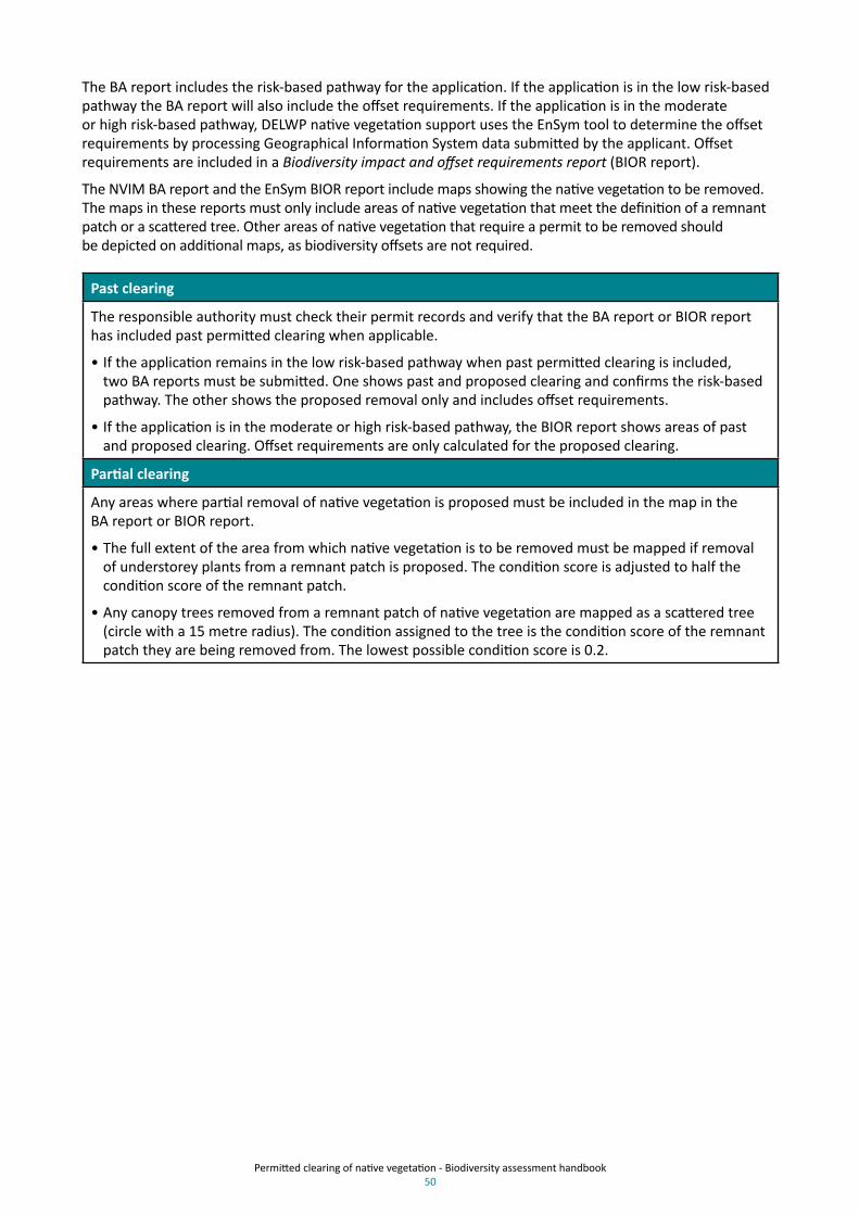
Permitted clearing of native vegetation - Biodiversity assessment handbook 50
The BA report includes the risk-based pathway for the application. If the application is in the low risk-based pathway the BA report will also include the offset requirements. If the application is in the moderate or high risk-based pathway, DELWP native vegetation support uses the EnSym tool to determine the offset requirements by processing Geographical Information System data submitted by the applicant. Offset requirements are included in a Biodiversity impact and offset requirements report (BIOR report).
The NVIM BA report and the EnSym BIOR report include maps showing the native vegetation to be removed. The maps in these reports must only include areas of native vegetation that meet the definition of a remnant patch or a scattered tree. Other areas of native vegetation that require a permit to be removed should be depicted on additional maps, as biodiversity offsets are not required.
Past clearing
The responsible authority must check their permit records and verify that the BA report or BIOR report has included past permitted clearing when applicable.
• If the application remains in the low risk-based pathway when past permitted clearing is included, two BA reports must be submitted. One shows past and proposed clearing and confirms the risk-based pathway. The other shows the proposed removal only and includes offset requirements.
• If the application is in the moderate or high risk-based pathway, the BIOR report shows areas of past and proposed clearing. Offset requirements are only calculated for the proposed clearing.
Partial clearing
Any areas where partial removal of native vegetation is proposed must be included in the map in the BA report or BIOR report.
• The full extent of the area from which native vegetation is to be removed must be mapped if removal of understorey plants from a remnant patch is proposed. The condition score is adjusted to half the condition score of the remnant patch.
• Any canopy trees removed from a remnant patch of native vegetation are mapped as a scattered tree (circle with a 15 metre radius). The condition assigned to the tree is the condition score of the remnant patch they are being removed from. The lowest possible condition score is 0.2.

Permitted clearing of native vegetation - Biodiversity assessment handbook 51
Appendix D: Application checklists
Pre-assessment checklist:• a permit is needed
• the category of native vegetation to be removed is correct
• the application is in the correct risk-based pathway
• confirm that the application is complete (shaded areas are only applicable for some applications)
• determine if the application must be referred to DELWP.
Is a permit needed? Refer to section 2 of handbook No Yes
Will the development result in the removal of native vegetation?
If under 52.16, is the removal in accordance with the NVPP?
Is the clearing covered by an exemption in clause 52.16, 52.17 or 52.48?
If under 52.17, is the vegetation listed in a schedule under the clause?
If any answer falls into the shaded blocks – no permit is required to remove native vegetation.
What native vegetation is being removed? Refer section 3.1 and Appendix A of handbook
Remnant Patch
Scattered Trees
Both
Neither
If neither a remnant patch nor a scattered tree is being removed, the decision guidelines for biodiversity considerations are not applied and no offset is required.
Has the correct risk-based pathway been identified? Refer to section 3.3 of handbook and section 6 of the Guidelines No Yes
Is the extent of the clearing correct?
What is the extent of the proposed clearing? ______ ha ______ trees
Total ha ______________
Has permitted clearing taken place in the last 5 years?
What is the combined extent (past and proposed removal)? ______ ha ______ trees
Total ha ______________
What is the location risk? A B C
Calculated risk-based pathway. Low Mod High
Calculate the risk-based pathway using the combined extent of proposed and past permitted clearing.

Permitted clearing of native vegetation - Biodiversity assessment handbook 52
Is the application complete? No Yes
Location – address and co-ordinates
Description of native vegetation – ha or no. of scattered trees to be cleared
Maps and plans – showing vegetation to be removed
Risk-based pathway of the application
Recent dated photographs of vegetation to be cleared
Topographic information, saline discharge and existing erosion areas
Defendable space motivation (as applicable)
Property vegetation plan (as applicable)
Precinct plan statement (as applicable)
Details of any permitted clearing done in the last 5 years (as applicable)
Strategic biodiversity score
Offset requirements
Habitat hectare assessment report (mod/high risk only)
Steps to minimise impacts to biodiversity described (mod/high risk only)
Assessment of impact on Victoria’s biodiversity (mod/high risk only)
Offset strategy (mod/high risk only)
If the application is not complete refer back to applicant requesting that it be completed, if complete determine referral requirements and refer as needed.
Does the application need to be referred to DELWP? No Yes
More than 0.5 ha of native vegetation being removed
High risk-based pathway applications
Property vegetation plan included
Crown land managed or occupied by responsible authority
If the application must be referred, refer to DELWP for biodiversity assessment, stipulating relevant response timeframes, and complete your assessment of the permit application.
This checklist is only for Clause 52.16 or 52.17 applications, overlays and other clauses may have different or additional requirements.
Application requirements in italics text are met by the BA report or BIOR report

Permitted clearing of native vegetation - Biodiversity assessment handbook 53
Appendix E: Calculate offset requirements If a permit is granted to remove native vegetation an offset must be secured in accordance with section 9 of the Guidelines and the Native vegetation gain scoring manual. If a first party general offset is proposed, the First party general offset kit and calculator must be complied with unless a qualified native vegetation assessor prepares the required reports.
The offset must provide a gain to Victoria’s biodiversity that is equivalent to the loss to Victoria’s biodiversity from the native vegetation removal. Gain and loss are measured in biodiversity equivalence units.
All low risk-based pathway applications will require a general offset. Moderate and high risk-based pathway applications may require specific offsets. The specific-general offset test will determine if a general offset, specific offset or combination of both is required. The amount and attributes of the offset are determined by the contribution the native vegetation to be removed makes to Victoria’s biodiversity and these are detailed in the BA report or BIOR report.
Low risk-based pathway applicationsThe steps that the NVIM tool does to calculate offset requirements for low risk-based pathway applications are detailed below. The offset requirements are detailed in the BA report.
Calculate the loss to Victoria’s biodiversity
Step 1: Calculate the habitat hectares of the vegetation to be removedThe loss in habitat hectares of the native vegetation to be removed is calculated by multiplying the extent (provided by the applicant in number of trees and/or hectares of remnant vegetation) by the condition score (taken from the Native vegetation condition map). The weighted average condition score of the native vegetation to be removed is used. The lowest condition score on the map is 0.2. If a habitat hectare assessment report is included the modelled condition score must be manually replaced with the assessed condition score.
For remnant patches
Habitat hectares of remnant patch = extent in hectares × modelled condition score
For scattered trees (including removal of canopy trees from a remnant patch)
Habitat hectares of scattered trees = (number of trees × standard extent) × modelled condition scoreWhere: Standard extent is a circle with 15 metre radius
For a combination of remnant patch and scattered trees
Habitat hectares total = (extent of trees in hectares + extent of remnant patch in hectares) x modelled condition scoreWhere: Extent of trees in hectares = number of trees x standard extent (circle with 15 metre radius)

Permitted clearing of native vegetation - Biodiversity assessment handbook 54
Step 2: Calculate the biodiversity equivalence score of the native vegetation to be removedThe general biodiversity equivalence score of the proposed removal is calculated as follows:
General biodiversity equivalence score = habitat hectares × strategic biodiversity score
The Strategic biodiversity map shows the strategic biodiversity score for each 75 metre × 75 metre location across Victoria. The weighted average strategic biodiversity score of the all the native vegetation to be removed is used. The lowest strategic biodiversity score on the map is 0.1.
Determine the required gain to Victoria’s biodiversityStep 3: Apply the risk factor to the biodiversity equivalence score to determine the offset amountA risk factor is applied to the biodiversity equivalence score of the clearing site to address the risk of offsets failing. Low risk-based pathway applications require a general offset and the risk factor for general offsets is 1.5. The amount of offset required is the risk adjusted biodiversity equivalence score (the general biodiversity equivalence units) of the native vegetation calculated as follows:
General biodiversity equivalence units = general biodiversity equivalence score clearing × risk factor
Results of this equation are rounded to three decimal places and if the rounded answer is 0.000, no offset is required.
Step 4: Determine the required attributes of the offset Low risk-based applications require general offsets with the following attributes:
• The offset must be located in the same Catchment Management Authority boundary or municipal district as the native vegetation to be removed. Note: the BA report does not list the municipal district area, this must be manually added.
• The offset site must have a strategic biodiversity score of at least 80 per cent the strategic biodiversity score of the clearing site.
Determining offset requirements for non-standard applications in the low risk-based pathway
When clearing of some or all understorey plants from a remnant patch, the condition score determined by the NVIM tool must be halved. This may be relevant when modifying vegetation within a Bushfire Management Overlay (BMO). This will adjust the habitat hectares, the general biodiversity equivalence score and the amount of offset required. These changes must be made manually in the BA report by the applicant. More than one report will be required if part of removal is full removal and part is partial removal.
When clearing only some canopy trees from a remnant patch, the offset requirements are determined by assigning the standard area of a scattered tree to each canopy tree, and using the condition score of the remnant patch they are located in.
When clearing of some or all understorey plants from a remnant patch and some canopy trees, the offset requirements for the understorey is determined by halving the condition score. This is added to the offset requirement for the canopy trees. The maximum offset requirement for this type of clearing is the offset requirement for complete clearing of the remnant patch.
If the applicant has included a habitat hectare assessment report completed by a qualified native vegetation assessor or an experienced ecologist familiar with the method, the condition24 score determined by that assessment is used in place of the modelled condition score. This will adjust the habitat hectares, the general biodiversity equivalence score and the amount of offset required. This can apply to remnant patch and scattered tree condition scores determined by the NVIM tool from the Native vegetation condition map. These changes must be made manually in the BA report by the applicant.
24 This is the final habitat score as per the Vegetation Quality Assessment Manual – Guidelines for applying the habitat hectares scoring method Version 1.3. This method will be updated and will then refer to the site assessed condition score.
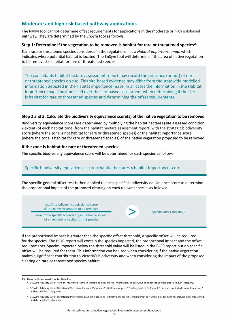
Permitted clearing of native vegetation - Biodiversity assessment handbook 55
Moderate and high risk-based pathway applicationsThe NVIM tool cannot determine offset requirements for applications in the moderate or high risk-based pathway. They are determined by the EnSym tool as follows:
Step 1: Determine if the vegetation to be removed is habitat for rare or threatened species25
Each rare or threatened species considered in the regulations has a Habitat importance map, which indicates where potential habitat is located. The EnSym tool will determine if the area of native vegetation to be removed is habitat for rare or threatened species.
The consultants habitat hectare assessment report may record the presence (or not) of rare or threatened species on site. This site-based evidence may differ from the statewide modelled information depicted in the Habitat importance maps. In all cases the information in the Habitat importance maps must be used over the site-based assessment when determining if the site is habitat for rare or threatened species and determining the offset requirements.
Step 2 and 3: Calculate the biodiversity equivalence score(s) of the native vegetation to be removedBiodiversity equivalence scores are determined by multiplying the habitat hectares (site assessed condition x extent) of each habitat zone (from the habitat hectare assessment report) with the strategic biodiversity score (where the zone is not habitat for rare or threatened species) or the habitat importance score (where the zone is habitat for rare or threatened species) of the native vegetation proposed to be removed.
If the zone is habitat for rare or threatened species:The specific biodiversity equivalence score will be determined for each species as follows:
Specific biodiversity equivalence score = habitat hectares × habitat importance score
The specific-general offset test is then applied to each specific biodiversity equivalence score to determine the proportional impact of the proposed clearing on each relevant species as follows:
If the proportional impact is greater than the specific offset threshold, a specific offset will be required for the species. The BIOR report will contain the species impacted, the proportional impact and the offset requirements. Species impacted below the threshold value will be listed in the BIOR report but no specific offset will be required for them. This information can be used when considering if the native vegetation makes a significant contribution to Victoria’s biodiversity and when considering the impact of the proposed clearing on rare or threatened species habitat.
25 Rare or threatened species listed in • DELWP’s Advisory List of Rare or Threatened Plants in Victoria as ‘endangered’, ‘vulnerable’, or ‘rare’, but does not include the ‘poorly known’ category;
• DELWP’s Advisory List of Threatened Vertebrate Fauna in Victoria as ‘critically endangered’, ‘endangered’ or ‘vulnerable’, but does not include ‘near threatened’ or ‘data deficient’ categories;
• DELWP’s Advisory List of Threatened Invertebrate Fauna in Victoria as ‘critically endangered’, ‘endangered’ or ‘vulnerable’, but does not include ‘near threatened’ or ‘data deficient’ categories.
specific biodiversity equivalence score of the native vegetation to be removed
sum of the specific biodiversity equivalence scores of all remaining habitat for the species
specific offset threshold

Permitted clearing of native vegetation - Biodiversity assessment handbook 56
If no species are impacted above the threshold, the general biodiversity equivalence score of the habitat zone will be determined as follows.
If the zone is not habitat for rare or threatened species:The general biodiversity equivalence score will be determined for the zone as follows:
General biodiversity equivalence score = habitat hectares × strategic biodiversity score
The general biodiversity equivalence score is determined for each habitat zone that is not habitat for rare or threatened species (as determined by the Habitat importance maps) and for any habitat zone where the result of the specific-general offset test is below the threshold for all species.
The specific and general biodiversity equivalence scores for each habitat zone are then aggregated to determine the total scores for the proposal.
Note:• If a specific offset applies to all the native vegetation to be removed, a general offset is not required.
• If a specific offset is required for only part of the native vegetation to be removed, a general offset is required for the removal of the remainder of the native vegetation.
• If no specific offset is required, a general offset is required for all the planned native vegetation removal.
• If multiple rare or threatened species habitat is impacted above the specific offset threshold, multiple specific offsets will be required. These can be met by a single offset site that provides suitable habitat for all the species impacted or multiple offset sites that together provide suitable habitat for all the species impacted. Each species specific offset requirement must be fully met.
Step 4: Apply the offset risk factor to calculate offset amountApply the risk factor to determine the amount of offset required:
• Specific offset: A risk factor of 2 is applied to all specific offsets. The specific biodiversity equivalence score is multiplied by this risk factor to give the specific biodiversity equivalence units.
• General offset: A risk factor of 1.5 is applied to all general offsets. The general biodiversity equivalence score is multiplied by this risk factor to give the general biodiversity equivalence units.
Specific biodiversity equivalence units = specific biodiversity equivalence score clearing × 2
General biodiversity equivalence units = general biodiversity equivalence score clearing × 1.5
Step 5: Determine the relevant offset attributesSpecific offsets have the following attributes:
• The offset must be suitable habitat for the rare or threatened species that has been impacted, as determined by the Habitat importance map for that species.
General offsets have the following attributes:
• The offset must be located in the same Catchment Management Authority boundary or municipal district as the native vegetation to be removed.
• The offset must have a strategic biodiversity score of at least 80 per cent of the strategic biodiversity score of the clearing site.

Permitted clearing of native vegetation - Biodiversity assessment handbook 57
Appendix F: Standard permit conditionsThese standard conditions should be used when preparing a response to an application for a permit to remove, destroy or lop native vegetation submitted under Clause 52.16 or 52.17. These conditions will ensure that the biodiversity impacts are appropriately addressed. Additional conditions may be required for non-biodiversity implications. Determine if the requirement will be to the satisfaction of the responsible authority or DELWP and insert where applicable.
Where text is in [brackets and is red] add required details.
1. Notification of permit conditionsBefore works start, the permit holder must advise all persons undertaking the vegetation removal or works on site of all relevant permit conditions and associated statutory requirements or approvals.
2. Construction management Use this condition when an endorsed plan for the permitted removal of native vegetation is required – particularly relevant where plans submitted do not have sufficient detail to enable compliance audit for regulator.
Before any permitted clearing of native vegetation starts, [amended] plans to the satisfaction of the responsible authority must be submitted to and approved by the [insert]. When approved, the plans will be endorsed and will form part of this permit. The plans must include [Delete or amend the following as required]:
a. a detailed description of the measures to be implemented to protect the native vegetation to be retained during construction works, and the person/s responsible for implementation and compliance. These measures must include the erection of a native vegetation protection fence around all native vegetation to be retained on site, to the satisfaction of the [insert], including the tree protection zones of all native trees to be retained. All tree protection zones must comply with AS 4970-2009 Protection of Trees on Development Sites, to the satisfaction of the [insert].
b. an amended site plan, drawn to scale with dimensions and georeferences (such as VicGrid94 co-ordinates), that clearly shows:
i. the location and identification of the land affected by this permit, including standard parcel identifiers for freehold land
ii. the location and area of all native vegetation present, including scattered trees, that are permitted to be removed under this permit
iii. [any other information required to ensure provision of an endorsable plan]
3. Protection of vegetation to be retainedSelect one of the following conditions based on the site condition and proposed works:
• 3.1 used when a plan must be prepared
• 3.2 specifies requirements for remnant patches
• 3.3 specifies requirements for scattered trees

Permitted clearing of native vegetation - Biodiversity assessment handbook 58
3.1. Protection of vegetation to be retainedBefore works start, a plan to the satisfaction of the [insert] identifying all native vegetation to be retained and describing the measures to be used to protect the identified vegetation during construction, must be prepared and submitted to and approved by the responsible authority. When approved, the plan will be endorsed and will form part of this permit. All works constructed or carried out must be in accordance with the endorsed plan.
or
3.2. Protection of remnant vegetation to be retainedBefore works start, a native vegetation protection fence must be erected around all remnant patches of native vegetation to be retained on site. This fence must be erected around the remnant patch at a distance of [number] metres from retained native vegetation. The protection fence must be constructed of [star pickets/chain mesh/or similar] to the satisfaction of the [insert]. The protection fence must remain in place until all works are completed to the satisfaction of the [insert].
Except with the written consent of the [insert], within the area of native vegetation to be retained and any associated tree protection zone, the following are prohibited:
a. vehicular or pedestrian access
b. trenching or soil excavation
c. storage or dumping of any soils, materials, equipment, vehicles, machinery or waste products
d. entry and exit pits for underground services
e. any other actions or activities that may result in adverse impacts to retained native vegetation.
or
3.3. Protection of treesBefore works start, a fence must be erected around [insert details of trees] to be retained on site. This fence will protect the tree by demarcating the tree protection zone and must be erected at a radius of 12 × the diameter at a height of 1.3 metres to a maximum of 15 metres but no less than 2 metres from the base of the trunk of the tree. The fence must be constructed of [star pickets/ chain mesh/ or similar] to the satisfaction of the [insert]. The fence must remain in place until all works are completed to the satisfaction of the [insert].
Except with the written consent of the [insert], within the tree protection zone, the following are prohibited:
a. vehicular or pedestrian access
b. trenching or soil excavation
c. storage or dumping of any soils, materials, equipment, vehicles, machinery or waste products
d. entry and exit pits for underground services
e. any other actions or activities that may result in adverse impacts to retained native vegetation.
or
3.4. Protection of remnant vegetation and treesBefore works start, a native vegetation protection fence must be erected around all remnant patches and trees to be retained on site. This fence must be erected around the remnant patch at a minimum distance of [number] metres from retained native vegetation and/or at a radius of 12 × the diameter at a height of 1.3 metres to a maximum of 15 metres but no less than 2 metres from the base of the trunk of tree. The fence must be constructed of [star pickets/ chain mesh/ or similar] to the satisfaction of the [insert]. The fence must remain in place until all works are completed to the satisfaction of the [insert].

Permitted clearing of native vegetation - Biodiversity assessment handbook 59
Except with the written consent of the [insert], within the area of native vegetation to be retained and any tree protection zone associated with the permitted use and/or development, the following is prohibited:
a. vehicular or pedestrian accessb. trenching or soil excavationc. storage or dumping of any soils, materials, equipment, vehicles, machinery or waste productsd. entry and exit pits for underground servicese. any other actions or activities that may result in adverse impacts to retained native vegetation.
4. Native vegetation offsets Each permit for the removal of native vegetation must contain conditions stipulating the offset requirements. These are determined by NVIM or EnSym, and included in the BA report or BIOR report. Use an offset requirement condition as well as the offset evidence and monitoring and reporting condition. The extent of permitted vegetation removal must be defined in a permit condition. It may be agreed for some projects that offsets are secured in stages to allow for offset reconciliation – if this occurs the permit condition will have to be amended at completion of project and offset reconciliation.
4.1. Offset requirement Either a general offset, specific offset(s) or combination of both will be required. Specific offsets will be required for each species that is impacted above the threshold of the specific-general offset test. Include the text below and then select either 4.1.1, 4.1.2 or both.
To offset the removal of [number] hectares of native vegetation and/or [number] scattered trees the permit holder must secure a native vegetation offset, in accordance with the Permitted clearing of native vegetation – Biodiversity assessment guidelines (DEPI 2013) and Native vegetation gain scoring manual (DEPI 2013) as specified below:
4.1.1. General offsetA general offset of [XXX] general biodiversity equivalence units with the following attributes:
• be located within the [insert name of Catchment Management Authority] boundary or [insert name of municipality] municipal district
• have a strategic biodiversity score of at least [80 per cent of the strategic biodiversity score of the native vegetation approved for removal].
and/or/not required
4.1.2. Specific offset [add/delete depending on number of species impacted]
A specific offset(s) of [XXX] specific biodiversity equivalence units for [ID, common name, genus species A], and [XXX] specific biodiversity equivalence units for [ID, common name, genus species B] ….. insert all required specific offsets.
4.2. Offset evidence and timingThe Guidelines require that a compliant offset be secured, to the satisfaction of the responsible or referral authority, before the native vegetation is removed. This can be a security agreement for an offset site that includes an onsite management plan OR evidence of a third party offset. Security agreement requirements are specified in the Native vegetation gain scoring manual (DEPI, 2013). It may be agreed for some projects that offsets are secured in stages to enable offset reconciliation – this can be provided for in this condition Include the following condition:
[Before any native vegetation is removed/ Prior to the issue of the Statement of Compliance], evidence that the required offset [for the project/for each stage] has been secured must be provided to the satisfaction of [insert]. The offset evidence can be:
• a security agreement signed by both parties, to the required standard, for the offset site or sites, including a 10 year offset management plan and/or
• an allocated credit extract from the Native Vegetation Credit Register.
Permitted clearing of native vegetation - Biodiversity assessment handbook 60
A copy of the offset evidence will be endorsed by the responsible authority and form part of this permit. Within 30 days of endorsement of the offset evidence by the responsible authority, a copy of the endorsed offset evidence must be provided to the Department of Environment, Land, Water and Planning. Optional text: At the conclusion of the project, offset requirements can be reconciled with agreement by the [responsible authority and referral authority].
4.3. Monitoring and reporting on onsite offset implementation Annual monitoring and reporting is required for offsets not secured on the Native Vegetation Credit Register
In the event that a security agreement is entered into as per condition [insert relevant #], the applicant must provide the annual offset site condition report to the responsible authority by the anniversary date of the execution of the offset security agreement, for a period of 10 consecutive years. After the tenth year, the landowner must provide a report at the reasonable request of a statutory authority.
5. Offsets in Bushfire Management Overlay (BMO) areasUnless otherwise agreed in writing by the Country Fire Authority and the Department of Environment, Land, Water and Planning, offsets must not be located within the 150 metre BMO assessment area in accordance with the Planning for Bushfire Victoria, Guidelines for Meeting Victoria’s Bushfire Planning Requirements (CFA 2012).
6. Offset requirements for timber harvestingAlternative offset arrangements have been provided for timber harvesting of native vegetation in the Guidelines. These provide for offsets to be provided by regeneration at the site where timber is harvested. This only applies to harvesting within remnant patches that results in the need for a general offset. If scattered trees are being removed use conditions selected from section 2 above. If a specific offset is required use conditions selected from section 2 above.
Use construction management conditions above (1.1 and 1.2.1/1.2.2)
Select appropriate general offset condition below 6.1 or 6.2
6.1. General offset for clearfell harvestingIn order to offset the removal of [number] hectares of native vegetation by clearfell harvesting approved as part of this permit, the applicant must provide for the regeneration of native vegetation onsite, over the same area as the harvesting. The regenerated native vegetation must achieve a condition score of at least 50 per cent of the condition score before timber harvesting within 10 years of harvesting. Supplementary planting and active management may be required to achieve this:
• The regenerated area must be protected by a recognised security agreement in accordance with the Native vegetation gain scoring manual, for this 10 year period.
• The regeneration must be in accordance with the relevant code under Part 5 of the Conservation, Forests and Land Act 1987.
• This condition remains in effect until the regenerated native vegetation achieves a score equivalent to the condition of the native vegetation immediately before it was harvested. Supplementary planting and active management may be required for this to be achieved.
or
6.2. General offset for selective harvesting The Guidelines require that selective harvesting of native vegetation must not reduce the condition score of the site by more than 50 per cent of the condition score before timber harvesting. The number of trees permitted to be removed must be restricted to ensure that this is achieved. A habitat hectare assessment report should indicate how many trees can be removed whilst ensuring that the condition score remains at the acceptable value. Use the condition below:
In order to offset the removal of [number] trees by selective harvesting approved as part of this permit, the applicant must provide for the regeneration of native vegetation on site, over the same area as the selective harvesting.

Permitted clearing of native vegetation - Biodiversity assessment handbook 61
• The regenerated area must be protected by a recognised security agreement in accordance with the Native vegetation gain scoring manual, for this 10 year period.
• The regeneration must in accordance with the relevant code under Part 5 of the Conservation, Forests and Land Act 1987.
• This condition remains in effect until the regenerated native vegetation achieves a score equivalent to the condition of the native vegetation immediately before it was harvested. Supplementary planting and active management may be required to achieve this.
6.3. Monitoring and reporting on on-site offset for timber harvesting Every two years after the harvesting has been completed, the applicant must provide notification to the responsible authority [and the Department of Environment, Land, Water and Planning] of the condition score of the site and any actions that have been taken to supplement natural regeneration.
7. Conditions for clearing in accordance with an approved property vegetation planThis permit will expire if one of the following circumstances applies:
• the development or any stage of it does not start within 10 years of the date of this permit
• the development or any stage of it is not completed within 10 years of the date of this permit.