Embed Size (px)
Citation preview

Big River CDFG Appendix

i
Table of Contents Table of Contents................................................................................................................. i List of Tables ...................................................................................................................... v List of Figures .................................................................................................................. viii
Introduction..................................................................................................................... 1 Objectives ....................................................................................................................... 1 CDFG Assessment Methods and Components ............................................................... 1
Division of Subbasins ................................................................................................. 1 Investigation of Existing Data .................................................................................... 2 Species of Special Concern......................................................................................... 3 Stream Crossings Investigation................................................................................... 3 Stream Surveys ........................................................................................................... 4 Target Values from Habitat Inventory Surveys .......................................................... 4 Hawthorne Timber Company Fisheries Data ............................................................. 6 Mendocino Redwoods Company Fisheries Data........................................................ 6 Large Woody Debris Surveys..................................................................................... 6 Limiting Factor Analysis ............................................................................................ 7
Introduction............................................................................................................. 7 Methods................................................................................................................... 8
CWPAP Salmonid Refugia Identification and Classification .................................. 11 Spatial and Temporal Scales of Refugia............................................................... 11 Refugia and Meta-population Concept ................................................................. 12 Methods to Identify Refugia ................................................................................. 13 CWPAP Approach to Identifying Refugia ........................................................... 13 CWPAP Salmonid Refugia Categories and Criteria:............................................ 15
High Quality Refugia........................................................................................ 15 High Potential Refugia...................................................................................... 15 Medium Potential Refugia ................................................................................ 15 Low Quality Habitat, Low Potential Refugia ................................................... 15
Other Related Refugia Component Categories:.................................................... 16 Potential Future Refugia (Non-Anadromous)................................................... 16 Critical Contributing Areas............................................................................... 16 Data Limited ..................................................................................................... 16
Refugia Worksheet and Summary Tables............................................................. 16 Big River Watershed Profile......................................................................................... 18
Fish Habitat Relationships ........................................................................................ 18 Anadromous Salmonid Natural History................................................................ 18
Coho Salmon..................................................................................................... 18 Steelhead Trout ................................................................................................. 19 Chinook Salmon................................................................................................ 20
Issues Affecting Fisheries Resources.................................................................... 21 Freshwater Environment................................................................................... 21 Estuarine Environment...................................................................................... 23 Marine Environment ......................................................................................... 24
Historic Fish Habitat Relationship........................................................................ 26

ii
Effects of Historic Splash Dams ....................................................................... 28 Large Woody Debris Removal and Reduction ................................................. 28
Current Fish Habitat Relationship ........................................................................ 30 Large Woody Debris......................................................................................... 32 Fish Passage Barriers ........................................................................................ 32
Stream Crossings .......................................................................................... 32 Dry Channel .................................................................................................. 32
Fish History and Status ............................................................................................. 32 Salmonid Fisheries History................................................................................... 33 Current Salmonid Populations .............................................................................. 37 Fishing Interests and Constituents ........................................................................ 38 Special-Status Species .......................................................................................... 38
Subbasin Profiles .......................................................................................................... 40 Coastal Subbasin....................................................................................................... 40
Introduction........................................................................................................... 40 Fish Habitat Relationship...................................................................................... 41
Historic Habitat Conditions .............................................................................. 41 Current Conditions............................................................................................ 44
Habitat Inventory Survey Summaries........................................................... 44 Big River................................................................................................... 44 Laguna Creek ............................................................................................ 46 Railroad Gulch .......................................................................................... 47 Little North Fork Big River ...................................................................... 47 Rocky Gulch ............................................................................................. 48 Manly Gulch ............................................................................................. 49 Thompson Gulch....................................................................................... 50 East Branch Little North Fork Big River.................................................. 51 Berry Gulch............................................................................................... 54 Berry Gulch Tributary............................................................................... 56 Big River Wheel Gulch to Blind Gulch.................................................... 56
Fish Passage Barriers ........................................................................................ 57 Stream Crossings .......................................................................................... 57 Dry Channel .................................................................................................. 58
Fish History and Status ......................................................................................... 58 Historic Salmonid Populations ......................................................................... 58 Current Salmonid Population Data ................................................................... 59
Middle Subbasin ....................................................................................................... 62 Introduction........................................................................................................... 62 Fish Habitat Relationship...................................................................................... 63
Historic Habitat Conditions .............................................................................. 63 Current Conditions............................................................................................ 65
Habitat Inventory Survey Summaries........................................................... 65 Kidwell Gulch........................................................................................... 65 Two Log Creek ......................................................................................... 67 Saurkraut Creek ........................................................................................ 73 Ayn Creek ................................................................................................. 73

iii
Big River Tramway Gulch to North Fork Big River ................................ 74 Hatch Gulch .............................................................................................. 76
MRC Habitat Surveys ................................................................................... 77 Canopy Closure......................................................................................... 77 Pools.......................................................................................................... 78 Spawning Gravel....................................................................................... 79 Large Woody Debris................................................................................. 79
Fish Passage Barriers ........................................................................................ 80 Stream Crossings .......................................................................................... 80 Dry Channel .................................................................................................. 80
Historic Salmonid Populations ......................................................................... 81 Current Salmonid Population Data ................................................................... 81
Inland Subbasin......................................................................................................... 85 Introduction........................................................................................................... 85 Fish Habitat Relationship...................................................................................... 87
Historic Habitat Conditions .............................................................................. 87 Current Conditions............................................................................................ 97
Habitat Inventory Survey Summaries........................................................... 97 North Fork Big River ................................................................................ 97 East Branch North Fork Big River............................................................ 99 Chamberlain Creek ................................................................................. 101 Water Gulch ............................................................................................ 102 Water Gulch Tributary............................................................................ 103 Park Gulch .............................................................................................. 104 West Chamberlain Creek ........................................................................ 104 Gulch Sixteen.......................................................................................... 105 Gulch Sixteen Tributary.......................................................................... 107 Arvola Gulch........................................................................................... 107 Lost Lake Creek...................................................................................... 108 Soda Gulch.............................................................................................. 109 James Creek ............................................................................................ 110 James Creek North Fork ......................................................................... 111 South Fork Big River .............................................................................. 112 Biggs Gulch ............................................................................................ 115 Ramon Creek .......................................................................................... 115 North Fork Ramon Creek........................................................................ 117 Mettick Creek.......................................................................................... 118 Poverty Gulch ......................................................................................... 118 Anderson Gulch ...................................................................................... 119 Boardman Gulch ..................................................................................... 119 Halfway House Gulch............................................................................. 120 Daugherty Creek ..................................................................................... 121 Soda Creek .............................................................................................. 125 Gates Creek............................................................................................. 129 Johnson Creek (Tributary to Gates Creek) ............................................. 132 Horse Thief Creek................................................................................... 134

iv
Snuffins Creek ........................................................................................ 135 Johnson Creek......................................................................................... 137 Dark Gulch.............................................................................................. 138 Montgomery Creek ................................................................................. 140 Unnamed Tributary 1 to South Fork Big River ...................................... 141 Unnamed Tributary 2 to South Fork Big River ...................................... 143 Russell Brook.......................................................................................... 144 Martin Creek ........................................................................................... 145 Martin Creek Left Bank Tributary.......................................................... 146 Martin Creek Right Bank 1 Tributary..................................................... 146 Martin Creek Right Bank 2 Tributary..................................................... 147 Valentine Creek ...................................................................................... 148 Rice Creek............................................................................................... 149
MRC Habitat Surveys ................................................................................. 149 Canopy Closure....................................................................................... 150 Pools........................................................................................................ 151 Spawning Gravel..................................................................................... 153 Large Woody Debris............................................................................... 154
Fish Passage Barriers ...................................................................................... 156 Stream Crossings ........................................................................................ 156 Dry Channel ................................................................................................ 157
Fish History and Status ....................................................................................... 159 Historic Salmonid Populations ....................................................................... 159 Current Salmonid Population Data ................................................................. 161
Bibliography ............................................................................................................... 181

v
List of Tables Table 1. Big River Basin and subbasin characteristics. ..................................................... 2 Table 2. Definitions of barrier types and their potential impacts to salmonids (from
Taylor 2001)................................................................................................................ 3 Table 3. Habitat Inventory Target Values taken from the California Salmonid Stream
Habitat Restoration Manual (Flosi et al 1998)............................................................ 5 Table 4. Key LWD Piece Size Requirements (adapted from Bilby and Ward, 1989) ...... 7 Table 5. Target for Number of Key Large Woody Debris Pieces in Watercourses of the
Big River Watershed Assessment Unit....................................................................... 7 Table 6. Fish habitat components and parameters potentially applicable for limiting
factors analysis............................................................................................................ 8 Table 7. CWPAP refugia worksheet................................................................................ 17 Table 8. Anadromous habitat in the Big River Basin in 1965 (from CDFG 1965)......... 26 Table 9. Streams surveyed by CDFG in the Big River Basin from 1957-1966............... 27 Table 10. Summary of current (1995, 1996, 1997, 1998, and 2002) conditions. ............ 30 Table 11. Fishery resources of Big River (Pers. comm. Harris and LeDoux CDFG,
Wright CTM 2004, Grantham 2003, Britschgi and Marcus 1981)........................... 33 Table 12. Documented salmonid presence across the Big River Basin........................... 34 Table 13. Salmonid stocking in the Big River Basin....................................................... 36 Table 14. Coho salmon and steelhead trout presence reported in CDFG and CEMPR
stream surveys from 1950-1989................................................................................ 36 Table 15. USFWS electrofishing results from ten transects across the Big River Basin in
1973........................................................................................................................... 36 Table 16. Coho salmon and steelhead trout presence reported in MRC stream surveys
from 1990-2002. ....................................................................................................... 37 Table 17. Coho salmon and steelhead trout presence reported in Georgia Pacific stream
surveys in 1996. ........................................................................................................ 37 Table 18 Coho salmon and steelhead trout presence reported in CDFG stream surveys
from 1990-2003. ....................................................................................................... 37 Table 19. Special status species of the Big River Basin. ................................................. 38 Table 20. Tributaries to the Big River in the Coastal Subbasin by river mile from 7.5
minute topographic maps.......................................................................................... 40 Table 21. Summary of stream surveys conducted in the Coastal Subbasin by the
California Department of Fish and Game before 1990. All comments are taken from survey sheets. See Condensed Tributary Reports for CDFG stream surveys made after 1990. ................................................................................................................. 41
Table 22. Additional historical references to salmonid habitat in the Coastal Subbasin.44 Table 23. Electrofishing results for East Branch Little North Fork Big River, 2002. ..... 54 Table 24. Culverts described on inventoried streams in the Coastal Subbasin. .............. 57 Table 25. Dry Channel Recorded in CDFG Stream Surveys in the Coastal Subbasin..... 58 Table 26. Summary of stream surveys conducted in the Big River Basin by the
California Department of Fish and Game before 1990. All comments are taken from survey sheets. See Condensed Tributary Reports for CDFG stream surveys made after 1990 .................................................................................................................. 59

vi
Table 27. Additional historical references to salmonid populations in the Coastal Subbasin.................................................................................................................... 59
Table 28. Summary of CDFG carcass surveys in the Coastal Subbasin. ........................ 61 Table 29. Summary of coho salmon and steelhead trout detection in the CDFG coho
salmon inventory in 2001 for the Coastal Subbasin. ................................................ 61 Table 30. Summary of coho salmon and steelhead trout detection in CDFG stream
inventories in the Coastal Subbasin. ......................................................................... 61 Table 31. Additional references to salmonid populations in the Coastal Subbasin......... 61 Table 32. Summary of all electrofishing, snorkel survey, and bank observation surveys
conducted in the Coastal Subbasin. .......................................................................... 61 Table 33. Tributaries to the Big River in the Middle Subbasin by river mile from 7.5
minute topographic maps.......................................................................................... 63 Table 34. Summary of stream surveys conducted in the Middle Subbasin by the
California Department of Fish and Game before 1990. All comments are taken from survey sheets. See Condensed Tributary Reports for CDFG stream surveys made after 1990. ................................................................................................................. 64
Table 35. Electrofishing results for Kidwell Gulch, 2002. .............................................. 67 Table 36. Electrofishing results for Two Log Creek, 2002. ............................................ 72 Table 37. Electrofishing results for Big River Tramway Gulch to North Fork Big River,
2002........................................................................................................................... 76 Table 38. Surveyed stream segments on MRC ownership in the Middle Subbasin (MRC
2003). ........................................................................................................................ 77 Table 39. Pool characteristics measured on stream segments in the MRC ownership of
the Middle Subbasin (MRC 2003)............................................................................ 78 Table 40. Spawning gravel characteristics measured on stream segments in the MRC
ownership of the Middle Subbasin (MRC 2003)...................................................... 79 Table 41. MRC LWD survey results in the Middle Subbasin (MC 2003). ..................... 79 Table 42. Instream LWD quality ratings for major streams and sections of streams in
MRC ownership in the Middle Subbasin (MRC 2003). ........................................... 80 Table 43. Dry Channel Recorded in CDFG Stream Surveys in the Middle Subbasin. .... 80 Table 44. Summary of stream surveys conducted in the Middle Subbasin by the
California Department of Fish and Game before 1990. All comments are taken from survey sheets. See Condensed Tributary Reports for CDFG stream surveys made after 1990. ................................................................................................................. 81
Table 45. Summary of coho salmon and steelhead trout detection in the CDFG coho salmon inventory in 2001 for the Middle Subbasin.................................................. 84
Table 46. Summary of coho salmon and steelhead trout detection in CDFG stream inventories in the Middle Subbasin........................................................................... 84
Table 47 . Additional references to salmonid populations in the Middle Subbasin. ....... 84 Table 48. Summary of all electrofishing, snorkel survey, and bank observation surveys
conducted in the Middle Subbasin............................................................................ 84 Table 49. Tributaries to the Big River in the Inland Subbasin by river mile from 7.5
minute topographic maps.......................................................................................... 86 Table 50. Summary of stream surveys conducted in the Inland Subbasin by the
California Department of Fish and Game and the Center for Education and Man

vii
Power Resources before 1990. All comments are taken from survey sheets. See Condensed Tributary Reports for CDFG stream surveys made after 1990 .............. 88
Table 51. Snorkel survey results for Daugherty Creek, 2002........................................ 125 Table 52. Electrofishing results for Soda Creek, 2002. ................................................. 129 Table 53. Electrofishing results for Gates Creek, 2002. ................................................ 131 Table 54. Electrofishing results for Horsethief Creek, 2002. ........................................ 135 Table 55. Snorkel survey results for Snuffins Creek, 2002. .......................................... 137 Table 56. Electrofishing results for Johnson Creek, 2002. ............................................ 138 Table 57. Electrofishing results for Dark Gulch, 2002.................................................. 140 Table 58. Electrofishing results for Unnamed Tributary #1 to South Fork Big River,
2002......................................................................................................................... 143 Table 59. Surveyed stream segments on MRC ownership in the Inland Subbasin (MRC
2003). ...................................................................................................................... 149 Table 60. Pool characteristics measured on stream segments in the MRC ownership of
the Inland Subbasin (MRC 2003). .......................................................................... 152 Table 61. Spawning gravel characteristics measured on stream segments in the MRC
ownership of the Inland Subbasin (MRC 2003). .................................................... 153 Table 62. MRC LWD survey results in the Inland Subbasin (MC 2003)...................... 154 Table 63. Instream LWD quality ratings for major streams and sections of streams in
MRC ownership in the Inland Subbasin (MRC 2003)............................................ 156 Table 64. Culverts surveyed for barrier status in the Inland Subbasin (Taylor 2001)... 156 Table 65. Culverts described on streams inventoried by CDFG and in the MRC
Watershed Analysis(2003) in the Inland Subbasin................................................. 157 Table 66. Dry channel recorded in CDFG stream surveys in the Inland Subbasin. ...... 158 Table 67. Summary of stream surveys conducted in the Inland Subbasin by the
California Department of Fish and Game and the Center for Education and Man Power Resources before 1990. All comments are taken from survey sheets. See Condensed Tributary Reports for CDFG stream surveys made after 1990. ........... 159
Table 68. 1973 USFWS electrofishing results in the Inland Subbasin.......................... 161 Table 69. Electrofishing results from 1983, 1995, and 1996 for the Inland Subbasin
(surveys by CDFG). ................................................................................................ 162 Table 70. Summary of CDFG carcass surveys in the Inland Subbasin. ........................ 163 Table 71. Additional references to salmonid populations in the Inland Subbasin......... 163 Table 72. Summary of coho salmon and steelhead trout detection in CDFG stream
inventories in the Inland Subbasin.......................................................................... 164 Table 73. Summary of coho salmon and steelhead trout detection in the CDFG coho
salmon inventory in 2001 for the Inland Subbasin. ................................................ 165 Table 74. Electrofishing results from July and August 1994 for South Fork Subbasin
(surveys by MRC)................................................................................................... 169 Table 75. Summary of all electrofishing, snorkel survey, and bank observation surveys
conducted in the Inland Subbasin. .......................................................................... 172

viii
List of Figures Figure 1. Commercial landings of salmon in California from 1952-1999. ...................... 25 Figure 2. Recreational landings of salmon in California from 1962-1999. ...................... 26 Figure 3. Electrofishing results from 1993-2000 for the Little North Fork Big River
(surveys by Georgia-Pacific). ................................................................................... 60 Figure 4. Electrofishing results from 1986 and 1995 for the Coastal Subbasin (surveys by
CDFG)....................................................................................................................... 60 Figure 5. Stream Canopy closure on stream segments in the MRC ownership of the
Middle Subbasin (MRC 2003).................................................................................. 78 Figure 6. Map of instream LWD demand in MRC ownership in the Middle Subbasin
(MRC 2003). ............................................................................................................. 80 Figure 7. Electrofishing results from 1993-2000 for Two Log Creek (surveys by
Georgia-Pacific). ....................................................................................................... 82 Figure 8. Snorkel survey results from July 12, 1994 for the mainstem Big River below
the confluence with the North Fork Big River (survey by MRC). ........................... 82 Figure 9. Electrofishing results from July 6 and 7, 1994 for Two Log Creek, mainstem
Big River below Tramway Gulch, and Tramway Gulch (surveys by MRC). .......... 83 Figure 10. Electrofishing results from October 4, 1983 for Two Log Creek (surveys by
CDFG)....................................................................................................................... 83 Figure 11. Stream Canopy closure on stream segments in the MRC ownership of the
Inland Subbasin (MRC 2003). ................................................................................ 151 Figure 12. Map of instream LWD demand in MRC ownership in the Inland Subbasin
(MRC 2003). ........................................................................................................... 156 Figure 13. Electrofishing results from 1983 to 1997 for the Inland Subbasin (surveys by
CDFG)..................................................................................................................... 162 Figure 14. Electrofishing results from 1993 and 1994 for East Branch North Fork Big
River (surveys by MRC). a. Number of fish. b. Salmonid density and biomass. . 166 Figure 15. Electrofishing results from 1993 and 1994 for Gates Creek (surveys by
MRC). a. Number of fish. b. Salmonid density and biomass. .............................. 167 Figure 16. Electrofishing results from 1993 and 1994 for mainstem Big River at Wild
Horse Opening (surveys by MRC). a. Number of fish. b. Salmonid density and biomass. .................................................................................................................. 168
Figure 17. Electrofishing results from 1994 for the Inland Subbasin (surveys by MRC).................................................................................................................................. 169
Figure 18. Snorkel survey results from July 12, 1994 for the mainstem Big River below the confluence with the North Fork Big River (surveys by MRC)......................... 170
Figure 19. Snorkel survey results from July 12, 1994 for North Fork Big River (survey by MRC). ................................................................................................................ 170
Figure 20. Snorkel survey results from July 12, 1994 for mainstem Big River (survey by MRC). ..................................................................................................................... 171
Figure 21. Bank observation results from July 1994 for Mettick Creek and Anderson Gulch (survey by MRC).......................................................................................... 171

1
Introduction Named for the giant redwood trees that used to line its banks, the Big River drains a 181.1 square mile watershed located in the northern California Coast Range in western Mendocino County, entering the Pacific Ocean at the town of Mendocino, about 10 miles south of Fort Bragg. The Big River Basin extends 24 miles to the east, to within three miles of Willits and Highway 101. It drains primarily from east to west, sharing ridges with the Noyo River and Caspar Creek basins to the north and the Albion and Navarro river basins to the south. Elevations within the Big River Basin range from sea level at the basin outlet to Irene Peak at 2,836 feet, 5 miles south-southwest of Willits in the east end of the Martin Creek Planning Watershed, Inland Subbasin.
The basin’s topography is diverse along its length, varying from flat estuarine environments and uplifted marine terraces to rugged mountains with high relief in the eastern portion. It is characterized by narrow ridgelines separated by deeply incised inner gorges of the major river channels and streams draining the watershed.
The basin supports runs of coho salmon and steelhead trout. Chinook salmon (O. tshawytscha) have been reported occasionally, but there is no significant run. Historical accounts indicate that salmon were plentiful and that salmon fishing was a common activity. However, agency reports starting in the 1950s indicate that salmonid populations were depleted and in decline. In recent years, efforts have been underway to recover salmonid stocks of the Big River Basin. For example, local residents and conservation groups recently organized and purchased a 7,342-acre parcel at the mouth of Big River from the Hawthorne Timber Company and gave it to DPR to be managed for conservation and recreation. In addition, timber land in the Two Log Creek watershed was sold to conservation groups.
Objectives The California Department of Fish and Game (CDFG) focused on the historic and current fisheries and instream data. Objectives included: 1) compile and verify existing data from all available sources; 2) identify data gaps; 3) collect additional data to help fill data gaps; 4) analyze data when possible; and 5) report limiting factors in terms of suitability for salmonid production.
CDFG=s work is intended to provide answers to the following assessment questions at the basin and subbasin scales in California=s North Coast watersheds:
• What are the history and trends of the size, distribution, and relative health and diversity of salmonid populations?
• What are the current salmonid habitat conditions? How do these conditions compare to desired conditions?
• Based upon these conditions, trends, and relationships, are there elements that could be considered to be limiting factors for salmon and steelhead trout health and production?
• What watershed and habitat improvement activities would most likely lead toward more desirable habitat conditions in a timely, cost effective manner?
CDFG Assessment Methods and Components
Division of Subbasins CWPAP determined early on in their efforts that a broad-brush statement about the entire Big River Watershed would be difficult to make due to the large amount of variability within the watershed.

2
Therefore, the CWPAP team divided the watershed into three subbasins based on commonalities of attributes: Coastal, Middle, and Inland (Table 1). Table 1. Big River Basin and subbasin characteristics.
Attribute Coastal Middle Inland Total/Average Square Miles 32.49 17.86 130.853 181.2 Acreage, Total 20,793 11,432 83,746 115,972 Private Land (Acres) 6,803 10,905 66,837 84,545
Public Land (Acres) 13,990 528 16,909 31,427
Low Elevation (Feet) 0 ~40 ~200 0
High Elevation (Feet) 1235 ~1560 2836 2836
Predominant Geology
Coastal Belt Franciscan Complex
Coastal Belt Franciscan Complex
Coastal Belt Franciscan Complex, small area of Tertiary Sandstone in southeast, and Central Belt rocks in central area of eastern margin
Coastal Belt Franciscan Complex
Rainfall (Inches) ~40-55 ~55-65 ~45-65 ~40-65 Miles of Blue Line Stream 42.4 26.0 160.6 228.5
Predominant Vegetation Redwood-Douglas-fir Redwood-Douglas-fir
Redwood-Douglas-fir Douglas-fir White, Black, or Live Oak Bay Laurel
Redwood-Douglas-fir Douglas-fir
Principle Communities Near Mendocino Orr Springs
Predominant Land Use
Public Land Recreation Timber Harvest
Timber Harvest Timber Harvest Grazing Recreation
Timber Harvest Public Land
Fish Habitat Available
Spawning Rearing Migration Corridor
Spawning Rearing Migration Corridor
Spawning Rearing Migration Corridor
Spawning Rearing Migration Corridor
Salmonid Species
Coho salmon Steelhead trout
Coho salmon Steelhead trout
Coho salmon Steelhead trout
Coho salmon Steelhead trout
Investigation of Existing Data When beginning a watershed assessment, it is important to investigate existing studies and reports in a watershed. Existing data will give direction to a watershed assessment by elucidating data gaps and preventing redundancy in future data collection. In addition, the process of obtaining and using this data will provide an opportunity for participation by interested parties. Lastly, previously collected data will lead to a more comprehensive watershed assessment.
In the Big River Assessment, CDFG personnel participated in an extensive literature review to obtain and examine previously collected information. This information was available from both public agencies and private organizations such as timber companies. Literature was photocopied from files and brought back to CDFG headquarters to build a library of existing documents. CDFG was also able to obtain information from the CDFG North Coast Watershed Improvement Center (NCWIC). CDFG obtained recent stream habitat inventory surveys and electro-fishing inventories from NCWIC.

3
The habitat and electro-fishing data were placed into the library of existing documents. Everything in the library of existing documents was then entered into an annotated bibliography.
All entries in the library of existing documents were scanned for pertinent information and general conclusions about historic salmonid presence and distribution, and habitat conditions were drawn.
Species of Special Concern A list of the species of special concern for the Big River Basin was obtained from CDFG records.
Stream Crossings Investigation Stream connectivity is essential for juvenile and adult anadromous fish. Stream connectivity describes the absence of barriers to the free instream movement of adult and juvenile salmonids. Free movement in well-connected streams allows salmonids to find food, escape from high water temperatures, escape from predation, and migrate to and from their stream of origin as juveniles and adults. Dry or intermittent channels can impede free passage for salmonids. Temporary or permanent dams, poorly constructed road crossings, landslides, debris jams, or other natural and/or man-caused channel disturbances can also disrupt stream connectivity. Of these, poorly installed or worn road culverts commonly disrupt fish passage and disconnect stream continuity.
Culverts constructed of steel, aluminum, or plastic are the most common stream crossing devices found in rural road systems. Culverts often create temporary, partial or complete barriers for adult and/or juvenile salmonids during their freshwater migration activities (Table 2). Passage barriers that can be created by culverts include an excessive drop at the culvert outlet (too high of entry jump required); an excessive velocity within the culvert; a lack of depth within the culvert; an excessive velocity and/or turbulence at the culvert inlet; and a debris accumulation at and/or within the culvert. The cumulative effect of numerous culvert-related passage barriers in a river system can be significant to anadromous salmonid populations (Taylor 2001). Inventories and fish passage evaluations of culverts within the coastal Mendocino County road system were conducted between August 1998 and December 2000 by Ross Taylor and Associates, under contract with the Department of Fish and Game’s Fishery Restoration Grants Program (Taylor 2001). These inventories included 26 stream crossings in Mendocino County, of which three were in the Big River Basin. Table 2. Definitions of barrier types and their potential impacts to salmonids (from Taylor 2001).
Barrier Category Definition Potential Impact Temporary Impassable to all fish some of the
time Delay in movement beyond the barrier for some period of time
Partial Impassable to some fish at all times
Exclusion of certain species and lifestages from portions of a watershed
Total Impassable to all fish at all times Exclusion of all species from portions of a watershed
These culvert inventories and fish passage evaluations followed a standardized assessment procedure. First, all culverted stream crossings that may inhibit fish passage were located and counted. Second, each culvert location was visited during both late-summer/early fall low flow conditions and after early storm events. Third, information was collected regarding culvert specifications. Fourth, fish passage at each culvert was assessed using culvert specifications and passage criteria for juvenile and adult salmonids (from scientific literature and Fish Xing computer software) and on-site observations of fish movement. Last, the quality and quantity of stream habitat above and below each culvert was assessed. Habitat information was obtained from habitat typing surveys conducted by CDFG, watershed groups and/or timber companies.

4
Following the culvert inventory and fish passage assessment, a prioritized list of culverts that that impede fish spawning and rearing activities was compiled for Humboldt and Mendocino counties. Criteria for priority ranking included salmonid species diversity, extent of barrier problem present, culvert risk of failure, current culvert condition, salmonid habitat quantity, salmonid habitat quality, and a total salmonid habitat score. The reports of the culvert inventories and fish passage surveys were provided to the Humboldt and Mendocino counties’ Public Works, Natural Resources and Engineering Divisions, the CDFG Native Anadromous Fish and Watershed Branch, and the CDFG Region One Headquarters.
Culvert repair, upgrade, and improvement are an important part of stream restoration projects. In the Albion Basin, the CDFG North Coast Watershed Improvement Program includes culverts as a part of stream restoration and improvement efforts and was able to supply CWPAP with information on recent culvert assessment and treatment contracts. Typically, following assessments like those done by Ross Taylor and Associates, the County or landowner follows up with improvement proposals to CDFG for funding support to implement recommendations. In the Big River Basin, some of the recommended treatments are currently proposed or being implemented.
Stream Surveys CDFG conducted tributary habitat inventories and biological data collections in the Big River Watershed in order to gain a better understanding of existing salmonid habitat and populations. Fifty-five tributaries and the mainstem Big River were surveyed in the watershed from 1993 to 2002 for both physical habitat data and biological data. Stream habitat inventory and biological data surveys were conducted following the protocol presented in the California Salmonid Stream Habitat Restoration Manual (Flosi et al. 1998).
Two person crews trained in standardized habitat inventory methods by the CDFG conducted physical habitat inventories during a period from 1993 to 2002. Crews used the Rosgen channel typing method to determine channel types and stratify the streams into reaches. Then, the habitat type and stream length were determined for all habitat units within a survey reach. In addition, approximately 10% of the habitat units within a reach were randomly selected and sampled for all physical parameters (Hopelain, 1994). Physical parameters consisted of nine stream components: flow, channel type, temperature, habitat type, embeddedness, shelter rating, substrate composition, canopy and bank composition, and vegetation (each component is discussed in detail in the Restoration Manual). All habitat types encountered for the first time were also measured for all stream components and all pool habitat types were measured for maximum depths. Streams were surveyed until the end of anadromy was determined. Crews based this judgment on either the presence of physical barriers to fish passage or a steep gradient of 8-10% in a long continuous stretch of the stream for 1000 feet or more.
CDFG fish biologists with Smith Root Model 12 backpack electro-fishing units collected information on salmonid presence and distribution in the tributaries surveyed for habitat inventories. Data were collected from 1993 to 2002. At least one pool, run and riffle combination was sampled in each reach by electro-fishing. Salmonids were identified to species and age class was estimated based on size. Non-salmonid species were also recorded but not classified by age class.
Habitat and biological data for each sampled stream was compiled into a Stream Inventory Report, which is stored at the CDFG office in Fortuna, CA.
Target Values from Habitat Inventory Surveys Beginning in 1991, habitat inventory surveys were used as a standard method to determine the quality of the stream environment in relation to conditions necessary for salmonid health and production. In the California Salmonid Stream Habitat Restoration Manual (Flosi et al. 1998) target values were

5
given for each of the individual habitat elements measured (Table 3). When habitat conditions fall below the target values, restoration projects may be proposed in an attempt to meet critical habitat needs for salmonids. Table 3. Habitat Inventory Target Values taken from the California Salmonid Stream Habitat Restoration Manual (Flosi et al 1998)
Habitat Element Canopy Density Embeddedness Primary Pool Frequency
Shelter/Cover
Range of Values 0-100% 0-100% 0-40% 0-300 Rating Target Values >80% >50% of the pool
tails surveyed with category 1 and 2 embeddedness values
>40% of stream length Primary pools are pools >2 feet deep in 1st and 2nd order streams, >3 feet deep in 3rd order streams, or >4 feet deep in 4th order streams
>80
Canopy Density- 80 Percent or Greater of the Stream is Covered by Canopy Near-stream forest density and composition contribute to microclimate conditions. These conditions help regulate air temperature and humidity, which are important factors in determining stream water temperature. Along with the insulating capacity of the stream and riparian areas during winter and summer, canopy levels provide an indication of the potential present and future recruitment of large woody debris to the stream channel. Re-vegetation projects should be considered when canopy density is less than the target value of 80 percent. Good Spawning Substrate- 50 Percent or Greater of the Pool Tails Sampled are 50 Percent or Less Embedded Cobble embeddedness is the percentage of an average sized cobble piece, embedded in fine substrate at the pool tail. The best Coho salmon and steelhead trout spawning substrate are 0-50 percent embedded. Category 1 is defined by the substrate being 0-25 percent embedded. Category 2 is defined by the substrate being 26-50 percent embedded. Cobble embedded deeper that 51 percent is not within the range for successful spawning. The target value is 50 percent or greater of the pool tails sampled are 50 percent or less embedded, thus provides good spawning substrate conditions. Streams with less than 50 percent of their length greater than 51 percent embedded do not meet the target value or provide adequate spawning substrate conditions. Pool Depth/Frequency- 40 Percent or More of the Stream Provides Pool Habitat During their life history, salmonids require access to pools, flatwater, and riffles. Pool enhancement projects are considered when pools comprise less than 40 percent of the length of total stream habitat. The target values for pool depth are related to the stream order. First and second order streams are required to have 40 percent or more of the pools 2 feet or deeper to meet the target values. Third and fourth order streams are required to have 40 percent or more of the pools 3 feet or deeper to meet the target values. A frequency of less than 40 percent or inadequate depth related to stream order indicates that the stream provides insufficient pool habitat. Shelter/Cover- Scores of 80 or Better Means that the Stream Provides Sufficient Shelter/Cover Pool shelter/cover provides protection from predation and rest areas from high velocity flows for salmonids. Shelter/cover elements include undercut bank, small woody debris, large woody debris,

6
root mass, terrestrial vegetation, aquatic vegetation, bubble curtain (whitewater), boulders and bedrock ledges. All elements present are measured and scored. Shelter/cover values of 80 or less indicates that shelter/cover enhancement should be considered.
Hawthorne Timber Company Fisheries Data Georgia-Pacific (now the Hawthorne Timber Company, HTC) established two sites in the Big River basin as part of a monitoring program that began in 1993. The monitoring has been continued by HTC. The sites, one on the Little North Fork and another on Two Log Creek, were subject to annual electrofishing for the monitoring of aquatic vertebrates, as well as temperature monitoring and sediment monitoring. For the purposes of electrofishing, the sites are actually 30 to 50 meter reaches that include a combination of pool and riffle habitat. Reach limits are defined by change in habitat type, and 4.5 mm mesh blocking nets where used when sampling. Sampling occurred in September or early October when flows are low and fish have become less mobile.
Data collected during the surveys include habitat area, number of vertebrates captured by species, and species biomass per site. These data provide annual measures of abundance, density, biomass, and community structure which are useful in detecting trends in community structure and population levels. Measured density and relative abundance are not accurate for all species due to different capture probabilities. Sculpin, for example, have low catch rates due to their ability to lodge themselves in the stream bottom. Inference from this site-specific data to stream-wide conditions is may not be valid from a strict scientific perspective due to lack of replication and sample replication. Data from these sites do provide, however, valuable indices on the condition of juvenile salmonid and other stream fish populations.
Mendocino Redwoods Company Fisheries Data The Mendocino Redwood Company (MRC) has both quantitative and non-quantitative electrofishing data available in the Watershed Analysis of their land within the Big River Basin. Electrofishing can generate quantitative data when used block nets are placed above and below the area surveyed, and when multiple passes are made. Such data was collected for two sites in Gates Creek for the years 1990-1994, and for a site in the East Branch North Fork, and the Big River at Wildhorse Opening in the years 1993-1994. Only these data are available for investigating fish density, biomass, or changes in abundance.
Another and larger set of fisheries data from MRC comes from single-pass electrofishing or snorkel counts of many sites in the years 1994-1996, and 2000. The sites are distributed widely over stream courses on MRC land and surveyed for the purpose of detecting the presence of fish species. These data do not enable the assessment of fish health or abundance, but do provide a look at fish community structure, and specifically the presence of coho or other species.
Large Woody Debris Surveys Large woody debris (LWD) was inventoried by the Mendocino Redwood Company (MRC). LWD was inventoried in watercourses during the stream channel assessment. All functional LWD was tallied within the active channel and the bankfull channel for each sampled stream segment. Functional LWD is that LWD which is providing some habitat or morphologic function in the stream channel (i.e. pool formation, scour, debris dam, bank stabilization, or gravel storage). There is no minimum size requirement for functional LWD. The LWD is classified by tree species class, either redwood, fir (Douglas-fir, hemlock, grand fir), hardwood (alder, tan oak, etc.), or unknown (if tree species is indeterminable). Length and diameter were recorded for each piece so that volume could be calculated.

7
LWD associated with an accumulation of 3 pieces or more is recorded and the number of LWD accumulations in the stream survey reach is tallied. LWD pieces are also assigned attributes if they fall into certain categories. These categories are: if the LWD piece is part of a living tree, root associated (i.e. does it have a root wad attached to it), is part of the piece buried within stream gravel or the bank, or is the piece associated with a restoration structure.
By assigning these attributes, the number of pieces in a segment which, for example, have a root wad associated with the piece can be noted. This is important as these types of pieces can have ecological benefits above that which a LWD piece alone may have. Pieces that were partially buried were noted, as calculated volume for these LWD pieces represents a minimum. There may likely be a significant amount of volume that is buried that we cannot measure. Also, these pieces are more stable in the channel during high flows. The percentage of total pieces which are partially buried was calculated for each stream segment. Some consideration was given as to what percentage (0-25%, 25-50%, 50-75% and 75-100%) of the LWD pieces in the stream were recently contributed (<10 years). The LWD is further classified as a key LWD piece if it meets the following size requirement: Table 4. Key LWD Piece Size Requirements (adapted from Bilby and Ward, 1989)
Bankfull Width (feet) Diameter (inches) Length (feet)
0-20 12 20 20-30 18 30 30-40 22 40 40-60 24 60
Debris jams (>10 pieces) were noted and total dimensions of the jam recorded. This volume was calculated and added to total LWD volume with a correction factor of 50%. In other words, 50% of the total volume of a debris jam was considered to be air space. Total number of pieces and number of key pieces were noted. Species and dimensions were not recorded for individual pieces contained in debris jams. All volume estimates and piece counts were separated in two groups, one not considering jams and one considering all LWD pieces in the segment, debris jams included. The percentage of total volume and total pieces per segment which was contained in debris jams was also calculated.
The quantity of LWD observed is normalized by distance, for comparison through time or to other similar areas, and is presented as a number of LWD pieces per 100 meters. This normalized quantity, by distance, is performed for functional and key LWD pieces within the active and bankfull channel. The key piece quantity in the bankfull channel (per 100 meters of channel) is compared to the target for what would be an appropriate key piece loading. The target for appropriate key piece loading is derived from Bilby and Ward (1989) and Gregory and Davis (1992) and presented in Table 5. Table 5. Target for Number of Key Large Woody Debris Pieces in Watercourses of the Big River Watershed Assessment Unit.
Number of Key Pieces Bankfull Width (feet) Per 100 meters Per 1000 feet Per mile
<15 6.6 20 106 15-35 4.9 15 79 35-45 3.9 12 63 >45 3.3 10 53
Limiting Factor Analysis
Introduction A main objective of the North Coast Watershed Assessment Program (CWPAP) and a task delegated to the Department of Fish and Game (CDFG) is to identify factors that limit production of anadromous salmonid populations in North Coast watersheds. A loosely termed approach to identify these factors is often called a “limiting factors analysis” (LFA). The limiting factors concept is based upon the

8
assumption that eventually every population must be limited by the availability of resources (Hilborn and Walters 1992) or that a population’s potential may be constrained by an over abundance, deficiency, or absence of a watershed ecosystem component. Identifying stream habitat factors that limit or constrain anadromous salmonids is an important step towards setting priorities for habitat improvement projects and management strategies aimed the recovery of declining fish stocks and protection of viable fish populations.
Although several factors have contributed to the decline of anadromous salmonid populations, habitat loss and modification are major determinants of their current status (FEMAT 1993). Our approach to a LFA integrates two habitat based methods to evaluate the status of key aspects of stream habitat that affect anadromous salmonid production, species life history diversity, and the stream’s ability to support viable populations. The first method uses priority ranking habitat categories based on a CDFG team assessment of data collected during stream habitat inventories. The second method uses a computer-based decision support system, Ecosystem Management Decision Support (EMDS) to evaluate the suitability of key stream habitat components to support anadromous fish populations. These habitat based methods assume that stream habitat quality and quantity play important roles in a watershed’s ability to produce viable salmonid populations. The LFA assumes that poor habitat quality and reduced quantities of favorable habitat impairs fish production. The CWPAP LFA is focused mainly on those physical habitat factors within freshwater and estuarine ecosystems that affect spawning and subsequent juvenile life history requirements during low flow seasons.
Two general categories of factors or mechanisms limit salmonid populations: 1) density independent; and 2) density dependent mechanisms. Density independent mechanisms generally operate without regard to population density. These include factors related to habitat quality such as stream flow and water temperature. In general, if water temperatures exceed lethal levels, for example, fish will die regardless of the population density. Density dependent mechanisms generally operate according to population density and habitat carrying capacity. Competition for food, space, and shelter are examples of density dependent factors which affect growth and survival when populations reach or exceed the habitat carrying capacity. The CWPAP’s approach considers these two types of habitat factors before prioritizing recommendations for habitat management strategies. Priority steps are given to preserving and increasing the amount of high quality habitat in a cost effective manner.
Methods The LFA examines a suite of environmental factors that affect anadromous salmonid life cycles beginning with spawning success: egg incubation, fry emergence, juvenile rearing, and movements though the stream network (Table 6). Stream surveys quantify stream habitat factors or characteristics such as pool depth, shade canopy, and spawning substrate embeddedness. Data characterizing stream habitat conditions are collected according to protocols described in the California Salmonid Stream Habitat Restoration Manual (Flosi et al.1998).
Table 6. Fish habitat components and parameters potentially applicable for limiting factors analysis.
Fish Habitat Components and Parameters Water Quality
Flow Temperature Turbidity
Sediments Pool tail embeddedness Spawning gravel composition, permeability, and stability Bank stability
Riparian Vegetation
Percent Shade canopy by habitat type and average percent by reach, stream, or watershed Species diversity (% coniferous vs deciduous) Seral stage LWD future recruitment Sediment filter Bank stability

9
Fish Habitat Components and Parameters Large Wood
Abundance, size, and distribution of in channel large woody debris (LWD) Future recruitment of LWD to stream
Pool and Riffle Habitat Characteristics
Pool depth Residual pool depth and volume Pool, run and riffle frequency Pool, run, and riffle percent of total length of stream Pool shelter complexity Value Coverage (% of habitat coverage) Pool shelter rating (shelter value x % cover)
Barriers or Impediments to Upstream and Downstream Fish Movements
Stream gradient as a barrier to upstream migration Stream crossings Debris jams Excessive sediment deposition attenuating stream flows or creating dry channels Channel connectivity Water temperature
Nutrients
Macroinvertebrate production Macroinvertebrate community diversity Adult salmonid carcasses
Fish sampling is performed to determine species presence and the extent of anadromy in watersheds. Collection of detailed biologic indicators are beyond our current logistic ability and are too complex for analysis considering existing time constraints for report generation, as they may require obtaining many years or even generations of data to make useful conclusions.
Priority rankings of habitat categories are based on a CDFG team assessment of data collected during stream habitat inventories. These inventories are a combination of several stream reach surveys: habitat typing, channel typing, biological assessments, and in some reaches LWD and riparian zone recruitment assessments. An experienced biologist and / or habitat specialist conducts QA/QC on field crews and collected data, performs data analysis, and determines general areas of habitat deficiency based upon the analysis and synthesis of information. Finally, recommendation categories for potential habitat improvement activities are selected and ranked.
Ecosystem Management Decision Support (EMDS) is used to evaluate the suitability of key stream habitat components to support anadromous fish populations. The EMDS analyses compares measures of habitat factors collected at the reach scale during stream surveys to a set of reference conditions determined from empirical studies of naturally functioning channels, expert opinion, and peer reviewed literature. For each factor, the CWPAP team will create a conceptual model that relates parameter values to relative habitat quality or potential suitability for fish. Using these “habitat quality functions” and the EMDS, the various parameters will be combined into an indicator of fish habitat status. The EMDS rates each habitat component with a suitability score between -1 and +1. A score of +1 means high suitability and – 1 means low or inadequate suitability. Scores in between -1 and +1 indicate a degree of suitability between high and low with positive scores associated with suitable conditions and negative scores associated with less suitable conditions. If a habitat component’s score does not fit within the suitable range of the reference values, it may be considered a limiting factor. For evaluation at the reach, stream, subbasin, and basin scale, EMDS scores are weighted according to each stream reach length. Scores from long reaches carry more weight than those from short reaches. The equation for calculating stream reach weighted average for identifying stream, subbasin and basin scale limiting factors is:
Weighted Average by Stream Reach = ∑∑
i
ii
LSL
Where: Li = reach length Si = EMDS score by reach

10
Habitat components evaluated by the EMDS that receive the lowest overall rating score will be considered as limiting factors. Limiting factors identified by the EMDS will be used to support or refine the broader scoped interpretations derived from CDFG and interdisciplinary watershed synthesis teams assessments. Detailed discussions of analysis using the EMDS and the development of reference curves are provided in Appendix A.
Results from the two LFA methods are displayed in tabular form and then evaluated by CDFG biologists and interdisciplinary watershed synthesis teams. Limiting factors identified by the EMDS will be used to support or refine the broader scoped interpretations derived from CDFG and interdisciplinary watershed synthesis teams assessments. A third list of limiting factors may be generated at the watershed scale for making recommendations for restoration projects or management strategies to improve or maintain stream habitat conditions.
EMDS evaluations from the “watershed condition” knowledge base help identify relationships or associations between watershed processes or land use that contribute to a limiting factor’s root cause (see EMDS Appendix). This includes evaluations of road density, riparian condition and upland condition and others. The results generated by the EMDS system are synthesized and integrated with other watershed information collected by the CWPAP team. Finally, the team addresses the factors or issues that may impair fish populations and makes recommendations for improving watershed conditions to benefit salmonid fishery resources.
The CDFG acknowledges that this procedural LFA is a simplified approach to identifying ecosystem components that constrain habitat capacity, fish production, and species life history diversity (Mobrand et al. 1997). Therefore, the LFA is developed for assessing coarse scale stream habitat components and may not satisfy the need for site specific analysis at an individual land owner scale. It is important to understand that LFA tributary survey components and recommendations for habitat improvements are made from stream reach conditions that are observed at the times of the surveys and do not include upslope watershed observations other than those that can be seen from the streambed. In addition, we lack specific habitat surveys for juvenile winter habitat, so we are unable to perform focused winter habitat assessments. Stream surveys reflect a single point in time and do not anticipate future conditions. However, these general recommendation categories have proven to be useful as the basis for specific project development, and provide focus for on-the-ground project design and implementation. Bear in mind that stream and watershed conditions change over time and periodic survey updates and field verification are necessary if projects are being considered.
In general, the recommendations that involve erosion and sediment reduction by treating roads, failing stream banks, and riparian corridor improvements precede the instream recommendations in reaches that demonstrate disturbance levels associated with watersheds in current stress. Instream improvement recommendations are usually a high priority in streams that reflect watersheds in recovery or good health. Projects recommendation can be made in concurrence if conditions warrant.
Fish passage problems, especially in situations where favorable stream reaches are blocked by a man-caused feature (e.g., culvert), are usually a treatment priority. Additional considerations enter into the decision process before general recommendations are further developed into improvement activities. In these regards, CWPAP’s more general watershed scale upslope assessments can go a long way in helping determine the suitability of conducting instream improvements based upon watershed health. As such, there is an important relationship between the instream and upslope assessments.
In addition to watershed condition considerations as a context for these recommendations, there are certain logistic considerations that enter into a recommendation’s subsequent ranking for project development. These can include work party access limitations based upon lack of private party trespass permission and / or physically difficult or impossible locations of the candidate work sites. Biological considerations are made based upon the propensity for benefit to multiple or single fishery

11
stocks or species. Cost benefit and project feasibility are also factors in project selection for design and development.
CWPAP Salmonid Refugia Identification and Classification Establishment and maintenance of salmonid refugia areas containing high quality habitat and sustaining fish populations are activities vital to the conservation of our anadromous salmonid resources (Moyle and Yoshiyama 1992; Liet al. 1995; Reeves et al. 1995). Protecting these areas will prevent the loss of the remaining high quality salmon habitat and salmonid populations. Therefore, a refugia investigation project should focus on identifying areas found to have high salmonid productivity and diversity. Identified areas should then be carefully managed for the following benefits: • Protection of refugia areas to avoid loss of the last best salmon habitat and populations. The focus
should be on protection for areas with high productivity and diversity; • Refugia area populations which may provide a source for re-colonization of salmonids in nearby
watersheds that have experienced local extinctions, or are at risk of local extinction due to small populations;
• Refugia areas provide a hedge against the difficulty in restoring extensive, degraded habitat and recovering imperiled populations in a timely manner (Kaufmann, et al. 1997).
The concept of refugia is based on the premise that patches of aquatic habitat provide habitat that still retain the natural capacity and ecologic functions that support wild anadromous salmonids in such vital activities as spawning and rearing. Anadromous salmonids exhibit typical features of patchy populations; they exist in dynamic environments and have developed various dispersal strategies including juvenile movements, adult straying, and relative high fecundity for an animal that exhibits some degree of parental care through nest building (Reeves et al. 1995). Conservation of patchy populations requires conservation of several suitable habitat patches and maintaining passage corridors between them.
Potential refugia may exist in areas where the surrounding landscape is marginally suitable for salmonid production or altered to a point that stocks have shown dramatic population declines in traditional salmonid streams. If altered streams or watersheds recover their historic natural productivity, either through restoration efforts or natural processes, the abundant source populations from nearby refugia can potentially re-colonize these areas or help sustain existing salmonid populations in marginal habitat. Protection of refugia areas is noted as an essential component of conservation efforts to ensure long-term survival of viable stocks, and a critical element towards recovery of depressed populations (Sedell, 1990; Moyle and Yoshiyama 1992; Frissell 1993, 2000).
Refugia habitat elements include the following: • Areas that provide shelter or protection during times of danger or distress; • Locations and areas of high quality habitat that support populations limited to fragments of their
former geographic range; and • A center from which dispersion may take place to re-colonize areas after a watershed and / or sub-
watershed level disturbance event and readjustment.
Spatial and Temporal Scales of Refugia These refugia concepts become more complex in the context of the wide range of spatial and temporal habitat required for viable salmonid populations. Habitat can provide refuge at many scales from a single fish to groups of them, and finally to breeding populations. For example, refugia habitat may range from a piece of wood that provides instream shelter for a single fish, or individual pools that

12
provide cool water for several rearing juveniles during hot summer months, to watersheds where conditions support sustaining populations of salmonid species. Refugia also include areas where critical life stage functions such as migrations and spawning occur. Although fragmented areas of suitable habitat are important, their connectivity is necessary to sustain the fisheries. Today, watershed scale refugia are needed to recover and sustain aquatic species (Moyle and Sato 1991). For the purpose of this discussion, refugia are considered at the fish bearing tributary and subbasin scales. These scales of refugia are generally more resilient than the smaller, habitat unit level scale to the deleterious effects of landscape and riverine disturbances such as large floods, persistent droughts, and human activities (Sidell et al. 1990).
Standards for refugia conditions are based on reference curves from the literature and CDFG data collection at the regional scale. CWPAP uses these values in its EMDS models and stream inventory, improvement recommendation process. Li et al. (1995) suggested three prioritized steps to use the refugia concept to conserve salmonid resources.
1. Identify salmonid refugia and ensure they are protected; 2. Identify potential habitats that can be rehabilitated quickly; 3. Determine how to connect dispersal corridors to patches of adequate habitat.
Refugia and Meta-population Concept The concept of anadromous salmonid meta-populations is important when discussing refugia. The classic metapopulation model proposed by Levins (1969) assumes the environment is divided into discrete patches of suitable habitat. These patches include streams or stream reaches that are inhabited by different breeding populations or sub-populations (Barnhart 1994,; McElhany et al. 2000). A metapopulation consists of a group of sub-populations which are geographically located such that over time, there is likely genetic exchange between the sub-populations (Barnhart 1994). Metapopulations are characterized by 1) relatively isolated, segregated breeding populations in a patchy environment that are connected to some degree by migration between them, and 2) a dynamic relationship between extinction and re-colonization of habitat patches.
Anadromous salmonids fit nicely into the sub-population and metapopulation concept because they exhibit a strong homing behavior to natal streams forming sub-populations, and also have a tendency to stray into new areas. The straying or movement into nearby areas results in genetic exchange between sub-populations or seeding of other areas where populations are at low levels. This seeding comes from abundant or source populations supported by high quality habitat patches which may be considered as refugia.
Habitat patches differ in suitability and population strength. In addition to the classic metapopulation model, other theoretical types of spatially structured populations have been proposed (Li et al. 1995; McElhany et al. 2000). For example, the core and satellite (Li et al. 1995) or island-mainland population (McElhany et al. 2000) model depicts a core or mainland population from which dispersal to satellites or islands results in smaller surrounding populations. Most straying occurs from the core or mainland to the satellites or islands. Satellite or island populations are more prone to extinction than the core or mainland populations (Li et al. 1995; McElhany et al. 2000). Another model termed source-sink populations is similar to the core-satellite or mainland-island models, but straying is one way, only from the highly productive source towards the sink subpopulations. Sink populations are not self-sustaining and are highly dependant on migrants from the source population to survive (McElhany et al. 2000). Sink populations may inhabit typically marginal or unsuitable habitat, but when environmental conditions strongly favor salmonid production, sink population areas and may serve as important sites to buffer populations from disturbance events (Li et al. 1995) and increase basin population strength. In addition to testing new areas for potential suitable habitat, the source-

13
sink strategy adds to the diversity of behavior patterns salmonids have adapted to maintain or expand into a dynamic aquatic environment.
The metapopulation and other spatially structured population models are important to consider when identifying refugia because in dynamic habitats, the location of suitable habitat changes (McElhany et al. 2000) over the long term from natural disturbance regimes (Reeves et al. 1995) and over the short term by human activities. Satellite, island, and sink populations need to be considered in the refugia selection process because they are an integral component of the metapopulation concept. They also may become the source population or refugia areas of the future.
Methods to Identify Refugia Currently there is no established methodology to designate refugia habitat for California’s anadromous salmonids. This is mainly due to a lack of sufficient data describing fish populations, meta-populations and habitat conditions and productivity across large areas. This lack of information holds true for CWPAP basins especially in terms of meta-population dynamics. Studies are needed to determine population growth rates and straying rates of salmonid populations and sub-populations to better utilize spatial population structure to identify refugia habitat.
Classification systems, sets of criteria and rating systems have been proposed to help identify refugia type habitat in north coast streams, particularly in Oregon and Washington (Moyle and Yoshiyama 1992; FEMAT 1993; Li et al. 1995; Frissell et al. 2000; Kisup County, 2000). Upon review of these works, several common themes emerge. A main theme is that refugia are not limited to areas of pristine habitat. While ecologically intact areas serve as dispersal centers for stock maintenance and potential recovery of depressed sub-populations, lower quality habitat areas also play important roles in long term salmonid metapopulation maintenance. These areas may be considered the islands, satellites, or sinks in the metapopulation concept. With implementation of ecosystem management strategies aimed at maintaining or restoring natural processes, some of these areas may improve in habitat quality, show an increase in fish numbers and add to the metapopulation strength.
A second common theme is that over time within the landscape mosaic of habitat patches, good habitat areas will suffer impacts and become less productive, and wink out and other areas will recover and wink in. These processes can occur through either human caused or natural disturbances or succession to new ecological states. Regardless, it is important that a balance be maintained in this alternating, patchwork dynamic to ensure that adequate good quality habitat is available for viable anadromous salmonid populations (Reeves et al. 1995.)
CWPAP Approach to Identifying Refugia The CWPAP interdisciplinary team identified and characterized refugia habitat by using expert professional judgment and criteria developed for north coast watersheds. The criteria considered different values of watershed and stream ecosystem processes, the presence and status of fishery resources, forestry and other land uses, land ownership, potential risk from sediment delivery, water quality, and other factors that may affect refugia productivity. The expert refugia team encourages other specialists with local knowledge to participate in the refugia identification and categorization process.
The team also used results from information processed by CWPAP’s EMDS at the stream reach and planning watershed / subbasin scales. Stream reach and watershed parameter evaluation scores were used to rank stream and watershed conditions based on collected field data and air photo analysis. Stream reach scale parameters included pool shelter rating, pool depth, embeddedness, and canopy cover. Water temperature data was also used when available. The individual parameter scores identified which habitat factors currently support or limit fish production (see EMDS and limiting factors sections).

14
Planning watershed scale parameters used were road density, number of stream crossings, road proximity to streams, riparian cover, and LWD loading potential. The refugia team used the potential sediment production and other planning watershed scale EMDS evaluations in a similar manner as they become available.
When identifying anadromous salmonid refugia the CWPAP team took into account that anadromous salmon have several non-substitutable habitat needs for their life-cycle. A minimal list (NMFS 2000) includes: • Adult migration pathways; • Spawning and incubation habitat; • Stream rearing habitat; • Forage and migration pathways; • Estuarine habitat.
The best refugia areas are large and meet all of these life history needs and therefore provide complete functionality to salmonid populations. These large, intact systems are scarce today and smaller refugia areas that provide for only some of the requirements have become very important areas, but cannot sustain large numbers of fish. These must operate in concert with other fragmented habitat areas for life history support and connectivity becomes very important for success. Therefore, the refugia team considered relatively small, tributary areas in terms of their ability to provide at least partial refuge values, yet contribute to the aggregated refugia of larger scale areas. Therefore, the team’s analyses used the tributary scale as the fundamental refugia unit.
The CWPAP team created a tributary scale refugia rating worksheet (CDFG Appendix). The worksheet has 21 condition factors that were rated on a sliding scale from high quality to low quality. The 21 factors were grouped into five categories: 1) stream condition; 2) riparian condition; 3) native salmonid status; 4) present salmonid abundance; 5) management impacts (disturbance impacts to terrain, vegetation, and the biologic community). The tributary ratings were determined by combining the results of air photo analyses results, EMDS results, and data in the CDFG tributary reports by a multi-disciplinary, expert team of analysts. The various factors’ ratings were combined to determine an overall tributary rating on a scale from high to low quality refugia. The tributary ratings were subsequently aggregated at the subbasin scale and expressed a general estimate of the subbasin refugia conditions. Factors with limited or missing data were noted. In most cases there were data limitations on 1 – 3 factors. These were identified for further investigation and inclusion in future analysis.
The CWPAP has created a hierarchy of refugia categories that contain several general habitat conditions. This descriptive system is used to rank areas by applying the results of the analyses of stream and watershed conditions described above and are used to determine the ecological integrity of the study area. A basic definition of biotic integrity is "the ability [of an ecosystem] to support and maintain a balanced, integrated, and functional organization comparable to that of the natural habitat of the region" (Karr and Dudley 1981).
The Report of the Panel on the Ecological Integrity of Canada's National Parks submitted this definition:
A Definition of Ecological Integrity: The Panel proposes the following definition of ecological integrity: "An ecosystem has integrity when it is deemed characteristic for its natural region, including the composition and abundance of native species and biological communities, rates of change and supporting processes." In plain language, ecosystems have integrity when they have their native components (plants, animals and other organisms) and processes (such as growth and reproduction) intact.

15
CWPAP Salmonid Refugia Categories and Criteria:
High Quality Refugia • Maintains a high level of watershed ecological integrity (Frissell 2000); • Contains the range and variability of environmental conditions necessary to maintain community
and species diversity and supports natural salmonid production (Moyle and Yoshiyama 1992; Frissell 2000);
• Relatively undisturbed and intact riparian corridor; • All age classes of historically native salmonids present in good numbers, and a viable population
of an ESA listed salmonid species is supported (Li et al. 1995); • Provides population “seed sources” for dispersion, gene flow and re-colonization of nearby
habitats from straying local salmonids; • Contains a high degree of protection from degradation of its native components.
High Potential Refugia • Watershed ecological integrity is diminished but remains good (Frissell 2000); • Instream habitat quality remains suitable for salmonid production and is in the early stages of
recovery from past disturbance; • Riparian corridor is disturbed, but remains in fair to good condition; • All age classes of historically native salmonids are present including ESA listed species, although
in diminished numbers; • Salmonid populations are reduced from historic levels, but still are likely to provide straying
individuals to neighboring streams; • Currently is managed to protect natural resources and has resilience to degradation, which
demonstrates a strong potential to become high quality refugia (Moyle and Yoshiyama 1992; Frissell 2000).
Medium Potential Refugia • Watershed ecological integrity is degraded or fragmented (Frissell, 2000); • Components of instream habitat are degraded, but support some salmonid production; • Riparian corridor components are somewhat disturbed and in degraded condition; • Native anadromous salmonids are present, but in low densities; some life stages or year classes are
missing or only occasionally represented; • Relative low numbers of salmonids make significant straying unlikely; • Current management or recent natural events have caused impacts, but if positive change in either
or both occurs, responsive habitat improvements should occur.
Low Quality Habitat, Low Potential Refugia • Watershed ecological integrity is impaired (Frissell, 2000); • Most components of instream habitat are highly impaired; • Riparian corridor components are degraded; • Salmonids are poorly represented at all life stages and year classes, but especially in older year
classes; • Low numbers of salmonids make significant straying very unlikely;

16
• Current management and / or natural events have significantly altered the naturally functioning ecosystem and major changes in either of both are needed to improve conditions.
Other Related Refugia Component Categories:
Potential Future Refugia (Non-Anadromous) • Areas where habitat quality remains high but does not currently support anadromous salmonid
populations; • An area of high habitat quality, but anadromous fish passage is blocked by man made obstructions
such as dams or poorly designed culverts at stream crossings etc.
Critical Contributing Areas • Area contributes a critical ecological function needed by salmonids such as providing a migration
corridor, conveying spawning gravels, or supplying high quality water (Li et al. 1995) • Riparian areas, floodplains, and wetlands that are directly linked to streams (Huntington and
Frissell 1997).
Data Limited • Areas with insufficient data describing fish populations, habitat condition watershed conditions, or
management practices.
Refugia Worksheet and Summary Tables This worksheet provides a list of key factors upon which CWPAP refugia categories are based (Table 7). “Ecologic Integrity” is used to summarize the evaluations of these criteria. Evaluations of these factors at the tributary scale are used to determine refugia classification for each stream, and then combined for a general subbasin refugia rating.

17
Table 7. CWPAP refugia worksheet.
Stream Name: Date: Raters: Ecological Integrity - Overall Refugia Summary Ratings:
High Quality; High Potential; Medium Potential; Low Quality (Other: Non-Anadromous; Contributing Functions; Data Limited)
Stream Condition: High Quality Medium Quality Low Quality Stream Flow Water Temperature Free Passage Gravel Pools Shelter In-Channel Large Wood Canopy Nutrients Stream Summary Rating: Riparian Condition: High Quality Medium Quality Low Quality Forest Corridor Seral Stage Fluvial Disequilibrium Aquatic/Riparian Community Riparian Summary Rating: Native Salmonids Status: (Native Species and Age Classes)
Present Diminished
Absent
Chinook Coho Steelhead Species Summary Rating: Salmonid Abundance: High Medium Low Chinook Coho Steelhead Abundance Summary Rating: Management Impacts: Low Impacts Medium Impacts High Impacts Disturbed Terrain Displaced Vegetation Native Biologic Integrity Impacts Summary Rating: Comments:
The CWPAP team created the tributary scale refugia rating worksheet (Table 7). The worksheet has 21 condition factors that were rated on a sliding scale from high quality to low quality. The 21 factors were grouped into five categories: 1) stream condition; 2) riparian condition; 3) native salmonid status; 4) present salmonid abundance; 5) management impacts (disturbance impacts to terrain, vegetation, and the biologic community). The tributary ratings were determined by combining the results of air photo analyses results, EMDS results, and data in the CDFG tributary reports by a multi-disciplinary, expert team of analysts. The various factors’ ratings were combined to determine an overall tributary rating on a scale from high to low quality refugia. The tributary ratings were subsequently aggregated at the subbasin scale and expressed a general estimate of the subbasin refugia conditions. Factors with limited or missing data were noted. In most cases there were data limitations on 1 – 3 factors. These were identified for further investigation and inclusion in future analysis.
The rating sheet is used by placing an “X” on a sliding scale extending from High Quality to Low Quality in each row of the rating sheet. Please consult the CWPAP refugia criteria discussion for

18
guidance. The sheet should be filled out by qualified and knowledgeable analysts from the various watershed specialties, and in consultation with interested constituents familiar with subject areas. The comments section can be used to explain items like missing data, or special situations like diversions or dams, etc.
After the sheets are completed, average the ratings in each section, and then average the five sections’ mean ratings to produce an overall summary rating for the sub-watershed (stream). These stream ratings can then be normalized by stream distance and/or sub-watershed area and once more combined to produce a subbasin level mean refugia rating useful for comparison between subbasins.
Although the range of variance within these layers is somewhat blurred through this lumping procedure, particulars and detail can be regained by focusing back down through the layers from subbasin to sub-watershed, stream, and finally to the individual parameters. In this manner guidance can be given to an analyst investigating opportunities for watershed improvements through restoration or management activities.
Big River Watershed Profile
Fish Habitat Relationships The Big River Basin supports populations of coho salmon, steelhead trout, and other valuable fishery resources. Coho salmon and steelhead trout enter the Big River Basin on their spawning migration during November or December, depending on stream flow conditions. Spawning takes place from November to March. The majority of juveniles move downstream to the ocean between March and June of each year. Chinook salmon have also been reported occasionally in the basin.
Anadromous Salmonid Natural History
Coho Salmon
Coho salmon adults enter the Big River from October through December and reach the upper spawning reaches in November and January. In the shorter California coastal streams, most return from mid-November through mid-January. Spawning commences shortly after arriving at the spawning sites provided that water conditions, including flow and temperature are satisfactory.
Redd construction behavior is similar to that displayed by other salmonid species, with the female excavating a depression in the gravel by turning on her side and using her body and tail to displace gravel downstream.
The number of eggs produced by the female is directly related to her size. Four-pound and ten-pound females produce about 2,000 and 2,700 eggs, respectively. Under optimum conditions, most eggs will hatch.
The amount of time required for the incubation of coho eggs varies primarily with water temperature. Normally, four to eight weeks are required for incubation. Another two to seven weeks are required before fry hatch and emerge from the gravels (Shapovalov and Taft, 1954). Mortalities during this period can vary substantially. Under optimum conditions, mortalities can be as small as ten percent. However, under very adverse conditions such as scouring flows or heavy siltation, close to a complete loss may occur. Shapovalov and Taft (1954) estimated that under favorable conditions (in the absence of heavy silting) survival to emergence in Waddell Creek (Santa Cruz) was between 65 and 85 percent of the eggs deposited.
Juvenile coho will normally attempt to remain in the stream, in the vicinity where hatched, for one year. However, environmental factors, such as low summer flows or high water temperatures, or

19
population pressures due to limited rearing space and food, will force the smaller, weaker individuals to relocate. Most of this movement is manifested in a downstream migration of fry during the first spring and summer.
Smoltification, which is the physiological change adapting young anadromous salmonids for survival in saltwater, normally occurs in California coho during the spring of the fish's second year. In recent downstream migrant studies on several Mendocino County streams and on Lagunitas Creek, juvenile coho emigrating from the streams ranged in size from 2.5 to 8 inches fork length indicating age 0+ and age 1, and averaged approximately 4.5 inches (Bratovich and Kelley, 1988; W. Jones, pers. comm.).
Coho typically spend two growing seasons in the ocean and return to spawn near the end of their third year of life. However, some males return to spawn near the end of their second year. Nearly all are precocious males (jacks) which, like their adult counterparts, die after spawning.
Steelhead Trout
Steelhead trout are an anadromous strain of rainbow trout that migrate to sea and later return to inland rivers as adults to spawn. In contrast to all Pacific salmon, not all steelhead die after spawning. Upstream migration occurs from November through May with the peak run occurring in January-February. Big River steelhead spawners are typically age four or five years and weigh 2 to 12 pounds or more. Female steelhead carry an average of 3,500 eggs, with a range of 1,500-4,500.
Like other salmonids, steelhead prefer to spawn in clean, loose gravel and swift, shallow water. Gravel from the redd excavation forms a mound or tail-spill on the downstream side of the pit. Eggs deposited along the downstream margin of the pit are buried in the gravel as excavation proceeds. An average of 550-1,300 eggs are deposited in each redd. The males fertilize the eggs as they are deposited. Water flowing through the gravel supplies oxygen to the developing embryos.
Water depth and velocity criteria for spawning and rearing steelhead differ slightly from those for salmon. Spawning velocity appears to be about the same as for Chinook salmon, 1.5 fps, but depth is slightly less, to about 0.75 foot. Gravel particle sizes selected by steelhead vary from about 0.25-3.0 inches in diameter, somewhat smaller than those selected by Chinook salmon.
Steelhead eggs seem less tolerant of fine sediment than Chinook salmon, probably because eggs are smaller and oxygen requirements for developing embryos are higher. A positive correlation has been demonstrated between steelhead egg and embryo survival and the rate of water flow through the gravel. Egg survival is highly dependent upon the flow of well oxygenated water. The average size of a steelhead redd is smaller than that of a Chinook salmon. Redd sizes range from 22.5 to 121 square feet and average 56 square feet.
All freshwater life stages of steelhead, except rearing, require lower temperatures than Chinook salmon. The preferred temperatures for steelhead are between 50°F and 58°F, although they will tolerate temperatures as low as 45EF. Studies show that the upper preferred temperature limit for rainbow trout in Sierra Nevada streams is 65°F. The temperature range for spawning is somewhat lower, ranging from 39-55°F, and the preferred incubation and hatching temperature is 50°F. During the egg's tender stage, which may last for the first half of the incubation period, a sudden change in water temperature may result in increased mortality.
Egg incubation in the Big River system takes place from December through April. The rate of embryo development is a function of temperature with higher temperatures contributing to faster development. At 50°F, hatching occurs in 31 days; at 55°F hatching occurs in 24 days.
Newly hatched sac fry remain in the gravel until the yolk sac is completely absorbed, a period of 4-8 weeks. Emergence is followed by a period of active feeding and accelerated growth. The diet of newly emergent fry consists primarily of small insects and invertebrate drift. As they grow, fry move from the shallow, quiet margins of streams to deeper, faster water.

20
Unlike juvenile fall-run Chinook salmon, which typically emigrate within 3 to 4 months after emerging from the gravel, juvenile steelhead usually remain in fresh water for two years. Because rearing steelhead are present in fresh water all year, adequate flow and temperatures are important to the population at all times.
Generally, throughout their range in California, steelhead that are most successful in surviving to adulthood spend at least two years in fresh water before migrating downstream. In the Big River, steelhead generally migrate downstream as 2-year old smolts during spring and early summer months. Emigration appears to be more closely associated with size than age, 6-8 inches being the size of most downstream migrants. Downstream migration in unregulated streams has been correlated with spring freshets.
Chinook Salmon
Big River Chinook salmon are fall-run, migrating into the river as adults from October through February and spawning during the same period. Shortly after fry emerge from redds, gravel incubation nests built by spawning females, they begin to move downstream and arrive at the estuary throughout the spring. In California, most Chinook smolts enter the ocean during their first seven months of life. Chinook salmon generally mature at 3 to 4 years of age. Some precocious males mature at age 2 (commonly called jacks) and return to spawn and die along with the older, larger fish.
Chinook salmon generally spawn in swift, relatively shallow riffles or along the edges of fast runs where there is an abundance of loose gravel. The females dig spawning nests (redds) in the gravel and deposit their eggs in the redd. Eggs are immediately fertilized by a male and covered with gravel by the female. The adults die within a few days after spawning. Water flows through the gravel and supplies oxygen to the developing embryos. An average female Chinook salmon produces 3,000-6,000 eggs depending on the size of the fish.
Chinook salmon select spawning sites within narrow ranges of water velocity and depth. Spawning requires well oxygenated, cool water. Velocity is generally regarded as a more important parameter than depth for determining the suitability of a particular spawning site. The velocity determines the amount of water which will pass over the incubating eggs. Depths under six inches can be physically prohibitive for spawning activities. In general, optimum spawning velocity is 1.5 feet per second (fps), ranging from 1.0 to 3.5 fps. Salmon exhibit differences in preferred depths for spawning based on watershed. Big River fall-run Chinook typically spawn at depths ranging from 1-5 feet.
Substrate composition is another critical factor in determining the suitability of spawning site selection. For successful reproduction, Chinook salmon require clean and loose gravel that will remain stable during incubation and emergence. Average size of Chinook salmon redds ranges from 75 to 100 square feet. In areas where spawning activity is high, redds of later spawners may be dug adjacent to, or super-imposed upon, earlier redds and some egg disturbance may occur. The territory required for pre-mating activity has been estimated to be between 200 and 650 square feet for a pair of salmon but this varies widely according to population density. Where spawning occurs throughout a protracted spawning season, as many as three or four redds may be dug in the area equivalent to the territorial requirement of one pair.
In general, the substrate chosen by Chinook salmon for spawning is composed mostly of gravels from 0.5 to 5 inches in diameter with smaller percentages of coarser and finer materials with no more than about 5 percent fines. Although some spawning will occur in sub-optimal substrates, incubation success will be lower. Substrate composition must be low in sand and silt so that oxygenated water is allowed to freely permeate and flow through intra-gravel spaces, and to allow newly hatched salmon to move up through the gravel into the water column. Sediments deposited on redds can reduce water flow through the gravel and suffocation of eggs or newly hatched fry may occur. Gravel is completely

21
unsatisfactory when it has been cemented with clays and other fines, or when sediments settle out and cover eggs during the spawning and incubation period.
The preferred temperature for Chinook salmon spawning is generally 52°F with lower and upper threshold temperatures of 42°F and 56°F. Holding adults prefer water temperatures less than 60°F, although, acceptable temperatures for upstream migration range from 57°F to 67°F.
In the Big River system, Chinook salmon eggs usually hatch in 40 to 60 days, and the young "sac fry" usually remain in the gravel for an additional 30 days until the yolk sac is nearly entirely absorbed. The rate of development is faster at higher water temperatures. Significant egg mortalities can occur at temperatures in excess of 57.5°F with total mortality normally occurring at 62°F.
After emergence, Chinook salmon fry attempt to hold position in the water column and feed in low velocity slack water and back eddies. They move to somewhat higher velocity areas as they grow larger and make their way to the estuary. Juveniles that enter the ocean and survive to adulthood, usually return to the system after their third or fourth year at sea.
Issues Affecting Fisheries Resources Chinook salmon, coho salmon, and steelhead trout all utilize headwater streams, larger rivers, estuaries and the ocean for parts of their life history cycles. There are several factors necessary for the successful completion of an anadromous salmonid life history.
A main component of the CWPAP is the analyses of these factors in order to identify whether any of them are at a level that limits production of anadromous salmonids in North Coast watersheds. This “limiting factors analysis” (LFA) provides a means to evaluate the status of a suite of key environmental factors that affect anadromous salmonid life history.1 These analyses are based on comparing measures of habitat components such as water temperature and pool complexity to a range of reference conditions determined from empirical studies and/or peer reviewed literature. If the component’s condition does not fit within the range of the reference values, it may be viewed as a limiting factor. This information will be useful to identify the underlying causes of stream habitat deficiencies and help reveal if there is a linkage to watershed processes and land use activities.
Freshwater Environment
In the freshwater phase in salmonid life history, stream connectivity, stream condition, and riparian function are essential for survival. Stream connectivity describes the absence of barriers to the free instream movement of adult and juvenile salmonids. Free movement in well-connected streams allows salmonids to find food, escape from high water temperatures, escape from predation, and migrate to and from their stream of origin as juveniles and adults. Dry or intermittent channels can impede free passage for salmonids; temporary or permanent dams, poorly constructed road crossings, landslides, debris jams, or other natural and/or man-caused channel disturbances can also disrupt stream connectivity.
Stream condition includes several factors. They include adequate stream flow, suitable water quality, suitable steam temperature, and complex habitat. For successful salmonid production, stream flows should mimic the natural hydrologic regime of the watershed. A natural regime minimizes the frequency and magnitude of storm flows and promotes better flows during dry periods of the water year. Salmonids evolved with the natural hydrograph of coastal watersheds, and changes to the timing, magnitude, and duration of low flows and storm flows can disrupt the ability of fish to follow
1 The concept that fish production is limited by a single factor or by interactions between discrete factors is fundamental to stream habitat
management (Meehan 1991). A limiting factor can be anything that constrains, impedes, or limits the growth and survival of a population.

22
life history cues. Adequate instream flow during low flow periods is essential for good summer time stream connectivity, and is necessary to provide juvenile salmonids free forage range, cover from predation, and utilization of localized temperature refugia from seeps, springs, and cool tributaries.
Three important aspects of water quality for anadromous salmonids are water temperature, turbidity, and sediment load. In general, suitable water temperatures for salmonids are between 48° and 56° F for successful spawning and incubation, and between 50-52° and 60-64° F, depending on species, for growth and rearing. Additionally, cool water holds more oxygen, and salmonids require high levels of dissolved oxygen in all stages of their life cycle.
A second important aspect of water quality is turbidity, which is the relative clarity of water. Water clarity and turbid suspended sediment levels affect nutrient levels in streams that in turn affect primary productivity of aquatic vegetation, and insect life. This eventually reverberates through the food chain and affects salmonid food availability. Additionally, high levels of turbidity interfere with juvenile salmonids’ ability to feed and can lead to reduced growth rates and survival (B. Trush, personal communication).
A third important aspect of water quality is stream sediment load. Salmonids cannot successfully reproduce when forced to spawn in streambeds with excessive silt, clays, and other fine sediment. Eggs and embryos suffocate under excessive fine sediment conditions because oxygenated water is prevented from passing through the egg nest, or “redd.” Additionally, high sediment loads can “cap” the redd and prevent emergent fry from escaping the gravel into the stream at the end of incubation. High sediment loads can also cause abrasions on fish gills, which may be susceptible to infection. At extreme levels, sediment can clog the gills causing death. Additionally, materials toxic to salmonids can cling to sediment and be transported through the downstream areas.
Habitat complexity for salmonids is created by a combination of deep pools, riffles, and flatwater habitat types. Pools, and to some degree flatwater habitats, provide escape cover from high velocity flows, hiding areas from predators, and ambush sites for taking prey. Pools are also important juvenile rearing areas, particularly for young coho salmon. They are also necessary for adult resting areas. A high level of fine sediment fills pools and flatwater habitats. This reduces depths and can bury complex niches created by large substrate and woody debris. Riffles provide clean spawning gravels and oxygenate water as it tumbles across them. Steelhead fry use riffles during rearing. Flatwater areas often provide spatially divided “pocket water” units that separate individual juveniles which helps promote reduced competition and successful foraging (Flosi, et al., 1998).
A functional riparian zone helps to control the amount of sunlight reaching the stream, and provides vegetative litter and invertebrate fall. These contribute to the production of food for the aquatic community, including salmonids. Tree roots and other vegetative cover provide stream bank cohesion and buffer impacts from adjacent uplands. Near stream vegetation eventually provides large woody debris and complexity to the stream (Flosi et al. 1998).
Riparian zone functions are important to anadromous salmonids for numerous reasons. Riparian vegetation helps keep stream temperatures in the range that is suitable for salmonids by maintaining cool stream temperatures in the summer and insulating streams from heat loss in the winter. Larval and adult macroinvertebrates are important to the salmonid diet and they are in turn dependent upon nutrient contributions from the riparian zone. Additionally, stream bank cohesion and maintenance of undercut banks provided by riparian zones in good condition maintains diverse salmonid habitat, and helps reduce bank failure and fine sediment yield to the stream. Lastly, the large woody debris provided by riparian zones shapes channel morphology, helps a stream retain organic matter and provides essential cover for salmonids (Murphy and Meehan 1991).
Therefore, excessive natural or man-caused disturbances to the riparian zone, as well as the directly to the stream and/or the watershed itself can have serious impacts to the aquatic community, including

23
anadromous salmonids. Generally, this seems to the case in streams and watersheds in the north coast of California. This is borne out by the recent decision to include many North Coast Chinook and coho salmon, and steelhead trout stocks on the Endangered Species Act list.
Depressed populations of salmonids are at a higher risk of serious impacts from predation. Predators of juvenile salmonids in the freshwater habitat include birds such as herons and mergansers, otters, snakes, and larger fish. Adequate escape cover in the freshwater habitat provides salmonids with some protection from these predators.
Estuarine Environment
Estuaries are critical habitats for all anadromous salmonids. Estuaries provide the connection between freshwater and marine environments through which salmonids pass as juveniles during seaward migrations and as adults during spawning migrations. Estuaries are also recognized as valuable salmonid nursery areas because their ocean connection helps provide abundant food supplies, diverse habitat, and relative security from predators. Fish that utilize estuaries for an important part of their life cycle, such as salmonids, are referred to as estuarine-dependent.
During seaward migrations, all juvenile Chinook salmon, coho and steelhead utilize at least a brief estuarine residence while they undergo physiological adaptations to salt water and imprint on their natal stream. Juvenile salmonids may also extend their estuarine residency to utilize the sheltered, food rich environment for several months or a year before entering the ocean. Studies have revealed that juvenile salmonids utilizing estuaries for three months or more return to their natal stream at a higher rate than non-estuarine reared members of their cohort (Riemers 1976, Nicholas and Hankin). Estuarine reared salmonids may be at an advantage because they enter the ocean at a larger size or during more favorable conditions. Entering the ocean at a larger size may be advantageous by allowing juvenile salmonids to avoid predation or increasing the amount of prey items that can be used for food.
Estuarine rearing is a strategy that adds diversity to juvenile salmonid life history patterns and increases the odds for survival of a species encountering a wide range of environmental conditions in both the freshwater and marine environments. Additionally, an extended estuarine residency may be especially beneficial for salmonids from rivers where low summer flows or warm water temperatures severely limit summer rearing habitat. Benefits are dependent upon the estuary retaining its connection with cool, nutrient laden seawater.
High levels of estuarine filling with sediment transported from upper watersheds through periodic flooding can reduce estuary volume and alter the physical and biologic function of the estuarine ecosystem and adjacent wetlands. Alterations include elevated summer water temperatures and loss of habitat complexity. A loss of habitat complexity reduces salmonid refugia from high summer water temperatures, low dissolved oxygen, and avian predators.
Salmonids are also at risk for sea lion and seal predation when they cross through estuaries on their spawning migration. Sea lion and seal populations off the coast of California have been increasing since the enactment of the Marine Mammal Protection Act in 1972. These sea mammals are opportunistic feeders and will eat salmonids when available (CDFG 2002). Local residents have expressed concern about sea lion predation on salmonids in many Northern California estuaries. Although no studies of predation in the Big River Estuary have been conducted, numerous studies of sea lion and seal food preferences and predation upon salmonids throughout the Pacific Northwest exist.
Studies dating back to the 1900s have looked at the proportion of sea lion and seal diets that is composed of salmonids. Sea lions and seals utilize a wide range of food resources, including salmonids (CDFG 2002). However, examinations of the stomach contents of hunter-killed seals and sea lions in the early 1900s rarely showed signs of salmon (Bokin et al. 1995). California sea lions at

24
the mouth of the Russian River were also found to forage minimally on anadromous salmonids (Hanson 1993). A dietary analysis of California sea lions at the mouth of the Klamath River found that lampreys were the main prey item and that 1-8% of diet samples included salmon (Bowlby 1981). Additionally, an analysis of the relative abundance of salmonid remains in sea lion and seal scat at the Smith, Mad, and Eel rivers found the relative abundance to range from 0.2-1.6% (Goley and Gemmer 2000). In general, salmonids appear to be a minor component of the diet of marine mammals (Scheffer and Sperry 1931, Jameson and Kenyon 1977, Gaybill 1981, Brown and Mate 1983, Roffe and Mate 1984, Hanson 1993, Bokin et al. 1995, Goley and Gemmer 2000, Williamson and Hillemeier 2001a, 2001b).
Studies have also been conducted to examine the impact of sea lion and seal predation on salmonid populations. Sea lions and seals at the Rogue River in Oregon were found to take less than 1% of the returning adult summer steelhead (Roffe and Mate 1984). Harbor seals in the Klamath River Estuary were observed to prey upon salmonids during CDFG tagging operations; however, little or no predation occurred on days when no seining occurred. The estimated percentage of tagged fish taken by seals ranged from 3-8%, with the majority of fish taken by as few as 12 seals (Hart 1987, Stanley and Shaffer 1995). A recent study at the Klamath River estuary estimated that California sea lions, Pacific harbor seals, and Steller sea lions combined ate 2.3-2.6% of fall run Chinook salmon entering the Klamath estuary (Williamson 2002). Therefore, it appears that the relative impact of sea lion and seal predation upon salmonids is small.
Sea lions and seals are a part of the natural environment in which salmonids have evolved. Although salmonids appear to constitute only a small part of sea lion and seal diets, the impact on salmonid populations could still be significant. In fact, when salmonid population levels are low, other prey are absent, and physical habitat conditions lead to the crowding of adult and juvenile salmonids into small areas, even low rates of predation by sea lions and seals can have an impact (CDFG 2002).
Marine Environment
Anadromous salmonids spend most of their life cycle in the ocean. Climate-driven variability in marine water temperature and ocean upwelling are two important factors that affect the availability of nutrients for production of plankton, which in turn affects food availability for salmonids. Changes in water temperatures also lead to changes in species composition, creating variability in the type and abundance of predators and competitors of salmon.
Another important factor affecting salmonids in the ocean is commercial and recreational fishing. During periods of decreased habitat availability, the impacts of recreational fishing on native anadromous stocks may be heightened. Commercial fishing on unlisted, healthier stocks has caused adverse impacts to weaker stocks of salmon, and illegal high seas driftnet fishing and mid-water trawl fisheries in past years may have also been partially responsible for declines in salmon abundance. However, such fisheries cannot account for the total reductions in salmon abundance in North America (NMFS 2000).
Salmon fishing has been important in California since settlement by Native Americans. Salmon were an important part of the diet of native peoples along the Pacific coast as well as a product for bartering. It is estimated that Native American salmon harvest in the Central Valley may have exceeded 8.5 million pounds a year. Traditional fishing methods included gill nets, dip nets, fishing spears, and communal fish dams (CDFG 2002).
The arrival of gold miners in California in 1850s drove the start of commercial fishing in California, and the opening of the first cannery on the Pacific Coast in 1864 on the Sacramento River quickly intensified fishing efforts. Commercial fishing reached a peak in 1882 when 12 million pounds of salmon were caught. Increased salmon landing combined with stream degradation by mining

25
pollution, agriculture, and timber operations caused salmon stocks to collapse. The last cannery was shut down in 1919, and the last inland commercial fishing area was closed in 1957 (CDFG 2002).
Commercial ocean troll fishing began in California during the 1880s. The fishery grew to approximately 200 boats by 1916 and expanded north to Fort Bragg, Eureka, and Crescent City. Technology improved, salmon stocks rebounded, and the fleet grew to 1,100 vessels in 1947, and 5,000 vessels in the 1970s (CDFG 2002).
CDFG began systematic sampling of commercial ocean salmon landings in 1952 (Figure 1). During the 1960s and 1970s, salmon harvests were high and consistent. The following two decades produced more variable catches. The largest commercial landings occurred in 1988 when 14.4 million pounds of Chinook salmon were landed and 319,000 pounds of coho salmon were landed. The lowest commercial landings occurred in 1992, an El Niño year, when 1.6 million pounds of Chinook salmon were landed and 11,300 pounds of coho salmon were landed (CDFG 2002).
California Commercial Landings of Salmonids
0
2
4
6
8
10
12
14
16
1950 1955 1960 1965 1970 1975 1980 1985 1990 1995 2000
Year
Mill
ions
of P
ound
s
Chinook
Coho
Total Salmon
Figure 1. Commercial landings of salmon in California from 1952-1999.
Catch data includes salmon taken in the ocean, and coastal rivers including the Sacramento River. The Sacramento commercial fishery closed after 1959. Coho were no longer permitted for take after 1992. Data from CDFG Catch Bulletins and commercial landing receipts as reported in California’s Living Marine Resources: A Status Report.
The development of the commercial passenger fishing vessel industry after World War II popularized ocean sport fishing for salmon and CDFG started monitoring recreation landings in 1962 (Figure 2). Sport industry contributions to the total annual salmon catch in California increased from 17% to 31% in the 1990s due to increased regulation of commercial fishing. The largest sport landings occurred in 1995 when 398,100 salmon were landed and the lowest sport landings occurred in 1999 when 88,300 salmon were landed (CDFG 2002).

26
California Recreational Landing of Salmonids
0
50
100
150
200
250
300
350
400
1960 1965 1970 1975 1980 1985 1990 1995 2000
Year
Thou
sand
s of
Fis
h
Chinook Salmon
Coho Salmon
Total Salmon
Figure 2. Recreational landings of salmon in California from 1962-1999.
Coho were no longer permitted for take after 1992. Data from CDFG Ocean Salmon Project as reported in California’s Living Marine Resources: A Status Report.
Historic Fish Habitat Relationship There are approximately 52 named streams in the Big River Basin. In 1965, CDFG estimated that these streams provided 101 miles of coho salmon habitat and 137 miles of steelhead trout habitat (Table 8).
Table 8. Anadromous habitat in the Big River Basin in 1965 (from CDFG 1965).
Miles of Stream Summer Stream Wetted Width in Feet
Accessible to Anglers Species
Up to 7 8 to 20 21 to 100
Total Stream Miles
Miles % Coho Salmon 74 22 5 101 40 40 Steelhead Trout
110 22 5 137 40 29
In 1957, 1958, 1959, 1966, and 1979 CDFG conducted stream surveys on various tributaries in the three subbasins of the Big River Basin (Table 9). Many of the stream surveys coincided with the extensive logging across the Big River Basin. The results of past stream surveys were not quantitative and cannot be used in comparative analyses with current habitat inventories; however, they do provide a description of habitat conditions. The data from these stream surveys provide a snapshot of the conditions at the time of the survey. Summary tables appear in the subbasin sections of this report.

27
Table 9. Streams surveyed by CDFG in the Big River Basin from 1957-1966.
Year Coastal Subbasin Middle Subbasin
Inland Subbasin
Undated 1950s
Tramway Gulch Dietz Gulch
Kelly Gulch Biggs Gulch Mettick Creek
Anderson Gulch Boardman Gulch
1957 South Fork Big River
1958
North Fork Big River East Branch North Fork Big River James Creek North Fork James Creek
South Fork Big River Unnamed Tributary to South Fork Big River #1 Unnamed Tributary to South Fork Big River #2
1959
Big River Little North Fork Big River Cookhouse Gulch Rocky Gulch Manly Gulch Thompson Gulch Berry Gulch
Two Log Creek North Fork Big River East Branch North Fork Big River Water Gulch Ramon Creek Daugherty Creek Soda Creek Johnson Creek (Tributary to Gates Creek) Snuffins Creek
Johnson Creek Russell Brook Pig Pen Gulch Martin Creek East Fork Martin Creek Valentine Creek Rice Creek East Branch Rice Creek
1966
Two Log Creek Tramway Gulch
South Fork Big River Snuffins Creek Johnson Creek
Surveys across the Big River Basin described a range of spawning habitat, pools, and shelter from poor to excellent. Good spawning habitat was reported in most surveyed streams in the Coastal and Middle subbasins. Pools were described as small, but abundant in most surveyed streams. Abundant deep pools were reported in North Fork and South Fork Big rivers. Shelter was described as good to excellent in most streams across the Basin.
Logjams were also reported on many tributaries. On October 16, 1958 CDFG conducted a fly-over survey of the Big River Basin in order to locate log jams or other obstructions that could constitute barriers to anadromous fish populations. It was estimated that 64 miles were totally free from obstructions to fish life. Eighty-five miles of the streams in the basin were estimated to have been seriously affected by logging operations. Thirty-seven miles were estimated to have been affected seriously enough to be permanently or temporarily lost to fisheries production. For details, please see the Fish Habitat Relationship sections of the Subbasin Profiles and the CDFG Appendix.
In 1965, DWR reported that although “there was considerable logging damage to these streams [in the Big and Noyo basins] in the past… stream clearance work recently completed by CDFG has removed logging debris from stream channels and provided access throughout the drainage to anadromous fish.” The report also stated that the better spawning areas in the basin were mainly upstream from the confluence with Two Log Creek.
The California Fish and Game Plan in 1965 states that damage to the basin from logging had been severe, although a stream clearance project helped rehabilitate the drainage. The plan reports that the Big River Basin was not supporting “the maximum runs of fish” and that limiting factors for salmonids were “siltation and erosion, probably resulting from poor forest practices.” The plan recommends better land use programs and post-logging rehabilitation of streamside cover to improve fish runs.
In 1973, USFWS conducted a Fishery Improvement Study in the Big River Basin (Perry 1974). USFWS found that the factors affecting fish resources in the basin in 1973 were mostly linked to timber harvesting activities:

28
“Cattrails, skid roads, logging roads, and vegetation removal have contributed heavily to sediment clogging the spawning gravels. Though stream clearance projects have been undertaken, debris still presents physical barriers to migrating fish. Loss of streamside cover exposes the stream to solar radiation which increases the water temperatures to levels no longer tolerated by cold-water fishes. The stream has aggraded seriously in areas and would require reconstruction of pools and riffles. Summer flows appear adequate to support small populations of fingerlings and yearlings, provided pools and streamside vegetation are improved.”
USFWS stated that a watershed rehabilitation program would be needed to preserve and enhance existing spawning areas. Suggested rehabilitation measures included increasing summer flows in upstream rearing locations and creating additional pools. Due to Big River’s potential for fishery enhancement, the basin was selected as a pilot project for a fishery improvement study.
Effects of Historic Splash Dams
As discussed in the Land Use section of the Basin Profile, splash dam logging was used extensively throughout the Big River Basin. The basin had 27 splash dams.
When river flows were high during the winter season, dam flood gates were opened and the flood flows moved downstream and picked up logs that had been stacked in stream channels downstream. At some sites, logs were stored in the reservoir and released along with the water. Many of the dams were designed to operate in a synchronized fashion to maximize the flow of water in downstream reaches. The transport of logs downstream was called a log drive and usually occurred once per winter (GMA 2001).
Before water was released from dams, the stream channels downstream from the dam all the way to the estuary were cleared of all obstructions and debris. Sometimes, logs moving downstream did get jammed, and one such jam on the Hellsgate reach of the South Fork Big River lasted for several years before it was cleared up. Most jams were quickly cleared, however (GMA 2001).
These splash dam activities had a large impact upon stream channels across the Big River Basin that can still be seen today. South Fork Big River is heavily incised from flushing logs. Escola described the flushing of logs as intense snapping, popping and loud booms. In the fork where Anderson and Mettick Creeks come together, there resides a large boulder gouged by the pounding of the logs as they were flushed down the river. The Big River was “beat up the worst” (Escola 2001) of any of the coastal rivers due to the 80 years of driving logs down it.
Studies in the nearby Caspar Creek watershed of the effects of splash dams on channel geometry found post-splash damming channels to be deeply entrenched, cut down to bedrock in many places, lacking functional floodplains, and depleted of LWD. The lack of LWD is also allowing sediment to move more quickly through the stream system and thus reach the estuary in greater quantities than pre-disturbance (Napolitano 1996, 1998 as cited in GMA 2001). Channels within the Big River Basin share these characteristics (GMA 2001). Another common effect of splash dam logging was displacement of main-channel gravels during log drives (Sedell et al. 1991).
Large Woody Debris Removal and Reduction
LWD shapes channel morphology, helps a stream retain organic matter, and provides essential cover for salmonids (Murphy and Meehan 1991). A lack of LWD in stream channels contributes to reduced pool frequency, depth, and overall habitat complexity. This reduces the quality of over-summering and over-wintering habitat for anadromous fishes. Where wood is lacking, stored sediments flush out,

29
resulting in channel lowering and entrenchment. This disconnects channels from floodplains and reduces backwater habitats, which are thought to be important refuges for fish during strong winter storms.
Across the Big River Basin, past land use practices have removed LWD from stream channels. As discussed previously, the use of splash dam logging involved both the manual removal of LWD before dam waters were released and the flushing of remaining LWD by flood waters. Other logging practices also reduced LWD in streams by removing near-stream trees that would have otherwise been recruited into stream channels.
Additionally, there was a widespread program of LWD removal from low gradient (0-4 percent) stream channels in JDSF from the 1950s to the early 1990s. Stream channels in the Big River Basin cleared under this program include:
• Tramway Gulch • Two Log Creek • Berry Gulch • East Branch Little North Fork Big River • Laguna Creek • James Creek • Chamberlain Creek • Water Gulch • East Branch North Fork Big River • North Fork Big River (CDF 1999, as cited in GMA 2001)
CDFG also contracted various groups to clear LWD in streams in the 1980s and 1990s. Streams affected by these programs included:
• Russell Brook • Ramon Creek • Daugherty Creek • Halfway House Gulch • Mettick Creek • Tramway Gulch • East Branch North Fork Big River (MRC 2003)
The idea behind LWD removal was to re-establish fish passage around large wood jams that formed after logging activities. A secondary purpose was to allow sediment to flush from upstream of logjams where good spawning gravels were buried under fine sediment (Holman and Evans 1964). The apparent assumption underlying the removal of LWD was that sediment limits fisheries and that flushing it from the system will restore stream channels to equilibrium.
This strategy did not take into account that moderating sediment movement actually benefited downstream reaches by allowing them to at least retain patches of clean gravel for spawning. Additionally, large wood provided roughness elements to sort bed load and create scour. LWD removal programs also assumed that sediment supply would decrease, but instead, additional land use activities generated more sediment.

30
Current Fish Habitat Relationship The 52 named streams in the Big River Basin currently provide approximately 148 miles of anadromous salmonid habitat. The Big River Basin includes approximately 182 miles of low gradient streams and wetland habitat that is well suited to support coho salmon.
Recent habitat inventory surveys have been conducted on a total of 55 streams and three sections of the mainstem Big River (Table 10). In 2002, CDFG conducted 79.3 miles of habitat inventory surveys on 30 streams and two sections of the mainstem Big River. These surveys were completed under the direction of the CWPAP. Prior to the CWPAP, approximately 100.2 miles of current habitat inventory data existed. This included five streams and the mainstem Big River inventoried by Georgia Pacific in 1996 and 28 streams inventoried by CDFG from 1993 to 1998. Of these streams, seven were re-inventoried by CDFG in 2002. Tributary data presented in this report are from the most recent tributary inventories. Data from earlier inventories are summarized in the CDFG Appendix.
Table 10. Summary of current (1995, 1996, 1997, 1998, and 2002) conditions.
Stream Surveyed Length (miles).
% Canopy Density over
the Surveyed Stream
% of Pool Tails with Cobble
Embeddedness in Category 1
% Length of Surveyed Stream in Primary Pools
Shelter Cover
Ratings
Target Values (Flosi et al 1998) >80% >50% >40% >100 Big River Basin 154.1 Coastal Subbasin 39.5 Big River 20.3 33 <1 36 45 Laguna Creek 1.9 87 1 30 61 Railroad Gulch 1.1 93 5 5 21 Little North Fork Big River 3.7 89 8 22 33 Rocky Gulch 0.2 100 57 2 33 Manly Gulch 0.7 92 23 1 18 Thompson Gulch 1.1 92 7 2 51 East Branch of the Little North Fork Big River 2.4 88 37 9 68
Berry Gulch 2.2 93 0 4 24 Berry Gulch Tributary 1.1 92 8 6 47 Big River (Wheel Gulch to Blind Gulch) 5.0 65 60 27 34
Middle Subbasin 9.5 Kidwell Gulch 0.9 97 8 1 22 Two Log Creek 3.0 92 25 20 16 Sauerkraut Creek (Two Log Creek Tributary) 0.1 85 0 4 80
Ayn Creek (Two Log Creek Tributary) 0.3 80 0 3 58
Big River (Tramway Gulch to North Fork Big River) 4.7 56 53 35 66
Hatch Gulch 0.5 64 0 0 49 Inland Subbasin 105.1 North Fork Big River 12.0 67 15 22 19 East Branch of the North Fork Big River 7.4 74 5 9 87
Chamberlain Creek 5.1 73 23 4 25 Water Gulch 1.9 94 2 13 41 Water Gulch Tributary 0.4 97 9 0 10 Park Gulch 1.0 97 6 2 64 West Chamberlain Creek 3.5 87 2 3 63 Gulch Sixteen 0.9 94 6.5 1 40 Gulch Sixteen Tributary 0.4 97 16 2 40

31
Stream Surveyed Length (miles).
% Canopy Density over
the Surveyed Stream
% of Pool Tails with Cobble
Embeddedness in Category 1
% Length of Surveyed Stream in Primary Pools
Shelter Cover
Ratings
Arvola Gulch 0.9 84 3 2 33 Lost Lake Creek 0.9 93 15 1 17 Soda Gulch 0.7 98 0 0 8 James Creek 4.4 67 18 9 14 North Fork James Creek 2.4 80 11 7 50 South Fork Big River 20.5 78 27 24 27 Biggs Gulch 0.5 85 23 1 30 Ramon Creek 3.0 75 15 2 38 North Fork Ramon Creek 1.5 76 48 2 39 Mettick Creek 1.0 74 43 5 26 Poverty Gulch 0.1 69 0 0 38 Anderson Gulch 0.5 90 0 2 21 Boardman Gulch 1.3 87 0 1 51 Halfway House Gulch 0.2 84 67 10 30 Daugherty Creek 8.8 84 37 11 73 Soda Creek 1.7 83 74 3 27 Gates Creek 2.7 88 32 11 79 Johnson Creek (Gates Creek Tributary) 1.2 71 37 2 51
Horse Thief Creek 0.1 95 0 0 25 Snuffins Creek 1.3 81 18 1 38 Johnson Creek 0.9 71 37 1 51 Dark Gulch 1.4 77 16 2 26 Montgomery Creek 0.7 80 8 12 19 South Fork Big River Tributary #1 1.1 69 32 7 35 South Fork Big River Tributary #2 0.6 78 4 1 31 Russell Brook 4.1 83 1 2 36 Martin Creek 3.7 81 15 11 24 Martin Creek Left Bank Tributary 0.6 90 11 2 26 Martin Creek Right Bank Tributary #1 1.5 83 0 2 26
Martin Creek Right Bank Tributary #2 0.6 86 0 6 34
Valentine Creek 1.8 84 15 2 19 Rice Creek 1.8 82 8 3 39
Based Upon Habitat Inventory Surveys from the Big River Basin, California. Condensed Tributary Reports are located in the CDFG Appendix.
Across the Big River Basin, the Flosi et al. (1998) canopy cover target value was reached on most surveyed tributary streams. Only 15 surveyed tributaries, one in the Middle Subbasin and fourteen in the Inland Subbasin did not meet canopy cover targets. Two of these, the North and South forks of the Big River, are third order streams and thus expected to have lower canopy level observations due to wider channels. Surveys on the mainstem Big River also showed low canopy density. The mainstem is a fourth order river; however, so the target values do not apply.
Embeddedness target values were only reached on three tributaries and the mainstem Big River from Wheel Gulch to Blind Gulch and from Tramway Gulch to North Fork Big River. None of the surveyed tributaries in the Middle Subbasin reached target values for cobble embeddedness.
The target values for Pool Frequency/Depth were not met on any of the streams surveyed. The target values for Pool Shelter/Cover were only met on Sauerkraut Creek and East Branch North Fork Big River.

32
Large Woody Debris
Large woody debris, or LWD, is an important component of stream habitats for anadromous salmonids. LWD shapes channel morphology, helps retain organic matter and provides essential cover for salmonids. MRC examined LWD in stream channels across their ownership (in the Middle and Inland Subbasins) in the Big River Basin and found a lack of LWD as well as a low recruitment potential for LWD (MRC 2003). LWD was low in major channels such as the mainstem Big River, North and South Forks Big River, and the East Branch North Fork Big River. For details, please see the Riparian Conditions and Fish Habitat Relationship sections of the Subbasin Profiles.
Fish Passage Barriers
Stream Crossings
Three stream crossings were surveyed in the Big River Basin as a part of the coastal Mendocino County culvert inventory and fish passage evaluation conducted by Ross Taylor and Associates (2001). Priority ranking of 24 culverts in coastal Mendocino County for treatment to provide unimpeded salmonid passage to spawning and rearing habitat placed the culvert on Johnson Creek at rank 5, the culvert on Dark Gulch at rank 7, and the culvert on the unnamed tributary to the South Fork of the Big River at rank 10.
Additional culverts that may pose problems for fish passage were noted by CDFG stream surveys, the CGS Geologic Report for the State Park, the MRC Watershed Analysis and in surveys documented by NMFS (Jones 2000). Please see the Subbasin Profiles for further details.
Culvert repair, upgrade, and improvement are an important part of stream restoration projects. In the Big River Basin, the CDFG North Coast Watershed Improvement Program includes culverts as a part of stream restoration and improvement efforts. They were able to supply information on recent culvert assessment and treatment contracts. Typically, following assessments like those done by Ross Taylor and Associates, the County or landowner follows up with improvement proposals to CDFG for funding support to implement recommendations. In the Big River Basin, some of the recommended treatments are currently proposed or being implemented.
Dry Channel
CDFG stream inventories found dry channels on 41 streams in the Big River Basin. Although the habitat typing survey only records the dry channel present at the point in time when the survey was conducted, this measure of dry channel can give an indication of summer passage barriers to juvenile salmonids. Dry channel conditions in the Big River Basin generally occur from late July through early September. Therefore, CDFG stream surveys conducted outside this period are less likely to encounter dry channel.
The amount of dry channel reported in surveyed stream reaches in the Big River Basin is 2.7% of the total length of streams surveyed. This dry channel was found in eight streams of the Coastal Subbasin, two streams of the Middle Subbasin, and 31 streams of the Inland Subbasin. Dry habitat units occurred near the mouth, in the middle reaches, and at the upper limit of anadromy of the tributaries.
Fish History and Status Fishery resources of the Big River Basin include coho salmon and winter-run steelhead trout. Chinook salmon have been reported occasionally, but there is no run of any importance. CDFG attempted to establish a run of Chinook in the 1950s, but was not successful (DWR 1965). Other fish present in the Big River Basin include sticklebacks, lampreys, and sculpins (Table 11).

33
Table 11. Fishery resources of Big River (Pers. comm. Harris and LeDoux CDFG, Wright CTM 2004, Grantham 2003, Britschgi and Marcus 1981).
Common Name Scientific Name Anadromous
Coho Salmon Oncorhynchus kisutch Chinook Salmon Oncorhynchus tshawytscha Steelhead Trout Oncorhynchus mykiss Eulachon Thaleichthys pacificus Pacific Lamprey Lampetra tridentata
Freshwater Coastrange Sculpin Cottus aleuticus Prickly Sculpin Cottus asper Sacramento Western Sucker Catostomus occidentalis occidentalis Eulachon Thalichthys pacificus Pacific Brook Lamprey Lampetra pacifica Threespine Stickleback Gasterosteus aculeatus
Marine or Estuarine Dependent Pacific Halibut Hippoglossus stenolepis Pacific Herring Clupea harengus pallasii Pacific Tomcod Microgadus proximus Topsmelt Atherinops affinis Bay Pipefish Sygnathus leptorhynchus Bocaccio Sebastes paucispinis Red-tail Surfperch Amphistichus rhodoterus Silver Surfperch Hyperprosopon ellipticum Striped Surfperch Embiotoca lateralis Pile Surfperch Damalichthys vacca Walleye Surfperch Hyperprosopon argentum Shiner Surfperch Cymatogaster aggregata White Surfperch Phanerodon furcatus Surf Smelt Hypomesus pretiosus Buffalo sculpin Enophrys bison Staghorn Sculpin Leptocottus armatus Starry Flounder Platicthys stellatus
Amphibians Pacific Giant Salamander Dicamptodon tenebrosus Tailed Frog Ascaphus truei Red-legged Frog Rana aurora Foothill Yellow-Legged Frog Rana boylei
Many fish in the Big River Basin use the estuary during some part of their life history. Anadromous salmonids and pacific lampreys pass through the estuary on migrations. Threespine stickleback, sculpins, surfperch, herring, eulachon, and topsmelt spawn or give birth within the estuary. Some steelhead trout, some coho salmon, threespine stickleback, sculpin, starry flounder, Pacific halibut, and surfperch rear in the estuary (Britschgi and Marcus 1981).
Salmonid Fisheries History Fishery resources of the Big River and its estuary were likely important food sources for the Pomo village that was once located near the town of Mendocino. The fishery resources also provided an important food supply to early European settlers of the Mendocino area.
As for most coastal streams, salmonid population data are limited for the Big River Basin. Anecdotal evidence and local opinion provide a case that salmonids were plentiful in the Big River Basin and experienced a decrease like other salmonid populations along the coast of California. Coho salmon have been documented in 31 tributaries and the mainstem Big River across the basin (Table 12). Steelhead trout have been documented in 51 tributaries and the mainstem Big River.

34
Table 12. Documented salmonid presence across the Big River Basin.
All known surveys are listed, although salmonids may not have been detected in each survey. More details of individual surveys are available in subbasin sections and the CDFG Appendix.
Streams Coho Salmon
Steelhead Trout
Unidentified Salmonids Reference*
Coastal Subbasin Estuary channel Big River X X SONAR 2001, 2002
Mainstem Big River X X CDFG 1959, 2002; USFWS 1973; NMFS 1994-1996; CI 2001; HTC 1996
Laguna Creek X HTC 1996 Railroad Gulch X X CEMR 1979; NMFS 1995-1997; HTC 1996; SONAR 2001
Little North Fork Big River X X CDFG 1959, 1985, 1995; CEMR 1979; NMFS 1995-2000; SONAR 2001, 2002; HTC 1993-2002
Rocky Gulch X CDFG 1959, 1997 Manly Gulch X CDFG 1959, 1997 Thompson Gulch X X CDFG 1959, 1985, 1997; CEMR 1979; NMFS1995-1997 East Branch Little North Fork Big River X X NMFS 1967; CDFG 2002 Berry Gulch X X CDFG 1959, 1997; NMFS 1995-1997 Berry Gulch Tributary X X CDFG 1997
Middle Subbasin Mainstem Big River X X CDFG 2002; MRC 1994-1996, 2000-2002 Kidwell Gulch X CDFG 2002
Two Log Creek X X CDFG 1959, 1966, 1997, 1998, 2002; NMFS 1983, 1995-1997, 2000; CI 2001; MRC 1994-1996, 2000-2002; HTC 1993-2002
Saurkraut Creek CDFG 1998 Ayn Creek X CDFG 1998 Beaver Pond Gulch MRC 1995-1996, 2000-2002
Tramway Gulch X X CDFG circa 1950, 1966; NMFS 1995-1996; MRC 1994-1996, 2000-2002
Hatch Gulch X X CDFG 1988, HTC 1996, CDFG 1996 Dietz Gulch CDFG circa 1950
Inland Subbasin
North Fork Big River X X CDFG 1958, 1959, 1985, 1996-1997; USFWS 1973; NMFS 1966, 1967, 1995-1997; CI 2001; MRC 1994-2002
Steam Donkey Gulch MRC 1996, 2000-2001
East Branch North Fork Big River X X CDFG 1958, 1959, 1966, 1998; CI 2001; USFWS 1973; CEMR 1979; NMFS 1995-1997; MRC 1994-1996, 2000-2002
Quail Gulch MRC 1996 Bull Team Gulch X X NMFS 1996; MRC 1996, 2000-2002 Frykman Gulch X MRC 2000-2002 Dunlap Gulch MRC 1996, 2000-2002 Chamberlain Creek X NMFS 1980, 1995-1997; CDFG 1997; SONAR 2001 Water Gulch X X CDFG 1959, 1997; NMFS 1981, 1995-1997 Water Gulch Tributary X CDFG 1995 Park Gulch X CDFG 1997; NMFS 1981, 1995-1997 West Chamberlain Creek X CDFG 1997; NMFS 1981, 1995-1997; SONAR 2001 Gulch Sixteen X CDFG 1997; NMFS 1995-1997 Gulch Sixteen Tributary CDFG 1997 Arvola Gulch X X CDFG 1997; NMFS 1980, 1995-1997 Lost Lake Creek X CDFG 1997; NMFS 1980, 1995-1997 Soda Gulch CDFG 1997 James Creek X CDFG 1958, 1996; NMFS 1980, 1995-1997 North Fork James Creek X CDFG 1958, 1995; NMFS 1995-1997
South Fork Big River X X CDFG 1957/1958, 1966, 2002; USFWS 1973; NMFS 1995, 1996;CI 2001; MRC 1994-1996, 2000-2002
Kelly Gulch CDFG circa 1950 Biggs Gulch CDFG circa 1950, 2002 Noname Gulch MRC 1995-1996, 2000-2001
Ramon Creek X X CDFG 1959, 2002; NMFS 1995; CI 2001; MRC 1994-1996, 2000-2002; CDFG 2003
North Fork Ramon Creek X X CDFG 2002; MRC 1994-1996, 2000-2002

35
Streams Coho Salmon
Steelhead Trout
Unidentified Salmonids Reference*
Mettick Creek X CDFG circa 1950, 2002; NMFS 1994-1996; MRC 1994-1996, 2000-2002; CDFG 2003
Poverty Gulch CDFG 2002
Anderson Gulch X CDFG circa 1950, 2002; NMFS 1994-1996; MRC 1994-1996, 2000-2002
Boardman Creek X CDFG circa 1950, 2002; MRC 1996, 2000-2002 Halfway House Creek X NMFS 1996; MRC 1996, 2000-2002
Daugherty Creek X X CDFG 1959, 1993, 2002; NMFS 1996; CI 2001; MRC 1994-1996, 2000-2002
Soda Creek X X CDFG 1959, 1988, 1993, 2002; NMFS 1995-1997; MRC 1994-1996, 2000-2002
Gates Creek X X CDFG 1993, 2002; NMFS 1996; MRC 1994-1996, 2000-2002 Tributary to Gates Creek X MRC 2000 Johnson Creek (Tributary to Gates Creek) X CDFG 1959, 1993, 2002; NMFS 1996; MRC 1994-1996, 2000-2002
Horse Thief Creek CDFG 2002
Snuffins Creek X X CDFG 1959, 1966, 1993, 2002; NMFS 1996; MRC 1994-1996, 2000-2002
Johnson Creek X CDFG 1959, 1966, 2002; Jones 2000 Dark Gulch X X NMFS 1958, 1999; CDFG 2002 Montgomery Creek CDFG 2002 South Fork Tributary #1 X X CDFG 1958, 2002 South Fork Tributary #2 X X CDFG 1958, 2002 Mainstem Big River Headwaters X X MRC 1994-1996, 2000-2002
Russell Brook X X CDFG 1959, 2002; NMFS 1967, 1996; MRC 1994-1996, 2000-2002; CDFG 2003
Pigpen Gulch X CDFG 1959; NMFS 1967, 1994,-1996; MRC 1994-1996, 2000-2002
Martin Creek X X CDFG 1959, 2002; NMFS 1967, 1994-1996; USFWS 1973; MRC 1994-1996, 2000-2002
Martin Creek Left Bank Tributary X CDFG 1959, 2002 Martin Creek Right Bank Tributary #1 X X CDFG 2002 Martin Creek Right Bank Tributary #2 CDFG 2002 Valentine Creek X X CDFG 1959, 2002 Rice Creek X CDFG circa 1959, 2002; NMFS 1967 East Branch Rice Creek CDFG 1959
* CDFG = Department of Fish and Game survey; CI = Department of Fish and Game Coho Inventory; CEMPR = Center for Education and Man Power Resources; MRC = Mendocino Redwood Company Report; HC = Hawthorn Campbell Report; SNR = School of Natural Resources at Mendocino High School; USFWS = US Fish and Wildlife Service electrofishing
Historical accounts indicate that salmon were plentiful and that salmon fishing was a common activity (Jackson 1991). One local newspaper accounts mentioned a haul of 79 salmon seined in the river and sold for 25 cents each in 1900 (Wynn 1989).
A 1955 CDFG memo described the coho salmon fishery as depleted, with only two salmon seen in the past year. Fisheries biologists recommended stocking coho salmon to revive their populations along with stream improvement measures.
Estimates of Chinook salmon, coho salmon, and steelhead trout populations in the Mattole Basin were made by the United States Fish and Wildlife Service (USFWS) in 1960. Existing population estimates were based on spawning gravel surveys and interviews with sportsmen and local residents. Potential population estimates were based on spawning gravel surveys. Existing populations of 2,000 Chinook salmon, 5,000 coho salmon and 12,000 steelhead trout were estimated, while potential populations of 7,900 pairs of Chinook salmon, 10,000 pairs of coho salmon and 10,000 pairs of steelhead trout were predicted (Figure 36).
In 1965, DWR reported that although “there was considerable logging damage to these streams [in the Big and Noyo basins] in the past… stream clearance work recently completed by CDFG has removed logging debris from stream channels and provided access throughout the drainage to anadromous fish.” DWR described excellent populations of steelhead and coho salmon in the Big River Basin. Creel census data collected by CDFG during January 1955 indicated that about 800 angler days were

36
expended resulting in a catch of 450 steelhead. Based on this data, DWR estimated that the Big River had runs of about 6,000 steelhead and 2,000 coho salmon annually. The DWR report stated that the better spawning areas in the basin were mainly upstream from the confluence with Two Log Creek.
Salmonids have been stocked in the Big River over the past 100 years. Although Big River was characterized as a primarily coho salmon and steelhead trout stream, CDFG attempted to establish a run of Chinook salmon in the basin in the late 1940s and early 1950s. A 1955 CDFG memo described the coho salmon fishery as depleted and describes department efforts to stock Chinook salmon. Many unmarked Chinook fingerlings were released in the basin from 1949 through 1952 (Table 27). In addition, over 100,000 marked Chinook salmon fingerlings were released in 1950 as part of a larger study on the survival of stocked salmonids (Hallock et al. 1952). Only 14 of these marked fish were recovered, although an increase of Chinook salmon present was observed in the year that the recheck was made. This increase was attributed to the presence of straying Sacramento River and Umpqua River fish. Coho salmon eggs were stocked in South Fork Big River in January 1956. Table 13. Salmonid stocking in the Big River Basin.
Date Where stocked Number Species Source of Fish 1949-1952 Mainstem Big River 480,000 unmarked Chinook fingerlings Mad River 1950 Mainstem Big River 132,734 marked Chinook fingerlings Mad River 1956 South Fork Big River 200,000 Coho salmon eggs 1978 South Fork Big River many thousands? Coho salmon fingerlings
CDFG conducted 31 stream surveys on 23 Big River tributaries in the 1950s and 1960s. Survey reports included drainage, stream condition, habitat suitability, stream obstruction, and fisheries descriptions. Salmonid presence and habitat characteristics were usually determined by direct stream bank observation. Survey reports concluded with recommendations for management. The Center for Education and Man Power Resources (CEMPR) surveyed four streams in the Lower and North Fork subbasins in 1979 using the same protocols as CDFG. CDFG and CEMPR surveys documented coho salmon and steelhead trout presence throughout the basin (Table 14). Table 14. Coho salmon and steelhead trout presence reported in CDFG and CEMPR stream surveys from 1950-1989.
Subbasin Number of Streams Surveyed Number of Streams Where Coho Salmon Were Reported*
Number of Streams Where Steelhead Trout Were Reported *
Lower 4 (including mainstem Big River) 1 1 Middle 2 1 2 North Fork 4 1 2 South Fork 9 3 8 Upper 6 1 5 *These numbers do not include unidentified salmonid observations.
USFWS conducted field investigations of several streams across the Big River Basin associated with a Fisheries Improvement Study in 1973. Ten transects across the basin were electrofished to determine juvenile salmonid populations. Transects were 328 feet long (100 meters) and located in the mainstem Big River, North Fork Big River, East Branch North Fork Big River, South Fork Big River, and Martin Creek. Six sites were electrofished in July and all ten sites were electrofished in October. Steelhead trout were found in all transects and coho salmon were found in six transects (Table 15). Table 15. USFWS electrofishing results from ten transects across the Big River Basin in 1973.
Subbasin Number of Transects Surveyed
Number of Transects Where Coho Salmon Were Reported
Number of Transects Where Steelhead Trout Were Reported
Lower 1 1 1 North Fork 4 2 4 South Fork 1 1 1 Upper 4 2 4

37
MRC has collected single-pass electrofishing or snorkel counts of 64 sites on 28 tributaries and the mainstem Big River in the Middle, North Fork, South Fork, and Upper subbasins in the years 1994-1996, and 2000-2002. Sites were surveyed for the purpose of detecting the presence of fish species. These data do not enable the assessment of fish health or abundance, but do provide a look at fish community structure, and specifically the presence of coho salmon or other species. Coho salmon were found in 13 tributaries and the mainstem Big River and steelhead trout were detected in 23 tributaries and the mainstem Big River (Table 16). Not all study sites were sampled for multiple years, but in 13 study sites that were sampled for four years or more, coho salmon were only found in 2002. Table 16. Coho salmon and steelhead trout presence reported in MRC stream surveys from 1990-2002.
Coho Salmon Reported* Steelhead Trout Reported * Subbasin Number of Study Sites
Number of Streams Number of Sites
Number of Streams
Number of Sites Number of Streams
Middle 8 5 (including mainstem Big River)
5 3 (including mainstem Big River)
7 4 (including mainstem Big River)
North Fork 11 7 6 3 8 4 South Fork 35 14 13 6 33 13 Upper 10 4 (including
mainstem Big River) 7 3 (including
mainstem Big River)
10 4 (including mainstem Big River)
*These numbers do not include unidentified salmonid observations.
With the publication of the California Salmonid Stream Habitat Restoration Manual in 1991, stream survey methodologies used by CDFG became standardized and more quantitative. Georgia-Pacific (now Hawthorn Campbell) surveyed seven streams in the Lower and North Fork subbasins in 1996 using CDFG protocols. These surveys documented coho salmon in one stream and steelhead trout in four (Table 17). Fifty-six tributary reports were completed by CDFG on 51 Big River tributaries from 1995 to 2002. Coho salmon were detected in 21 surveyed tributaries and two reaches of the mainstem Big River and steelhead trout were detected in 35 surveyed tributaries and two reaches of the mainstem Big River (Table 18). Table 17. Coho salmon and steelhead trout presence reported in Georgia Pacific stream surveys in 1996.
Subbasin Number of Streams Surveyed Number of Streams Where Coho Salmon Were Reported*
Number of Streams Where Steelhead Trout Were Reported *
Lower 5 1 3 Middle 2 0 1 *These numbers do not include unidentified salmonid observations.
Table 18 Coho salmon and steelhead trout presence reported in CDFG stream surveys from 1990-2003.
Subbasin Number of Streams Surveyed Number of Streams Where Coho Salmon Were Reported*
Number of Streams Where Steelhead Trout Were Reported *
Lower 9 (including mainstem Big River) 8 (including mainstem Big River)
7 (including mainstem Big River)
Middle 3 (including mainstem Big River) 2 (including mainstem Big River)
3 (including mainstem Big River)
North Fork 14 3 12 South Fork 18 6 9 Upper 7 4 6 *These numbers do not include unidentified salmonid observations.
Current Salmonid Populations No studies have been done that estimate the current populations of coho salmon and steelhead trout throughout the Big River Basin.

38
Fishing Interests and Constituents Historically, sport fishing for salmon and steelhead has drawn local anglers to the Big River during the winter months to a few locations where there is public access. The threatened status of Chinook, coho salmon, and steelhead trout restricts river sport fishing on Big Basin stocks. The winter salmon and steelhead fishery of the Big River below the confluence with Two Log Creek is managed as a catch and release fishery from November 1 to March 31. Only barbless hooks may be used. For up to date fishing regulations contact Department of Fish and Game Central Coast Region in Yountville, CA 95501 (707) 944-5500 or visit the CDFG website at www.dfg.ca.gov.
Special-Status Species Many plant and animal species in the Big River Basin have been found to have declining populations across their ranges and thus warrant special concern (Table 19). Species with declining populations are eligible to be listed under the federal Endangered Species Act (ESA) and the California Endangered Species Act (CESA) for special attention. Table 19. Special status species of the Big River Basin.
Common Name Scientific Name Federal Listing State Listing Invertebrates
Pomo Bronze Shoulderband Helminthoglypta arrosa pomoensis
Species of Concern
Lotis Blue Butterfly Lycaeides argyrognomon lotis Endangered Fish
Steelhead Trout Oncorhynchus mykiss Threatened Chinook Salmon Oncorhynchus tshawytscha Threatened Coho Salmon Oncorhynchus kisutch Threatened Endangered
Amphibians Tailed Frog Ascaphus truei Species of Concern Species of Special Concern Foothill Yellow Legged Frog Rana boylii Species of Concern Species of Special Concern California Red Legged Frog Rana aurora draytonii Threatened Species of Special Concern Del Norte Salamander Plethodon elongatus Species of Concern Species of Special Concern Southern Torrent Salamander Rhyacotriton variegatus Species of Concern Species of Special Concern
Reptiles Northwestern Pond Turtle Clemmys marmorata marmorata Species of Concern Species of Special Concern
Birds Tricolored Blackbird Agelaius tricolor Species of Concern Species of Special Concern Sharp-shinned Hawk Accipiter striatus Species of Special Concern American Peregrine Falcon Falco peregrinus anatum De-listed Endangered Tufted Puffin Fratercula cirrhata Species of Special Concern Osprey Pandion haliaetus Species of Special Concern
Mammals Red Tree Vole Arborimus pomo Species of Special Concern
Plants Pink Sand-Verbena Abronia umbellate spp beviflora Species of Concern Special Plant Blasdale’s Bent Grass Agrostis blasdalei Species of Concern Special Plant Point Reyes Blennosperma Blennosperma nanum var.
robustum Special Plant
Small Ground Cone Boschniakia hookeri Special Plant Humboldt Milk Vetch Astragalus agnicidus Endangered Thurber's Reed Grass Calamagrostis crassiglumis Special Plant Coastal Bluff Morning-Glory Calystegia purpurata ssp.
saxicola Special Plant
Swamp Harebell Campanula californica Species of Concern Special Plant California Sedge Carex californica Special Plant Livid Sedge Carex livida Species of Concern Special Plant Lyngbye’s Sedge Carex lyngbyei Special Plant Deceiving Sedge Carex saliniformis Species of Concern Special Plant Green Sedge Carex viridula var. viridula Special Plant Oregon Coast Indian Paintbrush Castilleja affinis ssp. littoralis Special Plant

39
Humboldt Bay Owl’s-clover Castilleja ambigua ssp. humboldtiensis
Special Plant
Mendocino Coast Indian Paintbrush
Castilleja mendocinensis Species of Concern Special Plant
Howell’s Spineflower Chorizanthe howellii Endangered Threatened Whitney's Farewell-to-Spring Clarkia amoena ssp. whitneyi Special Plant Round-Headed Chinese Houses Collinsia corymbosa Special Plant Pygmy Cypress Cupressus goveniana ssp.
pigmaea Species of Concern Special Plant`
Supple Daisy Erigeron supplex Species of Concern Special Plant Menzies's Wallflower Erysimum menziesii ssp.
menziesii Endangered Endangered
Coast Fawn Lily Erythronium revolutum Special Plant Roderick's Fritillary Fritillaria roderickii Species of Concern Endangered Pacific Gilia Gilia capitata ssp. pacifica Special Plant Dark-eyed Gilia Gilia millefoliata Special Plant Glandular Western Flax Hesperolinon adenophyllum Special Plant Point Reyes Horkelia Horkelia marinensis Special Plant Hair-Leaved Rush Juncus supiniformis Special Plant Baker’s Goldfields Lasthenia macrantha spp. bakeri Species of Concern Special Plant Coast Lily Lilium maritimum Species of Concern Special Plant Running-Pine Lycopodium clavatum Special Plant Northern Microseris Microseris borealis Special Plant Leafy-Stemmed Mitrewort Mitella caulescens Special Plant Robust Monardella Monardella villosa ssp. globosa Special Plant North Coast Phacelia Phacelia insularis var.
continentis Special Plant
North Coast Semaphore Grass Pleuropogon hooverianus Species of Concern Threatened White Beaked-Rush Rhynchospora alba Special Plant Great Burnet Sanguisorba officinalis Special Plant Seacoast Ragwort Senecio bolanderi var. bolanderi Special Plant Maple-Leaved Checkerbloom Sidalcea malachroides Species of Concern Special Plant Long-Beard Lichen Usnea longissima Special Plant Marsh Violet Viola palustris Special Plant
ESA defines an endangered species as any species that is in danger of extinction throughout all or a significant portion of its range. The lotis blue butterfly, Menzie’s wallflower, and Howell’s spineflower are listed as a federally endangered species.
A federally threatened species is any species that is likely to become an endangered species within the foreseeable future throughout all or a significant portion of its range. Coho salmon, steelhead trout, and California red-legged frogs are all listed as federally threatened.
Federal species of concern is a is an informal term referring to species that the United States Fish and Wildlife Service believes might be declining or be in need of concentrated conservation actions to prevent decline. Foothill yellow-legged frogs and tailed frogs are examples of federal species of concern.
CESA defines an endangered species as a native species or subspecies of a bird, mammal, fish, amphibian, reptile, or plant which is in serious danger of becoming extinct throughout all, or a significant portion, of its range due to one or more causes, including loss of habitat, change in habitat, overexploitation, predation, competition, or disease. Coho salmon, the American peregrine falcon, Humboldt milk vetch, Menzie’s wallflower, and Roderick’s fritillary are listed as California endangered species.
A California threatened species as a native species or subspecies of a bird, mammal, fish, amphibian, reptile, or plant that, although not presently threatened with extinction, is likely to become an endangered species in the foreseeable future in the absence of the special protection and management efforts required by CESA. Howell’s spineflower and North Coast Semaphore Grass are listed as California threatened species.

40
California species of special concern have low, scattered, or highly localized populations and require active management to prevent them from becoming California threatened or endangered species. Foothill yellow-legged frogs, tailed frogs, and southern torrent salamanders are California species of special concern.
A California plant species, subspecies, or variety is determined to be rare or a special plant when, although not presently threatened with extinction, it is in such small numbers throughout its range that it may become endangered if its present environment worsens. Pink Sand-Verbena is an example of a special plant species.
Subbasin Profiles
Coastal Subbasin
Introduction There are 20 perennial and intermittent tributaries to the Big River in the Coastal Subbasin according to the USGS 7.5 minute topographic maps (Table 20). Table 20. Tributaries to the Big River in the Coastal Subbasin by river mile from 7.5 minute topographic maps.
CalWater Planning Watershed
R.M. Bank (L,R)
Stream Perennial (Miles)
Intermittent (Miles)
0.4 R Unnamed Tributary 0.9 2.3 R Unnamed Tributary 0.8 3.2 R Unnamed Tributary 0.6 3.6 L Unnamed Tributary 0.6 4.1 R Unnamed Tributary 1.3 5.1 L Unnamed Tributary 0.5 0.3 5.3 L Dry Dock Gulch 1.2 0.1 5.6 L Unnamed Tributary 0.5 0.4 7.3 R Unnamed Tributary 0.3 0.3
Mouth of Big River
8.0 L Unnamed Tributary 0.5 0.3 Laguna Creek 9.2 R Big River Laguna 5.6 0.8 Mouth of Big River 12.2 L Railroad Gulch 2.7
12.4 L Little North Fork Big River 8.4 0.1
Unnamed Tributary to Little North Fork Big River/Cook House Gulch 1.0
Rocky Gulch 0.5 0.7 Manly Gulch 1.1 Thompson Gulch 1.9 East Branch Little North Fork Big River 1.1 1.7 Berry Gulch 2.6 0.4
Berry Gulch
Berry Gulch Tributary 1.8 13.9 R Unnamed Tributary 0.4 0.3 14.4 R Unnamed Tributary 0.6 15.2 L Unnamed Tributary 1.0 15.8 L Wheel Gulch 0.9 15.9 R Unnamed Tributary 0.5 16.1 R Unnamed Tributary 0.5 0.1
Mouth of Big River
17.9 R Unnamed Tributary 1.3

41
Fish Habitat Relationship
Historic Habitat Conditions
CDFG stream surveys were conducted for six tributaries and the mainstem Big River in the Coastal Subbasin from 1959 to 1966. Three stream surveys were also conducted by the Center for Education and Man Power Resources in 1979. The results of the historic stream surveys are not quantitative and can not be used in comparative analyses with current habitat inventories; however, they do provide a description of habitat conditions. The data from these stream surveys provide a snapshot of the conditions at the time of the survey. Terms such as excellent, good, fair and poor were based upon the opinion of the biologist or scientific aid conducting the survey.
Surveys describe some good spawning habitat, abundant smaller pools, and good cover in Railroad Gulch and the Little North Fork Big River (Table 21 and Table 22). However, the surveyed tributaries to the Little North Fork Big River were described as having poor salmonid habitat. Many debris jams were described on the Little North Fork Big River. Table 21. Summary of stream surveys conducted in the Coastal Subbasin by the California Department of Fish and Game before 1990. All comments are taken from survey sheets. See Condensed Tributary Reports for CDFG stream surveys made after 1990.
Tributary Date Surveyed General Comments Habitat Comments Barrier Comments Management Recommendations
Mainstem Big River
7/27/1959 It is felt that this area has undergone severe damage due to improper logging practices, primarily the loss of riparian cover and the removal of forest from the immediate drainage basin; however, the large numbers of trout seen suggests that the area is still suitable for salmonids. Because the barrier-dam at the lower end of the surveyed area, it is felt that these trout are a resident population; it is believed that the “Johnson Dam” located at the mouth of Rice Creek is actually the large, wooden, flush dam below Rice Creek on Big River; flow averaged 0.3 cfs
Mostly poor to fair spawning areas with a few areas approaching good; Pools uncommon in the lower half of the river, becoming more common in the upper half of the river, averaging 10 feet long, 4 feet wide, and 10 inches deep; the lower 2/3 of the river very open, with only undercut bank and log jams for cover; the upper 1/3 of this river area more contained and large boulders and some riparian growth afford fair shelter
Many barriers; many log jams, scattered debris, and slash; old flush dam located one mile above the mouth of Valentine Creek a complete barrier with a 14 foot drop in the streambed; log jam barrier 0.4 miles upstream of the mouth of Rice Creek; boulder-log jam barrier 0.7 miles upstream of the mouth of Rice Creek; Log and dirt filled jam and barrier 0.9 miles upstream of the mouth of Rice Creek; Anadromy ends at a 12 foot high natural rock falls
The most important management would be to control logging practices and prevent further damage to the river. Otherwise, only normal steelhead spawning and nursery stream management required.

42
Railroad Gulch
1979 (Center for Education and Man Power Resources)
Multiple diversions through grassy swamp area; flow 12 cfs
A few pockets of good spawning gravel observed, totaling 100 yards; many small pools, totaling 50% of stream, but few that were more than 2 feet deep; good shelter, behind numerous logs and boulders
Culvert at mouth 72 feet long, blocked at upper end by log and small debris; in swamp many logs would prevent easy passage; 1.25 mile upstream a few small jams at 100 yard intervals; limited passage 1.5 mile upstream 100 feet above 35 foot culvert crossing road are 4 foot falls with 4 foot pool below;100 yards above this another small falls with jam; difficult passage follows; after this, road crosses river with old wooden culvert which is caving in; 200 yards above this, total blockage with fallen tree stump; 100 yards above this more falls
Low priority stream because of excessive silt runoff from road, multiple barriers, low amount of spawning gravel; if managed in the future, first priority would be to clean culvert at the mouth, then general clean up of debris silt
Little North Fork Big River
3/8/1959 A diversion for the Mendocino Woodlands Camp Association is located above a concrete dam; flow 0.8 to 6 cfs; very extensive logging damage in the form of log-jams
The lower stream has several miles of very good spawning gravels, the upper stream might be of some value if it were cleaned up; pools are common and abundant; shelter is common throughout, mostly pools, logs and undercut banks; there are very few large boulders and very little low-growing riparian growth
Although there are many extensive log-jams, are not barriers because of the tendency of the stream to flood around them; a beaver dam across the main channel near the mouth; this dam, except for seepage, has closed the main stream channel; this has forced the water into at least four separate meandering channels, and is flooding the canyon; the resultant cutgrass and cattails make it difficult to see that there is more than a swamp here; anadromous fish must find this a difficult egress; many down stream migrants must be lost in drying pools and side streams; there is a concrete dam before the 5th tributary
The upper 1/3 of the stream is of no great value, even if it were rehabilitated; however, it is at present source of silt and debris for the lower stream; the lower stream has at least 4 miles of excellent spawning and nursery area; this tributary could be an important salmon and steelhead producing section of the river; it is difficult to recommend a management program for the upper area of this stream; I would like to see the log-jams taken out, and possibly a program of replanting on the large erosion areas on the slopes of highway # 20; however, this expense would certainly not be justified by the area potential; the lower stream has a high potential, and requires less extensive rehabilitation; here, the expense would be justified; there are several log-jams that would benefit the stream by their removal; one in particular at the mouth of the stream; the present limiting factor of this stream is a beaver dam located below cook house gulch in a wide, level, park-like section of the canyon; I would suggest that this dam be taken out, and a small amount of hand work be done on the main channel; when the surrounding area is suitably dried out a small cat or tractor can provide for a more stabilized main channel; I don’t believe a beaver control will be necessary; other than above, only normal salmon-steelhead management is required for this stream

43
4/2/1979 (Center for Education and Man Power Resources)
Silt enters stream in many places due to eroding old road and railway bed along streamside and by banks next to jams; swamp area near mouth serves as a thermal barrier during warmer parts of the year; flow above second jam was 50cfs; in the section of the river running through campground there are places logs have been set across the stream creating low (1foot) fall, with small cut-out space for periods of low flow; these have improved flat bottom areas creating pools above and below logs
95% gravel bottom; suitable spawning areas for salmon and trout throughout the stream; mostly good spawning gravel with some silt from erosion of old road following stream; riffles 50%, pools 45%, cascades 5%; good shelter caused by old logging debris and logs and overhanging banks; resting pools intermittently up to 6 feet deep all along stream; temperature 40°F
Log jam #1, 2 miles upstream from swamp, 40-50feet wide, 90feet long, 10feet high, appears to be a floater although further collection of upstream debris could make it impassable in near future; the jam causes water to divert into bank with some resultant erosion; silt build-up on upper side of jam; log jam #2 is ½ mile from the first jam, 100feet long, 75feet wide, 6-8feet high, again it is barely passable for fish with further debris probable near future blockage; with removal of strategic pieces on upstream part of jam it could be fully passable and would stop further erosion and silt deposit into the stream; log jam #3 is 1/3 mile above 2nd jam, 40feet long, 30feet wide, 10feet high with passage under logs; just above swampy area near fork with Big River were fallen logs causing some blockage
Excellent stretch of river for spawning and nursery areas; should receive high priority for stream management; should be managed for anadromous fish resources; the partial or complete removal of the three jams noted would enable easier passage and open sections of streams and tributaries for spawning
Unnamed Tributary to Little North Fork Big River/Cook House Gulch
3/8/1959 - Note in the Little North Fork Big River Survey
Not of sufficient value to justify a survey; mouth not seen; area flooded with water impounded by a beaver dam
Rocky Gulch
3/8/1959 - Note in the Little North Fork Big River Survey
Not flowing at its mouth though a small pool results
May have been a good, small spawning tributary; may still supply some spawning near the mouth; however, has been destroyed by gravel taking operations a few hundred feet above the mouth
Manly Gulch
3/8/1959 - Note in the Little North Fork Big River Survey
Not flowing at the mouth; above the mouth the flow was perceptible, but insignificant
Mud bottom, swampy, and probably dry during the summer
Thompson Gulch
3/8/1959 - Note in the Little North Fork Big River Survey
Flow about 0.25 cfs May provide some spawning near its mouth
About 100 yards upstream from mouth there is a 3 foot falls
Walked 1/10 mile upstream from falls and do not feel this tributary will justify a further survey or removal of the falls

44
4/15/1979 (Center for Education and Man Power Resources)
Flow 2.2 cfs Substrate medium to small gravel overall (60%), although perhaps 10% more than 3 inches; 50% of stream suitable for steelhead spawning, 10% for salmon spawning; numerous pools below the many small falls on this stream, although few are deeper than 3 feet; good shelter, behind logs and undercut banks; temperature at mouth 49°F
7 log jams and 6 main falls; several impassable
Stream appeared to be good quality for steelhead spawning, although some salmon spawning could occur; suggest removal of log blockage at mouth, and jams 4,5, and 6; overall debris clean up of stream would help further blockage from occurring so that spawners could have access to this stream
Berry Gulch 3/8/1959 - Note in the Little North Fork Big River Survey
Insignificant at its mouth; flow negligible
Table 22. Additional historical references to salmonid habitat in the Coastal Subbasin.
Tributary Source Date General Comments Habitat Comments Mainstem Big River
Memo from Fisheries Management Supervisor, Region 3, to Manager, Region 3, regarding a meeting about a possible King Salmon Project in Big River
8/15/1955 This memo describes the issues presented at a public meeting discussing the possible and past stocking of Chinook salmon in the Big River Basin.
Stream improvement should accompany this project. The chances of making sufficient changes to the environment to establish a successful Chinook salmon run is doubtful. The chances of the rehabilitation of a good coho salmon run are better. Coho salmon have undergone decline in our north coastal area, probably as a result of logging, creation of barriers, and erosion. No thorough study has been made to determine this. Some small streams which have not been logged show a similar decline.
Current Conditions
Habitat Inventory Survey Summaries
Big River
Big River is a tributary to the Pacific Ocean. Elevations range from 0 feet at the mouth of the creek to 2,620 feet in the headwater areas. Big River’s legal description at the confluence with the Pacific Ocean is T17N R17W Sec36. Its location is 39°17'10"N. latitude and 123°42'16"W. longitude according to the USGS Mathison Peak 7.5 minute quadrangle. Big River drains a watershed of approximately 32,234 acres.
The habitat inventory was conducted on July 10, 1996 through July 24, 1996. The portion of the mainstem surveyed includes the section at the end of the tidal zone, near the confluence of Laguna Creek, to the end of the Georgia-Pacific (G.P.) property line. The total length of surveyed stream in Big River was 108,731 feet (20.6 miles, 33 KM). Side channels comprised 1,837 feet of this total.
Big River consists of three reaches: F4 for the first 79,207 feet, F3 for the next 9,291 feet and a B2 for the remaining 18,396 feet. F4 channels are entrenched meandering riffle/pool channels on low gradients (< 2%) with high width/depth ratios and gravel dominated substrate. F3 channels are entrenched, meandering, riffle/pool channels on low gradients with high width/depth ratios and cobble-dominant substrates. B2 channels are moderately entrenched, moderate gradient, riffle dominated channels with stable banks and boulder-dominant substrates.

45
Location of Stream Mouth: Survey Dates: 7/10/1996 through 7/24/1996 USGS Quad Mathison Peak Latitude: 39º 17' 10'' Longitude: 123º 42' 16'' Stream Reach: 1 Channel Type: F4 Canopy Density: 32% Bankfull Width: ft Coniferous Component: 51% Channel Length: 42725 ft Deciduous Component: 49% Riffle/Flatwater Mean Width: 37 ft Pools by Stream Length: 52% Total Pool Mean Depth: 3 ft Pools >= 3 ft Depth: 92% Base Flow: 22.6 cfs Mean Pool Shelter Rating: 64 Water Temperature: -ºF Dominant Shelter: Small Woody Debris Air Temperature: -ºF Occurrence of Large Organic Debris: 23% Dominant Bank Vegetation: Deciduous Trees Dry Channel: 0 ft Vegetative Cover: 78% Dominant Bank Substrate: Silt/Clay/Sand Embeddedness Value: 1: 1% 2: 1% 3: 9% 4: 89% 5: 0% Stream Reach: 2 Channel Type: F4 Canopy Density: 40% Bankfull Width: ft Coniferous Component: 75% Channel Length: 26272 ft Deciduous Component: 25% Riffle/Flatwater Mean Width: 38 ft Pools by Stream Length: 38% Total Pool Mean Depth: 2.6 ft Pools >= 3 ft Depth: 94% Base Flow: 22.6 cfs Mean Pool Shelter Rating: 56 Water Temperature: -ºF Dominant Shelter: Small Woody Debris Air Temperature: -ºF Occurrence of Large Organic Debris: 19% Dominant Bank Vegetation: Deciduous Trees Dry Channel: 0 ft Vegetative Cover: 65% Dominant Bank Substrate: Silt/Clay/Sand Embeddedness Value: 1: 0% 2: 18% 3: 43% 4: 39% 5: 0% Stream Reach: 3 Channel Type: F4 Canopy Density: 35% Bankfull Width: ft Coniferous Component: 68% Channel Length: 10210 ft Deciduous Component: 32% Riffle/Flatwater Mean Width: 23 ft Pools by Stream Length: 35% Total Pool Mean Depth: 2.5 ft Pools >= 3 ft Depth: 83% Base Flow: 22.6 cfs Mean Pool Shelter Rating: 15 Water Temperature: -ºF Dominant Shelter: Undercut Banks Air Temperature: -ºF Occurrence of Large Organic Debris: 0% Dominant Bank Vegetation: Deciduous Trees Dry Channel: 0 ft Vegetative Cover: 57% Dominant Bank Substrate: Silt/Clay/Sand Embeddedness Value: 1: 0% 2: 31% 3: 23% 4: 46% 5: 0% Stream Reach: 4 Channel Type: F3 Canopy Density: 38% Bankfull Width: ft Coniferous Component: 76% Channel Length: 9291 ft Deciduous Component: 24% Riffle/Flatwater Mean Width: 39 ft Pools by Stream Length: 38% Total Pool Mean Depth: 3.3 ft Pools >= 3 ft Depth: 100% Base Flow: 22.6 cfs Mean Pool Shelter Rating: 20 Water Temperature: -ºF Dominant Shelter: Root Masses

46
Air Temperature: -ºF Occurrence of Large Organic Debris: 0% Dominant Bank Vegetation: Deciduous Trees Dry Channel: 0 ft Vegetative Cover: 62% Dominant Bank Substrate: Silt/Clay/Sand Embeddedness Value: 1: 0% 2: 0% 3: 31% 4: 69% 5: 0% Stream Reach: 5 Channel Type: B2 Canopy Density: 23% Bankfull Width: ft Coniferous Component: 64% Channel Length: 18396 ft Deciduous Component: 36% Riffle/Flatwater Mean Width: 28 ft Pools by Stream Length: 47% Total Pool Mean Depth: 3 ft Pools >= 3 ft Depth: 100% Base Flow: 22.6 cfs Mean Pool Shelter Rating: 8 Water Temperature: -ºF Dominant Shelter: Bedrock Ledges Air Temperature: -ºF Occurrence of Large Organic Debris: 0% Dominant Bank Vegetation: Deciduous Trees Dry Channel: 0 ft Vegetative Cover: 39% Dominant Bank Substrate: Silt/Clay/Sand Embeddedness Value: 1: 0% 2: 3% 3: 18% 4: 79% 5: 0%
Laguna Creek
Laguna Creek is a tributary to the Big River. Elevations range from 100 feet at the mouth of the creek to 600 feet in the headwater areas. Laguna Creek’s legal description at the confluence with the Big River is T17N R16W Sec31. Its location is 39°17'15"N. latitude and 123°41'19"W. longitude according to the USGS Mathison Peak 7.5 minute quadrangle. Laguna Creek drains a watershed of approximately 3,245 acres.
The habitat inventory was conducted on July 1, 1996 through July 8, 1996. The total length of surveyed stream in Laguna Creek was 10,220 feet (1.9 miles, 3.0 KM). There were no side channels in this creek. Flow measured at the mouth of Laguna Creek in July 1996 was .144 cubic feet per second (cfs). Laguna Creek consists of one reach: a C3 for the entire 10,220 feet of creek.
Location of Stream Mouth: Survey Dates: 7/1/1996 through 7/8/1996 USGS Quad Mathison Peak Latitude: 39º 17' 15'' Longitude: 123º 41' 19'' Stream Reach: 1 Channel Type: C3 Canopy Density: 87% Bankfull Width: ft Coniferous Component: 66% Channel Length: 10220 ft Deciduous Component: 34% Riffle/Flatwater Mean Width: 3 ft Pools by Stream Length: 68% Total Pool Mean Depth: 0.9 ft Pools >= 3 ft Depth: 19% Base Flow: 0.1 cfs Mean Pool Shelter Rating: 97 Water Temperature: -ºF Dominant Shelter: Terrestrial Vegetation Air Temperature: -ºF Occurrence of Large Organic Debris: 7% Dominant Bank Vegetation: Coniferous Trees Dry Channel: 32 ft Vegetative Cover: 81% Dominant Bank Substrate: Silt/Clay/Sand Embeddedness Value: 1: 1% 2: 0% 3: 3% 4: 94% 5: 2%

47
Railroad Gulch
Railroad Gulch is tributary to the Big River, tributary to the Pacific Ocean, located in Mendocino County, California. Railroad Gulch's legal description at the confluence with Big River is T17N R17W S24. Its location is 39°19'02" north latitude and 123°42'00" west longitude. Railroad Gulch is a second order stream and has approximately one mile of blue line stream according to the USGS Mathison Peak 7.5 minute quadrangle. Railroad Gulch drains a watershed of approximately 1.7 square miles. Elevations range from about 40 feet at the mouth of the creek to 1000 feet in the headwater areas. Redwood forest dominates the watershed. The watershed is entirely within the Jackson Demonstration State Forest and is managed by the California Department of Forestry and Fire Protection for timber production and recreation. Vehicle access exists via Highway 1 to Caspar Little Lake Road to Jackson State Forest Road 772.
The habitat inventory was conducted on October 17, 18, 22, and 23, 1996. The total length of the stream surveyed was 5,683 feet with an additional 28 feet of side channel. Starting at 411 feet from the confluence with Big River, and extending upstream 1,526 feet, was a marshy area that was not surveyed.
Railroad Gulch is an F4 channel type for the entire 5,683 feet of stream reach surveyed. F4 channels are entrenched, meandering, riffle/pool channels on low gradients with high width/depth ratios and gravel-dominant substrates. Location of Stream Mouth: Survey Dates: 10/17/1996 through 10/23/1996 USGS Quad Mathison Peak Latitude: 39º 19' 2'' Longitude: 123º 42' 0'' Stream Reach: 1 Channel Type: F4 Canopy Density: 93% Bankfull Width: 13.1 ft Coniferous Component: 64% Channel Length: 5671 ft Deciduous Component: 36% Riffle/Flatwater Mean Width: 5 ft Pools by Stream Length: 36% Total Pool Mean Depth: 0.8 ft Pools >= 3 ft Depth: 3% Base Flow: 0.1 cfs Mean Pool Shelter Rating: 21 Water Temperature: 45-53ºF Dominant Shelter: Small Woody Debris Air Temperature: 38-57ºF Occurrence of Large Organic Debris: 19% Dominant Bank Vegetation: Grass Dry Channel: 57 ft Vegetative Cover: 91% Dominant Bank Substrate: Silt/Clay/Sand Embeddedness Value: 1: 8% 2: 45% 3: 38% 4: 9% 5: % Four sites were electrofished on October 23, 1996, in Railroad Gulch. The first site sampled was a confluence pool approximately 5,595 feet from the confluence with Big River. This site had an area of 168 sq. ft. and a volume of 168 cu. ft. The site yielded 3 steelhead and 5 coho.
The second site included a step run, mid-channel pool, run, riffle, run and mid-channel pool located approximately 6,943 feet above the creek mouth. The site yielded 6 coho and 1 salamander.
The third site sampled is located approximately 80 feet above the end of the survey. It is 140 feet long and consists of runs and pools. The site yielded no fish.
The fourth site sampled is located approximately 450 feet above the end of the survey. It is 300 feet long and consists of runs and pools. The site yielded no fish.
Little North Fork Big River
Little North Fork Big River is tributary to Big River, tributary to the Pacific Ocean, located in Mendocino County, California. Little North Fork Big River's legal description at the confluence with

48
Big River is T17N R17W S24. Its location is 39°18’51” north latitude and 123°42’16” west longitude. Little North Fork Big River is a second order stream and has approximately 12.5 total miles of blue line stream according to the USGS Mathison Peak, Noyo Hill, and Comptche 7.5 minute quadrangles. Little North Fork Big River drains a watershed of approximately 12.8 square miles. Summer base runoff is approximately 0.03 cubic feet per second (cfs) above Berry Gulch. Elevations range from about 20 feet at the mouth of the creek to 1000 feet in the headwater areas. Redwood and Douglas fir forest dominates the watershed. The watershed is partly located within Jackson Demonstration State Forest and is managed for timber production. Vehicle access exists via California Department of Forestry and Fire Protection (CDF) Road 70.
The habitat inventory was conducted on October 2-11, 1995. The total length of the stream surveyed was 19,441 feet with an additional 210 feet of side channel.
Little North Fork Big River is a G4 channel type for the entire 19,441 feet of stream reach surveyed. G4 channels are entrenched, gully-like, step-pool channels on moderate gradients with low width/depth ratios. Location of Stream Mouth: Survey Dates: 10/2/1995 through 10/11/1995 USGS Quad Mathison Peak Latitude: 39º 18' 51'' Longitude: 123º 42' 16'' Stream Reach: 1 Channel Type: G4 Canopy Density: 89% Bankfull Width: ft Coniferous Component: 90% Channel Length: 19441 ft Deciduous Component: 19% Riffle/Flatwater Mean Width: 4 ft Pools by Stream Length: 52% Total Pool Mean Depth: 0.4 ft Pools >= 3 ft Depth: 13% Base Flow: 0 cfs Mean Pool Shelter Rating: 33 Water Temperature: 53-59ºF Dominant Shelter: Root Masses Air Temperature: 48-71ºF Occurrence of Large Organic Debris: 62% Dominant Bank Vegetation: Grass Dry Channel: 112 Vegetative Cover: 86% Dominant Bank Substrate: Silt/Clay/Sand Embeddedness Value: 1: 8% 2: 14% 3: 38% 4: 40% 5: % Three sites were electrofished on October 5, 1995, in Little North Fork Big River. The first site sampled included a series of pools, runs, and a riffle approximately 6,767 feet from the confluence with East Branch Little North Fork Big River. This site had a length of 180 feet. The site yielded twelve 0+ coho, fifteen 0+ steelhead, and four 1+ steelhead.
The second site included a series of pools and runs located approximately 10,603 feet above the survey start. This site had a length of 118 feet. The site yielded nine 0+ coho, two 0+ steelhead, and five 1+ steelhead.
The third site sampled included a series of pools, runs, and riffles located approximately 19,341 feet above the survey start. The site had a length of 100 feet. The site yielded two 1+ steelhead.
Rocky Gulch
Rocky Gulch is tributary to the Little North Fork Big River, tributary to the North Fork Big River, tributary to Big River, tributary to Pacific Ocean located in Mendocino County, California. Rocky Gulch's legal description at the confluence with Little North Fork Big River is T17N R17W S13. Its location is 39°20'03" north latitude and 123°41’57” west longitude. Rocky Gulch is a 1st order stream and has approximately one mile of blue line stream according to the USGS Mathison Peak 7.5 minute quadrangle. Rocky Gulch drains a watershed of approximately 0.36 square miles. Elevations range from about 40 feet at the mouth of the creek to 1,040 feet in the headwater areas. Mixed conifer forest

49
dominates the watershed. The watershed is entirely within the Jackson Demonstration State Forest and is managed for timber production. Vehicle access exists via state route 20.
The habitat inventory was conducted on September 11, 1997. The total length of the stream surveyed was 1098 feet.
Rocky Gulch is an E4 channel type for the first 642 feet and A3 channel for the remainder of the survey. E4 channels are low gradient, meandering riffle/pool streams with a low width/depth ratio, little deposition, and a gravel dominated channel. A3 channels are steep, narrow cascading, step-pool streams, with high energy/debris transport, associated with depositional soils and a cobble dominated channel. Location of Stream Mouth: Survey Dates: 9/11/1997 through 9/11/1997 USGS Quad Mathison Peak Latitude: 39º 20' 3'' Longitude: 123º 41' 57'' Stream Reach: 1 Channel Type: E4 Canopy Density: 85% Bankfull Width: 7 ft Coniferous Component: 90% Channel Length: 642 ft Deciduous Component: 10% Riffle/Flatwater Mean Width: 7 ft Pools by Stream Length: 11% Total Pool Mean Depth: 1.3 ft Pools >= 3 ft Depth: 25% Base Flow: 0.03 cfs Mean Pool Shelter Rating: 33 Water Temperature: 55-56ºF Dominant Shelter: Terrestrial Vegetation Air Temperature: 56-56ºF Occurrence of Large Organic Debris: 13% Dominant Bank Vegetation: Grass Dry Channel: 15 ft Vegetative Cover: 97% Dominant Bank Substrate: Cobble/Gravel Embeddedness Value: 1: 75% 2: 25% 3: 0% 4: 0% 5: 0% Stream Reach: 2 Channel Type: A3 Canopy Density: 96% Bankfull Width: 7.7 ft Coniferous Component: 94% Channel Length: 456 ft Deciduous Component: 6% Riffle/Flatwater Mean Width: 4 ft Pools by Stream Length: 6% Total Pool Mean Depth: ft Pools >= 3 ft Depth: 0% Base Flow: 0 cfs Mean Pool Shelter Rating: Water Temperature: 55-55ºF Dominant Shelter: Boulders Air Temperature: 56-58ºF Occurrence of Large Organic Debris: 0% Dominant Bank Vegetation: Grass Dry Channel: 297 Vegetative Cover: 83% Dominant Bank Substrate: Cobble/Gravel Embeddedness Value: 1: 33% 2: 0% 3: 0% 4: 0% 5: 67% Two sites were electrofished on September 11, 1997, in Rocky Gulch. The first site sampled was a lateral scour pool - root wad enhanced approximately 89 feet from the confluence with Little North Fork Big River. The site yielded 2 coho salmon.
The second site was a high gradient riffle located approximately 642 feet above the creek mouth. The site yielded 5 Pacific giant salamanders.
Manly Gulch
Manly Gulch is tributary to Little North Fork Big River, tributary to Big River, tributary to the Pacific Ocean, and is located in Mendocino County, California. Manly Gulch's legal description at the confluence with Little North Fork Big River is T17N R17W S13. Its location is 39°20’03" north

50
latitude and 123°42'0" west longitude. Manly Gulch is a first order stream and has approximately 3.5 miles of blue line stream according to the USGS Mathison Peak 7.5 minute quadrangle. Manly Gulch drains a watershed of approximately 0.48 square miles. Elevations range from about 40 feet at the mouth of the creek to 600 feet in the headwater areas. The watershed is dominantly mixed conifer forest. The upper reach of the watershed is located in and managed by Jackson Demonstration State Forest, primarily for timber harvest. The lower reach is located in Mendocino Woodlands State Park. Vehicle access exists via State Route 20 to Road 730.
The habitat inventory was conducted on June 4 and 5, 1997. The total length of the stream surveyed was 3,563 feet.
Manly Gulch is a G4 channel type for the entire 3,563 feet of stream reach surveyed. G4 channels are highly entrenched with low width/depth ratios on a low gradient. G4 channels have gravel-dominant substrates. Location of Stream Mouth: Survey Dates: 6/4/1997 through 6/5/1997 USGS Quad Mathison Peak Latitude: 39º 20' 3'' Longitude: 123º 42' 0'' Stream Reach: 1 Channel Type: G4 Canopy Density: 92% Bankfull Width: 6.5 ft Coniferous Component: 98% Channel Length: 3563 ft Deciduous Component: 2% Riffle/Flatwater Mean Width: 4 ft Pools by Stream Length: 19% Total Pool Mean Depth: 0.9 ft Pools >= 3 ft Depth: 3% Base Flow: 0 cfs Mean Pool Shelter Rating: 18 Water Temperature: 53-64ºF Dominant Shelter: Terrestrial Vegetation Air Temperature: 54-74ºF Occurrence of Large Organic Debris: 15% Dominant Bank Vegetation: Grass Dry Channel: 729 Vegetative Cover: 79% Dominant Bank Substrate: Silt/Clay/Sand Embeddedness Value: 1: 23% 2: 39% 3: 6% 4: 0% 5: 32% One site was electrofished on June 11, 1997, in Manly Gulch. The site sampled included isolated pools approximately 1,652 feet from the confluence with Little North Fork Big River. The site yielded 5 salamanders and 1 frog. No fish were observed during the biological inventory, but the water level has decreased approximately 2-3 times since the habitat inventory was taken on June 4, 1997. Habitat inventory memos report a 2" long unidentified fish on June 4, 1997, and three young-of-the-year salmonids were observed on June 11, 1997.
Thompson Gulch
Thompson Gulch is tributary to Little North Fork Big River, tributary to the Big River, tributary to the Pacific Ocean, located in Mendocino County, California. Thompson Gulch's legal description at the confluence with Little North Fork Big River is T17N R16W S18. Its location is 39°20’28” north latitude and 123°41’31” west longitude. Thompson Gulch is a first order stream and has approximately 2.2 miles of blue line stream according to the USGS Mathison Peak 7.5 minute quadrangle. Thompson Gulch drains a watershed of approximately 1.05 square miles. Elevations range from about 70 feet at the mouth of the creek to 1,100 feet in the headwater areas. Mixed conifer forest dominates the watershed. The watershed is primarily within the Jackson Demonstration State Forest and is managed for timber production. The mouth of the creek is located in Mendocino Woodlands State Park. Vehicle access exists via State Route 20 to Mendocino Woodlands State Park.
The habitat inventory was conducted on June 5, 6, 11 and 12, 1997. The total length of the stream surveyed was 5,748 feet with an additional 579 feet of side channel.

51
Thompson Gulch is a B4 channel type for the first 3,756 feet of stream surveyed, and an F4 channel type for the remaining 1,992 feet of stream surveyed. B4 channel types are moderately entrenched, riffle dominated channels with infrequently spaced pools on moderate gradients. B4 channels have cobble-dominate substrates with very stable banks, plans and profiles. F4 channels are entrenched, meandering, riffle/pool channels on low gradients with high width/depth ratios and gravel-dominant substrates. Location of Stream Mouth: Survey Dates: 6/5/1997 through 6/12/1997 USGS Quad Mathison Peak Latitude: 39º 20' 28'' Longitude: 123º 41' 31'' Stream Reach: 1 Channel Type: B4 Canopy Density: 91% Bankfull Width: 12.5 ft Coniferous Component: 81% Channel Length: 3756 ft Deciduous Component: 19% Riffle/Flatwater Mean Width: 4 ft Pools by Stream Length: 27% Total Pool Mean Depth: 0.7 ft Pools >= 3 ft Depth: 4% Base Flow: 0.2 cfs Mean Pool Shelter Rating: 62 Water Temperature: 54-57ºF Dominant Shelter: Undercut Banks Air Temperature: 50-75ºF Occurrence of Large Organic Debris: 14% Dominant Bank Vegetation: Coniferous Trees Dry Channel: 263 Vegetative Cover: 91% Dominant Bank Substrate: Silt/Clay/Sand Embeddedness Value: 1: 8% 2: 32% 3: 41% 4: 8% 5: 12% Stream Reach: 2 Channel Type: F4 Canopy Density: 94% Bankfull Width: 7 ft Coniferous Component: 97% Channel Length: 1992 ft Deciduous Component: 3% Riffle/Flatwater Mean Width: 5 ft Pools by Stream Length: 34% Total Pool Mean Depth: 0.8 ft Pools >= 3 ft Depth: 3% Base Flow: 0.2 cfs Mean Pool Shelter Rating: 59 Water Temperature: 53-54ºF Dominant Shelter: Small Woody Debris Air Temperature: 61-67ºF Occurrence of Large Organic Debris: 27% Dominant Bank Vegetation: Coniferous Trees Dry Channel: 65 ft Vegetative Cover: 90% Dominant Bank Substrate: Silt/Clay/Sand Embeddedness Value: 1: 5% 2: 24% 3: 51% 4: 7% 5: 12% Three sites were electrofished on September 11, 1997, in Thompson Gulch. The first site included a mid-channel pool and a lateral scour pool located approximately 316 feet above the confluence with Little North Fork Big River. The site yielded 2 steelhead and 2 salamanders.
The second site sampled began approximately 3,442 feet above the creek mouth. The site yielded 1 coho and 13 salamanders.
The third site sampled included a pool/riffle/run combination located approximately 3,840 feet above the creek mouth. The site yielded 31 salamanders and 1 frog. No fish were observed.
East Branch Little North Fork Big River
East Branch Little North Fork Big River is a tributary to the Little North Fork Big River. Elevations range from 200 feet at the mouth of the creek to 800 feet in the headwater areas. East Branch Little North Fork’s legal description at the confluence with Little North Fork Big River is T17NR16WSec08. Its location is 39°20'54"N. latitude and 123°40'54"W. longitude on the USGS Mathison Peak 7.5 minute quadrangle.

52
1996
The habitat inventory was conducted on June 26, 1996 through June 28, 1996. The total length of surveyed stream in East Branch Little North Fork Big River was 10,257 feet (1.9 miles, 3.1 KM). There were no side channels in this creek.
East Branch Little North Fork consists of two reaches: B3 for the first 6,595 feet and F4 for the remaining 3,662 feet. B3 channels are moderately entrenched, moderate gradient, riffle dominated channel with infrequently spaced pools; very stable plan and profile; stable banks; cobble channel. The suitability of B3 channel types for fish habitat improvement structures is as follows: excellent for plunge weirs, boulder clusters and bank placed boulder, single and opposing wing-deflectors and log cover. F4 channels are entrenched, meandering, riffle/pool channels on low gradients with high width/depth ratios and gravel-dominant substrates. Location of Stream Mouth: Survey Dates: 6/26/1996 through 6/28/1996 USGS Quad Mathison Peak Latitude: 39º 20' 54'' Longitude: 123º 40' 54'' Stream Reach: 1 Channel Type: B3 Canopy Density: 86% Bankfull Width: ft Coniferous Component: 76% Channel Length: 6595 ft Deciduous Component: 24% Riffle/Flatwater Mean Width: 6 ft Pools by Stream Length: 44% Total Pool Mean Depth: 1.1 ft Pools >= 3 ft Depth: 5% Base Flow: 0.4 cfs Mean Pool Shelter Rating: 89 Water Temperature: -ºF Dominant Shelter: Large Woody Debris Air Temperature: -ºF Occurrence of Large Organic Debris: 37% Dominant Bank Vegetation: Coniferous Trees Dry Channel: 15 ft Vegetative Cover: 77% Dominant Bank Substrate: Silt/Clay/Sand Embeddedness Value: 1: 1% 2: 1% 3: 16% 4: 80% 5: 2% Stream Reach: 2 Channel Type: F4 Canopy Density: 93% Bankfull Width: ft Coniferous Component: 91% Channel Length: 3662 ft Deciduous Component: 9% Riffle/Flatwater Mean Width: 7 ft Pools by Stream Length: 31% Total Pool Mean Depth: 0.8 ft Pools >= 3 ft Depth: 7% Base Flow: 0.4 cfs Mean Pool Shelter Rating: 75 Water Temperature: -ºF Dominant Shelter: Terrestrial Vegetation Air Temperature: -ºF Occurrence of Large Organic Debris: 35% Dominant Bank Vegetation: Coniferous Trees Dry Channel: 80 ft Vegetative Cover: 86% Dominant Bank Substrate: Silt/Clay/Sand Embeddedness Value: 1: 2% 2: 0% 3: 0% 4: 98% 5: 0% 2002
The habitat inventory was conducted on June 30, 2002 through July 23, 2002. The total length of surveyed stream in East Branch Little North Fork Big River was 12,376 feet.
East Branch Little North Fork consists of two reaches: A4 for the first 4,560 feet and B4 for the remaining 7,816 feet. A4 channels are steep, narrow, cascading, step-pool streams; high energy/debris transport associated with depositional soils. B4 channels are moderately entrenched, moderate gradient, riffle dominated channel, with infrequently spaced pools, very stable plan and profile, stable banks and gravel-dominant substrates.

53
Location of Stream Mouth: Survey Dates: 6/30/2002 through 7/23/2002 USGS Quad Mathison Peak Latitude: 39º 20' 24'' Longitude: 123º 40' 13'' Stream Reach: 1 Channel Type: A4 Canopy Density: 89% Bankfull Width: 10.5 ft Coniferous Component: 55% Channel Length: 4560 ft Deciduous Component: 45% Riffle/Flatwater Mean Width: 6 ft Pools by Stream Length: 54% Total Pool Mean Depth: 0.9 ft Pools >= 3 ft Depth: 2% Base Flow: 0.1 cfs Mean Pool Shelter Rating: 86 Water Temperature: 56-62ºF Dominant Shelter: Large Woody Debris Air Temperature: 66-81ºF Occurrence of Large Organic Debris: 27% Dominant Bank Vegetation: Coniferous Trees Dry Channel: 30 ft Vegetative Cover: 92% Dominant Bank Substrate: Silt/Clay/Sand Embeddedness Value: 1: 56% 2: 19% 3: 9% 4: 9% 5: 7% Stream Reach: 2 Channel Type: B4 Canopy Density: 89% Bankfull Width: 11.3 ft Coniferous Component: 79% Channel Length: 7816 ft Deciduous Component: 21% Riffle/Flatwater Mean Width: 4 ft Pools by Stream Length: 37% Total Pool Mean Depth: 0.9 ft Pools >= 3 ft Depth: 6% Base Flow: 0.1 cfs Mean Pool Shelter Rating: 59 Water Temperature: 55-65ºF Dominant Shelter: Large Woody Debris Air Temperature: 58-78ºF Occurrence of Large Organic Debris: 28% Dominant Bank Vegetation: Coniferous Trees Dry Channel: 216 Vegetative Cover: 94% Dominant Bank Substrate: Silt/Clay/Sand Embeddedness Value: 1: 27% 2: 12% 3: 22% 4: 18% 5: 22% Three sites were electrofished for species composition and distribution in East Branch Little North Fork Big River on July 24, 2002 (Table 23). Water temperatures taken during the electrofishing period were steady at 58 degrees Fahrenheit. Air temperatures ranged from 64 to 68 degrees Fahrenheit.
The first site sampled included a mid-channel pool approximately 3,653 feet from the confluence with Little North Fork Big River. The site yielded 11 coho juveniles and one sculpin.
The second site included a mid-channel pool located approximately 2,584feet above the creek mouth. The site yielded one 1+ steelhead and 26 coho juveniles.
The third site sampled included a step pool located approximately 5,194 feet above the creek mouth. The site yielded one 1+ steelhead and 25 coho juveniles.

54
Table 23. Electrofishing results for East Branch Little North Fork Big River, 2002.
Date
Site #
Approximate Distance from mouth (feet)
Habitat.
Type
Reach #
Channel type
Steelhead Trout 1+
Coho Salmon
07/24/02
1
3,653
Mid-
channel pool
1
A4
0
11
07/24/02
2
2,584
Mid-
channel pool
1
A4
1
26
07/24/02
3
5,194
Step pool
2
B4
1
25
Berry Gulch
Berry Gulch is tributary to Little North Fork Big River, tributary to Big River, located in Mendocino County, California. Berry Gulch's legal description at the confluence with Little North Fork Big River is T17N R16W S8. Its location is 39°20’53” north latitude and 123°40’19” west longitude. Berry Gulch is a first order stream with approximately 2.6 miles of blue line designation according to the USGS Mathison Peak 7.5 minute quadrangle. Berry Gulch drains a watershed of approximately 2.8 square miles. Elevations range from about 190 feet at the mouth of the creek to 900 feet in the headwater areas. Redwood/Douglas fir forest dominates the watershed. The watershed is primarily owned by Jackson Demonstration State Forest and is managed for timber production. Vehicle access exists via Highway 20 to Road 560.
The habitat inventory was conducted on June 11 through 19, 1997. The total length of the stream surveyed was 12,918 feet with an additional 293 feet of side channel.
Berry Gulch is an F3 channel type for the first 436 feet, an F4 channel type for the next 6,985 feet, a B2 for the following 1,051 feet and returns to an F4 channel type for the remaining 3,078 feet of stream reach surveyed. F3 and F4 type channels are entrenched, meandering, riffle/pool channels on low gradients with high width/depth ratios and have cobble and gravel dominant substrates respectively. B2 channel types are: moderately entrenched, moderate gradient, riffle dominated channels with infrequently spaced pools, very stable plan and profile, stable banks and boulder dominant substrate. Location of Stream Mouth: Survey Dates: 6/11/1997 through 6/19/1997 USGS Quad Mathison Peak Latitude: 39º 20' 53'' Longitude: 123º 40' 19'' Stream Reach: 1 Channel Type: F3 Canopy Density: 97% Bankfull Width: 16.1 ft Coniferous Component: 89% Channel Length: 436 ft Deciduous Component: 11% Riffle/Flatwater Mean Width: 9 ft Pools by Stream Length: 27% Total Pool Mean Depth: 1.4 ft Pools >= 3 ft Depth: 0% Base Flow: 0.3 cfs Mean Pool Shelter Rating: 80 Water Temperature: 54-55ºF Dominant Shelter: Boulders Air Temperature: 60-63ºF Occurrence of Large Organic Debris: 32% Dominant Bank Vegetation: Coniferous Trees Dry Channel: 0 ft Vegetative Cover: 91% Dominant Bank Substrate: Silt/Clay/Sand Embeddedness Value: 1: 100 2: 0% 3: 0% 4: 0% 5: 0%

55
Stream Reach: 2 Channel Type: F4 Canopy Density: 94% Bankfull Width: 17 ft Coniferous Component: 87% Channel Length: 6985 ft Deciduous Component: 13% Riffle/Flatwater Mean Width: 7 ft Pools by Stream Length: 31% Total Pool Mean Depth: 0.9 ft Pools >= 3 ft Depth: 10% Base Flow: 0.3 cfs Mean Pool Shelter Rating: 15 Water Temperature: 53-58ºF Dominant Shelter: Undercut Banks Air Temperature: 57-76ºF Occurrence of Large Organic Debris: 15% Dominant Bank Vegetation: Coniferous Trees Dry Channel: 0 ft Vegetative Cover: 97% Dominant Bank Substrate: Silt/Clay/Sand Embeddedness Value: 1: 0% 2: 67% 3: 29% 4: 2% 5: 1% Stream Reach: 3 Channel Type: B2 Canopy Density: 92% Bankfull Width: 11.4 ft Coniferous Component: 94% Channel Length: 1051 ft Deciduous Component: 6% Riffle/Flatwater Mean Width: 6 ft Pools by Stream Length: 24% Total Pool Mean Depth: 0.6 ft Pools >= 3 ft Depth: 18% Base Flow: 0.3 cfs Mean Pool Shelter Rating: 18 Water Temperature: 55-56ºF Dominant Shelter: Boulders Air Temperature: 62-65ºF Occurrence of Large Organic Debris: 20% Dominant Bank Vegetation: Coniferous Trees Dry Channel: 0 ft Vegetative Cover: 94% Dominant Bank Substrate: Silt/Clay/Sand Embeddedness Value: 1: 0% 2: 0% 3: 73% 4: 0% 5: 27% Stream Reach: 4 Channel Type: F4 Canopy Density: 90% Bankfull Width: 20.3 ft Coniferous Component: 97% Channel Length: 3078 ft Deciduous Component: 3% Riffle/Flatwater Mean Width: 4 ft Pools by Stream Length: 32% Total Pool Mean Depth: 1 ft Pools >= 3 ft Depth: 4% Base Flow: 0.3 cfs Mean Pool Shelter Rating: 13 Water Temperature: 54-58ºF Dominant Shelter: Large Woody Debris Air Temperature: 59-76ºF Occurrence of Large Organic Debris: 39% Dominant Bank Vegetation: Coniferous Trees Dry Channel: 82 ft Vegetative Cover: 96% Dominant Bank Substrate: Silt/Clay/Sand Embeddedness Value: 1: 0% 2: 2% 3: 76% 4: 16% 5: 6% Four sites were electrofished on September 11 and 12, 1997, in Berry Gulch. The first site sampled included a riffle/run/pool combination approximately 304 feet from the confluence with Little North Fork Big River. The site yielded five steelhead and one coho.
The second site included a riffle/run/pool combination located approximately 436 feet above the creek mouth. The site yielded two steelhead and two coho.
The third site sampled included a riffle/run/pool combination located approximately 7,164 feet above the creek mouth. The site yielded two steelhead.
The fourth site sampled included a riffle/run/pool combination located approximately 10,703 feet above the creek mouth. The site yielded 1 stickleback

56
Berry Gulch Tributary
Unnamed Berry Gulch tributary is tributary to Berry Gulch, tributary to Little North Fork Big River, tributary to Big River located in Mendocino County, California. Unnamed Berry Gulch tributary's legal description at the confluence with Berry Gulch is T17N R16W S7. Its location is 39°21’15” north latitude and 123°40’54” west longitude. Unnamed Berry Gulch tributary is an intermittent stream according to the USGS Mathison Peak 7.5 minute quadrangle. Unnamed Berry Gulch tributary drains a watershed of approximately 0.85 square miles. Elevations range from about 280 feet at the mouth of the creek to 800 feet in the headwater areas. Mixed conifer forest dominates the watershed. The watershed is entirely within the Jackson Demonstration State Forest and is managed for timber production. Vehicle access exists Highway 20.
The habitat inventory was conducted on June 13 through 19, 1997. The total length of the stream surveyed was 5,844 feet, with an additional 79 feet of side channel.
Unnamed Berry Gulch tributary is an F4 channel type for the entire 5,844 feet of stream surveyed. The suitability of F4 channel types for fish habitat improvement structures is described in the main body of this report. Location of Stream Mouth: Survey Dates: 6/13/1997 through 6/19/1997 USGS Quad Mathison Peak Latitude: 39º 21' 15'' Longitude: 123º 40' 54'' Stream Reach: 1 Channel Type: F4 Canopy Density: 92% Bankfull Width: ft Coniferous Component: 85% Channel Length: 5844 ft Deciduous Component: 15% Riffle/Flatwater Mean Width: 5 ft Pools by Stream Length: 32% Total Pool Mean Depth: 1.2 ft Pools >= 3 ft Depth: 2% Base Flow: 0.5 cfs Mean Pool Shelter Rating: 47 Water Temperature: 52-57ºF Dominant Shelter: Large Woody Debris Air Temperature: 50-69ºF Occurrence of Large Organic Debris: 35% Dominant Bank Vegetation: Brush Dry Channel: 0 ft Vegetative Cover: 96% Dominant Bank Substrate: Cobble/Gravel Embeddedness Value: 1: 8% 2: 46% 3: 31% 4: 1% 5: 14% One site was electrofished on September 12, 1997, in Unnamed Berry Gulch tributary. The sample site was a plunge pool 234 feet from the confluence with Berry Gulch. The site yielded one coho and one steelhead.
Big River Wheel Gulch to Blind Gulch
A stream inventory was conducted during the summer of 2002 on Big River. The survey began at the confluence with Wheel Gulch and extended upstream 2.8 miles to Blind Gulch.
Big River is a tributary to the Pacific Ocean and is located in Mendocino County, California. Big River's legal description at the confluence with Wheel Gulch is T17N R16W S20. Its location is 39º18’57.25” north latitude and 123º40’18.78” west longitude. Big River is a fourth order stream and has approximately 32.54 miles of solid blue line stream according to the USGS Mathison Peak 7.5 minute quadrangle. Big River drains a watershed of approximately 181 square miles. Elevations range from sea level at the mouth of the river to 984 feet in the headwater areas. Redwood and Douglas fir trees are the predominant vegetation in the lower to mid watershed with hardwoods interspersed. The headwaters are dominated by oak grasslands and brush. The watershed is entirely privately owned and is managed for timber production and rangeland. Vehicle access to the surveyed

57
section of Big River exists via a haul road on Campbell Timberland Management land from Highway 20 at mile marker 14.3 approximately 2 miles past Dunlap Campground.
The habitat inventory was conducted on July 9, 10, 11, 22, and 23, 2002. The total length of the stream surveyed was 26,226 feet with an additional 774 feet of side channel.
Big River is an F4 channel type for the entire 26,226 feet of the stream surveyed. F4 channels are entrenched, meandering, riffle/pool channels on low gradients with high width/depth ratios and gravel-dominant substrates. Location of Stream Mouth: Survey Dates: 7/9/2002 through 7/23/2002 USGS Quad Mathison Peak Latitude: 39º 18' 57'' Longitude: 123º 40' 19'' Stream Reach: 1 Channel Type: F4 Canopy Density: 65% Bankfull Width: 54.6 ft Coniferous Component: 44% Channel Length: 26226 ft Deciduous Component: 56% Riffle/Flatwater Mean Width: 35 ft Pools by Stream Length: 40% Total Pool Mean Depth: 2.5 ft Pools >= 3 ft Depth: 88% Base Flow: 8.1 cfs Mean Pool Shelter Rating: 34 Water Temperature: 65-79ºF Dominant Shelter: Terrestrial Vegetation Air Temperature: 60-89ºF Occurrence of Large Organic Debris: 14% Dominant Bank Vegetation: Deciduous Trees Dry Channel: 0 ft Vegetative Cover: 88% Dominant Bank Substrate: Silt/Clay/Sand Embeddedness Value: 1: 64% 2: 34% 3: 2% 4: 0% 5: 0% One site was snorkel surveyed for species composition and distribution in Big River (Wheel Gulch to Blind Gulch) on September 30, 2002. Water temperature taken during the snorkel survey period (1200-1230) was 59º Fahrenheit. Air temperatures ranged from 64º to 65º Fahrenheit.
The site sampled was a mid channel pool located approximately 10,600 feet from the confluence with Wheel Gulch. The site yielded 36 young of the year steelhead, nine age one plus steelhead, 19 young of the year coho and 50 stickleback.
Fish Passage Barriers
Stream Crossings
Although no stream crossings were surveyed in the Coastal Subbasin as a part of the coastal Mendocino County culvert inventory and fish passage evaluation conducted by Ross Taylor and Associates (2001), CDFG stream surveys noted culverts on three tributaries, Little North Fork Big River, Railroad Gulch, and Berry Gulch Tributary (Table 24). Table 24. Culverts described on inventoried streams in the Coastal Subbasin.
Stream Name Road Name (s) Number of Culverts Feet of Culvert Little North Fork Big River 2 104 Railroad Gulch 1 86 Berry Gulch Tributary 1 65
Additionally, in the stream tributary report for Manly Gulch in 1997 a recommendation was given to create a channel under the main road to connect Manly Gulch to Little North Fork Big River. Winter access problems for adult fish at a non-existent channel at Camp Three (near the mouth of the stream) may be stopping Manly Gulch from being utilized for habitat by salmonids. The available habitat is sufficient for use by steelhead and coho.

58
Dry Channel
CDFG stream inventories were conducted for 39.7 miles on 21 reaches of nine tributaries and the mainstem Big River in the Coastal Subbasin. A main component of CDFG Stream Inventory Surveys is habitat typing, in which the amount and location of pools, flatwater, riffles, and dry channel is recorded. Although the habitat typing survey only records the dry channel present at the point in time when the survey was conducted, this measure of dry channel can give an indication of summer passage barriers to juvenile salmonids. Dry channel conditions in the Big River Basin generally become established from late July through early September. Therefore, CDFG stream surveys conducted outside this period are less likely to encounter dry channel.
Dry channel disrupts the ability of juvenile salmonids to move freely throughout stream systems. Juvenile salmonids need well-connected streams to allow free movement to find food, escape from high water temperatures, escape from predation, and migrate out of their stream of origin. The amount of dry channel reported in surveyed stream reaches in the Coastal Subbasin is 2.3% of the total length of streams surveyed. This dry channel was found in eight streams (Table 25). An additional survey of East Branch Little North Fork Big River conducted in 1996 found 95 feet of dry channel. Table 25. Dry Channel Recorded in CDFG Stream Surveys in the Coastal Subbasin.
Stream Survey Period # of Dry Units Dry Unit Length (ft) % of Survey Dry Channel Big River July 1996 0 0 0.0 Laguna Creek July 1996 1 32 0.3 Railroad Gulch October 1996 1 57 1.0 Little North Fork Big River October 1995 39 1121 5.8 Rocky Gulch September 1997 3 312 28.4 Manly Gulch June 1997 9 729 20.5 Thompson Gulch June 1997 5 328 5.7 East Branch of the Little North Fork Big River June 1996 3 95 0.9
East Branch of the Little North Fork Big River June 2002 22 2194 17.7
Berry Gulch June 1997 2 82 0.7 Berry Gulch Tributary June 1997 0 0 0.0 Big River (Wheel Gulch to Blind Gulch) July - August 2002 0 0 0.0
Dry channel disrupts the ability of juvenile salmonids to move freely throughout stream systems. Juvenile salmonids need well-connected streams to allow free movement to find food, escape from high water temperatures, escape from predation, and migrate out of their stream of origin. The amount of dry channel reported in surveyed stream reaches in the Coastal Subbasin is 2.3% of the total length of streams surveyed. This dry channel was found in eight streams. Dry habitat units occurred near the mouth of two tributaries, in the middle reaches of five tributaries, and at the upper limit of anadromy in three tributaries. Dry channel at the mouth of a tributary disconnects that tributary from the mainstem Big River, which can disrupt the ability of juvenile salmonids to access tributary thermal refugia in the summer. Dry channel in the middle reaches of a stream disrupts the ability of juvenile salmonids to forage and escape predation. Lastly, dry channel in the upper reaches of a stream indicates the end of anadromy.
Fish History and Status
Historic Salmonid Populations
CDFG stream surveys were conducted for six tributaries and the mainstem Big River in the Coastal Subbasin from 1959 to 1966 (Table 26). Three stream surveys were also conducted by the Center for Education and Man Power Resources in 1979. Out of the six streams surveyed in the 1950s and 1960s, steelhead trout were found in the mainstem Big River, coho salmon were found in the Little North Fork Big River, and unidentified salmonids were found in two streams. Out of three streams

59
surveyed in the 1979, steelhead trout were found in none and unidentified salmonids were reported in the Little North Fork Big River. Few salmonids were reported these surveys.
Other sources of information about anadromous salmonids in the Coastal Subbasin included a 1955 CDFG memo and 1973 USFWS electrofishing (Table 27). The memo describes Chinook salmon stocking efforts in the Big River, and characterizes the river as a coho salmon stream, with most of the coho salmon fishery depleted. USFWS found both coho salmon and steelhead trout in the mainstem Big River in 1973. Table 26. Summary of stream surveys conducted in the Big River Basin by the California Department of Fish and Game before 1990. All comments are taken from survey sheets. See Condensed Tributary Reports for CDFG stream surveys made after 1990
Tributary Date Surveyed Fish Comments
Mainstem Big River 7/27/1959 Rainbow trout/steelhead trout common throughout; 1-6 inches in length, averaging 2 ½ inches; success seems satisfactory; no other fish seen
Railroad Gulch 1979 (Center for Education and Man Power Resources) No fish observed 3/8/1959 Two small salmonids seen; the remains of a adult
salmonid and the backbone and skin of an adult coho salmon found; one 2 ½ inch coho salmon caught on 8/10/1959
Little North Fork Big River
4/2/1979 (Center for Education and Man Power Resources) No fish observed; local resident says many salmonids seen in lower section the previous summer and fall
Unnamed Tributary to Little North Fork Big River/Cook House Gulch
3/8/1959 - Note in the Little North Fork Big River Survey
Rocky Gulch 3/8/1959 - Note in the Little North Fork Big River Survey One juvenile salmonid observed in pool Manly Gulch 3/8/1959 - Note in the Little North Fork Big River Survey Not of any value to salmonids
3/8/1959 - Note in the Little North Fork Big River Survey Thompson Gulch 4/15/1979 (Center for Education and Man Power Resources) No fish observed
Berry Gulch 3/8/1959 - Note in the Little North Fork Big River Survey
Table 27. Additional historical references to salmonid populations in the Coastal Subbasin.
Tributary Source Date Fish Comments Mainstem Big River
Memo from Fisheries Management Supervisor, Region 3, to Manager, Region 3, regarding a meeting about a possible King Salmon Project in Big River
8/15/1955 Older stocking efforts are described: 135,000 marked Chinook fingerlings were released in May 1950, a total of 480,000 unmarked Chinook fingerlings were released from 1949-1952 with stock from the Mad River. Only 14 marked fish were recovered. An upswing of fish present occurred in the year that the recheck was made; however, this was due primarily to the presence of Sacramento River and Umpqua River fish. The Big River is mostly a coho salmon stream rather than a king salmon stream. The coho salmon fishery in local streams is mostly gone.
Mainstem Big River - Mendocino Woodlands
USFWS Electrofishing 10/10/ 1973 23 steelhead trout and 4 coho salmon were captured
Current Salmonid Population Data
Several recent studies have documented salmonids in the Coastal Subbasin. Salmonid surveys have been conducted by Georgia Pacific (the Hawthorn Timber Company) and CDFG.
Georgia Pacific conducted electrofishing surveys on the Little North Fork Big River as part of a monitoring program that began in 1993. The monitoring has been continued by the Hawthorne Timber Company. The sample site was electrofished annually for the monitoring of aquatic vertebrates, as well as temperature monitoring and sediment monitoring.

60
Little North Fork Big River Georgia Pacific Electrofishing
0
10
20
30
40
50
60
1993 1994 1995 1996 1997 1998 1999 2000
Year
Num
ber
of F
ish
Coho SalmonSteelhead TroutThree-spined SticklebackUnidentified Lamprey
Figure 3. Electrofishing results from 1993-2000 for the Little North Fork Big River (surveys by Georgia-Pacific).
CDFG has conducted electrofishing, snorkel surveys, and stream bank observations of several tributaries in the Coastal Subbasin.
Coastal Subbasin DFG Electrofishing
0
20
40
60
80
100
120
Railroad Gulch-1995 East Branch Little NorthFork Big River-1986
Berry Gulch-1986 Berry Gulch-1995
Stream
Num
ber o
f Fis
h
Coho SalmonYOY
Steelhead TroutYOY
Coast RangeSculpin
Sculpin spp.
Figure 4. Electrofishing results from 1986 and 1995 for the Coastal Subbasin (surveys by CDFG).

61
Table 28. Summary of CDFG carcass surveys in the Coastal Subbasin.
Tributary Date Live Coho Salmon
Fresh Coho Salmon
Carcasses
Old Coho Salmon
Carcasses Redds
Railroad Gulch 1/14/1996 6 1 2 26 12/19/1995 34 3 2 30 1/14/1996 26 12 26
Little North Fork Big River
2/15/1996
Table 29. Summary of coho salmon and steelhead trout detection in the CDFG coho salmon inventory in 2001 for the Coastal Subbasin.
Tributary Coho Salmon Detected Steelhead Trout Detected Mainstem Big River Y
Table 30. Summary of coho salmon and steelhead trout detection in CDFG stream inventories in the Coastal Subbasin.
Tributary Survey Method Year Surveyed
Coho Salmon Detected
Steelhead Trout Detected
Unidentified Salmonids Detected
Railroad Gulch E-fishing 1996 X X Little North Fork Big River E-fishing 1995 X X Rocky Gulch E-fishing 1997 X Manly Gulch E-fishing 1997 Manly Gulch Bank observation 1997 X Thompson Gulch E-fishing 1997 X X East Branch Little North Fork Big River E-fishing 2002 X X
Berry Gulch E-fishing 1997 X X Berry Gulch Tributary E-fishing 1997 X X Big River Wheel Gulch to Blind Gulch Snorkel survey 2002 X X
Table 31. Additional references to salmonid populations in the Coastal Subbasin.
Tributary Source Date General Comments Habitat Comments Fish Comments
Mainstem Big River
Salmon trollers stream restoration project preliminary report for February 1990 - Louisiana Pacific Property
2/9/1990 Update of status of Salmon Trollers Marketing Association carcass recovery program; the section from South Fork Big River to Duffy Flat was surveyed two times in February
No evidence of fish use found
Big River Estuary
Big River Estuary Transect Fish Count by the School of Natural Resources at Mendocino High School
9/2001 A snorkel survey of the Big River estuary
The estuary was divided into six sections - the first being the closest to the ocean; coho salmon were found only in the first section; steelhead trout were found in the first, second, and forth sections; unidentified salmonids were found in the first three sections
23 unidentified salmonids, 7 coho salmon, 21 steelhead trout, and 829 surf perch were counted
Table 32. Summary of all electrofishing, snorkel survey, and bank observation surveys conducted in the Coastal Subbasin.
Stream Year Surveyed Data Source Survey Method Coho Salmon Steelhead Trout Estuary channel Big River 2001 SNR Snorkel Survey Present Present

62
Stream Year Surveyed Data Source Survey Method Coho Salmon Steelhead Trout
1959 CDFG Visual Observation Present
1994 CDF Electrofishing Present
1996 HC Visual Observation Present
Mainstem Big River
2001 CDFG Coho Inventory Present
Laguna Creek 1996 HC Visual Observation ?? ??
1979 CEMPR Visual Observation
1995 CDFG Electrofishing Present HC Electrofishing Present Present
Railroad Gulch
1996 CDFG Carcass Survey Present Present Tributary to Railroad Gulch 1996 HC Electrofishing
1959 CDFG Visual Observation Present
1979 CEMPR Visual Observation
1993 HC Electrofishing Present 1994 HC Electrofishing Present
HC Electrofishing Present CDFG Electrofishing Present Present 1995 CDFG Carcass Survey Present Present CDFG Carcass Survey Present Present 1996 HC Electrofishing Present
1997 HC Electrofishing Present 1998 HC Electrofishing Present 1999 HC Electrofishing Present 2000 HC Electrofishing Present
Little North Fork Big River
2001 HC Electrofishing Present Rocky Gulch 1997 CDFG Electrofishing Present Manly Gulch 1997 CDFG Electrofishing
1979 CEMPR Visual Observation Thompson Gulch
1997 CDFG Electrofishing Present Present 1986 CDFG Electrofishing Present Present 1996 CDFG Carcass Survey Present Present
East Branch Little North Fork Big River
2002 CDFG Electrofishing Present Present 1986 CDFG Electrofishing Present Present 1995 CDFG Electrofishing Present Present
Berry Gulch
1997 CDFG Electrofishing Present Present Berry Gulch Tributary 1997 CDFG Electrofishing Present Present Big River from Wheel Gulch to Blind Gulch 2002 CDFG Snorkel Survey Present Present
Middle Subbasin
Introduction There are 20 perennial and intermittent tributaries to the Big River in the Middle Subbasin according to the USGS 7.5 minute topographic maps (Table 33).

63
Table 33. Tributaries to the Big River in the Middle Subbasin by river mile from 7.5 minute topographic maps.
CalWater Planning Watershed
R.M. Bank (L,R)
Stream Perennial (Miles)
Intermittent (Miles)
17.6 L Peterson Gulch 1.7 19.1 L Kidwell Gulch 1.9 20.1 L Unnamed Tributary 0.5 20.9 L Unnamed Tributary 0.6 21.0 L Blind Gulch 0.5 0.2 21.9 R Unnamed Tributary 0.9 22.5 L Unnamed Tributary 0.4 23.1 R Unnamed Tributary 0.5 0.1 24.1 L Two Log Creek 2.5 2.0
Saurkraut Creek 0.4 Ayn Creek 0.8
25.5 L Tramway Gulch 1.7 0.6 25.7 R Unnamed Tributary/Hatch Gulch? 1.0 0.4 26.5 L Unnamed Tributary 0.5 0.1 26.8 L Unnamed Tributary 0.5 0.2 26.9 L Unnamed Tributary 0.4 0.1 27.4 R Unnamed Tributary 0.6 0.1 29.4 R Unnamed Tributary 0.4 0.3 29.4 R Unnamed Tributary 0.8 0.4 31.2 L Unnamed Tributary 0.3 0.3 32.0 R Dietz Gulch 0.1 3.6
Two Log Creek
32.1 L Unnamed Tributary 0.6
Fish Habitat Relationship
Historic Habitat Conditions
CDFG stream surveys were conducted for three tributaries in the Middle Subbasin from 1950 to 1966. The results of the historic stream surveys are not quantitative and can not be used in comparative analyses with current habitat inventories; however, they do provide a description of habitat conditions. The data from these stream surveys provide a snapshot of the conditions at the time of the survey. Terms such as excellent, good, fair and poor were based upon the opinion of the biologist or scientific aid conducting the survey.
Surveys describe good spawning habitat, shallow pools, and good cover in Two Log Creek and Tramway Gulch (Table 34). Many debris jams were described on both streams as well.

64
Table 34. Summary of stream surveys conducted in the Middle Subbasin by the California Department of Fish and Game before 1990. All comments are taken from survey sheets. See Condensed Tributary Reports for CDFG stream surveys made after 1990.
Tributary Date Surveyed General Comments Habitat Comments Barrier Comments Management Recommendations
7/28/1959 Flow less than 0.25 cfs
Substrate mostly gravel with some rubble and bedrock with occasional patches of sand; good spawning, stream has long stretches of adequate spawning gravel present throughout; pools average 10 feet long and 6 feet wide and 1 foot deep, range from 6 feet deep to 1 foot deep; good shelter in the form of heavy to tree shade and undercut banks; average water temperature 54°F
17 log jams; many barriers Remove log jams; new logging operation beginning at headwaters just south of Highway 20, periodic checks should be made of logging practices
Two Log Creek
6/20/1966 Sluice dam built near headwaters in 1875 for use in transporting logs - abandoned by 1900s; recent logging of second growth redwood in the area; flow estimated 3 cfs
Pool substrate mostly fine gravel with some coarse gravel; pools upstream have more fine gravel and less sand; riffle substrate generally fine gravel with a little coarse gravel; pool areas from poor to good - appears to be more shallow riffle area than pool area; normal pool 2 feet deep; fair shelter provided by undercut banks, tree stumps, log jams, logs, a few large rocks, and some overhanging terrestrial plants; water temperatures ranged from 60-65°F
No barriers observed; two log jams near the mouth
Undated (1950s?) Logging is of old origin
Substrate mostly gravel, some sand, little rubble; good spawning areas, extensive stretches of gravel throughout; small, fairly frequent pools, average size 6 feet long and 2 feet wide and 6 inches deep; Good shelter provided by undercut banks, logs, and some rocks; average water temperature 58°F
Infrequent old log jams, only partial barriers
Tramway Gulch
8/5/1966 First logged around 1875 when a railroad tramway went along the stream; logging of second growth started in 1962; no streamside vegetation in the first half mile above the mouth; cleaned of in stream debris by CDFG; however, some debris back in the stream
The first half mile of stream presently suitable for spawning steelhead; average pools are 15 inches deep; an occasional pool was 2 feet deep; pool frequency is less than that of riffles; pools caused by log jams, current, undercut banks, single logs wedged crosswise to the direction of flow, and a few scattered boulders and some bedrock; 1:2 pool to riffle ratio; shelter adequate in first half mile; water temperature 59°F
First log jam not presently a total barrier, but may silt in soon- approximately 100 yards above mouth; first complete total barrier approximately 2-300 yards above first jam- very small jam but evidently stopped spawners as no fry could be observed above, consists of some silted in logs that the adults apparently cannot pass over; upstream from total barrier- large log jam, another total barrier, water drops about 12 to 15 feet over silted in jam; above there are several small jams; however, are in logged area and stream intermittent
Barrier removal and cleanup would add about 1/2 mile to the spawning and nursery area; until removal of barriers, fry should be taken from lower section near the mouth and placed in pools above the barriers to make use of the now vacant nursery areas; should only be managed for steelhead; minimum water requirements needed to support existing fishery is 1 cfs for minimum summer flow

65
Tributary Date Surveyed General Comments Habitat Comments Barrier Comments Management Recommendations
Dietz Gulch
Undated (1950s) Poor and short sections of stream for fisheries
Current Conditions
Habitat Inventory Survey Summaries
Kidwell Gulch
Kidwell Gulch is a tributary to the Big River, located in Mendocino County, California. Kidwell Gulch's legal description at the confluence with the Big River is T17N R16W S22. Its location is 39º18’58” north latitude and 122º38’25” west longitude. Kidwell Gulch is a first order stream and has approximately 1.9 miles of solid blue line stream according to the USGS Mathison Peak 7.5 minute quadrangle. Kidwell Gulch drains a watershed of approximately 0.4 square miles. Elevations range from about 200 feet at the mouth of the creek to 1100 feet in the headwater areas. Mixed conifer forest dominates the watershed. The watershed is entirely privately owned and is managed for timber production. Vehicle access exists via Highway 20.
The habitat inventory was conducted on June 20, 21, 24, and 25, 2002. The total length of the stream surveyed was 4,845 feet with an additional 32 feet of side channel.
Kidwell Gulch is a F4 channel type for the first 3,297 feet of the stream surveyed, a B4 channel type for the next 853 feet, and an A4 channel for the remaining 695 feet. F4 channels are entrenched, meandering, riffle/pool channels on low gradients with high width/depth ratios and gravel-dominant substrates. B4 channels are moderately entrenched, moderate gradient, riffle dominated with infrequently spaced pools, very stable plan and profile, stable banks, and gravel dominated substrates. A4 channels are steep, narrow, cascading, step-pool streams, having high energy/debris transport associated with depositional soils and gravel dominated substrates. Location of Stream Mouth: Survey Dates: 6/20/2002 through 6/25/2002 USGS Quad Mathison Peak Latitude: 39º 18' 58'' Longitude: 123º 38' 25'' Stream Reach: 1 Channel Type: F4 Canopy Density: 96% Bankfull Width: 5.6 ft Coniferous Component: 72% Channel Length: 3297 ft Deciduous Component: 28% Riffle/Flatwater Mean Width: 3 ft Pools by Stream Length: 17% Total Pool Mean Depth: 0.7 ft Pools >= 3 ft Depth: 2% Base Flow: cfs Mean Pool Shelter Rating: 24 Water Temperature: 54-56ºF Dominant Shelter: Large Woody Debris Air Temperature: 56-76ºF Occurrence of Large Organic Debris: 39% Dominant Bank Vegetation: Coniferous Trees Dry Channel: 248 Vegetative Cover: 79% Dominant Bank Substrate: Silt/Clay/Sand Embeddedness Value: 1: 9% 2: 29% 3: 20% 4: 7% 5: 36% Stream Reach: 2 Channel Type: B4 Canopy Density: % Bankfull Width: 6 ft Coniferous Component: % Channel Length: 853 ft Deciduous Component: % Riffle/Flatwater Mean Width: 0 ft Pools by Stream Length: 0%

66
Total Pool Mean Depth: 0 ft Pools >= 3 ft Depth: 0% Base Flow: 0 cfs Mean Pool Shelter Rating: 0 Water Temperature: -ºF Dominant Shelter: Undercut Banks Air Temperature: 60-60ºF Occurrence of Large Organic Debris: 0% Dominant Bank Vegetation: Coniferous Trees Dry Channel: 853 Vegetative Cover: 0% Dominant Bank Substrate: Silt/Clay/Sand Embeddedness Value: 1: 0% 2: 0% 3: 0% 4: 0% 5: 0% Stream Reach: 3 Channel Type: A4 Canopy Density: 98% Bankfull Width: 6 ft Coniferous Component: 80% Channel Length: 695 ft Deciduous Component: 20% Riffle/Flatwater Mean Width: 3 ft Pools by Stream Length: 11% Total Pool Mean Depth: 0.5 ft Pools >= 3 ft Depth: 0% Base Flow: cfs Mean Pool Shelter Rating: 15 Water Temperature: 53-56ºF Dominant Shelter: Small Woody Debris Air Temperature: 60-62ºF Occurrence of Large Organic Debris: 34% Dominant Bank Vegetation: Coniferous Trees Dry Channel: 242 Vegetative Cover: 74% Dominant Bank Substrate: Silt/Clay/Sand Embeddedness Value: 1: 0% 2: 60% 3: 0% 4: 0% 5: 40% Eleven sites were electrofished for species composition and distribution in Kidwell Gulch on July 24, 2002 (Table 35). The water temperature taken during the electrofishing period was 58º Fahrenheit.
The first site sampled included a mid-channel pool approximately 85 feet from the confluence with the Big River. The site yielded no fish.
The second site included a mid-channel pool located approximately 198 feet above the creek mouth. The site yielded one young of the year steelhead.
The third site sampled included a plunge pool located approximately 332 feet above the creek mouth. The site yielded one age one plus steelhead.
The fourth site sampled included a mid-channel pool located approximately 658 feet above the creek mouth. The site yielded no fish.
The fifth site sampled included a mid-channel pool located approximately 1075 feet above the creek mouth. The site yielded no fish.
The sixth site sampled included a plunge pool located approximately 1234 feet above the creek mouth. The site yielded one age one plus steelhead.
The seventh site sampled included a mid-channel pool located approximately 2100 feet above the creek mouth. The site yielded no fish.
The eight site sampled included a mid-channel pool located approximately 2628 feet above the creek mouth. The site yielded no fish.
The ninth site sampled included a mid-channel pool located approximately 3158 feet above the creek mouth. The site yielded no fish.
The tenth site sampled included a mid-channel pool located approximately 3289 feet above the creek mouth. The site yielded no fish.
The eleventh site sampled included a mid-channel pool located approximately 4214 feet above the creek mouth. The site yielded no fish.

67
Table 35. Electrofishing results for Kidwell Gulch, 2002.
Steelhead Trout
Date Site # Approximate
Distance from mouth
(feet)
Habitat Type Reach # Channel
Type Young of the Year
1+ 2+
7/24/02 1 85 Mid-channel
Pool
1 F4 0 0 0
7/24/02 2 198 Mid-channel
Pool
1 F4 1 0 0
7/24/02 3 332 Plunge pool
1 F4 0 1 0
7/24/02 4 658 Mid-channel
Pool
1 F4 0 0 0
7/24/02 5 1,075 Mid-channel
Pool
1 F4 0 0 0
7/24/02 6 1,234 Plunge pool
1 F4 0 1 0
7/24/02 7 2,100 Mid-channel
Pool
1 F4 0 0 0
7/24/02 8 2,628 Mid-channel
Pool
1 F4 0 0 0
7/24/02 9 3,158 Mid-channel
Pool
1 F4 0 0 0
7/24/02 10 3,289 Mid-channel
Pool
1 F4 0 0 0
7/24/02 11 4,182 Mid-channel
Pool
3 A4 0 0 0
Two Log Creek
Two Log Creek is tributary to the Big River, tributary to the Pacific Ocean, located in Mendocino County, California. Two Log Creek's legal description at the confluence with Big River is T17N R16W S23. Its location is 39°19’12” north latitude and 123°36’46” west longitude. Two Log Creek is a second order stream and has approximately 2.3 miles of blue line stream according to the USGS Comptche and Mathison Peak 7.5 minute quadrangles. Two Log Creek drains a watershed of approximately 5.2 square miles. Elevations range from about 300 feet at the mouth of the creek to 800 feet in the headwater areas. Mixed conifer forest dominates the watershed. The watershed is entirely privately owned and is managed for timber production. Vehicle access exists via Highway 20 on a logging road at the 14 mile marker. 1996
The habitat inventory was conducted on June 18, 1996 through June 24, 1996. The total length of surveyed stream in Two Log Creek was 16,009 feet (3.0 miles, 4.9 KM). There were no side channels

68
in this creek. Flow measured at the mouth of Two Log Creek in June 1996 was .119 cubic feet per second (cfs).
Two Log Creek consists of three reaches: An F4 for the first 5,766 feet, a B3 for the next 9,221 feet and a B4 for the remaining 1,061 feet. F4 channels are entrenched, meandering, riffle/pool channels on low gradients with high width/depth ratios and gravel-dominant substrates. B3 channels are moderately entrenched, moderate gradient, riffle dominated channel with infrequently spaced pools; very stable plan and profile; stable banks; cobble channel. The suitability of B3 channel types for fish habitat improvement structures is as follows: excellent for plunge weirs, boulder clusters and bank placed boulder, single and opposing wing-deflectors and log cover. B4 channels are moderately entrenched, moderate gradient, riffle dominated channel, with infrequently spaced pools, very stable plan and profile, stable banks and gravel-dominant substrates. Location of Stream Mouth: Survey Dates: 6/18/1996 through 6/24/1996 USGS Quad Comptche Latitude: 39º 19' 13'' Longitude: 123º 36' 37'' Stream Reach: 1 Channel Type: F4 Canopy Density: 76% Bankfull Width: ft Coniferous Component: 56% Channel Length: 5766 ft Deciduous Component: 44% Riffle/Flatwater Mean Width: 9 ft Pools by Stream Length: 47% Total Pool Mean Depth: 0.9 ft Pools >= 3 ft Depth: 21% Base Flow: 0.1 cfs Mean Pool Shelter Rating: 86 Water Temperature: -ºF Dominant Shelter: Small Woody Debris Air Temperature: -ºF Occurrence of Large Organic Debris: 5% Dominant Bank Vegetation: Coniferous Trees Dry Channel: 0 ft Vegetative Cover: 81% Dominant Bank Substrate: Silt/Clay/Sand Embeddedness Value: 1: 0% 2: 0% 3: 9% 4: 91% 5: 0% Stream Reach: 2 Channel Type: B3 Canopy Density: 89% Bankfull Width: ft Coniferous Component: 53% Channel Length: 9221 ft Deciduous Component: 46% Riffle/Flatwater Mean Width: 5 ft Pools by Stream Length: 63% Total Pool Mean Depth: 1.1 ft Pools >= 3 ft Depth: 15% Base Flow: 0.1 cfs Mean Pool Shelter Rating: 83 Water Temperature: -ºF Dominant Shelter: Undercut Banks Air Temperature: -ºF Occurrence of Large Organic Debris: 1% Dominant Bank Vegetation: Coniferous Trees Dry Channel: 0 ft Vegetative Cover: 66% Dominant Bank Substrate: Silt/Clay/Sand Embeddedness Value: 1: 0% 2: 1% 3: 5% 4: 82% 5: 13% 1997
A stream inventory was conducted during the summer of 1997 on Two Log Creek, beginning at the confluence with a right bank tributary near Jackson State Forest boundary. The habitat inventory was conducted on August 19 through 22, 1997. The total length of the stream surveyed was 1,417 feet.
Two Log Creek is a B4 channel type for the entire 1,417 feet of stream reach surveyed. B4 channels are moderately entrenched, moderate gradient, riffle dominated channels, with infrequently spaced pools; very stable plan and profile; stable banks; gravel channel. Location of Stream Mouth:

69
Survey Dates: 8/19/1997 through 8/22/1997 USGS Quad Comptche Latitude: 39º 19' 12'' Longitude: 123º 36' 47'' Stream Reach: 1 Channel Type: B4 Canopy Density: 94% Bankfull Width: 6.6 ft Coniferous Component: 98% Channel Length: 2413 ft Deciduous Component: 3% Riffle/Flatwater Mean Width: 3 ft Pools by Stream Length: 8% Total Pool Mean Depth: 0.5 ft Pools >= 3 ft Depth: 0% Base Flow: 0 cfs Mean Pool Shelter Rating: 21 Water Temperature: 56-59ºF Dominant Shelter: Boulders Air Temperature: 50-69ºF Occurrence of Large Organic Debris: 14% Dominant Bank Vegetation: Grass Dry Channel: 179 Vegetative Cover: 90% Dominant Bank Substrate: Cobble/Gravel Embeddedness Value: 1: 7% 2: 21% 3: 21% 4: 7% 5: 43% Three sites were electrofished on August 26, 1997, in Two Log Creek. The first site sampled was a plunge pool approximately 736 feet from the beginning of the survey. The site yielded 1 coho.
The second site sampled was above the end of survey, approximately 2,970 feet from the survey beginning. The site yielded no fish.
The third site, also above the end of survey, included several isolated pools located approximately 3,570 feet above the start of the survey. The site yielded no fish. 1998
The habitat inventory was conducted on June 24, 25, 26, 29, 30, and July 1, 1998. The total length of the stream surveyed was 23,309 feet, an additional 1,386 feet was not surveyed due to lack of access.
Two Log Creek is a B4 channel type for the first 7,057 feet of stream reach surveyed. B4 channels are moderately entrenched, moderate gradient, riffle dominated channel, with infrequently spaced pools, very stable plan and profile, stable banks and gravel-dominant substrates. The remaining 16,158 feet of the reach surveyed is an F4 channel type. F4 channels are entrenched, meandering, riffle/pool channels on low gradients with high width/depth ratios and gravel-dominant substrates. Location of Stream Mouth: Survey Dates: 6/24/1998 through 7/1/1998 USGS Quad Comptche Latitude: 39º 19' 12'' Longitude: 123º 36' 46'' Stream Reach: 1 Channel Type: B4 Canopy Density: 77% Bankfull Width: ft Coniferous Component: 76% Channel Length: 7057 ft Deciduous Component: 24% Riffle/Flatwater Mean Width: 16 ft Pools by Stream Length: 35% Total Pool Mean Depth: 1.7 ft Pools >= 3 ft Depth: 24% Base Flow: 1.4 cfs Mean Pool Shelter Rating: 34 Water Temperature: 55-57ºF Dominant Shelter: Undercut Banks Air Temperature: 67-68ºF Occurrence of Large Organic Debris: 9% Dominant Bank Vegetation: Coniferous Trees Dry Channel: 0 ft Vegetative Cover: 67% Dominant Bank Substrate: Silt/Clay/Sand Embeddedness Value: 1: 4% 2: 40% 3: 32% 4: 12% 5: 12% Stream Reach: 2 Channel Type: F4 Canopy Density: 77% Bankfull Width: ft Coniferous Component: 76%

70
Channel Length: 16158 ft Deciduous Component: 24% Riffle/Flatwater Mean Width: 22 ft Pools by Stream Length: 35% Total Pool Mean Depth: 1.4 ft Pools >= 3 ft Depth: 24% Base Flow: 1.4 cfs Mean Pool Shelter Rating: 34 Water Temperature: 55-57ºF Dominant Shelter: Undercut Banks Air Temperature: 59-68ºF Occurrence of Large Organic Debris: 9% Dominant Bank Vegetation: Coniferous Trees Dry Channel: 0 ft Vegetative Cover: 61% Dominant Bank Substrate: Cobble/Gravel Embeddedness Value: 1: 0% 2: 19% 3: 44% 4: 12% 5: 26% Four sites were electrofished on July 13, 1998, in Two Log Creek. The first site sampled included a pool, run, pool, run, pool series approximately 280 feet from the confluence with Big River. This site had an area of 11,830 sq ft and a volume of 57,967 cu ft. The site yielded 1 coho, 8 steelhead and 7 Pacific giant salamanders.
The second site included a riffle, run, pool, riffle series located approximately 9,969 feet above the creek mouth. This site had an area of 3,999 sq ft and a volume of 14,396 cu ft. The site yielded 1 coho, 3 steelhead, 1 sculpin and 5 Pacific giant salamanders.
The third site sampled included a run and pool series located approximately 17,658 feet above the creek mouth. The site had an area of 424 sq ft and a volume of 721 cu ft. The site yielded 2 coho and 2 steelhead.
The fourth site sampled was above the culvert located approximately 21,449 feet above the creek mouth. The site did not yield any fish. 2002
The habitat inventory was conducted on June 11 through June 19, 2002. The total length of the stream surveyed was 15,074 feet with an additional 21 feet of side channel.
Two Log Creek is a B4 channel type for the first 7,197 feet of the stream surveyed, a B3 channel type for the next 483 feet, a B4 for the next 6,873 feet, a G1 for the next 303 feet, and a G6 channel type for the last 218 feet of the surveyed. B4 and B3 channel types are moderately entrenched, moderate gradient, riffle dominated channels with infrequently-spaced pools; very stable plan and profile, stable banks, and having gravel and cobble dominated substrates, respectively. G1 and G6 are entrenched "gully" step-pools and have low width/depth ratios on moderate gradients, and having bedrock and silt/clay dominated substrates, respectively. Location of Stream Mouth: Survey Dates: 6/11/2002 through 6/13/2002 USGS Quad Comptche Latitude: 39º 19' 13'' Longitude: 123º 36' 47'' Stream Reach: 1 Channel Type: B4 Canopy Density: 87% Bankfull Width: 14.5 ft Coniferous Component: 69% Channel Length: 7197 ft Deciduous Component: 31% Riffle/Flatwater Mean Width: 9 ft Pools by Stream Length: 36% Total Pool Mean Depth: 1 ft Pools >= 3 ft Depth: 18% Base Flow: 0.4 cfs Mean Pool Shelter Rating: 16 Water Temperature: 54-60ºF Dominant Shelter: Boulders Air Temperature: 52-78ºF Occurrence of Large Organic Debris: 2% Dominant Bank Vegetation: Coniferous Trees Dry Channel: 0 ft Vegetative Cover: 84% Dominant Bank Substrate: Silt/Clay/Sand Embeddedness Value: 1: 41% 2: 49% 3: 2% 4: 0% 5: 8%

71
Stream Reach: 2 Channel Type: B3 Canopy Density: 92% Bankfull Width: 15.2 ft Coniferous Component: 37% Channel Length: 483 ft Deciduous Component: 63% Riffle/Flatwater Mean Width: 10 ft Pools by Stream Length: 40% Total Pool Mean Depth: ft Pools >= 3 ft Depth: 33% Base Flow: 0.4 cfs Mean Pool Shelter Rating: Water Temperature: 54-54ºF Dominant Shelter: Boulders Air Temperature: 58-58ºF Occurrence of Large Organic Debris: 0% Dominant Bank Vegetation: Coniferous Trees Dry Channel: 0 ft Vegetative Cover: 76% Dominant Bank Substrate: Silt/Clay/Sand Embeddedness Value: 1: 33% 2: 0% 3: 67% 4: 0% 5: 0% Stream Reach: 3 Channel Type: B4 Canopy Density: 96% Bankfull Width: ft Coniferous Component: 48% Channel Length: 6873 ft Deciduous Component: 52% Riffle/Flatwater Mean Width: 7 ft Pools by Stream Length: 48% Total Pool Mean Depth: 1.4 ft Pools >= 3 ft Depth: 29% Base Flow: 0.4 cfs Mean Pool Shelter Rating: 8 Water Temperature: 52-60ºF Dominant Shelter: Undercut Banks Air Temperature: 56-65ºF Occurrence of Large Organic Debris: 3% Dominant Bank Vegetation: Coniferous Trees Dry Channel: 0 ft Vegetative Cover: 88% Dominant Bank Substrate: Silt/Clay/Sand Embeddedness Value: 1: 13% 2: 38% 3: 32% 4: 0% 5: 18% Stream Reach: 4 Channel Type: G1 Canopy Density: 97% Bankfull Width: 6.2 ft Coniferous Component: 89% Channel Length: 303 ft Deciduous Component: 11% Riffle/Flatwater Mean Width: 5 ft Pools by Stream Length: 31% Total Pool Mean Depth: 1.3 ft Pools >= 3 ft Depth: 0% Base Flow: 0.4 cfs Mean Pool Shelter Rating: 5 Water Temperature: 54-54ºF Dominant Shelter: Boulders Air Temperature: 60-68ºF Occurrence of Large Organic Debris: 0% Dominant Bank Vegetation: Coniferous Trees Dry Channel: 0 ft Vegetative Cover: 84% Dominant Bank Substrate: Silt/Clay/Sand Embeddedness Value: 1: 0% 2: 0% 3: 50% 4: 50% 5: 0% Stream Reach: 5 Channel Type: G6 Canopy Density: 97% Bankfull Width: ft Coniferous Component: 63% Channel Length: 218 ft Deciduous Component: 38% Riffle/Flatwater Mean Width: 6 ft Pools by Stream Length: 17% Total Pool Mean Depth: 1.9 ft Pools >= 3 ft Depth: 50% Base Flow: 0.4 cfs Mean Pool Shelter Rating: 10 Water Temperature: 54-54ºF Dominant Shelter: Undercut Banks Air Temperature: 68-68ºF Occurrence of Large Organic Debris: 25% Dominant Bank Vegetation: Coniferous Trees Dry Channel: 0 ft Vegetative Cover: 52% Dominant Bank Substrate: Silt/Clay/Sand

72
Embeddedness Value: 1: 0% 2: 0% 3: 0% 4: 50% 5: 50% Nine sites were electrofished for species composition and distribution in Two Log Creek on July 24, 2002 (Table 36). Water temperatures taken during the electrofishing period (0930 to 1430) ranged from 58º to 60º Fahrenheit.
The first site sampled included a mid-channel pool approximately 412 feet from the confluence with Big River. The site yielded 3 young of the year coho.
The second site included two mid-channel pools located approximately 7,424 and 7,618 feet above the creek mouth. The sites yielded 2 young of the year steelhead and 5 young of the year coho.
The third site sampled included a mid-channel pool located approximately 7,769 feet above the creek mouth. The site yielded 2 young of the year steelhead and 6 young of the year coho.
The fourth site sampled included two mid-channel pools and a run, located approximately 14,553, 14,667, and 14,740 feet above the creek mouth. The sites yielded one age one-plus steelhead and 15 young of the year coho.
The fifth site sampled included two mid-channel pools located approximately 14,856 and 15,074 feet, respectively, above the creek mouth. The sites yielded 1 one-plus steelhead and 7 juvenile coho. Table 36. Electrofishing results for Two Log Creek, 2002.
Steelhead trout
Date Site # Approximate
Distance from mouth
(feet)
Habitat Type Reach # Channel
type
0+ 1+
Coho salmon
0+
07/24/02 1 412 Mid-channel
pool
1 B4 1 0 3
07/24/02 2 7,424 Mid-channel
pool
2 B3 0 0 3
07/24/02 2 7,618 Mid-channel
pool
2 B3 2 0 2
07/24/02 3 7,769 Mid-channel
pool
3 B4 2 0 6
07/24/02 4 14,553 Mid-channel
pool
4 G1 0 0 6
07/24/02 4 14,667 Mid-channel
pool
4 G1 0 0 5
07/24/02 4 14,740 Run 4 G1 0 1 4
07/24/02 5 14,856 Mid-channel
pool
5 G6 0 1 4
07/24/02 5 15,074 Mid-channel
pool
5 G6 0 0 3

73
Saurkraut Creek
Saurkraut Creek, tributary to Two Log Creek, tributary to Big River, located in Mendocino County, California. Saurkraut Creek's legal description at the confluence with Two Log Creek is T17N R16W S14. Its location is 39°19’37” north latitude and 123°36’45” west longitude. First right bank tributary is an ephemeral stream according to the USGS Comptche 7.5 minute quadrangle. Saurkraut Creek drains a watershed of approximately 0.34 square miles. Summer base runoff is approximately 0.06 cubic feet per second (cfs) at the mouth. Elevations range from about 320 feet at the mouth of the creek to 380 feet in the headwater areas. Mixed conifer forest dominates the watershed. The watershed is entirely privately owned and is managed for timber production. Vehicle access exists to Two Log Creek via Highway 20 on a logging road at the 14 mile marker.
The habitat inventory was conducted on July 2, 1998. The total length of the stream surveyed was 439 feet.
Saurkraut Creek is a G4 channel type for the entire 439 feet of stream surveyed. The suitability of G4 channel types for fish habitat improvement structures is good for bank placed boulders; fair for plunge weirs, opposing wing-deflectors and log cover; and poor for boulder clusters and single wing deflectors. Location of Stream Mouth: Survey Dates: 7/7/1998 through 7/7/1998 USGS Quad Comptche Latitude: 39º 19' 37'' Longitude: 123º 36' 45'' Stream Reach: 1 Channel Type: G4 Canopy Density: 85% Bankfull Width: ft Coniferous Component: 78% Channel Length: 439 ft Deciduous Component: 22% Riffle/Flatwater Mean Width: 2 ft Pools by Stream Length: 48% Total Pool Mean Depth: 1.5 ft Pools >= 3 ft Depth: 0% Base Flow: 0.1 cfs Mean Pool Shelter Rating: 80 Water Temperature: 58-58ºF Dominant Shelter: Small Woody Debris Air Temperature: 78-78ºF Occurrence of Large Organic Debris: 18% Dominant Bank Vegetation: Coniferous Trees Dry Channel: 0 ft Vegetative Cover: 49% Dominant Bank Substrate: Cobble/Gravel Embeddedness Value: 1: 0% 2: 0% 3: 13% 4: 88% 5: 0%
Ayn Creek
Ayn Creek is tributary to Two Log Creek, tributary to Big River, located in Mendocino County, California. Ayn Creek's legal description at the confluence with Two Log Creek is T17N R16W S12. Its location is 39°20’57” north latitude and 123°35’14” west longitude. Ayn Creek is an ephemeral stream according to the USGS Comptche 7.5 minute quadrangle. Ayn Creek drains a watershed of approximately .24 square miles. Summer base runoff is approximately 0.15 cubic feet per second (cfs) at the mouth. Elevations range from about 320 feet at the mouth of the creek to 620 feet in the headwater areas. Mixed conifer forest dominates the watershed. The watershed is entirely privately owned and is managed for timber production. Vehicle access exists to Two Log Creek via Highway 20 on a logging road at the 14 mile marker.
The habitat inventory was conducted on July 7, 1998. The total length of the stream surveyed was 929 feet.
Ayn Creek is a G4 channel type for the entire 929 feet of stream surveyed. The suitability of G4 channel types for fish habitat improvement structures is good for bank-placed boulders; fair for plunge

74
weirs, opposing wing-deflectors and log cover; and poor for boulder clusters and single wing deflectors. Location of Stream Mouth: Survey Dates: 7/7/1998 through 7/7/1998 USGS Quad Comptche Latitude: 39º 20' 57'' Longitude: 123º 35' 14'' Stream Reach: 1 Channel Type: G4 Canopy Density: 80% Bankfull Width: ft Coniferous Component: 93% Channel Length: 1829 ft Deciduous Component: 7% Riffle/Flatwater Mean Width: 3 ft Pools by Stream Length: 9% Total Pool Mean Depth: 1.5 ft Pools >= 3 ft Depth: 9% Base Flow: 0.2 cfs Mean Pool Shelter Rating: 58 Water Temperature: 56-56ºF Dominant Shelter: Large Woody Debris Air Temperature: 70-74ºF Occurrence of Large Organic Debris: 38% Dominant Bank Vegetation: Coniferous Trees Dry Channel: 0 ft Vegetative Cover: 46% Dominant Bank Substrate: Silt/Clay/Sand Embeddedness Value: 1: 0% 2: 0% 3: 9% 4: 73% 5: 18% One site was electrofished on July 15, 1998, in Ayn Creek. The site sampled included pools and runs approximately 363 feet from the beginning of the survey. The site yielded 3 steelhead trout young-of-the-year.
Big River Tramway Gulch to North Fork Big River
Big River (Tramway Gulch to North Fork) is a tributary to the Pacific Ocean, located in Mendocino County, California. Big River’s legal description at the confluence with Tramway Gulch is T 17N R 16W S 25. Its location is 39E18N46.19O north latitude and 123E36N9.8O west longitude. Big River (Tramway Gulch to North Fork) is a fourth order stream and has approximately 4.8 miles of blue line stream according to the USGS Comptche 7.5 minute quadrangle. Big River (Tramway Gulch to North Fork) drains a watershed of approximately 137.7 square miles. Elevations range from about 196 feet at the mouth of the creek to 196 feet in the headwater areas. Redwood/Douglas fir/grass/oak/mixed hardwood/mixed conifer forest dominates the watershed. The watershed is primarily privately owned and is managed for timber production. Vehicle access exists via Highway 20 at mile marker 14.3 approximately 2 miles past Dunlap Campground.
The habitat inventory was conducted on July 2, 9, 10, 31and August 1, 2002. The total length of the stream surveyed was 24,983 feet with an additional 1079 feet of side channel.
Big River (Tramway Gulch to North Fork) is a F4 channel type for the entire 24,983 feet of the stream surveyed. F4 channels are entrenched, meandering, riffle/pool channels on low gradients with high width/depth ratios and gravel-dominant substrates. Location of Stream Mouth: Survey Dates: 7/2/2002 through 8/1/2002 USGS Quad Comptche Latitude: 39º 18' 46'' Longitude: 123º 36' 10'' Stream Reach: 1 Channel Type: F4 Canopy Density: 56% Bankfull Width: 104 ft Coniferous Component: 39% Channel Length: 24984 ft Deciduous Component: 61% Riffle/Flatwater Mean Width: 30 ft Pools by Stream Length: 57% Total Pool Mean Depth: 2.2 ft Pools >= 3 ft Depth: 84% Base Flow: 9.1 cfs Mean Pool Shelter Rating: 66

75
Water Temperature: 68-77ºF Dominant Shelter: Aquatic Vegetation Air Temperature: 63-89ºF Occurrence of Large Organic Debris: 8% Dominant Bank Vegetation: Deciduous Trees Dry Channel: 0 ft Vegetative Cover: 85% Dominant Bank Substrate: Silt/Clay/Sand Embeddedness Value: 1: 54% 2: 35% 3: 11% 4: 0% 5: 0% Seven sites were snorkel surveyed for species composition and distribution in Big River (Tramway Gulch to North Fork) on September 30, 2002 (Table 37). Water temperatures taken during the snorkel survey period (1300-1700) ranged from 64 to 61 degrees Fahrenheit.
The first site sampled included a lateral scour root wad located approximately 778 feet above Tramway Gulch. The site yielded 35 juvenile steelhead, 1 one plus steelhead, 50 stickleback and 5 coho.
The second site sampled included a lateral scour root wad approximately 7057 feet from the confluence with Tramway Gulch. The site yielded 85 juvenile steelhead, 1 one plus steelhead, 600 stickleback, and 1 turtle.
The third site included a lateral scour root wad located approximately 7802 feet above Tramway Gulch. The site yielded 65 juvenile steelhead, eight one plus steelhead, and 80 stickleback.
The fourth site sampled included a mid-channel pool located approximately 17,412 feet above the Tramway Gulch. The site yielded 25 juvenile steelhead and 50 stickleback.
The fifth site sampled included a lateral scour bedrock located approximately 17,736 feet above the Tramway Gulch. The site yielded 45 juvenile steelhead, 3 one plus steelhead, 1 two plus steelhead, and 50 stickleback.
The sixth site sampled included a lateral scour bedrock located approximately 18,094 feet above the Tramway Gulch. The site yielded 45 juvenile steelhead, and 200 stickleback.
The seventh site sampled included a lateral scour bedrock located approximately 18,378 feet above the Tramway Gulch. The site yielded 65 juvenile steelhead, and 30 stickleback.

76
Table 37. Electrofishing results for Big River Tramway Gulch to North Fork Big River, 2002.
Steelhead trout
Date
Site #
Approximate Distance from
Start (feet)
Habitat Type
Reach #
Channel type
Young of the year
1+ 2+
9/30/02
1 778
Lateral scour pool -
root wad enhanced
1
F4
35
1
0
9/30/02
2
7057
Lateral scour pool -
root wad enhanced
1
F4
85
1
0
9/30/02
3
7802
Lateral scour pool -
root wad enhanced
1
F4
65
8
0
9/30/02
4 17412
Mid-
channel pool
1
F4
25
0
0
9/30/02
5
17736
Lateral scour pool -
bedrock formed
1
F4
45
3
1
9/30/02
6
18094
Lateral scour pool -
bedrock formed
1
F4
45
0
0
9/30/02
7
18378
Lateral scour pool -
bedrock formed
1
F4
65
0
0
Hatch Gulch
Hatch Gulch is a tributary to the Big River. Elevations range from 100 feet at the mouth of the creek to 600 feet in the headwater areas. Hatch Gulch’s legal description at the confluence with the Big River is T17N R16W Sec25. Its location is 39°18'13"N. latitude and 123°35'59"W. longitude according to the USGS Comptche 7.5 minute quadrangle.
The habitat inventory was conducted on July 9, 1996. The total length of surveyed stream in Hatch Gulch was 2,880 feet (.55 miles, .87 KM). There were no side channels in this creek. Flow measured at the mouth of Hatch Gulch on 07/09/96 was .07 cubic feet per second (cfs).
Hatch Gulch consists of one reach: A G4 for the entire 2,880 feet of creek. The suitability of G4 channel types for fish habitat improvement structures is good for bank-placed boulders; fair for plunge

77
weirs, opposing wing-deflectors and log cover; and poor for boulder clusters and single wing deflectors. Location of Stream Mouth: Survey Dates: 7/9/1996 through 7/9/1996 USGS Quad Latitude: 39º 18' 13'' Longitude: 123º 35' 59'' Stream Reach: 1 Channel Type: G4 Canopy Density: 86% Bankfull Width: ft Coniferous Component: 58% Channel Length: 2880 ft Deciduous Component: 42% Riffle/Flatwater Mean Width: 5 ft Pools by Stream Length: 24% Total Pool Mean Depth: 0.6 ft Pools >= 3 ft Depth: 0% Base Flow: 0.1 cfs Mean Pool Shelter Rating: 82 Water Temperature: 0-0ºF Dominant Shelter: Large Woody Debris Air Temperature: 0-0ºF Occurrence of Large Organic Debris: 48% Dominant Bank Vegetation: Coniferous Trees Dry Channel: 391 Vegetative Cover: 79% Dominant Bank Substrate: Cobble/Gravel Embeddedness Value: 1: 0% 2: 3% 3: 22% 4: 76% 5: 0%
MRC Habitat Surveys
MRC inventoried and assessed salmonid habitat along seven stream segments on four tributaries and the mainstem Big River across their ownership in the Middle Subbasin in 2000 (Table 38). Table 38. Surveyed stream segments on MRC ownership in the Middle Subbasin (MRC 2003).
Stream Segment Segment ID Survey Length (feet) Big River BT1 1766 Big River BT2 1628 Two Log Creek BT4 480 Two Log Creek BT4(2) 494 Beaver Pond Gulch BT5 224 Tramway Gulch BT12 218 Dietz Gulch BT26 328
Canopy Closure
Canopy closure measured on stream segments across the MRC’s ownership in the Middle Subbasin ranged from less than 40% on the mainstem Big River to greater than 90% on all the tributaries surveyed (Figure 5). Low canopy density is expected on higher order streams such as Big River.

78
Shade Canopy on MRC Stream Surveys
0 10 20 30 40 50 60 70 80 90 100
Beaver Pond Gulch BT5
Dietz Gulch BT26
Tramway Gulch BT12
Two Log Creek BT4
Two Log Creek BT4(2)
Big River BT1
Big River BT2
Stre
am S
egm
ent
Mean Shade Canopy (%)
Figure 5. Stream Canopy closure on stream segments in the MRC ownership of the Middle Subbasin (MRC 2003).
Pools
The number of pools measured on stream segments across the MRC’s ownership in the Middle Subbasin ranged from five to seven (Table 39). The percentage of pools with mean residual pool depths greater than 3 feet was less than 50% in all segments surveyed. Most pools were bank forced.
Table 39. Pool characteristics measured on stream segments in the MRC ownership of the Middle Subbasin (MRC 2003).
Pool Mechanism Stream Segment % Pool:Riffle: Flatwater by stream
length
Total # of pools
Pool Spacing (reach
length/bankfull/#pool
s)
Shelter rating
Mean residual pool depth (feet)
% of all pools with residual depth >3
ft.
Key LWD + rootwads
/ 328 ft. with
Debris Jams
Free LWD forced
Boulder forced
Bank forced
MRC ‘Good’ Target
>50%pools NA < 2.9 >120 NA >50% >6.6 in streams >40 feet
BFW
>3.9 in streams <40 feet
BFW
NA
Big River BT1 34:10:56 5 4.6 66 1.8 14 0 2 2 0 1 Big River BT2 48:41:11 7 3.0 71 2.9 30 0 0 0 0 7
Two Log Creek BT4 60:37:3 5 4.4 55 1.6 16 0.7 0 3 0 2 Two Log Creek BT4(2) 81:19:0 7 3.5 83 1.4 14 1.3 2 3 0 2
Beaver Pond Gulch
BT5 50:50:0 5 3.8 136 0.7 0 2.9 1 2 0 2
Tramway Gulch BT12 49:51:0 5 5.5 41 0.7 0 1.5 0 3 0 2 Dietz Gulch BT26 49:51:0 6 6.6 20 1.0 0 0 2 0 0 4

79
Spawning Gravel
The amount of spawning gravel measured on stream segments across the MRC’s ownership in the Middle Subbasin ranged from 1.5 to greater than 3% (Table 40); the target of greater than three percent was reached on three stream segments. MRC characterized spawning gravels as fair quality on all segments surveyed.
Table 40. Spawning gravel characteristics measured on stream segments in the MRC ownership of the Middle Subbasin (MRC 2003).
Stream Segment Spawning gravel quantity (%)
% Embeddedness Sub-surface fines Gravel Quality % Over-wintering substrate
MRC ‘Good’ Target
>3% <25% 1.0-1.6 1.0-1.6 >40% of units cobble or boulder
dominated Big River BT1 >3 25-50 Fair Fair 0
Big River BT2 >3 25-50 Fair Fair 0
Two Log Creek BT4 >3 25-50 Fair Fair 0
Two Log Creek BT4(2) 1.5-3 >50 Fair Fair 10
Beaver Pond Gulch BT5 1.5-3 >50 Poor Fair 60
Tramway Gulch BT12 1.5-3 >50 Fair Fair 11
Dietz Gulch BT26 1.5-3 >50 Poor Fair 0
Large Woody Debris
MRC (2003) examined LWD loading and demand in 7 stream segments across their ownership in the Middle Subbasin (Table 41). Only one segment on Beaver Pond Gulch made the MRC target value for key LWD. The target value set was 3.3 pieces of LWD per 100 meters for streams with bankfull widths greater than 45 feet; 3.9 with bankfull widths 35-45 feet; 4.9 with bankfull widths 15-35 feet; and 6.6 with bankfull widths less than 15 feet. Table 41. MRC LWD survey results in the Middle Subbasin (MC 2003).
Pieces of Functional LWD Total Volume of LWD Key LWD Jams Stream # of Segments Surveyed
Number Including Jams
Number per 328 feet (including jams)
Cubic Yards (including jams)
Cubic Yards per 328 feet (including jams)
Number Including Jams
% of LWD pieces in jams
% of volume in jams
Big River 2 42 3.9-4.2 44.3 1.8-6.6 0 0 0 Two Log Creek
2 28 9.3-9.6 27.9 7.2-11.5 3 0 0
Beaver Pond Gulch
1 49 71.8 33.2 48.6 7 37 60
Tramway Gulch
1 9 13.5 7.3 10.9 1 0 0
Dietz Gulch
1 5 5.0 1.2 1.2 0 0 0
Although debris jams were scarce, they did contain a significant portion of the LWD present when they occurred. MRC also found that a considerable amount of the LWD observed was at least partially buried and thus could not be quantified. LWD was dominated by redwood, which is more stable than hardwood species.
Nearly all surveyed segments contained LWD that was not recently recruited to the stream. It did not appear that much LWD had been contributed within the past ten years. Low recruitment in recent years could be a result of timber harvest practices.

80
MRC gave surveyed stream segments in the Middle Subbasin low quality LWD ratings (Figure 6, Table 42). Only Tramway Gulch was rated marginal. Combined with the low LWD recruitment potential discussed in the Riparian Conditions section, the low quality LWD ratings across the MRC ownership show that much of the streams are badly in need of LWD. Major channels, such as the mainstem Big River are especially in need of LWD.
Figure 6. Map of instream LWD demand in MRC ownership in the Middle Subbasin (MRC 2003). Table 42. Instream LWD quality ratings for major streams and sections of streams in MRC ownership in the Middle Subbasin (MRC 2003).
Stream Instream LWD Quality Rating Big River in Two Log Creek PW Deficient Two Log Creek Deficient Tramway Gulch Marginal
Fish Passage Barriers
Stream Crossings
Although no stream crossings were surveyed in the Middle Subbasin as a part of the coastal Mendocino County culvert inventory and fish passage evaluation conducted by Ross Taylor and Associates (2001), CDFG stream surveys noted culverts on one tributary, Ayn Creek.
Dry Channel
CDFG stream inventories were conducted for 9.4 miles on 13 reaches of 5 tributaries and the mainstem Big River in the Middle Subbasin. A main component of CDFG Stream Inventory Surveys is habitat typing, in which the amount and location of pools, flatwater, riffles, and dry channel is recorded. Although the habitat typing survey only records the dry channel present at the point in time when the survey was conducted, this measure of dry channel can give an indication of summer passage barriers to juvenile salmonids. Dry channel conditions in the Big River Basin generally become established from late July through early September. Therefore, CDFG stream surveys conducted outside this period are less likely to encounter dry channel.
Dry channel disrupts the ability of juvenile salmonids to move freely throughout stream systems. Juvenile salmonids need well-connected streams to allow free movement to find food, escape from high water temperatures, escape from predation, and migrate out of their stream of origin. The amount of dry channel reported in surveyed stream reaches in the Middle Subbasin is 3.5% of the total length of streams surveyed. This dry channel was found in two streams (Table 43). Additional surveys of Two Log Creek conducted in 1996, 1997, and 1998 found 1791 feet of dry channel in 1997. Table 43. Dry Channel Recorded in CDFG Stream Surveys in the Middle Subbasin.
Stream Survey Period # of Dry Units Dry Unit Length (ft) % of Survey Dry Channel Big River (Wheel Gulch to Blind Gulch) July - August 2002 0 0 0.0
Kidwell Gulch June 2002 13 1343 27.7 Two Log Creek June 1996 0 0 0.0 Two Log Creek August 1997 14 1791 74.2 Two Log Creek June - July 1998 0 0 0.0 Two Log Creek June 2002 0 0 0.0 Saurkraut Creek (Two Log Creek Tributary) July 1998 0 0 0.0
Ayn Creek (Two Log Creek Tributary) July 1998 0 0 0.0
Big River (Tramway Gulch to North Fork Big River) July 2002 0 0 0.0
Hatch Gulch July 1996 5 391 13.6

81
Dry channel disrupts the ability of juvenile salmonids to move freely throughout stream systems. Juvenile salmonids need well-connected streams to allow free movement to find food, escape from high water temperatures, escape from predation, and migrate out of their stream of origin. The amount of dry channel reported in surveyed stream reaches in the Middle Subbasin is 3.5% of the total length of streams surveyed. This dry channel was found in two. Dry habitat units occurred in the middle reaches and at the upper limit of anadromy in both tributaries. Dry channel in the middle reaches of a stream disrupts the ability of juvenile salmonids to forage and escape predation. Lastly, dry channel in the upper reaches of a stream indicates the end of anadromy.
Fish History and Status
Historic Salmonid Populations
CDFG stream surveys were conducted for three tributaries in the Middle Subbasin from 1959 to 1966 (Table 44). Coho salmon and steelhead trout were observed in Two Log Creek in 1959; however, only steelhead trout were observed in 1966.
No salmonids were described in Tramway Gulch in the 1950s survey. A 1966 survey detected about 20 steelhead trout per habitat unit near the mouth of the stream. No fish were observed in a 1950s survey of Dietz Gulch. Table 44. Summary of stream surveys conducted in the Middle Subbasin by the California Department of Fish and Game before 1990. All comments are taken from survey sheets. See Condensed Tributary Reports for CDFG stream surveys made after 1990.
Tributary Date Surveyed Fish Comments
7/28/1959 Coho salmon and steelhead trout fingerlings present in fairly large numbers; 3 coho salmon for each steelhead trout
Two Log Creek
6/20/1966 Steelhead yearlings (4-6 inches) and fry (1 ¼ -2 inches) present as far as Highway 20; about 100-150 fry per 100 feet of stream up to 200 yards before the highways; the number of fish thins as you approach the highway; spawning success is very good
Undated (1950s?) None observed Tramway Gulch 8/5/1966 Steelhead fry average 6 cm; 3 to 4 per pool in upper areas; usually 1-2 in the riffles in the upper areas;
near the mouth, steelhead fry more numerous (about 20 per pool or riffle); probably just 1 or 2 spawners take care of the entire stream; may be some drift of fry into the gulch from Big River as water temperatures are more suitable in Tramway Gulch
Dietz Gulch Undated (1950s) None observed
Current Salmonid Population Data
Several recent studies have documented salmonids in the Middle Subbasin. Salmonid surveys have been conducted by Georgia Pacific (the Hawthorn Timber Company), the Mendocino Redwood Company, and CDFG.
Georgia Pacific conducted electrofishing surveys Two Log Creek as part of a monitoring program that began in 1993. The monitoring has been continued by the Hawthorne Timber Company. The sample site was electrofished annually for the monitoring of aquatic vertebrates, as well as temperature monitoring and sediment monitoring.

82
Two Log Creek Georgia Pacific Electrofishing
0
5
10
15
20
25
30
35
40
1993 1994 1995 1996 1997 1998 1999 2000
Year
Num
ber o
f Fis
h Coho SalmonSteelhead TroutCoastrange SculpinThree-spined SticklebackPrickly Sculpin
Figure 7. Electrofishing results from 1993-2000 for Two Log Creek (surveys by Georgia-Pacific).
The Mendocino Redwood Company (MRC) has collected single-pass electrofishing or snorkel counts of many sites in the Middle Subbasin in the years 1994-1996, and 2000. The sites were surveyed for the purpose of detecting the presence of fish species. These data do not enable the assessment of fish health or abundance, but do provide a look at fish community structure, and specifically the presence of coho or other species.
MRC Snorkel Survey Big River-Below North Fork Confluence
0
10
20
30
40
50
60
Steelhead Trout YOY Steelhead Trout 1 Year Old Three-spined Stickleback
Fish
Num
ber o
f Fis
h
Figure 8. Snorkel survey results from July 12, 1994 for the mainstem Big River below the confluence with the North Fork Big River (survey by MRC).

83
MRC Electrofishing Middle Subbasin
0
5
10
15
20
25
30
35
Tw o LogCreek-Low er
Tw o LogCreek-Upper
Big River-Below
Tramw ay
Tramw ayGulch
Tramw ayGulch-Upper
Stream
Num
ber o
f Fis
h
Steelhead Trout YOY
Steelhead Trout 1 Year Old
Sculpin spp.
Three-spined Stickleback
Figure 9. Electrofishing results from July 6 and 7, 1994 for Two Log Creek, mainstem Big River below Tramway Gulch, and Tramway Gulch (surveys by MRC).
CDFG has conducted electrofishing, snorkel surveys, and stream bank observations of several tributaries in the Middle Subbasin.
1983 Two Log Creek DFG Electrofishing
0
5
10
15
20
25
30
35
40
45
50
Coho SalmonYOY
Steelhead TroutYOY
Steelhead Trout 1Year Old
Prickly Sculpin Stickleback LampreyAmmocoete
Fish
Num
ber o
f Fis
h
Figure 10. Electrofishing results from October 4, 1983 for Two Log Creek (surveys by CDFG).

84
Table 45. Summary of coho salmon and steelhead trout detection in the CDFG coho salmon inventory in 2001 for the Middle Subbasin.
Tributary Coho Salmon Detected Steelhead Trout Detected Tramway Gulch N
Table 46. Summary of coho salmon and steelhead trout detection in CDFG stream inventories in the Middle Subbasin.
Tributary Survey Method
Year Surveyed
Coho Salmon Detected
Steelhead Trout Detected
Unidentified Salmonids Detected
Kidwell Gulch E-fishing 2002 X Two Log Creek E-fishing 1997 X Two Log Creek E- fishing 1998 X X Two Log Creek E-fishing 2002 X X Big River Tramway Gulch to North Fork Big River
Snorkel survey 2002 X X
Table 47 . Additional references to salmonid populations in the Middle Subbasin.
Tributary Source Date General Comments Habitat Comments Fish Comments Unnamed Tributary/Hatch Gulch Creek
CDFG Electrofishing
10/25/1988 A 100 foot electrofishing station on Hatch Gulch Creek approximately 200 feet upstream from the bridge over Hatch Gulch; Stop nets were used at either end even though there was no surface flow that fish could migrate through; random electrofishing upstream from the sample reach was also conducted
The sample reach contained a series of 9 riffles and pools; pools ranged in maximum depth from 6 inches to 12 inches; the creek appears to have been filled with large deposits of gravel, rock, and woody debris including large logs from past logging operations; the stream is in the process of reforming a V shape from its present U shape; In several; areas, measured where the creek has cut through 24 inches of deposited material; as move upstream, the canyon walls become steeper and shading of the stream becomes almost 100%; estimated flow 10-15 gallons per second
Six coho salmon were caught - measuring 74,84,61,51,58, and 51 mm in length; random electrofishing upstream from the sample reach produced: one 127 mm steelhead trout; one 135 mm steelhead trout, and 19 coho salmon (ranging in length from 48 to 79 mm)
Table 48. Summary of all electrofishing, snorkel survey, and bank observation surveys conducted in the Middle Subbasin.
Stream Year Surveyed Data Source Survey Method Coho Salmon Steelhead Trout Kidwell Gulch 2002 CDFG Electrofishing Present
1994 MRC Electrofishing Present 1995 MRC Electrofishing Present Present 1996 MRC Electrofishing Present Present 2000 MRC Electrofishing Present Present 2001 MRC Electrofishing Present Present
Two Log Creek - Lower
2002 MRC Snorkel Survey Present Present 1994 MRC Electrofishing Present 1995 MRC Electrofishing Present 1996 MRC Electrofishing 2000 MRC Electrofishing Present Present
Two Log Creek - Middle
2001 MRC Electrofishing Present Two Log Creek - Upper 2002 MRC Electrofishing Present Present
1959 CDFG Visual Observation Present Present
1966 CDFG Visual Observation Present
1983 CDFG Electrofishing Present Present 1993 HC Electrofishing Present
Two Log Creek
1994 HC Electrofishing Present

85
Stream Year Surveyed Data Source Survey Method Coho Salmon Steelhead Trout 1995 HC Electrofishing Present 1996 HC Electrofishing Present
HC Electrofishing Present 1997 CDFG Electrofishing Present CDFG Electrofishing Present Present 1998 HC Electrofishing Present
1999 HC Electrofishing Present 2000 HC Electrofishing Present 2001 HC Electrofishing Present
2002 CDFG Electrofishing Present Present
Saurkraut Creek 1998 CDFG Visual Observation
CDFG Visual Observation Ayn Creek 1998
CDFG Electrofishing Present 2001 MRC Electrofishing Beaver Pond Gulch - Lower 2002 MRC Electrofishing 1995 MRC Electrofishing 1996 MRC Electrofishing Beaver Pond Gulch - Upper 2000 MRC Electrofishing 1994 MRC Electrofishing Present 1995 MRC Snorkel Survey Present 1996 MRC Snorkel Survey Present Present 2000 MRC Electrofishing Present Present 2001 MRC Electrofishing Present
Big River-Below Tramway Gulch
2002 MRC Snorkel Survey Present Present
circa 1950 CDFG Visual Observation
1966 CDFG Visual Observation Present Tramway Gulch
2001 CDFG Coho Inventory 1994 MRC Electrofishing Present 1995 MRC Electrofishing Present 1996 MRC Electrofishing Present 2000 MRC Electrofishing 2001 MRC Electrofishing
Tramway Gulch - Lower
2002 MRC Electrofishing Present Present 1994 MRC Electrofishing 1995 MRC Electrofishing Present 1996 MRC Electrofishing Present 2000 MRC Electrofishing 2001 MRC Electrofishing
Tramway Gulch - Upper
2002 MRC Electrofishing Big River from Tramway Gulch to North Fork Big River 2002 CDFG Snorkel Survey Present Present
1988 CDFG Electrofishing Present Present CDFG Snorkel Survey Present Hatch Gulch 1996 HC Visual
Observation
1994 MRC Snorkel Survey Present 1995 MRC Snorkel Survey Present 1996 MRC Snorkel Survey Present
Big River-Below North Fork Confluence
2002 MRC Snorkel Survey Present
Inland Subbasin
Introduction There are 51 perennial and intermittent tributaries to the Big River in the Inland Subbasin according to the USGS 7.5 minute topographic maps (Table 49).

86
Table 49. Tributaries to the Big River in the Inland Subbasin by river mile from 7.5 minute topographic maps.
CalWater Planning Watershed
R.M. Bank (L,R)
Stream Perennial (Miles)
Intermittent (Miles)
30.9 L North Fork Big River 17.2 0.6 East Branch North Fork East Branch North Fork Big River 7.4 1.4
Chamberlain Creek 6.0 Water Gulch 1.2 1.2 Water Gulch Tributary 1.0 Park Gulch 0.8 0.6 West Chamberlain Creek 4.0 0.1 Gulch Sixteen 1.8 1.0 Gulch Sixteen Tributary 2.4 0.1 Arvola Gulch 1.2 0.9
Chamberlain Creek
Unnamed Tributary to Chamberlain Creek/Lost Lake Creek 0.3 1.0
Lower North Fork Big River Unnamed Tributary to North Fork Big River/Soda
Gulch 1.1
James Creek 2.8 2.8 Sindel Gulch 0.8 0.3
James Creek
North Fork James Creek 3.6 32.4 R South Fork Big River 23.6 2.0
Kelly Gulch 1.2 Biggs Gulch 0.1 1.2 Ramon Creek 4.8 North Fork Ramon Creek 2.1 0.3 Bowman Gulch 1.1 Mettick Creek 2.4 Poverty Gulch 1.1 0.3 Anderson Gulch 1.8 0.2 Boardman Gulch 2.5 0.2
Mettick Creek
Halfway House Gulch 1.5 0.6 Daugherty Creek 7.7 2.3 Soda Creek 1.0 1.9 Gates Creek 3.1 1.7 Johnson Creek 1.9 0.3 Horsethief Creek 1.0
South Daugherty Creek
Snuffins Creek 2.0 0.9 Johnson Creek 2.4 0.3 Dark Gulch 0.5 2.1
Dark Gulch
Montgomery Creek 2.1 0.6 Unnamed Tributary South Fork Big River #1 3.3 Leonaro Lake Unnamed Tributary South Fork Big River #2 3.3
33.4 L Unnamed Tributary 0.7 33.4 L Unnamed Tributary 1.0 0.3 34.0 L Unnamed Tributary 1.2 0.2 35.1 L Unnamed Tributary 1.1 35.6 L Unnamed Tributary 0.6 0.2 35.7 L Unnamed Tributary 0.5 0.1 36.0 R Russell Brook 4.8 0.2
Russell Brook
36.3 L Unnamed Tributary 0.4

87
CalWater Planning Watershed
R.M. Bank (L,R)
Stream Perennial (Miles)
Intermittent (Miles)
36.9 L Unnamed Tributary 0.6 37.3 L Unnamed Tributary 0.6 37.3 R Unnamed Tributary 0.6 37.7 L Unnamed Tributary 0.7 38.0 R Unnamed Tributary 0.4 38.5 R Unnamed Tributary 0.4 38.9 L Pigpen Gulch 1.0 0.9 39.0 R Unnamed Tributary 1.0 39.7 L Unnamed Tributary 0.5
39.8 R Unnamed Tributary 0.7 40.1 L Martin Creek 5.2 0.2
Martin Creek Right Bank Tributary #2 0.4 1.4 Martin Creek Right Bank Tributary #1 3.2 Martin Creek Left Bank Tributary 1.6
40.7 L Unnamed Tributary 0.6 40.9 L Unnamed Tributary 1.2 0.3 41.0 R Unnamed Tributary 0.5 41.4 L Unnamed Tributary 1.1 41.7 L Unnamed Tributary 0.6 0.1 42.1 R Unnamed Tributary 0.7 42.4 R Unnamed Tributary 0.6 42.6 L Unnamed Tributary 0.5 0.2 42.8 R Unnamed Tributary 0.3
Martin Creek
42.9 L Unnamed Tributary 1.1 43.0 R Valentine Creek 4.5 0.3 43.3 L Unnamed Tributary 0.6 43.5 R Unnamed Tributary 0.4 43.9 R Unnamed Tributary 0.6 0.2 44.1 R Unnamed Tributary 0.4 0.1 44.2 L Unnamed Tributary 0.5 0.1 44.6 R Rice Creek 2.8 0.3 44.6 L Unnamed Tributary 0.4 44.7 L Unnamed Tributary 0.4 44.8 L Unnamed Tributary 1.1 0.4 45.5 R Unnamed Tributary 0.4 0.1 45.6 L Unnamed Tributary 0.5 45.7 L Unnamed Tributary 0.5 46.0 L Unnamed Tributary 0.4 46.2 R Unnamed Tributary 0.6 0.1 46.4 R Unnamed Tributary 0.9 0.3 46.8 L Unnamed Tributary 0.4 0.3 47.0 L Unnamed Tributary 0.3 47.2 L Unnamed Tributary 0.2
Rice Creek
47.6 L Unnamed Tributary 0.3 0.2
Fish Habitat Relationship
Historic Habitat Conditions
CDFG stream surveys were conducted for 26 tributaries in the Inland Subbasin from 1950 to 1979. One stream survey was also conducted by the Center for Education and Man Power Resources in 1979. The results of the historic stream surveys are not quantitative and can not be used in

88
comparative analyses with current habitat inventories; however, they do provide a description of habitat conditions. The data from these stream surveys provide a snapshot of the conditions at the time of the survey. Terms such as excellent, good, fair and poor were based upon the opinion of the biologist or scientific aid conducting the survey.
Surveys mostly describe a range of spawning habitat, pools, and cover from poor to excellent (Table 50). Spawning gravel in most streams was describes as excellent to fair. However, spawning gravel in James Creek, Snuffins Creek, Pig Pen Gulch, and the two unnamed tributaries to South Fork Big River was reported as scarce or poor. Pool development was described as excellent in South Fork Big River. Pools in most streams were described as common, but not deep. Shelter in most streams was described as good to excellent though shelter in Rice Creek and East Branch Rice Creek was reported as poor.
Many debris jams were described on most surveyed streams. A 1958 CDFG flyover survey of 25 tributaries and the mainstem Big River found possible fish passage barriers South Fork Big River, Mettick Creek, Anderson Gulch, Daugherty Creek, Montgomery Creek, and South Fork Big River Tributary #1, mainstem Big River, and Martin Creek. The flyover also reported extensive damage caused by logging in Chamberlain Creek, James Creek, Johnson Creek, Dark Gulch, Montgomery Creek, and South Fork Big River tributaries #1 and #2. Table 50. Summary of stream surveys conducted in the Inland Subbasin by the California Department of Fish and Game and the Center for Education and Man Power Resources before 1990. All comments are taken from survey sheets. See Condensed Tributary Reports for CDFG stream surveys made after 1990
Tributary Date Surveyed General Comments Habitat Comments Barrier Comments Management Recommendations
10/16/1958 Flows ranged from 8-10 cfs Substrate predominantly gravel and small rubble throughout; very good to excellent spawning areas; very good pool development, some pools average 10 feet deep; very good shelter, mainly in the form of undercut banks, rock, and streamside vegetation
Two log jams may develop into barriers; 1. approximately 200 feet. below TS-3 road bridge crossing- four cut logs jammed in narrow gorge section, serious barrier to fish life could result; 2. approximately ¼ mile above North Fork Camp- small amount of debris piled up against large log lying across the channel (10feet. above the streambed level), no barrier at present, potential barrier
Appears to be an excellent spawning and nursery area for anadromous fishes in the Big River drainage; it is recommended that this branch continue to be managed primarily as an anadromous spawning and nursery area; it is further recommended that efforts be made to have log jams noted in this report removed; since they are within the boundaries of Jackson State Forest, there is a possibility the removal can be effected through the use of the Forest Service personnel at the Parlin Fork Honor Camp; this possibility should be investigated.
North Fork Big River
8/4/1959 Flows 2 cfs; watershed logged and much old debris on banks and in stream bed
Substrate gravel, sand, rubble, and bedrock; good spawning areas above tributary #6; good pool development, range from 2 - 4 feet deep; good shelter provided by undercut banks, boulders, and heavy tree shade; water temperature 57-60°F
Many log jams and barriers; 10 complete barriers
Remove complete barriers, keep a close watch on future logging operations
East Branch North Fork Big River
11/3/1958 Flows 2 cfs; no evidence of extensive logging operations
Substrate gravel and rubble; excellent spawning areas throughout 1 mile lower section; medium sized pools scattered
One barrier observed 50 feet above the mouth of the stream; not a barriers at present, but may become a barrier in the future
Removal of log jam noted at mouth should be considered; there is a possibility the removal can be effected through the use

89
Tributary Date Surveyed General Comments Habitat Comments Barrier Comments Management Recommendations
throughout the one mile section; good shelter provided by under cut banks and rock
of the Forest Service personnel at the Parlin Fork Honor Camp; otherwise , manage as spawning and nursery grounds for anadromous fish
7/30/1959 Flow 0.25 cfs; area has been logged over
Excellent spawning in the middle and upper sections; good pool development, average 6 feet wide, 10 feet long, 2 feet deep; excellent shelter provided by heavy tree shade, rocks, and undercut banks
Many log jams and partial barriers
Stream has excellent spawning areas accessible to steelhead and coho salmon; removal of log jams and a close watch on future logging is recommended; some log jams provide good shelter
8/29/1966 Flow approximately 0.5 cfs at mouth; stream is being filled with silt due to current road building in the area - the building is preliminary to logging
Section 1: Few spawning areas, very little gravel, mainly boulders; pools frequently excellent, average 1 foot deep; good shelter , provided by logs, roots, boulders, and undercut banks; Section 2: spawning areas plentiful, gravels very good, silt is a problem; pools frequently good, average size 1 foot deep; good shelter, provided by logs, roots, boulders, and undercut banks; Section 3: spawning gravels present, could be good if winter flow is high enough to remove silt; pools frequently poor, average size 0.5 foot deep; shelter poorer than sections 1 and 2, provided by logs, roots, boulders, and undercut banks; water temperature 55°F
7 log jams, all major barriers to fish passage
Seems to be of less than average value as a spawning and nursery stream; fish seem to be undersized and few in numbers when compared to most streams of the same size; unusual number of boulders near the mouth present a barrier to the upstream passage of spawning fish except during especially high waters; an extreme lack of food and silt seems to be the main reason; some slosh is in the stream, also, because of the road building
3/26/1979 (Center for Education and Man Power Resources)
Numerous landslides coming from old logging sites and roads; flow 1.2-1.4 cfs; two grassy swamplands cause stream diversion
Excellent quality gravel for spawning in the first 1 mile upstream, then increasing quantities of silt; 80% pools, some up to 4 feet deep, often more than 2 feet deep; numerous logs, pools, and boulders provide shelter; water temperature 49-50°F
8 main log jams; 1 impassable, and several with limited passage
Since gravel was suitable for salmon spawning for the first section of the stream clearance of some of the major debris in log jams #1 through #5 would be advisable; special attention needs to be taken with the loosening of silt from hillside erosion; however, as the lower part of the stream was generally more clear of silt and sand than the upper section (past the Railroad trestles)
Water Gulch
10/1959 At present, of no use to fish life; possibly could be of importance to fish life after stream clearance
James Creek
11/30/1958 Flow averaged 0.5-2 cfs; abandoned water storage box at the head of the creek; silt present in the streambed throughout the entire stream section is at the saturation point; no part
Poor spawning areas due to siltation and logging debris, spawning areas present are probably inaccessible due to existing barriers; pools common to scarce, range from 1 to 4 feet deep,
Filled with log-debris jams; not a 100 feet section of streambed that is free of logs; trees and slash actually fill the streambed for a considerable distance
Do not recommend any management or rehabilitation of this creek because the removal of the major log jams in the streambed would be a monumental

90
Tributary Date Surveyed General Comments Habitat Comments Barrier Comments Management Recommendations
of stream that cannot be defined as heavily silted; stream side roads and logging seem to be the cause;
average 2 feet deep; mostly excellent shelter
feat and the silting would still remain as a limiting factor; however the present logging company should be required to clean up their existing mess and practice better logging methods in the future
North Fork James Creek
12/9/1958 Flow averaged 1.5 cfs; road building activities well on their way to reducing the stream to the plight of James Creek proper in regard to silting and log jams; area to be logged off next year (1959); extreme headwaters has been logged and there are road building operations near the mouth; serious silting from the road at the mouth
Substrate mostly gravel-rubble and rubble-gravel, some silt in the lower section of the creek and some mud in the bottom near the headwaters; comparatively large areas of medium to good spawning gravels in the upper reaches; pools common throughout, averaging 1-2 feet deep; good to excellent shelter provided by undercut bank, riparian growth, and fallen trees
Many log jams throughout; most appear to be partial barriers, but could become permanent barriers in the future; all jams are natural windfalls
Do not feel qualified to make any practical suggestions concerning this tributary; since this tributary appears to have considerable fisheries potential, suggest an effort be made to work closely with Forestry personnel during the coming year when they are to be extending their road building activities and logging in this area, to preserve what remains of the spawning and nursery areas in the stream
Tributary Date Surveyed General Comments Habitat Comments Barrier Comments Management
Recommendations South Fork Big River
8/8/1957 10/16/1958 11/8/1958
Flow 0.25-2 cfs; 1 or 2 mills adjacent to the river; no diversions seen, but may be a number of small domestic and larger irrigation diversions for small gardens; considerable amount of slush and silt noted in the stream at several points - this from recent logging operations; fairly good spring development
Substrate predominantly gravel, rubble, with some bedrock; generally good to excellent spawning areas; excellent pool development, large and frequent pools; very good shelter provided by logs, brush, and undercut banks
7 log jams that are complete or partial barriers
This section of the drainage appears to be an excellent rainbow trout/steelhead trout and coho salmon spawning and nursery area; however, log jams, forming barriers, prevent full utilization of this drainage; continue to manage primarily as a spawning and nursery area for anadromous fish; remove all existing log jams beginning with Hell Gate Dam working Upstream, Hell’s Gate Dam cuts off approximately 28 miles of drainage which is badly needed by the fisheries resources in this drainage.

91
Tributary Date Surveyed General Comments Habitat Comments Barrier Comments Management
Recommendations 8/25/1966 Flow estimated 1.7 cfs; a
lot of silt in section 3, due to road building;
Section 1: Good spawning gravels; excellent pool frequency, very large pools; good shelter Section 2: abundant spawning areas; excellent pool frequency, fairly large pools; good shelter Section 3: poor spawning area due to heavy silt, and a great deal of rubble; good pool frequency, smaller pools; good shelter Section 4: poor spawning area due to a great deal of bedrock and silt; poor pool frequency, small pools; poor shelter Water temperature 74°F at Orr Springs
No log jams that could be considered barriers
Stream has excellent value as a spawning and rearing area; fish seem very successful, steelhead in particular; conditions in the stream are at a maximum; no management is necessary for this stream
Kelly Gulch Undated (1950s)
Poor and short sections of stream for fisheries
Biggs Gulch Undated (1950s)
Poor and short sections of stream for fisheries
Ramon Creek
8/11/1959 Flow averaged 0.25-1 cfs; logged over some 50 years or more ago; abundant springs
Substrate primarily gravel with some bedrock, sand, and organic debris; about 75% of the stream is extremely good for spawning fish; good pool development, up to 3 feet deep; fair to good shelter provided by overhanging trees, log jams, undercut banks, and some large boulders; average water temperature 64°F
Log jams Excellent small coastal anadromous fish stream; recommend removal of log jams
Mettick Creek
Undated (1950s)
Poor and short sections of stream for fisheries
Anderson Gulch
Undated (1950s)
Poor and short sections of stream for fisheries
Boardman Gulch
Undated (1950s)
Poor and short sections of stream for fisheries
Daugherty Creek
8/10/1959 Snuffins Creek Road to mouth; flow averaged 1 cfs; stream cover from the origin downstream to the mouth of Snuffins Creek has been completely destroyed through logging; springs common
Substrate gravel and rubble, with occasional areas of bedrock; good to fair spawning areas; pools averaged 8 inches deep and were well developed; good to fair shelter provided by pools, undercut banks, and large rubble; water temperatures ranged from 58-62°F
Many log jams and barriers resulting from logging
Good and important steelhead and coho salmon spawning and nursery stream; control of logging operators and normal anadromous salmonid management recommended

92
Tributary Date Surveyed General Comments Habitat Comments Barrier Comments Management
Recommendations 8/10/1959 Snuffins Creek Road to
extreme headwaters; flow averaged 0.3 cfs; heavily timbered and logged over; poor logging practice damage
Substrate silt, gravel, boulder, rubble, bedrock and sand, heavily silted in upper areas; no-existent spawning areas in valley and upper forks, fair spawning areas in north tributary and remainder of stream; pools common in gorge and canyon and uncommon in valley, averaged 8 inches deep; good shelter provided by stream side growth; average water temperature 62°F
Many log jams and barriers This section of the stream is in poor condition with severe logging damage, continuous log jams, slash, debris, fallen logs and heavily silting; the narrow canyon, and gorges exhibit small amounts of spawning areas; the valley and headwater forks are in the poorest condition; the headwater forks are of no fishery value due to the logging damage; the North tributary has received heavy damage, but has some spawning potential if cleaned out; these are fallen logs, debris and slash scattered throughout the stream, not included as jams and barriers; the area above the valley is questionable as far as rehabilitation; recommended management: cleaning up entire stream and removal of jams and barriers - this might allow the stream (headwater section) to rehabilitate itself in time, and could then be managed as a spawning and nursery area for anadromous fishes
Soda Creek 8/11/1959 Flow averaged 0.2 cfs; logging damage present;
Substrate gravel, bedrock, rubble, and silt in the upper area and behind barrier; good spawning areas throughout middle and upper areas, upper area only has a few scattered spots of gravel due to siltation; abundant pools averaging 1 foot deep; good shelter provided by overhanging streamside growth and trees; average water temperature 58°F
Many jams and barriers; natural rock falls barrier 75 yards upstream from the mouth
Creek has received heavy logging damage in upper area with heavily silting, extensive jams, barriers, slash and debris; middle and lower sections in fair condition but with some jams and barriers; all tributaries of no fishery value due to the steep gradient, lack of water, jams and barriers and lack of spawning areas; lower and middle areas have many bedrock outcroppings and gravel available; use of the upper area at present is non existent due to heavy logging damage; removal of bed rock barrier by blasting and removal of log jams, slash and debris and a general stream clean up recommended; stream then, if it cleans out, could be managed as an anadromous fishery spawning and nursery area

93
Tributary Date Surveyed General Comments Habitat Comments Barrier Comments Management
Recommendations 8/7/1959 Flow averaged 0.1 cfs;
drainage logged in past years; three springs observed
Substrate gravel with rubble, sand, boulder and bedrock; good spawning areas throughout except for a few poor areas; good pool development, average 1 foot deep; good shelter throughout provided by stream side trees and overhanging limbs and roots; average water temperature 57°F
Several jams and barriers The tributaries of Johnson Creek appear to be of little value to spawning fish; this condition is due to the steep gradient, lack of water and barriers; barriers are present at or near the mouth of the tributaries; Johnson Creek appears to be in fair to good condition; however, taller, logs, slash from old lumber operations and old fire litter the stream; barriers listed are not complete barriers to spawning anadromous fishes; this condition is shown by the numbers of RT-SH above the barriers; it is felt that the removal of log jams and barriers in this stream will be of little value because this stream is of such minor importance; this stream should continue to be managed as a spawning and nursery stream for anadromous fishes
Johnson Creek (tributary to Gates Creek)
8/9/1966 Flow 1 cfs; headwaters logged in late 1950s or early 1960s; railroad and sluice dam put along stream in late 1800s or early 1900s; logging road put along stream in mid-1950s; some logging and road building pollution near the headwaters
Average bottom very little fine and coarse rubble, very little bedrock, moderate amount of coarse gravel, great deal of fine gravel; pool: riffle ratio 1:3, pools shallow; most pools open and devoid of hiding places, shelter not very good; water temperature 59°F
No barriers present; some log jams present in upper headwater areas
This stream should only be managed for steelhead, and the existing population of sculpins should be allowed to stay as they do not appear to compete with the steelhead; some work might be done in the way of habitat improvement by improving shelter and hiding places along the stream; the minimum water requirements necessary in order to support the existing fishery is 1 cfs; the fishery could be enhanced by adding 2 or 3 more cfs. during the critical summer months

94
Tributary Date Surveyed General Comments Habitat Comments Barrier Comments Management
Recommendations Snuffins Creek
8/10/1959 Flow averaged 0.1 cfs; once heavily timbered
Substrate gravel, silt, sand and small amounts of rubble, heavy concentration of silt found in the upper area; fair to poor spawning areas throughout, lower section has fine gravel, middle section has gravel to silt, upper section has some gravel and heavy silting; pools uncommon and poor, average 4 inches deep; fair to good shelter; average water temperature 59°F
Many log jams Overall, the stream is in poor condition; there is extensive logging damage in the middle and upper sections, filled with continuous debris and slash, along with heavy siltation; lower section is in better condition; one point in the middle section in a cut showed at least 5 feet of silt, packed in; anadromousfish probably can not make use of the stream at this time; headwater forks and tributaries not checked as it was visible that they were in poor condition and of no fishery value at this time due to lack of water, spawning area, steep gradient and filled with slash, debris and minor jams, and heavily silting; recommended management: removal of log jams, slash and debris If the stream could then clear itself out, future management could then be as an anadromous fishery spawning and nursery area, it should be noted that roads will soon be reopened and new ones made for re-logging and new logging of this area and of Horse Thief Greek area We learned of this from the Masonite Company

95
Tributary Date Surveyed General Comments Habitat Comments Barrier Comments Management
Recommendations 6/9/1966 Flow 2 cfs; recent logging
in the drainage starting in late spring 1965, and still in progress; severe logging damage with roads paralleling stream on both sides the first mile, and along one side the first 1 1/2 miles; there is a very large amount of slash and short cut pieces of redwood in the main stream channel forming semi- permanent and permanent barriers to fish passage; roads and nearby skid trails being eroded and filling in behind the log jams; present stands of Douglas fir are still owned by the Union Lumber Company and must be cut by 1970 after which, all timber will be owned by Masonite
Since the gravel in the stream bed is fairly loose, and this years fry is present in the stream, it appears that spawning areas are not a problem in the stream; the gravel particle size necessary for steelhead spawning is present in most all riffle areas, and the tail of pools; pools are not to common (1/ 100 feet approximately); pools appear to be in fair shape; average pool 7 inches deep; few pools were observed that were two feet deep; frequency of pools was 25% or less; poor shelter provided by log jams, single logs, and tree roots from large redwood stumps; water temperature 62°F
At least five log jams from the stream mouth to the first total barrier to upstream migration; first total barrier 0.1 mile above the mouth of the stream; first 5 or so jams are not barriers at present, but they will probably silt in during next winters rain; another total barrier located at the second bridge crossing; similar barrier 100 feet above the bridge; 8 log jams were removed in 1966 which improved 2 miles of stream
This stream should only be managed for steelhead; habitat improvement is the recommended management; first step would be the removal of all log jams and barriers; second, erosion should be checked where possible- this could be done by seeding with grasses, or planting of willow and alder along the stream to stabilize the stream banks, and at the same time offering streamside shade which would reduce water temperatures and inhibit algae growth; meanwhile, fry should be netted from the stream near the mouth and planted above the barriers to cause less reduction in the 1966 year class- this would spread the nursery area over a 2 1/2 mile area instead of only the first 0.1 mile; water requirements are at a minimum now to support the existing fishery; it is suggested that no water be diverted from this stream from May through December
Johnson Creek
7/8/1959 Flow averaged 0.2 cfs; a small domestic pump located about 200 yards upstream from the mouth pumping approximately 100 gallons per minute; small concrete dam 250 yards upstream from the mouth used as a diversion in the past
Spawning areas fair throughout; good pool development of medium sized pools throughout, becoming uncommon in the extreme upper section; excellent shelter provided by undercut banks, rocks, streamside vegetation, and fallen rocks; average water temperature 57°F
Several log jams and barriers
It is felt that this stream should be cleaned up and all logging debris removed and that after the logging debris is removed this stream should be managed as a steelhead and silver salmon stream.
Unnamed Tributary to the South Fork Big River #1
11/8/1958 Flow averaged 0.1 cfs; entire canyon logged in the past though there is considerable second growth cover; some erosion of bare stream sides
Generally fair to poor spawning areas scattered throughout the entire stream, best in the lower ¾ mile; pools fair in the lower mile, and poor above; shelter provided by logging debris and undercut banks
Considerable logging debris constituting some partial barriers
This tributary in its present condition appears to constitute very little to the Big River Fishery; past logging has left the stream in its usual miserable mess; the best area for fish production is considered to be in the lower one mile; the stream above this point is not important enough to warrant rehabilitation measures; would recommend leaving the stream as it is; anadromous fish can utilize the lower section of the stream as a spawning and nursery area

96
Tributary Date Surveyed General Comments Habitat Comments Barrier Comments Management
Recommendations Unnamed Tributary to the South Fork Big River #2
11/8/1958 Flow 0.1 cfs or less; siltation from past logging operations present;
Substrate mostly silt, some scattered gravel sections throughout; fair spawning areas present, but generally scarce; pools small and infrequent; shelter adequate and fair
Three log barriers and other small debris
This tributary is a victim of old logging operations; in its present state it is not of too much importance as a SS-SH spawning stream; this tributary is not considered to be important enough to warrant expenditure of time and effort in rehabilitation measures
Tributary Date Surveyed
General Comments Habitat Comments Barrier
Comments Management Recommendations
Russell Brook
8/5/1959 Flow averaged 0.2 cfs; area has been logged over in the past; springs common
Substrate gravel, rubble, and sand with some amounts of bedrock; fair to good spawning areas; good pool development, average 2 feet deep; excellent shelter provided by overhanging tree limbs and foliage; average water temperatures 58°F
Log jams, but no barriers to fish
It is recommended that the log jam barriers should not be removed due to the numbers of fish above them; the stream should be continued to be managed as an excellent anadromous fish spawning and nursery grounds; little or no improvements are needed at present
Pig Pen Gulch
5/29/1959 Flow averaged 0.16 cfs; heavy poor logging practice observed; springs common in middle section
Spawning areas poor throughout, no desirable spawning areas in upper headwaters, and fair to poor spawning areas in middle and lower sections; good pool development, abundant pools, average 1 foot deep; abundant shelter provided by riparian growth, heavy horsetail and undercut banks
Logging debris and two barriers
It is questionable if this stream is of great enough value to remove the logging debris and return it to a spawning and nursery ground for anadromous fishes; combination of logging damages and low flow raise the question in this reasoning; probably the cost of rehabilitation of this stream/relation to the number of fishes that would use this stream would require some amount of reasoning before the debris removing was undertaken
Martin Creek
8/3/1959 Flow averaged 0.35 cfs; poor logging practice damage seen; springs common; logging is being conducted at present by E. R. Smith in the headwater section of the east branch
Gravel, rubble, sand, and silt bedrock substrate; fair to good spawning areas, none to poor in the upper and headwater sections, fair in the middle section, good in the lower section; abundant pools throughout, 6 inches to 7 feet deep; excellent shelter provided by riparian growth, undercut banks, and log jams; average water temperature 59°F
Many jams and barriers
The extreme headwater forks are heavily damaged by poor logging practices of past operations and are considered to be of little fishing value; the upper area has heavy logging damage and it is believed to be worth the effort to clean it up; it has fair spawning and nursery areas; the middle section is in good condition and needs little to be done; the lower section has heavy logging damage and has fair to good spawning areas; this stream appears to be the most important spawning stream in the headwater tributaries of Big River; remove the jams and barriers listed; should then be managed for anadromous fish spawning and nursery area
Martin Creek Left Bank Tributary
8/3/1959 Flow averaged 3-4 gallons per minute; headwaters being logged at present; area shows evidence of logging throughout
The east fork has only occasional spawning areas throughout ranging from fait to poor; the north fork of the east fork was fair to poor spawning gravel in the lower half with occasional fair to poor areas in the upper half; in the East Fork pools were common throughout, average 6 inches deep; in the north fork, pools were common in the upper half to uncommon in the lower half; shelter is good on the East Branch except for a few areas where logging operations have opened up the cover; shelter in the north fork is excellent; water temperatures ranged from 52 to 65°F
Many log jams and barriers
The East Fork has many old log jams throughout its length; there is at present a logging operation on its headwaters and large amounts of silt have been introduced in this 1/3 of the stream; this is otherwise a good steelhead spawning and nursery stream; the North Fork of the East Fork is an excellent steelhead tributary except that there is insufficient flow to maintain fish throughout the year; perhaps this stream has more water during the average years, but flow is definitely the limiting factor on this stream; recommend normal steelhead spawning and nursery stream management.

97
Tributary Date Surveyed
General Comments Habitat Comments Barrier
Comments Management Recommendations
Valentine Creek
7/29/1959 Flow 0.3 cfs; flush dam responsible for scouring of upper stream bed; flowing springs present in extreme headwaters
Poor to fair spawning areas throughout most of the stream; abundant pools, 5-8 inches deep; good to excellent shelter provided by boulders, undercut banks, tree roots, and riparian growth; water temperatures ranged from 60 to 70°F
1 log jam; 1 fallen in flush dam
This Creek should be protected from future logging malpractice; otherwise only normal steelhead, spawning management is necessary
Rice Creek
Approx. 1959 Flow averaged 0.15 cfs; logging damage observed; springs common to uncommon
Fair spawning areas in lower section, poor to non existent spawning areas in the upper section; poor pool development in the lower section, average 1 foot deep; lower section open with no shelter, middle and upper sections covered with riparian growth and logging debris; average water temperature 71°F
4 log jams and barriers
The lower section of Rice Creek appears to exhibit suitable spawning conditions; log jams should be removed in the lower section of the stream
East Branch Rice Creek
7/28/1959 Flow averaged 7 gallons per minute; area appears to have been heavily logged in the past
Extremely small gravel present, considered poor spawning; poor pool development, average 2feet by 3 feet by 6 inches; poor to fair shelter in the form of riparian growth, undercut banks, logging debris, and rocks, many areas open due to poor past logging practices; average water temperature 62°F
Many log jams and barriers
Removal of logging debris may possibly entice steelhead trout and salmon to use this stream for spawning; however, this is doubtful due to the small amount of water present in the stream; cost of removing logging debris will probably be prohibitive due to the large amount of log jams, fallen logs, slash, debris, and rubble; in fact, the stream is choked almost entirely throughout
Current Conditions
Habitat Inventory Survey Summaries
North Fork Big River
North Fork Big River is tributary to the Big River, tributary to the Pacific Ocean, located in Mendocino County, California. North Fork Big River's legal description at the confluence with Big River is T17N R15W S29. Its location is 39°18'05" north latitude and 123°33'01" west longitude. North Fork Big River is a third order stream and has approximately 64.5 miles of blue line stream according to the USGS Comptche 7.5 minute quadrangle. North Fork Big River drains a watershed of approximately 42.1 square miles. Elevations range from about 180 feet at the mouth of the creek to 2000 feet in the headwater areas. Redwood and Douglas fir forests are the dominant forest types although tan oak occurs as a visible component of the stands. The watershed is primarily state forest and is managed for timber production and recreation. Vehicle access exists via Highway 20 to Jackson State Forest Road 911. 1996
The habitat inventory was conducted on September 18, 19, 20, and 24, 1996. The total length of the stream surveyed was 11,001 feet with an additional 446 feet of side channel.
North Fork Big River is an F4 channel type for the entire 11,001 feet of stream reach surveyed. F4 channels are entrenched, meandering, riffle/pool channels on low gradients with high width/depth ratios and gravel-dominant substrates.
One site was electrofished on September 24, 1996, in North Fork Big River. The site sampled included a riffle, run, riffle, and run approximately 1001 feet from the confluence with James Creek. The site yielded: 54 steelhead, 1 coho, 1 stickleback, 2 yellow legged frogs, 1 sculpin and 1 Pacific giant salamander.

98
Location of Stream Mouth: Survey Dates: 9/18/1996 through 9/24/1996 USGS Quad Comptche Latitude: 39º 18' 5'' Longitude: 123º 33' 1'' Stream Reach: 1 Channel Type: F4 Canopy Density: 60% Bankfull Width: 0 ft Coniferous Component: 72% Channel Length: 11001 ft Deciduous Component: 28% Riffle/Flatwater Mean Width: 13 ft Pools by Stream Length: 37% Total Pool Mean Depth: 1.3 ft Pools >= 3 ft Depth: 27% Base Flow: 0.67 cfs Mean Pool Shelter Rating: 18 Water Temperature: 52-58ºF Dominant Shelter: Boulders Air Temperature: 49-72ºF Occurrence of Large Organic Debris: 10% Dominant Bank Vegetation: Grass Dry Channel: 0 ft Vegetative Cover: 73% Dominant Bank Substrate: Cobble/Gravel Embeddedness Value: 1: 52% 2: 31% 3: 11% 4: 0% 5: 7% Oneo site was electrofished on September 24, 1996 in North Fork Big River. The first site sampled included a riffle, later scour pool, riffle sequence approximately 1,001 feet from the confluence with Big River. The site yielded one young of the year coho salmon, 40 young of the year steelhead trout, eight 1+ steelhead trout, and one steelhead trout 2+. 1997
The habitat inventory was conducted on August 21, 1997 through September 3, 1997. The total length of the stream surveyed was 63,250 feet with an additional 1,135 feet of side channel.
North Fork Big River is an F4 channel type for the entire 63,250 feet of stream reach surveyed. F4 channels are entrenched, meandering, riffle/pool channels on low gradients with high width/depth ratios and gravel-dominant substrates. Location of Stream Mouth: Survey Dates: 8/21/1997 through 9/3/1997 USGS Quad Comptche Latitude: 39º 18' 3'' Longitude: 123º 33' 2'' Stream Reach: 1 Channel Type: F4 Canopy Density: 62% Bankfull Width: ft Coniferous Component: 87% Channel Length: 37622 ft Deciduous Component: 13% Riffle/Flatwater Mean Width: 18 ft Pools by Stream Length: 41% Total Pool Mean Depth: 1.5 ft Pools >= 3 ft Depth: 61% Base Flow: 3.8 cfs Mean Pool Shelter Rating: 11 Water Temperature: 61-71ºF Dominant Shelter: Boulders Air Temperature: 57-80ºF Occurrence of Large Organic Debris: 7% Dominant Bank Vegetation: Coniferous Trees Dry Channel: 0 ft Vegetative Cover: 84% Dominant Bank Substrate: Cobble/Gravel Embeddedness Value: 1: 25% 2: 47% 3: 26% 4: 0% 5: 2% Stream Reach: 2 Channel Type: F4 Canopy Density: 76% Bankfull Width: ft Coniferous Component: 89% Channel Length: 18411 ft Deciduous Component: 11% Riffle/Flatwater Mean Width: 13 ft Pools by Stream Length: 38%

99
Total Pool Mean Depth: 1.2 ft Pools >= 3 ft Depth: 43% Base Flow: 2.6 cfs Mean Pool Shelter Rating: 33 Water Temperature: 61-68ºF Dominant Shelter: Boulders Air Temperature: 55-79ºF Occurrence of Large Organic Debris: 9% Dominant Bank Vegetation: Coniferous Trees Dry Channel: 0 ft Vegetative Cover: 74% Dominant Bank Substrate: Cobble/Gravel Embeddedness Value: 1: 7% 2: 49% 3: 36% 4: 0% 5: 7% Stream Reach: 3 Channel Type: F4 Canopy Density: 68% Bankfull Width: ft Coniferous Component: 97% Channel Length: 7171 ft Deciduous Component: 3% Riffle/Flatwater Mean Width: 11 ft Pools by Stream Length: 46% Total Pool Mean Depth: 1.1 ft Pools >= 3 ft Depth: 21% Base Flow: 1.4 cfs Mean Pool Shelter Rating: 27 Water Temperature: 60-67ºF Dominant Shelter: Boulders Air Temperature: 53-81ºF Occurrence of Large Organic Debris: 7% Dominant Bank Vegetation: Coniferous Trees Dry Channel: 0 ft Vegetative Cover: 72% Dominant Bank Substrate: Cobble/Gravel Embeddedness Value: 1: 2% 2: 58% 3: 29% 4: 0% 5: 11% Two sites were electrofished, one on August 27, 1997 and one on September 16, 1997 in North Fork Big River. The first site sampled was a mid-channel pool approximately 14,138 feet from the confluence with Big River. The site yielded one two inch long (shell length) pond turtle.
The second site included a lateral scour pool - bedrock formed, run and lateral scour pool - root wad enhanced located approximately 54,167 feet above the creek mouth. The site yielded 18 steelhead and two stickleback.
East Branch North Fork Big River
East Branch North Fork Big River is tributary to the North Fork Big River, tributary to the Big River, tributary to the Pacific Ocean located in Mendocino County, California. East Branch North Fork Big River's legal description at the confluence with North Fork Big River is T17N R15W S20. Its location is 39°19’13” north latitude and 123°33’13” west longitude. East Branch North Fork Big River is a 1st order stream and has approximately 7.0 miles of blue line stream according to the USGS Comptche 7.5 minute quadrangle. East Branch North Fork Big River drains a watershed of approximately 7.3 square miles. Elevations range from about 230 feet at the mouth of the creek to 1440 feet in the headwater areas. Redwood and mixed conifer forest dominates the watershed. The watershed is entirely privately owned and is managed for timber production. Vehicle access exists via State Highway 20.
The habitat inventory was conducted onJune 25, 1998 through August 20, 1998. The total length of the stream surveyed was 39,034 feet with an additional 447 feet of side channel.
East Branch North Fork Big River is a B4 channel type for the first 34,792 feet of stream reach surveyed. B4 channels are moderately entrenched, moderate gradient, riffle dominated channel, with infrequently spaced pools; very stable plan and profile; stable banks. It then changes to an A4 channel type for the next 4,242 feet of stream reach surveyed. A4 channels are steep, narrow, cascading, step-pool streams; high energy/debris transport associated with depositional soils.

100
Location of Stream Mouth: Survey Dates: 6/23/1998 through 8/20/1998 USGS Quad Comptche Latitude: 39º 19' 13'' Longitude: 123º 33' 13'' Stream Reach: 1 Channel Type: B4 Canopy Density: 72% Bankfull Width: ft Coniferous Component: 69% Channel Length: 34792 ft Deciduous Component: 31% Riffle/Flatwater Mean Width: 12 ft Pools by Stream Length: 20% Total Pool Mean Depth: 1.6 ft Pools >= 3 ft Depth: 27% Base Flow: 3.2 cfs Mean Pool Shelter Rating: 82 Water Temperature: 56-65ºF Dominant Shelter: Undercut Banks Air Temperature: 58-81ºF Occurrence of Large Organic Debris: 14% Dominant Bank Vegetation: Deciduous Trees Dry Channel: 110 Vegetative Cover: 61% Dominant Bank Substrate: Silt/Clay/Sand Embeddedness Value: 1: 5% 2: 45% 3: 42% 4: 6% 5: 1% Stream Reach: 2 Channel Type: A4 Canopy Density: 85% Bankfull Width: ft Coniferous Component: 55% Channel Length: 4242 ft Deciduous Component: 45% Riffle/Flatwater Mean Width: 5 ft Pools by Stream Length: 5% Total Pool Mean Depth: 1.1 ft Pools >= 3 ft Depth: 0% Base Flow: 3.2 cfs Mean Pool Shelter Rating: 114 Water Temperature: 59-60ºF Dominant Shelter: Large Woody Debris Air Temperature: 70-76ºF Occurrence of Large Organic Debris: 21% Dominant Bank Vegetation: Deciduous Trees Dry Channel: 9 ft Vegetative Cover: 66% Dominant Bank Substrate: Silt/Clay/Sand Embeddedness Value: 1: 7% 2: 71% 3: 21% 4: 0% 5: 0% Five sites were electrofished on July 15, 1998 and August 20, 1998, in East Branch North Fork Big River. The first site sampled included a run, riffle, pool sequence approximately 3,913 feet from the confluence with North Fork Big River. This site had an area of 9,374 sq ft and a volume of 14,061 cu ft. The site yielded 12 steelhead and 3 yellow-legged frogs.
The second site included a run, riffle, pool sequence located approximately 6,965 feet above the creek mouth. This site had an area of 175 sq ft and a volume of 315 cu ft. The site yielded 3 steelhead and 2 salamanders.
The third site sampled included a lateral scour pool, riffle, lateral scour pool sequence located approximately 10,602 feet above the creek mouth. The site had an area of 3,219 sq ft and a volume of 3,862 cu ft. The site yielded 11 steelhead and 1 sculpin.
The fourth site sampled included a step run and mid-channel pool located approximately 20,181 feet above the creek mouth. The site had an area of 4,563 sq ft and a volume of 6,845 cu ft. The site yielded 8 steelhead, 1 yellow-legged frog and 1 salamander.
The fifth site sampled included a pool and step run sequence located approximately 28,072 feet above the creek mouth. The site had an area of 3,570 sq ft and a volume of 5,355 cu ft. The site yielded 20 steelhead, 4 salamanders, and 1 yellow-legged frog.

101
Chamberlain Creek
Chamberlain Creek is tributary to the North Fork Big River, tributary to the Big River, tributary Pacific Ocean located in Mendocino County, California. Chamberlain Creek's legal description at the confluence with North Fork Big River is T17N R15W S05. Its location is 39°21’10” north latitude and 123°33’30” west longitude. Chamberlain Creek is a third order stream and has approximately 18 miles of blue line stream according to the USGS Comptche 7.5 minute quadrangle. Chamberlain Creek drains a watershed of approximately 12.0 square miles. Elevations range from about 350 feet at the mouth of the creek to 1800 feet in the headwater areas. Mixed conifer forest dominates the watershed. The watershed is entirely within the Jackson Demonstration State Forest and is managed for timber production. Vehicle access exists via State Route 20.
The habitat inventory was conducted on July 07 through 22, 1997. The total length of the stream surveyed was 24,587 feet with an additional 297 feet of side channel.
Chamberlain Creek is an F4 channel type for the entire 26,587 feet of stream reach surveyed. F4 channels are entrenched, meandering, riffle/pool channels on low gradients with high width/depth ratios and gravel-dominant substrates. Location of Stream Mouth: Survey Dates: 7/7/1997 through 7/22/1997 USGS Quad Comptche Latitude: 39º 21' 10'' Longitude: 123º 33' 30'' Stream Reach: 1 Channel Type: F4 Canopy Density: 67% Bankfull Width: 22.5 ft Coniferous Component: 80% Channel Length: 7766 ft Deciduous Component: 20% Riffle/Flatwater Mean Width: 12 ft Pools by Stream Length: 34% Total Pool Mean Depth: 1.5 ft Pools >= 3 ft Depth: 40% Base Flow: 1.5 cfs Mean Pool Shelter Rating: 11 Water Temperature: 56-64ºF Dominant Shelter: Boulders Air Temperature: 57-81ºF Occurrence of Large Organic Debris: 4% Dominant Bank Vegetation: Coniferous Trees Dry Channel: 0 ft Vegetative Cover: 87% Dominant Bank Substrate: Cobble/Gravel Embeddedness Value: 1: 16% 2: 51% 3: 19% 4: 5% 5: 9% Stream Reach: 2 Channel Type: F4 Canopy Density: 75% Bankfull Width: ft Coniferous Component: 93% Channel Length: 18799 ft Deciduous Component: 7% Riffle/Flatwater Mean Width: 7 ft Pools by Stream Length: 25% Total Pool Mean Depth: 0.8 ft Pools >= 3 ft Depth: 7% Base Flow: 1.5 cfs Mean Pool Shelter Rating: 29 Water Temperature: 54-65ºF Dominant Shelter: Boulders Air Temperature: 51-81ºF Occurrence of Large Organic Debris: 21% Dominant Bank Vegetation: Coniferous Trees Dry Channel: 21 ft Vegetative Cover: 84% Dominant Bank Substrate: Cobble/Gravel Embeddedness Value: 1: 25% 2: 37% 3: 26% 4: 5% 5: 8% Two sites were electrofished, one on August 26, 1997 and one on September 10, 1997, in Chamberlain Creek. The first site sampled included a plunge pool, run, mid-channel pool sequence approximately 6,247 feet from the confluence with North Fork Big River. The site yielded 8 sculpin, 24 Pacific giant salamanders, and 15 steelhead.

102
The second site included a plunge pool, run, mid-channel pool sequence located approximately 16,018 feet above the creek mouth. The site yielded 10 steelhead, 1 sculpin, and 3 salamanders.
Water Gulch
Water Gulch is tributary to Chamberlain Creek, tributary to the North Fork Big River, tributary to Big River, tributary to the Pacific Ocean located in Mendocino County, California. Water Gulch's legal description at the confluence with Chamberlain Creek is T17N R15W S05. Its location is 39°30’20” north latitude and 123°33’18” west longitude. Water Gulch is a first order stream and has approximately 2.0 miles of blue line stream according to the USGS Comptche 7.5 minute quadrangle. Water Gulch drains a watershed of approximately 1.5 square miles. Elevations range from about 360 feet at the mouth of the creek to 1300 feet in the headwater areas. The watershed is dominantly mixed conifer. The watershed is managed by Jackson Demonstration State Forest for timber production. Vehicle access exists via State Route 20.
The habitat inventory was conducted on July 23 and 24, 1997. The total length of the stream surveyed was 9,713 feet with an additional 113 feet of side channel.
Water Gulch is a B4 channel type for the first 5,203 feet of stream reach surveyed, and an E4 channel type for the remaining 4,510 feet surveyed. B4 channel types are moderately entrenched channels with moderate gradient, riffle dominated channels with infrequently spaced pools; very stable plan and profile; and stable banks. E4 channel types are channels with low gradient, meandering riffle/pool streams with low width/depth ratio and little deposition; very efficient and stable; and high meander/width ratio. Location of Stream Mouth: Survey Dates: 7/23/1997 through 7/24/1997 USGS Quad Comptche Latitude: 39º 30' 20'' Longitude: 123º 33' 18'' Stream Reach: 1 Channel Type: B4 Canopy Density: 94% Bankfull Width: 9 ft Coniferous Component: 99% Channel Length: 5203 ft Deciduous Component: 1% Riffle/Flatwater Mean Width: 4 ft Pools by Stream Length: 53% Total Pool Mean Depth: 0.8 ft Pools >= 3 ft Depth: 9% Base Flow: 0 cfs Mean Pool Shelter Rating: 35 Water Temperature: 57-68ºF Dominant Shelter: Boulders Air Temperature: 60-77ºF Occurrence of Large Organic Debris: 18% Dominant Bank Vegetation: Coniferous Trees Dry Channel: 0 ft Vegetative Cover: 58% Dominant Bank Substrate: Silt/Clay/Sand Embeddedness Value: 1: 16% 2: 42% 3: 20% 4: 0% 5: 22% Stream Reach: 2 Channel Type: E4 Canopy Density: 95% Bankfull Width: ft Coniferous Component: 89% Channel Length: 4510 ft Deciduous Component: 11% Riffle/Flatwater Mean Width: 4 ft Pools by Stream Length: 23% Total Pool Mean Depth: 1.1 ft Pools >= 3 ft Depth: 7% Base Flow: 0 cfs Mean Pool Shelter Rating: 67 Water Temperature: 57-63ºF Dominant Shelter: Terrestrial Vegetation Air Temperature: 59-79ºF Occurrence of Large Organic Debris: 21% Dominant Bank Vegetation: Coniferous Trees Dry Channel: 19 ft Vegetative Cover: 77% Dominant Bank Substrate: Silt/Clay/Sand Embeddedness Value: 1: 0% 2: 17% 3: 19% 4: 26% 5: 38%

103
Two sites were electrofished on September 16, 1997 in Water Gulch. The first site sampled included a step run and several mid-channel pools approximately 3,075 feet from the confluence with Chamberlain Creek. The site yielded one steelhead and one coho salmon.
The second site included a pool / step run sequence located approximately 7,434 feet above the creek mouth. The site yielded 3 steelhead.
Water Gulch Tributary
The unnamed Water Gulch tributary is tributary to Water Gulch, tributary to Chamberlain Creek, tributary to North Fork Big River, tributary to Big River, tributary to Pacific Ocean located in Mendocino County, California. Unnamed Water Gulch tributary's legal description at the confluence with Water Gulch is T17N R15W S06. Its location is 39°20’05” north latitude and 123°34’33” west longitude. Unnamed Water Gulch tributary is an ephemeral stream according to the USGS Comptche 7.5 minute quadrangle. Unnamed Water Gulch tributary drains a watershed of approximately 0.36 square miles. Elevations range from about 480 feet at the mouth of the creek to 1300 feet in the headwater areas. Grass and mixed conifer forest dominates the watershed. The watershed is entirely within the Jackson Demonstration State Forest and is managed for timber production. Vehicle access exists via state route 20.
The habitat inventory was conducted on July 25 and August 05, 1997. The total length of the stream surveyed was 2,037 feet.
Unnamed Water Gulch tributary is a B4 channel type for the entire 2,037 feet of stream surveyed. The suitability of B4 channel types for fish habitat improvement structures is described in the main body of this report. Location of Stream Mouth: Survey Dates: 7/25/1997 through 8/5/1997 USGS Quad Comptche Latitude: 39º 20' 5'' Longitude: 123º 34' 33'' Stream Reach: 1 Channel Type: B4 Canopy Density: 97% Bankfull Width: ft Coniferous Component: 99% Channel Length: 2037 ft Deciduous Component: 1% Riffle/Flatwater Mean Width: 3 ft Pools by Stream Length: 24% Total Pool Mean Depth: 0.6 ft Pools >= 3 ft Depth: 0% Base Flow: 0.1 cfs Mean Pool Shelter Rating: 12 Water Temperature: 55-60ºF Dominant Shelter: Small Woody Debris Air Temperature: 58-75ºF Occurrence of Large Organic Debris: 18% Dominant Bank Vegetation: Coniferous Trees Dry Channel: 59 ft Vegetative Cover: 91% Dominant Bank Substrate: Silt/Clay/Sand Embeddedness Value: 1: 9% 2: 32% 3: 32% 4: 6% 5: 21% Two sites were electrofished on August 8, 1995, in unnamed Water Gulch tributary. The first site sampled included a series of pools, runs, and a riffle 442 feet from the confluence with Water Gulch. This site had an approximate length of 117 feet. The site yielded four steelhead, and 6 Pacific giant salamanders.
The second site included a series of pools, runs, and riffles 1,728 feet above the creek mouth. This site had a length of approximately 184 feet. No fish were sampled, but at least 3 Pacific giant salamanders were observed.

104
Park Gulch
Park Gulch is tributary to the Chamberlain Creek, tributary to the North Fork Big River, tributary to big river, tributary to the Pacific Ocean, located in Mendocino County, California. Park Gulch's legal description at the confluence with Chamberlain Creek is T17N R15W S05. Its location is 39°21’35” north latitude and 123°33’13” west longitude. Park Gulch is a first order stream and has approximately 1.3 miles of blue line stream according to the USGS Comptche 7.5 minute quadrangle. Park Gulch drains a watershed of approximately 1.14 square miles. Elevations range from about 350 feet at the mouth of the creek to 1700 feet in the headwater areas. Mixed conifer forest dominates the watershed. The watershed is entirely within Jackson Demonstration State Forest and is managed for timber production. Vehicle access exists via State Route 20 to Jackson Demonstration State Forest Road 200.
The habitat inventory was conducted on June 20 through 26, 1997. The total length of the stream surveyed was 5,502 feet with an additional 60 feet of side channel.
Park Gulch is an F4 channel type for the entire 5,502 feet of stream reach surveyed. F4 channels are entrenched, meandering, riffle/pool channels on low gradients with high width/depth ratios and gravel-dominant substrates. Location of Stream Mouth: Survey Dates: 6/20/1997 through 6/26/1997 USGS Quad Comptche Latitude: 39º 21' 35'' Longitude: 123º 33' 13'' Stream Reach: 1 Channel Type: F4 Canopy Density: 97% Bankfull Width: 6.6 ft Coniferous Component: 90% Channel Length: 5502 ft Deciduous Component: 10% Riffle/Flatwater Mean Width: 4 ft Pools by Stream Length: 32% Total Pool Mean Depth: 0.7 ft Pools >= 3 ft Depth: 1% Base Flow: 0.1 cfs Mean Pool Shelter Rating: 64 Water Temperature: 53-56ºF Dominant Shelter: Large Woody Debris Air Temperature: 52-71ºF Occurrence of Large Organic Debris: 33% Dominant Bank Vegetation: Coniferous Trees Dry Channel: 29 ft Vegetative Cover: 62% Dominant Bank Substrate: Silt/Clay/Sand Embeddedness Value: 1: 6% 2: 48% 3: 24% 4: 11% 5: 11% One site was electrofished on August 22, 1997, in Park Gulch. The site sampled included a series of habitat types consisting of eight mid-channel pools, six step runs, three runs, one low gradient riffle, one bedrock sheet and one lateral scour pool - bedrock formed. The beginning of the site was approximately 28 feet from the confluence with Chamberlain Creek. The site yielded two steelhead, 17 sculpin and 11 salamanders.
West Chamberlain Creek
West Chamberlain Creek is tributary to Chamberlain Creek, tributary to the North Fork Big River, tributary to Big River, tributary to the Pacific Ocean, and is located in Mendocino County, California. West Chamberlain Creek's legal description at the confluence with Chamberlain Creek is T17N R15W S05. Its location is 39°21’56” north latitude and 123°33’33” west longitude. West Chamberlain Creek is a second order stream and has approximately 3.7 miles of blue line stream according to USGS Comptche and Northspur 7.5 minute quadrangles. West Chamberlain Creek drains a watershed of approximately 4 square miles. Elevations range from about 350 feet at the mouth of the creek to 1400 feet in the headwater areas. The watershed is dominantly mixed conifer. The watershed is

105
primarily within Jackson Demonstration State Forest and is managed for timber production. Vehicle access exists via State Route 20.
The habitat inventory was conducted on June 27, July 1-3, 8-11, and 15-16, 1997. The total length of the stream surveyed was 18,363 feet with an additional 89 feet of side channel.
West Chamberlain Creek is an F4 channel type for 17,568 feet of stream reach surveyed. F4 channels are entrenched, meandering riffle/pool channels on a low gradient with high width/depth ratio. F4 channel types have gravel dominant substrates. The remaining 765 feet of stream reach surveyed is an A4 channel type. A4 channels are steep, narrow, cascading step pool streams with high energy/debris transport associated with depositional soils. A4 channels also have gravel dominant substrates. Location of Stream Mouth: Survey Dates: 6/27/1997 through 7/16/1997 USGS Quad Comptche Latitude: 39º 21' 56'' Longitude: 123º 33' 33'' Stream Reach: 1 Channel Type: F4 Canopy Density: 86% Bankfull Width: 20.2 ft Coniferous Component: 81% Channel Length: 17568 ft Deciduous Component: 19% Riffle/Flatwater Mean Width: 7 ft Pools by Stream Length: 29% Total Pool Mean Depth: 1.1 ft Pools >= 3 ft Depth: 2% Base Flow: 1.2 cfs Mean Pool Shelter Rating: 71 Water Temperature: 53-64ºF Dominant Shelter: Large Woody Debris Air Temperature: 57-79ºF Occurrence of Large Organic Debris: 25% Dominant Bank Vegetation: Coniferous Trees Dry Channel: 11 ft Vegetative Cover: 83% Dominant Bank Substrate: Silt/Clay/Sand Embeddedness Value: 1: 2% 2: 48% 3: 35% 4: 3% 5: 11% Stream Reach: 2 Channel Type: A4 Canopy Density: 97% Bankfull Width: 8.2 ft Coniferous Component: 93% Channel Length: 795 ft Deciduous Component: 7% Riffle/Flatwater Mean Width: 4 ft Pools by Stream Length: 33% Total Pool Mean Depth: 0.8 ft Pools >= 3 ft Depth: 0% Base Flow: 0.6 cfs Mean Pool Shelter Rating: 29 Water Temperature: 56-57ºF Dominant Shelter: Bedrock Ledges Air Temperature: 61-67ºF Occurrence of Large Organic Debris: 10% Dominant Bank Vegetation: Coniferous Trees Dry Channel: 0 ft Vegetative Cover: 89% Dominant Bank Substrate: Silt/Clay/Sand Embeddedness Value: 1: 5% 2: 14% 3: 33% 4: 0% 5: 48% Two sites were electrofished on September 10, 1997, in West Chamberlain Creek. The first site sampled included a low gradient riffle/pool combination approximately 7,527 feet from the confluence with Chamberlain Creek. The site yielded 7 steelhead, 3 salamanders, and 1 sculpin.
The second site included a pool/riffle/run combination located approximately 15,601 feet above the creek mouth. This site yielded 27 salamanders.
Gulch Sixteen
Gulch Sixteen is tributary to West Chamberlain Creek, tributary to Chamberlain Creek, tributary to North Fork Big River, tributary to Big River, tributary to the Pacific Ocean, located in Mendocino County, California. Gulch Sixteen's legal description at the confluence with West Chamberlain Creek

106
is T18N R15W S31. Its location is 39°22’42” north latitude and 123°34'37" west longitude. Gulch Sixteen is a first order stream and has approximately 6.75 miles of intermittent stream, including tributaries, according to the USGS Northspur 7.5 minute quadrangle. Gulch Sixteen drains a watershed of approximately 0.97 square miles. Elevations range from about 480 feet at the mouth of the creek to 1640 feet in the headwater areas. Mixed conifer forest dominates the watershed. The watershed is entirely within Jackson Demonstration State Forest and is managed for timber production. Vehicle access exists via State Route 20 to Road 200.
The following results and discussion are for main stem Gulch Sixteen. Results and discussion for the unnamed tributary are presented as a subsection following the main body of this report.
The habitat inventory was conducted on July 1 and 2, 1997. The total length of the stream surveyed was 4,653 feet with an additional 217 feet of side channel.
Gulch Sixteen is an F4 channel type for the first 4,015 feet of stream surveyed and an A3 channel type for the remaining 638 feet of stream surveyed. F4 channels are entrenched, meandering, riffle/pool channels on low gradients. F4 channel types have high width/depth ratios and gravel-dominant substrates. A3 channels are steep, narrow, cascading step-pool streams with high energy/debris transport associated with depositional soils. A3 channels have cobble-dominant substrates. Location of Stream Mouth: Survey Dates: 7/1/1997 through 7/2/1997 USGS Quad Northspur Latitude: 39º 22' 42'' Longitude: 123º 34' 37'' Stream Reach: 1 Channel Type: F4 Canopy Density: 93% Bankfull Width: 10 ft Coniferous Component: 99% Channel Length: 4015 ft Deciduous Component: 1% Riffle/Flatwater Mean Width: 4 ft Pools by Stream Length: 24% Total Pool Mean Depth: 0.7 ft Pools >= 3 ft Depth: 0% Base Flow: 0.4 cfs Mean Pool Shelter Rating: 39 Water Temperature: 52-54ºF Dominant Shelter: Small Woody Debris Air Temperature: 56-70ºF Occurrence of Large Organic Debris: 24% Dominant Bank Vegetation: Coniferous Trees Dry Channel: 78 ft Vegetative Cover: 89% Dominant Bank Substrate: Cobble/Gravel Embeddedness Value: 1: 7% 2: 46% 3: 30% 4: 0% 5: 16% Stream Reach: 2 Channel Type: F4 Canopy Density: 98% Bankfull Width: 5.9 ft Coniferous Component: 100% Channel Length: 638 ft Deciduous Component: 0% Riffle/Flatwater Mean Width: 1 ft Pools by Stream Length: 12% Total Pool Mean Depth: ft Pools >= 3 ft Depth: 0% Base Flow: 0.3 cfs Mean Pool Shelter Rating: Water Temperature: 53-54ºF Dominant Shelter: Undercut Banks Air Temperature: 61-68ºF Occurrence of Large Organic Debris: % Dominant Bank Vegetation: Coniferous Trees Dry Channel: 16 ft Vegetative Cover: 78% Dominant Bank Substrate: Cobble/Gravel Embeddedness Value: 1: 0% 2: 17% 3: 17% 4: 17% 5: 50% Two sites were electrofished on August 20, 1997, in Gulch Sixteen. The first site sampled included a run/riffle/pool combination approximately 1,606 feet from the confluence with West Chamberlain Creek. The site yielded two steelhead and four salamanders.

107
The second site included a step run/pool combination located approximately 3,717 feet above the creek mouth. The site yielded eight salamanders.
Gulch Sixteen Tributary
Unnamed Gulch Sixteen tributary is tributary to Gulch Sixteen, tributary to West Chamberlain Creek, located in Mendocino County, California. Unnamed Gulch Sixteen tributary's legal description at the confluence with Gulch Sixteen is T18N R15W S31. Its location is 39°22'44" north latitude and 123°34'41" west longitude. Unnamed Gulch Sixteen tributary is an intermittent stream according to the USGS Northspur 7.5 minute quadrangle. Unnamed Gulch Sixteen tributary drains a watershed of approximately 0.43 square miles. Elevations range from about 480 feet at the mouth of the creek to 1400 feet in the headwater areas. Mixed conifer forest dominates the watershed. The watershed is entirely within the Jackson Demonstration State Forest and is managed for timber production. Vehicle access exists via State Route 20 to Road 200.
The habitat inventory was conducted on July 3, 1997. The total length of the stream surveyed was 2,356 feet; 214 feet was not surveyed due to a marsh, and there was 20 feet of side channel.
Unnamed Gulch Sixteen tributary is an F4 channel type for the entire 2,356 feet of stream surveyed. The suitability of F4 channel types for fish habitat improvement structures is described in the main body of this report. Location of Stream Mouth: Survey Dates: 7/3/1997 through 7/3/1997 USGS Quad North Spur Latitude: 39º 22' 44'' Longitude: 123º 34' 41'' Stream Reach: 1 Channel Type: F4 Canopy Density: 97% Bankfull Width: ft Coniferous Component: 96% Channel Length: 2356 ft Deciduous Component: 4% Riffle/Flatwater Mean Width: 4 ft Pools by Stream Length: 24% Total Pool Mean Depth: 0.8 ft Pools >= 3 ft Depth: 3% Base Flow: 0.1 cfs Mean Pool Shelter Rating: 41 Water Temperature: 53-55ºF Dominant Shelter: Large Woody Debris Air Temperature: 53-69ºF Occurrence of Large Organic Debris: 23% Dominant Bank Vegetation: Coniferous Trees Dry Channel: 21 ft Vegetative Cover: 85% Dominant Bank Substrate: Silt/Clay/Sand Embeddedness Value: 1: 16% 2: 16% 3: 16% 4: 6% 5: 47% One site was electrofished on August 20, 1997, in Unnamed Gulch Sixteen tributary. The site sampled included a series of pools, runs, and riffles approximately 175 feet from the confluence with Gulch Sixteen. This site had an approximate length of 378 feet. The site yielded 18 salamanders.
Arvola Gulch
Arvola Gulch is tributary to the Chamberlain Creek, tributary to the North Fork Big River, tributary to Big River, tributary to the Pacific Ocean located in Mendocino County, California. Arvola Gulch's legal description at the confluence with Chamberlain Creek is T18N R15W S28. Its location is 39°22’52” north latitude and 123°32’45” west longitude. Arvola Gulch is a second order stream and has approximately 0.75 miles of blue line stream according to the USGS Northspur 7.5 minute quadrangle. Arvola Gulch drains a watershed of approximately 1.5 square miles. Elevations range from about 580 feet at the mouth of the creek to 1900 feet in the headwater areas. Mixed conifer forest dominates the watershed. The watershed is entirely within Jackson Demonstration State Forest and is managed for timber production. Vehicle access exists via State Highway 20.

108
The habitat inventory was conducted on August 17 through 21, 1997. The total length of the stream surveyed was 4,949 feet with an additional 53 feet of side channel.
Arvola Gulch is an F4 channel type for the entire 4,949 feet of stream reach surveyed. F4 channels are entrenched, meandering, riffle/pool channels on low gradients with high width/depth ratios and gravel-dominant substrates. Location of Stream Mouth: Survey Dates: 7/17/1997 through 7/21/1997 USGS Quad Northspur Latitude: 39º 22' 52'' Longitude: 123º 32' 45'' Stream Reach: 1 Channel Type: F4 Canopy Density: 84% Bankfull Width: 14.6 ft Coniferous Component: 76% Channel Length: 4949 ft Deciduous Component: 24% Riffle/Flatwater Mean Width: 5 ft Pools by Stream Length: 21% Total Pool Mean Depth: 0.8 ft Pools >= 3 ft Depth: 2% Base Flow: 0.5 cfs Mean Pool Shelter Rating: 36 Water Temperature: 55-67ºF Dominant Shelter: Boulders Air Temperature: 59-76ºF Occurrence of Large Organic Debris: 22% Dominant Bank Vegetation: Coniferous Trees Dry Channel: 0 ft Vegetative Cover: 69% Dominant Bank Substrate: Cobble/Gravel Embeddedness Value: 1: 3% 2: 29% 3: 32% 4: 9% 5: 27% Two sites were electrofished on August 20, 1997, in Arvola Gulch. The first site sampled included a mid-channel pool, low gradient riffle, and step pool sequence approximately 550 feet from the confluence with Chamberlain Creek. The site yielded 3 steelhead, 1 coho, 6 sculpin, and 1 salamander.
The second site included a low gradient riffle, run, and mid-channel pool located approximately 973 feet above the creek mouth. The site yielded 1 steelhead, 1 sculpin, and 3 salamanders.
Lost Lake Creek
Lost Lake Creek is tributary to Chamberlain Creek, tributary to the North Fork Big River, tributary to Big River, located in Mendocino County, California. Lost Lake Creek's legal description at the confluence with Chamberlain River is T18N R15W S28. Its location is 39°23’11” north latitude and 123°32’52” west longitude. Lost Lake Creek is a second order stream and has approximately 1.5 miles of blue line stream according to the USGS Northspur 7.5 minute quadrangle. Lost Lake Creek drains a watershed of approximately 0.44 square miles. Elevations range from about 550 feet at the mouth of the creek to 1600 feet in the headwater areas. Mixed conifer dominates the watershed. The watershed is within the Jackson Demonstration State Forest and is managed for timber production. Vehicle access exists via Highway 20.
The habitat inventory was conducted on July 17 and 18, 1997. The total length of the stream surveyed was 4,898 feet with an additional 17 feet of side channel.
Lost Lake Creek is a G4 channel type for the entire 4,898 feet of stream reach surveyed. G4 channels are entrenched “gully” step-pools and low width/depth ratios on moderate gradients.

109
Location of Stream Mouth: Survey Dates: 7/17/1997 through 7/18/1997 USGS Quad Northspur Latitude: 39º 23' 11'' Longitude: 123º 32' 52'' Stream Reach: 1 Channel Type: G4 Canopy Density: 93% Bankfull Width: ft Coniferous Component: 92% Channel Length: 4898 ft Deciduous Component: 8% Riffle/Flatwater Mean Width: 5 ft Pools by Stream Length: 26% Total Pool Mean Depth: 0.6 ft Pools >= 3 ft Depth: 5% Base Flow: 0.1 cfs Mean Pool Shelter Rating: 20 Water Temperature: 56-56ºF Dominant Shelter: Boulders Air Temperature: 67-68ºF Occurrence of Large Organic Debris: 5% Dominant Bank Vegetation: Coniferous Trees Dry Channel: 489 Vegetative Cover: 83% Dominant Bank Substrate: Cobble/Gravel Embeddedness Value: 1: 15% 2: 25% 3: 23% 4: 5% 5: 33% One site was electrofished on September 10, 1997, in Lost Lake Creek. The site sampled included a low gradient riffle and lateral scour pool - boulder formed approximately 318 feet from the confluence with Chamberlain Creek. The site yielded 3 steelhead, 2 salamanders, and 1 sculpin.
Soda Gulch
Soda Gulch is tributary to the North Fork Big River, tributary to the Big River, tributary to the Pacific Ocean, located in Mendocino County, California. Soda Gulch's legal description at the confluence with North Fork Big River is T17N R15S S10. Its location is 39°20’50” north latitude and 123°31’55” west longitude. Soda Gulch is a first order stream and has approximately 1.12 miles of blue line stream according to the USGS Comptche 7.5 minute quadrangle. Soda Gulch drains a watershed of approximately 0.39 square miles. Elevations range from about 400 feet at the mouth of the creek to 1600 feet in the headwater areas. Mixed conifer forest dominates the watershed. The watershed is entirely within the Jackson Demonstration State Forest and is managed for timber production. Vehicle access exists via State Route 20.
The habitat inventory was conducted on September 04 through 10, 1997. The total length of the stream surveyed was 3,563 feet.
Soda Gulch is a G3 channel type for the entire 3,563 feet of stream reach surveyed. G3 channel characteristics include entrenched "gully" step pools and low width/depth ratios on moderate gradient with cobble dominant substrate.

110
Location of Stream Mouth: Survey Dates: 9/4/1997 through 9/10/1997 USGS Quad Comptche Latitude: 39º 20' 50'' Longitude: 123º 31' 55'' Stream Reach: 1 Channel Type: G3 Canopy Density: 95% Bankfull Width: 5.3 ft Coniferous Component: 93% Channel Length: 3563 ft Deciduous Component: 7% Riffle/Flatwater Mean Width: 3 ft Pools by Stream Length: 17% Total Pool Mean Depth: 0.5 ft Pools >= 3 ft Depth: 0% Base Flow: 0 cfs Mean Pool Shelter Rating: 8 Water Temperature: 57-59ºF Dominant Shelter: Large Woody Debris Air Temperature: 60-76ºF Occurrence of Large Organic Debris: 35% Dominant Bank Vegetation: Coniferous Trees Dry Channel: 120 Vegetative Cover: 90% Dominant Bank Substrate: Silt/Clay/Sand Embeddedness Value: 1: 0% 2: 20% 3: 46% 4: 16% 5: 18% Three sites were electrofished on September 10, 1997 in Soda Gulch. Three plunge pools were sampled. The sites yielded a total of 12 Pacific giant salamanders.
James Creek
James Creek is tributary to the North Fork Big River, tributary to the Big River, located in Mendocino County, California. James Creek's legal description at the confluence with North Fork Big River is T17N R15W S11. Its location is 39°20'41'' north latitude and 123°30'52'' west longitude. James Creek is a second order stream and has approximately 2.3 miles of blue line stream according to the USGS Burbeck, Comptche, Greenough Ridge, and Northspur 7.5 minute quadrangles. James Creek drains a watershed of approximately 7.1 square miles. Elevations range from about 440 feet at the mouth of the creek to 1600 feet in the headwater areas. Redwood and Douglas fir forests are the dominant forest type, although tan oak occurs as a visible component of the stands. The watershed is primarily owned by the Jackson Demonstration State Forest and is managed by the California Department of Forestry and Fire Protection for timber production. Vehicle access exists via a Jackson State Forest access road from Highway 20.
The habitat inventory was conducted on October 24, 25, 28, 29 and 30, 1996. The total length of the stream surveyed was 23,326 feet with an additional 568 feet of side channel.
James Creek is an F3 channel type for the entire 23,326 feet of stream reach surveyed. F3 channels are entrenched, meandering, riffle/pool channels on low gradients with high width/depth ratios and cobble dominant substrates. Location of Stream Mouth: Survey Dates: 10/24/1996 through 10/30/1996 USGS Quad Burbeck Latitude: 39º 20' 41'' Longitude: 123º 30' 52'' Stream Reach: 1 Channel Type: F3 Canopy Density: 54% Bankfull Width: ft Coniferous Component: 44% Channel Length: 14990 ft Deciduous Component: 56% Riffle/Flatwater Mean Width: 10 ft Pools by Stream Length: 30% Total Pool Mean Depth: 1.9 ft Pools >= 3 ft Depth: 20% Base Flow: 1.3 cfs Mean Pool Shelter Rating: 15 Water Temperature: 48-54ºF Dominant Shelter: Boulders

111
Air Temperature: 50-59ºF Occurrence of Large Organic Debris: 4% Dominant Bank Vegetation: Deciduous Trees Dry Channel: 0 ft Vegetative Cover: 88% Dominant Bank Substrate: Cobble/Gravel Embeddedness Value: 1: 30% 2: 36% 3: 24% 4: 3% 5: 7% Stream Reach: 2 Channel Type: F3 Canopy Density: 78% Bankfull Width: ft Coniferous Component: 48% Channel Length: 8336 ft Deciduous Component: 52% Riffle/Flatwater Mean Width: 5 ft Pools by Stream Length: 25% Total Pool Mean Depth: 0.8 ft Pools >= 3 ft Depth: 4% Base Flow: 1.3 cfs Mean Pool Shelter Rating: 8 Water Temperature: 48-50ºF Dominant Shelter: Boulders Air Temperature: 45-55ºF Occurrence of Large Organic Debris: 24% Dominant Bank Vegetation: Deciduous Trees Dry Channel: 15 ft Vegetative Cover: 91% Dominant Bank Substrate: Cobble/Gravel Embeddedness Value: 1: 0% 2: 2% 3: 48% 4: 45% 5: 5% Three sites were electrofished on October 24 and 25, 1996, in James Creek. The first site sampled included approximately 6,030 feet from the confluence with the North Fork Big River. The site yielded a total of 24 steelhead, 1 sculpin, and 2 salamanders.
The second site included approximately 15,281 feet from the confluence. The site yielded a total of 9 steelhead, 3 sculpin, and 1 salamander.
The third site sampled included approximately 19,975 feet from the confluence. The site yielded a total of 6 steelhead.
James Creek North Fork
North Fork James Creek is tributary to the James Creek, tributary to the North Fork Big River, tributary to Big River, tributary to the Pacific Ocean, located in Mendocino County, California. North Fork James Creek's legal description at the confluence with James Creek is T18N R15W S35. Its location is 39°22’33” north latitude and 123°29’50” west longitude. North Fork James Creek is a first order stream and has approximately 3.1 miles of blue line stream according to the USGS Burbeck 7.5 minute quadrangle. North Fork James Creek drains a watershed of approximately 3.0 square miles. Elevations range from about 700 feet at the mouth of the creek to 1900 feet in the headwater areas. Mixed conifer forest dominates the watershed. The watershed is primarily within the Jackson Demonstration State Forest and is managed for timber production. Vehicle access exists via State Route 20.
The habitat inventory was conducted on July 22 through August 7, 1997. The total length of the stream was 14,208 feet, although 1,304 feet was un-surveyed due to a marsh and an additional 97 feet of stream was side channel.
North Fork James Creek is an F4 channel type for the 12,904 feet of stream reach surveyed. F4 channels are entrenched, meandering, riffle/pool channels on low gradients with high width/depth ratios and gravel-dominant substrates.

112
Location of Stream Mouth: Survey Dates: 7/22/1997 through 8/7/1997 USGS Quad Burbeck Latitude: 39º 22' 33'' Longitude: 123º 29' 50'' Stream Reach: 1 Channel Type: F4 Canopy Density: 80% Bankfull Width: 15 ft Coniferous Component: 83% Channel Length: 12718 ft Deciduous Component: 17% Riffle/Flatwater Mean Width: 6 ft Pools by Stream Length: 34% Total Pool Mean Depth: 0.9 ft Pools >= 3 ft Depth: 11% Base Flow: 0.4 cfs Mean Pool Shelter Rating: 50 Water Temperature: 53-81ºF Dominant Shelter: Boulders Air Temperature: 60-85ºF Occurrence of Large Organic Debris: 11% Dominant Bank Vegetation: Coniferous Trees Dry Channel: 52 ft Vegetative Cover: 86% Dominant Bank Substrate: Silt/Clay/Sand Embeddedness Value: 1: 12% 2: 33% 3: 25% 4: 4% 5: 25% One site was electrofished on September 17, 1995, in North Fork James Creek. The site sampled was a marsh-like area approximately 9,585 feet from the confluence with James Creek. The site yielded seven steelhead and three sculpin.
South Fork Big River
A stream inventory was conducted on July 9 through September 18, 2002 on South Fork Big River. The South Fork Big River was split equally into two separate stream habitat surveys due to time constraints and lack of human resources.
South Fork Big River is a tributary to the Big River, a tributary to Pacific Ocean, located in Mendocino County, California. South Fork Big River's legal description at the confluence with Big River is T17N R15W S33. Its location is 39°30′21″ North latitude and 123°53′33″ West longitude. South Fork Big River is a third order stream and has approximately 20.1 miles of solid blue line stream according to the USGS Comptche Ridge 7.5 minute quadrangle. South Fork Big River drains a watershed of approximately 54.3 square miles. Elevations range from about 190 feet at the mouth of the creek to 2300 feet in the headwater areas. Mixed conifer forest dominates the watershed. The watershed is owned by state and private entities for recreational, residential and timber production. Vehicle access exists via Highway 20 at mile marker 17. Mendocino Redwood Company logging roads are used to access the stream. The South Fork Big River can also be accessed from Comptche Ukiah Road to Orr Springs Road. Part One
The habitat inventory was conducted on July 9 to September 18, 2002. The total length of the stream surveyed was 61,998 feet.
South Fork Big River is an F3 channel type for the entire 61,998 feet of stream surveyed. F3 channels are entrenched, meandering, riffle/pool channels on low gradients with high width/depth ratio, cobble-dominated substrate.

113
Location of Stream Mouth: Survey Dates: 7/9/2002 through 9/18/2002 USGS Quad Comptche Latitude: 39º 30' 21'' Longitude: 123º 53' 33'' Stream Reach: 1 Channel Type: F3 Canopy Density: 72% Bankfull Width: ft Coniferous Component: 27% Channel Length: 33246 ft Deciduous Component: 73% Riffle/Flatwater Mean Width: 19 ft Pools by Stream Length: 40% Total Pool Mean Depth: 2.1 ft Pools >= 3 ft Depth: 70% Base Flow: 4.7 cfs Mean Pool Shelter Rating: 28 Water Temperature: 63-78ºF Dominant Shelter: Boulders Air Temperature: 55-91ºF Occurrence of Large Organic Debris: 6% Dominant Bank Vegetation: Deciduous Trees Dry Channel: 0 ft Vegetative Cover: 88% Dominant Bank Substrate: Bedrock Embeddedness Value: 1: 69% 2: 20% 3: 4% 4: 0% 5: 6% Stream Reach: 2 Channel Type: F3 Canopy Density: 81% Bankfull Width: ft Coniferous Component: 33% Channel Length: 28752 ft Deciduous Component: 67% Riffle/Flatwater Mean Width: 18 ft Pools by Stream Length: 39% Total Pool Mean Depth: 2 ft Pools >= 3 ft Depth: 85% Base Flow: 4.7 cfs Mean Pool Shelter Rating: 23 Water Temperature: 58-66ºF Dominant Shelter: Boulders Air Temperature: 68-84ºF Occurrence of Large Organic Debris: 8% Dominant Bank Vegetation: Deciduous Trees Dry Channel: 0 ft Vegetative Cover: 90% Dominant Bank Substrate: Bedrock Embeddedness Value: 1: 54% 2: 17% 3: 24% 4: 0% 5: 6% Young of year salmonids were detected using streambank observation techniques during the South Fork Big River stream survey. Part Two
The habitat inventory was conducted on August 27 to September 16, 2002. The total length of the stream surveyed was 48,522 feet.
South Fork Big River is a C3 channel type for 18,641 feet, an F3 for 17,481 feet, a B1 for 6,424 feet, and a C2 for the remaining 3,973 feet of stream surveyed. C3 channels are low gradient, meandering, point bar, riffle/pool, alluvial channels with broad, well defined floodplain and a cobble-dominated substrate. F3 channels are entrenched, meandering, riffle/pool channels on low gradients with high width/depth ratio with a cobble-dominated substrate. B1 channels are moderately entrenched, moderate gradient, riffle dominated channel with infrequently spaced pools, very stable plan and profile, stable banks with a boulder-dominated substrate. C2 channels are low gradient, meandering, point-bar, riffle/pool, alluvial channels with broad, well defined floodplain with a boulder-dominated substrate.

114
Location of Stream Mouth: Survey Dates: 8/27/2002 through 9/4/2002 USGS Quad Comptche Latitude: 39º 30' 21'' Longitude: 123º 53' 33'' Stream Reach: 1 Channel Type: C3 Canopy Density: 79% Bankfull Width: ft Coniferous Component: 55% Channel Length: 18641 ft Deciduous Component: 45% Riffle/Flatwater Mean Width: 11 ft Pools by Stream Length: 42% Total Pool Mean Depth: 1.6 ft Pools >= 3 ft Depth: 45% Base Flow: 4.7 cfs Mean Pool Shelter Rating: 22 Water Temperature: 56-65ºF Dominant Shelter: Bedrock Ledges Air Temperature: 56-94ºF Occurrence of Large Organic Debris: 4% Dominant Bank Vegetation: Coniferous Trees Dry Channel: 0 ft Vegetative Cover: 56% Dominant Bank Substrate: Silt/Clay/Sand Embeddedness Value: 1: 29% 2: 28% 3: 14% 4: 0% 5: 30% Stream Reach: 2 Channel Type: F3 Canopy Density: 79% Bankfull Width: ft Coniferous Component: 66% Channel Length: 17481 ft Deciduous Component: 34% Riffle/Flatwater Mean Width: 11 ft Pools by Stream Length: 40% Total Pool Mean Depth: 1.2 ft Pools >= 3 ft Depth: 26% Base Flow: 4.7 cfs Mean Pool Shelter Rating: 26 Water Temperature: 55-65ºF Dominant Shelter: Boulders Air Temperature: 56-85ºF Occurrence of Large Organic Debris: 6% Dominant Bank Vegetation: Coniferous Trees Dry Channel: 0 ft Vegetative Cover: 47% Dominant Bank Substrate: Silt/Clay/Sand Embeddedness Value: 1: 15% 2: 34% 3: 20% 4: 1% 5: 30% Stream Reach: 3 Channel Type: B1 Canopy Density: 83% Bankfull Width: ft Coniferous Component: 55% Channel Length: 6424 ft Deciduous Component: 45% Riffle/Flatwater Mean Width: 8 ft Pools by Stream Length: 26% Total Pool Mean Depth: 0.9 ft Pools >= 3 ft Depth: 10% Base Flow: 4.7 cfs Mean Pool Shelter Rating: 30 Water Temperature: 55-71ºF Dominant Shelter: Boulders Air Temperature: 55-79ºF Occurrence of Large Organic Debris: 5% Dominant Bank Vegetation: Coniferous Trees Dry Channel: 10 ft Vegetative Cover: 52% Dominant Bank Substrate: Silt/Clay/Sand Embeddedness Value: 1: 12% 2: 19% 3: 19% 4: 0% 5: 50% Stream Reach: 4 Channel Type: C2 Canopy Density: 90% Bankfull Width: ft Coniferous Component: 28% Channel Length: 3973 ft Deciduous Component: 72% Riffle/Flatwater Mean Width: 5 ft Pools by Stream Length: 21% Total Pool Mean Depth: 1.2 ft Pools >= 3 ft Depth: 12%

115
Base Flow: 4.7 cfs Mean Pool Shelter Rating: 34 Water Temperature: 55-62ºF Dominant Shelter: Boulders Air Temperature: 55-70ºF Occurrence of Large Organic Debris: 4% Dominant Bank Vegetation: Coniferous Trees Dry Channel: 987 Vegetative Cover: 64% Dominant Bank Substrate: Silt/Clay/Sand Embeddedness Value: 1: 16% 2: 24% 3: 4% 4: 0% 5: 56% Young of year and yearling salmonids were detected using streambank observation techniques during the South Fork Big River stream survey.
Biggs Gulch
Biggs Gulch is a tributary to the South Fork Big River, a tributary to the Big River, located in Mendocino County, California. Biggs Gulch's legal description at the confluence with South Fork Big River is T17N R15W S34. Its location is 39°28′8″ North latitude and 123°51′41″ West longitude. Biggs Gulch is a first order stream and has approximately 0.14 miles of solid blue line stream according to the USGS Comptche 7.5 minute quadrangle. Biggs Gulch drains a watershed of approximately 0.64 square miles. Elevations range from about 175 feet at the mouth of the creek to 850 feet in the headwater areas. Mixed conifer forest dominates the watershed. The watershed is entirely privately owned and is managed for timber production. Vehicle access exists via Highway 20 at mile marker 17. Foot access is available from Mendocino Redwood Company roads, approximately 8 miles south from Highway 20, by crossing the South Fork Big River to the mouth Biggs Gulch.
The habitat inventory was conducted on June 10 through 11, 2002. The total length of the stream surveyed was 2,855 feet.
Biggs Gulch is a F4 channel type for the entire 2,855 feet of the stream surveyed. F4 channels are entrenched, meandering, riffle/pool channels on low gradients with high width/depth ratios and gravel-dominant substrates. Location of Stream Mouth: Survey Dates: 6/10/2002 through 6/11/2002 USGS Quad Comptche Latitude: 39º 28' 8'' Longitude: 123º 51' 41'' Stream Reach: 1 Channel Type: F4 Canopy Density: 85% Bankfull Width: ft Coniferous Component: 83% Channel Length: 2855 ft Deciduous Component: 17% Riffle/Flatwater Mean Width: 4 ft Pools by Stream Length: 12% Total Pool Mean Depth: 0.9 ft Pools >= 3 ft Depth: 0% Base Flow: cfs Mean Pool Shelter Rating: 30 Water Temperature: 54-57ºF Dominant Shelter: Large Woody Debris Air Temperature: 67-78ºF Occurrence of Large Organic Debris: 47% Dominant Bank Vegetation: Grass Dry Channel: 116 Vegetative Cover: 25% Dominant Bank Substrate: Silt/Clay/Sand Embeddedness Value: 1: 23% 2: 27% 3: 5% 4: 5% 5: 41% Salmonids were not detected using streambank observation techniques during the Biggs Gulch stream survey.
Ramon Creek
Ramon Creek is a tributary to the South Fork Big River, a tributary to the Big River, located in Mendocino County, California. Ramon Creek's legal description at the confluence with South Fork

116
Big River is T16N R15W S2. Its location is 39°29′56″ North latitude and 123°53′26″ West longitude. Ramon Creek is a second order stream and has approximately 4.0 miles of solid blue line stream according to the USGS Comptche 7.5 minute quadrangle. Ramon Creek drains a watershed of approximately 5.3 square miles. Elevations range from about 350 feet at the mouth of the creek to 1700 feet in the headwater areas. Mixed conifer forest dominates the watershed. The watershed is entirely privately owned and is managed for timber production. Vehicle access exists via Highway 20 at mile marker 17.
The habitat inventory was conducted on June 13 through June 20, 2002. The total length of the stream surveyed was 20,832 feet.
Ramon Creek is a B4 channel type for the 8,356 feet of stream, an F3 for the next 7,638 feet, and a B3 for the final 4,838 feet of stream surveyed. B4 channel types are classified as moderately entrenched, moderate gradient, riffle dominated channels with infrequently spaced pools, very stable plan and profile, stable banks, and gravel-dominated channels. F3 channel types are entrenched meandering riffle/pool channels on low gradients with high width/depth ratio and cobble-dominated channels. B3 channel types are moderately entrenched, moderate gradient, riffle-dominated channels with infrequently spaced pools, very stable plan and profile, stable banks with a cobble-dominated channel. Location of Stream Mouth: Survey Dates: 6/13/2002 through 6/20/2002 USGS Quad Comptche Latitude: 39º 29' 56'' Longitude: 123º 53' 26'' Stream Reach: 1 Channel Type: B4 Canopy Density: 68% Bankfull Width: ft Coniferous Component: 88% Channel Length: 8356 ft Deciduous Component: 12% Riffle/Flatwater Mean Width: 7 ft Pools by Stream Length: 15% Total Pool Mean Depth: 1 ft Pools >= 3 ft Depth: 8% Base Flow: 0.3 cfs Mean Pool Shelter Rating: 26 Water Temperature: 56-64ºF Dominant Shelter: Large Woody Debris Air Temperature: 58-76ºF Occurrence of Large Organic Debris: 25% Dominant Bank Vegetation: Coniferous Trees Dry Channel: 0 ft Vegetative Cover: 68% Dominant Bank Substrate: Silt/Clay/Sand Embeddedness Value: 1: 22% 2: 59% 3: 19% 4: 0% 5: 0% Stream Reach: 2 Channel Type: F3 Canopy Density: 75% Bankfull Width: ft Coniferous Component: 83% Channel Length: 7638 ft Deciduous Component: 17% Riffle/Flatwater Mean Width: 7 ft Pools by Stream Length: 10% Total Pool Mean Depth: 1 ft Pools >= 3 ft Depth: 6% Base Flow: 0.3 cfs Mean Pool Shelter Rating: 31 Water Temperature: 55-62ºF Dominant Shelter: Large Woody Debris Air Temperature: 65-81ºF Occurrence of Large Organic Debris: 27% Dominant Bank Vegetation: Coniferous Trees Dry Channel: 0 ft Vegetative Cover: 79% Dominant Bank Substrate: Silt/Clay/Sand Embeddedness Value: 1: 14% 2: 57% 3: 23% 4: 6% 5: 0% Stream Reach: 3 Channel Type: B3 Canopy Density: 89% Bankfull Width: ft Coniferous Component: 93% Channel Length: 4838 ft Deciduous Component: 7%

117
Riffle/Flatwater Mean Width: 5 ft Pools by Stream Length: 8% Total Pool Mean Depth: 0.9 ft Pools >= 3 ft Depth: 0% Base Flow: 0.3 cfs Mean Pool Shelter Rating: 58 Water Temperature: 54-58ºF Dominant Shelter: Large Woody Debris Air Temperature: 58-79ºF Occurrence of Large Organic Debris: 35% Dominant Bank Vegetation: Coniferous Trees Dry Channel: 13 ft Vegetative Cover: 50% Dominant Bank Substrate: Silt/Clay/Sand Embeddedness Value: 1: 9% 2: 41% 3: 45% 4: 5% 5: 0% Young of year salmonids were detected using streambank observation techniques during the Ramon Creek stream survey.
North Fork Ramon Creek
North Fork Ramon Creek is a tributary to the Ramon Creek, a tributary to the South Fork Big River, located in Mendocino County, California. North Fork Ramon Creek's legal description at the confluence with Ramon Creek is T16N R15W S1. Its location is 39°26′9″ North latitude and 123°48′8″ West longitude. North Fork Ramon Creek is a second order stream and has approximately 1.8 miles of solid blue line stream according to the USGS Greenough Ridge 7.5 minute quadrangle. North Fork Ramon Creek drains a watershed of approximately 1.64 square miles. Elevations range from about 440 feet at the mouth of the creek to 1450 feet in the headwater areas. Mixed conifer forest dominates the watershed. The watershed is entirely privately owned and is managed for timber production. Vehicle access exists via Highway 20 at mile marker 17.
The habitat inventory was conducted on June 13 through 20, 2002. The total length of the stream surveyed was 7,657 feet.
North Fork Ramon Creek is an F4 channel type for the entire 7,657 feet of stream surveyed. F4 channel types are classified as entrenched meandering riffle/pool channels on low gradients with a high width/depth ratio and a gravel-dominated substrate. Location of Stream Mouth: Survey Dates: 6/13/2002 through 6/20/2002 USGS Quad Greenough Ridge Latitude: 39º 26' 9'' Longitude: 123º 48' 8'' Stream Reach: 1 Channel Type: F4 Canopy Density: 76% Bankfull Width: ft Coniferous Component: 91% Channel Length: 7657 ft Deciduous Component: 9% Riffle/Flatwater Mean Width: 4 ft Pools by Stream Length: 19% Total Pool Mean Depth: 0.7 ft Pools >= 3 ft Depth: 0% Base Flow: cfs Mean Pool Shelter Rating: 39 Water Temperature: 53-59ºF Dominant Shelter: Large Woody Debris Air Temperature: 56-71ºF Occurrence of Large Organic Debris: 29% Dominant Bank Vegetation: Coniferous Trees Dry Channel: 0 ft Vegetative Cover: 41% Dominant Bank Substrate: Silt/Clay/Sand Embeddedness Value: 1: 48% 2: 20% 3: 8% 4: 4% 5: 20% Salmonids were detected using streambank observation techniques during the North Fork Ramon Creek stream survey.

118
Mettick Creek
Mettick Creek is a tributary to the South Fork Big River, a tributary to the Big River, located in Mendocino County, California. Mettick Creek's legal description at the confluence with South Fork Big River is T16N R15W S11. Its location is 39°25′8″ North latitude and 123°50′58″ West longitude. Mettick Creek is a first order stream and has approximately 2.2 miles of solid blue line stream according to the USGS Comptche 7.5 minute quadrangle. Mettick Creek drains a watershed of approximately 1.5 square miles. Elevations range from about 350 feet at the mouth of the creek to 850 feet in the headwater areas. Mixed conifer forest dominates the watershed. The watershed is entirely privately owned and is managed for timber production. Vehicle access exists via Highway 20 at mile marker 17. Foot access is available from Mendocino Redwood Company roads, approximately 12 miles south from Highway 20, by crossing the South Fork Big River to the mouth of Mettick Creek.
The habitat inventory was conducted on June 26, through July 2, 2002. The total length of the stream surveyed was 5,328 feet.
Mettick Creek is a B4 channel type for the entire 5,328 feet of the stream surveyed. B4 channels are moderately entrenched, moderate gradient, riffle dominated channels with infrequently spaced pools; very stable plan and profile with stable banks and gravel-dominated substrate. Location of Stream Mouth: Survey Dates: 6/26/2002 through 7/2/2002 USGS Quad Comptche Latitude: 39º 25' 8'' Longitude: 123º 50' 58'' Stream Reach: 1 Channel Type: B4 Canopy Density: 74% Bankfull Width: ft Coniferous Component: 82% Channel Length: 5328 ft Deciduous Component: 18% Riffle/Flatwater Mean Width: 4 ft Pools by Stream Length: 19% Total Pool Mean Depth: 0.7 ft Pools >= 3 ft Depth: 8% Base Flow: cfs Mean Pool Shelter Rating: 26 Water Temperature: 56-59ºF Dominant Shelter: Small Woody Debris Air Temperature: 59-71ºF Occurrence of Large Organic Debris: 9% Dominant Bank Vegetation: Coniferous Trees Dry Channel: 482 Vegetative Cover: 36% Dominant Bank Substrate: Bedrock Embeddedness Value: 1: 43% 2: 19% 3: 22% 4: 0% 5: 16% Salmonids were not detected using streambank observation techniques during the Mettick Creek stream survey.
Poverty Gulch Location of Stream Mouth: Survey Dates: 7/2/2002 through 7/2/2002 USGS Quad Comptche Latitude: 39º 26' 25'' Longitude: 123º 52' 7'' Stream Reach: 1 Channel Type: E3 Canopy Density: 69% Bankfull Width: 3.5 ft Coniferous Component: 90% Channel Length: 354 ft Deciduous Component: 10% Riffle/Flatwater Mean Width: 3 ft Pools by Stream Length: 23% Total Pool Mean Depth: 0.4 ft Pools >= 3 ft Depth: 0% Base Flow: 0 cfs Mean Pool Shelter Rating: 38 Water Temperature: 54-54ºF Dominant Shelter: Large Woody Debris Air Temperature: 72-72ºF Occurrence of Large Organic Debris: 23%

119
Dominant Bank Vegetation: Coniferous Trees Dry Channel: 0 ft Vegetative Cover: 45% Dominant Bank Substrate: Cobble/Gravel Embeddedness Value: 1: 0% 2: 75% 3: 0% 4: 0% 5: 25%
Anderson Gulch
Anderson Gulch is a tributary to the South Fork Big River, a tributary to the Big River, located in Mendocino County, California. Anderson Gulch's legal description at the confluence with South Fork Big River is T16N R15W S11. Its location is 39°25′64″ North latitude and 123°50′9″ West longitude. Anderson Gulch is a first order stream and has approximately 1.5 miles of solid blue line stream according to the USGS Comptche 7.5 minute quadrangle. Anderson Gulch drains a watershed of approximately 0.93 square miles. Elevations range from about 360 feet at the mouth of the creek to 1080 feet in the headwater areas. Mixed conifer forest dominates the watershed. The watershed is entirely privately owned and is managed for timber production. Vehicle access exists via Highway 20 at mile marker 17. Foot access is available from Mendocino Redwood Company roads, approximately 12 miles south from Highway 20, by crossing the South Fork Big River to the mouth of Anderson Gulch.
The habitat inventory was conducted on August 20, 2002. The total length of the stream surveyed was 2,521 feet.
Anderson Gulch is a F3 channel type for the entire 2,521 feet of the stream surveyed. F3 channel types are classified as entrenched meandering riffle/pool channels on low gradients with high width/depth ratio and cobble-dominated substrate. Location of Stream Mouth: Survey Dates: 8/20/2002 through 8/20/2002 USGS Quad Comptche Latitude: 39º 25' 54'' Longitude: 123º 50' 9'' Stream Reach: 1 Channel Type: F3 Canopy Density: 90% Bankfull Width: ft Coniferous Component: 80% Channel Length: 2521 ft Deciduous Component: 20% Riffle/Flatwater Mean Width: 4 ft Pools by Stream Length: 11% Total Pool Mean Depth: 1 ft Pools >= 3 ft Depth: 5% Base Flow: 0 cfs Mean Pool Shelter Rating: 21 Water Temperature: 55-56ºF Dominant Shelter: Bedrock Ledges Air Temperature: 57-77ºF Occurrence of Large Organic Debris: 9% Dominant Bank Vegetation: Coniferous Trees Dry Channel: 98 ft Vegetative Cover: 26% Dominant Bank Substrate: Bedrock Embeddedness Value: 1: 0% 2: 16% 3: 37% 4: 0% 5: 47% Salmonids were not detected using streambank observation techniques during the Anderson Gulch stream survey.
Boardman Gulch
Boardman Gulch is a tributary to the South Fork Big River, a tributary to the Big River, located in Mendocino County, California. Boardman Gulch's legal description at the confluence with South Fork Big River is T16N R15W S14. Its location is 39°29′56″ North latitude and 123°53′26″ West longitude. Boardman Gulch is a first order stream and has approximately 2.09 miles of solid blue line stream according to the USGS Greenough Ridge 7.5 minute quadrangle. Boardman Gulch drains a watershed of approximately 1.24 square miles. Elevations range from about 400 feet at the mouth of

120
the creek to 1200 feet in the headwater areas. Mixed conifer forest dominates the watershed. The watershed is entirely privately owned and is managed for timber production. Vehicle access exists via Highway 20 at mile marker 17.
The habitat inventory was conducted on June 25, through June 27, 2002. The total length of the stream surveyed was 6,759 feet.
Boardman Gulch is a B4 channel type for the first 6,588 feet of the stream and B3 for 171 feet of the stream surveyed. B4 channel are classified as moderately entrenched, moderate gradient, riffle dominated channel with frequently spaced pools; very a stable plan and profile, stable banks, and gravel-dominated channel. B3 channels are moderately entrenched, moderate gradient, rifle dominated channels with frequently spaced pools, very stable plan and profile, stable banks and cobble-dominated substrates. Location of Stream Mouth: Survey Dates: 6/25/2002 through 6/27/2002 USGS Quad Greenough Ridge Latitude: 39º 29' 56'' Longitude: 123º 53' 26'' Stream Reach: 1 Channel Type: B4 Canopy Density: 87% Bankfull Width: ft Coniferous Component: 90% Channel Length: 6588 ft Deciduous Component: 10% Riffle/Flatwater Mean Width: 3 ft Pools by Stream Length: 10% Total Pool Mean Depth: 0.9 ft Pools >= 3 ft Depth: 2% Base Flow: cfs Mean Pool Shelter Rating: 22 Water Temperature: 55-62ºF Dominant Shelter: Small Woody Debris Air Temperature: 57-77ºF Occurrence of Large Organic Debris: 17% Dominant Bank Vegetation: Coniferous Trees Dry Channel: 0 ft Vegetative Cover: 62% Dominant Bank Substrate: Silt/Clay/Sand Embeddedness Value: 1: 0% 2: 16% 3: 47% 4: 12% 5: 26% Stream Reach: 2 Channel Type: B3 Canopy Density: 95% Bankfull Width: ft Coniferous Component: 100% Channel Length: 171 ft Deciduous Component: 0% Riffle/Flatwater Mean Width: ft Pools by Stream Length: 12% Total Pool Mean Depth: 0.1 ft Pools >= 3 ft Depth: 0% Base Flow: cfs Mean Pool Shelter Rating: 80 Water Temperature: 55-55ºF Dominant Shelter: Undercut Banks Air Temperature: 67-67ºF Occurrence of Large Organic Debris: 20% Dominant Bank Vegetation: Coniferous Trees Dry Channel: 0 ft Vegetative Cover: % Dominant Bank Substrate: Silt/Clay/Sand Embeddedness Value: 1: 0% 2: 0% 3: 100 4: 0% 5: 0% Young of year salmonids were observed from the stream banks in Boardman Gulch up to 5,863 feet.
Halfway House Gulch Location of Stream Mouth: Survey Dates: 6/25/2002 through 6/25/2002 USGS Quad Bailey Ridge Latitude: 39º 29' 56'' Longitude: 123º 53' 26'' Stream Reach: 1 Channel Type: F4 Canopy Density: 84% Bankfull Width: 6.7 ft Coniferous Component: 72%

121
Channel Length: 969 ft Deciduous Component: 28% Riffle/Flatwater Mean Width: 3 ft Pools by Stream Length: 17% Total Pool Mean Depth: 0.7 ft Pools >= 3 ft Depth: 17% Base Flow: 0 cfs Mean Pool Shelter Rating: 30 Water Temperature: 57-57ºF Dominant Shelter: Large Woody Debris Air Temperature: 62-74ºF Occurrence of Large Organic Debris: 36% Dominant Bank Vegetation: Deciduous Trees Dry Channel: 14 ft Vegetative Cover: 39% Dominant Bank Substrate: Silt/Clay/Sand Embeddedness Value: 1: 67% 2: 17% 3: 0% 4: 0% 5: 17%
Daugherty Creek
Daugherty Creek is tributary to the South Fork Big River, located in Mendocino County, California. The legal description at the confluence with the South Fork Big River is T16N R14W S19. Its location is 39N13'46" N. latitude and 123N27'46" W. longitude. Daugherty Creek is a third order stream and has approximately 7.4 miles of blue line stream, according to the USGS Bailey Ridge and Orrs Springs 7.5 minute quadrangles. Daugherty Creek and its tributaries drain a basin of approximately 16.6 square miles, and the system has a total of 15.2 miles of blue line stream. Elevations range from about 470 feet at the mouth of the creek to 2200 feet in the headwater areas. Redwood and Douglass fir forest dominates the watershed. The watershed is owned primarily by the Louisiana-Pacific Corporation and is managed for timber production. Vehicle access exists from the Masonite Road. 1993
The habitat inventory was conducted on July 12, 13, 14, 15, 19, 20, 21, 26, 27, and 28, 1993. The survey began at the confluence with the South Fork Big River. The total length of the stream surveyed was 41,490 feet, with an additional 612 feet of side channel.
This section of Daugherty Creek has two channel types: from the mouth to 37,250 a B1; the remainder of the stream is an A3. B1 channels are moderate gradient (2.5-4.0%), moderately confined boulder/large cobble channels. A3 channels are steep, erodible, coarse grained channels. Location of Stream Mouth: Survey Dates: 7/27/1993 through 7/28/1993 USGS Quad Bailey Ridge Latitude: 40º 13' 46'' Longitude: 124º 27' 46'' Stream Reach: 1 Channel Type: B1 Canopy Density: 65% Bankfull Width: ft Coniferous Component: 49% Channel Length: 36915 ft Deciduous Component: 50% Riffle/Flatwater Mean Width: 9 ft Pools by Stream Length: 2% Total Pool Mean Depth: 0.7 ft Pools >= 3 ft Depth: 20% Base Flow: 0 cfs Mean Pool Shelter Rating: 41 Water Temperature: 55-74ºF Dominant Shelter: Boulders Air Temperature: 52-86ºF Occurrence of Large Organic Debris: 6% Dominant Bank Vegetation: Deciduous Trees Dry Channel: 0 ft Vegetative Cover: 57% Dominant Bank Substrate: Bedrock Embeddedness Value: 1: 14% 2: 28% 3: 31% 4: 27% 5: % Stream Reach: 2 Channel Type: A3 Canopy Density: 82% Bankfull Width: ft Coniferous Component: 48% Channel Length: 4327 ft Deciduous Component: 52%

122
Riffle/Flatwater Mean Width: 7 ft Pools by Stream Length: 2% Total Pool Mean Depth: 0.5 ft Pools >= 3 ft Depth: 7% Base Flow: 0 cfs Mean Pool Shelter Rating: 39 Water Temperature: 57-64ºF Dominant Shelter: Boulders Air Temperature: 59-72ºF Occurrence of Large Organic Debris: 10% Dominant Bank Vegetation: Deciduous Trees Dry Channel: 0 ft Vegetative Cover: 51% Dominant Bank Substrate: Bedrock Embeddedness Value: 1: 5% 2: 43% 3: 41% 4: 11% 5: % Three sites were electrofished on August 26, 1993 in Daugherty Creek. All measurements are fork lengths unless noted otherwise.
The first site sampled was a lateral scour pool bedrock, approximately 2,026 feet from the confluence with the South Fork Big River. The site had an area of 826 sq ft, and a volume of 1322 cu ft. The sample included 26 steelhead, ranging from 52 to 128mm; 8 stickleback and 6 Pacific lamprey ammocetes.
The second sample site was a run, low gradient riffle, and mid-channel pool, approximately 32,856' above the confluence with the South Fork Big River. This site had an area of 524 sq ft, and a volume of 555 cu ft. The sample included 22 steelhead, ranging from 41 to 155mm; 2 sculpin, and 4 stickleback.
The third site was approximately 50' above the end of the survey, a low gradient riffle and plunge pool, approximately 41,490 feet from the confluence with the South Fork Big River. No fish were sampled. 2002
The habitat inventory was conducted from June 1 to August 12, 2002. The total length of the stream surveyed was 42,552 feet with an additional 113 feet of side channel.
Daugherty Creek is a B4 channel type for the first 14,466 feet of the stream surveyed, an F4 for the next 13,163 feet, an F3 for the next 10,566, an F2 for the next 4,199 feet surveyed and an A3 for the remaining 158 Feet surveyed. B4 channels are moderately entrenched, moderate gradient, riffle-dominated channels with infrequently-spaced pools, and have gravel-dominant substrates. F4, F3, and F2 channels are entrenched, meandering, riffle/pool channels on low gradients with high width/depth ratios and gravel-dominant, cobble-dominant, and boulder-dominant substrates, respectively. A3 channels are steep, narrow, cascading, step-pool streams with high energy/debris transport associated with depositional soils and have cobble dominated substrate. Location of Stream Mouth: Survey Dates: 7/1/2002 through 7/3/2002 USGS Quad Bailey Ridge Latitude: 39º 13' 46'' Longitude: 123º 27' 47'' Stream Reach: 1 Channel Type: B4 Canopy Density: 81% Bankfull Width: 27.6 ft Coniferous Component: 38% Channel Length: 14466 ft Deciduous Component: 62% Riffle/Flatwater Mean Width: 10 ft Pools by Stream Length: 40% Total Pool Mean Depth: 1.5 ft Pools >= 3 ft Depth: 46% Base Flow: 1 cfs Mean Pool Shelter Rating: 53 Water Temperature: 57-58ºF Dominant Shelter: Boulders Air Temperature: 53-89ºF Occurrence of Large Organic Debris: 10% Dominant Bank Vegetation: Coniferous Trees Dry Channel: 0 ft Vegetative Cover: 87% Dominant Bank Substrate: Silt/Clay/Sand

123
Embeddedness Value: 1: 46% 2: 40% 3: 10% 4: 1% 5: 3% Stream Reach: 2 Channel Type: F4 Canopy Density: 82% Bankfull Width: 20 ft Coniferous Component: 37% Channel Length: 13163 ft Deciduous Component: 63% Riffle/Flatwater Mean Width: 7 ft Pools by Stream Length: 35% Total Pool Mean Depth: 1.2 ft Pools >= 3 ft Depth: 25% Base Flow: 1 cfs Mean Pool Shelter Rating: 78 Water Temperature: 62-70ºF Dominant Shelter: Large Woody Debris Air Temperature: 72-97ºF Occurrence of Large Organic Debris: 29% Dominant Bank Vegetation: Coniferous Trees Dry Channel: 0 ft Vegetative Cover: 87% Dominant Bank Substrate: Silt/Clay/Sand Embeddedness Value: 1: 47% 2: 38% 3: 13% 4: 0% 5: 3% Stream Reach: 3 Channel Type: F3 Canopy Density: 89% Bankfull Width: 32.4 ft Coniferous Component: 29% Channel Length: 10566 ft Deciduous Component: 71% Riffle/Flatwater Mean Width: 6 ft Pools by Stream Length: 29% Total Pool Mean Depth: 1 ft Pools >= 3 ft Depth: 17% Base Flow: 1 cfs Mean Pool Shelter Rating: 66 Water Temperature: 52-68ºF Dominant Shelter: Large Woody Debris Air Temperature: 59-82ºF Occurrence of Large Organic Debris: 28% Dominant Bank Vegetation: Coniferous Trees Dry Channel: 23 ft Vegetative Cover: 87% Dominant Bank Substrate: Silt/Clay/Sand Embeddedness Value: 1: 25% 2: 43% 3: 20% 4: 1% 5: 10% Stream Reach: 4 Channel Type: F2 Canopy Density: 92% Bankfull Width: 19.4 ft Coniferous Component: 51% Channel Length: 4199 ft Deciduous Component: 49% Riffle/Flatwater Mean Width: 6 ft Pools by Stream Length: 12% Total Pool Mean Depth: 1.2 ft Pools >= 3 ft Depth: 18% Base Flow: 1 cfs Mean Pool Shelter Rating: 76 Water Temperature: 54-64ºF Dominant Shelter: Boulders Air Temperature: 68-86ºF Occurrence of Large Organic Debris: 19% Dominant Bank Vegetation: Coniferous Trees Dry Channel: 18 ft Vegetative Cover: 86% Dominant Bank Substrate: Silt/Clay/Sand Embeddedness Value: 1: 14% 2: 18% 3: 50% 4: 0% 5: 18% Stream Reach: 5 Channel Type: A3 Canopy Density: 81% Bankfull Width: 5.5 ft Coniferous Component: 83% Channel Length: 158 ft Deciduous Component: 18% Riffle/Flatwater Mean Width: 3 ft Pools by Stream Length: 23% Total Pool Mean Depth: 1.1 ft Pools >= 3 ft Depth: 0% Base Flow: 1 cfs Mean Pool Shelter Rating: 40 Water Temperature: 64-64ºF Dominant Shelter: Undercut Banks Air Temperature: 92-92ºF Occurrence of Large Organic Debris: 5% Dominant Bank Vegetation: Coniferous Trees Dry Channel: 0 ft

124
Vegetative Cover: 88% Dominant Bank Substrate: Silt/Clay/Sand Embeddedness Value: 1: 33% 2: 33% 3: 0% 4: 0% 5: 33% Seventeen sites were snorkel surveyed for species composition and distribution in Daugherty Creek on July 23, 2002 and on October 1, 2002 (Table 51). Water temperatures taken during the survey periods ranged from 48° to 66° Fahrenheit. Air temperatures ranged from 68° to 71° Fahrenheit.
The first site sampled included a corner pool approximately 14,158 feet from the confluence with South Fork Big River. The site yielded 12 young of the year steelhead, two age one plus steelhead, and 15 young of the year coho.
The second site included a mid-channel pool located approximately 14,685 feet above the creek mouth. The site yielded six young of the year steelhead.
The third site sampled included a mid-channel pool located approximately 14,868 feet above the creek mouth. The site yielded five young of the year steelhead and 25 young of the year coho.
The fourth site sampled included a mid-channel pool located approximately 33,272 feet above the creek mouth. The site yielded 14 young of the year steelhead and seven young of the year coho.
The fifth site sampled included a mid-channel pool located approximately 37,314 feet above the creek mouth. The site yielded no fish.
The sixth site sampled included a run located approximately 38,894 feet above the creek mouth. The site yielded no fish.
The seventh site sampled included a mid-channel pool located approximately 39,026 feet above the creek mouth. The site yielded no fish.
The eighth site sampled included a run located approximately 39,152 feet above the creek mouth. The site yielded no fish.
The ninth site sampled included a plunge pool located approximately 41,402 feet above the creek mouth. The site yielded no fish.
The tenth site sampled included a mid-channel pool located approximately 41,411 feet above the creek mouth. The site yielded no fish.
The eleventh site sampled included a mid-channel pool located approximately 41,516 feet above the creek mouth. The site yielded no fish.
The twelfth site sampled included a mid-channel pool located approximately 41,656 feet above the creek mouth. The site yielded no fish.
The thirteenth site sampled included a mid-channel pool located approximately 41,880 feet above the creek mouth. The site yielded no fish.
The fourteenth site sampled included a mid-channel pool located approximately 42,015 feet above the creek mouth. The site yielded one young of the year steelhead.
Three additional sites were surveyed above the fourteenth survey site, but no fish were observed.

125
Table 51. Snorkel survey results for Daugherty Creek, 2002.
Coho salmon
Date
Site #
Approximate Distance from mouth (feet)
Habitat Type Reach #
Channel type
Steelhead
trout 0+ 1+ 0+
07/23/02
1
14,158
Channel
confluence pool
1
B4
12
2
15
07/23/02
2
14,685
Mid-channel
pool
2
F4
6
0
17
07/23/02
3
14,868
Mid-channel
pool
2
F4
5
0
25
10/01/02
4
33,272
Mid-channel
pool
3
F3
14
0
7
10/01/02
5
37,314
Mid-channel
pool
3
F3
0
0
0
10/01/02
6
38,894
Run
4
F2
0
0
0
10/01/02
7
39,026
Mid-channel
pool
4
F2
0
0
0
10/01/02
8
39,152
Run
4
F2
0
0
0
10/01/02
9
41,402
Plunge pool
4
F2
0
0
0
10/01/02
10
41,411
Mid-channel
pool
4
F2
0
0
0
10/01/02
11
41,516
Mid-channel
pool
4
F2
0
0
0
10/01/02
12
41,656
Mid-channel
pool
4
F2
0
0
0
10/01/02
13
41,880
Mid-channel
pool
4
F2
0
0
0
10/01/02
14
42,015
Mid-channel
pool
4
F2
1
0
0
Soda Creek
Soda Creek is tributary to the Daugherty Creek, tributary to South Fork Big River, located in Mendocino County, California. Soda Creek's legal description at the confluence with Daugherty Creek is T16N R14W S29. Its location is 39N12'49" N. latitude and 123N26'29" W. longitude. Soda Creek is a first order stream and has approximately 1.8 miles of blue line stream, according to the USGS Bailey Ridge 7.5 minute quadrangle. Soda Creek drains a watershed of approximately 1.8 square miles. Elevations range from about 550 feet at the mouth of the creek to 1,400 feet in the headwater areas. Mixed conifer forest dominates the watershed. The watershed is owned by the Louisiana-Pacific Corporation and is managed for timber production. Vehicle access exists via Masonite Road. 1995
The habitat inventory was conducted on June 22 through July 5, 1995. The total length of the stream surveyed was 9,133 feet with an additional 68 feet of side channel.

126
Soda Creek is a B4 channel type for the entire 9,133 feet of stream reach surveyed. B4 channels are moderately entrenched, moderate gradient, riffle-dominant streams with infrequently spaced pools, stable banks, and gravel-dominant substrates. Location of Stream Mouth: Survey Dates: 6/22/1995 through 7/5/1995 USGS Quad Bailey Ridge Latitude: 39º 12' 49'' Longitude: 123º 26' 29'' Stream Reach: 1 Channel Type: G4 Canopy Density: 81% Bankfull Width: ft Coniferous Component: 86% Channel Length: 9133 ft Deciduous Component: 36% Riffle/Flatwater Mean Width: 6 ft Pools by Stream Length: 19% Total Pool Mean Depth: 0.2 ft Pools >= 3 ft Depth: 3% Base Flow: 0 cfs Mean Pool Shelter Rating: 23 Water Temperature: 58-68ºF Dominant Shelter: Root Masses Air Temperature: 65-86ºF Occurrence of Large Organic Debris: 41% Dominant Bank Vegetation: Grass Dry Channel: 0 ft Vegetative Cover: 61% Dominant Bank Substrate: Cobble/Gravel Embeddedness Value: 1: 9% 2: 56% 3: 27% 4: 9% 5: % One site was electrofished for species composition and distribution in Soda Creek on October 10, 1988. The site sampled was 36 feet long and included two mid-channel pools and a plunge pool. The site yielded 13 young of the year coho salmon, three young of the year steelhead trout, and one 1+ steelhead trout.
Three sites were electrofished for species composition and distribution in Soda Creek on August 25-26, 1993. The first site sampled was 49 feet long, a riffle and a mid-channel pool, approximately 123 feet from the confluence with the South Fork Big River. The site yielded six young of the year coho salmon, eight young of the year steelhead trout, and two 1+ steelhead trout. The second site sampled was 68 feet long, a riffle and a mid-channel pool, approximately 5,468 feet from the confluence with the South Fork Big River. The site yielded eleven young of the year steelhead trout, and two 1+ steelhead trout. The third site sampled was 97 feet long, a run and a mid-channel pool, approximately 5,575 feet from the confluence with the South Fork Big River. The site yielded six young of the year steelhead trout, and one 1+ steelhead trout. 2002
The habitat inventory was conducted on May 20-23, 28-30, 2002. The total length of the stream surveyed was 8,921 feet.
Soda Creek is a B4 channel type for the first 3,058 feet of the stream surveyed (reach 1), an F4 channel type for the next 672 feet (reach 2), a B4 channel type for the next 3,183 feet (reach 3) and a G4 channel type for the last 1,995 feet (reach 4) surveyed. B4 channels are moderately entrenched, moderate gradient, riffle dominated channel with infrequently spaced pools, with stable banks and gravel channel. F4 channels are entrenched, meandering riffle/pool channel on low gradients with high width/depth ratios and gravel channel. G4 channels are entrenched ‘gully-like’, step-pools, and low width/depth ratios on moderate gradient with gravel-dominated substrate. Location of Stream Mouth: Survey Dates: 5/20/2002 through 5/22/2002 USGS Quad Bailey Ridge Latitude: 39º 12' 49'' Longitude: 123º 26' 30'' Stream Reach: 1 Channel Type: B4 Canopy Density: 81% Bankfull Width: 11 ft Coniferous Component: 74%

127
Channel Length: 3058 ft Deciduous Component: 26% Riffle/Flatwater Mean Width: 7 ft Pools by Stream Length: 19% Total Pool Mean Depth: 1.3 ft Pools >= 3 ft Depth: 7% Base Flow: 0.2 cfs Mean Pool Shelter Rating: 26 Water Temperature: 51-55ºF Dominant Shelter: Large Woody Debris Air Temperature: 53-58ºF Occurrence of Large Organic Debris: 23% Dominant Bank Vegetation: Coniferous Trees Dry Channel: 0 ft Vegetative Cover: 84% Dominant Bank Substrate: Silt/Clay/Sand Embeddedness Value: 1: 74% 2: 19% 3: 0% 4: 0% 5: 7% Stream Reach: 2 Channel Type: F4 Canopy Density: 70% Bankfull Width: 10.7 ft Coniferous Component: 56% Channel Length: 672 ft Deciduous Component: 44% Riffle/Flatwater Mean Width: 5 ft Pools by Stream Length: 11% Total Pool Mean Depth: 0.8 ft Pools >= 3 ft Depth: 0% Base Flow: 0.2 cfs Mean Pool Shelter Rating: 20 Water Temperature: 56-56ºF Dominant Shelter: Boulders Air Temperature: 66-70ºF Occurrence of Large Organic Debris: 23% Dominant Bank Vegetation: Coniferous Trees Dry Channel: 0 ft Vegetative Cover: 89% Dominant Bank Substrate: Silt/Clay/Sand Embeddedness Value: 1: 75% 2: 25% 3: 0% 4: 0% 5: 0% Stream Reach: 3 Channel Type: B4 Canopy Density: 83% Bankfull Width: 10.6 ft Coniferous Component: 72% Channel Length: 3183 ft Deciduous Component: 28% Riffle/Flatwater Mean Width: 5 ft Pools by Stream Length: 16% Total Pool Mean Depth: 1 ft Pools >= 3 ft Depth: 7% Base Flow: 0.2 cfs Mean Pool Shelter Rating: 16 Water Temperature: 48-61ºF Dominant Shelter: Undercut Banks Air Temperature: 58-74ºF Occurrence of Large Organic Debris: 18% Dominant Bank Vegetation: Coniferous Trees Dry Channel: 0 ft Vegetative Cover: 84% Dominant Bank Substrate: Silt/Clay/Sand Embeddedness Value: 1: 77% 2: 17% 3: 0% 4: 0% 5: 7% Stream Reach: 4 Channel Type: G4 Canopy Density: 92% Bankfull Width: 5.9 ft Coniferous Component: 77% Channel Length: 1995 ft Deciduous Component: 23% Riffle/Flatwater Mean Width: 4 ft Pools by Stream Length: 9% Total Pool Mean Depth: 1.3 ft Pools >= 3 ft Depth: 8% Base Flow: 0.2 cfs Mean Pool Shelter Rating: 51 Water Temperature: 50-58ºF Dominant Shelter: Boulders Air Temperature: 64-70ºF Occurrence of Large Organic Debris: 24% Dominant Bank Vegetation: Coniferous Trees Dry Channel: 0 ft Vegetative Cover: 88% Dominant Bank Substrate: Silt/Clay/Sand Embeddedness Value: 1: 62% 2: 23% 3: 0% 4: 0% 5: 15%

128
Eleven sites were electrofished for species composition and distribution in Soda Creek on July 22 and 23, 2002 (Table 52). Water temperatures taken during the July 22nd electrofishing period of 1 p.m. to 3:00 p.m. ranged from 64º to 75º Fahrenheit. Air temperatures ranged from 68º to 77º Fahrenheit. Five sites in reach 1, a B4 channel type, were sampled.
The first site sampled included a mid channel pool approximately 119 feet from the confluence with Daugherty Creek. The site yielded three young of the year coho, and one sculpin.
The second site included a mid channel pool located approximately 330 feet above the creek mouth. The site yielded one salamander.
The third site included a mid channel pool approximately 619 feet above the creek mouth. The site yielded no fish or other species of interest.
The fourth site included a mid channel pool located approximately 1,189 feet above the creek mouth. The site yielded one young of the year class steelhead and one salamander.
The fifth site included a mid channel pool located approximately 1,412 feet above the creek mouth. The site yielded one age two-plus class steelhead and one salamander.
Water temperatures taken during the July 23rd first electrofishing period of 9:20 a.m. to 10:45 a.m. ranged from 60º to 61º Fahrenheit. Air temperatures were not recorded. Four sites in reach 2, an F4 channel type, were sampled.
The sixth site sampled included a mid channel pool located approximately 3,098 feet above the creek mouth. The site yielded one young of the year steelhead, one two-plus age class steelhead and one rough-skinned newt.
The seventh site included a mid channel pool approximately 3,297 feet above the creek mouth. The site yielded two young of the year steelhead, and one two-plus age class steelhead.
The eight site included a run located approximately 3,342 feet above the creek mouth. The site yielded four young of the year steelhead, and one Pacific Giant salamander.
The ninth site included a run located approximately 3,695 feet above the creek mouth. The site yielded one young of the year steelhead.
Water temperatures taken during the July 23rd second electrofishing period of 10:45 a.m. to 2:45 p.m. ranged from 60º to 64º Fahrenheit. Air temperatures were not recorded. Two sites in reach 3, a B4 channel type, were sampled.
The tenth site sampled included a mid channel located approximately 3,896 feet above the creek mouth. The site yielded one two-plus age class steelhead.
The eleventh site included a bedrock formed scour pool located approximately 4,086 feet above the creek mouth. The site yielded no fish and no other species.
Additionally, ocular observation detected five young of the year steelhead, and two one-plus age class steelhead along the remaining 2,262 feet of this reach.
Reach four, a G4 channel type, was not electrofished due to technical difficulties. Although water clarity was greater than four feet, no fish were observed along the entire 1,195 foot length of this reach. Water temperatures ranged from 64º to75º Fahrenheit during this survey which took place from 1 p.m. to 3 p.m. on July 23, 2002. Air temperatures ranged from 68º to 77º Fahrenheit.

129
Table 52. Electrofishing results for Soda Creek, 2002.
Coho salmon
Steelhead
trout Date Site #
Approximate Distance from mouth (feet)
Habitat Type Reach #
Channel type
0+ 0+ 1+ 2+
07/22/02 1 119 Mid-channel pool 1 B4 3 0 0 0
07/22/02 2 330 Mid-channel pool 1 B4 0 0 0 0
07/22/02 3 619 Mid-channel pool 1 B4 0 0 0 0
07/22/02 4 1,189 Mid-channel pool 1 B4 0 1 0 0
07/22/02 5 1,412 Mid-channel pool 1 B4 0 0 0 1
07/23/02 6 3,098 Mid-channel pool 2 F4 0 1 0 1
07/23/02 7 3,297 Mid-channel pool 2 F4 0 2 0 1
07/23/02 8 3,342 Run 2 F4 0 4 0 0
07/23/02 9 3,695 Run 2 F4 0 0 1 0
07/23/02 10 3,896 Mid-channel pool 3 B4 0 0 0 1
07/23/02 11 4,086 Lateral scour pool - bedrock formed
3 B4 0 0 0 0
Gates Creek
Gates Creek is tributary to Daugherty Creek a tributary to the South Fork Big River, located in Mendocino County, California. Gates Creek's legal description at the confluence with Daugherty Creek is T16N R14W S32. Its location is 39N12'21" N. latitude and 123N26'03" W. longitude. Gates Creek is a second order stream and has approximately 2.7 miles of blue line stream, according to the USGS Bailey Ridge and Orrs Springs 7.5 minute quadrangles. Gates Creek drains a watershed of approximately 5.3 square miles. Elevations range from about 680 feet at the mouth of the creek to 2,000 feet in the headwater areas. Redwood and Douglas fir forest dominate the watershed. The watershed is owned primarily by the Louisiana-Pacific Corporation and is managed for timber production. Vehicle access exists via Masonite Road. 1993
The habitat inventory was conducted on August 11, 16, 17 and 18, 1993. The total length of the stream surveyed was 13,138 feet, with an additional 382 feet of side channel.
Gates Creek is a B1-1 channel type for the entire 13,138 feet of stream reach surveyed. B1-1 channels are moderate gradient, bedrock controlled channels. Location of Stream Mouth: Survey Dates: 8/11/1993 through 8/17/1993 USGS Quad Bailey Ridge Latitude: 39º 12' 21'' Longitude: 123º 26' 3'' Stream Reach: 1 Channel Type: B1 Canopy Density: 77% Bankfull Width: ft Coniferous Component: 78% Channel Length: 12847 ft Deciduous Component: 22% Riffle/Flatwater Mean Width: 8 ft Pools by Stream Length: 19% Total Pool Mean Depth: 1.1 ft Pools >= 3 ft Depth: 12% Base Flow: cfs Mean Pool Shelter Rating: 28 Water Temperature: 57-66ºF Dominant Shelter: Boulders

130
Air Temperature: 49-78ºF Occurrence of Large Organic Debris: 5% Dominant Bank Vegetation: Coniferous Trees Dry Channel: 9 ft Vegetative Cover: 64% Dominant Bank Substrate: Bedrock Embeddedness Value: 1: 6% 2: 35% 3: 31% 4: 28% 5: 0% Three sites were electrofished on August 24, 1993 in Gates Creek. All measurements are fork lengths unless noted otherwise.
The first site sampled was a low gradient riffle and lateral scour pool - bedrock, approximately 112 feet from the confluence with Daugherty Creek. This site had an area of 623 sq ft, and a volume of 576 cu ft. The unit yielded 21 steelhead, ranging from 50 to 118mm; two sculpin; one amnocete; and one adult pacific lamprey.
The second site was a mid-channel pool, located approximately 10,958 feet above the creek mouth. This site had an area of 264 sq ft, and a volume of 370 cu ft. Seven steelhead were sampled. They ranged from 74 to 83mm.
The third site sampled was a step run and a mid-channel pool, located approximately 14,000 feet above the creek mouth. Fourteen sculpin were sampled. 2002
The habitat inventory was conducted on May 21-23, 28-29,31, and June 24-25. The total length of the stream surveyed was -13,931 feet with an additional 61 feet of side channel.
Gates Creek is F4 channel type for 853 feet of the survey. F4 channels are entrenched, meandering, riffle/pool channels with low gradient, high width/depth ratios, and gravel-dominant substrate.
Gates Creek is B4 channel type for 11,662 feet of the survey. B4 channels are moderately entrenched, with moderate gradient, and are riffle dominated with infrequently spaced pools. They have very stable banks and a gravel channel bed.
Gates Creek is A4 channel type for 1,416 feet of the survey. A4 channels are steep, narrow, cascading streams, with step-pools, high energy debris transport, and a gravel channel. Location of Stream Mouth: Survey Dates: 5/21/2002 through 6/25/2002 USGS Quad Bailey Ridge Latitude: 39º 12' 21'' Longitude: 123º 26' 2'' Stream Reach: 1 Channel Type: F4 Canopy Density: 88% Bankfull Width: 19.2 ft Coniferous Component: 25% Channel Length: 929 ft Deciduous Component: 59% Riffle/Flatwater Mean Width: 12 ft Pools by Stream Length: 44% Total Pool Mean Depth: 1.2 ft Pools >= 3 ft Depth: 20% Base Flow: 1.7 cfs Mean Pool Shelter Rating: 90 Water Temperature: 50-54ºF Dominant Shelter: Undercut Banks Air Temperature: 50-56ºF Occurrence of Large Organic Debris: 13% Dominant Bank Vegetation: Coniferous Trees Dry Channel: 0 ft Vegetative Cover: 96% Dominant Bank Substrate: Cobble/Gravel Embeddedness Value: 1: 0% 2: 25% 3: 75% 4: 0% 5: 0% Stream Reach: 2 Channel Type: B4 Canopy Density: 87% Bankfull Width: 23.5 ft Coniferous Component: 80% Channel Length: 11586 ft Deciduous Component: 20%

131
Riffle/Flatwater Mean Width: 9 ft Pools by Stream Length: 40% Total Pool Mean Depth: 1 ft Pools >= 3 ft Depth: 14% Base Flow: 1.7 cfs Mean Pool Shelter Rating: 83 Water Temperature: 50-66ºF Dominant Shelter: Boulders Air Temperature: 50-80ºF Occurrence of Large Organic Debris: 14% Dominant Bank Vegetation: Coniferous Trees Dry Channel: 0 ft Vegetative Cover: 94% Dominant Bank Substrate: Cobble/Gravel Embeddedness Value: 1: 35% 2: 31% 3: 29% 4: 0% 5: 5% Stream Reach: 3 Channel Type: A4 Canopy Density: 87% Bankfull Width: 14.8 ft Coniferous Component: 82% Channel Length: 1416 ft Deciduous Component: 18% Riffle/Flatwater Mean Width: 6 ft Pools by Stream Length: 36% Total Pool Mean Depth: 0.8 ft Pools >= 3 ft Depth: 0% Base Flow: 0.5 cfs Mean Pool Shelter Rating: 83 Water Temperature: 59-66ºF Dominant Shelter: Boulders Air Temperature: 65-82ºF Occurrence of Large Organic Debris: 13% Dominant Bank Vegetation: Coniferous Trees Dry Channel: 0 ft Vegetative Cover: 93% Dominant Bank Substrate: Cobble/Gravel Embeddedness Value: 1: 28% 2: 44% 3: 17% 4: 6% 5: 6% Three sites were electrofished for species composition and distribution in Gates Creek on July 22 and 23, 2002 (Table 53). Water temperatures taken during the electrofishing and snorkeling period ranged from 60 to 67 degrees Fahrenheit. Air temperatures ranged from 59 to 77 degrees Fahrenheit.
The first site sampled included a mid channel pool approximately 266 feet from the confluence with Daugherty Creek. The site yielded 5 0+steelhead, 3 Chinook, and 1 stickleback.
The second site included mid channel pools, located between 1,118-12,516 feet above the confluence. The site yielded 46 0+steelhead, 4 1+ steelhead, 2 2+ steelhead, and 3 sculpin.
The third site sampled included mid channel and step pools, located between 12,699-13,509 feet above the creek mouth. The site yielded 2 1+ steelhead, and 2 sculpin. Table 53. Electrofishing results for Gates Creek, 2002.
Steelhead trout
Date Site #
Approximate Distance from mouth (feet)
Habitat Type Reach #
Channel type Young of the
year 1+ 2+
07/22/02 1 266 Mid-channel pool
1 F4 5 0 0
07/22/02 2 1,119 Mid-channel pool
2 B4 0 0 0
07/23/02 2 11,513 Mid-channel pool
2 B4 11 1 1
07/23/02 2 11,598 Mid-channel pool
2 B4 7 1 0
07/23/02 2 11,755 Mid-channel pool
2 B4 3 0 0

132
Steelhead trout
Date Site #
Approximate Distance from mouth (feet)
Habitat Type Reach #
Channel type Young of the
year 1+ 2+
07/23/02 2 11,781 Mid-channel pool
2 B4 10 1 0
07/23/02 2 11,868 Mid-channel pool
2 B4 1 0 0
07/23/02 2 12,079 Mid-channel pool
2 B4 3 1 0
07/23/02 2 12,515 Mid-channel pool
2 B4 1 0 0
07/23/02 3 12,700 Mid-channel pool
3 A4 0 1 0
07/23/02 3 12,884 Mid-channel pool
3 A4 0 1 0
07/23/02 3 13,083 Step pool 3 A4 0 0 0
07/23/02 3 13,265 Mid-channel pool
3 A4 0 0 0
07/23/02 3 13,508 Step pool 3 A4 0 0 0
Johnson Creek (Tributary to Gates Creek)
Johnson Creek is tributary to Gates Creek, tributary to Daugherty Creek, tributary to the South Fork Big River, located in Mendocino County, California. Johnson Creek's legal description at the confluence with Gates Creek is T16N R14W S33. Its location is 39N12'24" N. latitude and 123N24'36" W. longitude. Johnson Creek is a first order stream and has approximately 1.7 miles of blue line stream, according to the USGS Bailey Ridge and Orrs Springs 7.5 minute quadrangles. Johnson Creek drains a watershed of approximately 1.7 square miles. Elevations range from about 750 feet at the mouth of the creek to 1,300 feet in the headwater areas. Redwood and Douglas fir forest dominate the watershed. The watershed is primarily owned by the Louisiana- Corporation and is managed for timber production. Vehicle access exists via Masonite Road. 1993
The habitat inventory was conducted on August 17 and 18, 1993. The total length of the stream surveyed was 6,164 feet, with an additional 23 feet of side channel.
Johnson Creek is a B2 channel for the first 4,917 feet of the stream survey reach then changes to an A3 channel type for the remaining 1,229 feet. B2 channels are moderate gradient, stable large cobble/coarse gravel channels. A3 channels are steep, erodible, coarse grained channels. Location of Stream Mouth: Survey Dates: 8/17/1993 through 8/18/1993 USGS Quad Bailey Ridge Latitude: 40º 12' 24'' Longitude: 124º 24' 36'' Stream Reach: 1 Channel Type: B2 Canopy Density: 81% Bankfull Width: 20 ft Coniferous Component: 84% Channel Length: 4903 ft Deciduous Component: 16% Riffle/Flatwater Mean Width: 6 ft Pools by Stream Length: 5% Total Pool Mean Depth: 0.3 ft Pools >= 3 ft Depth: 0% Base Flow: 0 cfs Mean Pool Shelter Rating: 26 Water Temperature: 60-66ºF Dominant Shelter: Boulders

133
Air Temperature: 71-82ºF Occurrence of Large Organic Debris: 5% Dominant Bank Vegetation: Grass Dry Channel: 456 Vegetative Cover: 64% Dominant Bank Substrate: Silt/Clay/Sand Embeddedness Value: 1: 0% 2: 17% 3: 33% 4: 50% 5: % Stream Reach: 2 Channel Type: A3 Canopy Density: 78% Bankfull Width: 12 ft Coniferous Component: 83% Channel Length: 1261 ft Deciduous Component: 17% Riffle/Flatwater Mean Width: 7 ft Pools by Stream Length: 2% Total Pool Mean Depth: 0.4 ft Pools >= 3 ft Depth: 0% Base Flow: 0 cfs Mean Pool Shelter Rating: 28 Water Temperature: 59-60ºF Dominant Shelter: Boulders Air Temperature: 75-76ºF Occurrence of Large Organic Debris: 2% Dominant Bank Vegetation: Grass Dry Channel: 447 Vegetative Cover: 62% Dominant Bank Substrate: Silt/Clay/Sand Embeddedness Value: 1: 0% 2: 10% 3: 40% 4: 50% 5: % Three sites were electrofished on August 24, 1993 in Johnson Creek. All measurements are fork lengths unless noted otherwise.
The first site sampled was a step run, approximately 230 feet from the confluence with Gates Creek. This site had an area of 445 sq ft, and a volume of 178 cu ft. The unit yielded 10 steelhead, ranging from 49 to 107mm.
The second site was a step run, low gradient riffle, and lateral scour pool - boulder, located below a log debris accumulation and possible barrier, approximately 3,342 feet above the creek mouth. This site had an area of 690 sq ft and a volume of 345 cu ft. Thirteen steelhead were sampled, ranging from 51mm to 120mm. In addition seven sculpin were found.
The third site sampled was a run, low gradient riffle, lateral scour pool - boulder, low gradient riffle, and mid-channel pool, located approximately 3,772 feet above the creek mouth. The reach had an area of 520 sq ft, and a volume of 188 cu ft. One steelhead measuring 131mm was sampled from this site. However, 15 sculpin were observed. 2002 Location of Stream Mouth: Survey Dates: 5/20/2002 through 5/31/2002 USGS Quad Bailey Ridge Latitude: 39º 12' 24'' Longitude: 123º 24' 36'' Stream Reach: 1 Channel Type: B4 Canopy Density: 89% Bankfull Width: 16.5 ft Coniferous Component: 82% Channel Length: 2052 ft Deciduous Component: 18% Riffle/Flatwater Mean Width: 7 ft Pools by Stream Length: 23% Total Pool Mean Depth: 0.9 ft Pools >= 3 ft Depth: 4% Base Flow: 0.4 cfs Mean Pool Shelter Rating: 72 Water Temperature: 49-57ºF Dominant Shelter: Boulders Air Temperature: 51-56ºF Occurrence of Large Organic Debris: 7% Dominant Bank Vegetation: Coniferous Trees Dry Channel: 0 ft Vegetative Cover: 87% Dominant Bank Substrate: Silt/Clay/Sand Embeddedness Value: 1: 7% 2: 54% 3: 29% 4: 4% 5: 7%

134
Stream Reach: 2 Channel Type: F4 Canopy Density: 96% Bankfull Width: 12.1 ft Coniferous Component: 64% Channel Length: 687 ft Deciduous Component: 36% Riffle/Flatwater Mean Width: 7 ft Pools by Stream Length: 16% Total Pool Mean Depth: 1.6 ft Pools >= 3 ft Depth: 0% Base Flow: 0.4 cfs Mean Pool Shelter Rating: 5 Water Temperature: 49-50ºF Dominant Shelter: Boulders Air Temperature: 47-51ºF Occurrence of Large Organic Debris: 0% Dominant Bank Vegetation: Coniferous Trees Dry Channel: 0 ft Vegetative Cover: 88% Dominant Bank Substrate: Silt/Clay/Sand Embeddedness Value: 1: 0% 2: 57% 3: 43% 4: 0% 5: 0% Stream Reach: 3 Channel Type: G4 Canopy Density: 93% Bankfull Width: 10.8 ft Coniferous Component: 81% Channel Length: 3531 ft Deciduous Component: 19% Riffle/Flatwater Mean Width: 5 ft Pools by Stream Length: 8% Total Pool Mean Depth: 0.7 ft Pools >= 3 ft Depth: 0% Base Flow: 0.4 cfs Mean Pool Shelter Rating: 26 Water Temperature: 50-60ºF Dominant Shelter: Boulders Air Temperature: 47-76ºF Occurrence of Large Organic Debris: 5% Dominant Bank Vegetation: Coniferous Trees Dry Channel: 0 ft Vegetative Cover: 90% Dominant Bank Substrate: Silt/Clay/Sand Embeddedness Value: 1: 8% 2: 60% 3: 16% 4: 8% 5: 8%
Horse Thief Creek
Horsethief Creek is a tributary to Daugherty Creek, a tributary to the South Fork Big River, located in Mendocino County, California. Horsethief Creek=s legal description at the confluence with Daugherty Creek is T15S R14W S5. Its location is 39E11N19.01O north latitude and 123E25N7.84O west longitude. Horsethief Creek is a first order stream and has approximately 0.8 miles of solid blue line stream according to the USGS Bailey Ridge 7.5 minute quadrangle. Horsethief Creek drains a watershed of approximately 0.42 square miles. Elevations range from about 740 feet at the mouth of the creek to 1360 feet in the headwater areas. Mixed conifer forest dominates the watershed. The watershed is entirely privately owned and is managed for timber production. Vehicle access exists via Masonite Road.
The habitat inventory was conducted on June 4 and 5, 2002. The total length of the stream surveyed was 686 feet.
Horsethief Creek is an F4 channel type for the entire 686 feet of the stream surveyed. F4 channels are entrenched, meandering, riffle/pool channels on low gradients with high width/depth ratios and gravel-dominant substrates. Location of Stream Mouth: Survey Dates: 6/4/2002 through 6/5/2002 USGS Quad Bailey Ridge Latitude: 39º 11' 19'' Longitude: 123º 25' 8'' Stream Reach: 1 Channel Type: F4 Canopy Density: 95% Bankfull Width: 5 ft Coniferous Component: 22% Channel Length: 686 ft Deciduous Component: 78%

135
Riffle/Flatwater Mean Width: 3 ft Pools by Stream Length: 7% Total Pool Mean Depth: 1.1 ft Pools >= 3 ft Depth: 0% Base Flow: cfs Mean Pool Shelter Rating: 25 Water Temperature: 52-58ºF Dominant Shelter: Large Woody Debris Air Temperature: 59-72ºF Occurrence of Large Organic Debris: 43% Dominant Bank Vegetation: Deciduous Trees Dry Channel: 0 ft Vegetative Cover: 92% Dominant Bank Substrate: Silt/Clay/Sand Embeddedness Value: 1: 0% 2: 75% 3: 0% 4: 0% 5: 25% Five sites were electrofished for species composition and distribution in Horsethief Creek on July 25, 2002 (Table 54). Water temperature taken during the electrofishing period was 58° Fahrenheit.
The sites sampled included three mid-channel pools, one run, and one plunge pool, beginning approximately 105 feet from the confluence with Daugherty Creek. None of these habitat units yielded any species of interest. Table 54. Electrofishing results for Horsethief Creek, 2002.
Steelhead trout Date Site #
Approximate Distance from mouth (feet)
Habitat Type Reach # Channel type
0+ 1+ 2+
07/25/02
1
105
Mid-
channel pool
1
F4
0
0
0
07/25/02
2
117
Plunge
pool
1
F4
0
0
0
07/25/02
3
450
Mid-
channel pool
1
F4
0
0
0
07/25/02
4
649
Run
1
F4
0
0
0
07/25/02
5
676
Mid-
channel pool
1
F4
0
0
0
Snuffins Creek
Snuffins Creek is tributary to the Daugherty Creek, tributary to South Fork Big River, located in Mendocino County, California. Snuffins Creek's legal description at the confluence with Daugherty Creek is T15N R14W S10. Its location is 39N10'36" N. latitude and 123N23'42" W. longitude. Snuffins Creek is a first order stream and has approximately 1.7 miles of blue line stream, according to the USGS Bailey Ridge and Orrs Springs 7.5 minute quadrangles. Snuffins Creek drains a watershed of approximately 1.7 square miles. Elevations range from about 900 feet at the mouth of the creek to 2,000 feet in the headwater areas. Redwood and Douglas fir forest dominate the watershed. The watershed is primarily owned by the Louisiana-Pacific Corporation and is managed for timber production. Vehicle access exists via the Masonite Road. 1993
The habitat inventory was conducted on August 8, 1993. The total length of the stream surveyed was 1,826 feet.

136
Snuffins Creek is a B1-1 channel type for the entire 1,826 feet of stream reach surveyed. B1-1 channels are moderate gradient (1.5-4% gradient), bedrock controlled channel with coarse textured depositional bank material. Location of Stream Mouth: Survey Dates: 8/23/1993 through 8/23/1993 USGS Quad Bailey Ridge Latitude: 39º 10' 36'' Longitude: 123º 23' 42'' Stream Reach: 1 Channel Type: B3 Canopy Density: 78% Bankfull Width: ft Coniferous Component: 54% Channel Length: 1826 ft Deciduous Component: 46% Riffle/Flatwater Mean Width: 8 ft Pools by Stream Length: 17% Total Pool Mean Depth: 0.9 ft Pools >= 3 ft Depth: 13% Base Flow: cfs Mean Pool Shelter Rating: 30 Water Temperature: 61-65ºF Dominant Shelter: Boulders Air Temperature: 77-82ºF Occurrence of Large Organic Debris: 16% Dominant Bank Vegetation: Deciduous Trees Dry Channel: 42 ft Vegetative Cover: 54% Dominant Bank Substrate: Bedrock Embeddedness Value: 1: 0% 2: 18% 3: 19% 4: 63% 5: 0% Three sites were electrofished for species composition and distribution in Snuffins Creek on August 23 and 24, 1993. Water temperature taken during the survey period ranged from57 to 59º Fahrenheit. Air temperature ranged from 54 to 66º Fahrenheit.
The first site electrofished included a step-run approximately 563 feet from the confluence with Daugherty Creek. The site yielded four steelhead trout young of the year and one steelhead trout 1+.
The second site electrofished included a run located approximately 849 feet above the creek mouth. The site yielded one steelhead trout 2+.
The third site electrofished included a run located approximately 3,586 feet above the creek mouth. The site yielded no fish. 2002
The habitat inventory was conducted on July 30, 31, and August 5, 2002. The total length of the stream surveyed was 7,056 feet.
Snuffins Creek is a G4 channel type for the entire 7,056 feet of the stream surveyed. G4 channels are entrenched, with low width/depth ratio on moderate gradient, with a predominantly gravel substrate. Location of Stream Mouth: Survey Dates: 7/30/2002 through 8/5/2002 USGS Quad Bailey Ridge Latitude: 39º 10' 36'' Longitude: 123º 23' 42'' Stream Reach: 1 Channel Type: G4 Canopy Density: 81% Bankfull Width: 7.5 ft Coniferous Component: 55% Channel Length: 7056 ft Deciduous Component: 45% Riffle/Flatwater Mean Width: 4 ft Pools by Stream Length: 13% Total Pool Mean Depth: 0.8 ft Pools >= 3 ft Depth: 2% Base Flow: 0.1 cfs Mean Pool Shelter Rating: 37 Water Temperature: 56-66ºF Dominant Shelter: Boulders Air Temperature: 64-82ºF Occurrence of Large Organic Debris: 21% Dominant Bank Vegetation: Coniferous Trees Dry Channel: 991 Vegetative Cover: 77%

137
Dominant Bank Substrate: Cobble/Gravel Embeddedness Value: 1: 18% 2: 35% 3: 31% 4: 8% 5: 8% Three sites were snorkel-surveyed for species composition and distribution in Snuffins Creek on October 1, 2002 (Table 55). Water temperature taken during the survey period was 50º Fahrenheit. Air temperature was 47º Fahrenheit.
The first site snorkeled included a run approximately 238 feet from the confluence with Daugherty Creek. The site yielded no fish.
The second site snorkeled included a mid channel pool located approximately 323 feet above the creek mouth. The site yielded one young of the year steelhead.
The third site snorkeled included a mid channel pool located approximately 390 feet above the creek mouth. The site yielded 10 young of the year steelhead and 15 young of the year coho. Table 55. Snorkel survey results for Snuffins Creek, 2002.
Steelhead trout
Date Site # Approximate
Distance from mouth
(feet)
Habitat Type Reach # Channel
type
0+ 1+
Coho Salmon
0+
10/01/02 1 238 Mid-channel
pool
1 G4 0 0 0
10/01/02 2 323 Mid-channel
pool
1 G4 1 0 0
10/01/02 3 390 Mid-channel
pool
1 G4 10 0 15
Johnson Creek
Johnson Creek is a tributary to the South Fork Big River, a tributary to the Big River, located in Mendocino County, California. Johnson Creek's legal description at the confluence with South Fork Big River is T16N R14W S20. Its location is 39°23′58″ North latitude and 123°44′16″ West longitude. Johnson Creek is a first order stream and has approximately 2.0 miles of solid blue line stream according to the USGS Bailey Ridge 7.5 minute quadrangle. Johnson Creek drains a watershed of approximately 1.8 square miles. Elevations range from about 560 feet at the mouth of the creek to 1360 feet in the headwater areas. Mixed conifer forest dominates the watershed. The watershed is entirely privately owned and is used for timber management and residential. Vehicle access exists via Comptche Ukiah Road at the confluence with South Fork Big River near the town of Comptche.
The habitat inventory was conducted on July 30 through August 19, 2002. The total length of the stream surveyed was 4,946 feet. Access was denied to 1,760 feet of Johnson Creek.
Johnson Creek is a F4 channel type for the entire 4,946 feet of the stream surveyed. F4 channels are entrenched meandering riffle/pool channels on low gradients with high width/depth ratio, and gravel-dominated substrates.

138
Location of Stream Mouth: Survey Dates: 7/30/2002 through 8/19/2002 USGS Quad Bailey Ridge Latitude: 39º 23' 58'' Longitude: 123º 44' 16'' Stream Reach: 1 Channel Type: F4 Canopy Density: 71% Bankfull Width: 11.3 ft Coniferous Component: 93% Channel Length: 4946 ft Deciduous Component: 7% Riffle/Flatwater Mean Width: 5 ft Pools by Stream Length: 20% Total Pool Mean Depth: 0.8 ft Pools >= 3 ft Depth: 2% Base Flow: cfs Mean Pool Shelter Rating: 51 Water Temperature: 54-63ºF Dominant Shelter: Small Woody Debris Air Temperature: 57-72ºF Occurrence of Large Organic Debris: 30% Dominant Bank Vegetation: Coniferous Trees Dry Channel: 338 Vegetative Cover: 66% Dominant Bank Substrate: Silt/Clay/Sand Embeddedness Value: 1: 37% 2: 33% 3: 2% 4: 2% 5: 27% Three sites were electrofished for species composition and distribution in Johnson Creek on September 26, 2002 (Table 56). Water temperatures taken during the electrofishing period (10:00-13:00) ranged from 54 to 56 degrees Fahrenheit. Air temperature was 69 degrees Fahrenheit.
The first site sampled included a mid-channel pool approximately 120 feet from the confluence with South Fork Big River. The site yielded no salmonids.
The second site included a mid-channel pool located approximately 280 feet above the creek mouth. The site yielded 2 1+ steelhead.
The third site sampled included a bedrock formed lateral scour pool located approximately 370 feet above the creek mouth. The site yielded 1, 1+ steelhead. Table 56. Electrofishing results for Johnson Creek, 2002.
Salmonid
Date Site #
Approximate
Distance from mouth
(feet)
Habitat
Type
Reach #
Channel type
Young of the year
1+ 2+
9/26/02
1
120
Mid-
channel pool
1
F4
0
0
0
9/26/02
2
280
Mid-
channel pool
1
F4
0
2
0
9/26/02
3
370
Lateral scour pool-
bedrock formed
1
F4
0
1
0
Dark Gulch
Dark Gulch is a tributary to the South Fork Big River, a tributary to the Big River, located in Mendocino County, California. Dark Gulch's legal description at the confluence with South Fork Big River is T16N R14W S16. Its location is 39°29′56″ North latitude and 123°53′26″ West longitude.

139
Dark Gulch is a first order stream and has approximately 0.42 miles of solid blue line stream according to the USGS Bailey Ridge 7.5 minute quadrangle. Dark Gulch drains a watershed of approximately 2.4 square miles. Elevations range from about 640 feet at the mouth of the creek to 1760 feet in the headwater areas. Mixed conifer forest dominates the watershed. The watershed is entirely privately owned and is managed for timber production. Vehicle access exists via Orr Springs Road at the confluence with South Fork Big River.
The habitat inventory was conducted on August 21, through 26, 2002. The total length of the stream surveyed was 7,504 feet.
Dark Gulch is a B3 channel type for the entire 7,504 feet of the stream surveyed. B3 channels are moderately entrenched, moderate gradient, rifle dominated channels with frequently spaced pools, very stable plan and profile, stable banks and cobble-dominated substrates. Location of Stream Mouth: Survey Dates: 8/21/2002 through 8/26/2002 USGS Quad Bailey Ridge Latitude: 39º 29' 56'' Longitude: 123º 53' 26'' Stream Reach: 1 Channel Type: B3 Canopy Density: 77% Bankfull Width: ft Coniferous Component: 92% Channel Length: 7504 ft Deciduous Component: 8% Riffle/Flatwater Mean Width: 5 ft Pools by Stream Length: 11% Total Pool Mean Depth: 0.9 ft Pools >= 3 ft Depth: 7% Base Flow: cfs Mean Pool Shelter Rating: 26 Water Temperature: 62-64ºF Dominant Shelter: Large Woody Debris Air Temperature: 54-81ºF Occurrence of Large Organic Debris: 29% Dominant Bank Vegetation: Coniferous Trees Dry Channel: 285 Vegetative Cover: 49% Dominant Bank Substrate: Silt/Clay/Sand Embeddedness Value: 1: 16% 2: 39% 3: 14% 4: 0% 5: 32% Three sites were electrofished for species composition and distribution in Dark Gulch on September 19, 2002 (Table 57). Water temperatures taken during the electrofishing period ranged from 56 to 58 degrees Fahrenheit. Air temperatures ranged from 60 to 65 degrees Fahrenheit.
The first site sampled included a plunge pool approximately 30 feet from the confluence with South Fork Big River. The site yielded 3 steelhead young of the year and 2 coho young of the year.
The second site included a mid-channel pool located approximately 300 feet above the creek mouth. The site yielded 2, 1+ steelhead.
The third site sampled included a plunge pool located approximately 520 feet above the creek mouth. The site yielded 3, 1+ steelhead.

140
Table 57. Electrofishing results for Dark Gulch, 2002.
Salmonid
Date
Site #
Approximate Distance from mouth (feet)
Habitat Type
Reach # Channel type
Young of the year
1+ 2+
9/19/02
1
20
Mid-
channel pool
1
B3
5
0
0
9/19/02
2
300
Mid-
channel pool
1
B3
0
2
0
9/19/02
3
350
Mid-
channel pool
1
B3
0
3
0
Montgomery Creek
Montgomery Creek is a tributary to the South Fork Big River, a tributary to the Big River, located in Mendocino County, California. Montgomery Creek’s legal description at the confluence with South Fork Big River is T16N R14W S22. Its location is 39°23′49″ North latitude and 123°39′51″ West longitude. Montgomery Creek is a first order stream for 1.8 miles of solid blue line stream according to the USGS Bailey Ridge 7.5 minute quadrangle. Montgomery Creek drains a watershed of approximately 1.64 square miles. Elevations range from about 720 feet at the mouth of the creek to 1940 feet in the headwater areas. Mixed conifer forest dominates the watershed. The majority of the watershed is owned by the State of California, with the remaining being privately owned for residential. Vehicle access exists via Comptche Ukiah Road to the confluence of Montgomery Creek and South Fork Big River.
The habitat inventory was conducted on July 8 through July 9, 2002. The total length of the stream surveyed was 3,304 feet.
Montgomery Creek is an F2 channel type for 951 feet and B2 for channel type for 334 feet, and an F6 for 2,019 feet of the stream surveyed. F2 channel types are entrenched meandering riffle/pool channel on low gradients with a high width and depth, and boulder-dominated substrate. B2 channel types are a moderately entrenched, moderate gradient, riffle dominated channels with infrequently spaced pools, very stable plan and profile, stable banks, and boulder-dominated substrate. F6 channel types are entrenched meandering riffle/pool channels on low gradients with a high width and depth ratio, sand dominated substrate. Location of Stream Mouth: Survey Dates: 7/8/2002 through 7/9/2002 USGS Quad Bailey Ridge Latitude: 39º 23' 49'' Longitude: 123º 39' 51'' Stream Reach: 1 Channel Type: F2 Canopy Density: 77% Bankfull Width: ft Coniferous Component: 83% Channel Length: 951 ft Deciduous Component: 17% Riffle/Flatwater Mean Width: 4 ft Pools by Stream Length: 17% Total Pool Mean Depth: 0.8 ft Pools >= 3 ft Depth: 0% Base Flow: cfs Mean Pool Shelter Rating: 24 Water Temperature: 56-57ºF Dominant Shelter: Boulders Air Temperature: 63-69ºF Occurrence of Large Organic Debris: 10%

141
Dominant Bank Vegetation: Coniferous Trees Dry Channel: 60 ft Vegetative Cover: 15% Dominant Bank Substrate: Bedrock Embeddedness Value: 1: 25% 2: 0% 3: 13% 4: 38% 5: 25% Stream Reach: 2 Channel Type: B2 Canopy Density: 83% Bankfull Width: ft Coniferous Component: 96% Channel Length: 334 ft Deciduous Component: 4% Riffle/Flatwater Mean Width: 4 ft Pools by Stream Length: 20% Total Pool Mean Depth: 0.9 ft Pools >= 3 ft Depth: 25% Base Flow: cfs Mean Pool Shelter Rating: 13 Water Temperature: 59-59ºF Dominant Shelter: Boulders Air Temperature: 69-69ºF Occurrence of Large Organic Debris: 5% Dominant Bank Vegetation: Coniferous Trees Dry Channel: 32 ft Vegetative Cover: 60% Dominant Bank Substrate: Bedrock Embeddedness Value: 1: 0% 2: 25% 3: 25% 4: 50% 5: 0% Stream Reach: 3 Channel Type: F6 Canopy Density: 85% Bankfull Width: ft Coniferous Component: 100% Channel Length: 2019 ft Deciduous Component: 0% Riffle/Flatwater Mean Width: 3 ft Pools by Stream Length: 26% Total Pool Mean Depth: 1.5 ft Pools >= 3 ft Depth: 40% Base Flow: cfs Mean Pool Shelter Rating: 21 Water Temperature: 55-55ºF Dominant Shelter: Undercut Banks Air Temperature: 55-74ºF Occurrence of Large Organic Debris: 21% Dominant Bank Vegetation: Coniferous Trees Dry Channel: 130 Vegetative Cover: 27% Dominant Bank Substrate: Bedrock Embeddedness Value: 1: 0% 2: 40% 3: 20% 4: 40% 5: 0% Salmonids were detected using streambank observation techniques during the Montgomery Creek stream survey.
Unnamed Tributary 1 to South Fork Big River
Unnamed Tributary One is a tributary to South Fork Big River, a tributary to Big River, located in Mendocino County, California. Unnamed Tributary One’s to legal description at the confluence with South Fork Big River is T16N R14W S14. Its location is 39°23′59″ North latitude and 123°38′0″ West longitude. Unnamed Tributary One to South Fork Big River is a first order stream and has approximately 0.15 miles of solid blue line stream according to the USGS Bailey Ridge 7.5 minute quadrangle. Unnamed Tributary One to South Fork Big River drains a watershed of approximately 2.20 square miles. Elevations range from about 780 feet at the mouth of the creek to 1920 feet in the headwater areas. Mixed conifer forest dominates the watershed. The watershed is owned partially by the State of California, while the majority is privately owned and used for residential area. Vehicle access exists via Comptche Ukiah Road to the mouth of the unnamed stream in Montgomery Redwoods State Park.
The habitat inventory was conducted on July 10 through July 23, 2002. The total length of the stream surveyed was 6,177 feet.

142
Unnamed Tributary One to South Fork Big River is an F3 channel type for 3,855 feet of stream, a B2 for 664 feet, and a B4 for 1,342 feet of stream surveyed. F3 channel types are classified as entrenched, meandering/riffle channels with high width/depth ratios and cobble-dominated substrate. B2 channels are classified as moderately entrenched, moderate gradient, riffle dominated channels with infrequently spaced pools, very stable plan and profile with stable banks and bedrock-dominated substrate. B4 channels are classified as moderately entrenched, moderate gradient, riffle dominated channels with infrequently spaced pools, very stable plan and profile with stable banks and gravel-dominated substrate. Location of Stream Mouth: Survey Dates: 7/10/2002 through 7/23/2002 USGS Quad Bailey Ridge Latitude: 39º 23' 59'' Longitude: 123º 38' 0'' Stream Reach: 1 Channel Type: F3 Canopy Density: 74% Bankfull Width: ft Coniferous Component: 97% Channel Length: 3855 ft Deciduous Component: 3% Riffle/Flatwater Mean Width: 6 ft Pools by Stream Length: 24% Total Pool Mean Depth: 0.9 ft Pools >= 3 ft Depth: 18% Base Flow: cfs Mean Pool Shelter Rating: 30 Water Temperature: 59-69ºF Dominant Shelter: Undercut Banks Air Temperature: 62-84ºF Occurrence of Large Organic Debris: 11% Dominant Bank Vegetation: Deciduous Trees Dry Channel: 0 ft Vegetative Cover: 42% Dominant Bank Substrate: Cobble/Gravel Embeddedness Value: 1: 18% 2: 27% 3: 23% 4: 9% 5: 23% Stream Reach: 2 Channel Type: B2 Canopy Density: 69% Bankfull Width: ft Coniferous Component: 75% Channel Length: 664 ft Deciduous Component: 25% Riffle/Flatwater Mean Width: 5 ft Pools by Stream Length: 37% Total Pool Mean Depth: 0.6 ft Pools >= 3 ft Depth: 0% Base Flow: cfs Mean Pool Shelter Rating: 34 Water Temperature: 59-64ºF Dominant Shelter: Boulders Air Temperature: 78-90ºF Occurrence of Large Organic Debris: 0% Dominant Bank Vegetation: Deciduous Trees Dry Channel: 216 Vegetative Cover: 34% Dominant Bank Substrate: Cobble/Gravel Embeddedness Value: 1: 33% 2: 17% 3: 33% 4: 17% 5: 0% Two sites were electrofished for species composition and distribution in Unnamed Tributary One to South Fork Big River on September 26, 2002 (Table 58). Water temperature taken during the electrofishing period was 55 degrees Fahrenheit. Air temperatures ranged from 59 to 60 degrees Fahrenheit.
The first site sampled included a mid-channel pool approximately 150 feet from the confluence with South Fork Big River. The site yielded 1 steelhead young of the year and 1 steelhead 1+.
The second site included a mid-channel pool located approximately 200 feet above the creek mouth. The site yielded 4, 1+ steelhead, 2 coho young of the year, one coast range sculpin, and Pacific Giant Salamander larva.

143
Table 58. Electrofishing results for Unnamed Tributary #1 to South Fork Big River, 2002.
Salmonid Date Site #
Approximate Distance from mouth (feet)
Habitat Type Reach #
Channel type
Young of the year
1+ 2+
9/26/02
1
150
Mid-
channel pool
1
F3
1
1
0
9/26/02
2
200
Mid-
channel pool
1
F3
4
1
1
Unnamed Tributary 2 to South Fork Big River
Unnamed Tributary Two is a tributary to the South Fork Big River, a tributary to Big River, located in Mendocino County, California. Unnamed Tributary Two’s legal description at the confluence with South Fork Big River is T16N R14W S23. Its location is 39°23′6″ North latitude and 123°37′49″ West longitude. Unnamed Tributary Two to South Fork Big River is an ephemeral stream and has approximately 2.9 miles of dashed blue line stream according to the USGS Orr Springs 7.5 minute quadrangle. Unnamed Tributary Two to South Fork Big River drains a watershed of approximately 3.6 square miles. Elevations range from about 780 feet at the mouth of the creek to 2040 feet in the headwater areas. Mixed conifer forest dominates the watershed. The watershed is owned is entirely privately owned and used for residential area. Vehicle access exists via Comptche Ukiah Road to the mouth of the unnamed tributary.
The habitat inventory was conducted on July 29, 2002. The total length of the stream surveyed was 3,237 feet.
Unnamed Tributary Two to South Fork Big River is a C4 channel type for the entire 3,237 feet of stream surveyed. C4 channels are low gradient, meandering, point-bar, riffle/pool, alluvial channels with a broad, well defined floodplain, and cobble-dominated substrate. Location of Stream Mouth: Survey Dates: 7/29/2002 through 7/29/2002 USGS Quad Orr Springs Latitude: 39º 23' 6'' Longitude: 123º 37' 49'' Stream Reach: 1 Channel Type: C4 Canopy Density: 78% Bankfull Width: ft Coniferous Component: 63% Channel Length: 3237 ft Deciduous Component: 37% Riffle/Flatwater Mean Width: 4 ft Pools by Stream Length: 25% Total Pool Mean Depth: 0.6 ft Pools >= 3 ft Depth: 4% Base Flow: cfs Mean Pool Shelter Rating: 31 Water Temperature: 64-79ºF Dominant Shelter: Root Masses Air Temperature: 79-90ºF Occurrence of Large Organic Debris: 9% Dominant Bank Vegetation: Deciduous Trees Dry Channel: 184 Vegetative Cover: 29% Dominant Bank Substrate: Silt/Clay/Sand Embeddedness Value: 1: 4% 2: 22% 3: 26% 4: 35% 5: 13% Two sites were electrofished for species composition and distribution in Unnamed Tributary Two to South Fork Big River on September 26, 2002. Water temperature taken during the electrofishing

144
period ranged from 55 to 56 degrees Fahrenheit. Air temperatures ranged from 60 to 62 degrees Fahrenheit.
The first site sampled included a lateral scour pool approximately 20 feet from the confluence with South Fork Big River. The site yielded 4 steelhead young of the year and 1 coho young of the year.
The second site included a mid-channel pool located approximately 200 feet above the creek mouth. The site yielded steelhead young of the year, 20; steelhead 1+, 1; coho young of the year, 1; and rough skinned newts, 4.
The following chart displays the information yielded from these sites:
Salmonid Date
Site #
Approximate Distance from mouth (feet)
Habitat
Type
Reach # Channel type
Young of the year
1+ 2+
9/26/02
1
150
Mid-
channel pool
1
F3
5
0
0
9/26/02
2
200
Mid-
channel pool
1
F3
21
0
1
Russell Brook
Russell Brook is a tributary to the Big River, a tributary to the Pacific Ocean, located in Mendocino County, California. Russell Brook's legal description at the confluence with Big River is T17N R15W S26. Its location is 39°30′9″ North latitude and 123°49′9″ West longitude. Russell Brook is a second order stream and has approximately 4.3 miles of solid blue line stream according to the USGS Greenough Ridge 7.5 minute quadrangle. Russell Brook drains a watershed of approximately 4.1 square miles. Elevations range from about 400 feet at the mouth of the creek to 1540 feet in the headwater areas. Mixed conifer forest dominates the watershed. The watershed is entirely privately owned and is managed for timber production. Vehicle access exists via logging roads from Highway 20 at mile marker 27.
The habitat inventory was conducted on July 1 through July 9, 2002. The total length of the stream surveyed was 21,420 feet.
Russell Brook is a B3 channel type for the entire 21,420 feet of stream surveyed. B3 channel types are classified as moderately entrenched, moderate gradient, riffle dominated channels with infrequently spaced pools, very stable plan and profile, stable banks, and cobble-dominated substrate. Location of Stream Mouth: Survey Dates: 7/1/2002 through 7/9/2002 USGS Quad Greenough Ridge Latitude: 39º 30' 9'' Longitude: 123º 49' 9'' Stream Reach: 1 Channel Type: B3 Canopy Density: 83% Bankfull Width: ft Coniferous Component: 90% Channel Length: 21420 ft Deciduous Component: 10% Riffle/Flatwater Mean Width: 7 ft Pools by Stream Length: 14% Total Pool Mean Depth: 1 ft Pools >= 3 ft Depth: 5% Base Flow: cfs Mean Pool Shelter Rating: 36 Water Temperature: 56-65ºF Dominant Shelter: Large Woody Debris Air Temperature: 57-87ºF Occurrence of Large Organic Debris: 29% Dominant Bank Vegetation: Coniferous Trees Dry Channel: 814

145
Vegetative Cover: 65% Dominant Bank Substrate: Silt/Clay/Sand Embeddedness Value: 1: 1% 2: 19% 3: 36% 4: 11% 5: 33% Young of year salmonids were detected using streambank observation techniques during the Russell Brook stream survey.
Martin Creek
Martin Creek is a tributary to the Big River, which is a tributary to the Pacific Ocean, located in Mendocino County, California. Martin Creek's legal description at the confluence with Big River is T17N R14W S20. Its location is 39°30′10″ North latitude and 123°44′42″ West longitude. Martin Creek is a second order stream and has approximately 4.5 miles of solid blue line stream according to the USGS Greenough Ridge 7.5 minute quadrangle. Martin Creek drains a watershed of approximately 9.0 square miles. Elevations range from about 450 feet at the mouth of the creek to 1900 feet in the headwater areas. Mixed conifer forest dominates the watershed. The watershed is entirely privately owned and is managed for timber production. Vehicle access exists via Highway 20 at mile marker 27.
The habitat inventory was conducted on July 10 through 18, 2002. The total length of the stream surveyed was 19,973 feet.
Martin Creek is a B2 channel type for 18,740 feet and an F3 channel type for 1,233 feet of the stream surveyed. B2 channel types are classified as moderately entrenched, moderate gradient, riffle dominated channel with infrequently spaced pools, very stable plan and profile with stable banks, and a boulder-dominated substrate. F3 channel types are classified as entrenched meandering riffle/pool channels on low gradients with high width/depth ratio and cobble-dominated substrate. Location of Stream Mouth: Survey Dates: 7/10/2002 through 7/18/2002 USGS Quad Greenough Ridge Latitude: 39º 30' 10'' Longitude: 123º 44' 42'' Stream Reach: 1 Channel Type: B2 Canopy Density: 80% Bankfull Width: ft Coniferous Component: 56% Channel Length: 18740 ft Deciduous Component: 44% Riffle/Flatwater Mean Width: 10 ft Pools by Stream Length: 19% Total Pool Mean Depth: 1.5 ft Pools >= 3 ft Depth: 30% Base Flow: 0.2 cfs Mean Pool Shelter Rating: 24 Water Temperature: 55-69ºF Dominant Shelter: Boulders Air Temperature: 59-100ºF Occurrence of Large Organic Debris: 11% Dominant Bank Vegetation: Coniferous Trees Dry Channel: 0 ft Vegetative Cover: 52% Dominant Bank Substrate: Silt/Clay/Sand Embeddedness Value: 1: 9% 2: 21% 3: 22% 4: 8% 5: 39% Stream Reach: 2 Channel Type: F2 Canopy Density: 93% Bankfull Width: ft Coniferous Component: 89% Channel Length: 1233 ft Deciduous Component: 11% Riffle/Flatwater Mean Width: 5 ft Pools by Stream Length: 20% Total Pool Mean Depth: 0.8 ft Pools >= 3 ft Depth: 0% Base Flow: 0.2 cfs Mean Pool Shelter Rating: 23 Water Temperature: 56-59ºF Dominant Shelter: Boulders Air Temperature: 61-76ºF Occurrence of Large Organic Debris: 13% Dominant Bank Vegetation: Coniferous Trees Dry Channel: 0 ft

146
Vegetative Cover: 66% Dominant Bank Substrate: Silt/Clay/Sand Embeddedness Value: 1: 20% 2: 20% 3: 0% 4: 0% 5: 60% Young of year salmonid were detected up to 20,175 feet using streambank observation techniques during the Martin Creek stream survey.
Martin Creek Left Bank Tributary
Left Bank Tributary is a tributary to Martin Creek, a tributary to the Big River, located in Mendocino County, California. Left Bank Tributary to Martin Creek's legal description at the confluence with Martin Creek is T17N R14W S10. Its location is 39°20′15″ North latitude and 123°24′32″ West longitude. Left Bank Tributary to Martin Creek is a first order stream and has approximately 0.09 miles of solid blue line stream according to the USGS Greenough Ridge 7.5 minute quadrangle. Left Bank Tributary to Martin Creek drains a watershed of approximately 1.5 square miles. Elevations range from about 990 feet at the mouth of the creek to 1920 feet in the headwater areas. Mixed conifer forest dominates the watershed. The watershed is entirely privately owned and is managed for timber production. Vehicle access exists via Highway 20 at mile marker 27. Pioneer Resources logging roads were used to reach the tributary.
The habitat inventory was conducted on July 18 through 23, 2002. The total length of the stream surveyed was 2,950 feet.
Left Bank Tributary to Martin Creek is a B3 channel type for the entire 2,950 feet of stream surveyed. B3 channel types are classified as moderately entrenched, moderate gradient, riffle dominated channels with infrequently spaced pools, very stable plan and profile, stable banks, and cobble-dominated substrate. Location of Stream Mouth: Survey Dates: 7/18/2002 through 7/23/2002 USGS Quad Greenough Ridge Latitude: 39º 20' 15'' Longitude: 123º 24' 32'' Stream Reach: 1 Channel Type: B3 Canopy Density: 90% Bankfull Width: ft Coniferous Component: 99% Channel Length: 2950 ft Deciduous Component: 1% Riffle/Flatwater Mean Width: 5 ft Pools by Stream Length: 19% Total Pool Mean Depth: 1 ft Pools >= 3 ft Depth: 7% Base Flow: cfs Mean Pool Shelter Rating: 26 Water Temperature: 55-60ºF Dominant Shelter: Boulders Air Temperature: 65-85ºF Occurrence of Large Organic Debris: 14% Dominant Bank Vegetation: Coniferous Trees Dry Channel: 300 Vegetative Cover: 61% Dominant Bank Substrate: Silt/Clay/Sand Embeddedness Value: 1: 0% 2: 21% 3: 11% 4: 4% 5: 64% Young of year salmonids were detected using streambank observation techniques during the Left Bank Tributary to Martin Creek stream survey.
Martin Creek Right Bank 1 Tributary
Right Bank Tributary One is a tributary to Martin Creek, a tributary to Big River, located in Mendocino County, California. Right Bank Tributary One to Martin Creek's legal description at the confluence is T17N R14W S9. Its location is 39°20′10″ North latitude and 123°25′5″ West longitude. Right Bank Tributary One to Martin Creek is a first order stream and has approximately 1.7 miles of solid blue line stream according to the USGS Greenough Ridge 7.5 minute quadrangle. Right Bank

147
Tributary One to Martin Creek drains a watershed of approximately 2.2 square miles. Elevations range from about 720 feet at the mouth of the creek to 1400 feet in the headwater areas. Mixed conifer forest dominates the watershed. The watershed is entirely privately owned and is managed for timber production. Vehicle access exists via Highway 20 at mile marker 27. Pioneer Resources Timber Company’s logging roads were used to reach the tributary.
The habitat inventory was conducted on July 24 through 25. The total length of the stream surveyed was 7,749 feet.
Right Bank Tributary One to Martin Creek is a B3 channel type for the entire 7,749 of stream surveyed. B3 channel types are classified as moderately entrenched, moderate gradient, riffle dominated channels with infrequently spaced pools, very stable plan and profile, stable banks, and cobble-dominated substrate. Location of Stream Mouth: Survey Dates: 7/18/2002 through 7/23/2002 USGS Quad Greenough Ridge Latitude: º ' '' Longitude: º ' '' Stream Reach: 1 Channel Type: B3 Canopy Density: 83% Bankfull Width: ft Coniferous Component: 90% Channel Length: 7749 ft Deciduous Component: 10% Riffle/Flatwater Mean Width: 7 ft Pools by Stream Length: 16% Total Pool Mean Depth: 0.7 ft Pools >= 3 ft Depth: 5% Base Flow: cfs Mean Pool Shelter Rating: 26 Water Temperature: 55-61ºF Dominant Shelter: Boulders Air Temperature: 56-83ºF Occurrence of Large Organic Debris: 14% Dominant Bank Vegetation: Coniferous Trees Dry Channel: 20 ft Vegetative Cover: 64% Dominant Bank Substrate: Silt/Clay/Sand Embeddedness Value: 1: 11% 2: 20% 3: 38% 4: 23% 5: 9% Young of year salmonids were detected using streambank observation techniques during the Right Bank Tributary One to Martin Creek stream survey.
Martin Creek Right Bank 2 Tributary
Right Bank Tributary Two is a tributary to Martin Creek, a tributary to Big River, located in Mendocino County, California. Right Bank Tributary Two to Martin Creek's legal description at the confluence is T17N R14W S16. Its location is 39°19′31″ North latitude and 123°26’1″ West longitude. Right Bank Tributary Two to Martin Creek is a first order stream and has approximately 0.32 miles of solid blue line stream according to the USGS Greenough Ridge 7.5 minute quadrangle. Right Bank Tributary Two to Martin Creek drains a watershed of approximately 1.2 square miles. Elevations range from about 780 feet at the mouth of the creek to 1600 feet in the headwater areas. Mixed conifer forest dominates the watershed. The watershed is entirely privately owned and is managed for timber production. Vehicle access exists via Highway 20 at mile marker 27. Pioneer Resources Timber Company’s logging roads were used to reach the tributary.
The habitat inventory was conducted on July 29, 2002. The total length of the stream surveyed was 3,198 feet.
Right Bank Tributary Two to Martin Creek is a B4 channel type for the entire 3,198 of stream surveyed. B4 channel types are classified as moderately entrenched, moderate gradient, riffle dominated channels with infrequently spaced pools, very stable plan and profile, stable banks, and gravel-dominated substrate.

148
Location of Stream Mouth: Survey Dates: 7/18/2002 through 7/23/2002 USGS Quad Greenough Ridge Latitude: 39º 19' 31'' Longitude: 123º 26' 1'' Stream Reach: 1 Channel Type: B4 Canopy Density: 86% Bankfull Width: ft Coniferous Component: 84% Channel Length: 3198 ft Deciduous Component: 16% Riffle/Flatwater Mean Width: 8 ft Pools by Stream Length: 14% Total Pool Mean Depth: 0.9 ft Pools >= 3 ft Depth: 0% Base Flow: cfs Mean Pool Shelter Rating: 34 Water Temperature: 60-62ºF Dominant Shelter: Large Woody Debris Air Temperature: 70-83ºF Occurrence of Large Organic Debris: 53% Dominant Bank Vegetation: Coniferous Trees Dry Channel: 31 ft Vegetative Cover: 27% Dominant Bank Substrate: Silt/Clay/Sand Embeddedness Value: 1: 0% 2: 0% 3: 57% 4: 33% 5: 10% Yearling salmonids were detected using streambank observation techniques during the Right Bank Tributary to Two Martin Creek stream survey. Valentine Creek Valentine Creek is a tributary to the Big River, a tributary to Pacific Ocean, located in Mendocino County, California. Valentine Creek's legal description at the confluence with Big River is T17N R14W S32. Its location is 39°28′9″ North latitude and 123°42′4″ West longitude. Valentine Creek is a first order stream and has approximately 2.5 miles of solid blue line stream according to the USGS Greenough Ridge 7.5 minute quadrangle. Valentine Creek drains a watershed of approximately 2.5 square miles. Elevations range from about 600 feet at the mouth of the creek to 1680 feet in the headwater areas. Mixed conifer forest dominates the watershed. The watershed is owned is entirely privately owned and used for timber production. Vehicle access exists via Highway 20 at mile marker 17. Mendocino Redwood Company logging roads are used to access the stream. The habitat inventory was conducted on July 30 to August 1, 2002. The total length of the stream surveyed was 9,600 feet. Valentine Creek is a B3 channel type for the entire 9,600 feet of stream surveyed. B3 channels are moderately entrenched, moderate gradient, riffle dominated channels with infrequently spaced pools, very stable plan and profile, stable banks, and cobble-dominated substrate. Location of Stream Mouth: Survey Dates: 7/30/2002 through 8/1/2002 USGS Quad Greenough Ridge Latitude: 39º 28' 9'' Longitude: 123º 42' 4'' Stream Reach: 1 Channel Type: B3 Canopy Density: 84% Bankfull Width: ft Coniferous Component: 88% Channel Length: 9600 ft Deciduous Component: 12% Riffle/Flatwater Mean Width: 5 ft Pools by Stream Length: 15% Total Pool Mean Depth: 0.8 ft Pools >= 3 ft Depth: 6% Base Flow: 0 cfs Mean Pool Shelter Rating: 19 Water Temperature: 59-64ºF Dominant Shelter: Boulders Air Temperature: 66-94ºF Occurrence of Large Organic Debris: 4% Dominant Bank Vegetation: Coniferous Trees Dry Channel: 120 Vegetative Cover: 46% Dominant Bank Substrate: Silt/Clay/Sand Embeddedness Value: 1: 15% 2: 32% 3: 23% 4: 9% 5: 20%

149
Young of year salmonids were detected using streambank observation techniques during the Valentine Creek stream survey.
Rice Creek
Rice Creek is a tributary to the Big River, a tributary to the Pacific Ocean, located in Mendocino County, California). Rice Creek's legal description at the confluence with Big River is T17N R14W S27. Its location is 39°29′57″ North latitude and 123°40′12″ West longitude. Rice Creek is a first order stream and has approximately 2.4 miles of solid blue line stream according to the USGS Greenough Ridge 7.5 minute quadrangle. Rice Creek drains a watershed of approximately 2.6 square miles. Elevations range from about 620 feet at the mouth of the creek to 1960 feet in the headwater areas. Mixed conifer forest dominates the watershed. The watershed is entirely privately owned and is managed for timber production and recreation. Vehicle access exists via logging roads from Highway 20 at mile marker 27.
The habitat inventory was conducted on August 12 through 14, 2002. The total length of the stream surveyed was 9,351 feet.
Rice Creek is an F4 channel type for 9,351 feet of stream surveyed. F4 channel types are classified as entrenched meandering riffle/pool channels on low gradients with a high width/depth ratio and a gravel-dominated substrate. Location of Stream Mouth: Survey Dates: 8/12/2002 through 8/14/2002 USGS Quad Greenough Ridge Latitude: 39º 29' 57'' Longitude: 123º 40' 12'' Stream Reach: 1 Channel Type: F4 Canopy Density: 82% Bankfull Width: ft Coniferous Component: 87% Channel Length: 9261 ft Deciduous Component: 13% Riffle/Flatwater Mean Width: 5 ft Pools by Stream Length: 19% Total Pool Mean Depth: 0.8 ft Pools >= 3 ft Depth: 7% Base Flow: cfs Mean Pool Shelter Rating: 39 Water Temperature: 57-68ºF Dominant Shelter: Large Woody Debris Air Temperature: 67-93ºF Occurrence of Large Organic Debris: 30% Dominant Bank Vegetation: Coniferous Trees Dry Channel: 145 Vegetative Cover: 60% Dominant Bank Substrate: Cobble/Gravel Embeddedness Value: 1: 8% 2: 29% 3: 28% 4: 14% 5: 22% Young of year salmonids were detected using streambank observation techniques during the Rice Creek stream survey.
MRC Habitat Surveys
MRC surveyed habitat conditions across their ownership in the Big River Basin in 2000 (Table 59). Table 59. Surveyed stream segments on MRC ownership in the Inland Subbasin (MRC 2003).
Stream Segment Segment ID Survey Length (feet) East Branch North Fork Big River BE1 929 East Branch North Fork Big River BE2 546 Bull Team Gulch BE8 218 Frykman Gulch BE14 234 Big River in Rice Creek PW BI1 810 North Fork Big River BL1 889 North Fork Big River BL3 916 Steam Donkey Gulch BL7 159

150
Stream Segment Segment ID Survey Length (feet) Dunlap Gulch BL12 329 South Fork Big River BM1 934 South Fork Big River BM3 972 South Fork Big River BM5 932 Ramon Creek BM25 337 Ramon Creek BM26 511 Ramon Creek BM27 408 North Fork Ramon Creek BM31 495 North Fork Ramon Creek BM32 306 Mettick Creek BM54 371 Mettick Creek BM55 438 Boardman Gulch BM59 201 Halfway House Gulch BM64 418 South Fork Big River Tributary BM76 177 Big River in Russell Brook PW BR1 1105 Big River in Russell Brook PW BR2 1117 Big River in Russell Brook PW BR4 806 Russell Brook BR5 565 Russell Brook BR6 460 Russell Brook BR7 312 Wildhorse Gulch BR9 400 Pig Pen Gulch BR29 197 Daugherty Creek BS1 874 Daugherty Creek BS3 627 Daugherty Creek BS5 310 Soda Creek BS15 389 Gates Creek BS23 542 Johnson Creek BS24 519 Snuffins Creek BS49 331
Canopy Closure
Canopy closure measured on stream segments across the MRC’s ownership in the Inland Subbasin ranged from less than 50% on the South Fork Big River and Ramon Creek to greater than 90% on 14 surveyed stream segments (Figure 11). Low canopy density is expected on higher order streams such as the North and South forks Big River and Daugherty Creek. Canopy density on Ramon Creek appears to be very low.

151
Shade Canopy on MRC Stream Surveys
0 10 20 30 40 50 60 70 80 90 100
Bull Team Gulch BE8Frykman Gulch BE14
Steam Donkey Gulch BL7South Fork Big River Tributary BM76
Wildhorse Gulch BR9Dunlap Gulch BL12
Boardman Gulch BM59Halfw ay House Gulch BM64
Pig Pen Gulch BR29Mettick Creek BM54Mettick Creek BM55
North Fork Ramon Creek BM31North Fork Ramon Creek BM31(2)
Snuffins Creek BS49Johnson Creek BS24
Big River BI11Soda Creek BS15
Russell Brook BR5Russell Brook BR6Russell Brook BR7
Ramon Creek BM25Ramon Creek BM26Ramon Creek BM27Gates Creek BS23
East Branch North Fork Big River BE1East Branch North Fork Big River BE2
Big River BR1Big River BR2Big River BR4
Daugherty Creek BS1Daugherty Creek BS3Daugherty Creek BS5
North Fork Big River BL1North Fork Big River BL3
South Fork Big River BM1South Fork Big River BM3South Fork Big River BM5
Stre
am S
egm
ent
Mean Shade Canopy (%)
Figure 11. Stream Canopy closure on stream segments in the MRC ownership of the Inland Subbasin (MRC 2003).
Pools
The number of pools measured on stream segments across the MRC’s ownership in the Inland Subbasin ranged from none to 11 (Table 60). The percentage of pools with mean residual pool depths greater than 3 feet was 50% or greater in only four surveyed segments. Most pools were bank forced.

152
Table 60. Pool characteristics measured on stream segments in the MRC ownership of the Inland Subbasin (MRC 2003).
Pool Mechanism Stream Segment % Pool:Riffle: Flatwater by stream
length
Total # of pools
Pool Spacing (reach
length/bankfull/#pools)
Shelter rating
Mean residual pool depth (feet)
% of all pools with
residual depth >3 ft.
Key LWD + rootwads
/ 328 ft. With
Debris Jams
Free LWD forced
Boulder forced
Bank forced
MRC ‘Good’ Target
>50%pools NA < 2.9 >120 NA >50% >6.6 in streams >40 feet
BFW
>3.9 in streams <40 feet
BFW
NA NA NA NA
North Fork Big River
BL1 60:10:30 3 6.3 57 2.7 33 0 0 1 0 2
North Fork Big River
BL3 68:11:21 3 6.4 72 4.3 67 0 1 0 0 2
Steam Donkey Gulch
BL7 44:56:0 4 4.9 43 1.4 0 2.1 2 0 0 2
East Branch North Fork Big
River
BE1 54:46:0 9 3.3 62 NA 7 0 1 2 3 3
East Branch North Fork Big
River
BE2 56:44:0 4 6.7 83 1.4 0 2.4 0 1 0 3
Bull Team Gulch
BE8 37:63:0 6 5.4 56 0.8 0 4.5 0 4 0 2
Frykman Gulch BE14 64:36:0 7 4.1 43 NA 0 2.8 0 1 0 6 Dunlap Gulch BL12 40:60:0 5 6 122 0.9 0 16.9 0 3 1 1
South Fork Big River
BM1 58:32:10 4 3.7 78 2.8 20 0 2 0 0 2
South Fork Big River
BM3 78:13:9 4 4.7 64 4.0 50 0 0 0 0 4
South Fork Big River
BM5 81:19:0 4 5.1 93 2.9 50 0 0 0 0 4
Ramon Creek BM25 55:45:0 4 2.2 63 1.4 0 1.9 0 2 0 2 Ramon Creek BM26 50:50:0 7 3.3 58 1.6 14 2.6 0 2 1 4 Ramon Creek BM27 61:39:0 3 8.3 59 0.9 0 0.8 0 1 0 2
North Fork Ramon Creek
BM31 44:56:0 8 4.7 71 2.1 25 0 1 0 0 7
North Fork Ramon Creek
BM32 43:39:18 3 10.1 93 1.1 0 3.2 0 2 0 1
Mettick Creek BM54 63:37:0 6 4.3 79 1.3 0 0 1 0 0 5 Mettick Creek BM55 40:60:0 4 7.8 48 0.9 0 0.7 1 0 0 3
Boardman Gulch
BM59 61:39:0 0 0 36 0.9 0 0 0 0 0 0
Halfway House Gulch?
BM65 53:47:0 5 9.3 101 1.7 14 3.9 0 2 0 3
Unnamed 20 Mile tributary to South Fork Big
River
BM76 44:56:0
3 7.4 43 0.5 0 0 0 1 0 2
Daugherty Creek
BS1 56:44:0 5 4.8 70 2.6 20 0.4 1 0 0 4
Daugherty Creek
BS3 52:36:12 4 6.1 70 2.3 25 2.6 1 0 1 2
Daugherty Creek
BS5 53:47:0 6 3.6 63 1.8 0 6.3 0 4 0 2

153
Pool Mechanism Stream Segment % Pool:Riffle: Flatwater by stream
length
Total # of pools
Pool Spacing (reach
length/bankfull/#pools)
Shelter rating
Mean residual pool depth (feet)
% of all pools with
residual depth >3 ft.
Key LWD + rootwads
/ 328 ft. With
Debris Jams
Free LWD forced
Boulder forced
Bank forced
Soda Creek BS15 61:39:0 7 2.7 69 1.2 17 5.9 1 3 0 3 Gates Creek BS23 45:40:15 5 3.4 67 1.3 0 2.4 0 0 0 5
Johnson Creek (tributary to Gates Creek)
BS24 59:41:0 11 2.7 68 1.1 0 5.7 2 6 0 3
Snuffins Creek BS49 46:54:0 7 4.4 94 1.6 14 9.9 1 4 1 1 Big River BI1 48:44:8 5 3.3 51 1.8 20 0 1 0 0 4 Big River BR1 80:10:10 4 5.8 29 3.1 33 0.9 0 0 0 4 Big River BR2 63:37:0 6 3.6 74 3.0 50 0.3 0 1 0 5 Big River BR4 82:18 5 3.2 69 2.7 60 0 1 0 0 4
Russell Brook BR5 61:23:16 8 2.6 53 1.2 0 0.6 1 0 6 1 Russell Brook BR6 58:42:0 8 5.4 78 1.1 0 5 1 4 0 3 Russell Brook BR7 44:56:0 8 3.7 83 1.1 0 10.5 0 2 3 3 Pigpen Gulch BR29 52:48:0 6 3.1 43 0.9 0 3.3 1 1 2 2
Spawning Gravel
The amount of spawning gravel measured on stream segments across the MRC’s ownership in the Inland Subbasin ranged from 1.5 to greater than 3% (Table 61); the target of greater than three percent was reached on 18 stream segments. MRC characterized spawning gravels as fair quality on 32 segments surveyed and good quality on four.
Table 61. Spawning gravel characteristics measured on stream segments in the MRC ownership of the Inland Subbasin (MRC 2003).
Stream Segment Spawning gravel quantity (%)
% Embeddedness Sub-surface fines Gravel Quality % Over-wintering substrate
MRC ‘Good’ Target
>3% <25% 1.0-1.6 1.0-1.6 >40% of units cobble or boulder
dominated North Fork Big
River BL3 >3 25-50 Fair Good 0
Steam Donkey Gulch
BL7 1.5-3 >50 Poor Fair 62
East Branch North Fork Big River
BE1 >3 >50 Fair Fair 50
East Branch North Fork Big River
BE2 >3 25-50 Fair Fair 0
East Branch North Fork Big River
BL1 >3 25-50 Fair Good 16
Bull Team Gulch BE8 1.5-3 >50 Fair Fair 0
Frykman Gulch BE14 >3 >50 Fair Fair 20
Dunlap Gulch BL12 1.5-3 >50 Poor Fair 66
South Fork Big River
BM1 >3 25-50 Fair Fair 0
South Fork Big River
BM3 >3 <25 Fair Good 0
South Fork Big River
BM5 >3 25-50 Fair Fair 11
Ramon Creek BM25 1.5-3 >50 Fair Fair 0
Ramon Creek BM26 >3 >50 Poor Fair 0

154
Stream Segment Spawning gravel quantity (%)
% Embeddedness Sub-surface fines Gravel Quality % Over-wintering substrate
Ramon Creek BM27 1.5-3 >50 Fair Fair 0
North Fork Ramon Creek
BM31 1.5-3 >50 Fair Fair 0
North Fork Ramon Creek
BM32 1.5-3 >50 Fair Fair 0
Mettick Creek BM54 1.5-3 25-50 Fair Fair 18
Mettick Creek BM55 >3 25-50 Fair Fair 0
Boardman Gulch BM59 1.5-3 >50 Fair Fair 0
Halfway House Gulch?
BM65 1.5-3 25-50 Fair Fair 38
Unnamed 20 Mile tributary to South
Fork Big River
BM76 1.5-3 >50 Fair Fair 0
Daugherty Creek BS1 >3 >50 Fair Fair 50
Daugherty Creek BS3 >3 25-50 Fair Fair 44
Daugherty Creek BS5 >3 >50 Fair Fair 0
Soda Creek BS15 1.5-3 >50 Fair Fair 50
Gates Creek BS23 >3 25-50 Fair Fair 50
Johnson Creek (tributary to Gates
Creek)
BS24 >3 >50 Fair Fair 0
Snuffins Creek BS49 1.5-3 >50 Poor Fair 0
Big River BI1 1.5-3 25-50 Fair Fair 0
Big River BR1 >3 25-50 Fair Fair 10
Big River BR2 >3 25-50 Fair Good 67
Big River BR4 >3 25-50 Fair Fair 33
Russell Brook BR5 1.5-3 >50 Fair Fair 50
Russell Brook BR7 1.5-3 >50 Fair Fair 0
Pigpen Gulch BR29 1.5-3 >50 Fair Fair 11
Russell Brook BR6 1.5-3 >50 Fair Fair 13
Large Woody Debris
MRC (2003) examined LWD loading and demand in 37 stream segments across their ownership in the Inland Subbasin (Table 62). Only seven segments on Bull Team Gulch, Dunlap Gulch, Halfway House Gulch, Russell Brook, Soda Creek, Johnson Creek, and Snuffins Creek made the MRC target value for key LWD. The target value set was 3.3 pieces of LWD per 100 meters for streams with bankfull widths greater than 45 feet; 3.9 with bankfull widths 35-45 feet; 4.9 with bankfull widths 15-35 feet; and 6.6 with bankfull widths less than 15 feet. Table 62. MRC LWD survey results in the Inland Subbasin (MC 2003).
Pieces of Functional LWD Total Volume of LWD Key LWD Jams Stream # of Segments Surveyed
Number Including Jams
Number per 328 feet (including jams)
Cubic Yards (including jams)
Cubic Yards per 328 feet (including jams)
Number Including Jams
% of LWD pieces in jams
% of volume in jams
East Branch North Fork Big River
2 45 6-12.4 39.1 7.7-9.3 4 0 0
Bull Team Gulch
1 35 52.7 22.9 34.4 6 43 8
Frykman Gulch
1 15 21.0 15.8 22.2 2 0 0

155
Pieces of Functional LWD Total Volume of LWD Key LWD Jams Stream # of Segments Surveyed
Number Including Jams
Number per 328 feet (including jams)
Cubic Yards (including jams)
Cubic Yards per 328 feet (including jams)
Number Including Jams
% of LWD pieces in jams
% of volume in jams
Big River in Rice Creek PW
1 7 2.8 3.3 1.3 0 0 0
North Fork Big River
2 19 21-4.8 17.7 2.2-4.2 0 0 0
Steam Donkey Gulch
1 11 22.7 4.8 9.9 1 0 0
Dunlap Gulch 1 81 80.8 142.4 141.9 27 40 68 South Fork Big River
3 22 1.4-3.4 11.5 0.4-2.0 0 0 0
Ramon Creek 3 54 6.8-19.3 37.8 8.3-10.6 10 0-52 0-50 North Fork Ramon Creek
2 49 8.6-38.6 26.6 2.3-24.9 5 0-42 0-51
Mettick Creek 2 24 6.2-12.7 7.9 1.1-5.1 1 0 0 Boardman Gulch
1 10 16.3 1.3 2.1 0 0 0
Halfway House Gulch
1 33 25.9 42.5 33.3 9 42 29
South Fork Big River Tributary
1 7 13.0 0.7 1.2 0 0 0
Big River in Russell Brook PW
3 61 2.8-10.0 134.2 1.6-24.0 6 0-47 0-80
Russell Brook 3 166 26.1-58.9 119.9 13.6-55.7 18 0 0 Wildhorse Gulch
1 21 17.2 10.2 8.4 1 0 0
Pig Pen Gulch 1 20 33.3 5.9 9.8 2 0 0 Daugherty Creek
3 40 4.9-16.9 30.2 3.6-13.6 12 0 0
Soda Creek 1 17 14.3 12.8 10.8 7 0 0 Gates Creek 1 19 11.5 10.3 6.2 4 0 0 Johnson Creek 1 43 27.2 29.2 18.4 9 0 0 Snuffins Creek 1 48 47.6 31.1 30.8 10 0 0
Although debris jams were scarce, they did contain a significant portion of the LWD present when they occurred. MRC also found that a considerable amount of the LWD observed was at least partially buried and thus could not be quantified. LWD was dominated by redwood, which is more stable than hardwood species.
Nearly all surveyed segments contained LWD that was not recently recruited to the stream. It did not appear that much LWD had been contributed within the past ten years, except for a blow-down in Johnson Creek. Low recruitment in recent years could be a result of timber harvest practices.
MRC gave surveyed stream segments in the Inland Subbasin low quality LWD ratings (Figure 12, Table 63). Only Russell Brook, East Branch North Fork Big River, Ramon Creek, Halfway House Gulch, Daugherty Creek, Soda Creek, Gates Creek, and Snuffins Creek were rated marginal. Combined with the low LWD recruitment potential discussed in the Riparian Conditions section, the low quality LWD ratings across the MRC ownership show that much of the streams are badly in need of LWD. Major channels, such as the mainstem Big River, South Fork Big River, North Fork Big River, and East Branch North Fork Big River are especially in need of LWD.

156
Figure 12. Map of instream LWD demand in MRC ownership in the Inland Subbasin (MRC 2003).
Table 63. Instream LWD quality ratings for major streams and sections of streams in MRC ownership in the Inland Subbasin (MRC 2003).
Stream Instream LWD Quality Rating Big River in Russell Brook PW Deficient Big River in Rice Creek PW Deficient Russell Brook Marginal North Fork Big River in Lower North Fork Big River PW Deficient East Branch North Fork Big River Marginal South Fork Big River in Mettick Creek PW Deficient Ramon Creek Marginal Mettick Creek Deficient Anderson Gulch Deficient Boardman Gulch Deficient Halfway House Gulch Marginal Daugherty Creek Marginal Soda Creek Marginal Gates Creek Marginal Snuffins Creek Marginal
Fish Passage Barriers
Stream Crossings
Three stream crossings were surveyed in the Inland Subbasin as a part of the coastal Mendocino County culvert inventory and fish passage evaluation conducted by Ross Taylor and Associates (2001). Orr Springs Road has culverts on the Dark Gulch, Johnson Creek, and an unnamed tributary to the South Fork of the Big River. All three culverts were found to be total salmonid barriers (Table 64.). The culverts on Johnson Creek and Dark Gulch were also mentioned in surveys documented in NMFS (Jones 2000). Priority ranking of 24 culverts in coastal Mendocino County for treatment to provide unimpeded salmonid passage to spawning and rearing habitat placed the culvert on Johnson Creek at rank 5, the culvert on Dark Gulch at rank 7, and the culvert on the unnamed tributary to the South Fork of the Big River at rank 10. Criteria for priority ranking included salmonid species diversity, extent of barrier present, culvert risk of failure, current culvert condition, salmonid habitat quantity, salmonid habitat quality, and a total salmonid habitat score.
Table 64. Culverts surveyed for barrier status in the Inland Subbasin (Taylor 2001).
Stream Name Road Name
Priority Rank
Barrier Status Upstream Habitat Treatment
Dark Gulch Orr Springs Road
7 Total barrier. A barrier for adult coho salmon and steelhead trout and all age classes of juveniles due to excessive velocities over steep slope, lack of depth at lower migration flows, and the leap required to enter the culvert.
Approximately 1.7 miles of fair salmonid habitat.
?
Johnson Creek Orr Springs Road
5 Total barrier. A barrier for adult coho salmon and steelhead trout and all age classes of juveniles due to excessive velocities over steep slope, lack of depth at lower migration flows, and the leap required to enter the culvert.
Approximately 1.7 miles of good salmonid habitat.
?
Unnamed tributary to the South Fork of the Big River
Orr Springs Road
10 Total barrier. A barrier for adult coho salmon and steelhead trout and all age classes of juveniles due to excessive velocities and a lack of depth at lower migration flows within the culvert.
Approximately 0.5 miles of good salmonid habitat.

157
CDFG stream surveys noted culverts on four tributaries, North Fork James Creek, Gulch Sixteen Tributary, Water Gulch Tributary, and Soda Gulch (Table 65). The stream tributary report for Gulch Sixteen Tributary in 1997 recommends removal of the culvert at the confluence with Gulch Sixteen to provide fish passage. The tributary enters Gulch Sixteen through a culvert metal pipe, three feet in diameter. Some loss of flow occurs due to holes throughout culvert. The culvert contains no baffles and is impassible to fish.
The stream tributary report for Soda Gulch in 1997 also recommends that fish passage through the State Route 20 culvert located 114 feet from the confluence with the North Fork Big River needs to be improved. Alternatives need to be explored with the assistance of CDFG. The culvert has a five foot drop onto boulders. The culvert is 6 feet in diameter and has no baffles.
The MRC Big River Watershed Analysis identified culverts on a tributary to Ramon Creek (Donkeyhouse Gulch), Bull Team Gulch, Frykman Gulch, and Boardman Gulch. In addition, NMFS (Jones 2000) documented fish passage barriers found on surveys of Chamberlain Creek in the mid 1990s and James Creek in 1996. A pinched bedrock area under a road crossing was found to be a barrier to coho during low flow years in Chamberlain Creek. A barrier to coho salmon was found to occur in low flow years, such as 1996.
A complete barrier to downstream migration of salmonids was identified by CDFG in the North Fork Big River in August 1996 (Emig). It was recommended that this site be modified. The 1997 stream survey of the North Fork Big River does not mention a barrier at that location. An additional problemative stream crossing was identified on Martin Creek right bank tributary #1 where a rusted bottom culvert created a high jump from below for salmonids (Harris, personal communication, 2006).
Table 65. Culverts described on streams inventoried by CDFG and in the MRC Watershed Analysis(2003) in the Inland Subbasin.
Stream Name Number of Culverts
Feet of Culvert
Barrier Status Upstream Habitat
Ramon Creek Tributary/Donkeyhouse Gulch
2 NA Complete barrier. Complete barrier to upstream salmonid migration.
0.5 miles coho salmon 1 mile
steelhead trout Boardman Gulch 1 NA Partial barrier. Passable under 16% of
potential flows by adult steelhead trout and completely impassabe to juvenile steelhead
trout.
2 miles steelhead trout
Bull Team Gulch 1 NA Complete barrier. Complete upstream migration barrier to salmonids.
0.3 miles coho salmon
0.6 miles steelhead trout
Frykman Gulch 1 NA Partial barrier. Barrier to upstream adult steelhead migration under 55% of the range
of stream discharges, and an upstream barrier to juvenile salmonids.
0.3 miles coho salmon
0.6 miles steelhead trout
Water Gulch Tributary 1 42 NA Gulch Sixteen Tributary 1 60 NA Soda Gulch 1 95 NA North Fork James Creek 2 86 NA
Dry Channel
A main component of CDFG Stream Inventory Surveys was habitat typing, in which the amount and location of pools, flatwater, riffles, and dry channel is recorded. Although the habitat typing survey only records the dry channel present at the point in time when the survey was conducted, this measure of dry channel can give an indication of summer passage barriers to juvenile salmonids. Dry channel conditions in the Big River Basin generally become established from late July through early

158
September. Therefore, CDFG stream surveys conducted outside this period are less likely to encounter dry channel.
Dry channel disrupts the ability of juvenile salmonids to move freely throughout stream systems. Juvenile salmonids need well-connected streams to allow free movement to find food, escape from high water temperatures, escape from predation, and migrate out of their stream of origin.
The amount of dry channel reported in surveyed stream reaches in the Inland Subbasin is 2.9% of the total length of streams surveyed. This dry channel was found in 31 streams (Table 66). Dry habitat units occurred near the mouth of nine tributaries, in the middle reaches of 20 tributaries, and at the upper limit of anadromy in 19 tributaries. Dry channel at the mouth of a tributary disconnects that tributary from the mainstem Big River, which can disrupt the ability of juvenile salmonids to access tributary thermal refugia in the summer. Dry channel in the middle reaches of a stream disrupts the ability of juvenile salmonids to forage and escape predation. Lastly, dry channel in the upper reaches of a stream indicates the end of anadromy.
Table 66. Dry channel recorded in CDFG stream surveys in the Inland Subbasin.
Stream Survey Period # of Dry Units Dry Unit Length (ft)
% of Survey Dry Channel
North Fork Big River August - September 1997
0 0 0.0
East Branch of the North Fork Big River
June 1998 2 119 0.3
Chamberlain Creek July 1997 1 21 0.1 Water Gulch July 1997 1 19 0.2 Water Gulch Tributary July - August 1997 3 59 2.9 Park Gulch June 1997 2 29 0.5 West Chamberlain Creek June 1997 2 11 0.1 Gulch Sixteen July 1997 7 94 2.0 Gulch Sixteen Tributary July 1997 2 21 0.9 Arvola Gulch July 1997 0 0 0.0 Lost Lake Creek July 1997 3 489 10.0 Soda Gulch September 1997 33 1204 33.8 James Creek October 1996 2 15 0.1 North Fork James Creek July - August 1997 1 52 0.4 South Fork Big River (First Half) June 2002 0 0 0.0 South Fork Big River (Second Half)
August - September 2002
8 997 2.1
Biggs Gulch June 2002 2 116 4.1 Ramon Creek June 2002 1 13 0.1 North Fork Ramon Creek June 2002 0 0 0.0 Mettick Creek June - July 2002 2 482 9.0 Poverty Gulch July 2002 0 0 0.0 Anderson Gulch August 2002 4 98 3.9 Boardman Gulch June 2002 0 0 0.0 Halfway House Gulch June 2002 1 14 1.4 Daugherty Creek July 2002 3 41 0.1 Soda Creek May 2002 0 0 0.0 Gates Creek May - June 2002 0 0 0.0 Johnson Creek (Gates Creek Tributary)
May 2002 0 0 0.0
Horse Thief Creek June 2002 0 0 0.0 Snuffins Creek (2002) July - August 2002 13 431 6.6 Johnson Creek July - August 2002 10 338 6.8 Dark Gulch August 2002 27 2853 38.0 Montgomery Creek July 2002 6 1394 42.2 South Fork Big River Tributary #1 July 2003 16 1037 17.7 South Fork Big River Tributary #2 July 2002 12 1844 57.0

159
Stream Survey Period # of Dry Units Dry Unit Length (ft)
% of Survey Dry Channel
Russell Brook July 2002 7 814 3.8 Martin Creek July 2002 0 0 0.0 Martin Creek Left Bank Tributary July 2002 3 300 10.2 Martin Creek Right Bank Tributary #1
July 2002 1 20 0.3
Martin Creek Right Bank Tributary #2
July 2002 3 31 1.0
Valentine Creek July - August 2002 9 1206 12.6 Rice Creek August 2002 23 1451 15.7
Fish History and Status
Historic Salmonid Populations
CDFG stream surveys were conducted for 26 tributaries in this subbasin from 1959 to 1966 (Table 67). The USFWS electrofished four transects in the North Fork Big River, four transects in the mainstem Big River, East Branch North Fork Big River, South Fork Big River, and Martin Creek in 1973 (Table 69, Perry 1974). East Branch North Fork Big River was also surveyed by the Center for Education and Man Power Resources in 1979.
Out of the 27 streams surveyed in the 1950s, steelhead trout were found in 13 and unidentified salmonids were found in North Fork Big River, East Branch North Fork Big River, James Creek, North Fork James Creek, and Soda Creek. Coho salmon were found in the East Branch North Fork Big River, South Fork Big River, Daugherty Creek and possibly Russell Brook. Steelhead trout success was described as satisfactory to good in most surveyed tributaries. James Creek and Water Gulch were considered to have little value to fish life after being altered from their natural states.
East Branch North Fork Big River was also surveyed in 1966 and 1979, and steelhead trout were reported in 1966 and unidentified salmonids were reported in both years. South Fork Big River, Johnson Creek (tributary to Gates Creek), and Snuffins Creek were also surveyed in 1966. Steelhead trout were observed in all three, though coho salmon were only observed in South Fork Big River.
North Fork James Creek was electrofished in October of 1966 as part of a study of salmonid carrying capacity in Northern California coastal streams (Burns 1971). No coho salmon were detected, though steelhead trout were found. North Fork Big River was electrofished a second time in 1966 in another survey and coho salmon and steelhead trout were found.
North Fork Big River, Russell Brook, Pig Pen Gulch, Martin Creek, and Rice Creek were surveyed in 1967. Coho salmon were found in North Fork Big River while steelhead trout were found in all streams except for Martin Creek.
Coho salmon eggs and fingerlings were stocked in Chamberlain Creek, South Fork Big River, and mainstem Big River at various times from 1950 to 1980. More details are provided in the Basin Profile Fish History and Status section. Table 67. Summary of stream surveys conducted in the Inland Subbasin by the California Department of Fish and Game and the Center for Education and Man Power Resources before 1990. All comments are taken from survey sheets. See Condensed Tributary Reports for CDFG stream surveys made after 1990.
Tributary Date Surveyed Fish Comments
10/16/1958 Salmonids averaging 3-6 inches in length observed to be very common throughout; success considered to be very good
North Fork Big River
8/4/1959 Steelhead trout scarce - appear to be resident fish, 3-5 inches in length East Branch North Fork Big
11/3/1958 Salmonids averaging 3-4 inches in length observed to be common throughout the 1 mile section above the mouth; their success and natural propagation considered

160
Tributary Date Surveyed Fish Comments
good 7/30/1959 Steelhead and coho salmon present in large numbers, this stream has excellent
spawning areas 8/29/1966 Salmon and steelhead present; salmon appear to be more abundant; salmon smaller
than average, average size 2 inches; range in length from 1.25-2.5 inches; steelhead average size 1.75 inches, range from 1.25-5 inches
River
3/26/1979 (Center for Education and Man Power Resources)
At the pool at the mouth, several 3-4 inch fish; a fish also present in a pool 1 mile upstream
Water Gulch 10/1959 At present, of no use to fish life James Creek 11/30/1958 Very small fish averaging 1-2 inches, believed to be salmonids, observed in pools;
identification doubtful due to poor visibility due to nightfall; in its natural state tributary reported to have supported good runs of coho salmon and steelhead; in present state, stream considered to have little value to fish life
North Fork James Creek
12/9/1958 In past years served as an excellent steelhead spawning water; present value reduced due to poor logging practices and road building operations; salmonids averaging 1-3 inches in length common in lower ¾ of stream; success good and natural propagation satisfactory; many fish
8/8/1957 10/16/1958 11/8/1958
Rainbow trout/steelhead trout and coho salmon averaging 3 inches present throughout, though not in great numbers; stocked with 200,000 coho salmon eggs in January 1956
South Fork Big River
8/25/1966 Both silver salmon and steelhead present in abundance; Section 1: salmon and steelhead very numerous almost equal proportions slightly more steelhead; salmon 250/100 feet; steelhead 300/100 feet. Section 2: salmon, steelhead, salmon 100/100 feet, steelhead 350/100 feet Section 3: few salmon, many steelhead 275/100 feet Section 4: few fish, steelhead appear to be extremely successful in this stream despite the heavy silt in some areas
Kelly Gulch Undated (1950s) No fish observed Biggs Gulch Undated (1950s) No fish observed Ramon Creek 8/11/1959 Steelhead fingerlings ranging from 1.5 to 4 inches in length fairly abundant Mettick Creek Undated (1950s) No fish observed Anderson Gulch Undated (1950s) No fish observed Boardman Gulch
Undated (1950s) No fish observed
8/101959 Steelhead trout (averaging 2 inches in length) and coho salmon (averaging 2 inches in length) observed; success satisfactory; none of the tributaries had any value to fish life
Daugherty Creek
8/101959 Rainbow trout/steelhead trout average 2 inches success appeared to be good, common in lower section but uncommon in upper section; fish not seen through valley; no fish above the 15th barrier
Soda Creek 8/11/1959 No fish observed above the barrier at the mouth; below the barrier fish of the year present, averaging 2 inches in length
Johnson Creek (tributary to Gates Creek)
8/7/1959 Rainbow trout/steelhead trout averaging 2 inches (1-6 inches); success appears to be good; fish first observed above third tributary upstream from mouth
8/10/1959 No fish observed Snuffins Creek 6/9/1966 Steelhead trout present; two year classes presently in stream; from the confluence
of Snuffins Creek at Daugherty Creek to the first total barrier 0.1 mile upstream steelhead fry (mean fork length approximately 4.0 nun) are present (about 3 or 4 per small pool); above the total barrier no fry exist; however, yearling steelhead 4 to 6 inches fork length are present from 1 per pool to 4 per pool; these yearling steelhead extend to below the second total barrier located at the second bridge crossing
7/8/1959 Steelhead, rainbow trout averaging 3 inches (1 1/4 to 6 inch) were observed to be common throughout the entire stream; success and propagation is considered to be good
Johnson Creek
8/9/1966 Small numbers of steelhead fry (5-6 cm.) present in the stream to the 960 foot contour interval; mainly limited by lack of good shelter; average about 1-2 per pool, and are occasionally seen feeding in riffle areas; natural propagation appears good

161
Tributary Date Surveyed Fish Comments
Unnamed Tributary to the South Fork Big River #1
11/8/1958 Steelhead, rainbow trout averaging 3-5 inch in length were fairly common in the lower ½ to ¾ mile of stream; none were observed above this section; their success is considered to be fair
Unnamed Tributary to the South Fork Big River #2
11/8/1958 Steelhead, rainbow trout averaging 3-5 inches in length observed to be relatively scarce, total of 25-30 observed
Russell Brook 8/5/1959 Steelhead, rainbow trout observed from mouth to extreme headwaters considered to be abundant. Ave. size 2 inches (1-6 inch); success considered to be excellent; one salmonid (3 inch) appearing to be a silver salmon was observed in upper headwaters
Pig Pen Gulch 5/29/1959 Only 1 2-inch rainbow trout/steelhead trout observed; not used by anadromous fishes at present
Martin Creek 8/3/1959 Rainbow trout/steelhead trout common from the mouth to the upper road crossing; success in the lower section good
Martin Creek Left Bank Tributary
8/3/1959 Rainbow trout/steelhead trout 1-1/2 in to 5 inches observed throughout to be fairly common.; average length 2 - 2-1/2 inches; success appears to be satisfactory
Valentine Creek 7/29/1959 Rainbow trout/steelhead trout only, abundant in each pool; very successful despite estimate of spawning gravels; most trout were 1/2 in to 1-1/2 inches; occasionally larger trout, up to 5 inches seen
Rice Creek Approx. 1959 No fish observed East Branch Rice Creek
7/28/1959 No fish observed
Table 68. 1973 USFWS electrofishing results in the Inland Subbasin.
Transect Date Steelhead Trout
Coho Salmon
Total Salmonid Biomass (grams)
North Fork Big River by Conservation Camp October 10, 1973 33 2 220 July 15, 1973 83 24 209 East Branch North Fork Big River October 10, 1973 40 9 NA
North Fork Big River downstream from East Branch October 10, 1973 44 NA North Fork Big River - Upstream from dam July 15, 1973 152 1,659 South Fork Big River - Hansen School July 15, 1973 135 467 Martin Creek - upstream from dam October 10, 1973 171 1,173
July 15, 1973 77 393 October 10, 1973 175 1 NA
Big River - upstream from dam
October 10, 1973 181 15 712 July 15, 1973 62 245 Big River - South Fork Camp October 10, 1973 75 469 July 15, 1973 75 1 410 October 10, 1973 42 1 198
Big River - Wild Horse Opening
October 10, 1973 167 1,422
Current Salmonid Population Data
CDFG, CDF, the Salmon Trollers Stream Restoration Project, and MRC studies have continued to document the presence of coho salmon and steelhead trout in the Inland Subbasin.
Surveys of six streams in 1980 and 1981 were documented in NMFS (Jones 2000). Steelhead trout and coho salmon were found in Chamberlain Creek, Arvola Gulch, Lost Lake Creek, and James Creek while unidentified salmonids were found in Water Gulch. No fish were observed in Park Gulch.
CDFG conducted electrofishing surveys in several tributaries in 1983, 1993, 1995, 1996 and 1997 (Table 69, Figure 13). In 1983, coho salmon were detected in Chamberlain Creek and steelhead trout were detected in Upper North Fork Big River, Chamberlain Creek, West Chamberlain Creek, Water Gulch, Park Gulch, Arvola Gulch, and James Creek. Steelhead trout were also detected in James Creek in 1993 and 1995, Upper North Fork Big River in 1995 and 1996, and North Fork Big River

162
above Chamberlain Creek in 1996. CDF detected steelhead trout during a 1994 electrofishing survey of North Fork Big River near the confluence with Chamberlain Creek. Table 69. Electrofishing results from 1983, 1995, and 1996 for the Inland Subbasin (surveys by CDFG).
Tributary Date Sample Reach Area (ft2)
Coho Salmon Young of the Year
Steelhead Trout Young of the Year
Steelhead Trout 1 Year Old
Steelhead Trout 2 Year Old
Coast Range Sculpin
Prickly Sculpin
Stickleback Lamprey Amnocete
Upper North Fork Big River 9/14/1983 135 20 4 1 4 1 Upper North Fork Big River 10/31/1995 101.1 68 7 2 Upper North Fork Big River 10/22/1996 87.3 47 4
9/14/1983 83.7 1 99 4 5 Chamberlain Creek 9/15/1983 53.7 118 2
West Chamberlain Creek 9/15/1983 53.7 119 2 Water Gulch 9/15/1983 53.7 28 2 Park Gulch 9/15/1983 51 12 Arvola Gulch 9/16/1983 46.5 7 2 11 North Fork Big River (just above confluence with Chamberlain Creek)
10/25/1996 115.43 30 12 4
1 1 3 9/13/1983 101 16 1 81 1 6/30/1993 100.35 26 2 1 11 James Creek
10/25/1995 84.9 26 2
Inland Subbasin DFG Electrofishing
0
20
40
60
80
100
120
140
Upper N
orth Fo
rk Big
River-1
985
Upper N
orth Fo
rk Big
River-1
995
Upper N
orth Fo
rk Big
River-1
996
Chambe
rlain
Creek-1
983
Chambe
rlain
Creek-1
983
West Cha
mberla
in Creek
-1983
Water G
ulch-19
83
Park G
ulch-1
983
Arvola
Gulch-19
83
North Fork
Big Rive
r-1997
James
Cree
k-198
3
James
Cree
k-199
3
James
Cree
k-199
5
South
Fork Big
River-1
983
Gates C
reek-1
987a
Gates C
reek-1
987b
Gates C
reek-1
987c
Gates C
reek-1
988
Gates C
reek-1
996
Martin
Creek-19
95
Martin
Creek-19
96
Stream
Num
ber o
f Fis
h
LampreyAmmocoeteStickleback
Prickly Sculpin
Coast RangeSculpinCoho SalmonYOYSteelhead Trout 2Year OldSteelhead Trout 1Year OldSteelhead TroutYOY
Figure 13. Electrofishing results from 1983 to 1997 for the Inland Subbasin (surveys by CDFG).

163
A 1987 carcass survey conducted by CDFG in Gates Creek detected 1 redd and two live coho salmon. CDFG electrofishing in Daugherty Creek in 1988 detected both steelhead trout and coho salmon (Table 70). Salmon Trollers Stream Restoration Project carcass surveys of six streams in 1990 found redds in South Fork Big River and Ramon Creek (Table 71). A 1995 CDFG carcass survey in Daugherty Creek found 16 redds.
Table 70. Summary of CDFG carcass surveys in the Inland Subbasin.
Tributary Date Live Coho Salmon Redds
Daugherty Creek 3/7/1995 16 Gates Creek 12/15/1987 2 1
Table 71. Additional references to salmonid populations in the Inland Subbasin.
Tributary Source Date General Comments Habitat Comments Fish Comments South Fork Big River Salmon trollers stream
restoration project preliminary report for February 1990 - Louisiana Pacific Property
2/9/1990 2/13/1990 2/22/1990
Update of status of Salmon Trollers Marketing Association carcass recovery program; the lower section was surveyed two times in February; the upper section was surveyed three times
No fish carcasses found in the lower section; couple redds observed just below Hells Gate; one unidentified live fish and 20 redds seen on February 13; February 22 found a couple of redds; three redds counted below Hansen School
Ramon Creek Salmon trollers stream restoration project preliminary report for February 1990 - Louisiana Pacific Property
2/9/1990 2/22/1990
Update of status of Salmon Trollers Marketing Association carcass recovery program
Several redds, no fish or carcasses; resurveyed on February 22, 5 redds observed
Mettick Creek Salmon trollers stream restoration project preliminary report for February 1990 - Louisiana Pacific Property
2/9/1990 Update of status of Salmon Trollers Marketing Association carcass recovery program
Suitable to good habitat
No evidence of fish use
Anderson Gulch Salmon trollers stream restoration project preliminary report for February 1990 - Louisiana Pacific Property
2/9/1990 Update of status of Salmon Trollers Marketing Association carcass recovery program
Poor fish access and poor gravel conditions
No evidence of fish use
Salmon trollers stream restoration project preliminary report for February 1990 - Louisiana Pacific Property
2/1990 Update of status of Salmon Trollers Marketing Association carcass recovery program
No evidence of fish use
Daugherty Creek
CDFG Electrofishing 10/10/1988 100 foot sampling station 20 feet upstream from where Soda Creek enters Daugherty Creek; dirt and gravel road reached the upper edge of the station - appeared to be a source of some fines into the pool;
60% pool, 30% riffle, 10% run; shade canopy less than 5%; gravels were loose; wide floodplain; not stereotypical coho salmon habitat; substrate 1% silt, 34% gravel, 60% rubble; 5% boulder; maximum pool depth 10 inches
First pass: 29 steelhead trout ranging from 47 to 73 mm in length; 2 coho salmon, 65 and 62 mm in length; Second pass: 15 steelhead trout ranging from 52 to 104 mm in length; 1 coho salmon, 60 mm in length; Third pass: 6 steelhead trout ranging from 53 to 63 mm in length; 1 coho salmon, 64 mm in length; One random pass of two 40-feet pools was made immediately upstream of the mouth of Soda Creek - 6 juvenile coho salmon and 15 juvenile steelhead trout caught
Gates Creek Salmon trollers stream restoration project preliminary report for February 1990 - Louisiana Pacific Property
2/1990 Update of status of Salmon Trollers Marketing Association carcass recovery program
No evidence of fish use
CDFG stream inventory surveys across the subbasin also detected coho salmon and steelhead trout from 1993 through 1998 (Table 72). Coho salmon were detected in 13 of 41 surveyed tributaries: North Fork Big River, Water Gulch, Arvola Gulch, Daugherty Creek, Soda Creek, Snuffins Creek, Dark Gulch, two unnamed tributaries to South Fork Big River, Russell Brook, Martin Creek, Martin

164
Creek Right Bank Tributary #1, and Valentine Creek.. Steelhead trout were detected in 27 surveyed tributaries. Table 72. Summary of coho salmon and steelhead trout detection in CDFG stream inventories in the Inland Subbasin.
Tributary Survey Method
Year Surveyed
Coho Salmon Detected
Steelhead Trout Detected
Unidentified Salmonids Detected
E-fishing 1996 X X North Fork Big River E-fishing 1997 X East Branch North Fork Big River E-fishing 1998 X Chamberlain Creek E-fishing 1997 X Water Gulch E-fishing 1997 X X Water Gulch Tributary E-fishing 1995 X Park Gulch E-fishing 1997 X West Chamberlain Creek E-fishing 1997 X Gulch Sixteen E-fishing 1997 X Gulch Sixteen Tributary E-fishing 1997 Arvola Gulch E-fishing 1997 X X Lost Lake Creek E-fishing 1997 X Soda Gulch E-fishing 1997 James Creek E-fishing 1996 X North Fork James Creek E-fishing 1995 X
South Fork Big River Stream Bank Observation 2002 X
Biggs Gulch Stream Bank Observation 2002
Ramon Creek Stream Bank Observation 2002 X
North Fork Ramon Creek Stream Bank Observation 2002 X
Mettick Creek Stream Bank Observation 2002
Anderson Gulch Stream Bank Observation 2002
Boardman Gulch Stream Bank Observation 2002 X
Daugherty Creek E-fishing 1993 X Daugherty Creek Snorkel Survey 2002 X X Soda Creek E-fishing 1988 X X E-fishing 1993 E-fishing 2002 X X Gates Creek E-fishing 1993 X Gates Creek E-fishing 2002 X X (Chinook) Johnson Creek (tributary to Gates Creek) E-fishing 1993 X Horsethief Creek E-fishing 2002 Snuffins Creek E-fishing 1993 X Snorkel survey 2002 X X Johnson Creek E-fishing 2002 X Dark Gulch E-fishing 2002 X X Montgomery Creek Streambank
Observation 2002 X
Unnamed Tributary to the South Fork Big River #1 E-fishing 2002 X X Unnamed Tributary to the South Fork Big River #2 E-fishing 2002 X X
Russell Brook Streambank Observation 2002 X
Martin Creek Streambank Observation 2002 X
Martin Creek Left Bank Tributary #1 Streambank Observation 2002 X
Martin Creek Right Bank Tributary #1 Streambank Observation 2002 X
Martin Creek Right Bank Tributary #2 Streambank Observation 2002 X
Valentine Creek Streambank Observation 2002 X

165
Tributary Survey Method
Year Surveyed
Coho Salmon Detected
Steelhead Trout Detected
Unidentified Salmonids Detected
Rice Creek Streambank Observation 2002 X
Electrofishing in 25 streams in 1994 through 1997 was documented in NMFS (Jones 2000). Steelhead trout were found in all 25 streams, and coho salmon were found in North Fork Big River, East Branch North Fork Big River, Bull Team Gulch, Chamberlain Creek, Water Gulch, West Chamberlain Creek, Arvola Gulch, Lost Lake Creek, James Creek, South Fork Big River, Ramon Creek, and Daugherty Creek. Electrofishing in Dark Gulch in 1999 and Johnson Creek in 2000 found no fish.
The 2001 CDFG Coho Inventory detected coho salmon in North Fork Big River and East Branch North Fork Big River (Table 73). The Inventory did not detect coho salmon in South Fork Big River, Ramon Creek, Daugherty Creek, or Johnson Creek (which one?). Table 73. Summary of coho salmon and steelhead trout detection in the CDFG coho salmon inventory in 2001 for the Inland Subbasin.
Tributary Coho Salmon Detected Steelhead Trout Detected North Fork Big River Y East Branch North Fork Big River Y South Fork Big River N Ramon Creek N Daugherty Creek N Johnson Creek N
The School of Natural Resources at Mendocino High School conducted carcass surveys in Chamberlain Creek and West Chamberlain creeks in 2001. No fish or redds were observed.
MRC has collected both quantitative and non-quantitative electrofishing data in the Inland Subbasin. Quantitative data were collected for a site in the East Branch North Fork Big River in 1993 and 1994, two sites on Gates Creek from 1990 to 1994, and a site in the mainstem Big River at Wild Horse Opening in 1993 and 1994 (Figure 14, Figure 15, Figure 16). These data can be used to investigate fish density, biomass, or changes in abundance. Coho salmon were only found in East Branch North Fork Big River in 1993. Steelhead trout were found at all four sites at all sample times. Steelhead were found at similar abundance levels in both 1993 and 1994 in East Branch North Fork Big River. Steelhead trout were more abundant in Lower Gates Creek than other sample sites.
MRC also conducted single-pass electrofishing or snorkel surveys in 56 sites across the Inland Subbasin in the years 1994-1996, and 2000-2002 (Figure 17, Figure 18, Figure 19, Figure 20, Figure 21, Table 74, and Table 75). The sites were surveyed for the purpose of detecting the presence of fish species. These data do not enable the assessment of fish health or abundance, but do provide a look at fish community structure, and specifically the presence of coho salmon or other species.
Coho salmon were found in the mainstem Big River and 11 tributaries: North Fork Big River, East Branch North Fork Big River, Bull Team Gulch, South Fork Big River, Ramon Creek, North Fork Ramon Creek, Daugherty Creek, Gates Creek, Snuffins Creek, Russell Brook, and Martin Creek in 2002.
Steelhead trout were found in the mainstem Big River and 20 tributaries: North Fork Big River, East Branch North Fork Big River, Bull Team Gulch, Frykeman Gulch, South Fork Big River, Ramon Creek, North Fork Ramon Creek, Mettick Creek, Anderson Gulch, Boardman Gulch, Halfway House Gulch, Daugherty Creek, Soda Creek, Gates Creek, tributary to Gates Creek, Johnson Creek (tributary to Gates Creek), Snuffins Creek, Russell Brook, Pig Pen Gulch, and Martin Creek.
No salmonids were detected in Steam Donkey, Dunlap, Quail, and No Name gulches.

166
MRC Electrofishing East Branch North Fork Big River
0
10
20
30
40
50
60
1993 1994
Stream
Num
ber o
f Fis
h Coho Salmon
Steelhead Trout
Sculpin spp.
Three-spined Stickleback
Lamprey Ammocoete
a.
MRC Salmonid Biomass East Branch North Fork Big River
0
0.1
0.2
0.3
0.4
0.5
0.6
0.7
0.8
0.9
1993 1994
Year
Den
sity
(Fis
h pe
r Squ
are
Met
er )
0
0.5
1
1.5
2
2.5
3
3.5
4
Bio
mas
s (G
ram
s)
Coho Salmon Density
Steelhead Trout Density
Coho Salmon Biomass
Steelhead Trout Biomass
b.
Figure 14. Electrofishing results from 1993 and 1994 for East Branch North Fork Big River (surveys by MRC). a. Number of fish. b. Salmonid density and biomass.

167
MRC Gates Creek Electrofishing 1990-1994
0
20
40
60
80
100
120
1990 1991 1992 1993 1994 1990 1991 1992 1993 1994
Stream
Num
ber o
f Fis
h
SteelheadTrout
Sculpin spp.
Three-spinedStickleback
LampreyAmmocoete
Gates Creek - Low er Gates Creek - Upper
a.
MRC Electrofishing Steelhead Trout Density and Biomass
0
0.1
0.2
0.3
0.4
0.5
0.6
0.7
0.8
0.9
1
1990 1991 1992 1993 1994 1990 1991 1992 1993 1994
Stream
Den
sity
(Fis
h pe
r Squ
are
Met
er)
0
1
2
3
4
5
6
Bio
mas
s (G
ram
s)
Steelhead TroutDensity
Steelhead TroutBiomass
Gates Creek - Low er Gates Creek - Upper
b. Figure 15. Electrofishing results from 1993 and 1994 for Gates Creek (surveys by MRC). a. Number of fish. b. Salmonid density and biomass.

168
MRC Electrofishing Big River at Wild Horse Opening
0
10
20
30
40
50
60
70
80
90
1993 1994
Year
Num
ber o
f Fis
h
Steelhead Trout
Sculpin spp.
Three-spinedStickleback
SacramentoSucker
LampreyAmmocoete
a.
MRC Big River at Wild Horse Opening Steelhead Trout Density and Biomass
0
0.1
0.2
0.3
0.4
0.5
0.6
1993 1994
Year
Den
sity
(Fis
h pe
r Squ
are
Met
er)
0
0.5
1
1.5
2
2.5
3
Bio
mas
s (G
ram
s)
Steelhead TroutDensity
Steelhead TroutBiomass
b. Figure 16. Electrofishing results from 1993 and 1994 for mainstem Big River at Wild Horse Opening (surveys by MRC). a. Number of fish. b. Salmonid density and biomass.

169
MRC Electrofishing Inland Subbasin
0
10
20
30
40
50
60
North F
ork Big
River-U
pper
North F
ork Big
River-M
iddle
East B
ranch
Nort
h Fork
Big
River-U
pper
East B
ranch
Nort
h Fork
Big
River-L
ower
East B
ranch
Nort
h Fork
Big
River-M
iddle
Ramon
Cree
k-Low
er
Ramon
Cree
k-Midd
le
Ramon
Cree
k-Upp
er
North F
ork R
amon
-Lower
North F
ork R
amon
-Upp
er
Daugh
erty C
reek-L
ower
Daugh
erty C
reek-M
iddle
Daugh
erty C
reek-U
pper
Soda C
reek-L
ower
Soda C
reek-U
pper
Gates C
reek-L
ower
Gates C
reek-M
iddle
Gates C
reek-U
pper
John
son C
reek (
Tribu
tary t
o Gate
s Cree
k)-Upp
er
John
son C
reek (
Tribu
tary t
o Gate
s Cree
k)-Lo
wer
Snuffin
s Cree
k-Low
er
Snuffin
s Cree
k-Upp
er
Big Rive
r-Main
-Midr
each
Russe
ll Broo
k-Low
er
Russe
ll Broo
k-Midd
le
Russe
ll Broo
k-Upp
er
Pig Pen
Gulc
h
Big Rive
r-Abo
ve Pig
Pen
Martin
Creek-L
p Prop
L
Big Rive
r-Upp
er/Site
#1
Stream
Num
ber o
f Fis
h
LampreyAmmocoeteThree-spinedSticklebackSacramentoSuckerSculpin spp.
Steelhead Trout2 Year OldSteelhead Trout1 Year OldSteelhead TroutYOY
Figure 17. Electrofishing results from 1994 for the Inland Subbasin (surveys by MRC).
Table 74. Electrofishing results from July and August 1994 for South Fork Subbasin (surveys by MRC).
Tributary Date Steelhead Trout Young of the Year
Steelhead Trout 1 Year Old
Steelhead Trout 2 Year Old
Sculpin Species
Three-spined Stickleback
Lamprey Amnocete
Ramon Creek-Lower 7/7/1994 14 7
Ramon Creek-Middle 7/7/1994 26 12
Ramon Creek-Upper 7/7/1994 10 10 26
North Fork Ramon-Lower 7/7/1994 5 9 1
North Fork Ramon-Upper 7/7/1994 16
Daugherty Creek-Lower 7/11/1994 16 5 1
Daugherty Creek-Middle 7/11/1994 20 2 8 5
Daugherty Creek-Upper 7/11/1994 12 5 14
Soda Creek-Lower 7/11/1994 2 5 13
Soda Creek-Upper 7/11/1994 17
Gates Creek-Lower 8/2/1994 22 9 2 8
Gates Creek-Middle 8/2/1994 24 18 3 10 1

170
Tributary Date Steelhead Trout Young of the Year
Steelhead Trout 1 Year Old
Steelhead Trout 2 Year Old
Sculpin Species
Three-spined Stickleback
Lamprey Amnocete
Gates Creek-Upper 8/2/1994 1 3 18 Johnson Creek (Tributary to Gates Creek)-Lower 8/2/1994 12 7 14
Johnson Creek (Tributary to Gates Creek)-Upper 8/2/1994
Snuffins Creek-Lower 7/11/1994 1 6 3
Snuffins Creek-Upper 7/11/1994
MRC Snorkel Survey Big River-Below North Fork Confluence
0
10
20
30
40
50
60
Steelhead Trout YOY Steelhead Trout 1 Year Old Three-spined Stickleback
Fish
Num
ber o
f Fis
h
Figure 18. Snorkel survey results from July 12, 1994 for the mainstem Big River below the confluence with the North Fork Big River (surveys by MRC).
MRC Snorkel Survey North Fork Big River
0
5
10
15
20
25
30
Steelhead Trout YOY Steelhead Trout 1 Year Old Three-spined Stickleback
Fish
Num
ber o
f Fis
h
Figure 19. Snorkel survey results from July 12, 1994 for North Fork Big River (survey by MRC).

171
MRC Snorkel Survey Big River Main-Lowest
0
5
10
15
20
25
30
35
Steelhead Trout YOY Steelhead Trout 1 Year Old Three-spined Stickleback
Fish
Num
ber o
f Fis
h
Figure 20. Snorkel survey results from July 12, 1994 for mainstem Big River (survey by MRC).
MRC Visual Observation South Fork Subbasin
0
0.5
1
1.5
2
2.5
3
3.5
Mettick Creek-Upper Anderson Gulch-Low er
Streams
Num
ber o
f Fis
h
Steelhead Trout 1 Year Old
Sculpin spp.
Figure 21. Bank observation results from July 1994 for Mettick Creek and Anderson Gulch (survey by MRC).

172
Table 75. Summary of all electrofishing, snorkel survey, and bank observation surveys conducted in the Inland
Subbasin.
CDFG = Department of Fish and Game survey; CI = Department of Fish and Game Coho Inventory; CEMPR = Center for Education and Man Power Resources; MRC = Mendocino Redwood Company Report; HTC = Hawthorne Timber Company; SONAR = School of Natural Resources at Mendocino High School; NMFS = National Marine Fisheries Service (Jones 2000) Stream Year
Surveyed Data Source
Survey Method Coho Salmon
Steelhead Trout
Unidentified Salmonids
1958 CDFG Visual Observation Present
1959 CDFG Visual Observation Present
1966 NMFS Electrofishing Present Present
1967 NMFS Visual Observation Present Present
1973 USFWS Electrofishing Present Present 1985 CDFG Carcass Survey
MRC Snorkel Survey Present 1994 CDF Electrofishing Present MRC Snorkel Survey Present 1995 NMFS Electrofishing Present Present MRC Snorkel Survey Present Present CDFG Electrofishing Present Present 1996 NMFS Electrofishing Present Present CDFG Electrofishing Present 1997 NMFS Electrofishing Present Present
2000 MRC Electrofishing Present MRC Snorkel Survey Present Present 2001 CDFG Coho Inventory Present
North Fork Big River
2002 MRC Snorkel Survey Present Present 1996 MRC Electrofishing 2000 MRC Snorkel Survey Steam Donkey Gulch 2001 MRC Electrofishing 1994 MRC Electrofishing Present 1995 MRC Snorkel Survey Present 1996 MRC Snorkel Survey Present Present 2000 MRC Snorkel Survey Present 2001 MRC Electrofishing Present
North Fork Big River-Middle
2002 MRC Snorkel Survey Present Present 1996 MRC Electrofishing 2000 MRC Snorkel Survey 2001 MRC Electrofishing
Dunlap Gulch
2002 MRC Electrofishing 1994 MRC Electrofishing Present 1995 MRC Snorkel Survey Present 1996 MRC Snorkel Survey Present Present 2000 MRC Snorkel Survey Present 2001 MRC Electrofishing Present
North Fork Big River-Upper
2002 MRC Snorkel Survey Present Present 1983 CDFG Electrofishing Present 1995 CDFG Electrofishing Present Upper North Fork Big River 1996 CDFG Electrofishing Present
1958 CDFG Visual Observation Present
1959 CDFG Visual Observation Present Present
1966 CDFG Visual Observation Present Present
1973 USFWS Electrofishing Present Present
1979 CEMPR Visual Observation Present
1995 NMFS Electrofishing Present 1996 NMFS Electrofishing Present Present 1996 NMFS Electrofishing Present
East Branch North Fork Big River
1997 NMFS Electrofishing Present

173
Stream Year Surveyed
Data Source
Survey Method Coho Salmon
Steelhead Trout
Unidentified Salmonids
1998 CDFG Electrofishing Present 2001 CDFG Coho Inventory Present 1994 MRC Electrofishing Present 1995 MRC Snorkel Survey Present 1996 MRC Electrofishing Present 2000 MRC Snorkel Survey Present 2001 MRC Electrofishing Present Present
East Branch North Fork Big River-Lower
2002 MRC Snorkel Survey Present Present East Branch North Fork Big River-Middle 1994 MRC Electrofishing Present
Quail Gulch 1996 MRC Electrofishing 1996 NMFS Electrofishing Present Present 1996 MRC Electrofishing Present Present 2000 MRC Electrofishing 2001 MRC Electrofishing
Bull Team Gulch
2002 MRC Electrofishing Present Present 1995 MRC Snorkel Survey Present 1996 MRC Electrofishing Present Present 2000 MRC Electrofishing Present 2001 MRC Electrofishing Present
East Branch North Fork Big River-Upper
2002 MRC Electrofishing Present Present 1994 MRC Electrofishing Present 1995 MRC Electrofishing Present 1996 MRC Electrofishing Present 2000 MRC Electrofishing Present 2001 MRC Electrofishing Present
East Branch North Fork Big River-Upper 2
2002 MRC Snorkel Survey Present Present 2000 MRC Electrofishing 2001 MRC Electrofishing
Frykman Gulch
2002 MRC Electrofishing Present 1979 CDFG NA Present Present
1980 NMFS Visual Observation
Present Present
1983 CDFG Electrofishing Present Present 1995 NMFS Electrofishing Present Present 1996 NMFS Electrofishing Present Present
NMFS Electrofishing Present Present 1997 CDFG Electrofishing Present
Chamberlain Creek
2001 SONAR Carcass Surveys
1959 CDFG Visual Observation
1981 NMFS Visual Observation Present
1983 CDFG Electrofishing Present 1995 NMFS Electrofishing Present Present 1996 NMFS Electrofishing Present Present
NMFS Electrofishing Present Present
Water Gulch
1997 CDFG Electrofishing Present Present Water Gulch Tributary 1995 CDFG Electrofishing Present
1981 NMFS Visual Observation
1983 CDFG Electrofishing Present 1995 NMFS Electrofishing Present 1996 NMFS Electrofishing
NMFS Electrofishing Present
Park Gulch
1997 CDFG Electrofishing Present
1981 NMFS Visual Observation
1983 CDFG Electrofishing Present 1995 NMFS Electrofishing Present Present 1996 NMFS Electrofishing Present Present
NMFS Electrofishing Present Present 1997 CDFG Electrofishing Present
West Chamberlain Creek
2001 SONAR Carcass Survey Gulch Sixteen 1995 NMFS Electrofishing Present

174
Stream Year Surveyed
Data Source
Survey Method Coho Salmon
Steelhead Trout
Unidentified Salmonids
1996 NMFS Electrofishing Present NMFS Electrofishing Present
1997 CDFG Electrofishing Present Gulch Sixteen Tributary 1997 CDFG Electrofishing
1979 CDFG NA Present Present
1980 NMFS Visual Observation
Present Present
1983 CDFG Electrofishing Present 1995 NMFS Electrofishing Present Present 1996 NMFS Electrofishing Present Present
NMFS Electrofishing Present Present
Arvola Gulch
1997 CDFG Electrofishing Present Present
1980 NMFS Visual Observation Present
1995 NMFS Electrofishing Present 1996 NMFS Electrofishing Present 1997 NMFS Electrofishing Present
Lost Lake Creek
1997 CDFG Electrofishing Present Soda Gulch 1997 CDFG Electrofishing
1958 CDFG Visual Observation Present
1980 NMFS Visual Observation
Present Present
1983 CDFG Electrofishing Present 1993 CDFG Electrofishing Present
CDFG Electrofishing Present 1995 NMFS Electrofishing Present CDFG Electrofishing Present 1996 NMFS Electrofishing Present Present
James Creek
1997 NMFS Electrofishing Present
1958 CDFG Visual Observation Present
1966 Burns 1971 Electrofishing Present
CDFG Electrofishing Present 1995 NMFS Electrofishing Present 1996 NMFS Electrofishing Present
North Fork James Creek
1997 NMFS Electrofishing Present
Stream Year
Surveyed Data Source
Survey Method Coho Salmon
Steelhead Trout
Unidentified Salmonids
1957/1958 CDFG Visual Observation Present Present
1966 CDFG Visual Observation Present Present
1973 USFWS Electrofishing Present 1983 CDFG Electrofishing Present
1990 Nielsen et al. Carcass Survey Present
1995 NMFS Electrofishing Present NMFS Electrofishing Present Present 1996 NMFS Electrofishing Present
2001 CDFG Coho Inventory
South Fork Big River
2002 CDFG Visual Observation Present Present
1994 MRC Snorkel Survey Present 1995 MRC Snorkel Survey Present 1996 MRC Snorkel Survey Present Present 2000 MRC Electrofishing Present 2001 MRC Snorkel Survey Present
South Fork Big River-Lower
2002 MRC Snorkel Survey Present Present
Kelly Gulch circa 1950 CDFG Visual Observation
Biggs Gulch circa 1950 CDFG Visual
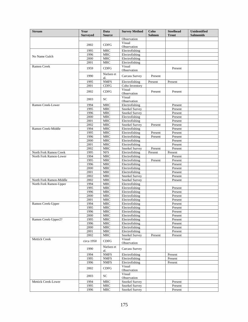
175
Stream Year Surveyed
Data Source
Survey Method Coho Salmon
Steelhead Trout
Unidentified Salmonids
Observation
2002 CDFG Visual Observation
1995 MRC Electrofishing 1996 MRC Electrofishing 2000 MRC Electrofishing No Name Gulch
2001 MRC Electrofishing
1959 CDFG Visual Observation Present
1990 Nielsen et al. Carcass Survey Present
1995 NMFS Electrofishing Present Present 2001 CDFG Coho Inventory
2002 CDFG Visual Observation Present Present
Ramon Creek
2003 SC Visual Observation
1994 MRC Electrofishing Present 1995 MRC Snorkel Survey Present 1996 MRC Snorkel Survey Present 2000 MRC Electrofishing Present 2001 MRC Electrofishing Present
Ramon Creek-Lower
2002 MRC Snorkel Survey Present Present 1994 MRC Electrofishing Present 1995 MRC Electrofishing Present Present 1996 MRC Electrofishing Present Present 2000 MRC Electrofishing Present 2001 MRC Electrofishing Present
Ramon Creek-Middle
2002 MRC Snorkel Survey Present Present North Fork Ramon Creek 1995 NFS Electrofishing Present Present
1994 MRC Electrofishing Present 1995 MRC Electrofishing Present Present 1996 MRC Electrofishing Present 2000 MRC Electrofishing Present 2001 MRC Electrofishing Present
North Fork Ramon-Lower
2002 MRC Snorkel Survey Present North Fork Ramon-Middle 2002 MRC Snorkel Survey Present
1994 MRC Electrofishing 1995 MRC Electrofishing Present 1996 MRC Electrofishing Present 2000 MRC Electrofishing Present
North Fork Ramon-Upper
2001 MRC Electrofishing Present 1994 MRC Electrofishing Present 1995 MRC Electrofishing Present 1996 MRC Electrofishing Present
Ramon Creek-Upper
2000 MRC Electrofishing Present 1995 MRC Electrofishing Present 1996 MRC Electrofishing Present 2000 MRC Electrofishing Present 2001 MRC Electrofishing Present
Ramon Creek-Upper2?
2002 MRC Snorkel Survey Present Present
circa 1950 CDFG Visual Observation
1990 Nielsen et al. Carcass Survey
1994 NMFS Electrofishing Present 1995 NMFS Electrofishing Present 1996 NMFS Electrofishing Present
2002 CDFG Visual Observation
Mettick Creek
2003 SC Visual Observation
1994 MRC Snorkel Survey Present 1995 MRC Snorkel Survey Present
Mettick Creek-Lower
1996 MRC Snorkel Survey Present

176
Stream Year Surveyed
Data Source
Survey Method Coho Salmon
Steelhead Trout
Unidentified Salmonids
2000 MRC Snorkel Survey Present 2001 MRC Electrofishing Present
2002 MRC Snorkel Survey Present
1994 MRC Visual Observation Present
1995 MRC Electrofishing Present 1996 MRC Electrofishing Present 2000 MRC Electrofishing Present
Mettick Creek-Upper
2001 MRC Electrofishing Present Poverty Gulch 2002 CDFG
1994 MRC Snorkel Survey Present 1995 MRC Snorkel Survey Present 1996 MRC Snorkel Survey Present 2000 MRC Snorkel Survey Present
South Fork Big River-Middle
2001 MRC Electrofishing Present circa 1950 CDFG Visual
Observation
1990 Nielsen et al. Carcass Survey
1994 NMFS Electrofishing Present 1995 NMFS Electrofishing Present 1996 NMFS Electrofishing Present
Anderson Gulch
2002 CDFG Visual Observation
1994 MRC Visual Observation Present
1995 MRC Snorkel Survey Present 1996 MRC Snorkel Survey Present 2000 MRC Snorkel Survey 2001 MRC Electrofishing
Anderson Gulch-Lower
2002 MRC Snorkel Survey Boardman Gulch circa 1950 CDFG Visual
Observation
2000 MRC Electrofishing Present 2001 MRC Electrofishing Present
Boardman Gulch - Lower
2002 MRC Electrofishing Present 1996 MRC Electrofishing 2000 MRC Electrofishing 2001 MRC Electrofishing Present
Boardman Gulch - Upper
2002 MRC Electrofishing NMFS Electrofishing Present
1996 MRC Visual Observation Present
2000 MRC Electrofishing 2001 MRC Electrofishing
Halfway House Gulch
2002 MRC Electrofishing Present 1994 MRC Snorkel Survey Present 1995 MRC Snorkel Survey Present 1996 MRC Snorkel Survey Present 2000 MRC Electrofishing Present 2001 MRC Snorkel Survey Present
South Fork Big River-Upper
2002 MRC Electrofishing Present Present 1959 CDFG Visual
Observation Present Present 1988 CDFG Electrofishing Present Present
Daugherty Creek
1988 LPP Carcass Survey Present Present

177
Stream Year Surveyed
Data Source
Survey Method Coho Salmon
Steelhead Trout
Unidentified Salmonids
1990 Nielsen et al. Carcass Survey
1993 CDFG Electrofishing Present 1995 CDFG Carcass Survey Present 1996 NMFS Electrofishing Present Present 2001 CDFG Coho Inventory
2002 CDFG Snorkel Survey Present Present 1994 MRC Electrofishing Present 2000 MRC Electrofishing Present 2001 MRC Electrofishing Present
Daugherty Creek-Lower
2002 MRC Snorkel Survey Present Present 1995 MRC Snorkel Survey Present 1996 MRC Snorkel Survey Present Present
Daugherty Creek-Middle
2000 MRC Electrofishing Present
1959 CDFG Visual Observation ?? ??
1988 CDFG Electrofishing Present Present 1993 CDFG Electrofishing Present Present 1995 NMFS Electrofishing Present 1996 NMFS Electrofishing Present
NMFS Electrofishing Present 1997 NMFS Electrofishing
Soda Creek
2002 CDFG Electrofishing Present Present 1994 MRC Electrofishing Present 1995 MRC Snorkel Survey Present 1996 MRC Snorkel Survey Present 2000 MRC Electrofishing Present 2001 MRC Electrofishing Present
Soda Creek-Lower
2002 MRC Snorkel Survey Present 1994 MRC Electrofishing Present 1995 MRC Electrofishing Present 1996 MRC Electrofishing Present 2000 MRC Electrofishing 2001 MRC Electrofishing Present
Soda Creek-Upper
2002 MRC Snorkel Survey Present 1979 CDFG NA Present
CDFG Carcass Survey Present Present 1987
CDFG Electrofishing Present 1988 CDFG Electrofishing Present Present 1990 Nielsen et
al. Carcass Survey 1993 CDFG Electrofishing Present
CDFG Electrofishing Present Present 1996
NMFS Electrofishing Present
Gates Creek
2002 CDFG Electrofishing Present Present 1994 MRC Electrofishing Present 1995 MRC Snorkel Survey Present 1996 MRC Snorkel Survey Present 2000 MRC Electrofishing Present 2001 MRC Electrofishing Present
Gates Creek-Lower
2002 MRC Snorkel Survey Present Present Gates Creek-Middle2? 2002 MRC Snorkel Survey Present Present Gates Creek-Middle 1994 MRC Electrofishing Present

178
Stream Year Surveyed
Data Source
Survey Method Coho Salmon
Steelhead Trout
Unidentified Salmonids
1995 MRC Snorkel Survey Present 1996 MRC Snorkel Survey Present 2000 MRC Snorkel Survey Present 2001 MRC Electrofishing Present
2002 MRC Snorkel Survey Present 1994 MRC Electrofishing Present 1995 MRC Electrofishing Present 1996 MRC Electrofishing Present
Gates Creek-Upper
2002 MRC Snorkel Survey Present Tributary to Gates Creek 2000 MRC Electrofishing Present
1996 MRC Electrofishing Present 2000 MRC Electrofishing Present 2001 MRC Electrofishing Present
Gates Creek-Upper2?
2002 MRC Snorkel Survey
1959 CDFG Visual Observation Present
1966 CDFG Visual Observation Present
1993 CDFG Electrofishing Present 1996 NMFS Electrofishing Present
Johnson Creek (tributary to Gates Creek)
2002 CDFG Electrofishing Present 1994 MRC Electrofishing Present 1995 MRC Snorkel Survey Present 1996 MRC Snorkel Survey Present 2001 MRC Electrofishing Present
Johnson Creek (Tributary to Gates Creek)-Lower
2002 MRC Snorkel Survey Present 1994 MRC Electrofishing 1995 MRC Electrofishing 1996 MRC Electrofishing 2000 MRC Electrofishing
Johnson Creek (Tributary to Gates Creek)-Upper
2001 MRC Electrofishing Horsethief Creek 2002 CDFG Electrofishing
1994 MRC Electrofishing Present 1995 MRC Snorkel Survey Present 1996 MRC Snorkel Survey Present Present 2000 MRC Electrofishing Present 2001 MRC Electrofishing Present
Daugherty Creek-Upper
2002 MRC Snorkel Survey Present Present
1959 CDFG Visual Observation
1966 CDFG Visual Observation Present
1993 CDFG Electrofishing Present 1996 NMFS Electrofishing Present
Snuffins Creek
2002 CDFG Snorkel Survey Present Present 1994 MRC Electrofishing Present 1995 MRC Snorkel Survey Present 1996 MRC Electrofishing Present 2000 MRC Electrofishing Present 2001 MRC Electrofishing Present
Snuffins Creek-Lower
2002 MRC Electrofishing Present Present 1994 MRC Electrofishing 1995 MRC Electrofishing 1996 MRC Electrofishing Present 2000 MRC Electrofishing Present 2001 MRC Electrofishing Present
Snuffins Creek-Upper
2002 MRC Electrofishing Daugherty Creek 2002 MRC Electrofishing Present Present
1994 MRC Electrofishing Present 1995 MRC Snorkel Survey Present 1996 MRC Electrofishing Present
Daugherty Creek
2000 MRC Electrofishing Present 1996 MRC Electrofishing Present 2000 MRC Electrofishing Present
Daugherty Creek
2001 MRC Electrofishing Present

179
Stream Year Surveyed
Data Source
Survey Method Coho Salmon
Steelhead Trout
Unidentified Salmonids
2002 MRC Electrofishing Present
1959 CDFG Visual Observation Present
2000 NMFS Visual Observation
2001 CDFG Coho Inventory
Johnson Creek
2002 CDFG Electrofishing Present
1958 NMFS Visual Observation
1999 NMFS Visual Observation
Dark Gulch
2002 CDFG Electrofishing Present Present Dark Gulch Tributary 2002 CDFG Electrofishing Present
2000 NMFS Visual Observation Montgomery Creek
2002 CDFG Visual Observation
1958 CDFG Visual Observation Present Unnamed Tributary to the South
Fork Big River #1 2002 CDFG Electrofishing Present Present 1958 CDFG Visual
Observation Present Unnamed Tributary to the South Fork Big River #2 2002 CDFG Electrofishing Present Present Stream Year
Surveyed Data Source Survey
Method Coho Salmon
Steelhead Trout
Unidentified Salmonids
Mainstem Big River (confluence with South Fork Big River to Duffy Flat)
1990 Salmon trollers stream restoration project
Carcass Survey
Big River at South Fork Camp 1973 USFWS Electrofishing Present 1994 MRC Snorkel Survey Present 1995 MRC Snorkel Survey Present 1996 MRC Snorkel Survey Present 2000 MRC Snorkel Survey Present
Big River Main-Lower
2001 MRC Snorkel Survey Present Present Big River at Wildhorse Opening 1973 USFWS Electrofishing Present Present
1959 CDFG Visual Observation Present Present
1967 NMFS Visual Observation Present
1996 NMFS Electrofishing Present
2002 CDFG Visual Observation Present Present
Russell Brook
2003 SC Visual Observation
1994 MRC Electrofishing Present 1995 MRC Snorkel Survey Present 1996 MRC Snorkel Survey Present 2000 MRC Snorkel Survey Present 2001 MRC Electrofishing Present
Russell Brook-Lower
2002 MRC Snorkel Survey Present Present 1994 MRC Electrofishing Present 1995 MRC Electrofishing Present 1996 MRC Electrofishing Present 2000 MRC Snorkel Survey Present 2001 MRC Electrofishing Present
Russell Brook -Middle
2002 MRC Electrofishing Present Present 1994 MRC Electrofishing Present 1995 MRC Electrofishing Present 1996 MRC Electrofishing Present 2000 MRC Electrofishing Present
Russell Brook -Upper
2002 MRC Electrofishing Present Present

180
Stream Year Surveyed
Data Source Survey Method
Coho Salmon
Steelhead Trout
Unidentified Salmonids
1996 MRC Electrofishing Present 2000 MRC Electrofishing Present 2001 MRC Electrofishing Present
Russell Brook -Upper 2
2002 MRC Electrofishing Present 1994 MRC Electrofishing Present 1995 MRC Snorkel Survey Present 2000 MRC Snorkel Survey Present 2001 MRC Electrofishing Present
Big River-Main-Midreach
2002 MRC Snorkel Survey Present Present Big River upstream from dam site 1973 USFWS Electrofishing Present Present
1959 CDFG Visual Observation Present
1967 NMFS Visual Observation Present
MRC Electrofishing Present 1994 NMFS Electrofishing Present MRC Snorkel Survey Present 1995 NMFS Electrofishing Present MRC Electrofishing Present 1996 NMFS Electrofishing Present
2000 MRC Electrofishing 2001 MRC Electrofishing
Pig Pen Gulch
2002 MRC Electrofishing 1994 MRC Electrofishing Present 1995 MRC Snorkel Survey Present 1996 MRC Snorkel Survey Present 2000 MRC Electrofishing Present 2001 MRC Snorkel Survey Present
Big River-Above Pig Pen
2002 MRC Snorkel Survey Present
1959 CDFG Visual Observation Present
1967 NMFS Visual Observation
1973 USFWS Electrofishing Present 1994 NMFS Electrofishing Present
CDFG Electrofishing Present 1995 NMFS Electrofishing Present CDFG Electrofishing Present 1996 NMFS Electrofishing Present
Martin Creek
2002 CDFG Visual Observation Present Present
1994 MRC Electrofishing Present 1995 MRC Snorkel Survey Present 1996 MRC Snorkel Survey 2000 MRC Electrofishing Present 2001 MRC Electrofishing Present
Martin Creek-Lp Prop L
2002 MRC Snorkel Survey Present Present
1959 CDFG Visual Observation Present Martin Creek Left Bank
Tributary
2002 CDFG Visual Observation Present
Martin Creek Right Bank Tributary #1 2002 CDFG Visual
Observation Present Present
Martin Creek Right Bank Tributary #2 2002 CDFG Visual
Observation
1994 MRC Electrofishing Present 1995 MRC Snorkel Survey Present 1996 MRC Snorkel Survey Present 2000 MRC Electrofishing Present 2001 MRC Electrofishing Present
Big River-Upper/Site#1
2002 MRC Snorkel Survey Present Present
1959 CDFG Visual Observation Present Valentine Creek
2002 CDFG Visual Present Present

181
Stream Year Surveyed
Data Source Survey Method
Coho Salmon
Steelhead Trout
Unidentified Salmonids
Observation
circa 1959 CDFG Visual Observation
1967 NMFS Visual Observation Present
Rice Creek
2002 CDFG Visual Observation Present
East Branch Rice Creek 1959 CDFG Visual Observation
Bibliography Anonymous. 1904. Stocking Report. Mendocino Dispatch Democrat, Mendocino.
Barnhart, R. 1994. Salmon and steelhead populations of the Klamath-Trinity Basin, California. Pages 73-97 in Proceedings of the Klamath Basin Fisheries Symposium. Califonia Cooperative Fisheries Research Unit, Humboldt State University, Arcata, California.
Britschgi, D. E., and M. L. Marcus. 1981. Aquatic Life. Pages 47-98 in S. Warrick, and E. Wilcox, editors. Big River: the Natural History of and Endangered Northern California Estuary. Environmental Field Program, University of California, Santa Cruz, California.
Brown, L., and P. Moyle. 1991. Status of Coho in California. For National Marine Fisheries Service by University of California, Davis, California.
Burns, J. 1971. The Carrying Capacity for Juvenile Salmonids in Some Northern California Streams. California Fish and Game 57(1):44-57.
California Department of Fish and Game (CDFG). 1958. Stream Survey - North Fork Big River.
CDFG. 1958. Stream Survey - East Branch North Fork Big River.
CDFG. 1958. Stream Survey - James Creek.
CDFG. 1958. Stream Survey - West Fork James Creek.
CDFG. 1958. Stream Survey - South Fork Big River Tributary #1.
CDFG. 1958. Stream Survey - South Fork Big River Tributary #2.
CDFG. 1959. Stream Survey - Mainstem Big River. California Department of Fish and Game.
CDFG. 1959. Stream Survey - Little North Fork Big River.
CDFG. 1959. Stream Survey - Two Log Creek.
CDFG. 1959. Stream Survey - North Fork Big River.
CDFG. 1959. Stream Survey - Ramon Creek.
CDFG. 1959. Stream Survey - Daugherty Creek (Part 1).
CDFG. 1959. Stream Survey - Daugherty Creek (Part 2).
CDFG. 1959. Stream Survey - Soda Creek.
CDFG. 1959. Stream Survey - Johnson Creek (Tributary to Gates Creek).
CDFG. 1959. Stream Survey - Snuffins Creek.
CDFG. 1959. Stream Survey - Johnson Creek.
CDFG. 1959. Stream Survey - Russell Brook.

182
CDFG. 1959. Stream Survey - Pig Pen Gulch.
CDFG. 1959. Stream Survey - Martin Creek.
CDFG. 1959. Stream Survey - East Fork Martin Creek.
CDFG. 1959. Stream Survey - Valentine Creek.
CDFG. 1959. Stream Survey - Rice Creek.
CDFG. 1965. California Fish and Wildlife Plan, Volume III Supporting Data Part B Inventory (Salmon-Steelhead and Marine Resources). California Department of Fish and Game, Sacramento, California.
CDFG. 1966. Stream Survey - Two Log Creek.
CDFG. 1966. Stream Survey - East Branch North Fork Big River.
CDFG. 1966. Stream Survey - South Fork Big River.
CDFG. 1966. Stream Survey - Snuffins Creek.
CDFG. 1966. Stream Survey - Johnson Creek.
CDFG. 1988. Electrofishing Report - Hatch Gulch.
CDFG. 1988. Electrofishing Report - Daugherty Creek.
CDFG. 1993. Stream Inventory Report - Daugherty Creek.
CDFG. 1993. Stream Inventory Report - Gates Creek.
CDFG. 1993. Stream Inventory Report - Snuffins Creek.
CDFG. 1993. Stream Inventory Report - Johnson Creek (Tributary to Gates Creek).
CDFG. 1995. Stream Inventory Report - Little North Fork Big River.
CDFG. 1995. Stream Inventory Report - Soda Creek.
CDFG. 1996. Stream Inventory Report - James Creek.
CDFG. 1996. Stream Inventory Report - Railroad Gulch.
CDFG. 1996. Stream Inventory Report - North Fork Big River.
CDFG. 1997. Stream Inventory Report - Berry Gulch.
CDFG. 1997. Stream Inventory Report - Chamberlain Creek.
CDFG. 1997. Stream Inventory Report - North Fork Big River.
CDFG. 1997. Stream Inventory Report - North Fork James Creek.
CDFG. 1997. Stream Inventory Report - Rocky Gulch.
CDFG. 1997. Stream Inventory Report - Soda Gulch.
CDFG. 1997. Stream Inventory Report - Thompson Gulch.
CDFG. 1997. Stream Inventory Report - Water Gulch.
CDFG. 1997. Stream Inventory Report - Manly Gulch.
CDFG. 1997. Stream Inventory Report - Berry Gulch Tributary.
CDFG. 1997. Stream Inventory Report - Two Log Creek.

183
CDFG. 1997. Stream Inventory Report - Water Gulch Tributary.
CDFG. 1997. Stream Inventory Report - Park Gulch.
CDFG. 1997. Stream Inventory Report - West Chamberlain Creek.
CDFG. 1997. Stream Inventory Report - Gulch Sixteen.
CDFG. 1997. Stream Inventory Report - Gulch Sixteen Tributary.
CDFG. 1997. Stream Inventory Report - Arvola Gulch.
CDFG. 1997. Stream Inventory Report - Lost Lake Creek.
CDFG. 1998. Stream Inventory Report - East Branch North Fork Big River.
CDFG. 1998. Stream Inventory Report - Two Log Creek.
CDFG. 1998. Stream Inventory Report - Two Log Creek Tributary (Ayn Creek).
CDFG. 1998. Stream Inventory Report - Two Log Creek Tributary (Saurkraut Creek).
CDFG. 2001. California's Living Marine Resources: A Status Report. Pages 592 p. in. University of California.
CDFG. 2002. Stream Inventory Report - Anderson Gulch.
CDFG. 2002. Stream Inventory Report - Big River Tramway Gulch to North Fork Big River.
CDFG. 2002. Stream Inventory Report - Big River from Wheel Gulch to Blind Gulch.
CDFG. 2002. Stream Inventory Report - Biggs Gulch.
CDFG. 2002. Stream Inventory Report - Dark Gulch.
CDFG. 2002. Stream Inventory Report - Boardman Gulch.
CDFG. 2002. Stream Inventory Report - Daugherty Creek.
CDFG. 2002. Stream Inventory Report - East Branch Little North Fork Big River.
CDFG. 2002. Stream Inventory Report - Gates Creek.
CDFG. 2002. Stream Inventory Report - Horse Thief Creek.
CDFG. 2002. Stream Inventory Report - Johnson Creek.
CDFG. 2002. Stream Inventory Report - Kidwell Gulch.
CDFG. 2002. Stream Inventory Report - Martin Creek.
CDFG. 2002. Stream Inventory Report - Martin Creek Left Bank Tributary.
CDFG. 2002. Stream Inventory Report - Martin Creek Right Bank Tributary #1.
CDFG. 2002. Stream Inventory Report - Martin Creek Right Bank Tributary #2.
CDFG. 2002. Stream Inventory Report - Mettick Creek.
CDFG. 2002. Stream Inventory Report - Montgomery Creek.
CDFG. 2002. Stream Inventory Report - Ramon Creek.
CDFG. 2002. Stream Inventory Report - North Fork Ramon Creek.
CDFG. 2002. Stream Inventory Report - Rice Creek.
CDFG. 2002. Stream Inventory Report - Russell Brook.

184
CDFG. 2002. Stream Inventory Report - South Fork Big River.
CDFG. 2002. Stream Inventory Report - Snuffins Creek.
CDFG. 2002. Stream Inventory Report - Soda Creek.
CDFG. 2002. Stream Inventory Report - Two Log Creek.
CDFG. 2002. Stream Inventory Report - South Fork Big River Tributary #1.
CDFG. 2002. Stream Inventory Report - South Fork Big River Tributary #2.
CDFG. 2002. Stream Inventory Report - Valentine Creek.
CDFG. 2002. Stream Inventory Report - Halfway House Gulch.
CDFG. 2002. Stream Inventory Report - Johnson Creek (Tributary to Gates Creek).
CDFG. 2002. Status review of California coho salmon north of San Francisco.
CDFG. c. 1959. Stream Survey - Tramway Gulch.
CDFG. 1957-1958. Stream Survey - South Fork Big River.
California Department of Water Resources (DWR). 1965. North Coastal Area Investigation, Appendix C, Fish and Wildlife, Dept. of Water Resources Bulletin No. 136. Redding, CA, Dept. of Water Resources.
Center for Education and Man Power Resources (CEMPR). 1979. Stream Survey - Railroad Gulch.
CEMPR. 1979. Stream Survey - Little North Fork Big River.
CEMPR. 1979. Stream Survey - Thompson Gulch.
CEMPR. 1979. Stream Survey - East Branch North Fork Big River.
Cherr, and J. Griffin. 1979. Department of Fish and Game Stream Inventory - Mendocino County. California Department of Fish and Game, Mendocino County, California.
Clapsadle, J., N. Sharples, A. Tone-Heckeroth, and M. Hedges. 2001. Big River Estuary Transect Fish Count. School of Natural Resources, Mendocino High School, Mendocino, California.
Kitsap County. 2000. Kitsap Peninsula Salmonid Refugia Study. Port Orchard, Washington.
Elwell, R. 1958. Big River Drainage Survey, Mendocino County. California Department of Fish and Game Intraoffice Correspondence.
Emig, J. 1996. Barrier Debris Jam on the North Fork Big River. California Department of Fish and Game Correspondence.
English, S. 1979. Final Draft Environmental Assessment for Protection of Big River Estuary, Mendocino County, California. US Fish and Wildlife Service, Sacramento, California.
Evans, W. 1955. Meeting at Fort Bragg, July 19, 1955. regarding King Salmon Project in Big River, Mendocino County. California Department of Fish and Game Intraoffice Correspondence.
Forest Ecosystem Management Assessment Team (FEMAT). 1993. Forest ecosystem management: an ecological, economic, and social assessment. Portland, OR, U.S. Department of Agriculture, U.S. Department of Interior, U.S. Department of Commerce, U.S. Environmental Protection Agency.
Flosi, G., S. Downie, and J. Hopelain. 1998. California Stream Habitat Restoration Manual. CDFG.
Frissell, C. 1993. Topology of Extinction and Endangerment of Native Fishes in the Pacific Northweat and California (USA). Oregon State University, Corvallis, Oregon.

185
Frissell, C., P. Morrison, S. Adams, L. Swope, and N. Hitt. 2000. Identifying Priority Areas for Salmon Conservation in the Puget Sound Basin. Pacific Biodiversity Institute, Open File Report Number 2000-1.
Georgia-Pacific. 1995. Stream Inventory Report - Little North Fork Big River.
Georgia-Pacific. 1996. Stream Inventory Report - Mainstem Big River. Georgia Pacific.
Georgia-Pacific. 1996. Stream Inventory Report - Laguna Creek.
Georgia-Pacific. 1996. Stream Inventory Report - Railroad Gulch.
Georgia-Pacific. 1996. Stream Inventory Report - East Branch Little North Fork Big River.
Georgia-Pacific. 1996. Stream Inventory Report - Two Log Creek.
Georgia-Pacific. 1996. Stream Inventory Report - Hatch Gulch.
Graham Matthews & Associates (GMA). 2001a. Sediment Source Analysis for the Big River Watershed, Mendocino County, California. Weaverville, California.
Hallock, R., G. Warner, and J. DH Fry. 1952. California's Part in a Three-State Salmon Fingerling Marking Program. California Fish and Game 38:301-332.
Hassler, T., C. Sullivan, and G. Stern. 1991. Distribution of Coho Salmon in California. US Fish and Wildlife Service, Arcata, California.
Hilborn, R., and C. J. Walters. 1992. Quantitative Fisheries Stock Assessment: Choice, Dynamics and Uncertainty. Chapman and Hall, New York.
Jackson, W. 1975. Big River Was Dammed.
Jackson, W. 1991. Mendocino City: A Daily Journal - 1852-1938. Mendocino Historical Research, Inc.
Jones, W. 1986. Salmon Carcass Surveys: North Fork Big River, Little North Fork Big River, and the East Branch Little North Fork Big River, Mendocino County. California Department of Fish and Game Memorandum.
Jones, W. 2000 Draft. California Coastal Salmon and Steelhead Current Stream Habitat Distribution Table. National Marine Fisheries Service.
Kight, T., and R. Waldman. 2003. Effects of Nest Box Installation on Wood Duck Brood in Big River Watershed. Mendocino High School School of Natural Resources, Mendocino, California.
Levins, R. 1969. Some demographic and genetic consequences of environmental heterogeneity for biological control. Bulletin of the Entomological Society of America 15:237-240.
Li, H., and coauthors. 1995. American Fisheries Society Symposium. Pages 371-380 in.
Maahs, B. 1978. Mendocino Coast Restoration Association. Salmon Unlimited.
Maahs, M. 1999. Fort Bragg's World's Biggest Salmon BBQ: a brief history of the Salmon Restoration Association. Fort Bragg, California.
Marcus, L., and S. Reneau. 1981. Historic Sedimentation in an Estuary: Salt Marsh Succession and Change, Big River Estuary, Mendocino County, California. Pages 246-257 in R. Coats, editor. Watershed Rehabilitation in Redwood National Park and Other Pacific Coastal Areas, Proceedings of a symposium held August 24-28, 1981. The Center for Nastural Resource Studies, JMI, Inc.

186
McElhany, P., M. Ruckelshaus, M. Ford, T. Wainwright, and E. Borkstedt. 2000. Viable salmonid populations and recovery of evolutionarily significant units. National Oceanic and Atmospheric Administration, Technical Memorandum NMFS-NWFSC-42.
Mendocino Coastal Streams Subcommittee of the Advisory Committee on Salmon and Steelhead Trout. 1986. Findings of the Mendocino Coastal Streams Subcommittee of the Advisory Committee on Salmon and Steelhead Trout.
Morford, M. 1987. Assessment of Impacts from Logging on Anadromous Fisheries of Big River, Willits, California.
Moyle, P., and G. Sato. 1991. On the design of preserves to protect native fishes. Pages 155-169 in W. Minkley, and J. Deacon, editors. Battle against extinction: native fish management in the American West. University of Arizona Press, Tuscon, Arizona.
Moyle, P., and R. Yoshiyama. 1992. Fishes, Aquatic Diversity Management Areas, and Endangered Species: A Plan to Protect California's Native Aquatic Biota. California Policy Seminar, University of California.
Mendocino Redwood Company (MRC). 2003. Watershed Analysis for Mendocino Redwood Company's Ownership in the Big River Watershed.
Murphy, M. L., W.R. Meehan, editor. 1991. Chapter 2: Stream ecosystems, volume Special Publication 19. American Fisheries Society, Bethesda, MD.
Nielsen, J., M. Maahs, and G. Balding. 1991. Anadromous Salmonid Resources of Mendocino Coastal and Inland Rivers 1989-1990. Salmon Trollers Marketing Association under contract with the California Department of Fish and Game, Standard Agreement Number FG9364, Mendocino County, California.
National Marine Fisheries Service (NMFS). 2001. Status Review Update for Coho Salmon (Oncorhynchus kisutch) from the Central California Coast and the California Portion of Southern Oregon/Northern California Coasts Evolutionarily Significant Units. Santa Cruz, California, National Marine Fisheries Service, Southwest Fisheries Center.
Perry, L. 1974. Progress Report: Fisheries Improvement Study, Big River, Mendocino County (Eureka Division, North Coast Project, California). US Fish and Wildlife Service, Portland, Oregon.
Reneau, S. 1981. Geography and Geology. Pages 3-45 in S. Warrick, and E. Wilcox, editors. Big River: the Natural History of and Endangered Northern California Estuary. Environmental Field Program, University of California, Santa Cruz, California.
Salmon Trollers Marketing Association. 1990. Salmon Trollers Stream Restoration Project Preliminary Report for February 1990 - Louisiana Pacific Property.
Scriven, J. 2003. Big River Watershed Stream Restoration Project Final Report. Prepared for US Fish and Wildlife Service by E Center's Mendocino Fisheries Program, Cooperative Agreement #11331-9-J096, Ukiah, California.
Sedell, J., G. Reeves, F. Hauer, J. Stanford, and C. Hawkins. 1990. Role of refugia in recovery from disturbances: modern fragmented and disconnected river systems. Environmental Management 14(5):711-724.
Sharples, N. 2003. Little North Fork Big River Coho and Steelhead Carcass/Redd Survey. Mendocino High School School of Natural Resources, Mendocino, California.
Shirazi, M., W. Seim, and D. Lewis. 1979. Characterization of Spawning Gravel and Stream System Evaluation. US Environmental Protection Agency, EPA-800/3-79-109.

187
Sommarstrom, S. 1984. Mendocino County Salmon and Steelhead Management Plan. Mendocino County Board of Supervisors, Ukiah, California.
Mendocino High School of Natural Resources (SONAR). 2001. Carcass and Redd Survey of Little North Fork Big River.
SONAR. 2001. Carcass and Redd Survey of Railroad Creek.
SONAR. 2001. Carcass and Redd Survey of West Chamberlain Creek.
SONAR. 2001. Carcass and Redd Survey of Chamberlain Creek.
SONAR. 2002. SONAR Big River Estuary Study Mud Flat #1 Plant Species List.
SONAR. 2002. Carcass and Redd Survey of Little North Fork Big River.
SONAR. 2003. Carcass and Redd Survey of Little North Fork Big River.
SONAR. 2002. Wood Duck Box Locations and GPS Coordinates. Mendocino, California.
Taylor, R. N. 2001. Final Report: Coastal Mendocino County Culvert Inventory and Fish Passage Evaluation. CDFG, McKinleyville, CA.
Toffoli, E. 1988. Digest of Opinion - Friends of Daugherty Creek v. California Department of Forestry, et. al, (Unpublished Decision, Mendocino Superior Court #55755). California Department of Fish and Game Memorandum.
Tunzi, L., and M. Tunzi. 1992. Letter to Mendocino County Board of Supervisors. Comptche, California.
United States Bureau of Reclamation (USBR). 1974. Fishery Improvement Study, Eureka Division, North Coast Project, California. Sacramento, California, Department of the Interior, Bureau of Reclamation: 46.
United States Environmental Protection Agency (EPA). 2001. Big River Total Maximum Daily Load for Sediment.
Warrick, S., and E. Wilcox, editors. 1981. Big River: the Natural History of an Endangered Northern California Estuary, volume Environmental Field Publication Number 6. Environmental Field Program, University of California, Santa Cruz, California.