Embed Size (px)
Citation preview
Bhuvan-NUIS- Master plan Preparation
National Remote Sensing Centre, ISRO
Regional WorkshopIIRS, Dehra Dun
15 April, 2014
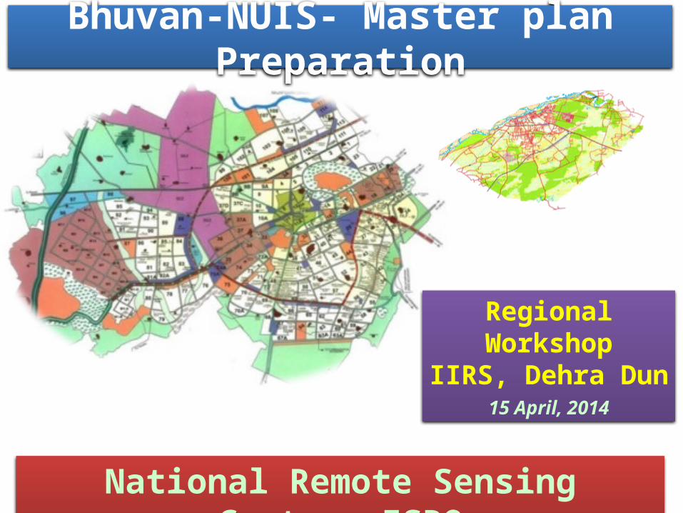
Basic Idea & Broad Architecture
Inputs Guidelines
Master Plan Preparation GIS Software (QGIS)
Bhuvan
URDPFI
Bhuvan NUIS Environment
Auxiliary DataGeospatial Data

Metro - 13 towns
Class I – 70 towns
Class II – 15 towns
Class III – 19 towns
Class IV – 17 towns
Class V – 6 towns
Class VI – 12 towns
National Urban Information System (NUIS)
Scope: Large scale Urban Geospatial database for various levels of Urban Planning, Infrastructure development and e-governance.
Primary Layers1. Urban land use
2. Physiography
3. Geomorphology
4. Geological Structures
5. Lithology
6. Soils
7. Drainage
8. Surface Water bodies
9. Road
10. Rail
11. Canal
12. Transportation Nodes
Incorporated Layers13. Administrative Boundaries
14. Forest Boundary
15.Settlement & Village Locations
16.City / Town Boundaries

BASE
URBAN LANDUSE
SOIL
Korba Town : 286 Sq.km
National Urban Information System (NUIS)PHYSIOGRAPHY
LITHOLOGY
GEOMORPHOLOGY
No. of Towns – 152 (~56 Sq. km)
Urban Geospatial database for Urban Local Bodies (ULB’s) for Urban Planning, Infrastructure development and e-governance.
Bhuvan-NUIS based online Geospatial solution for Master
Plan Preparation
SoilGeomorphology
Lithology
Physiography

Data Creation & Uploading
Data & User Management
Client side GIS Solution
What is Bhuvan NUIS ?
Bhuvan NUISBhuvan NUIS
Bhuvan Geoportal has 152 Towns GIS
Database offers National level
Services
Internet(suggested. 512 Kbps)
Online GIS services & uploading
of output GIS products
Open Source GIS Software
for editing and data creation
Towards Master Plan Preparation

Bhuvan NUIS – Access Mechanism
Bhuvan NUIS
Web Portal login(Operates on Bhuvan)
Bhuvan NUIS QGIS Plug-in(Operates through QGIS)
Data Creation / Uploading Data & User Management
QGIS
Common Username & Password

Bhuvan NUIS – Basic Work flow
Bhuvan - NUIS
Authentication(username &
password)
Download s/wQGIS and Plug-in
INSTALLAccess and View
data
Create data
Upload data to Bhuvan
Approve the Uploaded data
Public View
Feedback
1
2
3 4
5
6
7
8Web Portal
QGIS+Plugin
S/W Installation

Bhuvan NUIS – Access Privilege & User Management
NUIS Users
State National
Administrator
Approver
Data Creator
Town Administrator(TA)/ Commissioner
Town Planner(TPO)
JE/ Surveyor/ Draftsman/ Asst. Town Planner
Town

Bhuvan NUIS - Layer Management
Layer Management
Not Uploaded Layers
Pending Layers for Approval
Not Approved Layers
Approved Layers
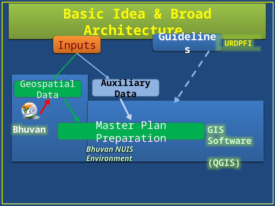
Basic Steps for Data CreatorInitial Setup of Bhuvan NUIS Environment• Step 1: Open Browser and enter URL
http://bhuvan-staging.nrsc.gov.in/projects/bhuvannuis
• Step 2: Web Portal Login: Enter Username and Password• Step 3: Click on Login as JE• Step 4: Now user in Bhuvan NUIS Environment• Step 5: Explore data-tree on Bhuvan NUIS• Step 6: Download & Install GIS tool (QGIS)• Step 7: Download & Install Software Plugin for Bhuvan
Assets under QGIS• Step 8: Enable Plugin under QGIS environment• Step 9: Explore Basic functionalities of Bhuvan NUIS

Basic Steps for Data Creator…..ContdRegular Usage sequence for data editing and creation• Step 10: Start QGIS on local desktop• Step 11: Invoke “Get Bhuvan WMS service”• Step 12: Bhuvan NUIS Login: Enter username and password• Step 13: Enables NUIS data tree in GIS Environment + Use
NUIS data• Step 14: Use QGIS for data creation, Edit, process, Analysis
etc.• Step 15: Possibilities for Geo-referencing of Cadastral data• Step 16: Use Bhuvan NUIS layers, local layers & Attribute data
on QGIS platform for Master plan preparation• Step 17: Upload Cadastral and Master Plan for Approval

WEB Portal: Login
Login as JE: Data Creator

Data-Tree on Bhuvan NUIS
LAYER TREE View NUIS data

Download and Installation of Software Plugin Under QGIS
• Click on the button to download the QGIS & plug-in.
Bhuvan NUIS QGIS Plug-in
Bhuvan WMS Legend Plug-in
Quantum GIS (QGIS)

Enable Plugin On QGIS
• After Download, perform Plug-in 4 easy steps
• Right Click on .zip file & extractExtract• Right Click on folder & click copyCopy• Go to plug-in directory of QGIS• Right click & PastePaste• Open QGIS• Plugin Manage Plugin Check Bhuvan
NUIS
Enable Plugin in QGIS

Enable Plugin in QGIS ……Contd

Plug-in under QGIS Environment
Bhuvan NUIS QGIS Plugin Icon
Bhuvan NUIS QGIS Plugin

Satellite Data In QGIS Environment
To Access the NUIS Spatial Data Upload data To Access the NUIS Spatial Data Upload data
Satellite Imagery Services. Administrative Boundary (State, District, & Taluk). Satellite Imagery Services. Administrative Boundary (State, District, & Taluk).

NUIS Data Tree in QGIS Environment

Edit & Data Creation Under QGIS

Edit & Data Creation under QGIS …… Contd

Upload/ Send Data For Approval

Upload/ send Data from Web Portal
Data Uploading
Status Intimation Alerts
Data Upload & Alerts

Help Module For Usage

Basic Steps to be followed by Approver
Step 1: “Web portal Login” through Login as TPO Step 2: Get Alert Messages for “New Layer Upload by Creator” Step 3: Explore data-tree on Bhuvan NUIS, Display layer & Legend• Step 4: Explore/ Analyse Layer(s) that are pending for Approval• Step 5: Based on Analysis “Approve / Reject” the layer in question• Step 6: If “Rejected”, Give Reasons – Descriptive information• Step 7: This Iteration is maintained as version until Final Approval• Step 8: If “Approved”, Go for Administrator’s Feedback• Step 9: Use Feedback facility to provide information
Further Process for Master Plan Approval could be adopted through Public domain Display using Bhuvan Geoportal.
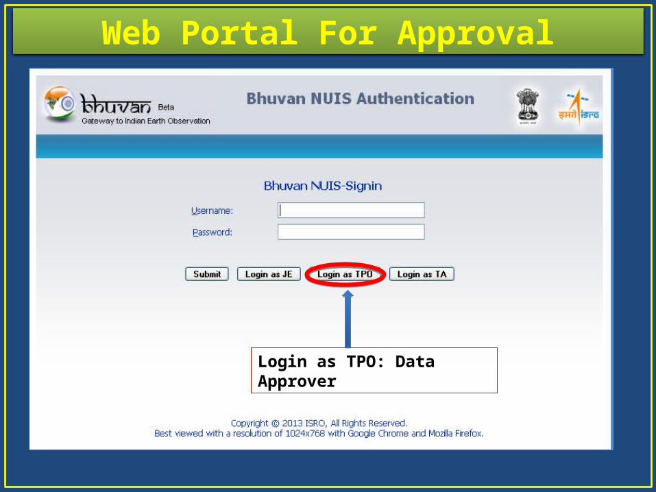
Web Portal For Approval
Login as TPO: Data Approver
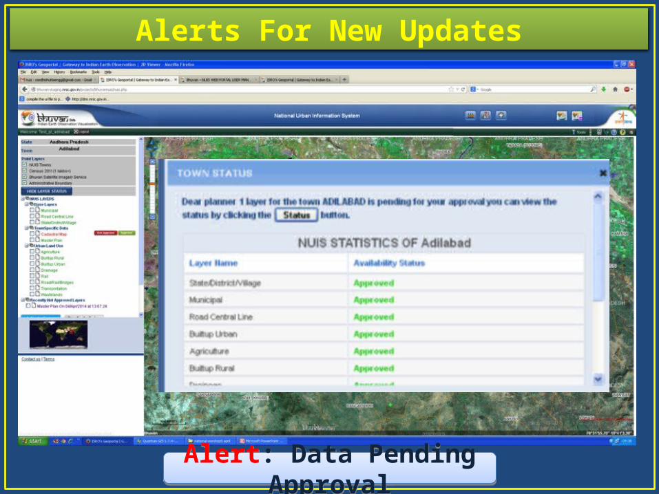
Alerts For New Updates
Alert: Data Pending ApprovalAlert: Data Pending Approval

Layer Tree And Legend Display

Explore for Data, “Pending Approval”
UPLODED DATAUPLODED DATA
ApprovedApproved RejectedRejected
• Uploaded data has to be approved.• Approval authority can approve it using this facility.• Clicking on button will make data in public domain. • Clicking on will reject the data and rejection reasons has to be mentioned.• On Rejection version of data will be maintained.

Data Rejection
UPLODED DATAUPLODED DATA
ApprovalApproval RejectedRejected
• Click on button to reject the data.• Give rejection reasons.• Version of rejected data will be maintained for further reference.
Versions Of data for further
reference
Versions of spatial data

Feedback Mechanism

Access to Town Admin Step 1: “Web portal Login” through Login as TA Step 2: Explore data-tree on Bhuvan NUIS, Display layer & Legend• Step 3: Explore/ Analyse Layer(s).• Step 4: Based on Analysis “Send Feedback “
Acces to State Admin Step 1: “Web portal Login” through submit button Step 2: Select town under the relevant state. Step 3: Explore data-tree on Bhuvan NUIS, Display layer & Legend• Step 4: Explore/ Analyse Layer(s).• Step 5: Based on Analysis “Send Feedback”
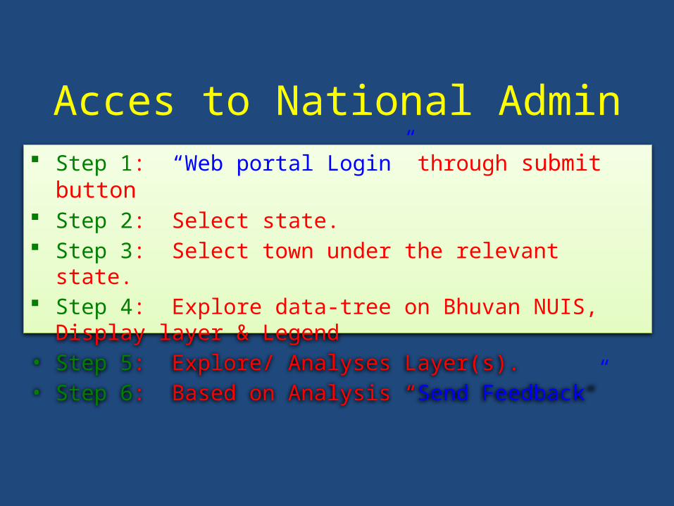
Acces to National Admin Step 1: “Web portal Login” through submit button Step 2: Select state. Step 3: Select town under the relevant state. Step 4: Explore data-tree on Bhuvan NUIS, Display layer & Legend• Step 5: Explore/ Analyses Layer(s).• Step 6: Based on Analysis “Send Feedback”

Web Portal Login - Town Admin
Login as TA: Town Administrator

Web Portal For Town Admin……..contd

Web Portal Login - State & National Admin
Submit Option: For State & National Admin

Web Portal For State Admin

Web Portal For National Admin

Help Documents(For further reading)
A BA. Help document for Web PortalB. Help document for Bhuvan
NUIS QGIS Plug-in
A. Help document for Web PortalB. Help document for Bhuvan
NUIS QGIS Plug-in
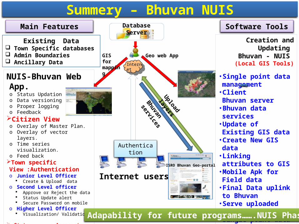
Database Server
Existing Data Town Specific databases Admin Boundaries Ancillary Data
NUIS-Bhuvan Web App.o Status Updationo Data versioningo Proper loggingo Feedback
Citizen Viewo Overlay of Master Plan.o Overlay of vector layers.o Time series visualization.o Feed back
Town specific View :Authentication o Junior Level Officer
Create & Upload datao Second Level officer
Approve or Reject the data Status Update alert Secure Password on mobile
o Higher Level Officer Visualization/ Validation
State : Access to all towns National : Access, state wise
Internet users
Authentication
Internet
Geo web AppGIS for mapping
Creation and Updating Bhuvan - NUIS (Local GIS Tools)
• Single point data management
• Client Bhuvan server• Bhuvan data services• Update of Existing GIS
data• Create New GIS data• Linking attributes to GIS• Mobile Apk for Field data• Final Data uplink to
Bhuvan• Serve uploaded data as
WMS• Single point data
management.• Help module for Plug-in• Video lectures for
download
ISRO Bhuvan Geo-portal
Bhuvan servicesUpload layers
Summery – Bhuvan NUISMain Features Software Tools
Adapability for future programs…….NUIS Phase II

Thank youThank You
Video Lectures(English + Hindi)