Embed Size (px)
Citation preview

ISRO’s Geoportalbhuvan
www.bhuvan.nrsc.gov.in
Gateway toIndian Earth Observation Data Products & Services
Gateway toIndian Earth Observation Data Products & Services

One-stop versatile
Data Products & ServicesWeb based Earth Observation
............... 2 ...............
Seamless Fly Throughs Multi Resolution Terrain
3D Geographic Models
Societal Applications
VisionTo evince the distinctiveness of Indian Earth Observation(EO) capabilities through online rendering of multi-resolution, multi-temporal and multi-sensor IRS imagery overlaying value added thematic information on 2D/3D virtual globe, providing satellite data and products for download and consume thematic datasets as OGC web services towards online Geo-Processing, whilst serving for societal good.
interoperability
Visualise different layers explore Geoprocessing, and feel empowered with Bhuvan 2D having no dependencies
Access to Bhuvan, the Earth Browser through smartphones
NRSC Open EO Data Archive (NOEDA) to browse and download satellite data and products
Geospatial Consortium (OGC) web services enabling Bhuvan – Gateway to Indian Earth Observation Explore, experience, visualise and analyse Indian Remote
Sensing (IRS) images
Rapid access to 3D geospatial data powered with real-time data sharing and colloboration providing a true Common Operating Picture
Rich Thematic Datasets to visualise and consume as Open
Thematic Vectors
Interactive 3D Environment
www.bhuvan.nrsc.gov.in

What is it?
What can it do?
How does it work?
Bhuvan (means Earth in Sanskrit) is a Geoportal of ISRO, to evince the Indian Earth Observation capabilities from the Indian Remote Sensing (IRS) series of satellites.
It is an interactive versatile Earth-Browser which showcases multi-sensor, mutli-platform and multi-temporal images with capabilities to overlay thematic information, interpreted from such imagery as a vector layer, along with near real-time information from Automatic Weather Stations (AWS), Potential Fishing Zone (PFZ) information, disaster support related information like forest fire alerts, periodic agricultural drought assessment etc.
Ranging from visualisation, Bhuvanites can also download IRS data products and consume thematic datasets as OGC web services towards Geoprocessing.·
A Place where users can add their own points of interest and share them with others
Can delineate vector features as shape files
· Can be connected to Global Positioning System(GPS) device in real-time or playback mode
· Users can chart routes, plot areas, view terrain profile and overlay images
· Useful for educators to teach subjects ranging from sciences to history. Also, take students virtually to an area being studied and show them the topography, surrounding areas etc.
· Useful for scientists to facilitate new possibilities from the IRS geospatial data for collaborative research
· Useful for administrators to monitor various developmental schemes at the grassroots level
· It is a free web based visualisation system. Users can access Bhuvan by visiting www.bhuvan.nrsc.gov.in
· Users can choose Bhuvan 2D or Bhuvan 3D for EO visualisation , Open EO data archive for downloading IRS satellite data and products, and thematic data
Know Bhuvan
dissemination for obtaining interoperable OGC web services
· Different supporting components like – interactive videos, virtual tour, discussion forum, help documents are also available.
· Registration is optional in Bhuvan. However, some features require registration. Users can use the Central Authentication Service of Bhuvan for creating an account on Bhuvan towards single sign-on (SSO). Registered users are having privilege to share and download the data, collaborate with other Bhuvanites, discussions in Forum etc.
A plug-in is to be downloaded and installed to access Bhuvan 3D (for first time use)
Scientists, academicians, policy makers and general public can leverage this integration of vast amounts of geospatial data in an easy-to-use multi-lingual interface without any additional resources
The tool's visual immediacy could prove enormously beneficial, for example, for a survey of various geological structures in a region
Individually, students can use Bhuvan to know and examine places they are studying. Also allows them to create and share personal resources like data sharing
Bhuvan lets users to download specific satellite data and products, and also encourages users to revisit and explore availability of new datasets
Bhuvan has become more sophisticated , with additional tools and increased coverage of high resolution imagery, free satellite data download and thematic data dissemination as web services
By integrating with other existing applications, Bhuvan is poised to become a spatially based collection of profound information, coupled with facts and knowledge.
Blogs, user groups, social networking sites and forums are enabled for users to share ideas and experiences, and post case studies also.
Why is it significant?
Where is it going?
............... 3 ...............www.bhuvan.nrsc.gov.in

ISRO is well known amongst space faring nations for its world-leading reputation in developing new, indigenous and innovative service oriented applications using remote sensing technology. Over the past 2 decades, ISRO has mastered the art of developing these unique applications using various spectral, spatial and temporal resolutions offered by the versatile IRS satellites and these have been successfully institutionalized in many important areas of policy making, natural resources management, disaster support, and enhancing the quality of life across all sections of the society.
Bhuvan an initiative to showcase this distinctiveness of Indian imaging capabilities including the thematic information derived from such imagery is of vital importance to common man. Bhuvan an ambitious project of ISRO to take Indian images and thematic information in multiple spatial resolutions to people with a web portal through easy access to information on basic natural resources in the geospatial domain. Bhuvan showcases Indian images by the superimposition of the IRS satellite imageries on 2D/ 3D virtual globe. It displays satellite images of varying resolution of India's surface, allowing users to visually see things like cities and important places of interest looking perpendicularly down or at an oblique angle, with different perspectives and can navigate through 3D viewing environment.
The degree of resolution showcased is based on the points of interest and popularity, but most of the Indian terrain is covered up to at least 6 metres of resolution with the least
spatial resolution being 55 metres from AWiFS Sensor, while some cities are having 2.5 metres and 1 metre resolution. With such rich content, Bhuvan opens the door to net-centric visualisation of digital geospatial India allowing individuals to experience the fully interactive terrain viewing capabilities.
Bhuvan 2D offers powerful, user-friendly mapping technology to organize the satellite and map data along with myriad information geographically with no dependencies in an easy way. It also offers Geoprocessing services, WMS manager, Embeddable HTML and SendLink options.
Apart from visualisation, Bhuvan facilitates user to browse, select and download satellite data and products through NOEDA. Through Thematic Services it also facilitates to select, browse and query thematic datasets and consume as OGC web services. Bhuvan brings a whole lot of uniqueness in understanding our own natural resources whilst presenting beautiful images and thematic information generated from varieties of geospatial data. Bhuvan also attempts to bring out the importance of multi-temporal data and to highlight the changes taking place to our natural resources, which will serve as a general awareness on our changing planet. There are lot more value added services which will be enabled onto this Geoportal due course of time and each one of those services are going to be unique to preserving and conserving our precious natural resources through public participation.
Bhuvan gives you an easy way to
IRS imagesexperience, explore, visualise & download
............... 4 ...............
Knowledge Insight Awareness Action- - -www.bhuvan.nrsc.gov.in

............... 5 ...............
Bhuvan 2D
The two dimensional (2D) Bhuvan, a web mapping service application based on OpenLayers open source project, offers powerful, user-friendly mapping technology to organise the satellite data and map along with myriad information geographically with no server-side dependencies in an easy way. Bhuvan 2D is a slick, exciting online mapping application. It provides a highly responsive, intuitive mapping interface with detailed imagery and map data embedded. Some of its functional capabilities include map navigation, drawing point line, polygon, online shapefile creation, geoprocessing overview map, linear and areal measurement. These capabilities combine to make Bhuvan 2D a compelling product.
Bhuvan 3D
Bhuvan 3D showcases images in a multi-sensor, multi-platform and a multi-temporal domain. It lets you access, explore and visualise IRS image and a bundle of rich thematic information in 3D landscape. On Bhuvan 3D, users can fly to different locations on the terrain and experience unparalleled 3D navigation.
3D Bhuvan has many unique features and easy to use intuitive interface, where users can virtually experience the physical characteristics of the terrain, especially the Indian landscape. The urban design tools are a magic galore. Here you can virtually build roads, junctions and traffic lights in an urban setting! Experience all this just on Bhuvan 3D!
Access Earth Browser in your smart phone. Supported in devices based on Android, Windows, Symbian, iOS and BlackBerry OS.
Pocket Bhuvan
www.bhuvan.nrsc.gov.in
............... 6 ...............
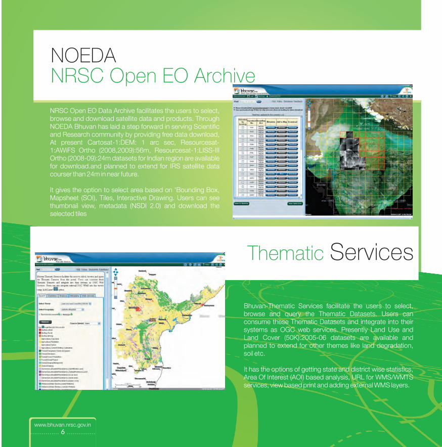
NOEDANRSC Open EO Archive
NRSC Open EO Data Archive facilitates the users to select, browse and download satellite data and products. Through NOEDA Bhuvan has laid a step forward in serving Scientific and Research community by providing free data download, At present Cartosat-1:DEM: 1 arc sec, Resourcesat-1:AWiFS Ortho (2008,2009):56m, Resourcesat-1:LISS-III Ortho (2008-09):24m datasets for Indian region are available for download.and planned to extend for IRS satellite data courser than 24m in near future.
It gives the option to select area based on 'Bounding Box, Mapsheet (SOI), Tiles, Interactive Drawing. Users can see thumbnail view, metadata (NSDI 2.0) and download the selected tiles
Bhuvan-Thematic Services facilitate the users to select, browse and query the Thematic Datasets. Users can consume these Thematic Datasets and integrate into their systems as OGC web services. Presently Land Use and Land Cover (50K):2005-06 datasets are available and planned to extend for other themes like land degradation, soil etc.
It has the options of getting state and district wise statistics, Area Of Interest (AOI) based analysis, URL for WMS/WMTS services, view based print and adding external WMS layers.
Thematic Services
www.bhuvan.nrsc.gov.in

............... 7 ...............
Online Shapefile creation
Online Web Processing Service
Snapshots of Bhuvan Functionalities
Terrain Profile
www.bhuvan.nrsc.gov.in

............... 8 ...............
Potential Fishing Zone Information
Flood Inundated Area
Near Real-time Weather Parameters
Snapshots ofBhuvan
Services
www.bhuvan.nrsc.gov.in

............... 9 ...............
Bhuvan ApplicationsSocietal
Wasteland Information
Ground Water Potential Zones
Soil Information
www.bhuvan.nrsc.gov.in
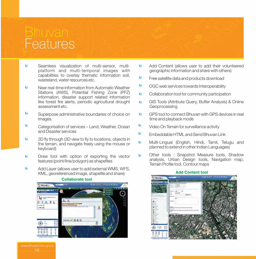
BhuvanFeatures
geographic information and share with others)
Free satellite data and products download
OGC web services towards Interoperability
Collaboration tool for community participation
GIS Tools (Attribute Query, Buffer Analysis) & Online Geoprocessing
GPS tool to connect Bhuvan with GPS devices in real time and playback mode
Video On Terrain for surveillance activity
Embeddable HTML and Send Bhuvan Link
Multi-Lingual (English, Hindi, Tamil, Telugu and planned to extend in other Indian Languages)
Other tools : Snapshot Measure tools, Shadow analysis, Urban Design tools, Navigation map, Terrain Profile tool, Contour maps
Add Content (allows user to add their volunteered
...............10...............
Seamless visualization of multi-sensor, mutli-platform and multi-temporal images with capabilities to overlay thematic information soil, wasteland, water resources etc.
Near real-time information from Automatic Weather Stations (AWS), Potential Fishing Zone (PFZ) information, disaster support related information like forest fire alerts, periodic agricultural drought assessment etc.
Superpose administrative boundaries of choice on images.
Categorisation of services – Land, Weather, Ocean and Disaster services
3D fly through (3D view to fly to locations, objects in the terrain, and navigate freely using the mouse or keyboard)
Draw tool with option of exporting the vector features (point/line/polygon) as shapefiles
Add Layer (allows user to add external WMS, WFS, KML, georeferenced image, shapefile and share) Add Content tool
Collaborate tool
www.bhuvan.nrsc.gov.in

About NRSC
...............11...............
National Remote Sensing Centre A key constituent of Indian Space Research Organisation (ISRO), Department of Space, Government of India, is at the heart of India's efforts to advance and benefit from the Indian Earth Observation Programme. NRSC strives to provide high quality, actionable data products and services in a timely, cost effective and efficient manner, facilitating enhanced utilization of remote sensing and geo-information in addressing societal needs and national imperatives. www.nrsc.gov.in
www.bhuvan.nrsc.gov.in

Bhuvan Cell
Indian Space Research OrganisationDept. of Space, Govt. of IndiaBalanagar, Hyderabad – 500 037www.bhuvan.nrsc.gov.inContact:
National Remote Sensing Centre
Stay ConnectedStay Connected
Follow us on Twitterwww.twitter.com/isrobhuvan
www.facebook.com/isrobhuvanBecome a Fan on Facebook
Get Our NewsletterWrite to [email protected]
Watch Bhuvan Videoswww.youtube.com/bhuvanisro
You Tube
![Lot N° 33 / 34816 piezas · 305 111043[1] thumbnail 20200 406 093916[1] thumbnail 20200 306 163106[1] thumbnail 20200 406 110021[1] thumbnail 20200 310 093707[1] thumbnail 20200](https://img.dokumen.tips/doc/110x75/60b49dcc34471c67ab0cc0ed/lot-n-33-34816-piezas-305-1110431-thumbnail-20200-406-0939161-thumbnail.jpg)