Embed Size (px)
Citation preview
U.S. Geological Survey and The National Academies; USGS OF-2007-1047, Extended Abstract 095
Beyond seafloor spreading: Neogene deformation and volcanism in the AdareBasinR. Granot,1 S. C. Cande,2 J. M. Stock,3 R. W. Clayton,4 and F. J. Davey5
1Scripps Institution of Oceanography, Mail Code 0220, La Jolla, CA 92093-0220, USA, <[email protected]>2Scripps Institution of Oceanography, Mail Code 0220, La Jolla, CA 92093-0220, USA, <[email protected]>3California Institute of Technology, Mail Stop 252-21, Pasadena, CA 91125, USA, <[email protected]>4California Institute of Technology, Mail Stop 252-21, Pasadena, CA 91125, USA, <[email protected] >5Institute of Geological and Nuclear Sciences, Lower Hutt, New Zealand, <[email protected]>
Summary Seafloor spreading at the Adare spreading axis, lasting from the Middle Eocene until the Late Oligocene(43 – 26 Ma), constrains the motion between East and West Antarctica throughout that period of time. Subsequentfaulting in the Adare and Northern Basins from Late Oligocene until present-day (26 - 0 Ma) is poorly resolved andmight provide a key constraint on the motion between the two plates. Here we present preliminary results of newseismic reflection and seafloor mapping data acquired on geophysical cruise 07-01 aboard the R/VIB Nathaniel Palmer.Our results suggest that the style of deformation has changed from spreading-related faulting into a diffuse normalfaulting (tilted blocks) that trend NE-SW with little resultant E-W extension. Recent volcanic activity is distributedthroughout but tends to align with the NE-SW trend. Formation of the Terror Rift within the same time frame suggeststhat the pole of rotation might have drifted northward.Citation: Granot, R., S. C. Cande, J. M. Stock, R. W. Clayton, and F. J. Davey (2007), Beyond seafloor spreading: Neogene Deformation andVolcanism in the Adare Basin, in Antarctica: A Keystone in a Changing World – Online Proceedings of the 10th ISAES X, edited by A. K. Cooperand C. R. Raymond et al, USGS Open-File Report 2007-1047, Extended Abstract 095, 4 p.
IntroductionLate Mesozoic extension between East and West Antarctica initiated the West Antarctic rifting (WAR) boundary
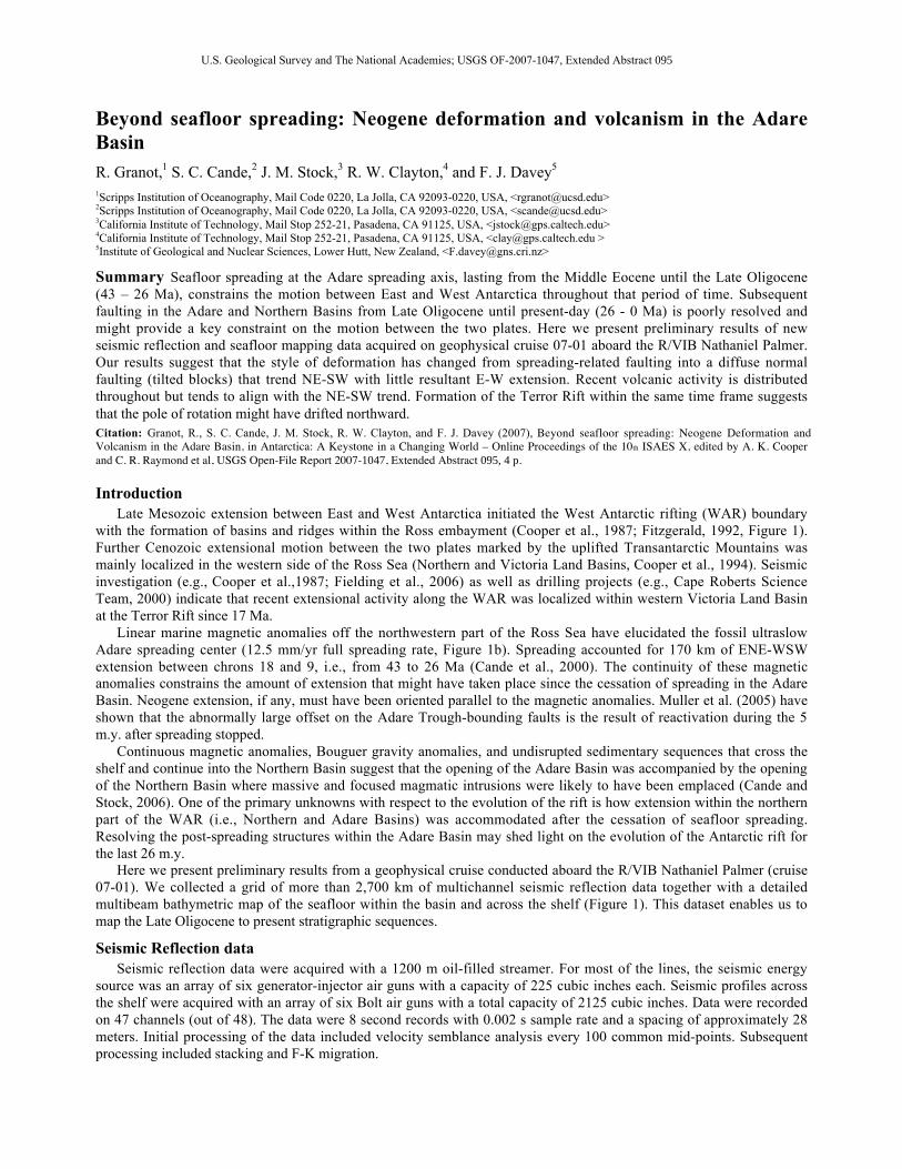
with the formation of basins and ridges within the Ross embayment (Cooper et al., 1987; Fitzgerald, 1992, Figure 1).Further Cenozoic extensional motion between the two plates marked by the uplifted Transantarctic Mountains wasmainly localized in the western side of the Ross Sea (Northern and Victoria Land Basins, Cooper et al., 1994). Seismicinvestigation (e.g., Cooper et al.,1987; Fielding et al., 2006) as well as drilling projects (e.g., Cape Roberts ScienceTeam, 2000) indicate that recent extensional activity along the WAR was localized within western Victoria Land Basinat the Terror Rift since 17 Ma.
Linear marine magnetic anomalies off the northwestern part of the Ross Sea have elucidated the fossil ultraslowAdare spreading center (12.5 mm/yr full spreading rate, Figure 1b). Spreading accounted for 170 km of ENE-WSWextension between chrons 18 and 9, i.e., from 43 to 26 Ma (Cande et al., 2000). The continuity of these magneticanomalies constrains the amount of extension that might have taken place since the cessation of spreading in the AdareBasin. Neogene extension, if any, must have been oriented parallel to the magnetic anomalies. Muller et al. (2005) haveshown that the abnormally large offset on the Adare Trough-bounding faults is the result of reactivation during the 5m.y. after spreading stopped.
Continuous magnetic anomalies, Bouguer gravity anomalies, and undisrupted sedimentary sequences that cross theshelf and continue into the Northern Basin suggest that the opening of the Adare Basin was accompanied by the openingof the Northern Basin where massive and focused magmatic intrusions were likely to have been emplaced (Cande andStock, 2006). One of the primary unknowns with respect to the evolution of the rift is how extension within the northernpart of the WAR (i.e., Northern and Adare Basins) was accommodated after the cessation of seafloor spreading.Resolving the post-spreading structures within the Adare Basin may shed light on the evolution of the Antarctic rift forthe last 26 m.y.
Here we present preliminary results from a geophysical cruise conducted aboard the R/VIB Nathaniel Palmer (cruise07-01). We collected a grid of more than 2,700 km of multichannel seismic reflection data together with a detailedmultibeam bathymetric map of the seafloor within the basin and across the shelf (Figure 1). This dataset enables us tomap the Late Oligocene to present stratigraphic sequences.
Seismic Reflection dataSeismic reflection data were acquired with a 1200 m oil-filled streamer. For most of the lines, the seismic energy
source was an array of six generator-injector air guns with a capacity of 225 cubic inches each. Seismic profiles acrossthe shelf were acquired with an array of six Bolt air guns with a total capacity of 2125 cubic inches. Data were recordedon 47 channels (out of 48). The data were 8 second records with 0.002 s sample rate and a spacing of approximately 28meters. Initial processing of the data included velocity semblance analysis every 100 common mid-points. Subsequentprocessing included stacking and F-K migration.

10th International Symposium on Antarctic Earth Sciences
2
Figure 1. Tectonic setting of the West Antarctic rift system. a. Main structural features of the Ross embayment. TR,VLB, and TAM stand for the Terror Rift, Victoria Land Basin, and the Transantarctic Mountains, respectively. Blackrectangle delineates the location of Figure 1b. b. Multi-beam bathymetry map of the Adare and Northern Basins. Reddashed-dotted lines delineate the magnetic anomalies formed at the Adare spreading center and Northern Basin. Blacklines show the recently acquired multichannel seismic reflection lines and white lines represent the profiles shown inFigure 2. Star shows the location of DSDP site 274. Note the NE-SW trend of the volcanic ridge and morphologyoriginating east of Cape Adare. These features are Neogene in age.
Preliminary resultsHigh quality seismic reflection data allow us to trace the oceanic basement and sediment contact throughout the
basin. In most lines in the Adare Basin, due to the relatively deep water, water bottom multiples were not a problem.Interpretation of the seismic stratigraphy was initially based on the published seismic stratigraphy (Muller et al., 2005)and was tied into the sedimentary sequences of DSDP site 274 (Figure 1b). The sedimentary sequences thickensouthward and westward toward the continental shelf and show large depositional variability between the different partsof the basin. Discrepancies between the correlation of the lowermost unit within and east of the Adare Trough have ledus to adjust the interpretation of the sequence inside the trough.
Brittle Deformation in the Adare BasinSeafloor spreading-related normal faulting show basement offsets of up to 500 meters (calculated with seismic
velocity of 1600 m/s, Hayes et al., 1975, Figure 2). These faults are predominantly dipping toward the spreading axisand trend perpendicular to the flow-line. The Adare Trough bounding faults are traced southward across the AdareBasin, buried under a thick sedimentary sequence, following the trend of the trough.
Intriguing block faulted structures are imaged south and southwest of the Adare Trough (for example see Figure 2).These features trend NNW-SSE but they are spatially located in an en-echelon pattern with an overall trend of NE-SWthat points toward the Cape Adare and Hallett volcanic provinces in the south. Individually, these faults are steepcausing little tilt on the strata indicating that there was vertical motion without much horizontal extension. Fault-tiltedblocks are the cause of the disappearance of the Adare Trough to the south and are probably responsible for the NE-SW

Granot et al.: Beyond seafloor spreading: Neogene Deformation and Volcanism in the Adare Basin
3
trend of the morphological trough originating at Cape Adare which merges into the Adare Trough at the north (Figure1b). The timing of activity on these blocks is constrained by the tilted sequence and the syn- and post-faultingsedimentary deposits suggesting activation during the early Late Oligocene - Early Miocene (?). Many of these faultsre-activate spreading related faults and hence are dominated by their NNW-SSE trends (Figure 2). Active faults arefrequently observed (presented by J.S. elsewhere). The total amount of extension on these post seafloor-spreading faultsis minimal based on the seismic profiles and on the continuity of the magnetic anomalies.
Volcanism in the Adare BasinTwo primary phases of volcanic activity were active in the entire time span recorded in the Adare Basin. Early
volcanic activity is characterized by an onlapped overlying sedimentary sequence suggesting seafloor spreading relatedvolcanism. Submarine lava flows are shown in places by a pseudo layering of structures imaged within the top 0.2seconds of the basement. The second phase of volcanism overlies the entire sediment sequence indicating very recent(Pliocene to present-day) volcanism. For the most part these features form individual volcanic knolls, although somehave coalesced to build a volcanic ridge oriented NE-SW. This ridge borders the tilted blocks and defines the westernedge of the overprinted rift. Volcanism seems to originate from the western side of the Northern Basin (Figures 1b and2). Commonly, young volcanism is associated with faulting, either recently active or fossil faults.
Figure 2. Representative seismic profiles. Profile A-A' crosses the southern end of the Adare Trough. Tilted LateOligocene (?) unit (top unit is defined by blue line) suggests reactivation of the faults that bound the trough. The Blueline traces the most pronounced unconformity in the center and west side of the basin. Profile B-B' shows tilted blockswith the recent to active volcanic ridge on its western side. Yellow and red lines trace the base of the Mid-Miocene andPliocene units, respectively. Top of oceanic basement is shown by the green line. Note vertical exaggeration of 1:7.5.
DiscussionThe evolution of rifting in the Adare and Northern Basin throughout the Neogene is poorly known. Our findings
reveal that shortly after spreading ceased along the Adare spreading center, an oblique, wide NE-SW rift connecting the

10th International Symposium on Antarctic Earth Sciences
4
Adare Trough to the western side of the Northern Basin became active. Reactivation of the Adare Trough-boundingfaults and the formation of the oblique rift might have coincided in time implying that this oblique rift was active mostlyduring the late Oligocene (within 5 m.y. after cessation of spreading). Throughout the Neogene deformation has beenconfined to vertical motions with minor horizontal extension.
The formation of the Terror Rift within the western side of the VLB indicates that the central part of the WAR wasactive during the Neogene (Cooper et al., 1987; Fitzgerald, 1992). Assuming that the locus of deformation of thenorthern part of the WAR is located within the Adare Basin, we suggest that the Neogene rotation pole for West andEast Antarctica was located somewhere north of the Adare Basin, implying that it migrated northward from a southerlyposition (Davey et al., 2006) during the Oligocene-Early Miocene. Geodetic (Donnellan and Luyendyk, 2004) andseismic measurements (Behrendt et al., 1991) show that there is currently no significant motion between the two plates,suggesting that the motion of the pole might have been the precursor to the unification of East and West Antarctica intoa coherent plate.Acknowledgments. This study could not have been done without the appreciable efforts of captain Mike Watson, the crew, and Raytheon staff of theR/VIB Nathaniel Palmer. We acknowledge the comments provided by the co-editor Phil Bart and Paul Henkart who greatly helped in the processingof the seismic data. Interpretation of the seismic profiles was done with Kingdom suite, a contribution of Seismic Micro-Technology. This study issupported by the National Science Foundation grant OPP0440959 (S.C.) and OPP-0440923 (J.S.).
ReferencesBehrendt, J.C., W.E. Lemasurier, A.K. Cooper, F. Tessensohn, A. Trehu, and D. Damaske, Geophysical studies of the West Antarctic Rift System,
Tectonics, 10 (6), 1257-1273, 1991.Cande, S.C., and J.M. Stock, Constraints on the timing of extension in the Northern Basin, Ross Sea, in Antarctica: Contributions to Global Earth
Science, edited by D.K. Futterer, D. Damaske, G. Kleinschmidt, H. Miller, and F. Tessensohn, pp. Chap. 6.5, 319-326, Springer, New York, 2006.Cande, S.C., J.M. Stock, R.D. Muller, and T. Ishihara, Cenozoic motion between East and West Antarctica, Nature, 404 (6774), 145-150, 2000.Cape Roberts Science Team, Studies from the Cape Roberts Projects, Ross Sea, Antarctica: Initial Report on CRP2/2A, Terra Antarctica, 7, 1-209,
2000.Cooper, A.K., G. Brancolini, J.C. Behrendt, F.J. Davey, P.J. Barrett, and ANTOSTRAT Ross Sea regional working group, A record of Cenozoic
tectonism throughout the Ross Sea and possible controls on the glacial record, Terra Antarctica, 2, 353-355, 1994.Cooper, A.K., F.J. Davey, and J.C. Behrendt, Seismic stratigraphy and structures in the Victoria Land Basin, estern Ross Sea, Antarctica., in The
Antarctic continental margin: geology and geophysics of the western Ross Sea, edited by A.K. Cooper, and F.J. Davey, pp. 27-76, Circum-PacificRes. Council, Houston, 1987.
Davey, F.J., S.C. Cande, and J.M. Stock, Extension in the western Ross Sea region-links between Adare Basin and Victoria Land Basin, GeophysicalResearch Letters, 33 (20), 2006.
Donnellan, A., and B.P. Luyendyk, GPS evidence for a coherent Antarctic plate and for postglacial rebound in Marie Byrd Land, Global andPlanetary Change, 42 (1-4), 305-311, 2004.
Fielding, R.C., S.A. Henrys, and T.J. Wilson, Rift history of the western Victoria Land Basin: A new perspective based on integration of cores withseismic reflection data, in Antarctica: Contributions to Global Earth Sciences, edited by D.K. Futterer, D. Damaske, G. Kleinschmidt, H. Miller, andF. Tessensohn, pp. Chap. 6.4, 309-318, Springer, New York, 2006.
Fitzgerald, P.G., The Transantarctic Mountains of Southern Victoria Land - the application of apatite fission-track analysis to a rift shoulder uplift,Tectonics, 11 (3), 634-662, 1992.
Hayes, D.E., L.A. Frakes, P.J. Barrett, D.A. Burns, P. Chen, A.B. Ford, A.G. Kaneps, E.M. Kemp, D.W. McCollum, D.J.W. Piper, R.E. Wall, andP.N. Webb, Site 274, in Initial Report Deep Sea Drilling Project, pp. 369-433, 1975.
Muller, R.D., S.C. Cande, J.M. Stock, and W.R. Keller, Crustal structure and rift flank uplift of the Adare Trough, Antarctica, GeochemistryGeophysics Geosystems, 6, 2005.