Embed Size (px)
Citation preview

BEFORE THE INDEPENDENT HEARINGS PANEL
PROPOSED WAIKATO DISTRICT PLAN (STAGE 1)
Under the Resource Management Act 1991 (RMA)
In the matter of hearing submissions and further submissions on the Proposed
Waikato District Plan (Stage 1) – Hearing 18 Rural Zone
By Hynds Pipe Systems Limited (Submitter, Further Submitter)
Hynds Foundation (Further Submitter)
Joint Statement of evidence by Chanel Hargrave and Dharmesh Chhima, TSC
(Planning)
Dated: September 2020

Page | 2
INTRODUCTION
1. This is a joint planning statement of evidence on behalf of Hynds Pipe Systems
Limited and Hynds Foundation in relation to the Proposed Waikato District Plan
Rural Zone provisions. Hynds Pipe Systems Limited are a submitter (S983) and
further submitter (FS1341). Hynds Foundation are a further submitter (FS1306).
Hynds Pipe Systems Limited and Hynds Foundation are referred to collectively as
Hynds in this evidence unless the distinction is made between the two
organisations. This statement has been prepared by Chanel Hargrave and
Dharmesh Chhima.
Experience and Qualifications
Chanel Hargrave
2. My full name is Chanel Yvonne Hargrave. I am a Senior Planner at TSC in Pukekohe.
I hold a Bachelor of Planning (Hons) and a Masters of Urban Design (Hons) from the
University of Auckland. I am an Intermediate Member of the NZPI.
3. My relevant professional experience spans eight years in a private sector role at
TSC. In this role I have prepared subdivision and land use (Regional and District)
Resource Consent applications for both urban and rural projects. I have been the
lead planner on projects from feasibility and design through to project completion.
I have prepared submissions on behalf of clients and provided planning evidence
for plan reviews and changes. For the last eight years I have worked extensively on
projects in the Waikato District and am familiar with the resource management
issues in this area.
Dharmesh Chhima
4. My full name is Dharmesh Chhima. I am a Senior Planner at TSC in Pukekohe. I hold
a Bachelor of Planning (Hons) and a Masters of Architectural Studies (Hons) from
the University of Auckland.
5. My relevant professional experience spans 12 years working for local authorities
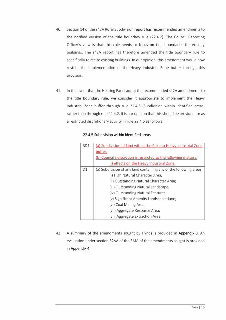
and 4 years in my current private sector role at TSC. In my 12 years with local

Page | 3
authorities (Auckland Council and former Franklin District Council) I was involved in
assessing a wide range of land use, subdivision, water take and discharge consent
applications. In my 4 years at TSC I have been the lead planner on resource
management projects from the feasibility and design stage through to project
completion. This has included the preparation and lodgement of rural and urban
land use and subdivision consent applications in the Waikato District.
Code of Conduct
6. We confirm that we have read the ‘Expert Witnesses Code of Conduct’ contained
in the Environment Court of New Zealand Practice Note 2014. This evidence has
been prepared in compliance with that Code in the same way as if giving evidence
in the Environment Court. In particular, unless we state otherwise, this evidence is
within our sphere of expertise and we have not omitted to consider material facts
known to us that might alter or detract from the opinions we express.
7. In preparing this statement of evidence we have read the s42A Rural Subdivision
report prepared by Katherine Overwater and the s42A Rural Zone Land Use report
prepared by Jonathan Clease, the Reporting Officers’ for Waikato District Council;
the summary of submissions and any relevant submissions lodged in respect of
Chapters 5 and 22; as well as any relevant information prepared for the District
Plan review.
THE SUBMITTERS
HYNDS PIPE SYSTEMS LIMITED
8. Hynds Pipes Systems Limited is owned by the Hynds Group and operates a concrete
manufacturing and distribution site at 9 McDonald Road, Pokeno (Hynds factory
site). Hynds Pipes System Limited is a significant heavy industry, utilising
approximately 22ha of land operating 24 hours a day, seven days a week. Hynds
Pipe Systems specialise in the manufacture and supply of construction materials
and water systems in New Zealand and Australia. The Hynds factory site at 9
McDonald Road is zoned Industrial 2 under the Operative Waikato District Plan:
Franklin Section (Operative Plan) and Heavy Industry under the Proposed Waikato
District Plan (Proposed Plan).

Page | 4
HYNDS FOUNDATION
9. The Hynds Foundation is the charitable foundation established by the Directors of
Hynds Holdings Limited. Hynds Foundation own land at 10 and 62 Bluff Road, south
of Hynds factory site. The land at 62 Bluff Road is within the operative Aggregate
Extraction and Processing (AEP) Zone and proposed Rural Zone. The land is
currently used for low intensity pastoral grazing. In 2017 a Resource Consent
(LUC0404/17) application was lodged to establish a cleanfill facility on this land.
This application is currently on hold under section 92 of the RMA. A submission on
the Proposed Plan lodged by Grander Investments (S548), former owners of 62
Bluff Road, seeks re-zoning of 62 Bluff Road from Rural (notified) to Heavy Industry.
The further submission of both Hynds Pipe Systems Limited and the Hynds
Foundation support Grander Investments’ submission to rezone this land. That
submission will be considered at Hearing 25 – Zone Extents.
10. The locations of the properties described above are shown in Appendix 1.
SCOPE OF EVIDENCE
11. This evidence is provided in support of Hynds’ submission and further submission.
The submission of Hynds Pipe Systems Limited has opposed the rezoning of the
Operative AEP Zone to Rural. Paragraph 8 of this submission seeks the following
decision from Council:
(a) Opposes the Rural zoning of the Adjacent Land, and proposes to apply
an appropriate or new zoning, which restricts residential activity.
(b) In the alternative;
(i) that the Rural zone provisions be amended to include
appropriate activity rules and land use rules for residential
development adjacent to land zoned Industrial Zone Heavy
(including the Hynds Site);
(ii) Residential development or subdivision on Rural zoned land
adjacent to the Industrial Zone Heavy land be prohibited or
restricted;

Page | 5
(c) Any additional relief considered necessary or desirable as a
consequence of the issues and concerns raised in this submission.
The Hynds Foundation support this submission. Hynds’ submission and further
submission seek to ensure that Hynds are protected from sensitive activities to
maintain the efficient operation of their business.
12. This evidence sets out how the rural rezoning and associated provisions will affect
the Heavy Industrial Zone and Hynds’ factory operation. Specifically, Hynds’
concerns relate to reverse sensitivity issues that are likely to result from the
proposed rural zoning. Hynds seeks that a heavy industrial buffer is added to the
Planning Maps with associated amendments to the building setback and
subdivision rules within Chapter 22. The extent of the proposed buffer is shown on
Appendix 2. This evidence will address:
(a) Operative Plan framework and establishment of the Industrial 2 Zone;
(b) Submitters’ concerns over the proposed Rural Zone;
(c) Proposed Plan policy framework and reverse sensitivity;
(d) Relief Sought: Proposed buffer and associated rule amendments; and
(e) Planning justification for proposed buffer and associated rule
amendments.
OPERATIVE PLAN FRAMEWORK AND ESTABLISHMENT OF THE INDUSTRIAL 2 ZONE
13. The majority of the existing urban area of Pokeno is a result of extensive rezoning
undertaken through the Pokeno Structure Plan, Plan Change 24 and Plan Change
21 processes. The vision for Pokeno, developed during the structure planning
process, was to maximise the town’s strategic location and establish a sustainable
town with a balance of opportunities for living, working and playing. Plan Change
24 was initiated as a Private Plan Change by Pokeno Landowners Consortium (PLC)
and adopted by the former Franklin District Council in December 2008. PLC
included significant land owners, business owners and developers who were ready
to invest in and develop the Pokeno area. John Hynds, director of Hynds Pipe
Systems Limited, was a member of PLC. Hynds Pipe Systems Limited saw an
opportunity to establish a new factory in Pokeno.

Page | 6
14. Pokeno was identified by Hynds as a suitable area to develop a purpose-built
factory. The strategic location of Pokeno at the junction of State Highway 1 and 2
provides excellent access to key transport links, customers and labour markets.
Through the Structure Planning and Plan Change processes appropriate zoning and
land use provisions were adopted enabling Hynds’ to establish on their current site
within the Industrial 2 Zone.
15. The Pokeno Structure Plan process identified the locational suitability of Pokeno
for industrial and business activities. Plan Change 24 resulted in two Industrial
Zones, the Light Industry and Industrial 2 Zone. The explanation provided in
19.6.1.4 of the Operative Plan states that the Industrial 2 Zone “provides for a
broad range of industrial uses including uses which may have air discharges.
Activities permitted in the zone are broadly defined as: manufacturing, processing,
assembly, storage, freighting of goods and the retailing of aggregates”. The
Operative Plan also recognises that industrial activities generate a range of effects
that are not compatible with residential and other sensitive activities. Land within
the Industrial 2 Zone has been developed with the construction of the Hynds and
Synlait factories. This land continues to be developed by these parties.
16. Significant consideration was given to the location of the Industrial 2 Zone and
adjacent zoning. The land within the Operative Industrial 2 Zone was considered
suitable for heavy industry due to the adjoining AEP Zone which provides for
aggregate quarrying and mineral extraction activities. The Structure Planning and
Plan Change process identified that anticipated effects generated by heavy industry
would be similar to those anticipated within the adjoining AEP Zone. The land
within the Industrial 2 Zone was identified as a low-lying flat basin against a steep
and much higher backdrop of ridges, generally separated from more sensitive
uses.1 The combination of adjoining zone and topographical location allowed for
relatively unconstrained provisions. The topographical nature of the land also
meant that industrial development would have limited visual impact on
surrounding residential and public land.
1 Proposed Plan Change 24: Statement of Evidence prepared by Ian Craig (Harrison Grierson Consultants) 24 August 2009, paragraph 3.11.

Page | 7
17. The design of the Hynds factory site responds to the surrounding zoning. The site
is designed with parking, offices and landscaping to the north where the site is
closest to the adjacent Residential 2 and Business Zone. Noisier, dustier and visually
intrusive activities are located towards the rear of the site adjoining the Industrial
2 Zone (Synlait’s factory) and AEP Zone. The layout of the site means that Hynds is
most likely to be impacted by sensitive activities that develop to the south and west
of the Heavy Industrial Zone.
18. Under the Operative Plan the southern and western extent of the Industrial 2 Zone
is buffered from the Rural Zone by the AEP Zone. There are no permitted dwelling
rights within the AEP Zone and any dwelling requires Resource Consent as a
Discretionary Activity (Rule 35.4). In the Rural Zone a Dwelling House, Sleepout,
Farmers' Market, or Equestrian Centre cannot locate within the 500m of the AEP
Zone without Resource Consent or the written approval of the Operator of the
extraction site (Rule 23A.2.1.10). This rule applies whether or not the land is being
utilised for an extraction activity. The AEP Zone and the associated provisions in the
Operative Plan provides a high level of assurance to Hynds that there will be limited
opportunity for sensitive activities to locate south and west of the Industrial 2 Zone.
This was a key reason the land was zoned Industrial 2 under Plan Change 24 and
why Hynds chose to develop the site at 9 McDonald Road.
SUBMITTERS’ CONCERNS OVER THE PROPOSED RURAL ZONE
19. The nature and scale of the Hynds operation means the activity generates high
levels of noise, dust, heavy traffic and lighting. Hynds is at high risk of being affected
by reverse sensitivity from sensitive activities locating in proximity to its site. Hynds
has serious concerns about the reverse sensitivity issues that would result from the
proposed Rural zoning.
20. The proposed zoning means that the Heavy Industrial Zone loses the compatible
AEP Zone buffer it currently has under the Operative Plan.
21. In our opinion Rural Zoning is not totally incompatible with the effects generated
by heavy industry. However, the proposed zoning and associated provisions
significantly change the planning framework allowing for additional sensitive land

Page | 8
uses to be established in proximity to existing heavy industrial sites. The planning
implications of the proposed changes on Hynds are summarised below:
a) The proposed Rural Zone provisions provide for dwellings and other
sensitive land uses, such as minor dwellings, to establish as permitted
activities. The proposed provisions enable sensitive land uses to establish
on land currently zoned AEP and within the 500m setback buffer from
this zone, where there are currently no permitted dwelling rights under
the Operative Plan. This increases the likelihood of reverse sensitivity as
additional sensitive land uses can establish in proximity to heavy
industrial activities. There are no setbacks within the Proposed Plan to
manage this potential reverse sensitivity issue.
b) The rezoning has the potential to affect Hynds’ existing operation as any
new permitted dwellings / sensitive land uses located within the
proposed Rural Zone could be closer than any existing dwelling. Hynds
would need to comply with the noise limits at the notional boundary of
any new dwelling or sensitive land uses. Hynds intends to extend its
existing operation and additional sensitive land uses could restrict and
curtail future expansion of its business.
c) The future use of the Hynds Foundation land at 62 Bluff Road for an
activity compatible with heavy industry is affected by the rural zoning and
associated provisions.
PROPOSED PLAN POLICY FRAMEWORK AND REVERSE SENSITIVITY
22. The Proposed Plan has a clear policy outcome that subdivision and development
should minimise potential for reverse sensitivity. It seeks to avoid locating sensitive
land uses in the vicinity of intensive farming, extractive industries or industrial
activities. The proposed Strategic Policy relevant to reverse sensitivity is set out in
4.7.11:
4.7.11 Policy – Reverse sensitivity
(a) Development and subdivision design (including use of
topographical and other methods) minimises the potential for
reverse sensitivity effects on adjacent sites, adjacent activities, or
the wider environment; and

Page | 9
(b) Avoid potential reverse sensitivity effects of locating new dwellings
sensitive land uses in the vicinity of an intensive farming, extraction
industry or industrial activity and strategic regionally significant
infrastructure. Minimise the potential for reverse sensitivity effects
where avoidance is not practicable.2
23. The Strategic Policy is relevant to all zones (including the Rural and Industrial Zones)
under the Proposed Plan. The Supreme Court, in the NZKS case, determined that
avoid means ‘do not allow’ or ‘prevent the occurrence of’3. The use of the word
‘avoid’ sends a clear signal that activities which result in the effects to be avoided
should not be allowed. In our opinion the intended policy outcome under the
Proposed Plan is, in the first instance, to not allow potential reverse sensitivity to
occur between sensitive land uses and industrial activity. In light of the strength of
this policy it is our opinion that the provisions of the Plan need to ensure that
sensitive activities are appropriately located in relation to industrial sites to ensure
reverse sensitivity can be avoided.
24. The Rural Zone objectives and policies in Chapter 5.3 of the Proposed Plan seek to
mitigate reverse sensitivity. Policy 5.3.7(c) of the Proposed Plan (notified version)
is to “mitigate the adverse effects of reverse sensitivity through the use of setbacks
and the design of subdivisions and development”.
25. Paragraph 291 of the s42A Rural Zone Land Use report has recommended
amendments to Policy 5.3.7 of the notified version. The Policy is recommended to
be retitled and rewritten as follows:
5.3.7 Policy – Separation of incompatible activities
(a) Contain adverse effects as far as practicable within the site where the
effect is generated, including through the provision of adequate
separation distances between the activity and site boundaries.
2 Section 42A Report: Rebuttal Evidence, Hearing H3 Strategic Directions, prepared by Alan Matheson (Consultant Planners) 30 October 2019, paragraph 87. Black text is the policy as notified. Blue text is the recommendation of the Reporting Officer on consideration of submissions and evidence. 3 Environmental Defence Society Inc v The New Zealand King Salmon Co Ltd [2014] NZSC 38 (the NZKS decision)

Page | 10
(b) Ensure that the design and location of new sensitive land uses
achieves adequate separation distances to mitigate potential reverse
sensitivity effects on lawfully established productive rural activities,
intensive farming, rural industry, strategic infrastructure, or
extractive activities.
26. In our opinion, the policy amendments presented by the Reporting Officer in the
s42A Report do not appropriately address the potential for reverse sensitivity
effects to occur between sensitive land uses and industrial activities. The
amendment in Policy 5.37(b) refers to reverse sensitivity effects on intensive
farming, extractive activities and strategic infrastructure (similar to Strategic Policy
4.7.11) but fails to recognise industrial activities. The wording of Strategic Policy
4.7.11(b) clearly identifies and recognises industrial activities as being potentially
affected by reverse sensitivity effects from new sensitive land uses.
27. Hynds seeks the inclusion of industrial activities in the wording of Policy 5.3.7(b).
This will ensure that the design and location of new sensitive land uses address the
potential for reverse sensitivity to occur on industrial activities, consistent with the
outcomes sought by Strategic Policy 4.7.11. The amendments Hynds seeks are
tracked in red and underlined as follows:
5.3.7 Policy – Separation of incompatible activities
(a) Contain adverse effects as far as practicable within the site where the
effect is generated, including through the provision of adequate
separation distances between the activity and site boundaries.
(b) Ensure that the design and location of new sensitive land uses
achieves adequate separation distances to mitigate potential reverse
sensitivity effects on lawfully established productive rural activities,
intensive farming, rural industry, strategic infrastructure, industrial
activities, or extractive activities.
28. The notified version of Policy 5.3.7 and the s42A amendments to this policy refer
to the use of setbacks or separation distances to mitigate reverse sensitivity effects.

Page | 11
This clearly signals that setbacks are an appropriate method to manage reverse
sensitivity issues.
29. The Proposed Plan includes setbacks for extractive industries and intensive
farming, however there are no setbacks for sensitive land uses from industrial
activities. Therefore, it is unclear how the Proposed Plan implements the policy
outcomes described above through the proposed Rural Zone provisions where
there is adjacent heavy industry. It is our opinion that reverse sensitivity issues,
which may occur between sensitive land uses in the proposed Rural Zone and
Heavy Industrial Zones in Pokeno, have not been managed appropriately.
30. Hynds has presented evidence at the Industrial / Heavy Industrial Zones and
Residential Zone hearings. Reverse sensitivity issues have been discussed at both
hearings.
31. As a result of the evidence presented by Hynds at the Residential Zone hearing, the
Reporting Officers’, Mr Alan Matheson and Ms Louise Allwood, have recommended
that reverse sensitivity be included as a separate matter of discretion in rule 16.4.1
(Subdivision – General)4.
32. At the Industrial Zone hearing Hynds requested that additional policy wording was
added to the Heavy Industrial Zone provisions to protect Heavy Industry from
sensitive activities. This was rejected by the Reporting Officer, Ms Macartney, for
the following reason:
any encroachment of a sensitive activity towards an industrial zone is best
dealt with by provisions for the adjoining zone, rather than the industrial
zones themselves5.
33. The opinion of the Reporting Officer, as reaffirmed in the Concluding Hearing
Report for that hearing, is that reverse sensitivity needs to be addressed in the rules
for adjacent sensitive zones that manage location of sensitive land uses.6
4 Section 42A Report Rebuttal Evidence. Hearing 10: Residential Zone, prepared by Alan Matheson and
Louise Allwood (Consultant Planners) 18 February 2020, paragraphs 44-47. 5 Section 42A Report Rebuttal Evidence. Hearing 7: Industrial Zone & Heavy Industrial Zone Report, prepared by: Jane Macartney, 13 January 2020, paragraph 308. 6 Concluding Hearing Report. Hearing 7: General Industrial Zone and Heavy Industrial Zone Report, prepared by: Jane Macartney, 8 May 2020, paragraph 2.

Page | 12
34. In regard to the Rural and Heavy Industrial Zone interface there are no rules that
seek to manage this issue despite the comments of the Reporting Officer (Ms
Macartney) and the Strategic Policy referred to above which sets a clear outcome
to avoid reverse sensitivity.
35. The Proposed Plan changes the anticipated planning outcomes for the land within
the Operative AEP Zone. This has implications on the adjacent Heavy Industrial
Zone. Most notably, the Proposed Plan allows for additional sensitive land uses to
locate within the vicinity of existing heavy industrial activities. Upon review of the
s32 analysis we have not been able to find any assessment that discusses the costs
and benefits of the removal of the AEP Zone or any assessment of the implication
the proposed change in zoning and associated provisions will have on the Heavy
Industrial Zone. Therefore, it appears little consideration has been given to this
issue. In our opinion the Rural Zone can be a compatible adjacent zone to the Heavy
Industrial Zone, provided that the provisions in the Rural Zone seek to avoid or
mitigate reverse sensitivity issues created by new sensitive land uses.
36. The Proposed Plan reduces the amount of available heavy industrial land within the
District from 292.6ha to 276.1ha7. Heavy industrial land supply is limited to existing
areas within the Horotiu Industrial Park, Huntly Power Station, the former
Meremere Power Station site and Pokeno. Given the limited amount of heavy
industrial zoned land supply available it is paramount that potential reverse
sensitivity issues are avoided. Plan Change 24 was successful in facilitating
industrial development within Pokeno. This has developed concurrently with
residential uses ensuring both economic, employment and housing growth within
the area. For these reasons it is important that the zoning and provisions applying
to adjacent sites do not undermine the integrity, purpose and usability of the
proposed heavy industrial land.
RELIEF SOUGHT: PROPOSED BUFFER AND ASSOCIATED RULE AMENDMENTS
37. Hynds seeks that the Heavy Industrial Buffer Line, shown on the plan in Appendix
2, is incorporated within the planning maps. We proposed that this buffer is then
7 Waikato District s32 Growth Areas Topic: Assessment Framework. Prepared by Market Economics Consulting, dated July 2018 – Final.

Page | 13
implemented through the land use setback rule (22.3.7.2) and subdivision rules.
This will protect the integrity of the Heavy Industrial Zone by avoiding reverse
sensitivity effects that may result from additional sensitive land uses within the
proposed Rural Zone. We consider that these amendments are the most
appropriate methods to manage reverse sensitivity and give effect to Strategic
Policy 4.7.11 of the Proposed Plan.
38. The amendments Hynds seeks to the land use setback rule (22.3.7.2) are tracked
in red and underlined as follows (Black text is the rule as notified. Blue text is the
s42A recommendation of the Council Reporting Officer):
22.3.7.2 (P1) – Building setback sensitive land uses
P1 (a) Any building for a sensitive land use must be set back a
minimum of:
(i) 5m from the designated boundary of the railway
corridor;
(ii) 15m from a national route or regional arterial road;
(iii) 35m from the designated boundary of the Waikato
Expressway;
(iv) 200m from an Aggregate Extraction Area, or Extractive
Resource Area containing a sand resource;
(v) 500m from an Aggregate Extraction Area or Extractive
Resource Area containing a rock resource, or a Coal
Mining Area;
(vi) 100m from a site in the Tamahere Commercial Areas A
and C;
(vii) 300m from the boundary of another site containing an
intensive farming activity;
(viii) 300m from oxidation ponds that are part of a municipal
wastewater treatment facility on another site;
(ix) 30m from a municipal wastewater treatment facility
where the treatment process is fully enclosed.
(b) Any building for a sensitive land use must be located outside
the Pokeno Heavy Industrial Zone buffer as shown on the
Planning Maps.
D1 Any building for a sensitive land use that does not comply with
Rule 22.3.7.2 P1.

Page | 14
39. The amendments Hynds seeks to the subdivision rules under the notified version
relate to the title boundary rule (22.4.2) and are tracked in red and underlined as
follows:
22.4.2 Title boundaries - natural hazard area, contaminated land,
Significant Amenity Landscape, notable trees, intensive farming activities,
aggregate extraction areas, Pokeno Heavy Industrial Zone buffer
RD1 (a) Subdivision of land containing any natural hazard area,
contaminated land, Significant Amenity Landscape, notable
trees, intensive farming activities, or Aggregate Extraction Areas
or land within the Pokeno Heavy Industrial Zone buffer must
comply with all of the following conditions:
(i) The boundaries of every proposed lot containing
existing buildings must demonstrate that existing
buildings comply with the Land Use-Building rules in
Rule 22.3 relating to:
A. Rule 22.3.1 (Number of Dwellings within a Record of
Title);
B. Rule 22.3.5 (Daylight admission);
C. Rule 22.3.6 (Building coverage);
D. Rule 22.3.7 (Building setbacks);
(ii) Rule 22.4.2 RD1 (a)(i) does not apply to any
noncompliance with the Land Use-Building rules in Rule
22.3 that existed lawfully prior to the subdivision.
(iii) The boundaries of every proposed lot must not divide
any of the following:
A. A natural hazard area;
B. Contaminated land;
C. Significant Amenity Landscape;
D. Notable trees.
(b) Council’s discretion is restricted to the following matters:
(i) landscape values;
(ii) amenity values and character;
(iii) reverse sensitivity effects;
(iv) effects on existing buildings;
(v) effects on natural hazard areas;
(vi) effects on contaminated land;
(vii) effects on any notable trees;
(viii)effects on an intensive farming activity;
(ix) effects on any Aggregate Extraction Area
(x) effects on the Heavy Industrial Zone.
D1 Subdivision that does not comply with Rule 22.4.2 RD1.
Page | 15
40. Section 14 of the s42A Rural Subdivision report has recommended amendments to
the notified version of the title boundary rule (22.4.2). The Council Reporting
Officer’s view is that this rule needs to focus on title boundaries for existing
buildings. The s42A report has therefore amended the title boundary rule to
specifically relate to existing buildings. In our opinion, this amendment would now
restrict the implementation of the Heavy Industrial Zone buffer through this
provision.
41. In the event that the Hearing Panel adopt the recommended s42A amendments to
the title boundary rule, we consider it appropriate to implement the Heavy
Industrial Zone buffer through rule 22.4.5 (Subdivision within identified areas)
rather than through rule 22.4.2. It is our opinion that this should be provided for as
a restricted discretionary activity in rule 22.4.5 as follows:
22.4.5 Subdivision within identified areas
RD1 (a) Subdivision of land within the Pokeno Heavy Industrial Zone
buffer.
(b) Council’s discretion is restricted to the following matters:
(i) effects on the Heavy Industrial Zone.
D1 (a) Subdivision of any land containing any of the following areas:
(i) High Natural Character Area;
(ii) Outstanding Natural Character Area;
(iii) Outstanding Natural Landscape;
(iv) Outstanding Natural Feature;
(v) Significant Amenity Landscape dune;
(vi) Coal Mining Area;
(vii) Aggregate Resource Area;
(viii)Aggregate Extraction Area.
42. A summary of the amendments sought by Hynds is provided in Appendix 3. An
evaluation under section 32AA of the RMA of the amendments sought is provided
in Appendix 4.
Page | 16
PLANNING JUSTIFICATION FOR PROPOSED BUFFER AND ASSOCIATED RULE AMENDMENTS
43. The purpose of the buffer and associated setback rules is to protect the integrity of
the Heavy Industrial Zone. The zone description adopted from the National
Planning Standards and proposed to be included in the Plan states:
The Heavy Industrial Zone contains areas used predominantly for
industrial activities that generate potentially significant adverse effects.
This zone may also be used for associated activities that are compatible
with the potentially significant adverse effects from industrial activities.
44. The associated objectives and policies for the Heavy Industrial Zone seek to enable
heavy industrial activity. Given the existing and anticipated scale and nature of
heavy industry it is our opinion that it is not appropriate to allow encroachment of
sensitive land uses within the vicinity of the Heavy Industrial Zone.
45. We acknowledge that industrial activities vary in operation, scale and nature
thereby generating different levels of adverse effects. For this reason a
standardised setback rule is unlikely to be the most appropriate method to manage
reverse sensitivity issues for all industrial activities. This is why a specific buffer has
been sought for the Pokeno Heavy Industrial Zone.
46. The proposed buffer is located just to the south of the ridgeline which is to the
south and west of the Pokeno Heavy Industrial Zone. This covers the elevated land
that has a direct line of sight towards the Heavy Industrial Zone and the operations
of both Hynds and Synlait.
47. The Pokeno Heavy Industrial Zone is located in a low-lying basin surrounded by
elevated slopes that face north and east resulting in an amphitheatre environment
around the zone. In addition, the Hynds factory site is located to the north / east of
this land and is likely to be viewed from the dominant outlook / orientation of any
land uses established on or below the ridgeline. The topographical nature of the
land means that activities undertaken with the Heavy Industrial Zone are visually
prominent from the surrounding land identified within the buffer. Given the
visibility of Hynds site from the identified land, dwellings established within the
buffer area would be able to see night lighting and dust emissions even where

Page | 17
these effects were lawful. The visibility of the site increases the likelihood that
neighbours will perceive adverse effects resulting in a high potential for reverse
sensitivity. Appendix 5 shows photos taken from viewpoints on Bluff Road looking
towards the Hynds factory, and from McDonald road looking towards the ridgeline.
48. Any measures taken by Hynds to screen the site from the elevated land within the
buffer would be futile because of the topography. Additionally, it is unlikely that
future dwellings would have any substantial screening that would significantly
reduce the visibility of the Heavy Industrial Zone. To have any benefit in this regard,
the screening would need to be to the north or east of a sensitive land use and
would potentially reduce sunlight access to the building. Additionally the
topography of the land would make it difficult to screen out any view of the Heavy
Industrial Zone below.
49. The proposed buffer area incorporates land within the Operative AEP Zone and a
small amount of land within the Operative Rural Zone. The land within the
proposed buffer has no permitted dwelling rights under the Operative Plan. In this
regard the proposed buffer and associated rule amendments will not place further
consenting obligations on this land. It is acknowledged that the key purpose of the
proposed Rural Zone is to provide for productive rural activities. This is generally
consistent with the National Planning Standards description of the ‘General Rural
Zone’ and the ‘Rural Production Zone’ as being areas used predominantly for
primary production activities.
50. Land within the proposed Heavy Industrial Zone buffer can continue to be used for
productive rural activities permitted under the Proposed Plan and therefore the
amendments Hynds seeks do not undermine the purpose or integrity of the Rural
Zone. With reference to the section 32AA evaluation provided in Appendix 4, it is
our opinion that the amendments sought by Hynds are the most appropriate way
to achieve the objectives of the Proposed Plan and address Hynds’ concerns
relating to reverse sensitivity issues.
51. The proposed Rural Zone adjoins the Heavy Industrial Zone. The proposed Rural
Zone provisions allow sensitive land uses to establish within the vicinity of existing
heavy industrial activities. Given the strength of the wording in Strategic Policy

Page | 18
4.7.11(b) and the reasons identified above, the proposed buffer and associated
amendments are considered an appropriate method to manage reverse sensitivity
issues.
CONCLUSION
52. Hynds are at high risk of being affected by reverse sensitivity from sensitive land
uses locating within proximity to its site. Hynds has serious concerns about the
reverse sensitivity effects that would result from the proposed Rural Zoning and
associated provisions. In our opinion the proposed buffer and associated
amendments to the building setback and subdivision rules will avoid and manage
reverse sensitivity appropriately. This will help to protect the integrity of the Heavy
Industrial Zone and give effect to Strategic Policy 4.7.11.
______________________________
Chanel Hargrave and Dharmesh Chhima
September 2020

Lot 1
DP 385944
22.6125ha
Lot 2
DP 463893
27.4090ha
RT 614850
RT 344135
M
c
D
o
n
a
l
d
R
o
a
d
N
I
M
T
R
a
i
l
w
a
y
S
t
a
t
e
H
i
g
h
w
a
y
1
Bluff Road
Lot 1
DP 463893
Lot 2
DP 385944
4
2
.
8
7
7
0
.
7
9
8
7
.
1
2
8
2
.
3
8
184.69
2
0
2
.
1
3
224.0
0
2
6
0
.
0
0
67.24
8
1
.
3
3
3
6
.
2
2
1
7
.
8
0
2
.
7
2
2
1
.
0
0
3
9
.
5
1
4
5
.
6
3
1
2
8
.
9
2
8
2
.
4
8
4
.
2
86
.
8
0
3
1
.
4
2
1
3
.
9
6
3
1
.
3
5
1
2
6
.
5
3
468.30
43.8
5
5
1
.5
0
3
8
.6
2
1
5
8
.
5
2
150.41
2
3
.
7
4
1
1
4
.5
9
9
9
.
1
8
8
4
.
7
5
1
0
.5
2
226.80
222.60
78.89
2
4
9
.
7
2
1
0
9
.
3
4
26.0
8
4
2
0
.
6
6
5
6
.
6
0
Lot 3
DP 463893
Lot 2
DP 23610
Pt Allotment 216
Parish of Mangatawhiri
1000 50 150 20010
HYNDS Pokeno
McDonald Road Site Plan
August 2019
12 August 2019
Scale 1 : 2000 (A1)
Contour Interval = 1.0m
Coordinates are in terms of Mt Eden Circuit NZGD 2000
Levels are in terms of Auckland Vertical Datum 1946
NOTE
Base of ponds not surveyed
Boundaries of Hynds Property have been
produced from Survey Data
All other bounaries are sourced from
quickmap and are not survey accurate.
Aerial Imagery Flown by The Surveying
Company Limited on 9 & 10 July 2019
The Surveying Company Limited
Drawing Number J549 - Site Plan
Address 17 HALL STREET, PO Box 466 PUKEKOHE
Phone 0800 TO SURVEY (0800 86 78 78)
E-mail [email protected]
Web www.thesurveyingcompany.nz

B
u
f
f
e
r
ju
s
t
t
o
S
o
u
t
h
o
f
R
id
g
e
N
HYNDS PIPE SYSTEMS LIMITED
AUG 2020 J5491 : 7500
HEAVY INDUSTRY BUFFER PLAN
APPENDIX 2
HEAVY INDUSTRY BUFFER PLAN - # 9 McDONALD ROAD, POKENO.

1
Appendix 3: Summary of Amendments Sought by Hynds
Planning Maps
Inclusion of the Heavy Industrial Zone Buffer on the Planning Maps
Chapter 5 Rural Environment
5.3.7 Policy – Separation of incompatible activities
(a) Contain adverse effects as far as practicable within the site where the effect is generated,
including through the provision of adequate separation distances between the activity and site
boundaries.
(b) Ensure that the design and location of new sensitive land uses achieves adequate separation
distances to mitigate potential reverse sensitivity effects on lawfully established productive rural
activities, intensive farming, rural industry, strategic infrastructure, industrial activities, or
extractive activities.
Chapter 22 – Rural Zone
Land Use – Building
22.3.7.2 (P1) – Building setback sensitive land uses
P1 (a) Any building for a sensitive land use must be set back a
minimum of:
(i) 5m from the designated boundary of the railway
corridor;
(ii) 15m from a national route or regional arterial road;
(iii) 35m from the designated boundary of the Waikato
Expressway;
(iv) 200m from an Aggregate Extraction Area, or Extractive
Resource Area containing a sand resource;
(v) 500m from an Aggregate Extraction Area or Extractive
Resource Area containing a rock resource, or a Coal
Mining Area;
(vi) 100m from a site in the Tamahere Commercial Areas A
and C;
(vii) 300m from the boundary of another site containing an
intensive farming activity;
(viii) 300m from oxidation ponds that are part of a municipal
wastewater treatment facility on another site;

2
(ix) 30m from a municipal wastewater treatment facility
where the treatment process is fully enclosed.
(b) Any building for a sensitive land use must be located outside
the Pokeno Heavy Industrial Zone buffer as shown on the
Planning Maps.
D1 Any building for a sensitive land use that does not comply with
Rule 22.3.7.2 P1.
22.4 Subdivision (amendment sought for the notified version of the Proposed Plan):
22.4.2 Title boundaries - natural hazard area, contaminated land,
Significant Amenity Landscape, notable trees, intensive farming activities,
aggregate extraction areas, Pokeno Heavy Industrial Zone buffer
RD1 (a) Subdivision of land containing any natural hazard area,
contaminated land, Significant Amenity Landscape, notable
trees, intensive farming activities, or Aggregate Extraction Areas
or land within the Pokeno Heavy Industrial Zone buffer must
comply with all of the following conditions:
(i) The boundaries of every proposed lot containing
existing buildings must demonstrate that existing
buildings comply with the Land Use-Building rules in
Rule 22.3 relating to:
A. Rule 22.3.1 (Number of Dwellings within a Record of
Title);
B. Rule 22.3.5 (Daylight admission);
C. Rule 22.3.6 (Building coverage);
D. Rule 22.3.7 (Building setbacks);
(ii) Rule 22.4.2 RD1 (a)(i) does not apply to any
noncompliance with the Land Use-Building rules in Rule
22.3 that existed lawfully prior to the subdivision.
(iii) The boundaries of every proposed lot must not divide
any of the following:
A. A natural hazard area;
B. Contaminated land;
C. Significant Amenity Landscape;
D. Notable trees.
(b) Council’s discretion is restricted to the following matters:
(i) landscape values;
(ii) amenity values and character;
(iii) reverse sensitivity effects;
(iv) effects on existing buildings;
(v) effects on natural hazard areas;

3
(vi) effects on contaminated land;
(vii) effects on any notable trees;
(viii)effects on an intensive farming activity;
(ix) effects on any Aggregate Extraction Area
(x) effects on the Heavy Industrial Zone.
D1 Subdivision that does not comply with Rule 22.4.2 RD1.
22.4 Subdivision (amendment sought based on the s42A recommendations):
22.4.5 Subdivision within identified areas
RD1 (a) Subdivision of land within the Pokeno Heavy Industrial Zone
buffer.
(b) Council’s discretion is restricted to the following matters:
(i) effects on the Heavy Industrial Zone.
D1 (a) Subdivision of any land containing any of the following areas:
(i) High Natural Character Area;
(ii) Outstanding Natural Character Area;
(iii) Outstanding Natural Landscape;
(iv) Outstanding Natural Feature;
(v) Significant Amenity Landscape dune;
(vi) Coal Mining Area;
(vii) Aggregate Resource Area;
(viii)Aggregate Extraction Area.

1
Appendix 4: Section 32AA Evaluation under the RMA
1. Scope of this Section 32AA Analysis
This evaluation examines whether the proposed changes to the provisions (including the provision of a
Pokeno Heavy Industrial Zone Buffer and associated rule amendments) are the most appropriate way
of achieving the objectives of the proposal. The changes do not propose to amend any Proposed Plan
objectives, and therefore the objectives will still remain if the amended proposal were to take effect.
For the proposed changes, the evaluation under section 32(1)(b) of the RMA relates to the relevant
objectives of the Proposed Plan and the purpose of the proposal.
The purpose of the proposed buffer and associated amendments to the provisions is to achieve the
objectives of the Proposed Plan and address Hynds’ concerns relating to reverse sensitivity issues. The
most relevant Proposed Plan objectives to this are:
4.1.1 Objective – Strategic
Liveable, thriving and connected communities that are sustainable, efficient and co-ordinated.
4.1.2 Objective – Urban growth and
development
Future settlement pattern is consolidated in and around existing towns and villages in the district.
4.6.1 Objective – Economic growth of industry
The economic growth of the district’s industry is supported and strengthened in industrial zones.
4.6.6 Objective – Manage adverse effects
1. The amenity values of sensitive activities and ecosystem values outside of industrial zones are protected from the significant adverse effects of industrial activities.
5.1.1 Objective – Strategic – The rural
environment
Subdivision, use and development within the rural environment where: (i) high class soils are protected for productive
rural activities; (ii) productive rural activities are supported,
while maintaining or enhancing the rural environment;
(iii) urban subdivision, use and development in the rural environment is avoided.
5.3.1 Objective - Rural character and amenity
Rural character and amenity are maintained.
The proposed objectives recognise the importance of creating liveable, thriving communities which are
sustainable, efficient and co-ordinated. They also seek to ensure the continued well-being of people
and communities, and provide for sustainable growth within the district. A key element to achieving
this is through strengthening the local economy, providing for employment opportunities, ensuring
appropriate subdivision and development, and maintaining rural production and amenity. These
objectives are delivered through a number of policies. The policies reinforce the importance of
sustainable growth within the district and recognise the need to ensure that the location of
incompatible activities is carefully managed to avoid reverse sensitivity effects and complaints.

2
2. Reasonably Practicable Options
The following options were identified for achieving the objectives:
Options Description and appropriateness
Option 1: Status quo – Proposed Plan provisions
Under this option the Proposed Plan rules would apply. The rules do not address the issue of reverse sensitivity effects on industrial activities from sensitive land uses in the Rural Zone. This would allow sensitive land uses to locate within proximity of the Hynds factory. This option would not achieve the economic growth objectives of the Proposed Plan relating to the district’s industry or protect the amenity values of sensitive land uses from the adverse effects of industrial activities such as adverse visual, noise, dust, traffic and lighting effects. The rules fail to implement Strategic Policy 4.7.11(b) (Reverse sensitivity) which gives effect to the objectives of the Proposed Plan. This option is not considered to be appropriate.
Option 2: Proposed changes - Proposed Pokeno Heavy Industrial Zone Buffer and associated amendments to provisions as sought by Hynds.
Under this option the proposed changes sought by Hynds to the provisions of the Proposed Plan would apply. This would include a resource consent requirement for the subdivision of land, or location of a sensitive land use, inside the Pokeno Heavy Industrial Zone Buffer. The Proposed Plan defines a sensitive land use as:
“Means an education facility including a childcare facility, waananga and koohanga reo, a residential activity, papakaainga building, rest home, retirement village, travellers’ accommodation, home stay, health facility or hospital.”
The extent of the proposed buffer is shown on Appendix 2. The proposed buffer setback is located just south of the ridgeline which is to the south and west of the Pokeno Heavy Industrial Zone. This covers the elevated land that has a direct line of sight towards the Heavy Industrial Zone and the operation of both Hynds and Synlait.
The proposed changes would give effect to the objectives in respect to reverse sensitivity issues, economic growth and protecting the amenity values of sensitive land uses. The use of setbacks is also recognised as an appropriate method to manage reverse sensitivity issues. In this respect, Strategic Policy 4.7.11 specifically refers to avoiding potential reverse sensitivity effects of locating new sensitive land uses in the vicinity of industrial activity1. This option is considered to be appropriate.
Option 3: Use of other controls – Visual screening, building height limit, acoustic insulation and no complaint rules.
This option involves using other controls to address the reverse sensitivity issue and achieve the relevant objectives of the Proposed Plan. These controls would apply to sensitive land uses permitted under the Proposed Plan and established within the Pokeno Heavy Industrial Zone Buffer described in Option 2. The controls would be rules (permitted activity standards) to be met by sensitive land uses within the buffer. If the rule(s) are not met, then resource consent would be required for the rule infringement.
1 Section 42A Report: Rebuttal Evidence, Hearing H3 Strategic Directions, prepared by Alan Matheson (Consultant Planners) 30 October 2019, paragraph 87.

3
The following controls were considered: Visual screening This rule would require the landowner to ensure that their sensitive land use is visually screened from the Hynds factory. In this respect, the topography of the land would make it difficult to completely screen out views of the Heavy Industrial Zone. Screening would be achievable in some situations through natural features (such as mature planting) or built forms and development (such as fences/walls). The rule is unlikely to be practical for sensitive land uses that are two storey in height. Furthermore, visual screening through planting can take time to establish and be effective. Single storey building height limit This rule would apply a single storey building height limit to sensitive land uses located within the buffer. In order to restrict visibility of the Hynds factory, this rule would need to be applied in combination with the visual screening rule referred to above. Consideration may still need to be given to building orientation to avoid exposure to the Heavy Industrial Zone. Acoustic insulation This rule would require any building for a sensitive land use to be acoustically insulated (at the expense of the landowner) to address potential reverse sensitivity noise effects. This would be an appropriate control to provide an internal environment where people have reasonable amenity and protection from sleep disturbance. This would be determined through acoustic experts and modelling. The control would not address the external environment (e.g outdoor living and other areas of curtilage) of sensitive land uses or the subjectivity of noise complaints. In some instances it may not avoid reverse sensitivity noise effects and complaints. There are also other reverse sensitivity effects (wider than just noise) to be considered in achieving the objectives. No complaint rules This rule would restrict landowners from complaining about the lawful effects generated from the Hynds factory (‘no complaint’ rule). The use of a ‘no complaint’ rule in the Plan to say that neighbours cannot complain was not considered an appropriate control as this approach does not avoid or mitigate reverse sensitivity effects, and would not achieve the objectives of the Proposed Plan. Summary Overall, this option relies on a multitude of controls with varying degrees of complexity, some of which may or may not be suitable in certain situations. The rules associated with these controls may not provide an appropriate planning framework to achieve the objectives of the proposal.

4
3. Discounted Options
Two further options were consider but not considered reasonably practicable. These are summarised
as follows:
An option of applying the 500m buffer setback under Rule 23A.2.1.10 of the Operative Plan was
considered. However, this setback is relevant to the operative AEP Zone adjacent to the Hynds
factory site. The rule as written would not be able to be implemented without the AEP zoning. This
option was therefore discounted and not evaluated further.
A further option to use a standardised setback distance from the Pokeno Heavy Industrial Zone
was considered. However, given the topographical nature of the land and visibility of the Hynds
factory from varying distances from the ridgeline, this option had a high potential to result in an
inadequate separation distance and was difficult to justify. In some instances, a standardised
setback could result in sensitive land uses being located to the north of the ridgeline with views to
the Hynds factory, resulting in a high potential for reverse sensitivity effects. In other instances,
the same setback could potentially create an inequitable situation by forcing sensitive land uses to
be setback further than would be necessary to achieve the objectives of the proposal, or require
resource consent with associated costs to the applicant. This option was therefore discounted and
not evaluated further.
4. Assessment of Options
The following section identifies the costs-benefit and efficiency and effectiveness of each option.
Option 1: Status quo – Proposed Plan provisions
Costs Benefits
Environmental This option is highly likely to increase the potential for reverse sensitivity effects to occur within the environment. Such effects would reduce the amenity of neighbouring landowners who subdivide or establish sensitive land uses in close proximity to the Heavy Industrial Zone. At the same time, it may result in operational constraints for the Hynds factory and undermine the sustainable use of the district’s industrial zoned land. The Hynds factory is on an industrial site that Hynds have invested in on the understanding that industrial land use would be protected from sensitive land uses. There would be ongoing uncertainty to Plan users as to the direction sought by Strategic Policy 4.7.11 which gives effect to the objectives of the Plan.
Environmental No environment benefits are evident. Economic Landowners are able to use their land unfettered by specific planning controls. There would be no uncertainty from the resource consent process and no resource consenting costs to landowners to establish sensitive land uses inside the buffer (provided all other Plan rules are met). Social The social benefits are tied into the economic benefits for neighbouring landowners. Cultural None identified

5
Social and Economic There are potential social and economic costs if reverse sensitivity effects on the Pokeno Heavy Industrial Zone are not managed appropriately. This cost can be on those who establish a sensitive land use within proximity of the Heavy Industrial Zone and perceive adverse effects from the Hynds site (even where these effects are lawful). More importantly, reactions to these effects or perceived effects, by way of complaints can lead to restrictions on Hynds’ existing operation and could curtail future expansion of their business. These are costs to Hynds who rely on the lawful use of its industrial zoned land. There are costs associated with loss of employment opportunities and economic growth should Hynds be restricted or impacted on by new sensitive land uses that may establish in close proximity of the Heavy Industrial Zone. There would be ongoing uncertainly for Hynds as to the appropriate management of reverse sensitivity issues. Cultural None identified
Efficiency and Effectiveness
This option is not efficient or effective at achieving the objectives of the proposal. Reverse sensitivity must be appropriately managed to avoid or mitigate effects on the Heavy Industrial zoned land resource and the established activities within it. Without any changes to the Proposed Plan, the objectives of the proposal would not be achieved.
Option 2: Proposed changes - Proposed Heavy Industrial Zone Buffer and associated amendments to provisions as sought by Hynds.
Costs Benefits
Environmental When compared to the status quo (Option 1), the proposed changes provide less certainty for landowners seeking to use or development land within the buffer. When compared to the operative District Plan provisions, the proposed changes would not result in the loss of any permitted dwelling rights given the operative AEP zone and 500m setback
Environmental The amendment to Policy 5.3.7 provides a clear link for Plan users to the direction sought by Strategic Policy 4.7.11 which gives effect to the objectives of the Proposed Plan. The rule amendments allow reverse sensitivity effects associated with a subdivision or new sensitive land use within the buffer to be

6
from this zone. In this regard, the proposed buffer and rule amendments would not place any further consenting requirements on the landowner. For other sensitive land uses such as education facilities and travellers accommodation that are not provided for as permitted activities, or for subdivisions, the amendments would result in an additional rule infringement needing to be assessed as part of that resource consent process. Economic A resource consent will be required with associated costs to the applicant and no certainty of a decision in the applicant’s favour. There would also be costs associated with the monitoring and compliance of consent conditions should consent be granted. This cost would be similar under the current operative District Plan provisions. Social Landowners may be prevented from establishing sensitive land uses or subdividing their land through the resource consent process if potential reverse sensitivity effects are not adequately avoided or mitigated. This would be similar under the current operative District Plan provisions. Cultural None identified
appropriately assessed through the resource consent process. It is more likely than not, that this option would avoid the risk of reverse sensitivity effects occurring in the first instance. This will assist Hynds in the continued operation of its factory and ensure the sustainable use of industrial zoned land. It will also maintain the amenity of neighbouring landowners who wish to subdivide or establish sensitive land uses. Economic The amendments will assist in maintaining Hynds’ existing operation which provides employment opportunities and contributes to the vitality of the district’s economy. The amendments will also assist in the expansion of Hynds’ existing operation within the Heavy Industrial Zone, which will provide further economic growth and employment opportunities. Hynds have invested into this environment based on due diligence assessments under the operative planning framework. This framework provides a mechanism (AEP Zone) to separate the activities on Hynds’ factory site from sensitive land uses that might be affected by and constrain the existing and future industrial activity on this site. This option is highly likely to reduce monitoring and compliance costs associated with complaints. There is also a low cost associated with including the amendments in the Proposed Plan. Social The amendments will assist in maintaining the health and well-being of neighbouring landowners by reducing the risk of exposure to adverse effects from the Hynds factory. At the same time, they provide a level of assurance to Hynds that the operation of its business (both now and in the future) is protected from new sensitive land uses, similar to the operative provisions.

7
These benefits contribute to the social and economic well-being of individuals, Hynds (including employees), and the community as a whole. Cultural None identified
Efficiency and Effectiveness
The proposed changes efficiently manage potential reverse sensitivity issues without being overly prescriptive. They will provide a clear and effective planning framework to achieve the objectives and appropriately align with the direction provided at the Strategic Policy level as to the management of reverse sensitivity effects. This includes avoiding, in the first instance, potential reverse sensitivity effects of locating sensitive land uses in the vicinity of an industrial activity.
Option 3: Use of other controls – Visual screening, building height limit, acoustic insulation and no complaint rules.
Costs Benefits
Environmental This option increases the risk that reverse sensitivity effects are not avoided in the first instance. Visual screening is likely to be difficult given the topography of the land and therefore the rule may not be suitable or practicable. Furthermore, visual screening through planting can take some time to establish and be effective. Where visual screening is achievable, this would need to be to the north or east of the sensitive landuse. This could reduce the amenity of the occupier of the building by reducing sunlight access to the building. Visual screening through built forms (such as closed boarded fences or walls) could also affect the amenity and character of the rural area or adjacent sites. That is, effectively introduce urban type forms into a rural environment that would further erode the distinction between the rural and urban environments. Social and Economic This option introduces a multitude of new controls to the Plan provisions which could be difficult to implement or achieve. There are
Environmental This option would allow neighbouring landowners to establish sensitive land uses inside the Pokeno Heavy Industrial Zone Buffer without resource consent but subject to meeting a number of specific controls. Economic There would be no resource consenting costs to landowners to establish sensitive land uses inside the buffer provided all controls and other Plan rules are met. Social The social benefits are tied into the environmental and economic benefits for neighbouring landowners. Cultural None identified

8
similar social and economic costs as assessed in Option 1 should the rules not achieve the desired effect. For example, if planting was to be used for visual screening it may take time to mature and achieve the desired effect, and it may not be clear when or at what point the rule is achieved. The rules relating to the use of planting for visual screening would also need to ensure that the planting is appropriate, maintained (replaced if necessary) and protected. This may involve the rule requiring a planting and maintenance plan. There would be costs to the landowner to meet a range of standardised controls, and costs to Council to ensure the compliance. The use of a ‘no complaint’ covenant rule would also result in a cost to the landowner and Hynds or the Council through the registration and potential enforcement of the covenant. Furthermore, there is uncertainty over the use and enforceability of no complaint rules. The administration resourcing and cost would fall on the Council and ratepayers. There would remain uncertainty that reverse sensitivity effects will not be avoided in the first instance or appropriately managed through the Plan rules. Cultural None identified
Efficiency and Effectiveness
This option requires the use of a multitude of controls and is not considered an efficient way to manage potential reverse sensitivity effects inside the Pokeno Heavy Industrial Zone Buffer. Rules relating to development controls for permitted activities must provide certainty to enable compliance to be objectively assessed. The rules have a high potential to be overly prescriptive and not achieve the objectives. The rules would not address the direction provided at the Strategic Policy level as to the management of reverse sensitivity effects through avoidance in the first instance. The rules would not provide a clear planning framework to align with this direction.
9
5. Risk of acting or not acting
There are significant risks in not acting (maintaining Option 1) or having uncertainty in the controls
(Option 3) to avoid reverse sensitivity effects. If the provisions are not amended to appropriately
manage reverse sensitivity issues, then sensitive land uses may establish in a manner that could restrict
or curtail Hynds’ operation. It may also reduce the amenity of neighbouring landowners who subdivide
or establish sensitive land uses inside the Heavy Industrial Zone Buffer.
The proposed changes (proposed buffer and rule amendments in Option 2) would not place any further
consenting requirements on the neighbouring landowners than those that are currently in place under
the Operative Plan. The amendments align with the direction provided at the Strategic Policy level as
to the management of reverse sensitivity effects on industrial activities. The amendments would more
likely avoid the risk of reverse sensitivity effects occurring in the first instance and would allow the
assessment of these effects within the buffer to be addressed through the resource consent process.
6. Summary for deciding on the most appropriate option (Option 2)
The evaluation provided above, including the costs-benefit, and efficiency and effectiveness
assessments have shown that overall, the proposed changes (Option 2) is the best practicable option
and most appropriate way to achieve the objectives. The proposed changes would more likely avoid
the risk of reverse sensitivity effects occurring in the first instance and would allow the assessment of
these effects within the buffer to be addressed through the resource consent process. The proposed
changes align with the direction provided at the Strategic Policy level as to the management of reverse
sensitivity effects on industrial activity. The proposed changes would give effect to the objectives in
respect to reverse sensitivity issues, economic growth and protecting the amenity values of sensitive
land uses.

1
Appendix 5: Photos
Viewpoint (VP) Map - Location of photos taken 31 August 2020
VP 3
VP 1
VP 2
Hynds Factory Site
Synlait

2
Viewpoint 1: From Bluff Road looking down to the Hynds factory site.
Viewpoint 2: From Bluff Road looking down to the Hynds factory site.
Viewpoint 3: From McDonald Road looking towards the ridgeline.