Embed Size (px)
Citation preview

BEFORE THE BOARD OF OIL, GAS AND MINING DEPARTMENT OF NATURAL RESOURCES
STATE OF UTAH
IN THE MATTER OF THE REQUEST FOR
AGENCY ACTION OF CRESCENT POINT
ENERGY U.S. CORP. FOR AN ORDER
ESTABLISHING TWO (2) SECTIONAL
(640 ACRE, OR SUBSTANTIAL EQUIVALENT)
DRILLING UNITS IN SECTION 18, T3S, RlE,
USM, AND SECTION 10, T4S, R2E, USM, AND TWO (2) 1280 ACRE (OR SUBSTANTIAL
EQUIVALENT) DRILLING UNITS
COMPRISED OF SECTIONS 20 AND 29, T3S,
RIE, USM, AND SECTIONS 22 AND 27, T3S,
R2E, USM, UINTAH COUNTY, UTAH, FOR
THE PRODUCTION OF OIL, GAS AND
ASSOCIATED HYDROCARBONS FROM THE
LOWER GREEN RIVER AND WASATCH
FORMATIONS, AND TO ALLOW, ON A PILOT
BASIS, THE DRILLING AND PRODUCTION
OF UP TO SIX (6) HORIZONTAL WELLS ON
EACH DRILLING UNIT SO ESTABLISHED
PETITIONER'S EXHIBITS
Docket No. 2014-023
Cause No. 131-138
Pursuant to Utah Admin. Code Rule R641-105-500, Petitioner Crescent Point
Energy U.S. Corp. ("CPE"), by and through its counsel of record, MacDonald & Miller
Mineral Legal Services, PLLC, hereby respectfully submits the following exhibits
intended to be offered into evidence in support of its Request for Agency Action
("RAA") at the June 25,2014 hearing on this cause:

EXHIBIT "A" - CPE's witnesses' resumes (collectively 6 pages).
• Ryan W. Waller - Negotiating Landman • Chris Sutton - Exploration Manager • Pam Bunz - Development Engineer
EXHIBIT "B" - Regional locator plat, reflecting the locations of the proposed 640 and 1280 pilot lands (1 page).
EXHIBIT "C" - Plats reflecting mineral and leasehold status of the proposed pilot lands (collectively, 4 pages).
EXHIBIT "D" - Type logs from which the stratigraphic definition of the Lower Green River-Wasatch formations was derived (1 page).
EXHIBIT "E" - Reference plat for cross-sections (1 page).
EXHIBIT "F" - Geologic cross-sections A-A' (NW to SE) and B-B' (SW to NE) (collectively, 2 pages).
EXHIBIT "G" - Microseismic analysis (2 pages).
EXHIBIT "H" - Original oil in place ("OOIP") calculations (collectively, 2 pages).
EXHIBIT "I" - Horizontal development (1 page).
EXHIBIT "J" - Horizontal lateral cross section schematic (1 page).
EXHIBIT "K" - Lateral length comparison and setbacks (1 page).
EXHIBIT "L" - Uteland Butte and Wasatch horizontal tracking (collectively, 2 pages).
EXHIBIT "M" - Uteland Butte and Wasatch 640-acre horizontal type well (collectively, 2 pages)
2

1125.02
EXHIBIT "N" - Uteland Butte 1280-acre horizontal type well (1 page).
EXHIBIT "0" - Randlett OOIP and horizontal development recovery factor (1 page).
EXHIBIT "P" - Reservoir data sheet (1 page.)
EXHIBIT "Z" - True and correct copies of return receipts indicating receipt of a copy of the RAA by, or ofthe mailings of the RAA returned as undeliverable to, or of USPS inquiries as to the status of mailings of the RAA to, paliies identified in the Celiificate of Service dated May 14, 2014, and Supplemental Celiificate of Service dated May 16, 2014, on file in this cause, as of May 27, 2014 (may be supplemented prior to hearing) (collectively 43 pages).
Respectfully submitted this 27th day of May, 2014.
MACDONALD & MILLER MINERAL LEGAL SERVICES, PLLC
B~'/;: ' ~/h /i,i~ <--' ~k"i
Re a M. Miller, Esq. 7090 S. Union Park Avenue, Suite 400 Salt Lake City, UT 84047 Telephone: (801) 676-0050 Facsimile: (801) 676-0051 E-Mail: [email protected] Attorneys for Petitioner Crescent Point Energy U.S. Corp.
3

EXHIBIT A

Ryan W. Waller
Professional Experience
Crescent Point Energy US Corp: 2013 - Present Utah Land Teanl, Denver, CO ...................................................... Negotiating Landman
o Leasing: verify mineral ownership, coordinate brokers to lease fee minerals, work with various agencies to negotiate tribal and allotted minerals, and nominate state and federal acreage for bidding.
o WI owner relations: negotiate with mineral or leasehold owners for purchase of interest andlor elicit participation in drilling.
o Acreage maintenance: review of rentals, expirations, and obligations in order to sustain company ownership on a field wide basis.
o Clearing title to drill: examination of Drilling and Division Order Title Opinions and completion ofval'ious curative issues.
o Deck setup and updates: collaboration with land administration for initial Jm and Revenue deck setup and continual updates with accurate company, partner, and owner information.
o Waterflood Project: prepared and presented land exhibits in front of the Utah Board of Oil, Gas and Mining in August 2013 for approval of a waterflood project.
Newfield Exploration: 2011- 2013
Central Basin Asset Team, Denver, CO ............................................................ Landlnan o Active leasing: assessment of open acreage and strategic acquisition of leasehold by direct
negotiation with mineral owners or through various brokerage firms. o Acreage maintenance: review of rentals, expirations, and obligations in order to sustain company
ownership on a field wide basis. o Clearing title to drill: examination of Drilling and Division Order Title Opinions and completion
ofval'ious curative issues in order to maintain an active drilling program. o Pooling and Communitization: preparation of Pooling Declarations and Communitization
Agreements in order to pool leases into a producing unit. o Deck setup and updates: collaboration with land administration for initial 1m and Revenue deck
setup and continual updates with accurate company, partner, and owner information.
El Paso E&P Company, L.P.: 2008 - 2011
• 2009-2011: Altamont Asset Team, Denver, CO ............................................... Landman o Perfonned the standard duties of an in-house landman, such as: acquiring leasehold and surface
agreements, acreage review, determination of company WI and NRI, title review and curative, broker coordination, contract negotiations, preparation of Communitization and Pooling Agreements, and acquisition due diligence. .
o Other duties included: seismic permitting, recompletion team land representative, college recruiting liaison, and summer intern mentor.
2008-2009: Rotational Training Program, Houston, TX ...................... Associate Landman o Rotated through key business units performing a variety of functions, including but not limited to:
surface work, cOUlthouse title review, marketing agreements, and land administration.
Educational Background
University of Oldahoma, Norman, OK: 2003 - 2008. BBA in Energy Management; Minor in Finance
• 2007 summer internship with Samson Resources, Tulsa, OK • 2006 summer intemship with Kerr-McGee Corporation, Dallas, TX
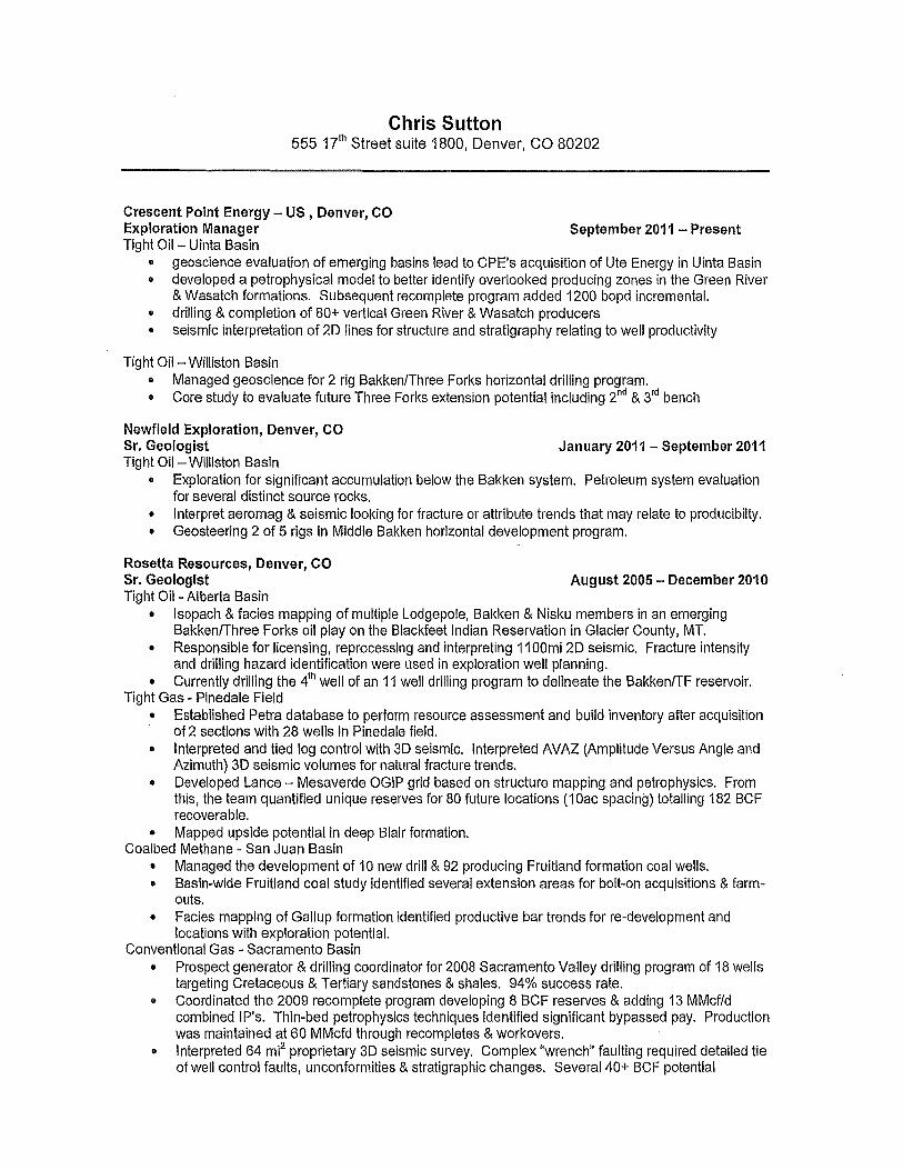
Chris Sutton 555 17th Street suite 1800, Denver, CO 80202
Crescent Point Energy - US , Denver, CO Exploration Manager September 2011 - Present Tight Oil - Uinta Basin
• geoscience evaluation of emerging basins lead to CPE's acquisition of Ute Energy in Uinta Basin e developed a petrophysical model to better identify overlooked producing zones in the Green River
& Wasatch formations. Subsequent recomplete program added 1200 bopd incremental. • drilling & completion of 80+ vertical Green River & Wasatch producers • seismic interpretation of 2D lines for structure and stratigraphy relating to well productivity
Tight Oil- Williston Basin • Managed geoscience for 2 rig Bakken/Three Forks horizontal drilling program. • Core study to evaluate future Three Forks extension potential including 2nd & 3rd bench
Newfield Exploration, Denver, CO Sr. Geologist January 2011 - September 2011 Tight Oil - Williston Basin
• Exploration for significant accumulation below the Bakken system. Petroleum system evaluation for several distinct source rocks.
• Interpret aeromag & seismic looking for fracture or attribute trends that may relate to producibilty. • Geosteering 2 of 5 rigs in Middle Bakken horizontal development program.
Rosetta Resources, Denver, CO Sr. Geologist August 2005 - December 2010 Tight Oil - Alberta Basin
• Isopach & facies mapping of multiple Lodgepole, Bakken & Nisku members in an emerging Bakken/Three Forks oil play on the Blackfeet Indian Reservation in Glacier County, MT.
• Responsible for licensing, reprocessing and interpreting 11 OOmi 2D seismic. Fracture intensity and drilling hazard identification were used in exploration well planning.
• Currently drilling the 4th well of an 11 well drilling program to delineate the Bakken/TF reservoir. Tight Gas - Pinedale Field
• Established Petra database to perform resource assessment and build inventory after acquisition of 2 sections with 28 wells in Pinedale field.
• Interpreted and tied log control with 3D seismic. Interpreted AVAZ (Amplitude Versus Angle and Azimuth) 3D seismic volumes for natural fracture trends.
• Developed Lance - Mesaverde OGIP grid based on structure mapping and petrophysics. From this, the team quantified unique reserves for 80 future locations (10ac spacing) totalling 182 BCF recoverable.
• Mapped upside potential in deep Blair formation. Coal bed Methane - San Juan Basin
• Managed the development of 10 new drill & 92 producing Fruitland formation coal wells. • Basin-wide Fruitland coal study identified several extension areas for bolt-on acquisitions & farm
outs. • Facies mapping of Gallup formation identified productive bar trends for re-development and
locations with exploration potential. Conventional Gas - Sacramento Basin
• Prospect generator & drilling coordinator for 2008 Sacramento Valley drilling program of 18 wells targeting Cretaceous & Tertiary sandstones & shales. 94% success rate.
e Coordinated the 2009 recomplete program developing 8 BCF reserves & adding 13 MMcf/d combined IP's. Thin-bed petrophysics techniques identified significant bypassed pay. Production was maintained at 60 MMcfd through recompletes & workovers.
• Interpreted 64 mi2 proprietary 3D seismic survey. Complex "wrench" faulting required detailed tie of well control faults, unconformities & stratigraphic changes. Several 40+ BCF potential

prospects being permitted 4) Evaluated, recommended purchase, & integrated aPEX California assets through a $40MM
acquisition.
Forest Oil Corporation, Denver, CO Geologist, Gulf of Mexico Offshore June 2003 - August 2005 Conventional Gas & Oil- Gulf of Mexico
4) Exploration and development for the Central Gulf maintaining 35 MMcf/d. 4) Generated 2 successful prospects in Vermilion 102 that added 8 BCF reserves. Project work
involved mapping five reservoirs trapped against a heavily faulted salt dome using poor quality 3D seismic data.
• Field study of Eugene Island 273/292. 2 prospects generated for previously overlooked shallow pay zones and clinoform trap mechanisms using high resolution 3-D seismic combined with accurate intrasand correlation.
4) 2004 & 2005 GaM Federal water lease sales. After performing a regional study of production trends and reservoir types along with regional structure mapping to identify areas with greatest potential, prospective reservoirs were identified and quantified to make recommendations on which lease blocks to pursue.
Forest Oil Corporation, Denver, CO Geotech, Gulf of Mexico Offshore May 1998 - June 2003
• Performed the division's geotech needs while working basic field development Geologist projects. Through success, this lead to an official promotion to Geologist.
• Database management of well header, deviation, tops, paleo, & seismic data. • 2D & 3D seisimc data loading. • Used Eclipse modeling software to design a water flood program for a mature oil field in Campbell
County, Wyoming. Core and log analysis and correlation were the keys to identifying stratigraphic variations critical to accurate field modeling and consequently, the best possible production and injection
SKILLS Strong subsurface stratigraphy & integration of structure with 20 & 3D seismic Drilling & recomplete program planning & implementation X-ray diffraction and SEM crystallography techniques Software Proficiency
Interpretation: Petra, SMT, Geographix, Geoframe IESX, SmartSection, Eclipse Standard: MS Word, Excel, PowerPoint
GraphicsIDatabase: CorelDraw, IHS Energy, OWL, Finder 9.1, Intellex, AutoCAD
MEMBERSHIPS & VOLUNTEER ACTIVITIES American Association of Petroleum Geologists Rocky Mountain Association of Geologists Four Corners Geological Society Philanthropy Chairman ~AE -1997-1998
PREVIOUS EXPERT QUALIFICATION Expert in Petroleum Geology by the Utah Board of Oil, Gas & Mining in Cause No. 142-09 (August 2013)
Expert in Petroleum Geology by the New Mexico Energy, Minerals and Natural Resources Department Oil Conservation Division (NMOCD) in case No. 14265 and 14266. (Feb 2009)
Expert in Petroleum Geology by North Dakota Industrial Comission (NDlC) in case No. 20325, 20507,. 18833,18917 (2011-2013).
Colorado School of Mines, Golden, CO B.S. Geology/Geological Engineering, 2002
EDUCATION

Pamela Bunz
Professional Qualifications:
• Eight year peh'oleum engineer with a strong exploration/development and production background.
• Proficient in the evaluation of acquisition and divestiture oppOliunities determining base asset value and upside value through future development.
• Ability to lead multi-disciplinary team to execute capital budget projects and react quickly to changes in planning in order to meet corporate reserve and production volume goals.
• Efficient at managing multiple projects simultaneously, achieving accurate results in tight timelines
• Proficient in economic analysis and project evaluation.
• Experienced in waterflood enhanced recovery planning, development and execution.
• Highly knowledgeable in completion techniques within the WCSB including multi-stage fracture stimulation, acid stimulations and traditional completions methods.
• Experienced in atiificiallift production optimization of existing oil wells.
• Ability to plan and implement oil and gas processing infi'astructure including pipelines, oil treating facilities, gas compressors and water injection plants.
• Ability to deliver clear and concise presentations to management.
• Ability to acknowledge information gaps and take initiative within a team setting.
• Demonstrates enthusiasm and passion to achieve successful corporate results.
Career Experience:
Crescent Point Energy
US Development Engineer Responsible for:
• Evaluating acquisition opportunities in US basins
Feb 2012 - present, Denver, CO
• Executed acquisition evaluations of ~$1 B in Unita Basin propelty value in 2012 and 2013. • Successful purchase of $860MM private company in 2013 including board presentation,
investor material preparation
• Planning, implementing and monitoring the Utah operated budget of ~$230MM in 2013. Consisting of: • Choosing 80+ drill locations to maximize reserve additions and meet production targets.
Implementing a permitting program to establish an inventory of high quality drill locations for future drilling.
• Project evaluation and recommendation of production optimization projects, facility and pipeline infrastructure.
• Accurate production and capital forecasting. Variance of3.6% achieved in 2013. • Project evaluation of non-operated drill locations contributing to 1/3 of capital activity in
2013 Utah budget.
• Executing depletion strategies: • Performing type well evaluation and continually updating based on new well performance. • Analyzing production performance of various multi-stage fracture completion techniques and
providing go forward recommendations.
• Identifying, booking and growing proved, probable and possible reserves.
• Predicting reserve targets for upcoming years and meeting these targets based on capital project selection. Exceeded 2013 target of 14.5MMboe reserve additions in Utah (16% of corporate adds)
• Coordinating operation activities in the Randlett and Horseshoe Bend field.
Identifying opportunities for improved production performance through optimization, recompletions and workovers.

•
•
Pamela Bunz
Coordinating the drill schedule to ensure planned locations get permitted and built within regulatory stipulations. Evaluate surface facility opportunities for reduced operating costs and increased production efficiencies, such as natural gas liquid processing, fuel gas infi'astructure and power installation.
• Direct supervision of Engineering Teclmologists.
Crescent Point Energy Jail 2010 - Feb 2012, Calgmy, AB
Exploitation Engineer Responsible for:
• Planning, implementing and monitoring the SE Sask Bakken budget of ~$400MM. Consisting of: • Choose 200+ Drill locations to address land expiries, maximize reserve additions and meet
production targets. • Project evaluation and recommendation of production optimization projects, facility and pipeline
infrastructure. • Production and capital forecasting.
• Implemented new waterflood pilot in Forget, SK: • Planed the development of a water injection plant and injection pipelines. • Chose injector patterns and injection rates to achieve efficient sweep. • Adapted injection rates, production techniques and stimulation techniques with the changing
environment of a new waterflood.
• Executed depletion strategies: • Performed type well evaluation and continually updating based on new well performance. • Analyzed production perfonnance of various multi-stage fracture completion techniques and
providing go forward recommendations. • Evaluated SE edge of core Bakken pool to identify areas of potential improved performance over
average area production results. Recommended locations were drilled with improved performance.
• Identified, booked and grew proved, probable and possible reserves.
• Coordinated operation activities in the Bakken field. Identified opportunities for improved production performance through optimization, cleanouts, workovers and annular pressure reduction.
• Executed acquisition and land sale evaluations of ~$1B in property value.
Crescent Point Energy June 2007 -Jan 2010, Calgmy, AB
Production Engineer Responsible for:
• Well service tracking for SE Sask conventional team • Tracked a prioritized list of work overs based on performance and economic criteria. • Prepared quarterly summaries of cost and failure statistics.
• Well service rig office supervision • Scheduled rig moves based on prioritized list and environmental conditions. • Recommend andlor approved downhole pumping system design changes. • Designed initial completion pumping systems. • Monitored safe work procedures.
• Aliificiallift production optimization • Created and analyzed inflow performance curves • Sized pumpjack systems, electronic submersible pumping systems, and progress cavity pumping
systems. • Perfonned economic analysis of pumping system projects. Made recommendations and
implemented design.

Pamela Bunz
.. Acquisition evaluations
Crescent Point Energy
Engineering Internship Student Responsible for Exploitation Engineer SUppOit.
Crescent Point Energy Trust
Engineering Summer Student Responsible for Exploitation Engineer support.
Designations: APEGGA Professional Engineer
Education and Professional Development:
B.Sc., Civil Engineering - The University of Calgary Introduction to Reservoir Engineering (ENPE 523) PetroSkills Applied Reservoir Engineering
May 2005 - Sept. 2006 CalgQlY, AB
May 2004 - Sept. 2004, Calgmy, AB
Sept 28,2010
2007 2005 2005 2006 2008 2010 2011
Introduction to Petroleum Production Engineering (ENPE 533) PetroSkills Production Operations I
Computer Skills:
SPE - Evaluation of Canadian Oil and Gas Properties PJVA - Introduction to Unitization
Proficient in Accumap, Oilfield Manager, PEEP, Value Navigator, AFE Navigator, XI Technologies Assetbook, Visage data exploration and visual analytics software, Generwell data management software and MS Office products.

E HIBITB

Exhibit B Docket No. 2014-023 Cause No. 131-138
T2S-R2W
T3S-R2W
Requested Pilots Under Cause # 131-138
o 640 LGR/Wasatch Pilot DSU
D 1280 LGR/Wasatch Pilot DSU
Offset Drilling Units
T3S-R1W
" c: n :::r (1)
'" ::I (1)
n o c: ;:; ..::
4S-R1W
~ Working Interest Owners and Unleased owners notified
Ba,,~ r" (,',/.
Rpf; no r
T2S-R1E
Fort Duchesne
T3S-R1E "
4S-R1E 4S-R2E
c -< . ..
(p Crescent Point
N
i

EXHIBIT C

j~
Exhibit C-1
Docket No. 2014-023 Cause No. 131-138
T3S-R1W 10 11 12
15 14 13
22 ,- 23 24 , c:
-
Mineral and Working Interest Ownership Status Uintah County
IJ 640 LGR/Wasatch Pilot DSU
27 o Fee Minerals -100% Crescent Point .,:1.
,~ , I ~ Tribal Minerals -100% Crescent Point
Cp Crescent Point
T3S-R1E 7 8 9
KendaIl1-18-3-1E
MerrI 3-: -3-1E • Section 18
Working Interest Owners Crescent Point 100%
1 ( 17 16 •
Kendal l 9-18-3-1E
19 20 21
N
30 29 28 1

Exhibit C-2
Docket No. 2014-023 Cause No. 131-138
22
27
34
23
26
35
13 18 17
T3S-Rl W T3S-R E 24
25
36
Mineral and Working Interest Ownership Status
Uintah County
C 1280 LGR/Wasatch Pilot DSU
L Fee Minerals -100% Crescent Point
19
30 29
31 32
T4S-R1E
(p Crescent Point
16 15
Sections 20 and 29 Working Interest Owners Crescent Point 100%
28 27
33 34
14
,:;., 23
26
35
N
I ~~_T_rib_a_IM_i_ne_ra_ls_-_1_00_o/c_oc_re_s_ce_nt_p_o_int ____ ~_6-------------5---------------4---------------3-----------2~~ _ Indian Allotment -100% Crescent Point -1-

Exhibit C-3
Docket No. 2014-023 Cause No. 131-138
T3S-R1E
24
25
36
18 17 16
T3S-R2E
Sections 22 and 27
19 Working Interest Owners Crescent Point 91.8929% Bill Barrett Corp .9281% Robert Bayless, LLC .9281% 3rd Party Mineral Interest 6.25%
30 29 28
31 32 Mineral and Working Interest Ownership Status 33
Uintah County
C 1280 LGR/Wasatch Pilot DSU
Fee Minerals -100% Crescent Point
~ Fee Minerals - Partial Crescent Point, Bill Barrett, & Bayless T4S-R2E Tribal Minerals -100% Crescent Point
Indian Allotment -100% Crescent Point 4 ----
~ 3,d Party Mineral Interest
(p Crescent Point
15 T S-R19E 12
13 22 23
26
34 35
N
-+ 3 2
- - -----_.

Exhibit C-4 Docket No. 2014-023 Cause No. 131-138
31 32 33 T3S-Rl T3S-R2E
T4S-Rl T4S-R2E 1 6 5 4
7 8 9 12
13 18 17 16 Mineral and Working Interest Ownership Status
Uintah County
[] 640 LGR/Wasatch Pilot DSU
o Fee Minerals -100% Crescent Point 21 Tribal Minerals -100% Crescent Point ---- -
34
3
L 10
15
22
35 36
T7
2 1
Section 10 Working Interest Owners Crescent Point 100%
(p Crescent Point
30 29
-R20E
32
7
T4 -R3 ill 13 18
N
r 23 24 19 -- ---

IBITD

Exhibit D Docket No. 2014-023 Cause No. 131-138
BLANCHARD 1-3 T1S R2WS3 1212211967
11,190
• Formation r--:::::;-.., Geologic \
Age ~ ~ ;=-..,.,.....""
HI!"I GRIDUWER..1
/ /
/ /
!cl':""::,)!J.:..:r Ji4$E / /
/ /
/ /
/ /
/ /
TGR:l /
/ /
/ /
/ /
/ /
/ /
/ /
/ /
WASATCH
/
/ /
/
/' /
Q) c Q) on o ~ ro 0..
Randlett type log
GAVITTE 13-23-3-1 E T3S R1E S23
5/15/2012 9,085
•
5955' MD
(p Crescent Point
Type Logs

EXHIBITE

'" u ....... c
UJ
.-t=
..0
..c X
UJ
& ....... c Q) 0 CI)
~ u
m N 0
I <::t .-t 0 N
0 Z 0
+-' Z
OJ OJ ..::.:. Vl u ::::l 0 C1J Cl U
tl.O e o .....J e Q) > c..Q) >-..c ~u
>}-
-Q- IoU tl.OM o I
.....JM I
Q) M c..N >- I ..... M
M Q)
.~
0.. ro E

EXHIBITF

Exhibit F-1 Docket No. 2014-023
t- ~ ~ l:- f-
'" r- ;: :
Wasatch
S
:....
Geologic Cross Section A-A'

Exhibit F-2 Docket No. 2014-023 Cause No. 131-138
B SW UTt!mUAl.~'£U'I'1i: TRIn.&J. :1044VTli: TRIe.&.L.~I5-0-qrI!TItlOAL. ,,,,'()...4.Uf1!TItICA\. ,·10""CtfTfUBAL 1l-: ... ,IlffI!:Tl':I!lAL 7.,:: ..... '1: IJLo'!' 1:!-~U!
71::e,.:olO ~I.,tte ~HI'=!011 " )0.-:<111 1111':'010 ~11 ~" , ' ncv.!OI ' e.tcr 'l' .O~: ;.!o t 7 7.'70 ':'.':SO 7,~eo 7."~ O,.')!-. . . . . . . . Ul~~~'lO 1JI. ~;:;~~'1!
',,," O, ' TO
ULT,·,e.].ll[lITfT1UaA.Llo-~TltIIUJ.."~3-:l!: lILT~).:C!: 11."-':'0" e.':!1<::C" 7n~l:: lY1I::!O" D.e~ 1I, le, ,.e-.o •. e=, . . . . ~l
."" ~
(p Crescent Point
NE B' 'E10E/U.l..l-o.1t" 'Dlt-:Je..e.1t
1~ " " :'G I~H n;~~;' OOVT.~!c",::-»-o
".:e, 10.100 11':10 u.!)~
'> • . "
~ ~ H ~
v ~
~ -0/ ;..
'-
,.-
f-:'-
~
~
i j,-
:-~ :--~ ~
f: ~ D
, r
~ ~ ... : . E=
i
, c ~ f t: ~ '-
~ [ ~ ~ :...
0
~
Geologic Cross Section B-B'

E HIBIT G

(p Crescent Point
Exhibit G-1 Docket No. 2014-023 Cause No. 131-138
ULT 9 26 3 1E M' .. S
Number of stages 8
Dominant Azimuth
Secondary Azimuth N61°W
Primary Fracture half length 600'
Secondary Fracture half length 300'
IUt -2.750 -2,500 -2.250 ·2.000 -1.750 " .500 ·1 ,250 " ,000 .7~1 ·500 ·250 0 250 500 150 1,000 1.250
1.750 .
1.500 - UlT 7-26-3-1E
1.2~ \ 1 ,000 .
700 . 500 •
* 250 . . . .
0 . . . ..
• + .,: ••• it. 0 +.,.+ • -2~ . (10 "~ .+.\aJ .•
• ¢ .~" ! ·000 .
o ¢ ~o ~ . . o· ., ., ., . .
UlT 9-26-3-1E . ·750 . .,
, ' .000
" .2..50 :, ' N26E
II 11I"'~2.~1 1 I
UlT7-26-3-1E Observation Well
__ ... _.T3S R, E ..
U . -1,500 . 1..2'50 .1 ,000 .750 ·500 .25(1 'a--I 2:SO SOO 7SO 1,000 1.250 1.500
Looking N26E 7.000 Lateral:Depth ratio is 0.9 :1 <·ULT'l-26-3-1E
·V"' -.~". ,"
7.750 .1----11----------+----1,-----------11
8,000 . . . ,
8.~ · . • . ;. : . . . 6.500 ., ..
~ .,
0 <> ~8.730 ll"
l} . ° a 9,000
B ° 0° ~ o.:z.o 6'
., ' .500 ., 0 . 9.750 . "
10,000 - . ~ \ GR.,EDTC

Exhibit G-2 Docket No. 2014-023 Cause No. 131-138
g c 0 ;;
i c '" n.
1000 800 600 400 200
0 -200 -400 -600 -800
-1000
Stage Number
200
100
g 0 ~ ~ -100 :t:
-200
-300
-400
-500 -'-----------------~
Stage Number
(p r"'''''"""n't Point

E IBIT H

3-18-3-1 E 1-18-3-1E 9-18-3-1 E NET : 184 NET : 223 NET : 267
A
h
por
Sw
Bo
OOIP! 640 ac
I ~.
\
I ! ,~,
~l"
t~.
u ;. ...
Exh ibit H-1 (p Docket No. 2014-023 Cause No. 131-138 Crescent Point
640
220
0.08
0.5
1.18
370280'14
Wo '
,
~')"'I
...... :>-..
acres
ft
bbl/bbl
bbl
'""t' ..... ' ''t'' ...... ' .-

16-9-4-2E NET: 205
3-15-4-2E NET: 190
2-15-4-2E NET : 239
-:-
;
... "I"
."..
-:-
-:-
A
h
par
Sw
Ba
<-
T
T
-r -r
"" ... -r
T'
T
-r
-:'"
... 0:-
..
Exhibit H-2 Docket No. 2014-023 Cause No. 131-138
acres
ft
(p Crescent Point
640
205
0.09
0.5
1.18 bbl/bbl
38 816 298 bbl

.. E HIBITI

(j~ ""Drawing not to scale •
HZ Development is > 5500ft below surface and> 4500ft below known Crescent Point water aquifers
Fracture Height growth expected to be less than <350ft
Surface wellhead Equipment
Water Aquifers
Unprospective overburden rock
column ~4,500 ft thick
............ 5,500' TVD
Green River/Wasatch Formation
~2,500 ft thick
Exhibit I Docket No. 2014-023 Cause No. 131-138

E HIBIT J .

Exhibit J Docket No. 2014-023 Cause No. 131":138
Horizontal Lateral Cross Section Schematic Intermediate Casing Cemented Past the 660' Setback
7" Int ermediate Casing
~ Cement
v
N Sec Line
Production liner Hanger/Seal
Heel
;>
7" Intermediat e Casing Shoe
~ 4.5" Production Casing
~
(p Crescent Point
oe
/' S Sec Line
660'Setback ( )

E HIBITK
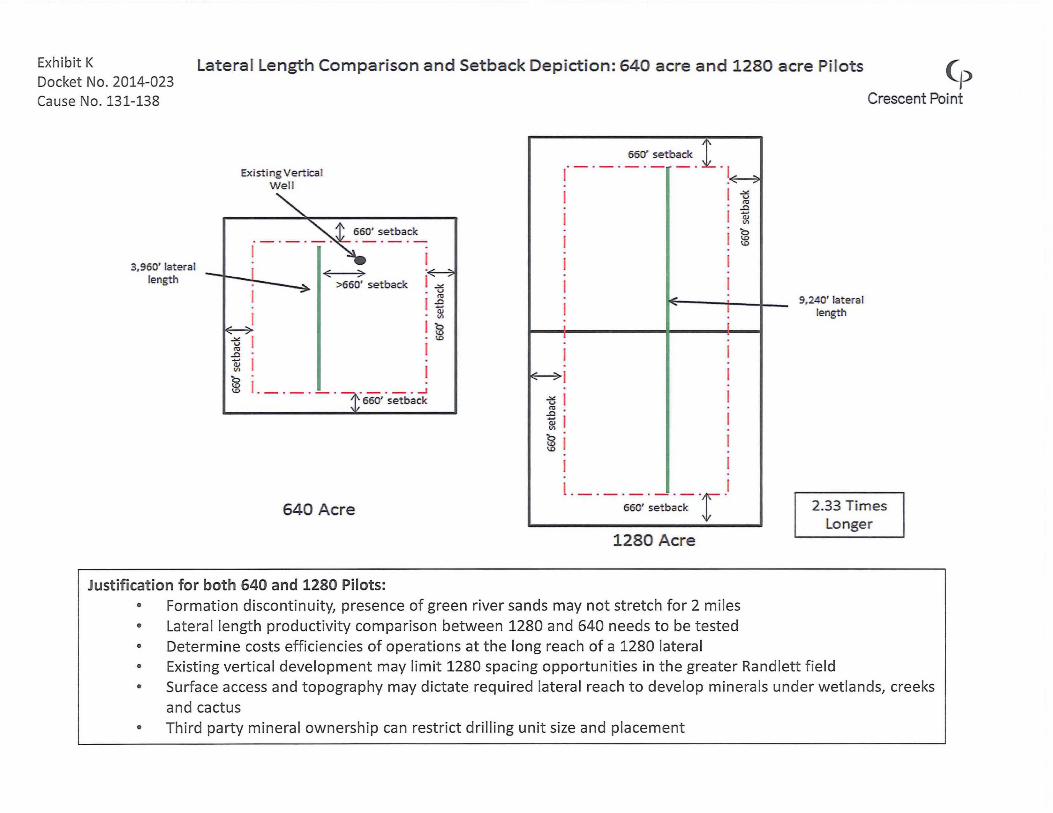
Exhibit K Latera l Length Comparison and Setback Depiction: 640 acre and 1280 acre Pilots (p Docket No. 2014-023 Cause No. 131-138 Crescent Point
Existing Vertical W ell
_ . _ . 55~' setback . i .
1 ~~
3,950' lat era l length
640 Acre
._._ • ....l
550' setback
Justification for both 640 and 1280 Pilots:
<E---7
-'" v ro
.0 Qj VI
b <D <.D
I -'" v OJ .0
I Qj VI
I b <D <D
I I
<I!'!..
I
I
·_·_·_·_·_·r 550' setback
1280 Acre
• Formation discontinuity, presence of green river sands may not stretch for 2 miles • Lateral length productivity comparison between 1280 and 640 needs to be tested • Determine costs efficiencies of operations at the long reach of a 1280 lateral
9,240' lat eral length
2.33 Times Longer
• Existing vertica l development may limit 1280 spacing opportunities in the greater Randlett field • Surface access and topography may dictate requi red lateral reach to develop minerals under wetlands, creeks
and cactus • Third party mineral ownersh ip can restrict drilling unit size and placement

EXHIBITL

Exhibit L-1 Docket No. 2014-023 Uteland Butte HZ Tracking (p Ca use No . r1~3~1-~1~3~8 __________________________________________________________________________ ~C~r~e~s~ce~n~t~8~o~int
"C co .c -Q.J .... ra c::
(5
1280 Average Well
1000
640 Average Well
100
1280 Type Well EUR: 400 mbbl IP1: 2600 bopd IP30: 1370 bopd Di:95% b: 1.2
640 Type Well EUR: 200 mbbl/275Mboe IP1: 1300 bopd IP30: 850 bopd Di: 95% b: 1.2
10 +-------------------r------------------.------------~~--_r------~----------._----------------~
o 5 10 15 20 25
M onths on Production

Exhibit L-2 Docket No. 2014-023 Wasatch HZ Tracking (p CauseNo.13r1~-1~3~8~ ____________________________________________________________ r=========~C~r~e~sc~e~n~t~P~o~int
:0-0-o .0 -<11 ..... I1J IX:
o
1000.0 t-----~~------------------------------------------------------------~
640 Average Wasatch Well
640 Type Well EUR: 300 mbblj407mboe IP1: 1500 bopd IP30: 889 bopd Di: 93.5% b: 1.2
100.0 t---------------------------------------~--~~----------------------------------------~
10.0 +-----------.-----------,-----------.-----------.-----------.-----------.---------~r_--~
o 2 4 6 8
Months on Production
10 12 14

E HIBITM

Exhibit M-1 Docket No. 2014-023 Cause No. 131-138
Randlett Wasatch 640 acre HZ Type Well (p
1000.00
"tJ C. o
.J:l
CII -ro 0:
o
::c .c ~ "tJ o Q: E ::s u
100.00
10.00
\ \ \ \ , ~
~ ..",- ~
JIll'" .............. ./
/ I
{
II
o 10
Crescent Point
Economic Parameters and Expected Results: Well Cost $5.5MM Gross Reserves 300 mbbl j 407 mboe WI 100% I---
-Oil Price $100jbbl Nymex -
Oil Diff 80% of Nymex -
Gas Price $4.50jMMBTU Nymex I---
Rate of Return 116% I---
-Payout 11 months
............... ............... ...............
-
20 30 40 50 60
Months on Production
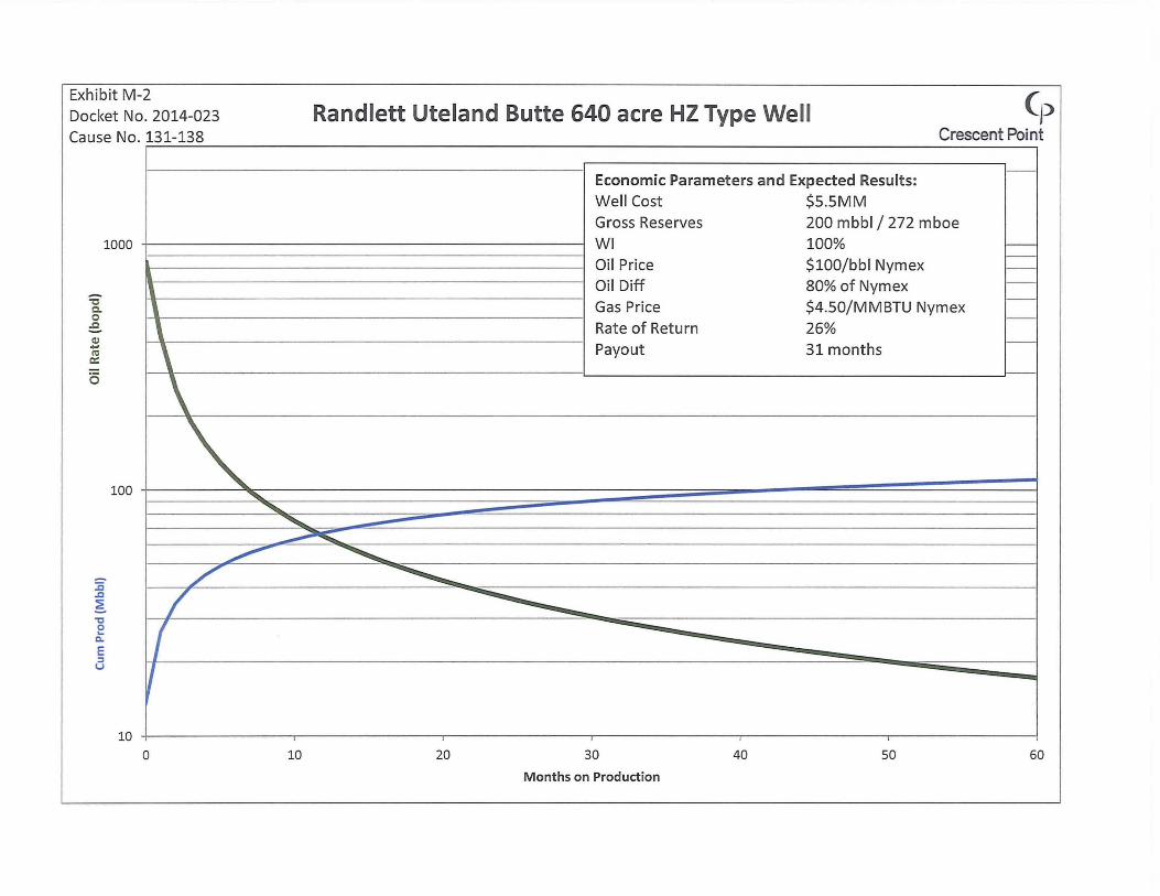
Exhibit M-2 Docket No. 2014-023 Cause No. 131-138
-'t:I 0.. o .c CII ... III a::
o
1000
\ \ \ \
100 " "'-
"""'" """"
Randlett Uteland Butte 640 acre HZ Type Well (p Crescent Point
Economic Parameters and Expected Results: Well Cost $5.5MM Gross Reserves 200 mbbl j 272 mboe WI 100% -
-Oil Price $100jbbl Nymex -
Oil Diff 80% of Nymex -
Gas Price $4.50jMMBTU Nymex -
-Rate of Return 26%
-Payout 31 months
~
'0 o ... c. E ~ u
10
~ /'
/ f ~
o 10
~ ............... ~
-
20 30 40 50 60
Months on Production

EXHIBITN
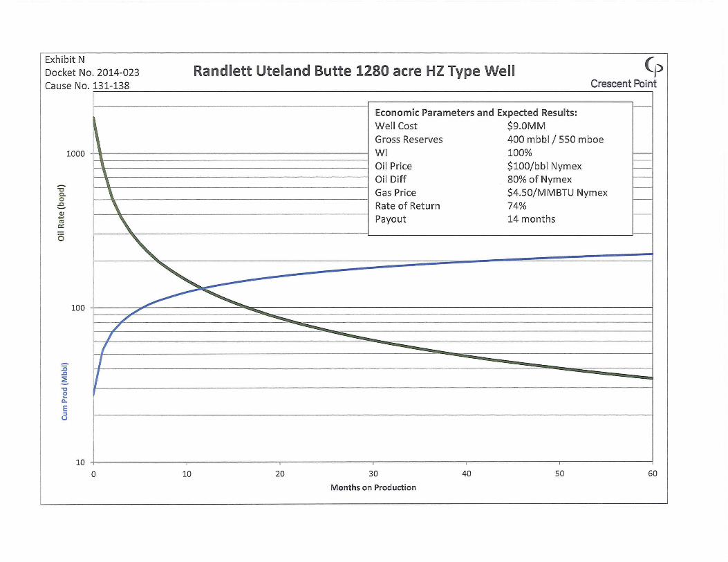
Exhibit N Docket No. 2014-023 Cause No. 131-138
Randlett Uteland Butte 1280 acre HZ Type Well (p
-"t:I co .c OJ ... It! 0::
o
~ 1000
100
10 a
• , \ \ \ \ \ \.
" ~-~ ~ /' .............
/ /
/ I
10
Crescent Point
Economic Parameters and Expected Results:
Well Cost $9.0MM
Gross Reserves 400 mbbl j 550 mboe
WI 100% f---
Oil Price $100jbbl Nymex -
Oil Diff 80% of Nymex --
Gas Price $4.50jMMBTU Nymex f--
Rate of Return 74% -
Payout 14 months
............... ............... -..............
-
20 30 40 50 60
Months on Production

EXHIBIT 0

Exhibit 0 Docket No. 2014-023 Cause No. 131-138
Section 18-3S-1E
A 640
h 220
por 0.08
Sw 0.50
Bo 1.18
OOIP 37,028,014
Forecasted
Reserves 1500.00
Recovery
Factor 4.1%
Rand lett OOIP and HZ Development Recovery Factor (p
Crescent Point
Section 10-4S-2E
acres A 640
ft h 205
por 0.09
Sw 0.50
bbl/bbl Bo 1.18
bbl OOIP 38,816,298
Forecasted
bbl Reserves 1500.00
Recovery
Factor 3.9%
acres
ft
bbl/bbl
bbl
bbl
OOIP = 7758 * Porosity * So * Net Pay * Area / Bo
Forecasted Reserves for 640 Acre D5U with 6 w ells
= WS EUR + UB EUR + 4*GR EUR
= 300Mbbl + 200Mbbl + 4*250Mbbl = 1500 Mbbl
**No analogous Green River HZ Production to date to estimate reserves, average of WS and UB used as an
analogy
Full HZ Development Recovery Factor Expected to be 15%
Vertica l vs Horizontal Development: • Sec 26-3-1E is fully drilled on a 640 Acre DSU with vertica l wells at 40 acre spacing
• Reserves = 1100 Mbbl • OOIP = 20,000 Mbbl
640 Acre DSU Vertical Development at 40 acre spacing Recovery Factor = 5.5%

EXHIBITP

Exhibit P
Docket No. 2014-023 Cause No. 131-138
Formation Data:
Formations:
Producing Interval :
Average Porosity:
Permeability Range:
Pay Thickness:
Average Water Saturation:
Initial Reservoir Pressure:
Fluid Data:
Oil API Gravity:
Solution GOR:
Oil Formation Volume Factor:
Oil Viscosity
Reservoir Drive Mechanism:
(p Reservoir Data Sheet Crescent Poi nt
Green River & Wasatch
5500'-9300'
8%-9%
0.05-10 mD
200'-350'
50%
2800 psi - 4600 psi
33°--40
500 scf/bbl
1.18
6.5 cP @ 181°F
Solution Gas