Embed Size (px)
Citation preview
BEAVER COUNTY, PENNSYLVANIA (ALL JURISDICTIONS)
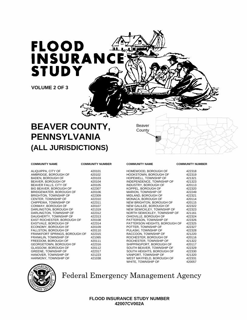
COMMUNITY NAME COMMUNITY NUMBER ALIQUIPPA, CITY OF 420101 AMBRIDGE, BOROUGH OF 420102 BADEN, BOROUGH OF 420103 BEAVER, BOROUGH OF 420104 BEAVER FALLS, CITY OF 420105 BIG BEAVER, BOROUGH OF 422307 BRIDGEWATER, BOROUGH OF 420106 BRIGHTON, TOWNSHIP OF 422309 CENTER, TOWNSHIP OF 422310 CHIPPEWA, TOWNSHIP OF 422311 CONWAY, BOROUGH OF 420107 DARLINGTON, BOROUGH OF 421319 DARLINGTON, TOWNSHIP OF 422312 DAUGHERTY, TOWNSHIP OF 422313 EAST ROCHESTER, BOROUGH OF 420108 EASTVALE, BOROUGH OF 422314 ECONOMY, BOROUGH OF 420109 FALLSTON, BOROUGH OF 420110 FRANKFORT SPRINGS, BOROUGH OF 422315 FRANKLIN, TOWNSHIP OF 421065 FREEDOM, BOROUGH OF 420111 GEORGETOWN, BOROUGH OF 422316 GLASGOW, BOROUGH OF 420112 GREENE, TOWNSHIP OF 422317 HANOVER, TOWNSHIP OF 421223 HARMONY, TOWNSHIP OF 421038
COMMUNITY NAME COMMUNITY NUMBER HOMEWOOD, BOROUGH OF 422318 HOOKSTOWN, BOROUGH OF 422319 HOPEWELL, TOWNSHIP OF 421321 INDEPENDENCE, TOWNSHIP OF 421323 INDUSTRY, BOROUGH OF 420113 KOPPEL, BOROUGH OF 422320 MARION, TOWNSHIP OF 422249 MIDLAND, BOROUGH OF 422321 MONACA, BOROUGH OF 420114 NEW BRIGHTON, BOROUGH OF 420115 NEW GALILEE, BOROUGH OF 422322 NEW SEWICKLEY, TOWNSHIP OF 422323 NORTH SEWICKLEY, TOWNSHIP OF 421161 OHIOVILLE, BOROUGH OF 422324 PATTERSON, TOWNSHIP OF 422326 PATTERSON HEIGHTS, BOROUGH OF 422325 POTTER, TOWNSHIP OF 422327 PULASKI, TOWNSHIP OF 422328 RACCOON, TOWNSHIP OF 421220 ROCHESTER, BOROUGH OF 420116 ROCHESTER, TOWNSHIP OF 421322 SHIPPINGPORT, BOROUGH OF 420117 SOUTH BEAVER, TOWNSHIP OF 422329 SOUTH HEIGHTS, BOROUGH OF 422330 VANPORT, TOWNSHIP OF 421320 WEST MAYFIELD, BOROUGH OF 422331 WHITE, TOWNSHIP OF 420057
VOLUME 2 OF 3
FLOOD INSURANCE STUDY NUMBER 42007CV002A
Beaver County

NOTICE TO FLOOD INSURANCE STUDY USERS
Communities participating in the National Flood Insurance Program have established repositories of flood hazard data for floodplain management and flood insurance purposes. This Flood Insurance Study (FIS) report may not contain all data available within the Community Map Repository. Please contact the Community Map Repository for any additional data. The Federal Emergency Management Agency (FEMA) may revise and republish part or all of this FIS report at any time. In addition, FEMA may revise part of this FIS report by the Letter of Map Revision process, which does not involve republication or redistribution of the FIS report. Therefore, users should consult with community officials and check the Community Map Repository to obtain the most current FIS report components. Selected Flood Insurance Rate Map (FIRM) panels for this community contain information that was previously shown separately on the corresponding Flood Boundary and Floodway Map (FBFM) panels (e.g., floodways, cross sections). In addition, former flood hazard zone designations have been changed as follows: Old Zone(s) New Zone
Al through A30 AE B X C X Initial Countywide FIS Effective Date:___________________________
i
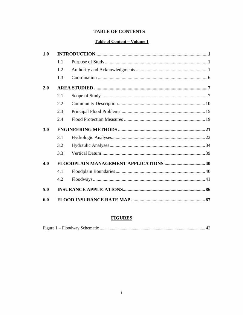
TABLE OF CONTENTS
Table of Content – Volume 1
1.0 INTRODUCTION.............................................................................................. 1 1.1 Purpose of Study ...................................................................................... 1
1.2 Authority and Acknowledgments ............................................................ 1
1.3 Coordination ............................................................................................ 6
2.0 AREA STUDIED ............................................................................................... 7
2.1 Scope of Study ......................................................................................... 7
2.2 Community Description ......................................................................... 10
2.3 Principal Flood Problems ....................................................................... 15
2.4 Flood Protection Measures .................................................................... 19
3.0 ENGINEERING METHODS ......................................................................... 21 3.1 Hydrologic Analyses .............................................................................. 22
3.2 Hydraulic Analyses ................................................................................ 34
3.3 Vertical Datum ....................................................................................... 39
4.0 FLOODPLAIN MANAGEMENT APPLICATIONS .................................. 40
4.1 Floodplain Boundaries ........................................................................... 40
4.2 Floodways .............................................................................................. 41
5.0 INSURANCE APPLICATIONS..................................................................... 86
6.0 FLOOD INSURANCE RATE MAP .............................................................. 87
FIGURES
Figure 1 – Floodway Schematic ................................................................................................ 42
ii
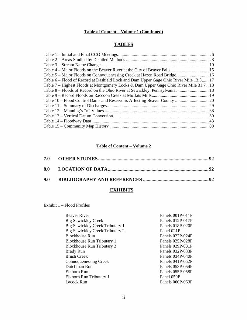
Table of Content – Volume 1 (Continued)
TABLES
Table 1 – Initial and Final CCO Meetings ................................................................................... 6 Table 2 – Areas Studied by Detailed Methods ............................................................................ 8 Table 3 – Stream Name Changes ............................................................................................... 10 Table 4 – Major Floods on the Beaver River at the City of Beaver Falls .................................. 15 Table 5 – Major Floods on Connoquenessing Creek at Hazen Road Bridge ............................. 16 Table 6 – Flood of Record at Dashield Lock and Dam Upper Gage Ohio River Mile 13.3 ...... 17 Table 7 – Highest Floods at Montgomery Locks & Dam Upper Gage Ohio River Mile 31.7 .. 18 Table 8 – Floods of Record on the Ohio River at Sewickley, Pennsylvania ............................. 18 Table 9 – Record Floods on Raccoon Creek at Moffats Mills ................................................... 19 Table 10 – Flood Control Dams and Reservoirs Affecting Beaver County .............................. 20 Table 11 – Summary of Discharges ........................................................................................... 29 Table 12 – Manning’s “n” Values ............................................................................................. 38 Table 13 – Vertical Datum Conversion ..................................................................................... 39 Table 14 – Floodway Data ......................................................................................................... 43 Table 15 – Community Map History ......................................................................................... 88
Table of Content – Volume 2
7.0 OTHER STUDIES ........................................................................................... 92
8.0 LOCATION OF DATA ................................................................................... 92
9.0 BIBLIOGRAPHY AND REFERENCES ...................................................... 92
EXHIBITS
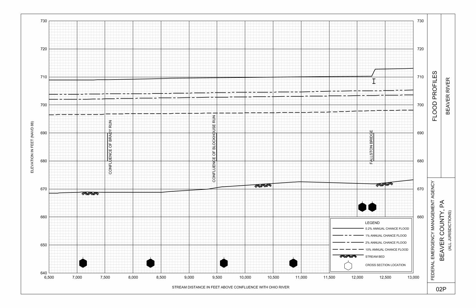
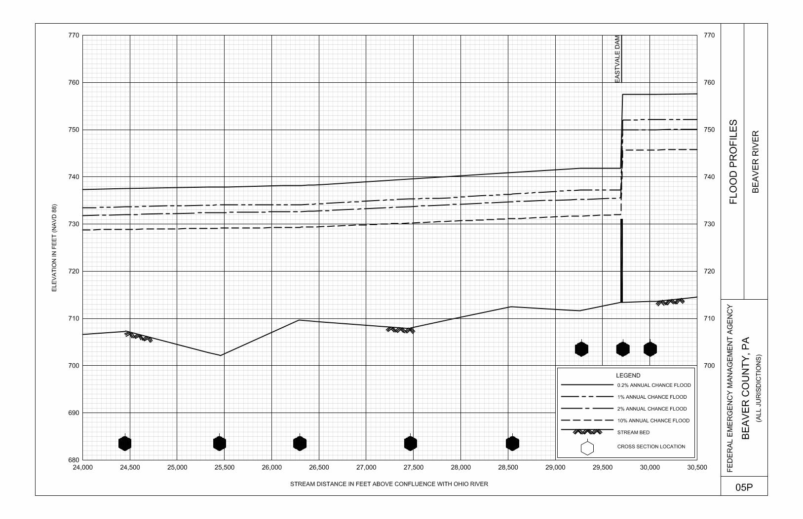
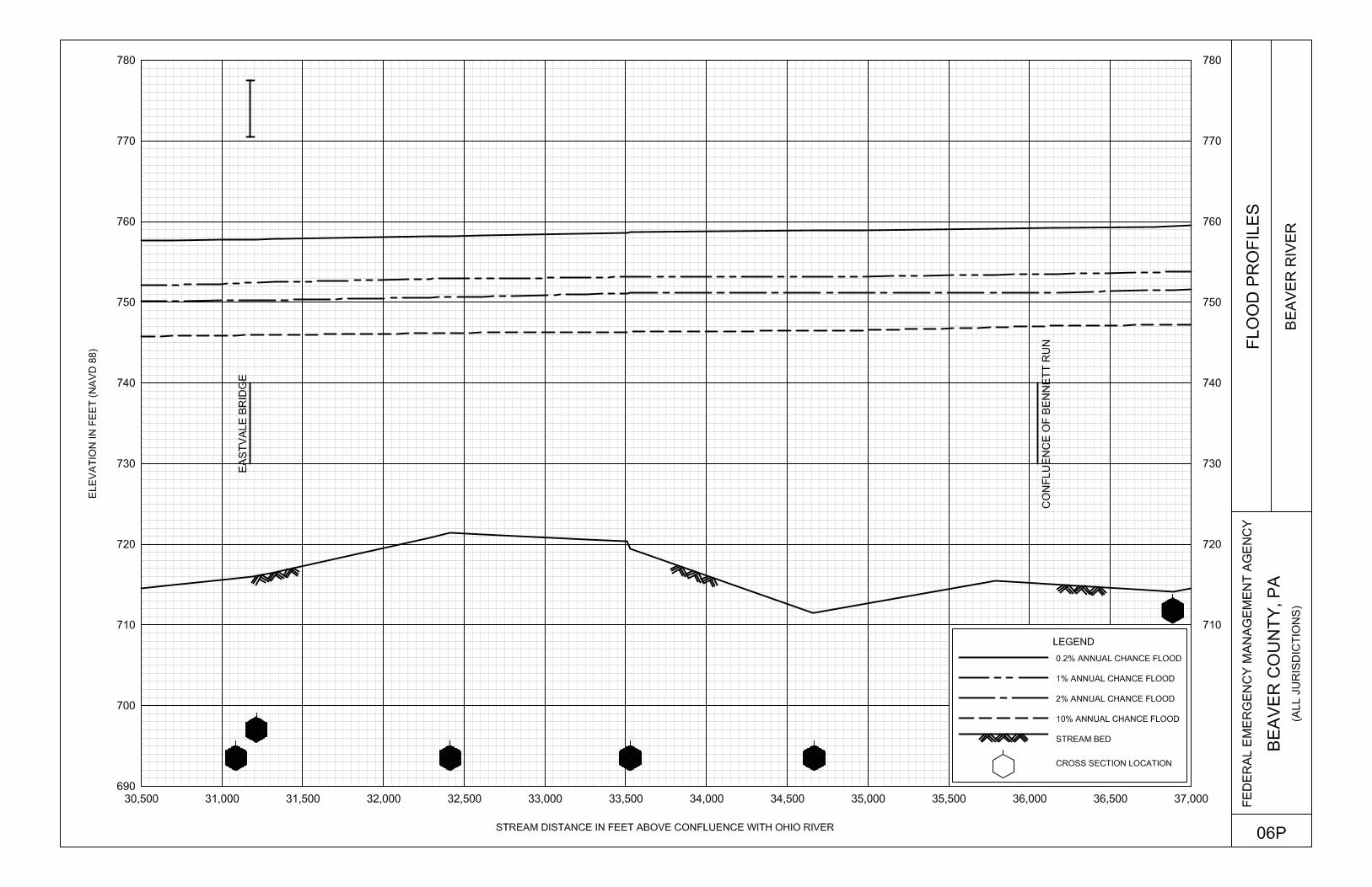
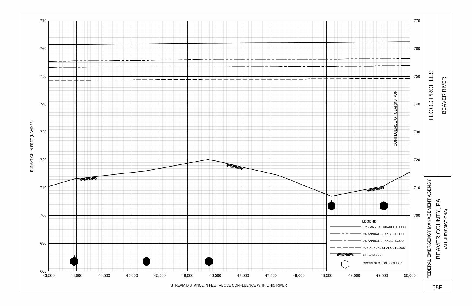
Exhibit 1 – Flood Profiles
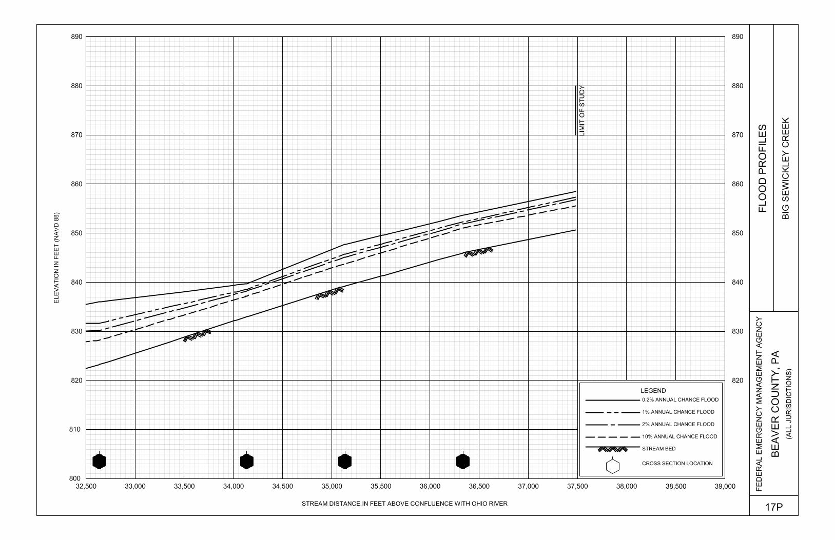
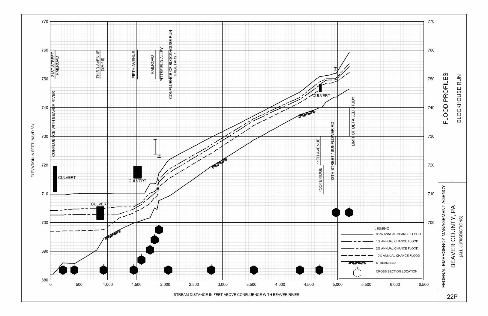
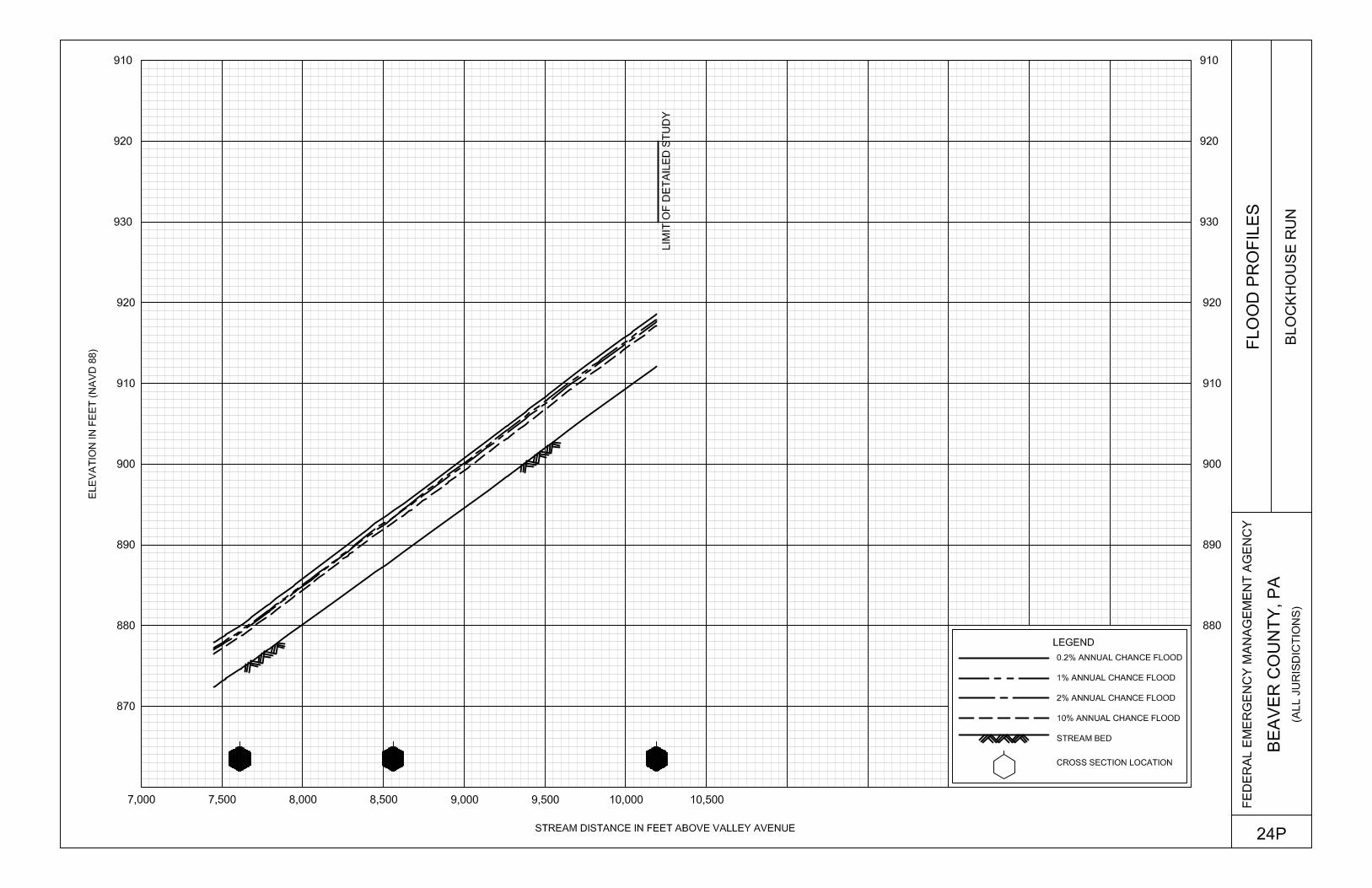
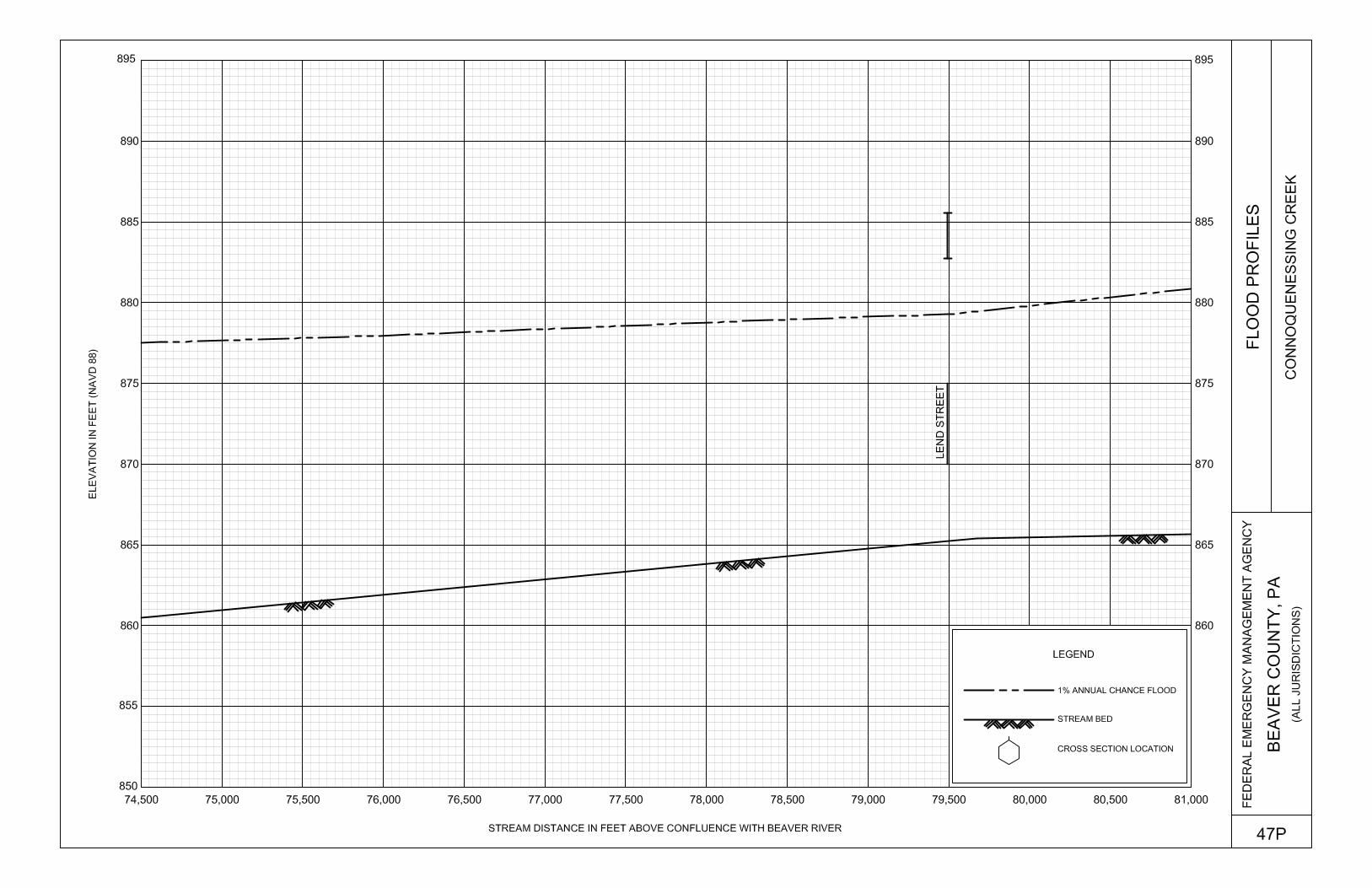
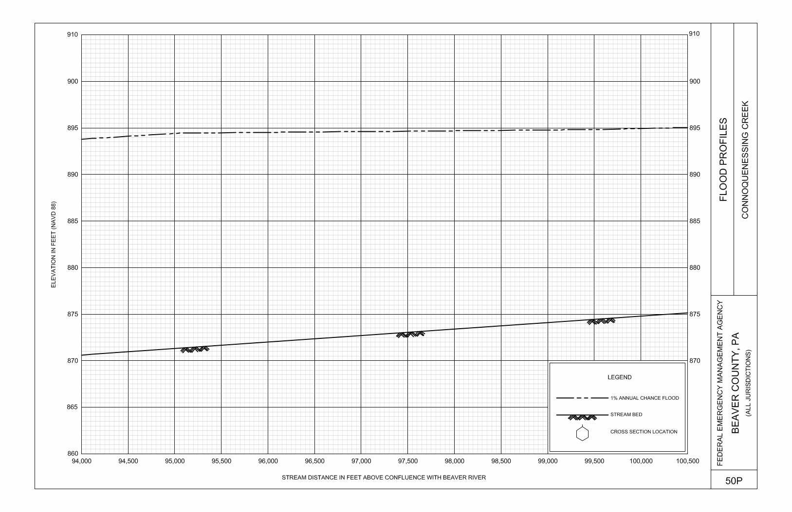
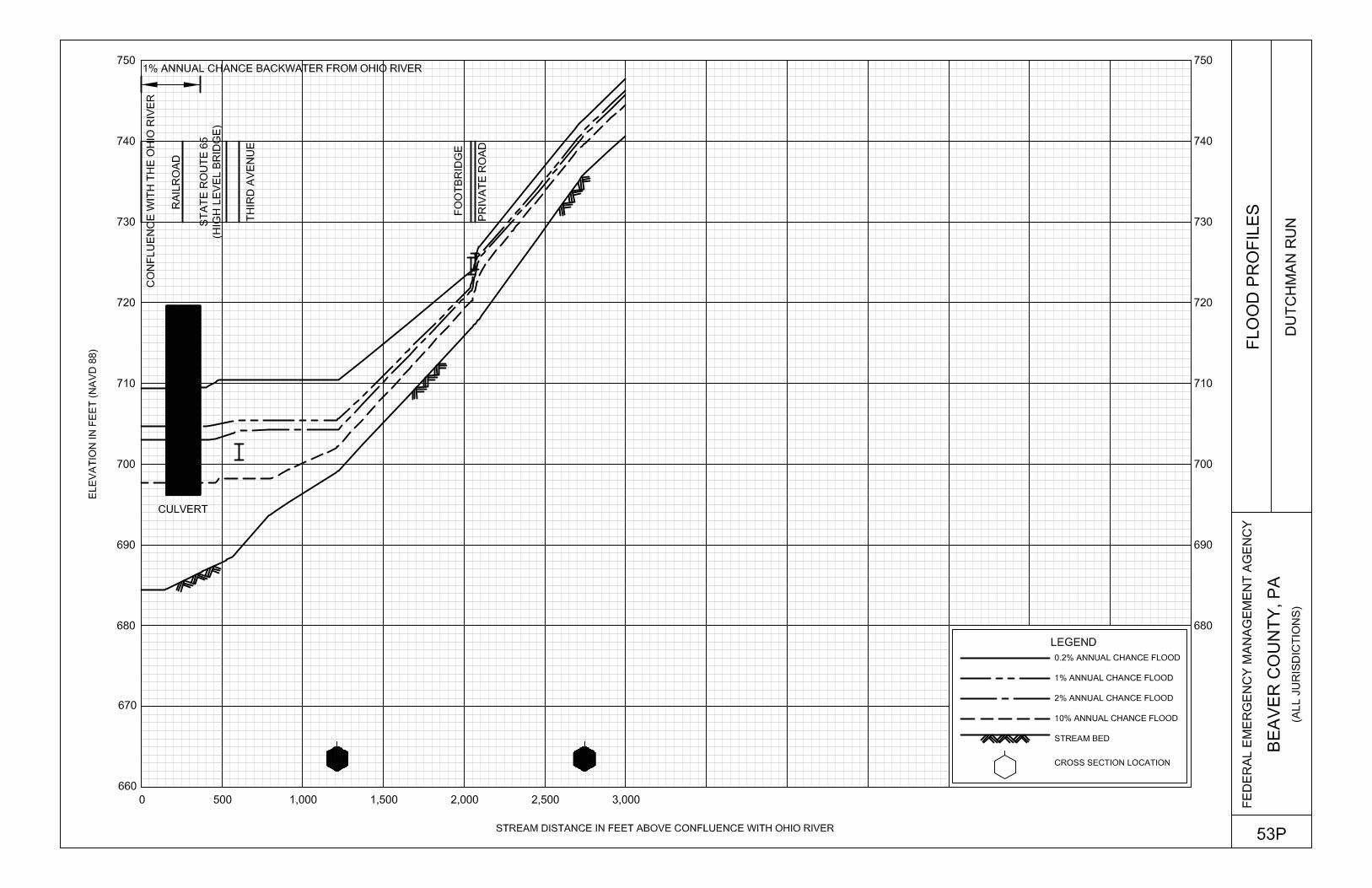
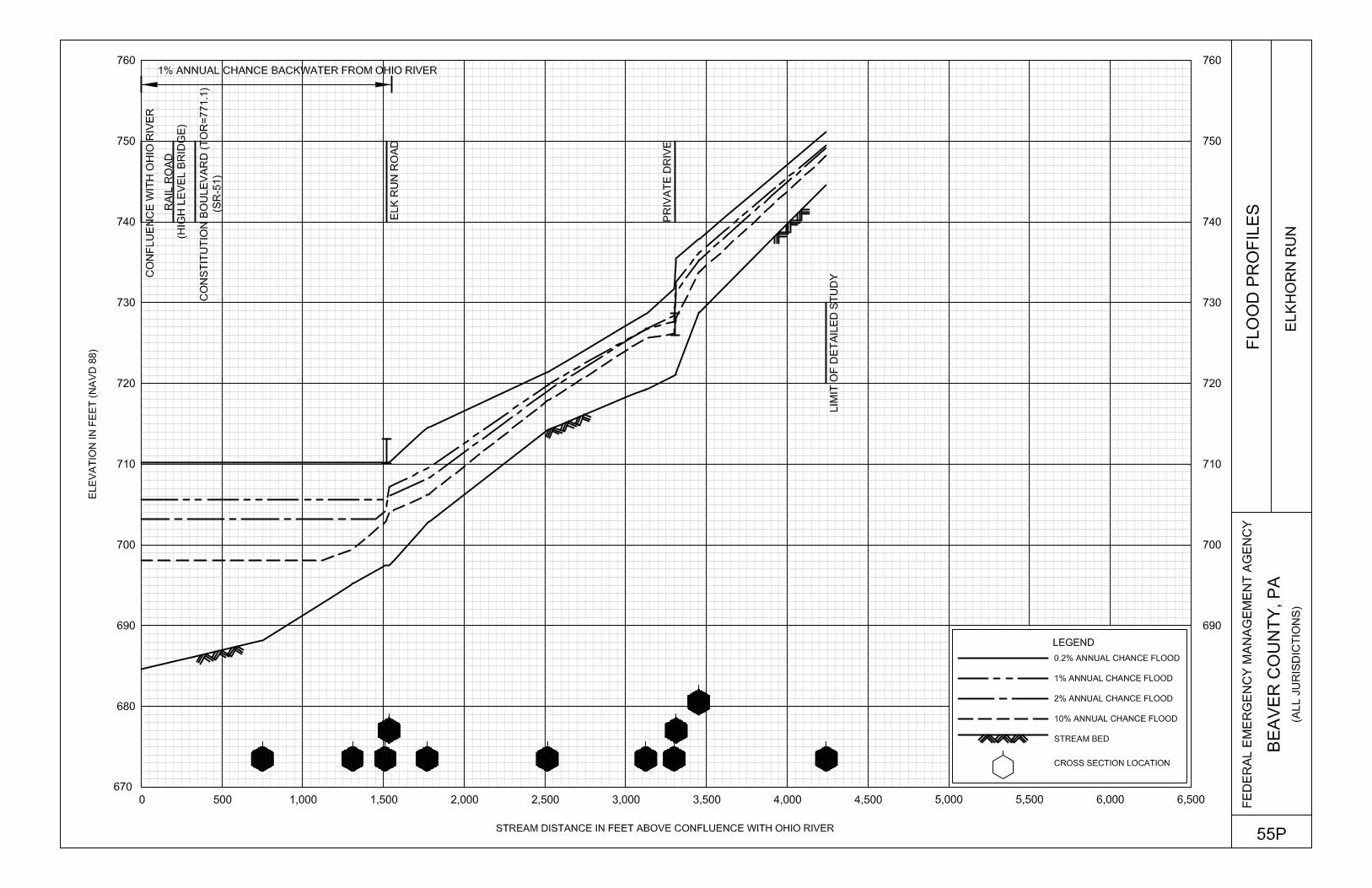
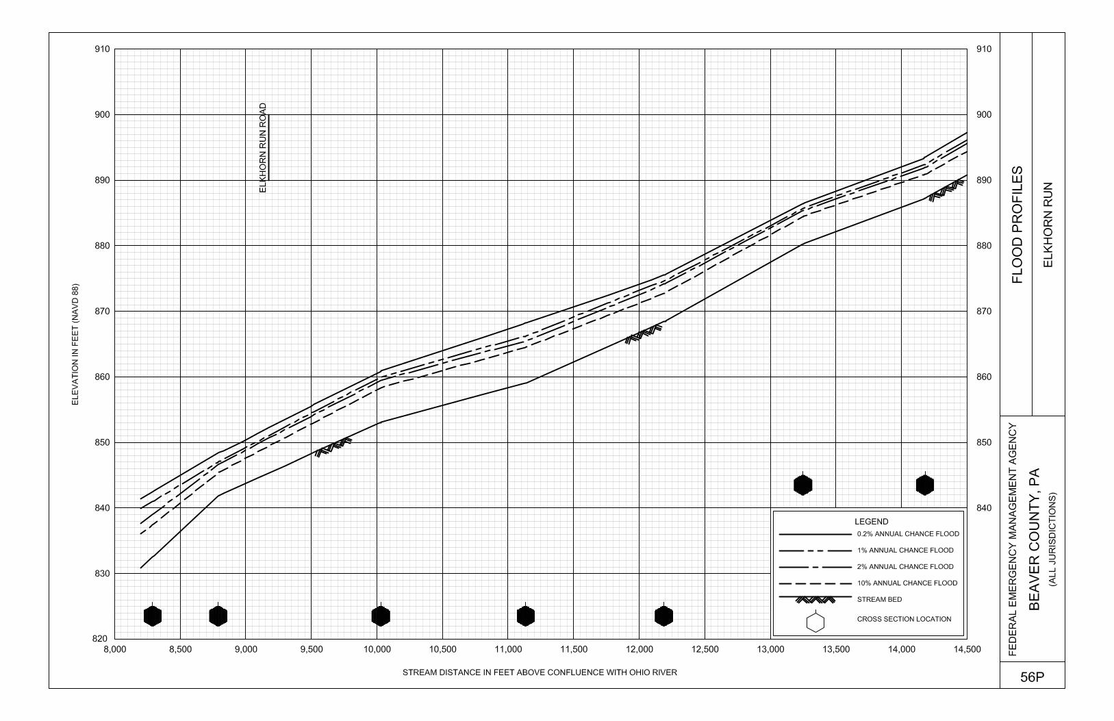
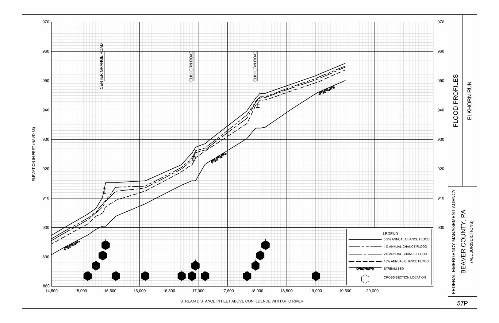
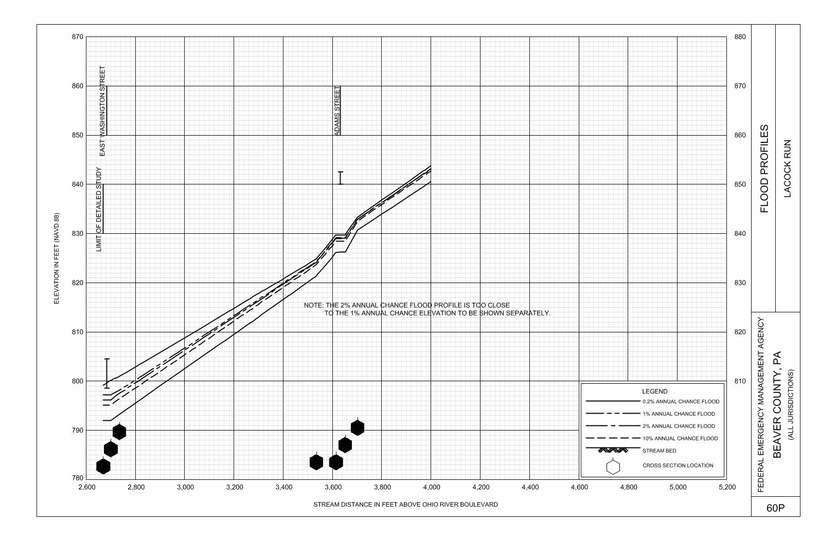
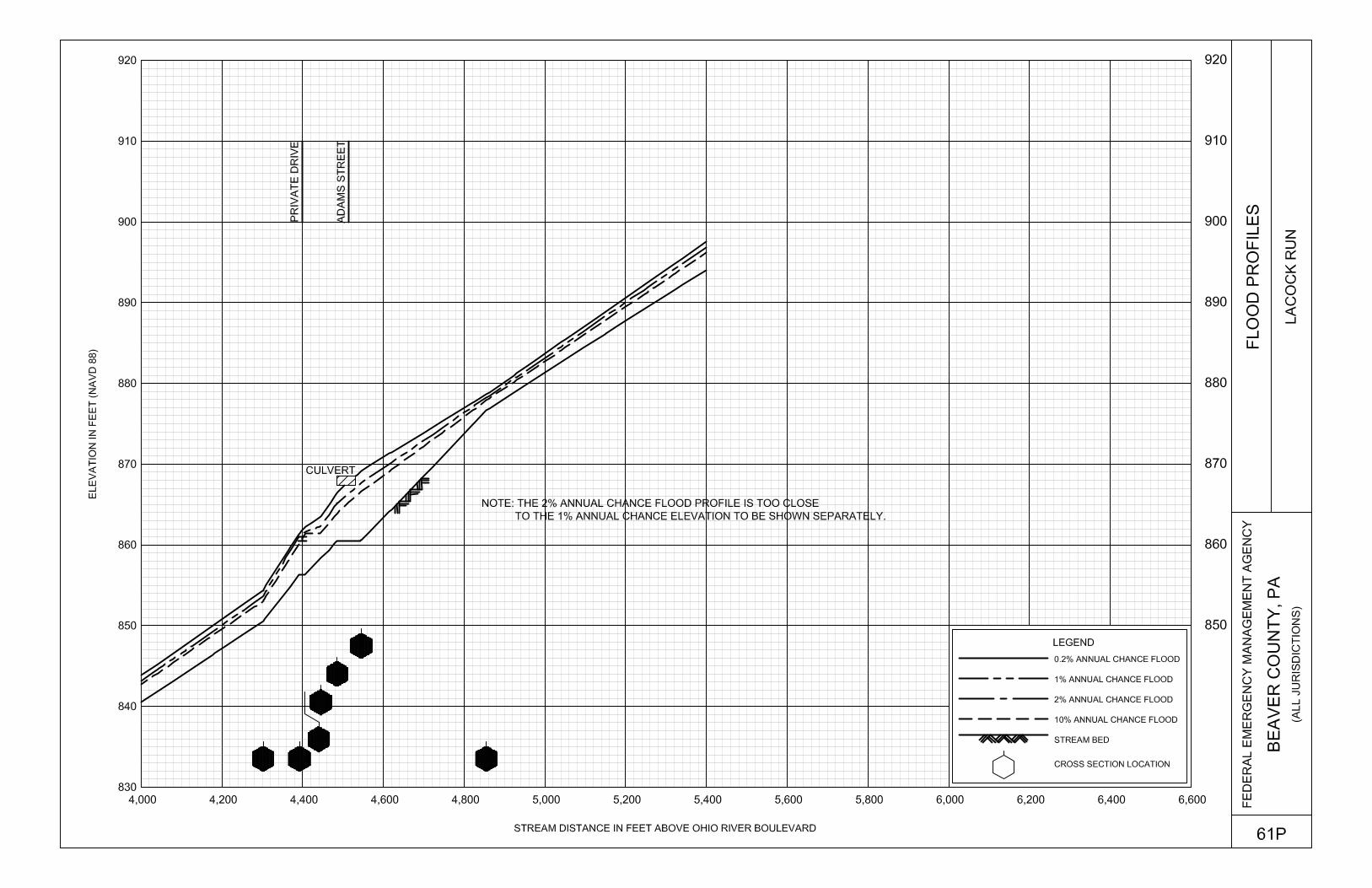
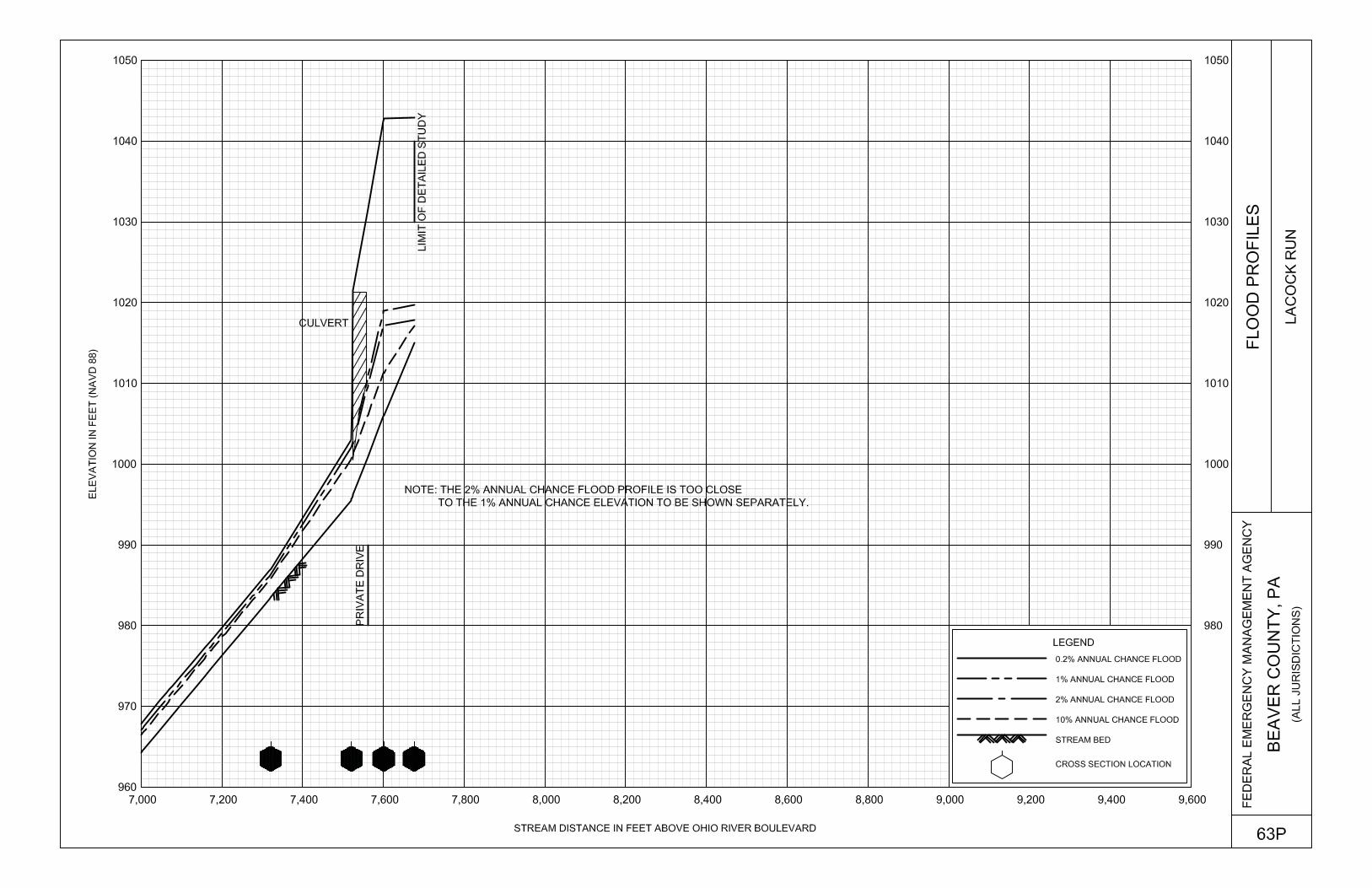
Beaver River Panels 001P-011P Big Sewickley Creek Panels 012P-017P Big Sewickley Creek Tributary 1 Panels 018P-020P Big Sewickley Creek Tributary 2 Panel 021P Blockhouse Run Panels 022P-024P Blockhouse Run Tributary 1 Panels 025P-028P Blockhouse Run Tributary 2 Panels 029P-031P Brady Run Panels 032P-033P Brush Creek Panels 034P-040P Connoquenessing Creek Panels 041P-052P Dutchman Run Panels 053P-054P Elkhorn Run Panels 055P-058P Elkhorn Run Tributary 1 Panel 059P Lacock Run Panels 060P-063P
iii
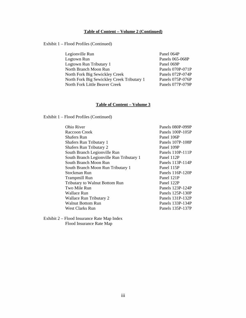
Table of Content – Volume 2 (Continued)
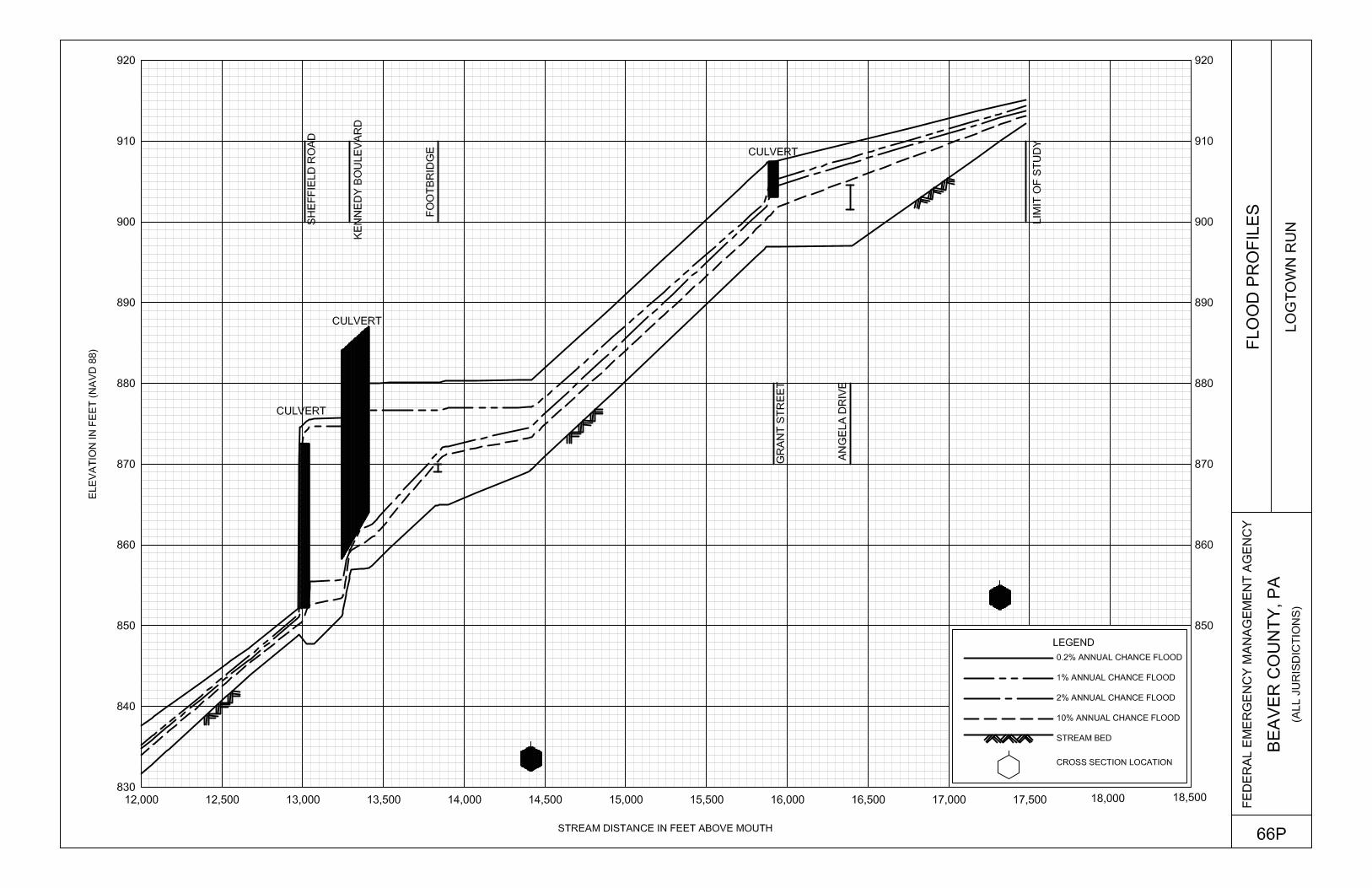
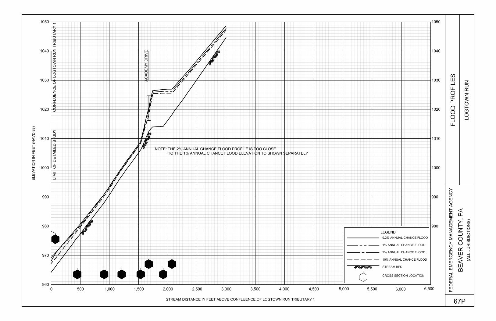
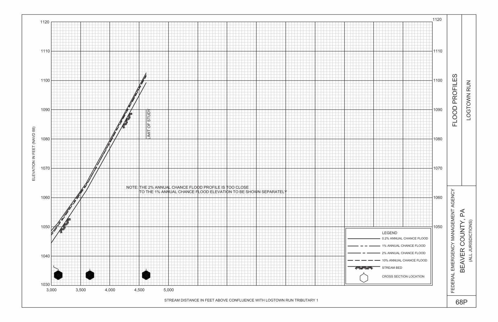
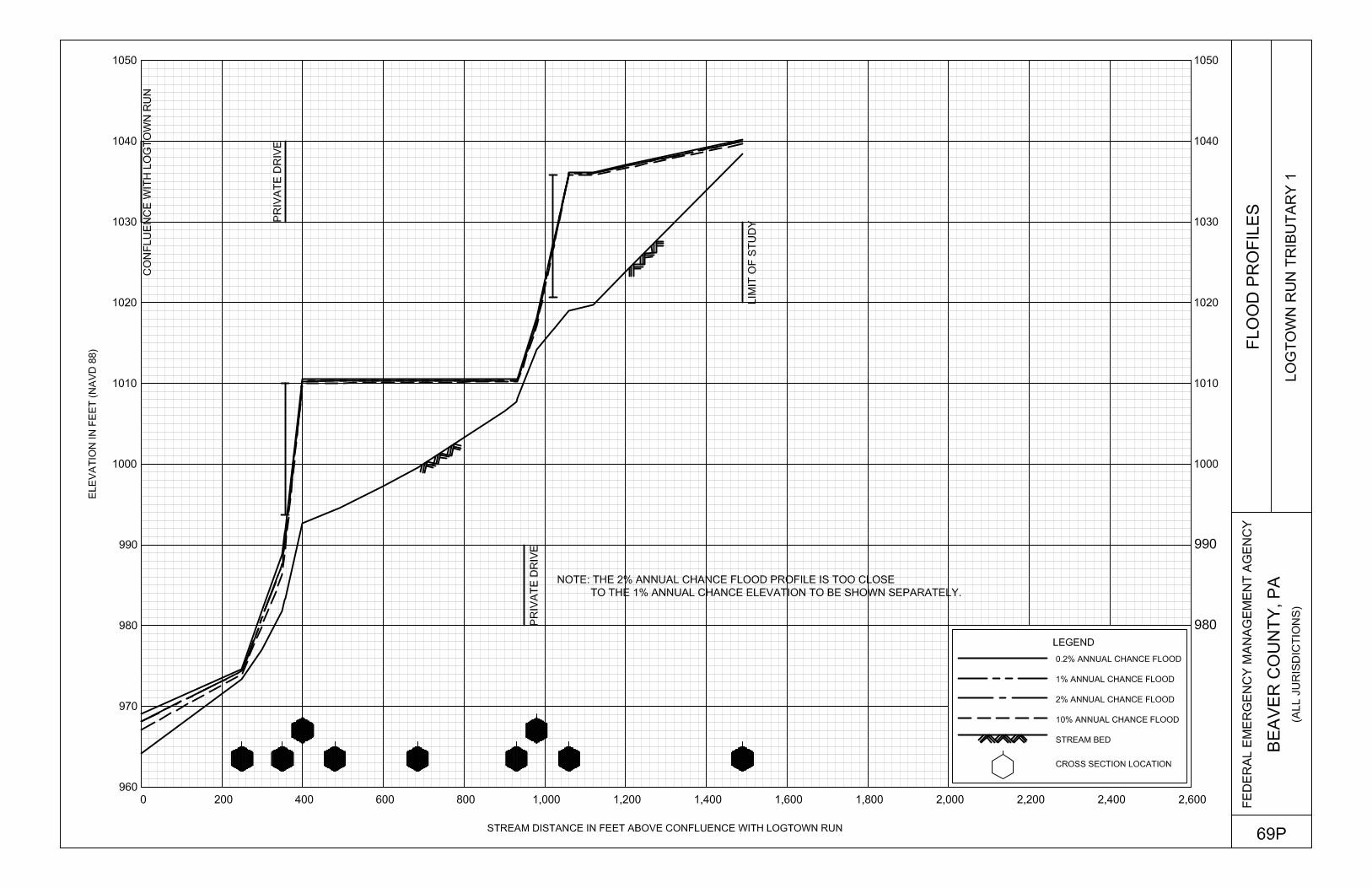
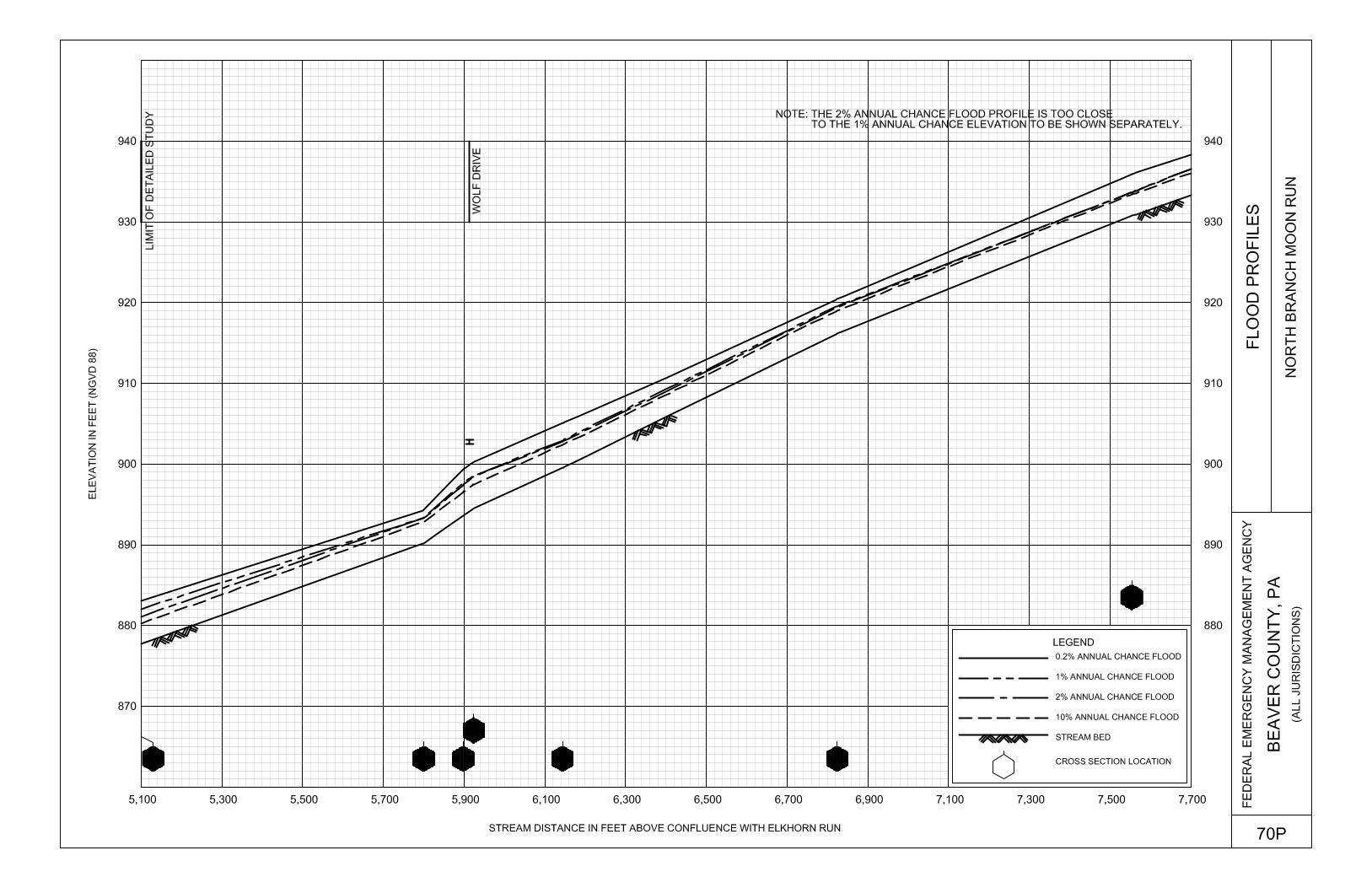
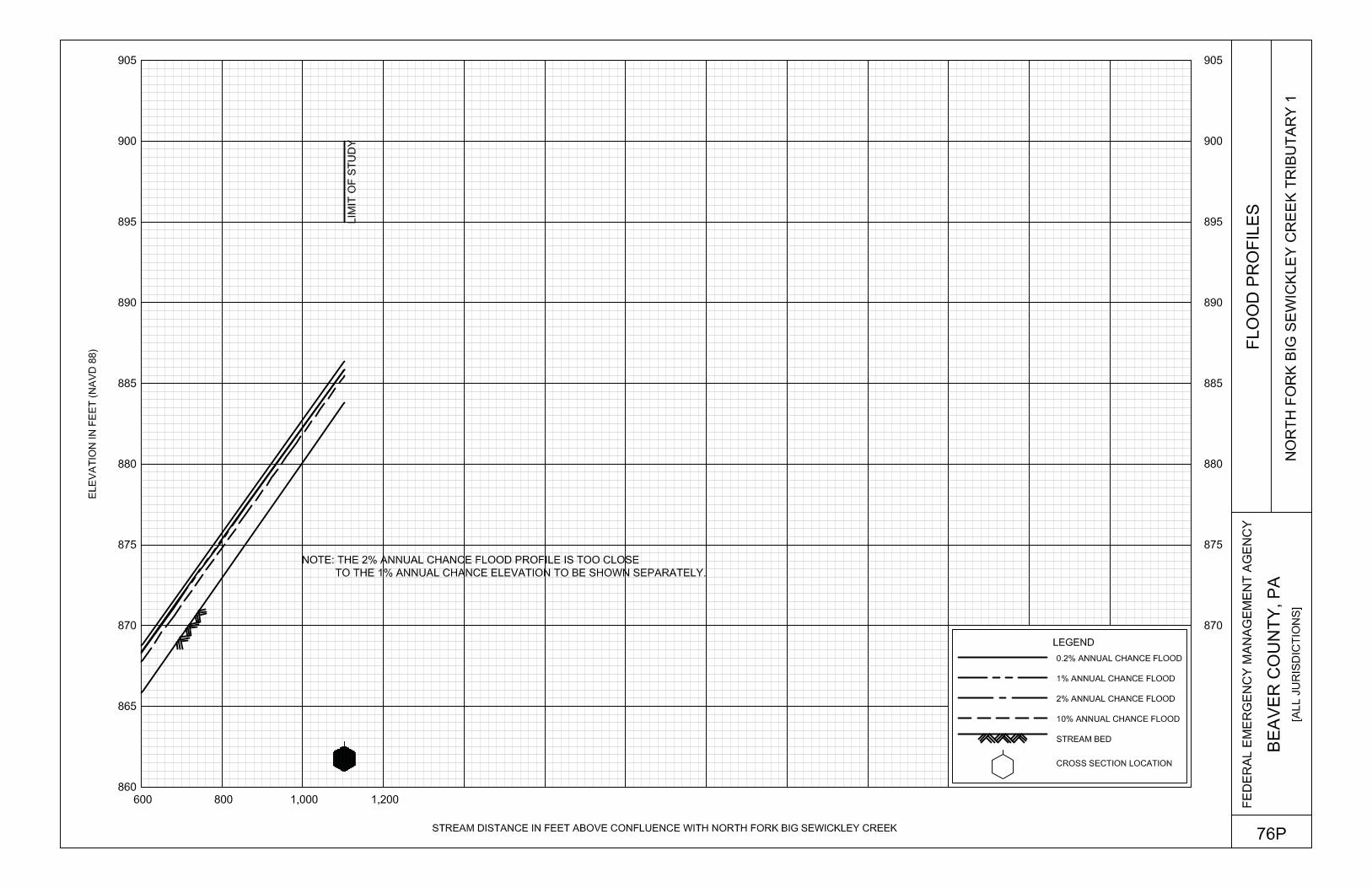
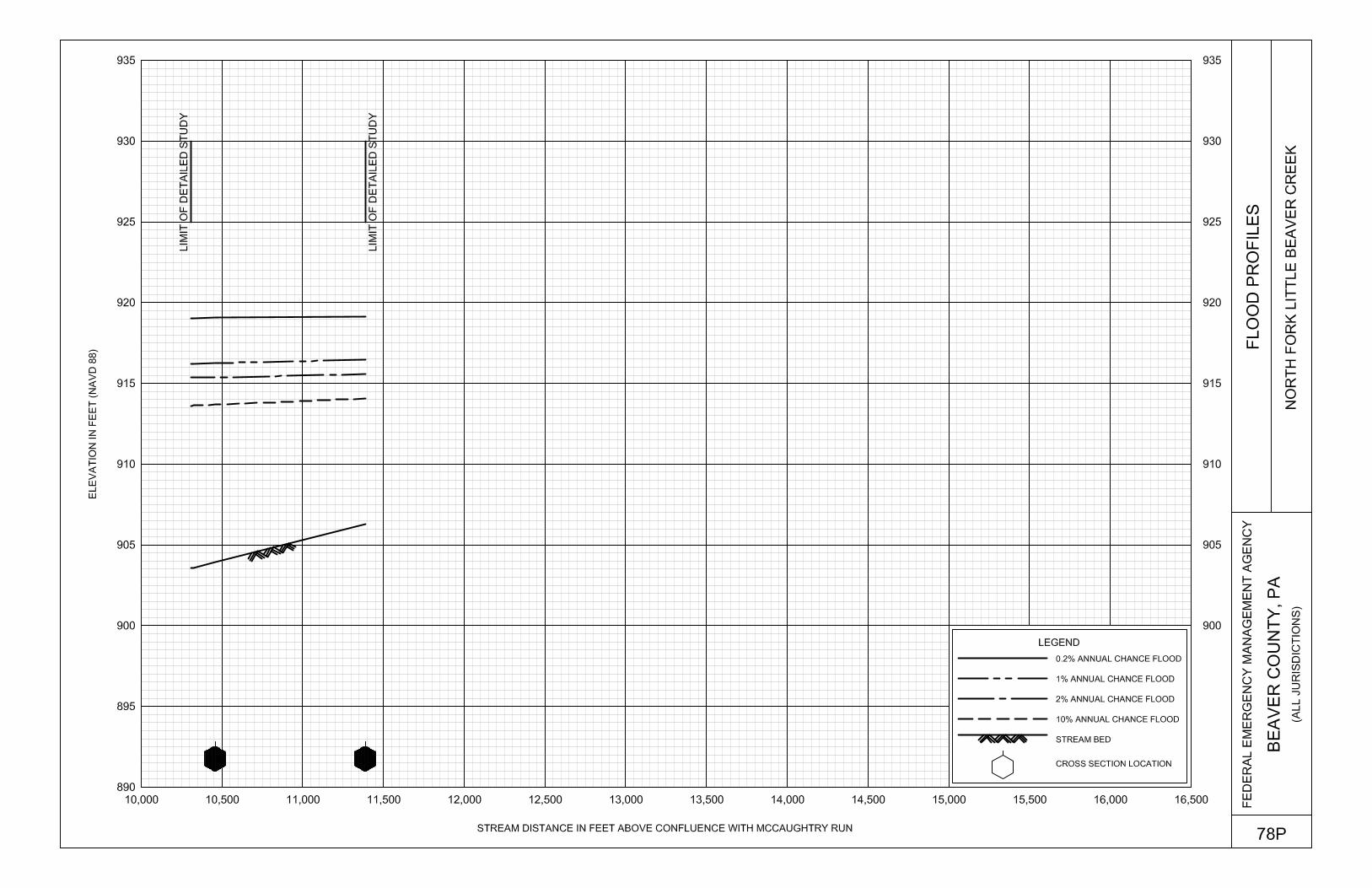
Exhibit 1 – Flood Profiles (Continued) Legionville Run Panel 064P Logtown Run Panels 065-068P Logtown Run Tributary 1 Panel 069P North Branch Moon Run Panels 070P-071P North Fork Big Sewickley Creek Panels 072P-074P North Fork Big Sewickley Creek Tributary 1 Panels 075P-076P North Fork Little Beaver Creek Panels 077P-079P
Table of Content – Volume 3
Exhibit 1 – Flood Profiles (Continued)
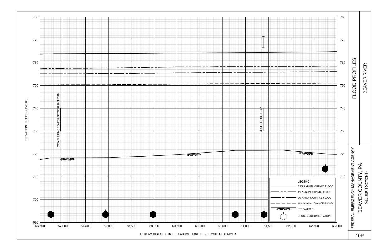
Ohio River Panels 080P-099P Raccoon Creek Panels 100P-105P Shafers Run Panel 106P Shafers Run Tributary 1 Panels 107P-108P Shafers Run Tributary 2 Panel 109P South Branch Legionville Run Panels 110P-111P South Branch Legionville Run Tributary 1 Panel 112P South Branch Moon Run Panels 113P-114P South Branch Moon Run Tributary 1 Panel 115P Stockman Run Panels 116P-120P Trampmill Run Panel 121P Tributary to Walnut Bottom Run Panel 122P Two Mile Run Panels 123P-124P Wallace Run Panels 125P-130P Wallace Run Tributary 2 Panels 131P-132P Walnut Bottom Run Panels 133P-134P West Clarks Run Panels 135P-137P
Exhibit 2 – Flood Insurance Rate Map Index
Flood Insurance Rate Map

92
7.0 OTHER STUDIES
This FIS report either supersedes or is compatible with all previous studies published on streams studied in this report and should be considered authoritative for the purposes of the NFIP.
8.0 LOCATION OF DATA
Information concerning the pertinent data used in preparation of this study can be obtained by contacting FEMA, Federal Insurance and Mitigation Division, One Independence Mall, Sixth Floor, 615 Chestnut Street, Philadelphia, Pennsylvania 19106-4404.
9.0 BIBLIOGRAPHY AND REFERENCES
1. Federal Emergency Management Agency, Federal Insurance Administration, Flood Insurance Study, City of Aliquippa, Beaver County, Pennsylvania, Washington, D.C., August 1979.
2. Federal Emergency Management Agency, Federal Insurance Administration, Flood Insurance Study, Borough of Ambridge, Beaver County, Pennsylvania, Washington, D.C., August 1979.
3. U.S. Department of Housing and Urban Development, Federal Insurance Administration, Flood Insurance Study, Borough of Baden, Beaver County, Pennsylvania, Washington, D.C., March 1979.
4. U.S. Department of Housing and Urban Development, Federal Insurance Administration, Flood Insurance Study, Borough of Beaver, Beaver County, Pennsylvania, Washington, D.C., March 1979.
5. Federal Emergency Management Agency, Flood Insurance Study, City of Beaver Falls, Beaver County, Pennsylvania, Washington, D.C., November 17, 1981.
6. Federal Emergency Management Agency, Flood Insurance Study, Borough of Big Beaver, Beaver County, Pennsylvania, Washington, D.C., November 17, 1981.
7. Federal Emergency Management Agency, Federal Insurance Administration, Flood Insurance Study, Borough of Bridgewater, Beaver County, Pennsylvania, Washington, D.C., November 1979.
8. Federal Emergency Management Agency, Federal Insurance Administration, Flood Insurance Study, Township of Center, Beaver County, Pennsylvania, Washington, D.C., December 15, 1980.
9. Federal Emergency Management Agency, Flood Insurance Study, Borough of Conway, Beaver County, Pennsylvania, Washington, D.C., November 4, 1988.
10. Federal Emergency Management Agency, Flood Insurance Study, Township of Daugherty, Beaver County, Pennsylvania, Washington, D.C., December 1, 1981.
11. Federal Emergency Management Agency, Federal Insurance Administration, Flood Insurance Study, Borough of East Rochester, Beaver County, Pennsylvania, Washington, D.C., January 16, 1981.
12. Federal Emergency Management Agency, Federal Insurance Administration, Flood Insurance Study, Borough of Eastvale, Beaver County, Pennsylvania, Washington, D.C., October 15, 1980.
93
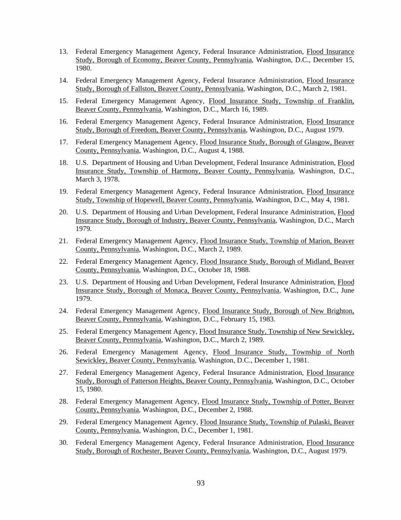
13. Federal Emergency Management Agency, Federal Insurance Administration, Flood Insurance Study, Borough of Economy, Beaver County, Pennsylvania, Washington, D.C., December 15, 1980.
14. Federal Emergency Management Agency, Federal Insurance Administration, Flood Insurance Study, Borough of Fallston, Beaver County, Pennsylvania, Washington, D.C., March 2, 1981.
15. Federal Emergency Management Agency, Flood Insurance Study, Township of Franklin, Beaver County, Pennsylvania, Washington, D.C., March 16, 1989.
16. Federal Emergency Management Agency, Federal Insurance Administration, Flood Insurance Study, Borough of Freedom, Beaver County, Pennsylvania, Washington, D.C., August 1979.
17. Federal Emergency Management Agency, Flood Insurance Study, Borough of Glasgow, Beaver County, Pennsylvania, Washington, D.C., August 4, 1988.
18. U.S. Department of Housing and Urban Development, Federal Insurance Administration, Flood Insurance Study, Township of Harmony, Beaver County, Pennsylvania, Washington, D.C., March 3, 1978.
19. Federal Emergency Management Agency, Federal Insurance Administration, Flood Insurance Study, Township of Hopewell, Beaver County, Pennsylvania, Washington, D.C., May 4, 1981.
20. U.S. Department of Housing and Urban Development, Federal Insurance Administration, Flood Insurance Study, Borough of Industry, Beaver County, Pennsylvania, Washington, D.C., March 1979.
21. Federal Emergency Management Agency, Flood Insurance Study, Township of Marion, Beaver County, Pennsylvania, Washington, D.C., March 2, 1989.
22. Federal Emergency Management Agency, Flood Insurance Study, Borough of Midland, Beaver County, Pennsylvania, Washington, D.C., October 18, 1988.
23. U.S. Department of Housing and Urban Development, Federal Insurance Administration, Flood Insurance Study, Borough of Monaca, Beaver County, Pennsylvania, Washington, D.C., June 1979.
24. Federal Emergency Management Agency, Flood Insurance Study, Borough of New Brighton, Beaver County, Pennsylvania, Washington, D.C., February 15, 1983.
25. Federal Emergency Management Agency, Flood Insurance Study, Township of New Sewickley, Beaver County, Pennsylvania, Washington, D.C., March 2, 1989.
26. Federal Emergency Management Agency, Flood Insurance Study, Township of North Sewickley, Beaver County, Pennsylvania, Washington, D.C., December 1, 1981.
27. Federal Emergency Management Agency, Federal Insurance Administration, Flood Insurance Study, Borough of Patterson Heights, Beaver County, Pennsylvania, Washington, D.C., October 15, 1980.
28. Federal Emergency Management Agency, Flood Insurance Study, Township of Potter, Beaver County, Pennsylvania, Washington, D.C., December 2, 1988.
29. Federal Emergency Management Agency, Flood Insurance Study, Township of Pulaski, Beaver County, Pennsylvania, Washington, D.C., December 1, 1981.
30. Federal Emergency Management Agency, Federal Insurance Administration, Flood Insurance Study, Borough of Rochester, Beaver County, Pennsylvania, Washington, D.C., August 1979.
94
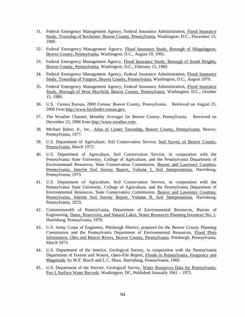
31. Federal Emergency Management Agency, Federal Insurance Administration, Flood Insurance Study, Township of Rochester, Beaver County, Pennsylvania, Washington, D.C., December 15, 1980.
32. Federal Emergency Management Agency, Flood Insurance Study, Borough of Shippingport, Beaver County, Pennsylvania, Washington, D.C., August 19, 1991.
33. Federal Emergency Management Agency, Flood Insurance Study, Borough of South Heights, Beaver County, Pennsylvania, Washington, D.C., February 15, 1983.
34. Federal Emergency Management Agency, Federal Insurance Administration, Flood Insurance Study, Township of Vanport, Beaver County, Pennsylvania, Washington, D.C., August 1979.
35. Federal Emergency Management Agency, Federal Insurance Administration, Flood Insurance Study, Borough of West Mayfield, Beaver County, Pennsylvania, Washington, D.C., October 15, 1980.
36. U.S. Census Bureau, 2000 Census: Beaver County, Pennsylvania. Retrieved on August 23, 2006 from http://www.factfinder.census.gov.
37. The Weather Channel, Monthly Averages for Beaver County, Pennsylvania. Retrieved on December 22, 2006 from http://www.weather.com.
38. Michael Baker, Jr., Inc., Atlas of Center Township, Beaver County, Pennsylvania, Beaver, Pennsylvania, 1977.
39. U.S. Department of Agriculture, Soil Conservation Service, Soil Survey of Beaver County, Pennsylvania, March 1973.
40. U.S. Department of Agriculture, Soil Conservation Service, in cooperation with the Pennsylvania State University, College of Agriculture, and the Pennsylvania Department of Environmental Resources, State Conservation Commission, Beaver and Lawrence Counties, Pennsylvania, Interim Soil Survey Report, Volume I, Soil Interpretations, Harrisburg, Pennsylvania, 1973.
41. U.S. Department of Agriculture, Soil Conservation Service, in cooperation with the Pennsylvania State University, College of Agriculture, and the Pennsylvania Department of Environmental Resources, State Conservation Commission, Beaver and Lawrence Counties, Pennsylvania, Interim Soil Survey Report, Volume II, Soil Interpretations, Harrisburg, Pennsylvania, 1973.
42. Commonwealth of Pennsylvania, Department of Environmental Resources, Bureau of Engineering, Dams, Reservoirs, and Natural Lakes, Water Resources Planning Inventory No. 1, Harrisburg, Pennsylvania, 1970.
43. U.S. Army Corps of Engineers, Pittsburgh District, prepared for the Beaver County Planning Commission and the Pennsylvania Department of Environmental Resources, Flood Plain Information, Ohio and Beaver Rivers, Beaver County, Pennsylvania, Pittsburgh, Pennsylvania, March 1973.
44. U.S. Department of the Interior, Geological Survey, in cooperation with the Pennsylvania Department of Forests and Waters, Open-File Report, Floods in Pennsylvania, Frequency and Magnitude, by W.F. Busch and L.C. Shaw, Harrisburg, Pennsylvania, 1960.
45. U.S. Department of the Interior, Geological Survey, Water Resources Data for Pennsylvania, Part I, Surface Water Records, Washington, DC, Published Annually 1961 – 1975.

95
46. Commonwealth of Pennsylvania, Department of Environmental Resources, Bulletin No. 9, Hydrologic Data of the June 1972 Flood in Pennsylvania, Harrisburg, Pennsylvania, August 1974.
47. U.S. Army Corps of Engineers, Office of Appalachian Studies, Development of Water Resources in Appalachia, Main Report, Part II, Shaping a Plan, Chapter II, Water Sub-Region I Today,” Cincinnati, Ohio, 1969.
48. Water Resources Council, “Guidelines for Determining Flood Flow Frequency,” Bulletin 17, Washington, D.C., March 1976.
49. Water Resources Council, “Guidelines for Determining Flood Flow Frequency,” Bulletin 17A, Washington, D.C., June 1977.
50. U.S. Army Corps of Engineers, Pittsburgh District, “Methodology to Determine Ungaged Stream Flow Frequencies,” (Unpublished); correspondence with Edwin W. Thomas, Pittsburgh, Pennsylvania, September 26, 1978.
51. B.M. Reich, et. Al., Flood Peak Frequency Design Manual, PSU III, The Pennsylvania State University, State College, Pennsylvania, 1971.
52. U.S. Department of the Interior, Geological Survey, Water Supply Paper 1675, Magnitude and Frequency of Floods in the United States, Part 3-A, Ohio River Basin Except Cumberland and Tennessee River Basins, 1965.
53. U.S. Department of Agriculture, Soil Conservation Service, Technical Release No. 55, Urban Hydrology for Small Watersheds, Washington, D.C., January 1975.
54. U.S. Department of Housing and Urban Development, Flood Insurance Administration, Flood Hazard Boundary Map, Borough of New Brighton, Beaver County, Pennsylvania, Revised June 18, 1976.
55. U.S. Department of the Interior, Geological Survey, Map of Flood-prone Areas, Scale 1:24,000, Contour Interval 20 feet: Beaver Falls, Pennsylvania, 1957, Photorevised 1969, 1975.
56. U.S. Department of the Interior, Geological Survey, Office of Water Data Collection, Interagency Advisory Committee on Water Data, “Guidelines for Determining Flood Flow Frequency,” Bulletin 17B, Reston, Virginia, Revised September 1981.
57. Commonwealth of Pennsylvania, Department of Environmental Resources, in cooperation with the U.S. Geological Survey, Water Resources Bulletin No. 13, Floods in Pennsylvania, A Manual for Estimation of their Magnitude and Frequency, by Herbert J. Flippo, Jr., Harrisburg, Pennsylvania, October 1977.
58. Leo R. Beard, Statistical Methods in Hydrology, Sacramento, California, U.S. Army Corps of Engineers, January 1962.
59. U.S. Army Corps of Engineers, Pittsburgh District, Stream Data for the Ohio River, Pittsburgh, Pennsylvania, (Unpublished).
60. Eastern Mapping Company of Pittsburgh, Pennsylvania, Aerial Photogrammetric Mapping, Scale 1:2,400, Contour Interval 4 Feet: Beaver County, Pennsylvania, December 19, 1978.
61. Eastern Mapping, Inc., of Blawnox, Pennsylvania, Aerial Photographs for Beaver River, Stockman Run, Wallace Run, North Fork Little Beaver Creek, West Clarks Run, and Tributary to Wallace Run, Scale 1:2,400, Contour Interval 4 Feet (Unpublished).
62. Eastern Mapping of Pittsburgh, Pennsylvania, Aerial Contour Maps, Scale 1”=200’, Contour Interval 4 Feet: Flightline 17, Beaver River, Pennsylvania, 1979.

96
63. Eastern Mapping of Pittsburgh, Pennsylvania, Topographic Maps, Scale 1:2,400, Contour Interval 4 Feet: Borough of Eastvale, Beaver County, Pennsylvania, December 19, 1978.
64. Eastern Mapping, Inc., of Blawnox, Pennsylvania, Topographic Maps for the Beaver River, Connoquenessing Creek, and Brush Creek, Scale 1:2,400, Contour Interval 4 Feet (Unpublished).
65. Eastern Mapping of Pittsburgh, Pennsylvania, Topographic Maps compiled from aerial photographs, Scale 1:2,400, Contour Interval 4 Feet: Beaver River, Borough of Patterson Heights, Beaver County, Pennsylvania, November 1, 1979.
66. Eastern Mapping of Pittsburgh, Pennsylvania, Topographic Maps compiled from photogrammetric methods, Scale 1:2,400, Contour Interval 4 Feet: Beaver River, Township of Rochester, Beaver County, Pennsylvania, 1973.
67. Eastern Mapping of Pittsburgh, Pennsylvania, Topographic Maps, Scale 1:2,400, Contour Interval 4 Feet, Borough of Economy, Beaver County, Pennsylvania, 1978.
68. Eastern Mapping of Pittsburgh, Pennsylvania, Contour Maps, Scale 1:2,400, Contour Interval 4 Feet: Township of Center, Beaver County, Pennsylvania, December 1978.
69. U.S. Army Corps of Engineers, Pittsburgh District, Ohio River Topography, Pittsburgh, Pennsylvania, July 1968.
70. U.S. Army Corps of Engineers, Pittsburgh District, Topographic Maps, Scale 1:7,200, Contour Interval 5 Feet: Ohio River, July 1966.
71. U.S. Army Corps of Engineers, Pittsburgh District, Topographic Maps, Scale 1:2,400, Contour Interval 4 and 5 Feet: Ohio River, Pittsburgh to Mile 30.4, Pittsburgh, Pennsylvania, 1960.
72. U.S. Army Corps of Engineers, Pittsburgh District, Topographic Maps, Scale 1:2,400, Contour Interval \ 5 Feet: Ohio River, Pittsburgh to Mile 30.9, Pittsburgh, Pennsylvania, March 1964, Updated September 1968.
73. U.S. Army Corps of Engineers, Topographic Maps, July 1966, July 1968.
74. U.S. Army Corps of Engineers, Hydrologic Engineering Center, HEC-2 Water-Surface Profiles, Users Manual, Davis, California, November 1976.
75. U.S. Army Corps of Engineers, Topographic Maps: Lake Erie-Ohio River Canal, Pittsburgh, Pennsylvania, December 1964.
76. U.S. Army Corps of Engineers, Hydrologic Engineering Center, HEC-2 Water-Surface Profiles, Generalized Computer Program, Davis, California, 1973, Updated 1976, 1979, and 1984.
77. U.S. Department of Housing and Urban Development, Flood Insurance Administration, Flood Insurance Study, Township of Leet, Allegheny County, Pennsylvania, Washington, D.C., September 14, 1979.
78. U.S. Army Corps of Engineers, Pittsburgh District, “District Stream Data, Flood Insurance Studies,” (Unpublished). Correspondence with Edwin W. Thomas, Pittsburgh, Pennsylvania, February 1979.
79. U.S. Army Corps of Engineers, Hydrologic Engineering Center, HEC-2 Water Surface Profiles, Computer Program 723-X6-L202A, Davis, California, November 1976.
80. U.S. Department of Commerce, Bureau of Public Roads, Hydraulic Design Series No. 3, Design Charts for Open-Channel Flow, Washington, D.C., August 1961.

97
81. Eastern Mapping of Pittsburgh, Pennsylvania, Topographic Maps compiled from aerial photographs, Scale 1:2,400, Contour Interval 4 Feet, Beaver River and Brady’s Run, Borough of Fallston, Beaver County, Pennsylvania, November 1, 1979.
82. U.S. Department of the Interior, Geological Survey, 7.5-Minute Series Topographic Maps, Scale 1:24,000, Contour Interval 20 Feet: Aliquippa, Pennsylvania, 1969; Ambridge, Pennsylvania, 1960, Photorevised 1969; Baden, Pennsylvania, 1953, Photorevised 1969, Photoinspected, 1979; Beaver, Pennsylvania, 1953, Photorevised 1969, Photoinspected, 1979; Beaver Falls, Pennsylvania, 1957, Photorevised 1969; Conway, Pennsylvania, 1953, Photorevised 1969; Midland, Pennsylvania, 1954, Photorevised 1969 and 1979; New Galilee, Pennsylvania, 1957, Photorevised 1969, Zelienople, Pennsylvania, 1958, Photorevised 1969, Photoinspected 1977.
83. U.S. Army Corps of Engineers, Pittsburgh District, Ohio River, Mile 30.9 to Mile 53.7 Topography, Scale 1:2,400, Contour Interval 5 Feet: Pittsburgh, Pennsylvania, March 1961, Updated September 1968.
84. U.S. Department of the Interior, Geological Survey, 7.5-Minute Topographic Maps, Scale 1:4,800, Contour Interval 10 Feet: Beaver, Pennsylvania, 1969.
85. U.S. Department of the Interior, Geological Survey, Scientific Investigations Report 2008-5102, Regression Equations for Estimating Flood Flows at Selected Recurrence Intervals for Ungaged Streams in Pennsylvania, by Mark A. Roland and Marla H. Stuckey, Reston, Virginia, 2008.
86. U.S. Army Corps of Engineers, Hydrologic Engineering Center, HEC-RAS River Analysis System, Version 4.0, Davis, California, March 2008.