Embed Size (px)
Citation preview

BEARE PARK KINGS CROSS ROTARY PARK ELIZABETH BAY Plan of Management and Landscape Master Plan
Final – March 2006


BEARE PARK KINGS CROSS ROTARY PARK Plan of Management and Landscape Master Plan
Table of amendments Issue A: 15/09/2004 Preliminary issue to Council for comment. Issue B: 11/10/2005 Draft Issue to Council for review Issue C: 22/11/2005 Revised draft issued to Council for review Issue D: 23/02/2006 Final Report issued to Council for review Issue E: 03/03/2006 Final Report issued for adoption Prepared by
Suite 91, 330 Wattle Street ULTIMO NSW 2007 Tel (02) 9211 3744 Fax (02) 9211 9449 Email: [email protected]
In association with
Suite 305, 27-39 Abercrombie Street CHIPPENDALE NSW 2008 Tel (02) 9698 5933 Fax (02) 9698 5944 Email: [email protected]


Final Report Beare Park and Kings Cross Rotary Park Issue E - 03/03/06 Plan of Management
Guy Sturt & Associates Pty Ltd Page i Phillips Marler
CONTENTS
1.0 EXECUTIVE SUMMARY 1 1.1 Background 1
1.1.1 What is a Plan of Management? 1 1.1.2 Why prepare a Plan of Management for Beare Park? 1 1.1.3 Objectives of the Plan of Management 1 1.1.4 The Master Plan 3
1.2 Land to which this Plan of Management applies 3 1.3 Study area at a glance 3
1.3.1 Ownership 5 1.4 Classification and categorisation 7 1.5 Description of the Study Area and Permissible Activities 7
1.5.1 Zoning and Land Use 7 1.5.2 Leases and licences 9 1.5.3 Easement 9 1.5.4 Park Hire 9
1.6 Study Process 12 1.7 Plan of Management structure 12 1.8 Background Information 12
2.0 DESCRIPTION OF THE PARK 13 2.1 Location & Context 13
2.1.1 Open Space in the locality 13 2.2 History 14
2.2.1 Site Heritage 14 2.2.2 Aboriginal Heritage 14 2.2.3 Brief History of the Parks 15 2.2.4 Inventory of Heritage Items 18 2.2.5 Cultural Significance 20 2.2.6 Heritage Listing 20
2.3 Current use of the park 22 2.3.1 Dog Walkers 22
2.4 Physical description 22 2.4.1 Current facilities and condition 23 2.4.2 Access, circulation and parking 23
3.0 BASIS FOR MANAGEMENT 29 3.1 Core objectives outlined in the Local Government Act 1993 29 3.2 Objectives of The City of Sydney 29
3.2.1 Objectives for recreation and open space 29 3.3 Community values 30
3.3.1 Introduction 30 3.3.2 Open Space Values of the Community 30 3.3.3 Community Values for Beare Park and Kings Cross Rotary
Park 31 3.4 Objectives and Outcomes 32
3.4.1 Objectives and desired outcomes of the community 32 3.4.2 Suggested future uses and improvements for the parks 33
3.5 Roles of Open Space 33 3.5.1 Roles of the Parks 33
3.6 Vision Statement 34 3.7 Management Objectives 34
4.0 MANAGEMENT STRATEGIES 35 4.1 Management issues and strategies 35 4.2 Strategies for implementation 35 4.3 Landscape Master Plan 37
4.3.1 Landscape Master Plan 37 4.3.2 Master Plan Elements 37

Beare Park and Kings Cross Rotary Park Final Report Plan of Management Issue E – 03/03/06
Page ii Guy Sturt & Associates Pty Ltd Phillips Marler
4.3.3 Environmentally Sustainable Design Initiatives 41
4.4 Action Plan and Tables 43 4.4.1 Action Tables 43
4.5 Action Plan 44
5.0 IMPLEMENTATION AND REVIEW 49 5.1 Future use and development 49
5.1.1 Community land 49 5.1.2 Road Reserve – Closure of Ithaca Road 50
5.2 Leases and licences 50 5.2.1 What are leases, licences and other estates? 50 5.2.2 Existing leases, licences and other estates 50 5.2.3 Authorisation of future leases, licences and other estates 50 5.2.4 Casual Park Hire 51
5.3 Implementation 52 5.4 Review 52 5.5 Implementation Funding 52
6.0 PLANNING CONTEXT – LEGISLATION AND POLICIES 55 6.1 State government legislation 55
6.1.1 Local Government Act 1993 55 6.1.2 Sharing Sydney Harbour Access Plan - DIPNR 55 6.1.3 Sydney Regional Environmental Plan (Sydney Harbour
Catchment) 2005 56 6.1.4 Sydney Harbour Foreshores & Waterways Area DCP for
SREP (Sydney Harbour Catchment) 2005 58 6.1.5 Roads Act 1993 59 6.1.6 NSW Maritime Authority 59
6.2 Local planning context 59 6.2.1 The South Sydney Plan 59 6.2.2 South Sydney Council – Generic Open Space Plan of
Management 1993 61 6.3 Other Studies 61
6.3.1 Recreation and Open Space Needs Study 2004 61 6.3.2 The community of the City of Sydney 61 6.3.3 Census Data (2001) 61 6.3.4 Recreation patterns of residents 62 6.3.5 Recreation needs of the residents 62 6.3.6 South Sydney Section 94 Contributions Plan 1998 62
7.0 BIBLIOGRAPHY 63

Final Report Beare Park and Kings Cross Rotary Park Issue E - 03/03/06 Plan of Management
Guy Sturt & Associates Pty Ltd Page iii Phillips Marler
LIST OF FIGURES
Figure 1.1 Location Map 2
Figure 1.2 Legal Boundaries & Categorisation 4
Figure 1.3 Site Boundary changes 6
Figure 1.4 Zoning Plan 10
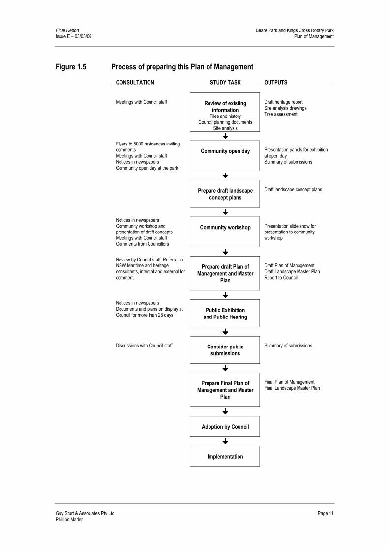
Figure 1.5 Process of preparing this Plan of Management 11
Figure 2.1 Open space in the locality 13
Figure 2.2 Beare Park and the original Elizabeth Bay Estate 16
Figure 2.3 Land acquisition 17
Figure 2.4 Heritage Inventory Images 21
Figure 2.5 Site Facilities Images 25
Figure 2.6 Site Facilities 26
Figure 2.7 Access and Circulation 27
Figure 4.1 Improvements to the Promenade 39
Figure 4.2 Tennis Court Gardens 40
Figure 4.3 Improvements to Amenities Block 41
Figure 4.4 Landscape Master Plan 42
Figure 6.1 Access Improvements 57
Figure 6.2 Foreshore Zoning Map 60

Beare Park and Kings Cross Rotary Park Final Report Plan of Management Issue E – 03/03/06
Page iv Guy Sturt & Associates Pty Ltd Phillips Marler
LIST OF TABLES
Table 1.1 Legal Description 5
Table 1.2 Structure of this Plan of Management 12
Table 2.1 Significant tree & palm species 23
Table 2.2 Facilities condition and use 24
Table 3.1 Community values for the Parks 31
Table 3.2 Community objectives and desires 32
Table 3.3 Future uses 33
Table 3.4 Role of Open Space 33
Table 4.1 Management strategies to address issues 35
Table 4.2 Value: Environmental Quality 44
Table 4.3 Value: Accessibility 45
Table 4.4 Value: Facilities and developments 46
Table 4.5 Value: Heritage 46
Table 4.6 Value: Social opportunities 47
Table 4.7 Value: Recreational opportunity 47
Table 4.8 Value: Safety and security 48
Table 5.1 Permitted uses in Beare Park and Kings Cross Rotary Park 49
Table 5.2 Master Plan Budget Estimate 53
Table 6.1 Requirements for Plans of Management under the Local Government Act 55
Table 6.2 Recreation Needs 62

Final Report Beare Park and Kings Cross Rotary Park Issue E – 03/03/06 Plan of Management
Guy Sturt & Associates Pty Ltd Page 1 Phillips Marler
1.0 EXECUTIVE SUMMARY
1.1 Background
1.1.1 What is a Plan of Management? A Plan of Management (POM) is a document that identifies issues affecting public open space, and outlines how that space is intended to be used, improved and managed. A POM typically is accompanied by a landscape master plan that shows proposed changes to that open space.
1.1.2 Why prepare a Plan of Management for Beare Park? Under the Local Government Act, 1993, the City of Sydney is required to prepare Plans of Management for its community land, including its parks and open spaces. Beare Park and Kings Cross Rotary Park are covered under South Sydney Councils Generic Plan of Management, however, it was felt that the parks required a specific Plan of Management. This POM for Beare Park and Kings Cross Rotary Park has been guided by, and prepared according to the requirements of the Local Government Act 1993. The Act provides Councils with a specific approach to the management of community land. Broadly, the objectives of the Act for community land categorised as park, are to: � encourage, promote and facilitate recreational, cultural, social and
educational pastimes and activities, and
� provide for passive recreational activities or pastimes and for the casual playing of games, and
� improve the land in such a way as to promote and facilitate its use to achieve the other core objectives for its management.
1.1.3 Objectives of the Plan of Management
The Plan of Management will “aim to guide Council’s upgrade and maintenance of these important open space assets and provide a basis for the effective day to day and long term decision making.” This POM aims to: � Establish a sound and balanced approached to the management of the parks
� Reflect the values and expectations of the community
� Meet all legislative requirements
� Be consistent with the City of Sydney Corporate plan and other plans and policies
� Support the conservation and interpretation of heritage values of the parks
� Present a master plan that illustrates action required to implement improvements to the parks.

Beare Park and Kings Cross Rotary Park Final Report Plan of Management Issue E – 03/03/06
Page 2 Guy Sturt & Associates Pty Ltd Phillips Marler
Figure 1.1 Location Map Source: Aerial photo supplied by City of Sydney

Final Report Beare Park and Kings Cross Rotary Park Issue E – 03/03/06 Plan of Management
Guy Sturt & Associates Pty Ltd Page 3 Phillips Marler
Through a process of analysis and consultation, further site specific objectives have been identified and addressed by this POM. These combined objectives guide the development of the Master Plan and future management of the parks. These objectives provide for a community space that fulfils future needs, with regard to: � Environmental quality
� Accessible facilities
� Suitable facilities and development
� Social opportunities
� Recreation opportunities
� Safety and security
1.1.4 The Master Plan
The Plan of Management incorporates a concept Master Plan (Figure 4.4), which responds to the principles and strategies developed through the preparation of this report. It addresses the key features of the parks, including: � Location on Sydney Harbour
� Heritage structures
� Archaeological potential
� Community owned land
Key Features of the Master Plan The Master Plan developed for the site, addresses community desires and concerns, and Councils vision to provides for the: � Integration of Beare Park and Kings Cross Rotary Park
� Enhancement of the Harbourside edge
� Development of an interpretative layer
� New plantings
� Minor infrastructure improvements
� Parking and access changes to Ithaca Road
1.2 Land to which this Plan of Management applies
This Plan of Management applies to Beare Park and Kings Cross Rotary Park (referred to as the Parks), in Elizabeth Bay, as shown in Figure 1.1. The Plan of Management also addresses the section of Ithaca Road, which currently separates the two parks and the interface with the adjacent Elizabeth Bay marina and waterfront.
1.3 Study area at a glance
Property and title information applying to Beare Park and Kings Cross Rotary Park is outlined in Table 1.1, with Figure 1.2 showing the location of lots making up the areas of the parks and their categorisation.

Beare Park and Kings Cross Rotary Park Final Report Plan of Management Issue E – 03/03/06
Page 4 Guy Sturt & Associates Pty Ltd Phillips Marler
Figure 1.2 Legal Boundaries & Categorisation Source: City of Sydney

Final Report Beare Park and Kings Cross Rotary Park Issue E – 03/03/06 Plan of Management
Guy Sturt & Associates Pty Ltd Page 5 Phillips Marler
Table 1.1 Legal Description
Address Ithaca Road, Elizabeth Bay Title information Lot 1 DP 136079 (Beare Park)
Lot A DP 88740 (Beare Park) Lot B DP 88740 (Beare Park) Lot 1 DP 439442 (Beare Park) Lot 1 DP 79117 (Kings Cross Rotary Park) Lot 3 DP 68974 (Kings Cross Rotary Park) Lot 4 DP 68974 (Kings Cross Rotary Park)
Ownership Council of the City of Sydney
Care, Control and Management
City of Sydney
Location Parish of Alexandria, County of Cumberland City of Sydney Ithaca Road, Esplanade, Port Jackson (Elizabeth Bay)
Total area Beare Park – 4534m2 Kings Cross Rotary Park – 1655m2 Road Reserve (Ithaca Road, north of Esplanade) – 730m2 Total Area – 6919m2
Zoning Beare Park – 6(a) Local Recreation Zone Kings Cross Rotary Park - 6(a) Local Recreation Zone Ithaca Road, Road Reserve – Road
Classification Beare Park – Community land Kings Cross Rotary Park - Community land
Categorisation Beare Park – Park Kings Cross Rotary Park - Park
Assets and condition Seawall – poor condition; Benches – reasonable condition Amenities block – fair condition Fountains – fair condition Sculpture – good condition Pathways – fair to good condition
Existing uses Walking, picnics, social gatherings, sitting, relaxing. Leases and Licences Lot 3 in DP68974 leased to Sydney Water until 31 May 2019. Caveats and easements
There is an easement granted to Sydney Water over part of lot 3 DP 68974, lot 4 DP 68974 and part of lot 1 DP 79117.
1.3.1 Ownership Initially a small park, Beare Park was first established in 1901 with a deed of conveyance from James William Macarthur Onslow to the Municipal Council of Sydney. Acquisitions of private land to the east in 1949 and to the west of Ithaca Road in 1980 have expanded the Parks to their present size. Figure 1.3 shows the changing boundaries of the parks. Due to changes to local government boundaries, the parks have been variously part of the Municipality of the Council of Sydney, South Sydney City Council and most recently the City of Sydney. The parks current ownership, as part of the City of Sydney came about when the boundaries between South Sydney City Council LGA and the City of Sydney were revised by the State Government in May 2003.

Beare Park and Kings Cross Rotary Park Final Report Plan of Management Issue E – 03/03/06
Page 6 Guy Sturt & Associates Pty Ltd Phillips Marler
Figure 1.3 Site Boundary changes Source: Aerial photo supplied by City of Sydney

Final Report Beare Park and Kings Cross Rotary Park Issue E – 03/03/06 Plan of Management
Guy Sturt & Associates Pty Ltd Page 7 Phillips Marler
1.4 Classification and categorisation
Beare Park and Kings Cross Rotary Park Both Beare Park and Kings Cross Rotary Park are classified as "community land" according to the provisions of Schedule 7, Clause 6 of the Local Government Act 1993. Community land is defined as land that must be kept for the use of the general community and must not be sold. The Parks are categorised as “Park” in the South Sydney Council Generic Open Space Plan of Management 1993. Clause 104 of the Local Government (General) Regulation 2005 sets out guidelines for categorising community land as a park as follows: Land should be categorised as a park under Section 36(4) of the Act if the land is, or is proposed to be, improved by landscaping, gardens, or the provision of non-sporting equipment and facilities, for use mainly for passive or active recreational, social, educational and cultural pursuits that do not unduly intrude on the peaceful enjoyment of the land by others. The land within Beare Park and Kings Cross Rotary Park applying to the “park” category is shown in Figure 1.2. Core objectives for the “park” category are in Section 3.1. Ithaca Road - Road Reserve Ithaca Road, which currently separates the two parks is Council land and as such is under the management of the City of Sydney. Although considered public land under the Local Government Act (Part 2), being land vested in Council, roads do not require classification. However, Section 43 (2) of the Act states that after the disposal of land comprising a former public road owned by Council the land is “operational land for the purposes of the Local Government Act 1993 unless, before the land becomes vested in the Council, the Council resolves that it is to be community land, in which case the land is community land.” If Council resolves to classify the land as community land, the land would then require categorisation under the Act.
1.5 Description of the Study Area and Permissible Activities
1.5.1 Zoning and Land Use Beare Park and Kings Cross Rotary Park As described in The South Sydney Plan, the parks are zoned Local Recreation 6(a). This zone enables development of land for open space and recreation purposes, together with related development to encourage enjoyment of the land. Figure 1.4 identifies the zoning of the parks and surrounding areas. The South Sydney Plan defines activities permitted in the parks that do not require development consent, they are: � Any development identified in a Plan of Management adopted by Council
under the Local Government Act 1993, which does not involve the creation of any gross floor area.
� Development for the purposes of: gardening, landscaping, public lighting
� Exempt developments as listed in clause 10A of the South Sydney Council Plan.

Beare Park and Kings Cross Rotary Park Final Report Plan of Management Issue E – 03/03/06
Page 8 Guy Sturt & Associates Pty Ltd Phillips Marler
Consistent with the Local Government Act and the Local Government Regulation, other uses are authorised by this Plan of Management, because they are generally consistent with the management objectives developed for the parks. Such uses are wedding ceremonies and functions, playing of a musical instrument or singing for fee or reward, delivering a public address or speech, markets and / or temporary stalls including food stalls, commercial filming and photography, corporate functions, birthday parties and family gatherings, and other special events/ promotions provided they are on a scale appropriate to the benefit and enjoyment of the local community. In accordance with the Local Government Regulation, the above uses are only permitted if they do not involve the erection of a building or structure of a permanent nature. All uses would be subject to Council’s standard conditions, approval processes and booking fees. Motor vehicle access into the site is not permissible, with the exception of authorised Council and emergency vehicle access if required. A temporary licence would need to be issued by Council as part of the approval process prior to the park being used for these activities. Permissible activities generally include those permissible under Council ordinance, and those that do not interfere with the use and enjoyment of the parkland by other park users There are several activities which Council, private persons/organisations and non-profit community groups undertake on community land and in public places which must be approved by Council. These are: � Install a temporary structure on land i.e. marquees, tents and stalls.
Temporary structure includes:
� a booth, tent or other temporary enclosure, whether or not a part of the booth, tent or enclosure is permanent, and
� a mobile structure.
� Use a building or temporary structure as a place of public entertainment or permit its use as a place of public entertainment
� Direct or procure a theatrical, musical or other entertainment for the public
� Construct a temporary enclosure for the purpose of entertainment
� For fee or reward, play a musical instrument or sing
� Set up, operate or use a loudspeaker or sound amplifying device
� Deliver a public address or hold a religious service or public meeting
� Install or operate amusement devices
� Use a standing vehicle or any article for the purpose of selling any article in a public place
Road Reserve – Ithaca Road Ithaca Road which presently divides the two parks is land dedicated as a public road. Any closure or changes to the road would need to be carried out with the approval of the RTA as outlined in the Roads Act 1993, refer to Section 6.1.4 of this report. Surrounding land The Parks are enclosed by residential land to the east, south and west, while to the north the waters of Elizabeth Bay form the boundary. Residential land: The residential land surrounding the parks is zoned 2(b) Residential (medium density). This zone aims to preserve the amenity of existing low density residential areas.

Final Report Beare Park and Kings Cross Rotary Park Issue E – 03/03/06 Plan of Management
Guy Sturt & Associates Pty Ltd Page 9 Phillips Marler
Waterfront: The waterways of the Harbour, including the land below the mean high water mark are controlled by the Waterways Authority. Development in this zone requires consent of the authority.
1.5.2 Leases and licences There is one current formal lease, but no licenses applying to the land within the boundary of the parks addressed by this Plan of Management. Sydney Water – pumping station The Council owned building housing the control room for the Sydney Water pumping station is currently leased to Sydney Water Corporation Limited. The location of the existing building is shown on Figure 2.7, Site Facilities. The lease commenced 13 December 1995 and will expire on 31 May 2019. The lease, number 5185633G is for part of lot 3 in DP 68974, is designated (a) on plan 5185933. (City of Sydney File reference 2003603) Waterways – marina The marina adjacent to the parks is the responsibility of NSW Maritime, and is outside the area addressed by this Plan of Management. The marina is leased from NSW Maritime to Spicy Capricorn Pty Ltd until midnight on 31 December 2009. The condition of the structure is the responsibility of NSW Maritime. This lease and future proposals for the development of the Marina may impact on the parks future usage levels and layout.
1.5.3 Easement There is currently an easement granted over 192m2 of land to the west of Ithaca Road. Refer Figure 1.2, Legal Boundaries and Categorisation. The easement was granted to Sydney Water on 12 April 2000 over land in Kings Cross Rotary Park. The easement extends over part of lot 3 DP 68974, lot 4 DP 68974 and part of lot 1 DP 79117. The easement is associated with the pumping station and is for the purposes of protecting underground pipes and electrical services.
1.5.4 Park Hire The City Services Group within Council manages park bookings. Bookings are subject to Council’s standard conditions, approval processes and booking fees. Motor vehicle access into the parks is not permissible, with the exception of authorised Council and emergency vehicle access if required. Under section 68 of the Local Government Act activities (such as installing temporary structures, directing or procuring entertainment events, operating amusement devices and using a standing vehicle for selling articles) require approval usually through a temporary licence. This is issued by Council as part of the approval process prior to the park being used for activities.

Beare Park and Kings Cross Rotary Park Final Report Plan of Management Issue E – 03/03/06
Page 10 Guy Sturt & Associates Pty Ltd Phillips Marler
Figure 1.4 Zoning Plan Source: The South Sydney Plan
Final Report Beare Park and Kings Cross Rotary Park Issue E – 03/03/06 Plan of Management
Guy Sturt & Associates Pty Ltd Page 11 Phillips Marler
Figure 1.5 Process of preparing this Plan of Management CONSULTATION STUDY TASK OUTPUTS
Meetings with Council staff
Review of existing
information Files and history
Council planning documents Site analysis
Draft heritage report Site analysis drawings Tree assessment
�
Flyers to 5000 residences inviting comments Meetings with Council staff Notices in newspapers Community open day at the park
Community open day
Presentation panels for exhibition at open day Summary of submissions
�
Prepare draft landscape
concept plans
Draft landscape concept plans
�
Notices in newspapers Community workshop and presentation of draft concepts Meetings with Council staff Comments from Councillors
Community workshop
Presentation slide show for presentation to community workshop
����
Review by Council staff, Referral to NSW Maritime and heritage consultants, internal and external for comment.
Prepare draft Plan of
Management and Master Plan
Draft Plan of Management Draft Landscape Master Plan Report to Council
����
Notices in newspapers Documents and plans on display at Council for more than 28 days
Public Exhibition and Public Hearing
����
Discussions with Council staff
Consider public submissions
Summary of submissions
����
Prepare Final Plan of
Management and Master Plan
Final Plan of Management Final Landscape Master Plan
����
Adoption by Council
����
Implementation

Beare Park and Kings Cross Rotary Park Final Report Plan of Management Issue E – 03/03/06
Page 12 Guy Sturt & Associates Pty Ltd Phillips Marler
1.6 Study Process
The process of preparing this Plan of Management, consultations with stakeholders and the community, and documents produced at each stage, are shown in Figure 1.5. Public comments were invited by a letter box drop to local residents and business and two community meetings. The consultation process included: � Distribution of an information leaflet and survey form to 5000 residents
� Advertisement of the community open day in the newspaper.
� Community open day
� Distribution of second information leaflet
� Advertisement of the community workshop in the newspaper.
� Community Meeting
The community placed high values on the following: � Sitting in sun or shade, relaxing
� Meeting friends and picnicking
� The Parks location, proximity, view and the waterfront
1.7 Plan of Management structure
This Plan of Management is divided into the following sections, as outlined in Table 1.2.
Table 1.2 Structure of this Plan of Management Section What does it include?
Executive Summary Summary, Introduction & Background Description of Beare Park and Kings Cross Rotary Park.
Legal description, history, facilities, uses, physical description
Basis for Management Goals for managing parks in the City of Sydney, values of the community, roles, vision and management objectives.
Management Strategies and Action Plan
Management issues and strategies, Landscape Master Plan, actions required to implement management strategies
Implementation and review Leases and licences, future uses and developments, maintenance, review Planning context State government planning legislation, local planning context
1.8 Background Information
During preparation of this Plan of Management, background information has been compiled. This information is included in the: � Consultation Report
� Heritage Report
� Site Analysis
� Tree Assessment Report
� Sea Wall Condition Report

Final Report Beare Park and Kings Cross Rotary Park Issue E – 03/03/06 Plan of Management
Guy Sturt & Associates Pty Ltd Page 13 Phillips Marler
2.0 DESCRIPTION OF THE PARK
2.1 Location & Context
Beare Park and Kings Cross Rotary Park are located within the inner Sydney suburb of Elizabeth Bay, within 2km of the central business district and close to the vibrant culture of Kings Cross. Presently separated by Ithaca Road, the parks are bounded by the harbour to the north and residential buildings to their other boundaries. Figure 1.1 Location map, shows the parks context within the suburb and its immediate surrounds.
2.1.1 Open Space in the locality The residents of the areas surrounding the two parks, those of Elizabeth Bay, Potts Point and Kings Cross, have access to a variety of open space. The open spaces within the suburbs themselves are mainly small neighbourhood parks with few formal facilities. Rushcutters Bay Park, on the boundary of the City of Sydney and Woollahra LGA’s provides formal recreation facilities including sports ovals and tennis courts. Rushcutters Bay Park was identified as being most frequently used by new household within the South Sydney LGA. (Stratcorp 2004). Beare Park and Kings Cross Rotary Park are shown in relation to open space within the locality in Figure 2.1.
Figure 2.1 Open space in the locality Source: City of Sydney

Beare Park and Kings Cross Rotary Park Final Report Plan of Management Issue E – 03/03/06
Page 14 Guy Sturt & Associates Pty Ltd Phillips Marler
The former South Sydney City Council Area (South Sydney Council Generic Open Space Plan of Management 1993) The area covered by the former South Sydney City Council LGA had over 270 open space sites, 83% of these spaces consist of small neighbourhood parks and street closures of less than 2000m2 in area. These small parks while being easily accessible to the local community, have limited recreational opportunities. Neighbourhood parks provide convenient casual recreational need for local users. They are important and are valued in providing visual relief from the built environment and serve as ‘backyard spaces’ and meeting areas for local children and residents. Beare Park and Kings Cross Rotary Park are typical of Neighbourhood Parks, consisting of planting, grassed areas, pathways, seats, picnic tables and occasionally playgrounds.
2.2 History
2.2.1 Site Heritage An investigation of the history of the Parks was undertaken as part of the preparation of this Plan of Management, and a summary of findings are outlined below. A detailed aboriginal study has not been prepared for this Plan of Management, however aboriginal heritage will be reviewed when an interpretation study is undertaken as part of the detailed design stage of works for the Parks
2.2.2 Aboriginal Heritage The City of Sydney website, Barani - Indigenous History of Sydney City, provides a brief history of Aboriginal People and Place in the City of Sydney. The traditional owners of the Sydney City region are the Cadigal band. Their land south of Port Jackson stretches from South Head to Petersham. The "Eora people" was the name given to the coastal Aborigines around Sydney. The word Eora simply means "here" or "from this place". Local Aboriginal people used the word to describe to the British, and so the word was then used to define the Aboriginal people themselves. The name Eora is proudly used today by the descendants of those very same people, with central Sydney therefore often referred to as "Eora Country". The shores of Sydney Harbour were rich hunting grounds for the local tribes, and campsites were often located close to the shore, especially during summer when fish and shellfish was the main food. In 1788 Governor Phillip estimated there were about 1500 Aboriginal people within a 10 mile radius of Port Jackson. The population reduced dramatically with the introduction of smallpox into Sydney's Aboriginal community in the first years of European contact. Almost half of Sydney's Indigenous population died in the smallpox epidemic of 1789 and it is said only three Cadigal people were left by 1791. However archaeological and anthropological investigations suggest that some Cadigal people may have escaped to the Concord area and remained there. After the deaths of so many local people due to smallpox, other diseases and warfare, new groups of remnant tribes formed. Over 200 Kooris lived in Woolloomooloo which remains an important site for Aboriginal people. It was set aside for them and Governor Macquarie re-dedicated it as a protected area in 1817. Huts and boats were built for the use of the Aborigines. Edward Mason’s sketch of Elizabeth Bay c1823, shows the huts and boats provided for the local aborigines. Later Governors were less concerned and gradually the Indigenous people were pushed further out.

Final Report Beare Park and Kings Cross Rotary Park Issue E – 03/03/06 Plan of Management
Guy Sturt & Associates Pty Ltd Page 15 Phillips Marler
Elizabeth Bay c1823, by Edward Mason. Source: Sydney, 1842-1992 Shirley Fitzgerald
2.2.3 Brief History of the Parks
Beare Park and the Kings Cross Rotary Park are located on the edge of Port Jackson, in the heart of Elizabeth Bay. The parks run along the foreshore from Elizabeth Point to the east past the wharf, to the boundary of the heritage listed mansion Boomerang to the west. The parks are divided by Ithaca Road. Beare Park is named after John Clement Beare, an alderman for Fitzroy Ward from 1881-1899, part of the park comprises reclaimed harbour foreshore and straddles the mean high water mark. Kings Cross Rotary Park was named following the offer of assistance from the Kings Cross Club Group to assist with maintenance and provide additional facilities for the community.
Elizabeth Bay House from Darling Point 1838, by Conrad Martens. Source: Carlin (2000).
The Park lies largely within the landscaped gardens and former orchards of Alexander Macleay’s, Elizabeth Bay Estate of 54 acres (21.9 hectares). Refer Figure 2.2. These gardens were notable for the integration of the Gardenesque tradition of planting exotic plantings with native bush in an Australian landscape. From 1901, the transformation of the land to public ownership began with a series of land acquisitions. In June 1901, an area of 1r 6 3/4p (1182.4 sqm), an area reclaimed by Council and vested in the Sydney Harbour Trust. Marked A on Figure 2.3, the site is referred to as Beare Park from this time. Established in 1901, the park was transferred to the City of Sydney by a Deed of Conveyance from James Macarthur Onslow (marked A and B on Figure 2.3). This conveyance almost doubles the size of Beare Park and is the area marked ‘B’ on Figure 2.3 and is referred to as part of Alexander Macleay’s 54 Acres’. This acquisition was undertaken in two sections, the larger area was acquired for the purpose of a public park and the smaller area for the purpose of a public way, to widen the Esplanade.

Beare Park and Kings Cross Rotary Park Final Report Plan of Management Issue E – 03/03/06
Page 16 Guy Sturt & Associates Pty Ltd Phillips Marler
Figure 2.2 Beare Park and the original Elizabeth Bay Estate Source: Carlin (2000)
In the late 1940s,’ Council sought to expand the park by resuming land on the eastern side. In 1954, Sydney Council resumed part of two properties, Holmesby and Tudor at 104 and 106 Elizabeth Bay Road, on its eastern boundary, effectively doubling the size of the Park. These properties demonstrate first generation subdivisions of the original Macleay Estate which was subdivided by the family from the 1840s. (Marked Area C on Figure 2.3).
Tudor c.1870s Elizabeth Bay c.1924 with Boomerang at centre

Final Report Beare Park and Kings Cross Rotary Park Issue E – 03/03/06 Plan of Management
Guy Sturt & Associates Pty Ltd Page 17 Phillips Marler
Figure 2.3 Land acquisition Source: City of Sydney Archives (Composite of Plans)
A B
C D

Beare Park and Kings Cross Rotary Park Final Report Plan of Management Issue E – 03/03/06
Page 18 Guy Sturt & Associates Pty Ltd Phillips Marler
Various improvements to Beare Park were carried out in the 1960s and 1970s including landscape work, repair of the fountain and the building of the amenities block facilities. In the late 1960s,’ playground equipment is introduced and in the 1970s’ lighting is introduced. In 1980, the Council acquired 1-3 Ithaca Road, comprising the former tennis court and part of the gardens of Boomerang. This western section of the Park comprising approximately 1560 square metres has remained divided from the rest of Beare Park by Ithaca Road. Council has mooted the closure of the northern end of Ithaca Road to increase the size of the Park over the years with no results. In 1991, South Sydney approves the naming of 1-3 Ithaca Road, the western section of the Park acquired in 1980 from the owner of Boomerang, ‘Rotary Park’. (Area D on Figure 2.3).
1-3 Ithaca Road, 1969.
In 1991, the Kings Cross Rotary Club celebrated its 25th anniversary. In return for the right to name this Park ‘Rotary Park’ the club offered to assist with maintenance and provide additional facilities for the community in the park. All of the land comprising the parks is either part of the original 1831 grant of the Elizabeth Bay Estate to Alexander Macleay or reclaimed land adjacent to it. Over more than a century, the parks have been remodelled and beautified in tandem with their expansion. The parks continue to be an important open space in an area of intense urban consolidation.
2.2.4 Inventory of Heritage Items The Canopy Fountain The canopy fountain is one of a group of highly ornamental fountains brought from Glasgow in 1870. These canopy fountains were intended for various locations throughout Sydney including the junction of William and Macleay Streets in Kings Cross. By October 1942, canopy fountains were located at Beare Park, Green Park, Moore Park, Alfred Park and Railway Square. The canopy fountain in Beare Park is located close to the corner of The Esplanade and Ithaca Road. The item has various inscriptions on each elevation of the canopy. Initially, all the fountains contained an iron tap and iron circular trough under the canopy. The trough of the Beare Park fountain has been removed and replaced with a bubbler. (Figure 2.4, Image 2). Three items of documentary evidence place the canopy fountain in two different locations in the park over the twentieth century. The first is on the Macarthur Onslow Deed of conveyance of 17th July 1901 which shows a fountain close to the corner of Ithaca Road and The Esplanade, similar to its location today. The second and third items are a photograph (possibly 1930s’) and a site plan of 1935 which show the fountain located close to the former

Final Report Beare Park and Kings Cross Rotary Park Issue E – 03/03/06 Plan of Management
Guy Sturt & Associates Pty Ltd Page 19 Phillips Marler
Boatshed i.e. north of the 1901 and present position. This suggests that the fountain may have been moved and then returned to its original location. The Spray Fountain In the 1954, landscape plan for the extended park (Figure 2.4, Image 3) there is reference to an existing pool to be repaired and to a new spray fountain to be added to it in the eastern corner of the extended area. The pool appears to have been part of Tudor’s gardens in the position of the extant spray fountain. The pool fountain may date back to the 1870s, and may be the pool and fountain at the waters edge of Tudor of that period referred to in Kings Cross Album. The Sculpture Tim Perritt’s, The Jar - This sculpture was part of an exhibition of three Artist developing works in progress at Taylor Square. The artist Tim Perritt worked with 2 other artists on large blocks of hebel blocks placed on palettes on the public footway outside the court house of Taylor Square. The blocks were donated by CSR and carved on site. The general public were able to see the works develop over time. South Sydney’s Council sculpture committee recommended that Council purchase “the Jar“ for $2,000 and the Council trade staff installed the work in Beare Park. This was agreed in the mid 1990’s. (Figure 2.4, Image 5). The Rotary Park Plaque Installed in April 1992 the plaque reads: ‘Rotary Park This park is dedicated for the enjoyment of families in the community by the Rotary club of Kings Cross in commemoration of the club’s 25th Anniversary. President Max Whitby April 1992’ (Figure 2.4, Image 6). South Sydney Council approved the naming rights. In return for the right to name this part of the Park ‘Rotary Park’ the club offered to assist with maintenance and provide additional facilities for the community in respect of this part. The approval was subject to any improvements being approved by the Director of Parks and Properties. Brick Paving and lion’s head drinking fountain On the western edge of the Rotary Park, brick paving and a brick wall with a mounted drinking fountain are remnants of the former Boomerang gardens that were resumed by the City of Sydney in 1980. These elements are in front of a wrought iron gate, which linked the former tennis courts to the rest of the Boomerang gardens. (Figure 2.4, Image 7 to 11). The Seawall The seawall to Beare Park was built in 1901 as part of the reclamation strategy to create new parkland. (Figure 2.4, Image 12). Built as fully grouted stonewalls, the walls have been infilled over time as various elements within the park have been removed including steps and boat ramps. In a number of places, it is possible to determine the former fixing positions for timber jetties or stairways. These areas of infill are subject to erosion and decay and there is some need for replacement of stones particularly those on the balustrade, and the necessity for minor grouting and filling. A seawall condition report has been prepared for Council. The Wharf Formally known as the Elizabeth Bay Boatshed, the collection of timber buildings on the wharf and the structure are owned and managed by NSW Maritime and have since the late 1940s’ been leased to various private operators. Maritime activities before 1940s were carried out on floating barges. By 1950, the tenants of the timber building situated in the Park known as ‘Elizabeth Bay Boat Shed’ quit the shed and moved to an approved boatshed erected over the water and enter into a new lease with Council.

Beare Park and Kings Cross Rotary Park Final Report Plan of Management Issue E – 03/03/06
Page 20 Guy Sturt & Associates Pty Ltd Phillips Marler
In 1951, Council approves the completion of a fence along the sea wall at the bottom of Ithaca Road adjacent to the wharf. In the following decade, a series of development applications from the late 1950s’ and into the 1960s’ are submitted to Council which attempt to develop and expand the site. These development applications attract a range of public comment and are largely refused. By the 1960s’, a proposal is put forward to develop the boatshed, kiosk and slipway into a marina and allow for refuelling. These proposals are rejected but by the mid 1970s’, the public jetty has been incorporated into a planned expansion of the wharf complex which Council approves on the grounds that refuelling cannot be installed on site.
2.2.5 Cultural Significance An assessment of cultural significance has not been prepared as part of this report but it is evident from archival material that the park has significance at a local level for its history as being part of the local gardens and estates of the area and as part of the public open space network of the City of Sydney. The eastern part of the Park comprises land resumed by Council from the c.1870s mansions Holmesby and Tudor which properties demonstrated first generation subdivision patterns of the original Macleay family. These properties demonstrated the evolution of the lifestyle of the mercantile elite over fifty to sixty years. Although likely to be outside the extent of Alexander Macleay’s landscaped gardens, the land resumed from these mansions contained outbuildings and hard landscaping. This area of the Park may contain the remains of steps, boat launching ramps and other elements relating to the openings from the former gardens to the water’s edge. This area was filled and the possibility exists of potential archaeological finds should the site be excavated. The City of Sydney will prepare a statement of significance as part of the detailed design phase of the Master Plan implementation.
2.2.6 Heritage Listing Although the current wharf and marina at the termination of Ithaca Road are not listed as heritage items in Schedule 2 of the South Sydney LEP, the site of the ferry wharf at the termination of Ithaca Road is listed in Schedule 4 of the Sydney Regional Environmental Plan (Sydney Harbour Catchment) 2005, (refer Section 6.1.4). While not specifically listed, the Parks fall within the Elizabeth Bay Conservation Area as set out in the South Sydney LEP 1998. State Heritage Inventory: The State Heritage Inventory describes the listing of the ”site of the Ithaca Road Ferry Wharf”, stating that “a wharf has existed at this location since the 19th Century.” The included Statement of Significance describes the site as being; “Indicative of the changing patterns of transport and the development of the nearby urban areas. It is a part of the history of the transport system based on the waterways of Sydney Harbour in the 19th and early 20th Centuries.”

Final Report Beare Park and Kings Cross Rotary Park Issue E – 03/03/06 Plan of Management
Guy Sturt & Associates Pty Ltd Page 21 Phillips Marler
Figure 2.4 Heritage Inventory Images
1. Canopy Fountain (1934) 2. Canopy Fountain (2004) 3. The Spray Fountain
4. 1954 Landscape Plan 5. The Jar (Tim Perritt) 6. Rotary plaque
7. Wrought iron gate 8. Wrought iron grill - Boomerang 9. Lion head fountain - Boomerang
10. Planting trough 11. Brick paving - Boomerang 12. Seawall

Beare Park and Kings Cross Rotary Park Final Report Plan of Management Issue E – 03/03/06
Page 22 Guy Sturt & Associates Pty Ltd Phillips Marler
2.3 Current use of the park
As part of the preparation of this Plan of Management, the study team undertook a variety of consultation processes to identify current uses within the Parks. Consultation events included the distribution of an information leaflet and user survey, a Community Open Day held on site and a Community Workshop. These processes identified a variety of recreational activities and the preferences of local residents. The parks are popular and are mainly used by local residents for passive recreation activities. A majority of respondents felt that the parks provided a valuable resource for the community, with some respondents indicating that with little or no private outdoor space, the parks acted as their “backyard”, providing a necessary and welcome open space. The parks are used by a wide range of age groups, from parents with children, to groups of elderly visitors. The majority of users appear to be adults relaxing in the park, this age group is representative of the demographics of the community. The most popular activities include sitting and relaxing, meeting friends, and appreciating the location and views. The peace and quiet of the park are appreciated by a large number of the users. Other passive or sedentary activities enjoyed in the park, include, reading, sitting in the sun and enjoying the views. More active users appreciate the parks proximity for walking and as an opportunity to exercise. The playground and open grass area provide opportunities for children in an area where backyards are few. A small number of residents use the park to exercise dogs. Much of the community saw little need for improvements and wanted to “leave the park as is.” There was little requirement for the introduction of more formal or active pursuits, with many respondents specifically stating the opposite wanting no increase in activity.
2.3.1 Dog Walkers A number of residents currently walk their dogs in the park. Information received from the consultation process suggests that while most users accept dogs in the park, the majority wish for them to be leashed and in the control of their owners. The installation of bins for dog waste is also of concern to residents and park users. The Companion Animals Act 1998, which is currently under review, states in section 13 (1) that “a dog that is in a public place must be under the effective control of some competent person by means of an adequate chain, cord or leash.” Unless an area is designated as leash free, a person with a dog off leash is technically in breach of the Act. At present the parks are designated on-leash areas, the nearby Rushcutters Bay Park provides for off-leash exercise areas for those owners wishing to let their dogs run free. This fulfils the requirement of the Act requiring that Councils establish leash free areas. Section 4.3.7 of the Review of the Companion Animals Act 1998 highlights that “Councils are principally accountable to their residents and ratepayers for ensuring that the needs of their communities are reasonable and adequately met. Local communities may negotiate the number and location of leash-free exercise areas with their Councils so that the needs of all residents, including dog owners and those members of the community that do not own dogs, are most adequately met.”
2.4 Physical description
Beare Park and Kings Cross Rotary Park are situated along the southern shoreline of Port Jackson within Elizabeth Bay. At the foot of a small catchment defined by the ridgelines of

Final Report Beare Park and Kings Cross Rotary Park Issue E – 03/03/06 Plan of Management
Guy Sturt & Associates Pty Ltd Page 23 Phillips Marler
Potts Point, Kings Cross and Elizabeth Bay, the land gently slopes to the seawall that defines the edge of the harbour at this point. The park is surrounded by residential development, with the predominantly high rise apartments overlooking both the park and the harbour. The natural environment of the Parks has been completely altered from its original state, with the majority of the land occupied by the Parks having been filled at some stage. The park landscape is characterised by an informal pattern of tree planting, with the existing vegetation consisting mainly of open grassed areas and trees. A number of the trees have been planted by residents of the private properties whose land now makes up a large portion of the park. Some of the trees are thought to have been planted after 1929 on the recommendation of Joseph Maiden the then director of the Botanic Gardens. A Tree Assessment Report has been prepared for Council.
Table 2.1 Significant tree & palm species Species Common Name Araucaria bidwillii Bunya Bunya Pine Cinnamomum camphora Camphor Laurel Ficus microcarpa var. hillii Hills Weeping Fig Flindersia australis Australian Teak Jacaranda mimosifolia Jacaranda Livistona australis Cabbage Tree Palm Magnolia grandiflora Bull Bay Olea africana Wild Olive Phoenix canariensis Canary Island Date Palm Phoenix reclinata Senegal Date Palm Phoenix sylvestris Silver Date Palm
2.4.1 Current facilities and condition The condition of facilities and improvements within the two parks have been assessed as part of this Plan of Management. The existing buildings and improvements within the Parks are shown on Figures 2.5 & 2.6, Site Facilities. This assessment is undertaken as outlined in Section 36(3A) of the Local Government Act 1993. This section requires that a Plan of Management that applies to just one area of community land must describe the condition and use of the land, and of any buildings or other improvements on the land, as at the date of adoption of the Plan of Management. In general the facilities within the park are in fair condition, however, park furniture is dated in style, inconsistent and often not functionally located. A number of features and commemorative plaques are located haphazardly with no apparent or coherent relationship to an overall park plan. Table 2.2 outlines the condition and use of the buildings and other improvements within Beare Park and Kings Cross Rotary Park.
2.4.2 Access, circulation and parking Public access to the parks is available via: � Vehicles from surrounding streets
� Foot and bicycles from surrounding streets
� Public bus
Vehicle access to the parks is via Ithaca Road and the Esplanade Figure 2.7. These are both dead end streets and are primarily local access roads. Ithaca Road terminates at the marina with 90 degree angle parking. Other than the all day parking on the western side of Ithaca Road, parking surrounding the Parks is limited to one

Beare Park and Kings Cross Rotary Park Final Report Plan of Management Issue E – 03/03/06
Page 24 Guy Sturt & Associates Pty Ltd Phillips Marler
hour for those without resident permits. These parking restrictions are intended to provide parking to marina patrons and casual park users, but are often taken up by long staying residents, or other long term visitors. The streets surrounding the parks are subject to a high level demand for parking associated with the high density of residential accommodation in the vicinity. Public vehicular is not permitted in the park. There is no formal maintenance vehicle entry into Beare Park, at present access is gained by crossing the kerb from Ithaca Road. There is a designated easement to provide access to the Sydney Water pumping station in Kings Cross Rotary Park, this also provides access to service vehicles.
Table 2.2 Facilities condition and use Item Building
/Improvement Condition Use Comments
1 Childrens Playground Beare Park
Recently upgraded, in good condition and conforms to current Australian standards.
Children’s Play:
Equipment provides a limited play experience. Limited shaded areas. No seating for carers
2 Seating Reasonable Sitting, resting Located throughout park Consistent though dated in style. Most oriented towards Harbour view. Little shade Single benches with no opportunity for groups.
3 Amenities Block Fair
Ablutions Dated 1950’s block
4 Lighting Reasonable / below current Australian Standards
Provision of light at night
Inconsistent style Random location. Some areas not adequately lit. None to western park.
5 Sea wall
Poor Degraded
6 Promenade (asphalt) Beare Park
Good Access Functional.
7 Promenade (sandstone) Kings Cross Rotary Park
Fair Access Uneven Functional.
8 Sandstone paving
Fair Access and circulation
Uneven
9 Sculpture “The JAR” by Tim Perrot
Good Focal point/ Public art
Highly visible location
10 Canopy fountain Fair Heritage / drinking fountain
Modern bubbler is unsympathetic with historic canopy. Inscription unclear
11 Rotary plaque Good Heritage value Heritage interpretation 12 Fountain / pond
Good Heritage / focal
point
13 Boomerang (remnants of garden)
Fair Heritage value Some item deteriorating. Lack of heritage interpretation
* Item number refers to Site Facilities figure on the following page.

Final Report Beare Park and Kings Cross Rotary Park Issue E – 03/03/06 Plan of Management
Guy Sturt & Associates Pty Ltd Page 25 Phillips Marler
Figure 2.5 Site Facilities Images
1. Children’s playground 2. Park seating 4. Park Lighting
3. Amenities Block 5. Sea wall
6. Promenade – Beare Park 7. Sandstone Promenade 8. Sandstone Paving
9. The Jar 10. Canopy Fountain 11. Rotary Plaque
12. Spray Fountain / Pond 13. Remnants of Boomerang

Beare Park and Kings Cross Rotary Park Final Report Plan of Management Issue E – 03/03/06
Page 26 Guy Sturt & Associates Pty Ltd Phillips Marler
Figure 2.6 Site Facilities

Final Report Beare Park and Kings Cross Rotary Park Issue E – 03/03/06 Plan of Management
Guy Sturt & Associates Pty Ltd Page 27 Phillips Marler
Figure 2.7 Access and Circulation

Beare Park and Kings Cross Rotary Park Final Report Plan of Management Issue E – 03/03/06
Page 28 Guy Sturt & Associates Pty Ltd Phillips Marler

Final Report Beare Park and Kings Cross Rotary Park Issue E – 03/03/06 Plan of Management
Guy Sturt & Associates Pty Ltd Page 29 Phillips Marler
3.0 BASIS FOR MANAGEMENT
This section comprises the Basis for Management. It describes the legal and policy frame works applied to the parks and community aspirations and direction for them.
3.1 Core objectives outlined in the Local Government Act 1993
The Local Government Act 1993 establishes Core objectives for all categories of community land. Council must manage the land according to the core objectives. Section 36G of the Local Government Act 1993, sets out core objectives for management of community land categorised as a park (refer to Section 6.1). These objectives are to: � encourage, promote and facilitate recreational, cultural, social and
educational pastimes and activities, and
� provide for passive recreational activities or pastimes and for the casual playing of games, and
� improve the land in such a way as to promote and facilitate its use to achieve the other core objectives for its management.
3.2 Objectives of The City of Sydney
The objectives for managing open space within the City of Sydney are in addition to the core objectives set out in Section 36G of the Local Government Act 1993. They include those developed by the City of Sydney and the former South Sydney City Council. These objectives as outlined in this Plan of Management guide the future direction of open spaces within the City of Sydney. This Plan of Management is consistent with Council's vision and goals, and the NSW Government's principles, goals and objectives relating to community land, as outlined below.
3.2.1 Objectives for recreation and open space The City of Sydney’s current goals for the management of open space and recreation areas such as Beare Park and Kings Cross Rotary Park are outlined below. In addition Council aims to influence state government on planning outcomes for key foreshore sites and for a working harbour. Council also establishes guidelines to achieve high quality design in private and public developments so that they enhance the local character and sense of place. City of Sydney Strategic Plan 2006 - 2009 The Strategic Plan outlines the vision, guidelines and goals for all areas of Councils activities, operations and responsibilities; those which most impact on the future development of the parks are as follows: Vision for the City: “Sydney is a tolerant, diverse and prosperous “City of Villages” that provides a high quality of life and amenity for residents, business and visitors. Sydney’s people feel a strong sense of belonging and are empowered to participate in the opportunities the City offers. We value our rich natural, cultural and urban heritage. By building on this strong foundation and through our commitment to sustainability, equity and civic collaboration, Sydney is a flourishing and outward- looking city of which its communities are justly proud.” Quality Urban Environment: Foster sustainable growth and change through high quality development that respects and reinforces the natural environment, character and heritage of its CBD, villages and places.

Beare Park and Kings Cross Rotary Park Final Report Plan of Management Issue E – 03/03/06
Page 30 Guy Sturt & Associates Pty Ltd Phillips Marler
Environmental Leadership: Responsibly and cooperatively managing impacts on the natural environment and maintaining infrastructure to ensure long-term sustainability of natural resources. Community and Social Equity: Sydney is a city of many cultures and beliefs, it is inclusive, welcoming and celebrates diversity. It is a city that applies innovative and compassionate solutions to complex social problems. Transport and Accessibility: Facilitate the provision of transport and linkages that are accessible and integrated, contributing to a thriving economy and improved environmental quality. Public Domain: Provide appropriate, attractive, quality public domain and facilities that are efficiently and well maintained, clean, accessible and safe, and managed to the principles of sustainable development. Open space goals Council goals for open space within the former South Sydney City Council boundaries are set out in the South Sydney Council – Generic Open Space Plan of Management (1993). These goals outlined below, aim to: � provide a variety and diversity of recreational and sporting opportunities.
� increase the safety , accessibility and linkage of the open space system.
� promote community involvement and awareness of Council’s open space system.
� enhance and protect the environment, historic and cultural qualities of the open space system.
� ensure a consistent approach to the management and maintenance of the open space system.
3.3 Community values
3.3.1 Introduction Values can be defined as aspects or attributes which are highly regarded and important to people. By understanding the reasons why the community values the parks, the role that the community expects the Parks to play in the future may be determined. The values the community places on its open space areas have been surveyed as part of this Plan of Management. As this Plan of Management is based on the community's values, the desired outcomes, management strategies and actions have been developed to reflect these values.
3.3.2 Open Space Values of the Community The community values relating to open space as described in the Generic Open Space Plan of Management are outlined below: � recreation amenity and respite from inner city living,
� convenient, accessible neighbourhood locations,
� environmental quality, and
� communal space.
Final Report Beare Park and Kings Cross Rotary Park Issue E – 03/03/06 Plan of Management
Guy Sturt & Associates Pty Ltd Page 31 Phillips Marler
Residents valued open space which provides; � peace and quiet, commune in nature,
� community meeting spaces,
� relief from the built environment,
� greenery, shade and natural settings,
� opportunities to sit and watch people,
� spaces to walk, play, kick balls,
� facilities for outdoor eating and seating,
� facilities for a variety of sports,
� a sense of history and time link to the early development of Sydney,
� location and proximity to residents, and
� visual appeal.
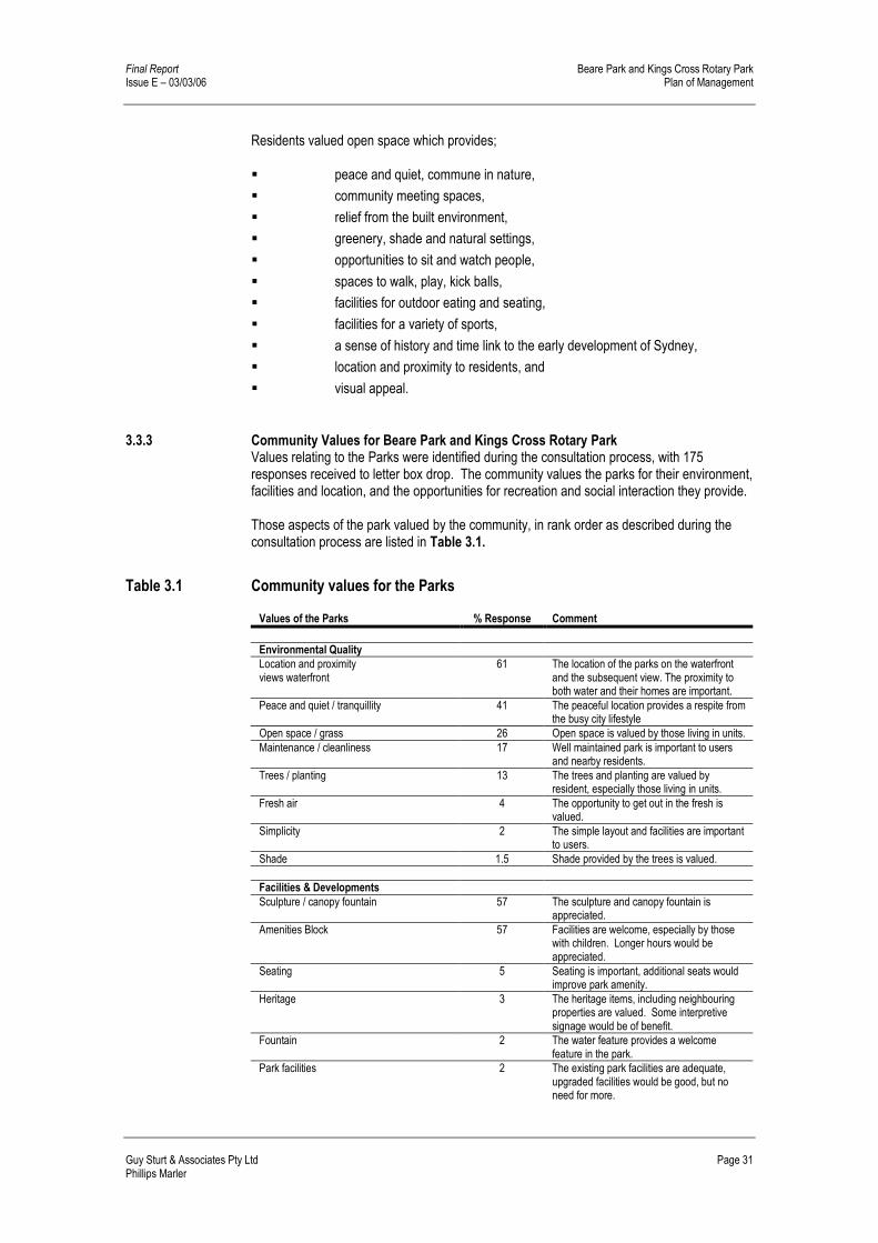
3.3.3 Community Values for Beare Park and Kings Cross Rotary Park Values relating to the Parks were identified during the consultation process, with 175 responses received to letter box drop. The community values the parks for their environment, facilities and location, and the opportunities for recreation and social interaction they provide. Those aspects of the park valued by the community, in rank order as described during the consultation process are listed in Table 3.1.
Table 3.1 Community values for the Parks Values of the Parks % Response Comment
Environmental Quality Location and proximity views waterfront
61 The location of the parks on the waterfront and the subsequent view. The proximity to both water and their homes are important.
Peace and quiet / tranquillity 41 The peaceful location provides a respite from the busy city lifestyle
Open space / grass 26 Open space is valued by those living in units. Maintenance / cleanliness 17 Well maintained park is important to users
and nearby residents. Trees / planting 13 The trees and planting are valued by
resident, especially those living in units. Fresh air 4 The opportunity to get out in the fresh is
valued. Simplicity 2 The simple layout and facilities are important
to users. Shade 1.5 Shade provided by the trees is valued. Facilities & Developments Sculpture / canopy fountain 57 The sculpture and canopy fountain is
appreciated. Amenities Block 57 Facilities are welcome, especially by those
with children. Longer hours would be appreciated.
Seating 5 Seating is important, additional seats would improve park amenity.
Heritage 3 The heritage items, including neighbouring properties are valued. Some interpretive signage would be of benefit.
Fountain 2 The water feature provides a welcome feature in the park.
Park facilities 2 The existing park facilities are adequate, upgraded facilities would be good, but no need for more.

Beare Park and Kings Cross Rotary Park Final Report Plan of Management Issue E – 03/03/06
Page 32 Guy Sturt & Associates Pty Ltd Phillips Marler
Social opportunities Sitting in sun / shade / relaxing 88 Many use the park for relaxing. Safety 74 The park is seen as safe during the day. Meeting friends / picnics 68 A good place to meet friends and show off
the city to visitors. Recreation opportunities Walking or exercise 33 A good place for exercise, Visit playground 30 Play equipment is welcome, more variety
would be appreciated. Reading / drawing 29 Peaceful location for reading and drawing Walking dog / cat 10 Dog & cat owners appreciate being able to
exercise animals in the parks Children playing 9 The playground and open grass areas
provide play opportunities. Meditate / yoga / reflection 5 The peaceful nature of the park allows for
meditation and reflection. Cycling 4 Paths provide safe location for children to
learn to ride bikes. Lunch 3 A welcome place for lunch breaks. Fishing 2 The wharf and sea wall provides good
fishing spots. Birthday parties / gatherings 2 Great location for parties and family
gatherings % Response: percentage of respondents who valued each aspect.
3.4 Objectives and Outcomes
3.4.1 Objectives and desired outcomes of the community The local community expressed its objectives and desired outcomes for the parks through written comments to Council, attendance at the Community Open Day and Workshop, and through consultations with Council staff and community representatives The park is mainly used for passive recreation activities at present, although this may be a reflection of the minimal amount of facilities within the park. There was little requirement or need identified by park users for the introduction of more formal or active pursuits. The opposite (no increase in activity) could be said to be the opinion of the majority of respondents. Park users and the community generally considered that the current park facilities were acceptable. A large proportion of those responding to surveys felt that the park should be left as it is or have minimal improvements only, such as more seats or new furniture. The resident surveys and community workshops have identified the following recreational activities and preferences of local residents. These have been taken into account when planning future recreation opportunities in the Parks. Their ten top priority objectives and desired outcomes for the park in order of preference are listed below in Table 3.2.
Table 3.2 Community objectives and desires Rank Objective or desire
1. Leave as is / minimal improvements / as existing 2. More planting or landscaping / shade trees 3. Improved or increase furniture 4. Improvements to amenities block 5. Marina upgrade / improve / public access 6. Expanded / improved playground 7. Connect both parks / reduce parking area 8. Continue promenade 9. Improve lighting 10. Improve lawn area

Final Report Beare Park and Kings Cross Rotary Park Issue E – 03/03/06 Plan of Management
Guy Sturt & Associates Pty Ltd Page 33 Phillips Marler
3.4.2 Suggested future uses and improvements for the parks The current passive nature of the park and the minimal provision of formal activities were favoured by the majority of the residents. There were opposing views regarding some activities and improvements, but low scale, minimal disturbance and quiet activities were mentioned frequently.
Table 3.3 Future uses Activities & improvements wanted by the Community Activities or improvements not wanted by the
Community
1. Small coffee shop / café / bistro / restaurant 1. Ball games 2. Passive recreation activities 2. Dogs or dogs off leash 3. Playground 3. Noisy activities / loud music / bands 4. Seating / furniture 4. Café / kiosk / restaurant 5. Exercise facilities 5. Marina or marina extensions 6. Picnic tables 6. Homeless people / camping / overnight
stays 7. Beach or water access 7. Sport facilities / team sports 8. Barbeques 8. Cycling 9. Dogs or dogs on leash 9. Drugs / drinking 10. Sculpture / exhibit 10. Skateboards / roller skates 11. Pier / access to pier 11. Barbeques 12. Public meetings / community festivals 12. Building / development / new structures
3.5 Roles of Open Space
The role of open space is to fulfil community values for the open space network as stated in the Generic Open Space Plan of Management. While no single park can fulfil all community desires, the mix of major parks, neighbourhood parks and streetscapes, “combine to perform a variety of functions to facilitate a broad range of recreation experiences.”
Table 3.4 Role of Open Space Role Park Type
Organised recreation Major Park Casual recreation, playgrounds Major or Neighbourhood Park Casual recreation, picnics, walking, bbq, lunch, rest Major or Neighbourhood Park Pedestrian or cycle links Major or Neighbourhood Park Parking and vehicle access Major Safety Major or Neighbourhood Park Visual and landscape character Major or Neighbourhood Park Historic and cultural focus Major or Neighbourhood Park Environmental Quality Major or Neighbourhood Park Public Art Major or Neighbourhood Park Organised Events Major or Neighbourhood Park Adopt a Park scheme Neighbourhood Park Community management input Major or Neighbourhood Park Meeting area Major or Neighbourhood Park Open space management Major or Neighbourhood Park
A description of Major and Neighbourhood parks is included in the following section.
3.5.1 Roles of the Parks
Beare Park and Kings Cross Rotary Park are listed as Neighbourhood Parks in the South Sydney Council Generic Open Space Plan of Management 1993. Neighbourhood Parks are defined as being generally small in size (less than 5000m2 in area). These parks provide convenient casual recreational need almost exclusively for local users. In high density residential environments these parks are important and valued in

Beare Park and Kings Cross Rotary Park Final Report Plan of Management Issue E – 03/03/06
Page 34 Guy Sturt & Associates Pty Ltd Phillips Marler
providing visual relief from the built environment and serve as ‘backyard spaces’ and meeting areas for local children and residents. Typically these parks consist of planting, grassed areas, pathways, seats, picnic tables and occasionally playgrounds. Although currently neighbourhood parks, integration of the two parks could effectively create a single park that has the potential to be defined as a major park. The combined parks would exceed 5000m2 in area and their location, on the edge of the harbour and close to Kings Cross could be considered a landmark location, this would place aspects of the parks within the major park category. Major Parks as are defined in the South Sydney Council Generic Open Space Plan of Management 1993, as being relatively large in size and serve large areas of South Sydney and areas outside the local government area. Typically these parks possess one or more of the following characteristics: � over 5000m2 in area
� can provide a broad range of recreational opportunities including sports fields and tennis courts; and
� usually located on major transport links, or prominent landmark location that are often visited by interstate and overseas tourists.
3.6 Vision Statement
The City of Sydney is committed to a “future vision” for the parks. Consideration of Councils corporate goals, community values and the desired outcomes of the community have merged to formulate a vision for Beare Park and Kings Cross Rotary Park. “The parks shall be enhanced and combined to reclaim the foreshore, interpret the site’s past, improve access to the harbour and meet the community needs.” The Open Space Strategy as outlined in the Generic Open Space Plan of Management outlines the following vision. “All elements of the public domain will contribute positively to the lifestyle of the community.” This means the public domain will be safe to use, will meet the diverse and changing needs of the community, be visually attractive and environmentally sustainable, linked and accessible to all, and be managed efficiently.
3.7 Management Objectives
Subsequent to the vision statement for the development and management of the Parks, the City of Sydney’s objectives for the Parks are to: � Protect, enhance and extend Sydney’s public domain
� Maximise public access to the public domain, open spaces, harbour, and the foreshore.
� Achieve best practice environmental policies and high quality design
� Create a continuous walk from Rushcutter’s Bay to Rozelle Bay.
� To influence state government on planning outcomes for key foreshore sites and for a working harbour.
� To establish guidelines to achieve high quality design in private and public developments so that they enhance the local character and sense of place within the CBD and villages.

Final Report Beare Park and Kings Cross Rotary Park Issue E – 03/03/06 Plan of Management
Guy Sturt & Associates Pty Ltd Page 35 Phillips Marler
4.0 MANAGEMENT STRATEGIES
4.1 Management issues and strategies
This section sets out management strategies designed to address management issues, consistent with the objectives, community values, desired roles of the park, and the vision for the park outlined previously in Section 3.0. Issues raised by the analysis and consultation process, and the strategies designed to address them, are outlined in Table 4.1.
4.2 Strategies for implementation
The means by which Council will implement actions outlined by these strategies are further described in the Action Plan in Section 4.5.
Table 4.1 Management strategies to address issues
Community Values Community Issues Implementation Strategy
Environmental Quality
Views and waterfront Community values views and connection to waterfront
Consider impact of future improvements on existing views and the waterfront connection.
Poorly designed marina in deteriorating condition dominates view when approaching parks.
Ensure future Development Applications are reviewed in context with the park master plan and POM.
Peace and quiet / tranquillity
Desire to maintain passive, peaceful nature of park.
Maintain passive nature of parks
Community doesn’t want to encourage large groups or loud activities in the parks
Ensure new activities do not create an unacceptable level of noise or activity on a day to day basis.
Open space / grass Retain open, uncluttered nature of park. Retain open lawn areas, No connection between two parks. Provide connection between both sides of park. Trees / planting Community desire to retain and supplement
plantings of trees and shrubs Develop a planting scheme to enhance the existing landscape values of the park Provide additional tree/shrub planting for shade and amenity. Provide succession planting to replace senescent trees/palms over time.
Simplicity Keep it simple, maintain low key park and facilities
Ensure improvements to the parks maintain simple layout and low key facilities.
Shade Retain areas of shade Maintain existing tree canopies by provision of succession planting.
Location and Access Entry Major entry point down Ithaca Road is
dominated by Marina. Implement design treatments to reduce impact of marina.
Ithaca Road and parking divides the two Parks Investigate alternative parking options / relocation, extend and connect parks.
Accessibility Park entries are unwelcoming and not defined. Provide attractive and welcoming entrances to the park.
Improve access for people with disabilities to the park.
Ensure access for people with disabilities to all facilities and areas within the park. Provide accessible parking for people with disabilities.
Require equal access and access for prams to playground.
Ensure access for all to all areas within the park, including playground.

Beare Park and Kings Cross Rotary Park Final Report Plan of Management Issue E – 03/03/06
Page 36 Guy Sturt & Associates Pty Ltd Phillips Marler
Location and Access (continued) Paths Promenade doesn’t go anywhere Provide for future extension or link to waterfront
promenade Bicycles Bicycle route Provide signage to local bicycle route. There is no bicycle parking in the park. Provide bicycle racks Vehicles & Parking Car parking is limited Maintain level of car parking for residents. Vehicles access the park too frequently Ensure limited access for maintenance vehicles only. Access to waterfront Community concern for the maintenance of
seawall, access steps Retain / repair seawall Ensure access to water at current steps is maintained/ upgraded during any future improvements/ development to Marina.
No safe access to water for paddling, fishing. Repair / provide access to water, via steps and/ or boardwalks.
Marina / wharf Marina is visually obtrusive, Improve public access to wharf, water taxis.
Ensure future Development Applications are sympathetic to the park master plan and POM. Investigate, encourage Marina leaseholders to provide public access.
Facilities & Developments
Sculpture / canopy fountain Public Art
The sculpture and canopy fountain are not clearly interpreted.
Use interpretative techniques to inform park users.
The community has diverse views about sculptures and art placed in the park.
Ensure community support for sculptures and art placed within the park.
Amenities block The facilities are outdated and visually obtrusive.
Develop plans to renew or remodel amenities block.
Amenities close to early, especially in summer.
Investigate extended opening hours whilst maintaining security of users.
Heritage items The park’s heritage value is not interpreted clearly by the public
Use a variety of interpretative techniques to inform park users of the history of the park.
The heritage value of the parks context is not clearly interpreted.
Use a variety of interpretative techniques to inform park users of the history of the surrounds.
Café or Kiosk The community has diverse views about café / restaurant and kiosks, within park and at marina.
Ensure community support for development within park and at marina. Ensure future Development Applications are reviewed in context with the park master plan and POM.
New structures and development
The community has diverse views about new structures or development within park and at marina.
Ensure community support for any structures or development within park. Ensure future Development Applications are reviewed in context with the park master plan and POM.
Fountain The fountain is appreciated, although its setting could be improved.
Upgrade fountain surrounds.
Seating and park furniture
Additional seats have been requested in the park and near playground. Provide an adequate level of seating in a location and orientation that promotes easy access.
Provide an adequate level of seating in a location and orientation that promotes easy access.
Picnic tables have been requested. Provide alternative seating and /or picnic facilities. BBQ facilities generally bring negative views
from the community Do not install BBQs without further consultation.
Paths Foreshore Promenade doesn’t go anywhere and terminates in blank boundary walls.
Allow for future link to waterfront access proposed by State Government and as per the City of Sydney corporate plan
There are no loop paths, continuous routes. Upgrade paths to provide circuit or continuous route. Paths Some paths are uneven and dangerous Ensure that pathways are safe for pedestrians. Maintenance and cleanliness
Community desire that the park be well maintained
Ensure the park is regularly maintained to an acceptable level.
Bins Bins often full, not emptied enough, especially after weekends. Bins need lids to deter ibis.
Provide garbage bins with lids and empty more frequently.
Some dog owners do not pick up dog waste Encourage dog owners to dispose of dog waste, provide dog litter bins.

Final Report Beare Park and Kings Cross Rotary Park Issue E – 03/03/06 Plan of Management
Guy Sturt & Associates Pty Ltd Page 37 Phillips Marler
Social opportunities Social and friendly meeting place
There are no facilities such as picnic tables for informal group activities in the park, such as picnics, birthdays or lunches.
Provide facilities within the park that encourage small social group activities.
Make provision for groups of nursing home residents visiting park.
Make provision for equal access and suitable seating.
Relaxing / meditating Areas for quiet reflection, meditation. Provide opportunities for a variety of social opportunities, from Individuals, small groups.
Recreation opportunities
Passive recreation Residents pursue a variety of passive
recreation activities in the parks. Informal exercise Meditation, reading, drawing
Provide opportunities for a variety of passive recreation activities.
Place to exercise dogs Some dog owners do not pick up their dog’s waste, and do not adequately control their dog.
Encourage responsible dog ownership to minimise conflicts between dogs and other park users.
Some dog owners exercise their dogs off the leash.
Encourage owners to use designated off-leash parks such as Rushcutters Bay Park.
Playground Lack of facilities within the park for older children and youth. Lack of seating near the children’s play area.
Provide alternative opportunities for play for children of all ages in a safe environment.
Active play Some activities, such as ball games, conflict with passive uses of the park. Identify suitable areas for casual spontaneous active recreation, eg. ball games, frisbee, and dog exercise.
Prohibit formal active recreation activities and identify suitable areas in close vicinity (eg. Rushcutters Bay Park) available for active recreation, eg. ball games.
Safety and security Paths Some paths are uneven and dangerous Ensure that pathways are safe for pedestrians. Wharf Steps to access water are deteriorating and
dangerous Review Marina lease requirements and determine responsibility for ongoing maintenance.
Lighting Community perceived lack of lighting in the park.
Ensure an adequate level of lighting is provided in appropriate locations and of a design sympathetic to the historical value of the park and neighbouring residents.
Safety Night time safety is an issue for some park users.
Ensure adequate lighting and security.
Perception of drug use and ’undesirable behaviour” in parks.
Ensure adequate security and patrols are provided. Improve security and lighting within the park to lessen incidents.
4.3 Landscape Master Plan
4.3.1 Landscape Master Plan The Landscape Master Plan for Beare Park and Kings Cross Rotary Park is presented in Figure 4.4. The Landscape Master Plan illustrates the works and actions outlined in the Action Plan, Section 4.5. These proposed works set out to achieve the objectives and desired outcomes for the park.
4.3.2 Master Plan Elements The Landscape Master Plan incorporates the following five key elements, with each aspect outlined in further detail below: � Integration of Beare Park and Kings Cross Rotary Park to increase the area
and quality of open space.
� Enhancement of the Harbourside Edge and provide opportunities to access the harbour.

Beare Park and Kings Cross Rotary Park Final Report Plan of Management Issue E – 03/03/06
Page 38 Guy Sturt & Associates Pty Ltd Phillips Marler
� Development of an Interpretative Layer
� New Plantings
� Minor Infrastructure Improvements
Integration of Beare Park and Kings Cross Rotary Park The two areas of parkland on either side of Ithaca Road are linked together by reducing the extent of the road and replacing it with new continuous landscaped open space on the harbour side. The remaining road and parking area is re-configured and raised to the same level as the adjoining park to create both a shared pedestrian/vehicular zone and a visual transition zone between Ithaca Road proper and the park. The design comprises the: � Replacement of parallel with right-angle parking at the northern end of Ithaca
Road.
� Provision of extra parking spaces in the Esplanade and adjacent streets.
The proposed design of the shared zone will be subject to further detailed design and a traffic study. Enhancement of the Harbourside Edge The harbourside location of Beare Park defines its fundamental character and outlook. The park’s harbourside edge is enhanced by: � Improvements to the amenity of the promenade.
� New opportunities for public access to the beach below the seawall.
� Possible connections to a future harbourside walk
Improvements to promenade amenity The promenade is widened and repaved. New seating elements with shade trees are provided. Individual seating elements could be large so that shaded seating opportunities along the promenade are significantly increased. At the same time the seating elements with their accompanying shade trees are widely spaced to allow clear views of the harbour in between (Figure 4.1). New public access to the beach New public access to the beach is provided by new steps through the seawall at the site of the former boat slipway, part of the ‘Holmsby’ Estate, accurately located in a 1929 survey plan. The old boat slipway provides an historical precedent for penetration of the seawall at this point and will also create an opportunity for on-site interpretation. (Figure 4.1). Additional access to the beach at the western end of the promenade could be provided by new steps adjacent the Marina. This could also provide an opportunity for interpretation of the former public jetty. Future harbourside walk In anticipation of possible future public access along the waterfront either side of the park and the inclusion of the promenade in a continuous harbourside walk, possible connection points include: � West end: At the location of proposed steps to the beach next to the marina
or at the western extremity of the promenade.
� East end: At the site of the former steps of the ‘Tudor’ estate. Similarly to the former ‘Holmsby’ estate slipway site, this location provides a precedent for penetration of the seawall and the possibility of on-site interpretation.

Final Report Beare Park and Kings Cross Rotary Park Issue E – 03/03/06 Plan of Management
Guy Sturt & Associates Pty Ltd Page 39 Phillips Marler
Figure 4.1 Improvements to the Promenade
Development of an Interpretative Layer Although the park has a history of land acquisition dating back to the Macleay Estate in the 1830’s, it currently has no on-site interpretation. An indicative layer of interpretive infrastructure is proposed - integrated with physical improvements to the parks amenity - in the following possible locations: � Canopy Fountain at the corner of Ithaca Road and the Esplanade: an entry
precinct incorporating the fountain, formalized ‘marker’ plantings and interpretation for the overall park.
� Site of former ‘Boomerang’ gardens: an interpretative and decorative landscape recalling the former ‘Boomerang’ tennis courts, (Figure 4.2).
� Site of former ‘Holmesby’ estate boat slipway: interpretation incorporated into new stairway access to the beach.
� Site of former seawall steps from ‘Tudor’ estate garden: interpretation incorporated into possible future link to harbourside walk at eastern end of promenade.
� Site of former public jetty adjacent to marina: interpretation incorporated into possible future link to harbourside walk at western end of promenade.
� Fountain from former ‘Tudor’ estate garden: interpretation incorporated into new landscaping of the fountain surrounds.
New Plantings The preservation of the parks existing open landscape character is considered desirable and only a modest layer of new plantings is proposed. New plantings are proposed: � To improve the amenity of certain locations (eg. provision of shade) or,
� As part of an interpretative area or,
� To define or improve certain boundaries or edge conditions.
The key new plantings proposed are: � ‘Marker’ tree plantings as part of the new entry and interpretation area at the
corner of Ithaca Road and the Esplanade.

Beare Park and Kings Cross Rotary Park Final Report Plan of Management Issue E – 03/03/06
Page 40 Guy Sturt & Associates Pty Ltd Phillips Marler
� Tree planting to the new landscaped space between Beare and Kings Cross Rotary Parks. These plantings are a visual continuation of existing avenue planting and will allow the preservation of views down Ithaca Road to the water.
� Widely spaced tree plantings along the harbourside promenade for shaded seating.
� Low scale interpretive plantings in the former tennis court area of ‘Boomerang’. (Figure 4.2).
� Plantings at the eastern end of the park to create a defined setting, possibility in association with interpretation, for the fountain from the former ‘Tudor’ garden.
� Edge planting to define the western boundary and help soften the impact of the existing Sydney Water building.
� Cliff planting on the eastern boundary to help soften existing constructed elements.
Figure 4.2 Tennis Court Gardens
Minor Infrastructure Improvements Improvements are proposed to miscellaneous infrastructure elements within the park including: � Playground: A future upgrade of play equipment to cater for a greater age
range and alterations to allow for equal access.
� Picnic facilities.
� Future upgrade of existing amenities block (Figure 4.3).

Final Report Beare Park and Kings Cross Rotary Park Issue E – 03/03/06 Plan of Management
Guy Sturt & Associates Pty Ltd Page 41 Phillips Marler
Figure 4.3 Improvements to Amenities Block
4.3.3 Environmentally Sustainable Design Initiatives The master plan recognises that environmental sustainability is integral to the design of the parks. This will be further considered at the detail design stage. The detail design of the parks will consider innovative water recycling and stormwater management systems. Existing stormwater runoff from the adjoining road network has the potential to be diverted into parkland filtration systems with water recycled and used to irrigate the park. All paved areas within the parks can be designed to ensure maximum water infiltration, reducing runoff into the harbour. The majority of the parks are planted, and where possible the vegetation species utilised will be locally occurring, providing fauna habitat for indigenous species.

Beare Park and Kings Cross Rotary Park Final Report Plan of Management Issue E – 03/03/06
Page 42 Guy Sturt & Associates Pty Ltd Phillips Marler
Figure 4.4 Landscape Master Plan

Final Report Beare Park and Kings Cross Rotary Park Issue E – 03/03/06 Plan of Management
Guy Sturt & Associates Pty Ltd Page 43 Phillips Marler
4.4 Action Plan and Tables
The management strategies and actions to resolve management issues (consistent with the community's values for the parks) and to implement the Landscape Master Plan are presented in the following Action tables.
4.4.1 Action Tables The layout of the Action Tables and the headings used are explained as follows: Value: Community values of the park, as described in Section 3.3. Objective: Related to Council and community and core objectives for the park
(Section 3). Performance target: Goal, objective or desired outcome for addressing issues, consistent
with community value. Means to achieve: Specific task or action required to achieve the performance target,
consistent with the strategy. Priority: Importance or urgency of the action, rated as: Immediate High Medium Low Responsibility: City of Sydney - CoS Assessment of How Council intends to measure its performance in performance: implementing and achieving the action.

Beare Park and Kings Cross Rotary Park Final Report Plan of Management Issue E – 03/03/06
Page 44 Guy Sturt & Associates Pty Ltd Phillips Marler
4.5 Action Plan
Table 4.2 Value: Environmental Quality
OBJECTIVE Ensure Beare Park and Kings Cross Rotary Park are visually attractive, usable open space areas which respect the values of the community, the site and its surrounds.
PERFORMANCE TARGETS
MEANS TO ACHIEVE PRIORITY RESPON-SIBILITY
ASSESSMENT OF PERFORMANCE
Master plan design to retain and enhance views within the site, from and to the site.
Select appropriate tree/ palm species and planting locations to minimise disruptions to existing view corridors.
Medium CoS View corridors maintained. Minimal complaints from residents regarding disruption of views and requests for pruning.
Ensure improvements to the park do not disrupt existing views.
Ensure tree planting does not disrupt existing views.
High CoS Existing views retained.
Develop a planting scheme to enhance the existing landscape values of the park and retain its open character.
Ensure planting is appropriate to soil and other site conditions. Select species suited to the site and its heritage value. Plant trees/palms along the waterfront to provide shade and to define the waters edge. Develop a consistent and coherent planting scheme for the park, including native plant species. Ensure trees are of adequate size and installed in tree guards to minimise vandalism.
Medium
Medium
Medium
High
CoS Ensure trees established Ensure trees established along waterfront. Ensure trees established Undamaged mature trees
Provide additional tree/ palm planting to ensure succession of senescent specimens.
Plant appropriate trees/pams to provide replacements for existing senescent/mature species that will ultimately require removal.
High CoS Ensure trees/ palms established
Provide additional tree/ shrub planting for shade, amenity and screening.
Plant appropriate trees to provide shade to seating. Provide planting to screen stone cutting to boundary and to fences. Provide planting to reflect heritage of site
Medium
Medium Low
CoS Positive community feedback Ensure planting established Positive community feedback
Ensure new activities do not create an unacceptable level of noise or activity on a day to day basis.
Retain the current passive activities of the Park. Allow no active recreation facilities.
Immediate CoS Adopt in Plan of Management

Final Report Beare Park and Kings Cross Rotary Park Issue E – 03/03/06 Plan of Management
Guy Sturt & Associates Pty Ltd Page 45 Phillips Marler
Table 4.3 Value: Accessibility OBJECTIVE
Ensure convenient, recognisable and equitable access to and within the park for all sections of the community.
PERFORMANCE TARGETS
MEANS TO ACHIEVE PRIORITY RESPON-SIBILITY
ASSESSMENT OF PERFORMANCE
Provide attractive and welcoming entrance to the park.
Define the entry point at Ithaca Road with appropriate signage, planting and hardscape treatments. Extend avenue planting/ paving to the marina. Landscape road closure at Ithaca Road
High
Low Medium
CoS Entry point constructed/ landscaped Tree planting/ paving installed. Landscaping installed.
Provide safe access to and along the waterfront
Provide steps for access to the water. Allow for future connection to continuous harbour promenade
Med Low
CoS Access steps constructed. Connection to harbour promenade.
Ensure the sea wall is preserved and is safe
Carry out maintenance to sea wall as outlined in the prepared Sea Wall Condition Report
Low / Med Damaged areas repaired, monitoring in place.
Ensure access for people with disabilities to all facilities and areas within the park.
Ensure the requirements of the Disability Discrimination Act and Council’s Policy are met in the detailed design of the park. Provide pram/ wheelchair ramps to kerbs at all entry points to the park. Provide a ramped adjacent to the playground.
Ongoing
High
High
CoS The requirements of the Disability Discrimination Act and Council’s Policy are met. Wheelchair/ pram ramps installed. Ramped entry constructed.
Provide accessible parking for people with disabilities.
Provide disabled parking at Ithaca Road.
High CoS Disabled parking installed.
Encourage walking or cycling as the primary means of travelling to the park.
Ensure the park is well signposted from Ithaca Road cycle route. Install new bicycle racks in the park.
Medium Medium
CoS Directional sign installed Bicycle racks installed.
Maintain resident parking numbers within the vicinity of the park
Ensure park improvements do not reduce resident parking numbers within the vicinity of the parks.
High CoS Parking numbers retained within the vicinity of the parks.
Prevent cars from entering the park
Install bollards or other devices/ methods to prevent entry at locations currently accessible by vehicles. Restrict maintenance vehicle access to essential works
High
Medium
CoS
Bollards/ devices installed. Council policy in place

Beare Park and Kings Cross Rotary Park Final Report Plan of Management Issue E – 03/03/06
Page 46 Guy Sturt & Associates Pty Ltd Phillips Marler
Table 4.4 Value: Facilities and developments OBJECTIVE Ensure facilities and developments reflect the passive nature of the parks and respects the values of the community.
PERFORMANCE TARGETS
MEANS TO ACHIEVE PRIORITY RESPON-SIBILITY
ASSESSMENT OF PERFORMANCE
Sufficient seating in good condition and oriented towards views is provided.
Replace and increase seating along promenade. Provide seating within the park and at playground. Place seats under shade trees within the park
High Medium Medium
CoS Increase in the number of people sitting on seats within the park.
Opportunities for family & small group picnics are provided for in the park.
Provide picnic tables within the park Medium
CoS Picnic tables provided.
Amenities block which doesn’t detract from the parks atmosphere
Upgrade amenities block to improve Provide accessible facilities
Low Low
CoS Amenities block upgraded to current standards Equal access provided.
Allow for mobile / temporary Café or Kiosks
Lease agreements Low CoS Lease agreement in place
Park users and the community appreciate sculptures and other art works placed in the park.
Provide interpretation for existing sculptures/heritage elements. Proposals for sculptures and art are displayed for public comment before placement in the park.
Medium Low
CoS Interpretation installed/carried out General community support for sculptures and other forms of art in the park.
Drinking water is available for all park users.
Upgrade the canopy fountain to reflect its heritage value.
Medium
CoS Bubblers and taps are installed.
Ensure the park is regularly maintained to an acceptable level.
Closely monitor the parks appearance and revise maintenance schedules as required. Implement a level of maintenance appropriate to the level of the provision of new plantings and facilities.
High
High
CoS Community/ staff feedback Community/ Staff feedback
Encourage dog owners to dispose of dog waste properly
Install new dog waste bins Educate dog owners to pick up dog litter through appropriate signage.
Medium CoS Ensure dog waste bin installed. Signage installed Community/ staff feedback
Ensure garbage bins are covered and emptied regularly.
Install new bins with lids, adjust maintenance regime to take account of high weekend / summer usage.
Medium CoS New bins installed. No overflowing bins.
Table 4.5 Value: Heritage OBJECTIVE Ensure improvements to parks include strategies to respect and reveal the heritage values of the site and its surrounds.
PERFORMANCE TARGETS
MEANS TO ACHIEVE PRIORITY RESPON-SIBILITY
ASSESSMENT OF PERFORMANCE
Maintain and conserve all heritage items including the historic canopy fountain.
Carry out conservation measures including refitting of canopy fountain with appropriate bubbler.
High
CoS Heritage items in good repair and canopy fountain refurbished. Community/ staff feedback
Fountain pond setting should be improved.
Incorporate fountain pond into park design.
Low CoS Fountain incorporated into Master Plan.
Use a variety of interpretative techniques to inform park users of the history of both the park and its context.
Install interpretative signage at the main entry point and at heritage locations within the park.
High
CoS Signage installed

Final Report Beare Park and Kings Cross Rotary Park Issue E – 03/03/06 Plan of Management
Guy Sturt & Associates Pty Ltd Page 47 Phillips Marler
Table 4.6 Value: Social opportunities OBJECTIVE
Provide for a range of social interaction in a relaxed and friendly environment within the park. PERFORMANCE TARGETS
MEANS TO ACHIEVE PRIORITY RESPON-SIBILITY
ASSESSMENT OF PERFORMANCE
Opportunities for informal group activities are provided for in the park.
Locate a group of seats facing each other. Provide picnic tables.
Medium Medium
CoS Seats installed. Picnic tables provided.
Opportunities for individual and quiet activities within the parks.
Locate seating in quiet locations away from access routes and paths.
Medium CoS Seats installed.
The park is used for private events in accordance with Council Policy.
Assess applications for use of the park for community and private events consistent with this Plan of Management. Ensure compliance of event organisers with terms and conditions of agreements.
Ongoing
Ongoing
CoS
Minimal complaints to Council from residents about noise and other impacts from events held in the park.
Table 4.7 Value: Recreational opportunity OBJECTIVE Provide opportunities for a wide range of informal recreational and cultural activities in the park that do not unduly conflict with other uses of the park.
PERFORMANCE TARGETS
MEANS TO ACHIEVE PRIORITY RESPON-SIBILITY
ASSESSMENT OF PERFORMANCE
Provision of recreation opportunities in the park for a wider range of children.
Install items of play equipment in the playground suitable for a variety of age groups children. Possible replacement of existing equipment as existing items become damaged/ redundant.
Low CoS New play equipment installed. Positive feedback from children and carers.
Children’s play equipment and softfall is in good condition at all times.
Ensure regular playground audits are carried out. Maintain play equipment to current Australian Safety Standards
Immediate
CoS Play equipment is usable as soon as possible after damage. Play equipment meets Australian standards. No safety incidents reported.
Adequate adult supervision of children in the playground.
Place seating adjacent to children’s playground for carers.
Medium CoS Seats installed adjacent to the children’s playground.
Encourage people to access the park by bicycle.
Install secure bicycle parking facilities near the car parking area/ Marina. Install signage for bicycles with directions to local bike routes, as shown on Council’s Bicycle Plan.
Medium
Medium
CoS Bicycle parking facilities are installed. Signage installed
Ensure informal games do not unduly conflict with other uses of the park.
Continue to allow small scale informal games, with no bats within the park.
Immediate CoS Monitor impacts of informal games on other park users. Reduction in complaints to Council regarding conflicts with informal games.
Encourage responsible dog ownership, while allowing for dog exercise within the park.
Erect signs outlining dog owner’s responsibilities. Notices that parks are on-leash areas.
Medium CoS Signs installed.
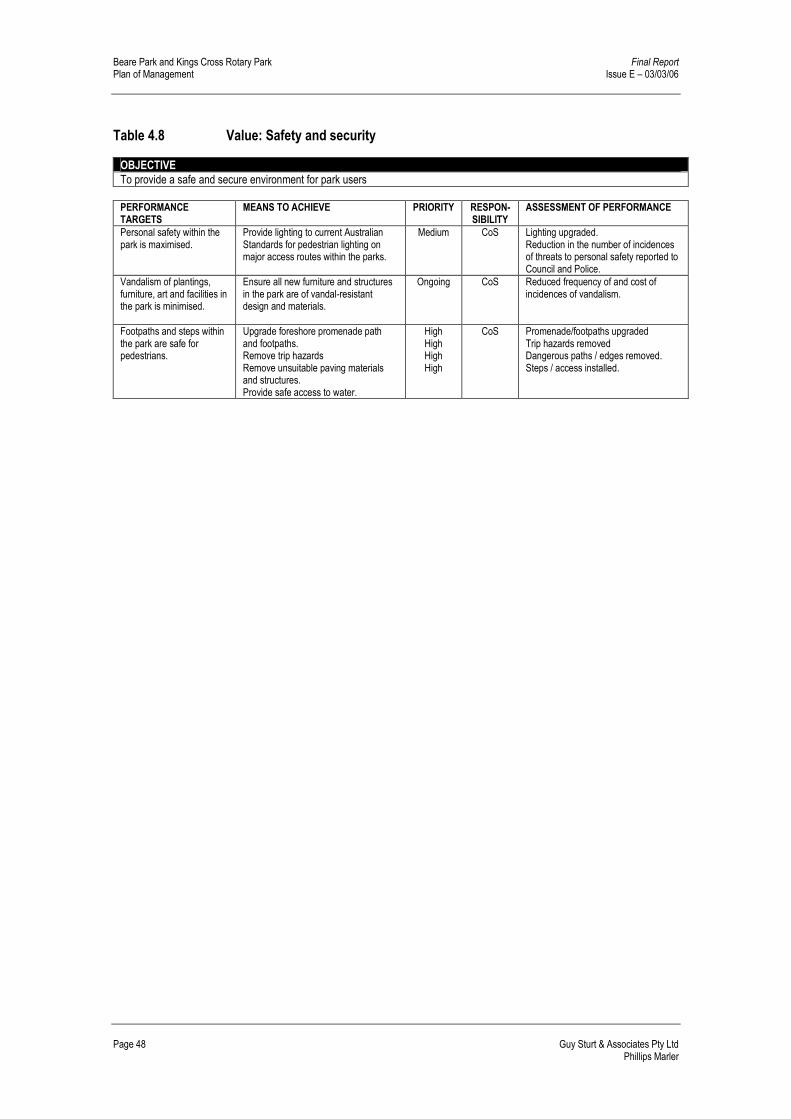
Beare Park and Kings Cross Rotary Park Final Report Plan of Management Issue E – 03/03/06
Page 48 Guy Sturt & Associates Pty Ltd Phillips Marler
Table 4.8 Value: Safety and security OBJECTIVE To provide a safe and secure environment for park users
PERFORMANCE TARGETS
MEANS TO ACHIEVE PRIORITY RESPON-SIBILITY
ASSESSMENT OF PERFORMANCE
Personal safety within the park is maximised.
Provide lighting to current Australian Standards for pedestrian lighting on major access routes within the parks.
Medium
CoS Lighting upgraded. Reduction in the number of incidences of threats to personal safety reported to Council and Police.
Vandalism of plantings, furniture, art and facilities in the park is minimised.
Ensure all new furniture and structures in the park are of vandal-resistant design and materials.
Ongoing
CoS Reduced frequency of and cost of incidences of vandalism.
Footpaths and steps within the park are safe for pedestrians.
Upgrade foreshore promenade path and footpaths. Remove trip hazards Remove unsuitable paving materials and structures. Provide safe access to water.
High High High High
CoS Promenade/footpaths upgraded Trip hazards removed Dangerous paths / edges removed. Steps / access installed.

Final Report Beare Park and Kings Cross Rotary Park Issue E – 03/03/06 Plan of Management
Guy Sturt & Associates Pty Ltd Page 49 Phillips Marler
5.0 IMPLEMENTATION AND REVIEW
5.1 Future use and development
It is not possible to forecast every activity, development or structure that may occur at the Parks in the future. When assessing future development and activities within the parks Council must take into consideration all existing policies and planning instruments. These documents outline the development and activities allowed in Councils parks and reserves, and those activities requiring the consent of Council. In addition to the activities listed in Table 5.1 and in Section 5.2, the Public Parks, Reserves and Open Space, Conditions of Use, as outlined in the South Sydney Council, Generic Open Space Plan of Management, describes the conditions of use which apply to the carrying out of activities in public parks, reserves and open space which require Council approval Activities requiring Council Consent � Install a temporary structure on land
� Use a building or temporary structure as a place of public entertainment or permit its use as a place of public entertainment
� Direct or procure a theatrical, musical or other entertainment for the public
� Construct a temporary enclosure for the purpose of entertainment
� For fee or reward, play a musical instrument or sing
� Set up, operate or use a loudspeaker or sound amplifying device
� Deliver a public address or hold a religious service or public meeting
� Install or operate amusement devices
� Use a standing vehicle or any article for the purpose of selling any article in a public place
5.1.1 Community land
Section 36 (3A)(b) of the Local Government Act, 1993 requires that a Plan of Management that applies to just one area of community land must specify how the land will be permitted to be used in the future. These requirements are outlined below in Table 5.1.
Table 5.1 Permitted uses in Beare Park and Kings Cross Rotary Park
Purposes for which the land, and any such buildings or improvements, will be permitted to be used.
Recreation purposes, including informal recreation activities, in accordance with community preferences for activities that should be or not be permitted in the park (refer to Section 3.4), and the core objectives for land categorised as a park (refer to Section 3.1).
Purposes for which any further development of the land will be permitted, whether under lease or license or otherwise.
Planned developments and improvements to Beare Park and Kings Cross Rotary Park, based on consultation with the community and park users, are shown on the Landscape Master Plan in Figure 4.4. Any further development of the land will not be permitted under this Plan of Management.
Scale and intensity of any such permitted use or development.
The scale and intensity of permitted developments are shown on the Landscape Master Plan in Figure 4.4. The scale and intensity of permitted uses should generally be consistent with the scale and intensity of current use, and as specified by Council in licence agreements. Increased use of the park for recreational activities, such as community events, will be permitted where damage to the park and inconvenience to local residents is minimised.

Beare Park and Kings Cross Rotary Park Final Report Plan of Management Issue E – 03/03/06
Page 50 Guy Sturt & Associates Pty Ltd Phillips Marler
5.1.2 Road Reserve – Closure of Ithaca Road Any proposed closure of the road or a section of road must be undertaken in accordance with the Roads Act 1993, refer Section 6.1.4. The Act requires that the public be notified of the closure of a public road. Upon closure of a public road the land is then operational land.
5.2 Leases and licences
5.2.1 What are leases, licences and other estates? The Local Government Act, 1993 allows Council to grant leases, licences and other estates over all or part of community land. Leases and licences are a method of formalising the use of land and facilities. Leases and licences can be held by groups such as community organisations and schools, and by commercial organisations or individuals providing facilities and/or services for profit. A lease will be typically required where exclusive use or control of all or part of Beare Park and, or Kings Cross Rotary Park is desirable for effective management. A lease may also be required due to the scale of investment in facilities, the necessity for security measures, or where the relationship between a major user and facilities in the park justifies such security of tenure. Licences allow multiple and non-exclusive use of an area. A licence may be required where intermittent or short-term use or control of all or part of the park is proposed. A number of licences for different users can apply to the same area at the same time, provided there is no conflict of interest. Leases and licences can be established by the Council for public or private purposes, providing they are consistent with the major objectives of this Plan of Management, and that the residential and environmental amenity of surrounding areas is maintained.” The definition of "estate", under Section 21 of the Interpretation Act, 1987, includes other rights over land, such as easements, including "interest, charge, right, title, claim, demand, lien and encumbrance, whether at law or in equity".
5.2.2 Existing leases, licences and other estates Sydney Water has an existing lease over part of lot 3 in DP 68974. The lease of the building housing the control room for the pumping station expires on 31 May 2019. An easement for the purposes of protecting underground pipes and electrical services was granted to Sydney Water over a section of Kings Cross Rotary Park. Refer to Section 1.5.2 and Section 1.5.3 for more detail on existing leases and easements.
5.2.3 Authorisation of future leases, licences and other estates To comply with the Local Government, 1993, this Plan of Management must clearly specify the leases, licences and other estates that are authorised on community land within Beare Park and Kings Cross Rotary Park. Occupation of community land by leases, licences and other estates that apply to Beare Park and Kings Cross Rotary Park are set out in Sections 46, 46A, 47, 47A, 47C and 47D of the Local Government Act, 1993. Section 5.2 of this Plan of Management provides relevant considerations that apply to the granting of a lease, licence or other estate. Terms and conditions of a lease, licence or other estate should generally reflect the interests of Council and the public, and ensure proper management and maintenance. Under these conditions, this Plan of Management expressly authorises the granting of short-term licences that fall within the following categories:

Final Report Beare Park and Kings Cross Rotary Park Issue E – 03/03/06 Plan of Management
Guy Sturt & Associates Pty Ltd Page 51 Phillips Marler
markets; temporary or moveable food outlets, coffee carts, concerts; delivering a public address; commercial photographic sessions; picnics and private celebrations such as weddings and family gatherings; filming for cinema and television; and community, educational activities or uses for single one-off events, organised fetes, festivals, and parades, provided they are of a scale appropriate to the objectives for the park. The maximum period for licences/ leases on community land allowable under the Local Government Act is 21 years for purposes consistent with the categorisation and core objectives of the particular area of community land. Community land may only be leased or licensed if public notice is given as per the requirements of the Local Government Act. Where a lease arrangement has been entered into with Council for community land, subleasing of the land must be in accordance with the requirements of section 47C of the Local Government Act. This Plan of Management allows Council to grant “an estate” over community land for the provision of public utilities and works associated with or ancillary to public utilities in accordance with the Local Government Act. Licences over community land will be granted for casual events including, but not limited to, community events, organised fetes, festivals, parades and performances, weddings, filming and photography. The above events may generally be held within the hours of 8am and 10pm. All short-term casual hire will be in accordance with Section 24 and 25 of the Local Government (General) Regulation 2005. To be considered as casual hire, activities must not: � involve the erection of any building or structure of a permanent nature.
� continue for more than three consecutive days.
� continue to recur for a period of more than 12 months in the case of uses occurring more than once. Each occurrence must be no more than 3 consecutive days, not including Saturday and Sunday.
The Local Government and Environmental Planning and Assessment Amendment (Transfer of Functions) Act 2001 transfers approvals formally required under Section 68 of the Local Government Act to the Environmental Planning and Assessment Act. These transferred approvals include installing temporary structures on land. Consequently casual use hire of the park may require a Development Application if the proposal includes the erection of temporary structures such as tents, booths, stage areas and mobile structures. In regard to such licences, Council must take into consideration the following matters in deciding to grant such a licence: � Whether the use or activity is in the public interest.
� Whether the use or activity would not cause any significant detrimental impact on the park or on the local community.
� No permanent buildings or structures may be erected.
Organisers of the event should be responsible for cleaning up the site and repairing any damage that may occur.
5.2.4 Casual Park Hire The City of Sydney is currently preparing a policy on the hire of parks. At present the Service & Quality Group within Council manages park bookings. Special conditions regarding noise and vehicle access, cleaning and park reinstatement are outlined in the park booking “Letter of Agreement”.

Beare Park and Kings Cross Rotary Park Final Report Plan of Management Issue E – 03/03/06
Page 52 Guy Sturt & Associates Pty Ltd Phillips Marler
For large functions requiring the installation of a stage a Development Application must be submitted to Council.
5.3 Implementation
All proposed development and building works consistent with the values, desired outcomes, strategies and actions in this Plan of Management (excluding activities associated with landscaping, gardening or public lighting, which are permitted without development consent under the South Sydney Local Environmental Plan, 1998, and the Section 117 Direction of the Director of Urban Affairs and Planning) would be subject to normal development and building applications in accordance with the Environmental Planning and Assessment Act, 1979, the South Sydney Local Environmental Plan, 1998 and the Development Control Plan 1997. This Plan of Management and Landscape Master Plan would form an important part of the required Development and Building Applications for the proposed works.
5.4 Review
This Plan of Management should be reviewed every five years, and updated as necessary according to changing circumstances and to reflect changing community and Council priorities and issues. Review of this Plan of Management should also take into account the outcomes of concurrent reviews of open space and recreation planning documents, and the Section 94 Contributions Plan. The Action Plan tables have a shorter life and therefore require more frequent reviews and updating. The Action Plan tables should be reviewed and revised every year in accordance with Council's budgets and changing priorities.
5.5 Implementation Funding
The preliminary proposals as described in the Master Plan comprise a range of potential improvements. The following table outlines the estimated budget required, subject to future detailed design.

Final Report Beare Park and Kings Cross Rotary Park Issue E – 03/03/06 Plan of Management
Guy Sturt & Associates Pty Ltd Page 53 Phillips Marler
Table 5.2 Master Plan Budget Estimate
Ref Description Indicative Cost Estimate
A. Preliminaries: $80,000
B. Demolitions: $35,885
C. Sea Wall: $85,000
D. Promenade: $376,500
E. Parking Area: $136,735
F. Entry Feature: $187,500
G. Playground: $61,000
H. Amenities: $110,000
J. Soft Landscape: $67,750
K. Furniture: $50,000
L. Parking Outside Site: $7,545
Total All Sections $1,197,915
Builders OH&P – 6% $71,875 Consultants' Fees – 8% $101,583
Contingency – 10% $137,137
RECOMMENDED PROJECT BUDGET
(excluding GST) as at September 2004 $1,508,510
This estimate was prepared by BDA Consultants Pty Ltd, 23 September 2004, from a preliminary landscape master plan drawing without specification notes nor structural and services engineers' advice. It is intended for initial budgetary purposes only. Council charges, special equipment or services, future cost increases and GST are all excluded.

Beare Park and Kings Cross Rotary Park Final Report Plan of Management Issue E – 03/03/06
Page 54 Guy Sturt & Associates Pty Ltd Phillips Marler

Final Report Beare Park and Kings Cross Rotary Park Issue E – 03/03/06 Plan of Management
Guy Sturt & Associates Pty Ltd Page 55 Phillips Marler
6.0 PLANNING CONTEXT – LEGISLATION AND POLICIES
6.1 State government legislation
6.1.1 Local Government Act 1993 The Parks are classified as “community land” under the Local Government Act 1993. This Plan of Management has been prepared according to the requirements of the Local Government Act, 1993 and the Local Government (General) Regulation 2005, for the contents of Plans of Management, as shown below in Table 6.1. The general requirements of the Local Government Act 1993 for community land are that it: � must have a Plan of Management prepared for it.
� must be kept for the use of the general community, and must not be sold.
� cannot be leased for a period of more than 21 years.
� the use and management of community land is regulated by a Plan of Management. Until a Plan of Management is adopted, the nature and use of the land must not change.
The Local Government Act 1993, requires that draft Plans of Management are placed on public exhibition for a minimum of 28 days, with a further 14 days allowed for written comment.
Table 6.1 Requirements for Plans of Management under the Local Government Act A Plan of Management needs to identify:
Relevant Sections of The Local Government Act, 1993:
How this Plan of Management satisfies the Act:
The category of the land. Section 36(3)(a) Section 1.4, Figure 1.2 Objectives for categories of land. Section 36E to 36N Section 3.1 Condition of the land and existing facilities.
Section 36(34)(a) Section 2.4.1
The objectives and performance targets of the plan with respect to the land.
Section 36(3)(b) Sections 3.1, 3.4
The means by which Council proposes to achieve the plan's objectives and performance targets.
Section 36(3)(c) Section 4.5
The manner in which Council proposes to assess its performance with respect to the plan’s objectives and performance targets.
Section 36 (34)(d) Performance indicators and methods of measurement in Action Tables (Section 4.5).
Permitted future uses of the land. Sections 46 to 47F Section 5.1 Leases, licences and other estates that can be granted.
Section 5.2
6.1.2 Sharing Sydney Harbour Access Plan - DIPNR Jointly prepared by the Department of Infrastructure, Planning and Natural Resources (formerly Planning NSW) and the NSW Waterways Authority, the Sharing Sydney Harbour Access Plan, outlines the NSW Governments vision “to enhance the recreational opportunities of Sydney Harbour and its tributaries for the people of, and visitors to, Sydney.” This is to be achieved through a network of new and improved public access ways for pedestrians and cyclists, and waterways facilities for recreational watercraft. In response to

Beare Park and Kings Cross Rotary Park Final Report Plan of Management Issue E – 03/03/06
Page 56 Guy Sturt & Associates Pty Ltd Phillips Marler
these aims the Access Plan provides for a zone of intertidal access to the foreshore of the Parks, refer to Figure 6.1. Priority projects under the Sharing Sydney Harbour banner, include, the Sydney Regional Environmental Plan (Sydney Harbour Catchment) and the Sydney Harbour Foreshores & Waterways Area DCP.
6.1.3 Sydney Regional Environmental Plan (Sydney Harbour Catchment) 2005 The SREP (Sydney Harbour Catchment) was set up to provide “an improved and clearer planning framework and better environmental outcomes for Sydney Harbour. The principal aim of SREP is to ensure that the catchment, foreshores, waterways and islands of Sydney Harbour are recognised, protected and maintained as an outstanding natural asset and public asset of national and heritage significance for existing and future generations. The planning principles developed for land in the SREP for Foreshores and Waterways include: � development should protect, maintain and enhance the natural assets and
unique environmental qualities of Sydney Harbour and its islands and foreshores,
� public access to and along the foreshore should be increased, maintained and improved, while minimising its impact on watercourses, wetlands, riparian lands and remnant vegetation,
� access to and from the waterways should be increased, maintained and improved for public recreational purposes (such as swimming, fishing and boating), while minimising its impact on watercourses, wetlands, riparian lands and remnant vegetation,
� development along the foreshore and waterways should maintain, protect and enhance the unique visual qualities of Sydney Harbour and its islands and foreshores,
� adequate provision should be made for the retention of foreshore land to meet existing and future demand for working harbour uses,
� public access along foreshore land should be provided on land used for industrial or commercial maritime purposes where such access does not interfere with the use of the land for those purposes,
� water-based public transport (such as ferries) should be encouraged to link with land-based public transport (such as buses and trains) at appropriate public spaces along the waterfront.

Final Report Beare Park and Kings Cross Rotary Park Issue E – 03/03/06 Plan of Management
Guy Sturt & Associates Pty Ltd Page 57 Phillips Marler
Figure 6.1 Access Improvements Source: Sharing Sydney Harbour Access Plan.

Beare Park and Kings Cross Rotary Park Final Report Plan of Management Issue E – 03/03/06
Page 58 Guy Sturt & Associates Pty Ltd Phillips Marler
The SREP (Sydney Harbour Catchment) defines the zones and related controls for foreshore and waterway areas. The Parks are included in Zone No W8 Scenic Waters: Passive Use, refer to Figure 6.2
The objectives of this zone are as follows: � to give preference to unimpeded public access along the intertidal zone, to
the visual continuity and significance of the landform and to the ecological value of waters and foreshores,
� to allow low-lying private water-dependent development close to shore only where it can be demonstrated that the preferences referred to in (the) paragraph (above) are not damaged or impaired in any way, that any proposed structure
� conforms closely to the shore, that development maximises open and unobstructed waterways and maintains and enhances views to and from waters in this zone,
� to restrict development for permanent boat storage and private landing facilities in unsuitable locations,
� to allow water-dependent development only where it can be demonstrated that it meets a demonstrated demand and harmonises with the planned character of the locality,
� to ensure that the scale and size of development are appropriate to the locality and protect and improve the natural assets and natural and cultural scenic quality of the surrounding area, particularly when viewed from waters in this zone or areas of public access.
The SREP lists the site of the Ithaca Road ferry wharf in Schedule 4 Heritage Items. The heritage principles of the SREP are that: � Sydney Harbour and its islands and foreshores should be recognised and
protected as places of exceptional heritage significance,
� the heritage significance of particular heritage items in and around Sydney Harbour should be recognised and conserved,
� an appreciation of the role of Sydney Harbour in the history of Aboriginal and European settlement should be encouraged,
� the natural, scenic, environmental and cultural qualities of the Foreshores and Waterways Area should be protected,
� significant fabric, settings, relics and views associated with the heritage significance of heritage items should be conserved,
� archaeological sites and places of Aboriginal heritage significance should be conserved.
6.1.4 Sydney Harbour Foreshores & Waterways Area DCP for SREP (Sydney Harbour
Catchment) 2005 The area relevant to this Development Control Plan (DCP) is the Foreshores and Waterways Area as defined in SREP (Sydney Harbour Catchment) 2005 and as identified in this DCP. This DCP is a revision of the DCP for Sydney and Middle Harbours REP and Parramatta River REP and has been revised to accompany SREP (Sydney Harbour Catchment) 2005. The DCP will need to be taken into consideration by land owners, developers and consent authorities when preparing or assessing development applications within the area covered by the Foreshores and Waterways Area of SREP (Sydney Harbour Catchment) 2005.

Final Report Beare Park and Kings Cross Rotary Park Issue E – 03/03/06 Plan of Management
Guy Sturt & Associates Pty Ltd Page 59 Phillips Marler
6.1.5 Roads Act 1993 Due to the possibility of incorporating portions Ithaca Road into the future upgrading of the parks, it is necessary to address the implications of the Roads Act 1993 on these proposals. Any proposed closure of the road or a section of road must be undertaken in accordance with the Roads Act 1993, with any changes to the road alignment, parking or speed limits requiring consultation with and approval of the RTA. Section 35 (1) of the Roads Act requires that the public be notified of the closure of a public road with a “notice of the proposed closing of a public road to be published in a local newspaper.” Upon closure of a public road, which was previously vested in a council, that land remains vested in council. Section 38 (2) (b). Section 43 (2) of the Act states that after the disposal of land comprising a former public road owned by council the land is “operational land for the purposes of the Local Government Act 1993 unless, before the land becomes vested in the council, the council resolves that it is to be community land, in which case the land is community land.”
6.1.6 NSW Maritime Authority With the Elizabeth Bay Marina and the waters of Port Jackson forming an immediate boundary to the north of the parks, the management of these areas will impact on the future character of the parks. Future works along the parks interface with the harbour and the marina, will need to be referred to the NSW Maritime Authority, which regulates these areas, as set out in the Maritime Services Act 1935. However discussions to date have indicated support for the proposal, including improved access to the water.
6.2 Local planning context
6.2.1 The South Sydney Plan Prepared by the former South Sydney Council, the South Sydney Plan “comprises documents whose strategy is to provide and manage the future direction of development” within the LGA. The two major planning instruments affecting the Parks are outlined below. South Sydney Local Environmental Plan 1998 (LEP) The LEP was gazetted by the Minister in April 1998. It identifies the land use zones and the aims and objectives for development within these zones. This document forms a single, comprehensive planning instrument covering the entire area of what was previously the City of South Sydney. Development Control Plan 1997: Urban Design (DCP) The DCP “establishes the design framework and criteria within which development takes place.” It aims “to achieve a high quality built environment with a balance between development, conservation and sustainability.” South Sydney (Heritage Conservation) Development Control Plan 1998 This DCP supplements the controls of the South Sydney LEP and establishes the framework for detailed conservation planning.

Beare Park and Kings Cross Rotary Park Final Report Plan of Management Issue E – 03/03/06
Page 60 Guy Sturt & Associates Pty Ltd Phillips Marler
Figure 6.2 Foreshore Zoning Map Source: SREP (Sydney Harbour Catchment) 2005.

Final Report Beare Park and Kings Cross Rotary Park Issue E – 03/03/06 Plan of Management
Guy Sturt & Associates Pty Ltd Page 61 Phillips Marler
6.2.2 South Sydney Council – Generic Open Space Plan of Management 1993 The Generic Open Space Plan of Management prepared by the former South Sydney City Council and adopted in November 1996, looks at all community land within the Council’s “open space network in a comprehensive and coordinated manner.” It examines the “roles, functions, issues and pressures relating to the open space network” within the previous South Sydney Council boundaries.
6.3 Other Studies
6.3.1 Recreation and Open Space Needs Study 2004 The Recreation and Open Space Needs Study (2004) prepared for the former South Sydney City Council by Stratcorp looks at the implications of the demographic makeup of the area on the provision of recreation facilities within the South Sydney City Council LGA.
6.3.2 The community of the City of Sydney The characteristics of the population, listed by Stratcorp (2004), that may impact on the provision of recreation facilities include: � The population is expected to double by 2021.
� Diverse range of community members from different socio-economic backgrounds.
� Just over 60% of the population is aged between 20 – 49 years, the most active age cohort in relation to the participation in active recreation.
� Higher proportion of males than females, males have a higher participation rate in physical activity.
� Above average level of income, education and employment. This suggests a relatively high socio-economic status, with the population more likely to engage in physical activity and be able to pay for recreation.
� Within several pockets in the LGA there is a high proportion of the population receiving social service benefits. There is a need to increase availability of subsidised, free or low cost recreation opportunities.
� The workforce within South Sydney LGA is larger than the resident population, (50% under 40 years of age), with above average incomes.
� Nearly 50% of household had no in-building recreation facilities.
� Second lowest open space ratio per person in metropolitan Sydney.
� Number of organised team sports and participation is declining.
� Economics and locality and lack of facilities are major issues restricting access to recreation opportunities.
6.3.3 Census Data (2001)
The population of Elizabeth Bay as outlined in the 2001 Census consists of the following: � Just over 40% of the population of Elizabeth Bay is aged between 25-39
years (Census 2001).
� School age children make up only 1.3% of the population of Elizabeth Bay, 8.4% attend tertiary institutions, this is less than half the ratio for the total LGA.
� Pre-school age children (0-4 years) make up 2.08% of the population
� Residents older than 65 years make up over 16% of the population, almost twice the average for the LGA.
� 98.5% of the population live in flats, units, apartments or attached dwellings. Only 0.6% live in separate houses.
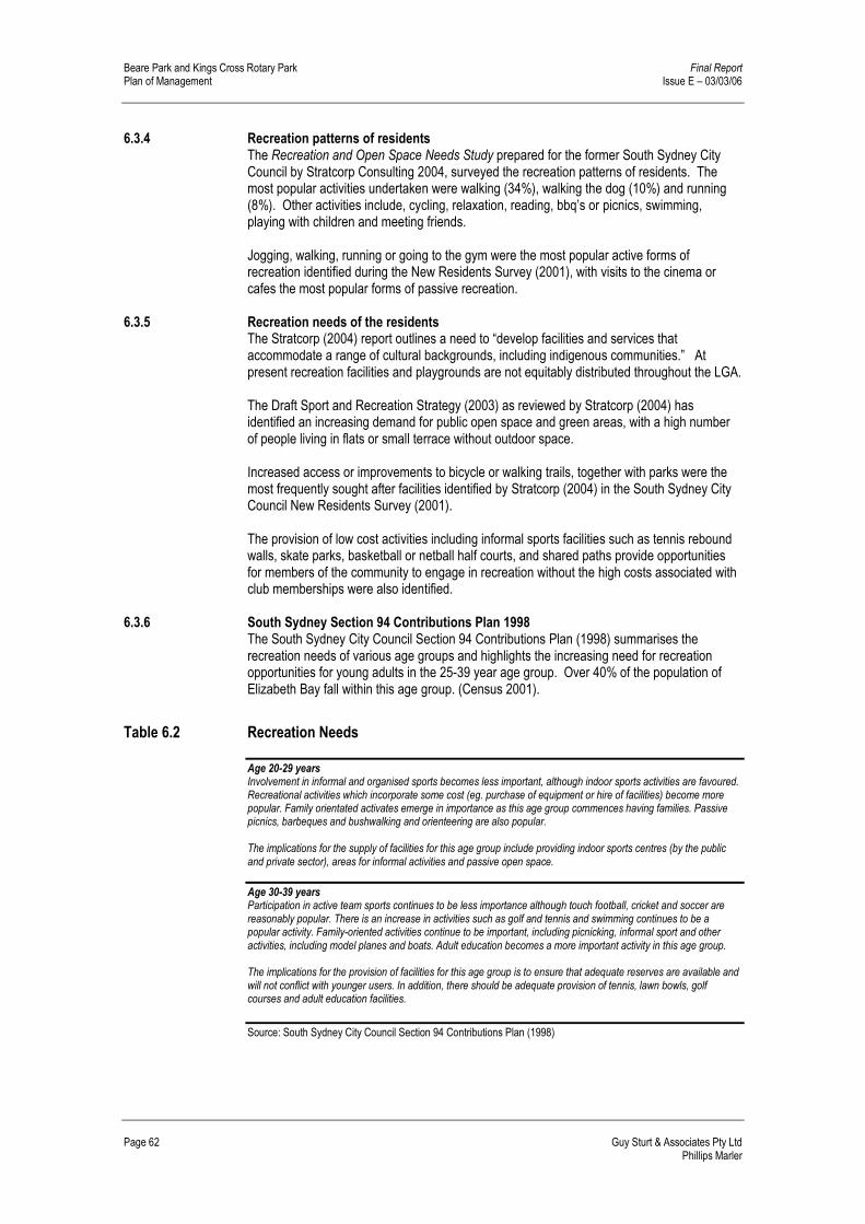
Beare Park and Kings Cross Rotary Park Final Report Plan of Management Issue E – 03/03/06
Page 62 Guy Sturt & Associates Pty Ltd Phillips Marler
6.3.4 Recreation patterns of residents The Recreation and Open Space Needs Study prepared for the former South Sydney City Council by Stratcorp Consulting 2004, surveyed the recreation patterns of residents. The most popular activities undertaken were walking (34%), walking the dog (10%) and running (8%). Other activities include, cycling, relaxation, reading, bbq’s or picnics, swimming, playing with children and meeting friends. Jogging, walking, running or going to the gym were the most popular active forms of recreation identified during the New Residents Survey (2001), with visits to the cinema or cafes the most popular forms of passive recreation.
6.3.5 Recreation needs of the residents The Stratcorp (2004) report outlines a need to “develop facilities and services that accommodate a range of cultural backgrounds, including indigenous communities.” At present recreation facilities and playgrounds are not equitably distributed throughout the LGA. The Draft Sport and Recreation Strategy (2003) as reviewed by Stratcorp (2004) has identified an increasing demand for public open space and green areas, with a high number of people living in flats or small terrace without outdoor space. Increased access or improvements to bicycle or walking trails, together with parks were the most frequently sought after facilities identified by Stratcorp (2004) in the South Sydney City Council New Residents Survey (2001). The provision of low cost activities including informal sports facilities such as tennis rebound walls, skate parks, basketball or netball half courts, and shared paths provide opportunities for members of the community to engage in recreation without the high costs associated with club memberships were also identified.
6.3.6 South Sydney Section 94 Contributions Plan 1998 The South Sydney City Council Section 94 Contributions Plan (1998) summarises the recreation needs of various age groups and highlights the increasing need for recreation opportunities for young adults in the 25-39 year age group. Over 40% of the population of Elizabeth Bay fall within this age group. (Census 2001).
Table 6.2 Recreation Needs Age 20-29 years Involvement in informal and organised sports becomes less important, although indoor sports activities are favoured. Recreational activities which incorporate some cost (eg. purchase of equipment or hire of facilities) become more popular. Family orientated activates emerge in importance as this age group commences having families. Passive picnics, barbeques and bushwalking and orienteering are also popular. The implications for the supply of facilities for this age group include providing indoor sports centres (by the public and private sector), areas for informal activities and passive open space.
Age 30-39 years Participation in active team sports continues to be less importance although touch football, cricket and soccer are reasonably popular. There is an increase in activities such as golf and tennis and swimming continues to be a popular activity. Family-oriented activities continue to be important, including picnicking, informal sport and other activities, including model planes and boats. Adult education becomes a more important activity in this age group. The implications for the provision of facilities for this age group is to ensure that adequate reserves are available and will not conflict with younger users. In addition, there should be adequate provision of tennis, lawn bowls, golf courses and adult education facilities.
Source: South Sydney City Council Section 94 Contributions Plan (1998)

Final Report Beare Park and Kings Cross Rotary Park Issue E – 03/03/06 Plan of Management
Guy Sturt & Associates Pty Ltd Page 63 Phillips Marler
7.0 BIBLIOGRAPHY
Australian Bureau of Statistics, 2001 Census Data
Butel, Kings Cross Album
S. Carlin, Elizabeth Bay House A History & Guide, Sydney, 2000
City of Sydney Archives, NSCA-ITM-22108, Ithaca Rd. Proposed closing of section for incorporation into Beare Park, Record Item 2726/72.
City of Sydney Archives, Archives file Fountains, Article, ‘Drinking Fountains for the City’, Town & Country Journal, 9/7/1870.
City of Sydney Archives, file marked “Fountains”, List of ‘Canopy Fountains as at 7.10.42
City of Sydney, Barani – Indigenous History of Sydney City, People and Place, www.cityofsydney.nsw.gov.au/barani/themes/theme1.htm.
City of Sydney (2004), Corporate Plan 2005 – 2007
City of Sydney (2005), Strategic Plan 2006 – 2009. http:/www.cityofsydney.nsw.gov.au
Department of Infrastructure, Planning and Natural Resources, (2003), Sharing Sydney Harbour, Sharing Sydney Harbour Access Plan, Department of Infrastructure, Planning and Natural Resources.
Department of Local Government (2004), Review of the Companion Animals Act 1998, www.dlg.nsw.gov.au
Guy Sturt & Associates and Phillips Marler (2005), Community Consultation Report, Beare Park & Kings Cross Rotary Park; Elizabeth Bay Guy Sturt & Associates and Phillips Marler (2004), Site Analysis, Beare Park & Kings Cross Rotary Park; Elizabeth Bay. Phillips Marler and Guy Sturt & Associates (2005), Heritage Report, Beare Park & Kings Cross Rotary Park; Elizabeth Bay.
Planning NSW (1991), State Heritage Inventory Pilot Entry Form, for Ithaca Road Ferry Wharf.
Planning NSW (2004), www.planning.nsw.gov.au, website, Sharing Sydney Harbour.
Richmond + Ross (2004), Elizabeth Bay – Sea Wall Condition Report, Structural Condition Assessment.
South Sydney Council, The South Sydney Plan, includes South Sydney Local Environmental Plan 1998 (LEP) and the Development Control Plan 1997: Urban Design (DCP)
South Sydney City Council (1993), Generic Open Space Plan of Management, 1993
South Sydney City Council, The South Sydney City Council Section 94 Contributions Plan (1998)
Stratcorp Consulting (2004), Recreation and Open Space Needs Study, Final Report, Prepared for the former South Sydney City Council.
Urban Tree Management and Guy Sturt & Associates (2004), Tree Assessment Report, Beare Park & Kings Cross Rotary Park; Elizabeth Bay.
NSW Government Legislation NSW Government, Parliamentary Counsels Office, Local Government Act, 1993, www.legislation.nsw.gov.au
NSW Government, Parliamentary Counsels Office, Roads Act 1993, www.legislation.nsw.gov.au
NSW Government, Parliamentary Counsels Office, The Companion Animals Act 1998, www.legislation.nsw.gov.au
NSW Government, Parliamentary Counsels Office, Sydney Regional Environmental Plan (Sydney Harbour Catchment) 2005, www.legislation.nsw.gov.au