Embed Size (px)
Citation preview
A Reference Guide to Coastal Terminology
BEACH BASICSBEACH BASICS
•E • L • I • C • C •A •EASTERN LONG ISLAND COASTAL CONSERVATION ALLIANCE, LTD.
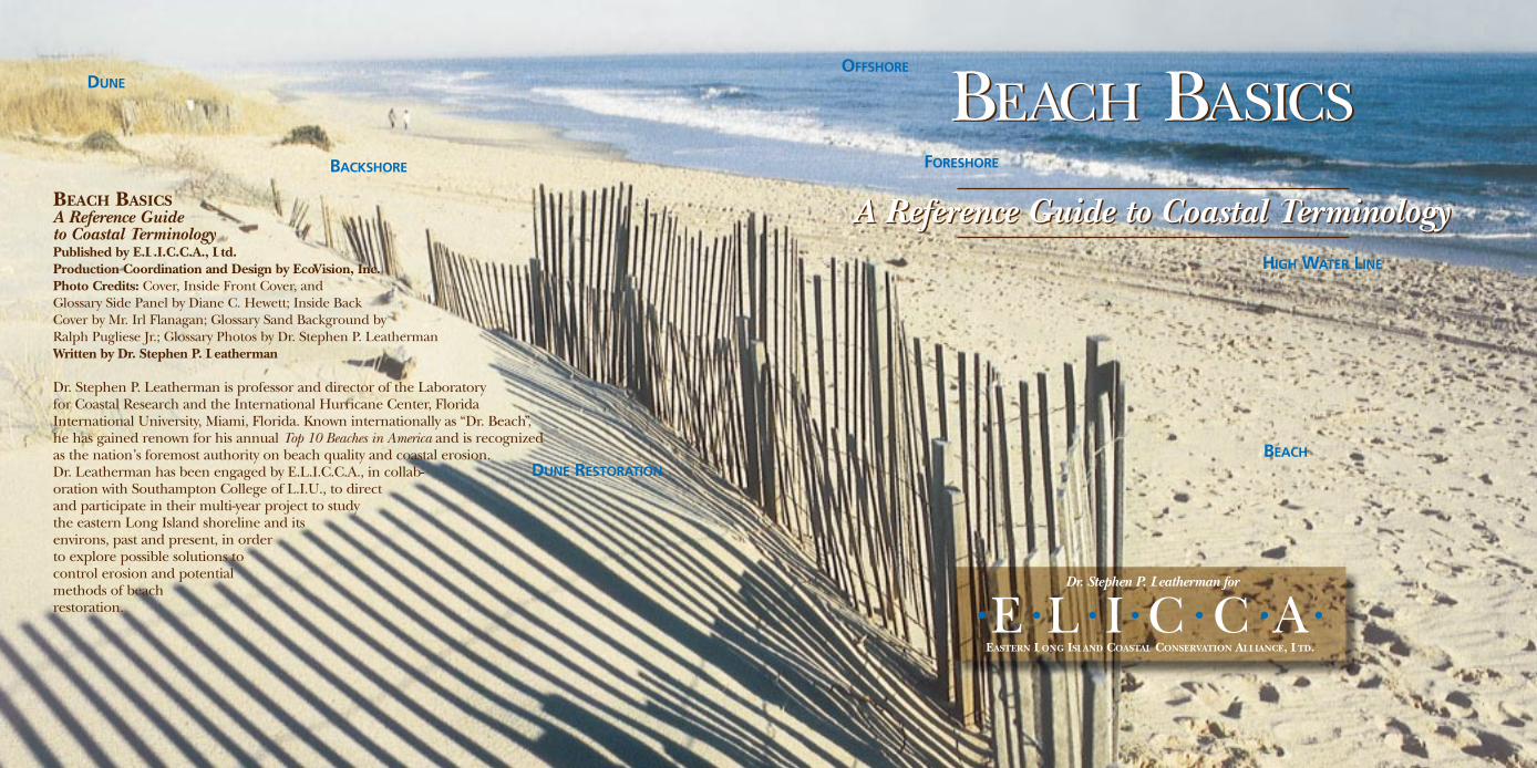
BACKSHORE
DUNE
FORESHORE
OFFSHORE
BEACH BASICSA Reference Guide to Coastal TerminologyPublished by E.L.I.C.C.A., Ltd.Production Coordination and Design by EcoVision, Inc.Photo Credits: Cover, Inside Front Cover, and Glossary Side Panel by Diane C. Hewett; Inside Back Cover by Mr. Irl Flanagan; Glossary Sand Background by Ralph Pugliese Jr.; Glossary Photos by Dr. Stephen P. LeathermanWritten by Dr. Stephen P. Leatherman
Dr. Stephen P. Leatherman is professor and director of the Laboratory for Coastal Research and the International Hurricane Center, FloridaInternational University, Miami, Florida. Known internationally as “Dr. Beach”, he has gained renown for his annual Top 10 Beaches in America and is recognized as the nation’s foremost authority on beach quality and coastal erosion. Dr. Leatherman has been engaged by E.L.I.C.C.A., in collab-oration with Southampton College of L.I.U., to direct and participate in their multi-year project to study the eastern Long Island shoreline and its environs, past and present, in order to explore possible solutions tocontrol erosion and potential methods of beach restoration.
A Reference Guide to Coastal Terminology
Dr. Stephen P. Leatherman for
DUNE RESTORATION
HIGH WATER LINE
BEACH

BEACH BASICSA Reference Guide to Coastal Terminology
BEACHES – WHAT THEY ARE; HOW THEY CHANGE
Beaches are accumulations of wave-deposited, loose sediment (usually sand) that extend fromthe outermost breakers to the landward limit of normal wave and swash action. A generalizedbeach profile and related terminology are shown in the figure below. The beach is generallycomposed of the backshore, the portion of the beach from the berm crest to the dunes; theforeshore, the portion sloping toward the ocean; and the nearshore, the portion below water,extending seaward to the outermost breakers.
The beach profile adjusts rapidly to the wave energy. In general, high waves with short periodscause the beach to erode, and the berm sand is shifted offshore to the bar. Low waves withlonger periods, primarily in summer, move sand from the bar and return it to the berm. The average wave height varies on a seasonal basis, resulting in typical “winter” (high energy)and “summer” (low energy) beach profiles. The winter profile is characterized by a narrowbackshore, flat foreshore, and a large offshore bar. The summer profile has a wide backshore,a steep foreshore, and a well-developed berm.
The Beach Basics Glossary that follows has been compiled as a useful reference guide tocoastal terminology.
DUNE BEACH OFFSHORE
NEARSHOREFORESHOREBACKSHORE
BERMS BREAKERS
HIGH WATER LEVEL
BEACH SCARPLOW WATER LEVEL
BAR
BEACH SCARPLOW WATER LEVEL
BAR
BEACH BASICSBEACH BASICSA Reference Guide to Coastal Terminology
INTRODUCTION
The Eastern Long Island Coastal Conservation Alliance, Ltd. (E.L.I.C.C.A.), a not-for-profitcorporation, in collaboration with Southampton College of Long Island University, has undertaken a multi-year project to study the eastern Long Island shoreline and its environs, as it exists now, and has in the past, in order to explore possible solutions to the erosion problems and evaluate potential methods of beach restoration.
Coastal preservation and environmentally responsible stewardship of the coastal environmentare issues that East End policymakers and residents face on a daily basis. Too frequently, well intended but potentially damaging decisions are made based upon public opinion anduninformed sources. Data are often lacking, and user groups are not kept abreast of currentdata and policies.
Beach erosion and the subsequent issues of control and containment are challenges thatplague the East End environment as well as other shorelines around the world. The bulkheadcontroversy, impact of jetties and groins, and dredging plans are issues of major concern toboth beachfront property owners and the general populace.
The purpose of Beach Basics is to provide a common terminology for those interested in beaches.Far too often, people use different terms for the same beach feature or process; others
may have different interpretations of the same term, which may not even appearin the dictionary. We must all be reading from the same page, as under-
standing beach terminology is basic to resolving the differences andreaching accord on the options for dealing with the difficult problem
of beach erosion. Beach Basics is being produced by E.L.I.C.C.A.to provide coastal communities with a handy reference to
beach terminology and to bring people together inorder to forge a consensus on ways to addressthe beach erosion problem.

BE
AC
HB
ASI
CS
GL
OSS
AR
YACCRETION Deposition of sediment,usually sand, which is evident by the seaward advance of a shoreline indicator,such as the high water line, berm crest, or vegetation line. Accretion causes the beach to become wider. Opposite of erosion.
AEOLIAN Transport and deposition of sand by wind; the principal means by which sand dunes are formed.
ALONGSHORE CURRENT SeeLONGSHORE CURRENT.
ARMORING Placement of fixed engineering structures, typically rock,wood timbers, or concrete, on or alongthe shoreline to reduce coastal erosion.Armoring structures include seawalls,revetments, bulkheads, and rip rap.
BACKSHORE Generally dry portion ofthe beach between the berm crest andthe vegetation line that is submerged only during high water levels and erodedduring storm events.
BACKWASH The seaward return flow ofswash on the beach face due to gravity.
BAR Submerged mound of sand thatgenerally runs parallel to the shore andcauses waves to break before reaching the beach.
BARRIER BEACH A low-lying, sandyisland or spit that lies offshore and generally parallel to the mainland.
BEACH Accumulation of wave-deposited, loose sediment, usually sand, that extends from the outermostbreakers to the landward limit of wave and swash action.
BEACH LOSS Volumetric loss of sand, usually measured by a loss of dry beach width.
BEACH MONITORING Periodic collection of data, such as dry beachwidth, to study changes over time.
BEACH NARROWING Decrease in usable (dry) beach width caused by episodic storm impact or long-term erosion.
BEACH NOURISHMENT Sand artificiallyplaced on the beach, usually by pumpingsea bottom sediments onshore, to replacethat being lost alongshore or offshore.Beach nourishment projects are usuallylarge scale, spanning many miles ofshoreline to rebuild eroded beaches.
BEACH PROFILE Measurement of the elevation or height of the beach surface taken along a line that runs fromthe dune to the water across the beach.Profiles taken at different dates can be compared to illustrate and quantifystorm, seasonal, and longer-term changes in beach width, height, volume,and shape.
BERM Feature usually located at mid-beach and characterized by a sharp breakin slope, separating the flatter backshorefrom the seaward-sloping foreshore.
BLOWOUT Small, often circular or ovaldepression in sand dunes, caused by windscouring where protective vegetation hasbeen disturbed.
BLUFF High, steep bank or cliff alongthe mainland of non-coastal origin.Steepened bluffs are caused by waveundercutting of the cliff toe.
BREAKWATER Structure built parallel to the shoreline and seaward of the beach designed to protect the beach and upland areas by causing waves tobreak and dissipate their energy beforereaching the shore.
BUILDING SETBACK State or locallyrequired seaward limit of beachfront construction, usually for a house.
BULKHEADS Rigid structures with vertical walls built parallel to the shore-line to serve as barriers to wave attack andprevent storm surge flooding of uplandareas; constructed out of treated wood,corrugated steel, PVC, or other materials.
BEACH BASICS GLOSSARYACCRETION BULKHEADS
Bulkhead at Ocean City, Maryland

BEACH BASICS GLOSSARYCOASTAL COMPARTMENT GROINS
COASTAL COMPARTMENT Stretch ofshore that is connected by a commonlongshore sediment transport system,such as the south shore of Long Island,New York.
CUSPS Crenulated beach surface, char-acterized by an evenly spaced series ofrounded, small headlands (projections)and bays (or embayments). The along-shore spacing of cusps ranges from a fewfeet to 100’s of feet and their relief variesfrom a few inches to several feet.
DEFLATION Lowering of the beach profile.
DOWNDRIFT In the direction of netlongshore sediment transport.
DUNE Mound or ridge of sand deposit-ed by the wind, capable of movementwhen unvegetated. Dune building can beaugmented by sand fencing or plantingbeach grass.
DUNE RESTORATION Technique ofrebuilding an eroded or degraded dunethrough one or more methods (sand fill,fencing, revegetation, etc.).
DUNE WALKOVER Light constructionthat provides pedestrian access across adune without trampling the vegetation.
EBB CURRENT Tidal current movingaway from the coast during a falling(ebbing) tide, often with high velocityflows through tidal inlets.
EBB TIDAL DELTA Sandy shoals formedby ebbing currents found on the seawardside of tidal inlets.
EROSION Physical removal of sand from the beach which is transported offshore, alongshore, or into bays andlagoons via inlets. Erosion results inshoreline recession—landward retreat of a shoreline indicator such as the highwater line, vegetation line or dune line.Opposite of accretion.
EROSION HOT SPOTS Areas where erosion is occurring at a much higherrate than adjacent beach areas, which can threaten beachfront development or infrastructure. Typically the dry beachhas narrowed considerably.
EROSION WATCHSPOTS Areas wherethe coastal environment (natural orbuilt) will soon be threatened if shoreerosion trends continue.
EUSTATIC SEA-LEVEL RISE World-widechanges of sea level over decades to centuries caused by addition of waterfrom the melting of glacial ice and/orthermal expansion of sea water due toglobal warming.
FETCH Distance of open water overwhich the wind blows in the developmentof waves. The fetch length can restrictwave development so that only relativelysmall waves occur in narrow bays and lagoons.
FLOOD CURRENT Tidal current movingtoward the shore, through a tidal inlet, or up a tidal river, estuary, or lagoon.
FLOOD TIDAL DELTA Sandy shoalsformed on a rising (flooding) tide andfound on the estuarine or lagoonwardside of a tidal inlet.
FORESHORE Seaward sloping portion ofthe beach within the normal range of tides.
GEOTEXTILE TUBES Elongated clothbags or tubes made out of plastic materialthat can be stacked or arranged as a formof semi-hard coastal engineering.
GROINS Shore protection structureswhich extend from the beach backshoreinto the surf zone, perpendicular to theshoreline. A groin is intended to build upan eroded beach by trapping littoral driftor to retard the erosion of a stretch ofbeach. Often mis-identified as jetties.
Groin field atWesthampton Beach,New York

BEACH BASICS GLOSSARYHARDENING OVERWASH
HARDENING See ARMORING.
HARD STABILIZATION Emplacement of treated wood, rocks, concrete, PVC,and/or steel in the form of breakwaters,bulkheads, groins, jetties, seawalls, etc.
HIGH WATER LINE The line or “wettedbound” separating wet from dry sand andformed by swash uprush on the beach face.
HURRICANES Tropical cyclones withwinds 75 mph or greater which spiralinward toward a core of low pressure androtate in a counterclockwise direction inthe Northern Hemisphere.
INLET See TIDAL INLET.
ISOSTATIC Local or regionalchanges in the ground surface elevation, resulting in land subsidence or uplift.
JETTIES Shore-perpendicularstructures built at the sides of aninlet to maintain navigable water-ways. They stabilize an inlet byintercepting the longshore trans-port of sand that would otherwisefill it in or cause the channel toshift position. Jetties are oftenconfused with groins, but aremuch longer and more substantialstructures, usually built in pairs.
LITTORAL BUDGET Sediment budget ofthe beach consisting of sources and sinks.
LITTORAL DRIFT Sand and coarsermaterial moved in the breaker and swashzones by waves and longshore currentsalong the shoreline.
LITTORAL SYSTEM Area from the landward edge of the coastal upland(usually the dune) to the seaward edge of the nearshore zone.
LONGSHORE CURRENT Current moving along (parallel to) the shore, generated by waves breaking at an angle to the shoreline.
LONGSHORE SEDIMENT TRANSPORTSediment transport along the beach (parallel to the shoreline) caused by longshore currents and/or wavesapproaching obliquely to the shoreline.See LITTORAL DRIFT.
MEAN SEA LEVEL The average elevation of the sea surface determinedfrom tide gauges.
NEAP TIDE Small tide range, occurringat the first and third quarters of themoon, when the gravitational pull of the sun opposes that of the moon.
NEARSHORE Underwater area close to the beach, often characterized by sandbars, where sediment is actively beingmoved by waves and currents. This zonetypically extends to a depth of 25 to 30feet along the Atlantic coast.
NODAL POINT Location of longshoresediment transport divergence, where the littoral drift moves away in oppositedirections along the coast. Normally areas of higher erosion rates.
NOR’EASTERS Extratropical storms with winds that commonly blow from thenortheast, occur during the winter, andcan generate large waves and elevatedtides, resulting in considerable beach and dune erosion.
OBLIQUE WAVE APPROACH Wavesthat approach the beach at an angle (e.g., not straight-on) and generate longshore currents.
OFFSHORE Area seaward of thenearshore zone where sediment transport is only initiated by large swell waves or coastal storms.
OVERWASH Wave uprush overtoppingthe beach and dunes during storms;water and entrained sand that are movedlandward of the dune. Also called anoverwash surge during major events. See WASHOVER.
Updrift (eastern) Jetty at Rockaway Inlet, N.Y.

BEACH BASICS GLOSSARYPEAT SEA
PEAT Dark-brown to black, fibrous material produced by plants which growin marshes or bogs. When exposed onthe beach face, it indicates long-term erosion and landward barrier migration.
PERIGEAN Period of time (twice a year)when the moon is at its closest approachto the Earth, and the tidal range is largerthan normal.
PERIGEAN SPRING TIDES Coincidenceof perigean and spring tidal conditionsresulting in the highest high and the lowest low tides, Nor’easters, such as AshWednesday Storm of 1962, become evenmore damaging when they occur duringperigean spring high tides.
PERIOD See WAVE PERIOD.
RECESSION Landward movement of the shoreline due to the loss of beachmaterial and/or direct inundation of the land.
REFRACTION The bending of waves bybars and shoals that can cause the con-centration of wave energy on a portion of the shoreline, resulting in acceleratedbeach erosion.
RELATIVE SEA LEVEL RISE The gradualrise in the water level relative to the landsurface due to worldwide changes in thevolume of seawater and/or local verticalmovement of the land.
REVETMENT Facing of stone, concreteor rubble built to protect an embank-ment or upland against erosion by waveaction or currents.
RIDGE A longshore feature that maybecome exposed at low tide; oftenformed by a bar moving onshore as a form of post-storm beach recovery.
RIP CURRENTS Strong, localized current flowing seaward from the shore;visible as an agitated band of water, whichis the return movement of water piled up on the shore by incoming waves. Ripcurrents are by far the biggest killers ofocean swimmers.
RIPRAP Layer, facing or protectivemound of stones randomly placed to prevent erosion of upland areas. Also the name of the stone so used.
RUNUP Part of the swash action causedby breaking waves.
SAND BAGS Sand-filled cloth or geo-textile bags that can be stacked to providesemi-hard coastal protection and aredesigned to retain sand while allowingwater to flow through.
SAND WAVES Much larger featuresthan cusps that may migrate along theshoreline. Sand waves can locally causeaccelerated erosion known as erosion“hot spots.” Also called shoreline mean-ders, sand humps, or giant beach cusps.
SCARP Vertical drop-off of the drybeach caused by oblique wave attack dur-ing stormy conditions; beach scarps canbe several inches to over six feet high anddisappear by the return of sand onshoreduring berm accretion. Dunes can also bescarped, forming vertical, wave-cut faces.
SCOUR Removal of beach material bywaves and currents such as at the base of a dune or toe of a shore structure.
SCARPING Erosion of a dune or berm,usually by oblique wave attack during a storm.
SEA Short period, steep waves generated during a storm that causebeach erosion.
Riprap inGreat Lakes

BEACH BASICS GLOSSARYSEAWALLS WAVE REFRACTION
SEAWALLS Vertical or near verticalshore-parallel structures designed to prevent upland erosion and storm surgeflooding. Seawalls are generally massiveconcrete structures emplaced along a considerable stretch of shoreline aturban beaches.
SEMI-HARD STABILIZATION Use ofsand bags and/or geotextile tubes thatcan be stacked or arranged to provideprotection to beachfront properties.
SHADOW EFFECT Stretch of sand-starved, eroded beach that is downdrift of a structure such as a jetty or groin and hence in the littoral drift “shadow” of that structure.
SHOAL A large deposit of sand, generally created by currents near inlets, that can be an obstruction to boats and can cause wave refraction.
SHORELINE Boundary between the land and the sea, which is oftendefined as the mean high water line for mapping purposes.
SOFT STABILIZATION Artificial emplace-ment of sand via beach nourishment orthrough building and enhancement ofsand dunes with sand fencing or vegeta-tive plantings. Sand scraping of the beachto build up sand dunes is another meansof “soft stabilization”.
SORT Separation of particles into various size categories by moving water or wind.
SPOIL Dredged sediment, usually from inlets or lagoons, that can be clean or polluted.
SPRING TIDE Larger than average tidal range that occurs twice monthly during new and full moon times.
STORM SURGE Sudden, temporary rise of sea level primarily due to windsbut also caused by atmospheric pressurereduction, resulting in piled-up wateragainst the coast, which is the primarycause of coastal flooding during a storm.
SWASH Sheet of water that flows up and down the beach foreshore caused bywaves breaking and gravity, respectively.See UPRUSH and BACKWASH.
SWELL Long period waves that tend towiden the dry beach, usually in summermonths or during fairweather.
TIDAL INLET Channel through a barrier beach, which is characterized byswift currents that interrupt the littoraldrift of sand.
TIDAL PRISM Amount of water thatflows in and out of a semi-enclosed bay or estuary between high and low tide.
TIDAL RANGE Difference in heightbetween high and low tide.
UNDERTOW General layman’s termused to describe coastal currents whichmay “suck” swimmers underwater. Amore accurate description is backwashfrom large breaking waves or seaward-flowing rip currents.
UPDRIFT Direction opposite that of the predominant movement of the littoral drift. Opposite of downdrift.
UPLAND Mainland or land behind thedunes; high ground that is above normaltidal flooding.
UPRUSH The movement of water(swash) up the beach face when a wavebreaks on the foreshore.
WASHOVER OR WASHOVER FANSand deposited during storms landwardof the dune line, sometimes extending to the marshes or into the bay waters.
WAVE HEIGHT Vertical differencebetween a wave’s crest and trough; higher waves are more energetic and can cause rapid beach changes.
WAVELENGTH Distance between successive wave crests.
WAVE PERIOD Time in secondsbetween successive wave crests. Swell are long period, while sea are short period waves.
WAVE REFRACTION See REFRACTION.
Seawall at Galveston Island, Texas

•E • L • I • C • C •A •EASTERN LONG ISLAND COASTAL CONSERVATION ALLIANCE, LTD.
A NOT-FOR-PROFIT CORPORATION
ADMINISTRATIVE OFFICE
Tel: (631) 204-1245 Fax: (631) 204-1246
P.O. Box 1307, Southampton, NY 11969-1307
FOR FURTHER INFORMATION REGARDING THIS STUDY, PLEASE CONTACT:Dr. Stephen P. Leatherman
Tel: (305) 238-5888Fax: (305) [email protected]
ACKNOWLEDGMENTS.The following people provided valuable assistance:
Fred Anders, Mark Crowell, Sheila David, Tim Davis, Jay Diesing, Bruce Douglas, David Emilita, Jane Finalborgo, Gil Flanagan, Frank Galgano,
Thelma Georgeson, Weikai Huang, Joe Romanosky, Sandra Shumway, Whit Stevens, Jay Tanski, Aram Terchunian, Thomas Tobin, and Keqi Zhang.
EASTERN LONG ISLAND COASTAL
CONSERVATION ALLIANCE, LTD.For the Trustees:
Thomas E. OplingerSamuel H. Swint, Jr.
SOUTHAMPTON COLLEGE
LONG ISLAND UNIVERSITY
For the College:Timothy Bishop, ProvostDr. Sandra E. Shumway
The photo on the left shows that the beach downdrift of the groin field is badly eroded (April 23, 1991). The photo on the right (November 4, 1999) shows the same area after a major beach
nourishment project was completed at considerable expense by the U.S. Army Corps of Engineers.