Embed Size (px)
Citation preview
Trench-forearc interactions reflected in thesedimentary fill of Talara basin, northwest PeruAndrea Fildani,1 Angela M. Hessler and Stephan A. Graham
Department of Geological and Environmental Sciences, Stanford University, Stanford, CA, USA
ABSTRACT
Exceptional exposure of the forearc region of NW Peru o¡ers insight into evolving convergentmargins.The sedimentary ¢ll of theTalara basin spans the Cretaceous to the Eocene for an overallthickness of 9000m and records within its stratigraphy the complicated history of plate interactions,subduction tectonics, terrane accretion, and Andean orogeny. By the earlyTertiary, extensionaltectonismwas forming a complex horst and graben system that partitioned the basin into a series oflocalized depocentres. Eocene strata record temporal transitions from deltaic and £uvial to deep-water depositional environments as a response to abrupt, tectonically controlled relative sea-levelchanges across those depocentres. Stratigraphic and provenance data suggest a direct relationshipbetween sedimentary packaging and regional tectonics, marked by changes in source terranes atmajor unconformities. A sharp shift is recognized at the onset of deepwater (bathyal) sedimentationof the Talara Formation, whose sediments re£ect an increased in£ux of ma¢c material to the basin,likely related to the arc region. Although the modern topography of the AmotapeMountains partiallyisolates theTalara basin from the Lancones basin and the Andean Cordillera to the east, provenancedata suggest that the AmotapeMountains were not always an obstacle for Cordilleran sedimentdispersal.The mountain belt intermittently isolated theTalara basin fromAndean-related sedimentthroughout the early Tertiary, allowing arc-related sediment to reach the basin only during periods ofsubsidence in the forearc region, probably related to plate rearrangement and/or seamounts collidingwith the trench. Intraplate coupling and/or partial locking of subduction plates could be among themajor causes behind shifts from contraction to extension (and enhanced subduction erosion) in theforearc region. Eventually, collisional tectonic and terrane accretion along the Ecuadorian marginforced a major late-Eocene change in sediment dispersal.
INTRODUCTION
Forearc basins record compelling evidence about the age,nature and intensity of subduction-related tectonicevents (Dickinson, 1995). Forearc basin sedimentary ¢llshave low preservation potential because many active mar-gins involve accretionary phases with major shorteningand/or destructive phases (i.e. subduction erosion). TheMesozoic forearc is missing in most of southern Peru,and as much as 148 km in width of the South Americanmargin has been lost since the Eocene at the Lima basinlatitude because of subduction erosion (Clift et al., 2003).However, in NW Peru, approximately 9000m of near-continuous forearc sedimentation preserved in theTalara basin (Figs 1 and 2) records events occurring ata dynamic Andean juncture: between (1) active ridgesubduction (Witt et al., 2006) and terrane accretion
(Spikings et al., 2005) to the north and (2) an area of activesubduction erosion to the south (Lima basin: Clift et al.,2003).
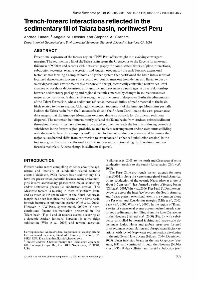
The Peru-Chile arc-trench system extends for morethan 5000 km along the western margin of SouthAmerica,where subduction of the oceanic Nazca plate at a rate ofabout 6^7 cmyear�1 has formed a series of forearc basins(Clift etal., 2003;Witt etal., 2006;Figs1and 2).Despite con-vergence across the interface between the South Americaand Nazca plates, extensional events are common alongthe Peruvian and Ecuadorian margins (Clift et al., 2003;Sage et al., 2006; Witt et al., 2006). In the region of Talara,a series of extensional events accommodated nearly con-tinuous sedimentary in- ¢lling from the Late Cretaceousto the Neogene (Jaillard et al., 2000) (Fig. 3), with subsi-dence controlled by normal faulting and large-scale de-tachment faults. Horst and graben structures fosteredthick sediment accumulation and abrupt lateral facies var-iations, with loci of deep-water sedimentation developingin the middle and late Eocene (Fildani, 2004; Duerichen,2005). Basin inversion began in the late Oligocene (Ser-anne, 1987) and continued through the Neogene (Nobletet al., 1996). Ridge collision and partial subduction (well
Correspondence: Andrea Fildani,Department ofGeological andEnvironmental Sciences, Stanford University, Stanford, CA94305, USA. E-mail: andrea¢[email protected] Present address: Chevron Energy and Technology Company,6001 Bollinger Canyon Rd., Rm. D1192, San Ramon, CA 94583,USA.
BasinResearch (2008) 20, 305–331, doi: 10.1111/j.1365-2117.2007.00346.x
r 2008 The Authors. Journal compilation r 2008 Blackwell Publishing Ltd 305
documented to the north of the study area, i.e. Carnegieridge; Fig.1) is presumed responsible for the uplift and ex-humation of most of theEcuador and northernPeru coast-line (Gutscher et al., 1999a; Pedoja et al., 2006; Witt et al.,2006).
This paper focuses on the sedimentary record in theonshore part of the basin, where the sedimentary ¢ll con-sists of 60^70% shale, with the balance being sandstoneand conglomerate.The purpose of this study is three-fold:(1) to re-evaluate the stratigraphic record of theTalara ba-sin based on evolving depositional environments, (2) todetermine the provenance of distinctive sedimentologicalcycles of the basin and (3) to evaluate large-scale tectonicimplications for the northern Central Andes.We use stra-tigraphic stacking patterns, sediment dispersal patterns,sandstone petrography, mudstone geochemistry, and con-glomerate clast data to relate local forearc development tolarge-scale subduction processes, such as seamount sub-duction (Gutscher etal.,1999a, b;Witt etal., 2006), subduc-tion erosion (Clift et al., 2003; Laursen & Normark, 2003),accretionary tectonics (Spikings et al., 2005), and changesin plate convergence rate (Pardo-Casas & Molnar, 1987;Silver et al., 1998).
TECTONIC HISTORYOF THEHUANCABAMBA ANDES
The sector of the Andes inland of theTalara area, known asthe Huancabamba Andes or the Cordillera Real, stretchesbetween 31S and 81S in southern Ecuador and northernPeru, and represents the connection between the North-ern and the Central Andes (Figs 1 and 2). A distinguishingfeature here is the directional variation in the Andeantrend known as the Huancabamba de£ection (Mourieret al., 1988), from N 201W in the northern part of theCentral Andes to N 201E in the Northern Andes (Fig. 1).The Huancabamba de£ection is a major tectonic linea-ment that separates two intrinsically di¡erent sectors ofthe main Andean Cordillera: the Palaeozoic metamorphicbelts of the Cordillera Real intruded by Mesozoic(?) plu-tons and the PeruvianWesternCordillera (CordilleraOcci-dental, Fig. 1) composed of Mesozoic sediments intrudedby a Mesozoic arc (the Coastal batholiths) with youngerTertiary volcanics (Chew et al., 2007).
Early Senonian onset of contractional deformation andcalc-alkaline arc activity in the Huancabamban Andesis interpreted as the initiation of Farallon-Nazca plate
Tumbes-Guayana Megashear
Huancabamba DeflectionAmazonas Megashear
Axis Peru - Chile Trench
Dolores-Guayaquil Megashear
Cord. O
ccidental
Cord. C
entralC
ord. Oriental
Cord.
Orie
ntalC
ord.
Cen
tral
Cor
d. O
ccid
enta
l
C. R
eal
LIMA
QUITO
BOGOTA
C. C
oast
al
0 500
km
N
PanamaBasin
SouthAmerica
Pacific O
cean Atla
ntic
Oce
an
Carnegie
Ridge
Ocala R.
Sarmiento R.
75°80°
10° S
5° S
5° N
80° 75° 70°
0°
5° S
5° N
0°
TG.F.Z.
6-7 cm/yr
Mendana F.F.
Gulf of Guayaquil
Fig. 2
Fig.1. Distribution of major tectoniclineaments of the northern Andes, andof the Peru^ChileTrenchwithintersecting seamount chains. LocationofTalara basin is in grey andmarkedwithaT, G.F.Z., Grijalba Fracture Zone.C. Real, Cordillera Real.The NazcaRidge location is reported in the insetmap (map modi¢ed from Shepherd &Moberly, 1981).
r 2008 The Authors. Journal compilation r 2008 Blackwell Publishing Ltd,Basin Research, 20, 305^331306
A. Fildaniet al.

subduction (Benavides-Caceres, 1999) following westwarddrift of the South American plate as a consequence of theSouthAtlanticOcean opening since theAlbian (Nurnberg&Muller,1991).Changing tectonic styles along theAndeanmargin since the Senonian are de¢ned by major tectonicphases with not well-de¢ned timing (Fig. 4). In the Peru-vian Andes these tectonic phases have been linked to:(1) changes in convergence rates between the overridingSouth American plate and the Farallon-Nazca plate(Jaillard et al., 1995), (2) successive clockwise rotations inthe direction of convergence (Pardo-Casas & Molnar,1987; Mayes et al., 1990) and/or (3) absolute plate motion(Silver et al., 1998). It is arguable that tectonic phasesmay span only a few million years per event, and perhapsthese phases are better described by a continuum of
convergence interrupted by periods of acceleration(Noblet et al., 1996).
Presently, £at slab subduction and a volcanic gap are re-ported in the Andean portion inboard of theTalara basin(Bernal et al., 2002; Lamb&Davis, 2003).
TECTONIC SETTING AND GEOLOGYOFTALARA BASIN
TheTalara basin sits immediately eastward of the Nazca-South American plate boundary (Fig. 2).To the north, the
Tertiary Arc
TamarindoHigh
Silla dePaita
Cretaceous arc
Jurassic arc
Progreso basin ?
?
Talarabasin
Lanc
ones
basin
Cerro deIllesca
100 km
Trench
DGFS
Cordillera uplift
Basement highs(i.e. Amotape Mts.)
?
N
South America
Pacific O
cean Atlant
ic O
cean
6° S
4° S
82° 80°
Sechura basin
Cor
dille
ra
Amotape-TahuinBlock
Amot
ape
Mts.
Tumbes B
.
Puna IslandJambelibasin
PacificOcean
?
?
G.F.Z.G.G.
R.G.
Fig. 2. Sketch map of the NW Peru Cordillera Real and locationof major basins and tectonic lineaments.Talara and Tumbesbasins extent highlightedwith dashed lines. N.F., Naranjo Fault;R.G., Raspas Group; G.G., Gulf of Guayaquil; P.deZ., Pillars deZorritos; H.F., Huayapira Fault; DGFS, Dolores^GuayaquilFault System (map modi¢ed fromMourier et al., 1988; Jaillardet al., 1999; Fildani et al., 2005; Spikings et al., 2005;Witt et al.,2006; Bourgois et al., 2007).
MesaPA
LE
OG
EN
E
EO
CE
NE
PALE
OC.
Lowe
rBasal Salina Fm. (Ss.)
Balcones Fm. (Sh.)
Mesa Fm. (Ss.)
Mogollon Fm.
Ostrea Fm.
Talara Group
Echinocyamus(Echino) Fm.
Pozo Sh.Verdun Fm. (Ss.)
Chira Fm.
?
Mid
dle
Formations
Mirador Fm.
Carpitas Fm. (Sh.)Mancora Fm.
Uppe
r
OLIG
.
Lowe
r
Petacas Fm. (Sh.)Ancha Fm. (Cong.)
Copa Sombrero Fm. (Sh.)
Amotape Fm. (Met.)
CR
ET
A.
Low.
Uppe
r
Monte Grande Fm. (Sh.)
Pananga Fm. (Carb.)Muerto Fm. (Ml.)
Redondo Fm. (Sh.)
Heath Fm.
PaleGreda Fm.
Salina Group
PaleozoicD
eta
ils in
Fig
. 6S
echu
ra b
. Tum
bes
b.
Fig. 3. Simpli¢ed stratigraphic column of Talara basin.Thisstudy focused on the Eocene section (modi¢ed fromMarsaglia &Carozzi, 1991). Formations present in Sechura and/orTumbesbasins are noted to the right. Sh., Shale; SS., Sandstone; Cong.,Conglomerate;Ml.,Marls; Met.,Metamorphic.
r 2008 The Authors. Journal compilation r 2008 Blackwell Publishing Ltd,Basin Research, 20, 305^331 307
TheTalara Forearc basin

Peru-Ecuador trench is dissected by a major tectoniclineament trending SW^NE that continues inland as theDolores^Guayaquil Fault System (DGFS in Fig. 2). TheDGFS represents a fundamental break in crustal struc-ture along the South American margin (Shepherd & Mo-berly, 1981).The basement of western Ecuador, west of thefault system, may be an accreted fragment of an overthick-ened and buoyant oceanic plateau of Upper Cretaceous toLower Palaeocene age (Reynaud et al., 1999), whereas thebasement south and east of the fault system has continen-tal a⁄nities (Shepherd & Moberly, 1981; Spikings et al.,2005;Witt etal., 2006).TheTalara basin mostly overlies this‘continental-type’ crust based on gravimetric studies(Lonsdale, 1978).
The DGFS delineates the southern end of the NorthAndean Block whose northward movement and subse-quent extensional strain is the likely cause of detachmentfaulting and subsidence in the Gulf of Guayaquil (Fig. 2;Witt etal., 2006). Recent (o12Myr) collision of the Carne-gie Ridge with the trench caused interplate coupling,northward movement of the North Andean Block, and es-cape tectonics in the Gulf of Guayaquil in the last 2Myr(Witt et al., 2006).This has given rise to a tectonic mosaic
of at least four di¡erent detachment-bound basins in theGulf of Guayaquil: Progreso, Jambeli, Esperanza andTumbes. (Witt et al., 2006; Fig. 2).
Nowadays, the Lancones basin is separated from theTalara basin to the east by the Amotape Mountains, atopographic expression of the much larger metamorphicAmotape Tahuin block (Fig. 2; Mourier et al., 1988; Spik-ings et al., 2005).TheTamarindo High is presently coveredby sediments and it is the southern continuation of theAmotape Tahuin block and part of a larger block togetherwith the Silla de Paita and the Cerro de Illescas (Fig. 2),which currently isolates theTalara basin from the Sechurabasin to the south.To the north, theTalara basin appears tobe separated from theTumbes basin by the ‘Pillars deZorri-tos’, a series of enigmatic granitic intrusions encountered indrilling (Bush etal.,1994).The present-day o¡shorewesternand southwestern margins remain conjectural. Active de-tachment faults and active subduction erosion for this mar-gin suggest that theTalara basin could have been partiallydestroyed to the west (Bourgois et al., 2007).
However, theTalara basin was not always isolated fromthese nearbybasins. Intermittent activity along theHuaypiraand other normal faults in the southern Amotape Tahuin
MogollonInferior
MogollonMedio
MogollonSuperior
Ostrea E
Ostrea D
Ostrea C
Pena Negra
TerebratulaLobitos
Talara SS
Cabo Blanco
Helico
Verdun
Marginal Marine(nearshore to offshore)
Outer Shelf toSlope
Deltaic
Fluvial
Marginal Marine
Marginal Marine
Bathyal (turbidites)
Bathyal
Marginal Marine(foreshore to shelf)
Bathyal to Middle Bathyal
Shallow Marine
Marginal Marine ?
Bathyal (slope to basin facies)
Ypresian
Lutetian
Late
Early
Bartonian
FormationAGE
Low
erM
iddl
ePriabonian
TalaraShales
ChiraU
pper
Echino-cyamus
Pozo
Mogollon
Ostrea/Pale Greda
Shallow Marine
Marginal Marine toBrackish??
Talara Br.
?
EO
CE
NE
Change in Convergence Direction
High Subsidence Rate
Partial AmotapeUplift ?
Amotape Uplift(N Talara basin
uplift)
Tectonic Events
Deep Shallow
VerdeBallenaSomatito
Clavel
Major subsidencephase NW Peru
(Talara and Sechura)
Talara BasinPaleobathymetry
1000 m 200 m 0 m
Member Sedimentary Env.
PB
Mac
uchi
Isla
nd A
rcC
ollis
ion
~43
Ma
?H
igh
Pla
te C
onve
rgen
ce R
ate
High Accommodation?
Change inConvergence Direction
End of Inca I Phase(Jaillard et al., 2000)
Fig.4. Detailed stratigraphic section for Eocene strata of Talara basinwith sedimentary environment interpretation for members andformations (this study) and their relation with major tectonic events (from this study, Benavides-Caceres, 1999; Jaillard et al., 2000;Spikings et al., 2005). Chronostratigraphy is based on data fromTable1 (based on Berggren et al., 1995).The reconstructed palaeobathy-metric curve (PB on Fig. 4, data reported onTable1) is superimposed over the global eustatic sea-level curve (in grey) for comparison(sea-level curve fromHardenbol et al., 1998).
r 2008 The Authors. Journal compilation r 2008 Blackwell Publishing Ltd,Basin Research, 20, 305^331308
A. Fildaniet al.

block (Fig. 2) may have controlled interactions betweentheTalara, Lancones, and Sechura basins (Fildani, 2004).The Lancones basin is ¢lledwith Cretaceous sedimentaryrocks unconformably overlain by upper Eocene strata de-scribed as coeval with theVerdun andChira Formations ofthe Talara region (Valencia & Uyen, 2002), con¢rming aconnection between the two basins during the late Eocene.The Verdun and Chira formations of theTalara basin ex-tend into the Sechura basin (Fig. 3), but the late Oligoceneto Miocene sequences of the Sechura basin do not extendto theTalara basin (Caldas etal., 1980), suggesting completeseparation of these two basins by the lateOligocene.Northof theTalara basin, theTumbes basin contains a thick accu-mulation of Oligocene and Miocene strata exposed alongthe southern edge of the Gulf of Guayaquil (Fig. 2). TheOligocene Mancora Formation ¢lled a depocentre thatstraddled theTumbes and Talara basins.The Progreso Ba-sin, an extensional or pull-apart basin related to activityalong the DGFS (Fig. 2), was contiguous to the Tumbesbasin in the Miocene, but did not likely interact with theTalara basin at any point in its history.
Upper Oligocene andMiocene rocks are missing acrossmost of the central and southernTalara basin, where Plio-cene strata rest unconformably on Eocene strata.
METHODS
The present investigation uses data derived from outcrop-based sedimentary facies and biofacies analyses to build apalaeobathymetric history of the basin; sandstone composi-tion data from modal petrologic analyses; conglomeratecomposition data from clast counts and inorganic geochem-ical analyses of shale and single clasts from conglomerate.
The stratigraphic framework presented here is one re-¢ned from Fildani (2004), Fildani et al. (2005), and Dueri-chen (2005). Foraminifera, nannoplankton, palynomorphsand macrofossils were used to constrain timing, palaeo-bathymetry, and palaeoenvironment of key stratigraphiclevels in the basin (Fildani, 2004). Because of a lack of pub-lished palaeobathymetric zonations for the PalaeogenePeruvian sections, we used the California palaeobathy-metric model of Ingle (1980) with modi¢cations by Ingleet al. (1980).The data, summarized inTable 1, are includedin appendix in Fildani (2004).
Modal composition for each of the 38 medium-grainedsandstone samples was determined using the Gazzi-Dick-inson point-counting method (Dickinson, 1970, 1985; In-gersoll et al., 1984) (Table 2). More than 500-point countswere performed on each thin section by one operator (A.Fildani). Potassium feldspars were stained to facilitatetheir identi¢cation.
Forty shale samples from representative formationsthroughout the Eocene^Oligocene section, were analysedfor major-, trace- and rare-earth elements (REE) with X-ray £uorescence spectrography (XRF) and inductivelycoupled plasma mass spectrometry (ICP-MS) atWashing-ton State University GeoAnalytical Laboratories (Supple-
mentary materials Tables S1 and S2). Conglomerate clastcounts were performed on a regular outcrop 10� 10 cmgrid at eight locations (100 clasts per locations). Clast-count categories included: plutonic clasts (mainly grani-toids), volcanic, white quartzite, black quartzite, sedimen-tary clasts (siltstone, shale and sandstone).
STRATIGRAPHYOF THE TALARA BASIN
The general stratigraphy of theTalara basin to date has de-veloped out of both academic (Bosworth, 1922; Iddings &Olsson, 1928; Travis, 1953; Bellido, 1969; Gonzales, 1976;Marsaglia & Carozzi, 1991; Carozzi & Palomino, 1993; Fil-dani, 2004) and proprietary petroleum-related study.Theoldest outcrops of theTertiary deposits, the Lower EoceneMogollon Formation, sit unconformably on pre-Cenozoicmetasedimentary and granitoid rocks of the Amotapeblock. Upsection, there is fairly continuous marginal mar-ine deposition of the Ostrea/Pale Greda, Echinocyamus,andTerebratula Formations, punctuated by minor uncon-formities and £uctuating (but shallow) water depths (Fig.4). By the middle Eocene, a signi¢cant unconformity andmarine £ooding event separates theTerebratula from theTalara Formation, and the basin remains a deepwater de-pocentre through the middle Eocene Verdun Formation.These formations and unconformities are detailed in thefollowing section.
Consensus on stratigraphic nomenclature and correla-tion in theTalara basin has been hindered by (1) structuralpartitioning due to horst and graben subsidence through-out the earlyTertiary, (2) abrupt lateral facies changes dueto the nature of marginal marine depositional systems and(3) the �20 000 km2 blanket of Pliocene to Quaternarymarine terraces or ‘tablazos’ (DeVries, 1988; Bourgoiset al., 2007) that obscure the Eocene section, except whereincised by £ash- £ood quebradas (Fig. 5). Based on allavailable information, however, the Talara basin can besub-divided into southern and northern palaeogeo-graphic domains. Age control between the two domains ispoor, but Seranne (1987) proposed a correlation betweenthe northern and southern basin using a proprietary data-base, which has been modi¢ed using newdata fromFilda-ni (2004) (Fig. 6).
Palaeobathymetry for theTalara Basin was constructedfrom facies analysis combined with palaeontological(benthic foraminifera) and palaeoecological (ichnofossilsand/or fossils) observations (Table 1; Fig. 4; Fildani, 2004).This palaeobathymetric curve strictly relates to the north-ern part of the basinwheremajor deep-water sedimentationoccurred and the majority of the data was collected, but itcan tentatively be extended to the southern part of the basin.
DEPOSITIONAL ENVIRONMENTS ANDPALAEO-DISPERSAL PATTERNS
The sedimentary ¢ll of Talara basin consists of threemajor intervals, from bottom to top: (1) 4000^6000m of
r 2008 The Authors. Journal compilation r 2008 Blackwell Publishing Ltd,Basin Research, 20, 305^331 309
TheTalara Forearc basin

Tab
le1.
Micropaleon
tologicaldataforselectedform
ations
ofTalarabasin(m
icrofaun
adescriptionrepo
rted
inFildani(2004))
Form
ations
Benthon
icforam
Calcareou
snann
oplankton
Palyno
logy
Environ
ment
Age
Age
Zon
es(O
kada
&Buk
ry,1980)
ChiraFm.(outcrop)
Probablebathyal
Indeterm
inate
Barren
Verdun
(11/8-2)
Middle/lowbathyal
Indeterm
inate
Barren
Verdun
(11/22-6)
Middle/lowbathyal
Indeterm
inate
Barren
Pozo
(11/27-11)
Bathyal
Indeterm
inate
Indeterm
inate
PZ1-11/6/01(PozoSh
.)Bathyal(/)
Indeterm
inate
Barren
Pozo
(Well3265)
Probablebathyal
MiddleEocene
Barren
Talarass.(11/16-3)
Marine
Indeterm
inate
Barren
B.Talara(11/13-3)
Middle/lowbathyal
B.Talara(11/13-2)
ProbableBathyal
Indeterm
inate
TalaraSh
.(Mon
te-11/27-2)
Middle/lowbathyal
Indeterm
inate
EarlymiddleEocene
CP10-13B
TalaraSh
.(11/20-6)
Bathyal
HelicoMb.(TOO-H
2)Middle/lowbathyal
MiddleEocene
MiddleEocene
ProbableC14A
HelicoMb.(TOO-H
1)Bathyal
MiddleEocene
Indeterm
inate
HelicoM.(TO1-H7wellA
A80)
MiddleBathyal(?)
MiddleEocene
Indeterm
inate
HelicoMb.@
P.LaCruz
MiddleBathyal(?)
MiddleEocene
Indeterm
inate
Lob
itos
(11/23-4)
Middle/lowbathyal
Indeterm
inate
EarlymiddleEocene
CP10-13B
Lob
itos
(11/17-5)
Middle/lowbathyal
Indeterm
inate
Lob
itos
(11/17-3)
Middle/lowbathyal
Indeterm
inate
Lob
itos
(Well1768)
Bathyal
MiddleEocene
MiddleEocene
CP12B-C
P13C
BasalTalara(11/27-1)
Bathyal?
Indeterm
inate
Non
-Marine(Pinacee)
TopEchino@
Ter.(11/22-2)
Indeterm
inate
Indeterm
inate
Indeterm
inate
Echino(11/27-6)
OuterNeritic
Indeterm
inate
Clavel(11/29-1)
Marine(?)
Indeterm
inate
Indeterm
inate
Clavel(11/27-4)
Marginalm
arine
Indeterm
inate
Clavel(WellE
A9296)
Indeterm
inate
Indeterm
inate
Marginalm
arine(Eocene)
Clavel(outcrop)
Indeterm
inate
Indeterm
inate
Indeterm
inate
ProbableEocene-Olig
ocene
PaleGreda
?(11/15-1)
ProbableMiddleBathyal
Lateearly
Eocene
CP10-CP12A
OstreaII(W
ellA
X11)
Marginalm
arine
Indeterm
inate
Barren
Ostrea(W
ellA
A80)
Marignalm
arine
Indeterm
inate
Barren
MogollonMedio(W
ell1944)
Indeterm
inate
Indeterm
inate
Barren
Marginalm
arine(Eocene)
r 2008 The Authors. Journal compilation r 2008 Blackwell Publishing Ltd,Basin Research, 20, 305^331310
A. Fildaniet al.
Palaeocene to middle Eocene shallow-marine mudstonepunctuated by £uvio-deltaic to shallow-marine coarsesiliciclastic sediments, (2) 1500^3000m of middle to lateEocene deep-water turbiditic sandstone and conglomer-ate units within ¢ne-grained sandstone and mudstone
background and (3) 1500m of latest Eocene to Oligoceneshallow-marine siliciclastic sediments (Marsaglia &Carozzi, 1991; Carozzi & Palomino, 1993; Fildani, 2004;Duerichen, 2005). This study focuses on outcrop datafrom the earliest two intervals.
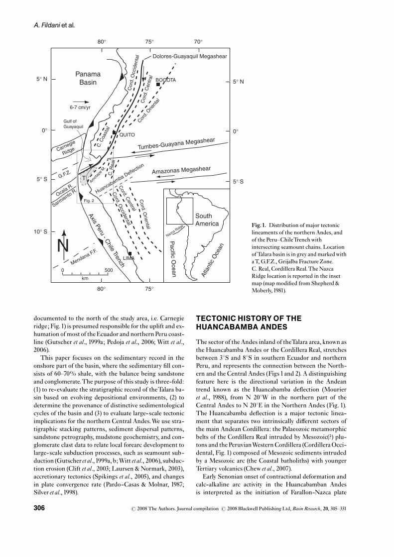
Table2. Raw point-count data for sandstone from theTalara basin, Peru
No. Sample Location Qm Qp Cht. Kspar Plags Lv Lm Lsheav/opaq
Detritalmicas Interstitial
TotalGr.
Mogollon Fm.1 11/25-2 Well EA1764 144 42 3 19 101 52 71 10 3 6 49 5002 11/25-4 Well EA1764 128 36 2 16 113 57 47 15 3 16 66 5003 11/25-5 Well EA1764 177 56 5 16 69 60 42 17 8 5 45 5004 3/16-1 S 4 31038.700W814055.700 160 23 0 3 105 45 38 3 6 33 84 5005 3/16-2 S 4 31038.700W814055.700 121 33 5 7 97 89 42 5 4 8 89 5006 TM2-00 S 4 320600W814041.200 139 41 1 18 114 51 44 4 5 22 61 5007 TM4-00 S 4 320600W814041.200 188 41 2 15 82 72 34 8 2 1 55 5008 TM10-00 S 4 28024.900W80 59053.200 174 47 0 7 92 62 25 8 10 11 64 5009 TM12-00 S 4 32028.600W81 04046.800 128 19 1 13 101 61 32 3 11 32 90 500
HelicoM.1 T02HR1 Punta Restin 70 16 3 19 77 70 44 19 7 4 153118 5002 T01-PLC2 Punta Restin 102 17 9 34 83 77 25 9 5 10 12217 5003 T01-N2 S 4 2804700W811804000 98 20 10 28 73 124 30 14 5 8 8515 5004 T02PLON9B Punta Lobitos North 99 29 4 23 73 113 23 16 3 3 11014 5005 T02Hrest1 Punta Restin 65 21 6 71 31 100 24 28 1 1 140112 5006 T0192-4217 Punta Restin 95 23 9 29 69 150 53 13 1 4 51 5007 T0192-4123 Punta Restin 88 23 6 23 98 124 31 11 4 4 8414 5008 T01-PLC3 Punta La Cruz 75 29 5 22 71 93 32 10 5 9 133116 500
Verdun Fm.1 11/22-7 S04 32055.000W8111028.20 227 19 5 13 91 13 24 7 4 8 89 5002 11/24-1 S04 08003.100W80 58005.60 214 26 6 10 59 37 33 7 2 14 92 5003 11/24-5 S04 10030.200W80 54 57.100 226 19 2 32 89 30 31 11 2 3 55 5004 11/29-5 Well EA 8003 230 35 5 26 31 43 19 14 6 8 83 5005 11/29-7 Well EA 8004 182 32 6 19 62 50 38 35 2 5 69 5006 11/30-6 S04 10056.600W81 080 00.400 210 32 7 24 46 25 36 12 0 11 97 5007 3/16-3 Quebrada Parinas 215 9 2 16 53 31 34 23 22 50 61 5008 3/20-3 Taime Field 225 40 5 8 64 18 19 12 16 101 500
Echino Fm.1 11/17-1 S04 25022.000W8115053.100 137 27 0 29 72 35 42 7 10 27 114 500
Terebratula Fm.1 11/18-1 S 04 25036.100W8115052.300 152 3 2 37 128 37 29 1 3 4 104 5002 11/18-3a S 04 25036.100W8115052.300 124 20 1 24 70 67 59 3 1 16 115 5003 11/18-3b S 04 25036.100W8115052.300 111 15 1 29 85 67 39 4 1 16 132 5004 11/22-3 S 04 25037.000W8115051.400 138 8 7 28 86 40 36 2 0 10 145 500
Ostrea Fm.1 4/11-01 S 4 1602500W811509.600 168 28 3 18 79 78 32 2 6 9 77 5002 T01-00 S 4 1602500W811509.600 182 25 5 20 58 57 45 14 4 12 78 5003 3/20-1 S 4 1602500W811509.600 162 31 2 17 68 55 36 10 1 7 111 500
Pale Greda Fm.1 11/11-2 S 04 31024.800W81 05032.500 183 21 2 6 83 27 39 1 2 31 105 5002 11/10-3 S 04 31034.500W81 04058.800 212 27 2 5 97 25 20 1 1 5 104 500
Cabo BlancoM.1 TCB1-00 S 04 13040.6W 8112013.100 310 24 5 18 20 13 50 0 0 1 59 5002 TCB3-00 S 04 13039.2W 8112007.200 313 36 3 21 7 16 45 5 0 6 48 5003 11/21-3 S 04 13039.2W 8112007.200 374 29 2 3 12 13 36 1 0 2 28 500
Counted parameters.Qm,Quartz monocrystalline; Qp, Quartz polycrystalline; Cht, Chert; Kspar, Potassium feldspar; Plags, Plagioclase feldspar; Lv,Volcanic lithic; Lm,Metamorphic lithic; Ls, Sedimentary lithic; Heav, Heavy minerals; cmt, cement; mat, matrix.
r 2008 The Authors. Journal compilation r 2008 Blackwell Publishing Ltd,Basin Research, 20, 305^331 311
TheTalara Forearc basin

Mogollon and Pale Greda formations
The lower Eocene Mogollon Formation is the oldestformation to crop out continuously in the eastern portion
of theTalara basin with a maximum thickness of �700m(Fig. 5). It is interpreted as a braided £uvial depositbased on thick cross-bedded sandstone, conglomerateand the occurrence of large £ow-parallel tree trunks
Scale1:100 000
0 5 10 15 kilometers
Legend
Tertiary
Ce
no
zoic
Paleozoic
Era Period Epoch
Basement (Undiff.)
Basement (Undiff.)
Deep-waterDeposits
Cretaceous
TumbesBasin
Amot
ape
Und
iffer
entia
ted
N81° 00'
4° 30'
4° 00'
81° 30' 81° 00'
Mancora
Los Organos
Cabo Blanco
Punta Restin
Punta La Cruz
Punta Lobitos
Talara
Negritos
Pac
i f ic
Oce
an
Punta Nautilus
Considered Tumbes Basin
El Nuro
Border Talara-Tumbes
?
1
2
3
4
5
Fig. 5. Geologic map of the Peru coastal area (scale1 : 100 000 ^ modi¢ed and simpli¢ed from Bellido, 1969 and INGEMMET,1999).Only the Eocene interval is discussed in details in this paper. (1) Location of measured section on Fig. 7a; (2) Location for sketchedmeasured section fromQuebrada Angostura on Fig. 7b; (3) Reported Pale Greda section in Fig. 7c; (4) Cabo BlancoMember outcropscharacterized in Fig.9a; (5) location of measured section of Terebratula Fm. in Fig.9b.
r 2008 The Authors. Journal compilation r 2008 Blackwell Publishing Ltd,Basin Research, 20, 305^331312
A. Fildaniet al.

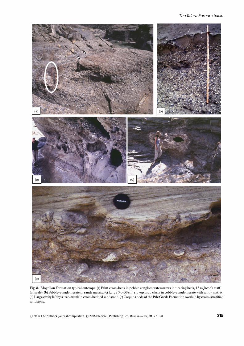
(Figs 7a, b and 8) (Fildani, 2004). Palaeocurrent datafrom clast imbrication and cross-sets clearly indicate apredominant west and northwestward palaeo- £owdirection (Figs 7a, b and 8a^d). From unpublished sub-surface data (courtesy of Perez Companc) the MogollonFormation is correlatable to shallow marine facies tothe west and south. Together, these relations de¢ne anNE^SW transition from non-marine to marine facies(Fig. 6).
The uppermost Mogollon Formation, composed ofmedium- to ¢ne-grained sandstone with faint planarlaminations, may represent the gradual transition from£uvial to marginal marine deposition of the overlyingPaleGreda Formation.The contact between theMogollonand Pale Greda Formations is marked by the ¢rst appear-ance of unequivocal marine deposition: a thick shellfragment-rich bed (mostly gastropods and oysters)interpreted as coquina bed (Figs 7c and 8e).ThePaleGredaFormation is composed of marine shale and siltstonewith intercalated sandstone and common coquina beds,which contain progressively fewer gastropods andmore oyster shells upsection. Because of its sedimentarypackaging and biofacies associations (Weiss, 1955;Fildani, 2004), this formation has been interpreted as ashallow-marine deposit that deepens upsection (Fig. 7c)(Fildani, 2004). The equivalent of the Pale Greda
Formation to the north is the Ostrea Formation (Fig. 6),which crops out very sparsely but has been studied in coreand logs in the subsurface (Perez Companc, nowPetrobrasS.A., proprietary data). Both the Ostrea and Pale GredaFormations are characterized by shallow-marine shelf ele-ments; however, the more sand-rich Ostrea Formationwas likely deposited closer to a source of coarse detritalmaterial (Fildani, 2004). The Ostrea Formation reaches amaximum thickness of �1100m (Picarelli et al., 2003).Transition to the unconformably overlying EchinocyamusFormation is only observed in the subsurface (Fig. 11)(Fildani, 2004).
The Echinocyamus formation
TheEchinocyamusFormation (hereafter shortened to Echi-no) is composed of ¢ve members: Clavel, Cabo Blanco,Verde, Ballena and Somatito for an overall thickness of�400m (Daudt et al., 2004).The Clavel and Cabo Blancomembers are the only Echino Formation members to cropout, other than a few metres of the Somatito Member ac-cessible in a limited outcrop along the coast. The ClavelMember is a green^grey shale barren of microfossils (Fil-dani, 2004; seeTable 1). The top few metres of the ClavelMember are pervasively bioturbated, overlain by shell lagsand metre-scale cross-bedded, quartz-rich sandstone of
S N
OstreaPale Greda
Salinas-Mogollon
Parinas
Chacra
Lobitos
HelicoTalara Shale
Pozo Shale
Chira
Verdun
San Cristobal
Tablazo
Mogollon
1
2
3
4
5
Sed
imen
tary
Cyc
les
Talara Sandstone
Basal Salina
Eo
ce
ne
?
?
Lo
we
rM
idd
leU
p.
Manta (?)
Terebratula
Echino
Clavel
Sandstone
Sandstone (with conglomerate)
Conglomerate
Shale
?
?
Fig. 6. Correlation betweennorthern and southerndepositional areas and mainsedimentary cycles of Talarabasin (Modi¢ed afterSeranne, 1987; unpublisheddata PetroPeru).
r 2008 The Authors. Journal compilation r 2008 Blackwell Publishing Ltd,Basin Research, 20, 305^331 313
TheTalara Forearc basin

6070 50 40 30 20 10 090 80
ms
fm
c
ss
Mog
ollo
n F
orm
atio
n(M
ogol
lon
Sup
erio
r M
embe
r)Lo
c. Q
uebr
ada
Sal
ado
S 0
4° 3
2' 6
"W
81°
4' 4
1.2"
40 30 20 10 0m
sf
mc
ss
Mog
ollo
n F
orm
atio
n(M
ogol
lon
Sup
erio
r M
embe
r)Lo
c. Q
uebr
ada
Ang
ostu
raS
04°
28'
32.
9"W
80°
59'
54.
9"S
impl
ified
rep
rese
ntat
ive
sect
ion
(tot
al e
stim
ate
~30
0 m
eter
s)
Pal
eocu
rren
ts fr
om im
bric
atio
n: fl
ow to
war
d w
est
Tran
sitio
n to
Pal
e G
reda
Fm
.
Lege
nd
Cro
ss-b
edde
d sa
ndst
one
Con
glom
erat
e (S
andy
mat
rix)
Mas
sive
san
dsto
ne
Fos
silif
erou
s in
terv
als
(Coq
uina
bed
s)
Mud
ston
e
(c)
(b)
(a)
Pla
ne la
min
atio
ns
ssss
Con
glom
erat
e (C
last
sup
port
ed)
68 4 02101214
18 1624 20222628
ms
fm
cpe
bm
sf
mc
peb
Low
er P
ale
Gre
da F
orm
atio
n(O
stre
a E
Mem
ber)
Loc.
Que
brad
a S
alad
o
Oys
ter
inliv
ing
posi
tion
N=
8im
br.
N=
11x-
beds
N=
6x-
beds
N=
7x-
beds
N=
7x-
beds
N=
7x-
beds
N=
28im
br.
N
N
Fig
. 8E
Fig
. 8A
Fig
. 8B
Fig
. 8D
Fig.7.
(a)S
impli¢ed
measuredsectionoftheUpp
erMogollonForm
ationin
theQuebradaSalado
withtransition
toPaleGreda
Form
ationand(b)sim
pli¢ed
measuredsectionfrom
Quebrada
Ang
ostura.(c)MeasuredsectionofthelowerPaleGreda
Fm.intheQuebradaSalado
(Locations
onFig.5).R
osediagramsindicatepersistent
NW
directed
palaeo£ows.Thicknessin
metres.
r 2008 The Authors. Journal compilation r 2008 Blackwell Publishing Ltd,Basin Research, 20, 305^331314
A. Fildaniet al.
(a) (b)
(c) (d)
(e)
Fig. 8. Mogollon Formation typical outcrops. (a) Faint cross-beds in pebble conglomerate (arrows indicating beds, 1.5m Jacob’s sta¡for scale). (b) Pebble-conglomerate in sandy matrix. (c) Large (40^50 cm) rip-up mud clasts in cobble-conglomerate with sandy matrix.(d)Large cavity left by a tree-trunk in cross-bedded sandstone. (e)Coquina beds of the PaleGredaFormation overlain by cross-strati¢edsandstone.
r 2008 The Authors. Journal compilation r 2008 Blackwell Publishing Ltd,Basin Research, 20, 305^331 315
TheTalara Forearc basin

05101520253035404550
50556065
ms
fsm
scs
peb
ms
fsm
scs
peb
6070 50 40 30 20 10 0
130
140
120
110
100
90 80
170
180
160
150
Coq
uina
bed
(in s
cour
with
peb
bles
)
Coq
uina
bed
(Ter
ebra
tulid
i)
Silt
y sh
ale
Cro
ss-b
edde
d(w
ith s
hells
)
Tree
logs
(w
ith T
ered
olite
s)
Nau
tilus
100
Tree
logs
(with
Ter
edol
ites)
Larg
e cr
oss-
sets
with
peb
bles
Coq
uina
bed
(Ter
ebra
tulid
i)
Lobi
tos
Sha
le M
b.(T
alar
a F
m.)
190
ms
fsm
scs
peb
ms
fsm
scs
peb
Tere
brat
ula
For
mat
ion
(Loc
. Pun
ta N
autil
us)
S 0
4° 2
5' 3
6.1"
W 0
81°
15' 3
1.9"
Bio
turb
atio
n
Cla
vel M
b.
She
ll La
gs
(a)
(b)
Ech
ino
Cab
o B
lanc
o M
embe
r(E
chin
o F
orm
atio
n)S
4°
13' 4
0.6"
W 8
1° 1
2' 1
3.1"
Bio
turb
atio
n
She
lls+
qtzi
te p
ebs
N
N
N
Tere
brat
ula
N=
11C
last
s im
br.
N=
12C
last
s im
br.
N=
13X
-bed
s
N=
8X
-bed
s
N=
3Lo
gs o
rien.
N=
12X
-bed
s
N=
9P
ebbl
e im
br.
N=
7Lo
g-or
ien.
Pal
eocu
rren
ts p
ublis
hed
by P
alom
ino
and
Car
ozzi
, 197
9
N=
98
Pal
eocu
rren
ts m
easu
red
for
this
stu
dyS
4°
15' 5
.1"
W 8
1° 1
4' 8
.8"
N=
10x-
beds
Fig.9.
(a)S
impli¢ed
measuredsectionoftheCaboBlancoMem
bersandstone
incoastaloutcrop
sofElN� uro.R
osediagramsindicatewestd
irectedpalaeo£ows.(b)D
etailedmeasuredsectionofthe
TerebratulaForm
ationwithtransition
sfrom
theEchinoFm.(bottom
)and
Lobitos
Shale(to
p)(L
ocations
onFig.5).T
hicknessin
metres.
r 2008 The Authors. Journal compilation r 2008 Blackwell Publishing Ltd,Basin Research, 20, 305^331316
A. Fildaniet al.

the lower Cabo Blanco member (Fig. 9a). Upsection theCabo Blanco member contains lenticular sandstone beds,¢ne-sandstone beds with oyster bioherms,Turritellae shelllags and bioturbated siltstone are present; inferred sedi-ment dispersal is westward (Fig. 9a). The Cabo BlancoMember has been interpreted as a mixture of £uvial anddeltaic conglomeratic sandstone deposited from east towest (Palomino and Carozzi, 1979; Daudt et al., 2004;
Fildani, 2004). Combined outcrop and proprietarysubsurface data for the Echino Formation support theinterpretation of the ¢ve members as successive £uvio-deltaic to deltaic and/or shallow marine deposits stackedin a prograding fashion (Fig. 10) (cf. Van Wagoner et al.,1990).This interpretation is in agreement with the Daudtetal. (2004) interpretation of the Echino being a ‘regressivemegacycle’.
CLAVEL
CABO BLANCO
VERDE
SOMATITOINFERIOR
SOMATITOSUPERIOR
LOBITOS
LAGOON OSTREA
ShaleTALARA
Type Well from ZAPOTAL-CENTRAL field Well EA 9526
Member Formation
EC
HIN
OC
YAM
US
Env.
Flo
od p
lain
Flu
vio-
delta
icD
elta
ic (
Sha
llow
-mar
ine)
Dee
pw
ater
(777
m)
(747
m)
(716
m)
(686
m)
(655
m)
(625
m)
(594
m)
(564
m)
(533
m)
Lago
on?
Fig.10. Resistivity and g-ray well log record from thenorthern portion of thebasin (BlockX), showing thetypical stacking pattern ofthe Echino Formation(courtesy of Perez Compancdel Peru). Env., Interpreteddepositional environment.
r 2008 The Authors. Journal compilation r 2008 Blackwell Publishing Ltd,Basin Research, 20, 305^331 317
TheTalara Forearc basin

TheTalara Group:Terebratula and TalaraFormations
A major basin-wide depositional transition occurs be-tween the Echino, Terebratula, and Talara Formations.The Terebratula Formation (�200m) overlies the cross-bedded sandstone of the Somatito Member (Echino For-mation) in apparent angular discordance (Fildani, 2004).Gutierrez & Arriola (2002) indicated a �2m.y. hiatusbetween the Echino Formation and TerebratulaFormation using well data. The Terebratula Formationis characterized by 2- to 3-m-thick cross-beddedsandstone beds with pebble- and shell- ¢lled scouredbases. Conglomerate beds are also present. Coquina bedscontain common brachiopods (terebratulidi) and Turritellae.Upsection, pervasively bioturbated shaly siltstonebecomes predominant with interbedded cross-beddedthin layers of pebbly sandstone and shells (Fig. 9b). Thisformation is interpreted to re£ect progressive deepeningfrom foreshore to outer shelf depositional environments(Fildani, 2004).
The overlying Talara Formation represents the ¢rstdeep-marine deposits in the Talara basin (Fig. 4) with amaximum thickness of�700m (Picarelli et al., 2003).Theshaly LobitosMember (�80m), deposited in a deep-waterenvironment on the palaeoslope of the basin (see palaeo-bathymetric reconstruction fromTable 1), unconformablyoverlies the shallow marineTerebratula Formation. Basedon benthic foraminifera (Table 1; details reported in Ap-pendix for Fildani, 2004), deepening of the basin appearsto have been rapid, with water depth changing fromo200m during deposition of theTerebratula Formationto upper bathyal depths of the Lobitos Member and mid-dle bathyal of the overlying HelicoMember.
Interbedded shale and pebbly sandstone deposits of theHelico Member (�300m) are re-sedimented gravity £ows(sensu Bouma, 1962; Lowe, 1982) and show palaeocurrentpatterns indicating a northwestward trend very similar tothat of the Mogollon Formation (Fig. 11b). However, theoverlying deepwater turbidite of the Talara SandstoneFormation, which outcrops as discontinuous sandstonebeds within the background shale of theTalara Formation(Fildani, 2004), indicate a WSW palaeo£ow direction(Fig.11c; Fildani, 2004; Duerichen, 2005).
Eventually, the Pozo shale blanketed the entire basinto end the ¢rst stage of basin-wide deep-water deposi-tion. Biofacies assemblages con¢rm a widespread deep-water environment across Talara during Pozo time(Gutierrez & Arriola, 2002) and are supported by thisstudy (Table 1).
Verdun and Chira formations
The second and ¢nal deep-water episode in theTalara ba-sin deposited the Verdun-Chira formations immediatelyfollowing the Talara Group. Gutierrez & Arriola (2002)proposed a hiatus of �1m.y. between the Talara Groupand the Verdun Formation. The Verdun Formation varies
in thickness, from about 400 to 620m, and was depositedbasin-wide (Duerichen, 2005). It is composed of thickconglomerate and sandstone intervals interbedded withthin-bedded sandstone and mudstone and it is inter-preted as a turbidite system, where palaeocurrent dataconsistently indicate a southwestward palaeo£ow (Fig.11d). This palaeodispersal pattern di¡ers signi¢cantlyfrom that observed in underlying formations (Fig. 11).Using nannoplankton data, Duerichen (2005) attributedthe Verdun Formation to the late Eocene. TheVerdun Formation is overlain by the Chira Formation, abasin-wide marine mudstone (Carozzi & Palomino, 1993).Bio-facies associations indicate that uppermostsediments of this formation were deposited in a shallowmarine environment (Fildani, 2004; seeTable 1).
PROVENANCE ANALYSIS
Conglomerate clast composition
Throughout theTalara basin, conglomerate units consistof mature, well-rounded pebbles of highly resistant rocktypes like quartzite, chert, and low-grade metamorphicrock. However, variations between the major sedimentaryunits are observed in detailed clast counts (Fig.12).
Mogollon Superior conglomerate units contain abun-dant quartzite, in addition to lesser felsic volcanic andgranitoid clasts. Intermediate volcanic clasts of greenishcolour (described by the local geologists as ‘andesita’) arepresent in both localities but were most easily identi¢ablein the Quebrada Angostura outcrop (Fig.12).
HelicoMember conglomerate units are rich in quartziteand contain volcanic clasts (sub-rounded to rounded in-termediate volcanic clasts showing microlitic, porphyritic,lathwork, and vitric textures) and very few plutonic and re-cycled sandstone pebbles. Overall, the Helico Memberconglomeratic units show a �20% increase in volcanicclasts with a marked increase in intermediate varieties(Fig.12).
Verdun Formation conglomeratic units contain easilyrecognizable sandstone intraclasts (¢ne-grained sand-stone and shale matrix supported), microcrystalline chert,and granitic cobbles.Very few intermediate volcanic clastswere observed in outcrops but never occurred withinanalysis grids (Fig.12).
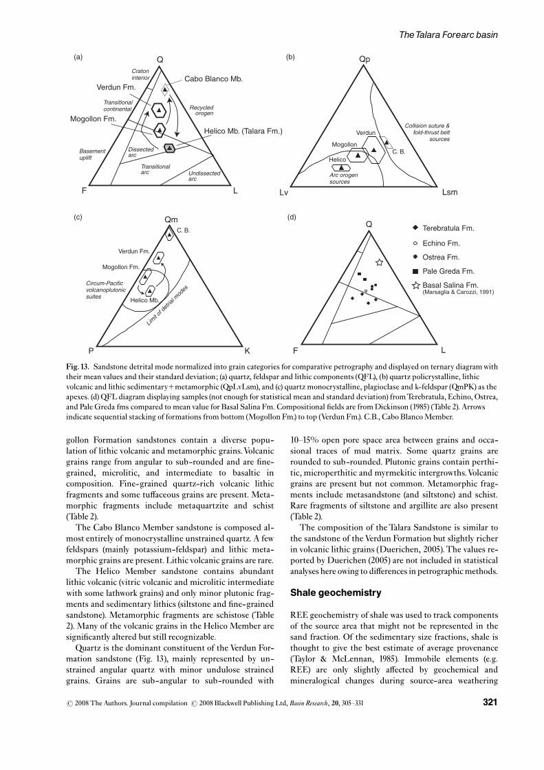
Sandstone petrography
Previous petrographic studies in theTalara basin (Marsa-glia & Carozzi, 1991; Carozzi & Palomino, 1993) havereached comparable conclusions: derivation from a fairlyuniform mineralogical province producing quartz-richsand with only minor volcanic input. However, only theBasal Salina Formation, a pre-Mogollon (Palaeocene)fan-delta deposit restricted to the subsurface, has beenstudied in detail (Marsaglia & Carozzi, 1991; Fig. 13d). Ba-sal Salina sandstone plots within the recycled orogen, andthe presence of plutonic and high-grade metamorphic
r 2008 The Authors. Journal compilation r 2008 Blackwell Publishing Ltd,Basin Research, 20, 305^331318
A. Fildaniet al.

Gross paleo-currents dispersalpatterns
Cabo Blanco
Talara
Pacific Ocean
Talara Sandstone
N
Talara
Pacific Ocean
Verdun Formation
Amotape undifferentiated
Cenozoicsediments
(c) (d)
N
Outcrop and Core Locations
Pacific Ocean
Mogollon Formation
Outcrop
N
Cabo Blanco
Talara
Pacific Ocean
Helico Member
N
(a) (b)
Fig.11. Palaeocurrent distribution patterns for theMogollon Formation (a), the HelicoMember of theTalara Formation (b),TalaraFormation (c), and Verdun Formation (d). Arrows indicate gross palaeo-dispersal trends. Figure modi¢ed fromDuerichen (2005).Data forTalara Formation, HelicoMember and Verdun Formation are fromDuerichen (2005).
r 2008 The Authors. Journal compilation r 2008 Blackwell Publishing Ltd,Basin Research, 20, 305^331 319
TheTalara Forearc basin

fragments is interpreted to re£ect derivation from anancient Amotape highland and its cover sequences (Mar-saglia & Carozzi, 1991) (Fig.13d).
Petrographic data are presented in Table 2, and sand-stone detrital modes are summarized on ternary diagramsin Fig.13.
Mogollon Formation arenites are weakly cemented bycalcite and clay minerals. Quartz (angular to subangular)and feldspar are the dominant framework grains, with pla-gioclase more common than potassium feldspar (Fig.13c).Quartz grains exhibit varying degrees of undulose extinc-tion, and polycrystalline quartz grains are common. Mo-
VERDUN
HELICO
(Talara Group)
MOGOLLON
0
10
20
30
40
50
60
70
Mogollon 1
WHT QZT
0
20
40
60
80
100
120
Mogollon 2
0
20
40
60
80
100
120 Mogollon 3
0
10
20
30
40
50
60
0102030405060708090
100
UP
SE
CT
ION
BLK QZT
VOLC PLUT SS SHALE
WHT QZT
BLK QZT
VOLC PLUT SS SHALE WHT QZT
BLK QZT
VOLC PLUT SS SHALE
WHT QZT
BLK QZT
VOLC PLUT SS SHALE
WHT QZT
BLK QZT
VOLC PLUT SS SHALE
Fig.12. Conglomerate clast counts results of major conglomeratic units of Talara basin.WHTQZT, white quartzite; BLKQTZ, blackquartzite;VolC, volcanic rocks; PLUT, plutonic rocks; SS, sandstone; SHALE, shale. Data from Fildani (2004).
r 2008 The Authors. Journal compilation r 2008 Blackwell Publishing Ltd,Basin Research, 20, 305^331320
A. Fildaniet al.
gollon Formation sandstones contain a diverse popu-lation of lithic volcanic and metamorphic grains.Volcanicgrains range from angular to sub-rounded and are ¢ne-grained, microlitic, and intermediate to basaltic incomposition. Fine-grained quartz-rich volcanic lithicfragments and some tu¡aceous grains are present. Meta-morphic fragments include metaquartzite and schist(Table 2).
The Cabo Blanco Member sandstone is composed al-most entirely of monocrystalline unstrained quartz. A fewfeldspars (mainly potassium-feldspar) and lithic meta-morphic grains are present. Lithic volcanic grains are rare.
The Helico Member sandstone contains abundantlithic volcanic (vitric volcanic and microlitic intermediatewith some lathwork grains) and only minor plutonic frag-ments and sedimentary lithics (siltstone and ¢ne-grainedsandstone). Metamorphic fragments are schistose (Table2). Many of the volcanic grains in the Helico Member aresigni¢cantly altered but still recognizable.
Quartz is the dominant constituent of the Verdun For-mation sandstone (Fig. 13), mainly represented by un-strained angular quartz with minor undulose strainedgrains. Grains are sub-angular to sub-rounded with
10^15% open pore space area between grains and occa-sional traces of mud matrix. Some quartz grains arerounded to sub-rounded. Plutonic grains contain perthi-tic, microperthitic and myrmekitic intergrowths.Volcanicgrains are present but not common. Metamorphic frag-ments include metasandstone (and siltstone) and schist.Rare fragments of siltstone and argillite are also present(Table 2).
The composition of theTalara Sandstone is similar tothe sandstone of the Verdun Formation but slightly richerin volcanic lithic grains (Duerichen, 2005).The values re-ported by Duerichen (2005) are not included in statisticalanalyses here owing to di¡erences in petrographicmethods.
Shale geochemistry
REE geochemistry of shale was used to track componentsof the source area that might not be represented in thesand fraction. Of the sedimentary size fractions, shale isthought to give the best estimate of average provenance(Taylor & McLennan, 1985). Immobile elements (e.g.REE) are only slightly a¡ected by geochemical andmineralogical changes during source-area weathering
Qp
Lv Lsm
Arc orogensources
Collision suture &fold-thrust belt
sources
Helico
Mogollon
Verdun
Q
F L
Cabo Blanco Mb.Verdun Fm.
Mogollon Fm.
Helico Mb. (Talara Fm.)
P K
Qm
Helico Mb.
Verdun Fm.
Circum-Pacific volcanoplutonicsuites
Limit o
f detr
ial m
odes
Mogollon Fm.
Recycledorogen
Dissected arc
Transitionalarc Undissected
arc
Basementuplift
Transitionalcontinental
Cratoninterior
(a)
(c) (d)
(b)
Ostrea Fm.
Echino Fm.
Pale Greda Fm.
Terebratula Fm.Q
F L
Basal Salina Fm.(Marsaglia & Carozzi, 1991)
C. B.
C. B.
Fig.13. Sandstone detrital mode normalized into grain categories for comparative petrography and displayed on ternary diagramwiththeir mean values and their standard deviation; (a) quartz, feldspar and lithic components (QFL), (b) quartz policrystalline, lithicvolcanic and lithic sedimentary1metamorphic (QpLvLsm), and (c) quartz monocrystalline, plagioclase and k-feldspar (QmPK) as theapexes. (d) QFLdiagram displaying samples (not enough for statistical mean and standard deviation) fromTerebratula, Echino, Ostrea,and Pale Greda fms compared to mean value for Basal Salina Fm. Compositional ¢elds are fromDickinson (1985) (Table 2). Arrowsindicate sequential stacking of formations from bottom (Mogollon Fm.) to top (Verdun Fm.). C.B., Cabo BlancoMember.
r 2008 The Authors. Journal compilation r 2008 Blackwell Publishing Ltd,Basin Research, 20, 305^331 321
TheTalara Forearc basin

(McLennan, 1989; Cullers et al., 1993; Hessler & Lowe,2006). REE in shale are considered particularly reliableprovenance tracers because of their relative insolubilityduring weathering and sedimentary transport (McLen-nan,1989).We investigated REE abundance and fractiona-tion assuming that a high mass-related REE fractionationcorresponds to silt and clay weathered from felsic sourcerocks, whereas low mass-related REE fractionation im-plies a ma¢c source for silt and clay (Nesbitt, 1979).
On a plot of average, chondrite-normalized REEvalues(Fig.14), the oldest shale (MogollonFm.) shows the highestdegree of mass-fractionation, and therefore the most felsiccomposition of the basin shales. Upsection, the Echinoshale has a slightly smaller mass-fractionation than theMogollon shale, showing increased relative input of morema¢c-derived clays. REE show intermediate mass fractio-nation for the overlyingTalara group,making this shale themost ma¢c in the basin.The overlyingVerdun shale showsa signi¢cant increase in felsic material but still does not at-tain the high light REE values of the older Mogollon andEchino groups.
We assume that variations in shale geochemistry are re-lated to changing composition of source terrane rather thanto changing weathering conditions. Al2O3, CaO1N2O,K2O (A^CN^K) relationships in shale provide an estimateof the degree of weathering of the source terrane before ¢ -nal deposition and burial (Fig. 15; Nesbitt & Young, 1989).With progressive weathering, major-element geochemis-try of plutonic source rock shifts away from the CN apexand towards theA apex, as a function of feldspar weatheringand mobile cation (Ca, Na) depletion (Nesbitt & Young,1989). During early phases ofweathering no relative loss ofK2O occurs. Throughout the Talara basin stratigraphy,shales exhibit a consistent degree of weathering (Fig. 15),enabling geochemical di¡erences to be attributed to prove-nance rather than to climate and/or weathering changes.
Signi¢cant variations in REE fractionation throughoutthe Eocene stratigraphy is illustrated inFig.16. Shale unitsshow signi¢cant shifts inREEmass fractionation (expressedby the ratioLaN/LuN;Rollinson,1993) at major unconfor-mities. The most notable shift from high (felsic) to low(ma¢c) fractionation occurs at the Echino Talara contact.
DISCUSSION
Palaeogeographic evolution
The Lower Eocene section is characterized by a series ofdepositional systems ranging from terrestrial to shallowmarine: Mogollon, Pale Greda/Ostrea, and Echino fms.(Fig. 3).TheMogollon Formation (Figs 3 and 4) is an allu-vial fan to £uvial system transgressed by the overlyingshallow marine Pale Greda Formation (Fildani, 2004).TheMogollon depositional system consists of a £uvial sys-tem in proximal areas (eastern portion of the basin),whereas equivalent shallow-marine facies can be foundin the southern and western parts of the basin (Salinas-Mogollon Fm.; Fig. 6). A similar relationship is truefor the Echino deltaic system and its shaly, deeper-watercounterparts to the south (Fig. 6).With the exception of agradual deepening of theTalara area to outer shelf or slopedepths duringOstrea/PaleGreda deposition, water depthsare generally shallow through the higher-order deltaicprogradational cycles of the Echino Formation (Fig. 4).Fluvial and shallow marine sediment transport directionis consistently to theWNW, in accordance with the distri-bution of deeper water environments to the west (Fig.17a).
A major palaeogeographic disruption is marked by theangular unconformity between the Echino and overlyingTerebratula Formations, following uplift, tilting, and ero-sion of parts of the underlying sedimentary succession be-
5
25
45
65
85
105
La Ce Pr Nd Sm Eu Gd Tb Dy Ho Er Tm Yb Lu
Felsic
Mafic
Mogollon
Echino
Talara
Verdun
(ppm
/ppm
cho
ndrit
e)
Mogollon
Echino
Verdun
Talara
REE (Rare Earth Elements)
Fig.14. Fractionationdiagram for REE comparingmajor formations of Talarabasin. Patterns are shown asaverage (dark-line), with onestandard deviation (shadedcolours) (SupplementaryTables S1and S2). REE,rare-earth elements.
r 2008 The Authors. Journal compilation r 2008 Blackwell Publishing Ltd,Basin Research, 20, 305^331322
A. Fildaniet al.

fore the major mid-Eocene deepening of theTalara basin.Subsurface data are in accordance; in at least one PerezCompanc oil ¢elds (Carrizo ¢eld in Block X), the EchinoFormation is absent and theTalara Group is reported tounconformably overlie the Ostrea Formation (Gutierrez& Arriola, 2002).
Deepening of the middle Eocene shelf (Terebratula For-mation) and deposition of the overlying deep-water (bath-yal) shale (Lobitos Member, Talara Formation) is the ¢rstmajor phase of deep-water deposition in theTalara basin(Fig. 9b). The Talara Sandstone, which is comprised ofhighly discontinuous, lenticular sand bodies encapsulatedin shales, is interpreted as the ¢ll of channels that carveda palaeo-slope environment where the background de-position is represented byTalara Formation shale (Fildani,2004) (Fig.17).This palaeo-environment setting is similarto the modern slope described by Laursen & Normark(2003) and Spinelli & Field (2003).The channels ¢lled byTalara Sandstone may have occurred between sub-basinswhere intervening ridges were covered by mud and fed bylocal sources from the shelf, either recycling shelf sand orbypassing the shelf and tapping into more distant sources(Fildani, 2004).
Basin con¢guration during this deepening event is un-certain due to likely lateral heterogeneities along the slope;however, palaeocurrent data suggest a westward sloping
gradient (Figs 11 and 17). Abrupt changes in lateral faciesassociations encountered in the ¢eld suggest segmenta-tion of the larger basin into sub-basins perhaps along ma-jor border faults.
The deep-water (bathyal) upper middle Eocene PozoFormation shales cover the entire basin. This may be re-lated to the shutting o¡ of a distal coarse sediment supplyduring widespread deepening of the basin and/or to up-dip sequestration of the coarser material.
The �1m.y. hiatus proposed by Gutierrez & Arriola(2002) between the Pozo and Verdun Formations corre-sponds with a major palaeogeographic change at theboundary. The overlying Verdun Formation representscontinued deposition into a deep-water setting but with asigni¢cant shift in sediment dispersal to the south (Figs11and 17). Sediment transport along the axis of a north^south elongated basin is in accordance with observationsof the Verdun Formation extending to the southernLancones basin (Fig. 2; Valencia & Uyen, 2002) and theSechura basin (Dunbar et al., 1990) as well as withsubsurface indications of a north^south con¢ningfault system (Gutierrez & Arriola, 2002; Picarelli et al.,2003; Duerichen, 2005).
Deepwater sedimentation ended in theTalara basin bythe upper Eocene, with deposition of the Chira Forma-tion. Biofacies associations in the overlying Chira
Verdun Group
Al
wea
ther
ing
trend
Talara Groupwea
ther
ing
trend
Ostrea/Echino Groupwea
ther
ing
trend
Mogollon Group
Up-
sect
ion
CaNa K
wea
ther
ing
trend
(Al 50%)
Fig.15. Ca1Na, Al, K ternary diagrams fordi¡erent shale groups to show thatweathering trend did not a¡ect Talara shalefractionation (Supplementary Table S1).
r 2008 The Authors. Journal compilation r 2008 Blackwell Publishing Ltd,Basin Research, 20, 305^331 323
TheTalara Forearc basin

Formation indicate a shoaling upward history (Fildani,2004). By the time of deposition of theOligoceneMancoraFormation (Fig. 3), the basin was again characterized byshallow-marine water depths, with theMancora sequenceinterpreted as a deltaic system (Kraemer et al., 1999). Atthat time, activity along theDGFS already controlled sub-sidence of the Tumbes basin as the locus of depositionshifted to the north (Fig. 2).The southern end of theTalarabasin was uplifted in the late Oligocene as depocentresshifted northward, with upper Oligocene strata preservedonly in the northern part of the basin (Fildani, 2004).
Provenance
TheMogollon Formation unconformably overlies the de-formedCretaceous and older rocks of the central and low-ermost Amotape Mountains. This relationship suggeststhat the Amotape Mountains probably did not partitionthe Lancones and Talara basins during the lower EoceneMogollon deposition, and that sediment from the Lan-cones basin did reach theTalara basin. The proximity ofthe Lancones basin to the east, and the SE^NW-directedpalaeocurrents of theMogollonFormation (Figs11and17),suggest it may have been a signi¢cant source for theTalarabasin. The petrography of the Mogollon sandstone, theclast composition of its conglomerate, and the overall geo-chemical signature of the shale and pebbles re£ect a mixedsource terrane (Figs 12, 13 and 14). Highly fractionatedREE values of the shale indicate a strong felsic igneous
component (Fig. 14). Sandstone petrography indicates anintermediate volcanic source area, and sandstone modesplot between the arc and recycled orogenic ¢elds (Fig.13a).The occurrence of a signi¢cant amount of intermedi-ate volcanic detritus in the sandstone (410%) suggeststhe presence of a volcanic terrane among other sources.The Lancones basin does include a thick cover of Cretac-eous (?) intermediate and basaltic volcanic £ows (Valencia& Uyen, 2002). Recycled arc-derived materials from theLancones basin may provide the partial arc and felsic sig-natures ofMogollon Formation sandstones and shales, re-spectively.
Above the Mogollon Formation, sandstone detritalmodes of the Ostrea/Pale Greda formations continue toplot in the ‘recycled orogenic’ ¢eld with little in£uencefrom an Amotape-type source and only partial recyclingof Cretaceous and lowerTertiary sandstone (Fig.13d).TheLancones basin may have still been linked with theTalarabasin through Pale Greda/Ostrea deposition. Detritalmodes of the Cabo Blanco member (lowermost memberof theEchino group), however, indicate amature sandstonemainly composed ofmedium- towell-roundedmonocrys-talline quartz, which also plots very closely with thePalaeocene Amotape-derived Basal Salina sandstone(Marsaglia & Carozzi, 1991). We infer that the AmotapeMountains were a topographic high at this time, isolatingtheTalara basin from the Lancones basin and serving as aprimary sediment source for the Echino Formation.Thispotential Amotape uplift corresponds with renewed
La/Lu
Chira
Verdun
Talara ss
Helico
Monte
Lobitos
Terebratula
Echino/Chacra
Chacra
Verde
Clavel
Pale Greda
Mogollon
San Cristobal
Verdun/ChiraGroup
Talara Group
Echino Group
Mogollon/OstreaGroup
10.00 20.00 30.00 40.00 50.00 60.00 70.00 80.00 90.00
Fig.16. La/Lu fractionation plot indicatingvariation of fractionation of rare-earthelements (REE) at major unconformitiesthroughout the Eocene stratigraphy (datafrom supplementary Table S2).
r 2008 The Authors. Journal compilation r 2008 Blackwell Publishing Ltd,Basin Research, 20, 305^331324
A. Fildaniet al.

Talara Basin
Lancones Basin
Andean CordilleraAmotapeMountains
Verdun Fm.(late-middle Eocene)
NTr.?
Active Subductionchannel
Talara Basin
Lancones Basin
Andean CordilleraAmotapeMountains(lower relief)
NTr.?
Mogollon Fm.(early Eocene)
Talara Basin
Lancones Basin
Andean CordilleraAmotapeMountains(lower relief)
NTr.?
Talara Fm.(middle Eocene)
A
B
C
Underplating
Forearc subsidence
Fig.17. Block diagram summarizing the di¡erent stages of Talara basin evolution during the Eocene. Arrows indicate gross palaeo-dispersal patterns (see details Fig.11). (A) In the early Eocene (Mogollon time) sediments from the Lancones basin were able to bypassthe AmotapeMountains.Mogollon Fm. palaeo-dispersal patterns indicate northwestward directions with sediments wedging outeastward. (B) By the middle Eocene (Talara time), the basin is highly partitionedwith areas of deep-water sedimentation. Palaeo-dispersal patterns are more mature with diverse sources (mixed Amotape sources and Lancones-related detritus able to bypass theAmotapeMountains to the south - see Fig.11 for details). (C) By the late middle Eocene (Verdun time) the dominant palaeo-dispersalpattern is towards the southwith the AmotapeMountains separating the fully deep-water Talara basin from the Lancones basin to theeast. Diagram inspired by Shepherd &Moberly, 1981.
r 2008 The Authors. Journal compilation r 2008 Blackwell Publishing Ltd,Basin Research, 20, 305^331 325
TheTalara Forearc basin

east^west deltaic progradation of the Echino Formationonto the outer shelf environment of the Pale Greda/OstreaFormations.
The late-Middle Eocene Terebratula Formation restswith angular unconformity on the Echino Formation andshows a marked shift towards more lithic-rich sandstone(Fig. 13b) and a more ma¢c source terrane (Fig. 16). Thepresumed uplift and erosion associated with the angulardiscordance may have provided the increased lithiccomponent inTerebratula sandstone. As well, the onset ofTalara Formation deep-water sedimentation above theTerebratula Formation correspondswith a signi¢cant shiftin detrital composition. Sandstone, conglomerate, andshale of theTalaraGroup indicate amore intermediate vol-canic (or partly ma¢c) source (Figs12^14).Talara shaleREEre£ects a partly ma¢c source terrane (Fig. 14); sandstonedetrital modes of the Helico sandstone also indicate asource enrichedwith intermediate to ma¢c volcanic mate-rial (Fig. 13).The palaeogeographic model proposed herefor the Talara Formation includes a westward-dippingincised slope system, possibly partitioned into fault-controlled sub-basins. Possible intermediate- to ma¢c-volcanic source areas could be either the arc to the east,the Raspas Group to the north (Fig. 2; Arculus et al., 1999;Spikings et al., 2005), or the Lancones basin to the east, ifsediment was again able to bypass the Amotape barrier. Ifthe Talara deepening event was regional, and subsidenceinvolved the entire forearc region, perhaps the AmotapeMountains were a lower relief feature and sediment fromLancones basinwas able to reach the outboard basin ofTa-lara (Fig. 17).Work from Duerichen (2005) indicates thatpalaeocurrents of the Helico Member have dominantlynorthwestward directions indicating the Lancones basinas a very promising source area (Fig. 11).We cannot dis-count that the largely unmapped Cordillera to the eastmay have contributed arc-related detritus, bypassing theLancones basin. Preliminary detrital zircon data indicatepresence of an active arc throughout the Eocene (Hessler& Fildani, 2005).
Another shift in sediment composition and in palaeo-current dispersal pattern is evident in the late middle Eo-cene Verdun Formation; a highly fractionated (felsic) REEsignature (Figs14 and16), the sandstone composition (Fig.13), the presence of meta-granodioritic cobbles (Fig. 12),and north^south palaeocurrents (Fig. 11) set this forma-tion apart from the underlyingTalara Formation.The pre-sence of sandstone cobbles in the Verdun Formation,which contain the sameVerdun index microfossils (Lepido-cyclina peruviana), suggest partial recycling of the VerdunFormation itself. The Verdun Formation is recognizedacross the entire basin, but with the more distal faciesin the southern basin (Fildani, 2004; Duerichen, 2005).This palaeogeography, together with the occurrence ofintraformational clasts, indicate that inversion occurredin the north, where Verdun beds were uplifted, eroded,and recycled into the southern part of the basin. The�1m.y. hiatus between theTalara Group and the VerdunFormation indicated by Gutierrez & Arriola (2002) may
have speci¢cally involved partial uplift and erosion ofthe Eocene strata of the northern end of the basin in thelate Eocene.
During the early Oligocene, the locus of depositionshifted to the north with deposition of the thick £uvio-deltaic sequence of the Mancora Formation spilling intotheTumbes basin (Kreamer et al., 1999; Fildani, 2004; Fil-dani et al., 2005).The Mancora Formation sediments sug-gest a shift to more ‘ma¢c’ source material with thepresence of andesitic cobbles in the conglomerate (Filda-ni, 2004). Shale geochemistry con¢rms a shift to ma¢csources that could be the geographically nearby RaspasComplex (Table S1; Fig. 2).
Basin tectonics
Evolution of theTalara basin is directly tied to regional in-teractions between theSouthAmerican andFarallon-Naz-ca plates. However, the peculiar forearc position, with amodern quiescent arc (Andean Cordillera), escape tec-tonics features to the north (DGFS and Gulf ofGuayaquil), and the present day £at-slab subduction(Bernal et al., 2002)make for a complicated tectonic recon-struction of the basin’s Eocene history.
Eocene deep-water deposition in theTalara basin is un-ique relative to other coastal basins of northern Peru andsouthern Equador, which are characterized by shallow-marine deposition or non-deposition during the late Eo-cene (Jaillard etal.,1995; Jaillard&Soler,1996).This abruptdeepening ( �1000m of bathymetric change) is almostone order ofmagnitude greater than global eustatic sea-le-vel £uctuations (Hardenbol etal.,1998) that occurredwith-in the same time frame, emphasizing its tectonic driver(Fig. 4).Moreover, eustatic £uctuations are dominantly re-gressive during this time interval, requiring signi¢cantlyenhanced, tectonically driven subsidence (Fig. 4).The me-chanisms behind these deep-water events are not clear,but they are probably related to a combination of wrenchtectonism and subduction erosion.Eustacy appears to haveplayed a minor role in sedimentation inTalara basin.
Wrench tectonics may be manifest in the origin and be-haviour of the Amotape Tahuin block. The tectonics aremore complicated than the simplistic scenario that pro-poses the Amotape Tahuin block as accreted to SouthAmerica (Feininger, 1987; Mourier et al., 1988).The Amo-tape TahuinBlock north of theNaranjoFault zone is com-posed of a regional-scale me¤ lange which encloses tectonicblocks of high-pressure, low-temperature rocks inter-preted as a partially subducted and now exhumed oceanicassemblage of an accretionary prism (Fig. 2; Arculus et al.,1999; Spikings et al., 2005, among others). The Amotape^Tahuin block south of the Naranjo fault is a continentalblock that rotated clockwise as consequence of multipleterrane collisions along the Ecuadorian margin (Spikingset al., 2005). Cooling and rotation of the block at 43^39Macould be directly related to the collision of theMacuchi Is-land Arc with the Ecuadorian margin (Spikings et al.,2005). Recently published ages from granitoids in the
r 2008 The Authors. Journal compilation r 2008 Blackwell Publishing Ltd,Basin Research, 20, 305^331326
A. Fildaniet al.

AmotapeMountains indicate aTriassic crystallization agerelated to the break-up of western Gondwana (Jaillardet al., 1990; Noble et al., 1997) and continental a⁄nities forthe S-type, granitoid intrusions of theTres Lagunas blockin Ecuador (Sanchez et al., 2006) suggesting its para-auto-chthonous origins as a translated sliver of the CordilleraReal (Aspden & Litherland, 1992; Aspden et al., 1992; Spik-ings et al., 2005).
Rotation of the Amotape Tahuin block during the LateCretaceous^earlyTertiary (Mourier et al., 1988; Jaillard etal.,1999) andmore speci¢cally in the lateEocene (Spikingset al., 2005) indicates that coeval wrench tectonismwas ac-tive in the Talara forearc region as terrane collisions af-fected the plate boundary.The change in palaeo-dispersalpatterns and possible uplift in the northern source areasduring Verdun time deposition could be related to terranecollision along the Ecuadorian margin (Spikings et al.,2005). Evidence for right-lateral strike^slip movement isreported for theDolores^Guayaquil system from theMio-cene to recent (Kreamer etal.,1999) but mayhave occurredearlier based on the presumed mid-Eocene uplift of theAmotape Tahuin block that served to isolate the Talaraand Lancones basins (Fig. 17). Large-scale strike^slipfaulting can result in rapid vertical tectonism and lateralshifting along the boundary of large and small blocks overdistances of hundreds of kilometres (Ryan & Coleman,1992); resultant deep, partitioned basins create high ac-commodation space for sudden deep-water depositionand rapid lateral facies changes, as is seen in the mid-Eo-cene Talara section (Figs 4 and 17). During this time theAmotape blockwas segmented and partially submerged.
As a modern analogue, right-lateral motion is behindthe formation of the northern Progreso-Tumbes basins.Witt et al. (2006) reported evidence of large-scale exten-sional faults accommodating the thick sedimentary ¢ll inthe Gulf of Guayaquil (Witt et al., 2006).The recent rapidopening of the Gulf is explained by escape tectonism andnorthward movement of the North Andean Block (Wittet al., 2006), but the area was already a locus of sedimenta-tion during theOligocene (Mancora Formation ofTumbesbasin; Fildani, 2004) and the Miocene (Progreso basin;Kreamer et al., 1999).
Another mechanism for Eocene subsidence could beextension related to subduction erosion (sensuVon Heune& Scholl, 1991).This mechanism may have caused the re-gional forearc deepening during Verdun deposition (Fig.17). Sediment accretion, sediment subduction, and sub-duction erosion seem to take place at the same time alongthe western margin of South America (Sage et al., 2006).Basal subduction erosion of the forearc crustal basementinboard of an accretionary prism is quite common (see re-view in Clift & Vannucchi, 2004) and deep-water forearcbasins may form as a result of enhanced thinning of theupper plate through basal subduction erosion along theplate interface, as explained by Laursen &Normark (2003).For example, subsidence of the Lima basin is controlled bysubduction erosion related to the subducting Nazca plate
underneath South America causing hundreds of metres ofvertical excursion in the forearc position (Clift etal., 2003).
Sediment in the trench seems to play a major role in ‘lu-brication’ of the subduction channels controlling intra-plate coupling and de-coupling. Forearc basins can formdue to subduction erosion even in over¢lled trenches(Wells et al., 2003). It is worthwhile to explore the possibi-lity that enhanced trench- ¢lling caused bywrench tecton-ism during ‘Talara Formation time’ may have locked theintraplate zone, thereby forcing subduction erosion andsubsequent regional deepening during ‘VerdunFormationtime’ (Fig. 17). In any case, we speculate that locking andunlocking related to variable coupling in the intraplate po-sition causes extensile or contractile phases (as reported inBourgois etal., 2007), resulting in dramatic vertical forearcmovements such as that observed in the EoceneTalara ba-sin (this study) or in the Lima Basin (Clift et al., 2003).
Modern subduction erosion along the Peruvian trenchis well documented (Clift et al., 2003) even at Talara basin’slatitude (Bourgois et al., 2007). Bourgois et al. (2007) docu-mented major detachment faults o¡shore of Talara andspeculated on their direct connection with the subductionchannel. Local events in the trench, such as subduction ofseamounts, could cause major erosion underneath theoverriding plate and enhance the extensional fabric in theforearc region.TheTalara basin may have evolved in aVal-paraiso basin-type setting (sensu Laursen & Normark,2003), very similar to that associated with Carnegie ridgesubduction occurring o¡ the modern coast of Ecuador(Fig. 2).
Subduction erosion events in the Talara basin corre-spond with and may have been enhanced by the late Mid-dle Eocene contractional Inca II tectonic phase (Jaillardet al., 1995; Benavides-Caceres, 1999). Plate rearrangementand changes in convergence rate would encourage subduc-tion erosion with subsidence in the upper plate and majorsediment accumulation in the forearc position (Fig. 4)(Fildani, 2004).
We speculate that the modern Talara basin is what re-mains of a once much larger forearc basin. Bourgois et al.(2007) estimated that subduction erosion removed �25to100 km3Myr km�1 for the past �5.2Myr.The presenceof Precambrian and Palaeozoic basement in the Ciclayocanyon on the Peruvian slope just south of the study area(Sosson etal.,1994) con¢rms subduction erosion along thismargin possibly for even longer periods.
Today, £at- slab subduction, collision and partial sub-duction of seamounts into the Peruvian trench (Fig. 1), aswell as intensi¢ed coupling along subduction channelscaused by intraplate locking (Bourgois et al., 2007), allcombine to cause dramatic vertical excursions theTalararegion. Emergent Pleistocene terraces show up to�400m of uplift along the Talara coast (Pedoja et al.,2006; Bourgois et al., 2007), and this uplift has been linkedto the Carnegie ridge subduction (Pedoja et al., 2006) andto poor lubrication and locking along the subductionchannel in the intraplate position (Bourgois et al., 2007).
r 2008 The Authors. Journal compilation r 2008 Blackwell Publishing Ltd,Basin Research, 20, 305^331 327
TheTalara Forearc basin

CONCLUSIONS
The Eocene section of Talara basin records rapid shifts ofdepositional, stratigraphic and provenance patterns. De-position in terrestrial to shallow-marine environmentspersisted until the abrupt deepening of the basin startingin theMiddle Eocene.This deepening event loosely corre-spondswith a reported change in the direction of plate con-vergence (Pardo-Casas &Molnar, 1987; Somoza, 1998). Re-organization of plate motion vectors and new convergencedirection may have enhanced subduction erosion of theoverriding plate (sensuClift etal., 2003) or wrench tectonismand reactivated strike^slip faults thatwere active during theLate Cretaceous, causing the major extension in the LateMiddle Eocene that correspond to the deposition of thedeep-water sequences of the Talara Formation. Strati-graphic and provenance data suggest a direct relationshipbetween sedimentary packaging and regional tectonicswith changes in source terranes and sediment dispersalpatterns at major unconformities. A sharp shift is recog-nized at the onset of deep-water sedimentation within theTalara Formation (Lobitos shale Member) by an increasedin£ux of ma¢c material to the basin related to the segmen-tation and partial subsidence of theAmotapeBlock.A laterdeepening phase is re£ected by the deposition of the deep-water Verdun Formation that shows a di¡erent dispersalpattern than theTalara Formation and was deposited aftera hiatus of �1Ma (Gutierrez & Arriola, 2002).The activewrench tectonism of the ‘Talara Formation time’ may havefavored the sediment delivery in the trench, initially lock-ing and eventually lubricating and unlocking the intraplatezone, thereby forcing subduction erosion and subsequentregional deepening during ‘Verdun Formation time’. Lock-ing and unlocking related to variable coupling in the intra-plate position causes extensile or contractile phases (asreported in Bourgois et al., 2007), possibly resulting in ver-tical forearc movements such as the ones observed in theEocene of Talara basin. Variation of intraplate couplingand partial locking of subduction plates have been identi-¢ed as some of the major causes behind switching tectonicsetting from contraction to extension (andvice versa) in theforearc region. Collisions of terranes along the Ecuadorianmargins (Spikings et al., 2005) forced inversion of the basinstarting in the late Eocene (Verdun time). Eventually activedeposition shifted to the north in the modern Gulf ofGuayaquil area. Talara basin sedimentary ¢ll is thus theresult of a complicated forearc history: itwas never comple-tely isolated from surrounding basins and its con¢gurationand sediment source areas changed through time. TheAmotape Tahuin block was not a persistent barrier be-tween theTalara basin and the arc area, and so arc-deriveddetritus was able to reach the basin episodically.
ACKNOWLEDGEMENTS
We thank Perez Companc del Peru (now Petrobras delPeru) for ¢nancial support and help in the ¢eld. In particu-
lar, A. F. would like to thank the geologists of Perez Com-panc del Peru (Pedro Raul Arriola, Gerardo Pozo, Peter‘Pedro’ McGregor, the late Juan Leyva, Fabian Gutierrez,Ricardo Savini, Jose Daudt and many others) that helpedto improve our understanding of the basin through dis-cussions about the geology of NW Peru.This manuscriptis solidly built on the results of two PhDdissertations sup-ported by Perez Companc and based on extensive ¢eldmapping and facies analysis, integrated with proprietaryunpublished subsurface data (Fildani, 2004; Duerichen,2005). ErinDuerichen is thanked for sharing ideas. Specialthanks go to SPODDS (Stanford Project On Deep-waterDepositional Systems), a consortium of 15 oil-companies.Bill Normark, Don Lowe and Jim Ingle are thanked for re-viewing early versions of this manuscript. Constructivecomments from Reviewers Kathie Marsaglia, Je¡ Trop,Dave Scholl and Editor Peter DeCelles largely improvedthis manuscript. Agustin Cardona and AnthonyTankardare thanked for insightful conversations about the generaltectonic setting of South America. Brad Ritts (Chevron) isthanked for reading the latest version of this paper.
A. F. andA.M.Hwould like to dedicate this manuscriptto their son Cesare, whose arrival joyfully delayed thispublication.
Supplementary Material
The following material is available for this article online:Table S1.Major and trace element data for shales in the
Talara Basin. XRF analyses performed by WashingtonState GeoAnalytical Laboratories.
Table S2. Unnormalized rare-earth element data forshales in theTalara Basin. ICP-MS analyses performed byWashington State GeoAnalytical Laboratories.
This material is available as part of the online articlefrom: http://www.blackwell- synergy.com/doi/abs/10.1111/j.1365-2117.2007.00346.x (This linkwill take you to the arti-cle abstract).
Please note: Blackwell Publishing are not responsiblefor the content or functionality of any supplementary ma-terials supplied by the authors. Any queries (other thanmissing material) should be directed to the correspondingauthor for the article.
REFERENCES
Arculus, R.J., Lapierre, H. & Jaillard, E. (1999) Geo-chemical window into subduction and accretion processes:Raspas metamorphic complex, Ecuador. Geology, 27(6),547^550.
Aspden, J.A.,Fortey,N.,Litherland,M.,Viteri,F.&Harri-
son, S.M. (1992) Regional S-type granites in the EcuadorianAndes: possible remnants of the break-up ofwesternGondwa-na. J. South Am. Earth Sci., 6, 123^132.
Aspden, J.A.&Litherland,M. (1992) The geology andMeso-zoic collisional history of the Cordillera Real, Ecuador.Tectono-physics, 205, 187^204.
r 2008 The Authors. Journal compilation r 2008 Blackwell Publishing Ltd,Basin Research, 20, 305^331328
A. Fildaniet al.

Bellido, B.E. (1969) Synopsis de la Geologia del Peru. Serv.Geol.Miner., Peru, Boletin, 22, 1^54 (in Spanish).
Benavides-Caceres,V. (1999) Orogenic evolution of the Peru-vian Andes; the Andean Cycle. In: Geology and Ore Deposits ofthe Central Andes (Ed. by B.J. Skinner), Spec. Publ.^Soc. Econ.Geol., 7, 61^107.
Berggren,W.A.,Kent,D.V.,Swicher III,C.C.&Aubry,M.P.
(1995) A revised cenozoic geochronology and chronostratigra-phy. In: Geochronology, Time Scales and Global StratigraphicCorrelation (Ed. by W.A. Berggren, D.V. Kent, M.P. Aubry &J. Hardenbol), Soc. Sediment. Geol., Spec. Publ. 54, 129^212.
Bernal, I.,Tavera,H. &Antayhua,Y. (2002) Zonas sismogen-ica en el Peru: volumenes de informacion, gra¢cos polares yzoni¢cacion preliminary.Bol. Soc. Geol. Peru, 93, 31^44.
Bosworth,T.O. (1922)Geology of theTertiary and Quaternary Peri-ods in theNorthwest Part of Peru. Macmillan and Company, Lon-don, UK, 434pp.
Bouma,A.H. (1962)Sedimentation ofSomeFlyschDeposits. Elsevier,Amsterdam,168pp.
Bourgois, J.,Bigot-Cormier,F.,Bourles,D.,Braucher,R.,Dauteuil,O.,Witt,C.&Michaud,F. (2007)Tectonic recordof strain buildup and abrupt co-seismic stress releaseacross the northwestern Peru coastal plain, shelf, and conti-nental slope during the past 200 kyr. J. Geophys. Res., 112,BO4104, doi:10.1029/2006JB004491.
Bush, V.A., Vinogradov, L.D. & Titov, A.I. (1994) Tectonicbreccia and thrust tectonic of the tertiary deposits innorthwestern Peru. Geotectonic (English translation), 28,159^167.
Caldas, J., Palacios,O., Pecho,V. & Vela, C. (1980) Geologiade los Cuadrangulos de: Bayovar, Sechura, La Retonda, Pta. laNegra, Lobos de Tierra, Las Salinas y Morrope. Inst. Geolog.Miner.Metal. Bol., Ser. A, 32, 1^78.
Carozzi, A.V. & Palomino, J.R. (1993) TheTalara forearc basin:depositional models of oil-producing Cenozoic clastic sys-tems. J. Petrol. Geol., 16(1), 5^32.
Chew,D.M., Scheltegger,U.,Kos� ler, J.,Whitehouse,M.J.,Gutjahr, M., Spikings, R.A. & Mis� kovic, A. (2007) U-Pbgeochronologic evidence for the evolution of the Gondwananmargin of the north-central Andes. Geol. Soc. Am. Bull., 119,697^711.
Clift,P.D.,Pecher, I.,Hutt,L.,Kukowski,N.&Hampel,A.(2003)Tectonic erosion of the Peruvian forearc, LimaBasin, bysubduction andNazca Ridge collision.Tectonics, 22, 1023.
Clift, P.D.&Vannucchi, P. (2004) Controls on tectonic accre-tion versuserosion in subduction zones: implications for theorigin and recycling of the continental crust. Rev. Geophys.,42, RG20001, doi: 10.1029/2003RG000127.
Cullers, R., DiMarco, M., Lowe, D.R. & Stone, J. (1993)Geochemistry of a silici¢ed, felsic volcanic suite from the earlyArchean Panorama Formation, Pilbara Block, western Austra-lia; an evaluation of depositional and post-depositional pro-cesses with special emphasis on the rare-earth elements. In:Archean and Early Proterozoic Geology of the Pilbara region,WesternAustralia (Ed. byT. Blake &A.Meakins),Precambr. Res., 60, 1^4,99^116.
Daudt, J.A., Grosso, S. & Sullivan, M.D. (2004) Sea-levelchanges and tectonic in£uence in the deposition of the CaboBlanco Member: example of an Eocene £uvio-estuarine sys-tem inTalara basin, NW Peru.Bol. Soc. Geol. Peru, 97, 67^80.
DeVries,T.J. (1988)The geology of lateCenozoicmarine terraces(tablazos) in northwestern Peru. J. South Am. Earth Sci., 1, 121^136.
Dickinson, W.R. (1970) Interpreting detrital modes of grey-wacke and arkose. J. Sediment. Petrol., 40, 695^707.
Dickinson,W.R. (1985) Interpreting provenance relations fromdetrital modes of sandstones. In: Provenance of Arenites (Ed. byG. Zu¡a), pp. 333^361. D. Reidel, Dordrecht.
Dickinson,W.R. (1995) Forearc basins. In:Tectonics of Sedimen-tary Basins (Ed. by C.J. Busby & R.V. Ingersoll), pp. 221^261.Blackwell Scienti¢c Publications, Oxford.
Duerichen, E. (2005) Sedimentology and architecture of upperEocene deep-water deposits, Talara basin, NW Peru. PhDThesis, Stanford University.
Dunbar, R.B., Marty, R.C. & Baker, P.A. (1990) Cenozoicmarine sedimentation on the Sechura and Pisco basins, Peru.Palaeogeogr. Palaeoclimatol. Palaeoecol., 77, 235^261.
Feininger, T. (1987) Allochthonous terranes in the Andes ofEcuador and northwestern Peru.Can. J. Earth Sci., 24, 266^278.
Fildani,A. (2004) Analysis of two arc-associated basins and on-set of their deep-water stages: Magallanes basin, Chile, andTalara Basin. Peru. PhDThesis, StanfordUniversity, Stanford,California, p. 375.
Fildani,A.,Hanson,A.D.,Chen,Z.,Moldowan,M.J.,Gra-
ham,S.A.&Arriola,P.R. (2005) Talara basin petroleum sys-tem: geochemical characteristics of oils and correlation withpossible source rocks from NW Peru. Am. Assoc. Petrol. Geol.Bull., 89, 1519^1545.
Gonzales,G. (1976) Ciclo de sedimentation en el Eocene de lacuencaTalara.Bol. Soc. Geol. Peru¤ , 51, 73^80.
Gutierrez,F.E.&Arriola, I.P. (2002)Analisis estratigra¢co delos ciclosTalara-Verdun para la generacion de nuevas oportu-nidades Yacimento Carrizo^Cuenca Talara^Peru. INGEPET,EXPR-3-FG-33. (Extended Abstract, non peer reviewed,in Spanish).
Gutscher,M.A.,Malavieille, J.,Lallemand, S.&Collot,J.-Y. (1999a) Tectonic segmentation of the North Andean mar-gin: impact of the Carnegie Ridge collision. Earth Planet. Sci.Lett., 168, 255^270.
Gutscher, M.A., Olivet, J.L., Aslanian, D., Eissen, J.P. &Maury, R. (1999b) The ‘‘lost Inca Plateau’’: cause of£at subduction beneath Peru? Earth Planet. Sci. Lett., 171,335^341.
Hardenbol, J., Thierry, J., Farley, M.B., Jacquin, T., De
Graciansky,P.C.&Vail,P.R. (1998)Mesozoic-Cenozoic se-quence chronostratigraphic chart. In:MesozoicandCenozoicSe-quence Stratigraphy of European Basins (Ed. by P.C. DeGraciansky, J. Hardenbol, T. Jacquin, P.R.Vail & M.B. Farley),SEPMSpec. Publ., 60 (charts).
Hessler, A.M. & Lowe,D.R. (2006) Weathering and sedimentgeneration in the Archean: An integrated study of the evolu-tion of siliciclastic sedimentary rocks of the 3.2 Ga MoodiesGroup, Barberton Greenstone Belt, South Africa. PrecambrianResearch, 151, 185^210.
Hessler,A.M.&Fildani,A. (2005)Detrital zircon geochronol-ogy as applied to the evolution of the petroleum-rich Talarabasin, northwest Peru.Geol. Soc. Am. Abstr. Programs, 37, 4^51.
Iddings, A. & Olsson, A. (1928) Geology of northwest Peru.Am. Ass. Petrol. Geol. Bull., 12, 1^39.
INGEMMET (Instituto Geologico Minero Y Metalur-
gico Del Peru). (1999) Bolletin Numero 55, Serie A: CartaGeologica Nacional (1:100000). Responsable Oscar PalaciosMoncayo, Lima. http://www.ingemmet.gob.pe/Images/productos/imagenes __ asociadas/Publicaciones.pdf
Ingersoll, R.V., Bullard, T.F., Ford, R.L., Grimm, J.P.,Pickle, J.D. & Sares, S.W. (1984) The e¡ect of grain size on
r 2008 The Authors. Journal compilation r 2008 Blackwell Publishing Ltd,Basin Research, 20, 305^331 329
TheTalara Forearc basin

detrital modes: a test of the Gazzi-Dickinson point-countingmethod. J. Sediment. Petrol., 54, 103^116.
Ingle, J.C. Jr. (1980) Cenozoic peleobathymetry and deposi-tional history of selected sequences within the southern Cali-fornia continental borderlands. Cushman FoundationForaminiferal Res. Spec. Publ., 19, 165^195.
Ingle, J.C. Jr.,Keller,G.&Kolpack,R.L. (1980) Benthic for-aminiferal biofacies, sediments andwater masses of the south-ern Peru-Chile Trench area, southeastern Paci¢c Ocean.Micropaleontology, 26(2), 113^150.
Jaillard, E., Herail, J., Monfret, T., Diaz-Martinez, E.,Baby, P., Lavenu, A. &Dumont, J.F. (2000) Tectonic evolu-tion of the Andes of Ecuador, Peru, Bolivia, and northernmostChile. In:Tectonic Evolution of SouthAmerica (Ed. byU.G.Corda-ni, E.J. Milani, A.T. Filho & D.A. Campos), pp. 481^561. 31stInternational Geological Congress, Rio de Janeiro.
Jaillard, E., Laubacher, G., Bengtson, P., Dhondt, A.V. &Bulot,L.G. (1999) Stratigraphy and evolution of the Cretac-eous forearcCelica-Lancones basin of the southwestern Equa-dor. J. South Am. Earth Sci., 12, 61^68.
Jaillard, E., Ordonez,M., Benitez, S., Berrones,G., Jime-nez,N.,Montenegro,G. & Zambrano, I. (1995) Basin de-velopment in an accretionary, oceanic- £oored forearcsetting: southern coastal Ecuador during late Cretaceous toLate Eocene times. In: Petroleum Basins of South America (Ed.by A.J.Tankard, R. Suarez Soruco &H.J.Welsink),Am.Ass. Pet-rol. Geol.Mem., 62, 597^613.
Jaillard, E. & Soler, P. (1996) Cretaceous to early Paleogenetectonic evolution of the northern Central Andes (0^181S)and its relations to geodynamics.Tectonophysics, 259, 41^53.
Jaillard,E.,Soler,P.,Carlier,G.&Mourier,T. (1990)Geo-dynamic evolution of the northern and central Andes duringearly to middle Mesozoic times: aTethyan model. J. Geol. Soc.London, 147, 1009^1022.
Kraemer, P.,Weiner,G.&Alvarez, P. (1999) EvolucionTecto-noestratigra¢ca de la Cuenca de Tumbes-Progreso, o¡shorePeru. INGEPET, EXPR-1-PK-07. (Extended abstract, nonpeered review, in Spanish).
Lamb, S.&Davis, P. (2003) Cenozoic climate change as a possi-ble cause for the rise of the Andes.Nature, 425, 792^797.
Laursen, J. & Normark,W.R. (2003) Impact of structural andautocyclic basin- £oor topography on the depositional evolu-tion of the deep-water Valparaiso forearc basin, central Chile.Basin Res., 15, 201^226.
Lonsdale, P. (1978) Ecuadorian subduction system. Am. Ass.Petrol. Geol. Bull., 62, 2454^2477.
Lowe,D.R. (1982) Sediment gravity- £ows II; depositional mod-els with special reference to the deposit of high-density tur-bidity currents. J. Sediment.Petrol., 52, 279^297.
Marsaglia, K.M. & Carozzi, A.V. (1991) Depositional environ-ment, sand provenance, and diagenesis of the basal salinaformation (lower Eocene), NW Peru. J. South Am. Earth Sci., 3,253^267.
Mayes, C.L., Lawver, L.A. & Sandwell,D.T. (1990) Tectonichistory and new Isochron chart of South Paci¢c. J. Geophys.Res., 95, 8543^8567.
McLennan, S.M. (1989) Rare earth elements in sedimentaryrocks, in£uence on provenance and sedimentary processes.In: Geochemistry and Mineralogy of Rare Earth Elements (Ed. byB.R. Lipin &G.A.McKay),Rev.Mineralogy, 21, 169^200.
Mourier,T.,Laj,C.,Megard,F.,Roperch,P.,Mitouard,P.&Farfan Medrano, A. (1988) An accreted continental terranein northwestern Peru. Earth Planet. Sci. Lett., 88, 182^192.
Nesbitt, H.W. (1979) Mobility and fractionation of rare earthelements during weathering of a granodiorite. Nature, 279,206^210.
Nesbitt,H.W. &Young,G. (1989) Formation and diagenesis ofweathering pro¢les. J. Geol., 97, 129^147.
Noble,S.R.,Aspden, J.A.& Jemielita,R. (1997)NorthernAn-dean crustal evolution: new U-Pb geochronological con-straints from Ecuador.Geol. Soc. Am. Bull., 109, 789^798.
Noblet,C.,Lavenu,A.&Marocco,R. (1996) Concept of con-tinuum as opposed to periodic tectonism in the Andes.Tecto-nophysics, 255, 65^78.
Nurnberg,D.&Muller,R.D. (1991) The tectonic evolution ofthe South Atlantic from late Jurassic to present.Tectonophysics,191, 27^53.
Okada,H.&Bukry,D. (1980) Supplementary modi¢cation andintroduction of code numbers to the lower latitude coccolithbiostratigraphic zonation (Bukry,1973,1975).Mar.Micropaleon-tol., 5(3), 321^325.
Palomino, J.R. &Carozzi,A.V. (1979) Sedimentology and elec-tric log interpretation of the Cabo Blanco Sandstone (LowerEocene), Talara basin, northwest Peru. Archives des Sciences,Societe de Physique et d’Histoire Naturelle de Geneve, 32, 127^149.
Pardo-Casas, F. & Molnar, P. (1987) Relative motion of theNazca (Farallon) and South American plates since late Cretac-eous time.Tectonophysics, 6, 233^248.
Pedoja, K., Ortlieb, L., Dumont, J.F., Lamothe, M.,Ghaleb, B., Auclair, M. & Laborusse, B. (2006)Quaternary coastal uplift along the Talara Arc (Ecuador,Northern peru) from new marine terrace data. Mar. Geol.,228, 73^91.
Picarelli,A.T.,Pozo,E.G.,Daudt, J.,Leyva, J.,Arriola,P.&Arispe, A. (2003) Upper-Eocene Fault-Controlled DeepWater Systems in the Talara Forearc Basin, Northwest Peru:Sand-Transport Paths, Sand-BodyGeometry and ExplorationandDevelopmentOpportunities.AAPGAbstract, AAPGAn-nualMeeting,May11^14, 2003.
Reynaud, C., Jaillard, E., Lapierre, H., Mamberti, M. &Mascle, G.H. (1999) Oceanic plateau and island arcs ofsouthwestern Ecuador: their place in the geodynamic evolu-tion of northwestern South America. Tectonophysics, 307,235^254.
Rollinson,H. (1993)Using Geochemical Data: Evaluation, Presen-tation, Interpretation. PrenticeHall, Pearson Education Limited,LongmanGroup, London, UK, 352pp.
Ryan,H.F. & Coleman, P.J. (1992) Composite transform-con-vergent plate boundaries: description and discussion. Mar.Petrol. Geol., 9, 89^97.
Sage, F., Collot, J.-Y. & Ranero, C.R. (2006) Interplatepatchiness and subduction-erosion mechanisms: evidencefrom depth-migrated seismic images at the Central Ecuadorconvergent margin.Geology, 34, 997^1000.
Sanchez, J., Palacios, O., Feininger, T., Carlotto, V. &Quispesivana, L. (2006) Puesta en evidencia de granitoidestriasico an loa Amotape-Tahuin: De£exion de Huancabamba.XIII Congreso Peruano de Geologia, Resumenes Extendidos,SociedadGeologica del Peru, pp. 312^315. (ExtendedAbstract,non reviewed, in Spanish)
Seranne,M. (1987) EvolutionTectono-Sedimentaire du Bassinde Talara (nord-ouest du Perou). Bull. Inst. Franc. Anden,XVI(3^4), 103^125. (In French).
Shepherd,G.L. &Moberly, R. (1981) Coastal structure of thecontinental margin, NW Peru and SW Ecuador.Geol. Soc. Am.Mem., 154, 351^391.
r 2008 The Authors. Journal compilation r 2008 Blackwell Publishing Ltd,Basin Research, 20, 305^331330
A. Fildaniet al.

Silver, P.G., Russo, R.M. & Lithgow-Bertolloni, C. (1998)Coupling of South American and African plate motion andplate deformation. Science, 279, 60^63.
Somoza,R. (1998)UpdatedNazca (Farallon)- SouthAmerica re-lative motions during the last 40m.y.: implications for themountain building in the central Andean region. J. South Am.Earth Sci., 11, 211^215.
Sosson, M., Bourgois, J. & Mercier de Lepinay, B. (1994)SeaBeam and deep-sea submersible Nautile surveys in theChiclayo canyon o¡ Peru: subsidence and subduction erosionof an Andean type convergent margin since Pliocene time.Mar. Geol., 118, 237^256.
Spikings, R.A.,Winkler,W., Hughes, R.A. & Handler, R.(2005) Thermochronology of allochthonous terranes in Ecua-dor: Unravelling the accretionary and post-accretionary his-tory of the Northern Andes.Tectonophysics, 399, 195^220.
Spinelli, G.A. & Field, M.E. (2003) Evolution of continentalslope gullies of the Northern California margin. J. Sediment.Res., 71(2), 237^245.
Taylor, S.R. & McLennan, S.M. (1985) The Continental Crust:Its Composition and Evolution. Blackwell, Oxford.
Travis,R.B. (1953) LaBrea-Parin� as oil ¢eld, northwest Peru.Am.Ass. Petrol. Geol. Bull., 37, 2093^2118.
Valencia,K. &Uyen,D. (2002) Cuenca Lancones: Interpreta-tion geologica. INGEPET, EXPR-3-KV-18. (Extended Ab-stract, non peer reviewed, in Spanish).
VanWagoner, J.C.,Mitchum,R.M.,Campion,K.M.&Rah-
manian,V.D. (1990) Siliciclastic sequence stratigraphy inwelllogs, cores, and outcrops.Am.Assoc. Petrol. Geol.Methods Explor.Ser., 7, 1^55.
Von Heune,R. & Scholl,D.W. (1991) Observations at conver-gent margin concerning sediment subduction erosion, and thegrowth of continental crust.Rev. Geophys., 29, 279^316.
Weiss,L. (1955) Foraminifera from the Paleocene PaleGreda for-mation of Peru. J. Paleontol., 29, 1^21.
Wells, R.E., Blakely, R.J., Sugiyama, Y., Scholl, D.W. &Dinterman, P.A. (2003) Basin-centered asperities in greatsubduction zone earthquakes-a link between slip, subsidence,and subduction erosion. J. Geophys. Res., 108(B10), 2507,doi:10.1029/2002JB002072.1^21.
Witt, C., Bourgois, J., Michaud, F., Ordonez, M.,Jimenez, N. & Sosson, M. (2006) Development of theGulf of Guayaquil (Ecuador) during the Quaternary as ane¡ect of the North Andean block tectonic escape.Tectonics, 25,TC3017.
Manuscript received 9 April 2007; Manuscript accepted19 October 2007.
r 2008 The Authors. Journal compilation r 2008 Blackwell Publishing Ltd,Basin Research, 20, 305^331 331
TheTalara Forearc basin