Embed Size (px)
Citation preview

Geo. Soc. Malaysia, Bulletin 29, July 1991; pp. 183 - 193
Basin development and deposition of the Bongaya Formation in the Pitas Area, Northern
Sabah.
F. TONGKUL
Earth Science Dept., Universiti Kebangsaan Malaysia, Sabah
Abstract: Development of a small, shallow basin for the deposition of the Bongaya sediments of late Miocene age in the Pitas region was controlled by earlier faults trending NE-SW, N-S and NW-SE on the underlying rocks of the area (Crocker and Chert-Spilite Formations). This nearly circular-shaped basin was filled by sediments sourced from older uplifted rocks to the east, south and southeast by the overlapping of numerous fiuvio-deltaic fan lobes.
INTRODUCTION
The occurrence of Upper Tertiary basins for the deposition of thick sediments in Sabah is widespread, yet studies on them is quite scarce. This is probably due to the inaccessibility of most of these areas in the past and previous efforts have been mainly concentrated on Upper Tertiary offshore basins where oil occurs. The presence of new road cuttings due to logging activities provide a new avenue for studying these sediments. One such basin occurs in the Pitas region in the Bengkoka Peninsular of Northern Sabah (Fig. 1), where the Bongaya sediments have been deposited. Good exposures of the formation in this region and the availability of good aerial photographs provided an opportunity to study the probable development mechanism of this basin.
The Bongaya Formation in Northern Sabah occurs in several isolated basins lying unconformably on older deformed sediments which includes the Crocker, Kudat and Chert-Spilite Formations (see Fig. 1). The Bongaya sediments have been dated as Upper Miocene in age based on foraminifera and was deposited in a shallow water environment (Wilson, 1960). In the Pitas region the Bongaya sediments rest with marked unconformity on the Crocker Formation (Fig. 2) ..
SEDIMENTOLOGICAL FEATURES
The Bongaya sediments consist mainly of grey sandstones interbedded with carbonaceous shales with minor occurrences of conglomerate beds. The sandstones are texturally immature, consisting mostly of quartz grains with mud matrix as its cement. The conglomerate clasts mainly of sandstones and cherts which is typical of the Crocker and Chert-Spilite sediments.

184
South China
Sea
AGE
F. TONGKUL
117°00'E
Bolombongon Is.
I
M~RAK PARAK
FOR MATION
RECENT 1:--;::1 ALLUVIUM
PLlO.-PLEIST. li:H::I TIMOHING
MID.-UPP. MIOC. r/'1 BONGAYA / SOUTH BA NGGI (Sb) ~
IK{1 MID EOC. - L . MIOC. L:::::::£.J KUDAT (K)jCROCK ER (C)
L .CRET- L . EOC. BASEMENT (CHERT-SPllITE)
I /
/
lowoli Is.
Sulu Sea
LINEAMENTS / DIP
FAULTS
GEOLOGICAL BOUNDARY
? MAJOR RIVERS
I i MAJOR ROADS
;.i ""
N
Fig 1. Geological map of Northern Sabah showing the occurrence of the Bongaya Formation as isolated circular basins.

MARU O u BAY
07° 45' N
N 17° OO' E
t
Basement ROC k /Chert- spdite Fm.
(Early Cretoceous - Early Eocene )
J'. Fold O ~ IS
/1 Fault s / Thrusts
/4~ Frac t ures
~ Strike / dip
ROCk Boundar ies
Sc ol e
j( f { , ~ .
Rivers
R oodS
Poloeoflow
Inlier
Q 2 i Km
CROSS-SEC nON
Fig 2. Geological ma p of the Pitas area. The un deformed Bongaya sediments sit unconform ably on the folded-faulted Crocker sediments. The near ly circular -shape of the Bongaya basin was controll ed by major faults tr endin g N-S, NW-SE and NE-SW.
td » C/l
Z Cl tTl < tTl r o "0 :s: tTl Z o-J » z o o tTl -0 o C/l
:i o z z o-J :r: tTl
""d
~ C/l
>-;;0 tTl »
f-' 00 01

186 F. TONGKUL
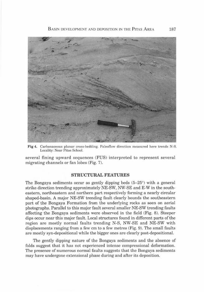
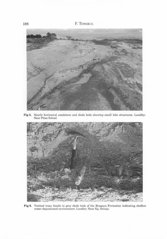
The sandstone beds vary in thickness from a few centimetre to several metres thick. The sandstone beds mostly pinched out laterally (Fig. 3). Some of the thick sandstone beds have conglomeratic bases. Sedimentary structures most commonly found in the sandstone beds are cross-beddings and crosslaminations (Fig. 4). Small lobe structures are also quite common (Fig. 5). Current directions derived from these structures varies from about N3300E to N600E (see Fig. 2). This wide distribution of paleoflow probably indicate local changes in the source area and depositional system during the filling of the basin. The shale beds also vary in thickness from a few cm to several metres. They are mostly carbonaceous showing cross liminations and parallel laminations. Vertical trace fossils (Fig. 6) are quite common in them indicating a shallow water depositional environment.
Measured sections from different parts of the region indicate that the thickness of the Bongaya sediments varies from one area to another, usually thicker towards the side of the basin. Its total thickness is uncertain but is estimated to be less than 200 metres. The stratigraphic sequence consists of several thick sandy and shaly sequences (each about 20-30 metres thick) alternating with each other. Sequence analysis indicates the presence of
Fig 3. Pinching out of sandstone beds interpreted to represent lobe migrations. Locality: Near Kg. Senaja.
B ASIN DEVELOPMENT A D DEPOSITIO N IN T HE PITAS AREA 187
Fig 4. Carbonaceous plana r cross-bedding. Paleoflow direction measured here trends N-S. Locality: Near Pitas School.
several fining upward sequences (FUS) interpreted to represent several migrating channels or fan lobes (Fig. 7).
STRUCTURAL FEATURES
The Bongaya sediments occur as gently dipping beds (5-25°) with a general strike direction trending approximately NE-SW, NW-SE and E-W in the southeastern, northeastern and northern part respectively forming a nearly circular shaped-basin. A major NE-SW trending fault clearly bounds the southeastern part of the Bongaya Formation from the underlying rocks as seen on aerial photographs. Parallel to this major fault several smaller NE-SW trending faults affecting the Bongaya sediments were observed in the field (Fig. 8). Steeper dips occur near this major fault. Local structures found in different parts of the region are mostly normal faults trending N-S , NW-SE and NE-SW with displacements ranging from a few cm to a few metres (Fig. 9). The small faults are mostly syn-depositional while the bigger ones are clearly post-depositional.
The gently dipping nature of the Bongaya sediments and the absence of folds suggest that it has not experienced intense compressional deformation. The presence of numerous normal faults suggests that the Bongaya sediments may have undergone extensional phase during and after its deposition.
188 F. TONGKUL
Fig 5. Nearly horizontal sandstone and shale beds showing small lobe structures. Locality: Near Pitas School.
Fig 6. Vertical trace fossils in grey shale beds of the Bongaya Formation indicating shallow water depositional environment. Locality: Near Kg. Senaja.

20
15
10
5
M
BASIN DEVELOPMENT AND DEPOSITION IN THE PITAS AREA 189
Trougn cross.bedding
FUS
Mud clasts
Corban I lamination
I
Groin Size
KEY
~;::~I ~~cz:l1Sl !lli:B2 ~3 LL.J4 ~5
20.~~ FUS
15
FUS
10
r FUS
5
M
o Groin Size
~6 1i17 Fig 7. Lithostratigraphic sequence of the Bongaya sediments showing several fining upward
sequences (FUS) probably representing migrating lobes or channels. 1. Conglomerate 2. Sandstone 3. Shale 4. Trough cross-bedding 5. Planar cross-bedding 6. Vertical trace fossils 7. Laminations.

190 F. TONGKUL
Fig 8. Horizontal fault trending N40E cutting through the Bongaya sediments with an oblique sinistral movement. Locality: Near Kg. Kabatasan.
DISCUSSION: DEPOSITIONAL MODEL
The sedimentological and structural features of the Bongaya sediments suggest that the deposition of these sediments was closely controlled by earlier major structures. Based on earlier studies (Tongkul, 1989), the underlying sediments were found to have been folded and thrust-faulted with their fold axes trending approximately NW-SE. These NW-SE trending lineaments are cross-cut by several sets of N-S and NE-SW horizontal faults as a consequence of continued N-S compression in this region up to late middle Miocene. The extensional features observed in the Bongaya sediments having a similar trend to the structures on the underlying rocks, indicate that the former was a manifestation of the latter (inverse structure). This is seen to be the case in other parts of Sabah (Tongkul, 1990). The existence of the earlier fault systems significantly controlled the shape of the basin and subsequently the depositional system (Fig. 10).
The Bongaya basin probably started to develop by extension during the uplift of the underlying rocks as a late stage accommodation structure. Extension utilized the existing N-S and NE-SW fault system here to form a shallow V-shaped graben-type basin. The narrow southeastern part of the basin was probably relatively shallower compared to the northeastern part of

BASIN DEV ELOPM ENT AND DEPOSITION TN THE PITAS AREA 191
". - - . . - - .. -~
Fig 9. Several normal faults and fractures cutting through gently dipping Bongaya sediment. Vertical displacement is about a metre. Locality: near Kg. Tambilidon.

192 F. TONGKUL
_--- -30 km ----------
1 -2km
1
(A) Mid. Miocene
(8) Late Miocene Open shallow sea
(C) Pliocene KEY
[[ill." I ..... .•....
Fig 10. Schematic diagram to illustrate the probable development of the Bongaya basin. (a) Structural features present on the underlying rock prior to the development of the basin; NW-SE trending faults and fold axis; N-S and NE-SW horizontal faults. (b) Extension in this region utilizing the existing major faults producing inverse structures (graben-type). The NE-SW and N-S horizontal faults marked the edge of the basin. (c) The narrow and elongate shape of the basin controlled the depositional system. (1) Bongaya Formation (2) Crocker Formation (3) Basement Rock (Chert-Spilite Formation) (4) Horizontal fault (5) Thrust and fold axis (6) Current directions (7) Lobe migrations.

BASIN DEVELOPMENT AND DEPOSITION IN THE PITAS AREA 193
the basin which connected with the open sea during this period. This basin configuration controlled the major flow of sediments from the southeast fanning-out towards the northeast. Fluvial sediments represented by the conglomeratic beds filled the southwestern and southeastern side of the basin which gradually gave way to deltaic fan lobe sediments towards the deeper part of the basin. The continuous deposition of sediments from the uplifted surrounding rocks (Crocker and Chert-Spilite Formations) by the overlapping or coalescing of several deltaic lobes gradually filled the entire shallow basin. As a result of this filling the basin probably sagged a bit causing steepening of beds towards the side of the basin and the normal faults. Overall uplift of the Bengkoka region gradually exposed this sediment.
CONCLUSION
This case study has demonstrated that the development of a particular basin and subsequently the deposition of its sediments are closely related to earlier major structures. In trying to understand and reconstruct the depositional history of the Upper Tertiary sediments, especially the circular-shaped basin in Central Sabah, it is necessary to know the major structures present on the underlying rocks.
ACKNOWLEDGEMENTS
This research was funded by grants from UKM 6/85. The author is grateful to his colleagues and final year students for their contribution during the field work.
REFERENCES
WILSON, R.A.M., 1960. The geology and mineral resources of the Banggi Island and Sugut River area, North Borneo. Geol. Surv. Dept. Brit. Terr. Mem.15.
TONGKUL, F., 1989. The structural styles and tectonics of Northern and Western Sabah. Petroleum Geology Seminar 1989 (abstract): 19. Geological Society of Malaysia.
TONGKUL, F., 1990. The tectonic evolution of Sabah, Malaysia. Orogenesis in Action: Tectonics and Processes in the West Equatorial Pacific Margin (abstract): 57. Geological Society of London.
Manuscript received 12 November 1990