Embed Size (px)
Citation preview

Bean Brook, Newark
Tactical Basin Plan was prepared in accordance with 10 VSA § 1253(d), the Vermont Water Quality Standards1, the Federal Clean Water Act
and 40 CFR 130.6, and the Vermont Surface Water Management Strategy.
June 2019 | Draft for Public Review
Passumpsic
River Tactical
Basin Plan

i
Approved:
----------------------------------------- -------------------------
Emily Boedecker, Commissioner Date
Department of Environmental Conservation
-------------------------------------- -------------------------
Julie Moore, Secretary Date
Agency of Natural Resources
Cover Photo: Bean Brook in Newark photographed by Fritz Gerhardt (used with permission)
The Vermont Agency of Natural Resources is an equal opportunity agency and offers all persons the benefits
of participating in each of its programs and competing in all areas of employment regardless of race, color,
religion, sex, national origin, age, disability, sexual preference, or other non-merit factors.
This document is available in alternative formats upon request. Call 802-828-1535

ii
Table of Contents Executive Summary ......................................................................................................................... iv
What is a Tactical Basin Plan? ......................................................................................................... 1
Chapter 1 – Basin Description and Conditions ............................................................................... 2
A. Passumpsic River Basin Overview ........................................................................................... 2
B. Water Quality Conditions in the Passumpsic River Basin ....................................................... 4
Chapter 2 –Surface Water Protection Opportunities ................................................................... 13
A. Reclassification of Surface Waters ..................................................................................... 14
B. Outstanding Resource Waters Designation ....................................................................... 18
C. Class 1 Wetland Designation ............................................................................................. 18
D. Identification of Existing Uses ............................................................................................ 20
Chapter 3 –Priority Areas for Surface Water Restoration ............................................................ 21
A. Basin Specific Total Maximum Daily Loads (TMDLs) ............................................................. 21
B. Targeted watershed areas for Restoration ........................................................................... 24
Chapter 4 –Strategies to Address Pollution by Source Sector. ..................................................... 26
A. Agriculture ............................................................................................................................. 27
B. Developed Lands -- Stormwater ........................................................................................... 34
C. Developed Lands -- Roads ..................................................................................................... 38
D. Wastewater ........................................................................................................................... 43
E. Natural Resource Restoration--Forests ................................................................................. 45
F. Natural Resource Restoration--Lakeshore Restoration ....................................................... 46
G. Natural Resource Restoration--River Connectivity .............................................................. 48
Chapter 5 – The Implementation Table ........................................................................................ 53
A. Coordination of Watershed Partners .................................................................................... 53
B. Passumpsic River Basin Implementation Table .................................................................... 53
C. Monitoring Priorities Table ................................................................................................... 60
List of Acronyms ............................................................................................................................ 65
Glossary ......................................................................................................................................... 67
References .................................................................................................................................... 70
Appendix A. Existing Uses in Basin 15 ........................................................................................... 73
Appendix B. 2014 Passumpsic River Basin Report Card ............................................................... 75
Appendix C. Municipal Protectiveness Matrix for Basin 15 .......................................................... 82

iii
List of Figures
Figure 1. Steps in the tactical basin planning process .................................................................... 1
Figure 2. Land cover and major subwatersheds in the Passumpsic River Basin ........................... 3
Figure 3. Lake assessment status for lakes in the Passumpsic Basin as compared to the state .... 6
Figure 4. Lake Score Card results for lakes in the Passumpsic River Basin .................................... 8
Figure 5. Passumpsic River Basin use support across five uses as compared to the state ........... 9
Figure 6. Map of stressed or impaired rivers in the Passumpsic River Basin .............................. 11
Figure 7. Geomorphic conditions of basin waters as compared to the state ............................. 12
Figure 8. Actions identified for water quality protection in the 2019 Passumpsic River TBP.
Numbers refer to the number of waterbodies recommended for increased protection. ........... 13
Figure 9. Recommended and existing high-quality waters of the Passumpsic River Basin......... 16
Figure 10. a. Subwatershed nitrogen yield for the Passumpsic River subwatersheds b. Primary
nitrogen sources for subwatersheds along with upstream nitrogen sources .............................. 22
Figure 11. The map shows annual cropland across the HUC 12 watersheds of the Passumpsic
River Basin ..................................................................................................................................... 28
Figure 12. Acreage of NRCS and VAAFM practices implemented by year in the Passumpsic River
Basin .............................................................................................................................................. 31
Figure 13. Acres of VAAFM and NRCS field practices implemented by HUC 12 watershed in 2018
– along with 2018 annual cropland acreage based on NASS croplands dataset. ......................... 32
Figure 14. Target watersheds for implementation of road erosion practices. ........................... 38
Figure 15. MRGP timeline and milestones ................................................................................... 39
List of Tables Table 1. Priority Lakes in the Passumpsic River Basin as identified through the Vermont Lake
Score Card. ...................................................................................................................................... 7
Table 2. Rivers on the Vermont 2018 priority waters list (VDEC, 2018) and 2016 stressed water
list (VDEC, 2016) for the Passumpsic River Basin .......................................................................... 9
Table 3. A list of uses that can be placed into each water class in the Vermont Water Quality
Standards (VDEC, 2017). ............................................................................................................... 14
Table 4. Class A(2) designated public water sources in the Passumpsic River Basin .................. 15
Table 5. Waters meeting A(1) and B(1) criteria for Aquatic Biota based on data through 2018 17
Table 6. Waters meeting B(1) criteria for recreational fishing in the Passumpsic River Basin .... 18
Table 7. Focus areas for implementation of water quality projects by sector in the Passumpsic
River Basin ..................................................................................................................................... 25
Table 8. Prioritization of municipal road segments based on REI status and slope. ................... 40
Table 9. Progress of Passumpsic River Basin towns toward completing Road Erosion Inventories.
....................................................................................................................................................... 40

iv
Table 10. Count of 100m road segments in the Passumpsic River Basin broken down by town
based on REI status as of 3/27/19 ................................................................................................ 41
Table 11. WWTF permit details for facilities in the Passumpsic River Basin ............................... 43
Table 12. Passumpsic River Basin Implementation Table............................................................ 55
Table 13. Passumpsic River Basin priorities for monitoring and assessment. ............................. 61
Table 14. Swimming as an existing use of specific waters within the Passumpsic River Basin. .. 73
Table 15. Recreational boating as an existing use of specific waters within the Passumpsic River
Basin. ............................................................................................................................................. 73
Table 16. Public water sources as an existing use within the Passumpsic River Basin. ............... 74
Table 17. Municipal protectiveness matrix for towns with significant area in Basin 15 ............. 82
Executive Summary
The Passumpsic Tactical Basin Plan (TBP) provides an assessment of watershed condition and
identifies current and future strategies to protect high quality waters and restore impaired water
resources based on the approaches set forward in the Vermont Surface Water Management Strategy
(VSWMS).
The five chapters in this plan provide a framework for understanding the Passumpsic River Basin
(Basin 15), including its unique characteristics and water quality issues, and where and how to carry
out priority actions to protect, maintain, enhance, and restore water quality in the basin.
The Passumpsic River Basin drains 507 square miles covering the majority of Caledonia County and
minor portions of Essex, Orleans and Washington counties. Many waters in the basin are of high
quality and so the basin plan recommends the reclassification of two waters for A(1) for aquatic
biota and five for B(1) aquatic biota use and 12 waters for reclassification for B(1) fishing use. Six
abandoned drinking water supplies are recommended for reclassification from A(2) to B(1) or B(2)
waters. Finally, Victory Basin Wetlands Complex is highlighted as a candidate for reclassification as
a Class 1 wetland. On page 14 Figure 9 includes a map of these waters.
Chapter 1
• Basin Overview
Chapter 2
• Protection
Chapter 3
• Restoration
Chapter 4
• Strategies
Chapter 5
• Implementation

v
There are no impaired lakes or ponds in the basin but eight are identified by the lake score card as
having reduced or poor shoreland conditions due to development, three have elevated or increasing
levels of nutrients, two are stressed due to acid precipitation, and one pond is stressed for
sedimentation as shown on page 8 in Figure 4. The only impaired waters in the Passumpsic River
Basin are the Passumpsic and Sleepers River which are listed as due to elevated E. coli levels from
the St Johnsbury combined waste and stormwater system overflowing. Several other rivers and
streams are listed as stressed due to sediment, E. coli, nutrients, metals (including nickel) and oil as
shown on page 11 in Figure 6.
Chapter 4 of the plan lays out the plan of attack for the next five years to address pollution
contributing to these water quality issues (in addition to addressing nitrogen loading to Long Island
Sound) and for protecting high quality waters which are all summarized in Table 7 on page 25.
Information from assessments in the basin and derived from public input have been pulled together
to guide the development of strategies for the agricultural sector, developed lands sector focused on
stormwater roads and wastewater treatment facilities, and restoration of forest lands and natural
lands along or lakes and streams. A total of 41 strategies are listed in Chapter 5 in the
implementation table on page 59 and 73 stream segments or ponds have been identified for
additional water quality monitoring in the monitoring priorities table on page 64. Specific
implementation projects are listed in the Watershed Projects Database.

1
What is a Tactical Basin Plan?
Tactical basin planning is carried out for the Vermont Agency of Natural Resources (VANR) by the
Watershed Management Division’s Monitoring, Assessment, and Planning Program (MAPP) in
coordination with watershed partners. Tactical basin plans (TBPs) are developed in accordance with
the Vermont Surface Water Management Strategy (VSWMS) and the Vermont Water Quality
Standards (VWQS) to protect, maintain, enhance, and restore the biological, chemical, and physical
integrity of Vermont’s water resources. The basin-specific water quality goals, objectives, strategies,
and actions described in the TBPs aim to protect public health and safety, and ensure public use and
enjoyment of VT waters and their ecological
health.
The TBP process allows for the issuance of
plans for Vermont’s fifteen basins every five
years, as required by statute 10 V.S.A. § 1253.
The plans incorporate the U.S Environmental
Protection Agency’s (EPA) 9-element
framework for watershed plans (USEPA, 2008)
and meet obligations of the Vermont Clean
Water Act. Updating a basin plan includes: 1.
Monitoring water quality and summarizing
existing information, 2. Assessing and analyzing
water quality data, 3. Identifying strategies and
projects to protect and restore waters, 4. Seeking
public comment and finalizing plan, and 5. Plan
implementation and tracking which is ongoing
throughout the planning cycle.
Tactical basin plans can be considered a strategic
guidebook for protecting and restoring VT surface
waters for VANR and watershed partners. They identify causes and sources of pollution,
opportunities for protecting waters through outstanding resource water designation and
reclassification. Plans identify reductions needed to restore water quality including those necessary to
meet Total Maximum Daily Load targets, and plans contain implementation tables (Chapter 5) that
list strategies to foster education and outreach, and targeted restoration actions that are eligible for
federal and State funding. The Plan’s strategies, described in Chapter 5’s implementation table, target
individual projects that are tracked via its online counterpart, the Watershed Projects Database
(WPD). The WPD is continuously updated to capture project information from the TBP process,
on the ground assessments and emerging projects due to natural and/or anthropogenic events. The
2014 Basin 15 Report Card located in Appendix B provides status and update information on each
of the objectives identified in the previous basin plan available here.
Figure 1. Steps in the tactical basin planning process

2
Chapter 1 – Basin Description and Conditions
A. Passumpsic River Basin Overview
The Passumpsic River Basin drains 507 square miles, a major portion of Caledonia County and
minor portions of Essex, Orleans and Washington counties. The East Branch of the Passumpsic
River originates in the town of Brighton and joins the West Branch just northeast of Lyndonville.
The Passumpsic River then joins Millers Run which drains the towns of Sheffield and Wheelock and
flows over 20 miles to the south until it reaches the Connecticut River in East Barnet passing over a
series of seven hydroelectric dams along the way. The basin also includes the Moose River
watershed with headwaters in East Haven and includes Victory Bog wetlands complex, along with
the Sleepers River and Joes Brooks and several smaller tributaries which are broken out into lower
and upper tributaries for this basin plan. A more extensive basin description is available in The
Passumpsic Watershed - Water Quality Assessment Report 2018 (VDEC, 2019).
The basin is broken down into 8 subwatersheds that have unique characteristics including different
land use patterns as shown in Figure 2. The Moose River and East Branch are the least developed of
the major watersheds with only a small percentage of developed or agricultural lands, while the
upper and lower tributary watersheds are much more developed with nearly one quarter developed
or agricultural land. The remaining watersheds have a similar level of developed lands compared to
the basin as a whole, with around six percent developed lands and approximately double that
percentage of agricultural lands. These broader land use patterns influence the conditions of waters
in these subwatersheds. More waters are identified for protection in the less developed Moose River
watershed, although there are localized water quality impacts in this watershed including elevated
levels of E. coli in the Chesterfield Valley Brook. There are also pockets of higher quality waters in
more developed watersheds such as in the Calendar Brook and Stannard Mountain Brooks which
are recommended for a higher level of protection in this plan.

3
Figure 2. Land cover and major subwatersheds in the Passumpsic River Basin

4
Climate Change and Implications for the Passumpsic River Basin
Climate is defined by long-term weather patterns, which in turn, influence human and natural
systems. The 2014 Vermont Climate Assessment established state-level, climate change information
with implications for local surface waters. Since 1941, Vermont average temperatures have increased
2.7° F with warming occurring twice as fast in winter. The latter results in earlier thaw dates for
rivers, lakes and ponds, and mountain snowpack. Average annual stream flows are increasing, which
is expected to continue in the future. High flows now happen more frequently, leading to increased
inundation flooding and fluvial erosion (stream-related erosion.) Additional information on climate
change in Vermont can be found at: https://climatechange.vermont.gov.
The impact of increased runoff and streamflow in a watershed depends on local land use and land
cover. In developed areas, more precipitation can increase stormwater volume and velocity thereby
mobilizing larger pollutant loads (Galford, et al., 2014). In addition, increased streamflow will
increase bed and bank erosion and deliver more sediments downstream. In areas where non-point
source pollution is a concern more runoff can increase sediment, nutrient, and pathogen loading to
surface waters (Galford, et al., 2014). Changes in climate increasingly require watershed restoration
projects to preserve natural sediment attenuation locations and incorporate stormwater and non-
point source runoff controls to counteract pollutant transport as well as consider the potential for
higher peak flows. Restoring floodplain connectivity along streams is essential to provide space for
sediment, debris, and nutrients to settle and store naturally and to maintain ecosystem resilience as
the climate changes.
Aquatic habitats affected by increased runoff and streamflow could experience increases in sediment
mobilization, nutrients and scouring in addition to increased water temperature. In response, local
freshwater plant and animal species may shift their geographic ranges and seasonal activities and
alter their abundance. Maintaining habitat connectivity, river and lake riparian buffers, and stream
equilibrium conditions will help reduce the impacts of climate change on Vermont’s rivers, lakes and
ponds, and wetlands.
B. Water Quality Conditions in the Passumpsic River Basin
Vermont Assessment Approach
The Vermont Department of Environmental Conservation (VDEC) uses monitoring and
assessment data to assess individual surface waters in relation to Vermont Water Quality Standards
as outlined in the 2016 VTDEC Assessment and Listing Methodology (VDEC, 2016). Vermont’s
assessment approach is described in the Vermont Water Quality Monitoring Program Strategy 2011-
2020 which was updated in 2015 (VDEC, 2015).
The Passumpsic River Basin Assessment report includes information on biological, chemistry and
stream geomorphic conditions in the basin, and specific data for individual sites can be found using
the Vermont Integrated Watershed Information System (VIWIS) online data portal. Chapter 4 includes

5
information on sector specific assessments such as bridge and culvert surveys, stream geomorphic
assessments, stormwater master plans and road erosion inventories while the monitoring table in chapter
5 identifies priorities for future monitoring.
The four categories used in Vermont’s surface water assessments are full support, stressed, altered and
impaired. For Vermont, impairment is substantiated by chemical, physical or biological data collected
through monitoring and these waters are noted on the state's 303(d) list of impaired waters. Aside from
the 303(d) list, the State also produces the priority waters list which identifies other waters that do not
meet water quality standards but do not require a Total Maximum Daily Load (TMDL). Sections of that
list include: Part B- impaired waters that have other required remediation measures in place; Part D-
impaired waters with TMDLs in place; Part E-waters altered by aquatic invasive species; and Part F-
waters altered by flow modifications. These priority waters can be viewed on the Vermont
Environmental Atlas.
For a more detailed description of monitoring results use the Vermont Integrated Watershed
Information System online data portal. In addition to this, water quality standards status is displayed on
the Vermont Lake Score Card that displays if a lake is impaired, altered or stressed along with nutrient
trends, shoreland condition and lake habitat, mercury pollution and invasive species.
Waters that support designated and existing uses and meet water quality standards are placed into the full
support or stressed categories. The stressed waters category refers to waters that support uses but where
water quality or habitat have been disturbed by point or by nonpoint sources of human origin and the
water may require some attention to maintain or restore water quality. Water quality monitoring is also
used to identify waters that exceed criteria and are candidates for reclassification to class B(1) or A(1)
waters as described in Chapter 2.
Conditions of Lakes and Ponds
Vermont has over 800 lakes or ponds, with 220 of them larger than 20 acres in size. The Passumpsic
River Basin hosts only 21 lakes or ponds 10 acres or larger, fewer lakes than most of the other
basins in the state. With excellent water quality, intact shoreline, high biodiversity, few invasive
species and scenic features, the best lakes in this basin include Bald Hill, Bean, Center and Stannard
ponds. These ponds have been identified by Division staff as some of the best lakes in Vermont (in
the top 10% statewide). Chandler and Joes ponds rank in the top 20% and Bruce Pond in the top
25%. Bald Hill Pond and Stannard Pond are two of just 13 ‘sentinel’ lakes that have been chosen as
research sites to evaluate how climate change is impacting lakes in Vermont. The Passumpsic River
Basin is also unique in that there are no reported aquatic invasive species in any lake in the basin as
shown in Figure 3. None of the lakes in the basin are considered impaired or altered (poor
conditions) for water quality standards status, while over 30% of lake acreage in Vermont is listed as
impaired or altered.
6
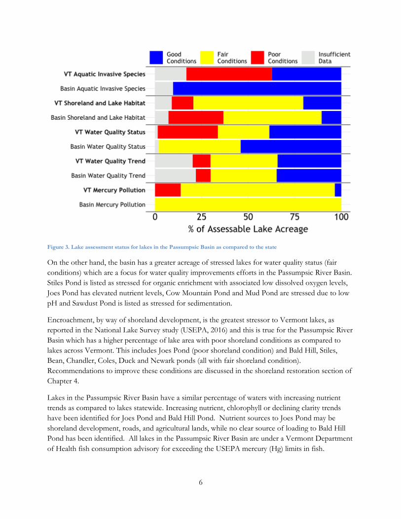
Figure 3. Lake assessment status for lakes in the Passumpsic Basin as compared to the state
On the other hand, the basin has a greater acreage of stressed lakes for water quality status (fair
conditions) which are a focus for water quality improvements efforts in the Passumpsic River Basin.
Stiles Pond is listed as stressed for organic enrichment with associated low dissolved oxygen levels,
Joes Pond has elevated nutrient levels, Cow Mountain Pond and Mud Pond are stressed due to low
pH and Sawdust Pond is listed as stressed for sedimentation.
Encroachment, by way of shoreland development, is the greatest stressor to Vermont lakes, as
reported in the National Lake Survey study (USEPA, 2016) and this is true for the Passumpsic River
Basin which has a higher percentage of lake area with poor shoreland conditions as compared to
lakes across Vermont. This includes Joes Pond (poor shoreland condition) and Bald Hill, Stiles,
Bean, Chandler, Coles, Duck and Newark ponds (all with fair shoreland condition).
Recommendations to improve these conditions are discussed in the shoreland restoration section of
Chapter 4.
Lakes in the Passumpsic River Basin have a similar percentage of waters with increasing nutrient
trends as compared to lakes statewide. Increasing nutrient, chlorophyll or declining clarity trends
have been identified for Joes Pond and Bald Hill Pond. Nutrient sources to Joes Pond may be
shoreland development, roads, and agricultural lands, while no clear source of loading to Bald Hill
Pond has been identified. All lakes in the Passumpsic River Basin are under a Vermont Department
of Health fish consumption advisory for exceeding the USEPA mercury (Hg) limits in fish.

7
Table 1. Priority Lakes in the Passumpsic River Basin as identified through the Vermont Lake Score Card
Waterbody Pollutant WQ problem Sector Remediation approach
Stressed and Priority Lakes (Assessment database – Lake Scorecard)
Bald Hill Pond Nutrients, Shoreland encroachment
Highly significantly increasing nutrient trend, fair shoreland conditions
Unidentified Complete a watershed survey in 2019, reevaluate shoreland assessment.as there appears to be limited shoreland development.
Bean Pond Shoreland encroachment
Fair shoreland conditions
Natural resources -shoreland restoration
Lake wise assessment and implementation
Center Pond Shoreland encroachment
Fair shoreland conditions
Natural resources -shoreland restoration
Lake wise assessment and implementation
Chandler Pond Shoreland encroachment
Fair shoreland conditions
Natural resources -shoreland restoration
Reevaluate shoreline assessment
Coles Pond Shoreland encroachment
Fair shoreland conditions
Natural resources -shoreland restoration
Lake wise assessment and implementation
Cow Mountain Pond
Acid Stressed due to low alkalinity
Atmospheric deposition Implement acid TMDL
Duck Pond Shoreland encroachment
Encroachment Natural resources -shoreland restoration
Lake wise assessment and implementation
Joes Pond Nutrients, shoreland encroachment
Elevated phosphorus levels with an increasing nutrient trend, poor shoreland conditions
Agriculture, developed lands—roads, developed lands – stormwater, natural resources -shoreland restoration
Agricultural Best Management Practices (BMPs), buffer planting, road BMPs, lake wise assessment and implementation, stormwater BMPs
Mud Pond (Granby)
Acid Stressed due to low alkalinity
Atmospheric deposition Implement acid TMDL
Newark Pond Shoreland encroachment
Fair shoreland conditions
Natural resources -shoreland restoration
Lake wise assessment and implementation
Sawdust Pond Sediment Stressed due to sedimentation
Site visit to identify Source areas
Stiles Pond Low dissolved oxygen, shoreland encroachment
Stressed due to low dissolved oxygen levels, fair shoreland conditions (due to Route 18)
Developed lands – roads, developed lands – stormwater
Buffer planting, road BMPs, stormwater BMPs

8
Conditions of Rivers and Streams
There are fewer impaired or altered rivers in the Passumpsic River Basin as compared to the rest of
Vermont as shown in Figure 5. A large percentage of waters in the basin are identified as meeting
B(1) criteria for aquatic biota or fishing use and only a short length of river is considered altered.
Elevated levels of mercury in fish tissue, driven primarily by atmospheric deposition, has resulted in
stressed conditions for fish consumption for all surface waters in the basin and a statewide fish
consumption advisory. Based on the length of stressed or impaired waters, pathogens are the next
most widespread pollutant in the basin followed by nutrients, sedimentation and other habitat
alterations. The most widespread sources of these stressed or impaired conditions are agriculture,
Figure 4. Lake Score Card results for lakes in the Passumpsic River Basin

9
channel instability, combined sewer overflows, municipal point sources, hazardous waste sites and
developed lands runoff.
Figure 5. Passumpsic River Basin use support across five uses as compared to the state
The only impairments in the basin are E. coli impairments of Passumpsic River and Lower Sleepers
River which receive combined sewer overflow from the St Johnsbury combined waste and
stormwater system – described in detail in Chapter 4. Individual impaired, altered and stressed
Rivers are listed in Table 2 which also identifies the water quality problem, sector, and remediation
approach and Figure 6 which maps out the geographical extent of these waters.
Table 2. Rivers on the Vermont 2018 priority waters list (VDEC, 2018) and 2016 stressed water list (VDEC, 2016) for the
Passumpsic River Basin
Waterbody Pollutant WQ problem Sector Remediation approach
IMPAIRED SURFACE WATERS IN NEED OF TMDL (VDEC 2018) Passumpsic River –Tremont Street - 5 miles downstream.
E. coli Pathogens Stormwater - combined sewer overflow (CSO)
Green stormwater infrastructure (GSO) practices and sewer
separation practices in CSO watersheds
Lower Sleepers River E. coli Pathogens Stormwater - combined sewer overflow (CSO
STRESSED RIVERS (VDEC 2016)
Water Andric Nutrients, enrichment,
low dissolved oxygen
Danville WWTF causes high phosphorus levels.
WWTF, Agriculture, Roads, Stormwater.
Ag BMP’s, Road practices, Stormwater treatment, WWTF improvements

10
Waterbody Pollutant WQ problem Sector Remediation approach
Millers Run Physical alteration,
Sediments
Agricultural land with no buffers, streambank erosion
Agriculture, Streambank Erosion (loss of riparian vegetation), Roads
River corridor protection, outreach on strengthening zoning bylaws, restoration projects
Dish Mill Brook Sediment, hydrologic alteration.
Scour events from increased peak flows; periodic
Sedimentation issues.
Roads, Stormwater Stormwater and road treatment practices, riparian restoration.
Dish Mill Brook tributary
Sediment High embeddedness, erosion from parking areas.
Roads, Stormwater. Stormwater and road treatment practices, riparian restoration.
Chesterfield Valley/ Moose River
E. coli Elevated E. coli; ag bmp installed in 2008 with improvement noted
Agriculture
Continue to work with farmer on farmstead and field management. Assess current E. coli levels.
Simpson Brook Undefined Impacts to fish community from undetermined sources
Undefined Watershed assessment.
Sleepers River Metals, oil Elevated levels of Ni in sediment, Fairbanks-Morse foundry site: oil spill, other possible contaminants
Stormwater Continue VDEC biomonitoring, Metals sampling
Unnamed Outlet Stream of Lily Pond
in Lyndon
Priority org (tce), metals (in sediment)
Parker landfill received hazardous waste;
contaminated groundwater & stream sediments
contain metals
Stormwater VDEC biomonitoring
WATERS ALTERED BY FLOW REGULATION (VDEC 2018)
Passumpsic River, Below Great Falls Dam (0.1 Miles)
Low and fluctuating
flows
Flow Alteration Artificial flow regime and condition by hydro operations; alters aquatic habitat in bypass reach
Federal Energy Regulatory Commission (FERC) license expires in 2019; in FERC relicensing process where this issue will be considered.

11
Figure 6. Map of stressed or impaired rivers in the Passumpsic River Basin

12
Physical alterations are also present throughout the basin, ranging from habitat alteration, general
stream channel instability and encroachment into floodplains and river corridors, as well as flow
alterations. As compared to statewide geomorphic assessments, the Passumpsic River Basin has less
mileage of waters in both poor and reference condition (Figure 7) although the assessed reaches may
not be representative of conditions in the basin as a whole. The results of specific assessments are
described in greater detail in the river connectivity section of Chapter 4.
Figure 7. Geomorphic conditions of basin waters as compared to the state
Conditions of Wetlands
The Passumpsic River Basin contains a great diversity of wetlands, ranging from open water habitats
to rich forested swamps. The wetlands in the basin are identified on the Vermont Wetlands
Inventory Map although up to 39% of Vermont wetlands may not be mapped. More than 35% of
the original wetlands in Vermont have been lost. In recent years, residential, commercial and
industrial development have been the primary causes of wetland loss.
The USEPA’s National Wetland Condition Assessment 2011 survey included Vermont wetlands
with assistance from the WSMD Wetlands and Monitoring, Assessment and Planning Programs.
The assessment of Eastern Mountains wetlands, including Vermont’s, estimated that 52% of the
estimated wetland area is in good condition; 11% is in fair condition, and 37% is in poor condition.
Presently, the WSMD Wetlands Program is developing a biomonitoring program to measure
wetland health to allow assessment of data specific to Vermont. There are a limited number of
wetlands assessments that have been completed in the Passumpsic River Basin based on this data it
suggests that wetlands in this basin are in better condition than on average for the state as a whole.

13
Chapter 2 –Surface Water Protection Opportunities
All surface waters in Vermont
are managed to support
designated uses valued by the
public. These uses include
swimming, boating, fishing,
aquatic biota, aquatic habitat,
aesthetics, drinking water
source and irrigation. In this
section of the plan, several
waters are identified as being
high quality exceptional, and
these, as well as other unique
waterbodies, are candidates for
establishing enhanced
management objectives or
augmented protections
through one of the processes
that are further described
below.
• Reclassification of surface
waters
• Class I Wetland designation
• Outstanding Resource Waters
designation
• Designation of waters as cold-water fisheries
• Identification of existing uses
The Vermont Water Quality Standards establish water quality classes and associated management
objectives. The protection of water quality and water-related uses can be promoted by establishing
specific management objectives for bodies and stretches of water. The management objectives
describe the values and uses of the surface water that are to be protected or achieved. In addition to
this, strategies to protect forested and riparian lands to support the protection of high quality waters
are described in chapters 4 and 5.
The Agency of Natural Resources is responsible for determining the presence of existing uses on a
case-by-case basis or through basin planning and is also responsible for classification or other
designations which are summarized in Figure 8. Once the Agency establishes a management goal,
the Agency manages state lands and issues permits to achieve all management objectives established
for the associated surface water.
Figure 8. Actions identified for water quality protection in the 2019 Passumpsic
River TBP. Numbers refer to the number of waterbodies recommended for
increased protection.

14
Before the Agency recommends management objectives through a classification or designation
action, input from the public on any proposal is required and considered. The public may present a
proposal for establishing management objectives for Agency consideration at any time, while the
Agency typically relies on the publication of basin plans to promote reclassification (10 V.S.A. §
1424a). When the public develops proposals regarding management objectives, the increased
community awareness can lead to protection of uses and values by the community and individuals.
Public involvement is an essential component to restoring and protecting river and lake ecology. The
Vermont Water Quality Standards indicate that in the basin planning process, “Public participation shall
be sought to identify and inventory problems, solutions, high quality waters, existing uses and significant resources of
high public interest.” Emphasis on the identification of values and expectations for future water
conditions can only be achieved through public contributions to the planning process. The public,
watershed partners and stakeholders are encouraged to make recommendations for additional
monitoring and research where very high-quality waters appear to exist.
A. Reclassification of Surface Waters
Since the 1960s, Vermont has had a classification system for surface waters that establishes
management goal objectives and supporting criteria for each use in each class of water. Pursuant to
Act 79 of 2016, the Vermont General Assembly, recognizing the wide range of quality for Class B
waters, created a new intermediary water quality class between B(2) and A(1), now called Class B(1).
Act 79 also sets forth the expectation that individual uses of waters (e.g., aquatic biota and wildlife,
aquatic habitat, recreation, aesthetics, fishing, boating, or swimming) may be individually classified,
so a specific lake or stream may have individual uses classified at different levels. Act 79 indicates
that uses may be reclassified independently to Class B(1) for individual uses if the quality of those
uses are demonstrably and consistently of higher quality than Class B(2). The extent of the water
being reclassified is subject to review based on documented conditions.
These waters and their elevated uses are identified through the tactical planning process or on a case
by case basis. The current classification of a water does not signify that B(1) criteria are not met.
Additional waters suitable for reclassification may be identified in the future as some waters have not
been previously monitored. Table 3 lists the possible classes into which each use may be placed.
Table 3. A list of uses that can be placed into each water class in the Vermont Water Quality Standards (VDEC, 2017)
Classification (2016) Applicable Uses
Class A(1) One or more of: Aquatic biota and wildlife, aquatic habitat, aesthetics, fishing, boating, or swimming
Class A(2) Public water source
Class B(1) One or more of: Aquatic biota and wildlife, aquatic habitat, aesthetics, fishing, or boating
Class B(2) Aquatic biota and wildlife, aquatic habitat, aesthetics, fishing, boating, swimming, public water source or irrigation

15
The Vermont Water Quality Standards (VWQS) begin classification with two broad groups based on
elevation:
• All waters above 2,500 feet altitude, National Geodetic Vertical Datum, are designated Class
A(1) for all uses, unless specifically designated Class A(2) for use as a public water source.
• All waters at or below 2,500 feet altitude, National Geodetic Vertical Datum, are designated
Class B(2) for all uses, unless specifically designated as Class A(1), A(2), or B(1) for any use.
Tactical basin plans identify surface waters where monitoring data indicates conditions are
significantly better than the water quality objectives and criteria of the VWQS. This high-level of
quality may be protected by site-specific application of the anti-degradation policy of the VWQS, or
by reclassification to a higher-level designated use.
Reclassification is proposed for many surface waters in this Tactical Basin Plan as shown in Figure 9
and tables 4-6. Seven waters are designated as A(2) public water sources in the Passumpsic River
Basin. Five of these have been abandoned as public water sources and are recommended to be
reclassified to reflect their current condition for each designated use (Table 4).
Table 4. Class A(2) designated public water sources in the Passumpsic River Basin
Map ID Waters Water Source Description
9. Unnamed tributary to Miller Run including Mathewson Reservoir
Lyndonville Abandoned. Village of Lyndonville water source. Unnamed tributary to Miller Run including Mathewson Reservoir and all waters within their watersheds above the intake in the Towns of Lyndon and Sutton. Recommend reclassification to B(1) or B(2).
10. Unnamed tributary to Miller Run including Copeland Reservoir
Lyndonville Abandoned. Village of Lyndonville water source. Unnamed tributary to Miller Run including Copeland Reservoir and all waters within their watersheds above the intakes. Recommend reclassification to B(1) or B(2).
18. Chandler Pond Lyndonville Abandoned. Lyndonville Village water source. Chandler Pond and all waters within its watershed in the Town of Wheelock. Wheelock Pond drains to the South Wheelock Branch. Recommend reclassification to B(1) or B(2).
19. Woodworth Reservoir Lyndonville Abandoned. Lyndonville water source. Woodworth Reservoir and all waters within its watershed in the Town of Lyndon. Woodworth Reservoir flows to the South Wheelock Branch. Recommend reclassification to B(1) or B(2).
3. Two unnamed tributaries to Sutton River.
West Burke Abandoned. Unknown water source. Two unnamed tributaries to the Sutton River, near West Burke, and all waters within their watersheds above the intakes. Recommend reclassification to B(1) or B(2).
26. Stiles Pond St. Johnsbury Permanent. St. Johnsbury Village (WSID 5045) water source. Stiles Pond and all waters within its watershed in the Town of Waterford. Stiles Pond is in the St. Johnsbury municipal forest and flows to the Moose River.
22. Danville Reservoir. Danville Emergency. Danville (WSID 5037) water source. Danville Reservoir on tributary of Brown Brook and all waters within its watershed in Danville.
Very High-Quality Waters Supporting Aquatic Biota
Based upon stream biomonitoring assessments conducted by the VTDEC, five surface waters in the
Basin consistently and demonstrably attain a higher level of quality than Class B(2), meeting Class
B(1) criteria for aquatic biota – but not rising to the level of class A(1). These waters are Clark

16
Figure 9. Recommended and existing high-quality waters of the Passumpsic River Basin

17
Brook, Nation Brook Tributary 3, Houghton Brook and the Upper Moose River. Through the
rulemaking process which provides opportunities for public comment and input, these waters are
recommended for reclassification to B(1). Two waters, Clark Brook Trib 22 and Bog Brook
consistently and demonstrably meet Class A(1) criteria for aquatic biota and are recommended for
reclassification to A(1). Thirteen additional sites are recommended for additional sampling to
confirm eligibility for B(1) for aquatic biota as listed in monitoring priorities table (Table 13.) Bog
Brook and the Upper Moose River are two of just 12 sentinel stream monitoring sites statewide
which are monitored regularly to look at the effects of climate change. Reclassification of these
waters as recommended would offer further protection for these reference waters.
Table 5. Waters meeting A(1) and B(1) criteria for Aquatic Biota based on data through 2018
ID Stream Name Town Reclassification opportunity
1. Bog Brook Burke, Victory A(1)
2. Calendar Brook Tributary 22 Sheffield A(1)
3. Calendar Brook Sutton, Sheffield B(1)
4. Clark Brook Sheffield, Sutton, Burke, Lyndon
B(1)
5. Nation Brook Tributary 3 Sheffield B(1)
6. Moose River Victory, Granby, East Haven B(1)
7. Houghton Brook Walden, Stannard, Danville B(1)
Very Good Waters for Recreational Fishing
Certain waters in the Passumpsic River Basin support productive noteworthy populations of cold-
water salmonids. Rivers and streams classified as B(1) recreational fishing waters, support wild, self-
sustaining salmonid populations characterized by the presence of multiple age classes and a
minimum abundance of 1000 individuals per mile (all species/ages/sizes); and/or 200 large (> 6
inches total length) individuals per mile; and/or 20 pounds/acre (all species/ages/sizes)1. Table 6
lists the names of streams that meet B(1) criteria for recreational fishing (§29A-306), which are also
displayed in Figure 9.
These waters shall be managed to achieve and maintain very good quality fishing. The list in Table 6
may be adjusted in the future based on new and updated surveys and as protocols are refined.
Waters that meet the revised criteria in the water quality standards for both B(1) and A(1) fishing use
will be continually identified and updated. Twelve streams identified as requiring one more round of
1 It should be recognized that wild trout populations vary widely from year to year and therefore an individual population may sometimes go below or greatly exceed these values in any given year. Because of these fluctuations, two years of data are needed to support reclassification within the last 20 years – with at least one sampling with in the last 10 years above the criteria. Alternatively, one year of data may be used if populations meet any of the following criteria: 3000/mile, 400/mile (>6 inches) or 40 pounds/acre. The upstream and downstream extent of the stream classification should be based upon consistent or improving water quality, physical habitat quality and land use conditions. The reach should include all upstream habitats which are deemed essential to sustain water quality and physical habitat requirements necessary to support wild salmonid populations at a very good level.

18
sampling to support reclassification are listed in Table 13 on Page 64. It is important to note that all
waterbodies that would naturally support fish populations are protected and maintained in
perpetuity.
Table 6. Waters meeting B(1) criteria for recreational fishing in the Passumpsic River Basin based on data through 2018
ID Stream Name Elevation (meters)
Town Trout Species Present
Brook Brown Rainbow
1. Burroughs Brook 337 Danville, Wheelock x
2. Dexter Brook 285 Sheffield, Wheelock
x
3. Dish Mill Brook 326 Burke x
4. Kirby Brook 287 Concord, Kirby x
5. Mathewson Brook 263 Wheelock, Sheffield
x
6. Millers Run Headwaters 323 Sheffield x
7. Umpire Brook 415 Victory x
8. Unnamed trib to Millers Run 256 Lyndon x
9. Unnamed trib to Passumpsic 168 St. Johnsbury x
10. Water Andric 213 Barnet, Danville x
11. Weir Mill Brook 410 Victory, Burke x
12. Whiteman Brook 428 Danville x
B. Outstanding Resource Waters Designation
In 1987, the Vermont Legislature passed Act 67, “An Act Relating to Establishing a Comprehensive
State Rivers Policy.” A part of Act 67 provides protection to rivers and streams that have
“exceptional natural, cultural, recreational or scenic values” through the designation of Outstanding
Resource Waters (ORW). Depending on the values for which designation is sought, ORW
designation may protect exceptional waters through permit conditions in stream alteration, dams,
wastewater, aquatic nuisance control, solid waste disposal, Act 250 permits. ORWs are waters which
can be designated by the Agency of Natural Resources through a petition process. ORWs display
outstanding qualities that are determined to deserve a higher level of protection. There are currently
no ORW designations in the Passumpsic River Basin or recommendations in this plan for new
ORW designations.
C. Class 1 Wetland Designation
It is policy of the State of Vermont to identify and protect significant wetlands and the values and
functions they serve in such a manner that the goal of no net loss of such wetlands and their
functions is achieved. Based on an evaluation of the extent to which a wetland provides functions
and values, it is classified at one of three levels:

19
• Class I: Exceptional or irreplaceable in its contribution to Vermont's natural heritage
and therefore, merits the highest level of protection
• Class II: Merits protection, either taken alone or in conjunction with other wetlands
• Class III: Neither a Class II or Class I wetland
Impacts to Class I wetlands may only be permitted when the activity is necessary to meet a
compelling public need for health or safety. The VT Wetlands Program has created a Class I website
with an interactive map. This website includes the determinations for eight Class I wetlands: Dorset
Marsh, Northshore Wetland, Tinmouth Channel, Chickering Fen, Dennis Pond Wetlands, Sandbar
Wetlands, Peacham Bog and the LaPlatte River Wetlands. The last five wetlands were added since
2016.
The VT Wetlands Program welcomes recommendations for Class I candidates. There are currently
no Class I wetlands in the Passumpsic River Basin, however Victory Basin Wetlands Complex in
Victory is recommended for Class I designation. Victory Basin is a remarkable boreal wetland
complex in northeastern Vermont. While it is smaller than the similar Nulhegan Basin, it supports a
large, intact wetland complex with a high variety of natural community types and significant plant
and animal diversity. Nearly all of the wetland is in a Wildlife Management Area. All wetland
functions and values as tracked by the Vermont Wetland Program are provided at a significant level
by this wetland.
This wetland is one of the centerpieces of Vermont’s natural environment, and is well known by
naturalist groups, scientists, hunters, birdwatchers, anglers and other wetland-interested groups. The
wetland is on public land and the thick vegetation and challenging terrain offer a wilderness
experience unusual in Vermont for those who choose to stray off the main trails. Anglers target the
remoteness of the fishery as a unique opportunity to catch large and abundant Brook Trout in the
Bog Brook and Umpire Brook that drain into the complex. The Moose River as it flows though the
wetland offers one of the best canoe trips in the state and chances to see a moose in its natural
habitat.
As one of the coldest places in the state, the wetland also offers refugia to cold-affinity species in the
face of climate change that might be extirpated from the state entirely without access to this wetland
and the Nulhegan Basin wetlands. The abundance of peaty soils in the bogs, beaver wetlands, and
conifer swamps also sequester a tremendous amount of carbon. Past land use has affected the
wetland, but it is recovering well over time. Invasive species are uncommon and beavers have
implemented ‘restoration projects’ that have largely flooded the old railroad bed passing through the
wetland and despite past land use there are a handful of small patches of forested wetland with very
old trees that have apparently never been logged. Given protection, the condition of the wetland is
likely to continue to improve further over time.
As part of the implementation of this tactical basin plan, the Department will hold a site visit to the
wetland complex in the spring or summer of 2019 in coordination with VFWD staff to evaluate
reclassification opportunities and potential boundaries for a Class 1 wetland. If this site visit
confirms wetland complex satisfies criteria for designation, the Department will compile information

20
and initiate discussions with the community and stakeholders about reclassification. If these efforts
determine that the wetland complex satisfies criteria for designation it may be proposed for such
designation through departmental rulemaking authority, and as consistent with the Vermont
Wetland Rules.
D. Identification of Existing Uses
The Agency may identify existing conditions, known as existing uses, of waters during the tactical
basin planning process or on a case-by-case basis during application reviews for State or federal
permits. Consistent with the federal Clean Water Act, the Vermont Water Quality Standards have
always stipulated that existing uses may be documented in any surface water location where that use
has occurred since November 28, 1975. Pursuant to the definition of the new Class B(1) in Act 79,
the Agency may identify an existing use at Class B(1) levels when that use is demonstrably and
consistently attained. The public is encouraged to recommend waters for existing uses for
swimming, boating, fishing, drinking water, and ecological significance given that they provide
evidence of such use.
The existing uses identified by VTDEC for the Passumpsic River Basin to date should be viewed as
only a partial accounting of known existing uses based upon limited information. The list does not
change protection under the Clean Water Act or Vermont Water Quality Standards for waters not
listed. The existing uses in the Passumpsic River Basin for swimming, boating, and drinking water
supply are found in Appendix A. New recommendations for these existing uses should be sent to
the Passumpsic River Watershed Coordinator for review.
It is the Agency’s long-standing stipulation that all lakes and ponds in the basin have existing uses of
swimming, boating and fishing. Likewise, the Agency recognizes that fishing activities in streams and
rivers are widespread throughout the state and are too numerous to thoroughly document for the
Passumpsic River Basin. Also recognized is that streams too small to support significant angling
activity provide spawning and nursery areas, which contribute to fish stocks downstream where
larger streams and rivers support a higher level of fishing activity. As such, along with the larger
streams and rivers that support a higher level of fishing activity, these small tributaries are
considered supporting the use of fishing and are protected at a level commensurate with
downstream areas.
For existing uses of waters, the level of water quality necessary to protect those existing uses shall be
maintained and protected regardless of the water’s classification (VDEC, 2017).

21
Chapter 3 –Priority Areas for Surface Water Restoration
A. Basin Specific Total Maximum Daily Loads (TMDLs)
A TMDL or Total Maximum Daily Load is the calculated maximum amount of a pollutant that a
waterbody can receive and still meet Vermont Water Quality Standards. In a broader sense, a TMDL
is a plan that identifies the pollutant reductions a waterbody needs to meet Vermont's Water Quality
Standards and develops a means to implement those reductions. TMDLs can be calculated for
reducing water pollution from specific point source discharges or for an entire watershed to
determine the location and amount of needed pollution reductions.
Under Section 303(d) of the Federal Clean Water Act, all states are required to develop lists of
impaired waters. The list includes impaired lakes, ponds, rivers and streams that do not meet Water
Quality Standards. For Vermont, impairment is substantiated by chemical, physical or biological data
collected through monitoring and these waters are noted on the state's 303(d) list of Impaired
Waters. The Federal Clean Water Act requires TMDLs to be developed for waters on the list; the list
provides a schedule indicative of TMDL completion priority.
TMDLs for the Passumpsic River Basin include:
• Long Island Sound (LIS) Dissolved Oxygen TMDL
• Northeast Regional Mercury Total Maximum Daily Load
The Long Island Sound (LIS) Dissolved Oxygen TMDL, released in 2000, is designed to address
low dissolved oxygen or hypoxia in Long Island Sound bottom waters. It is often referred to as the
Connecticut River Nitrogen TMDL because it is linked to an overabundance of nitrogen discharging
into the Sound from the Connecticut River and other tributaries. While nitrogen is essential to a
productive ecosystem, too much nitrogen fuels the excessive growth of algae. When the algae die,
they sink to the bottom, where they are consumed by bacteria. The microbial decay of algae and the
respiration of oxygen-breathing organisms use up the available oxygen in the lower water column
and in the bottom sediments, gradually reducing the dissolved oxygen concentration to unhealthy
levels.2
In 2013, a Vermont-specific section was added to the LIS-TMDL to address four goals.
• First, to identify the Vermont sources of nitrogen as they are currently understood, across
broad land use sectors, such as developed, agricultural and forested;
• Second, to identify the current status and trends of important drivers of nitrogen export
such as the intensity of agricultural and development activities and investigate how these
might have changed since the TMDL baseline time period of 1990;
2 A Total Maximum Daily Load Analysis to Achieve Water Quality Standards for Dissolved Oxygen in Long Island Sound

22
• Third, to identify the management programs, operating at that time, that address these
drivers of nitrogen loading that have a significant effect on reducing or preventing nitrogen
export. A part of this is to identify a timeline as to when programs were initiated or
enhanced; and
• Fourth, using a weight-of-evidence approach, to assess the combined management
programs/projects to develop a qualitative evaluation as to whether management efforts are
sufficient to meet the original 2000 TMDL of a 10% NPS nitrogen reduction and if these
actions are sufficient to maintain that control into the future. 3
A USGS report found loading of nitrogen of 1610 and 1890 pounds per square mile per year from
the Moose River at Victory and Passumpsic River at Passumpsic respectively. These rates of loading
are lower than the estimated loading from the Connecticut River watershed above Thompsonville
Connecticut, at 2230 pounds per square mile per year, but higher than other subwatersheds,
suggesting that levels of nitrogen loading are intermediate even though much of the basin is forested
(Deacon, 2006).
Loading of nitrogen in the Connecticut River watershed has also been modeled through the Spatially
Referenced Regressions on Watershed Attributes (SPARROW) model by the New England
Interstate Water Pollution Control Commission and USGS presented in a publication by Richard
Moore (Richard Bridge Moore, 2004). This modeling included estimated loading from municipal
3 Vermont Enhanced Implementation Plan for the Long Island Sound TMDL
a. b.
Nitrogen Yield Nitrogen Source
Figure 10. a. Subwatershed nitrogen yield for the Passumpsic River subwatersheds b. Primary nitrogen sources for subwatersheds
along with upstream nitrogen sources showing dominance of atmospheric deposition as a nitrogen source in the Passumpsic River
watershed (graphics taken from Connecticut River Atlas).

23
discharges, agricultural, developed lands along with atmospheric deposition with additional
calculations for watershed and in stream nitrogen loss. This model estimated Vermont nitrogen
export to LIS to be about 4% of the total load to the Sound with approximately 21% of Vermont’s
nitrogen export originating from agricultural areas, 9% from Municipal Wastewater and
approximately 4% originating from developed areas. Of note is that approximately 65% of the
nitrogen exported from Vermont originates as atmospheric deposition. Also, worth noting, is that
this model was calibrated based on loading data from 1992 and 1993 or earlier so in addition to the
typical uncertainties for a model the passage of a quarter of a century adds uncertainty in using this
model to understand current nitrogen loading levels.
The LIS Nitrogen TMDL included a provision to re-evaluate and revise the TMDL at a later date.
That process is currently underway by a workgroup comprised of representatives of the five
watershed states (Connecticut, Massachusetts, New Hampshire, New York and Vermont), EPA, and
NEIWPCC. The workgroup is considering many source categories for possible nitrogen reductions
and is evaluating management strategies for achieving those reductions. In 2017, EPA embarked
on its Nitrogen Reduction Strategy to investigate and better define control actions to reduce
nitrogen in the Long Island Sound. Information on the most current developments and strategies
can be found in EPA’s Long Island Sound Study, a summary is provided below:
EPA is implementing a strategy to aggressively continue progress on nitrogen reductions, in parallel with the
States’ continued implementation of the 2000 Total Maximum Daily Load (TMDL), and achieve water
quality standards throughout Long Island Sound and its embayments and near shore coastal waters. The
strategy recognizes that more work must be done to reduce nitrogen levels, further improve dissolved oxygen
(DO) conditions, and address other nutrient-related impacts in Long Island Sound. The nitrogen reduction
strategy complements the 2000 TMDL in important ways. Foremost, while the 2000 TMDL is premised
on achieving water quality standards for DO in the open waters of LIS, the EPA strategy expands the focus
to include other nutrient-related adverse impacts to water quality, such as loss of eelgrass, that affect many of
LIS’s embayments and near shore coastal waters.
The sources of nitrogen to be addressed in Vermont include wastewater discharges, agricultural
lands, developed lands and forest practices as shown in Figure 10. Overarching strategies and the
steps Vermont is taking to implement these by enacting Act 64 in 2015 include:
• Continue implementation of nitrogen reductions from wastewater treatment plants (WWTPs), including
capping WWTP nitrogen loads, monitoring nitrogen discharged from WWTPs, and the completion of
nitrogen removal optimization studies at WWTFs in the VT portion of the LIS watershed. The
development of targets for nitrogen reduction is underway. Discharge permits are being
reviewed and updated as part of the permit renewal process.
• Control non-point source discharges from agricultural lands through implementation of Required Agricultural
Practices (RAP) and Best Management Practices (BMP) to decrease sediment and nutrient runoff. RAPs
have been updated and implemented to include increased requirements for small farm
certification, increased buffer zones, livestock exclusion, additional nutrient management,

24
and tile drainage. Additional requirements include inspections of small certified farms;
requirements for training farm owners or operators regarding: prevention of discharges to
waters; mitigation of stormwater runoff; land application of manure or nutrients; and
nutrient management planning; and certification of custom applicators land-applying manure
or nutrients.
• Continue implementation of state stormwater permits covering construction, roads, direct and indirect
discharges. Activities that require an ANR stormwater permit have been expanded to include:
construction of one acre or more of impervious surface; discharge from industrial facilities;
municipal separate storm sewer systems; earth disturbance of one or more acres; expansion
of existing impervious surface by more than 5,000 square feet if the resulting impervious
area is more than one acre; runoff from municipal and state roads; and retrofitting of old
impervious surfaces.
• Decrease discharges from forestry practices through continued implementation of AMPs, outreach and the use
of portable skidder bridges. VDFPR has revised the Acceptable Management Practices for
Maintaining Water Quality on Logging Jobs (AMPs).
The Long Island Sound Watershed Regional Conservation Partnership Program (LISW-RCPP) was
created in 2015 across six states to coordinate the development and implementation of a
comprehensive working lands program with foci on: 1) nutrient management and soil health, 2)
protection of non-industrial forest habitat, biodiversity, and drinking water sources, and 3) stem
erosion and improve resiliency on working lands through riparian restoration.
In partnership with the Vermont Association of Conservation Districts (VACD), UVM Extension,
the Connecticut River Conservancy, The Nature Conservancy and federal, state and local
organizations in NH, MA, CT, NY and RI, ten million dollars is being invested in the adoption of
best management practices on private working lands, providing both technical and financial
assistance.4
B. Targeted watershed areas for Restoration
By combining the list of high quality waters identified for protection, the priority waters list and
those TMDL watershed acres identified as sources, the following focus areas have been identified
for restoration and protection across each land use sector. Details about the strategies are discussed
for each sector in Chapter 4 with additional information in the implementation table in Chapter 5.
4 LISW-RCPP website at: http://www.lisw-rcpp.com/home.html

25
Table 7. Focus areas for implementation of water quality projects by sector in the Passumpsic River Basin
Sector Focus Areas Strategies
Agriculture Joes Pond, Water Andric, Chesterfield Valley, Millers Run, Cropland areas
• Support regional agricultural working group
• Hold annual soil health, BMP and/or RAP workshops for farmers
• Support farmers in developing and implementing Nutrient Management Plans (NMPs)
• Initiate a regional equipment sharing program
• Increased buffers, river corridor and wetland restoration outreach and implementation
• Water quality monitoring to understand nitrogen source areas
Developed Lands - Stormwater
St Johnsbury CSO watersheds, Water Andric, Joes Pond, Stiles Pond, Dish Mill Brook
• Implement GSI in St. Johnsbury CSO watersheds
• Implement priority practices from Stormwater Master Plans
• Develop and implement GSI practices at local schools
• Support brownfields restoration efforts
• Identify stormwater treatment practices in Danville
Developed Lands - Roads
Water Andric, Dish Mill Brook, Joes Pond, Center Pond, Stiles Pond
• Complete REI’s and provide technical support for towns to use.
• Support for towns in applying for funding to target WQ issues
• Address Class 4 WQ issues with support from NWSC
• Host Workshops and Peer to Peer sharing on BMP’s
• Shared Lyndon/Burke and Sutton/Sheffield Hydro seeder
Natural Resources Restoration – Forestland
Bald Hill Pond, A(1) and B(1) watersheds
• Support forestland conservation and skidder bridge program
• Promote AMPS, implementation of Voluntary Harvesting Guidelinesand restoration projects on state lands
Natural Resources Restoration – Lakeshore
Joes, Bald Hill, Center, Chandler, Coles, Duck, Newark Ponds
• Support Lake Wise planning, assessment and implementation
• Support Aquatic Invasive Species spread prevention efforts
Natural Resources Restoration – River Connectivity
Water Andric, Millers Run, East Branch Passumpsic,
• Develop and implement projects from river corridor plans
• Restore floodplain access and stream stability through active projects or river corridor easements & buffer planting projects
• Remove obsolete dams and discuss removal of USGS weirs
• Strategic wood additions in the upper Moose River tributaries and other locations where this is identified by VFW.
• Provide outreach to communities on floodplain and river corridor protections
Natural Resources Restoration – Wetlands
Victory Basin Wetlands Complex
• Wetland reclassification

26
Chapter 4 –Strategies to Address Pollution by Source
Sector.
Tactical basin plans address water quality by sector as summarized in the following sections which
are consistent with the CWIP Clean water investment report (State of Vermont Treasurer, 2019).
Agriculture
• Installation or application of conservation practices that reduce sources of pollution from farm production areas and farm fields.
Developed Lands--Stormwater
• Installation of practices that reduce or treat polluted stormwater runoff from developed lands, such as parking lots, sidewalks, and rooftops.
Developed Lands--Roads
• Installation of stormwater and roadside erosion control practices that prevent erosion and treat road-related sources of pollution.
Wastewater
• Improvements to municipal wastewater infrastructure that decrease pollution from municipal wastewater systems through treatment upgrades, combined sewer overflow (CSO) abatement, and refurbishment of aging infrastructure.
Natural Resource Restoration
• Restoration of “natural infrastructure” functions that prevent and abate pollution. Natural infrastructure includes: floodplains and river channels, lakeshores, wetlands, and forest lands.

27
A. Agriculture
A little over 10 percent of the Passumpsic River watershed is in agricultural land use (Figure 2).
Agriculture can both positively and negatively affect water quality. Farms support food production
and agricultural land with good soil health absorbs more precipitation, allows for floodplain access
during high water flows, and removes nutrients through crop uptake. On the other hand nutrients,
pathogens, and sediments can be exported from farms when waste storage facilities don’t function
property or when rain or floodwaters wash sediment, manure or fertilizer from fields and farmstead
areas or cause field or streambank erosion.
Runoff from agricultural lands has been identified as a contributor to four of the watersheds in the
basin with water quality concerns. These water quality concerns include E. coli in the Chesterfield
Valley Brook, nutrient loading in Joes Pond and the Water Andric, and instability of Millers Run due
in part to agriculture as shown in Figure 11. Agricultural runoff also contributes nitrogen from the
Passumpsic River Basin to Long Island Sound which is a concern due to low dissolved oxygen
levels. Conversely, the South Wheelock, Calendar Brook, and Sleepers River watersheds have
significant numbers of farms and acreages of agricultural land use, and streams in these watersheds
consistently meet Class B(2) standards. Several tributaries in these watersheds are streams that are
better than Class B(2) standards which are candidates for reclassification to B(1) as described in
Chapter 2.
This section presents basin-specific strategies to address agricultural water resource impairments
through regulatory programs, best management practice (BMP) implementation, funding sources,
outreach efforts, and partnerships. The tactical basin planning approach engages local, regional, and
federal partners in the development of these strategies needed to accelerate agricultural BMPs to
meet the state’s clean water goals including reductions to support the Long Island Sound (LIS)
Nitrogen TMDL. This section is organized around the Vermont Agency of Agriculture, Food, and
Markets (VAAFM) regulatory programs including the Required Agricultural Practices (RAPs), the
Large Farm Operations Program (LFO) generally regulating farms with 700 or more dairy cows or
equivalent, the Medium Farm Operations Program (MFO) regulating farms with 200-699 dairy cows
or equivalent and the Certified Small Farm Operations Program (CSFO) which regulates farms with
50 – 199 dairy cows or equivalent or 50 acres of cropland or vegetables. The chapter concludes with
a discussion of the available agricultural assistance and outreach programs and local coordination
efforts.

28
Figure 11. The map shows annual cropland across the HUC 12 watersheds of the Passumpsic River Basin along with four
watersheds that have identified water quality issues related to agricultural runoff. The bar chart shows the current number
of large, medium, certified small and small farms by watershed as of the writing of this plan and the acreage of annual
cropland and permanent hay/pasture in 2018 for each HUC 12 watershed (National Agricultural Statistics Service).

29
Agricultural Regulatory Programs
The VAAFMs RAPs, formerly the Accepted
Agricultural Practices, and existing MFO and
LFO permit programs set baseline farm
management practices to ensure environmental
stewardship. Medium and Large Farm
Operational Permits have been in place for
over 10 years. The RAPs were revised in 2016
and 2018 to support the necessary phosphorus
load reductions for the Lake Champlain and
Lake Memphremagog TMDLs and nitrogen
reductions for the LIS TMDL. Details on the
RAPs and recent changes can be found at this
link. These revisions are expected to result in a
significant increase in conservation practice
implementation in the future. A few examples
of the revisions to the RAPs include new
requirements for nutrient management
planning and implementation, increased
perennially vegetative buffer zones and manure
spreading setbacks, reduction in maximum soil
erosion rates. The Flood Hazard Area and
River Corridor Rule, effective in 2015, also
regulates agricultural practices (as well as state
facilities, silvicultural practices, and public
energy transmission projects). The Rule limits
new encroachments that could reduce
floodplain storage and/or contribute to stream
channel instability.
Large (LFO) and Medium (MFO) Farm
Operation Programs
The VAAFM LFO Program requires large
sized farms with more than 700 dairy cows (or
the equivalent in other species) to operate
under an individual permit. The VAAFM MFO
Program requires farms with between 200 and
700 cows (or equivalent) to operate under a general permit. Both permit program requirements
exceed those of the technical components of the Federal Clean Water Act and aim to reduce the
amount of phosphorus and other nutrients entering Vermont’s waterways.
Adaptations:
A small family farm in Sutton embrace new practices
Kyle and his uncle James Seymour
at their family farm in Sutton, VT
After the Required Agricultural Practices were
passed, Kyle was approached about developing a
Nutrient Management Plan (NMP) for their family
farm. After studying Dairy Management in college,
he was interested in writing the plan himself. He
worked with their local Conservation District to
collect soil samples and field information to prepare
for taking UVM Extension’s “Digging In” class to
write their own NMP. During the process, he
learned their farm fields had a high risk of soil loss
and were prone to leaching nitrogen, a potential
problem for water quality and a concern for the
farm in optimizing their soil health and maintaining
their much-needed nutrients for growing crops. As
a result, they decided to try no-till practices and
better target their nitrogen fertilizer applications.
After two years the result include reduced fuel costs,
fertilizer savings, reduce soil loss, and improved
forage quality from comparable yields. Kyle has
been keeping their NMP updated and continues to
look for new innovations to try on their farm.

30
In the Passumpsic River Basin, there is only one individually permitted LFO and no farms seeking
coverage under the MFO General Permit. VAAFM inspects all LFOs annually and all MFOs every
three years. Inspections include assessments of farm Nutrient Management Plans (NMPs),
production area assessments of all facilities associated with the permitted operation, and cropland
management assessments in accordance with Vermont’s Water Quality Standards, RAP’s, and the
farm’s individual nutrient management plan.
Certified Small (CSFO) and Small Farm Operations (SFO) Programs
VAAFM’s Certified Small Farm Operations (CSFO) program supports farmers to ensure their clear
understanding of the RAPs, while helping assess, plan, and implement any necessary conservation
and management practices necessary to meet water quality goals. VAAFM estimates that there are 17
CSFO in the Passumpsic River watershed – mostly in the Calendar Brook, Lower Moose River,
Sleepers River, South Wheelock Branch, and Water Andric watersheds. CSFOs are required to
annually self-certify their operations and will be inspected at least once every 7 years. Priority
watersheds for inspection in this basin include the Water Andric and Chesterfield Valley Brook
watersheds. The Certified Small Farm Program began July 1, 2017. Since this program is still new
many small farms have not yet been inspected, and so much of the effort at this stage is increased
education and outreach about regulations and financial and technical assistance programs.
The VAAFM estimates 22 small farms in the Passumpsic River Basin will fall within RAP
jurisdiction but may not need to certify. Figure 11 shows the distribution of farms by size in each
HUC 12 watershed. Outreach will need to continue to the remaining farms or locations to help
landowners understand where they fall within the RAP farm size categories and to help them
understand the RAP requirements.
Agricultural Assistance and Outreach Programs
In addition to work completed to meet regulatory requirements, farm operators have begun and will
continue to voluntarily adopt BMPs based on the increased availability of technical and financial
assistance throughout the Passumpsic River Basin. VAAFM and NRCS both fund several programs
that support farmers with developing nutrient management plans, implementing practices, or
purchasing equipment to improve water quality. State funding programs are listed on the VAAFM
website at https://agriculture.vermont.gov/grants. Figure 12 represents the combination of
conservation practices implemented from 2012 to 2018 through state and federal assistance
programs. Figure 12 shows an increase in the acreage of crop rotation, cover cropping corn/hay
conversion and conservation tillage practices over time. There has also been an increase in the
number of waste storage facilities and barnyard management practices from 2012 through 2018
primarily focused in the Calendar Brook watershed and to a lesser degree in the Sleepers River and
Water Andric watersheds. This graph just represents practices funded though these programs so
practices that continued by the farmer outside these programs would not be included.

31
Figure 12. Acreage of NRCS and VAAFM practices implemented by year in the Passumpsic River Basin
While some farmstead work has focused in the Chesterfield valley and Water Andric watersheds –
additional work in these areas may be necessary to address E. coli and nutrient sources respectively.
There are two small farms in the Joes Brook HUC 12 watershed that includes Joes Pond and so if
there are above Joes Pond these would be a priority for farmstead projects. The focus for the
Millers Run watershed is on river channel conditions for which farmstead BMPs would not be a
focus.
Figure 13 shows that a large percentage of land in annual cropland was addressed by field BMPs in
2018. Many of the HUC 12 watersheds showing more acreage of field BMPs than acreage of annual
cropland, which indicates that many of these field BMPs are overlapping as each BMP is counted
separately. For example, ten acres of conservation tillage and ten acres of cover crop implemented
on the same field (overlap) are counted as 20 acres of field BMPs. VAAFM is pilot testing a partner
database and coordinating with NRCS to create a method for identifying overlap and duplicative
BMPs. Millers Run watershed was the exception, where a relatively small percentage of annual
cropland had field BMPs installed in 2018 through state or federal funding. Since this watershed is a
focus for this plan due to stream instability, implementing field BMPs in this watershed is a priority
for this tactical basin planning cycle with a focus on riparian restoration and river corridor
protection.
0
100
200
300
400
500
600
700
800
900
1000
2012 2013 2014 2015 2016 2017 2018
Acr
esCoverCrop CropRotation
ConservationTillage CornHayConversion
PrescribedGrazing

32
Figure 13. Acres of VAAFM and NRCS field practices implemented by HUC 12 watershed in 2018 – along with 2018 annual
cropland acreage based on NASS croplands dataset.
EXPLANATION OF FIGURE 13 This chart and map show the level of BMP implementation in each HUC 12 watershed relative the area of annual cropland where these practices can be applied. Three of the watersheds identified as impacted by agriculture have high levels of BMP implementation although there is still room for additional practice instillation where BMPs could help to improve water quality further. On the other hand, the fourth target watershed, Millers Run, does not have a high percentage of lands with BMPs funded though VAAFM or NRCS which makes this a target for BMP implementation going forward.

33
Tactical Basin Plan Implementation for Agriculture
A workgroup for the Passumpsic and Upper Connecticut River Basins was established in 2018 to
coordinate agricultural water quality improvement efforts. Members of this workgroup include
UVM Extension., local Conservation Districts, USDA Natural Resources Service, DEC Basin
Planner, and VAAFM staff that work with small, medium and large farms. This group has met twice
to discuss agricultural priorities in the watershed and sustaining this group is an important strategy in
this plan to effectively target agricultural BMP implementation to improve water quality conditions.
Other strategies that are a focus for this group are listed below and in the implementation table:
• Hosting annual workshops on improving soil health, RAP revisions and the Flood Hazard &
River Corridor Rule, implementing conservation tillage and cover cropping practices.
• Supporting farmers in developing Nutrient Management Plans (NMPs) and continuing to
work with priority farms on implementing NMPs
• Developing a regional equipment sharing programs to support the implementation of
effective cover cropping and reduced tillage practices.
• Conducting outreach to better promote buffer planting programs across the watershed.
• Developing a water quality monitoring and research effort to understand nitrogen source
areas in the Passumpsic and Upper Connecticut River watersheds.
• Identifying areas for potential voluntary land use changes that would provide increase water
quality protection as well as financial support to the farmers.
• Coordinating outreach and targeting project implementation among partners
Click the following hyperlink to view strategies to address Runoff from Agricultural Lands.

34
B. Developed Lands -- Stormwater
Stormwater runoff is a contributor to many of the water quality issues in the Passumpsic River
Basin. Impairments in the basin are caused by Combined Sewer Overflows (CSOs) driven by
stormwater runoff into the St. Johnsbury combined waste and stormwater systems which results in
the release of untreated waste and stormwater when the system can’t handle the flow volumes.
These overflows cause the E. coli impairment of the Passumpsic and Sleepers Rivers. Stormwater
runoff across the basin also contributes nitrogen which is a concern in relation to Long Island
Sound with the primary source areas being in St. Johnsbury, Lyndon and other small communities
such as Concord. Stormwater runoff is a key concern in Dish Mill Brook, draining developed areas
near Burke Mountain which has been noted as causing erosion and a resulting high sand bedload.
Stormwater runoff may also be a contributor to elevated levels of sediment and nutrients along the
Water Andric and nitrogen regarding the LIS TMDL. Finally, stormwater runoff from developed
lands is a contributor to nutrient loading to many upland lakes where we see impacts from
encroachment on the littoral zone and nutrient and sediment loading including Joes Pond, Stiles
Pond, Center Pond.
This section integrates basin-specific information on stormwater-related water resource
impairments, regulatory programs, stormwater master plans, Illicit Discharge Detection and
Elimination (IDDE) studies, existing implementation efforts and partnerships to inform strategies to
address stormwater-related water resource impairments. The tactical basin planning approach
engages local, regional, and federal partners in the development of strategies needed to accelerate
adoption and monitoring of stormwater-related BMPs to meet the state’s clean water goals including
reductions to support the Long Island Nitrogen TMDL. The section is organized around the 3-acre
operational permit, stormwater master planning and IDDE studies which are the primary drivers for
voluntary implementation efforts in the Basin.
Operational three-acre impervious surface permit program
The Stormwater Program will issue a general permit in 2019 for stormwater from so-called “three-
acre sites” which are existing sites with three or more acres of impervious surface that lack a
stormwater permit based on the 2002 Vermont Stormwater Management Manual. For the
Connecticut River watershed including the Passumpsic River Basin, parcels will need to apply for
permit coverage by 2033. Since this date is well beyond the timeframe for this plan, voluntary
stormwater efforts though stormwater master planning are likely to be the primary drivers for
stormwater implementation efforts for this planning cycle.

35
Stormwater Master Planning and Outreach
Stormwater master plans (SWMP) have been
completed or are in the works for most of the
communities with stormwater systems in the
Passumpsic River Basin as well as the Dish Mill
Brook watershed where development around
Burke Mountain Resort has caused increased
sedimentation and stormwater runoff. The
Caledonia and Essex County Conservation
Districts have taken the lead on these
assessments in this basin working closely with
local communities. In addition, the
NorthWoods Stewardship Center (NWSC) has
been partnering with the Conservation
Districts to provide a summer Work Crew to
implement small scale stormwater practices.
Below are brief updates on the stormwater
master planning efforts in each of these
communities.
St. Johnsbury
The Stormwater Master Plan (SWMP) for the
town of St. Johnsbury was completed in 2016
and assessed approximately 1800 acres of
drainage primarily centered on the village area
of St. Johnsbury and extending north forming
a corridor to St. Johnsbury Center. The
SWMP outlined 25 stormwater “problem
areas”, nine of which were prioritized and
advanced to a greater level of detail and design.
One project that was identified in the plan was
a sand pile noted on Bay Street that was
eroding into the Passumpsic River which did
not require further design and was removed
after outreach to the town. Prior to the
SWMP, a stormwater treatment project was
installed along Western Ave, treating 95-acres
of drainage with 41-acres of impervious
surface. Additional completed projects are
listed on the right. Next steps include:
Stormwater water quality accomplishments over
the last 5 years…
✓ Completion of the St. Johnsbury SWMP and installation of: o Oak Street neighborhood scale infiltration
practices o Town Garage sedimentation basin o Bay Street Sand Pile removal o Pearl Street parking lot design
✓ Completion of the Lyndon SWMP and installation of: o Fenton Chester Arena treatment practices o Rain garden and infiltration trench, and trail
erosion control at Lyndon Institute o Rain gardens and erosion control at Northern
Vermont University o Designs are being developed for several large-
scale practices
✓ Completion of the Dish Mill Brook SWMP and installation of: o Several rain gardens at Burke Mountain Resort o Instillation of an infiltration basin at Burke
Mountain Academy. o Several designs for large scale stormwater at
the base and Mid Burke Lodge
✓ Completion of a SWMP for the Town of Concord
Fenton Chester Arena treatment practice

36
• The retrofit of the Pearl Street municipal parking lot to improve drainage and install green
stormwater infrastructure (GSI) practices.
• Continued partnership with the Town of St. Johnsbury to integrate GSI into CSO
construction projects to achieve co-benefits and install GSI practices in CSO watersheds to
reduce stormwater flows where CSO efforts may not take place for many years
• Continued outreach to St. Johnsbury Academy to address erosion concerns and pursue
opportunities for improved stormwater management and GSI integration on campus.
Lyndon
The Town of Lyndon Stormwater Master Plan (SWMP) was completed in 2017 and evaluated 3300
acres of drainage area within the Village of Lyndonville, Lyndon State College (now called Northern
Vermont University), and south of Lyndonville toward the industrial park. A total of 72 stormwater
“problem areas” were identified and prioritized, including opportunities for Best Management
Practice (BMP) installation, erosion control, and gully prevention and stabilization. Thirty (30)
projects were selected for further development and design. A number of projects have been
installed since the SWMP was completed, including small-scale design-build projects installed by
NWSC at Lyndon Institute and Northern Vermont University, and stormwater drainage
improvements and erosion control at the Fenton Chester Ice Arena. Project designs are underway
for three additional projects in Lyndonville, and there are many more opportunities for project
development, including:
• Installation of stormwater improvements for the “High Street” project, receiving drainage
from Chase Street, a portion of High Street and the southern end of Pinehurst Street.
• Technical Assistance and alternatives analysis to Lyndonville and landowners regarding a
large gully located at the end of South Prospect Street in Lyndonville.
• Continued project development and technical assistance to Northern Vermont University,
including installation of gravel wetland near the Faculty Parking Lot, and Best Management
Practice (BMP) installation at soccer field and near Dragon Pond.
• Assistance to Town of Lyndon to address drainage and gully erosion at Chamberlain Bridge.
• Continued installation of small design-build practices at Lyndon Institute and Northern
Vermont University.
Dish Mill Brook
The Dish Mill Brook Stormwater Master Plan was completed in 2015 and included an assessment of
developed lands within the 6.7-square mile or 4300-acre watershed. Three large projects were
identified and developed at Burke Mountain, two smaller projects at Burke Mountain Academy, and
one project in East Burke Village on Belden Hill. One project was installed at Burke Mountain
Academy in 2018. Next steps include:

37
• Continuing to partner with Burke Mountain Resort to install large-scale stormwater projects
designed for their base lodge and mid-Burke parking lots.
• Seeking funding to address gully erosion near Bear Path Development
• Maintaining communications with Burke Mountain Academy to encourage installation of
project near Shelly Glover Center.
• Continued communications with Town of Burke to discuss road management and
maintenance capacity for Belden Hill project.
Concord
The Concord Stormwater Master Plan was completed in Spring of 2019 and provided an assessment
on WQ issues identified in the surrounding town properties. Twenty stormwater management
opportunities were identified but two larger projects on Folsum Avenue and High Street were
identified for implementation. Final project design for the Folsum Avenue project is planned for
Summer of 2019 with partial project construction in the fall. Next steps include:
• Identification of funding sources for implementation of Folsum Avenue project.
• Coordination of activities with adjacent landowners and VTRANS.
• Seeking funding through various grants to address smaller project areas identified in SWMP
including the High Street project.
• Provide Technical Assistance to ensure town residents understand project goals.
• Collaborate with Concord School to install small scale retro-fit opportunities.
Basin-wide Illicit Discharge Detection and Elimination (IDDE) Study
In 2015, Stone Environmental, Inc., completed an IDDE study of the Town of St. Johnsbury. The
study is available on the web at:
http://dec.vermont.gov/sites/dec/files/wsm/erp/docs/IDDE/St%20J%20IDDE%20Final%20Re
port%20compiled.pdf
A second study was completed for the remaining stormwater systems in the basin in 2017 covering
communities of Burke, Danville, Lyndon and Concord in the Passumpsic River Basin. This report is
available at the following link:
http://dec.vermont.gov/sites/dec/files/wsm/erp/docs/IDDE/Upper-Mid-
CT%20River%20IDDE_Vfinal_red.pdf
Through these studies stormwater drainage systems have been mapped and several discharges were
detected and eliminated in the communities of Concord and St. Johnsbury although there are a few
locations were some additional follow up is needed. Click the following hyperlink to view strategies
to address Runoff from Developed Lands -- Stormwater.

38
C. Developed Lands -- Roads
Reducing road runoff and erosion is critical to meeting the state’s clean water goals. Runoff from
municipal roads is a
major source of
sediment and nutrients
in the Passumpsic
River Basin that
contributes to water
quality issues in the
Dish Mill Brook, Water
Andric, and Millers
Run, Joes Pond, Center
Pond and Stiles Pond
watersheds (see
Chapter 3). Road
runoff also contributes
a small portion of the
nitrogen loading to the
Connecticut River
watershed which is a
concern for the Long
Island Sound Nitrogen
TMDL.
This section integrates
basin-specific
information on
transportation-related
water resource
impairments, regulatory
programs, road erosion
inventories (REIs),
road practice
implementation, and existing partnerships to inform strategies to address water resource
impairments. The tactical basin planning approach engages local, regional, state and federal partners
in the development of strategies needed to accelerate transportation-related BMPs in order to meet
the state’s clean water goals including reductions to support the Long Island Sound nitrogen
TMDL. The section is organized around the regulatory programs including the Municipal Roads
Figure 14. Target watersheds for implementation of road erosion practices

39
General Permit (MRGP), and the Transportation Separate Storm Sewer System Permit (TS4) as
these regulatory programs are the driving factor in road water quality implementation efforts in the
Basin.
Municipal Roads General Permit
The 2015 MRGP is a stormwater permit for Vermont cities and towns signed into law as part of Act
64. The MRGP is intended to achieve significant reductions in stormwater-related erosion from
paved and unpaved roads. The permit requires each municipality to conduct a road erosion
inventory (REI) of hydrologically connected roads by 12/31/2020 to determine if they meet MRGP
standards (Figure 15). Hydrologically connected roads are those municipal roads within 100’ of or
that bisect a wetland, lake, pond, perennial or intermittent stream, or a municipal road that drains to
one of these water resources. These road segments represent ≈ 60% of municipal roads and can be
viewed using the “Municipal Road Theme” on the ANR Natural Resource Atlas. Road segments are
assessed as fully meeting, partially meeting, or not meeting the MRGP standards.
MRGP standards include: road crowning, stabilizing drainage ditches and turnouts, and upgrading
drainage culverts and intermittent stream culverts. VDEC has established a timeline with milestones
to guide towns through the MRGP requirements (Figure 15). Towns will use the REI results to
prioritize road upgrades with goal of all municipal roads meeting the MRGP standard by
12/31/2036.
This plan recommends that technical and financial assistance be prioritized for interested towns
based on the water quality benefit and feasibility of a project. Projects that “do not meet standards”
and have >10% slope and high erosion risk are very high water quality priorities (Table 6).
Resources available from the Clean Water Fund (e.g. VDEC Grant-in-Aid and VTrans Better Roads
grants) assist with development of designs, capital budgets, cost estimates and implementation of
road projects. Completion of these projects may be counted towards meeting the requirements of
the MRGP. For additional information see the VDEC Municipal Roads Program.
Very High Priority roads meet the
MRGP standards
All municipal roads meet the
MRGP standards
12/31/2020 12/31/2028 12/31/2036
Class 4 roads meet the MRGP standards
Towns to upgrade 15% of non-compliant roads to MRGP standards
Road erosion inventory (REI) of
hydrologically-connected roads
12/31/2025 12/31/2022
Figure 15. MRGP timeline and milestones

40
Table 8. Prioritization of municipal road segments based on REI status and slope. Road segments that do not meet
standards and are on a steep slope are priorities for water quality protection
MRGP Status 0-4% slope or Low Road Erosion Risk
5-9% slope or Moderate Road Erosion Risk
10%+ slope or High Road Erosion Risk
Fully Meets - - -
Partially Meets
Low priority Moderate priority Moderate priority
Does Not Meet
Moderate priority High priority Very High priority
DEC and its partners are offering training, technical assistance, outreach, and funding for REIs,
road upgrades and equipment purchases to assist municipalities with the MRGP requirements. For
towns in Caledonia, Orleans and Essex Counties, a Northeast Kingdom Roads and Rivers
workgroup (NEKRR) was established to support towns in these efforts. This group includes:
VTrans, NVDA, Natural Resources Conservation Districts, NWSC, Memphremagog Watershed
Association, and VDEC. This workgroup provides municipalities with outreach, technical and
financial assistance, and additional training to assist towns with the upcoming MRGP requirements.
NVDA set up a partnership with Northern Vermont University to support the completion of REIs
necessary to meet MRGP requirements, while partners in the NEKRR workgroup continue to work
with towns on the development of more complete capital budgets to support towns in applying for
better road grants. Table 9 below shows the status for REIs for each town in the basin. Table 10
Table 9. Progress of Passumpsic River Basin towns toward completing Road Erosion Inventories
shows the preliminary number of segments that meet standards For road segments that don’t meet
standards or partially meet standards Table 10 identifies the priority for addressing segments
following the prioritization scheme shown in Table 8. Many towns that completed earlier
inventories still need to have assessments uploaded into the MRGP database and eight towns still
need to complete inventories by 2020.
REI Status Complete Complete (need to be uploaded)
Planned (2019-2020)
Towns Danville, Lyndon Sheffield, Sutton, Waterford
Barnet, Kirby, Peacham, Stannard, Walden, Granby
Burke, Newark, St. Johnsbury, Wheelock Concord, East Haven, Victory, Westmore

41
Table 10. Count of 100m road segments in the Passumpsic River Basin broken down by town based on REI status as of
3/27/19
Municipality Hydrologically Connected
No Data
Incomplete Data
Very High
High Moderate Low Meets Standards
Barnet 274 274
Burke 419 419
Cabot 40 40
Concord 257 257
Danville 700 10 1 31 29 44 26 559
East Haven 156 156
Granby 94 94
Kirby 255 255
Lyndon 602 17 1 37 32 24 9 482
Lyndonville Village 91 91
Newark 223 222
1
Peacham 37 37
Saint Johnsbury 772 770
1
1
Sheffield 189 4 1 16 12 7 2 147
Sutton 238 6
15 11 8 3 195
Victory 199 199
Walden 107 107
Waterford 222 153 1 1 1 3 1 62
West Burke Village 31 31
Westmore 15 15
Wheelock 216 216
Total 5137 3373 4 100 86 86 41 1447
Funding through tactical basin planning grants and the Transportation Planning Initiative provide
support that allows NVDA and Conservation Districts to continue to work with towns after
inventories have been completed to apply for Vtrans Better Road grants and other funding sources
to implement the capital budgets. This funding, and the partnerships it supports have been
instrumental in getting REIs completed for towns in this basin as many towns have small road crews
and limited town staff and so Strategy 15 is to continue this support so that the eight towns that
need REIs can get them completed before the deadline of December 31st, 2020. Towns also need
technical support to be able to use technology including tablets with software to track road segment
status. Strategy 16 is to provide towns with workshops and one on one assistance on how to use
these systems. Six towns in the basin completed REIs before the current software application was
available. Strategy 17 is to support towns in getting these data uploaded into the MRGP database.
In addition, many towns need technical assistance in developing project proposals and budgets and
in seeking funding to implement high priority projects that have the largest water quality benefits as

42
highlighted in strategy 18. Strategy 19 supports the completion of very high and high priority
projects in target watersheds as well as other water quality priority projects in the basin.
Another local effort has involved working with NWSC watershed work crew to address erosion
issues on class 4 roads and legal trails which are often a lower priority for municipal officials but are
frequently large sources of sediment. Continuing this work is important as more towns complete
assessments and identify areas where a work crew can be effective at addressing WQ issues (Strategy
20).
There are also limitations on equipment that make it challenging for towns to meet towns MRGP
standards. Some of the equipment most needed to support this work in the basin include hydro
seeders, hay bale shredders, leaf blowers and shoulder discs. In addition to purchasing equipment,
municipalities need support in how to use this equipment most effectively and how to implement
best management practices. Peer-to-peer information sharing is needed, including information on
best management practices for fertilizer use in hydro seeders and hosting workshops on best
management practices for this equipment (strategy 21).
Click the following hyperlink to view summary strategies to address Runoff from Municipal Roads.

43
D. Wastewater
In the Passumpsic River Basin, there are three municipal wastewater treatment facilities and one
electrical paper manufacturing facility. All of these are subject to NPDES discharge permit
requirements issued by the State of Vermont (Table 11).
An overarching consideration for the issuance of permits in the Passumpsic planning basin is the
Long Island Sound TMDL for nitrogen. This multi-state TMDL has been promulgated with interim
waste load and nonpoint source nitrogen load allocations. As of the issuance of this Plan, all facilities
are operating under permits developed under a nitrogen permitting strategy whereby all Vermont
WWTFs ultimately discharging to the Connecticut River must, collectively, discharge no more than
1,727 lbs. TN/day. Each individual facility has a unique TN loading limit. In addition to the nitrogen
loading limit, WWTFs are required to develop optimization plans for maximizing nitrogen removal
and regularly monitor for nitrogen compounds.
As part of an effort to be better informed about potential nutrient impacts, the WSMD, with
assistance from certain municipalities, is conducting an extensive sampling effort to document the
current loading conditions to determine the “reasonable potential” that WWTFs have, to cause or
contribute to downstream water quality impairment. Results of these investigations are recorded as
part of permit issuance documentation. The municipal wastewater discharge permits in the Basin are
shown in Table 11.
Facility Specific Information
Table 11. WWTF permit details for facilities in the Passumpsic River Basin
Facility (permit ID)
Permit effective date
Planned permit re-issuance year
Design flow (MGD)
IWC* 7Q10 /LMM
Current Percent of Design Flow (2017)
Treatment type
# of CSOs
Receiving water
Danville 2018 amended
2021 0.060 0.146 / 0.076
66% Aerated lagoon
0 Water Andric
Lyndon 2016 2021 0.75 0.029 / 0.010
19% Activated sludge
0 Passumpsic River
St. Johnsbury 2018 2023 1.6 0.028 / 0.011
50% Rotating biological contactor
15 Passumpsic River
EHV Weidman
2012 2019 0.350 0.011 / 0.004
41% 0 Passumpsic River
* Instream Waste Concentration – or the proportion of river flow at lowest base (7Q10) and low median monthly (LMM) flow
attributable to discharge, for the facility design flow. Note that the IWC is specific to the flow of receiving water.

44
Danville
The Danville WWTF is a small facility discharging to a receiving stream of limited assimilative
capacity. A waste management zone extends from the outfall one-mile downstream. Owing to the
small size of the receiving water, this facility is required to monitor receiving water flow during
summer months, and release effluent only in such quantities as can be assimilated, based on
measured effluent concentrations for key pollutants.
Lyndon
The Lyndon WWTF was upgraded in 2012 from extended aeration to complete mix activated sludge
with anoxic selectors. The upgrade included new mechanical fine-screens, grit removal, and
centrifugation to de-water sludges, to improve operational and cost efficiency. The facility
participated in the Long Island Sound TMDL nitrogen treatment optimization study. As noted in
this study the plant staff at Lyndonville have been experimenting with cyclic aeration to reduce
nitrogen without having to use a recycle pump and this approach has shown good nitrogen removal
over extended periods, except for colder temperatures (JJ Environmental, 2015).
St. Johnsbury
The St. Johnsbury facility is actively pursuing remediation of CSO outfall points as required by order
of the Department, under authority of 10 V.S.A.§1272. The municipality is developing a long term
control plan to develop and select the long-term CSO controls. Through this process St. Johnsbury
is encouraged to evaluate and implement GSI for stormwater runoff and sewer overflow
management to the greatest extent possible as described in more detail in the stormwater sector
section of this plan. Several outfall points are identified by this Order, which are being remediated
in sequence by the City. During 2018, the City replaced a 600-foot section of 6-inch diameter force
main crossing the Passumpsic River and extending to Oak Street to increase capacity of the Hood
Pump Station. Replacement of the Oak Street pump station is currently under contract for
construction and is scheduled to be completed by 2019. An $8.7 million-dollar combined sewer
separation project for the Pleasant Street, Gilman Avenue, and Farmer Drive area was approved at
the 2019 Town Meeting.
The St. Johnsbury wastewater treatment facility has completed numerous upgrades over the past
couple of years. In 2015, the facility installed a magnetic flow meter for septage metering and
upgraded the chemical feed system. In 2016, the two Archimedes-style screw pumps that carry
influent wastewater into the facility’s headworks were replaced. In 2017, a new headworks building
with a new grinder, fine screen, and compactor was installed. In 2018, refurbishment of the digester
mixing system and repair of the digester exterior walls was completed. In 2019, the facility plans on
installing an influent flow meter, methane/oil furnace, and a methane waste burner.

45
E. Natural Resource Restoration--Forests
Forest lands cover a majority of the Passumpsic River watershed and maintaining forestland cover is
a key strategy to maintaining water quality conditions in the Passumpsic River Basin. Poorly
planned and implemented forestry operations can be a source of sediment and nutrients which can
impact surface waters. Logging operations have not been specifically identified as a cause for any of
the stressed or impaired waters in the basin however poor logging practices may contribute to
nutrient loading which is a concern for several waters. This section includes information around the
forestland conservation efforts, the Acceptable Management Practices for Logging Jobs, Vermont
Voluntary Harvesting Guidelines to protect forest health and Sustainability, local skidder bridge
programs.
The focus for this tactical basin plan is to support the working forest lands across the basin to
maintain forest lands for water quality as well as many other benefits. This will be done by
supporting VDFPR, VFWD, local land trusts and conservation organizations in conserving forest
blocks that are important for maintaining good water quality along with wildlife and other functions.
As described in Chapter 1 the LISW-RCPP has a focus on protection of non-industrial forest
habitat, diversity and drinking water sources.
Vermont adopted rules in 1987 for Acceptable Management Practices (AMPs) for Maintaining
Water Quality on Logging Jobs in Vermont and updated these effective August 11, 2018. The
AMPs are intended and designed to prevent any sediment, petroleum products and woody debris
(logging slash) from entering the waters of the State and to otherwise minimize the risks to water
quality. The state also published a set of voluntary harvesting guidelines in 2015 which include a
chapter on protecting water resources which go above the AMPs. One strategy in the plan is to
support outreach to private forestland owners, foresters and loggers on the revised AMPs and
voluntary harvesting guidelines. VDFPR can be reached directly for technical assistance for
harvesting and associated stream crossings.
The Department of Forests, Parks and Recreation is promoting and demonstrating the use of
portable bridge designs on timber harvesting operations throughout Vermont, including a bridge
that is rented through the Caledonia County Natural Resources Conservation District in this basin.
When properly installed, used, and removed, skidder bridges minimize stream bank and stream bed
disturbance as compared with alternative devices, such as culverts or poled fords. In addition, these
bridges reduce the occurrence of sedimentation, channeling, and any degradation of aquatic habitat,
while allowing loggers to harvest timber in compliance with the AMPs. Continued support for this
program and outreach necessary to maximize the use of the bridges will support water quality
improvements in the basin and support loggers in meeting the new AMP’s.
Click the following hyperlink to view summary strategies to address Runoff from Forest Lands.

46
F. Natural Resource Restoration--Lakeshore Restoration
Restoration of lakeshores is critical to meeting the state’s clean water goals in the Passumpsic River
Basin. Several lakes in the Basin have increasing phosphorus trends or fair or poor shoreland
conditions with Joes Pond having both. Joes Pond is rated as having poor shoreland conditions
while Bald Hill, Stiles, Bean, Chandler, Coles, Duck and Newark ponds are rated as having fair
shoreland conditions.
This section includes basin specific information about the Lake Wise program which is the State’s
focus for restoring lakeshore habitat. Tactical basin planning can play an integral role in supporting
Lake Wise assessments by engaging local communities, lake and watershed organizations and
partners in the targeting of these efforts locally where to date there hasn’t been a lot of local
support. This section provides a brief update on the shoreland protection act and then a discussion
of how efforts can target lake wise restoration efforts to restore lakeshore conditions in this basin.
Shoreland protection act
The Shoreland Protection Act ensures that new shoreland development will have minimal impact on
the lake in terms of phosphorus and sediment runoff, and degradation of aquatic habitat. This
program regulates shoreland development within 250 feet of a lake’s mean water level for all lakes
greater than 10 acres in size.
Lake Wise Program
Many of the lakes in the basin already have high levels of development along their shorelands and
efforts are needed to restore shoreland conditions. To address this issue, VDEC’s Lakes and Ponds
Management and Protection Program created the Lake Wise program that is designed to provide
outreach and technical assistance around shoreland management. Launched in the summer of 2013,
the program provides on-site review of shoreland conditions and recommendations for lessening the
impact of existing shoreland development on a lake. More importantly, the program is designed to
recognize and reward good shoreland management by providing landowners with an attractive sign
to post on their property that indicates they are “Lake Wise.” Landowners wishing to retrofit their
property to meet Lake Wise standards are given a list of BMPs that can be easily implemented.
Participation is tracked and a cumulative benefit of the program in terms of improved property
management can be calculated. There have been no Lake Wise assessments in the Passumpsic River
Basin to date. The status of Lake Wise assessments in the basin can be viewed online at
:http://dec.vermont.gov/watershed/lakes-ponds/lakeshores-lake-wise/lakewisemap
The Agency is developing a Lake Wise planning process where coordinated Lake Wise assessments
can be done around a target lake with each assessment cataloging potential BMP projects and
landowner interest in implementing these. These BMPs will then be prioritized based on their ability
to reduce nutrient runoff and improve habitat conditions along lakes and landowner interest in

47
implementing practices. Joes Pond and Center Pond are priorities for Lake Wise planning if the local
landowners or lake association support these efforts and Bald Hill, Bean, Coles, Duck and Newark
ponds may also benefit from such an effort.
The Passumpsic River Basin is unique in Vermont in that no lakes have identified aquatic invasive
species and so support for AIS spread prevention efforts is a strategy in this plan.
Click the following hyperlink to view summary strategies to address Runoff from Lakeshore
Properties.

48
G. Natural Resource Restoration--River Connectivity
Rivers are in a constant balancing act between the energy they produce and the work that must be
done to carry the water, ice, sediment and woody material produced in their watersheds. A change in
any one of these factors will cause adjustments of the other variables until the river system comes
back into equilibrium (balance). These changes can be caused by natural events and by human
activity. Human activities can disrupt the balance by changing flow inputs to the channel (such as by
deforestation, increasing impervious surfaces and runoff, or water withdrawals) or by changing
sediment regime (such as with dams, dredging, or in response to intensified erosion). In this basin,
channel alterations such as straightening, dredging, berm construction, and gravel mining have
played a significant role in the stream instability we see today. Over time, channel alterations have
caused the streambed to degrade (erode downward) in many areas, preventing streams from being
able to regularly flow onto their floodplains, lose energy, and deposit sediment, ice, and wood. As a
result, floods become more powerful and erosive in many areas, as high flows are more confined in
the stream channel and can’t spread out or slow down until they reach a place to break out.
Sediment and floodwater that would have otherwise been deposited or stored along the way is
transported downstream, leading to higher flood levels and channel migration downstream. . The
impact of these actions may be seen immediately, at the degraded site or downstream, or for decades
after the activity occurred. We are still seeing the impacts in this basin of activities from decades
before including:
• Historic deforestation and land clearing
• Roads, railroads, and other development
• Widespread dredging and gravel mining on the East Branch of the Passumpsic River and
Calendar Brook,
• Interstate 91 construction in the Millers Run watershed, which increased flow inputs to this
watershed
The goal of managing toward protecting and restoring the equilibrium condition of Vermont rivers
is to resolve or avoid conflicts between human investments and river dynamics in a manner that is
technically sound, and economically, socially and ecologically sustainable. While water quality in the
Passumpsic River Basin is some of the best in the state, the degraded geomorphic condition of some
of the basin’s streams impacts wildlife and fish habitat (e.g. riparian buffer removal that reduces
shading and habitat for insects that feed fish, and channel alteration that destroys aquatic habitat),
public safety (e.g. loss of floodplains that store floodwaters, accelerated streambank erosion which

49
results in infrastructure damage, and channel
straightening that increases flow velocity during
rain events), soil building, and water quality (e.g.
higher E. coli populations caused by increased
fine sediment resuspension and bank soil
erosion, and nutrient and chemical runoff from
encroachment of impervious surfaces and
agricultural land). Managing towards stream
equilibrium is essential for good water quality,
healthy aquatic habitat, and flood resilience in
the basin and will help to mitigate impacts of
increased runoff and streamflow described in
the Climate Change section.
This section includes basin specific information
on how to improve river connectivity. River
connectivity means that a river is connected
longitudinally, laterally, vertically, and
temporarily to support stream equilibrium and
riparian habitat. In simple terms, a connected
river is a river that freely flows from upstream
to downstream, freely meanders and exchanges
water with lands, vegetation, and waterbodies
alongside its path, freely accesses its floodplain,
and freely cycles through its flow pattern with
the seasons. The tactical basin planning
approach engages local, regional, and federal
partners in the development of strategies
needed to accelerate practices to increase river
connectivity and meet the state’s clean water
goals including reductions to support the Long
Island Nitrogen TMDL. This section provides
an overview of stream geomorphic assessments
completed in the basin, restoration project
priorities, community efforts to regulate
floodplain and river corridor development, and
efforts to improve Aquatic Organism Passage
(AOP) and riparian habitat.
Project Spotlight: East Branch Dam Removal
Before and after pictures of the East Burke Dam
The East Burke Dam was removed in the fall of 2017
through a collaborative effort between the Passumpsic
Valley Land Trust, Connecticut River Conservancy and
several other partners and funding sources. This project
connected 99 miles of stream for aquatic organism
passage, improved habitat, and restored natural sediment
transport. The project involved the removal of 11,000
cubic yards of trapped sediment and included riparian
buffer plantings. This tactical basin plan includes a
recommendation to continue to monitor the geomorphic
condition of the East Branch as it adjusts to a more
natural sediment and hydrological regime which should
continue to improve habitat up and downstream.

50
Stream Geomorphic Assessments & Restoration Project priorities
Phase 1 and Phase 2 stream geomorphic assessments have been completed on portions of all the
major tributaries in the Passumpsic River Watershed except for Joes Brook which only has had a
Phase 1 assessment. The Passumpsic River main stem has not been assessed since it is influenced by
dams for most of its length except for the reaches from the East and West Branch confluence to the
backwater of the Vail Dam where a Phase 2 assessment would be valuable. Assessments on Millers
Run, the East and West Branch and the Moose River were done between 2006 and 2010 using
earlier protocols and did not include funding for detailed project development work and where such
work was completed land ownership may have since changed. More recent assessments of Dish
Mill Brook and lower tributaries did involve more project development and a few of these projects
were completed. All final assessment reports are available at the following link. Funding is needed
to support continued project development work in all these areas as recommended by strategy 31.
Additional project development is especially needed to advance restoration of floodplain access and
stream stability, through active projects such as floodplain excavation, berm removal, channel
restoration, and/or river corridor easements where feasible. These projects will be key to restoring
stream stability and water quality, especially in subwatersheds where sediment impairment is of
concern. Opportunities will become feasible through outreach to find interested landowners and by
building off riparian land ownership by the Passumpsic Valley Land Trust.
Through these stream geomorphic assessments and other assessments, several dams have been
identified as priorities for removal in the watershed. Three of these were identified by the Village of
Lyndonville as obsolete water supply reservoirs that are a liability for the village and also block
aquatic organism and sediment movement. American Rivers coordinated a preliminary assessment
of opportunities and constraints for the removal of these three dams plus a nearby privately-owned
dam and is continuing to look for funding to move forward with removal efforts for the Fay Young
Reservoir (Strategy 34). In addition to this, the stream geomorphic assessment of the Sleepers
Rivers identified several USGS Weirs that are barriers to aquatic organism and sediment transport
and no longer appear to be in use to gage stream flows in this study watershed. Strategy 35
recommends a discussion with USGS on the potential removal of Weirs in the Sleepers River
watershed and restoration of aquatic habitat.
The Vermont Department of Fish and Wildlife has identified the East and West branches of the
Moose River and Line Brook as priorities to restore Brook Trout habitat through strategic wood
addition, as these streams were historically impacted by logging operations. Field assessments of
these streams identified lower large woody material densities than desired for supporting Brook
Trout communities. Similar work in the upper Connecticut River basin has shown increases in
Brook Trout density through strategic wood addition and studies are being done to evaluate
increased floodplain access and storage of sediment in instream gravel bars that can also be achieved
through strategic wood addition in targeted locations. VFW has identified James Brook, Cold
Brook, Weir Mill Brook, Umpire Brook and Bog Brook in the Moose River watershed, as well as
Mathewson Brook, Calendar Brook, Steam Mill Brook, and Rock Brook that flow through state

51
lands as priorities for determining whether strategic wood addition may be appropriate on these
streams which are all listed in the monitoring priorities table.
Bridge and Culvert Surveys
The CCNRCD and Vermont Fish and Wildlife Departments have completed VANR Bridge and
Culvert assessments of most culverts in the Passumpsic River Basin. Undersized or poorly installed
culverts can increase sediment loading and pose a risk to public health when they fail or act as a
barrier to sediment movement, which causes erosion downstream of the structure. Culverts can also
act as a barrier to aquatic organism passage (AOP) and this can have impacts as fish and other
species need to move to gain access to colder water habitats, feeding and spawning locations, and
for natural dispersal. The Vermont Agency of Natural Resources has developed a bridge and culvert
assessment and screening tools that provide a first cut as to the need for replacement or retrofit to
restore fish passage or address geomorphic issues and a guide for Implementing AOP Enhancement
Projects in Vermont (Kirn, 2016). In addition to these, new visualization tools have been developed
by the WSMD assessment program to view the outputs from these assessments such as the culvert
mapping tool http://arcg.is/19eqSD0.
Floodplain and River Corridor Bylaws
Local zoning, bylaws, and town plan policies can provide community specific protections and
guidance to maintain and enhance local water resources. Local protections also afford benefits to
downstream communities and water resource users. Towns without zoning do not need to institute
comprehensive zoning but have the option to adopt stand-alone flood hazard bylaws. Although a
town may have bylaws or town plan policies it does not mean their resources are afforded the
strongest protection. Communities should work with NVDA and VDEC staff to identify
opportunities that provide their constituents with the highest level of natural resource protection
within their means.
In the Passumpsic Basin twelve out of the nineteen towns in the basin participate in the NFIP
program as highlighted in the municipal protectiveness table. Several communities, including
Lyndon, Burke, St Johnsbury, Granby and Kirby have bylaws that are stricter than the minimum
NFIP requirements in regard to limits on the filling of the special flood hazard area. Such standards
can further reduce development in the floodplain at high risk for flood damage which maintains
flood storage capacity of the floodplain, limiting increases in flood levels that can happen with
development under the minimum NFIP requirements.
Communities can also adopt zoning bylaws to protect river corridors. Protecting river corridors
helps protect roads and structures from erosive damage, improves water quality, moderates flooding,
and enhances wildlife habitat. River corridor protection, limits development close to stream and
river channels to allow the channel to establish and maintain a least-erosive path through the valley
lessening the need to armor channel edges. Lyndon adopted River Corridor zoning in 2016 and
Burke in 2018 but these are the only towns that have adopted river corridor zoning in the

52
Passumpsic Basin. These river corridor protections are important since these regulations will limit
further encroachment and allow the upper Passumpsic tributaries to reestablish floodplain which
will slow the transport of sediment and flood waters downstream, reducing peak flood levels which
are a major concern for the Village of Lyndonville.
Implementing new development standards can be challenging. Continued support of these
community policies is important to help communities explain the benefits and refine
implementation of these new standards within the community. Priorities for community outreach
are to continue to provide information to the seven communities that don’t currently participate in
the NFIP program in the basin to encourage participation and provide support as communities
consider joining this program. Another priority is to encourage communities to adopt river corridor
protections with a focus on communities in the upper watershed, and finally to support
communities that have adopted new regulations as these regulations are applied.
Community flood resilience planning and regulations can make a significant contribution to stream
stability and equilibrium conditions in the watershed. When new development is placed in a river
corridor or floodplain, encroachment on the stream increases the likelihood of conflict with stream
adjustment and the desire to channelize the stream to protect property. Given the space, streams
can regain their natural stability and floodplain access. Information about municipal flood resilience
planning efforts is available online at https://floodready.vermont.gov/.
Partners have identified a need to work with the communities of Sheffield and Wheelock to provide
information on Millers Run geomorphic conditions and conservation opportunities for landowners
along the river tied into improving fisheries.
Recreational Access and Opportunities
Community members at the Passumpsic River Basin public forum held in November of 2018
emphasized that they would like to increase recreational connectivity to rivers in the watershed.
Providing access to the river with opportunities for walking, fishing and boating was identified as a
key strategy to increase appreciation for the Passumpsic River and its tributaries and to build
support for the actions needed to protect and restore water quality in the Passumpsic River Basin.
This desire has been highlighted by the St Johnsbury riverfront committee that would like to
increase access between the downtown and the Passumpsic River identified as a need during a
community visit. The Town of Lyndon has been working on a restoration and recreation plan for
an old town garage site along the Passumpsic River which not only would provide for more
opportunities for recreation on the river but remove old buildings and plant riparian buffers. The
Passumpsic River Paddling Guide was updated in 2017 and is a great resource for paddling
opportunities in the basin which could be better promoted to increase use and appreciation or the
River and its tributaries.
Click the following hyperlink to view summary strategies to address Natural Resource Restoration --
Stream connectivity.

53
Chapter 5 – The Implementation Table
A. Coordination of Watershed Partners
There are several active organizations undertaking watershed monitoring, assessment, protection,
restoration, and education and outreach projects in the Passumpsic River Basin. These partners are
non-profit, private, state, and federal organizations working on both private and public lands.
Partnerships are crucial in carrying out non-regulatory actions to improve water quality. Partners
active in working with farms in the basin include Natural Resources Conservation Service (NRCS),
Vermont Agency of Agriculture food and Markets (VAAFM), Caledonia County Natural Resources
Conservation District (CCNRCD), and Essex County Natural Resources Conservation District
(ECNRCD), the Vermont Department of Environmental Conservation (VDEC), UVM Extension
Service, Connecticut River Conservancy (CRC), Vermont River Conservancy (VRC) and Northeast
Organic Farming Association (NOFA) VT through the Passumpsic and Connecticut Agricultural
Work Group. The Northeast Vermont Development Association (NVDA) is key partner in
working with towns who are also individually partners on many projects in the basin directly or
through several active conservation commissions. There are active watershed and lake organizations
including the Passumpsic Valley Land Trust, (PVLT), Joes Pond Association, and the Connecticut
River Joint Commission. The NorthWoods Stewardship Center (NWSC) has also been an active
partner in the basin in implementing many road and stormwater projects. There are also other
active state partners working on water quality issues including Vermont Fish and Wildlife
Department (VFWD), the Department of Forests Parks and Recreation, (VFPR) and VTrans. The
large amount of work that is necessary to meet water quality targets in this basin require such tight
collaborations to maximize the effectiveness of watershed partners.
B. Passumpsic River Basin Implementation Table
The process for identifying priority actions is the result of a comprehensive compilation and review of
both internal ANR monitoring and assessment data and reports, and those of our watershed partner
organizations. The monitoring and assessment reports include, but are not limited to, stormwater
mapping reports, geomorphic assessments, river corridor plans, bridge and culvert assessments, Hazard
Mitigation Plans, agricultural modeling and assessments, road erosion inventories, biological and
chemical monitoring, lake assessments, fisheries assessments, and natural communities and biological
diversity mapping. Many of these assessments identify specific projects which are added to an on-going
detailed list of projects that can be viewed via the online as the Watershed Projects database.
These assessment results also guided basin planning meetings with key partners where gaps in funding,
technical assistance or technical knowledge necessary to effectively address water quality issues was the
focus of discussion. The outcomes of these meetings are the priority strategies to address water quality in
the Passumpsic River Basin over the next five years which are identified in Table 12. Many of these
strategies represent categories of the many specific projects which are individually catalogued in the
watershed project database. The following table serves to identify high priority implementation strategies

54
and tasks that provide opportunities for stakeholders in surface water management to pursue and secure
technical and financial support for implementation. For these priorities to be achieved, partners and
stakeholders must help to carry out the actions identified in the basin plan.
Table 12 is organized by land use or pollutant sectors described in Chapter 4 and can be accessed
directly by clicking on the bookmarks below:
A) Runoff from Agricultural Lands
B) Runoff from Developed Lands -- Stormwater
C) Runoff from Developed Lands -- Roads
D) Wastewater Treatment Facilities
E) Natural Resource Restoration -- Forest Lands
F) Natural Resource Restoration – Lakeshore Restoration
G) Natural Resource Restoration -- Stream connectivity

55
Table 12. Passumpsic River Basin Implementation Table
Strategy Priority Area Town(s) Partners (see Partners)
Funding
Strategies to address runoff from Agricultural lands. 1. Continue the development of the Caledonia and
Essex agricultural workgroup to support the implementation of RAPs, BMPs, and effective workshops and outreach efforts.
CCNRCD, ECNRCD VAAFM, NRCS, VDEC, UVM Ext.
ACWIP, TBP
2. Host annual workshops on improving soil health, new RAPs, implementing conservation tillage and cover cropping practices.
CCNRCD, ECNRCD VAAFM, NRCS, VDEC, UVM Ext.
RCPP, USDA, ERP, ACWIP
3. Support farmers in developing Nutrient Management Plans (NMPs) through UVM Extension’s Digging In course and the development of NMPs for all certified farms through NRCS CAPS funding.
Water Andric, and Millers Run, Joes Pond, and Chesterfield Valley tributary watersheds
CCNRCD, ECNRCD VAAFM, NRCS, UVM Ext.
RCPP, EQIP, ACWIP
4. Recruit and support funding for partners to continue to work with priority farms on implementing NMPs through BMP installation.
Water Andric, and Millers Run, Joes Pond, and Chesterfield Valley tributary watersheds
CCNRCD, ECNRCD, VAAFM, NRCS, VDEC, UVM ext, NOFA
RCPP, USDA, ERP, ACWIP, VAAFM BMP
5. Develop regional equipment sharing programs to support the implementation of conservation practices
CCNRCD, ECNRCD VAAFM, NRCS, UVM Ext.
ACWIP, EQIP, RCPP, VAAFM BMP, ERP
6. Recruit and support funding for increased buffer planting programs across the watershed.
CCNRCD, ECNRCD VAAFM, NRCS, VDEC, CRC
ERP, ACWIP, CREP, RCPP, NFWF
7. Identify high priority sites for water quality monitoring to increase understanding of nitrogen source areas and targeted BMP implementation areas in the Passumpsic and upper Connecticut River watersheds
CCNRCD, ECNRCD VAAFM, VDEC, NRCS, UVM Ext.
LaRosa, ACWIP, TBP

56
Strategy Priority Area Town(s) Partners (see Partners)
Funding
8. Conduct outreach to farmers with potential natural resource protection opportunities (river corridor or wetlands)
ANR F&W, ANR DEC
Developed Lands-- Stormwater. 9. Implement green stormwater infrastructure (GSI)
projects in areas of St. Johnsbury where sewer and stormwater systems are combined.
St. Johnsbury CSO drainage areas
St. Johnsbury St. Johnsbury, CCNRCD, VDEC
ERP
10. Add GSI to CSO separation projects as they are designed and built in St. Johnsbury.
St. Johnsbury CSO drainage areas
St. Johnsbury St. Johnsbury, CCNRCD, VDEC
CWI, ERP
11. Implement priority practices from St. Johnsbury, Lyndon, Concord and Dish Mill Brook Stormwater master plans.
Dish Mill Brook Lyndon, St. Johnsbury, Concord, Burke
Lyndon, CCNRCD, Burke Mountain Resort
CWI, ERP
12. Develop and implement GSI practices at local schools with a focus on St. Johnsbury Academy, Cornerstone School off of School St, Sutton and Millers Run Schools, Waterford School.
Waterford, St. Johnsbury, Sutton, Sheffield
Local school administrations and towns, VDEC, CCNRCD
CWI, ERP
13. Support brownfields restoration efforts that mitigate surface water pollution generated from these sites.
Sleepers River, Lily Pond Stream watersheds
St. Johnsbury, Lyndon
NVDA, Towns, VDEC EPA
14. Identify potential stormwater treatment practices in Danville
Water Andric watershed
Danville Danville, CCNRC TBP, CWI
Developed Lands -- Roads. 15. Complete Road Erosion Inventories (REIs) for
remaining eight towns in the basin by 12/31/20. Burke, Newark, St.
Johnsbury, Wheelock Concord, East Haven, Victory, Westmore
NVDA, VTrans, CCNRCD, ECNRCD, Towns
Better Roads

57
Strategy Priority Area Town(s) Partners (see Partners)
Funding
16. Provide workshops and one on one technical support for towns to guide town in the purchase, setup and use of technology to track road segment status.
NVDA, VTrans, CCNRCD, ECNRCD, towns, VDEC, Vermont Local Roads
TPI, TBP
17. Provide support to towns to upload 2017 data into Municipal Roads General Permit (MRGP) database in 2019.
Danville, Lyndon Sheffield, Sutton, Waterford
NVDA, VDEC , VTrans, Towns, CCNRCD, ECNRCD,
TPI, TBP
18. Provide technical assistance to towns for developing project proposals, budgets and funding opportunities for implementing priority projects that have the largest water quality benefits.
Dish Mill Brook, Water Andric, and Millers Run, Joes Pond, Center Pond and Stiles Pond watersheds
Burke, Danville, Walden, Wheelock, Lyndon, Sheffield, Waterford, Newark
NVDA, VTrans, CCNRCD, VDEC, Vermont Local Roads.
TPI, TBP
19. Implement priority road projects in target watersheds along with other priority road projects across the basin to meet MRGP requirements.
Towns, Vtrans Grant in Aid, BBR, Town funds, VTrans funds
20. Complete projects to address erosion issues on Class 4 roads and legal trails with support from the NWSC watershed work crew.
NWSC, Towns, CCNRCD, VDEC, NVDA, VTrans
CWI, ERP, BBR, Work Crew
21. Host road crew workshops and peer to peer sharing on best practices for using new equipment to meet MRGP standards and support equipment purchase through grant in aid funding.
NVDA, VDEC, VTrans, CCNRCD, ECNRCD, Local Roads
TPI, TBP, Grant in Aid
22. Create an upper watershed hydro seeder sharing programs and other locally supported equipment sharing efforts to meet MRGP requirements.
Lyndon, Burke, Sutton Sheffield
Towns, CCNRCD Grant in aid – equipment grant
Natural Resource Restoration -- Forest Lands. 23. Support local land trusts and conservation
organizations in conserving forest blocks that are important for protecting water quality in headwater streams.
Bean, Center and Newark ponds watersheds
Headwater areas of Moose River, East and West Branch of the Passumpsic River and Miller Run
Newark, VLT, PVLT CWI, ERP, VHCB, MEF, TPL, LWCF, TNC, Forest Legacy

58
Strategy Priority Area Town(s) Partners (see Partners)
Funding
24. Provide outreach, technical assistance and workshops to private forestland owners, foresters and loggers on the revised AMPs and voluntary harvesting guidelines.
ECNRCD, County Foresters, VDFPR
TBP,
25. Continue to support local skidder bridge rental program and increase usage of bridges.
CCNRCD, VDFPR CWI, ERP
26. Implement forest infrastructure restoration projects on state lands such as culvert replacements or retrofits, road decommissioning where water quality benefits are identified through assessments and long range management plans.
VDFPR, VFWD, TU, ERP,
Natural Resource Restoration -- Shorelands 27. Provide outreach to communities around Center
Pond and Joes pond to generate interest in Lake Wise Program.
Center and Joes Pond watersheds
Newark, Danville VDEC, Local Lake Wise Partners
ERP,
28. Complete Lake Wise planning for lakes where there is community support for such efforts.
Center and Joes Pond watersheds
Newark, Danville VDEC, Local Lake Wise Partners
ERP,
29. Implement priority projects identified in Lake Wise assessments.
Center and Joes Pond watersheds
Newark, Danville NWSC, CCNRCD, VDEC, Danville, Newark CC, Joes Pond Association.
CWI, ERP
30. Support AIS spread prevention efforts in the Passumpsic River Basin.
Joes Pond Danville CCNRCD, DEC, Danville, Joes Pond Association.
ANS grant
31. Support acquisitions in fee or easement for conservation of undeveloped lakeshore habitat on priority lakes and ponds.
Center, Newark, Bean, Peets Ponds
Newark, Burke PVLT, Lake Associations and towns, Conservation Commissions
MEF, VHCB
Natural Resources Restoration – River Connectivity 32. Complete a project development effort to contact
landowners of potential projects identified in river corridor plans to identify support for moving into design or implementation phases.
Millers Run, East Branch, Water Andric
Danville, Lyndon, Burke, Sutton, Sheffield, Newark
CCNRCD, ECNRCD, CRC, PVLT, VDEC
ERP, MEF

59
Strategy Priority Area Town(s) Partners (see Partners)
Funding
33. Develop and implement priority river corridor protection projects and floodplain/channel restoration projects where there is landowner support
Millers Run, East Branch, Water Andric
Danville, Lyndon, Burke, Sutton, Sheffield, Newark
CCNRCD, ECNRCD, CRC, PVLT, VDEC
ERP, MEF, EQIP
34. Remove obsolete Lyndonville water system dams, Fairbanks Mill Dam and other priority dams.
Lyndon, Danville Lyndonville, American Rivers, CRC, CCNRCD, VFW , VDEC
ERP, MEF
35. Initiate a discussion with USGS on the removal of weirs in the Sleepers River watershed that are a barrier to fish and sediment passage and are no longer used for flow gaging.
Sleepers River Danville American Rivers, CRC, CCNRCD, Danville, DEC, VFW
ERP, MEF
36. Work with towns to retrofit or replace priority culverts to restore fish passage.
CCNRCD, ECNRCD, Towns, NVDA, VFW
ERP, MEF, Better Roads, SWIG
37. Target strategic wood additions in the East and West branches of the Moose River as well as Line Brook to restore Brook Trout habitat in these streams which were historically impacted by logging operations.
Upper Moose River East Haven, Granby
VFW, TU
ERP, MEF
38. Continue buffer plantings along rivers in priority locations through CREP, Trees for Streams program.
Joes Pond, Water Andric, Millers Run, East Branch
Danville, Walden, Lyndon, Wheelock, Sheffield
CCNRCD, ECNRCD, VFW, NRCS, PVLT, CRC, TU
ERP, MEF, RCPP, NFWF, TU
39. Work with communities of Sheffield and Wheelock to provide information on Millers Run geomorphic conditions and conservation opportunities for landowners along the river tied into fisheries.
Millers Run Sheffield, Wheelock
CCNRCD, VDEC, VFW, NVDA, CRC
TBP, MEF, RCPP, NFWF
40. Provide information on the benefits of the NFIP program and technical support for towns that are interested in joining the program.
East Branch, Millers Run
Sheffield, Newark, Wheelock, East Haven, Victory, Walden
VDEC, NVDA, Towns TBP

60
Strategy Priority Area Town(s) Partners (see Partners)
Funding
41. Provide support to Lyndon and Burke to continue River corridor protections in bylaws as a key strategy to allow East Branch and Millers Run to establish new floodplain.
East Branch, Millers Run
Lyndon, Burke VDEC, CCNRCD, NVDA
TBP
42. Provide support on community projects to provide access to rivers for recreation while maximizing riparian restoration opportunities and minimizing any permanent constraints on rivers.
Passumpsic River, East and West Branch, Sleepers, Moose River
St Johnsbury, Lyndon, Burke, Concord
Towns, CCNRCD, PVLT, VFW, NVDA, VDEC
MEF, Rec Trails Grants, ERP (for restoration)
C. Monitoring Priorities Table
This section identifies monitoring priorities for the Passumpsic River Basin across several monitoring programs to achieve a number of
monitoring goals. As described in the What is a tactical basin plan section – the planning process is broken down into a 5 year planning
cycle and the Passumpsic River Basin is up for targeted monitoring in 2020. While 2020 is the target year for monitoring in this basin
several monitoring programs monitor water quality in the Basin on an ongoing basis. There are a wide variety of monitoring programs that
are supported by the Department and its partners which are described in detail in the Water Quality Monitoring Program Strategy.
Monitoring programs in this basin include the Biological and Aquatic Studies Section (BASS) – that focuses on biological monitoring of
macroinvertebrate and fish communities as well as targeted chemistry sampling around WWTF or other pollution concerns. This section
also supports the LaRosa volunteer water quality monitoring program. The Vermont Fish and Wildlife Department supports fish
assessments which are used to understand fish populations – and does temperature monitoring and the evaluation of streams for the need
to strategically add wood to restore habitat. The Lakes and Ponds Program supports the spring phosphorus monitoring and lay monitoring
programs which evaluate nutrient conditions and trends on lakes, as well as shoreland condition and more in depth lake assessments in
addition to surveys for aquatic invasive species. Finally, the Rivers Program supports stream geomorphic assessments that evaluate
geomorphic and habitat conditions on our rivers and the Wetlands programs has a wetlands assessment program.
There are several common goals for monitoring efforts across programs which include:
1) The confirmation of waters quality conditions that support reclassification of surface waters to a higher level where there is not
sufficient amounts of data or data is too old to support reclassification which is a focus for the BASS with regards to aquatic biota
and VFWD program with regard to fishing use.

61
2) To understand water quality conditions where these are unknown such as streams or lakes that have not been sampled or assessed
or where assessments may be out of date.
3) To understand water quality conditions where there is a known water quality problem – to evaluate if the problem has gotten worse
or to evaluate the effectiveness of restoration efforts.
4) To understand pollution source areas that may be contributing to water quality issues such as nitrogen loading regarding LIS.
5) To evaluate water quality changes over time – as supported by sentinel monitoring network on lakes and streams or targeted studies
to evaluate water quality improvements with the implementation of best management practices.
Table 13 is an initial list of water quality monitoring priorities to guide monitoring over the next 5 years. This list has more sites than there
is capacity to sample so will need to be further prioritized and this list will be adjusted based on new information at a monitoring summit
early in 2020 before the 2000 monitoring season.
Table 13. Passumpsic River Basin priorities for monitoring and assessment. VFWD locations are based on stream elevation in meters and BASS on stream mile.
Waterbody Assessment Goal Priority Location Partner(s) Monitoring action 1. Arcadia Brook Eval. B(1) biota Moderate 0.3 BASS Data to support reclassification
2. Bald Hill Pond Eval. Nutrient Trend High Lakes Program Spring Phosphorus testing / LMP / Watershed and shoreline survey/land use and flow accumulation analysis
3. Barnes Brook Eval. B(1) biota Moderate 0.1 BASS Data to support reclassification
4. Bean Brook Eval. B(1) biota High 5.2, 4.8 BASS Data to support reclassification B(1) which is a priority for Newark Conservation Commission
5. Berry Hill Brook Eval. B(1) fishing Moderate 290 - 304 m VFWD Requires further VFWD fish sampling
6. Bog Brook Eval. wood addition High VFWD Scout for large woody material
7. Brown Brook Eval. B(1) fishing Moderate VFWD Requires further VFWD fish sampling
8. Brown Pond Eval. Nutrient Trend Moderate Lakes Program Spring Phosphorus testing/AIS
9. Bruce Pond Eval. Nutrient Trend Moderate Lakes Program Spring Phosphorus testing
10. Burroughs Brook Eval. B(1) biota Moderate BASS Data to support reclassification
11. Calendar Brook Support (B1) / wood addition
High 11.2 BASS/VFW Requires data to remain candidates for aquatic biota reclassification in 2022 if reclass hasn’t taken place yet./ Scout for large woody material
12. Calendar Brook Trib 22 Support (B1) High BASS Requires data to remain candidates for aquatic biota reclassification in 2022 if reclass hasn’t taken place yet.
13. Calendar Brook Trib 24 Support (B1) High BASS Requires data to remain candidates for aquatic biota reclassification in 2022 if reclass hasn’t taken place yet.

62
Waterbody Assessment Goal Priority Location Partner(s) Monitoring action 14. Center Pond Eval. Nutrient Trend High Lakes Program Spring Phosphorus testing or LMP
15. Chesterfield Valley Brook
Evaluate WQ issue High LaRosa E. coli sampling
16. Clark Brook Support (B1) High BASS Requires data to remain candidates for aquatic biota reclassification in 2022 if reclass hasn’t taken place yet.
17. Cold Brook Eval. wood addition High VFWD Scout for large woody material
18. Copeland Reservoir tributary
Eval. Reclass from A(2)
High BASS Data to support reclassification from A(2) to either B(1) or B(2).
19. Cow Mountain Pond Eval. Nutrient Trend Moderate Lakes Program Spring Phosphorus testing
20. Dish Mill Brook Evaluate WQ issue High BASS Bug and Fish Historic Sites
21. Dish Mill Brook Tributary
Evaluate WQ issue High BASS Bug and Fish Historic Sites
22. Dollof Inlet Eval. B(1) fishing Moderate 564 m VFWD Requires further VFWD fish sampling
23. Duck Pond (Waterford) Eval. Nutrient Trend Moderate Lakes Program Spring Phosphorus testing/AIS
24. Dunn Mountain Brook Eval. B(1) fishing/Eval. B(1) biota
Moderate 297 m, 0.2 VFWD/BASS Requires further VFWD fish sampling/ Data to support reclassification
25. East Branch Passumpsic
Geomorphic cond. Moderate Above/below East Burke
Rivers/CCNRCD SGA could help evaluate adjustments after East Burke dam removal project.
26. East Branch Passumpsic River
Eval. B(1) biota Moderate 8.9 BASS Data to support reclassification
27. Fall Brook No Data High BASS Potential Water quality Issue with road runoff
28. Flower Brook Old Data Low BASS Has not has recent assessment.
29. Goslants Mill Pond Eval. Nutrient Trend Moderate Lakes Program Spring Phosphorus testing/AIS/Shoreland
30. Hawkins Brook Eval. B(1) fishing Moderate 288 ft VFWD Requires further VFWD fish sampling
31. Houghton Brook Eval. B(1) fishing Moderate 335 ft VFWD Requires further VFWD fish sampling
32. James Brook Eval. wood addition High VFWD Scout for large woody material
33. Joes Brook Eval. B(1) biota High 10.7, 10.5, 8.6, 10.6, 10.8
BASS Data to support reclassification
34. Joes Pond Eval. Nutrient Trend High Lakes Program Spring Phosphorus testing or LMP
35. Jones Brook Eval. B(1) fishing Moderate 506 m VFWD Requires further VFWD fish sampling
36. Kirby Pond Eval. Nutrient Trend Moderate Lakes Program Spring Phosphorus testing/AIS
37. Lily Pond Outlet Evaluate WQ issue High BASS Metals sampling
38. Lower South Wheelock No Data Moderate BASS

63
Waterbody Assessment Goal Priority Location Partner(s) Monitoring action 39. Lyford Pond Eval. Shoreland Moderate Lakes Program Shoreland development status
40. Marl Pond Eval. Nutrient Trend Moderate Lakes Program Spring Phosphorus testing/AIS/Shoreland
41. Mathewson Brook Eval. wood addition High VFWD Scout for large woody material
42. Mathewson Reservoir tributary
Eval. Reclass from A(2)
High BASS Data to support reclassification from A(2) to either B(1) or B(2).
43. Miller Run, above Dunne Mtn Trib
No Data Moderate BASS
44. Millers Run Eval. B(1) fishing/Evaluate WQ issue
Moderate 257 – 265 m VFWD/BASS Requires further VFWD fish sampling/Sample more embedded riffles
45. Moose River Eval. B(1) biota Moderate 0.1, 1.7 BASS Data to support reclassification
46. Moose River Evaluate WQ issue High East St Johnsbury
LaRosa E. coli sampling
47. Morrill Brook Eval. B(1) fishing Moderate 359-467 m VFWD Requires further VFWD fish sampling
48. Mud (Granby) Eval. AIS Low Lakes Program AIS
49. Nation Brook Trib 3 Support (B1) High BASS Requires data to remain candidates for aquatic biota reclassification in 2022 if reclass hasn’t taken place yet.
50. Passumpsic River Eval. B(1) biota Moderate 6.7, 4.9, 8.6 BASS Data to support reclassification
51. Passumpsic River Eval. B(1) biota Moderate 12.9, 14.3, 14.5, 14
BASS Data to support reclassification
52. Passumpsic River Geomorphic cond. High From the East Branch to Vale Dam
Rivers/CCNRCD SGA needed to support restoration – zoning.
53. Pope Brook Evaluate WQ issue BASS Fish data suggests stressed conditions – need to evaluate cause
54. Pope Brook Eval. B(1) fishing Moderate 412 -515 m VFWD Requires further VFWD fish sampling
55. Pope Brook Trib Eval. B(1) biota Low 0.1 BASS Data to support reclassification (old data – very small stream)
56. Rake Factory Brook No Data High BASS/LaRosa Danville Conservation Commission has interest in this stream – potential for Chem monitoring
57. Rake Factory Brook Eval. B(1) fishing Moderate 213 -220 m VFWD Requires further VFW fish sampling
58. Rock Brook Eval. wood addition High VFWD Scout for large woody material
59. Roundy Brook No Data High BASS Interest for Burke CC- potential higher pollutant levels due to developed and Ag land use and road runoff.
60. Roy Brook Eval. B(1) biota Moderate 0.1, 1.3 BASS Data to support reclassification

64
Waterbody Assessment Goal Priority Location Partner(s) Monitoring action 61. Sawdust Pond Eval. Nutrient
Trend/ Sed. Stress High Lakes Program Spring Phosphorus testing/AIS/Shoreland
62. Simpsons Brook Evaluate WQ issue Moderate BASS Sample Fish at Historic Sites
63. Sleepers River Evaluate WQ issue High BASS Sample for heavy metals and organics
64. South Wheelock Branch
Eval. B(1) biota/Geomorphic cond.
Moderate BASS Data to support reclassification & SGA needed to support restoration – zoning.
65. Steam Mill Brook Eval. B(1) biota / wood addition
High 5.5 BASS Evaluate fish community conditions/ Scout for large woody material
66. Stiles Brook Eval. B(1) biota Moderate BASS Data to support reclassification
67. Stiles Pond Eval. DO stress Moderate Lakes Program Spring Phosphorus testing
68. Sutton River No Data Moderate BASS
69. Umpire Brook Eval. wood addition High VFWD Scout for large woody material
70. Upper Danville Pond Eval. Nutrient Trend Moderate Lakes Program Spring Phosphorus testing/AIS/Shoreland
71. Water Andric Evaluate WQ issue High BASS/ LaRosa Bug Fish and Chemistry (LaRosa)
72. Weir Mill Brook Eval. wood addition High VFWD Scout for large woody material
73. West Branch Passumpsic
Eval. B(1) fishing/ Eval. B(1) biota
Moderate 244 - 306 m / 3.4
VFWD/BASS Requires further VFWD fish sampling/Data to support reclassification

65
List of Acronyms
604(b) Federal Clean Water Act, Section 604b
ACWIP Agricultural Clean Water Initiative Grant Program
AIS Aquatic Invasive Species
AMPs Acceptable Management Practices (for logging)
ANS Aquatic Nuisance Species
AOP Aquatic Organism Passage
BASS VDEC Biomonitoring and Aquatic Studies Section
BMP Best Management Practices
CCNRCD Caledonia County Natural Resources Conservation District
CRC Connecticut River Conservancy
CREP Conservation Reserve Enhancement Program
CWI Clean Water Initiative Grant Funding
CWIP Clean Water Initiative Program
CWSRF Clean Water State Revolving Fund
DWSRF Drinking Water State Revolving Fund
EBTJV Eastern Brook Trout Joint Venture
ECNRCD Essex County Natural Resources Conservation District
EQIP Environmental Quality Incentive Program
ERP Ecosystem Restoration Program
FAP Farm Agronomic Practices
GIS Geographic Information System
GSI Green Stormwater Infrastructure
IDDE Illicit Discharge Detection (and) Elimination
LFO Large farm Operation
LiDAR Light Detection and Ranging
LIS Long Island Sound
LTP Land Treatment Plan
LWCF Land and Water Conservation Fund
MAPP Monitoring, Assessment and Planning Program
MEF Upper Connecticut River Mitigation and Enhancement Fund
MFO Medium Farm Operation
MPG Municipal Planning Grant
MRGP Municipal Roads General Permit
NEKRR Northeast Kingdom Roads and Rivers Workgroup
NFIP National Flood Insurance Program
NFWF National Fish and Wildlife Foundation
NMP Nutrient Management Plan
NPS Non-point source pollution
NRCD Natural Resources Conservation District

66
NRCS Natural Resources Conservation Service
NVDA Northeast Vermont Development Association
NWSC NorthWoods Stewardship Center
ORW Outstanding Resource Water
PDM Pre-Disaster Mitigation
PVLT Passumpsic Valley Land Trust
RAP Required Agricultural Practices
RTE Rare, Threatened and Endangered Species
RCPP Regional Conservation Partnership Program
RMP River Management Program
RPC Regional Planning Commission
SFO Small Farm Operation
SGA Stream Geomorphic Assessment
SWG State Wildlife Grants
SWMP Stormwater master plans
TBP Tactical Basin Plan
TMDL Total Maximum Daily Load
TNC The Nature Conservancy
TS4 Transportation Separate Storm Sewer System General Permit
TPL Trust for Public Lands,
TU Trout Unlimited
USDA United States Department of Agriculture
USEPA United States Environmental Protection Agency
USFWS United States Fish and Wildlife Service
USGS United States Geological Survey
UVA Use Value Appraisal program, or Current Use Program
UVM Ext. University of Vermont Extension Service
VAAFM Vermont Agency of Agriculture, Food, and Markets
VACD Vermont Association of Conservation Districts
VANR Vermont Agency of Natural Resources
VDEC Vermont Department of Environmental Conservation
VDFPR Vermont Department of Forests, Parks and Recreation
VFWD Vermont Fish and Wildlife Department
VHCB Vermont Housing and Conservation Board
VIP Vermont Invasive Patrollers
VLCT Vermont League of Cities and Towns
VLRP Vermont Local Roads Program
VLT Vermont Land Trust
VRC Vermont Rivers Conservancy
VTrans Vermont Agency of Transportation
VWQS Vermont Water Quality Standards

67
Glossary
10 V.S.A., Chapter 47 - Title 10 of the Vermont Statutes Annotated, Chapter 47, Water Pollution
Control, which is Vermont’s basic water pollution control legislation.
Accepted Agricultural Practices (AAP) - land management practices adopted by the Secretary of
Agriculture, Food and Markets in accordance with applicable State law.
Acceptable Management Practices (AMP) - methods to control and disperse water collecting on
logging roads, skid trails, and log landings to minimize erosion and prevent sediment and
temperature changes in streams.
Aquatic biota - all organisms that, as part of their natural life cycle, live in or on waters.
Basin - one of fifteen planning units in Vermont. Some basins include only one major watershed
after which it is named such as the Lamoille River Basin. Other Basins include two or major
watersheds such as the Poultney/Mettawee Basin.
Best Management Practices (BMP) - a practice or combination of practices that may be
necessary, in addition to any applicable Accepted Agricultural or Silvicultural Practices, to prevent or
reduce pollution from nonpoint source pollution to a level consistent with State regulations and
statutes. Regulatory authorities and practitioners generally establish these methods as the best
manner of operation. BMPs may not be established for all land use sectors but are often listed by
professional associations and regulatory agencies as the best manner of operation for a particular
industry practice.
Classification - a method of designating the waters of the State into categories with more or less
stringent standards above a minimum standard as described in the Vermont Water Quality
Standards.
Designated use - any value or use, whether presently occurring or not, that is specified in the
management objectives for each class of water as set forth in §§ 3-02 (A), 3-03(A), and 3-04(A) of
the Vermont Water Quality Standards.
Existing use - a use that has actually occurred on or after November 28, 1975, in or on waters,
whether or not the use is included in the standard for classification of the waters, and whether or
not the use is presently occurring
Farm production area - means those areas of a farm where animals, agricultural inputs, or raw
agricultural products are confined, housed, stored, or prepared whether within or without structures,
including barnyards, raw materials storage areas, heavy use areas, fertilizer and pesticide storage
areas, and waste storage and containment areas. Production areas include egg washing or egg
processing facilities, milkhouses, raw agricultural commodity preparation or storage, or any area used
in the storage, handling, treatment, or disposal of mortalities.

68
Fluvial geomorphology - a science that seeks to explain the physical interrelationships of flowing
water and sediment in varying land forms
Impaired water - a water that has documentation and data to show a violation of one or more
criteria in the Vermont Water Quality Standards for the water’s class or management type.
Mesotrophic – An intermediate level of nutrient availability and biological productivity in an
aquatic ecosystem.
Natural Community - An interacting assemblage of organisms, their physical environment, and the
natural processes that affect them.
Natural condition - the condition representing chemical, physical, and biological characteristics
that occur naturally with only minimal effects from human influences.
Nonpoint source pollution - pollution that reaches waters in a diffuse manner from any source
other than a point source including, but not limited to, overland runoff from construction sites, or
as a result of agricultural or silvicultural activities.
pH - a measure of the hydrogen ion concentration in water on an inverse logarithmic scale ranging
from 0 to 14. A pH under 7 indicates more hydrogen ions and therefore more acidic solutions. A
pH greater than 7 indicates a more alkaline solution. A pH of 7.0 is considered neutral, neither
acidic nor alkaline.
Point source - any discernible, confined and discrete conveyance including but not limited to any
pipe, ditch, channel, tunnel, conduit, well, discrete fissure, container, rolling stock, concentrated
animal feeding operation, landfill leachate collection system, vessel or other floating craft from
which either a pollutant or waste is or may be discharged.
Production Area - means those areas of a farm where animals, agricultural inputs, or raw
agricultural products are confined, housed, stored, or prepared whether within or without structures,
including barnyards, raw materials storage areas, heavy use areas, fertilizer and pesticide storage
areas, and waste storage and containment areas. Production areas include egg washing or egg
processing facilities, milkhouses, raw agricultural commodity preparation or storage, or any area used
in the storage, handling, treatment, or disposal of mortalities.
Riparian vegetation - the native or natural vegetation growing adjacent to lakes, rivers, or streams.
River Corridor - the land area adjacent to a river that is required to accommodate the dimensions,
slope, planform, and buffer of the naturally stable channel and that is necessary for the natural
maintenance or natural restoration of a dynamic equilibrium condition, as that term is defined in 10
V.S.A. §1422, and for minimization of fluvial erosion hazards, as delineated by the Agency in
accordance with the VANR River Corridor Protection Guide.

69
Sedimentation - the sinking of soil, sand, silt, algae, and other particles and their deposition
frequently on the bottom of rivers, streams, lakes, ponds, or wetlands.
Thermal modification - the change in water temperature
Turbidity - the capacity of materials suspended in water to scatter light usually measured in
Nephelometric Turbidity Unit (NTU). Highly turbid waters appear dark and “muddy.”
Waste Management System -a planned system in which all necessary components are installed for
managing liquid and solid waste, including runoff from concentrated waste areas and silage leachate,
in a manner that does not degrade air, soil, or water resources. Such systems are planned to preclude
discharge of pollutants to surface or ground water and to recycle waste through soil and plants to
the fullest extent practicable.
Water Quality Standards - the minimum or maximum limits specified for certain water quality
parameters at specific locations for the purpose of managing waters to support their designated uses.
In Vermont, Water Quality Standards include both Water Classification Orders and the Regulations
Governing Water Classification and Control of Quality.
Waters - all rivers, streams, creeks, brooks, reservoirs, ponds, lakes, springs and all bodies of surface
waters, artificial or natural, which are contained within, flow through or border upon the State or
any portion of it.
Watershed - all the land within which water drains to a common waterbody (river, stream, lake
pond or wetland).
Wetlands - are places where land and water meet which may be inundated or saturated by water for
a few weeks of the year to shallow water year round. Vermont's wetlands are defined as those areas
of the state that are inundated by surface or ground water with a frequency sufficient to support
plants and animals that depend on saturated or seasonally saturated soil conditions for growth and
reproduction. These areas are commonly known as ponds, bogs, fens, marshes, wet meadows,
shrub swamps, and wooded swamps.

70
References
Butler, B. (2016, May 25). Local Project to Use LiDAR to Map Private Forest Roads. Retrieved from
VTDigger.org: http://vtdigger.org/2016/05/26/local-project-to-use-lidar-to-map-private-
forest-roads/
Deacon, J. S. (2006). Assessment of total nitrogen in the Upper Connecticut River Basin in New Hampshire,
Vermont, and Massachusetts, December 2002–September 2005. U.S. Geological Survey Scientific
Investigations Report. Retrieved from https://pubs.usgs.gov/sir/2006/5144/pdf/sir2006-
5144.pdf
Galford, G. L., Carlson, S., Ford, S., Nash, J., Palchak, E., Pears, S., . . . Baker, D. V. (Eds.). (2014).
Considering Vermont’s Future in a Changing Climate: The First Vermont Climate
Assessment. 219.
IPCC. (2014). Summary for Policymakers. In: Climate Change 2014: Impacts, Adaptation, and Vulnerability.
Part A: Global and Sectoral Aspects. Contribution of Working Group II to the Fifth Assessment Report of
the Intergovernmental Panel on Climate Change .
JJ Environmental. (2015). Final Report - Low Cost Retrofits for Nitrogen Removal at Wastewater Treatment
Plants in the Upper Long Island Sound Watershed. NEIWPCC. Retrieved from
http://click.neiwpcc.org/neiwpcc_docs/LIS%20Low%20Cost%20Retrofit%20Final%20Re
port%20-%20March%202015%20(revised).pdf
Kirn, R. (2016, April 29). Implementing AOP Enhancement Projects in Vermont. Retrieved from VT Fish
and Wildlife:
https://vtfishandwildlife.com/sites/fishandwildlife/files/documents/Learn%20More/Libra
ry/REPORTS%20AND%20DOCUMENTS/AOP/IMPLAMENTING%20AOP%20PRO
JECTS%20IN%20VT.pdf
Richard Bridge Moore, C. M. (2004). Estimation of Total Nitrogen and Phosphorus in New England Streams
Using Spatially Referenced Regression Models. U.S. Geological Survey. Retrieved from
https://pubs.usgs.gov/sir/2004/5012/SIR2004-5012_report.pdf
State of Vermont Treasurer. (2019). Clean water Report Required by Act 64 of 2015. Montpelier, VT.
Retrieved from https://dec.vermont.gov/sites/dec/files/wsm/erp/docs/2019-01-
15%20Vermont%20Clean%20Water%20Investment%20Report%20SFY2018_Revised%202
019-02-01.pdf
Tetra Tech, Inc. (2015, April). Lake Champlain BMP Scenario Tool: Requirements and Design. Boston,
MA: US Environmental Protection Agency.
USEPA. (2008, March). Handbook for Developing Watershed Plans to Restore and Protect Our Waters.
Retrieved from US Environmental Protection Website:

71
https://www.epa.gov/sites/production/files/2015-
09/documents/2008_04_18_nps_watershed_handbook_handbook-2.pdf
USEPA. (2016, June 17). Phosphorus TMDLs for Vermont Segments of Lake Champlain. Boston, MA,
New England: USEPA.
USEPA. (2016). Climate change indicators in the United States, 2016. 4th Edition. Retrieved from
https://www.epa.gov/climate-indicators
USEPA. (2016). National Lakes Assessment 2012: A Collaborative Survey of Lakes in the United States.
Washington DC: U.S. Environmental Protection Agency. Retrieved from
https://nationallakesassessment.epa.gov/
VAAFM. (2018, November 23). Required Agricultural Practices (RAPs). Retrieved from Vermont.gov:
https://agriculture.vermont.gov/rap
VDEC. (2015). Water Quality Monitoring Program Strategy Interim Update – May 2015. Montpelier:
VDEC. Retrieved from
https://dec.vermont.gov/sites/dec/files/documents/WSMD_MonitoringStrategy2015.pdf
VDEC. (2016, March). Vermont Surface Water Assessment and Listing Methodology. Montpelier, Vermont:
Agency of Natural Resources.
VDEC. (2016). State of Vermont 2016 Stressed Waters List. Montpelier, VT: State of Vermont.
VDEC. (2017, January 15). Vermont Water Quality Standards Environmental Protection Rule Chapter 29A.
VT: State of Vermont.
VDEC. (2018, September). Part A. Impaired Surface Waters in Need of TMDL. State of Vermont
2018 303(d) List of Impaired Waters - Draft. Montpelier, VT: State of Vermont.
VDEC. (2018). Part B. Impaired Surface Waters - No Total Maximum Daily Load Determination
Required. State of Vermont 2018 List of Priority Surface Waters. Montpelier, VT: State of
Vermont.
VDEC. (2018). Part D. Impaired Surface Waters with Completed and Approved TMDLs. State of
Vermont List of Priority Surface Waters. Montpelier, VT: State of Vermont.
VDEC. (2018). Part E. Suface Waters Altered by Invasive Aquatic Species. State of Vermont 2018 List
of Priority Surface Waters. Montpelier, VT: State of Vermont.
VDEC. (2018). Part F. Surface Waters Altered by Flow Regulation. State of Vermont 2018 List of
Priority Surface Waters. Vermont: State of Vermont.

72
VDEC. (2019, January 2). The Passumpsic Watershed Water Quality Assessment Report 2018. Montpelier,
VT: State of Vermont. Retrieved from https://dec.vermont.gov/content/passumpsic-river-
watershed-assessment-report-2018
Vermont Lakes and Ponds Program. (2012). Best Lakes. Montpelier, Vermont: Vermont Agency of
Natural Resources.
VT Association of Conservation Districts. (2015, May). Regional Conservation Patnership Program.
Retrieved from USDA Natural Resource Conservation Service Vermont:
http://www.nrcs.usda.gov/wps/portal/nrcs/main/vt/programs/farmbill/rcpp/
VTANR & VAAFM. (2015, August). Vermont Lake Champlain Phosphorus TMDL Phase 1
Implementation Plan. Montpelier, VT: State of Vermont.
VTANR. (2015, December). Riparian Management Guidelines for Agency of Natural Resources
Lands. Montpelier, VT.
VTDEC. (2016, August 5). Vermont Surface Water Management Strategy. Retrieved from VTDEC
Website: http://dec.vermont.gov/watershed/map/strategy

73
Appendix A. Existing Uses in Basin 15
Swimming
Most of the swimming in the basin takes places on the many lakes and ponds which have a
presumed existing use of contact recreation. During the 2014 tactical basin planning process three
locations of swimming use on rivers were identified as listed below.
Table 14. Swimming as an existing use of specific waters within the Passumpsic River Basin.
Location Town Description
Emerson Falls swimming hole - Sleepers River
Saint Johnsbury Off of Emerson Falls Road above and below the waterfall.
East Burke village swimming hole – East Branch Passumpsic River
Burke Swimming hole used by mountain bikers and local residents for swimming in the village
East Burke park swimming hole – East Branch Passumpsic River
Burke Lightly used swimming hole on the East Branch of the Passumpsic River.
Recreational Boating
It is the Agency’s long-standing stipulation that all lakes and ponds in the basin have existing uses of
boating and so only boating locations on rivers are listed below. Several locations are good
whitewater or flatwater boating stretches in the basin; some highly rated by the Vermont Paddlers
Association, listed in the AMC or Vermont White Water Rivers. The Passumpsic River Paddling
Guide was updated in 2017 and is a great resource for paddling opportunities in the basin.
Table 15. Recreational boating as an existing use of specific waters within the Passumpsic River Basin.
Location Documentation Characteristics that support that use
Put in Take out
Moose River Victory through St Johnsbury
AMC River Guide, Vermont’s White Water Rivers
Flat water to Class III rapids. Remote stream with wetland scenery through Victory Bog.
Victory Basin WMA
Fred Mold Park
East Branch Passumpsic River (11 miles)
Vermont’s White Water Rivers
Class I and II rapids rural scenery.
Rt. 114 Bridge in Newark
Lily Pond Road/Passumpsic River access or PVLT lands at the confluence with West

74
Branch
Passumpsic River West Branch confluence to Connecticut River
AMC River Guide, Passumpsic River boating guide
Lily Pond Road or PVLT lands at the confluence with West Branch
Connecticut River access in Barnet
Public Water Sources
Table 16. Public water sources as an existing use within the Passumpsic River Basin.
Water Body Town Documentation
Stiles Pond Brighton Town of St. Johnsbury water supply
Danville Reservoir - Tributary to Brown Brook
Brighton Danville emergency water supply
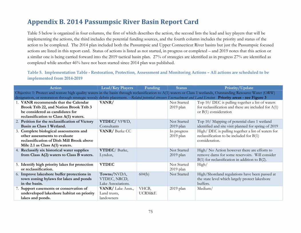
75
Appendix B. 2014 Passumpsic River Basin Report Card
Table 5 below is organized in four columns, the first of which describes the action, the second lists the lead and key players that will be
implementing the actions, the third includes the potential funding sources, and the fourth column includes the priority and status of the
action to be completed. The 2014 plan included both the Passumpsic and Upper Connecticut River basins but just the Passumpsic focused
actions are listed in this report card. Status of actions is listed as not started, in progress or completed – and 2019 notes that this action or
a similar one is being carried forward into the 2019 tactical basin plan. 27% of strategies are identified as in progress 27% are identified as
completed while another 46% have not been started since 2014 plan was published.
Table 5. Implementation Table - Restoration, Protection, Assessment and Monitoring Actions – All actions are scheduled to be
implemented from 2014-2019
Action Lead/Key Players Funding Status Priority/Update
Objective 1: Protect and restore high quality waters in the basin through reclassification to A(1) waters or Class 1 wetlands, Outstanding Resource Water (ORW) designation, or restoration through strategic woody debris placement. --Related potential stressors Encroachment and Land Erosion Priority areas - see Figure 3
1. VANR recommends that the Calendar Brook Trib 22, and Nation Brook Trib 3 be considered as candidates for reclassification to Class A(1) waters.
VANR/ Not Started 2019 plan
Top 10/ DEC is pulling together a list of waters for reclassification and these are included for A(1) or B(1) consideration
2. Petition for the reclassification of Victory Basin as Class 1 Wetland.
VTDEC/ VFWD, Consultants
Not Started 2019 plan
Top 10/ Mapping of potential class 1 wetland identified and site visit planned for spring of 2019
3. Complete biological assessments and other assessments to evaluate reclassification of Dish Mill Brook above Mile 2.1 as Class A(1) waters.
VANR/ Burke CC In progress 2019 plan
High/ DEC is pulling together a list of waters for reclassification to be included for B(1) consideration.
4. Reclassify six historical water supplies from Class A(2) waters to Class B waters.
VTDEC/ Burke, Lyndon,
Not Started 2019 plan
High/ No Action however there are efforts to remove dams for some reservoirs. Will consider B(1) for reclassification in addition to B(2).
5. Identify high priority lakes for protection or reclassification.
VTDEC Not Started 2019 plan
High/
6. Improve lakeshore buffer protections in town zoning bylaws for lakes and ponds in the basin.
Towns/NVDA, VTDEC, NRCD, Lake Associations.
604(b) Not Started High/Shoreland regulations have been passed at the state level which largely protect lakeshore buffers.
7. Support easements or conservation of undeveloped lakeshore habitat on priority lakes and ponds.
VANR/ Lake Assn., Land trusts, landowners
VHCB, UCRM&E
2019 plan Medium/

76
Action Lead/Key Players Funding Status Priority/Update
Objective 2: Reduce prevalence of and damage caused by flooding in Lyndonville and erosion hazards throughout watershed. Related stressors: Channel erosion and Encroachment Priority areas: Lyndonville and upstream watershed for flooding and Millers Run, East and West Branches, South Wheelock Branch and Sleepers River for Erosion Hazards (see Figure E2)
8. Improve river corridor and floodplain protections for the Passumpsic, Millers Run, East and West Branch Passumpsic River in town zoning bylaws to allow these streams to develop new floodplains and reduce flood damage.
Towns/NVDA, CCNRCD, VTDEC
ERP, UCRM&E, Municipal planning grants
In progress 2019 plan
Top 10/ Lyndon and Burke have adopted new river corridor bylaws! Other towns have considered but have not adopted new bylaws.
9. Complete Phase 1 and targeted Phase 2 assessments on unassessed tributaries in the lower watershed.
CCNRCD / Towns, NVDA, VTDEC
ERP Completed High/ Phase 2 completed 2014 except for Joes brook
10. Meet with towns to discuss updating zoning bylaws to address erosion hazards after completion of Phase 2 assessments in the lower Passumpsic River watershed.
Towns/NVDA, CCNRCD, VTDEC
PDM, 604(b) In progress High/ Some discussion with the town of Danville
11. Complete priority river corridor protection projects recommended in Phase 2 SGA reports (Figure E2).
Towns/ NVDA, CCNRCD, VTDEC
ERP, UCRM&E
In progress 2019 plan
High/ Water Andric bridge project completed. Unsure of how to move other projects forward
12. Finalize and get FEMA approval for all hazard mitigation plans for Lyndon and upstream towns as well as towns interested in receiving increased state match under the Emergency Relief and Assistance Fund.
Lyndon/ NVDA, CCNRCD, VTDEC, FEMA
PDM Completed Medium/
13. Support implementation of mitigation measures listed in all hazard mitigation plans including the removal of repeat flooding structures and evaluation of other mitigation measures to reduce future flood losses.
Lyndonville/ NVDA, CCNRCD, VTDEC, FEMA
PDM In progress Medium/ Lyndon town garage site grant application for design has been submitted.
14. Complete priority buffer planting projects recommended in Phase 2 SGA reports through Trees for Streams program or CREP program (Figure E3)
Towns/ NVDA, CCNRCD, VTDEC
ERP, Watershed grants
In progress 2019 plan
Medium/ update??
15. Support Low Impact Development (LID) standards and the use of Green Stormwater Infrastructure (GSI) in the
Towns/ NVDA, CCNRCD, VTDEC
ERP, VANR, 604(b)
In progress Medium/ Lyndon stormwater master plan and small scale project implementation.
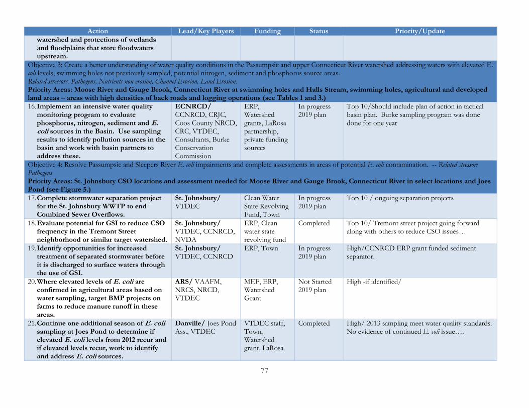
77
Action Lead/Key Players Funding Status Priority/Update
watershed and protections of wetlands and floodplains that store floodwaters upstream.
Objective 3: Create a better understanding of water quality conditions in the Passumpsic and upper Connecticut River watershed addressing waters with elevated E. coli levels, swimming holes not previously sampled, potential nitrogen, sediment and phosphorus source areas. Related stressors: Pathogens, Nutrients non erosion, Channel Erosion, Land Erosion. Priority Areas: Moose River and Gauge Brook, Connecticut River at swimming holes and Halls Stream, swimming holes, agricultural and developed land areas – areas with high densities of back roads and logging operations (see Tables 1 and 3.)
16. Implement an intensive water quality monitoring program to evaluate phosphorus, nitrogen, sediment and E. coli sources in the Basin. Use sampling results to identify pollution sources in the basin and work with basin partners to address these.
ECNRCD/ CCNRCD, CRJC, Coos County NRCD, CRC, VTDEC, Consultants, Burke Conservation Commission
ERP, Watershed grants, LaRosa partnership, private funding sources
In progress 2019 plan
Top 10/Should include plan of action in tactical basin plan. Burke sampling program was done done for one year
Objective 4: Resolve Passumpsic and Sleepers River E. coli impairments and complete assessments in areas of potential E. coli contamination. -- Related stressor: Pathogens Priority Areas: St. Johnsbury CSO locations and assessment needed for Moose River and Gauge Brook, Connecticut River in select locations and Joes Pond (see Figure 5.)
17. Complete stormwater separation project for the St. Johnsbury WWTP to end Combined Sewer Overflows.
St. Johnsbury/ VTDEC
Clean Water State Revolving Fund, Town
In progress 2019 plan
Top 10 / ongoing separation projects
18. Evaluate potential for GSI to reduce CSO frequency in the Tremont Street neighborhood or similar target watershed.
St. Johnsbury/ VTDEC, CCNRCD, NVDA
ERP, Clean water state revolving fund
Completed Top 10/ Tremont street project going forward along with others to reduce CSO issues…
19. Identify opportunities for increased treatment of separated stormwater before it is discharged to surface waters through the use of GSI.
St. Johnsbury/ VTDEC, CCNRCD
ERP, Town In progress 2019 plan
High/CCNRCD ERP grant funded sediment separator.
20. Where elevated levels of E. coli are confirmed in agricultural areas based on water sampling, target BMP projects on farms to reduce manure runoff in these areas.
ARS/ VAAFM, NRCS, NRCD, VTDEC
MEF, ERP, Watershed Grant
Not Started 2019 plan
High -if identified/
21. Continue one additional season of E. coli sampling at Joes Pond to determine if elevated E. coli levels from 2012 recur and if elevated levels recur, work to identify and address E. coli sources.
Danville/ Joes Pond Ass., VTDEC
VTDEC staff, Town, Watershed grant, LaRosa
Completed High/ 2013 sampling meet water quality standards. No evidence of continued E. coli issue….

78
Action Lead/Key Players Funding Status Priority/Update
Objective 6: Reduce nitrogen loading to the Connecticut River and Long Island Sound. Related stressors: Nutrient loading (non-erosion) Priority Areas: Basin wide with focus on sources areas shown in Figure 7.
22. Complete outreach to farmers to improve nitrogen management on farms through the use of Adapt N software, pre side dress nitrate testing and demonstrating the use of shorter duration corn with legume cover crops.
UVM Ext/ NRCD, VAAFM, NRCS
Long Island Sound Futures fund, 319
In progress 2019 plan
Top 10/ UVM ext staff leading project has moved on – need to check on status of these efforts.
23. Reduce nitrogen loading from wastewater treatment plants as identified in WSMD wasteload allocation plan.
VTDEC/ Towns Clean water state resolving fund, Local funding
Completed High/Lyndon reduced TN loading significantly
24. Identify potential nitrogen sources and highest priority BMP’s for reducing nitrogen runoff from agricultural and developed lands in the Basin.
ARS/ NRCS, VTDEC, NRCD, VAAFM
ERP, MEF In progress 2019 plan
High/ Stormwater master plans have identified high priority projects. Farm priorities need to be identified.
25. Complete IDDE in Danville, Lyndonville, Concord.
VTDEC/ CCNRCD, Towns
ERP Completed Medium/
26. Complete BMP’s to address nitrogen runoff as suggested by studies above or low cost strategies such as buffer plantings in locations targeted to filter runoff or with other local water quality benefits targeting areas identified in Figure 7.
VTDEC/ Lake Associations, VTDEC, NRCD’s
EQIP, ERP, MEF, AG BMP, CREP, CRP
In progress 2019 plan
Medium/ some small scale stormwater projects installed, buffer plantings completed, Ag BMP’s widely applied.
Objective 7: Improve the biological condition of Dish Mill Brook which is stressed by increased scour from stormwater flows and sedimentation. -- Related stressors: Channel Erosion, Land Erosion. Priority Areas: Dish Mill Brook tributary and adjacent drainage to Dish Mill Brook(see Figure 5)
27. Complete a stormwater master plan in the Dish Mill Brook Watershed working with key partners to identify stormwater and sediment source areas, treatment options, and required maintenance schedule for proposed as well as existing infrastructure.
CCNRCD/ VTDEC, Q Burke, Town of Burke, Kingdom Trails, VDFPR, Homeowner Associations, NVDA
ERP, Municipal planning grants, 604(b), Private or local funding
Completed Top 10/ See memo with summary of actions.
28. Complete Better Backroads assessment and projects for High Meadow Road, the Mountain Road as well as other town and private roads in the Dish Mill Brook Watershed.
CCNRCD/ Q Burke, VTDEC, Homeowner Associations, Town of Burke
Better Backroads Grants, Private or local funding, ERP
Completed High/ Road projects completed in 2017 with details included in memo.

79
Action Lead/Key Players Funding Status Priority/Update
29. Work with towns to develop zoning bylaws to protect pre-development hydrology and minimize increases in sediment and stormwater in this watershed. Bylaws should also protect natural features such as wetlands, streams, floodplains, and riparian buffers.
Town of Burke / VTDEC, NVDA
Municipal planning grants, 604(b)
Not started High/ Progress on floodplain and river corridor protection for Lyndon and Burke– less so in other areas.
30. Implement high priority sediment reduction and stormwater treatment projects identified through stormwater master planning including low impact development retrofits and roadway erosion control projects if identified as a priority.
Q Burke/ VTDEC, CCNRCD, VDFPR
Private or local funding, ERP, Dry hydrant funding, Better Backroads Grants
In progress 2019 plan
Medium/ BMA projects moving forward.
31. Work with homeowners associations, QBurke, other partners in the Dish Mill Brook watershed to put in rain gardens to reduce stormwater runoff.
CCNRCD/ VTDEC, Q Burke, Town of Burke, homeowner associations, NVDA
ERP, Private funding, Watershed grant
In progress Medium/ Several Burke mountain resort rain gardens installed
32. Work with developers in the Dish Mill Brook watershed to use innovative green stormwater infrastructure techniques in future development proposals.
Q Burke/ VTDEC, CCNRCD, NVDA, Developers, VDFPR
Private funding, ERP
In progress 2019 plan
Medium/
33. Support regulatory review of ski area long term development plans for additional stormwater treatment to handle existing discharges in areas proposed for future development. Evaluate trails network(s) for soil erosion potential. As necessary update Water Quality Remediation Plan.
QBurke, VANR, NRB
QBurke In progress Medium/ Grant has funded restoration of Fire road including regrading and pulling culverts on state land along with similar efforts on Burke Mountain Resort property
Objective 8: Reduce phosphorus and sediment loading to stressed lakes, ponds and streams in the Basin. Related stressors: Channel Erosion, Encroachment, Land Erosion, Nutrient Loading (non-erosion) Priority Areas: Maidstone Lake, and Wallace, Stevens, Miles, Mile, West Mountain Ponds- Leach Stream, First and Murphy Brooks (See Figure 5) along with Connecticut River above Moore Reservoir and the Passumpsic River watershed.
34. Work with the communities of Burke, Newark, Danville, Walden, St. Johnsbury and Concord to complete capital improvement inventories and develop a local template that can be applied to other
NRCD/ NVDA, VAOT, VTDEC, Town Road Foreman and Select Boards
Better Backroads grant, Watershed
Completed 2019 plan
Top 10/ All plans completed. Work continuing with communities to develop new plans to meet new MRGP requirements.

80
Action Lead/Key Players Funding Status Priority/Update
towns in the basin and that includes use of bridge and culvert assessment data.
Grant, MEF, ERP
35. Complete a dirt road erosion inventory (including class IV roads) in the upper Passumpsic River watershed (towns of Wheelock, Sutton, Newark, Burke) to identify priority erosion projects for Better Backroads project grants. Continue work in Kirby, Lyndon, St. Johnsbury, Danville, Walden, Concord, Lunenburg.
NVDA/ NRCD, VAOT, VTDEC, Town Road foreman and select boards
ERP, Better Backroads grant, Watershed grant
In progress 2019 plan
High/ project proposal by NVDA to work with one or two towns in 2018 on class 4 assessments. Town not yet selected.
36. Complete projects to address major identified sediment sources (or AOP barriers) while working to minimize concentration of runoff into ditches.
Towns/VTDEC, NRCD, VAOT , NVDA,
Better backroads, ERP
In progress 2019 plan
Medium/ Many projects completed…
37. Purchase a hydroseeder through a cooperative agreement to share with multiple towns.
NVDA/ NRCD, VAOT, VTDEC, Town Road Foreman and Select Boards
MEF, ERP grant
Completed 2019 plan
Medium/ Danville has a shared hydro seeder program with other towns – need to replicate project for other towns.
38. Set up a series of workshops and trainings with towns to discuss key barriers preventing towns from addressing priority water quality issues associated with transportation infrastructure building on the well attended road resiliency workshop held in 2012.
NRCD/NVDA, VAOT, VTDEC, Town Road Foreman
ERP grant, Watershed grant
Completed Medium/ CCNRCD received watershed grant to hold workshop in 2014
Objective 9: Restore littoral habitat on impacted lakes and ponds in the Basin. Related stressors: Encroachment, Land Erosion, Nutrient Loading (non-erosion) Priority Areas: Shadow, Neils, Coles, and Newark Ponds with reduced habitat from development and Miles, Maidstone, and Joes Ponds with poor shoreline habitat from development (see Figure 5.)
39. Identify lake associations or blocks of interested landowners for targeted outreach for the LakeWise certification program.
VTDEC/ Lake associations, NRCD
Watershed grant Not Started 2019 plan
High/ None in Passumpsic River Basin yet…
40. Fund buffer restoration to allow landowners to meet LakeWise standards targeted to contiguous blocks of landowners.
VTDEC/ Lake associations, NRCD
ERP In progress 2019 plan
Medium/ pond project going in in 2018 with work crew support.
Objective 10: Monitor and minimize spread of Didymo – and prevent spread of other invasive species not in the basin including Eurasian water milfoil. -- Related Stressor: Aquatic Invasive Species

81
Action Lead/Key Players Funding Status Priority/Update
Priority Areas: Basin wide
41. Support Upper Connecticut Cooperative Invasive Species Management Area (UCCISMA) as an organization that can coordinate early detection and rapid response for invasive species in this basin.
ECNRCD/ NRCS, VDFPR, VTDEC, Conte, NWSC
MEF In progress Medium
42. Support lake associations in starting up and continuing VIP programs on lakes in the basin.
Lake associations/ VTDEC
ANS In progress Medium
Objective 11: Reduce levels of oil and contaminants reaching the Sleepers River. Related Stressor: Toxic Substances Priority Areas: Fairbanks Morse and St. Johnsbury landfill site (see Figure 5.)
43. Continue recovery efforts for oil on the Fairbanks Morse site until threat to surface waters has been sufficiently addressed.
Landowners/ Consultants, VTDEC
In progress Medium
44. Complete a Phase 2 brownfield assessment to identify any additional contamination at the Fairbanks Morse site and address any that may be impacting surface waters.
St. Johnsbury, NVDA/ VTDEC
Brownfields grant
Not Started 2019 plan
Medium
45. Consider streambank and floodplain restoration opportunities that might be possible with any redevelopment of the Fairbanks Morse site.
St. Johnsbury, Landowners/ NVDA, VTDEC, CCNRCD
ERP, MEF Not Started 2019 plan
Medium

82
Appendix C. Municipal Protectiveness Matrix for Basin 15
Table 17. Municipal protectiveness matrix for towns with significant area in Basin 15 (5/22/19)
National Flood Insurance Program (NFIP)
Road and Bridge Standards
Emergency Operations Plan (LEOP)
Hazard Mitigation Plan (LHMP)
River Corridor Protection
ERAF Stormwater Master Plan
Illicit Discharge Detection and
Elimination
Stormwater Mapping
En
rolled
?
Ado
pted
?
Co
mp
leted?
Ado
pted
?
Ado
pted
?
Percen
t
Co
mp
leted?
Co
mp
leted?
Co
mp
leted?
Barnet Yes No No No No 7.5% NA Yes NA
Burke Yes Yes No No Yes 7.5% Yes Yes Yes
Concord Yes Yes No Yes No 7.5% Yes Yes Yes
Danville Yes No No No No 7.5% No Yes Yes
East Haven No Yes No No No 7.5% NA NA NA
Granby Yes Yes No Yes Interim 7.5% NA NA NA
Kirby Yes Yes Yes Yes Interim 17.5% NA NA NA
Lyndon Yes Yes No Yes Yes 7.5% Yes Yes Yes
Lyndonville Village
Yes Yes No Yes Yes 7.5% Yes Yes Yes
Newark No No No No No 7.5% NA NA NA
Sheffield No Yes No No No 7.5% NA No Yes
St. Johnsbury Yes Yes No Yes No 7.5% Yes Yes Yes
Stannard Yes No No No No 7.5% NA NA NA
Sutton Yes Yes No No No 7.5% NA NA NA
Victory No Yes No No No 7.5% NA NA NA
Walden No Yes Yes Yes No 7.5% NA NA NA
Waterford Yes Yes No Yes No 7.5% NA NA NA
Westmore No Yes No No No 7.5% NA NA NA
Wheelock No Yes No No No 7.5% NA No Yes
![Tactical Combat Casualty Care [TCCC] Some reminders and ...€¦ · Tactical Combat Casualty Care Tactical Evacuation Care The term “Tactical Evacuation” includes both Casualty](https://img.dokumen.tips/doc/110x75/604ef4767ef6a83727287be2/tactical-combat-casualty-care-tccc-some-reminders-and-tactical-combat-casualty.jpg)