Embed Size (px)
Citation preview

Barratt Homes Hattersley Planning, Design and Access Statement
Applications for outline planning permission for residential development, Hattersley Submitted on behalf of Barratt Homes Manchester
Planning Application 1: Site 11, Planning Application 2: Sites 12 to 17 and 19 to 20,Planning Application 3: Site 23, Planning Application 4: Site 24


Applications for outline planning permission for residential development, Hattersley
Submitted on behalf of Barratt Homes Manchester
Planning, Design and Access Statement
Planning Application 1: Site 11
Planning Application 2: Sites 12 to 17 and 19 to 20
Planning Application 3: Site 23
Planning Application 4: Site 24
September 2009
Document: 4543/pdas/final Taylor Young Compiled By: AB / JM Reviewed By: RL / MG
Chadsworth House Wilmslow Road Handforth Cheshire SK9 3HP Tel: 01625 542 200 Fax: 01625 542 250 Email: [email protected]
Date: September 2009
Contents 1. Introduction
2. Planning and Design Policy Context
3. Site Context
4. The Sites
5. Design process (including consultation statement)
6. Overarching development parameters and principles
7. Site specific development parameters and principles
a. Application 1: Development parameters and principles (Site 11)
b. Application 2: Development parameters and principles (Site 12 to 17 and 19 to 20)
c. Application 3: Development parameters and principles (Site 23)
d. Application 4: Development parameters and principles (site 24)
8. Accessibility and movement
9. Waste Management Strategy

1. Introduction
The applications
1.1. This Planning, Design and Access Statement accompanies four applications for outline planning permission for residential development in respect of 11 sites in Hattersley, submitted on behalf of Barratt Homes Manchester. The applications are grouped as follows:
Site 11 (up to 55 dwellings)
Sites 12 to 17 and 19 to 20 (up to 192 dwellings)
Site 23 (up to 21 dwellings)
Site 24 (up to 39 dwellings)
1.2. The development of these sites has not been considered in isolation. The proposed development has been designed to integrate with the existing built form and with the development of each of the sites. This creates a coordinated approach to the overall development.
Background
1.3. Twenty-five sites have been identified as residential development sites within Hattersley to broaden the housing offer in the neighbourhood.
1.4. Outline planning permission for residential development was granted for all 25 residential sites in 2006. Whilst Sites 1a, 1b, 2, 3, 4, 5, 6, 7, 8 and 10 have detailed approvals, the outline permissions on sites 11 to 20, 23 and 24 have expired.
Site No. Outline Planning Applications
Date of Outline Planning Permission
11 06/00150/OUT 17/03/06
12, 13, 14, 15, 16 & 17 06/00143/OUT 17/03/06
18, 19 & 20 06/00151/OUT 17/03/06
23 06/00155/OUT 17/03/06
24 06/00154/OUT 17/03/06
1.5. These planning applications seek to re-establish outline permission for residential development.

Vision
1.6. The following Vision has guided the design process:
Our Vision is ‘Hattersley Town’ - a rural edge
community reconnected to the wider landscape
setting, one of a family of popular, sought after towns
and villages within Longdendale.
The real challenge for Hattersley is to make the place
look and feel like a community in which everyone
benefits from the facilities and to make long term
commitments to the neighbourhood. It must convey a
sense of credibility and longevity. Our plans are
realisable and promote good urban design principles
which we know will work. A simple but strong urban
structure is proposed rectifying the problems of the
‘Radburn layouts’, creating a legible street pattern and
a feeling of well-being and safety.
Structure
1.7. This Statement will cover the following aspects:
Section 2: Planning and design policy context
Section 3: Site context
Section 4: The sites
Section 5: Design process (including consultation statement)
Section 6: Overarching development parameters and principles
Section 7a: Application 1: Development parameters and principles (Site 11)
Section 7b: Application 2: Development parameters and principles (Site 12 to 17 and 19 to 20)
Section 7c: Application 3: Development parameters and principles (Site 23)
Section 7d: Application 4: Development parameters and principles (site 24)
Section 8: Sustainability statement
Section 9: Accessibility and movement
Section 10: Waste Management Strategy

2. Planning & Design Policy Context
2.1. This section reviews national, regional and local planning policy, including design policy, which has influenced the development of the proposals.
National Planning Policy PPS1 Delivering Sustainable Development (2005)
promotes the sustainability, encouraging high quality design and integrated development and regeneration
PPS3 Housing (2006) seeks to create mixed communities with a choice of housing, whilst emphasising sustainability and affordability
PPG13 Transport (1999) seeks to ensure new developments are accessible by a choice of means of transport and reduced reliance on the car
2.2. The following design documents and best practice have informed the design evolution of the proposals:
Sustainable Communities: Building for the future (ODPM, 2003)
By Design: Better Places to Live (A Companion Guide to PPG3) (ODPM, 2001)
By Design: Urban Design in the Planning System – Towards Better Practice (DETR & CABE, 2000)
Safer Places: The Planning system and Crime prevention (ODPM, 2004)
The Urban Design Compendium 1 & 2 (English Partnerships, 2000 & 2007)
Manual for Streets (Led by DfT, March 2007)
Car Parking: What Works Where? (English Partnerships, 2007)
Regional Planning Policy
2.3. The Regional Spatial Strategy (RSS) for the North West was published in September 2008.
2.4. Policy DP1 (Spatial Principles), seeks to promote sustainable communities, make the best use of existing resources and marry opportunity and need.
2.5. Policy DP3 (Promote Sustainable Communities), seeks to build communities where people want to live and work, meeting diverse needs of existing and future residents, promote cohesion and contribute to high quality of life.
2.6. Policy DP4 (Making the Best Use of Existing Resources and Infrastructure), prioritises development which builds upon existing activity and infrastructure.
2.7. Policy DP5 (Manage Travel Demand; Reduce the Need to Travel, and Increase Accessibility), seeks to reduce the need to travel and encouraging a shift to non-car modes of transport. New development should be accessible by public transport, walking and cycling.

2.8. Policy DP7 (Promote Environmental Quality), seeks to protect and enhance environmental quality, including understanding and respecting character and distinctiveness; promoting good quality design in new development and maximising opportunities for the regeneration of derelict or dilapidated areas.
2.9. Policy L2 (Understanding Housing Markets) and L3 (Existing Housing Stock and Housing Renewal) promotes an understanding of local housing markets and support housing market restructuring and renewal.
2.10. Policy L4 (Regional Housing Provision) encourages an appropriate mix of house types, sizes, tenures and prices and high quality standards and maximising the re-use of vacant and under-used brownfield land and buildings.
2.11. Policy MCR 5 (Northern Part of the Manchester City Region) supports the transformation of the local economy, regeneration of communities, and enhancement of the environment, including expansion of the quality and choice of housing.
2.12. Policy RT 9 (Walking and Cycling) seeks to develop attractive and safe routes for walking and cycling.
2.13. Policy EM 16 (Energy Conservation & Efficiency) also promotes minimising consumption and demand and promoting maximum efficiency and minimum waste.
Local Planning Policy
2.14. Tameside Unitary Development Plan (2004) is the statutory development plan for the Borough. Those policies relevant to Hattersley and new development are summarised below.
2.15. All the sites have had the benefit of outline planning permission for residential development. As there has been no significant change in planning circumstance since the original applications, the principle of housing on these sites has already been agreed. Therefore, the following will explain the key Local Plan policies relevant only to the details of development.
2.16. Policy H4 (Type, Size and Affordability of Dwellings) encourages the provision of a range of dwelling types, sizes and affordability to meet the needs of the community and to create better balanced communities for the future. Policy H7 (Mixed Use and Density) encourages high density developments between 30-50 dph, or greater in locations highly accessible by public transport. These proposals will include a range of size of homes at appropriate densities.
2.17. Policy H10 (Detailed Design of Housing Developments) states that the layout, design and external appearance of housing developments, will be of high quality and to meet more detailed criteria, relating to:
Providing attractive, convenient and safe environment for the local community
Enhancing the character and appearance of the surrounding area

Suitable arrangements for parking, access, delivery, refuse and emergency vehicles, including access by pedestrians, cyclists and disabled people, and for convenient access to public transport
Suitable landscaping strategy
No unacceptable impact on the amenity
Minimisation of the opportunities for crime and anti-social behaviour.
2.18. The design principles ensure that the proposed layouts will provide safe and attractive environments, which relate well to their context. Pedestrians will be prioritised over cars. Landscape and public realm design will also be an integral part of the design process and safety and security will be a key consideration.
2.19. Policy C1 (Townscape and Urban Form) seeks to ensure development proposals consider context; the distinct settlement pattern, open space features, topography, townscape and landscape character. Creating a place with character has been a key objective of the design. The Baseline and Vernacular studies have informed the design process.
2.20. Policy N4 (Trees and Woodland) and Policy N5 (Trees Within Development Sites) seeks to protect trees and woodlands of amenity value, unless unsafe / or considered appropriate in connection with an approved development.
2.21. Policy U5 (Energy Efficiency) encourages all development to incorporate energy efficiency within the proposal, so far as is appropriate.
Hattersley and Mottram Supplementary Planning Guidance (2004)
2.22. The SPG outlines the planning policy framework for the area and provides further details on key issues, such as housing development sites. The SPG also outlines the design ethos for the area, centred building a community. It describes a comprehensive set of design principles, which have influenced the indicative layouts and will inform detailed layouts at reserved matters stage.
2.23. The proposals and design principles will ensure the above criteria are achieved, creating a high quality environment.
Other relevant supplementary planning documents and guidance notes Residential Development Guidelines SPD (2005)
Trees and Landscaping on Development Sites SPD (2007)
Sustainable Design and Construction Guide SPD (2005)
Streetscenes Good Practice Guide
Car Parking Standards for New Development
Planning and Crime Prevention
Standards Within Dwellings
2.24. The design principles outlined in this Design and Access Statement, have taken the above guidance documents into consideration.

Summary
2.25. The principle of residential development on the application site has already been established by the outline planning permission granted in 2006 and there has been no material change in planning circumstances since that time. The proposed development is capable of meeting all key policy considerations in relation to the location of housing development, design, open space and other site specific matters such as highways.

3. Site context 3.1. To create a high quality new development, it is important
to have a robust understanding of the development context. The following section provides an overview of the urban design context, focusing on the sites and their immediate surroundings.
Movement and access
‘Radburn’ Style layouts Train station under-realised asset
Sites are accessible by bus Formal and informal routes through sites
3.2. Hattersley is located at the end of the M67 which provides good access to the M60, Manchester and beyond. All sites are well connected to the wider neighbourhood, via Hattersley Road East, Fields Farm Road, Clough End Road and Hyde Road, which are locally important routes.
3.3. However, many houses are accessed from pedestrian only linkages separated from the street which creates inward looking residential areas. The proposals for these sites provide an opportunity to improve connectivity and permeability between these streets and create an outward looking development. It is considered that the local movement network is sufficiently robust to support higher densities in this location.
3.4. The sites are also within a 5-10 minute walk of local bus routes, with services approximately every 10 minutes, to a range of destinations, including Godley, Hyde, Denton and Manchester. This will ensure that future residents have a choice of transport mode, and are not reliant on the car.
3.5. Hattersley also benefits from a local train station, to the south west of the neighbourhood. The majority of sites are within 1 to 10 minute walk of the railway station, which provides a sustainable transport connection to Manchester city centre (25 minute journey) and to Hadfield (10 minute journey), every 30 minutes. Site 23 is just a 15 minute walk, with Site 24 being 20 minutes and 28 being the furthest at 30 minutes.

Uses and activities
Hattersley has a range of facilities, with proposals for a new district centre
3.6. The land use surrounding the sites is principally residential. Retail and community uses are focused at the existing district centre off Hattersley Road East. These include a number of shops, including a Co-op, a community centre and library, day nursery, medical centre, a gym, church and church hall. A number of the units are used as a base for local initiatives – such as the Hattersley Neighbourhood Partnership. A small parade of shops is also located on Honiton Avenue. The wider estate also benefits from other facilities including a number of churches, community halls and the Ken Ward Sports Centre. Future residents would therefore be able to access a range of facilities, which can be maximised through safe, direct, convenient and interesting routes.
Public realm and open space
The estate benefits from large areas of open space
3.7. There is a significant amount of public open space in and around Hattersley. The Clough through the centre of the estate is also an asset for the whole neighbourhood and is a Site of Biological Importance. This is currently an underutilised asset for the area and should be protected, but at present lacks safe and secure access.
3.8. Other open spaces throughout the neighbourhood often lack a sense of purpose and ownership and can therefore attract anti-social behaviour. Many of these are former cleared sites.
3.9. The public realm around the neighbourhood (which includes the streets, pathways, lights and street furniture), could be improved. There is limited lighting and few seats or litter bins. Grass verges alongside roads contribute to visual amenity, but, as mentioned previously, where these have no function they can attract anti-social behaviour.

Buildings and townscape
3.10. The site is situated on the edge of the built up area of Hattersley and benefits from views to the west toward Godley, across open space and woodland. The townscape of the neighbourhood is predominantly by 1960s two-storey terraces and semi-detached dwellings. The area is also characterised by informal and in parts incidental open space. Generally there is little variation in housing type and style across the estate. The layout is generally inward looking, with houses fronting onto pedestrian walkways which does not maximise the views out over the open spaces surrounding the neighbourhood. There is often little definition between public and private spaces. Vehicles are segregated and accommodated on perpendicular main roads or garage courtyards.
3.11. This schemes provides an opportunity to diversify the mix in housing type. They will create safe and overlooked environment, through buildings which address the street and a clear definition between public and private space.
Sustainability
3.12. The sections above demonstrate the sustainability credentials of the sites. The developments will make use of underutilised and vacant sites, which are close to a range of facilities and public transport. New residential development will contribute to the regeneration and environmental improvement of Hattersley by providing high quality housing and public realm. In addition, by improving the mix of housing within the area, this will also contribute to achieving sustainable communities through increasing housing choice.
Design cues and vernacular
3.13. Whilst the neighbourhood itself provides limited design cues, there are other examples of local vernacular that can act as design cues for Hattersley.
3.14. For example in neighbouring Mottram Village that abuts Hattersley to the north-east has strong streets that are supported by buildings constructed to the back of pavement (or with very small front gardens enclosed by a low wall) which define a sense of enclosure not present in the Hattersley neighbourhood more generally. However, this does not provide a wealth of visual cues to develop the entire neighbourhood successfully given that this scale is only appropriate for smaller settlements. Considering the overall scale of the neighbourhood and the task set (as outlined throughout) it is clear that the vernacular will have to be sought much more widely, away from the application site, to gain inspiration for the design cues, including Marple Bridge.
Extracts from the Vernacular Study

4. The sites 4.1. The following section introduces each of the application
sites and their immediate context. This has informed the design process and outline proposals for each of the sites.
4.2. As outlined in Section 1, the sites are grouped as follows, for the planning applications:
Application Site Location Application 1 Site 11 Land adjacent to Hattersley
Road West / Milverton Avenue
Application 2 Sites 12 to 17 and 19 to 20
Sites off Hattersley Road East and Fields Farm Road
Application 3 Site 23 Land off Bunkers Hill Road Application 4 Site 24 Land on the east side of
Dawlish Close

The sites in context
Figure 1: The Sites in Context Colours indicate how the sites have been grouped for the applications

Application 1 (Site 11)
Site 11 Land adjacent to Milverton Avenue
Site Description
Photographs
Context 4.3. Site 11 is located on the western side of the neighbourhood, close to the railway station. It is accessed from Milverton Avenue, off Hattersley Road West.
4.4. The north east of the site is bound by the sides of properties. The south and west is bound by a wooded area which provides a buffer to the train line.
4.5. The site sits adjacent to two-storey houses. The site wraps around the south of Milverton Avenue, where five terraced houses back onto the site. This area is exposed and therefore lacks security. The site encloses two retained properties within the centre of the site, with pedestrian access from Milverton Avenue.
4.6. The majority of the site is allocated for future development (E2).
Use 4.7. The site had been occupied by apartment buildings which have now been cleared. The site now consists of areas of hardstanding, underutilised parking courts and low quality open space.
Topography 4.8. The topography of site 11 is varied and undulates in different directions. The site is relatively flat at the end of Milverton Avenue and across all the existing parking courts. However, it falls steeply down towards the

woodland buffer from the south east boundary and falls in the region of 4m from the hard standing at the end of Milverton Avenue down to the south west boundary.
Access / Movement
4.9. The site extends to cover an access way to the railway line.
4.10. There is a track across the site from Milverton Avenue to the south west boundary which provides an access route for United Utilities to adjoining land.
Landscape 4.11. Site 11 comprises under-utilised open space and trees, which are not considered to provide significant landscape value.
4.12. Local features (outside of the site) that have a high ecology and amenity value are the wooded valleys of the Cloughs, which represent a valuable resource and diverse habitat. Whilst the site is adjacent to a Protected Green Space, there are no significant ecological constraints to this site. A further reptile study was recommended and undertaken.
Constraints 4.13. Railway line and existing housing.

Application 2 (Sites 12 to 17 and 19 to 20)
Site 12 Land adjacent to the Railway Station Approach Site Description
Photographs
Context 4.14. Site 12 is located adjacent to the railway station and its car park / redundant bus terminus.
4.15. The site wraps around a terrace of three houses, and adjacent to another terrace of five.
4.16. To the south west of the site is a sub station (this is not within the site boundary).
Use 4.17. The site was previously housing, associated open space and parking. The site has now been cleared and is a combination of hard standing and grass.
Topography 4.18. The site slopes toward railway station.
Access / Movement
4.19. Vehicular access is provided from Hattersley Road West. There are access footpaths running though and along the boundary of the site, to access the three adjacent houses and the electricity sub station.
4.20. A vehicular and pedestrian access provides a route through to Hattersley Train Station.

Site 13 Site Description
Photographs
Context 4.21. Site 13 is also located on the western side of the neighbourhood, off Hattersley Road West.
4.22. To the north, west and east of the site are the side and rears of adjacent two-storey houses. To the north-east is the rear and sides of existing dwellings and the south-west boundary is adjacent to woodland. Directly south of site 13 is the access to Hattersley Train Station, and under utilised open space and site 14.
Use 4.23. The site was occupied by former maisonettes, including some amenity space and trees. It has been cleared and is now occupied by green space and a parking court.
Topography 4.24. The topography of the site is fairly level.
Access / Movement
4.25. Existing vehicular access to the site is via Fields Farm Road from the south and Bankside from the north, although the access is constrained.
Landscape 4.26. The development will not impact on the adjacent woodland area.
Constraints 4.27. There may be some foundations left over from demolitions.

Site 14 Land to West of Sandy Bank Avenue Site Description
Photographs
Context 4.28. Site 14 is located off Hattersley Road West and Sandy Bank Avenue having extensive frontage to these roads.
4.29. It sits adjacent to the railway station and its car park / redundant bus terminus. The railway cutting lies to the south, whilst sites 15 and 16 sit to the east.
4.30. A substation and access route is located in the south of the site.
Use 4.31. The site itself is cleared and is now a combination of hard standing, mown and overgrown grass.
Topography 4.32. Site 14 slopes gently in the region of 4m from the eastern boundary to the west.
Landscape 4.33. A further reptile study was recommended and undertaken. The survey shows that there are no reptile populations present on the site.
Access / Movement
4.34. The north-east corner of the site is accessed from both Hattersley Road West and Sandy Bank Avenue. The existing electrical sub station located at the southern end of the site is accessed through the site / along the southern boundary.
Constraints 4.35. The substation, remaining foundations and infrastructure.

Site 15 Site adjacent to Beck House Site Description
Photographs
Context 4.36. Site 15 is located off Sandy Bank Avenue.
4.37. The site shares a boundary with Site 14 to the west, train tracks and cutting to the south, and Site 16 across Sandy Bank Avenue to the north. Beck House, a three-storey residential development and its associated fenced grounds sit to the east of Site 15.
4.38. The site is adjacent to Site 14 and therefore should be considered as an extension of this site.
Use 4.39. The site itself is currently underutilised green space of limited amenity value.
Topography 4.40. The site has a slight fall to the north (approximately 1.5m).
Access / Movement
4.41. As mentioned above, the site is accessed to the south of Sandy Bank Avenue.
Landscape 4.42. The site is bound to the south by the railway buffer.
Constraints 4.43. Relationship with adjacent flats.
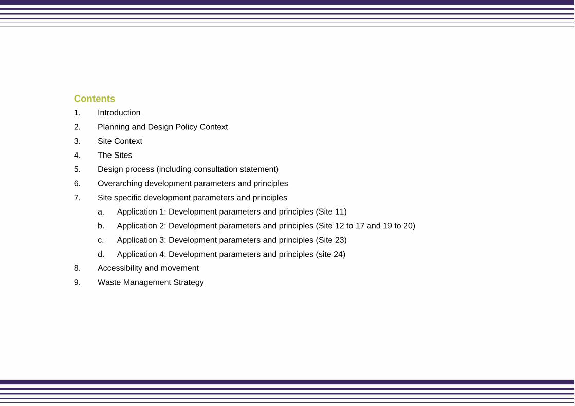
Site 16 Site to east of Sandy Bank Avenue Site Description
Photographs
Context 4.44. Site 16 is located off Sandy Bank Avenue, from which it has a vehicular access. The majority of its frontage is to Sandy Bank Avenue, with a small corner frontage to Hattersley Road West.
4.45. The majority of the northern boundary and part of the south eastern boundary of Site 16 is formed by the rear and sides of existing two storey properties. To the west, south and north are sites 14, 15 and 17 respectively.
Use 4.46. It is a cleared site (formerly housing, associated open space and parking) with some retained planting and infrastructure.
Topography 4.47. The site falls approximately 2m and is retained by a low wall on the frontage to Sandy Bank Avenue.
Access / Movement
4.48. Site access from Hattersley Road West.
Landscape 4.49. A further reptile study was recommended and undertaken. The survey shows that there are no reptile populations present on the site.
Constraints 4.50. Access to adjacent uses

Site 17 Site opposite the junction of Sandy Bank Avenue Site Description
Photographs
Context 4.52. Site 17 is located within the western side of the neighbourhood, accessed from Hattersley Road West.
4.53. The site is bound to the north by protected green space, whilst the south is bound by Hattersley Road East and Sites 14 and 16 beyond. To the west are the side and fronts of two-storey terraces which front open space. To the east is the rear and side boundaries of existing two-storey terraces.
4.54. Site 17 also includes an electricity sub station, to the rear of no. 191, which is accessed through the site.
Use 4.55. The site was formerly occupied by a tower block and associated parking, the site is now cleared and includes an under utilised grassed area, hard standing and a parking court.
Topography 4.56. Site 17 is relatively flat, although it slopes around 1m on the southern boundary. This is retained to a height of some 0.5 – 1m.
Access / Movement
4.57. The vehicular access is from Hattersley Road West.
Landscape 4.58. The site itself is mown grass and has negligible ecological value.
Constraints 4.59. Retaining wall, sub station and garages.

Site 19 Site to west of Waterside Site Description
Photographs
Context 4.60. Site 19 is accessed from Waterside, a short cul-de-sac with a small area of parking and a turning circle at its southern end. The site also has a small frontage to Fields Farm Road.
4.61. The western boundary of the site is adjacent to the side and rear of existing two-storey houses. The south of the site is bound by woodland that is designated as protected green space. The east of the site is bound by Waterside, with two-storey houses and Site 20 beyond.
Use 4.62. The site was formerly housing, but now comprises a combination of an overgrown cleared site and hard standing (former parking court). The site also includes a short section of an access road to the west.
Topography 4.63. Site 19 falls approximately 7m from its north-east corner to the south-west corner. The parking court is relatively flat but has a retaining wall to its northern boundary with the adjacent houses at a higher level.
Access / Movement
4.64. The site can be accessed from Bankside and Waterside. Access to the former parking court on site 19 was previously accessed from Bankside, however bollards currently prevent access.
Landscape 4.65. There are no trees on the site, although the south of the site is bound by an area of mature woodland which creates a strong landscaped boundary. The site is of negligible ecological value.
Constraints 4.66. Retaining wall to the north.

Site 20 Site opposite Waterside Close Site Description
Photographs
Context 4.67. Site 20 is also located within the western side of the neighbourhood, sitting on the corner of Fields Farm Road and Waterside.
4.68. To the south and east of the site are the sides of two-storey terraced houses. To the north is Site 21 and to the west Waterside and Site 19 beyond.
Use 4.69. The site was formerly housing, but has been cleared and is currently mown grass.
Topography 4.70. The site is relatively flat, with a gentle fall to the south east.
Access / Movement
4.71. The site has no vehicular access, but could be accessed from Waterside.
Landscape 4.72. The site has no trees or vegetation and is of negligible ecological value.
Constraints 4.73. Retaining wall to the north-east of the site.

Application 3 (Site 23)
Site 23 Land off Bunkers Hill Road Site Description
Photographs
Context 4.74. Site 23 is located on the east side of Stockport Road, accessed from Bunkers Hill Road. Whilst the site has a small frontage to Stockport Road, there is no vehicular access onto / from it.
4.75. To the north, east and south of the site fronts two-storey terraced houses. To the south-east is the Chapman Arms public house and its car park. The west of the site is bound by Stockport Road with two-storey terraced housing behind a grass verge beyond.
4.76. There is a single property whose rear and sides face into the site which is open and lacks security.
Use 4.77. The site is a mix of hard-standing (including a storage yard) and grass, being formerly occupied by housing and flats which has since been demolished, and associated car parking.
Topography 4.78. Site 23 is relatively flat with a gentle fall of approximately 3m from the south east towards Stockport Road.
Access / Movement
4.79. The site has a number of short paths within it. However, these are not through-routes (alternative routes exist) and most relate to the parking court. There are two existing pedestrian routes adjacent to site 23, which provide access to existing dwellings.

Landscape 4.80. There are no significant ecological constraints to the site.
Constraints 4.81. Access to adjacent uses.
Application 4 (Site 24)
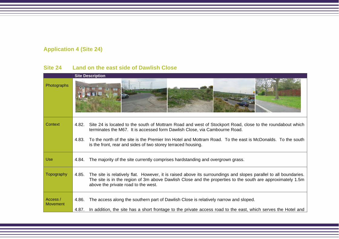
Site 24 Land on the east side of Dawlish Close Site Description
Photographs
Context 4.82. Site 24 is located to the south of Mottram Road and west of Stockport Road, close to the roundabout which terminates the M67. It is accessed form Dawlish Close, via Cambourne Road.
4.83. To the north of the site is the Premier Inn Hotel and Mottram Road. To the east is McDonalds. To the south is the front, rear and sides of two storey terraced housing.
Use 4.84. The majority of the site currently comprises hardstanding and overgrown grass.
Topography 4.85. The site is relatively flat. However, it is raised above its surroundings and slopes parallel to all boundaries. The site is in the region of 3m above Dawlish Close and the properties to the south are approximately 1.5m above the private road to the west.
Access / Movement
4.86. The access along the southern part of Dawlish Close is relatively narrow and sloped.
4.87. In addition, the site has a short frontage to the private access road to the east, which serves the Hotel and
McDonalds.
4.88. There is currently no vehicular access onto the main body of the site.
Constraints 4.89. Providing new access.

5. Design process including consultation statement
5.1. This section provides a summary of the design process through which the proposal has progressed to date. It builds upon our understanding of context as outlined in sections 3 and 4.
Assessment
Physical
5.2. The understanding and assessment of the physical context has been described in Section 3. The new developments need to form a relationship, and integrate with, the existing residential area.
5.3. To help develop the physical layout and appearance of the scheme a local Vernacular Study was prepared. The purpose of the Vernacular Study was to inform the evolution of the proposal for these sites. It looked at two local settlements in detail, analysing a range of features, including: the urban structure, hierarchy of streets and spaces, building forms, detailing, fenestration and massing.
5.4. The settlements chosen were Mottram-in-Longdendale and Marple Bridge. After analysing their form and layout the Study went on to propose the translation of this character into forms which could be used to guide future development in Hattersley. The Study finishes with
proposed materials for the built forms, public realm and also colour palettes to use in conjunction with the render, rainscreens and woodwork within the development.
Social and economic
5.5. This scheme will have a positive impact on those who live in local area and for the image of Hattersley. It will provide a high quality mix of housing types which will create an area where people want to live. Additionally, it will demonstrate further investment and confidence in Hattersley and the comprehensive regeneration strategy for the whole neighbourhood.
Crime and safety
5.6. In terms of the impact that the development will have on safety and security, a number of issues have been considered during the design process. The proposed development will have a positive role in activating all parts of the site. The proposed housing will increase natural surveillance and ownership within Hattersley.
5.7. Greater Manchester Police has completed a Part A Crime Impact Statement for all the sites.
Planning policy and design guidance
5.8. The planning and design guidance relevant to the site has been summarised in Section 2. We have demonstrated that these proposals will meet the principles and objectives of national and regional planning policy. In addition, it will also meet Supplementary Planning Guidance on residential development.

Consultation Statement
5.9. The purpose of this section of the report is to provide an overview of consultation undertaken.
5.10. These outline planning applications build upon an extensive amount of consultation undertaken over the last 5 years.
5.11. The following will highlight the main issues raised.
Local Planning Authority
5.12. There have been pre-application meetings with the Barratt team and TMBC planning team. This has enabled discussions around the content of the application, the form and layout of the development and other relevant planning issues. The feedback included:
Confirmation of the content of the applications, including site sections
Confirmation on the grouping of the applications
Agreement on the structure of the Design and Access Statement and that one document would relate to all four outline applications
Greater Manchester Architectural Liaison Unit, Greater Manchester Police
5.13. A Part A Crime Impact Statement has also been prepared for all the sites.
Community
5.14. There has been extensive consultation with Hattersley residents as part of the regeneration agenda within Hattersley and on earlier phases of development.
5.15. To raise awareness of the fresh outline applications, information will be published in the Hattersley Terrier. The applicant has attended the Residents Steering Group to discuss the fresh applications.
Evaluation – the evolution of the design
5.16. The design development has been ongoing since November 2006 and developed from the outline approval and development brief as prepared by GVA Grimley on behalf of English Partnerships.
5.17. The “Evolution of Design” illustrates the ongoing process of development since November 2006 and is set out below:
The GVA Grimley development brief was used as the starting point to inform the design.
Further site visits and consideration of constraints.
Initial layouts were prepared based on BASE’s original proposal and the development brief, to discuss unit mix, massing, layout principles etc. with the partners.
Additional studies undertaken e.g. transport statement, ecological reports and flood risk assessments.

Layout amended to creatively exploit topography and maximise development potential.
Design objectives – the vision “Our Vision is ‘Hattersley Town’ - a rural edge
community reconnected to the wider landscape
setting, one of a family of popular, sought after towns
and villages within Longdendale.
The real challenge for Hattersley is to make the place
look and feel like a community in which everyone
benefits from the facilities and wishes to make long-
term commitments to the neighbourhood. It must
convey a sense of credibility and longevity. Our plans
are realisable and promote good urban design
principles which we know will work and reflect the
requirements of the Homes and Communities Agency
(HCA) (formerly English Partnership) brief.
5.18. A simple but strong urban structure is proposed, rectifying the problems of the ‘Radburn layouts’, creating a legible street pattern and a feeling of well-being and safety. The sites have been organised to allow them to be developed separately or as a group, this assists with both phasing and delivery. It will also allow densities and housing typology to be refined over time.
5.19. To help deliver this vision, we propose the following six objectives founded upon our understanding of building on the existing and creating the new communities;
The 6 Objectives
5.20. Strategic fit - to create a neighbourhood that plays a fundamental role in achieving the regeneration and image of Hattersley and Tameside.
5.21. Distinctive brand - to offer an alternative and distinctive mix of residential accommodation, an addition and alternative to the monotonous accommodation currently available.
5.22. Connectivity - to provide an accessible environment building on the strong motorway and road links, and by enhancing the rail links and the environment around the station and adjacent areas.
5.23. Mixed neighbourhoods - establish a new neighbourhood centre linked to the existing highways to create a major attractive gateway to Hattersley. The new neighbourhoods will contain a mix of tenure and type of housing and within the renewal area improve and retain some of the existing properties.
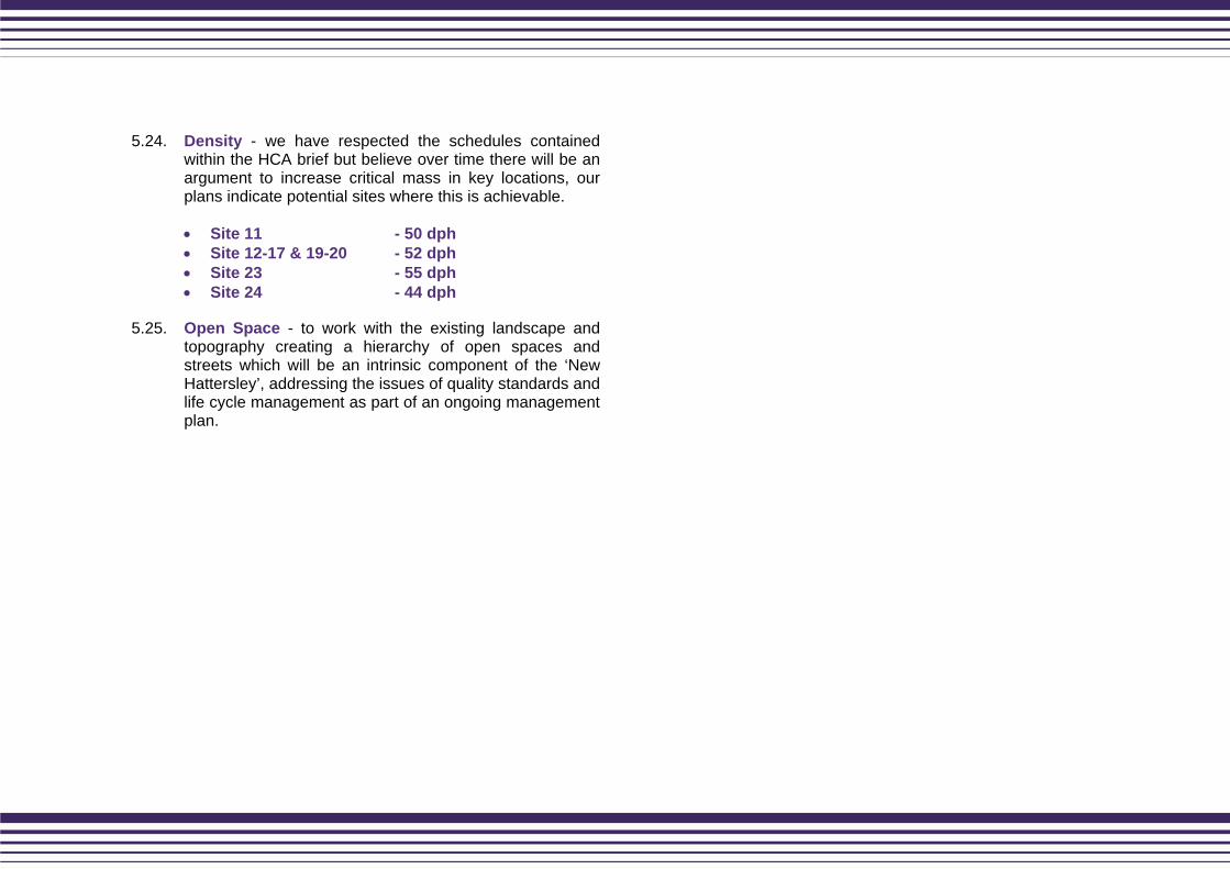
5.24. Density - we have respected the schedules contained within the HCA brief but believe over time there will be an argument to increase critical mass in key locations, our plans indicate potential sites where this is achievable.
Site 11 - 50 dph Site 12-17 & 19-20 - 52 dph Site 23 - 55 dph Site 24 - 44 dph
5.25. Open Space - to work with the existing landscape and topography creating a hierarchy of open spaces and streets which will be an intrinsic component of the ‘New Hattersley’, addressing the issues of quality standards and life cycle management as part of an ongoing management plan.

6. Overarching development parameters and principles
Introduction
6.1. This section of the Design and Access Statement describes the outline design proposals for Hattersley (Sites 11, 12-17 & 19-20, 23 and 24).
Overarching Urban Design Principles for all sites
6.2. The sites have been grouped together to ensure that the proposals maintain a high quality design and identity of place.
6.3. These design principles, which will guide the detailed development proposals for residential sites 11, 12-17 & 19-20, 23 and 24 responds to the ‘Building For Life’ criteria, which is a key criteria within HCA quality standards.
Scale, height and massing
6.4. The proposals will establish a family-friendly residential development comprising house type suitable for families and couples.
6.5. In general, the height and scale of buildings will respond to the streets and spaces that they face, in order to create a logical and visually permeable development structure.
6.6. It is therefore, anticipated that the majority of housing on the sites, will be 2-4 storeys, reflecting the heights of the residential buildings in the rest of Hattersley. There will be four-storey buildings at points where greater scale is required. This will also provide the visual focus on key junctions and gateways.
6.7. It is envisaged that house types will comprise a mix of 2, 3 and 4 bedroom townhouses in a courtyard arrangement; and the 3 and 4 bedroom detached and semi-detached housing and limited apartments. This will achieve a mix of house types and size, and contribute to widening the house choice in the area.
6.8. Therefore, it is envisaged that the housing density will present a consistent an average of approximately 50 dph.
Appearance
6.9. Appearance is a reserved matter. The detailed schemes should demonstrate principles of high quality design, relating to family housing and the public realm. Reference can be made to the vernacular study, to ensure the proposals are relevant to the local area.

Design layout
6.10. The principles of ‘place-making’ will inform the residential layout. In particular, the integrated public realm and built form will be central to the design process.
6.11. The proposed residential development will maximise the benefits of the location, such of Hattersley train station, the new district centre for retail opportunities and the Clough for open space.
6.12. The regeneration of Hattersley aims to overcome the physical and visual fragmentation identified during site analysis. This will require careful structuring of the built form to create visual and physical permeability, with the Clough acting as the heart of the new community.
6.13. Public space will be enlivened by active building frontage, and the legibility of the overall layout will be supported by a hierarchy of spatial and built form, reinforced by detailed design and material choice.
6.14. Within the urban block structure key corners and articulation points (e.g. gateways into the sites) should be marked with building of an appropriate scale and architectural interest.
6.15. The next section takes each of the 4 individual planning applications in turn, and discusses the proposals in more detail.

Indicative masterplan
6.16. This is an overall indicative masterplan for all the sites in context.
Figure 2: Overall indicative masterplan

Chapter 7: Site specific development parameters and principles


7a. Application 1 (Site 11) parameters and principles


Application 1: Site 11
Urban Design Principles
6.17. This assessment and evaluation process has led to the following urban design principles, which have underpinned the proposals. The urban design principles, as illustrated in Figure 3 are based on the form and structure of the Vernacular Study.
6.18. The Urban Design Principles are as follows:
Creation of architectural landmark feature on entrance and leaving points into the new development on Milverton Avenue.
Provide key view across the open space, opening up views across to Manchester.
Create a sense of place and identity.
Creation of the street network to link to the heart to the new community which can also be used by the existing residents.
Exploit the topography for views into and out of the development, to create interest in terms of roofscape and skyline and aid in accessibility of the site.
Create a strong public realm which is creative yet durable for the long term.
Ensure defensible space is provided to each property to give privacy and ‘breathing space’ between residents and visitors.
A sense of enclosure should be created, by appropriate heights of buildings which related to the widths of streets, which provides a human scale and sense of place.
Provide a strong architectural identity to the development which extends beyond the front elevations to the quality and adaptation of the units, the detailing of gables ends and rear elevations, the palette of materials proposed and the general form of each property which contributes positively to the whole.
6.19. Please refer to the indicative masterplan below, which demonstrates these principles.
Figure 3: Indicative Masterplan (Site 11)
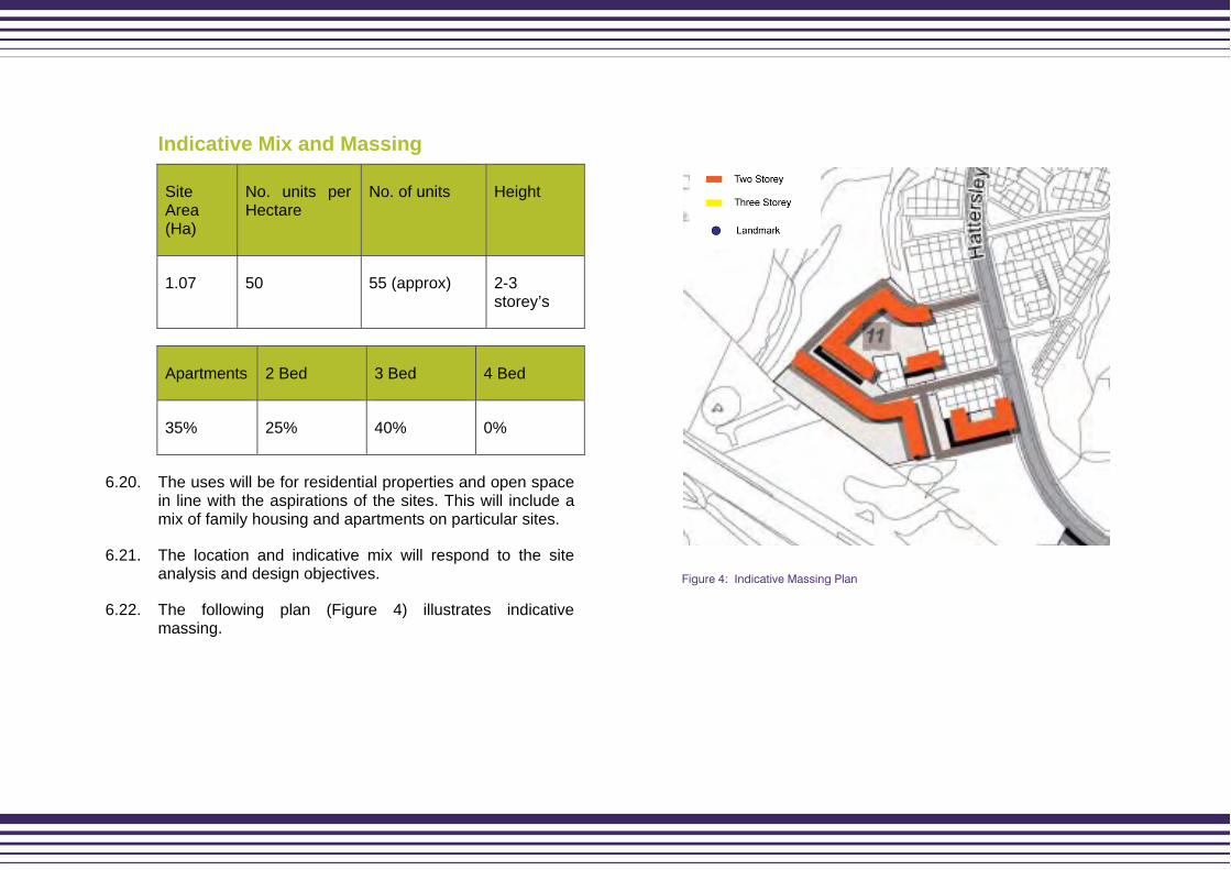
Indicative Mix and Massing
Site Area (Ha)
No. units per Hectare
No. of units Height
1.07 50 55 (approx) 2-3 storey’s
Apartments 2 Bed 3 Bed 4 Bed
35% 25% 40% 0%
6.20. The uses will be for residential properties and open space in line with the aspirations of the sites. This will include a mix of family housing and apartments on particular sites.
6.21. The location and indicative mix will respond to the site analysis and design objectives.
6.22. The following plan (Figure 4) illustrates indicative massing.
Figure 4: Indicative Massing Plan

Application 2 (Sites 12 to 22)
7b. Application 2 (Sites 12-17 & 19-20)


Application 2: Sites 12-17 and 19-20
Urban Design Principles
6.23. Sites 12-17 and 19-20 benefit from the nearby Hattersley train station and also the Clough, which contains green space and trees. This combined collection of sites cover’s a large area and whilst incorporated into the station quarter it is of sufficient size to meet a narrative of its own.
6.24. Figure 5 shows the urban design principles for the sites 12-17 and 19-20. The area around the station will be developed with higher density in mind and provide a choice of housing. Hattersley with its natural surroundings offers a great place to live for people who work in or near Manchester City Centre, but wish to live near open countryside.
6.25. The proposed station area will include a number of key features. A key vista from Hattersley Road East to the new station building and two new public squares, one located outside the train station and the other on a new access road from Sandy Bank Avenue to the train station. All public routes and spaces within the proposed scheme are overlooked from building frontages, creating a good level of natural surveillance.
6.26. Enclosed development blocks have communal courtyards and private gardens being locked together, within the interior of the blocks. These are requirements of ‘Secured by Design’.
6.27. The Urban Design Principles are as follows:
Should create active building frontage onto proposed street, in particular, Hattersley Road West and Sandy Bank Avenue.
A sense of enclosure should be created, by appropriate heights of buildings which related to the widths of streets, which provides a human scale and sense of place.
Ensure the layout is legible with a central core and strong urban structure which softens toward the rural fringe.
There are a number of solutions for car parking – these can be found in the English Partnerships Car Parking ‘what works where?’
6.28. Sites 13 and 17 will be able to provide frontage onto Hattersley Road East and site 17 which has potential to allow for future development linking with site 22. The remainders of the development sites within this area are smaller and will be new build, but following the same urban design principles as above.
6.29. Please refer to the following page for indicative masterplan (Figure 5), which demonstrates these principles.

Figure 5: Indicative Masterplan
Indicative Mix and Massing
Site Area (Ha) No. units per Hectare
No. of units Height
3.34 52 dph 192 (approx) 2-4 storeys
Site Apartments 1 Bed 2 Bed 3 Bed
12 100% 0% 0% 0%
13 25% 0% 20% 55%
14 25% 0% 20% 55%
15 25% 0% 20% 55%
16 25% 0% 20% 55%
17 25% 0% 20% 55%

Site Apartments 1 Bed 2 Bed 3 Bed
19 25% 0% 20% 55%
20 25% 0% 20% 55%
Average 34% 0% 18% 48%
6.30. The uses will be for residential properties and open space in line with the aspirations of the sites. This will include a mix of family housing, and apartments on particular sites.
6.31. The location and indicative mix will respond to the site analysis and design objectives.
6.32. The following plan (Figure 6) illustrates indicative massing.
Figure 6: Indicative Massing Plan

7c. Application 3 (Site 23)


Application 3: Site 23
Urban Design Principles
6.33. As in the proposed diagram the small development will include frontage onto Stockport Road and Bunkers Hill Road. All public routes and spaces within the scheme are overlooked from building frontage, creating a good level of natural surveillance. The parking solution for this development would include an element of communal courtyard parking.
6.34. The proposal should be sensitive to the existing houses on Bunkers Hill Road and Bretland Gardens. This proposal will have frontage onto property fronts which are in the south of the site. This will benefit from an access road from Bunkers Hill Road which will allow access into the courtyard parking.
6.35. The Urban Design Principles are as follows:
Connecting and reinforcing existing pedestrian routes – in particular the link between Stockport Road and Bunkers Hill Road.
Developing positive frontage onto Stockport and Bunkers Hill Road.
Enhance green space and trees around the square features.
Design features which assist to enhance the corner feature as a landmark leaving Stockport Road.
6.36. Please refer to the following indicative masterplan (Figure 7), which demonstrates these principles.
Figure 7: Indicative Masterplan

Indicative Mix and Massing
Site Area (Ha) No. units per Hectare
No. of units Height
0.4 55 22 (approx) 2-3 storeys
Apartments 2 Bed 3 Bed 4 Bed
15% 25% 45% 15%
6.37. The uses will be for residential properties and open space in line with the aspirations of the sites. This will include a mix of family housing and apartments on particular sites.
6.38. The location and indicative mix will respond to the site analysis and design objectives.
6.39. The following plan (Figure 8) illustrates indicative massing.
Figure 8: Indicative Massing Plan
7d. Application 4 (Site 24)


Application 4: Site 24
Urban Design Principles
6.40. This assessment and evaluation process has led to the following urban design principles, which have underpinned the proposals. The urban design principles, as illustrated in Figure 9 are based on the form and structure of the vernacularly study.
6.41. The site is located between Stockport Road and Cambourne Road. This proposal will allow for a new access road through the site. All public routes and spaces within the proposed scheme are overlooked from building frontage, creating a good level of natural surveillance.
6.42. As illustrated in the above proposal, it should create a positive building frontage onto the proposed access road from Dawlish Close and Stockport Road. The proposal should include a square which fronts onto Dawlish Close and provide a key spine that would connect the two places.
6.43. In addition, extra consideration should be given to creating secure attractive boundaries to the north and east of the proposed development blocks.
6.44. The Urban Design Principles are as follows:
Parking solutions should be integrated into the scheme in a number of ways.
A sense of enclosure should be created within the urban block.
A sense of enclosure should be created which relate to the width of the street.
Create a sense of place and identity.
6.45. Please refer to the following indicative masterplan (Figure 9), which demonstrates these principles.
Figure 9: Indicative Masterplan

Indicative Mix and Massing
Site Area (Ha) No. units per Hectare
No. of units Height
0.83 44 40 approx 2-3 storeys
Apartments 2 Bed 3 Bed 4 Bed
15% 15% 35% 35%
6.46. The uses will be for residential properties and open space in line with the aspirations of the sites. This will include a mix of family housing and apartments on particular sites.
6.47. The location and indicative mix will respond to the site analysis and design objectives.
6.48. The following plan (Figure 10) illustrates indicative massing.
Figure 10: Indicative Massing Plan

7. Accessibility and movement
Making Connections
7.1. The concept is to fully integrate the proposed developments within its context. Critical to achieving this is making connections at both a local and strategic level. It is particularly important to maximise pedestrian connections to encourage walking within the area and to public transport facilities hence reducing people’s reliance on the private vehicle.
Street Types
7.2. The scheme proposes a clear hierarchy of routes connecting with existing streets and spaces to achieve an integrated development whilst creating a sense of place. The street hierarchy should be reinforced by the design of the built form and public realm to create a coherent attractive development which is legible.
7.3. A wider strategy for improvements across the area shall be progressed. This shall include reducing traffic speeds, improving safety, introduce pedestrian crossings, improve the bus facilities, address parking and enhance the environment with formal and naturalistic planting.
7.4. The classification of the street types below considers the street in terms of:
Capacity: how movement of every kind can be accommodated safety.
Character: the role of the street in the urban realm and the types of building and landscape that enclose it.
Parking
7.5. To encourage sustainable lifestyles parking should be provided at a minimum which would also enable the visual dominance of cars to be reduced. Hattersley should be designed to promote use by pedestrians and cyclists with car parking reflecting guidance in PPS3.
7.6. Integrating parking is a complex design issue to achieve a high quality residential environment which is not dominated by vehicles yet provides safe areas for residents to park their cars. The approach should be

integrated with the overall concept of developing streets with Home Zone principles, which could integrate parking, planting and traffic calming.
7.7. Parking may be provided in a combination of ways including: private garages, within curtilages, shared parking areas, adjacent to the streets either parallel or perpendicular. Well designed on street parking will be allowed. Where parking is proposed within the public realm it must be designed to ensure that:
It is clearly visible from the property they serve.
Good level of lighting.
High level of natural surveillance provided by overlooking from neighbouring properties.
Enhance with tree planting to minimise visual impact of parked cars.
To avoid large clusters of car parking courts. These are generally no more than ten spaces in any one area.
To ensure that parking areas are always overlooked by neighbouring houses.
7.8. Tameside Metropolitan Borough Council provides guidance, in their Residential Development Guidelines (please refer to http://www.tameside.gov.uk/planning/ldf/spd/residential), on the provision of parking within residential areas. There is also English Partnership parking best practice -“Car Parking, What Works Where” (please refer to http://www.englishpartnerships.co.uk/carparking.htm).
Pedestrians and cyclists
7.9. The dwellings, spaces between them and the needs of pedestrians and cyclists rather than the vehicular requirements should dictate the site’s layout. However, the ambition to achieve a sensitive and intimate environment needs to be balanced against practical considerations for use and operation of the development.
Servicing of Dwellings
7.10. Sufficient space should be provided around all building blocks to allow for building maintenance and refuse collection. No unsafe alleyways will be created.
Services
7.11. Where possible services should be located in common delineated zones, below streets which will be ‘taken in charge’. As a general principle the integration of services should not undermine the intimate scale and layout. Co-ordination, concentration and integration of services will be required to ensure that infrastructure (and access requirements to service infrastructure) does not undermine the character of the public realm.

8. Waste Strategy 8.1. This waste management strategy supports the outline
application for residential development in Hattersley. The strategy has been developed in accordance with Tameside Metropolitan Borough Council guidance document “A Strategy for the management of waste in Tameside 2005-2010” (please refer to www.tameside.gov.uk/recycling/wastestrategy0510.pdf).
8.2. The houses will have refuse containers in accordance with the Council’s waste storage requirements which include segregated waste. The layout has been designed to accommodate the required number of bins within the curtilage of each house, and allow refuse vehicle access to collection points. The segregated waste will then be collected in accordance with the Council’s standard arrangements for house and apartments.
8.3. Therefore, in accordance with the Council’s waste collection policy each house will be provided with:
Refuse 1 no. 240 litre wheeled bin
Paper 1 no. 140 litre wheeled bin
Glass 1 no. 140 litre wheeled bin
Garden 1 no. 140 litre wheeled bin
Total 4no. wheeled bins

ty head office • chadsworth house • wilmslow road • handforth • cheshire • sk9 3hptel: 01625 542 200 • fax: 01625 542 250
ty manchester • 4th floor • fourways house • 57 hilton street • manchester • m1 2ejtel: 0161 200 6230 • fax: 0161 200 6259
ty liverpool • vanilla factory • 39 fleet street • liverpool • l1 4artel: 0151 702 6500 • fax: 0151 702 6509
www.tayloryoung.co.uk


![Barratt Homes v Welsh Water - The Supreme Court · Michaelmas Term [2009] UKSC 13 On appeal from: [2008] EWCA 1552 JUDGMENT Barratt Homes Limited (Respondents) v Dwr Cymru Cyfyngedig](https://img.dokumen.tips/doc/110x75/5bde43ad09d3f2995d8c717a/barratt-homes-v-welsh-water-the-supreme-court-michaelmas-term-2009-uksc.jpg)