Embed Size (px)
Citation preview
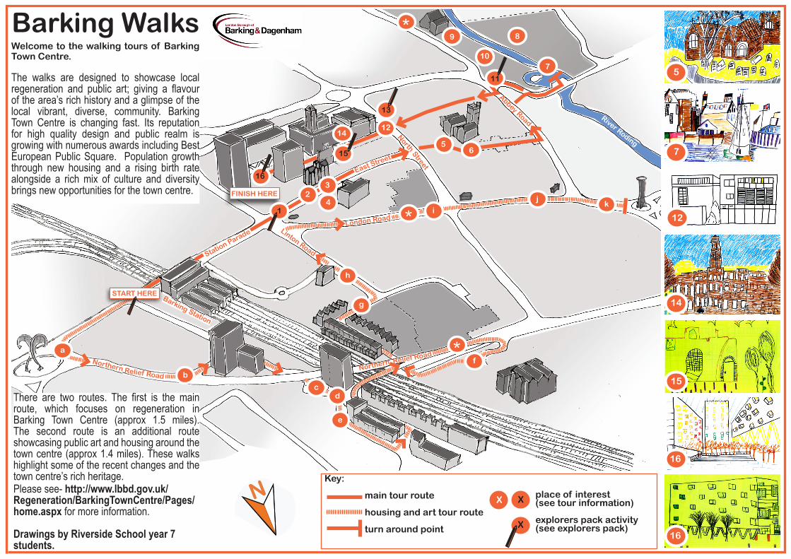
Station Parade
NorthStreet
4
5
Abbey Road
6
River Roding
9
11
14
15
16
FINISH HERE
aNorthern
b
cd
f
g
Linton Road
London Roadi
*j
Relief RoadNorthern Relief Road
1
East Street
3
7
8
13
12
e
START HERE
k2
10
*
Barking Station
*
h
Barking WalksWelcome to the walking tours of Barking Town Centre.
The walks are designed to showcase local regeneration and public art; giving a flavour of the area’s rich history and a glimpse of the local vibrant, diverse, community. Barking Town Centre is changing fast. Its reputation for high quality design and public realm is growing with numerous awards including Best European Public Square. Population growth through new housing and a rising birth rate alongside a rich mix of culture and diversity brings new opportunities for the town centre.
Key:
main tour route
housing and art tour route
turn around point
X
5
7
12
15
16
16
14
X
X place of interest (see tour information)
explorers pack activity(see explorers pack)
There are two routes. The first is the main route, which focuses on regeneration in Barking Town Centre (approx 1.5 miles). The second route is an additional route showcasing public art and housing around the town centre (approx 1.4 miles). These walks highlight some of the recent changes and the town centre’s rich heritage. Please see- http://www.lbbd.gov.uk/Regeneration/BarkingTownCentre/Pages/home.aspx for more information.
Drawings by Riverside School year 7 students.
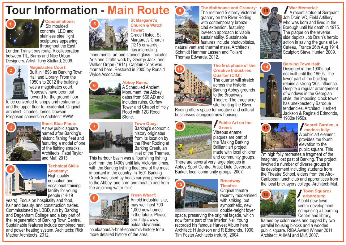
Constellations: Six moulded concrete, LED and stainless steel light sculptures appearing throughout the East
London Transit bus route. A collaboration between TfL, Burns and Nice Urban Designers. Artist: Tony Stallard, 2009.
Tour Information - Main Route
4
5
7
8
9
12
14
15
16
Technical Skills Academy: High quality education and vocational training facility for young people (14-19
years). Focus on hospitality and food, hair and beauty, and construction trades. Commissioned by LBBD, run by Barking and Dagenham College and a key part of the regeneration of Barking Town Centre. Sustainable features include combined heat and power heating system. Architects: Rick Mather Architects, 2012.
Short Blue Place: A new public square named after Barking’s historic fishing fleet and featuring a model of one of the fishing smacks. Architects: Patel Taylor and Muf, 2013.
St Margaret’s Church & Watch Tower: Grade I listed, St Margaret’s Church (1215 onwards) has interesting
monuments, art and stained glass. Includes Arts and Crafts work by George Jack, and Walker Organ (1914). Captain Cook was married here. Restored in 2005 by Ronald Wylde Associates.
Abbey Ruins: A Scheduled Ancient Monument, the Abbey dates from 666 AD and includes ruins, Curfew Tower and Chapel of Holy Rood with 12C Rood Stone.
Town Quay: Barking’s economic history originates from its location by the River Roding at Barking Creek, an inlet of the Thames.
This harbour basin was a flourishing fishing port from the 1400s until late Victorian times, with the Barking fishing fleet one of the most important in the country. In 1601 Barking Creek was used by boats carrying provisions to the Abbey, and corn and meal to and from the adjoining water mills.
Fresh Wharf: An old industrial site, may well host 700-1,000 new homes in the future. Please see: http://www.boldanddynamic.
co.uk/about/a-brief-economic-history for a more detailed history of the area.
The Malthouse and Granary: The restored 5-storey Victorian granary on the River Roding with contemporary bronze clad extension, featuring low-tech approach to viable sustainability. Sustainable features include photovoltaics,
natural vent and thermal mass. Architects: Schmidt Hammer Lassen and Pollard Thomas Edwards, 2012.
The first phase of the Creative Industries Quarter (CIQ): The quarter will stretch across the historic Barking Abbey grounds to the Broadway Theatre. The three acre site fronting the River
Roding offers space for creative and cultural businesses alongside new housing.
Public Art on the Green: Vitreous enamel plaques are part of the ‘Making Barking Brilliant’ art project, made with local children and community groups.
There are several very large plaques in Abbey Sport Centre. Artist: Dale Deveroux Barker, local community groups, 2007.
Broadway Theatre: Original theatre recently modernised with striking, but sympathetic, new double-height foyer
space, preserving the original façade, which now forms part of the interior. Neil Young recorded his famous Harvest Album here. Architect: H Jackson and R Edmonds, 1930. Tim Foster Architects (refurb), 2004.
War Memorial: A recent statue of Sergeant Job Drain VC, Field Artillery who was born and lived in the Borough until his death in 1975. The plaque on the reverse side depicts Job Drain’s heroic action in saving the guns at Le Cateau, France 26th Aug 1914. Sculptor: Steve Hunter, 2009.
Barking Town Hall: Designed in the 1930s but not built until the 1950s. The lower part of the building retains a strong ‘30s influence. Despite a regular arrangement of windows in the Georgian style, the imposing clock tower has unexpectedly Baroque tendencies. Architect: Herbert Jackson & Reginald Edmonds, 1930s/1950s.
Secret Garden, a modern folly: A public art element provides the fourth elevation to the public square. This
7m high folly recreates a fragment of the imaginary lost past of Barking. The project involved a number of diverse groups in its development including students from the Theatre School, elders from the Afro-Caribbean lunch club and apprentices from the local bricklayers college. Architect: Muf.
Town Square / arboretum: A bold new town centre development comprising a Learning Centre and library,
framed by colonnades and topped by two parallel housing blocks and a wooded public square. RIBA Award Winner 2011. Architect: AHMM and Muf, 2007.
Magistrates Court: Built in 1893 as Barking Town Hall and Library. From the 1950’s to 2012 the building was a magistrates court. Proposals have been put forward for the ground floor
to be converted to shops and restaurants and the upper floor to residential. Original architect: Charles James Dawson. Proposed conversion Architect: AWW.
2
3
6
11
13
10
1

The Catch: A gateway public artwork for Barking Town Centre. The theme reflects two key elements of the heritage and history of
Barking - the fishing industry and the area’s Saxon heritage. Artist: Loraine Leeson of cSPACE, in collaboration with Anne Thorne Architects Partnership, 2002.
Tour Information - Additional Routea
East Thames Foyer / Media Centre: The 116 unit Foyer service works with and engages young people who live in and around Barking and Dagenham. The Foyer is a place where young people can
live and receive support to enable them to achieve their goals. Architect: Jestico + Whiles Architects, 2009.
Light Waves: A dynamic light installation with pulses of coloured lights triggered by passers by (best seen at night). Funding
for this project was secured through a Section 106 Agreement with the developers of the nearby Tanner Street housing scheme. Artist: Raphael Daden, 2006.
Equinox House: The second phase of the Tanner Street development, a block of apartments called Equinox Tower. Architect: Peter Barber Architects and Jestico + Whiles Architects, 2007.
Tanner Street: Known locally as ‘Costa Del Barking’, it is a re-development of the Clevelands, Bloomfields and Wakering tower blocks. 165 mixed tenure homes including 1 & 2 bed flats and 4 bed houses. Tanner Street won the 2005 Housing Design Awards,
2007 RIBA Award and the Daily Telegraph New Home Award. Architects: Peter Barber Architects, 2005.
e
Northbury Junior School Extension: An expansion to a Victorian school taking the form of a giant timber classroom box, raised up on
wooden legs. A glass curtain wall gives every classroom an 8m wide x 3m high window. Sustainable features include stack-effect natural ventilation, solar-reflective glass, full-heat recovery and ventilation. RIBA Award Winner in 2010. Architects: Greenhill Jenner, 2009.
William Street Quarter: A new housing development replacing the former Lintons Estate. Phase 1 has 31 terraced houses on a 2.5 ha site. Known
as Anne Mews, it is the first Council housing in the Borough for 27 years, completed in 2011. Phase 2 now on site with 477 affordable homes, ranging from flats, duplex blocks and 1-4 bed houses. Completion is due in 2014. Architects: AHMM & Maccreanor Lavington Architects, 2001 & 2014.
g
Barking Enterprise Centre: Part of the William Street Quarter Development. The four storey building
provides much needed space for small businesses with easy-in/easy-out terms. It aims to bring home the message to residents and visitors that Barking and Dagenham is a place where businesses can start up and flourish. Sustainable features include a brown roof and photovoltaics. Architect: Pellings Architects, 2011.
London Road /North Street: This scheme will deliver a new Asda store for Barking Town Centre, part
of Barking and Dagenham’s £45 million redevelopment of London Road. The overall project also includes 100 private apartments above the store and provides 350 parking spaces below. Developer: Bouygues.
Lighted Lady: A 20m high landmark sculpture forming a gateway into Barking Town Centre. Subtle daylight reflects at the top. It is best seen at night when the sculpture is lit by lamps of different colours, which are situated around the sculpture. The Lady is a reference to the maternal forces of nature and to the nearby Christian
Abbey. Architects: Muf Artist: Joost Van Santen, 2007.
k
Blocks of London Bridge: Two granite blocks from the foundation of the demolished London Bridge are placed near each other and connected with a stainless steel bridge, creating a sculpture with a background and history. Artist: Joost Van Santen, 2004.
b
c
d
f
h
j
i
UP! Barking: Community art project for 16-25 year olds which aims to produce 350 metres of art work for numerous hoardings around key regeneration sites. Please visit the Up! Barking facebook page.
*