Embed Size (px)
Citation preview

R-101209_DMP_Balnaves Deep-1 (Amendment to timing & vessel)_Rev 1.docx 1 14/01/2011
Balnaves Deep-1 (Commonwealth Waters, WA-356-P)
Directional Exploration well BRIDGING DOCUMENT to the Generic Environment Plan (EP) for Apache's drilling activities on the North West Shelf 2007-2011 (EA-00-RI-164)
13th January 2011
Introduction Apache proposes to drill Balnaves Deep-1 as a directional exploration well in permit area WA-356-P in Commonwealth waters. Drilling is proposed to commence early March 2011 (dependent on rig availability; and weather conditions permitting) using either the Ocean Patriot semi-submersible drill rig.
Distances from the well to key regional features are listed below: - Closest Apache offshore platform: John Brookes, 41 km S - Closest Montebello Island: 47 km SE - Closest Lowendal Island: 68 km SSE - Varanus Island: 74 km SSE - Closest mainland point (Mardie Station): 134 km SE - Closest island in Dampier archipelago: 141 km ESE The location of the well is shown in Figure 1.
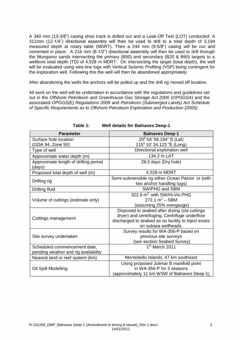
The Generic Environment Plan (EP) for Apache's drilling activities on the North West Shelf 2007-2011 (EA-00-RI-164) will be used to drill the well, as it covers the expected environmental risks and control measures to be undertaken during the drilling programme. The well details for Balnaves Deep-1 are summarised in Table 1. The well will be drilled with
both water based mud (WBM) and synthetic-based mud (SBM) and drill cuttings will be discharged to the seabed after being dried and centrifuged. The Ocean Patriot is the proposed rig to drill the Balnaves Deep-1 and has been used by Apache for previous drilling campaigns. A summary of the Ocean Patriot semi-submersible drill rig is provided in Table 2. Drilling Programme After anchoring the drill rig, Balnaves Deep-1 will have a 762 mm by 508 mm (30” by 20”) conductor set just below the seabed. A low pressure wellhead housing (LPWHH) will be set at the mud line. A 406 (16”) hole will then be drilled to 50 m into the Mandu formation. A 340mm (13-3/8”) casing will then be run and cemented with a high pressure wellhead housing (HPWHH) latched within the LPWHH. At this point the blow-out preventor (BOP) and marine riser will be installed. A full BOP pressure test will be conducted. A 914 mm (36”) and 406 mm (16”) sections will be drilled with a combination of seawater and gel sweeps (SW/PHG). The well will then be displaced to a synthetic based mud (SBM) for the lower sections (i.e. 311mm (12-1/4”) and 216mm (8-1/2”)).
R-101209_DMP_Balnaves Deep-1 (Amendment to timing & vessel)_Rev 1.docx 2 14/01/2011
A 340 mm (13-3/8”) casing shoe track is drilled out and a Leak-Off Test (LOT) conducted. A 311mm (12-1/4”) directional assembly will then be used to drill to a total depth of 3,194 measured depth at rotary table (MDRT). Then a 244 mm (9-5/8”) casing will be run and cemented in place. A 216 mm (8-1/2”) directional assembly will then be used to drill through the Mungaroo sands intersecting the primary (B50) and secondary (B20 & B60) targets to a wellbore total depth (TD) of 4,528 m MDRT. On intersecting the target (total depth), the well will be evaluated using wire-line logs with Vertical Seismic Profiling (VSP) being contingent for the exploration well. Following this the well will then be abandoned appropriately. After abandoning the wells the anchors will be pulled up and the drill rig moved off location. All work on the well will be undertaken in accordance with the regulations and guidelines set out in the Offshore Petroleum and Greenhouse Gas Storage Act 2006 (OPGGSA) and the associated OPGGS(E) Regulations 2009 and Petroleum (Submerged Lands) Act Schedule of Specific Requirements as to Offshore Petroleum Exploration and Production (2005).
Table 1: Well details for Balnaves Deep-1
Parameter Balnaves Deep-1
Surface hole location (GDA 94, Zone 50)
200 04' 58.194” S (Lat) 1150 10' 34.123 ”E (Long)
Type of well Directional exploration well
Approximate water depth (m) 134.2 m LAT
Approximate length of drilling period (days)
28.5 days (Dry hole)
Proposed total depth of well (m) 4,528 m MDRT
Drilling rig Semi-submersible rig either Ocean Patriot or (with
two anchor handling tugs)
Drilling fluid SW/PHG and SBM
Volume of cuttings (estimate only) 322.9 m3 with SW/Hi-Vis PHG
272.1 m3 – SBM (assuming 25% overgauge)
Cuttings management
Disposed to seabed after drying (via cuttings dryer) and centrifuging. Centrifuge underflow
discharged to seabed as no facility to inject exists on subsea wellheads.
Site survey undertaken Survey results for WA-356-P based on
previous site surveys (see section Seabed Survey)
Scheduled commencement date, pending weather and rig availability
1st March 2011
Nearest land or reef system (km) Montebello Islands, 47 km southeast
Oil Spill Modelling Using proposed Julimar B manifold point
in WA-356-P for 3 seasons (approximately 11 km WSW of Balnaves Deep-1)

R-101209_DMP_Balnaves Deep-1 (Amendment to timing & vessel)_Rev 1.docx 3 14/01/2011
Figure 1: Location of the proposed Balnaves Deep-1 drilling location

R-101209_DMP_Balnaves Deep-1 (Amendment to timing & vessel)_Rev 1.docx 4 14/01/2011
Table 2: Ocean Patriot semi-submersible drill rig
Rig Type: Semi -submersible Bulk cement: 3 x 95 m3 = 285 m3
Year Built: 1983 Liquid Mud: 6 total cap 1,900 bbls and slug pit 70 bbls
Yard Built: Le Seyne Mer by Chanties France
Drill Water: 1,067 metric tonnes
Rated Water Depth:
450 m (1,476 ft) Base Oil storage:
Not applicable
Drilling Depth (rated):
6,096 m (20,000 ft) Brine storage:
Not applicable
Dimensions: 102 m (334.6 ft) x 73 m (239.5 ft)
Potable Water:
458 metric tonnes
Weight: 12,307 metric tonnes Oily water separator
Hamworthy HS 1 (M) (1”). Set point of 15 ppm
Quarters: 100 persons Primary BOP: Stack (18-3/4") complete with guide frame and frame pickup.
Number of Legs:
6 Diverter BOP: Regan KFDS-3 (20”)
Moonpool dimensions:
21.9 m x 6.25 m (72 ft x 20.5 ft)
BOP control system:
Koomey (Type 80 SSA 30011 TL)
Source: Standard Format Equipment List Semi-submersible Units – Ocean Patriot (13 May 2010).
Seabed Survey Neptune Geomatics was contracted by Apache Energy Limited (Apache) to provide a series of geophysical survey services for the Balnaves-1 site survey located within permit WA-356-P in the North West Shelf approximately 140 km northwest of Dampier, Western Australia. Historically, four previous site surveys were conducted within the WA-356-P survey area, these include:
Brulimar-1 site survey conducted 12 November to 4 December 2007 using the Mermaid Eagle.
Balnaves-1 site survey(1) conducted 21 to 24 October 2008 using the Pacific Crest.
Balthazar-1 site survey conducted 22 October to 24 November 2009 using the Mermaid Investigator.
Julimar Development Project(2) conducted 13 March to 06 May 2010 using the Mermaid Investigator.
All the surveys with exception of the Brulimar-1 site survey (by Tri-Surv Geomatics) were conducted by Neptune Geomatics.
Due to the extensive surveys undertaken in the WA-356-P; no site specific survey is proposed for Balnaves Deep-1. As the proposed Balnaves Deep-1 well site is closest to the surveyed Balnaves-1 site (survey boundary is approximately 1.4 km southwest from the Balnaves-1
1 Neptune Geomatics, 2008. Balnaves Site Survey Report. Report No.: 8A305-RR-001-R0. Prepared for Apache
Energy Ltd. 2 Fugro, 2010. Julimar South-West-1 & 2 Site Survey Report. To be prepared for Apache Energy Ltd. Report
pending.

R-101209_DMP_Balnaves Deep-1 (Amendment to timing & vessel)_Rev 1.docx 5 14/01/2011
surface location) seabed conditions may exhibit similar features as recorded for the Balnaves-1 survey area. Survey equipment used in previous seabed surveys included an echo sounder, side scan sonar, sub-bottom profiler (boomer), survey positioning and acquisition software in an area of 4 km x 4 km surrounding the surface location. Overall, the seabed within the Balnaves-1 survey area was found to be flat, gently deepening to the northwest with an average gradient of less than 10. In general, the Balnaves survey area is likely to consist of prominent seabed sediments of unconsolidated calcareous sandy clayey silt. The survey area is most likely to be featureless with the exception of disturbed areas of seabed (including anchor scars) attributed to previous drilling activity (undertaken by the Ocean Patriot) at the Brunello-1 and Balnaves-1 well sites.
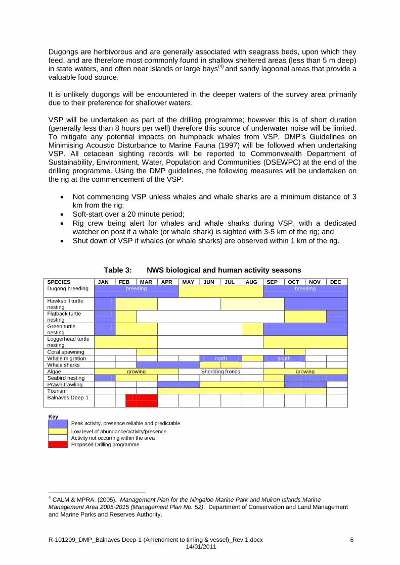
The well sites are located 3.5 km northwest and 1.5 km northwest respectively of the proposed Balnaves Deep-1 site. General Environmental Considerations The drilling programme occurring predominantly in February does not coincide with the peak migration of humpback whales (Megaptera novaeangliae) in the Exmouth to Port Hedland region (see Table 3). The humpback whale is a cetacean listed as 'threatened' under the Environment Protection and Biodiversity Conservation (EPBC) Act 1999.
The humpback whale migrates between the Antarctic waters and the Kimberly region of Western Australia. The peak of the northerly migration occurs around June – July, while the southerly return migration peaks around September – October. Northbound whales tend to remain on or within the 200 m contour passing to the west and north of Serrurier Island, westward of Barrow Island and north of the Montebello Islands whereas the southern migration route is more variable and often in shallower waters to the east of the Montebello/Lowendal/Barrow region. Whale sharks (Rhincodon typus), the world's largest fish (up to 12 m in length), are oceanic and cosmopolitan in their distribution. During autumn (late March to June) they aggregate in and near the waters of the Ningaloo Marine Park (a distance of greater than 200 km from the Balnaves Deep-1 drill site), with the largest numbers being recorded in April. Although drilling is proposed to occur outside of the peak whale shark aggregation period, it may be possible that whale sharks may be present within the wider region. The proposed Balnaves Deep-1 drilling location is approximately 47 km distant from the nearest island (Montebello islands) and 68 km from the nearest Lowendal Island; however management measures will be in place throughout the drilling programme to avoid potential impact on cetaceans (see Environmental Guidelines and Commitments). Dugongs (Dugong dugon) occur across the tropical coastal waters of Australia from Shark
Bay to Queensland and are protected under national legislation and international agreements. They are generally restricted to coastal or shallow water habitats with sufficient seagrass, on which they feed and large populations are known to occur in coastal waters of northern Western Australian(3)
3 Prince, R.I.T. (2001) Aerial survey of the distribution and abundance of dugongs and associated
macroinvertebrate fauna- Pilbara Coastal and Offshore Region, W.A. Report to Environment Australia; and Marsh, H., H. Penrose, C. Eros & J. Hugues (2002). Dugong Status Report and Action Plans for Countries and Territories. United Nations Environment Programme, Nairobi.
R-101209_DMP_Balnaves Deep-1 (Amendment to timing & vessel)_Rev 1.docx 6 14/01/2011
Dugongs are herbivorous and are generally associated with seagrass beds, upon which they feed, and are therefore most commonly found in shallow sheltered areas (less than 5 m deep) in state waters, and often near islands or large bays(4) and sandy lagoonal areas that provide a valuable food source. It is unlikely dugongs will be encountered in the deeper waters of the survey area primarily due to their preference for shallower waters. VSP will be undertaken as part of the drilling programme; however this is of short duration (generally less than 8 hours per well) therefore this source of underwater noise will be limited. To mitigate any potential impacts on humpback whales from VSP, DMP’s Guidelines on Minimising Acoustic Disturbance to Marine Fauna (1997) will be followed when undertaking VSP. All cetacean sighting records will be reported to Commonwealth Department of Sustainability, Environment, Water, Population and Communities (DSEWPC) at the end of the drilling programme. Using the DMP guidelines, the following measures will be undertaken on the rig at the commencement of the VSP:
Not commencing VSP unless whales and whale sharks are a minimum distance of 3 km from the rig;
Soft-start over a 20 minute period;
Rig crew being alert for whales and whale sharks during VSP, with a dedicated watcher on post if a whale (or whale shark) is sighted with 3-5 km of the rig; and
Shut down of VSP if whales (or whale sharks) are observed within 1 km of the rig.
Table 3: NWS biological and human activity seasons
SPECIES JAN FEB MAR APR MAY JUN JUL AUG SEP OCT NOV DEC
Dugong breeding breeding breeding
Hawksbill turtle
nesting
Flatback turtle nesting
Green turtle nesting
Loggerhead turtle
nesting
Coral spawning
Whale migration north south
Whale sharks
Algae growing Shedding fronds growing
Seabird nesting
Prawn trawling
Tourism
Balnaves Deep-1
Key
Peak activity, presence reliable and predictable
Low level of abundance/activity/presence
Activity not occurring within the area
Proposed Drilling programme
4 CALM & MPRA. (2005). Management Plan for the Ningaloo Marine Park and Muiron Islands Marine
Management Area 2005-2015 (Management Plan No. 52). Department of Conservation and Land Management
and Marine Parks and Reserves Authority.

R-101209_DMP_Balnaves Deep-1 (Amendment to timing & vessel)_Rev 1.docx 7 14/01/2011
Oil and Diesel Spill Modelling This section details the results of oil spill modelling during three different seasons, using the spill point (namely Julimar B Manifold) within WA-356-P (for the proposed Julimar Development Project) (APASA, November 2010(5)) located approximately 11 km west southwest of Balnaves Deep-1 drill site (see Figure 1). Given the relatively short distance
between the wells and the distance to sensitive resources and shorelines, the results of this modelling can be applied to the Balnaves Deep -1 location. Oil spill modelling was undertaken using a three-dimensional oil spill trajectory and weathering model (SIMAP) designed to simulate the transport, spreading and weathering of specific oil types under the influence of changing meteorological and oceanographic forces. Modelling scenarios considered during the spill assessment were a surface diesel spill of a total of 80,000 L (large volume, worst case during construction activities) and an uncontrolled subsea blowout (with a release rate of 4,200 barrels per day) for a period of ten weeks6. Modelling was carried out using current and wind data sampled from the APASA data archive for the regional area based on periods corresponding to summer (December to February), winter (June to August) and transitional periods (autumn and spring) to quantify risks of contact at surrounding locations during each of these seasons. Risks of contact with surrounding shorelines are assessed in terms of threshold levels of oil concentration. Indicative thresholds of oil mass per surface area were applied for surfaced oil – equivalent to oil films displaying dull metallic colours (5 g/m2), rainbow sheen (0.15 g/m2) and silver sheen (0.15 g/m2). Given Balnaves Deep-1's distance from offshore islands and the mainland, the modelling outlined below can be considered as a worst-case scenario. Table 4 outlines the predicted
risks to sensitive shorelines from potential oil spills at the proposed Julimar B Manifold point (in WA-356-P) under summer, winter and transitional season conditions. It is noted that the Balnaves Deep-1 drilling programme will be undertaken during the summer season. Summer Season (October to March) Under summer conditions, the predominant winds (those that will be experienced during this drilling campaign) are to the northeast, forcing the majority of simulated spills in that direction. Stochastic modelling indicated that spills during the summer season are unlikely to drift onto land as winds at the spill site will predominantly be from the southwest and spills are most likely to travel to the northeast (Figures 2 - 3). A low probability (5%) of shoreline contact by condensate films of concentrations > 0.15 g/m2
was indicated at Barrow Island, the Murion Islands and North West Cape. The earliest (minimum) time for oil of any concentration to arrive at this shoreline is 730 hrs. The Montebello Islands was the shoreline predicted to have the highest probability (10%) of exceeding the 0.15 g/m2 threshold, with a minimum time to shoreline of 1,015 hrs (Table 4).
Surface probability contours of diesel oil indicates a ≤ 20% chance of exceeding the 1 g/m2 concentration threshold up to 20 km to the north and up to 30 km to the south west of the spill site. For the 5 g/m2 threshold, the extent of the 20% probability contour is reduced to no further than 5 km form the spill site in any direction. Overall, there is a 2% probability of
5 Julimar Development- Hydrocarbon Spill Risk Assessment, November 2010. Prepared by Asia Pacific Applied
Science Associates (APASA) on behalf of Apache Energy Ltd (AEL). 6 A leak frequency analysis conducted by Bureau Veritas in October 2010 (on behalf of AEL), predicts the
probability of a blowout occurring at the proposed Julimar B manifold is 4.9 x 10⁻⁴ per year, or approximately 1 in
every 2,000 years. Applying this probability reduces the risk of most of the outcomes of the blowout simulations to less than 1 in every 5,000 years.

R-101209_DMP_Balnaves Deep-1 (Amendment to timing & vessel)_Rev 1.docx 8 14/01/2011
surface diesel oil contacting any shoreline during summer, with a minimum drift time of 100 hours (Table 4).
Transitional Season (April and September) Winds during the transitional months particularly during autumn tend to be weaker and more variable than during summer or winter. Wind is predominantly from the southwest sector particularly during the spring period. As a result, surface probability contours for both thresholds indicate similar results to the summer simulations, although 10% probability contours do not extend as far to the southwest.
At the 1.0 g/m2 threshold, the high likelihood zone (> 90% probability) is reduced to 25 km to the north and 50 km to the south west (Figure 4). There is a moderate probability (> 40%) of surface condensate contacting waters 55 km to the north and 130 km to the southwest of the spill site.
The probability of surface condensate >0.15 g/m2 contacting any of the shorelines (see Table 4) is <1% during the transition period (Figure 4). Overall, there was a low probability (5%) of surface condensate of any concentration contacting any shoreline during this period, with a minimum drift time prior to contact of 1,310 hours (Table 4).
No surface diesel > 0.15 g/m2 was predicted to contact any nearby shoreline during this period. Overall, modelling indicated there was a very low (1%) probability of surface oil of any concentration contacting any shoreline during transitional periods.
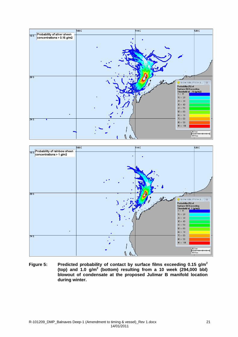
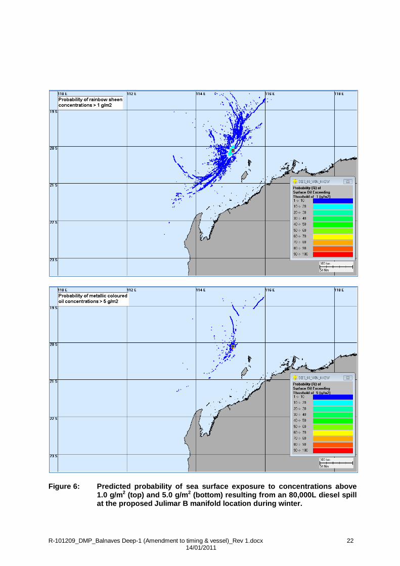
Winter Season (May to August) Winds during the winter season are predominantly from the southwest; however there is a north north-easterly component.
Probability contours indicate a greater bias to the north than in the summer and transitional periods. The high likelihood zone (>90%) for the 0.15 g/m2 threshold lies within 35 km to the north and 55 km to the southwest of the spill site. Lower probabilities are found over similar distances to the west and east. The spill trajectory indicates at that threshold a moderate likelihood (> 40%) of contacting waters up to 100 km in both the north and southwest directions (Figure 5).
At the 1.0 g/m2 threshold the highest probability contact zone (> 90%) is reduced to within 25 km to the north and 35 km to the southwest of the spill site, with low probabilities (< 10%) extending 350 km to the northwest.
A low probability (5%) for surface condensate > 0.15 g/m2 reaching the shoreline at North West Cape was predicted. The minimum time for condensate of any concentration to reach this shoreline was 610 hours, with a maximum shoreline concentration of 1.2 g/m² predicted in the worst case scenario (Table 4).
As shown in Table 4, diesel surface films >0.15 g/m2 were not expected to contact any of the
shoreline locations. Overall, there was a very low probability (< 1%) of surface oil of any concentration contacting any shorelines during winter. Entrained diesel > 10 ppb could occur at North West Cape during winter; however the probability is very low (1%), with concentrations potentially reaching 610 ppb as the worst case scenario (Figure 6).

R-101209_DMP_Balnaves Deep-1 (Amendment to timing & vessel)_Rev 1.docx 9 14/01/2011
Table 4: Predicted risks to shorelines from oil spills under summer, winter and transitional conditions at Balnaves Deep-1 (using the proposed Julimar B Manifold location spill modelling, 11 km west southwest)
Season Spill
Scenario Shoreline
Probability of surface oil
> 0.15 g/m2
at shorelines
(%)
Minimum time to
shoreline before
exposure (hrs)
Mean expected
max. shoreline
concentration
(g/m2)
Max. shoreline
concentration
(g/m2)
Summer 294,000 bbls Condensate
Montebello Islands
10 1,015 0.3 5
Summer 294,000 bbls Condensate
Barrow Island
5 835 LT 0.5
Summer 294,000 bbls Condensate
Murion Islands
5 970 0.4 8
Summer 294,000 bbls Condensate
North West Cape
5 730 3 50
Summer 80,000L Diesel
Montebello Islands
0 190 LT LT
Summer 80,000L Diesel
Barrow Island
0 - 0 0
Summer 80,000L Diesel
Murion Islands
0 100 LT LT
Summer 80,000L Diesel
North West Cape
1 100 LT 14
Winter 294,000 bbls Condensate
Montebello Islands
0 - 0 0
Winter 294,000 bbls Condensate
Barrow Island
0 - 0 0
Winter 294,000 bbls Condensate
Murion Islands
0 - 0 0
Winter 294,000 bbls Condensate
North West Cape
5 610 LT 1.2
Winter 80,000L Diesel
Montebello Islands
0 - 0 0
Winter 80,000L Diesel
Barrow Island
0 - 0 0
Winter 80,000L Diesel
Murion Islands
0 - 0 0
Winter 80,000L Diesel
North West Cape
0 - 0 0
Transition 294,000 bbls Condensate
Montebello Islands
0 - 0 0
Transition 294,000 bbls Condensate
Barrow Island
0 1,310 LT LT

R-101209_DMP_Balnaves Deep-1 (Amendment to timing & vessel)_Rev 1.docx 10 14/01/2011
Season Spill
Scenario Shoreline
Probability of surface oil
> 0.15 g/m2
at shorelines
(%)
Minimum time to
shoreline before
exposure (hrs)
Mean expected
max. shoreline
concentration
(g/m2)
Max. shoreline
concentration
(g/m2)
Transition 294,000 bbls Condensate
Murion Islands
0 - 0 0
Transition 294,000 bbls Condensate
North West Cape
0 - 0 0
Transition 80,000L Diesel
Montebello Islands
0 - 0 0
Transition 80,000L Diesel
Barrow Island
0 - 0 0
Transition 80,000L Diesel
Murion Islands
0 - 0 0
Transition 80,000L Diesel
North West Cape
0 - 0 0
LT: some concentrations predicted but these are lower than the threshold of 0.15 g/m2.
Zero: does not necessarily indicate absolutely “no risk” of an event, denotes a generally low risk. Shading = period for scheduled drilling (Source: APASA, 2010).
Drilling with SBM The lower sections of the Balnaves Deep-1 well will be drilled using either (or both) Novaplus, base oil LAO 14/16/18 and/or Shell Saraline 185V. This is because of lessons learned on the nearby Julimar wells where the two greatest risks that were faced when drilling were differential sticking over the reservoir sands and deterioration of the Muderong and Gearle formations. The use of SBM significantly reduces both of these risks to the point where it is considered crucial to the achievement of the objectives of the well, both from an exploration perspective of data gathering, and a possible future production well. The base oil used will be dependent on the availability of the base oils in Australia and what base oil is carried over from the well drilled prior to the Balnaves Deep-1 well. Because the well will be drilled using a semi-submersible rig, where the well head and BOP is on the seabed rather than at surface during drilling, the centrifuge underflow needs to be disposed of to the sea rather than re-injected down the annulus as is the current Apache practice on jack-up rig based shallow water NWS drilling operations when utilising SBM. This activity has not been approved of in the Generic Drilling EP. Measures in place to deal with
SBM cuttings discharge include:
Capturing shaker cuttings from the shale shakers by first plugging the cuttings ditch
and using an auger to transport the shaker cuttings directly to the cuttings dryer. The Verti-G dryer will remove most of the synthetic oil from the shale shaker cuttings and this recovered fluid will be returned directly to the active mud system via a transfer pump. The processed cuttings from the Verti-G dryer will then be discharged directly overboard.
A single high-efficiency centrifuge will be used to control the SBM solids content. This
newly fitted 3rd generation “Big Bowl” centrifuge will be capable of achieving very low
R-101209_DMP_Balnaves Deep-1 (Amendment to timing & vessel)_Rev 1.docx 11 14/01/2011
oil-on-cuttings values. Apache is confident that the oil on cuttings values of the solids effluent from the centrifuge, in combination with the dried cuttings from the Verti-G drier, will achieve a combined oil-on-cuttings discharge value of well below 10% by dry weight of cuttings per drill hole section. Apart from dried shaker cuttings and centrifuge effluent discharges, there will be no other synthetic discharges from the drilling operation.
Drilling with Novaplus, base oil LAO 14/16/18
Novaplus has been used for drilling previous Apache wells. Sections of the nearby Balnaves and Brokenwood wells were also drilled using Novaplus, base oil LAO 14/16/18 SBM. The situation in Australia in relation to the supply of Novaplus is that there are presently limited volumes of this fluid available. Should Novaplus be used, the above measures (measures in place to deal with SBM cuttings discharges) will be adhered to. Drilling with Shell Saraline 185V
The use of Shell Saraline 185V for drilling Apache’s Balthazar-1 & 2 wells, was identified as an alternative base oil to Novaplus (as contingency - should there be insufficient supplies of Novaplus). The use of Shell Saraline 185V for the Julimar South West-1 & 2 wells was detailed in WA-356-P, Julimar South West-1 & 2 Appraisal Well and Sidetrack Environment Plan Bridging Document (R100105) to Generic Environment Plan (EA-00-RI-164). This bridging document was approved by the DMP on 13 January 2010. Similar to Novaplus, Shell Saraline 185V is classified as a synthetic base fluid (SBF) as it is produced from the reaction of a purified feedstock as opposed to processed mineral oils, which are typically produced from the distillation of refining crude oil. Saraline 185V is composed of paraffin C10-C20 (Note: Novaplus is a linear alpha olefin). The Material Data Sheet (MDS) for Shell Saraline 185V includes data on biodegradation, water column toxicity and sediment toxicity. Based on this data, Shell Saraline 185V is considered to be readily biodegradable, non-toxic in the water column (test species include Mysid Shrimp (Mysidopsis bahia), Indian White Prawn (Penaeus indicus) and Australian Pink Snapper (Pagrus auratus)) and of low sediment toxicity.
(The Material Data Sheet for Shell Saraline 185V Material Data Sheet is provided as Attachment 1)
A study to investigate the responses of juvenile pink snapper (Pagrus auratus) to exposure to
three synthetic based drilling fluids, including Shell Saraline 185V has been undertaken for Shell MDS Malaysia (Curtin University, 20067). The study measured a suite of biomarkers of fish health, including physiological parameters (liver enlargement) and biochemical parameters (liver detoxification enzyme, liver damage/malfunction, DNA damage and stress protein) from exposure to the selected SBFs over a 28 day period. Key findings from this study include:
7 Curtin University, 2006. Chronic Toxicity of Novel SBFs to Fish as Measured by Fish Biomarkers – Final Report.
Report prepared for Shell MDS Malaysia.

R-101209_DMP_Balnaves Deep-1 (Amendment to timing & vessel)_Rev 1.docx 12 14/01/2011
Saraline 185V (and the other SBFs tested) did not result in changes to liver size8.
Saraline 185V caused minimum metabolic perturbations in the juvenile pink snapper studied.
Exposure to Saraline 185V did not cause significant DNA damage in fish (in comparison to the negative control fish - the negative control fish were not exposed to the SBFs tested).
Fish exposed to Saraline 185V did not show signs of liver malfunctions.
Fish exposed to Saraline 185V did not have high levels of stress proteins relative to control fish, suggesting that the chemical stress caused by this SBF was not elevated enough to warrant an induction of cellular repair mechanisms.
From this study, Saraline 185V was found to cause the least impact on fish health out of all of the paraffin drilling fluids tested and was considered to be the most environmentally acceptable in a marine environment (the other fluids tested as part of this study were Sarapar 147 and Saraline 200). A study on the environmental fate and effects of selected SBF cuttings discharges (3 paraffin based and one olefin based, including the paraffin based Saraline 185V), has been undertaken offshore Malaysia (Dorn et al., 20079). This study included shallow and deep water sites and tested physical, chemical and biological properties to determine whether or not paraffin based drilling mud cuttings were comparable to olefin based cuttings discharges. In this study, five drilling sites were sampled approximately 90 days post discharge of SBM and re-sampled 12 months later. Three of the sites sampled were discharging cuttings prepared with Shell Saraline 185V. Key results from this study include (Dorn et al., 2007):
Paraffin based cuttings in sediments (measured as TEH (total extractable hydrocarbons)) decreased 3-15 months post discharge. Furthermore, the composition of the paraffin based SBM changed over time with a loss of alkanes and some of the isoparaffins. These results indicate that paraffin degradation occurs in the field.
Benthic community did not appear to be effected by the discharged SBM cuttings discharges during the study.
A toxicity assessment of Shell Saraline 185V has also been undertaken by Geotech (Geotech, 200510). The tests included an acute toxicity test (96hr LC50) on larval pink snapper (Pagrus auratus) and chronic toxicity tests on alga (Nitzschia closterium – 72 hr EC50) and pink snapper (Pagrus auratus – 7 day larval fish growth EC50). The test results were compared to drilling fluid toxicity classifications from Hinwood (199411) as detailed in Table 5 below.
8 Note: the liver of an organism may become enlarged in response to the increased metabolic demand imposed by
contaminants to metabolise (enlargement is measured by the weight of the liver in comparison to the weight of the fish – Liver Somatic Index (LSI). A high LSI is often observed in relation to chronic exposure of fish to contaminants. 9 Dorn P.B., Rhodes I.A., Wong D.C.L., Van Compernolle R., Hinojosa E.M., Farmayan W.F., Ray J.P., James B.,
and Hj-Kip S. 2007. Assessment of the Fate and Ecological Risk of Synthetic Paraffin Based Drilling Mud Discharges Offshore Sarawak and Sabah (Malaysia). 10
Geotech, 2005. Toxicity Assessment of Shell Saraline 185V. Test Report for Shell ENV 05-011. 11
Hinwood J.B et al. 1994. Drilling activities in: Environmental Implications for Offshore Oil and Gas Development in Australia. Australian Production Petroleum Exploration Association pp 123-207.

R-101209_DMP_Balnaves Deep-1 (Amendment to timing & vessel)_Rev 1.docx 13 14/01/2011
Table 5: Drilling Fluid Toxicity Classifications* (Hinwood et al., 1994)
Toxicity Rating LC50 Value (mg/L)
Very Toxic 1
Toxic 1-100
Moderately Toxic 100-1,000
Slightly Toxic 1,000-10,000
Almost No-Toxic 10,000-100,000
Non-Toxic >100,000
* A search of the scientific literature by Geotech to determine the basis for the above ratings could find no scientific basis for the
toxicity allocations and therefore assumed that the ratings had been arbitrarily assigned based on the solubility of the drilling fluid. A direct addition method to obtain a water-accommodated fraction (WAF) was used for the toxicity testing. The results from the toxicity testing undertaken by Geotech are listed in Table 6. The test results showed that the in comparison to the Hinwood Drilling Fluid Toxicity
Classification the fluid was classified as almost non-toxic to non-toxic. Table 6: Results from Geotechs Toxicity testing of Saraline 185V
Test EC50/LC50 (mg/L)
LOEC* (mg/L)
NOEC** (mg/L)
Toxicity
Larval pink snapper, 96 hr LC50
>100,000 >100,000 100,000 Non-Toxic
Algal growth 72 hr EC50
>83,300 >83,300 83,300 Non-Toxic but not able to calculate EC50
7-day larval pink snapper growth, EC50
>100,000 100,000 50,000 Non-Toxic
* LOEC – Lowest Observable Effect Concentration (lowest concentration causing a significant growth decrease)
** NOEC – No Observable Effect Concentration (The concentration showing no significant decrease in growth)
Should Saraline 185V be used, it is proposed that the management measures to deal with cuttings discharges with Saraline 185V would be as per those utilized by Apache for Novaplus to ensure that a combined oil-on-cuttings discharge value for the well is below 10% by dry weight of cuttings. On the basis of ecotoxicity information provided in the MSDS for Saraline 185V and ecotoxicity information gathered through studies on SBFs that have included Saraline 185V (Curtin 2006, Dorn et al, 2007, Geotech 2005), water depth at the Balnaves Deep-1 well location (134.2 m (LAT)) and distance from sensitive environmental resources significant impacts on the marine environment from the use of Saraline 185V are not expected.

R-101209_DMP_Balnaves Deep-1 (Amendment to timing & vessel)_Rev 1.docx 14 14/01/2011
Environmental Guidelines and Commitments A summary of the environmental guidelines and commitments for Balnaves Deep-1 is outlined in Table 7.
In addition to compliance with the relevant regulatory requirements, Apache and its Contractors’ are continually reviewing their drilling procedures, including inspection of survey equipment, to mitigate any environmental impact associated with drilling activities undertaken in the NWS.
Table 7: Apache Environmental Guidelines and Drilling Rig Environmental Commitments for Balnaves Deep-1
(Balnaves Deep-1 drilled under NWS 2007-2011 Generic Drilling EP: Doc EA-00-RI-164)
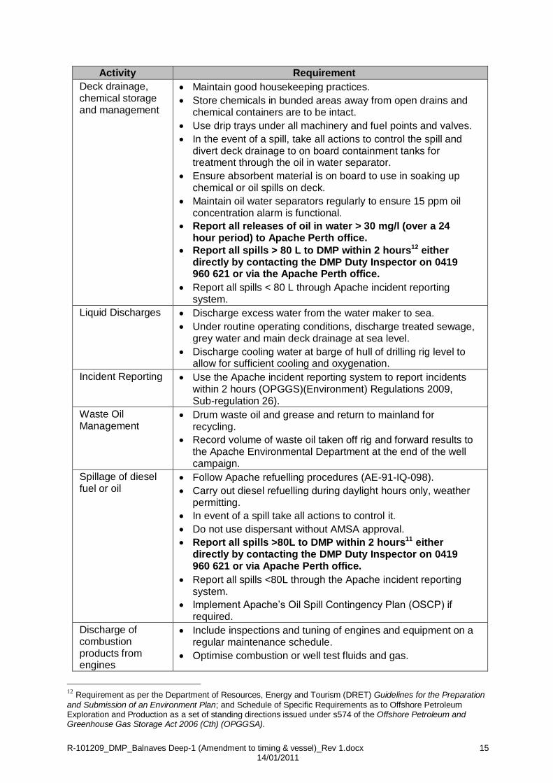
Activity Requirement
Disposal of drilling fluid and drilling cuttings
Dispose of WBM coatings directly to the seafloor.
Direct SBM cuttings through the Verti-G cuttings dryer to remove and recover synthetic fluid.
Plug the cuttings ditch and use an auger to transport the shaker cuttings directly to the cuttings dryer. Recovered fluid to be returned directly to the active mud system via a transfer pump. Processed cuttings from the dryer to be discharged overboard.
Use a high-efficiency centrifuge to control the SBM solids content, to achieve an average oil-on-cuttings discharge value of less than 10% by dry weight of cuttings per hole section (when combined with dried cuttings).
Follow Apache refuelling procedures (AE-91-IQ-098).
Record volume of drilling cuttings and fluid disposed into the ocean on environmental spreadsheet. Record retort figures for percentage of fluid-on-cuttings and report results to the Apache Environmental Department at the end of the well.
Pipe Dope Use pipe dope that has the lowest concentration of heavy metals and hydrocarbons but still meets safety and performance criteria.
Record volume of pipe dope used on location on the environmental spreadsheet. Send results to the Apache Environmental Department at the end of the well.
R-101209_DMP_Balnaves Deep-1 (Amendment to timing & vessel)_Rev 1.docx 15 14/01/2011
Activity Requirement
Deck drainage, chemical storage and management
Maintain good housekeeping practices.
Store chemicals in bunded areas away from open drains and chemical containers are to be intact.
Use drip trays under all machinery and fuel points and valves.
In the event of a spill, take all actions to control the spill and divert deck drainage to on board containment tanks for treatment through the oil in water separator.
Ensure absorbent material is on board to use in soaking up chemical or oil spills on deck.
Maintain oil water separators regularly to ensure 15 ppm oil concentration alarm is functional.
Report all releases of oil in water > 30 mg/l (over a 24 hour period) to Apache Perth office.
Report all spills > 80 L to DMP within 2 hours12 either directly by contacting the DMP Duty Inspector on 0419 960 621 or via the Apache Perth office.
Report all spills < 80 L through Apache incident reporting system.
Liquid Discharges Discharge excess water from the water maker to sea.
Under routine operating conditions, discharge treated sewage, grey water and main deck drainage at sea level.
Discharge cooling water at barge of hull of drilling rig level to allow for sufficient cooling and oxygenation.
Incident Reporting Use the Apache incident reporting system to report incidents within 2 hours (OPGGS)(Environment) Regulations 2009, Sub-regulation 26).
Waste Oil Management
Drum waste oil and grease and return to mainland for recycling.
Record volume of waste oil taken off rig and forward results to the Apache Environmental Department at the end of the well campaign.
Spillage of diesel fuel or oil
Follow Apache refuelling procedures (AE-91-IQ-098).
Carry out diesel refuelling during daylight hours only, weather permitting.
In event of a spill take all actions to control it.
Do not use dispersant without AMSA approval.
Report all spills >80L to DMP within 2 hours11 either directly by contacting the DMP Duty Inspector on 0419 960 621 or via Apache Perth office.
Report all spills <80L through the Apache incident reporting system.
Implement Apache’s Oil Spill Contingency Plan (OSCP) if required.
Discharge of combustion products from engines
Include inspections and tuning of engines and equipment on a regular maintenance schedule.
Optimise combustion or well test fluids and gas.
12 Requirement as per the Department of Resources, Energy and Tourism (DRET) Guidelines for the Preparation
and Submission of an Environment Plan; and Schedule of Specific Requirements as to Offshore Petroleum Exploration and Production as a set of standing directions issued under s574 of the Offshore Petroleum and Greenhouse Gas Storage Act 2006 (Cth) (OPGGSA).

R-101209_DMP_Balnaves Deep-1 (Amendment to timing & vessel)_Rev 1.docx 16 14/01/2011
Activity Requirement
Solid waste management
Food scraps
Garbage
Litter
Scrap metal and wood etc
Macerate all food scraps prior to ocean disposal (rig is 47 km from nearest land).
Do not dispose of debris, garbage or litter into the sea (skips need covers to prevent wind blown rubbish – especially plastics and cups).
Segregate industrial waste (scrap metals / drums etc) wherever possible for appropriate disposal onshore.
Do not use polystyrene cups.
Reduce, reuse and recycle waste wherever practicable.
Record the volume and type of waste taken off rig and forward to the Apache Environmental Department at the end of the well.
Undertake a ROV survey to check that no rubbish is left on seabed. Remove any debris if found.
Sewage discharge
Treat sewage to secondary level prior to discharge through the sewage plant (aerates, macerates and chlorinates). This unit meets MARPOL 1973/78 requirements.
Maintain the sewage treatment plant in order to ensure effective treatment.
Light Overspill Minimise use of non-essential lighting, while maintaining safety standards on the drill rig and support vessel.
Noise Minimise noise emissions when drilling near noise-sensitive environments.
Fishing No fishing is permitted from the drill rig whilst it is on location.
Anchoring & Disturbance to the seabed
Side scan sonar survey results used to select a rig approach and drill site location that avoids sensitive seabed features. No sensitive seabed features in immediate vicinity of the well.
No workboats are to anchor in areas where coral reefs occur; a designated area for mooring will be allocated. No sensitive seabed features in immediate vicinity of the well.
Operational Environmental Awareness
Through inductions and educational material present on the rig, all personnel are familiar with the environmental requirements of the EP to ensure these guidelines and procedures are being followed.
Ensure all personnel sign off on the rig register book confirming their induction.
Vertical Seismic Profiling (VSP)
Follow DMP (formerly DoIR) Guidelines on Minimising Acoustic Disturbance to Marine Fauna (1997) when
undertaking VSP:
Do not commence VSP unless whales are a minimum distance of 3 km from the rig.
Soft-start over a 20 minute period.
Ensure rig crew is alert for whales during VSP, with a dedicated whale-watcher on post if a whale is sighted with 3-5 km of the rig.
Shut down of VSP if whales are observed within 3 km of the rig.
Large Animal Observations
Fill in whale and turtle observation data sheets and send to the Apache Environmental Department at the completion of the drilling programme (Appendix in NWS generic drilling EP 2007-2011 (EA-00-RI-164).

R-101209_DMP_Balnaves Deep-1 (Amendment to timing & vessel)_Rev 1.docx 17 14/01/2011
Perth Office Commitments
Activity Requirement
Prior to drilling
NWS generic drilling EP 2007-2011 (EA-00-RI-164) is available to all personnel involved in drilling programme.
Ongoing consultations are part of each drilling campaign. In preparing the Generic NWS Drilling Programme EP, Apache consulted with numerous stakeholder representatives. Key stakeholders representatives such as fisheries will be notified of the Balnaves Deep-1 campaign prior to commencement of drilling.
Discharge of combustion products from engines
Report greenhouse gas emissions data to Commonwealth Government annually.
Environmental Audit
Audit drilling rigs every six months whilst under contract to Apache. (Ocean Patriot audit may be undertaken during this campaign; however it is evisaged that the audit be conducted prior to arrival to the Balnaves Deep-1 drill site).
Review electronic waste and chemical log received from rig at the completion of the drilling programme.

R-101209_DMP_Balnaves Deep-1 (Amendment to timing & vessel)_Rev 1.docx 18 14/01/2011
Figure 2: Predicted probability of contact by surface films exceeding 0.15 g/m2 (top)
and 1.0 g/m2 (bottom) resulting from a 10 week (294,000 bbl) blowout of condensate at the proposed Julimar B manifold location during summer.

R-101209_DMP_Balnaves Deep-1 (Amendment to timing & vessel)_Rev 1.docx 19 14/01/2011
Figure 3: Predicted probability of sea surface contact to concentrations above 1.0 g/m2 (top) and 5.0 g/m2 (bottom) resulting from an 80,000L diesel spill at the proposed Julimar B manifold location under summer currents and wind conditions.

R-101209_DMP_Balnaves Deep-1 (Amendment to timing & vessel)_Rev 1.docx 20 14/01/2011
Figure 4: Predicted probability of sea surface exposure to concentrations above
1.0 g/m2 (top) and 5.0 g/m2 (bottom) resulting from an 80,000L diesel spill at the proposed Julimar B manifold location during transitional periods.
R-101209_DMP_Balnaves Deep-1 (Amendment to timing & vessel)_Rev 1.docx 21 14/01/2011
Figure 5: Predicted probability of contact by surface films exceeding 0.15 g/m2
(top) and 1.0 g/m2 (bottom) resulting from a 10 week (294,000 bbl) blowout of condensate at the proposed Julimar B manifold location during winter.
R-101209_DMP_Balnaves Deep-1 (Amendment to timing & vessel)_Rev 1.docx 22 14/01/2011
Figure 6: Predicted probability of sea surface exposure to concentrations above
1.0 g/m2 (top) and 5.0 g/m2 (bottom) resulting from an 80,000L diesel spill at the proposed Julimar B manifold location during winter.

R-101209_DMP_Balnaves Deep-1 (Amendment to timing & vessel)_Rev 1.docx 23 14/01/2011
ATTACHMENT 1

R-101209_DMP_Balnaves Deep-1 (Amendment to timing & vessel)_Rev 1.docx 24 14/01/2011

R-101209_DMP_Balnaves Deep-1 (Amendment to timing & vessel)_Rev 1.docx 25 14/01/2011