Embed Size (px)
Citation preview

8/16/2019 B: Range Alternatives Tech Report
http://slidepdf.com/reader/full/b-range-alternatives-tech-report 1/86
U.S. 50 Corridor EastTier 1 Draft EnvironmentalImpact Statement
Range of Alternatives
Technical MemorandumJune 2016

8/16/2019 B: Range Alternatives Tech Report
http://slidepdf.com/reader/full/b-range-alternatives-tech-report 2/86

8/16/2019 B: Range Alternatives Tech Report
http://slidepdf.com/reader/full/b-range-alternatives-tech-report 3/86
U.S. 50 Corridor East Tier 1 Draft Environmental Impact StatementRange of Alternatives Technical Memorandum
June 2016 i
Table of Contents
Chapter Pages
1. Project Overview ............................................................................................................................ 1
2.
Topic Definition .............................................................................................................................. 2
3. Applicable Laws, Regulations, and Guidance ............................................................................ 3
3.1.
Council on Environmental Quality Regulations on Alternatives ....................................................... 3
3.2.
FHWA Regulations Implementing the National Environmental Policy Act ...................................... 3
3.3.
FHWA Guidance on Alternatives for Transportation Projects .......................................................... 3
4. Methodology ................................................................................................................................... 5
4.1.
Use of Screening Criteria Consistent With Tier 1 Analysis .............................................................. 5
4.2.
Linking Planning and NEPA ............................................................................................................. 5
5. Alternatives Development Process .............................................................................................. 6
5.1.
Regional Corridor Location .............................................................................................................. 6
5.2.
Transportation Mode ...................................................................................................................... 10
5.3.
Facility Type ................................................................................................................................... 16
5.4.
Through Town or Around Town (Bypass) ...................................................................................... 21
5.5.
Alternatives Carried Forward for Further Consideration ................................................................ 27
5.6.
Identification of Preferred Alternative ............................................................................................. 34
6. References .................................................................................................................................... 80
Appendices ..............................................................................................Error! Bookmark not defined.
Appendix A. Abbreviations and Acronyms...................................................................................... 81
TablesTable 5-1. Regional Corridor Location Screening Results Summary ........................................................... 8
Table 5-2. Transportation Mode Screening Results Summary ................................................................... 14
Table 5-3. Summary of Facility Type Screening Results ............................................................................ 18
Table 5-4. Homes, Businesses, and Historic Resources Potentially Affected by Through-Town Corridors23
Table 5-5. Homes, Businesses, and Historic Resources Potentially Affected by Around-Town Corridors 24
Table 5-6. Through-Town or Around-Town Screening Results Summary .................................................. 25
Table 5-7. Rural and Agricultural Environment Screening Criteria ............................................................. 35
Table 5-8. Natural Environment Screening Criteria .................................................................................... 35
Table 5-9. Community and Built Environment Screening Criteria ............................................................... 36
Table 5-10. Pueblo Build Alternatives Comparison—Rural and Agricultural Environment ......................... 38 Table 5-11. Pueblo Build Alternatives Comparison—Natural Environment ................................................ 39
Table 5-12. Pueblo Build Alternatives Comparison—Community and Built Environment .......................... 40
Table 5-13. Pueblo to Fowler Build Alternatives Comparison—Rural and Agricultural Environment ......... 42
Table 5-14. Pueblo to Fowler Build Alternatives Comparison—Natural Environment ................................ 43
Table 5-15. Pueblo to Fowler Build Alternatives Comparison—Community and Built Environment .......... 44
Table 5-16. Fowler Build Alternatives Comparison—Rural and Agricultural Environment ......................... 46
Table 5-17. Fowler Build Alternatives Comparison—Natural Environment ................................................ 47
Table 5-18. Fowler Build Alternatives Comparison—Community and Built Environment ........................... 48
Table 5-19. Manzanola Build Alternatives Comparison—Rural and Agricultural Environment .................. 50

8/16/2019 B: Range Alternatives Tech Report
http://slidepdf.com/reader/full/b-range-alternatives-tech-report 4/86
U.S. 50 Corridor East Tier 1 Draft Environmental Impact StatementRange of Alternatives Technical Memorandum
ii June 2016
Table 5-20. Manzanola Build Alternatives Comparison—Natural Environment.......................................... 51
Table 5-21. Manzanola Build Alternatives Comparison—Community and Built Environment .................... 52
Table 5-22. Rocky Ford Build Alternatives Comparison—Rural and Agricultural Environment .................. 54
Table 5-23. Rocky Ford Build Alternatives Comparison—Natural Environment ......................................... 55
Table 5-24. Rocky Ford Build Alternative Comparison—Community and Built Environment ..................... 55
Table 5-25. Swink Build Alternatives Comparison—Rural and Agricultural Environment .......................... 58
Table 5-26. Swink Build Alternatives Comparison—Natural Environment .................................................. 58
Table 5-27. Swink Build Alternative Comparison—Community and Built Environment .............................. 59 Table 5-28. La Junta Build Alternatives Comparison—Rural and Agricultural Environment ...................... 61
Table 5-29. La Junta Build Alternative Comparison—Natural Environment ............................................... 62
Table 5-30. La Junta Build Alternative Comparison—Community and Built Environment ......................... 63
Table 5-31. Las Animas Build Alternatives Comparison—Rural and Agricultural Environment ................. 67
Table 5-32. Las Animas Build Alternatives Comparison—Natural Environment ........................................ 67
Table 5-33. Las Animas Build Alternatives Comparison—Community and Built Environment ................... 68
Table 5-34. Granada Build Alternatives Comparison—Rural and Agricultural Environment ...................... 71
Table 5-35. Granada Build Alternatives Comparison—Natural Environment ............................................. 72
Table 5-36. Granada Build Alternatives Comparison—Community and Built Environment ....................... 72
Table 5-37. Holly Build Alternatives Comparison—Rural and Agricultural Environment ............................ 75
Table 5-38. Holly Build Alternatives Comparison—Natural Environment ................................................... 76
Table 5-39. Holly Build Alternatives Comparison—Community and Built Environment ............................. 76
Table 5-40. Summary of the Preferred Alternative ...................................................................................... 78
FiguresFigure 1-1. U.S. 50 Tier 1 EIS Project Area .................................................................................................. 1
Figure 5-1. Screening Approach Used to Develop the Range of Reasonable Alternatives .......................... 6
Figure 5-2. Location of the Regional Corridors Considered by the U.S. 50 Tier 1 EIS ................................. 7
Figure 5-3. Passenger Rail and Bus Services Available within the U.S. 50 Corridor ................................. 11
Figure 5-4. Ideal Through-Town Typical Section ........................................................................................ 21
Figure 5-5. Typical Right of Way and Access Effects for a Four-Lane Corridor Through a Community .... 22
Figure 5-6. Ideal Around-Town Typical Section .......................................................................................... 24
Figure 5-7. Build Alternative and Options.................................................................................................... 29
Figure 5-8. Project Corridor Sections Overview .......................................................................................... 30
Figure 5-9. Pueblo Build Alternatives .......................................................................................................... 37
Figure 5-10. Pueblo to Fowler Build Alternatives ........................................................................................ 41
Figure 5-11. Fowler Build Alternatives ........................................................................................................ 45
Figure 5-12. Manzanola Build Alternatives.................................................................................................. 49
Figure 5-13. Rocky Ford Build Alternatives ................................................................................................. 53
Figure 5-14. Swink Build Alternatives .......................................................................................................... 57
Figure 5-15. La Junta Build Alternatives ..................................................................................................... 60
Figure 5-16. Las Animas Build Alternatives ................................................................................................ 66
Figure 5-17. Granada Build Alternatives ..................................................................................................... 70
Figure 5-18. Holly Build Alternatives ........................................................................................................... 74
Figure 5-19. Identified Preferred Alternative ............................................................................................... 79

8/16/2019 B: Range Alternatives Tech Report
http://slidepdf.com/reader/full/b-range-alternatives-tech-report 5/86
U.S. 50 Corridor East Tier 1 Draft Environmental Impact StatementRange of Alternatives Technical Memorandum
June 2016 1
1. Project Overview
The U.S. 50 Corridor East Tier 1 Environmental Impact Statement (U.S. 50 Tier 1 EIS) was initiated by theproject’s lead agencies, the Colorado Department of Transportation (CDOT) and the Federal Highway Administration (FHWA). The purpose of the Tier 1 EIS is to provide, within the framework of the National
Environmental Policy Act (NEPA), a corridor location decision for U.S. Highway 50 (U.S. 50) from Pueblo tothe vicinity of the Colorado-Kansas state line that CDOT and the communities can use to plan and programfuture improvements, preserve right of way, pursue funding opportunities, and allow for resource planningefforts.
The U.S. 50 Tier 1 EIS officially began in January 2006 when the Notice of Intent was published in theFederal Register. The U.S. 50 Tier 1 EIS project area (Figure 1-1) is the area in which U.S. 50 Tier 1 EISalternatives were assessed. This area traverses nine municipalities and four counties in the Lower ArkansasValley of Colorado. The nine municipalities include (from west to east) the city of Pueblo, town of Fowler,town of Manzanola, city of Rocky Ford, town of Swink, city of La Junta, city of Las Animas, town of Granada,and town of Holly. The four counties that fall within this project area are Pueblo, Otero, Bent, and Prowerscounties.
The project area does not include the city of Lamar. A separate Environmental Assessment (EA), the U.S.287 at Lamar Reliever Route Environmental Assessment (), includes both U.S. 50 and U.S. Highway 287(U.S. 287) in this area, since they share the same alignment. The Finding of No Significant Impact (FONSI)for the project was signed November 10, 2014. This EA/FONSI identified a proposed action that bypassesthe city of Lamar to the east. The proposed action of the U.S. 287 at Lamar Reliever Route Environmental Assessment begins at the southern end of U.S. 287 near County Road (CR) C-C and extends nine miles toState Highway (SH) 196. Therefore, alternatives at Lamar are not considered in this U.S. 50 Tier 1 EIS.
Figure 1-1. U.S. 50 Tier 1 EIS Project Area

8/16/2019 B: Range Alternatives Tech Report
http://slidepdf.com/reader/full/b-range-alternatives-tech-report 6/86
U.S. 50 Corridor East Tier 1 Draft Environmental Impact StatementRange of Alternatives Technical Memorandum
2 June 2016
2. Topic Definition
More than one potential solution may exist to solve an identified transportation problem. The goal of an EISis not to support a particular solution from the outset but rather to help decision makers find the mostappropriate solution for the problem by considering the feasibility, merits, and environmental consequences
of various transportation solutions, referred to as alternatives. Through the process of preparing a Draft EISand considering public and agency comments, the solution that is found to best address the problem isidentified and becomes designated as the “preferred alternative” in the Final EIS.

8/16/2019 B: Range Alternatives Tech Report
http://slidepdf.com/reader/full/b-range-alternatives-tech-report 7/86
U.S. 50 Corridor East Tier 1 Draft Environmental Impact StatementRange of Alternatives Technical Memorandum
June 2016 3
3. Applicable Laws, Regulations, andGuidance
The following laws, regulations, and guidance were followed during this analysis of cumulative effects. They
are described in more detail below.
Council on Environmental Quality (CEQ) regulations on alternatives FHWA Regulations implementing NEPA
FHWA Guidance on Alternatives for Transportation Projects
3.1. Council on Environmental Quality Regulations onAlternatives
CEQ regulations prescribing consideration of alternatives in an EIS are found in United States Code (USC)Section 40 (Protection of the Environment), Section 1502 (EIS). These regulations are applicable to allFederal actions, not just transportation actions.
Section 1502.1 (Purpose) indicates that an EIS should provide “full and fair discussion of environmentalimpacts” for a Federal program or action, and “inform decision makers and the public of the reasonablealternatives which would avoid or minimize adverse impacts or enhance the quality of the humanenvironment.”
Section 1502.14 (Alternatives including the proposed action) indicates that the EIS should, “... Rigorouslyexplore and objectively evaluate all reasonable alternatives, and for alternatives which were eliminated fromdetailed study, briefly discuss the reasons for their having been eliminated.” The same section indicates thatthe EIS should, “... include the alternative of no action.”
3.2. FHWA Regulations Implementing the National
Environmental Policy ActFHWA regulations implementing the NEPA process are found in USC Title 23 (Highways), Part 771(Environmental Impact and Related Procedures). Section 771.123(d) indicates that, “The draft EIS shallevaluate all reasonable alternatives to the action and discuss the reasons why other alternatives, which mayhave been considered, were eliminated from detailed study.”
Additionally, in the case of a tiered EIS, Section 777.111(g) indicates that, “The first tier EIS would focus onbroad issues such as general location, mode choice, and area wide air quality and land use implications ofthe major alternatives. The second tier would address site-specific details on project impacts, costs, andmitigation measures.”
3.3. FHWA Guidance on Alternatives for Transportation ProjectsFHWA’s Technical Advisory T 6640.8A (October 1987), Part V ( EIS), Section E (alternatives) provides thefollowing additional guidance on transportation alternatives:
“This section of the draft EIS must discuss a range of alternatives, including all ‘reasonable alternatives’ under consideration and those ‘other alternatives’ which were eliminated from detailed study (23 CFR771.123(c)). The section should begin with a concise discussion of how and why the ‘reasonablealternatives’ were selected for detailed study and explain why ‘other alternatives’ were eliminated. Thefollowing range of alternatives should be considered when determining reasonable alternatives:

8/16/2019 B: Range Alternatives Tech Report
http://slidepdf.com/reader/full/b-range-alternatives-tech-report 8/86
U.S. 50 Corridor East Tier 1 Draft Environmental Impact StatementRange of Alternatives Technical Memorandum
4 June 2016
1. ‘No-action’ alternative: The ‘no-action’ alternative (or no-build) normally includes short-term minorrestoration types of activities (safety and maintenance improvements, etc.) that maintain continuingoperation of the existing roadway.
2. Transportation System Management (TSM) alternative: The TSM alternative includes those activitieswhich maximize the efficiency of the present system. Possible subject areas to include in this alternativeare options such as fringe parking, ridesharing, high-occupancy vehicle (HOV) lanes on existingroadways, and traffic signal timing optimization. This limited construction alternative is usually relevant
only for major projects proposed in urbanized areas over 200,000 population.3. While the above discussion relates primarily to major projects in urbanized areas, the concept of
achieving maximum utilization of existing facilities is equally important in rural areas. Before selecting analternative on new location for major projects in rural areas, it is important to demonstrate thatreconstruction and rehabilitation of the existing system will not adequately correct the identifieddeficiencies and meet the project need.
4. Mass Transit: This alternative includes those reasonable and feasible transit options (bus systems, rail,etc.) even though they may not be within the existing FHWA funding authority. It should be consideredon all proposed major highway projects in urbanized areas over 200,000 population. Consideration ofthis alternative may be accomplished by reference to the regional or area transportation plan where thatplan considers mass transit or by an independent analysis during early project development.
5. Build alternatives: Both improvement of existing highway(s) and alternatives on new location should beevaluated. A representative number of reasonable alternatives must be presented and evaluated in detail
in the draft EIS (40 CFR 1502.14(a)). For most major projects, there is a potential for a large number ofreasonable alternatives. Where there are a large number of alternatives, only a representative number ofthe most reasonable examples, covering the full range of alternatives, must be presented. Thedetermination of the number of reasonable alternatives in the draft EIS, therefore, depends on theparticular project and the facts and circumstances in each case.”
8/16/2019 B: Range Alternatives Tech Report
http://slidepdf.com/reader/full/b-range-alternatives-tech-report 9/86
U.S. 50 Corridor East Tier 1 Draft Environmental Impact StatementRange of Alternatives Technical Memorandum
June 2016 5
4. Methodology
Based on the regulations, CDOT developed an alternatives development approach and screening criteria toidentify reasonable alternatives for the EIS. These were drafted in consultation with federal and stateagencies in the scoping process, and were taken to the public for review and input at public meetings
conducted in the various communities along the U.S. 50 corridor in August 2007.
The primary metric for screening potential transportation solutions was whether they would be able to meetthe project’s purpose and need, which was similarly developed with agency and public consultation. Potentialsolutions that were found to meet the purpose and need then were examined in terms of the likelyenvironmental impacts of implementing transportation improvements within a general corridor location, inaccordance with the tiered EIS regulation cited above 23 USC 777.111(g).
4.1. Use of Screening Criteria Consistent With Tier 1 AnalysisThe screening criteria used to compare general corridor locations were consistent with a Tier 1 level ofanalysis, in which specific alignments are not known and precise impacts cannot be determined. Many of theenvironmental criteria used to compare general corridor locations thus involved resources that could be
estimated or counted using satellite photography and geographic information systems. Wetlands and riparianareas, for example, could be estimated using satellite photography, but could not be differentiated from oneanother using this approach. Field assessment and delineation of wetland boundaries was not performed forthis Tier 1 analysis, but will be accomplished in Tier 2 analyses when specific alignments are proposed forfurther consideration. This approach was developed and used in consultation with the U.S. Army Corps ofEngineers (USACE) and with the U.S. Environmental Protection Agency (EPA).
4.2. Linking Planning and NEPAOften, an EIS or other NEPA document is initiated following a feasibility study or other planning effort thathelped to identify the need for a project and potential solutions. It is logical and efficient to make use offindings from those efforts if they were conducted in a manner consistent with NEPA requirements,especially in terms of providing adequate consultation with affected agencies and the public. These
circumstances apply to this U.S. 50 EIS.
The U.S. 50 Tier 1 EIS was preceded by an extensive CDOT planning study that focused on determining anappropriate regional corridor location for U.S. 50 improvements. Entitled Corridor Selection Study: A Plan forU.S. 50 , this effort was completed in September 2003. This planning study had extensive involvement fromcitizens in all the cities and towns along U.S. 50. The study culminated in a long-term community-developedvision for the U.S. 50 corridor. The vision called for a safer roadway, on or near the existing U.S. 50, thatmaintains a reasonable traffic flow and speed for the movement of people and goods along and through theLower Arkansas Valley while providing flexibility to accommodate future transportation needs.
The 2003 planning study provided two key inputs into the Tier 1 EIS. First, it identified three regional corridorlocations for potential transportation improvements, finding strong support for the one regional corridor thatwould keep improvements “on or near the existing U.S. 50.” These three regional corridor locations were
considered in the development of alternatives for the EIS, making it unnecessary to start over and reinventregional corridor locations. Second, the study’s vision for the U.S. 50 corridor provided much of the basis forthe purpose and need of the Tier 1 EIS, again without the need to start over to identify existing problems andthe desired outcomes of the project.
In January 2006, when FHWA published its Notice of Intent to undertake this Tier 1 EIS, the noticespecifically referenced the vision statement and the preferred regional corridor location as elements thatwould be brought into the NEPA process from the planning study.

8/16/2019 B: Range Alternatives Tech Report
http://slidepdf.com/reader/full/b-range-alternatives-tech-report 10/86
U.S. 50 Corridor East Tier 1 Draft Environmental Impact StatementRange of Alternatives Technical Memorandum
6 June 2016
5. Alternatives Development Process
Consistent with a Tier 1 level of analysis, alternatives for theU.S. 50 EIS were developed by considering generally whattype of transportation action might be undertaken and
generally in what location. Transportation, engineering andenvironmental criteria were used in the screening process toidentify reasonable alternatives.
To be considered a reasonable alternative, a potentialtransportation solution would need to meet the project’spurpose and need, be feasible to implement, use a proventechnology, comply with federal and state laws andregulations, and not have an exorbitant cost. A potentialtransportation solution was eliminated if it would not meetthe project’s purpose and need.
Alternatives development and screening were approached
that followed four steps, as diagrammed in Figure 5-1. Eachstep is discussed below, framed as a question.
Step 1: Regional corr idor loc ation — At a regionallevel, where would transportation improvements be made?
Step 2: Transporta t ion m ode —What type(s) or mode(s) of transportation improvements would meetthe needs of the corridor (i.e., highway, rail, etc.)?
Step 3: Faci l i ty typ e —What type of facility/facilities would meet the needs of the corridor? Step 4: Through town o r around town —Would transportation improvements be made through
communities along the corridor or around them?
Two of these questions focus on what type of transportation action is needed, while the other two focus onwhere the corridor should be located. Each of these steps in the alternatives development process is
discussed in more detail below.
5.1. Regional Corridor Location As noted above, three potential regional corridor locationsfor U.S. 50 improvements were identified and evaluated inCDOT’s 2003 U.S. 50 planning study, with extensive inputfrom residents of the cities and towns along the highway.These locations included a north regional corridor, anexisting regional corridor, and a south regional corridor, eachof which are described below and shown in Figure 5-2.
North Regional Corridor —The north regional corridor
would be located one to 10 miles north of U.S. 50. It woulduse other existing roadway corridors, including SH 96, SH266, and SH 196, as well as portions of U.S. 50. Thiscorridor would remain entirely on the north side of the Arkansas River. Currently, 90 miles of U.S. 50 are locatedsouth of the river, as are all of the communities along theU.S. 50 corridor except for portions of Pueblo and Holly.
Existing Regional Corridor —The existing regional corridor would be on or near existing U.S. 50, generallywithin one mile of the current highway. During the 2003 CDOT planning study, a regional corridor location on
Figure 5-1. Screening Approach Used toDevelop the Range of Reasonable
Alternatives

8/16/2019 B: Range Alternatives Tech Report
http://slidepdf.com/reader/full/b-range-alternatives-tech-report 11/86
U.S. 50 Corridor East Tier 1 Draft Environmental Impact StatementRange of Alternatives Technical Memorandum
June 2016 7
or near the existing U.S. 50 received very strong support (76 percent of citizens participating in publicmeetings).
South Regional Corridor —The south regional corridor would be located one to 10 miles south of theexisting U.S. 50 alignment. This corridor would generally follow existing power lines, which are located threeto four miles south of U.S. 50 from eastern Pueblo County to La Junta. It would remain south of U.S. 50 toLas Animas. The south regional corridor would then turn north, crossing the Arkansas River to re-join the
existing U.S. 50 highway north of the city. It would continue east on the existing U.S. 50 highway to Granada,where it would shift north of that town. From Granada to the vicinity of the Colorado-Kansas state line, thesouth regional corridor would again follow the existing U.S. 50 highway.
Figure 5-2. Location of the Regional Corridors Considered by the U.S. 50 Tier 1 EIS
None of these locations represent a specific alignment, but instead a corridor generally 1,000 feet wide in
which appropriate alignments could be determined in the future. Additionally, deviations outside of thesecorridors would be considered in the future if needed to avoid sensitive environmental or communityresources.
5.1.1. Screening of Regional Corridor LocationsThe three regional corridor locations were screened to determine how well each would meet the project’spurpose and need, as determined by the following criteria:
How well each addresses U.S. 50 safety problems
How well each improves mobility for local users How well each improves mobility for regional users
How well each improves mobility for long-distance users How well each balances mobility and access for all users
How well each provides flexibility to address future travel needs
The results of this screening evaluation are summarized in Table 5-1. A rating system similar to that used inConsumer Reports magazine was used to indicate whether the corridor would fully, partially, or not addressthe need. A corridor was eliminated from further consideration if it failed to address any single criterion and,in some instances, if it only partially addressed criteria. Therefore, the North Regional Corridor and SouthRegional Corridor were not carried forward in the EIS for use as part of any “reasonable” alternative.

8/16/2019 B: Range Alternatives Tech Report
http://slidepdf.com/reader/full/b-range-alternatives-tech-report 12/86
U.S. 50 Corridor East Tier 1 Draft Environmental Impact StatementRange of Alternatives Technical Memorandum
8 June 2016
Table 5-1. Regional Corridor Location Screening Results Summary
Screening CriteriaNorth
RegionalCorridor
SouthRegionalCorridor
ExistingRegionalCorridor
Addresses U.S. 50 safety problems
Improves mobility for local users
Improves mobility for regional users
Improves mobility for long-distance users
Balances mobility and access for all users
Provides flexibility to address future traffic needs
KEY:
= does not address the need = partially addresses the need = fully addresses the need
The EIS contains a table summarizing the findings above but not necessarily specifying the rationale foreach rating for each corridor. These individual ratings are explained below.
Addresses U.S. 50 Safety Problems
The U.S. 50 project purpose and need identifies a large number of existing safety problems along thecorridor, including limited passing opportunities, inadequate clear zones, frequent changes in roadwaydesign, and an excessive number of access points.
North Regional Corridor ()—The extent to which safety problems would be corrected depends uponwhat transportation action is taken. However, if a new roadway were constructed, it is assumed a NorthRegional Corridor would be designated as the new U.S. 50 and the existing U.S. 50 facility would remainin place and relinquished to the city or county. Any new roadway would be constructed to current designstandards and would ensure the safe movement of people and goods. In addition, providingtransportation services in a North Regional Corridor would potentially divert existing travelers to the new
corridor, which may alleviate some safety concerns on the existing U.S. 50 by getting them off thehighway.
South Regional Corridor ()—For the same reasons applicable to the North Regional Corridor, theSouth Regional Corridor would also address U.S. 50 safety problems.
Existing Regional Corridor ()—The extent to which existing U.S. 50 safety problems would becorrected depends upon what transportation action is taken. However, actions undertaken on or near theexisting U.S. 50 have the potential to fully address these problems.
Improves Mobility for Local Users
Chapter 2 (Purpose and Need) of the U.S. 50 EIS describes various types of users of the existing highway,based on their trip characteristics. Local travelers were described as being those whose trips are made into,out of, or through one town, or in a rural area between towns. Their typical trip lengths are shorter than 15miles, and often very much shorter. For these travelers, the ability to enter, exit or cross U.S. 50, isparticularly important, as is the ability to move along U.S. 50 for short distances, perhaps at moderately lowspeeds.
North Regional Corridor ( )—The North Regional Corridor would indirectly benefit local users bydiverting long-distance trips away to the new corridor. However, most local trips on U.S. 50 are so shortthat having to travel one or more miles to or from the north to access the North General Corridor fromlocations along existing U.S. 50 would be an inconvenient diversion. Local travelers are more likely touse the existing road than to travel to the new corridor, use it, and return. This is because the vastmajority of homes and businesses within Bent, Otero and Prowers counties are located along or near the

8/16/2019 B: Range Alternatives Tech Report
http://slidepdf.com/reader/full/b-range-alternatives-tech-report 13/86
U.S. 50 Corridor East Tier 1 Draft Environmental Impact StatementRange of Alternatives Technical Memorandum
June 2016 9
existing highway. Thus the North Regional Corridor itself would create more out-of-direction travel forlocal users, but may improve mobility for those taking short local or in-town trips.
South Regional Corridor ( )—The South Regional Corridor would indirectly benefit local users bydiverting long-distance trips away to the new corridor. However, it would also create more out-of-direction travel for local users, as discussed for the North Regional Corridor.
Existing Regional Corridor ()—The extent to which mobility for local users of U.S. 50 would beimproved depends upon what transportation action is taken. However, actions undertaken on or near theexisting U.S. 50 have the potential to benefit local users because it is closest to where local users liveand work.
Improves Mobility for Regional UsersIn Chapter 1 of the U.S. 50 EIS, regional travelers were described as being those whose trips start or endwithin the U.S. 50 corridor and pass through more than one city or town. Typical regional trips are between15 and 100 miles long.
North Regional Corridor ( )—Regional trips include both a non-stop portion and the need to accesslocal communities at the trip origin, destination, or both. The North General Corridor offers the promise ofimproved mobility in terms of higher average trip speeds because the corridor would not have speed-reduction zones through towns. However, this benefit is partially offset by the need to drive one or moremiles out of each town to access the new corridor. As a net effect, longer regional trips (closer to 100
miles long) would benefit much more than shorter regional trips (closer to 15 miles long). South Regional Corridor ( )—The South Regional Corridor would offer mixed benefits for regional
users for the same reasons discussed immediately above.
Existing Regional Corridor ()—The extent to which mobility for local users of U.S. 50 would beimproved depends upon what transportation action is taken. However, actions undertaken on or near theexisting U.S. 50 have the potential to address this need, because they would not necessitate out-of-the-way travel to access the facility, as experienced with new corridors father from town.
Improves Mobility for Long-distance UsersChapter 1 of the U.S. 50 EIS describes long-distance users as those who pass through the Lower ArkansasValley to reach some other destination. Long-distance trips along U.S. 50 extend at least between U.S. 287and I-25, a distance of about 120 miles.
North Regional Corridor ( )—The North Regional Corridor offers long-distance users improvedmobility in terms of higher average trips speeds because the corridor would not have speed-reductionzones through towns.
South Regional Corridor ( )—The South Regional Corridor would benefit long-distance users in themanner described immediately above.
Existing Regional Corridor ( )—The extent to which mobility for long-distance users of U.S. 50 wouldbe improved depends upon what transportation action is taken. However, actions undertaken on or nearthe existing U.S. 50 have the potential to benefit long-distance users, if the action does not requirespeed reduction through towns and there is a reduction in the number of intersections..
Balances Mobility and Access for All UsersChapter 2 of the EIS discusses how the need for access by local and regional users conflicts with the needfor mobility by other regional users and by long-distance users. The project purpose and need calls for asolution that balances the needs of all users.
North Regional Corridor ()— As noted above, the North Regional Corridor offers long-distance usersimproved mobility in terms of higher average trip speeds and fewer access points by avoiding existing towns,but would create greater out-of-direction travel for local users because of its distance away from existingU.S. 50 communities. However, local users would continue to be able to use existing access on the currentU.S. 50 because that roadway would remain in use and mobility may be improved for those making shortlocal or in-town trips. The North Regional Corridor would balance mobility and access for users by providing

8/16/2019 B: Range Alternatives Tech Report
http://slidepdf.com/reader/full/b-range-alternatives-tech-report 14/86
U.S. 50 Corridor East Tier 1 Draft Environmental Impact StatementRange of Alternatives Technical Memorandum
10 June 2016
a high-speed facility with the more consistent travel speeds desired by long-distance and regional userswhile maintaining access for local users.
South Regional Corridor ()—The South Regional Corridor would have the same outcome onbalancing user needs as the North Regional Corridor, discussed above.
Existing Regional Corridor ( )—The effect of this corridor on balancing user needs would dependupon what transportation action is taken. However, actions undertaken on or near the existing U.S. 50
have the potential to benefit all user groups, both with regards to mobility and accessibility.
Provides Flexibility to Address Future Traffic NeedsRegardless of which regional corridor is used, transportation improvements could be designed in a mannerthat would provide flexibility to meet future needs. All three corridors offer this potential.
North Regional Corridor ( )—Could accommodate improvements designed to provide future flexibility
South Regional Corridor ( )—Could accommodate improvements designed to provide future flexibility
Existing Regional Corridor ( )—Could accommodate improvements designed to provide future
flexibility
5.1.2. Screening Results for Regional Corridor Location
The individual findings for each general corridor for each criterion based on the project’s purpose and needwere summarized in Table 5-1 and detailed above. The Existing Regional Corridor was found to have thepotential to fully meet all aspects of the purpose and need. The North and South Regional Corridors wereless advantageous with regard to three out of the six criteria. Because the North Regional Corridor andSouth General Corridor could not fully meet the project’s purpose and need, they were eliminated fromfurther consideration.
From this point forward, the alternatives development process focused on transportation solutions that couldbe implemented in the Existing Regional Corridor, on or near existing U.S. 50.
5.2. Transportation ModeThe FHWA regulations cited earlier in this Technical
Memorandum indicated that a Tier 1 EIS should resolve theissue of “mode choice,” which means the type of transportationsystem that would be used to carry people and/or goodsthrough the corridor. Related FHWA guidance (also citedearlier), indicates that in addition to a “build” alternat ive (i.e.,highway improvements), mass transit and TSM approachesshould be considered in urban areas, but typically are notapplicable in rural areas. These concepts are examined below,once again using screening criteria based on the project’spurpose and need.
There are a number of ways to improve the movement ofpeople and goods within and through the existing regional
corridor. These include a variety of modes (i.e., rail, bus,highway, etc.) as well as strategies such as carpooling andTSM that make more efficient use of existing transportationsystems. These modes and strategies are described below.
5.2.1. RailMost of the communities along U.S. 50 originally were established as stops along the railroad, servingpassengers as well as freight. Today, railroad lines still pass through these communities, carrying freight.There is also daily Amtrak passenger service between Lamar and La Junta, with stops in no other U.S. 50communities, as shown in Figure 5-3.

8/16/2019 B: Range Alternatives Tech Report
http://slidepdf.com/reader/full/b-range-alternatives-tech-report 15/86
U.S. 50 Corridor East Tier 1 Draft Environmental Impact StatementRange of Alternatives Technical Memorandum
June 2016 11
Figure 5-3. Passenger Rail and Bus Services Available within the U.S. 50 Corridor

8/16/2019 B: Range Alternatives Tech Report
http://slidepdf.com/reader/full/b-range-alternatives-tech-report 16/86
U.S. 50 Corridor East Tier 1 Draft Environmental Impact StatementRange of Alternatives Technical Memorandum
12 June 2016
It is possible that passenger rail service could be re-established along the corridor on existing tracksbetween Pueblo and La Junta if there were sufficient demand to make the service economically feasible. Also, Amtrak service could be increased, if there were sufficient demand and if additional Federal fundingwere available. However, the characteristics that make passenger rail service feasible, such as largepopulation centers, high population densities, and major tourist destinations, are not present along the U.S.50 corridor.
In 1997, CDOT conducted a Statewide Passenger Rail Study, assessing the feasibility of institutingpassenger rail service in various corridors around the state. Not surprisingly, the corridors which ranked bestin feasibility were all connected to Denver, which has a metro area population of more than 2.5 million.Denver’s large population clearly was the key to giving any rail corri dor the number of potential customersneeded for cost-effectiveness.
The corridor that ranked lowest in the study was the southern-most one that was considered, linking Pueblowith Trinidad. The population in these two cities was not sufficient to offer enough potential customers tomake rail service cost-effective, especially in comparison to links between larger cities. Trinidad has apopulation between 9,000 and 10,000 residents, making it bigger than any single city in the Lower ArkansasValley. Service to communities in the Lower Arkansas Valley (U.S. 50 corridor) was not considered in thestudy.
More than 15 years have passed since the Passenger Rail Study was completed, and there is no newpassenger rail service anywhere in the state. On the basis of the study results and the slow pace of progressin developing any intrastate rail service (i.e., Colorado service, not Amtrak), the prospects for any suchservice within the Lower Arkansas Valley in the foreseeable future are clearly minimal.
Rail freight is carried through the Lower Arkansas Valley on BNSF Railway (formerly the Atchison, Topeka,and Santa Fe Railway) tracks that closely parallel U.S. 50. Key factors that decide whether freight travels bytruck or rail include the value and perishable nature of the freight, the weight and bulk of the shipment, andthe trip distance. For example, coal is shipped by rail because it is low-value, non-perishable, heavy andbulky. A shipment of household goods typically travels by moving van, as it is comparatively valuable, fragileand time-sensitive, and smaller in size.
By the time freight reaches the U.S. 50 corridor from elsewhere, the transportation mode decision has
already been made by the shipper. Changes in fuel cost can induce a shift of some freight between thesemodes, but the other factors discussed above more strongly influence the shipping decision. Therefore it isnot likely that a significant shift of freight between trucks and trains will occur in the U.S. 50 corridor in theforeseeable future.
5.2.2. BusThere is no regional bus transit service provided by either the private or public sectors serving allcommunities along U.S. 50. Currently, Greyhound Lines offers twice-daily intercity bus service along the U.S.50 corridor between Pueblo and Lamar with a stop in Rocky Ford, as part of a long-distance routeconnecting Denver and destinations in Texas. More stops or more frequent service could be added byGreyhound if there were sufficient demand from communities along the route. However, adding stops to theroute would increase total trip time, making this mode less attractive for long-distance passengers.
Apart from bus service provided by the private sector, the prospects for provision of any publicly fundedservice are dim, for the same fundamental reasons that make increased passenger rail service infeasible. Additionally, the Lower Arkansas Valley lacks the population base and economic strength to create aregional transportation district (supported by local sales tax) which is how the state’s larger municipalitiesfund their local transit services.
The largest county-to-county commuter movement reflected in 2000 Census results was 500 employeestraveling daily from Otero County (primarily the Town of Fowler) into Pueblo County. If 10 percent of thisdaily total would shift to transit use in the peak hour, they would fill one 50-passnger bus westbound in themorning and eastbound in the afternoon.

8/16/2019 B: Range Alternatives Tech Report
http://slidepdf.com/reader/full/b-range-alternatives-tech-report 17/86
U.S. 50 Corridor East Tier 1 Draft Environmental Impact StatementRange of Alternatives Technical Memorandum
June 2016 13
5.2.3. Carpooling/TSMCarpooling programs, park-and-ride lots, and traffic signal synchronization are not a separate transportationmode but instead are TSM strategies designed to get more efficient use out of existing roadways. Thesestrategies are often used in metropolitan areas where roads are highly congested, with carpooling and park-and-ride lots generally serving the commuter community. In rural areas that lack a major central attractionzone, peak travel usually is multidirectional and highly dispersed across transportation corridors. TSM andcarpooling programs provide few benefits in these places. Because the U.S. 50 corridor contains only 13
traffic signals spread across 150 miles and lacks major directional traffic flows, synchronizing the trafficsignals or providing other TSM strategies would not make a significant difference in the overall corridoroperations. Urban traffic congestion is not one of the problems that comprise the purpose and need for theU.S. 50 Tier 1 EIS.
Carpooling already is prevalent for commuting from Fowler (a “bedroom community”) into Pueblo. Accordingto the 2000 Census, 14.9 percent of Fowler’s workers carpooled to their jobs. This is a higher percentage ofcarpooling than was prevalent within the State’s large metropolitan areas (Pueblo 13.8 percent, ColoradoSprings 11.7 percent, Denver 13.5 percent). Savings in vehicle operating already provide effectivecarpooling incentives for these regional trips, without the need for carpool promotion programs or park-and-ride lots to promote additional carpooling.
Traffic signalization is not an applicable TSM strategy for the U.S 50 corridor, as there are only 13 signals
along the 150-mile corridor and they are so far apart that they cannot be synchronized.
5.2.4. HighwayU.S. 50 is the most-used roadway serving east-west trips through the Lower Arkansas Valley. Typical 2011traffic volumes on U.S. 50 were approximately 5,500 vehicles per day (vpd). Truck volumes along the U.S.50 corridor make up 10 percent of the overall corridor volume, including trucks that are typically used forlocal or regional deliveries and those larger tractor-trailers used for long-distance or regional deliveries(Swenka 2014). Highway use has been the dominant transportation mode in the region for decades, as it iswell suited to the types of trips made and the low-density development patterns along the corridor.
5.2.5. Screening of Transportation ModesThe transportation modes described above were examined to determine how well each would meet theproject’s purpose and need, using the same screening criteria that were applied to determine a regionalcorridor location:
How well each addresses U.S. 50 safety problems
How well each improves mobility for local users How well each improves mobility for regional users
How well each improves mobility for long-distance users How well each balances mobility and access for all users How well each provides flexibility to address future travel needs
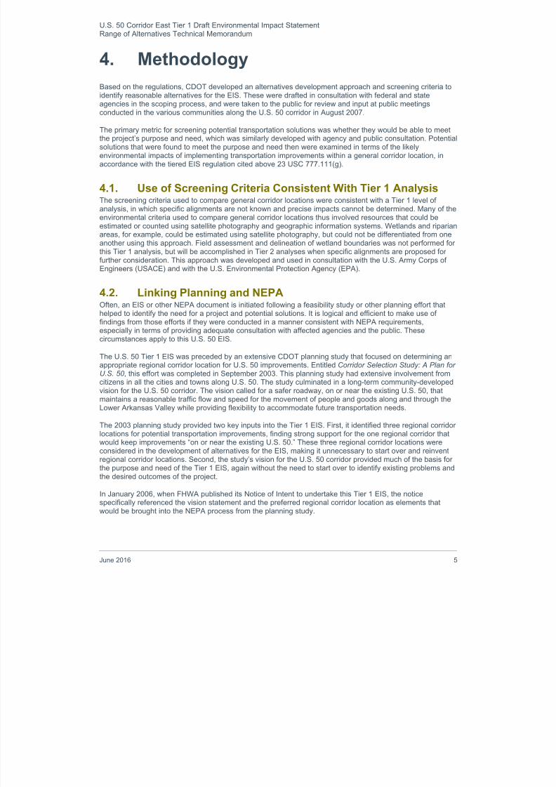
The results of this screening evaluation are summarized in Table 5-2.
8/16/2019 B: Range Alternatives Tech Report
http://slidepdf.com/reader/full/b-range-alternatives-tech-report 18/86
U.S. 50 Corridor East Tier 1 Draft Environmental Impact StatementRange of Alternatives Technical Memorandum
14 June 2016
Table 5-2. Transportation Mode Screening Results Summary
Screening CriteriaRail/BusTransit
Carpooling/TSM
StrategiesHighway
Addresses U.S. 50 safety problems
Improves mobility for local users
Improves mobility for regional users
Improves mobility for long-distance users
Balances mobility and access for all users
Provides flexibility to address future traffic needs
KEY:
= does not address the need = partially addresses the need = fully addresses the need
The EIS contains a table summarizing the findings above but not necessarily specifying the rationale foreach rating for each corridor. These individual ratings are explained below.
Addresses U.S. 50 Safety ProblemsThe U.S. 50 project purpose and need identifies a large number of existing safety problems along thecorridor, including limited passing opportunities, inadequate clear zones, frequent changes in roadwaydesign, and an excessive number of access points.
Rail/Bus Transit ( )—Providing increased bus or rail service in the Existing Regional Corridor wouldleave existing U.S. 50 safety problems uncorrected. Slightly fewer motorists would be exposed toexisting safety problems, if some traffic diverted to use of rail or bus services. Bus passengers on U.S.50 would face the same problems as motorists, but in a different type of vehicle.
Transportation System Management ( )—For the same reasons applicable to Rail/Bus Transit, TSMstrategies such as carpooling programs and traffic signal synchronization would also not address U.S. 50
safety problems. Highway Improvements ( )—Corridor-wide highway improvements would be designed in accordance
with current safety standards and thus would address U.S. 50 safety problems to the greatest degreepractical. Only highway improvements could address these needs on U.S. 50.
Improves Mobility for Local UsersFor travelers making short trips on U.S. 50 (e.g., 15 miles or less), the ability to enter, exit, or cross U.S. 50,is particularly important, as is the ability to move along U.S. 50 at moderately low speeds.
Rail/Bus Transit ( )—To provide reasonable average travel speeds for passengers, corridor-level busor rail service would need to have a minimum number of stops, such as one stop per U.S. 50 community,consistent with the types of service currently offered by the private sector and Amtrak. This means thatall users of this mode would be making regional trips. This mode is not suited to accommodate local
trips.
Transportation System Management ( )—Carpooling offers no benefit for local trips because theyare so short (less than 15 miles, and often much shorter) that the time and distance spent to coordinatethe carpool adds a large proportional increase to the amount of time needed to make the trip.
Highway Improvements ( )—The extent to which mobility for local users of U.S. 50 would beimproved depends upon what transportation action is taken. However, actions undertaken on or near theexisting U.S. 50 have the potential to benefit local users because it is closest to where local users liveand work.

8/16/2019 B: Range Alternatives Tech Report
http://slidepdf.com/reader/full/b-range-alternatives-tech-report 19/86
U.S. 50 Corridor East Tier 1 Draft Environmental Impact StatementRange of Alternatives Technical Memorandum
June 2016 15
Improves Mobility for Regional UsersRegional travelers make trips that start or end within the U.S. 50 corridor and pass through more than onecity or town. Typical regional trips are between 15 and 100 miles long.
Rail/Bus Transit ( )—Rail or bus transit is well suited for regional passenger trips from one U.S. 50community to another, but not all commutes along U.S. 50 areas are served by regional bus and/orpassenger rail. Where there is existing and planned bus or rail service, service would not be offered at
intervals frequent enough to be convenient for most trips, including most freight trips. Rail and busmodes would carry regional travelers from one rail station or bus stop to another, but could not beexpected to provide door-to-door service between the trip’s specific origin and destination. Transit modeswould be beneficial for some regional users, but not for all regional users.
Transportation System Management ( )— Among potential TSM strategies, carpooling is well suitedfor regional trips, due to the savings in vehicle operating costs available to the user. As with the transitmode, carpooling would be beneficial for some regional users, but not for all, and especially not forfreight trips.
Highway Improvements ( )—The extent to which mobility for regional users of U.S. 50 would beimproved depends upon what transportation action is taken. However, highway improvements have thepotential to improve mobility for all regional trips.
Improves Mobility for Long-distance UsersChapter 1 of the U.S. 50 EIS describes long-distance users as those who pass through the Lower ArkansasValley to reach some other destination. Long-distance trips along U.S. 50 extend at least between U.S. 287and I-25, a distance of about 120 miles.
Rail/Bus Transit ( )—The region is currently serviced by Greyhound buses and Amtrak long-distancerail service. There are Greyhound stations in the City of Pueblo and the City of Rocky Ford, and Amtrakstations are in the City of Lamar and the City of La Junta. These services currently provide long-distanceusers with transit service to Denver, Santa Fe, Kansas City, and regions beyond. Adding long-distancetransit service along the U.S. 50 corridor would duplicate these existing services. To improve mobility forlong-distance users, rail or bus transit service within the U.S. 50 corridor would need to offer convenientconnections with similar services connecting to other locations in Colorado and other states (e.g., Amtrakor Greyhound Bus). Adding bus or rail service would not do anything to improve travel time for bus usersor for the majority of long-distance users (i.e., those in personal autos), who would still encounter no-
passing zones on the highway and speed-reduction zones through towns.
Transportation System Management ( )—TSM strategies are not designed to address long-distanceusers. They would not reduce travel time for these users for the same reasons mentioned above for railand bus modes.
Highway Improvements ( )—The extent to which mobility for long-distance users of U.S. 50 would beimproved depends upon what transportation action is taken. However, highway improvements have thepotential to improve mobility for all long-distance users, either by eliminating speed-reduction zonesthrough towns and reducing the conflicts with other user types.
Balances Mobility and Access for All UsersChapter 2 of the EIS discusses how the need for access by local and regional users conflicts with the needfor mobility by other regional users and by long-distance users. The project purpose and need calls for a
solution that balances the needs of all users.
Rail/Bus Transit ( )— As noted above, rail and bus transit would provide very limited mobility benefitsfor regional users but no improvement for local and long-distance users.
Transportation System Management ( )— As noted above, rail and bus transit would provide verylimited mobility benefits for regional users but no improvement for local and long-distance users.
Highway Improvements ( )—The effect of this corridor on balancing user needs would depend uponwhat transportation action is taken. However, actions undertaken on or near the existing U.S. 50 have

8/16/2019 B: Range Alternatives Tech Report
http://slidepdf.com/reader/full/b-range-alternatives-tech-report 20/86
U.S. 50 Corridor East Tier 1 Draft Environmental Impact StatementRange of Alternatives Technical Memorandum
16 June 2016
the potential to serve both higher passenger vehicle volumes and reduce conflicts between private,commercial, and agricultural users.
Provides Flexibility to Address Future Traffic NeedsRegardless of which regional corridor is used, transportation improvements could be designed in a mannerthat would provide flexibility to meet future needs. All three corridors offer this potential.
Rail/Bus Transit ( )—Rail has the flexibility to carry increased ridership in the future, but cannot beeasily relocated. Bus transit can carry increased ridership and can be re-routed as necessary. However,neither mode is well suited to handle the types of local and regional freight currently carried by trucks onthe highway.
Transportation System Management ( )—TSM strategies are highly flexible but are geared largelytoward could accommodate passenger congestion problems and not local and regional freight.
Highway Improvements ( )—Highway improvements offer the flexibility to provide expanded capacity(through future widening) and modified access as needed to meet demands from future development.
5.2.6. Screening Results for Transportation ModesThe individual findings for each transportation mode for each screening criterion based on the project’spurpose and need were summarized in Table 5-2 and detailed above. Highway improvements were found to
have the potential to fully meet all aspects of the purpose and need. Rail or bus transit and TSM strategieswere less advantageous with regard to four out of the six criteria. Their fatal flaw was their inability toaddress safety problems on the existing U.S. 50. Therefore, the rail/bus and TSM modes were eliminated forfurther consideration.
From this point forward, the alternatives development process focused on highway improvements that couldbe implemented in the Existing Regional Corridor, on or near existing U.S. 50.
5.3. Facility Type About two-thirds of the 150-mile U.S. 50 corridor today consistsof two-lane highway (one lane each direction), and about one-third has been built as a four-lane highway. Projected traffic
volumes along the U.S. 50 corridor could range from 3,000 to17,500 vpd by the year 2040. These future volumes can beaccommodated on a road with two to four through lanes (varyingby location), and clearly would not require a six-lane highway.Therefore, consideration was given only to two-lane and four-lane roadways.
The following facility types were considered and are discussedin more detail below:
Two-lane highway with passing lanes (partial rebuild)
Two-lane highway with passing lanes (total rebuild) Four-lane highway (partial rebuild)
Four-lane rural expressway (total rebuild) Four-lane freeway (total rebuild)
Consistent with the decision to go around towns discussedabove, each facility type would be built to go around U.S. 50communities, except at Pueblo where the existing four-lanehighway would remain at its current location. Through towns, the existing road would remain unchanged.

8/16/2019 B: Range Alternatives Tech Report
http://slidepdf.com/reader/full/b-range-alternatives-tech-report 21/86
U.S. 50 Corridor East Tier 1 Draft Environmental Impact StatementRange of Alternatives Technical Memorandum
June 2016 17
5.3.1. Two-Lane Highway with Passing Lanes (Partial Rebuild)The approximately 96 miles where U.S. 50 is a two-lane highway would be reconstructed to add intermittentpassing lanes. These lanes would be added to enable motorists to avoid having to follow a slow-movingvehicle for an extended time and distance. Extra-wide shoulders (10 – 12 feet) would be provided as well. Inaddition to making these improvements to the two-lane sections, safety improvements would be made atspot locations on four-lane sections in response to specific safety problems. Existing four-lane sectionswould remain four lanes. Speed limits would remain the same as they are currently, requiring vehicles to
slow down as they approach urban areas and intersections.
5.3.2. Two-Lane Highway with Passing Lanes (Total Rebuild)The entire U.S. 50 corridor would be reconstructed as a two-lane highway with passing lanes and extra-wideshoulders. Existing four-lane sections of road would be rebuilt as a modern two-lane highway with passinglanes. The reason that all of the highway would be rebuilt in this way is to avoid frequent roadway changesthat contribute to driver confusion. It would represent a decrease in the existing number of through lanes forportions of the corridor between towns. Speed limits would remain the same as they are currently, requiringvehicles to slow down as they approach urban areas and intersections.
5.3.3. Four-Lane Highway (Partial Rebuild)On the 96 miles of U.S. 50 where the highway is currently two lanes, it would be widened to four through
lanes (two in each direction), with acceleration and deceleration lanes for turning where appropriate. With theexception of at crossing locations, median types would vary from narrow paved medians to wider grassymedians, depending on location, terrain, and other factors. The highway would have at-grade intersections,not grade-separated interchanges. On rebuilt portions, the posted speed limit would typically be 65 miles perhour, and access to the highway normally would be available at intervals no closer than a half-mile apart.
Compliance with modern design standards generally would require a much wider cross section than theexisting CDOT right of way along the corridor. U.S. 50 and all intersecting roadways would meet at grade,requiring signalized intersections where warranted by traffic volumes.
5.3.4. Four-Lane Rural Expressway (Total Rebuild)U.S. 50 would be reconstructed as an expressway, with a wide median and access provided at a minimum ofhalf-mile spacing. The resulting elimination of numerous existing access points would require that some local
trips use other roadways, and in some cases frontage roads, to reach U.S. 50. An expressway wouldmaintain a posted speed limit of 65 miles per hour in most locations, dropping to 50 miles per hour forapproaches to signalized intersections.
Grade separations would be provided to minimize the number of signalized intersections needed. Access tothe highway would be available at intervals not closer than a half-mile apart and access to communitieswould be maintained. At locations with at-grade access but not enough traffic to warrant a signalizedintersection, unsignalized intersections would be provided. There would be sufficient room in the median fora vehicle to cross one direction of traffic, then wait at a stop sign before crossing the other highway lanes ormaking a left turn onto the highway.
5.3.5. Four-Lane Freeway (Total Rebuild)U.S. 50 would be completely reconstructed as a freeway, with no at-grade access and with interchanges
typically no closer than three miles apart. The posted speed limit would be 65 miles per hour. To make localtrips, motorists would have to use other local streets to reach a grade-separated interchange where U.S. 50could be accessed or crossed.
5.3.6. Screening of Facility TypesThe facility types described above were screened to determine how well each would meet the project’spurpose and need for local, regional, and long-distance users of the highway. The results of this screeningare summarized in Table 5-3 and are detailed below.

8/16/2019 B: Range Alternatives Tech Report
http://slidepdf.com/reader/full/b-range-alternatives-tech-report 22/86
U.S. 50 Corridor East Tier 1 Draft Environmental Impact StatementRange of Alternatives Technical Memorandum
18 June 2016
Table 5-3. Summary of Facility Type Screening Results
Screening Criteria
Two-Lane Highwaywith Passing Lanes
Four-LaneHighway
Four-LaneRural
Expressway
Four-LaneFreeway
PartialRebuild
TotalRebuild
Partial Rebuild Total Rebuild Total Rebuild
Addresses U.S. 50 safetyproblems
Improves mobility for localusers
Improves mobility forregional users
Improves mobility for long-distance users
Balances mobility andaccess for all users
Provides flexibility toaddress future traffic needs
KEY:
= does not address the need = partially addresses the need = fully addresses the need
Addresses U.S. 50 Safety Problems All rebuilt portions of the highway would be designed and constructed in accordance with modern safetystandards. Therefore all facility types would improve safety at least to some degree.
Two-Lane Highway with Passing Lanes (Partial Rebuild) ( )—Rebuilding just the existing two-laneportions of U.S. 50 to meet current safety standards would leave existing safety problems uncorrectedon the four-lane portions of the highway. This resulting degree of safety improvement would besubstantial but not corridor-wide.
Two-Lane Highway with Passing Lanes (Total Rebuild) ( )—Passing lanes would offer relief fromslow-moving vehicles in one direction at a time. The resulting degree of safety improvement would besubstantial but would not accommodate safe passing in both directions on a corridor-wide basis.
Four-Lane Highway (Partial Rebuild) ( )—Rebuilding just the existing two-lane portions of U.S. 50would leave existing safety problems uncorrected on the four-lane portions of the highway. This resultingdegree of safety improvement would be substantial but not corridor-wide.
Four-Lane Rural Expressway (Total Rebuild) ( )—Total rebuild to a four-lane expressway meetingmodern safety standards would enable faster-moving traffic in the left lane to safely pass slower movingtraffic in the right lane on a corridor-wide basis.
Four-Lane Freeway (Total Rebuild) ( )—Total rebuild to a four-lane freeway meeting modern safetystandards would enable faster-moving traffic in the left lane to safely pass slower moving traffic in theright lane on a corridor-wide basis.
Improves Mobility for Local Users All rebuilt portions of the highway would be designed and constructed to provide better passingopportunities, at least in some locations, which would benefit all users at least to some degree. Additionally,the following effects would result for the respective facility types:
Two-Lane Highway with Passing Lanes (Partial Rebuild) ( )—Improved passing opportunitieswould be beneficial to all users, including local users. However, a two-lane highway with passing laneswould degrade the ability of local users to cross the highway or to make left turns onto the highway,because they would have to cross an additional lane of oncoming traffic to make these maneuvers.

8/16/2019 B: Range Alternatives Tech Report
http://slidepdf.com/reader/full/b-range-alternatives-tech-report 23/86
U.S. 50 Corridor East Tier 1 Draft Environmental Impact StatementRange of Alternatives Technical Memorandum
June 2016 19
Two-Lane Highway with Passing Lanes (Total Rebuild) ( )—Improved passing opportunities wouldbe beneficial to all users, including local users. However, on existing two-lane portions of U.S. 50,conversion to a two-lane highway with passing lanes would degrade the ability of local users to cross thehighway or to make left turns onto the highway, because they would have to cross an additional lane ofoncoming traffic to make these maneuvers.
Four-Lane Highway (Partial Rebuild) ( )—Improved passing opportunities would be beneficial to allusers, including local users. However, widening two-lane portions of U.S. 50 to four lanes with no
median would make crossing the highway more difficult for local users. Four-Lane Rural Expressway (Total Rebuild) ( )—Improved passing opportunities would be
beneficial to all users, including local users. Additionally, an expressway would provide a median so thatpersons crossing the highway or turning left onto it could cross one direction of traffic safely beforehaving to deal with traffic coming from the other direction.
Four-Lane Freeway (Total Rebuild) ()— Access onto the freeway would be provided only atlocations typically spaced several miles apart from one another, thus hindering the ability of local usersto access or cross the freeway.
Improves Mobility for Regional Users All rebuilt portions of the highway would be designed and constructed to provide better passingopportunities, at least in some locations, which would benefit all users at least to some degree. Additionally,
the following effects would result for the respective facility types:
Two-Lane Highway with Passing Lanes (Partial Rebuild) ( )—Improved passing opportunitieswould be beneficial to all users, including regional users. However, this would not be as beneficial toregional users as four-lane facility types, on which faster vehicles would have the ability to go aroundslower-moving vehicles on a corridor-wide basis.
Two-Lane Highway with Passing Lanes (Total Rebuild) ( )—Improved passing opportunities wouldbe beneficial to all users, including regional users. However, this would not be as beneficial to regionalusers as four-lane facility types, on which faster vehicles would have the ability to go around slower-moving vehicles on a corridor-wide basis.
Four-Lane Highway (Partial Rebuild) ( )—Mobility for regional users would be improved becausefaster vehicles would have the ability to go around slower-moving vehicles on a corridor-wide basis.
Four-Lane Rural Expressway (Total Rebuild) ( )—Mobility for regional users would be improved
because faster vehicles would have the ability to go around slower-moving vehicles on a corridor-widebasis.
Four-Lane Freeway (Total Rebuild) ( )—Mobility for regional users would be improved because fastervehicles would have the ability to go around slower-moving vehicles on a corridor-wide basis.
Improves Mobility for Long-distance Users Adding passing lanes would improve travel t imes over existing conditions, but four-lane facilities would bemore effective at separating fast-moving and slow-moving vehicles on a corridor-wide basis by providingmore consistent and higher average travel speeds for long-distance users of U.S. 50. Constructing a full,grade-separated, free flowing freeway facility would provide the best service to long-distance users.
Balances Mobility and Access for All Users
Chapter 1 of the EIS discusses how the need for access by local and regional users conflicts with the needfor mobility by other regional users and by long-distance users. The project purpose and need calls for asolution that balances the needs of all users.
Two-Lane Highway with Passing Lanes (Partial Rebuild) ( )— Adding passing lanes to a two-lanehighway would make it more difficult for local users to cross or turn left onto the highway. This would notresult in a balance between mobility and access for all users.

8/16/2019 B: Range Alternatives Tech Report
http://slidepdf.com/reader/full/b-range-alternatives-tech-report 24/86
8/16/2019 B: Range Alternatives Tech Report
http://slidepdf.com/reader/full/b-range-alternatives-tech-report 25/86
U.S. 50 Corridor East Tier 1 Draft Environmental Impact StatementRange of Alternatives Technical Memorandum
June 2016 21
lanes and wide shoulders could be constructed so that they would become one-half of the futureexpressway. These issues will be addressed during Tier 2 studies.
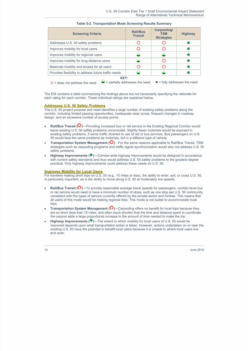
5.4. Through Town or Around Town (Bypass)Corridors through communities and those around themwere considered and evaluated in this Tier 1 EIS. This
question was critical for a number of reasons. First, in allof the communities east of Pueblo, U.S. 50 is lined withhomes and businesses, including many recognizedhistoric sites and other important community resourcesthat could be adversely affected. Second, existingcorridor right of way through most of the communities istypically not wide enough to accommodate a highwaybuilt to modern safety standards. Third, U.S. 50functions as the main street in many of thesecommunities. The highway is intersected by numerouscross streets and driveways, and even has roadsideparking for businesses. Highway improvements throughtown would change local access and traffic circulation
patterns. Furthermore, with increased traffic in the future,the highway will become even more of a barrier, separating one side of town from the other. Additionally,moving the highway outside of the town centers would reduce the number of intersections and traffic signals,thus reducing delays and speed reductions. This would be especially beneficial to regional and long-distancetravellers. These tradeoffs were recognized in the 2003 U.S. 50 planning study. Thus, CDOT worked with theaffected communities to identify issues and concerns with through-town corridors, and to identify potentialaround-town corridors.
It should be noted that, at Pueblo, alignment alternatives—including the existing alignment—are technicallywithin the city of Pueblo; therefore, it is partially inaccurate to describe the alternatives at that location as“around town.” For this reason, the existing alignment was retained as a Build Alternative regardless of theoutcome of the screening process for through-town versus around-town corridors.
It also should be noted that, between communities along the U.S. 50 corridor, the highway generally wouldremain in its current location, with the exception of the merger to a new alignment around towns andcorrection of one substandard curve.
5.4.1. Through-Town CorridorsPotential through-town corridors were examined that used the existing U.S. 50 right of way plus adjacentland on its north side or south side. CDOT’s existing right of way through towns varies from 60 feet to 80feet. Based on modern highway design, a minimum of 130 feet would be needed to accommodate through-traffic lanes, a center median, turn lanes, outside shoulders, sidewalks, and clear zones for vehicles torecover. A diagram depicting a 130-foot-wide right of way through a typical town is shown in Figure 5-4.
Figure 5-4. Ideal Through-Town Typical Section

8/16/2019 B: Range Alternatives Tech Report
http://slidepdf.com/reader/full/b-range-alternatives-tech-report 26/86
U.S. 50 Corridor East Tier 1 Draft Environmental Impact StatementRange of Alternatives Technical Memorandum
22 June 2016
Existing non-signalized intersections would be eliminated and the side roads turned into cul-de-sacs orconnected together to form loops. No on-street parking would be allowed on the highway. The highwaywould be designed to carry traffic at posted speed limits of 50 mph. Figure 5-5 shows that homes,businesses, historic resources, and other community assets would be displaced by a through-town corridorlocation.
TOP VIEW : The existing two-lane highway is lined with homes (orange areas) and businesses (purple areas), some ofwhich are historic sites (stars), and even has some on-street parking; the low-speed (35 miles per hour) highway can becrossed at many cross streets.MIDDLE VIEW : The cross-hatched area denotes right of way needed for a higher-speed (50 miles per hour), access-controlled highway designed to meet modern safety specifications.BOTTOM VIEW : A widened, access-controlled highway results in loss of homes, businesses, historic sites, and parking;opportunities to cross the highway are greatly reduced because cross streets are blocked off to improve safety on thehighway; local circulation patterns on the municipal street system change, putting more traffic on parallel streets and themajor cross-street. A left-turn lane (not shown) would likely be provided on U.S. 50 at the intersection.
Figure 5-5. Typical Right of Way and Access Effects for a Four-Lane Corridor Through a Community

8/16/2019 B: Range Alternatives Tech Report
http://slidepdf.com/reader/full/b-range-alternatives-tech-report 27/86
U.S. 50 Corridor East Tier 1 Draft Environmental Impact StatementRange of Alternatives Technical Memorandum
June 2016 23
Intersections with U.S. 50 would be limited to other connecting state highways and other major roads,generally no closer together than one-half mile apart, and signalized where warranted. This wouldsignificantly reduce the number of places where people could cross U.S. 50 on foot, by bicycle, or evendriving. Since streets crossing U.S. 50 would generally be one-half mile apart, local residents would need totravel out of their way to cross the highway.
Obtaining the right of way needed to build a modern highway through town would require removing homes
and businesses from one side or both sides of the highway. These alternatives were examined individuallyfor each community along the U.S. 50 corridor. Consideration was also given to new through-town corridors,generally along the north or south side of existing railroad tracks, for the purpose of minimizing impacts tohistoric resources along U.S. 50. The numbers of potentially affected resources that are reported belowreflect the best case and worst case impacts associated with the specific through-town corridors that weredeveloped for consideration in each community.
Depending on the corridors selected, through-town alternatives would unavoidably require removing at least225 homes and businesses, and possibly as many as 445.
Many homes, businesses, or public buildings that are significant to the history of U.S. 50 communities arelocated immediately adjacent to the highway, on either side of it. Thus, for example, shifting the highway toone side to avoid a particular historic site would often result in impacting another historic site on the other
side of the road. Table 5-4 shows the affects of the through-town corridors on homes, businesses, andhistoric sites, including those that are listed or eligible for listing on the National Register of Historic Places(NRHP).
Table 5-4. Homes, Businesses, and Historic Resources Potentially Affected byThrough-Town Corridors
Attribute Through-Town Corridors
Ideal right of way needed 130 feet (of the 1,000-foot corridor)
Number of homes and businesses within the corridor a 225 to 445b
Number of historic resources within the corridor a 150b a Ranges reflect best case and worst case corridors through town, excluding resources between communitiesb Resources in through-town corridors mostly cannot be avoided, because the existing highway is surrounded by
homes and businesses, many of them historic
5.4.2. Around-Town CorridorsDue to the community disruption of through-town corridors, CDOT explored potential around-town corridorsin consultation with local communities. Around-town corridors were developed initially in the U.S. 50 planningstudy and refined during the U.S. 50 Tier 1 EIS. Corridors going around the north and the south sides of thecommunities were sketched onto aerial maps, attempting to avoid impacts to community and ecologicalresources. At the request of the communities, these corridors were kept as close to U.S. 50 as possible, but just far enough around the towns to avoid impacting key resources. Because U.S. 50 connects to I-25 withinthe city of Pueblo (the western terminus for this Tier I EIS), an around-town corridor alternative was notdeveloped for Pueblo.
The right of way needed for around-town corridors would be up to 250 feet to provide a wide median(typically 100 feet) as a refuge for truck and farm equipment crossing U.S. 50 at crossroads, as shown inFigure 5-6. No sidewalks would be provided in these areas outside of the communities. Around-towncorridors would have a posted travel speed of 65 miles per hour. Around-town corridors would allow accessonly from crossroads, no closer than a half-mile apart. Generally, no direct access would be provided fordriveways and field roads.

8/16/2019 B: Range Alternatives Tech Report
http://slidepdf.com/reader/full/b-range-alternatives-tech-report 28/86
U.S. 50 Corridor East Tier 1 Draft Environmental Impact StatementRange of Alternatives Technical Memorandum
24 June 2016
Figure 5-6. Ideal Around-Town Typical Section
Table 5-5 shows the potential effects of the around-town corridors on homes, businesses, and historic sites,including those that are listed or eligible for listing on the NRHP.
Table 5-5. Homes, Businesses, and Historic Resources Potentially Affected byAround-Town Corridors
Attribute Around-Town Corridorsa
Ideal right of way needed 250 feet (of the 1,000-foot corridor)b
Number of homes and businesses within the corridor a 95 to 215c
Number of historic resources within the corridor a 69 to 72c aRanges reflect best-case and worst-case corridors around town.bRight of way required is greater than that of the through-town corridor to accommodate a wider median.c Resources are probably avoidable to a large degree since they were counted within a 1,000-foot-wide corridor, ofwhich only 250 feet actually will be needed for right of way.
5.4.3. Screening of Through-Town and Around-Town CorridorsThrough-town and around-town concepts for corridor locations were screened to determine how well each
would meet the project’s purpose and need for local, regional, and long-distance users of the highway. Inaddition to the six criteria that were used in the earlier screening steps, a seventh criterion was used here,due to public concerns about potential community disruption. The seventh criterion addresses how well athrough-town or around-town corridor would minimize community impacts. The results of the through-town oraround-town screening are summarized in Table 5-6.

8/16/2019 B: Range Alternatives Tech Report
http://slidepdf.com/reader/full/b-range-alternatives-tech-report 29/86
U.S. 50 Corridor East Tier 1 Draft Environmental Impact StatementRange of Alternatives Technical Memorandum
June 2016 25
Table 5-6. Through-Town or Around-Town Screening Results Summary
The EIS contains a table summarizing the findings above but not necessarily specifying the rationale foreach rating for each corridor. These individual ratings are explained below.
Addresses U.S. 50 Safety ProblemsThe U.S. 50 project purpose and need identifies a large number of existing safety problems along thecorridor, including limited passing opportunities, inadequate clear zones, frequent changes in roadwaydesign, and an excessive number of access points.
Through-Town Corridors ( )—If highway improvements were made through towns, they would bedesigned and constructed to comply with current safety standards for a design speed of 50 miles perhour.
Around-Town Corridors ( )—If highway improvements were made around towns, they would bedesigned and constructed to comply with current safety standards for a design speed of 65 miles perhour.
Improves Mobility for Local UsersFor travelers making short trips on U.S. 50 (e.g., 15 miles or less), the ability to enter, exit or cross U.S. 50,is particularly important, as is the ability to move along U.S. 50 at moderately low speeds.
Through-Town Corridors ( )— A highway carrying traffic at 50 miles per hour through towns wouldrequire eliminating access from residential and commercial driveways, as well as blocking most crossstreets. Motorists, bicyclists and pedestrians alike would be channeled to cross the highway at a few orperhaps a single location in town, greatly restricting their current mobility as well as changing local trafficcirculation on other local streets.
Around-Town Corridors ( )— A new highway corridor would take through-traffic around towns, Theresulting reduction of traffic through towns would make it easier for most local users to access or crossthe existing highway, although the new highway would adversely affect mobility for a small number oflocal trips within the new, around-town corridors. U.S. 50 traffic would be able to enter towns generallywhere it does today, on the existing roadway, and possibly from one or more major intersectingroadways that already enter the town. Thus there would be minimal disruption to local traffic patterns.
Screening Criteria Through-Town Around-Town
Addresses U.S. 50 safety problems Improves mobility for local users
Improves mobility for regional users
Improves mobility for long-distance users
Balances mobility and access for all users
Provides flexibility to address future traffic needs
Minimizes community impacts
KEY:
= does not address the need = partially addresses the need = fully addresses the need

8/16/2019 B: Range Alternatives Tech Report
http://slidepdf.com/reader/full/b-range-alternatives-tech-report 30/86
U.S. 50 Corridor East Tier 1 Draft Environmental Impact StatementRange of Alternatives Technical Memorandum
26 June 2016
Improves Mobility for Regional Users
Regional travelers make trips that start or end within the U.S. 50 corridor and pass through more than onecity or town. Typical regional trips are between 15 and 100 miles long.
Through-Town Corridors ( )— A highway offering travel at 50 mph through towns would reduce triptime and thereby improve mobility for regional travelers. However, accessing a specific origin ordestination within the town would be less convenient since access to adjacent properties and most cross
streets would be eliminated.
Around-Town Corridors ( )—Regional users would have the ability to travel around towns at 65 milesper hour on the new highway corridor or to enter town and access a trip origin or destination using theexisting highway.
Improves Mobility for Long-distance UsersLong-distance users are those who pass through the Lower Arkansas Valley to reach some otherdestination. Long-distance trips along U.S. 50 extend at least between U.S. 287 and I-25, a distance of about120 miles.
Through-Town Corridors ( )— A highway allowing travel at 50 mph through towns would improvemobility for long-distance users. However these motorists would likely have to stop for one or more traffic
signal within each city or town. Around-Town Corridors ( )—Long-distance users would be able to travel at 65 mph around towns,
with even greater mobility improvement than on through-town corridors.
Balances Mobility and Access for All UsersChapter 1 of the EIS discusses how the need for access by local and regional users conflicts with the needfor mobility by other regional users and by long-distance users. The project purpose and need calls for asolution that balances the needs of all users.
Through-Town Corridors ( )— As noted above, through-town corridors would significantly diminishaccess to U.S. 50 for the residents of the communities along the highway. This drawback would morethan offset the mobility improvement accruing to regional and long-distance users.
Around-Town Corridors ( )— Around-town corridors would maintain existing access and mobilitywithin communities while also improving mobility for regional and long-distance users by enabling themto travel at a high speed on the new corridors.
Provides Flexibility to Address Future Traffic NeedsEconomic diversification is seen as necessary by U.S. 50 communities which have seen four decades ofminimal population growth. To meet the U.S. 50 project purpose and need, the corridor needs to be able toaccommodate future development, not hinder it. Flexibility is needed to be able to accommodate accesschanges in the future.
Through-Town Corridors ( )—The through-town corridors examined in this EIS were designed tominimize the need for highway right of way because the existing highway is surrounded by homes,businesses, and community resources, including historic sites. Any needed expansion of through-town
corridors for new access, turn lanes, or other roadway modifications would adversely affect additionalcommunity resources. Thus the through-town corridors do not offer flexibility to meet future needs.
Around-Town Corridors ( )—The around-town corridors examined in this EIS traverse primarilyfarmland and other open areas with minimal concentrations of homes, businesses, or historic sites.These corridors offer significant flexibility to accommodate roadway modifications in response topotential future needs.

8/16/2019 B: Range Alternatives Tech Report
http://slidepdf.com/reader/full/b-range-alternatives-tech-report 31/86
U.S. 50 Corridor East Tier 1 Draft Environmental Impact StatementRange of Alternatives Technical Memorandum
June 2016 27
Minimizes Community ImpactsFive U.S. 50 communities range in population from approximately 500 to 1,200 residents, and four morerange in size from 2,700 to 8,900 (source: 2000 Census data). In these small towns and cities, manyimportant community assets are located immediately adjacent to the existing U.S. 50, and some of them areconsidered historic. Federal laws and regulations prohibit FHWA from taking an action that would adverselyaffect historic resources, if a reasonable and prudent alternative is available.
Through-Town Corridors (
)—The 130 feet of right of way needed to accommodate a 50 mphhighway meeting current safety standards would result in the relocation or loss of at least 225 homes orbusinesses and 150 historic sites in communities along the U.S. 50 corridor east of Pueblo. Goingthrough towns, it would not be possible to avoid these adverse impacts. As noted earlier, through-towncorridors would eliminate direct access for adjacent properties and substantially alter local trafficpatterns. These effects would be extremely disruptive to the communities.
Around-Town Corridors ( )—Corridors 1,000 feet wide were identified within which typically 250 feetof right of way would be needed for a 65 mph highway around towns. Within these corridors, 95 to 215homes and businesses and 69 to 72 historic resources were identified. However, there would be ampleroom within the 1,000-foot corridor to locate the highway right of way in a manner that would avoidimpacts to many of these resources. Around-town corridors also would not disrupt access and trafficpatterns within the communities. However, a bypass could also negatively affect the local economic if itdiverts traffic far from town. Fewer regional travelers passing through small town business districts could
result in reduced retail sales for travel-related businesses, such as hotels/motels, restaurants/bars,convenience stores, grocery stores, gas stations, etc. This criterion is included because of its importanceto the public.
5.4.4. Screening Results for Through-Town or Around-Town CorridorsThe through-town corridors were eliminated from consideration because they would adversely affect localmobility (limiting access and continued traffic), do not balance mobility and access for all users of U.S. 50,and would not allow for flexibility to address future traffic needs because of the restricted setting withintowns. Therefore, they do not meet the purpose and need of the project. In addition, the through-towncorridors directly impact community resources (through land and property acquisition), which was a concernfor the members of the communities. In Pueblo, however, U.S. 50 already is an expressway, so the existingcorridor location was not eliminated.
The around-town corridors were carried forward for further consideration because they would better meetaspects of the purpose and need while also minimizing community impacts.
5.5. Alternatives Carried Forward for Further ConsiderationThe alternatives development process described previously was undertaken to identify one or morealternative corridor alignments that would meet the project’s purpose and need. This process considered:
Regional corridor locations
Transportation modes Facility types
Through-town versus around-town corridor locations in communities
It provided Build Alternatives that will be a highway configured as a four-lane expressway located on or nearthe existing U.S. 50 between communities, and located around the communities east of Pueblo along theU.S. 50 corridor. The Build Alternatives resulting from this process were carried forward for subsequentcomparison to the No-Build Alternative. The No-Build and Build Alternatives are described below.
5.5.1. No-Build AlternativeIn accordance with NEPA, a no-build alternative is included in this EIS to provide a basis for comparison withthe Build Alternatives. The No-Build Alternative includes ongoing maintenance of pavement and bridges onthe existing U.S. 50 alignment. It also includes ongoing or planned minor safety improvements, provision of

8/16/2019 B: Range Alternatives Tech Report
http://slidepdf.com/reader/full/b-range-alternatives-tech-report 32/86
U.S. 50 Corridor East Tier 1 Draft Environmental Impact StatementRange of Alternatives Technical Memorandum
28 June 2016
passing-lane sections, routine pavement overlays, and repair of any weather- or crash-related damage. TheNo-Build Alternative also would accommodate local agency improvements to the U.S. 50 corridor.
5.5.2. Build AlternativesThe decisions described previously determined that a four-lane expressway on or near the existing U.S. 50alignment and going around each community, except in Pueblo, would meet the project’s pur pose and need.Therefore, the Build Alternatives consist of constructing a four-lane expressway on the existing U.S. 50
between the I-25 in Pueblo (milepost 316) to approximately one mile east of Holly (milepost 466).
Access will be restricted by placing access points at least one-half-mile apart. The resulting elimination ofnumerous existing access points would require that some local travelers use other roadways, and in somecases frontage roads will be added to reach U.S. 50. The access locations will not be determined until thecompletion of the Tier 2 studies. State highways and major regional roads will take priority as access pointsto U.S. 50. For example, if multiple access points exist within a one-half-mile segment, access to and fromprioritized roads would be retained, while lower-priority access points would be eliminated. Portions of theexisting highway that go through communities will remain in place to serve local needs, but will no longerserve as U.S. 50. For such roads, CDOT would relinquish ownership to cities and/or counties throughIntergovernmental Agreements (IGAs), as discussed below.
The Build Alternatives would maintain a posted speed limit of 65 mph in most locations, dropping to 50 mph
for approaches to signalized intersections. Some grade-separated intersections (where one of the roadscrosses over or under the other) would be provided to minimize the number of signalized intersections. Atlocations with at-grade access but not enough traffic to warrant a signalized intersection, unsignalizedintersections would be provided. The Build Alternatives would include a wide median with sufficient room fora vehicle to cross one direction of traffic, then wait at a stop sign before crossing the other highway lanes ormaking a left turn onto the highway.
It should be noted that the Build Alternatives are not final roadway alignments. Instead, each alternativeconsists of a corridor measuring approximately 1,000 feet in width and encompassing the actual 250-foot orless roadway alignment (i.e., footprint), which will be identified during Tier 2 studies. Within this 1,000-foot-wide corridor, resources can be avoided during Tier 2 studies. The Build Alternatives consist of constructinga four-lane rural expressway of typical AASHTO standard widths located along or near the existing U.S. 50highway between and around communities, as previously shown in the facility type selection discussion.
At each community east of Pueblo, there generally are two Build Alternatives that propose re-aligning U.S.50 around the community. General corridor alignments around each community were developed based onthe purpose and need of the project, socioeconomic and environmental constraints, engineering feasibility,and public input. Between communities, the corridor location is generally centered on the existing highwayalignment, except between Pueblo and Fowler. For this portion of U.S. 50, a realignment option wasdeveloped to avoid property acquisitions and the demolition of the historic Huerfano Bridge. Figure 5-7provides an overview of the Build Alternatives along the project corridor. As previously mentioned, theexisting alignments through each community would be relinquished to the city or county through IGAs.Generally, the process would follow this sequence:
1. Complete U.S. 50 Tier 1 EIS2. Complete U.S. 50 Tier 2 NEPA documents for each individual project
3. Coordinate with local jurisdiction4. Develop IGA for right of way, maintenance, and operations5. Finalize design6. Formalize IGA and submit to CDOT, Transportation Commission7. Execute IGA

8/16/2019 B: Range Alternatives Tech Report
http://slidepdf.com/reader/full/b-range-alternatives-tech-report 33/86
U.S. 50 Corridor East Tier 1 Draft Environmental Impact StatementRange of Alternatives Technical Memorandum
June 2016 29
Figure 5-7. Build Alternative and Options
No alternatives were developed for Lamar. Lamar has been studied in a separate EA, titled U.S. 287 at Lamar RelieverRoute Environmental Assessment; the FONSI for the project was signed November 10, 2014.

8/16/2019 B: Range Alternatives Tech Report
http://slidepdf.com/reader/full/b-range-alternatives-tech-report 34/86
U.S. 50 Corridor East Tier 1 Draft Environmental Impact StatementRange of Alternatives Technical Memorandum
30 June 2016
The project corridor consists of 18 sections, which represent the Build Alternatives between communitiesand around communities. These 18 sections are discussed briefly below in relation to the Build Alternative(s)proposed in each section. Figure 5-8 reflects the location of each of these sections along the existing U.S. 50corridor. Figures corresponding to each of the Build Alternatives in the around-town sections are located inSection 5.6, Identification of the Preferred Alternative, of this technical memorandum. In Pueblo, three Build Alternatives are proposed that either improve U.S. 50 on its existing alignment and/or reroute it to the northto utilize SH 47. East of Pueblo, generally, there is one Build Alternative alignment between each of the
communities along existing U.S. 50 with a north and south around-town Build Alternative at each of thecommunities.
Figure 5-8. Project Corridor Sections Overview

8/16/2019 B: Range Alternatives Tech Report
http://slidepdf.com/reader/full/b-range-alternatives-tech-report 35/86
U.S. 50 Corridor East Tier 1 Draft Environmental Impact StatementRange of Alternatives Technical Memorandum
June 2016 31
Section 1: PuebloBecause U.S. 50 connects to I-25 within Pueblo, an around-town Build Alternative was not developed.However, three Build Alternatives within Pueblo are under consideration:
Alternative 1: Pueblo Airport North Alternative 2: Pueblo Existing Alignment Alternative 3: Pueblo SH 47 Connection
Alternative 1: Pueblo Airport North consists of relocating U.S. 50 around the north side of the PuebloMemorial Airport. This alternative was proposed by Pueblo Area Council of Governments (PACOG) and isincluded in the Region’s 2035 Long-Range Transportation Plan. The 7.9-mile corridor would tie into SH 47approximately 1.5 miles north of U.S. 50 and 4.5 miles east of I-25. This local proposal would redesignate aportion of SH 47 as U.S. 50. Also, as part of this alternative, U.S. 50 would remain in use under itssecondary designation of SH 96.
Alternative 2: Pueblo Existing Alignment is under consideration because U.S. 50 in the area of Pueblo iscurrently a divided, four-lane expressway. This alternative would stay on the existing alignment, but wouldinclude some safety improvements to meet current design standards.
Alternative 3: Pueblo SH 47 Connection would include safety improvements like those under Alternative 2,
but instead of staying on the existing alignment until the western terminus of the project, it would construct anew segment of highway to connect U.S. 50 to SH 47 west of the airport. This also was a local proposalconsidered in the CDOT 2003 planning study for U.S. 50.
It should be noted that Alternatives 1 and 3 would move the alignment to be consistent with U.S. 50 west ofI-25.
Section 2: Pueblo to FowlerBetween Pueblo and Fowler, two Build Alternatives are under consideration. Alternative 1: Fort ReynoldsExisting Alignment consists of a 1,000-foot-wide corridor centered on the existing alignment. Alternative 2:Fort Reynolds Realignment is generally a 1,000-foot-wide corridor centered on the existing alignment exceptbetween milepost 333 and milepost 339 near Fort Reynolds. Alternative 2 realigns the highway to the southin this area to minimize the potential acquisition of homes in the Fort Reynolds area. It also has the potential
to avoid adverse effects to the historic Huerfano Bridge. The existing U.S. 50 could remain as a frontageroad in this alternative, which would require the bridge to be left in place. This will be evaluated further duringTier 2 studies.
Section 3: FowlerThere are two Build Alternatives under consideration around Fowler. Alternative 1: Fowler North is 3.4 mileslong and is aligned to minimize or avoid impacts to the BNSF Railway tracks and the Arkansas River. Alternative 2: Fowler South measures slightly less than five miles and extends nearly one mile south of town.This placement is meant to minimize effects to land irrigated by the Oxford Farmers Ditch, a major irrigationcanal, and provide for additional development opportunities.
Section 4: Fowler to ManzanolaThe Fowler to Manzanola Build Alternative is a 1,000-foot wide corridor on the existing alignment. The width
of the corridor extends from the edge of the highway right of way on the north side of U.S. 50 south 1,000feet to avoid the railroad that parallels the highway to the north.
Section 5: ManzanolaTwo Build Alternatives are under consideration around Manzanola. Alternative 1: Manzanola North wouldrequire a new railroad crossing west of town and would remain north of the railroad. Alternative 2:Manzanola South would remain south of the tracks until crossing them east of town, as U.S. 50 does today.Each Build Alternative is a little over 2.5 miles long and is situated to remain close to town. Alternative 1 was

8/16/2019 B: Range Alternatives Tech Report
http://slidepdf.com/reader/full/b-range-alternatives-tech-report 36/86
U.S. 50 Corridor East Tier 1 Draft Environmental Impact StatementRange of Alternatives Technical Memorandum
32 June 2016
aligned to minimize impacts to agricultural land to the north. Similarly, Alternative 2 was developed to avoidbisecting major farmland and to border or minimize impacts to the Otero Canal.
Section 6: Manzanola to Rocky FordThe Manzanola to Rocky Ford Build Alternative is a 1,000-foot-wide corridor on the existing alignment. Thewidth of the corridor extends from the edge of the highway right of way on the south side of U.S. 50 north1,000 feet to avoid the railroad that parallels the highway to the south.
Section 7: Rocky FordTwo Build Alternatives are under consideration around Rocky Ford. Alternative 1: Rocky Ford North islocated between the city and the Arkansas River and measures slightly less than seven miles in length. Alternative 2: Rocky Ford South is located approximately one mile south of U.S. 50 and is approximately 8.2miles long. Based on community input, Alternative 1 is intended to stay close to the city, while Alternative 2was aligned further south to avoid potential development opportunities south of the city limits.
Section 8: Rocky Ford to SwinkThe Build Alternative is a 1,000-foot-wide corridor on the existing alignment. In this section, the existing U.S.50 alignment parallels the railroad, which is located directly to the south of the highway in this section. Toavoid the railroad tracks in this area, the Rocky Ford to Swink Build Alternative extends 500 feet to the northof the railroad tracks (which extends along the existing U.S. 50 alignment) and 500 feet to the south of the
railroad tracks. The purpose of dividing the 1,000-foot-wide corridor in half generally was to avoid the railroadand associated right of way to the greatest extent possible. However, if the U.S. 50 alignment is shiftedsouth of the tracks, a new crossing of the railroad could be required.
Section 9: SwinkTwo Build Alternatives are under consideration aroundSwink. Alternative 1: Swink North is located close to the Arkansas River and is 2.4 miles in length, while Alternative2: Swink South is approximately 2.5 miles in length. Alternative 1 was aligned to avoid impacts to the ArkansasRiver and wastewater lagoons to the north. Alternative 2was configured to avoid or minimize impacts to the SwinkHigh School and a future area of development on the
southern limits of town, while also remaining close to thetown.
Section 10: La JuntaFour Build Alternatives are under consideration around La Junta. The southern alternatives primarily differ bylength and proximity to the town. All La Junta Build Alternatives are summarized below:
Alternative 1: La Junta North bypasses the town to the north and would construct two new bridges overthe Arkansas River. It is 8.9 miles in length. This alternative is only viable if Section 9, Alternative 1:Swink North, is selected. An alignment tying to Section 9, Alternative 2: Swink South, was not developeddue to having to cross the Fort Lyon Canal.
Alternative 2: La Junta South is 8.5 miles in length and located approximately two miles south of theexisting U.S. 50 alignment in La Junta.
Alternative 3: La Junta South is 9.8 miles in length and located approximately 2.3 miles south of theexisting U.S. 50 alignment in La Junta.
Alternative 4: La Junta South is 11.9 miles in length and located approximately 3.3 miles south of theexisting U.S. 50 alignment in La Junta.
Alternative 1 was developed to provide a northern alternative. Given the proximity of the Arkansas River tothe city, the alignment was situated north of the river and in a location to avoid existing development and theFort Lyon Canal. Alternative 2 was developed to provide a southern route, but also to remain close to the citylimits. Alternative 3: La Junta South was developed during public involvement efforts for this document as a
Swink to La Junta
Because of the short distance betweenSwink and La Junta, and the length ofthe alignment options around La Junta,the transition between the two
communities was incorporated into theoptions for Section 10: La Junta.

8/16/2019 B: Range Alternatives Tech Report
http://slidepdf.com/reader/full/b-range-alternatives-tech-report 37/86
U.S. 50 Corridor East Tier 1 Draft Environmental Impact StatementRange of Alternatives Technical Memorandum
June 2016 33
requested compromise between Alternative 2 and Alternative 4—a route closer to town, but farther from thecity limits. The Alternative 4 alignment generally reflects a proposed trucking route identified in the La JuntaComprehensive Plan. Alternative 4 generally follows this alignment, with the exception of deviating to thewest of La Junta in order to tie into Alternative 1: Swink North and Alternative 2: Swink South in Section 9 ofthe project corridor.
Section 11: La Junta to Las Animas
The La Junta to Las Animas Build Alternative consists of a 1,000-foot-wide corridor centered on the existingalignment, except in areas where the railroad parallels the highway to the north. In these areas, the 1,000-foot corridor shifts to the south.
Section 12: Las AnimasTwo Build Alternatives are under consideration around Las Animas. U.S. 50 crosses the Arkansas Rivernorth of the city and either new corridor also would cross the river. Alternative 1: Las Animas North isapproximately 3.5 miles long and includes replacement of the existing bridge over the Arkansas River. Thealignment is meant to avoid direct effects to community resources, such as the Bent County jail andtreatment center, wastewater facilities, and Bent ’s Fort Inn (which is viewed as an important communitygathering place), as well as use the existing U.S. 50 alignment to the greatest extent practicable. Alternative2: Las Animas South is approximately 4.7 miles long and would include a new bridge crossing over the Arkansas River. This placement stays close to town, while avoiding direct effects to the fairgrounds, which is
an important community resource, and the city and county airport.
Section 13: Las Animas to LamarThe Las Animas to Lamar Build Alternative consists of a 1,000-foot wide corridor centered on the existingalignment.
Section 14: Lamar to GranadaThe Lamar to Granada Build Alternative consists of 1,000 feet centered on the existing alignment. However,between Lamar and the U.S. 50 and CR GG.5 intersection, the corridor begins on the north edge of U.S. 50and extends 1,000 feet south to avoid the railroad on the north side.
Section 15: GranadaTwo Build Alternatives are under consideration around Granada. Alternative 1: Granada North is
approximately 2.1 miles long, while Alternative 2: Granada South is 2.2 miles long. Both alternatives wereintended to minimize or avoid potential effects to Camp Amache National Historic Landmark and/or theGranada State Wildlife Area.
Section 16: Granada to HollyThe Build Alternative between Granada and Holly is an alignment 1,000 feet wide centered on the existingroadway except where the corridor is near enough to the railroad to cause potential impacts. In these cases,the Build Alternative is shifted to the south or north along the existing U.S. 50 alignment.
Section 17: HollyTwo Build Alternatives are under consideration around Holly. Both alternatives are approximately 2.1 mileslong. Both Build Alternative alignments were intended to stay close to the existing city limits. Alternative 1
was aligned in a way to avoid potential development to the northwest of town, as well as potential housingdevelopment on the northeast of the existing town limits and the cemetery east of town. Community inputalso identified the best agricultural land as being north of town; keeping the northern alternative close to townwas intended to minimize agricultural land impacts. Alternative 2 was aligned between the southern limits oftown and the Arkansas River. This alternative has the potential to avoid the Holly State Wildlife Area while Alternative 1 would have unavoidable use of the wildlife area.

8/16/2019 B: Range Alternatives Tech Report
http://slidepdf.com/reader/full/b-range-alternatives-tech-report 38/86
U.S. 50 Corridor East Tier 1 Draft Environmental Impact StatementRange of Alternatives Technical Memorandum
34 June 2016
Section 18: Holly TransitionThe Build Alternative in this section is 1,000 feet wide and centered on the existing alignment. This sectionbegins approximately one mile east of Holly and extends to the vicinity of the Colorado-Kansas state line.The limits of this section will be determined during Tier 2 studies.
5.6. Identification of Preferred AlternativeThe decisions described above determined that a four-lane expressway on or near the existing U.S. 50 andgoing around each community, except at Pueblo, would meet the project’s purpose and need. Topreliminarily identify a preferred alternative, the Build Alternatives around communities, including theproposed realignment between Pueblo and Fowler, were further screened. For most communities, twoaround-town alternatives (one northern and one southern) were identified through community involvementand consideration of socioeconomic and environmental constraints. These locations were then evaluatedbased on criteria consistent with a Tier 1 level of analysis. This evaluation focused on three broad categoriesthat considered effects to the following environment categories:
Rural and agricultural environment
Natural environment Community and built environment
5.6.1. Screening of Build Alternatives (Around-Town Corridors)Criteria to screen Build Alternatives were developed based on comments received from agencies and thepublic, as well as regulatory requirements.
Public workshops were held in each U.S. 50 community to determine what resources were important to thelocal economy and quality of life. One important local concern was that the corridor location should not betoo far away from the community, and it should be supportive of a perceived “gateway” into the community.The purpose of the gateway is to attract through-traffic to local businesses. Impacts to agriculture were alsoa concern (due to the region’s economic dependence on agriculture), especially impacts to highly productive,irrigated lands.
Federal regulations protect certain resources, such as threatened and endangered species, wildlife andwaterfowl refuges, wetlands, historic resources, parks, and recreational facilities. Therefore screening criteriawere developed to address impacts to these resources, in addition to those resources that were important to,and identified by, the affected communities.
To understand the relationship between the affected resources and community concerns, the screeningcriteria were grouped together by their potential effects on the rural and agricultural environment, the naturalenvironment, and the community and built environment. These three criteria groups are presented below inTable 5-7, Table 5-8, and Table 5-9, respectively.

8/16/2019 B: Range Alternatives Tech Report
http://slidepdf.com/reader/full/b-range-alternatives-tech-report 39/86
U.S. 50 Corridor East Tier 1 Draft Environmental Impact StatementRange of Alternatives Technical Memorandum
June 2016 35
Table 5-7. Rural and Agricultural Environment Screening Criteria
Resource Importance How Measured
Agricultural
Land
Agriculture is the foundation of the
regional and local economies.
Quantity and quality of farm/ranch landwithin the corridor
(Most of the land in each 1,000-foot corridoris agricultural, but the 250 feet needed for
highway right of way would total only onequarter of this amount; therefore, thereported potential impacts are the farmlandin each corridor divided by four.)
AgriculturalOperations
Productivity and economies of scaledepend on the ability to efficiently irrigatefields and move equipment and livestock,typically on larger, unfragmented parcelsof land.
Qualitative determination
Table 5-8. Natural Environment Screening Criteria
Resource Importance How Measured
Wetland/riparian areas
Wetlands are highly beneficial to theecology and are protected by federal lawand presidential executive order.
Quantity (acres) and quality (functionalvalue) of wetland/riparian areas in thecorridor
(Extensive wetland avoidance will beundertaken in Tier 2 to develop a 250-foothighway right of way within each 1,000-footcorridor; therefore, the reported potentialimpacts are the wetland/riparian in eachcorridor divided by four, and this is likely torepresent a worst-case assumption.)
ArkansasRiver
The river and its associated floodplainsustain wetlands and riparian vegetation,wildlife habitat, and movement corridors,and provide a vital water source.
Number of new bridge crossings needed
Wildlife
Threatened and endangered species andtheir habitat are protected by federal andstate laws. Other species are alsoimportant to the health of the ecosystem.Hunting, fishing, and bird-watching areimportant recreational activities in theregion.
Potential for occurrence of threatened andendangered species habitat in the corridor;impacts to State Wildlife Areas; proximity tothe Arkansas River; qualitative assessmentof habitat fragmentation

8/16/2019 B: Range Alternatives Tech Report
http://slidepdf.com/reader/full/b-range-alternatives-tech-report 40/86
U.S. 50 Corridor East Tier 1 Draft Environmental Impact StatementRange of Alternatives Technical Memorandum
36 June 2016
Table 5-9. Community and Built Environment Screening Criteria
Resource Importance How Measured
Historic sites
Historic properties are protected byfederal law. Effects to historic propertiesmust be considered under federalregulations. Historic properties are
important to the culture of the area andhave the potential to boost “heritagetourism.”
Number of historic properties within thecorridor; number of times a linear historicresource (i.e., railroads, irrigation canals,
the Santa Fe Trail, etc.) is crossed
Homes andbusinesses
Communities along the U.S. 50 corridorare relatively small and stable, so loss ofhomes and businesses can disrupt thelocal economy.
Number of homes and businesses withinthe 1,000-foot corridor; as it is unlikely thatall of these could be impacted by the 250-foot highway right of way, this is a veryconservative, worst-case scenario
Publicparklands andrecreationareas
These amenities are important tocommunities along the U.S. 50 corridorand also are protected by federalregulations.
Number of parklands and recreationalfacilities within the corridor affected
Visibility to
town from thecorridor
If town is not visible from the corridor,
through-travelers may be less willing tostop for goods and services.
Distance from U.S. 50 to the new corridor
Compatibilitywith local landuse
Corridor should not disrupt local land useor hamper potential future economicdevelopment; it should support, not workagainst, the “gateway” into town.
Qualitative determination
Air quality
Transportation activities can negativelyimpact air quality, and reductions in airquality can affect the health of nearbyresidents and the environment.
Number of sensitive receivers (e.g.,schools, day care facilities, senior centers)within the 1,000-foot corridor and within anadditional 300 feet outside of the corridor
NoiseChanges to U.S. 50 will affect the way thenoise originating from the roadway
impacts the community.
Number of homes and businesses withinthe 1,000-foot corridor and within an
additional 300 feet outside of the corridorOtherconcerns
In some communities, issues wereidentified in community workshops.
Qualitative determination
Most of the criteria listed in these tables involved counting the number of units of the resource potentiallyaffected in the corridor (e.g., acres of wetland/riparian vegetation or the number of historic properties).However, considering only the quantity of certain resources, but not the quality, could misrepresent thesignificance of the impact. Therefore, the quality of these resources was also considered.
5.6.2. Screening of and Decisions Regarding Build AlternativesThe following paragraphs describe and discuss the Build Alternatives around each community and, in oneinstance, between communities. Key differences between the alternatives are discussed and summarized in
a table to show which location would have the least potential effects to the rural and agriculturalenvironment, the natural environment, and the community and built environment. In addition, the ability of thealternatives to meet the purpose and need of the project are discussed where alternatives differ. However,all of the Build Alternatives would meet the purpose and need of the project.

8/16/2019 B: Range Alternatives Tech Report
http://slidepdf.com/reader/full/b-range-alternatives-tech-report 41/86
U.S. 50 Corridor East Tier 1 Draft Environmental Impact StatementRange of Alternatives Technical Memorandum
June 2016 37
Pueblo Build AlternativesFigure 5-9 shows the three Build Alternatives considered in Pueblo.
A relocation of U.S. 50 around the north side of the Pueblo Memorial Airport (Alternative 1: Pueblo AirportNorth) was proposed by local officials and included in the region’s 2035 Long Range Transportation Plan.This 12-mile corridor would tie into SH 47 approximately 1.5 miles north of U.S. 50 and 4.5 miles east of I-25.This local proposal would re-designate a portion of SH 47 as U.S. 50. Also, as part of the proposal, U.S. 50
would remain in use under its secondary designation of SH 96.
Another corridor location that could be completed without building a new road was identified by using theexisting U.S. 50 corridor (Alternative 2: Pueblo Existing Alignment), which is already a divided, four-laneexpressway.
Alternative 1: Pueblo Airport North and a shorter new roadway that would connect U.S. 50 to SH 47 west ofthe airport (Alternative 3: Pueblo SH 47 Connection) were considered in the CDOT 2003 planning study forU.S. 50. Alternative 3 comprises about two miles of new roadway to tie into SH 47, with the remainingroughly nine miles consisting of minor safety improvements along the existing U.S. 50 alignment.
Figure 5-9. Pueblo Build Alternatives

8/16/2019 B: Range Alternatives Tech Report
http://slidepdf.com/reader/full/b-range-alternatives-tech-report 42/86
U.S. 50 Corridor East Tier 1 Draft Environmental Impact StatementRange of Alternatives Technical Memorandum
38 June 2016
Evaluation of the resources and issues associated with the Build Alternatives in Pueblo resulted in thefindings summarized in Table 5-10, Table 5-11, and Table 5-12. Pueblo is different from the othercommunities examined later in this report because U.S. 50 already exists as a four-lane expressway inPueblo. Thus, while it is possible to quantify various resources that are located nearby (within Alternative 2),it is unlikely that these would be newly impacted by the project.
Table 5-10. Pueblo Build Alternatives Comparison—Rural and Agricultural Environment
CriteriaAlternative 1:
PuebloAirport North
Alternative 2:PuebloExisting
Alignment
Alternative 3:Pueblo SH 47Connection
Assessment
Agricultural land(25 percent ofresource withinthe 1,000-footcorridor)
2 acres ofcorn/alfalfa
farmland
350 acres ofgrazing land
Total: 352
acres
1 acre of
corn/alfalfa
farmland
130 acres ofgrazing land
Total: 131
acres
0 acre ofcorn/alfalfafarmland
103 acres ofgrazing land
Total: 103 acres
Alternative 1: Pueblo AirportNorth has the most impactsbecause it is an entirely newalignment. Impacts tofarmlands for Alternative 2 and Alternative 3 are much thesame, since their corridoralignments are similar.
Impacts onagriculturaloperations
Grazing landwould befragmented bynew highway
No ag landwould be newlyfragmented
No ag landwould be newlyfragmented
Alternative 1 fragmentationcould leave isolated remnantsnot usable for grazing.
Corridor withLeast Impacts onRural andAgriculturalEnvironment
(tie)
(tie)
No substantive differencebetween Alternative 2 and Alternative 3. Alternative 1corridor would have adverseimpacts.

8/16/2019 B: Range Alternatives Tech Report
http://slidepdf.com/reader/full/b-range-alternatives-tech-report 43/86
U.S. 50 Corridor East Tier 1 Draft Environmental Impact StatementRange of Alternatives Technical Memorandum
June 2016 39
Table 5-11. Pueblo Build Alternatives Comparison—Natural Environment
CriteriaAlternative 1:
PuebloAirport North
Alternative 2:PuebloExisting
Alignment
Alternative 3:Pueblo SH 47Connection
Assessment
Wetland/
riparian areas(25 percent of theresource withinthe 1,000-footcorridor)
Acres bycategory
I (best): 0
II: 1
III: 9
IV: 3
Total: 13
Acres bycategory
I (best): 0
II: 0
III: 23
IV: 37
Total: 60
Acres bycategory
I (best): 0
II: 0
III: 21
IV: 27
Total: 48
Although Alternative 2 has a
large wetland/riparian acreage,U.S. 50 already exists as anexpressway and thus wouldnot newly impact anywetland/riparian areas.Similarly, much of Alternative 3is the existing U.S. 50. Despitehaving the least amount ofwetland/riparian resources, Alternative 1 has a greaterpotential for wetland/riparianimpacts because ofconstructing a new roadway.
Arkansas River No newcrossingsneeded
No newcrossingsneeded
No newcrossingsneeded
No differences.
Wildlife
Roughly 9miles of newroad wouldfragmentlargelyundisturbedshort-grassprairie (total of276 acres)
Would notnewly fragmentany wildlifehabitatbecause theexpresswayalready exists
About 2 miles ofnew road wouldcut throughshort-grassprairiein/through the Airport BusinessPark (total of 24acres).
Alternative 2 will not newlyimpact any wildlife habitat.Other corridors, which addnew roadway sections, wouldhave adverse effects; although Alternative 3 would have feweradverse effects than Alternative 1 given that itshares much of its proposedalignment with the existing
U.S. 50 expressway.Corridor withLeast Impacts onNaturalEnvironment
Alternative 2 is least impactfulas it would not newly consumeor fragment the naturalenvironment.

8/16/2019 B: Range Alternatives Tech Report
http://slidepdf.com/reader/full/b-range-alternatives-tech-report 44/86
U.S. 50 Corridor East Tier 1 Draft Environmental Impact StatementRange of Alternatives Technical Memorandum
40 June 2016
Table 5-12. Pueblo Build Alternatives Comparison—Community and Built Environment
CriteriaAlternative 1:
PuebloAirport North
Alternative 2:PuebloExisting
Alignment
Alternative 3:Pueblo SH 47Connection
Assessment
Historic sites
2 resources:would add acrossing of ahistoricrailroad and aditch
4 resources:would modifyan existingrailroadcrossing, 2bridges, and ahistoric district
1 resource;would add acrossing of ahistoric railroad
Alternative 2 (existing
expressway) is unlikely tonewly impact any sites.
Impacts to historic propertieswould be minimal by Alternative 2 in comparison tonew railroad and ditchcrossings by the other options.
Homes andbusinesses
None 8 9
Since U.S. 50 is already anexpressway, it is anticipatedthat Alternative 2 would resultin no change to nearbyresources.
Public parks andrecreation areas
None
A baseball field
at 28th Lane isnearby butwould not beaffected
None No difference.
Visibility to townfrom the corridor
New corridoris isolatedfrom existingdevelopment
Would notchange theexisting routeinto Pueblo
Corridor leads tonorthern Pueblo,not around theentire city
Not a key factor for Pueblo,since all three corridors lead tothe city.
Compatibility withlocal land use
Proposed as a
freeway onPueblo’s 2035“Preferred”Plan, but notfunded
Existingexpressway is
consistent withthe region’sadopted 2035RegionalTransportationPlan
Not consistentwith the adopted2035 RegionalTransportationPlan
While Alternative 1 is preferredin the 2035 long-range plan, itis not funded and isanticipated to have a notableimpact on existing land use byconverting agricultural land toa transportation use.
Alternative 2 is the existingexpressway and is alreadyconfigured to meet the projectpurpose and need and wouldchange local land use theleast.
Air quality effects
Would shifttraffic awayfrom U.S. 50corridor to SH
47 corridor
U.S. 50 projectwould notincrease trafficalong existing
expresswaycorridor
Would shifttraffic away fromU.S. 50 corridorto SH 47
corridor
Alternative 2 would not changeexisting conditions. The othercorridors would shift traffic andemissions to affect different
neighborhoods.
Noise effects
Would shifttraffic awayfrom U.S. 50corridor to SH47 corridor.
U.S. 50 projectwould notincrease trafficalong existingexpresswaycorridor
Would shifttraffic away fromU.S. 50 corridorto SH 47corridor.
Alternative 2 would not changeexisting conditions. The othercorridors would shift trafficnoise to affect differentneighborhoods.

8/16/2019 B: Range Alternatives Tech Report
http://slidepdf.com/reader/full/b-range-alternatives-tech-report 45/86
U.S. 50 Corridor East Tier 1 Draft Environmental Impact StatementRange of Alternatives Technical Memorandum
June 2016 41
CriteriaAlternative 1:
PuebloAirport North
Alternative 2:PuebloExisting
Alignment
Alternative 3:Pueblo SH 47Connection
Assessment
Other concerns
Would add
one newrailroadcrossing
The existing,flood-pronerailroad
crossing mayneed to berebuilt
Would replaceone existingrailroad crossing
No key differences.
Coordination with railroadwould be needed for anyoption.
Corridor withLeast Impacts onCommunity andBuiltEnvironment
The existing U.S. 50 corridor(Alternative 2) is already fullyintegrated with the Puebloarea road network. The otheralternatives would newly shifttraffic-related impacts toneighborhoods along SH 47.
Alternative 2: Pueblo Existing Alignment consistently had the fewest potential effects, or was equivalent tothe other options, in the three categories of the screening criteria. This is primarily because it would notconstruct new roadway segments, which would reduce the potential for effects. In addition, it better meetsthe purpose and need as it is already a divided, four-lane expressway and would need minimalimprovements. For these reasons, it is preliminarily identified as the Preferred Alternative at this location.The two other Build Alternatives were not preferred because of greater potential for environmental effectsresulting from construction of new roadway to connect U.S. 50 and SH 47. In addition, Alternative 1 wouldresult in greater out-of-direction travel for local and regional users, which does not improve mobility as wellas Alternatives 2 or 3.
Pueblo to Fowler Build AlternativesThe two Build Alternatives under consideration in this section are largely the same; however, Alternative 2:Fort Reynolds Realignment has been proposed to minimize potential impacts (Figure 5-10). Improvements tomeet design standards for a four-lane rural expressway along the existing alignment in Fort Reynolds wouldresult in numerous home acquisitions in the immediate area and removal of the historic Huerfano Bridge.The realignment has the potential to minimize or avoid impacts to residences and the bridge.
Figure 5-10. Pueblo to Fowler Build Alternatives

8/16/2019 B: Range Alternatives Tech Report
http://slidepdf.com/reader/full/b-range-alternatives-tech-report 46/86
U.S. 50 Corridor East Tier 1 Draft Environmental Impact StatementRange of Alternatives Technical Memorandum
42 June 2016
Evaluation of the resources and issues associated with the Build Alternatives between Pueblo and Fowlerresulted in the findings summarized in Table 5-13, Table 5-14, and Table 5-15.
Table 5-13. Pueblo to Fowler Build Alternatives Comparison—Rural and Agricultural Environment
Criteria
Alternative 1:Fort Reynolds
ExistingAlignment
Alternative 2:Fort Reynolds
Realignment
Assessment
Agricultural land (25percent of resourcewithin the 1,000-footcorridor)
86 acres ofcorn/alfalfa
farmland
533 acres ofgrazing land
Total: 619 acres
117 acres ofcorn/alfalfa
farmland
499 acres ofgrazing land
Total: 616 acres
The total impact to agricultural land iscomparable. Alternative 2 has moreranching/grazing lands, while effects of Alternative 1 have a higher impact toproductive value due to morealfalfa/corn farmland.
Impacts onagricultural
operations
No ag land wouldbe newly
fragmented
Minimal ag landfragmentation
Alternative 2 would have minimalfragmentation due to realignment. It isexpected to not be substantial, since it
remains close to the existing alignment.Corridor with LeastImpacts on Ruraland AgriculturalEnvironment
(tie)
(tie)
Impacts to the rural and agriculturalenvironment are comparable.

8/16/2019 B: Range Alternatives Tech Report
http://slidepdf.com/reader/full/b-range-alternatives-tech-report 47/86
U.S. 50 Corridor East Tier 1 Draft Environmental Impact StatementRange of Alternatives Technical Memorandum
June 2016 43
Table 5-14. Pueblo to Fowler Build Alternatives Comparison—Natural Environment
Criteria
Option 1: FortReynoldsExisting
Alignment
Option 2: FortReynolds
RealignmentAssessment
Wetland/riparian areas
(25 percent of theresource within the1,000-foot corridor)
Acres by category
I (best): 14
II: 22
III: 63
IV: 27
Total: 126
Acres by
categoryI (best): 14
II: 20
III: 54
IV: 24
Total: 112
Each alternative has comparablefunctioning wetlands. Alternative 2 hasfewer wetland impacts, but Alternative 1is on the existing alignment which wouldminimize new fragmentation.
Arkansas River
No new crossing,but replacement ofexisting bridgeover HuerfanoRiver (tributary tothe ArkansasRiver)
No new crossingof the Arkansasriver, but newcrossing of theHuerfano River(tributary to the Arkansas River)
Comparable impacts, as both wouldrequire some level of disturbance to thevalley, but no direct disturbance or newcrossings of the Arkansas River.
Wildlife
Mix of primarilyagricultural,grassland, andriparian/wetlandareas
About 3 miles ofnew road wouldcut throughprimarilyagricultural land
While Alternative 2 would require newdisturbance off alignment, it is in anarea already fragmented by the existingU.S. 50 alignment, local roadways, andhuman development. Agricultural land islikely to be taken. However, impacts towildlife and associated habitat is likelyto be a negligible difference betweenthe two options.
Corridor with LeastImpacts on NaturalEnvironment
(tie)
(tie)
Impacts to the natural environment arecomparable.
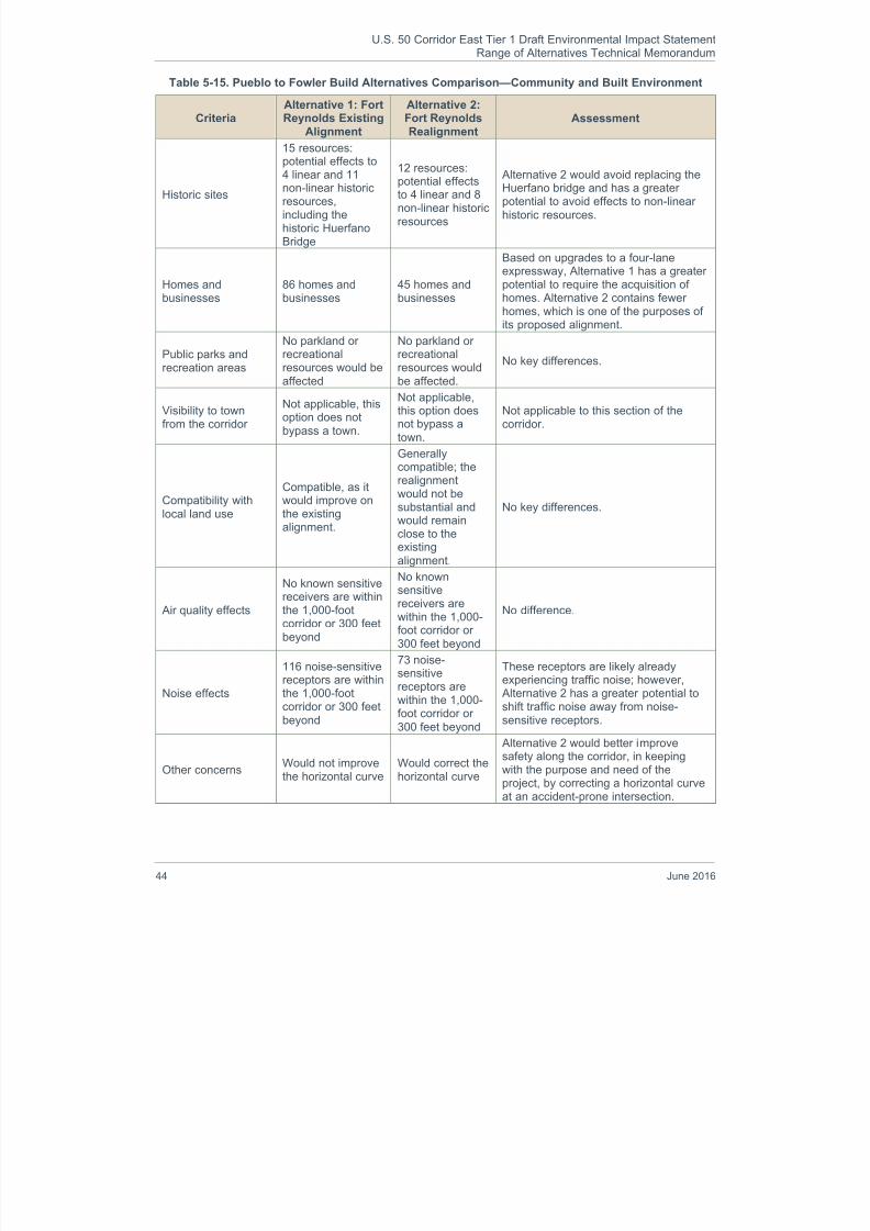
8/16/2019 B: Range Alternatives Tech Report
http://slidepdf.com/reader/full/b-range-alternatives-tech-report 48/86
U.S. 50 Corridor East Tier 1 Draft Environmental Impact StatementRange of Alternatives Technical Memorandum
44 June 2016
Table 5-15. Pueblo to Fowler Build Alternatives Comparison—Community and Built Environment
CriteriaAlternative 1: FortReynolds Existing
Alignment
Alternative 2:Fort ReynoldsRealignment
Assessment
Historic sites
15 resources:potential effects to
4 linear and 11non-linear historicresources,including thehistoric HuerfanoBridge
12 resources:
potential effectsto 4 linear and 8non-linear historicresources
Alternative 2 would avoid replacing theHuerfano bridge and has a greaterpotential to avoid effects to non-linearhistoric resources.
Homes andbusinesses
86 homes andbusinesses
45 homes andbusinesses
Based on upgrades to a four-laneexpressway, Alternative 1 has a greaterpotential to require the acquisition ofhomes. Alternative 2 contains fewerhomes, which is one of the purposes ofits proposed alignment.
Public parks andrecreation areas
No parkland or
recreationalresources would beaffected
No parkland or
recreationalresources wouldbe affected.
No key differences.
Visibility to townfrom the corridor
Not applicable, thisoption does notbypass a town.
Not applicable,this option doesnot bypass atown.
Not applicable to this section of thecorridor.
Compatibility withlocal land use
Compatible, as itwould improve onthe existing
alignment.
Generallycompatible; therealignmentwould not besubstantial andwould remain
close to theexistingalignment.
No key differences.
Air quality effects
No known sensitivereceivers are withinthe 1,000-footcorridor or 300 feetbeyond
No knownsensitivereceivers arewithin the 1,000-foot corridor or300 feet beyond
No difference.
Noise effects
116 noise-sensitivereceptors are withinthe 1,000-foot
corridor or 300 feetbeyond
73 noise-sensitivereceptors arewithin the 1,000-
foot corridor or300 feet beyond
These receptors are likely alreadyexperiencing traffic noise; however, Alternative 2 has a greater potential to
shift traffic noise away from noise-sensitive receptors.
Other concernsWould not improvethe horizontal curve
Would correct thehorizontal curve
Alternative 2 would better improvesafety along the corridor, in keepingwith the purpose and need of theproject, by correcting a horizontal curveat an accident-prone intersection.

8/16/2019 B: Range Alternatives Tech Report
http://slidepdf.com/reader/full/b-range-alternatives-tech-report 49/86
U.S. 50 Corridor East Tier 1 Draft Environmental Impact StatementRange of Alternatives Technical Memorandum
June 2016 45
CriteriaAlternative 1: FortReynolds Existing
Alignment
Alternative 2:Fort ReynoldsRealignment
Assessment
Corridor with LeastImpacts onCommunity andBuilt Environment
Alternative 2 would improve safety whilealso minimizing potential impacts to thecommunity and built environment byhaving greater opportunity to avoid the
acquisition of homes and businesses,shift traffic away from noise-sensitivereceptors, and avoid adversely affectingthe historic Huerfano Bridge.
The two Build Alternatives in this section of the corridor do not differ greatly because they generally followthe same alignment until near the Fort Reynolds area. However, Alternative 2: Fort Reynolds Realignment,has the ability to better meet the purpose and need of the project while also minimizing impacts to thecommunity and built environment. Therefore, it was preliminarily identified as the Preferred Alternative at thislocation.
Fowler Build Alternatives
The two Build Alternatives considered around Fowler are shown in Figure 5-11. Both alternatives weredeveloped with community input. Alternative 1: Fowler North would be located between the BNSF Railwaytracks and the Arkansas River. Alternative 2: Fowler South extends nearly a mile south of town to stay southof Oxford Farmers Ditch, a major irrigation canal.
Figure 5-11. Fowler Build Alternatives
Alternative 1: Fowler North is closer to town, and thus would provide a much more convenient and visiblegateway into town. In a community workshop, Fowler residents indicated that they would like the corridor togo north, through floodplains with limited development potential, rather than go south, which would result in aloss of highly productive farmland and ranch lands. However; because Alternative 1 is located close to the Arkansas River, there would be much greater impacts to wetland/riparian areas, amounting to approximately

8/16/2019 B: Range Alternatives Tech Report
http://slidepdf.com/reader/full/b-range-alternatives-tech-report 50/86
U.S. 50 Corridor East Tier 1 Draft Environmental Impact StatementRange of Alternatives Technical Memorandum
46 June 2016
25 acres. Alternative 1 crosses through a 100-year floodplain, which would increase the risk of flooding ofthe road and surrounding resources such as residences. Additionally, Alternative 1 would be situated tocross through the Cottonwood Links Golf Course. The public and Fowler town officials were aware ofpossible effects to the nine-hole, publicly owned Cottonwood Links Golf Course and suggested modificationsto the course that would accommodate the north corridor.
Alternative 2: Fowler South would affect more agricultural land than the north corridor, in part because the
south corridor is nearly 1.5 miles longer. Also, the quality of the agricultural land is better south of town thanit is to the north. In a community workshop, Fowler residents indicated that they would like the corridor to gonorth, through floodplains with limited development potential, rather than go south with the resulting loss offarmland.
Ecologically, the north corridor would affect more wetland/riparian areas and floodplains because it is muchcloser to the Arkansas River.
Alternative 1: Fowler North would likely require land from several holes on the nine-hole, publicly ownedCottonwood Links Golf Course. Town officials indicated their willingness to accept modifications to thecourse to accommodate the north corridor.
Evaluation of the resources and issues identified for these Build Alternatives in Fowler resulted in the
findings summarized in Table 5-16, Table 5-17, and Table 5-18.
Table 5-16. Fowler Build Alternatives Comparison—Rural and Agricultural Environment
CriteriaAlternative 1:Fowler North
Alternative 2:Fowler South
Assessment
Agricultural land (25percent of theresource within the1,000-foot corridor)
51 acres ofcorn/alfalfafarmland
38 acres of
grazing land
Total: 89 acres
144 acres ofcorn/alfalfafarmland
2 acres of
grazing land
Total: 146 acres
Alternative 1 would pass throughagricultural land in less quantity and oflower quality than the much longer Alternative 2.
Impacts onagriculturaloperations
Grazing landwould befragmented bynew highway
Would cross manyfields diagonally,rather than alongtheir boundarylines, resulting infield fragmentation
Alternative 1 would be less likely tointerfere with agricultural operationsthan the south corridor, due to thediagonal orientation of the latter.
Corridor with LeastImpacts on Ruraland AgriculturalEnvironment
Alternative 1 would consume less farmland and result in less fragmentation offields.

8/16/2019 B: Range Alternatives Tech Report
http://slidepdf.com/reader/full/b-range-alternatives-tech-report 51/86
U.S. 50 Corridor East Tier 1 Draft Environmental Impact StatementRange of Alternatives Technical Memorandum
June 2016 47
Table 5-17. Fowler Build Alternatives Comparison—Natural Environment
CriteriaAlternative 1:Fowler North
Alternative 2:Fowler South
Assessment
Wetland/
riparian areas
(25 percent of theresource within the1,000-foot corridor)
Acres by category
I (best): 11
II: 5
III: 7IV: 2
Total: 25
Acres by category
I (best): 2
II: 1
III: 1IV: 3
Total: 1
There is more acreage of wetland andriparian areas in Alternative 1, and it
appears to be of higher quality, than Alternative 2. The likelihood of avoidingimpacts is better by going south.
Arkansas River
No new crossingsneeded, but theNorth corridorwould locate thehighway closer tothe river than it istoday
No new crossingsneeded
Due to the potential for indirect,proximity effects to the Arkansas River,although minimal, Alternative 2 wouldbe preferable with regard to thiscriterion.
Wildlife
Majority (76percent) ofpotential wildlifehabitat impact is toareas agriculturalland, with 23percent being towetland/ riparianareas; would alsobe closer to the Arkansas River,slightly increasingroadkill potential
No known issues;majority (93percent) ofpotential habitat isagricultural land.
Not a key consideration because wildlifepresence and road mortality is minimalaround this long-established farmingcommunity. However, Alternative 1 hasa greater potential for impact to morevaluable wildlife habitat because of agreater presence of wetland/ riparianareas.
Corridor with LeastImpacts on NaturalEnvironment
Alternative 1 islocated in a 100-year floodplain,and has far moreacres ofwetland/riparianareas than Alternative 2.
Alternative 2 has fewer acres ofwetland/riparian areas, and this acreageis of lesser ecological value than theacreage in the north corridor, which isvery close to the Arkansas River.

8/16/2019 B: Range Alternatives Tech Report
http://slidepdf.com/reader/full/b-range-alternatives-tech-report 52/86
U.S. 50 Corridor East Tier 1 Draft Environmental Impact StatementRange of Alternatives Technical Memorandum
48 June 2016
Table 5-18. Fowler Build Alternatives Comparison—Community and Built Environment
CriteriaAlternative 1:Fowler North
Alternative 2:Fowler South
Assessment
Historic sites
3 resources:corridor includes ahouse built in
1894; would addtwo crossings ofthe historicrailroad and alsocross the OteroCanal twice
2 resources:would cross the
historic OxfordFarmers’ Ditchtwice and theHighline Canalonce
Adverse effects to the house may be
avoidable, but crossings of canals andrailroads likely cannot be avoided. Theeffects for each alternative are relativelyminimal and comparable.
Homes andbusinesses
7 homes andbusinesses arewithin the 1,000-foot corridor
11 homes andbusinesses arewithin the 1,000-foot corridor
No difference. Most of these resourceslikely can be avoided when a 250-foothighway right of way is determined.Fowler is a community with anestimated 597 homes/housing units(2010 Census).
Public parks andrecreation areas
Includes the
town’s public golfcourse, and islikely to requireland from severalof its holes
None
Impacts to this nine-hole golf course will
be avoided, minimized and mitigated,but the net effect cannot be determinedat the level of analysis of this Tier 1 EIS. Alternative 2 would avoid any directimpacts to this resource.
Visibility to townfrom the corridor
The north corridoris close to town,providing aneffective“gateway” intotown
The south corridoris about a mile outof town, notproviding aneffective“gateway”
Alternative 1 is preferable with regard tothis criterion.
Compatibility withlocal land use
Would consumeland with limited
developmentpotential due toadjacentfloodplains
Would consume
land that hasbetterdevelopmentpotential
Alternative 1 is preferable with regard tothis criterion.
Air quality effects
No knownsensitive receiversare within the1,000-foot corridoror 300 feet beyond
No knownsensitive receiversare within the1,000-foot corridoror 300 feet beyond
These comparable effects do not favorone alternative over the other. The townhas no major air quality problems.Either alternative would take through-traffic away from the main populatedarea. Because it is longer, Alternative 2would slightly increase vehicularemissions.
Noise effects
14 homes andbusinesses and agolf course arewithin the 1,000-foot corridor or300 feet beyond
18 homes andbusinesses arewithin the 1,000-foot corridor or300 feet beyond
The difference in the number of
potential noise receivers is not a keyconsideration in this community of 597homes (2010 Census). With eitherlocation, through-traffic would berelocated away from the main populatedarea.

8/16/2019 B: Range Alternatives Tech Report
http://slidepdf.com/reader/full/b-range-alternatives-tech-report 53/86
U.S. 50 Corridor East Tier 1 Draft Environmental Impact StatementRange of Alternatives Technical Memorandum
June 2016 49
CriteriaAlternative 1:Fowler North
Alternative 2:Fowler South
Assessment
Other concernsTwo new railroadcrossings wouldbe needed
No new railroadcrossings will beadded
The two new crossings needed for Alternative 1 would add project expenseand time needed for coordination withthe railroad.
Corridor with LeastImpacts onCommunity andBuilt Environment
(tie)
(tie)
Alternative 1 is much closer and morevisible to town (i.e., provides a bettergateway to town). Alternative 2 avoidsimpacts to the publicly owned golfcourse, as well as the need for twocostly crossings of a historic railroad.
Alternative 1 would have fewer adverse impacts on agriculture, while Alternative 2 would have fewer effectson the natural environment. The two Build Alternatives are comparable in their effects on the community andbuilt environment, as well as their ability to meet the purpose and need of the project. As each alternativehas its tradeoffs in the three categories, no Preferred Alternative could be preliminarily identified at thislocation and both Build Alternatives are carried forward for Tier 2 analysis.
Manzanola Build Alternatives
Figure 5-12 shows the two Build Alternatives considered around Manzanola. Alternative 1: Manzanola Northwould require a new railroad crossing west of town and remain north of the railroad tracks east of the town. Alternative 2: Manzanola South would remain south of the tracks until crossing them east of town as U.S. 50does today. Both Build Alternatives are of comparable length at a little over 2.5 miles long and comparabledistance from the existing highway.
Figure 5-12. Manzanola Build Alternatives
The acreage of potentially affected farm/ranch land and riparian/wetland area is comparable for the twocorridors, but Alternative 1: Manzanola North contains less productive agricultural land.

8/16/2019 B: Range Alternatives Tech Report
http://slidepdf.com/reader/full/b-range-alternatives-tech-report 54/86
U.S. 50 Corridor East Tier 1 Draft Environmental Impact StatementRange of Alternatives Technical Memorandum
50 June 2016
In a community workshop, Manzanola residents indicated that they would like the corridor to be locatednorth, in part because they felt that the community’s potential future growth was likely to occur south of town.
Evaluation of the resources and issues identified for these Build Alternatives in Manzanola resulted in thefindings summarized in Table 5-19, Table 5-20, and Table 5-21.
Table 5-19. Manzanola Build Alternatives Comparison—Rural and Agricultural Environment
CriteriaAlternative 1:
Manzanola NorthAlternative 2:
Manzanola SouthAssessment
Agricultural land (25percent of theresource within the1,000-foot corridor)
0 acres ofvegetablefarmland
56 acres of
corn/alfalfa
farmland
22 acres of
grazing land
Total: 78 acres
14 acres ofvegetablefarmland
58 acres ofcorn/alfalfa
farmland
5 acres of
grazing land
Total: 77 acres
Both alternatives would pass through acomparable total amount of agriculturalland, but Alternative 1 includes lower-quality grazing land while Alternative 2includes higher-quality vegetablefarmland. Therefore Alternative 1 wouldbe preferable in terms of agriculturalproductivity.
Impacts onagriculturaloperations
Would cross somefields diagonally,possibly leavingunusableremnants
Would cross somefields diagonally,possibly leavingunusableremnants
No key differences.
Corridor with LeastImpacts on Ruraland AgriculturalEnvironment
Each option includes approximately thesame amount of agricultural land, butthe acreage in Alternative 1 is lessproductive than that in Alternative 2.

8/16/2019 B: Range Alternatives Tech Report
http://slidepdf.com/reader/full/b-range-alternatives-tech-report 55/86
U.S. 50 Corridor East Tier 1 Draft Environmental Impact StatementRange of Alternatives Technical Memorandum
June 2016 51
Table 5-20. Manzanola Build Alternatives Comparison—Natural Environment
CriteriaAlternative 1:
Manzanola NorthAlternative 2:
Manzanola SouthAssessment
Wetland/
riparian areas
(25 percent of theresource within the1,000-foot corridor)
Acres by category
I (best): 1
II: 0
III: 2IV: 2
Total: 5
Acres by category
I (best): 3
II: 1
III: 0IV: 0
Total: 4
There is comparable acreage ofwetland and riparian areas in the two
corridors, but the resources in Alternative 2 appear to be of slightlyhigher quality than those in Alternative1.
Arkansas RiverNo new crossingsneeded
No new crossingsneeded
No difference.
Wildlife
Majority (82percent) of habitatimpacts toagricultural land;no known issues
Majority (91percent) of habitatimpacts toagricultural land;no known issues
No difference; both make comparableimpacts to low-quality wildlife habitat.
Corridor with LeastImpacts on NaturalEnvironment
(tie) (tie)
Each alternative includes approximately
the same amount of wetland/riparianarea, and would have relatively equalimpacts to the natural environment. Nokey differences.

8/16/2019 B: Range Alternatives Tech Report
http://slidepdf.com/reader/full/b-range-alternatives-tech-report 56/86
U.S. 50 Corridor East Tier 1 Draft Environmental Impact StatementRange of Alternatives Technical Memorandum
52 June 2016
Table 5-21. Manzanola Build Alternatives Comparison—Community and Built Environment
CriteriaAlternative 1:
Manzanola NorthAlternative 2:
Manzanola SouthAssessment
Historic sites
3 resources:corridor includes ahistoric railroad
trestle; would adda new crossing ofa historic railroadand of the CatlinCanal
2 resources:would newly cross
the Catlin Canalonce and theOtero Canal twice
With Alternative 1, the trestle likely canbe avoided, but canals and railroads
likely must be crossed. The effects foreach alternative are relatively minimaland comparable.
Homes andbusinesses
14 homes andbusinesses arewithin the 1,000-foot corridor
8 homes andbusinesses arewithin the 1,000-foot corridor
Most of these resources likely can beavoided when a 250-foot highway rightof way is determined. Alternative 1 isslightly preferable. Manzanola has only198 homes/housing units (2010Census).
Public parks andrecreation areas
Would crossPronghorn Trail
Would crossPronghorn Trail
No difference.
Visibility to townfrom the corridor
Is close enough toprovide aneffective“gateway” intotown
Is close enough toprovide aneffective“gateway” intotown
No difference.
Compatibility withlocal land use
Developmentpotential north oftown is limited byfloodplains
Land south oftown has betterdevelopmentpotential
The town does not have an adoptedland use plan. Citizen comments atopen house meeting indicatedpreference for north corridor as thetown is more likely to grow to the south.
Air quality effects
No knownsensitive receiversare within thecorridor or 300feet beyond
One sensitive
receiver is withinthis corridor or 300feet beyond
These comparable effects do not favorone alternative location over the other.
The town has no major air qualityproblems. Either alternative would takethrough-traffic away from the mainpopulated area.
Noise effects
39 homes andbusinesses arewithin the corridoror 300 feet beyond
21 homes andbusinesses arewithin the corridoror 300 feet beyond
With either location, through-trafficwould be relocated away from the mainpopulated area.
Other concernsTwo new railroadcrossings needed
No new railroadcrossings needed
The two new crossings for Alternative 1would add project expense and timeneeded for coordination with therailroad.
Corridor with LeastImpacts onCommunity andBuilt Environment
Alternative 1 is slightly preferable basedon community impacts, includingconsideration of citizen input.

8/16/2019 B: Range Alternatives Tech Report
http://slidepdf.com/reader/full/b-range-alternatives-tech-report 57/86

8/16/2019 B: Range Alternatives Tech Report
http://slidepdf.com/reader/full/b-range-alternatives-tech-report 58/86
U.S. 50 Corridor East Tier 1 Draft Environmental Impact StatementRange of Alternatives Technical Memorandum
54 June 2016
The Build Alternatives have comparable impacts to wetland/riparian resources, but, Alternative 1 is adjacentto Arkansas River floodplains. However, the community has zoned several properties for light industrial use,out of the floodplain, in an effort to develop an industrial park.
Evaluation of the resources and issues identified for these Build Alternatives in Rocky Ford resulted in thefindings summarized in Table 5-22, Table 5-23, Table 5-24.
Table 5-22. Rocky Ford Build Alternatives Comparison—
Rural and Agricultural Environment
CriteriaAlternative 1:Rocky Ford
North
Alternative 2:Rocky Ford
SouthAssessment
Agricultural land (25percent of theresource within the1,000-foot corridor)
170 acres ofvegetable
farmland
0 acres ofcorn/alfalfa
farmland
66 acres ofgrazing land
Total: 236 acres
164 acres ofvegetable
farmland
59 acres ofcorn/alfalfa
farmland
25 acres ofgrazing land
Total: 248 acres
Alternative 1 (6.6 miles long) wouldpass through fewer acres of agriculturalland than the longer (8.2-mile) Alternative 2 in the vicinity of thiscommunity that is well known for itsproduce, including cantaloupe,watermelons and much more.
The overall impacts to agricultural landare similar at this location.
Impacts onagriculturaloperations
The north corridorincludes a 10-acrefeedlot forlivestock
To minimize fieldfragmentation, thiscorridor goesprimarily north-south and theneast-west.
These considerations do not clearlyfavor one corridor over the other.
Corridor with LeastImpacts on Rural
and AgriculturalEnvironment
(tie)
(tie)
Although Alternative 1 would have aslightly less adverse effect on total
agricultural land impacted, bothalternatives would impact highlyproductive farmland.

8/16/2019 B: Range Alternatives Tech Report
http://slidepdf.com/reader/full/b-range-alternatives-tech-report 59/86
U.S. 50 Corridor East Tier 1 Draft Environmental Impact StatementRange of Alternatives Technical Memorandum
June 2016 55
Table 5-23. Rocky Ford Build Alternatives Comparison—Natural Environment
CriteriaAlternative 1:Rocky Ford
North
Alternative 2:Rocky Ford
SouthAssessment
Wetland/riparianareas(25 percent of theresource within thecorridor)
Acres by category
I (best): 0
II: 4III: 6
IV: 0
Total: 10
Acres by category
I (best): 1
II: 2III: 10
IV: 0
Total: 13
The quality of the wetland and riparian
areas in the two corridors arecomparable, with Alternative 2 havingslightly more impacts to wetlands.
Arkansas RiverNo new crossingsneeded
No new crossingsneeded
Alternative 1 ranges from a half-mile to0.8 mile away from the Arkansas River,which is not a key issue.
Wildlife
Majority (92percent) of habitatimpacts toagricultural land;no known issues
Majority (84percent) of habitatimpacts toagricultural land;no known issues
Not a major consideration becausewildlife presence and road mortality isminimal here, in this long-establishedfarming community.
Corridor with LeastImpacts on NaturalEnvironment
(tie)
(tie)
Ecological considerations do not favorone alternative over the other. Thedifference in wetland impacts is notsubstantial.
Table 5-24. Rocky Ford Build Alternative Comparison—Community and Built Environment
CriteriaAlternative 1:Rocky Ford
North
Alternative 2:Rocky Ford
SouthAssessment
Historic sites
3 resources:
2 canals, probablyresulting in only 1crossing;1 crossing of theBNSF railway
7 resources:1 farm or ranchbuilding (barn);
1 canal structure;4 canals, to becrossed a total of7 times;1 railroad to benewly crossedtwice
The barn and canal structure likely can
be avoided. The railroad and canalslikely must be crossed. The effects foreach alternative are relatively minimal.The large number of canal and railroadcrossings makes Alternative 1preferable.
Homes andbusinesses
36 homes andbusinesses arewithin the 1,000-foot corridor
14 homes andbusinesses arewithin the 1,000-foot corridor
Some of these resources likely can beavoided when a highway right of way isdetermined. The difference of 22 homesand businesses in this community of1,869 homes/housing units (2010
Census) favors Alternative 2.Public parks andrecreation areas
Would cross thePronghorn Trail
Would cross thePronghorn Trail
No difference.
Visibility to townfrom the corridor
The north corridoris close to town,providing aneffective“gateway” intotown
The south corridoris about a mile outof town, notproviding aneffective“gateway”
Alternative 1 is preferable with regard tothis criterion. According to citizen input,the gateway issue is an importanteconomic issue for the city.

8/16/2019 B: Range Alternatives Tech Report
http://slidepdf.com/reader/full/b-range-alternatives-tech-report 60/86
U.S. 50 Corridor East Tier 1 Draft Environmental Impact StatementRange of Alternatives Technical Memorandum
56 June 2016
CriteriaAlternative 1:Rocky Ford
North
Alternative 2:Rocky Ford
SouthAssessment
Compatibility withlocal land use
Would providegood access tofairgrounds andthe city’s
industrial park
Could slightlyincrease traffic onSH 71 through
neighborhoods
Alternative 1 is preferable with regard tothis criterion by providing good access toimportant community resources.
Air quality effects
No knownsensitivereceivers arewithin the corridoror 300 feetbeyond
No knownsensitivereceivers arewithin the corridoror 300 feetbeyond
No difference in the number of sensitivereceivers. The town has no major airquality problems. Both alterntaives wouldmove highway emissions out of the mainpopulated area. Alternative 2 would taketraffic farther away from the population,but also increase total vehicle milestraveled (vmt).
Noise effects
63 homes andbusinesses arewithin the corridoror 300 feetbeyond
27 homes andbusinesses arewithin the corridoror 300 feetbeyond
With either location, through-traffic wouldbe relocated away from the mainpopulated area.
Other concernsWould require 2new railroadcrossings
Would not requireany new railroadcrossings
The two new crossings needed for the Alternative 1 would add project expenseand time needed for coordination withthe railroad.
Corridor with LeastImpacts onCommunity andBuilt Environment
Community impacts seem generallycomparable, but according to citizeninput, Alternative 1 is preferable due toits better land use compatibility andgateway potential.
The Build Alternatives at Rocky Ford generally were comparable when looking at the screening criteria, aswell as in their ability to meet the purpose and need of the project, except when considering the communityand built environment. Alternative 1: Rocky Ford North has a greater potential to minimize effects to historicresources and received greater community support. Having an alignment close to town was important for thecommunity, both for having an effective “gateway” into the town and to provide adequate access to theirfairgrounds and industrial park. Therefore, Alternative 1: Rocky Ford North was preliminarily identified as thePreferred Alternative at this location.
Swink Build Alternatives
Figure 5-14 shows the two Build Alternatives considered around Swink. Both alternatives are located closeto town, and they are of comparable length. Alternative 1: Swink North is located close to the ArkansasRiver, while Alternative 2: Swink South traverses highly productive farmland.

8/16/2019 B: Range Alternatives Tech Report
http://slidepdf.com/reader/full/b-range-alternatives-tech-report 61/86
U.S. 50 Corridor East Tier 1 Draft Environmental Impact StatementRange of Alternatives Technical Memorandum
June 2016 57
Figure 5-14. Swink Build Alternatives
Alternative 1: Swink North includes 14 of the town’s 286 homes or housing units (2010 Census) compared tosix homes in Alternative 2: Swink South. However, Alternative 2 runs ad jacent to the town’s school facilit ies,which are key community assets. The school district is also a major employer in the town. Noise, airpollution, and traffic near the school grounds were noted as public concerns at a community meeting. Theschool site is one of two air quality-sensitive sites in the south corridor, compared to none in the northcorridor. More farm/ranch land is included in Alternative 2, and its productivity is approximately three timeshigher than the farm/ranch land in Alternative 1.
Evaluation of the resources and issues identified for the Build Alternatives in Swink resulted in the findingssummarized in Table 5-25, Table 5-26, and Table 5-27.
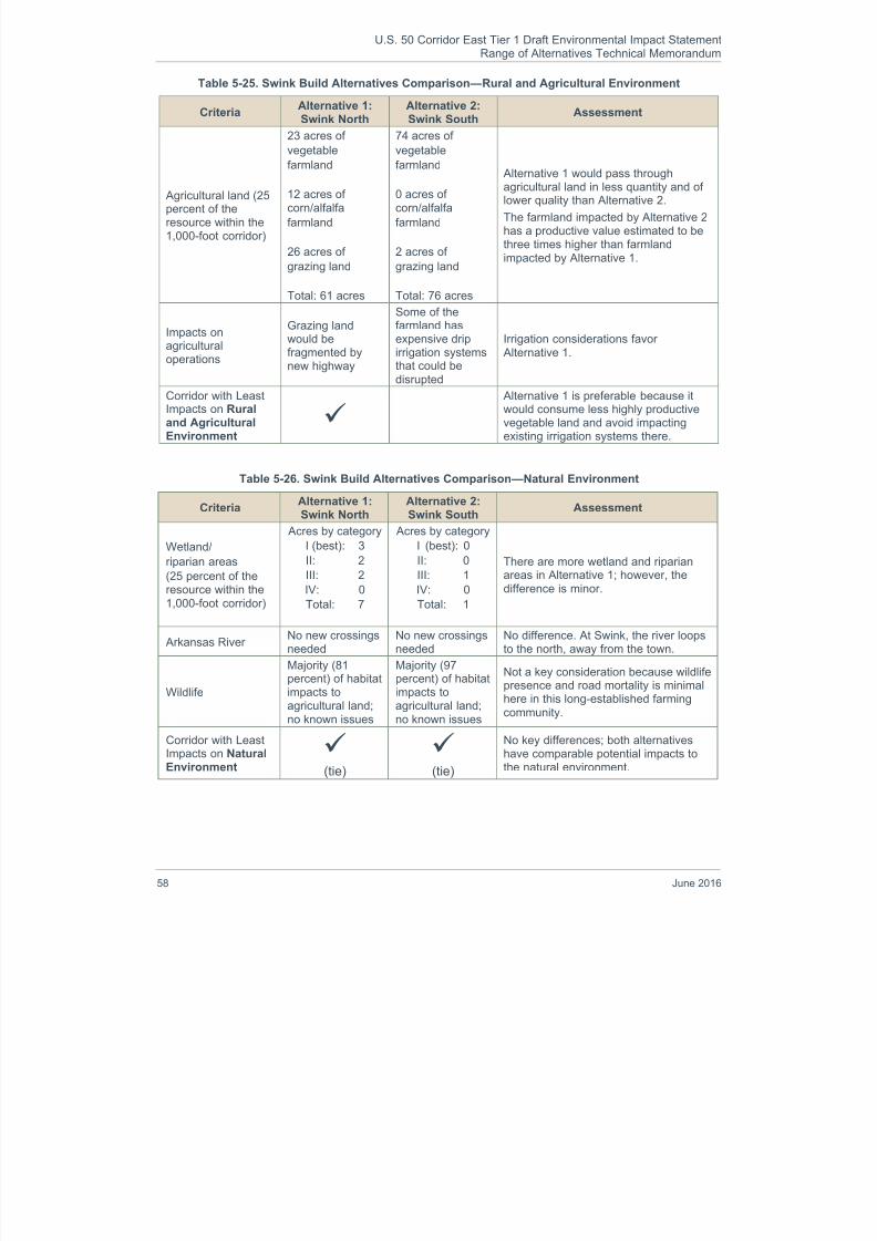
8/16/2019 B: Range Alternatives Tech Report
http://slidepdf.com/reader/full/b-range-alternatives-tech-report 62/86
U.S. 50 Corridor East Tier 1 Draft Environmental Impact StatementRange of Alternatives Technical Memorandum
58 June 2016
Table 5-25. Swink Build Alternatives Comparison—Rural and Agricultural Environment
CriteriaAlternative 1:Swink North
Alternative 2:Swink South
Assessment
Agricultural land (25percent of theresource within the1,000-foot corridor)
23 acres of
vegetable
farmland
12 acres ofcorn/alfalfa
farmland
26 acres of
grazing land
Total: 61 acres
74 acres of
vegetable
farmland
0 acres ofcorn/alfalfa
farmland
2 acres of
grazing land
Total: 76 acres
Alternative 1 would pass throughagricultural land in less quantity and oflower quality than Alternative 2.
The farmland impacted by Alternative 2has a productive value estimated to bethree times higher than farmlandimpacted by Alternative 1.
Impacts onagricultural
operations
Grazing landwould be
fragmented bynew highway
Some of thefarmland hasexpensive drip
irrigation systemsthat could bedisrupted
Irrigation considerations favor
Alternative 1.
Corridor with LeastImpacts on Ruraland AgriculturalEnvironment
Alternative 1 is preferable because itwould consume less highly productivevegetable land and avoid impactingexisting irrigation systems there.
Table 5-26. Swink Build Alternatives Comparison—Natural Environment
CriteriaAlternative 1:Swink North
Alternative 2:Swink South
Assessment
Wetland/
riparian areas(25 percent of theresource within the1,000-foot corridor)
Acres by categoryI (best): 3
II: 2
III: 2
IV: 0
Total: 7
Acres by categoryI (best): 0
II: 0
III: 1
IV: 0
Total: 1
There are more wetland and riparianareas in Alternative 1; however, thedifference is minor.
Arkansas RiverNo new crossingsneeded
No new crossingsneeded
No difference. At Swink, the river loopsto the north, away from the town.
Wildlife
Majority (81percent) of habitatimpacts toagricultural land;
no known issues
Majority (97percent) of habitatimpacts toagricultural land;
no known issues
Not a key consideration because wildlifepresence and road mortality is minimalhere in this long-established farming
community.
Corridor with LeastImpacts on NaturalEnvironment
(tie)
(tie)
No key differences; both alternativeshave comparable potential impacts tothe natural environment.
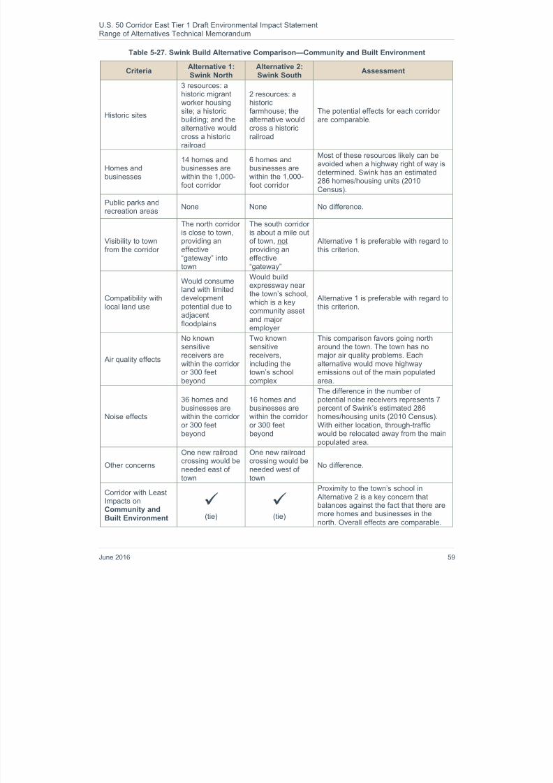
8/16/2019 B: Range Alternatives Tech Report
http://slidepdf.com/reader/full/b-range-alternatives-tech-report 63/86
U.S. 50 Corridor East Tier 1 Draft Environmental Impact StatementRange of Alternatives Technical Memorandum
June 2016 59
Table 5-27. Swink Build Alternative Comparison—Community and Built Environment
CriteriaAlternative 1:Swink North
Alternative 2:Swink South
Assessment
Historic sites
3 resources: ahistoric migrantworker housing
site; a historicbuilding; and thealternative wouldcross a historicrailroad
2 resources: ahistoric
farmhouse; thealternative wouldcross a historicrailroad
The potential effects for each corridorare comparable.
Homes andbusinesses
14 homes andbusinesses arewithin the 1,000-foot corridor
6 homes andbusinesses arewithin the 1,000-foot corridor
Most of these resources likely can beavoided when a highway right of way isdetermined. Swink has an estimated286 homes/housing units (2010Census).
Public parks andrecreation areas
None None No difference.
Visibility to townfrom the corridor
The north corridoris close to town,providing aneffective“gateway” intotown
The south corridoris about a mile outof town, notproviding aneffective“gateway”
Alternative 1 is preferable with regard tothis criterion.
Compatibility withlocal land use
Would consumeland with limiteddevelopmentpotential due toadjacentfloodplains
Would buildexpressway nearthe town’s school,which is a keycommunity assetand majoremployer
Alternative 1 is preferable with regard tothis criterion.
Air quality effects
No knownsensitivereceivers arewithin the corridoror 300 feetbeyond
Two knownsensitivereceivers,including thetown’s schoolcomplex
This comparison favors going northaround the town. The town has nomajor air quality problems. Eachalternative would move highwayemissions out of the main populatedarea.
Noise effects
36 homes andbusinesses arewithin the corridoror 300 feetbeyond
16 homes andbusinesses arewithin the corridoror 300 feetbeyond
The difference in the number ofpotential noise receivers represents 7percent of Swink’s estimated 286homes/housing units (2010 Census).With either location, through-trafficwould be relocated away from the mainpopulated area.
Other concerns
One new railroadcrossing would beneeded east oftown
One new railroadcrossing would beneeded west oftown
No difference.
Corridor with LeastImpacts onCommunity andBuilt Environment
(tie)
(tie)
Proximity to the town’s school in Alternative 2 is a key concern thatbalances against the fact that there aremore homes and businesses in thenorth. Overall effects are comparable.

8/16/2019 B: Range Alternatives Tech Report
http://slidepdf.com/reader/full/b-range-alternatives-tech-report 64/86
U.S. 50 Corridor East Tier 1 Draft Environmental Impact StatementRange of Alternatives Technical Memorandum
60 June 2016
Because each Build Alternative considered in Swink has advantages, and the alternatives are comparable intheir ability to meet the purpose and need of the project, no Preferred Alternative was preliminarily identified.Therefore, each is carried forward for Tier 2 analysis.
La Junta Build Alternatives
The four Build Alternatives considered around La Junta are shown in Figure 5-15. One of the alternativescrosses the Arkansas River to the north (Alternative 1: La Junta North), while the other three are located
south of the city (Alternatives 2 –4). Alternative 3: La Junta South was developed during public involvementefforts for the Tier 1 EIS, as a requested compromise between the other two southern corridors, which hadbeen identified in the 2003 U.S. 50 planning study.
Figure 5-15. La Junta Build Alternatives
Alternative 1: La Junta North is the second shortest (8.9 miles length) of the four Build Alternatives aroundthe city, and would have minimal effects on the La Junta Gardens residential area north of the ArkansasRiver. However, it would require the construction of two new bridges across the Arkansas River, which wouldbe a major ecological drawback.
Alternative 1: La Junta North and has the greatest amount of wetland/riparian acres (28 acres). In addition,some of the wetland/riparian acres in the southern alternatives may be avoided because they are isolated orare not perpendicular to the corridor. However, these opportunities for avoidance are not possible with Alternative 1 because it crosses the Arkansas River.
The most striking differences among the three southern Build Alternatives are their comparative lengths anddistances from the existing U.S. 50 facility.
Compared with the current trip on U.S. 50 from west of Swink to the east side of La Junta, which isapproximately six miles, the Build Alternatives are as follows:
Alternative 1: La Junta North is about 2.9 miles longer and 1.5 miles north. Alternative 2: La Junta South is about 2.5 miles longer and 2 miles south

8/16/2019 B: Range Alternatives Tech Report
http://slidepdf.com/reader/full/b-range-alternatives-tech-report 65/86
U.S. 50 Corridor East Tier 1 Draft Environmental Impact StatementRange of Alternatives Technical Memorandum
June 2016 61
Alternative 3: La Junta South is about 4 miles longer, and 2.3 miles south
Alternative 4: La Junta South is about 6 miles longer, and 3.3 miles south
Alternative 4 would add six miles to the length of a regional or long-distance trip on U.S. 50, and thus wouldbe twice as long as the current route through the city. At 65 miles per hour, this route would not save timecompared to taking the existing U.S. 50 through the city at lower speeds and stopping at a traffic signal.Instead, Alternative 4 would add two minutes of travel time to the trip. For this reason, Alternative 4 would be
expected to draw minimal traffic, not providing the intended benefits. In comparison, Alternative 3 would betime-neutral, and Alternative 2 would save travel time.
Evaluation of the resources and issues identified for the Build Alternatives in La Junta resulted in the findingssummarized in Table 5-28, Table 5-29, and Table 5-30.
Table 5-28. La Junta Build Alternatives Comparison—Rural and Agricultural Environment
CriteriaAlternative1: La Junta
North
Alternative2: La Junta
South
Alternative3: La Junta
South
Alternative4: La Junta
SouthAssessment
Agriculturalacres (25percent of theresourcewithin the1,000-footcorridor)
7 acres of
vegetable
farmland
16 acres ofcorn/alfalfa
farmland
239 acres of
grazing land
Total: 262acres
39 acres of
vegetable
farmland
3 acres ofcorn/alfalfa
farmland
211 acres of
grazing land
Total: 253acres
48 acres of
vegetable
farmland
0 acres ofcorn/alfalfa
farmland
246 acres of
grazing land
Total: 294acres
48 acres of
vegetable
farmland
17 acres ofcorn/alfalfa
farmland
294 acres of
grazing land
Total: 359acres
Alternatives 1, 2, and 3have comparable
agricultural impacts,with Alternative 4having the greatest dueto its length. However, Alternative 3 and Alternative 4 wouldhave the highestimpacts to productivevalue of agriculturallands ($216,000 –$223,000)
Impacts on
agriculturaloperations
Minimal landfragmentation
Diagonal
route wouldfragmentgrazing lands
Diagonal
route wouldfragmentgrazing lands
Diagonal
route wouldfragmentgrazing lands
Alternative 1 would be
very direct and causethe least fragmentationof agricultural lands.
Corridor withLeast Impactson Rural andAgriculturalEnvironment
(tie)
(tie)
Alternative 1 wouldlikely have the leasteffect on agriculturallands, although it doeshave slightly greateragricultural impactsthan Alternative 2. Inregards to the rural andagriculturalenvironment, though,
Alternatives 1 and 2have the least andcomparable impacts.

8/16/2019 B: Range Alternatives Tech Report
http://slidepdf.com/reader/full/b-range-alternatives-tech-report 66/86
U.S. 50 Corridor East Tier 1 Draft Environmental Impact StatementRange of Alternatives Technical Memorandum
62 June 2016
Table 5-29. La Junta Build Alternative Comparison—Natural Environment
CriteriaAlternative1: La Junta
North
Alternative2: La Junta
South
Alternative3: La Junta
South
Alternative4: La Junta
SouthAssessment
Wetland/
riparian areas(25 percent ofthe resourcewithin the1,000-footcorridor)
Acres bycategory
I (best): 9II: 3
III: 15
IV: 1
Total: 28
Acres by
categoryI (best): 1
II: 1
III: 11
IV: 2
Total: 15
Acres by
categoryI (best): 3
II: 7
III: 8
IV: 1
Total: 19
Acres by
categoryI (best): 3
II: 1
III: 7
IV: 0
Total: 11
Alternative 1 has thegreatest potential
wetland/riparianimpacts as well as thehighest qualitywetlands, while Alternatives 2 –4 havecomparable impacts tolower quality wetlands.
ArkansasRiver
Two newcrossingsneeded
No newcrossings
No newcrossings
No newcrossings
Alternative 1 hassignificant adverseeffects to the ArkansasRiver that can beavoided by any othercorridor.
Wildlife
Primarilyagricultural(39 percent)andgrasslands(44 percent);no knownissues
Primarilyagricultural(49 percent)andgrasslands(30 percent);no knownissues
Primarilyagricultural(44 percent)andgrasslands(44 percent);no knownissues
Primarilyagricultural(36 percent)andgrasslands(58 percent);no knownissues
No difference.
Corridor withLeast Impactson NaturalEnvironment
(tie)
(tie)
(tie)
Alternativess 2 –4 havecomparable impacts,with the fewestpotential impacts towetland/riparian areas
and are the leastharmful to the naturalenvironment. Alternative 1’s twocrossings of the Arkansas River and itsassociated wetlandsand riparian arearepresent a majorecological impact that isavoidable by keepingthe highway south ofthe river.

8/16/2019 B: Range Alternatives Tech Report
http://slidepdf.com/reader/full/b-range-alternatives-tech-report 67/86
U.S. 50 Corridor East Tier 1 Draft Environmental Impact StatementRange of Alternatives Technical Memorandum
June 2016 63
Table 5-30. La Junta Build Alternative Comparison—Community and Built Environment
CriteriaAlternative1: La Junta
North
Alternative2: La Junta
South
Alternative3: La Junta
South
Alternative4: La Junta
SouthAssessment
Historic sitesWithin the1,000-footcorridor
3 resources:
would crossrailroadtracks east ofcity, theSanta FeTrail, and ahistoric canal
3 resources:
would crossrailroad,Santa FeTrail, andOtero Canal(6 times)
4 resources:would cross
the samerailroad, trail,and canal (3times) as Alternative 2,plus an OteroDitch tunnel
3 resources:
would crossthe samerailroad, trail,and canal (3times) as Alternative 2
All of the alternativesare comparable. All
corridors would crossthe railroad once. Thethree southernalternatives all wouldcross the Otero Canaland the Santa Fe Trail.No substantialdifferences.
Homes andbusinesseswithin the1,000-footcorridor
6 18 14 5
Some of theseresources likely can beavoided when a 250-foot highway right ofway is determined. The
difference in numbersbetween alternatives isnot a majorconsideration in thiscommunity of 3,422homes/housing units(2010 Census); Alternative 1 and Alternative 4 have thefewest homes andbusinesses within theirrespective corridorslikely because they arefurther from downtown.
Public parksand recreationareas
Would crossthe PrairieCanyons andPlover trails
Would crossthe PrairieCanyons andPlover trails
Would crossthe PrairieCanyons andPlover trails
Would crossthe PrairieCanyons andPlover trails
No difference.
Visibility totown from thecorridor
The northcorridor isseparatedfrom the cityby the ArkansasRiver
2 miles southof existingU.S. 50 intown
2.3 milessouth ofexisting U.S.50 in town
3.3 milessouth ofexisting U.S.50 in town
Alternative 2 wouldkeep the highway morevisible and accessiblethan the otheralternatives.
Compatibilitywith local landuse
Is outside ofthe city
Is outside thecity’sdevelopedarea
Is outside thecity’sdevelopedarea
Reflected inCity plan
Bounded by the
railroad and river to thenorth, the city couldbenefit from having amain east-westthoroughfare in thesouth, so that residentsin the south would nothave to drive throughthe city to reach thehighway.

8/16/2019 B: Range Alternatives Tech Report
http://slidepdf.com/reader/full/b-range-alternatives-tech-report 68/86
U.S. 50 Corridor East Tier 1 Draft Environmental Impact StatementRange of Alternatives Technical Memorandum
64 June 2016
CriteriaAlternative1: La Junta
North
Alternative2: La Junta
South
Alternative3: La Junta
South
Alternative4: La Junta
SouthAssessment
Air qualityeffects
No sensitive
receptors
No
sensitive
receptors
No
sensitive
receptors
No
sensitive
receptors
No difference. Thetown has no air qualityproblems. Any newcorridor would shift
through-trafficemissions out of thecity’s downtown area. Alternatives 3 and 4are 2 and 4 mileslonger than Alternative2, so would result inincreased VMT
Noise effects
19 homesandbusinessesare within thecorridor or300 feetbeyond
48 homesandbusinessesare within thecorridor or300 feetbeyond
34 homesandbusinessesare within thecorridor or300 feetbeyond
15 homesandbusinessesare within thecorridor or300 feetbeyond
The small differencebetween the number ofreceptors for Alternative 2 and Alternative 3 is not a
key factor. Thecommunity has 3,422homes/housing units(2010 Census). Anynew corridor wouldrelocate through-trafficaway from the city’sdowntown area. Alternatives 1 and 4have the fewest noisereceptors due to beinglocated away from thedowntown area.
Otherconcerns
None None None
Would notbenefit usersdue to itsexcessivelength
More travel time wouldbe needed to use Alternative 4 than todrive through the cityon existing U.S.50. Bynot benefitting long-distance users, thiscorridor does not bestmeet the purpose andneed.

8/16/2019 B: Range Alternatives Tech Report
http://slidepdf.com/reader/full/b-range-alternatives-tech-report 69/86

8/16/2019 B: Range Alternatives Tech Report
http://slidepdf.com/reader/full/b-range-alternatives-tech-report 70/86
U.S. 50 Corridor East Tier 1 Draft Environmental Impact StatementRange of Alternatives Technical Memorandum
66 June 2016
Figure 5-16. Las Animas Build Alternatives
Alternative 1 includes 17 more acres of wetland/riparian area than Alternative 2 and would includereplacement of the existing U.S. 50 bridge over the Arkansas River. However, replacing the bridge may beless ecologically disruptive than building a new bridge downstream for the south corridor.
Alternative 1 includes a slightly greater number of homes than Alternative 2 (16 versus 9), but the differenceis minimal in comparison with the city’s total housing stock (1,214 homes). Alternative 1 would traverse landwith higher development potential, including vacant land that has existing utility infrastructure. An importantbenefit of Alternative 1: Las Animas North is that it leads westbound traffic into the city toward the existingU.S. 50, and thus provides a gateway into the downtown business district with minimal disruption to existing
traffic patterns. By contrast, Alternative 2: Las Animas South does not lead conveniently to downtown andinstead takes through-traffic past the prison.
Evaluation of the resources and issues identified for Build Alternatives in Las Animas resulted in the findingssummarized in Table 5-31, Table 5-32, and Table 5-33.

8/16/2019 B: Range Alternatives Tech Report
http://slidepdf.com/reader/full/b-range-alternatives-tech-report 71/86
U.S. 50 Corridor East Tier 1 Draft Environmental Impact StatementRange of Alternatives Technical Memorandum
June 2016 67
Table 5-31. Las Animas Build Alternatives Comparison—Rural and Agricultural Environment
CriteriaAlternative 1:Las Animas
North
Alternative 2:Las Animas
SouthAssessment
Agricultural land (25percent of theresource within the1,000-foot corridor)
0 acres of
vegetable
farmland
33 acres ofcorn/alfalfa
farmland
68 acres of
grazing land
Total: 101 acres
0 acres of
vegetable
farmland
36 acres ofcorn/alfalfa
farmland
105 acres of
grazing land
Total: 141 acres
Alternative 1 would pass through lessagricultural land than the longer southcorridor.
Impacts onagricultural
operations
Would minimizefragmentation by
abutting ArkansasRiver levee
No known issuesFragmentation of fields is likely to be
greater with Alternative 2.
Corridor with LeastImpacts on Ruraland AgriculturalEnvironment
Alternative 1 would have a less adverseeffect on the rural and agriculturalenvironment than Alternative 2.
Table 5-32. Las Animas Build Alternatives Comparison—Natural Environment
CriteriaAlternative 1:Las Animas
North
Alternative 2:Las Animas
SouthAssessment
Wetland/riparianareas (25 percent ofthe resource withinthe 1,000-footcorridor)
Acres by categoryI (best): 5
II: 5
III: 16
IV: 14
Total: 40
Acres by categoryI (best): 3
II: 3
III: 16
IV: 1
Total: 23
There is almost twice as many wetlandand riparian areas in Alternative 1. Thelikelihood of avoiding impacts is better bygoing south, although the difference isnot substantial.
Arkansas River
No new crossingsneeded, but theexisting bridgemay be replaced
A new bridgewould be builtabout 3,600 feetto the east of theexisting one
Construction of an additional, new bridgeat an undisturbed site on the ArkansasRiver could be more ecologicallydisruptive than replacing the existingone.
Wildlife
Increased
potential forroadkill becausemuch closer tothe ArkansasRiver
Would fragment Arkansas Riverriparian habitatdue to secondnew bridge
Effects are comparable.

8/16/2019 B: Range Alternatives Tech Report
http://slidepdf.com/reader/full/b-range-alternatives-tech-report 72/86
U.S. 50 Corridor East Tier 1 Draft Environmental Impact StatementRange of Alternatives Technical Memorandum
68 June 2016
CriteriaAlternative 1:Las Animas
North
Alternative 2:Las Animas
SouthAssessment
Corridor with LeastImpacts on NaturalEnvironment
(tie)
(tie)
The alternatives generally havecomparable effects, with the keydifference being replacement of a bridgeat an existing crossing or construction of
a bridge at a new crossing of the river.
Table 5-33. Las Animas Build Alternatives Comparison—Community and Built Environment
CriteriaAlternative 1: Las
Animas NorthAlternative 2: Las
Animas SouthAssessment
Historic sites
5 resources:would crossrailroad, levee,ConsolidatedDitch, and Town
Ditch. Corridorincludes Santa FeTrail.
5 resources:would crossrailroad, levee,and ConsolidatedDitch;corridor also
includes asegment of OldU.S. 50 and aresidence.
Non-“linear” sites likely can be avoided.Canals and railroads likely must becrossed. These effects for eachalternative are relatively minimal andcomparable.
U.S. 50 already crosses the Santa FeNational Historic Trail east of the city. Avoidance of additional impacts will beimportant.
Homes andbusinesses
16 homes andbusinesses arewithin the 1,000-foot corridor
9 homes andbusinesses arewithin the 1,000-foot corridor
Most of these resources likely can beavoided when a highway right of way isdetermined. The difference in thenumber of homes and businesses is nota key consideration in this community of1,214 homes/housing units (2010Census).
Public parks andrecreation areas
Would cross thePlover Trail
Would crossPlover and Prairie
Canyons trails. Also could acquirea small amount ofproperty from themunicipal golfcourse, although itwould not affectholes or otheramenities on thegolf course.
Alternative 1 allows for greateravoidance of recreational facilities in thearea, although neither option can avoidcrossing identified trails.
Visibility to townfrom the corridor
Brings eastboundtraffic into town at
its traditionallocation, providingan effective“gateway” intotown
Shifts eastboundtraffic from itstraditional
entrance intotown, and doesnot provide aneffective“gateway”
Alternative 1 is preferable with regard tothis criterion.

8/16/2019 B: Range Alternatives Tech Report
http://slidepdf.com/reader/full/b-range-alternatives-tech-report 73/86
U.S. 50 Corridor East Tier 1 Draft Environmental Impact StatementRange of Alternatives Technical Memorandum
June 2016 69
CriteriaAlternative 1: Las
Animas NorthAlternative 2: Las
Animas SouthAssessment
Compatibility withlocal land use
Would consumeland that alreadyhas some utility
infrastructure
A midtownconnectionbetween U.S. 50and downtown(e.g., Highway
101) could altertraffic throughneighborhoods
Since Alternative 1 is shorter, it is lesslikely to need additional access to the
city.
Air quality effects
Two knownsensitive receiversare within thecorridor or 300feet beyond.
No knownsensitive receiversare within thecorridor or 300feet beyond
This consideration slightly favors Alternative 2. However, the town has nomajor air quality problems, and eachalternative would move highwayemissions out of the main populatedarea.
Noise effects
35 homes andbusinesses are
within the corridoror 300 feet beyond
43 homes andbusinesses are
within the corridoror 300 feet beyond
The difference in the number ofpotential noise receivers is not a keyconsideration in this community of1,214 homes/housing units (2010Census). With either location, through-traffic would be relocated away from themain populated area.
Other concernsOne new railroadcrossing neededwest of the city
One new railroadcrossing neededeast of the city
Alternative 2 is in conflict with apotential new railroad line that iscurrently under consideration in theState’s Rail Relocation Study. The railline has state-level importance and alsocould benefit the Las Animas economy.
Corridor with Least
Impacts onCommunity andBuilt Environment
Having a convenient gateway into townis important to Las Animas, where manybusinesses and historic districts line the
highway. Alternative 1 provides a veryconvenient eastbound connection todowntown—i.e. the existing highway. Alternative 2 would not connect as wellwith the existing street system.
Alternative 1: Las Animas North has major access advantages which may alleviate potential socioeconomiceffects of a bypass, and also received support from the City. In addition, Alternative provides fewer accesspoints that could disrupt highway traffic operations than Alternative 2. Therefore, Alternative 1 waspreliminarily identified as the Preferred Alternative in this location.
Granada Build Alternatives
Figure 5-17 shows the two Build Alternatives considered in Granada. Alternative 1: Granada North wouldcross to the north side of the historic BNSF Railway tracks and back again, cut through the Granada StateWildlife Area, and run parallel to Wolf Creek, largely in floodplains. Alternative 2: Granada South would crosscomparatively dry lands and pass just northeast of the Granada Relocation Center National HistoricLandmark (NHL), also known as Camp Amache.

8/16/2019 B: Range Alternatives Tech Report
http://slidepdf.com/reader/full/b-range-alternatives-tech-report 74/86
U.S. 50 Corridor East Tier 1 Draft Environmental Impact StatementRange of Alternatives Technical Memorandum
70 June 2016
Figure 5-17. Granada Build Alternatives
Camp Amache was a relocation center where Japanese-Americans were held by the U.S. governmentduring World War II. This is a very significant historic resource that is owned by the town of Granada withoversight by the National Park Service (NPS). A consultation meeting was conducted with the NPS todetermine whether or not the indirect noise and visual impacts of a nearby south corridor would beacceptable to that agency. The result of this meeting was the determination that Alternative 2: GranadaSouth is feasible, provided that appropriate planning, coordination, and mitigation occur during Tier 2studies.
Evaluation of the resources and issues identified for the Build Alternatives around Granada resulted in thefindings summarized in Table 5-34, Table 5-35, and Table 5-36.

8/16/2019 B: Range Alternatives Tech Report
http://slidepdf.com/reader/full/b-range-alternatives-tech-report 75/86
U.S. 50 Corridor East Tier 1 Draft Environmental Impact StatementRange of Alternatives Technical Memorandum
June 2016 71
Table 5-34. Granada Build Alternatives Comparison—Rural and Agricultural Environment
CriteriaAlternative 1:
Granada NorthAlternative 2:
Granada SouthAssessment
Agricultural land (25percent of theresource within the1,000-foot corridor)
3 acres of
vegetable
farmland
45 acre ofcorn/alfalfa
farmland
0 acres of
grazing land
Total: 48 acres
15 acres of
vegetable
farmland
0 acre ofcorn/alfalfa
farmland
47 acres of
grazing land
Total: 62 acres
Alternative 2 would pass through moreagricultural land with higher productivevalue.
Impacts onagriculturaloperations
Diagonal routewould fragmentfarm fields
Diagonal routewould fragmentgrazing lands
By comparison, the fragmentation ofgrazing lands would be less adverse,slightly favoring Alternative 2.
Corridor with LeastImpacts on Ruraland AgriculturalEnvironment
(tie)
(tie)
Potential effects to the rural andagricultural environment would becomparable, with slightly fewer effectswith Alternative 1.

8/16/2019 B: Range Alternatives Tech Report
http://slidepdf.com/reader/full/b-range-alternatives-tech-report 76/86
U.S. 50 Corridor East Tier 1 Draft Environmental Impact StatementRange of Alternatives Technical Memorandum
72 June 2016
Table 5-35. Granada Build Alternatives Comparison—Natural Environment
CriteriaAlternative 1:
Granada NorthAlternative 2:
Granada SouthAssessment
Wetland/
riparian areas
(25 percent of theresource within the1,000-foot corridor)
Acres by category
I (best): 0
II: 4
III: 1IV: 0
Total: 5
Acres by category
I (best): 1
II: 0
III: 1IV: 0
Total: 2
There is slightly more and higher qualitywetland and riparian areas in
Alternative 1, although this is not asubstantial difference.
Arkansas River
No issue becausecorridor would belocated one milesouth of the river.
No issue becausecorridor would belocated threemiles south of theriver.
No difference.
Wildlife
Majority (88percent) of habitatis agricultural land;would cut throughthe southwestcorner of the3,672-acreGranada StateWildlife Area
Majority (54percent) of habitat
is shrubland; noknown issues
Uses of the State Wildlife Area includehunting (small game, waterfowl, anddeer), fishing, wildlife viewing, andphotography. Alternative 1 is likely to
have more roadkill than the southernalternative. Alternative 2 is preferabledue to avoidance of the State Wildlife Area.
Corridor with LeastImpacts on NaturalEnvironment
Both alternatives have comparablepotential impacts to wetland/riparianareas and no key issues with the Arkansas River; however, Alternative 2is preferable because of its avoidanceof the State Wildlife Area.
Table 5-36. Granada Build Alternatives Comparison—Community and Built Environment
CriteriaAlternative 1:
Granada NorthAlternative 2:
Granada SouthAssessment
Historic sites
4 resources:would cross the X-Y Canal andGranada Ditchone time, and ahistoric railroadtwice. Corridoralso includes a1905 residence.
1 resource: wouldcross the X-YCanal one time.
Would pass withinabout 500 feet ofCamp AmacheNational HistoricLandmarkproperty.
One new canal crossing cannot beavoided. The residence is easilyavoidable. The only difference thereforeis the two railroad crossings for Alternative 1.
Preliminary consultation with the NPSsuggests that Alternative 2 would notadversely affect Camp Amache.
Homes andbusinesses
1 home orbusiness is withinthe 1,000-footcorridor
2 homes andbusinesses arewithin the 1,000-foot corridor
This difference is negligible.

8/16/2019 B: Range Alternatives Tech Report
http://slidepdf.com/reader/full/b-range-alternatives-tech-report 77/86
U.S. 50 Corridor East Tier 1 Draft Environmental Impact StatementRange of Alternatives Technical Memorandum
June 2016 73
CriteriaAlternative 1:
Granada NorthAlternative 2:
Granada SouthAssessment
Public parks andrecreation areas
Would cross TwoButtes Trail
Includes thesoutheast cornerof school propertywith athletic fieldsat the east end of
town, as well ascrosses a plannedcounty trail.
The primary difference is the potentialimpact to the school with Alternative 2.However, the impact to school propertyis considered minor and also avoidable,as there are no conflicting resources
preventing the right of way from beinglocated south of the property, within the1,000-foot corridor.
Visibility to townfrom the corridor
The north corridoris close to town.
The south corridoris close to town.
No difference. The existing U.S. 50 willcontinue to serve as the main gatewayinto town, from both the east and thewest.
Compatibility withlocal land use
Would consumeland with limiteddevelopmentpotential due toadjacentfloodplains
Would consumeland that hasbetterdevelopmentpotential than inthe north
Alternative 1 is preferable with regard tothis criterion.
Air quality effects
No knownsensitive receiversare within thecorridor or 300feet beyond
Only knownsensitive receiver,the school notedunder parks andrec, has landbarely within thecorridor
This is not a key consideration. Neitherthe school building nor the active-userecreation areas are within the 300 feet,but some school land is. The small townhas no air quality problems. Eachalternative would move highwayemissions out of the main populatedarea.
Noise effects
15 homes andbusinesses arewithin the corridoror 300 feet beyond
8 homes andbusinesses arewithin the corridoror 300 feet beyond
The difference of potential noisereceivers is not a key consideration.With either location, through-trafficwould be relocated away from the main
populated area.
Other concernsTwo new railroadcrossings needed
No new railroadcrossings needed
The two new crossings needed for Alternative 1 would add project expenseand time needed for coordination withthe railroad.
Corridor with LeastImpacts onCommunity andBuilt Environment
The numbers and differences are small,but Alternative 2 includes fewer historicresources and noise receptors than Alternative 1. Input from a communitymeeting indicated local preference forthe south corridor.
Alternative 2: Granada South has slightly fewer potential impacts to the natural and community and builtenvironments, and input from a community meeting indicated local preference for the southern corridor. Inaddition, the Build Alternatives are comparable in meeting the purpose and need of the project; however, Alternative 2 would improve mobility by providing easier access to SH 385 while Alternative 1 would stillrequire drivers to go through Granada to access SH 385. Therefore, Alternative 2: Granada South waspreliminarily identified as the Preferred Alternative in this area.

8/16/2019 B: Range Alternatives Tech Report
http://slidepdf.com/reader/full/b-range-alternatives-tech-report 78/86
U.S. 50 Corridor East Tier 1 Draft Environmental Impact StatementRange of Alternatives Technical Memorandum
74 June 2016
Holly Build Alternatives
The two Build Alternatives considered around Holly are shown in Figure 5-18. Alternative 1: Holly Northwould cross through the northern part of the Holly incorporated area and also go through the Holly StateWildlife Area. Alternative 2: Holly South would pass to the south of the town crossing the historic BNSFRailway tracks twice and would pass through or is adjacent to a southern portion of the Holly State Wildlife Area along the north bank of the Arkansas River. Alternative 1: Holly North would pass through the northernportion of the Holly State Wildlife Area, which is used for dove, pheasant, and waterfowl hunting and for
wildlife viewing. For safety reasons, hunting is not permitted in the immediate vicinity of U.S. 50 (within 50feet on either side of center line).
The Horse Creek drainage that crosses under the existing U.S. 50 facility on the west side of Holly isreported to contain the Arkansas Darter. This darter is a fish species that is considered threatened within thestate of Colorado. Alternative 1: Holly North would be parallel and adjacent to Horse Creek, and thus wouldhave potential adverse effects to this habitat. Alternative 2: Holly South also must cross this creek, but itcrosses it perpendicularly, as U.S. 50 does today.
Alternative 1 also would include and follow the historic Santa Fe Trail and have potential impacts to itssetting.
Figure 5-18. Holly Build Alternatives
Evaluation of the resources and issues identified for the Build Alternatives around Holly resulted in the
findings summarized in Table 5-37, Table 5-38, and Table 5-39.

8/16/2019 B: Range Alternatives Tech Report
http://slidepdf.com/reader/full/b-range-alternatives-tech-report 79/86
U.S. 50 Corridor East Tier 1 Draft Environmental Impact StatementRange of Alternatives Technical Memorandum
June 2016 75
Table 5-37. Holly Build Alternatives Comparison—Rural and Agricultural Environment
CriteriaAlternative 1:Holly North
Alternative 2:Holly South
Assessment
Agricultural land (25percent of theresource within the1,000-foot corridor)
0 acres of
vegetable
farmland
31 acres ofcorn/alfalfa
farmland
20 acres of
grazing land
Total: 51 acres
0 acres of
vegetable
farmland
20 acres ofcorn/alfalfa
farmland
43 acres of
grazing land
Total: 63 acres
Alternative 1 would pass through less
total agricultural acres, but the land tothe north is more heavily used forfarming while the land to the south ismore heavily used for grazing.Therefore, Alternative 2 would have aless adverse effect on farmlandproductivity
Impacts onagricultural
operations
Grazing landwould befragmented by
new highway
Corridor crossesmany fields in adiagonal manner,
resulting in fieldfragmentation
Alternative 1 would be less likely tointerfere with agricultural operationsthan the southern alternative, due to the
diagonal orientation of the latter.
Corridor with LeastImpacts on Ruraland AgriculturalEnvironment
(tie)
(tie)
The alternatives have comparableeffects.

8/16/2019 B: Range Alternatives Tech Report
http://slidepdf.com/reader/full/b-range-alternatives-tech-report 80/86
U.S. 50 Corridor East Tier 1 Draft Environmental Impact StatementRange of Alternatives Technical Memorandum
76 June 2016
Table 5-38. Holly Build Alternatives Comparison—Natural Environment
CriteriaAlternative 1:Holly North
Alternative 2:Holly South
Assessment
Wetland/
riparian areas
(25 percent of theresource within the1,000-foot corridor)
Acres by category
I (best): 1
II: 8
III: 7IV: 0
Total: 16
Acres by category
I (best): 0
II: 2
III: 18IV: 0
Total: 20
There is slightly more acreage ofwetland and riparian area in Alternative2, but the wetlands in Alternative 1 are
of higher quality. The likelihood ofavoiding and minimizing impacts isbetter by going south.
Arkansas River
No new crossingsneeded; howeverthis corridor wouldadd a newcrossing of HorseCreek, a tributaryto the river
No new crossingsneeded; the southcorridor wouldlocate the highwaycloser to the riverthan it is today
These impacts are comparable.
Wildlife
Would passthrough oradjacent to theHolly State Wildlife Area northwest oftown; the SWA isused for huntingand wildlifeviewing; newcrossing of HorseCreek whichcontains ArkansasDarter
Would passthrough oradjacent to a“new” addition tothe Holly SWAsouth of town
Alternative 1 crosses the northern
portion of the SWA and cannot avoid it. Alternative 2 runs parallel to the newsouthern portion of it, and may be ableto stay just north of it. Both alternativeswould cross Horse Creek (as U.S. 50does today). This creek is part of theSWA connecting the larger parcels andcontains the Arkansas darter, a statethreatened species.
Corridor with LeastImpacts on Natural
Environment
Alternative 2 has fewer potential foradverse effects to the Holly SWA andwould not require a new crossing of
Horse Creek, which minimizes potentialfor effects to Arkansas Darter.
Table 5-39. Holly Build Alternatives Comparison—Community and Built Environment
CriteriaAlternative 1:Holly North
Alternative 2:Holly South
Assessment
Historic sites
5 resources: 1residence on thecorridor’s edge(likely avoidable);a horse ranch
complex, it cannotavoid crossing twobranches of theSanta Fe Trail andthe Holly Ditch,but may be able toavoid crossing theBuffalo Canal.
1 resource;corridor wouldcross the BNSFrailroad twice
Because of settlement, developmentand private land ownership, the SantaFe Trail is more greatly in danger of
being obliterated than the railroad,which, though crossed in many places,remains continuously intact under asingle owner. Overall, Alternative 1 hasgreater potential to affect historicresources than Alternative 2.

8/16/2019 B: Range Alternatives Tech Report
http://slidepdf.com/reader/full/b-range-alternatives-tech-report 81/86
U.S. 50 Corridor East Tier 1 Draft Environmental Impact StatementRange of Alternatives Technical Memorandum
June 2016 77
CriteriaAlternative 1:Holly North
Alternative 2:Holly South
Assessment
Homes andbusinesses
10 homes andbusinesses arewithin the 1,000-foot corridor
1 homes andbusinesses arewithin the 1,000-foot corridor
Most of these resources likely can beavoided when a 250-foot highway rightof way is determined. The difference of9 homes and businesses is a minorconsideration in this community of 298
homes/housing units (2010 Census).
Public parks andrecreation areas
Would cross theTwo Buttes Trialand plannedcounty trail
Would cross theTwo Buttes Trialand plannedcounty trail
No difference.
Visibility to townfrom the corridor
Would be close totown.
Would be close totown butseparated byrailroad tracks
Gateways into town will remain onexisting U.S. 50 from the east and west.No key difference.
Compatibility with
local land use
Would consumeland that hasbetter
developmentpotential
Would consumeland with limiteddevelopment
potential due toadjacentfloodplains
Alternative 2 is preferable with regard to
this criterion.
Air quality effects
6 known sensitivereceivers arewithin the corridoror 300 feet beyond
7 known sensitivereceivers arewithin the corridoror 300 feet beyond
These comparable effects do not favorone alternative over the other. The townhas no major air quality problems.Would move highway emissions out ofthe main populated area.
Noise effects
21 homes andbusinesses arewithin the corridoror 300 feet beyond
3 homes andbusinesses arewithin the corridoror 300 feet beyond
The difference of 18 potential noisereceivers in this community of 281homes/housing units slightly favors thesouth corridor. With either location,through-traffic would be relocated away
from the main populated area.
Other concernsWould require twonew railroadcrossings
Would not requireany new railroadcrossings
The two new crossings needed for Alternative 1 would add project expenseand time needed for coordination withthe railroad.
Corridor with LeastImpacts onCommunity andBuilt Environment
All community impacts except the needfor new railroad crossings favor Alternative 2. Alternative 2 avoidsimpacts to the Santa Fe NationalHistoric Trail.
Alternative 2: Holly South was determined to have fewer potential impacts to the natural environment and
community and built environment, as compared to Alternative 1: Holly North. Both Build Alternatives arecomparable in meeting the purpose and need of the project; however, Alternative 2 improves access fromSH 89 to U.S. 50 and vice versa, while also eliminating the need to go through Holly. For these reasons, Alternative 2: Holly South was preliminarily identified as the Preferred Alternative at this location.
5.6.3. Results of Preferred AlternativeThe result of the above analysis generally identified the Preferred Alternative as one around-town Build Alternative at each community, except in Fowler, Swink, and La Junta. Table 5-40 summarizes the

8/16/2019 B: Range Alternatives Tech Report
http://slidepdf.com/reader/full/b-range-alternatives-tech-report 82/86
U.S. 50 Corridor East Tier 1 Draft Environmental Impact StatementRange of Alternatives Technical Memorandum
78 June 2016
preliminarily identified Preferred Alternative and Figure 5-19 provides a general overview of the alternativealong the corridor.
Table 5-40. Summary of the Preferred Alternative
Category Preferred Alternative Components
Regional Corridor Location Existing Regional Corridor
Transportation Mode HighwayFacility Type Four-Lane Rural Expressway
Build Alternatives
Pueblo— Alternative 2: Pueblo Existing Alignment
Pueblo to Fowler — Alternative 2: Fort Reynolds Realignment
Fowler — Alternative 1: Fowler North and Option 2: Fowler South
Fowler to Manzanola Alternative (on or near existing alignment)
Manzanola— Alternative 1: Manzanola North
Manzanola to Rocky Ford Alternative (one or near existing alignment)
Rocky Ford— Alternative 1: Rocky Ford North
Rocky Ford to Swink Alternative (on or near existing alignment)
Swink— Alternative 1: Swink North and Option 2: Swink South
La Junta— Alternative 2: La Junta SouthLa Junta to Las Animas Alternative (on or near existing alignment)
Las Animas— Alternative 1: Las Animas North
Las Animas to Lamar Alternative (on or near existing alignment)
Lamar to Granada (on or near existing alignment)
Granada— Alternative 2: Granada South
Granada to Holly Alternative (on or near existing alignment)
Holly— Alternative 2: Holly South
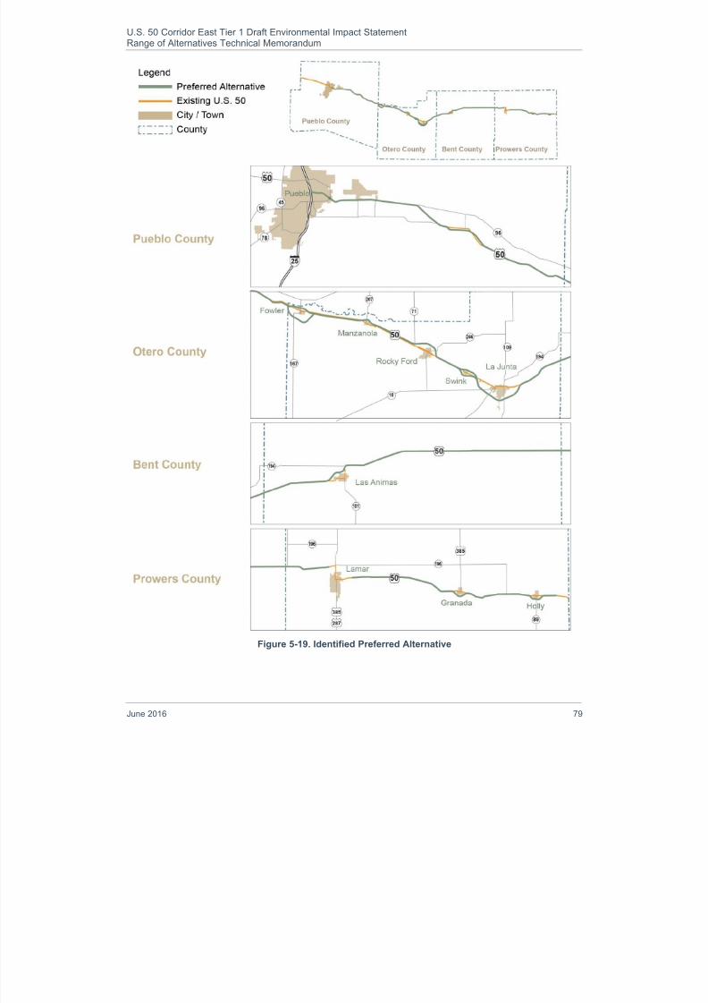
8/16/2019 B: Range Alternatives Tech Report
http://slidepdf.com/reader/full/b-range-alternatives-tech-report 83/86
U.S. 50 Corridor East Tier 1 Draft Environmental Impact StatementRange of Alternatives Technical Memorandum
June 2016 79
Figure 5-19. Identified Preferred Alternative

8/16/2019 B: Range Alternatives Tech Report
http://slidepdf.com/reader/full/b-range-alternatives-tech-report 84/86
U.S. 50 Corridor East Tier 1 Draft Environmental Impact StatementRange of Alternatives Technical Memorandum
80 June 2016
6. References
Colorado Department of Transportation (CDOT). Corridor Selection Study: A Plan for U.S. 50. ColoradoSprings, CO: Colorado Department of Transportation (CDOT), Region 2, September 2003. Print.[CDOT 2003a]
Colorado Department of Transportation (CDOT). Online Transportation Information System (OTIS) data for2012. Web. Mar. 2014. <http://dtdapps.coloradodot.info/otis>. [CDOT 2012]
Swenka, David, PE, PTOE. 2008-2012 Crash Summary and 2011 AADTs and LOSS for U.S. 50. ColoradoDepartment of Transportation (CDOT). Safety and Traffic Engineering Branch. Data emailed Feb.2014. [Swenka 2014]
U.S. Department of Commerce, Economics, and Statistics Administration. U.S. Census Bureau. 2000Census. Washington, D.C.: Web. 12 Dec. 2006. <http://dola.colorado.gov/dlg/demog/pop_totals.html>.
U.S. Department of Commerce, Economics, and Statistics Administration. U.S. Census Bureau. American
Community Survey data. Washington, D.C.: Web. 30 Aug. 2013. <http://www.census.gov/acs/www/data_documentation/2010_release/>.

8/16/2019 B: Range Alternatives Tech Report
http://slidepdf.com/reader/full/b-range-alternatives-tech-report 85/86
U.S. 50 Corridor East Tier 1 Draft Environmental Impact StatementRange of Alternatives Technical Memorandum
June 2016 81
Appendix A. Abbreviations and Acronyms
AASHTO American Association of State Highway and Transportation Officials
CDOT Colorado Department of Transportation
CEQ Council on Environmental QualityCFR Code of Federal Regulations
CR County Road
EA Environmental Assessment
EIS Environmental Impact Statement
EPA U.S. Environmental Protection Agency
FHWA Federal Highway Administration
HOV High-occupancy vehicle
I-25 Interstate 25
IGA Intergovernmental Agreement
NEPA National Environmental Policy Act of 1969
NPS National Park Service
NRHP National Register of Historic Places
PACOG Pueblo Area Council of Governments
SH State Highway
TSM Transportation System Management
U.S. 287 U.S. Highway 287
U.S. 50 U.S. Highway 50
U.S. 50 Tier 1 EIS U.S. Highway 50 Tier 1 Environmental Impact Statement
USACE U.S. Army Corps of Engineers
USC United States Code
vmt Vehicle miles traveled
vpd Vehicles per day

8/16/2019 B: Range Alternatives Tech Report
http://slidepdf.com/reader/full/b-range-alternatives-tech-report 86/86
U.S. 50 Corridor East Draft Environmental Impact StatementRange of Alternatives Technical Memorandum
This page left intentionally blank.