Embed Size (px)
Citation preview
AWIPS Operational Build 9:
Alpha Release Notes
Document No. AWP.RLSN-OB9 Alpha
02 September 2008
Prepared Under
Contract DG133W-05-CQ-1067 Advanced Weather Interactive Processing System (AWIPS)
Operations and Maintenance
Submitted to:
U.S. Department of Commerce National Oceanic and Atmospheric Administration
1325 East-West Highway Silver Spring, MD 20910
By:
Raytheon Technical Services Company LLC 8401 Colesville Road, Suite 800
Silver Spring, MD 20910
This document includes data that shall not be duplicated, used, or disclosed – in whole or in part – outside the Government for any purpose other than to the extent provided in contract DG133W-05-CQ-1067. However, the Government shall have the right to duplicate, use, or disclose the data to the extent provided in the contract. This restriction does not limit the Government’s right to use information contained in this data if it is obtained from another source without restriction. The data subject to this restriction are contained in all sheets.
AWIPS OB9 Alpha Release Notes. Section I, New Functionality, 02 September 2008
AWIPS OB9 Alpha Release Notes
Section I – New Functionality in OB9
Table of Contents Page
1.0 D2D/TEXT/OTHER APPLICATIONS ........................................................................ 1-1
1.1 Radar ..................................................................................................................... 1-1 1.2 Grib Decoder ......................................................................................................... 1-2 1.3 Great Lakes Wave Modeling................................................................................. 1-2 1.4 System for Convection Analysis and Nowcasting (SCAN).................................. 1-2 1.5 System on AWIPS for Forecasting and Evaluation of Seas and Lakes
(SAFESEAS)......................................................................................................... 1-3 1.6 NGM-LAMP ......................................................................................................... 1-3 1.7 Volume Browser.................................................................................................... 1-3 1.8 Local Storm Report ............................................................................................... 1-5 1.9 FFMP..................................................................................................................... 1-6 1.10 GFE ....................................................................................................................... 1-6 1.11 Satellite.................................................................................................................. 1-7 1.12 Guardian ................................................................................................................ 1-8 1.13 Gridded MOS ........................................................................................................ 1-8 1.14 Fog Monitor........................................................................................................... 1-8 1.15 WarnGen ............................................................................................................... 1-9 1.16 Higher Resolution Scatterometer Ocean Winds.................................................. 1-10 1.17 Four-Dimensional Storm Cell Investigator (FSI)................................................ 1-11 1.18 Aviation............................................................................................................... 1-11 1.19 Climate ................................................................................................................ 1-11 1.20 GOES................................................................................................................... 1-11 1.21 Graphic Workstation ........................................................................................... 1-11 1.22 Low Cloud Base .................................................................................................. 1-12 1.23 TDWR Products .................................................................................................. 1-12 1.24 Warning by Polygon............................................................................................ 1-12 1.25 Distributed Hydrologic Modeling (DHM) .......................................................... 1-12
2.0 HYDROLOGY ................................................................................................................ 2-1
2.1 Forecast Services Database and Interface ............................................................. 2-1 2.2 HydroGen .............................................................................................................. 2-1 2.3 SRA Tools Enhancement ...................................................................................... 2-1 2.4 HydroView/MPE................................................................................................... 2-1 2.5 RiverPro ................................................................................................................ 2-1 2.6 WHFS/IHFS Database .......................................................................................... 2-1
Contract DG133W-05-CQ-1067; DCN AWP.RLSN-OB9 Alpha Use or disclosure of data contained on this sheet is subject to the restriction on the title page of this document. I-ii
AWIPS OB9 Alpha Release Notes. Section I, New Functionality, 02 September 2008
2.7 RFC Archive Database (RAX).............................................................................. 2-1 2.8 Precipitation Processing ........................................................................................ 2-1 2.9 NWSRFS ............................................................................................................... 2-2 2.10 Interactive Verification Program........................................................................... 2-2 2.11 Historical Data Browser ........................................................................................ 2-2
3.0 SYSTEM........................................................................................................................... 3-1
3.1 COTS Software ..................................................................................................... 3-1 3.2 Processes ............................................................................................................... 3-1 3.3 Purging, Crons and Scripts.................................................................................... 3-1 3.4 Database Engine and Operating System ............................................................... 3-1 3.5 System for Nowcasting of Winter Weather (SNOW) ........................................... 3-1 3.6 WaveWatch III (WW3) ......................................................................................... 3-1 3.7 AVNFPS................................................................................................................ 3-1 3.8 Chat Server ............................................................................................................ 3-1 3.9 Radar System......................................................................................................... 3-1 3.10 Infrastructure ......................................................................................................... 3-2 3.11 Localization........................................................................................................... 3-2 3.12 Geographic Resources Analysis Support System (GRASS)................................. 3-2 3.13 GFESuite ............................................................................................................... 3-2 3.14 Interactive Calibration Program (ICP) .................................................................. 3-2 3.15 Configuration Management................................................................................... 3-2 ........................................................................................................................Archive Server
............................................................................................................................... 3-3 3.16 ................................................................................................................................... 3-3 3.17 Workarounds ......................................................................................................... 3-3
4.0 NWRWAVES................................................................................................................... 4-4
5.0 Marine Weather Warning (MWW)............................................................................... 5-1
6.0 LDAD................................................................................................................................ 6-1
7.0 RFC-Only Software in AWIPS Release OB8.3 (08/27/2008)....................................... 7-1
8.0 Enhancement DR’s.......................................................................................................... 8-1
* NOTE: Section 8.0 is a new section. It lists the enhancement DRs.
Contract DG133W-05-CQ-1067; DCN AWP.RLSN-OB9 Alpha Use or disclosure of data contained on this sheet is subject to the restriction on the title page of this document. I-iii

AWIPS OB9 Alpha Release Notes. Section I, New Functionality, 02 September 2008
1.0 D2D/TEXT/OTHER APPLICATIONS
1.1 Radar
• Data from FAA (ASR-11/ARSR-4) radars are available at most sites. These surveillance radars provide fill-in coverage in data gap areas. The ASR-11 uses a vertical fan beam that produces something like an 88D composite reflectivity, and the ARSR-4 product is similar to a hybrid scan as it uses lower-angle beams at increasing range. Since they differ from 88D/TDWR products, it was decided to call them simply "Reflectivity" on the menus, which appear in the top section of the Radar menu. When appropriate, these will also participate in radar mosaics – by default, as part of the Hybrid Scan Reflectivity mosaic.
• A new feature for four-panel displays is the ability to view each of the products individually, full-screen, while optionally sampling the contents of all (up to eight) components. Pop-up menu selectors and keyboard shortcuts allow you to select the component of interest and enable sampling. While this is primarily directed at radar data (future dual-polarization products, in particular), it can be used for any four-panel presentation.
Improvements: • The as-delivered 88D radar menus are the same as in OB8.3.
However, a turnkey script is included in OB9 to convert the menu layout to a dual-pol- focused form, should dual-pol data become available from your radar(s):
During the OB9 era, it is expected that dual-polarization radar data will become available. At that time, your ITO will run a turnkey script to swap in a dual-pol-focused menu and re-run radar localization to make use of it. For the new menu please refer to what’s new section of the OB9 User’s Manual. All of the existing products are included in this menu (and, indeed, the dual-pol products are on the current menu, in a pull-right at the top), but the menu has been rearranged to feature the dual-pol four-panel sets, as they are expected to be heavily used once dual-pol data become available. Please refer to what’s new section of the OB9 User’s Manual for the snapshots.
• In OB9, a few enhancements were added. They are described below from highest to lowest priority:
Hot-key toggle/zoom with cursor readout
Assuming D-2D has two sets of four products loaded in a 4-panel linked all-tilts display, the hot-key toggle capability allows the user to zoom in
Contract DG133W-05-CQ-1067; DCN AWP.RLSN-OB9 Alpha Use or disclosure of data contained on this sheet is subject to the restriction on the title page of this document. 1-1
AWIPS OB9 Alpha Release Notes. Section I, New Functionality, 02 September 2008
on one panel, making it the main panel. The other three pairs of products would be accessible via a hot-key toggle or cycle button. Ideally, the cursor readout would display the values from the other products.
There would need to be a user-friendly way to alert the user of which products are available for hot-key toggle/cycle.
Menu Reorganization
Due to the complexity of the D2D menus and the dwindling real-estate on D2D, it has become almost critical to reorganize the menus in order to accommodate new products. There have been several discussions on this matter and a new layout for radar menus has been proposed, including WDTB's sample reorganization layout.
Volume Browser CAPPI's and procedure patching.
Default RPS list updates when Dual Pol becomes available for a site. Dual Pol products will not be available until AWIPS OB9 has been deployed to the forecast offices. There needs to be a capability on AWIPS to seamlessly update default RPS lists with dual pol products when the ORPG at each site is upgraded to build 11.
Control to possibly limit central collection of the three hour Digital User Accumulation (DUA) to the top of hour product.
This capability is to follow what we do today for the THP (Three Hour Precip) and conserves bandwidth, especially since the DUA is a 250m resolution, 8-bit product and THP is a 2km, 4-bit product.
1.2 Grib Decoder No enhancements
1.3 Great Lakes Wave Modeling • NOAA National Weather Service Forecast Offices (WFO’s) with marine forecasting
responsibility for the Great Lakes need operational wave model guidance available on AWIPS to improve forecasts in their marine zones. Currently, a wave model; developed by NCEP exists for the Great Lakes which is consistent with the model framework for the rest of the coastal/ocean regions. This model developed by NCEP is an initial capability which will continue to be enhanced to further meet the needs of the forecasters.
1.4 System for Convection Analysis and Nowcasting (SCAN) No enhancements
Contract DG133W-05-CQ-1067; DCN AWP.RLSN-OB9 Alpha Use or disclosure of data contained on this sheet is subject to the restriction on the title page of this document. 1-2
AWIPS OB9 Alpha Release Notes. Section I, New Functionality, 02 September 2008
1.5 System on AWIPS for Forecasting and Evaluation of Seas and Lakes (SAFESEAS)
No enhancements
1.6 NGM-LAMP No enhancements
1.7 Volume Browser High-resolution Precipitation Nowcaster (HPN) products incorporated into the High-resolution Precipitation Estimator (HPE/BiasHPE) for D-2D (without/with bias correction):
In OB8.3, HPE provided high resolution (~1km x 1km) mosaics of rain rate and one-hour accumulation for multiple radars updated approximately every 5 minutes. In OB9, the High-resolution Precipitation Nowcaster (HPN) routine adds forecasts of instantaneous rain rates at four 15 minute intervals (consisting of 15, 30, 45, and 60 minutes) in the future and a forecast of 1-hour accumulated precipitation, without/with bias. The locally-generated HPN forecast grids are derived from the HPE and are generated by using a primarily advection algorithm (also see section 2.8 Precipitation Processing under 2.0 HYDROLOGY).
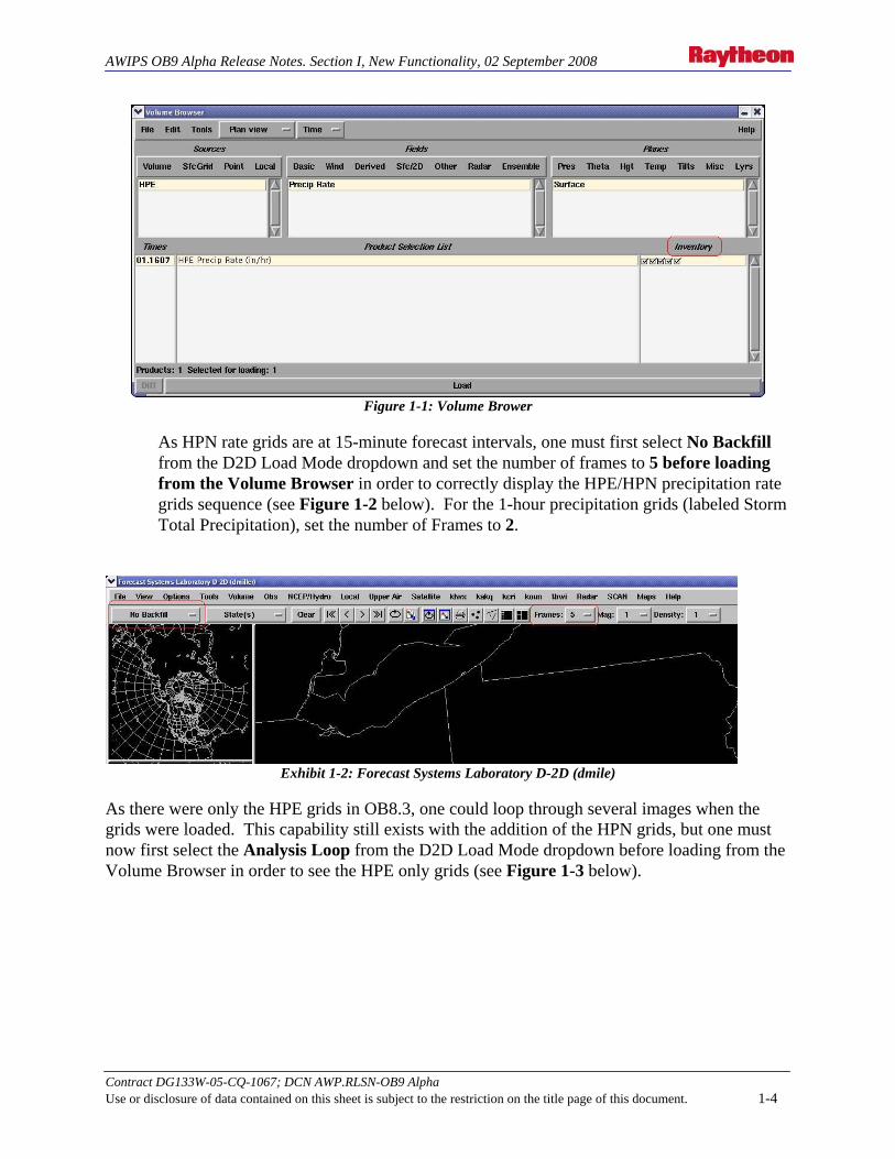
To view the HPN grids in D2D via the Volume Browser, go to Sfc/2D > Precip > Precip Rate and Sfc/2D > Precip > Storm Tot Precip submenus. The HPN forecast grids will appear as additional HPE grids in the Inventory section of the Volume Browser (see Figure 1-1 below). Except for the fact that the HPE/BiasHPE grids have been moved under the new Sources menu item SfcGrid, there are no real changes to the Volume Browser listing for these forecast grids. Thet HPE/BiasHPE for the combined HPE/HPN grid suite should be selected. The additional HPN grids will appear in the Inventory checkbox listing, if available.
Contract DG133W-05-CQ-1067; DCN AWP.RLSN-OB9 Alpha Use or disclosure of data contained on this sheet is subject to the restriction on the title page of this document. 1-3
AWIPS OB9 Alpha Release Notes. Section I, New Functionality, 02 September 2008
Figure 1-1: Volume Brower
As HPN rate grids are at 15-minute forecast intervals, one must first select No Backfill from the D2D Load Mode dropdown and set the number of frames to 5 before loading from the Volume Browser in order to correctly display the HPE/HPN precipitation rate grids sequence (see Figure 1-2 below). For the 1-hour precipitation grids (labeled Storm Total Precipitation), set the number of Frames to 2.
Exhibit 1-2: Forecast Systems Laboratory D-2D (dmile)
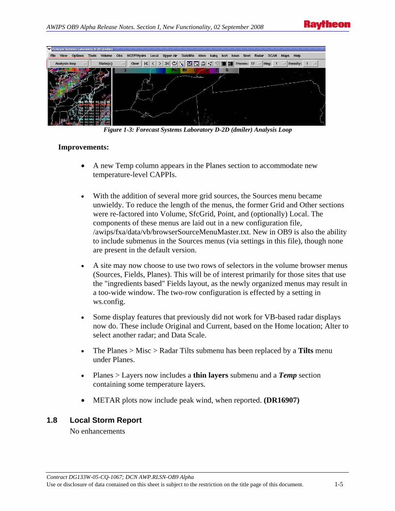
As there were only the HPE grids in OB8.3, one could loop through several images when the grids were loaded. This capability still exists with the addition of the HPN grids, but one must now first select the Analysis Loop from the D2D Load Mode dropdown before loading from the Volume Browser in order to see the HPE only grids (see Figure 1-3 below).
Contract DG133W-05-CQ-1067; DCN AWP.RLSN-OB9 Alpha Use or disclosure of data contained on this sheet is subject to the restriction on the title page of this document. 1-4
AWIPS OB9 Alpha Release Notes. Section I, New Functionality, 02 September 2008
Figure 1-3: Forecast Systems Laboratory D-2D (dmiler) Analysis Loop
Improvements:
• A new Temp column appears in the Planes section to accommodate new
temperature-level CAPPIs.
• With the addition of several more grid sources, the Sources menu became unwieldy. To reduce the length of the menus, the former Grid and Other sections were re-factored into Volume, SfcGrid, Point, and (optionally) Local. The components of these menus are laid out in a new configuration file, /awips/fxa/data/vb/browserSourceMenuMaster.txt. New in OB9 is also the ability to include submenus in the Sources menus (via settings in this file), though none are present in the default version.
• A site may now choose to use two rows of selectors in the volume browser menus (Sources, Fields, Planes). This will be of interest primarily for those sites that use the "ingredients based" Fields layout, as the newly organized menus may result in a too-wide window. The two-row configuration is effected by a setting in ws.config.
• Some display features that previously did not work for VB-based radar displays now do. These include Original and Current, based on the Home location; Alter to select another radar; and Data Scale.
• The Planes > Misc > Radar Tilts submenu has been replaced by a Tilts menu under Planes.
• Planes > Layers now includes a thin layers submenu and a Temp section containing some temperature layers.
• METAR plots now include peak wind, when reported. (DR16907)
1.8 Local Storm Report No enhancements
Contract DG133W-05-CQ-1067; DCN AWP.RLSN-OB9 Alpha Use or disclosure of data contained on this sheet is subject to the restriction on the title page of this document. 1-5

AWIPS OB9 Alpha Release Notes. Section I, New Functionality, 02 September 2008
1.9 FFMP Alternate Basin Trend Graphs
• When QPF was added to the Basin Trends in OB8.3, it added another layer of complexity to an already complex graph. It was decided to provide, in addition to the existing graph, graphs with an alternate appearance.
Enhanced RFC FFG Update Handling
• When the previous version of FFMP received an RFC FFG update, it would use it immediately, which created a situation where precipitation may get counted twice, thus over emphasizing the flash flood threat. As of OB9, FFMP will delay the usage of the RFC FFG update, as well as apply an intelligent transition scheme that yields more realistic and valuable RFC FFG.
1.10 GFE • Forecasters at WFOs with Great Lakes wave forecasting responsibility use a wave
model developed by NOAA’s Great Lakes Environmental Research Laboratory (GLERL). The model allows for inconsistency with current operational modeling framework. To meet the long-term needs of marine forecasters, sustainable wave model guidance that is consistent with other coastal WFOs and the current operational wave modeling architecture is required. NCEP’s EMC has developed a wave model based upon the current operational wave model, WaveWatch III (WW3) and adapted it to the Great Lakes. This model is known as the Great Lakes Wave Model (GLWM).
• The TPC/NHC AWIPS systems (NHCR & NHCW) do not have their own unique GFE identifiers. Without these identifiers, TPC/NHC cannot use GFE to explore the possibility of creating gridded forecasts. The identifiers would be the very first step toward producing grids on an experimental basis and allowing other offices the opportunity to view the experimental TPC/NHC grids created with GFE. The current lack of identifiers also precludes the TPC/NHC from having national support for the map shapefiles - although most (if not all) of the necessary maps already exist. Configuring a baseline GFE system, including the GFE identifiers, will allow TPC/NHC to generate grids on an experimental basis. Some of the capabilities to be tested include the production of TAFB text products using a text formatter, and the production of gridded products such as significant wave heights and wind wave grids. Other possibilities for using the grids include the creation of graphics for marine fax users and issuing point and route forecasts. Note: TPC/NHC that transmitting any experimental marine grids on AWIPS via the SBN and/or WAN would be a separate Request for Change (RC) and would not specifically fall under this request #07-047.
• In many cases, long-duration watch/warning/advisory products (issued from the
Contract DG133W-05-CQ-1067; DCN AWP.RLSN-OB9 Alpha Use or disclosure of data contained on this sheet is subject to the restriction on the title page of this document. 1-6
AWIPS OB9 Alpha Release Notes. Section I, New Functionality, 02 September 2008
Graphical Hazard Generator (GHG) program within GFE) are only intended to be in effect for certain portions of a forecast zone. For example, a heavy snow warning may only pertain to a portion of the zone above 3000 feet; a volcanic ash advisory will only include areas downwind of the volcano within a zone; or a lake wind advisory may only be in effect for the lake portions of a zone, not the whole land area of that zone.
• Currently, GHG formats a product with ALL of the cities that are resident within
a forecast zone included in the MND header of the product using a preset cities list (if it is included). Thus, the MND header can imply that the watch/warning/advisory is in effect for cities that were not intended to be included. The MND header of all GHG products is “locked”, meaning the forecaster is unable to edit it in any way; in this case, to remove unwanted cities from the list. To create this specificity within the product, the forecaster manually inserts the details at the end of the headline and within the body of the text; it is not contained within the hazard grid or VTEC code. Need accurate cities list in the MND header for long-duration prods. All configured cities are currently listed in the segment header. This is changed to include only those cities that are affected by the events in the segment.
• The High-Resolution Window (HIRESW) Forecast System is used by forecasters
for significant weather events, including tornadoes, large hail, damaging winds, heavy snow, flooding, fire weather, and other high impact weather events. Currently, the output from HIRESW is not part of the GFE suite of products in AWIPS. This requires integrating HIRESW data into the GFE suite of product. Integrating High Resolution Model Window Data (HIRESW) into GFE.
• Higher Resolution Map Shapefiles: In order to eliminate the currently occurring
mapping errors in D2D, NDFD, and GFE (and perhaps other applications) when using the existing map background shapefiles, higher resolution map background shapefiles are required. GFE Suite software is the primary mechanism through which forecasters create digital forecasts. Through STSIT tools are developed and distributed for use in GFE Suite to the forecast offices. Some of those tools have proved so useful to all WFOs that it has been decided to baseline them into the GFE Suite software.
1.11 Satellite
• The National Oceanic and Atmospheric Administration’s (NOAA) National Weather Service (NWS) has a need for WFOs to obtain and display High Resolution Model Window data. Currently, the WFOs can obtain the information via FTP site or web site. Due to bandwidth constraints the regions have asked for the High Resolution Model Window to be broadcasted over the Satellite Broadcast Network (SBN). Having access to current High Resolution Model Window data provides the WFOs an opportunity to obtain and become familiar with the High Resolution Model Window information. This was implemented in
Contract DG133W-05-CQ-1067; DCN AWP.RLSN-OB9 Alpha Use or disclosure of data contained on this sheet is subject to the restriction on the title page of this document. 1-7

AWIPS OB9 Alpha Release Notes. Section I, New Functionality, 02 September 2008
this release.
• High Density Geostationary Winds from the Japanese Satellite: This requirement implements the MTSAT HDW products to the AWIPS system. Products are available eight cycles per day. AWIPS decode, store, and display products.
• Blended Total Precipitable Water and Percent of Normal TPW: This
requirement implements the Blended Total Precipitable Water and Percent of Normal TPW products into the D2D. These products are available four cycles per day. As described in the OSIP project 06-084 CONOPS document, these products will provide the forecasters with the ability to “Monitor surges of moisture from the ocean areas into the U.S. (i.e., atmospheric rivers documented in scientific journals). These moisture surges can greatly influence the amount of rain produced by a storm. Better anticipate and forecast heavy rain and flooding events.”
THE FOLLOWING PRODUCTS WILL BE ADDED TO THE AWIPS/SBN DATASTREAM: AWIPS ID WMO HEADER -------- ----------- BTPW TICN17 KNES BTPW TICB17 KNES BTPW TICI17 KNES BTPW TICQ17 KNES TPWA TICN60 KNES TPWA TICB60 KNES TPWA TICI60 KNES TPWA TICQ60 KNES NOTE 1: BTPW IS BLENDED TPW NOTE 2: TPWA IS PERCENT OF NORMAL TPW ANOMALY NOTE 3: CURRENT SSMI AND AMSU TPW ARE ELIMINATED AFTER AWIPS OB9 IS LOADED ON ALL SITES
1.12 Guardian No enhancements
1.13 Gridded MOS No enhancements
1.14 Fog Monitor No enhancements
Contract DG133W-05-CQ-1067; DCN AWP.RLSN-OB9 Alpha Use or disclosure of data contained on this sheet is subject to the restriction on the title page of this document. 1-8

AWIPS OB9 Alpha Release Notes. Section I, New Functionality, 02 September 2008
1.15 WarnGen
• To insert Instruction Field markers around the MWW-defined Call-to-Action (CTA) statement(s):
This would allow the insertion and use of the Instruction Field markers in an experimental product (MWW) as a prototyping and risk reduction effort. The CAP standard specifies discreet event “Description” element and “Instruction” element. The NWS CAP IWT found it is not possible to parse the CAP “Instruction” element out of existing WMO-formatted text W/W/A products generated by AWIPS. The solution arrived at was to add a set of “markers” in WMO-formatted text W/W/A and associated statement products generated by AWIPS to delineate the “Instruction” (Call-to-Action) to be used to populate the CAP Instruction element. Consensus agreement was quickly reached in September 2007 with the OCWWS service program leads, the NWS regional headquarters dissemination program leads, and a group of national NWS partners that are working with the CAP IWT. Mark Tew sent to the Marine Weather Warning (MWW) product developer on September 21, 2007, a change request to insert Instruction Field markers around the MWW-defined Call-to- Action (CTA) statement(s). This would allow the insertion and use of the Instruction Field markers in an experimental product (MWW) in a prototyping and risk reduction effort.
Expected Benefits:
Implementing this change will be the first step in creating an interim solution to create viable CAP messages for distribution prior to the development of the Next Generation Warning that is expected to create CAP/XML on the AWIPS II platform. Current W/W/A product formats are not conducive to automated interpretation via modern technologies. Free text writing style and NWS product inconsistencies cause automated programs to generate errors. This upgrade to the AWIPS software will allow our customers to find the CTAs using automated tools.
DCS 3494.1. “No call to action” item shall be added as the first option in “CALL TO ACTION” section under Optional bullets.
DCS 3494.2. Default selection for “CALL TO ACTION” section.
2.1 “No call to action” shall be the default selection for all products specified in requirement 11 (listed below) except for Tornado Warning, Specific Marine Warning, and Marine Weather Statement – follow SMW.
2.1.1 For Tornado Warning, Specific Marine Warning, and Marine Weather Statement – follow SMW, keep the default selection the same way as it is today.
DCS 3494. 3. Actions if “No call to action” is the only selected CTA item.
Contract DG133W-05-CQ-1067; DCN AWP.RLSN-OB9 Alpha Use or disclosure of data contained on this sheet is subject to the restriction on the title page of this document. 1-9
AWIPS OB9 Alpha Release Notes. Section I, New Functionality, 02 September 2008
3.1 CTA markers shall not be added to warning product.
3.2 QC shall not check for missing CTA markers.
DCS 3494. 4. Action if an item other than “No call to action” is selected.
4.1 CTA markers shall be added to the warning product.
4.2 QC shall check for missing CTA markers.
DCS 3494. 5. Action if no CTA item is selected and “Create Text” is clicked.
5.1 A dialog box shall pop up to alert the user. The alert message shall be “No CTA item was selected”. Two buttons, called Proceed and Abort, respectively, shall be in the dialog box.
5.1.1 If Proceed is selected, warning text shall be created on text workstation; CTA markers shall not be added to warning text; and QC shall not check for the missing of CTA markers in warning text.
5.1.2 If Abort is selected, warning text shall not be created on text workstation.
5.2 The dialog box shall be closed when either Proceed or Abort is selected.
DCS 3494. 6. The start marker and end marker shall each be on a separate line and left justified with no other printable characters on the same line of text.
DCS 3494. 7. There shall be a blank line above the start marker, and a blank line beneath the end marker.
DCS 3494. 8. There shall be a blank line between the start marker and the text of CTAs, and a blank line between the text of CTAs and the end marker as well.
DCS 3494. 9. AWIPS shall allow the user to manually insert CTA text into warning text on a text workstation.
• In order to eliminate the currently occurring mapping errors in D2D, NDFD, and GFE (and perhaps other applications) when using the existing map background shapefiles, higher resolution map background shapefiles were created.
1.16 Higher Resolution Scatterometer Ocean Winds
• AWIPS has replaced the QuikSCAT product with higher resolution data and added the ASCAT product. The QuikSCAT product was previously available in D-2D with 25km resolution data. It was replaced with 12.5km resolution data. The ASCAT product will be available with 25km resolution data. AWIPS will decode the satellite messages received via SBN. The decoded data will be stored in netCDF file format. There will be 12 files retained for each satellite after purge. The decoded data will be displayable in D2D with all normal D-2D functionality available.
Contract DG133W-05-CQ-1067; DCN AWP.RLSN-OB9 Alpha Use or disclosure of data contained on this sheet is subject to the restriction on the title page of this document. 1-10
AWIPS OB9 Alpha Release Notes. Section I, New Functionality, 02 September 2008
1.17 Four-Dimensional Storm Cell Investigator (FSI) FSI, which was new in OB8.1, is defined as the graphical user interface (GUI) for the National Severe Storms Laboratory (NSSL) Warning Decision Support System – Integrated Information (WDSSII). FSI has been designed for specific NWS warning operations, and is a separate radar interrogation application that is to be launched from the D2D. FSI gives severe weather warning decision meteorologists advanced WSR-88D radar analysis capabilities. Because dynamic cross-sections (both vertical and at constant altitude) can be created, the user can “slice and dice” storms and view these data in three dimensions and across time.
Operational benefit: The dynamic and 3D display capabilities of FSI allow the user to assess the vertical structure of severe storms and their attendant signatures in a much more robust way than is currently provided by the D2D. The FSI is aimed at improving the forecasters’ understanding of storm signatures, and at allowing them to discover new signatures to help improve severe weather warning performance.
In this release, the following new functionality was added:
• TDWR data has been added to FSI (DR 3443)
1.18 Aviation No enhancements
1.19 Climate • Currently, Climate Prediction Center (CPC) in NCEP issues products in a
standard grid format that is supported by NWS software applications. However, only CPC’s monthly and seasonal temperature and precipitation grids are available in Network Common Data Form (netCDF) on AWIPS. CPC’s short and medium range temperature and precipitation products are only accessible either by way of the Internet or Red Book Format on AWIPS. Existing (non-NetCDF) graphics on AWIPS are outdated and lack the detail to provide much forecast value. At the RFCs, forecasters rely on the short to medium range temperature and precipitation guidance products for ensemble river forecasting. Presently, the RFCs are required to apply a labor-intensive approach to access and store this data, which is not efficient for their operations due to the workload involved. The complete delivery of NCEP’s short to medium range products will allow both the RFCs and WFOs to enhance current systems, while reducing office workload. CPC’s Short (6-10 day) and Medium Range (8-14 day) Outlooks.
1.20 GOES No enhancements
1.21 Graphic Workstation • Feature-following zoom: Using the distance/speed tool, one can set a motion vector
along which frame animation will proceed. This allows you to view a storm in a Lagrangian reference frame. Once you have established the feature motion with
Contract DG133W-05-CQ-1067; DCN AWP.RLSN-OB9 Alpha Use or disclosure of data contained on this sheet is subject to the restriction on the title page of this document. 1-11

AWIPS OB9 Alpha Release Notes. Section I, New Functionality, 02 September 2008
Distance/Speed, select Feature Following Zoom from the Tools menu and the frames will reload with the tracked location remaining in the center of the display.
1.22 Low Cloud Base No enhancements
1.23 TDWR Products • The National Oceanic and Atmospheric Administration’s (NOAA’s) National Weather
Service (NWS) needs additional and improved radar data to improve support to severe weather warnings, flood and flash flood warnings, and general forecast services (reference NWS SON 04-004: Additional Radar Observational Data). The NWS is deploying Supplemental Product Generation (SPG) units to ingest base data from 45 Federal Aviation Administration (FAA) Terminal Doppler Weather Radar (TDWR) units to complement data from the Weather Surveillance Radar – 1988 Doppler (WSR-88D) network. The TDWR data include base data (in Level II format) and many hydro-meteorological products (in Level III format), including rainfall, snowfall, mesocyclone, Tornadic Vortex Signature, Storm Cell Identification and Tracking, VAD Wind Profiles, Composite Reflectivity and Vertically Integrated Liquid Water. To provide maximum benefit to NOAA/NWS (e.g., WFOs, NCEP, NCDC, Laboratories) and external users (e.g., other government agencies, private sector), these Level II and Level III data need to be centrally collected, archived, and distributed similarly to the WSR-88D data. This task only focuses on central collection of TDWR products (Level III data). Central collection of Level II data will be pursued in the second phase when funding has been identified.
1.24 Warning by Polygon No enhancements
1.25 Distributed Hydrologic Modeling (DHM) Enhancements to Distributed Hydrologic Modeling:
The table that compares the DHM design features in OB9 to the design features in OB8.3 will be updated in OB9 Beta.
Contract DG133W-05-CQ-1067; DCN AWP.RLSN-OB9 Alpha Use or disclosure of data contained on this sheet is subject to the restriction on the title page of this document. 1-12
AWIPS OB9 Alpha Release Notes. Section I, New Functionality, 02 September 2008
2.0 HYDROLOGY • The VAR Into SSHP project incorporates the Variational Data Assimilation (VAR) into
the Site Specific Hydrologic Predictor (SSHP) to improve the accuracy of SAC-SMA-based forecasts. Precipitation estimates and prior model states are modified to result in better initial model conditions so that the forecast streamflow better reflects the observed streamflow.
• Common Alert Protocol: This task is part of a higher level of requirements described in OSIP 07-024. It involves insertion of “tags” in watch/warning/advisory products to identify the “call-to-action” (CTA) section of the product. These tags will facilitate later processing of the products generated by the AWIPS formatters. RiverPro four product categories will be affected – Point specific Flood warning (FLW), Flood statement/Flood Advisory (FLS) or Flood Watch (FFA). The NWR products are not applied.
2.1 Forecast Services Database and Interface No enhancements
2.2 HydroGen No enhancements
2.3 SRA Tools Enhancement No enhancements
2.4 HydroView/MPE No enhancements
2.5 RiverPro No enhancements
2.6 WHFS/IHFS Database No enhancements
2.7 RFC Archive Database (RAX) No enhancements
2.8 Precipitation Processing
• High-resolution Precipitation Nowcaster (HPN): As discussed in Section 1.7 under Volume Browser, the HPN routine was incorporated into the High-resolution Precipitation Estimator (HPE), which was added to Hydrology suite of Precipitation Processing routines in OB8.3. The primary purpose of HPE and HPN are for use in FFMP-A; to configure FFMP-A to use HPE and HPN, see the “How to Add HPE/BiasHPE” document found on the FFMP page at
Contract DG133W-05-CQ-1067; DCN AWP.RLSN-OB9 Alpha Use or disclosure of data contained on this sheet is subject to the restriction on the title page of this document. 2-1
AWIPS OB9 Alpha Release Notes. Section I, New Functionality, 02 September 2008
http://www.weather.gov/mdl/ffmp To compute the HPN grids, the most recent gridded HPE rain rate field is compared with the one about 15 minutes earlier to estimate the local motion of areas of echoes on a 20 km grid scale using a standard local pattern-matching scheme. The gridded rain rates are then projected forward in time using the most-recent estimated gridded motion vectors at a time step small enough to prevent pixel jumping (aliasing) of the echoes. The algorithm then computes smoothed forecasted rain rate fields. This approach uses a variable, adaptable rate of smoothing with time that is computed based on the current observed rain rate fields as well as observed changes in echo structure over the past 15 minutes.
2.9 NWSRFS No enhancements
2.10 Interactive Verification Program No enhancements
2.11 Historical Data Browser No enhancements
Contract DG133W-05-CQ-1067; DCN AWP.RLSN-OB9 Alpha Use or disclosure of data contained on this sheet is subject to the restriction on the title page of this document. 2-2
AWIPS OB9 Alpha Release Notes. Section I, New Functionality, 02 September 2008
3.0 SYSTEM
3.1 COTS Software The following were upgraded:
• LDM (6.6.5) • Fortran (7.2-4)
3.2 Processes
3.3 Purging, Crons and Scripts
3.4 Database Engine and Operating System • No changes to the Database Engine. (For reference only)
• The Operating System is Red Hat Enterprise Linux 4u2, and the Kernel is 2.6.9-55.0.2. (For reference only)
3.5 System for Nowcasting of Winter Weather (SNOW) No enhancements
3.6 WaveWatch III (WW3) No enhancements
3.7 AVNFPS The release identifier is OB9
3.8 Chat Server No enhancements
3.9 Radar System • A supplemental products generator (SPG) system will ingest data from the FAA’s ASR-
11 and/or ARSR-4 radar and will generate products following formats described in the WSR-88D-to-Class 1 User ICD. Differences between these products and baseline WSR-88D products are in the area of: radar id; product message codes; VCP; resolution in range, azimuth and time; and coverage range. For each radar, a SPG will generate a reflectivity product approximately once each minute and will distribute it to AWIPS following product distribution methods currently used by the WSR-88D. These products will follow the WSR-88D standard 3bit reflectivity product format (i.e., runlength-encoded “AF1F” packet for 8 level code) and data breakpoints (i.e., 18, 30, 41, 46, 50, 57 dBZ). Since the SPG was built by modifying a WSR-88D RPG to handle the characteristics of the FAA radars, a number of other product distribution messages will be exchanged between the SPG and AWIPS, as noted below. Since only one product type
Contract DG133W-05-CQ-1067; DCN AWP.RLSN-OB9 Alpha Use or disclosure of data contained on this sheet is subject to the restriction on the title page of this document. 3-1

AWIPS OB9 Alpha Release Notes. Section I, New Functionality, 02 September 2008
is generated for each of these radars (i.e., 8 level reflectivity product), to simplify the user interface and to reduce development effort, some of the familiar product distribution methods have been modified. In particular, the SPG will employ a line class 5 definition which is a combination of line class 1 (i.e., 2 PVC’s so that AWIPS may continue to use the standard Comms Manager software) and class 4 (i.e., SPG will establish a default RPS list for AWIPS when a connection is established which will contain the one product that is generated).
3.10 Infrastructure The interpretation of radarsOnMenu settings has changed. Prior to OB9, scales following an optional colon did not have four-panels enabled. Now that panel/combo rotate is available and each panel can be viewed full screen, this option has been eliminated. A colon in radarsOnMenu.txt now has no function.
3.11 Localization
No enhancements
3.12 Geographic Resources Analysis Support System (GRASS) No enhancements
3.13 GFESuite
• Formatting NWS Alert Messages in CAP: An instruction field marker will be created in the specified text products. This marker will be generated on both the initial and subsequent disseminations. This marker will appear only once in each segment of the product.
3.14 Interactive Calibration Program (ICP)
3.15 Configuration Management The Dimensions server operating system conversion from windows 2003 to Red Hat Linux v 4u2 has been completed during the OB8.3 period. (For reference only)
The primary benefits of converting the Dimensions server operating system from Windows to Linux will be as follows:
1. Uniform operating environment for Dimensions and the AWIPS development organizations
2. Elimination of extra carriage returns in files that cross O/S platforms (from Windows to Linux)
3. Elimination of Case Insensitivity in files and directory names
4. Improved performance of Dimensions server processes
Contract DG133W-05-CQ-1067; DCN AWP.RLSN-OB9 Alpha Use or disclosure of data contained on this sheet is subject to the restriction on the title page of this document. 3-2
AWIPS OB9 Alpha Release Notes. Section I, New Functionality, 02 September 2008
5. Improved stability of Dimensions server operating system.
3.16 Archive Server OB8.3 issue:
It was found back in OB7.2 that DVD-RWs could not be burned on the current operational AXs. In OB8.3, it was discovered that CD-RWs that burn at 4x to 12x also do not work. However, it was verified that older CD-RWs do still work and from past experience that 1x to 4x CD-RWs work.
Note: Deployment of the new AXs is expected to be completed at about the same time that OB8.3 begins deployment, but the schedule is currently trending later and later.
Update: The new AX server’s has been deployed. It works for the newer CD-RW, DVD-RW, DVD-R and CD-R disks.
3.17 Workarounds The HIRES and the hurricane models run in the same time slot, and the hurricane always gets priority. How much of the HIRESW run is canceled depends on how many hurricanes they are running the model for. Specifically: 1 hurricane cancels the ARW (large and small) 2 or 3 hurricanes cancel the ARW and the large domain NMM 4 hurricanes cancel all. Workaround: Please restart HiRes Window data stream to TNCF:
Contract DG133W-05-CQ-1067; DCN AWP.RLSN-OB9 Alpha Use or disclosure of data contained on this sheet is subject to the restriction on the title page of this document. 3-3
AWIPS OB9 Alpha Release Notes. Section I, New Functionality, 02 September 2008
4.0 NWRWAVES
• Implemented a filter option to parse CTA in NWS Alert Messages: In AWIPS OB9 release, NWRWAVES is required to provide the WFO-level (site-level) configuration options, to turn on or off the CTA statements, based on: Product Type (e.g., SVR, TOR) and VTEC event code (e.g. TO.W).
The only two exceptions are the RiverPro’s Flood Advisory and Warning (FLS and FLW) overview products where the CTA statements are located in the overview section. Thus, NWRWAVES recognized the following configuration options to turn off the CTA in NWRWAVES’s Overview product (OVR):
FLWOVR FLSOVR Optionally but not require (nice to have) for OB9 is the ability to configure the selection base on the action codes. NWRWAVES is also required to handle the “&&” or the ending marker which is also routinely used in the RiverPro’s Flood Advisory and Warning (FLS and FLW) products and may be optionally used in any product (see NWSI 10-1701, section 5.1.4, and NWSI 10-1702, section 4.1 and examples.). In these products the ending marker is used to indicate that either text or tabular data type may follow. When there are multiple VTEC events described within the same product or product segment, there may be more than one CTA. NWRWAVES is required to not attempt to associate specific CTAs with specific VTEC events. If the WFO elects through NWRWAVES to broadcast any one of the VTEC events in a given product or product segment, then the entire CTA section between the CTA markers shall be broadcast. In other words, more than one CTA may be broadcast. If no CTA markers (start or end) exist in a product, no additional action by NWRWAVES is required regarding the CTA. If only the start CTA marker (PRECAUTIONARY/PREPAREDNESS ACTIONS...) exists in a product without the end CTA marker (&&), no additional action by NWRWAVES is required regarding the CTA. This means if only the start CTA marker exists in a product without the end CTA marker, broadcast the text that follows the start CTA marker regardless of any WFO- level CTA option configuration. RA9-009 Problem: NWRWAVES does not suppress NWRSAME Tone during the silence period when “NWR Only.” (DR 19957) The current NWRWAVES OB8.3 or older version does set the alarm flag to a <blank> when the “NWR Only” option is selected. This is fine during the “unsilence” period. However, during
Contract DG133W-05-CQ-1067; DCN AWP.RLSN-OB9 Alpha Use or disclosure of data contained on this sheet is subject to the restriction on the title page of this document. 4-4
AWIPS OB9 Alpha Release Notes. Section I, New Functionality, 02 September 2008
the “silence” period NWRWAVES should suppress the Alert Tone (1050 Hz) and the NWRSAME Tone regardless to what is being selected by the forecasters. The alarm flag should be set to “N” to suppress both the Alert Tone and the NRWSAME Tone.
Temporary Solution: Select “off” for this option instead of “NWR Only.”
This is ready for testing and will be fixed in NWRWAVES version OB9.
Contract DG133W-05-CQ-1067; DCN AWP.RLSN-OB9 Alpha Use or disclosure of data contained on this sheet is subject to the restriction on the title page of this document. 4-5
AWIPS OB9 Alpha Release Notes. Section I, New Functionality, 02 September 2008
5.0 MARINE WEATHER WARNING (MWW) Marine Weather Warning (MWW) is a new application. A brief introduction to MWW and a description of application’s scope follow. (For reference only as they were introduced in OB8.3)
Marine warnings and advisories are currently disseminated through headlines in CWFs, NSHs, and GLFs. Other than being headlined in these three routine marine forecast products, no dedicated long-duration marine Watch/Warning/Advisory product exists to provide specificity and vital marine hazard information.
The MWW product, which is patterned after the WSW and NPW products, was created to fill the need.
MWW Objectives:
• Provide consistency with products and methodologies currently used in other National Weather Service Watch/Warning/Advisory programs (for example, NWS Public program).
• Provide marine users and external partners with more detailed and specific Watch/Warning/Advisory information.
• Provide external partners an improved and enhanced product format for more efficient dissemination of marine Watch/Warning/Advisory information.
Note: The MWW is also the first text product to contain Common Alerting Protocol (CAP) markup tags. In conjunction with the MWW, marine watches are also being added to the suite of available hazards
• Hurricane Force Wind Watch • Storm Watch, Gale Watch • Hazardous Seas Watch • Freezing Spray Watch
No enhancements in this release.
Contract DG133W-05-CQ-1067; DCN AWP.RLSN-OB9 Alpha Use or disclosure of data contained on this sheet is subject to the restriction on the title page of this document. 5-1
AWIPS OB9 Alpha Release Notes. Section I, New Functionality, 02 September 2008
6.0 LDAD
No enhancements
Contract DG133W-05-CQ-1067; DCN AWP.RLSN-OB9 Alpha Use or disclosure of data contained on this sheet is subject to the restriction on the title page of this document. 6-1
AWIPS OB9 Alpha Release Notes. Section I, New Functionality, 02 September 2008
7.0 RFC-ONLY SOFTWARE IN AWIPS RELEASE OB8.3 (08/27/2008) This section contains release information for RFC-ONLY Software provided by OHD and ASM team for AWIPS Release OB9.
Note: OHD made no changes to the RFC-Only software for OB9.The following DR’s correspond to the changes made by the ASM team.
DR 18927: Made changes to IFP Snow JAVA to display plotting for 6 Hour Data instead of displaying one value per 24 hours. DR 19133: Fixed a bug on the Historical Data Browser software to make the data descriptions align with the Column headings under the Station Information and Station List windows. DR 19883: No functional change. Update was to speed up the raw_shef_decode process. DR 19832: Fixed bugs so that it can run operations STAGREW and ADJUST-H. The problem was some dimension size definitions were wrong. DR 18809: Small enhancement to output carryover data every 06 hour, which can be used to predicted ESP more accurately. DR 19347: Fixed bugs which would cause a crash when the TORNADO key word is added to metar2shef. DR 19525: Fixed bugs which cause problem when nospcify option is given. DR 20141: Fixed out of memory error, which occurred when the many forecast groups were added to fcst.
Contract DG133W-05-CQ-1067; DCN AWP.RLSN-OB9 Alpha Use or disclosure of data contained on this sheet is subject to the restriction on the title page of this document. 7-1

AWIPS OB9 Alpha Release Notes. Section I, New Functionality, 02 September 2008
8.0 ENHANCEMENT DR’S1 This section lists the enhancement DR’s for this release.
DR 20452: Problem. WMO Header Change for Puerto Rico Area RTMA. Affected Sites: WFO SJU (San Juan) and its backup, WFO MLB (Melbourne FL) Description: There is a change to the WMO headers that will be assigned to the Puerto Rico area RTMA grids. For GRIB-format AWIPS products, the third character of the product's WMO header usually helps identify the grid contained in that message. It was originally planned that the grid ID for the Puerto Rico RTMA would be "P". However, a few potential inconsistencies were seen in recently-proposed header assignments, so NCEP and OS&T agreed to instead use the letter "C" in the third character of the WMO headers for the Puerto Rico area RTMA. The "C" corresponds to the Puerto Rico area 2.5km resolution NDFD grid. The complete header list (which reflects the recent adoption of the letter "C") is below. AWIPS sites that require these Puerto Rico RTMA products should be configured for SBN CP and DX ingest, and GRIB2 decoding of grids with these headers. WMO HEADERS ASSIGNED TO THE PUERTO RICO AREA RTMA GRIDS WMO HEADER RTMA PARAMETERS LTCA98 KWBR: TEMPERATURE ANALYSIS LTCA98 KWBR: TEMPERATURE ANALYSIS UNCERTAINTY LRCA98 KWBR: DEWPOINT TEMPERATURE ANALYSIS LRCA98 KWBR: DEWPOINT TEMPERATURE ANALYSIS UNCERTAINTY LNCA98 KWBR: WIND SPEED ANALYSIS LNCA98 KWBR: WIND SPEED ANALYSIS UNCERTAINTY LNCA98 KWBR: WIND DIRECTION ANALYSIS LNCA98 KWBR: WIND DIRECTION ANALYSIS UNCERTAINTY 1 Section 8.0 is a new section. It lists the enhancement DRs.
Contract DG133W-05-CQ-1067; DCN AWP.RLSN-OB9 Alpha Use or disclosure of data contained on this sheet is subject to the restriction on the title page of this document. 8-1
AWIPS OB9 Alpha Release Notes. Section I, New Functionality, 02 September 2008
LUCA98 KWBR: U WIND COMPONENT ANALYSIS LVCA98 KWBR: V WIND COMPONENT ANALYSIS DR 20389: Problem. Add additional logging for TextDB_Server (ref OB8.3.1 DR 20309) Additional logging was added to the TextDB_Server to support AWIPS Test Authorization Note 937. Two TextDB_Server logging entries which were very valuable were: 1 - For each product that is entered in the database, an entry on how long in seconds it took to write that product to the database. This is a great diagnostic tool when a site reports that their database appears to be running slowly because there is database timing information to perform an analysis of what occurred. 2 - An entry each time that a trigger was invoked. This is a great diagnostic tool when a site reports that their database appears to be running slowly because you can determine if the slowness is due to running too many triggers. This was in the original TextDB_Server log file and somehow this logging information was removed but it has always been very useful. Both these log entries should be on all of the time because by the time an AWIPS site reports a problem the diagnostic information that would be provided by the extra logging has passed. The extra logging does not make the log files significantly larger. DR 20329: Problem. OB8.2 - AF: Modifications for permanent EKA SBN WAN routing. The CPs at PTR and STO will feed specified products to EKA, in addition to the data that they feed locally.
Need to create custom versions of acq_send_parms for EKA, PTR, and STO. Modify the CP startup scripts to look for and use a site-specific acq_send_parms.
This task has been approved by NOAA. This DR should be added to the next baseline release.
Due to microwave interference from AT&T, SBN reception at EKA is severely degraded. Since AT&T is legally licensed for the microwave spectrum they are using, this degradation will be permanent. As a result, NOAA has authorized a redesign of EKAs SBN data routing to utilize the CPSBN servers from their two WAN hubs. This DR is for all of the configuration changes and script changes that must be implemented to make this part of the baseline. DR 20329: Problem. AvnFPS: Allow WFOs to update HDF5 climate files. To allow aviation focal points at WFOs to download archived observations from NCDC and create/update HDF5 climate files for use with AvnFPS climate tools. DR 20316: Problem. SE - Simplification of GHG Winter Weather Products (Ref. OB8.3.1 DR_20146). OB9 duplicate of OB8.3.1 DR 20146.
Contract DG133W-05-CQ-1067; DCN AWP.RLSN-OB9 Alpha Use or disclosure of data contained on this sheet is subject to the restriction on the title page of this document. 8-2

AWIPS OB9 Alpha Release Notes. Section I, New Functionality, 02 September 2008
Trouble ticket 328051 was issued for a small enhancement to remove 7 winter weather products from GFE. Specifically, AWIPS GHG software at all WFOs should not be able to create/issue: 1. The following Winter Weather Advisories: a. Lake Effect Snow and Blowing Snow Advisory. b. Snow Advisory. c. Snow and Blowing Snow Advisory. d. Sleet Advisory. e. Blowing Snow Advisory. 2. The following Winter Storm Warnings: a. Heavy Snow Warning. b. Sleet Warning. DR 20278: Problem. Trouble with Fortran Compiler PGF90 version 7.1-6. After installing the new PG Fortran compiler, the following was observed. The gribit and shefdecode applications stopped working because they have a mix of FORTRAN calling C (we know the specific nature of the crash). The new Portland Group (PG) compiler seems to have significant differences in the way C/FORTRAN interactions are handled. The prior method, which followed PG guidance, does not seem to be supported anymore. Here are two solutions to this problem. One solution is to add lines to every FORTRAN module that calls one or more C modules. The other solution is to have PG release a fix to their compiler supporting the C$PRAGMA statement. DR 20233: Problem. OB8.3: The follow-up severe products were being given date based on Zulu time. The follow-up severe warning products were being given dates based on Zulu time and not local time. The MND time/day line changed from the original time/date that was in the WRK file that came out of WarnGen. DR 20199: Problem. OB9 RADAR: Add more info to the CFC display. WSR-88D Build 11 (deploys in early 2009) includes a change to the ground clutter filtering
Contract DG133W-05-CQ-1067; DCN AWP.RLSN-OB9 Alpha Use or disclosure of data contained on this sheet is subject to the restriction on the title page of this document. 8-3
AWIPS OB9 Alpha Release Notes. Section I, New Functionality, 02 September 2008
functionality. A new feature can be selected to dynamically generate a clutter bypass map every volume scan for the lower elevation segments. This feature should be useful during periods of Anomalous Beam Propagation (AP), near-radar precipitation events, and when using SZ-2 Volume Coverage patterns. Part of this enhancement includes a CFC product change to report if the bypass map was generated by the new “Clutter Mitigation Decision (CMD)” feature or by the legacy static bypass map generation (STS) process. Half-word 28 in the product description block (which was previously spare and has always contained a value of 0) will have be either: 0 for STS generated bypass map, or 1 for CMD generated bypass map. The AWIPS display should be modified to report “STS” if half-word 28 is 0 (zero), and it should report “CMD” if half-word 28 is 1. These characters can be placed either below “Regions:” or added to the “BYPASS:” string. DR 20157: Problem. Small Enhancement: FFMP Basin Trace overlap the WARNGEN polygon hatching. From the DR: Dave Pearson at WFO Marquette asked whether we could provide a way to allow Upstream/Downstream hatching to co-exist with a WarnGen polygon? The current work around is to just have FFMP open on a different window, but it would be easier if this could be accomplished on the same D2D screen. Doing this would allow a forecaster to more easily draw a flash flooding polygon on a downstream basin. The problem is that both FFMP and WarnGen can't be editable at the same time.
As what Dave indicated at the end of his request, the D2D does not allow two applications to be EDITABLE at the same time. The current "clear" method clear the basin trace when if the FFMP interactive layer gets deactivated. We have to experiment to see if we change the current "clear" method to make the basin hatching to stay when the FFMP interactive layer gets deactivated. If it is workable, we can put the "clear" button in the Basin Table to clear the basin trace. This DR may take some time for the experiment. DR 20107: Problem. AvnFPS: Fix TAF formatter to use IFPS gridded ceiling and visibility. Charleston, WV and neighboring offices produce gridded visibility and ceiling grids. Up to now, AvnFPS ignores these data. DR 20103: Problem. Small Enhancement: SPC Day 1 Tornado Prod.(D2D) - replacing OSIP 06-020. Updated October 12, 2007: Gridded Day 1 tornado products are available from the SPC, are now disseminated on the SBN and are in the NDFD. Therefore, the Team requests the data be provided in AWIPS D2D and GFE as part of the OB9 baseline. This is the fourth data requirement for this project. The work and level of effort is analogous to the preceding three
Contract DG133W-05-CQ-1067; DCN AWP.RLSN-OB9 Alpha Use or disclosure of data contained on this sheet is subject to the restriction on the title page of this document. 8-4

AWIPS OB9 Alpha Release Notes. Section I, New Functionality, 02 September 2008
data sets: Taking gridded National Center products into AWIPS for D2D and GFE displays. DR 20071: Problem. NWRWAVES OB8.3: CTA Markers change for Marine Weather Warning products. There is a change of requirement on the Call-To-Action BEGIN and END markers. The changes are from: </INSTRUCTION> CTA statements </END INSTRUCTION> to a new proposed markers of: (BLANK LINE) PRECAUTIONARY/PREPAREDNESS ACTIONS... (BLANK LINE) CTA statements (BLANK LINE) && (BLANK LINE) This requires NWRWAVES software to make a corresponding change to filter the CTA statements. DR 20069: Problem. NWRWAVES-Selectively specify transmission status based on issuing WFO. WFO OKX has recommended to selectively specify the transmission status based on issuing WFO. Many times forecasters like products issued from their office to go straight to CRS, while those coming from other offices go to the Pending window for further review/editing if necessary. DR 20068: Problem. Puerto Rico NAM DNG: change the grid designator of the wmoid to a "C". Need to change acq patterns in order to handle NCEP changes for WMO header of Puerto Rico NAM DNG data flow. DR 19997: Problem. Small Enhancement: GFE formatter performance improvements. The Australian BoM has made various performance improvements to their version of the GFE
Contract DG133W-05-CQ-1067; DCN AWP.RLSN-OB9 Alpha Use or disclosure of data contained on this sheet is subject to the restriction on the title page of this document. 8-5

AWIPS OB9 Alpha Release Notes. Section I, New Functionality, 02 September 2008
Text Formatter sampling and analysis processes. These should be adapted to and included in AWIPS. DR 19957: Problem. NWRWAVES does not suppress NWRSAME Tone during the silence period when “NWR Only. The current NWRWAVES OB8.3 or older version does set the alarm flag to a <blank> when the “NWR Only” option is selected which is fine during the un-silence period. However during the silence period NWRWAVES should suppress the Alert Tone (1050 Hz) as well the NWRSAME Tone regardless to what are being selected by the forecasters. The alarm flag should be set to “N” in order to suppress both Alert and NRWSAME Tones. DR 19936: Problem. SPC Day 1 Tornado Prod. (GFE) - replacing OSIP 06-020. Note: See DR 20013 for D2D portion of this task. Updated October 12, 2007: Gridded Day 1 tornado products are available from the SPC are now disseminated on the SBN and are in the NDFD. Therefore, the Team requests the data be provided in AWIPS D2D and GFE as part of the OB9 baseline. This is the fourth data requirement for this project. The work and level of effort is analogous to the preceding three data sets: Taking a gridded National Center product into AWIPS for D2D and GFE displays. DR 19883: Problem. OB8.2: RAX Raw SHEFdeocder Running Slow. DR 19868: Problem. Add Byte Count Information for Products Received From LDAD to listener log. There is a need to do realistic loading exercises on the AWIPS-2 platform, particularly for products that are ingested. The principal sources for ingested data are from the SBN, WAN, local radar and LDAD. There is sufficient information in the SBN, WAN and local radar log files to compute both message and byte counts for these components. Unfortunately, there is no explicit byte count information for data being ingested from LDAD. We would like to have the incoming byte count information added to the LDAD listener log. Below is an example of a current entry from the listener log for data ingested from LDAD: 00:00:27.057 listener.c EVENT: do_G_Msg: rcp completed for vadotmet.dat.1199923226 00:00:27.060 listener.c EVENT: do_G_Msg: Preprocessor Command Line = </awips/ldad/bin/preprocess_madis.pl /data/fxa/LDAD/tmp/vadotmet.dat.1199923226 px2f 15009> We would like the last line in the above to look something like: 00:00:27.060 listener.c EVENT: do_G_Msg: Preprocessor Command Line =
Contract DG133W-05-CQ-1067; DCN AWP.RLSN-OB9 Alpha Use or disclosure of data contained on this sheet is subject to the restriction on the title page of this document. 8-6

AWIPS OB9 Alpha Release Notes. Section I, New Functionality, 02 September 2008
</awips/ldad/bin/preprocess_madis.pl /data/fxa/LDAD/tmp/vadotmet.dat.1199923226 px2f 15009> length = 678 Where, the "length" is the size of the product. Note that the byte count information is available for messages that go out from AWIPS to LDAD using the above "length" nomenclature. DR 19860: Problem. Small Enhancement: Change MND Product Type line for Red Flag Warning(RFW) in GFE. Specifically, the Mass News Disseminator (MND) Product Type line in the Red Flag Warning needs to be changed: from "FIRE WEATHER WATCH" or "RED FLAG WARNING" (Note: either is selectable now) to "URGENT - FIRE WEATHER MESSAGE". DR 19856: Problem. OB8.2 - AF: Modify NCF MHS start up files to support new NDFD servers at the BTG. Create three new files in /awips/ops/data on mh5 and mh6 (arch_config.NDFD.ancf, .bncf, and .both) that will contain entries for NDFD servers at the ANCF, BNCF, and both. The symbolic link arch_config.NDFD will point to one of these files indicating which NDFD servers will receive data from MHS. The default will be both. Only in the event of a failure communicating with one site will this need to be changed. The new script "route_ndfd_data" in /awips/ops/bin will be used to change the NDFD data routing. The new script, which can only run from mh6f, will perform the following actions: 1. On mh[56]-[ab]ncf, delete the link /awips/ops/data/arch_config.NDFD and replace it with a link to /awips/ops/data/arch_config.NDFD.<site>, where <site> is specified on the command line. 2. On mh6f-[ab]ncf (the server running the mhs_nwstg package), bounce the package with "hb_halt mhs_nwstg; hb_run mhs_nwstg" Installation: 1. Copy arch_config.NDFD.* to /awips/ops/data on mh[56] at [ab]ncf. 2. Create symbolic link /awips/ops/data/arch_config.NDFD pointing to arch_config.NDFD.both on mh[56].[ab]ncf. 3. Bounce the mhs_nwstg package and verify operation with msg_stats and by reviewing the log files. DR 19842: Problem. AvnFPS: Grace period for TEMPO should be optional aviation focal point wants to have grace period for TEMPO groups waived. TEMPO "Grace Period" NWSI 10-813 defines TEMPO conditions in the TAF as "Temporary fluctuations in forecast
Contract DG133W-05-CQ-1067; DCN AWP.RLSN-OB9 Alpha Use or disclosure of data contained on this sheet is subject to the restriction on the title page of this document. 8-7

AWIPS OB9 Alpha Release Notes. Section I, New Functionality, 02 September 2008
meteorological conditions which are expected to last less than one (1) hour in each instance and, in the aggregate, to cover LT half of the indicated period." AvnFPS allows the TAF TEMPO group a 1-hour as a "grace period" before forecast conditions, which have not occurred, are flagged. DR 19842 requests the ability to remove the "grace period" and have AvnFPS flag the TEMPO forecast immediately when not matching the current conditions. DR 19833: Problem. GFE: NAM DNG 5km CONUS: add 8 new elements (RA8-137) Ingest 8 new elements for NAM 5km DNG for OB9 per RA8-137 Percent frozen precipitation Transport wind 12-hour PoP 6-hour PoP 12-hour QPF 6-hour QPF 6-hour snowfall snow level Note: Data must be received by 03/14/08 DR 19832: Problem. D2D - NAM DNG 5km CONUS: add 8 elements (RA8-137) Add 8 elements to OB9 per RA8-137 Percent frozen precipitation Transport wind 12-hour PoP 6-hour PoP 12-hour QPF 6-hour QPF 6-hour snowfall snow level Note: Data must be received by 03/14/08. DR 19829: Problem. AOR RTMA: add Guam grid to D2D (RA8-137). Decoding and display RTMA Guam grid with 10 elements for OB9 per RA8-137. Add Guam RTMA grid to D2D with following 10 elements: Temperature Temperature analysis uncertainty Dewpoint Temperature Dewpoint analysis uncertainty u wind component v wind component
Contract DG133W-05-CQ-1067; DCN AWP.RLSN-OB9 Alpha Use or disclosure of data contained on this sheet is subject to the restriction on the title page of this document. 8-8
AWIPS OB9 Alpha Release Notes. Section I, New Functionality, 02 September 2008
Wind Direction Wind Direction analysis uncertainty Wind Speed Wind Speed analysis uncertainty Note: Clean data must be received by 07/07/08 DR 19828: Problem. AOR RTMA: add Puerto Rico grid to D2D (RA8-137) Decoding and display RTMA Puerto Rico grid with 10 elements for OB8.3 per RA8-137 Add Puerto Rico RTMA grid to D2D with following 10 elements: Temperature Temperature analysis uncertainty Dewpoint Temperature Dewpoint analysis uncertainty u wind component v wind component Wind Direction Wind Direction analysis uncertainty Wind Speed Wind Speed analysis uncertainty Note: Clean data must be received by 01/04/08 DR 19827: Problem. GFE: add RTMA ingest for Puerto Rico (RA8-137). Add RTMA ingest for Puerto Rico with following 10 elements per RA8-137 for OB8.3: Temperature Temperature analysis uncertainty Dewpoint Temperature Dewpoint analysis uncertainty u wind component v wind component Wind Direction Wind Direction analysis uncertainty Wind Speed Wind Speed analysis uncertainty NOTE: Clean data must be received by 01/04/08 DR 19825: Problem. GFE: NAM DNG 5km CONUS: add 3 new elements (RA8-137) Ingest 3 new elements for NAM 5km DNG for OB9 per RA8-137
Contract DG133W-05-CQ-1067; DCN AWP.RLSN-OB9 Alpha Use or disclosure of data contained on this sheet is subject to the restriction on the title page of this document. 8-9
AWIPS OB9 Alpha Release Notes. Section I, New Functionality, 02 September 2008
12-hour Maximum Temperature 12-hour Minimum Temperature 12-hr Maximum Relative Humidity DR 19824: Problem. D2D - NAM DNG 5km CONUS: add 3 elements. (RA8-137) Add 3 elements to OB9 per RA8-137 12-hour Maximum Temperature 12-hour Minimum Temperature 12-hr Maximum Relative Humidity DR 19817: Problem. Small Enhancement: Allow Grid Selection for the MPEeditor Multihour Accumulation. The MPE Editor includes a function which allows the user to build a multi-hour accumulation grid from the computed, hourly grids. Currently, this features only allows accumulations for the Best Estimate QPE field. It should allow accumulations to be generated for any generated precipitation grid. DR 19816: Problem. Small Enhancement: Include All Grids in MPEeditor Gage Table. The MPE Editor gage table lists the gage value and estimated precip value for the grid bin containing the gage from the assorted gridded estimates. Over the years, additional grid types have been added to MPE operations but these have not been recognized in the gage table. These grid types need to be available based on which grids are generated as per local office settings. The gage table should have a search text field to enable the quick location of a specific gage in the table. DR 19813: Problem. GFE: add RTMA ingest for Hawaii (RA8-137). Add RTMA ingest for Hawaii with following 10 elements per RA8-137 for OB8.3: Temperature Temperature analysis uncertainty Dewpoint Temperature Dewpoint analysis uncertainty u wind component v wind component Wind Direction Wind Direction analysis uncertainty Wind Speed
Contract DG133W-05-CQ-1067; DCN AWP.RLSN-OB9 Alpha Use or disclosure of data contained on this sheet is subject to the restriction on the title page of this document. 8-10
AWIPS OB9 Alpha Release Notes. Section I, New Functionality, 02 September 2008
Wind Speed analysis uncertainty DR 19809: Problem. Small Enhancement: GUI Changes to Support Forecast Services. The graphical interface which supports the identification of logistical verification measures for forecast services requires some modifications and enhancements based on field input. These modifications/enhancements include: 1. When deleting an entry, 2 pop-ups are initiated: one confirming that the user wants to delete the entry and a second one indicating whether the delete was successful. The second pop-up should only be initiated if the delete was unsuccessful 2. When a change is made to an attribute which is part of the database table primary key, a new entry is created and the user must delete the old entry. These changes via the GUI should result in an Update action, not an Insert action, so the user does not need to delete the original entry. 3. The messages in the database message box are listed with the oldest messages at the top. The order should be reversed so that new messages are listed at the top. 4. Within the GUI, data entry boxes for columns with NULL values are displayed with a dash (-). If there is more than one NULL field, and the user attempts to update only one field, an SQL error occurs because the GUI attempts to load the dash as a value into the database table. 5. The user should have the ability to refresh the main Point Services Data Management window after updates to location or river gage information are made. Currently, the user must close the GUI and re-open it for these changes to be recognized. DR 19808: Problem. Small Enhancement: Database Changes to Support Forecast Services. The database tables which support the forecast services function require some modifications and enhancements based on user feedback. These modifications include: 1. Including an "Other" option for all lookup tables 2. Adding a "Verification Response Type" column to the fcstptservices table 3. Add a "Drainage Area" column to the fcstptservices table 4. Add a "VAR Usage" column to the fcstptdeterm and fcstptesp tables DR 19800: Problem. AOR RTMA: add Hawaii grid to D2D (RA8-137). Decoding and display RTMA Hawaii grid with the following 10 elements for OB8.3 per RA8-137: Temperature Temperature analysis uncertainty
Contract DG133W-05-CQ-1067; DCN AWP.RLSN-OB9 Alpha Use or disclosure of data contained on this sheet is subject to the restriction on the title page of this document. 8-11
AWIPS OB9 Alpha Release Notes. Section I, New Functionality, 02 September 2008
Dewpoint Temperature Dewpoint analysis uncertainty u wind component v wind component Wind Direction Wind Direction analysis uncertainty Wind Speed Wind Speed analysis uncertainty DR 19718: Problem. FFMP: FFTI Guidance durations. The FFTI GUI provides the user with a drop-down choice of Guidance source durations. This disallows any interpolation, which is used heavily by FFMP display. In order to allow interpolation in the FFTI GUI for Guidance sources, we need to change the widget from a drop-down menu to a scale (like the existing Time Frame slider). This is an enhancement, and should be from low to moderate effort. There is no work-around. DR 19668: Problem. OB8.3 Modify IFPS export configuration data to both ANCF and BNCF. Now that we have a BNCF, we want to also send the site configuration there any time that site configuration goes out to ANCF to keep things in sync. DR 19653: Problem. AF: Rewrite NRS WMO to filename mapping function. This DR only affects the NCF. The action to be performed is to modify the NRS-specific functions and data structures that are used to determine a file name based on a WMO header. The current function is a convoluted, kludgy computation that even the original author thought should be rewritten. The best solution is to replace the current functions, data structures, and configuration files with equivalents that provide a direct table lookup that is easier to understand and maintain. This affects acq_prod_lib, nrs_config, and goes_east.data/goes_west.data. DR 19438: Problem. Small enhancement: add OPC and TAFD gridded wind speed and direction into AWIPS. Addition of the OPC and TAFB Gridded Wind Speed and Direction to AWIPS. At present, AWIPS can display OPC and TAFB significant gridded wave heights as an experimental product (PDD at http://products.weather.gov/detaile.php?selrow=268). The OPC and TAFB will prepare the forecast sea surface winds for the 24 and 48 hour time periods for the same grids as significant gridded wave heights. This will allow forecasters in the WFOs to display them as national center guidance, and will be of particular importance when a tropical system or winter storm approaches or moves along the coast. DR 19372: Problem. Small Enhancement: Request addition of Air Quality Advisory
Contract DG133W-05-CQ-1067; DCN AWP.RLSN-OB9 Alpha Use or disclosure of data contained on this sheet is subject to the restriction on the title page of this document. 8-12

AWIPS OB9 Alpha Release Notes. Section I, New Functionality, 02 September 2008
formatter. It's a small enhancement request for all sites. The addition of an AQA (Air Quality Advisory) formatter is being requested. *AQA Product Formatter* - some verbiage on this was included in the description of DR 18629 above. The Air Quality Alert Message (AQA) was a recently created new Product ID in which NWS offices use to relay alert information on air quality from external agencies. The AQA PIL creation was approved by the DRG in late June - #10649. DR 19033: Problem. Small Enhancement: Add information to hydro database on observation frequencies. The hydro database and the HydroBase application need to be modified to be able to store information regarding how frequently observed data is reported. Specifically: 1. Add the ability to define the observation frequency of observed data elements to the IHFS database. This capability needs to take into account those observed data element which are reported by a user on an infrequent (e.g. event-based) basis. 2. Add the ability to identify if the location receives random reports in addition to the defined observation frequency. 3. Provide the user the ability to manage observation frequency information via the Hydrobase application. DR 19032. Problem. Small enhancement: update textws to maintain proper indentation in warnings. Warnings have an indention throughout due to the bulleted format. But when the automatically generated text is edited, sites lose the formatting. The warning forecaster then spends time reformatting so as not to cause any possible dissemination issues. This cuts into a warning' lead time. A text workstation enhancement is requested so that short-duration warnings are auto indented when they contain bulleted paragraphs. A local app exists, which does this, but that functionality is needed in the baseline. The app is called textws_enhancement and a 7.2 package exists. The only documentation is from an older version and can be found at http://140.90.90.253/~applications/LAD/data/1462/PJ_textOptions.README. DR 18990: Problem. Small Enhancement: Enable User Control over language in Alert/Alarm Messages. The alert/alarm functionality with the OHD Common software generates a text message which is posted to the text database. This message contains information regarding locations which have exceeded alert and/or alarm thresholds for various data elements. The message is pre-formatted.
Contract DG133W-05-CQ-1067; DCN AWP.RLSN-OB9 Alpha Use or disclosure of data contained on this sheet is subject to the restriction on the title page of this document. 8-13
AWIPS OB9 Alpha Release Notes. Section I, New Functionality, 02 September 2008
Users would like the ability to control and modify the language which is included in these text messages. DR 18989: Problem. Small Enhancement: Modify Editing Capabilities of HydroBase Flood Report Feature. Within the Hydrobase application, the user has the ability to display Flood Report information in both a graphical and tabular format. The Flood Report information is made up of separate flood events. Each event contains individual observations of river stage/discharge. Currently, users cannot delete individual observations within a given flood event; they can only delete flood events. Also, users can only delete one flood event at a time. Users should be able to delete individual observations within a flood event and have the application re-compute rise above flood stage time, flood crest time, and fall below flood stage time based on the deletion of individual observations. Also, users should be able to delete more than one flood event at a time. DR 18988: Problem. Small Enhancement: Site Specific application create crest forecasts. The Site Specific application allows the user to create a forecast hydrograph and write the forecast data to the database, where it is then available to be used by the Riverpro application. When writing the forecast data to the database, the Site Specific application does not explicitly identify a forecast crest value. Site Specific should identify the maximum stage or discharge value in the forecast time series as the forecast crest by associating an X extremum value with the maximum data value when writing the forecast values to the database. DR 18987: Problem. Small Enhancement: Add arithmetic operations to Riverpro. Riverpro currently retrieves information from the IHFS database and inserts into a product via a variable substitution methodology implemented in Riverpro templates. There is a need to allow for simple arithmetic operations in Riverpro templates. Users should be able to construct addition, subtraction, multiplication, and division operations within Riverpro templates. These operations will be performed on either a set of variables or a combination of variables and defined values. DR 18985: Problem. OB7.2: HydroGen rounds Gage Zero value to tenths of a foot. The current HydroGen application retrieves the Gage Zero, or zero datum, value from the zd field of the rivertstat table in the IHFS database. The data in the zd field is often specified to hundredths of a foot. However, the HydroGen application rounds this value to the nearest tenth
Contract DG133W-05-CQ-1067; DCN AWP.RLSN-OB9 Alpha Use or disclosure of data contained on this sheet is subject to the restriction on the title page of this document. 8-14
AWIPS OB9 Alpha Release Notes. Section I, New Functionality, 02 September 2008
of a foot. HydroGen should retrieve the data as it stored in the database and do no rounding. DR 18978: Problem. Small enhancement request: Add -V option to GFE for runProcedure. Fred McMullen at RLX is requesting that the -V option be added to /awips/GFESuite/primary/bin/runProcedure. The option allows focal points to run GFE procedures from a cron with different options other than what the GFE procedure defaults too. For instance... ./runProcedure SevereWx -V " 'CAPE', '1000'" This allows the GFE procedure to run with a CAPE of 1000 instead of the default of 500. DR 18900: Problem. OB7.2: Guardian: Need distinctive sounds for different radar product alerts. Kevin Woodworth has recently discovered that when the MD and TVS products reach the threshold that they have set at their RPG, they no longer get the distinctive alarms that they have set up for each product. Kevin believes that this is going to be a very large problem come severe weather season. As it stands right now, you can only set one sound for each priority and he would like to be able to have different sounds to differentiate the two products. There are no known workarounds for this issue. DR 18810: Problem. Small Enhancement: Inclusion of Tide Data into the Archive DB and Verification. Data with a time interval of less than 15 minutes does not always fit cleanly in the 15 min interval format of the RFC Archive DB pecrsep table format. In particular, tidal gage data with a 6 minute interval is impacted at NWRFC (and SERFC in the near future). The fact that this data is not stored with its best fit into the pecrsep table makes verification of forecasts extremely difficult. Solution: a new database table, one new apps_defaults token and some code changes to the shef_decode_raw and IVP (verification) applications. - new table would be a single value per row format. - new apps_defaults token for shef_decode_raw apps this token would control if shef_decode_raw posts data to just the pecrsep table or to both the pecrsep table and the new table. - shef_decode_raw, the software would be modified so that if the token is set to say "ON" the decoder would post all data that would go into the pecrsep table, to it and the new table as well. This means that the same piece of data would be stored in both tables. In the pseudo array table, pecrsep data with the smaller time interval is shoved into the best fit time slot while in the single value per table, i.e., the new table, it would be stored with it true observation time. RFCs that do
Contract DG133W-05-CQ-1067; DCN AWP.RLSN-OB9 Alpha Use or disclosure of data contained on this sheet is subject to the restriction on the title page of this document. 8-15
AWIPS OB9 Alpha Release Notes. Section I, New Functionality, 02 September 2008
wish/need to post in parallel to this new table would set the token to "OFF" which should be the default setting. IVP (verification): This software would be modified to allow observed data during the paring process to be retrieved from this new table. DR 18809: Problem. Small Enhancement: Modify the NUMCOSAV command of the ofs fcst program. Requirement: Modify the NUMCOSAV command of the ofs fcst program to save retrospective carryover information at any time during the day (6hr, 12hr, 18hgr, or 24 hr), not only at 24 hr. Currently, the ofs fcst program is run for ESP in the hindcasting mode to generate streamflow ensembles from different 6-hour meteorological input ensemble forecasts relative to different time windows. Some pre-processed meteorological ensembles are generated in internal time from 0 hour - internal time (day 1) to 0 hour - internal time (day 2) and are then used to generate streamflow ensembles. The carryover data information generated by the ofs fcst program in the hindcasting mode with the NUMCOSAV command is always relative to 24 hour - local time. If another time is specified by the user, there is a time shift to generate the carryover information at 24 hour – local time. In that case, the carryover data information generated by the ofs fcst program is relative to 24hour - local time (day 1) whereas the first input forecasts are relative to 0-6hour - internal time (equivalent to 6-12 hour – local time) (day 2) and the first flow forecasts are generated for 6hour - internal time (equivalent to 12 hour – local time) (day 2). The carryover data relative to 24 hour local time (day 1) is used as if it was relative to 6 hour local time (day 2).There is an implicit 6 hour time shift for the carryover information when streamflow hindcasts are generated and this leads to incorrect streamflow hindcasts. The ofs program should be more flexible to enable the user to save the carryover data at any time (6hr, 12hr, 18hgr, or 24 hr). For this work, the carryover information would be saved at 6hr local time as it is needed for ingesting the pre-processed meteorological ensembles. DR 18656: Problem. D2D: Changes needed for the display CHGHUR guidance. TPC will be changing the format of the WHXX01 Hurricane Guidance text product AWIPS ID CHGHUR). The /awips/fxa/bin/CHGplotter uses this product to plot the forecast locations for hurricanes in D2D. The changes to the product are as follows:
Contract DG133W-05-CQ-1067; DCN AWP.RLSN-OB9 Alpha Use or disclosure of data contained on this sheet is subject to the restriction on the title page of this document. 8-16
AWIPS OB9 Alpha Release Notes. Section I, New Functionality, 02 September 2008
Addition of the issuing office line and date/time line Revised disclaimer statement Addition of the BAMS model Elimination of the A98E and P91E models Left justification of product E-mail from Joe Wakefield: CHGplotter will accept TROPICAL STORM, TROPICAL DEPRESSION, HURRICANE, or TYPHOON from product CHGHUR to decode and plot locations of storms. Recent products use the string TROPICAL CYCLONE, which doesn't sell. (Note that this is essentially a duplicate of canceled DR 18923.) The problem exists in all current releases (OB7.2.x, OB8.x). This might be a good time to break the storm type and model names (ref DR 18656, which could be modified to include this problem) out into a text file, so that we might hope to be able to accommodate future CHGHUR changes without rebuilding the code. DR 18632: Problem. GFE: Enable nonlinear thresholds for change in wind direction. MLB would like to use nonlinear thresholds which control the phrasing when wind changes direction. Currently the threshold is a constant, i.e., independent of wind speeds. DR 18628: Problem. Add ability to select AS.O VTEC string for Air Stagnation Outlook Product. WFOs need the ability to select a "AS.O" VTEC product type. This is for a new Air Stagnation Outlook that will be issued under the NPW AWIPS ID. Note: the VTEC code "AS.O" does not currently exist. DR 18621: Problem. GFE Small enhancement request: Smart tool updates Update the baseline CheckTandTd Smart Tool to CheckTTdWind: The original tool was created and baselined by GSD to address an NWS requirement for the QC of Temperature and Dewpoint grids. A new requirement has been added to also QC Wind and WindGust grids. To baseline this tool the developer simply needs to: Download the procedure at: http://140.90.90.253/~applications/STR/generalappinfoout.php3?appnum=10 72 Review code to assure it is compatible with current software.
Contract DG133W-05-CQ-1067; DCN AWP.RLSN-OB9 Alpha Use or disclosure of data contained on this sheet is subject to the restriction on the title page of this document. 8-17
AWIPS OB9 Alpha Release Notes. Section I, New Functionality, 02 September 2008
Place the file in /awips/GFESuite/primary/data/databases/BASE/TEXT/Procedure/ Estimated level of effort: 30 minutes. DR 18510: Problem. GFE service backup: change needed to assist in testing. Service backup cannot be tested using just the test-beds. A proposal was put in to modify the service backup and rsync scripts to allow either a 3-letter or 4-letter site ID to be used. The change to the backup scripts should only be installed on the sites who have a 4 letter id. DR 18447: Problem. ESPADP adjusted conditional simulation values. When running ESPADP in the interactive mode, the "exceedance quantiles" column is displayed in the exceedance probabilities section ie. 0.90, 0.75, etc for "adjusted conditional simulated". There is a need to include this information in the output file when ESPADP is run is batch mode.
Contract DG133W-05-CQ-1067; DCN AWP.RLSN-OB9 Alpha Use or disclosure of data contained on this sheet is subject to the restriction on the title page of this document. 8-18