Embed Size (px)
Citation preview

European Water 52: 23-34, 2015. © 2015 E.W. Publications
Avulsion potential on alluvial fans using a hydraulic-geomorphic approach: A case study of Sarbaz and Ferizy (Iran)
Z. Mollaei1*, H. Madani1, H. Moghimzadeh2, F. Akbarpoor3, K. Davary1 and F. Faridani1 1 Department of Water Engineering, Ferdowsi University of Mashhad, Mashhad, Iran 2 Department of Hydraulic Structures,Tehran University, Tehran, Iran 3 Department of Hydraulic Structures,Shahid Chamran University of Ahvaz, Ahvaz,Iran * e-mail: [email protected]
Abstract: Given the uncertainty surrounding the location of flow paths on active alluvial fans, alluvial fan floods are more dangerous than riverine floods. The flood hazards coupled with the potential of channel shift, or avulsion, across the width of alluvial fans may cause substantial damages. Avulsion is the process of flow path uncertainty that can result from floodwater overtopping a channel bank and creating a new channel. The earlier methods of determining avulsion on alluvial fans (such as FAN program model) received negative criticisms and failed to provide accurate results. Given the two-dimensionality of the flow on alluvial fans, FLO-2D model was used to identify the areas with avulsion potential in this research. The potential for avulsions were studied in two alluvial fans of Iran, one in the Northeast (Ferizy) and the other in the Southeast (Sarbaz). Using geomorphic-hydraulic approach, then, by plotting the results of the model on the recent aerial photographs of the alluvial fans, areas with avulsion potential were identified. In this study, some avulsions identified in hydraulic method were not detected in the geomorphic analysis and vice versa. The results also revealed the occurrence of massive avulsions in the areas without any expectation of such a phenomenon. Therefore, it can be concluded that an integration of FLO-2D model and geomorphic analyses can help identify areas with avulsion risk with the aim of reducing the potential damages. The findings of this study proved the reliability of FLO-2D model in determining the avulsion on alluvial fans.
Key words: Avulsion, Alluvial fans, FLO-2D model
1. INTRODUCTION
Evaluation of flood hazards on alluvial fans has been for many years a major dispute among hydrologists. The main problem is "avulsion", formation of new channels during flooding event that causes major flow path displacement. Therefore, characteristics of alluvial fan floods vary significantly from other flooding events, especially because of flow path uncertainty (avulsion), which consequently increases the risk of damage. In fact, as stated in (NRC, 1996, p. 62): “the area of deposition on an alluvial fan shifts with time, but the next episode of flooding is more likely to occur where the most recent deposits have been laid down than where deposits of greatest antiquity occur”.
Avulsion is a probable phenomenon that can significantly affect flood hazards in the alluvial fans. If an alluvial fan is immune to the avulsion risk, the estimation of flood hazards will be far less complicated using two-dimensional models. The avulsion is associated with (1) uncertain and displacement flow path locations during and between floods; (2) inundation and sedimentation hazards in areas that were not previously flooded; (3) unsteady, rapidly-varied flow condition and (4) changing flow rate distribution for areas that are located downstream of avulsions (JE Fuller, 2012a). The literature on avulsion can be categorized as follows:
§ According to historical evidence: different parameters such as channel pattern, surface age, stratigraphy and topography of the region can be used to detect avulsion. For example, the radial topographic pattern and the degree of contour bending are directly proportional to the place and risk of avulsion respectively. Surfaces with geologically young formations are very active in terms of flood events and thus avulsion. Also, distributary channel network and
24 Z. Mollaei et al.
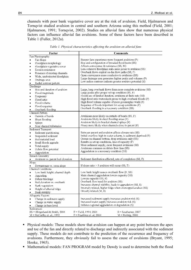
channels with poor bank vegetative cover are at the risk of avulsion. Field, Hjalmarson and Tornqvist studied avulsion in central and southern Arizona using this method (Field, 2001; Hjalmarson, 1991; Tornqvist, 2002). Studies on alluvial fans show that numerous physical factors can influence alluvial fan avulsions. Some of these factors have been described in Table 1 (Fuller, 2012a).
Table 1. Physical characteristics affecting the avulsion on alluvial fans
§ Physical models: These models show that avulsion can happen at any point between the apex and toe of the fan and directly related to discharge and indirectly associated with the sediment supply. These models do not contribute to the prediction of the occurrence and frequency of avulsions. Furthermore, they obviously fail to assess the cause of avulsions (Bryant, 1995; Hooke, 1965).
§ Mathematical models: FAN PROGRAM model by Dawdy is used to determine both the flood

European Water 52 (2015) 25
hazards on the alluvial fan and the effects of avulsion on alluvial fans (Dawdy, 1979; FEMA 1990). Based on Dawdy theory the flood channel occurs randomly and is unpredictable in active alluvial fans. Therefore, each point in an active area of a fan has similar chance to become a new channel as other points; since each point has the tendency to undergo the flood. Hence, the probability of flood occurrence in this model can be determined as follows (for more description see FAN program manual):
H = 1 if the location is inundated 0 if the location is not inundated
P H = 1 = p! ! 1, q f! q dq!!!
(1)
Q= random variable denoting the magnitude of the flood p! ! (!,!)= conditional probability that the location will be inundated, given that a flood of magnitude q is occurring. fq Q = Probability density function (PDF) defining the likelihood that a flood of a magnitude between q and q+dq will occur in any given year.
Based on the assumptions of this model all areas of the alluvial fan are subject to flooding and that there exist a fixed relationship between flooding depth and discharge (see FAN program manual and FEMA, 2003). This model makes a number of simple assumptions, failing to account for small-scale topography or superficial geology in a significant way (House, 2005). The FAN methodology does not explicitly recognize processes associated with alluvial fan flooding such as debris and mud flow, two dimensional flows, sheet flooding, avulsion, aggradation and flow attenuation (Fuller, 2012). Although Dawdy’s model was the first to be accepted by the Federal Emergency Management Agency (FEMA), it received a plethora of criticisms from experts. This model is rarely used nowadays.
Worthy to mention is that the Alluvial fan flows are two-dimensional. The application of one dimensional steady flow hydraulic models on alluvial fans has a number of limitations including: I) difficulties and inaccuracies in determining flow direction on floodplains; II) the lack of flood volumes in determining flooding boundaries, and III) the approximate nature of flood discharge calculation (East Ojai FLO-2D floodplain study, 2009). Therefore, a two dimensional model would perform much better in such situation. In this research FLO-2D model (O’Brien, 2007) was considered. As a volume conservation flood routing model, it offers a valuable tool for delineating flood hazards, regulating floodplain zoning and designing flood mitigation (Fuller, 2010). The first version of the model was used in 1988 to conduct a FEMA Flood Insurance Study (FIS) on an urbanized alluvial fan in the state of Colorado. Floodplain delineation studies were also performed in a number of other projects (Fuller, 2009; 2010) in which this model was used to simulate the 100-year flood risk on alluvial fans. Also, two-dimensional models such as FLO-2D have been used to identify the risk of avulsion instead of mathematical models such as FAN PROGRAM (Fuller, 2010).
Based on studies it can be concluded that there does not exist a comprehensible engineering standard to assess the flood hazards in alluvial fans, although there are some profound similarities among methods which are based on engineering and geomorphic approaches.
In this study, avulsions on two alluvial fans in the northeast and southeast of Iran have been studied. Determining avulsion risk is highly important in these regions, especially given the potential damages inflicted on the residential and industrial areas located in these alluvial fans. Hence, this study is aimed at enhancement of flood hazards evaluation on alluvial fans using a hydraulic-geomorphic approach. In fact, this research was focused on developing a new approach in order to cover some of the weaknesses of FEMA FAN. The effort put forth in this study was first to identify areas with the potential risk of avulsion using geomorphic features and predict the impact of this phenomenon on two alluvial fans using two-dimensional hydraulic model to add to the growing body of knowledge in this existing field.

26 Z. Mollaei et al.
2. STUDY AREA
This study was performed on two separated alluvial fans in Iran. Sarbaz fan is located on the southern piedmont of the Sistan Mountains in Sistan province which is located in the southeast part of Iran. Due to its arid climate, this fan has little rainfall, high temperature, slight humidity, poor vegetation, high aggradation and high amounts of water and wind erosion. Sarbaz fan has been created as a result of Sarbaz River aggradations. There are heavy rainfalls in this area that often cause huge floods. Ferizy fan is located on the northern piedmont slopes of the Binalood Mountains which is located in Khorasan province in north-eastern part of Iran. Ferizy fan was is the result of the erosion and sedimentation of Ferizy River. At present, Ferizy fan is under development by agricultural, residential and also industrial development. Figure 1 shows the location of the two fans. The characteristics of the two fans in terms of area, slope and Q100 and Q500 have been depicted in Table 2.
Geomorphic features for delineation avulsion include: slope, drainage patterns, topographic data, superficial characteristics, surface color and bank vegetation. Sarbaz fan has distributary drainage pattern at the hydrographic apex, while this pattern rapidly moves from inside to the margins. With its high distributary flow, this alluvial fan rapidly changes to shallow sheet flooding in the middle and toe of the fan. Sarbaz fan has light-coloured areas in the east, while the western parts are mainly characterized by dark surface color. Eastern parts of the fan have high aggradations, where coarse-grained channel deposits are an indication of active surfaces in this area. One of the characteristics of active areas on Sarbaz fan is the lack of vegetation.
In Ferizy fan, active areas are mostly located in the eastern part of the fan. In contrast, areas with developed areas and tributary patterns are inactive. The results of field investigations showed that western parts of the fan were almost inactive. In addition, channel deposits are fine-grained and extensive in the western part of the fan.
The main channel drainage pattern of Ferizy fan becomes braided to some extent, but it does not change dramatically. These fans have a dendritic drainage pattern.
Based on Geomorphic features of the Sarbaz Fan, as shown in Figure 2 (this figure is a recent aerial photograph of Sarbaz fan), three avulsions can be seen in Sarbaz Fan. Avulsion A is located near the apex of the fan while avulsions B and C are located in central areas of the fan. The former is a major avulsion while the latter are MINOR avulsions. Major avulsions have developed in the active area of the fan close to the hydrographic apex whereas minor avulsions occurred in the central areas of the fan in sheet flooding areas. The geological map of the area indicates is whichmostly composed of Holocene type deposits. Quaternary alluvial sediments are also on older geologic formations. This indicates that recent floods have brought vast amounts of sedimentsinto this inactive area (Figure 2).
As shown Figure 2, there is only one MAJOR avulsion on the fan which could be due to the absence of a recent major flood. Drawing on information in Table 1, it can be stated that the most important factor in the occurrence of small avulsions in the area is the large volume of sediment and the existence of sedimentary stacks. Further, the distributary channel pattern, large peak discharge and weak vegetative cover on this alluvial fan also contributes to this process. Figure (2) shows the avulsions of the Sarbaz alluvial fan based on the number and type of avulsion (MAJOR, MINOR).
Based on Geomorphic features of the Ferizy fan suggests that large avulsion occurred just below the hydrographic apex. Recently, however, it has been ruined by human activities. Moreover, even if, there were avulsions in the past, agricultural activities on the alluvial fan have destroyed their traces.
Table 2. Characteristics Of The Studied Alluvial Fans
Fan Area (km2)
Slope (m/m)
Q100 (m3/s)
Q500 (m3/s)
Ferizy 155 1.04 80.8 118 Sarbaz 71 1.03 108 208

European Water 52 (2015) 27
Figure 1. Location of the studied alluvial fans
Figure 2. Types of avulsions observed on the Sarbaz alluvial fan- A (MAJOR) and Avulsions B and C (MINOR)

28 Z. Mollaei et al.
Figure 3. Location of avulsion on the Ferizy alluvial fan – A (MAJOR)
Figure 3 (this figure is a recent aerial photograph of Ferizy fan) shows the location of the avulsion on the Ferizy alluvial fan in which avulsion A has been highlighted as a MAJOR avulsion along with other small avulsions. Low slope, low peak discharge and agricultural activities in the area are among the reasons for the decreased number of avulsions in the area.
3. SIMULATION METHOD
To predict the potential avulsion on alluvial fans in the study area, FLO-2D model was adopted. FLO-2D is a two-dimensional flood routing model which is commonly used by floodplain engineers to delineate flood hazard maps, implement floodplain zoning, and design flood mitigation schemes. In this model full dynamic wave equation and central finite-difference routing scheme with eight potential flow directions were used to predict the progression of a flood hydrograph over a system of square grid elements (FLO-2D, 2010). Where h is the flow depth, V is the depth-averaged velocity in one of the eight flow directions x, i is rainfall intensity, Sf is the friction slope component and 𝑆! is the bed slope (equations 2 and 3), (FLO-2D user’s manual, 2009).
!!!"+ !!!
!"= 𝑖 (2)
𝑆! = 𝑆! −!!!"− !
!!"!"− !
!!"!"
(3)
This model is characterized by some key advantages: I)runoff can flow anywhere along the dominant boundary, not only the concentration point, II)peak discharge can be generated anywhere within the model domain, not just at the concentration point, III)in adjacent alluvial fans, the flow could be easily modeled along unconfined boundaries, IV)watershed parameters rather than being lumped over large sub basins are distributed over each small grid cell, and V)since routed hydrographs are inherent in the model, there is no need to estimate hydrologic routing parameters or averaged hydraulic routing cross sections (Fuller, 2010). In addition, unstable flow path, downstream flooding of the hydrographic apex, flooding along distributary and tributary channels and sheet flooding can be delineated using FLO-2D model. The FLO-2D-based model reveals that floods are not transferred via a single channel at fan evaluation sites and flow paths locations can be predicted if floods have minimal sediment transport and relatively constant topography (Fuller, 2010).

European Water 52 (2015) 29
This model is sensitive to grid size and topographic data. To increase the accuracy of the model, small size grids and topographic data with minimum distance between contour lines should be used. For all fans, the gird size was 20m, the topographic data accuracy was 3 m and the values of n were calculated according to the land use.
3.1 FLO-2D 100- year and 500-year models
FLO-2D model simulates flood hydrograph on the alluvial fan based on topographic information and other parameters in the model. On many active alluvial fan surfaces as defined by a sandy bed and bank vegetation, are perched topographically above the surrounding terrain. In other areas the channels have aggraded to the point where they have no longer the potential to convey the flow delivered by upstream reaches. FLO-2D spreads runoff over topographically lower area in the floodplain, therefore potential avulsion flow corridors to be identified from plots of flow depths on the fan surface relative to the existing channel locations (Fuller, 2012a). In this method, the flow hydrograph is determined for a Q100 and Q500-year. To identify potential avulsions on the alluvial fan, the simulated flow of the model should be plotted on a recent aerial photograph of the area. This overlap suggests that there were channels missed on the aerial photograph that were identified in the simulation.
According to the literature, a depth of 1 m on the alluvial fan is accepted as the threshold of an avulsion (Pearthree, 2004). Thus, this method can identify potential avulsions that may occur on alluvial fans.
3.2 FLO-2D velocity zones
As noted in Table 1, OVERBANK flooding is a feature that causes avulsion on alluvial fans. For OVERBANK flooding to happen, the presence of adequate energy to erode the floodplain surface is necessary. According to previous studies, alluvial fans would be at the risk of erosion when velocity is higher than 2 m/s. Thus, having the velocity results of FLO-2D model, we can determine zones with flow velocity higher than 2 m/s, which are labelled as areas with avulsion potential.
3.3 FLO-2D hazard Classification
FlO-2D model has provided users with a series of tables that classify the risk based on the depth and velocity of the flow. Flood hazards are indicated on the map by three colors: high (red), medium (orange) and low (yellow). Thus, it can be used to determine the potential risk of avulsion. For instance, portions of fans at risk of major avulsions are considered high hazard zones. So, by merging these results with recent aerial photographs of the area, we can identify areas that are not connected to the network of channels but the model showed the risk of avulsion in them. This categorization has been depicted in Figure 4.
All discussed methods seek to identify avulsion where there is not any channel on the alluvial fan while its possibility cannot be ruled out. In all the above three methods, the location of the potential avulsive flow corridors is identified by overlaying the results of the FLO-2D model of the channel network on the recent aerial photographs.
4. RESULTS
4.1 Results of 100- year and 500-year FLO-2D models
The results of FLO-2D model with the recent aerial photograph of the Sarbaz fan which were overlapped in the GIS software is shown in Figure (5). As shown in Figure (5.A), there are five Q100-year avulsions: a large avulsion in the middle part of the alluvial fan (marked in black color) and four smaller avulsions (marked in orange color) in its vicinity. Also, there is a Q500-year
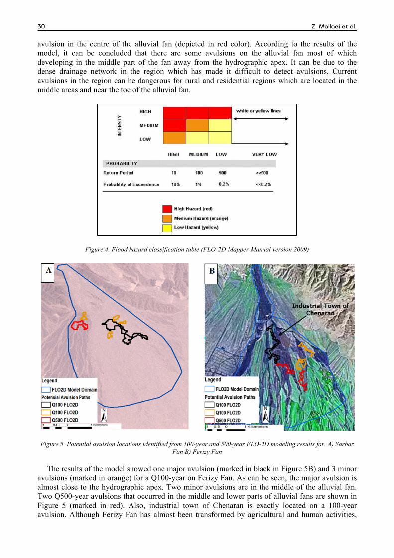
30 Z. Mollaei et al.
avulsion in the centre of the alluvial fan (depicted in red color). According to the results of the model, it can be concluded that there are some avulsions on the alluvial fan most of which developing in the middle part of the fan away from the hydrographic apex. It can be due to the dense drainage network in the region which has made it difficult to detect avulsions. Current avulsions in the region can be dangerous for rural and residential regions which are located in the middle areas and near the toe of the alluvial fan.
Figure 4. Flood hazard classification table (FLO-2D Mapper Manual version 2009)
Figure 5. Potential avulsion locations identified from 100-year and 500-year FLO-2D modeling results for. A) Sarbaz Fan B) Ferizy Fan
The results of the model showed one major avulsion (marked in black in Figure 5B) and 3 minor avulsions (marked in orange) for a Q100-year on Ferizy Fan. As can be seen, the major avulsion is almost close to the hydrographic apex. Two minor avulsions are in the middle of the alluvial fan. Two Q500-year avulsions that occurred in the middle and lower parts of alluvial fans are shown in Figure 5 (marked in red). Also, industrial town of Chenaran is exactly located on a 100-year avulsion. Although Ferizy Fan has almost been transformed by agricultural and human activities,

European Water 52 (2015) 31
the avulsion potential still can be seen in some areas.
4.2 Results of FLO-2D velocity zones
As to Ferizy Fan, the results showed that velocity was extremely high near the hydrographic apex and decreased as it moved towards the middle and end parts whereas Sarbaz Fan had the highest velocities in middle parts, which has the potential of avulsions and could be deleterious to rural and residential areas in this region (Figure 6A). Most avulsions identified in the Q100-year method were not detected in the velocity method. However, this method allows identifying areas that are on the verge of avulsion based on their velocity.
Figure 6. Results of 100- year FLO-2D velocity A) Sarbaz Fan B) Ferizy Fan
4.3 Results of FLO-2D hazard classification
Based on the current FLO-2D model shown in Figure 4, flood hazards were classified in different parts of the alluvial fans. The results indicated that Sarbaz Fan had a high risk of avulsion especially in the central areas, which could be due to high discharge (Figure 7A). Ferizy Fan had also avulsion risk in initial and middle parts especially in industrial town of Chenaran (Figure 7B). Thus, this method can help identify areas with high risk.
A comparison between the results of FAN model and FLO-2D are presented in Figure 8. As shown in this figure the FAN model zones the entire fan and each zone contains a specific depth and velocity, which both reduce as flood flow approaches from apex to the toe.
The FAN model shows that the flood hazard generally decreases with distance from the hydrographic apex. However, the FLO-2D results for Sarbaz fan showed that the velocity and depth were high near the fan’s toe and the areas located blew the hydrographic apex (Figure 6a). Hence, flood hazards in distal-fan areas could be more serious than in mid-fan parts. The results of FLO-2D model showed that flooding, probable at any point of the fan, is not limited to the upper areas.
In this study, comparison between Figures (2) and (5A) in Sarbaz fan and Figures (3) and (5B) in Ferizy fan shows that some avulsions and active areas (active areas are at risk of avulsion and inundation according to geomorphic data) that are identified in Figure (2) and (3) were not detected in hydraulic model results.

32 Z. Mollaei et al.
Figure 7. Results of FLO-2D hazard classification A) Sarbaz Fan B) Ferisy Fan
Figure 8. The results of fan model for: (A) Sarbaz fan; (B) Ferizy fan
All of the methods studied in this research (geomorphological features and FLO-2D hydraulic model) have a degree of uncertainty, with each only dealing with a certain part of flooding phenomenon. The geomorphic features do not provide quantitative engineering facts and its application requires training, experience and expertise. Factors such as change in topography, deposition and erosion are key elements of uncertainty in each of the geomorphic and engineering methodologies. Thus, the best way to delineate avulsion is to integrate geomorphic and engineering tools.
5. CONCLUSIONS
This study was conducted on two alluvial fans in northeast and southeast of Iran with the aim of identifying areas with avulsion risk. Alluvial fans situated in the northeastern part of Iran are subjected to agriculture and urbanization development due to their suitable climate and fertile soils,

European Water 52 (2015) 33
which in turn has alleviated the flood risk in these areas. On the contrary, alluvial fans in the southeastern part of Iran are still susceptible to enormous floods due to occurrence of heavy rainstorms and paucity of development stimulated by their arid climate and unfertile soils.
The findings showed that Sarbaz Fan had large discharge peak, which has brought large quantities of sediment to this region. The poor vegetative cover and the distributary channel network of this area are some of the factors contributing to the occurrence of avulsion in the alluvial fans. Ferizy alluvial fan has fertile soil with lower peak discharge and the disturbances caused by human activities have wiped out the avulsions in it. Thus, comparing two fans, it can be concluded that Sarbaz Fan has been more susceptible to potential avulsions than Ferizy Fan.
In this study, the two-dimensional FLO-2D model was used to identify avulsions on the alluvial fans by means of three different methods, namely FLO-2D 100- year and 500-year models, FLO-2D velocity zones and FLO-2D hazard classification. Based on geomorphic features of the fans, the results of plotting recent aerial photographs on FLO-2D model results indicate that there are striking differences between two methods. The results of the model show channels on the alluvial fans that are not detected in geomorphic features; however, these channels are the places of potential avulsions predicted by hydraulic model.
The results of the model about Ferizy Fan showed several avulsions, one of which was at a serious point (Industrial town of Chenaran). As such, necessary precautions must be taken to prevent damages to the area. Model also showed avulsions in the central areas of Sarbaz alluvial fan that could be threatened to Soldan County. Thus, the best approach to project flood hazards is to integrate hydraulic and geomorphic methods.
Review of literature indicates that FLO-2D model has always been an efficient tool for the management of alluvial fan floodplain and future flood mitigation project planning (for example, in Arizona alluvial fans project (see Fuller, 2010b). Appropriate topography mapping and small-size grids are recommended for obtaining accurate results in FLO-2D model (the modeler needs to choose a grid size that reflects the expected model precision, model run time, topographic data precision, and unique site characteristics).
Since avulsion is a very important phenomenon that affects flood hazards, its effect should be taken into account in flood hazards studies.
In summary, evaluation of flood hazards on alluvial fans still is an unaccomplished task and further research is required.
REFERENCES
Bryant, M., Falk, P., Paola, C., 1995. Experimental Study of Avulsion Frequency and Rate of Deposition, Geology, 23(4): 365-368. Dawdy, D.R., 1979. Flood Frequency Estimates on Alluvial Fans. Journal of the Hydraulics Engineering 105(11): 1407-1412. East Ojai FLO-2D Floodplain Study, 2009. Ventura County Watershed Protection District, Technical report, Project number: 11431. FEMA (Federal Emergency Management Agency), 2003. Guidelines and Specification for Flood Hazard Mapping Partners,
Appendix G: Guidance for Alluvial Fan Flooding Analyses and Mapping. FEMA, 1990. FAN: An Alluvial Fan Flooding Computer Program, User s Manual and Program Disk: Washington, D.C., Federal
Emergency Management Agency. Field, John, 2001. Channel Avulsion on Alluvial fans in southern Arizona. Geomorphology, 37: 93-104. FLO-2D, 2009. FLO-2D User’s Manual. FLO-2D Engineering. Fuller, J.E, 2012. Theoretical and Practical Deficiencies in the FEMA FAN Methodology, Arizona Geological Survey Contributed
Report CR-12-B, Tucson, Arizona. Fuller, J.E., 2009. Technical data notebook- approximate zone floodplain delineation study of White Tanks fans 1&2, FCD control
No. 2007C051, work Assignment#2, report to the flood control district of Maricopa county. Fuller, J.E., 2010. Alluvial Fan Flood Hazard Identification and Mitigation Methods Final Report, PFHAM Refinement Study: Final
Report. Fuller, J.E., 2012a. Evaluation of Avulsion Potential on Active Alluvial Fans in Central and Western Arizona. Arizona Geological
Survey Contributed Report CR-12-D, Tucson, Arizona. Fuller, J.E., 2012b. Alluvial fan flood hazards identification and mitigation methods final report. PFHAM refinement study: final
report
Hjalmarson, H.W., and Kemna, S.P., 1991. Flood hazards of distributary-flow areas in southwestern Arizona: U.S. Geological Survay Water Resources Investigations Report 91-4171, 68 p.
Hooke, R.L., 1965. Alluvial Fans, Ph.D. Dissertation, California Institute of Technology, Pasadena, California

34 Z. Mollaei et al.
NRC (National Research Council), 1996. Alluvial Fan Flooding. National Academy Press, Washington, D.C. O Brien, J.S., 2007. FLO-2D Flood Routing Model, Version 2007.06, FLO-2D Software Inc. Pearthree, P.A., Klawon, J.E., and Lehman, T.W., 2004. Geomorphology and Hydrology of an Alluvial Fan on Tiger Wash,
Maricopa and La Paz Counties, West-central Arizona Geological Survey Open-File Report 04-02, 40p. Tornqvist, T.E., and Bridge, J.S., 2002, Spatial Variation of Overbank Aggradation Rate and its Influence on Avulsion Frequency,
Sedimentology, 49: 891-905. URS, 2012. Rainbow Valley Area Drainage Master Plan, Report to the Flood Control District of Maricopa County.


