Embed Size (px)
Citation preview
Aviation Weather #0
Aviation Weather Course designed by Aaron Schoolcraft and Brock Hindman
Course Objectives
Student will be able to: • Identify weather conditions that may adversely
affect the safety of aviation operations.
• Describe mitigations that can be applied when working in unfavorable weather conditions.
• List at least two aviation weather resources that can assist in making informed decisions.
Aviation Weather #1
Aviation Weather #2
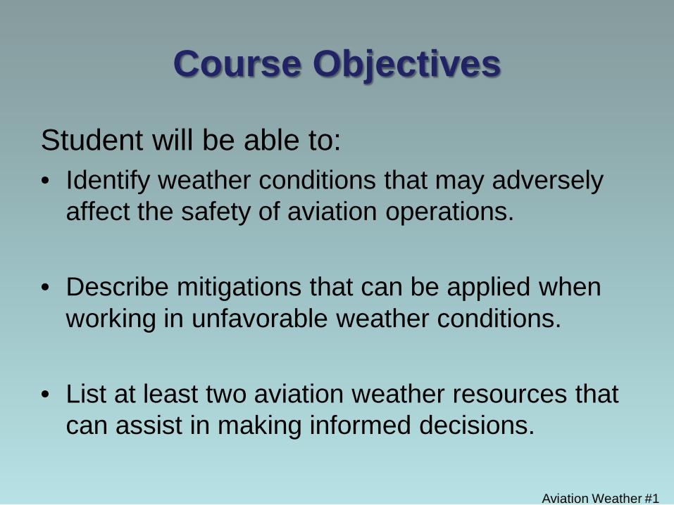
Aviation Weather • General Weather Overview • Mitigations • Aviation Weather Resources
Aviation Weather #3
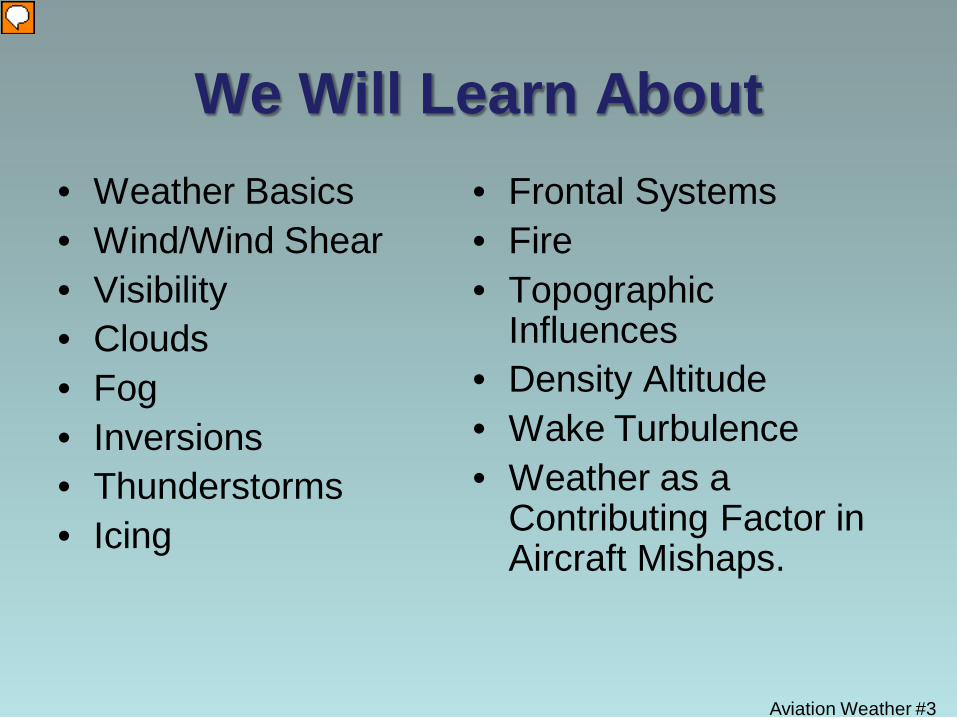
We Will Learn About • Weather Basics • Wind/Wind Shear • Visibility • Clouds • Fog • Inversions • Thunderstorms • Icing
• Frontal Systems • Fire • Topographic
Influences • Density Altitude • Wake Turbulence • Weather as a
Contributing Factor in Aircraft Mishaps.

Aviation Weather #4
Proceed to the AOPA Weather Wise training program And complete lesson on “Air Masses and Fronts”
http://flash.aopa.org/asf/wxwise_fronts/wxwise_fronts.cfm?
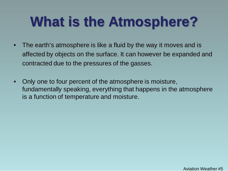
What is the Atmosphere? • The earth’s atmosphere is like a fluid by the way it moves and is affected by objects on the surface. It can however be expanded and contracted due to the pressures of the gasses.
• Only one to four percent of the atmosphere is moisture,
fundamentally speaking, everything that happens in the atmosphere is a function of temperature and moisture.
Aviation Weather #5
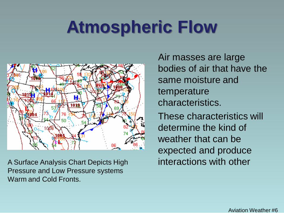
Atmospheric Flow Air masses are large
bodies of air that have the same moisture and temperature characteristics.
These characteristics will determine the kind of weather that can be expected and produce interactions with other
Aviation Weather #6
A Surface Analysis Chart Depicts High Pressure and Low Pressure systems Warm and Cold Fronts.
Aviation Weather Based On
• Temperature
• Density
• Pressure
• Moisture Aviation Weather #7
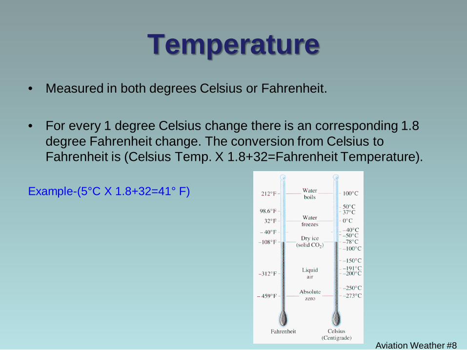
Temperature • Measured in both degrees Celsius or Fahrenheit.
• For every 1 degree Celsius change there is an corresponding 1.8
degree Fahrenheit change. The conversion from Celsius to Fahrenheit is (Celsius Temp. X 1.8+32=Fahrenheit Temperature).
Example-(5°C X 1.8+32=41° F)
Aviation Weather #8
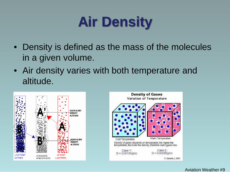
Air Density
• Density is defined as the mass of the molecules in a given volume.
• Air density varies with both temperature and altitude.
Aviation Weather #9
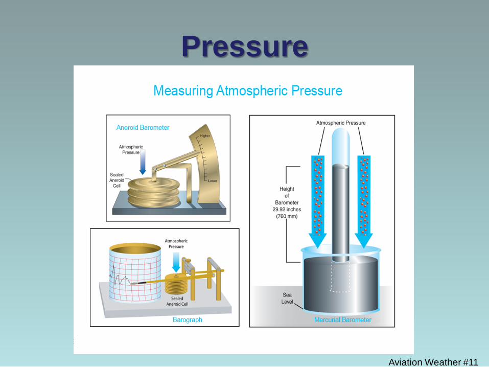
Pressure • The force exerted by the moving molecules of the gas on
a given area ( a square inch or square foot).
• Standard atmospheric pressure at sea level is 14.7 pounds per square inch or 29.92 inches of mercury.
• Standard pressure decreases one inch of mercury per thousand feet in elevation gain.
Aviation Weather #10
Pressure
Aviation Weather #11
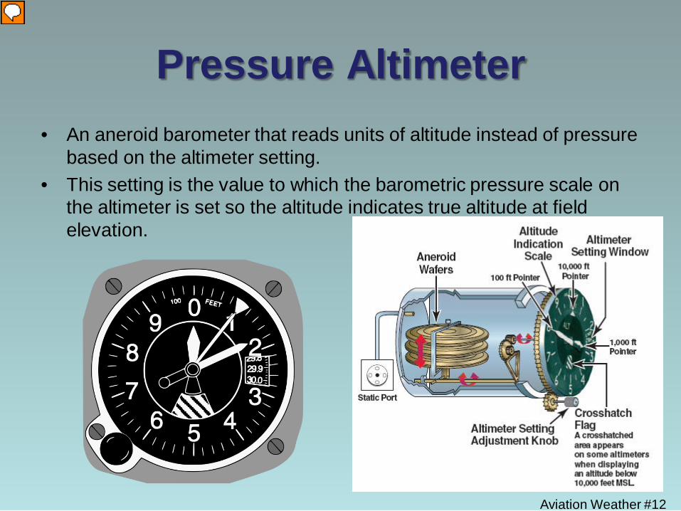
Pressure Altimeter • An aneroid barometer that reads units of altitude instead of pressure
based on the altimeter setting. • This setting is the value to which the barometric pressure scale on
the altimeter is set so the altitude indicates true altitude at field elevation.
Aviation Weather #12
Moisture
• Visibility is affected by a combination of Moisture and Temperature.
• When air is cooled to the point that it is completely saturated with water, you will be at Dew Point.
• When enough moisture is present (humidity) and the temperature falls close to dew point, visibility will decrease.
Aviation Weather #13
Aviation Weather #14
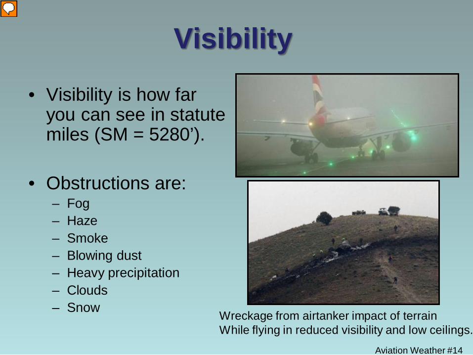
Visibility
• Visibility is how far you can see in statute miles (SM = 5280’).
• Obstructions are: – Fog – Haze – Smoke – Blowing dust – Heavy precipitation – Clouds – Snow Wreckage from airtanker impact of terrain
While flying in reduced visibility and low ceilings.
Aviation Weather #15
Visibility Obstructions • Fog:
– Forms rapidly – Can be very unpredictable – Forms in all parts of the country
• Haze:
– Concentrations of very fine dust particles – Occurs in stable atmospheric conditions and
relatively light wind
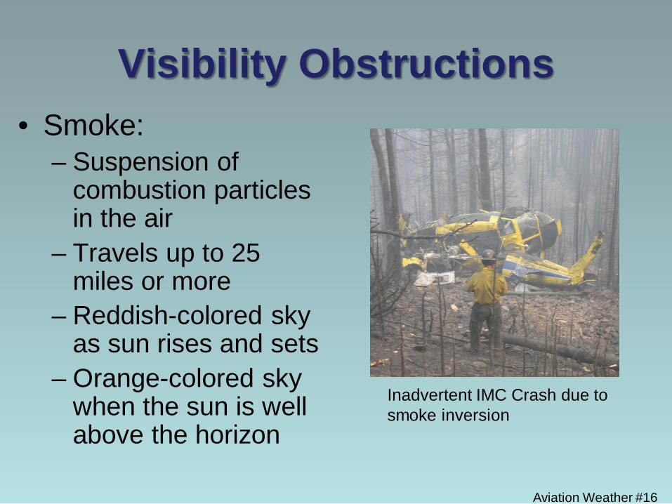
Visibility Obstructions • Smoke:
– Suspension of combustion particles in the air
– Travels up to 25 miles or more
– Reddish-colored sky as sun rises and sets
– Orange-colored sky when the sun is well above the horizon
Aviation Weather #16
Inadvertent IMC Crash due to smoke inversion
Visibility Obstructions
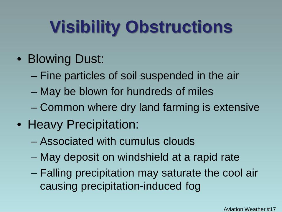
• Blowing Dust: – Fine particles of soil suspended in the air – May be blown for hundreds of miles – Common where dry land farming is extensive
• Heavy Precipitation: – Associated with cumulus clouds – May deposit on windshield at a rapid rate – Falling precipitation may saturate the cool air
causing precipitation-induced fog Aviation Weather #17
Aviation Weather #18
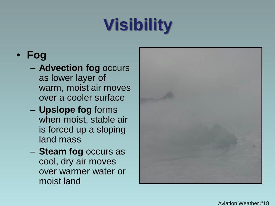
Visibility • Fog
– Advection fog occurs as lower layer of warm, moist air moves over a cooler surface
– Upslope fog forms when moist, stable air is forced up a sloping land mass
– Steam fog occurs as cool, dry air moves over warmer water or moist land
Aviation Weather #19
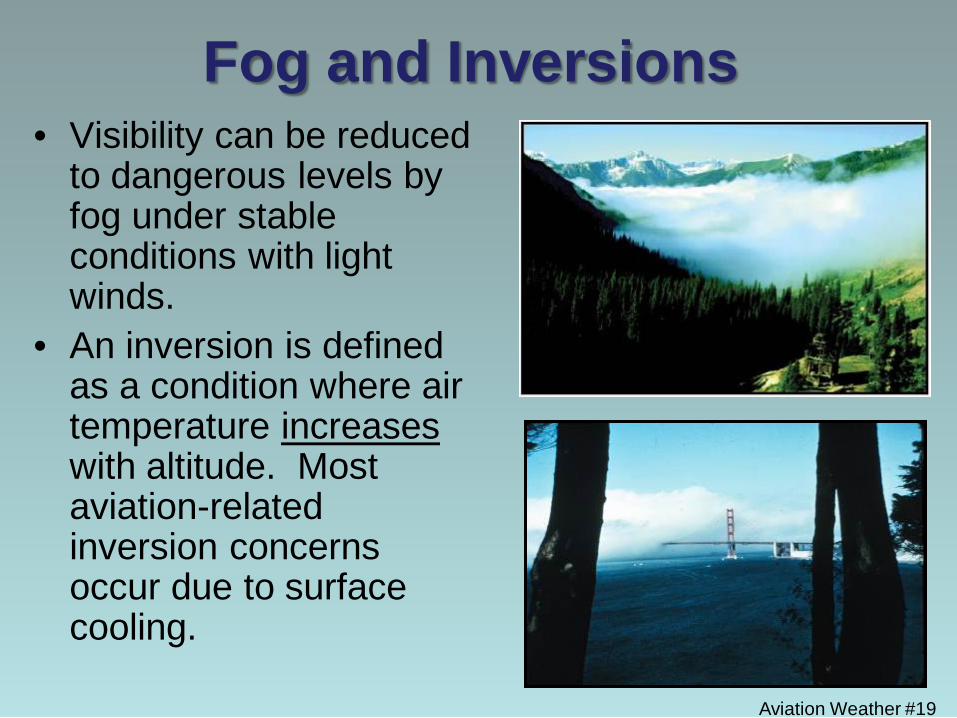
Fog and Inversions • Visibility can be reduced
to dangerous levels by fog under stable conditions with light winds.
• An inversion is defined as a condition where air temperature increases with altitude. Most aviation-related inversion concerns occur due to surface cooling.
Aviation Weather #20
Fog and Inversions • Fog can become concentrated beneath the
marine inversion caused by cool onshore winds, then disperse when the surface warms in the day or winds become offshore
• Fog is common when the temperature and dew point are close together or the same
• Mitigation: – Wait until temperatures and/or winds increase to
disperse the fog.
Additional Visibility Concerns
• Visibility may be extremely different at the incident or worksite compared to the airport.
• Marginal VFR conditions may still present some hazards that may be unsafe to fly around. – High Antenna Towers. – Less margin for changing weather patterns
Aviation Weather #21
Aviation Weather #22
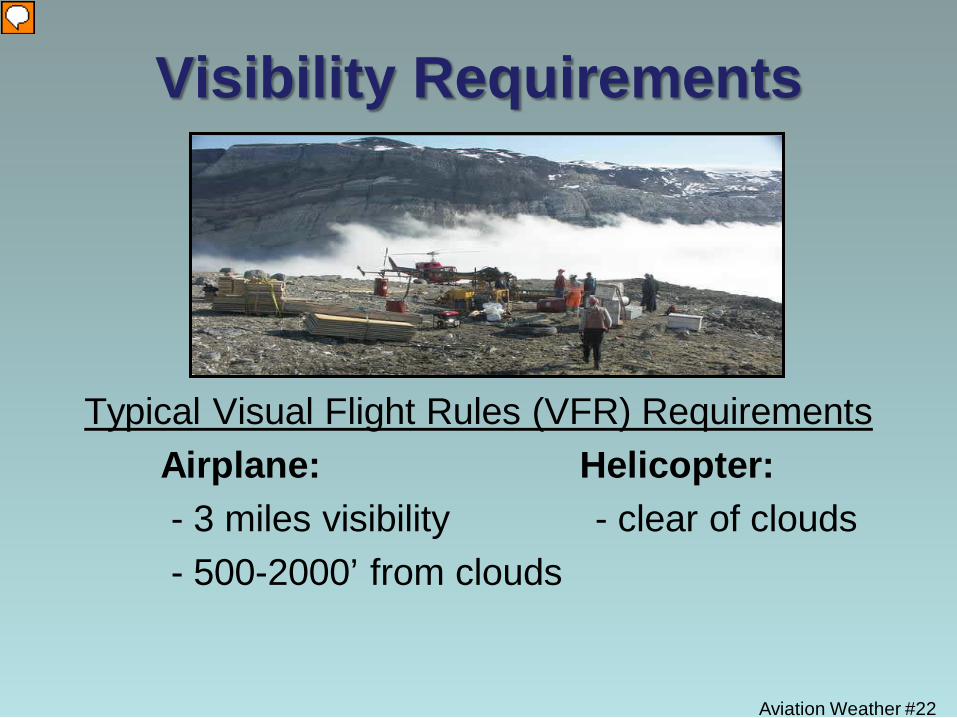
Visibility Requirements
Typical Visual Flight Rules (VFR) Requirements Airplane: Helicopter: - 3 miles visibility - clear of clouds - 500-2000’ from clouds
Aviation Weather #23
Wind What are the main forces that effect wind?
1. Pressure Gradient Force
– The difference in pressure between two points
2. Coriolis Force – It affects all objects moving across the face of the
earth
3. Frictional Force – The force that resists relative motion. Experienced
mainly in the lower 2,000 feet of the atmosphere
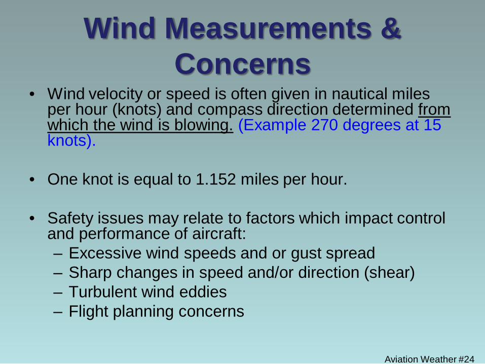
Wind Measurements & Concerns
• Wind velocity or speed is often given in nautical miles per hour (knots) and compass direction determined from which the wind is blowing. (Example 270 degrees at 15 knots).
• One knot is equal to 1.152 miles per hour.
• Safety issues may relate to factors which impact control and performance of aircraft: – Excessive wind speeds and or gust spread – Sharp changes in speed and/or direction (shear) – Turbulent wind eddies – Flight planning concerns
Aviation Weather #24
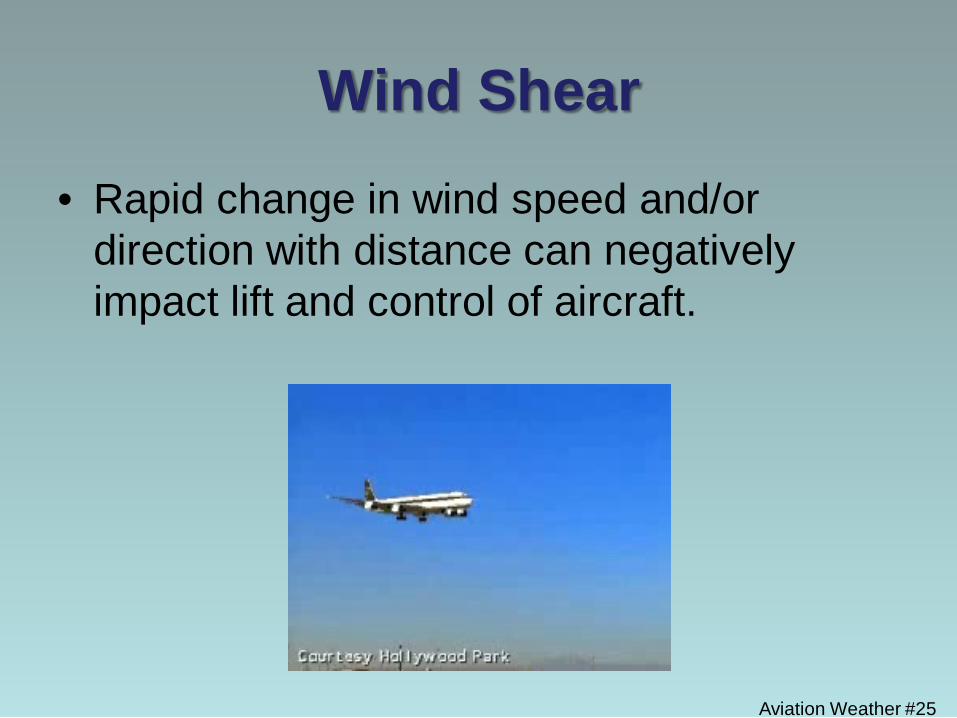
Wind Shear
• Rapid change in wind speed and/or direction with distance can negatively impact lift and control of aircraft.
Aviation Weather #25
Aviation Weather #26
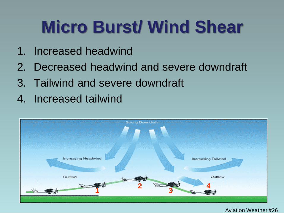
Micro Burst/ Wind Shear 1. Increased headwind 2. Decreased headwind and severe downdraft 3. Tailwind and severe downdraft 4. Increased tailwind
1 2 3 4
Aviation Weather #27
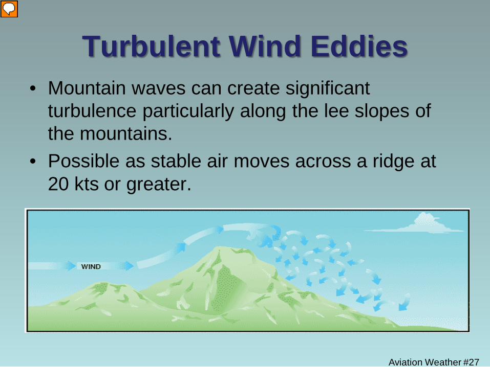
Turbulent Wind Eddies • Mountain waves can create significant
turbulence particularly along the lee slopes of the mountains.
• Possible as stable air moves across a ridge at 20 kts or greater.
Aviation Weather #28
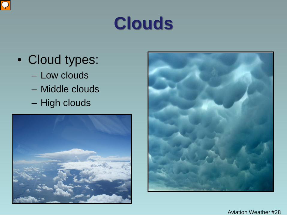
Clouds
• Cloud types: – Low clouds – Middle clouds – High clouds
Aviation Weather #29
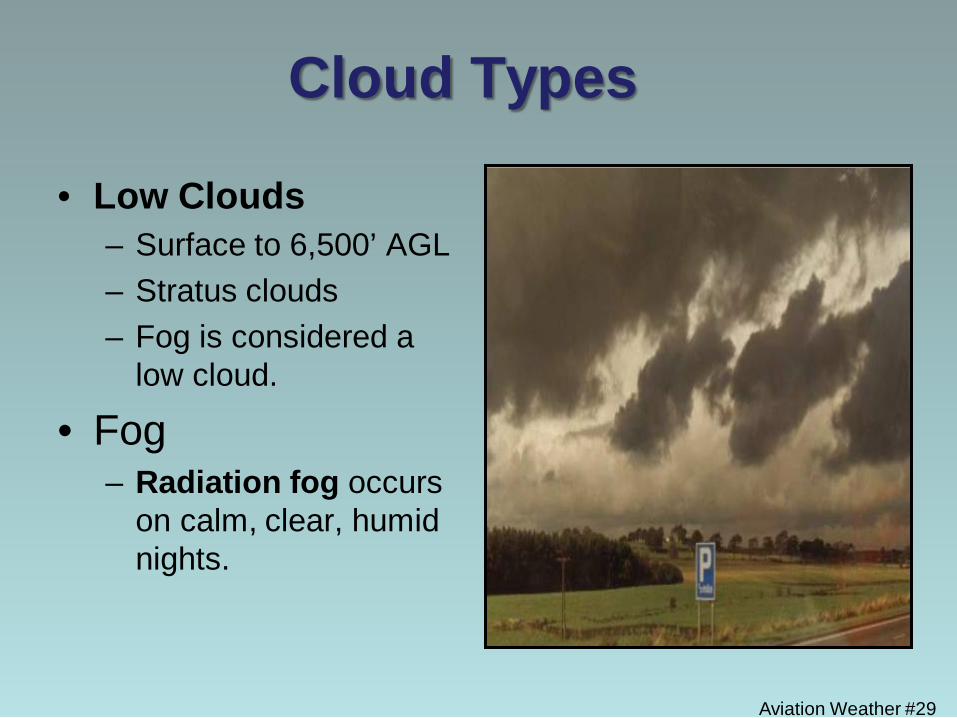
Cloud Types
• Low Clouds – Surface to 6,500’ AGL – Stratus clouds – Fog is considered a
low cloud.
• Fog – Radiation fog occurs
on calm, clear, humid nights.
Aviation Weather #30
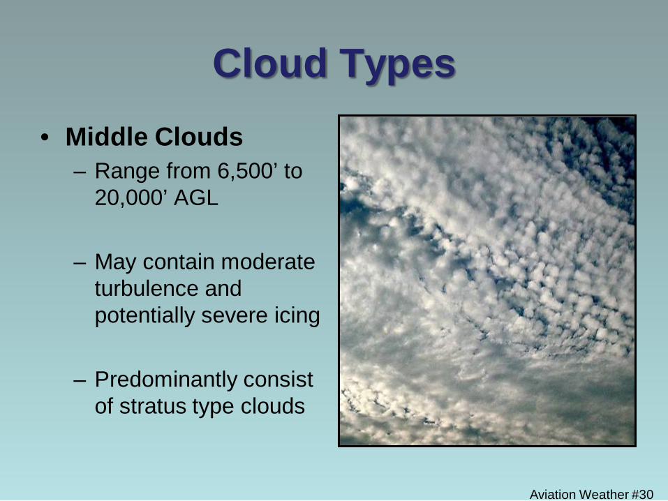
Cloud Types • Middle Clouds
– Range from 6,500’ to 20,000’ AGL
– May contain moderate turbulence and potentially severe icing
– Predominantly consist of stratus type clouds
Aviation Weather #31
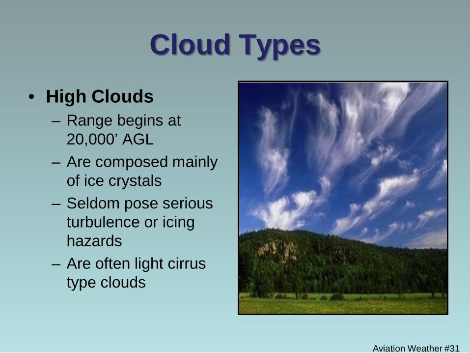
Cloud Types • High Clouds
– Range begins at 20,000’ AGL
– Are composed mainly of ice crystals
– Seldom pose serious turbulence or icing hazards
– Are often light cirrus type clouds
Aviation Weather #32
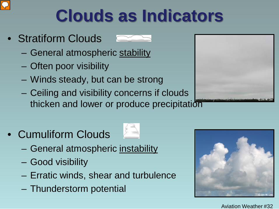
Clouds as Indicators • Stratiform Clouds
– General atmospheric stability – Often poor visibility – Winds steady, but can be strong – Ceiling and visibility concerns if clouds
thicken and lower or produce precipitation
• Cumuliform Clouds – General atmospheric instability – Good visibility – Erratic winds, shear and turbulence – Thunderstorm potential
Aviation Weather #33
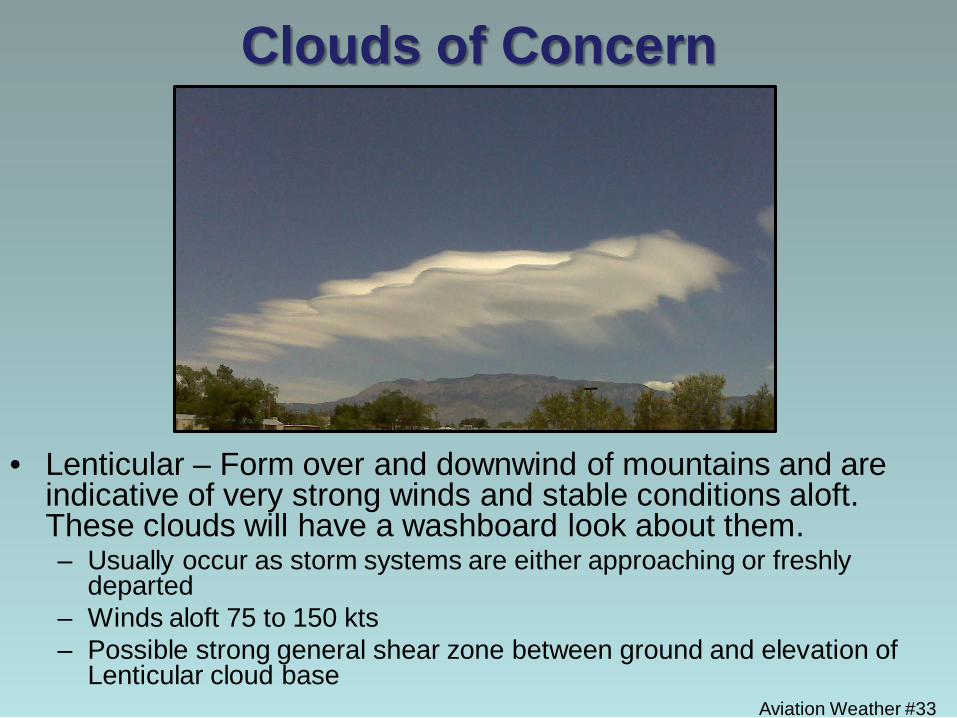
Clouds of Concern
• Lenticular – Form over and downwind of mountains and are indicative of very strong winds and stable conditions aloft. These clouds will have a washboard look about them. – Usually occur as storm systems are either approaching or freshly
departed – Winds aloft 75 to 150 kts – Possible strong general shear zone between ground and elevation of
Lenticular cloud base
Aviation Weather #34
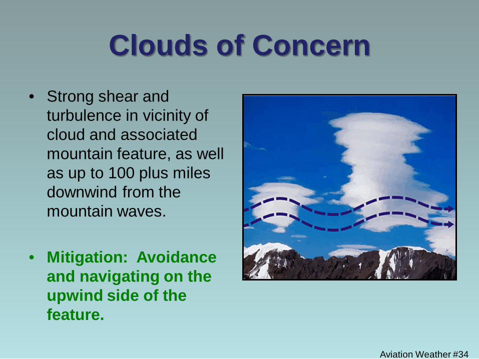
Clouds of Concern • Strong shear and
turbulence in vicinity of cloud and associated mountain feature, as well as up to 100 plus miles downwind from the mountain waves.
• Mitigation: Avoidance
and navigating on the upwind side of the feature.
Aviation Weather #35
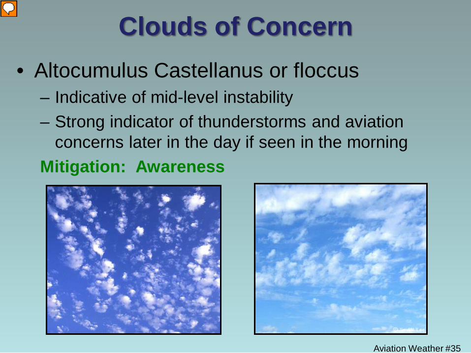
Clouds of Concern • Altocumulus Castellanus or floccus
– Indicative of mid-level instability – Strong indicator of thunderstorms and aviation
concerns later in the day if seen in the morning Mitigation: Awareness
Aviation Weather #36
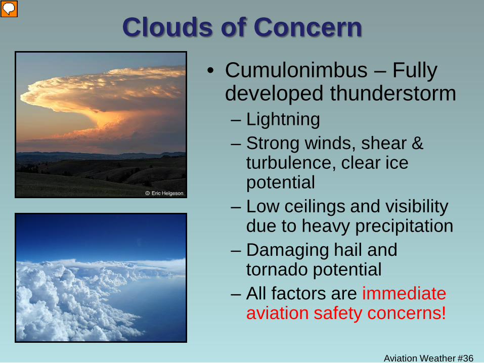
Clouds of Concern • Cumulonimbus – Fully
developed thunderstorm – Lightning – Strong winds, shear &
turbulence, clear ice potential
– Low ceilings and visibility due to heavy precipitation
– Damaging hail and tornado potential
– All factors are immediate aviation safety concerns!
Aviation Weather #37
Thunderstorms
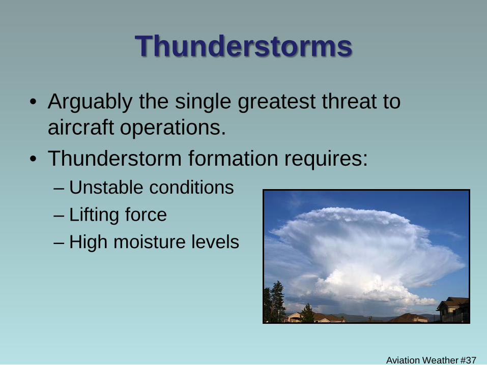
• Arguably the single greatest threat to aircraft operations.
• Thunderstorm formation requires: – Unstable conditions – Lifting force – High moisture levels
Aviation Weather #38
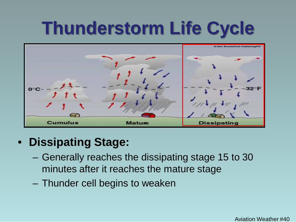
Thunderstorm Life Cycle
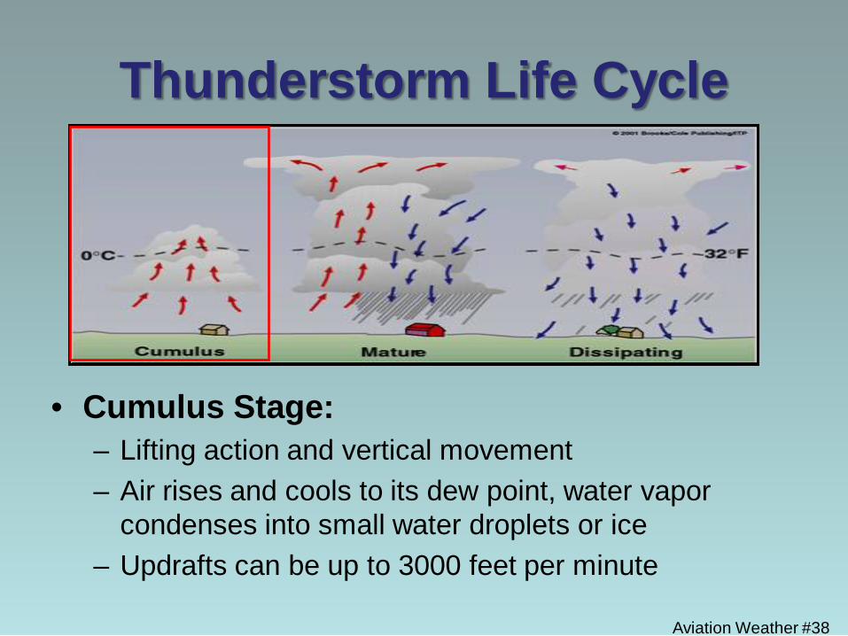
• Cumulus Stage: – Lifting action and vertical movement – Air rises and cools to its dew point, water vapor
condenses into small water droplets or ice – Updrafts can be up to 3000 feet per minute
Aviation Weather #39
Thunderstorm Life Cycle
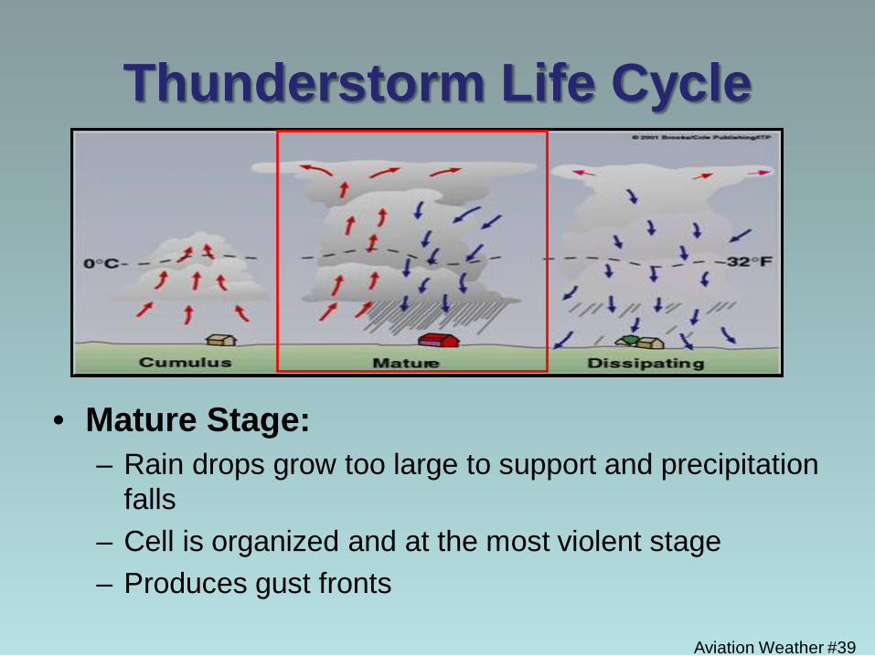
• Mature Stage: – Rain drops grow too large to support and precipitation
falls – Cell is organized and at the most violent stage – Produces gust fronts
Aviation Weather #40
Thunderstorm Life Cycle
• Dissipating Stage: – Generally reaches the dissipating stage 15 to 30
minutes after it reaches the mature stage – Thunder cell begins to weaken
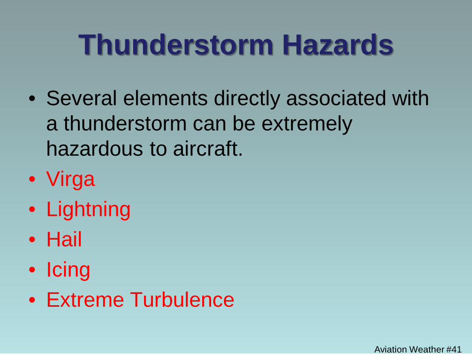
Thunderstorm Hazards
• Several elements directly associated with a thunderstorm can be extremely hazardous to aircraft.
• Virga • Lightning • Hail • Icing • Extreme Turbulence
Aviation Weather #41
Aviation Weather #42
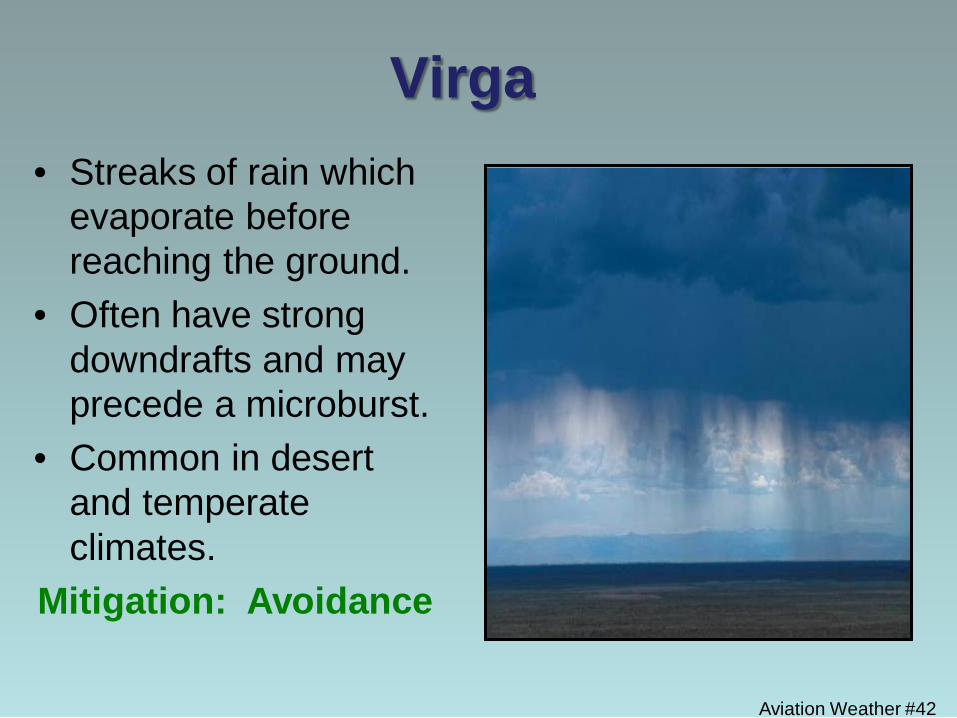
Virga • Streaks of rain which
evaporate before reaching the ground.
• Often have strong downdrafts and may precede a microburst.
• Common in desert and temperate climates.
Mitigation: Avoidance

Aviation Weather #43
Lightning
• Can strike in clear air in the vicinity of thunderstorms.
• Most likely to strike airborne aircraft when flight level temperature between 24
F and 40
F.
• Usually a minimal hazard
to airborne aircraft due to charge dispersion along metal skin.
Aviation Weather #44
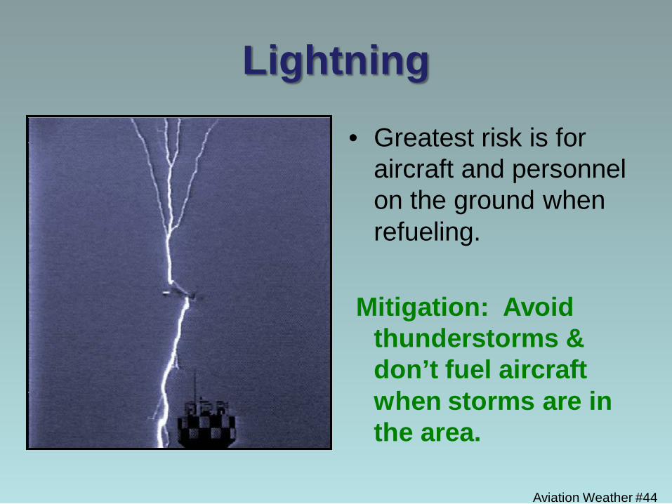
Lightning
• Greatest risk is for aircraft and personnel on the ground when refueling.
Mitigation: Avoid
thunderstorms & don’t fuel aircraft when storms are in the area.
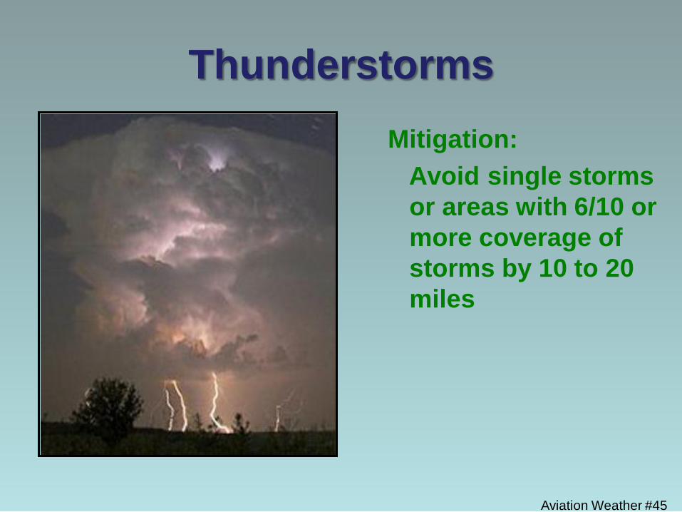
Aviation Weather #45
Thunderstorms Mitigation: Avoid single storms
or areas with 6/10 or more coverage of storms by 10 to 20 miles
Aviation Weather #46
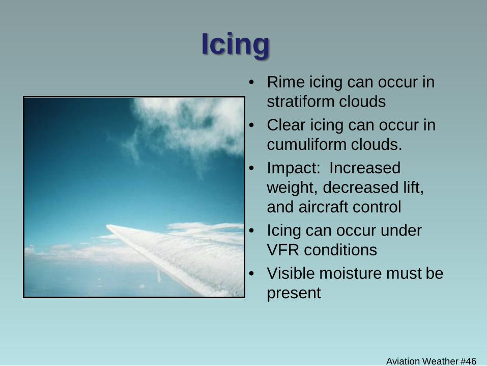
Icing • Rime icing can occur in
stratiform clouds • Clear icing can occur in
cumuliform clouds. • Impact: Increased
weight, decreased lift, and aircraft control
• Icing can occur under VFR conditions
• Visible moisture must be present
Aviation Weather #47
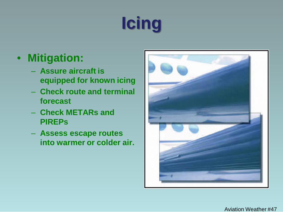
Icing
• Mitigation: – Assure aircraft is
equipped for known icing – Check route and terminal
forecast – Check METARs and
PIREPs – Assess escape routes
into warmer or colder air.
Turbulence • Extreme Turbulence and wind
shear can be encountered in a Thunderstorms.
• Moderate to severe turbulence
and wind shear can still be encountered in frontal activity regardless of presence of Thunderstorms
• Moderate turbulence - Changes in altitude/attitude occur. Aircraft remains in control at all times. Variations in indicated air speed.
• Severe turbulence - large, abrupt changes in altitude/attitude. Large variation in indicated airspeed. Aircraft may be temporarily out of control.
• Extreme turbulence - aircraft is violently tossed about and is impossible to control. May cause structural damage. Aviation Weather #48
Aviation Weather #49
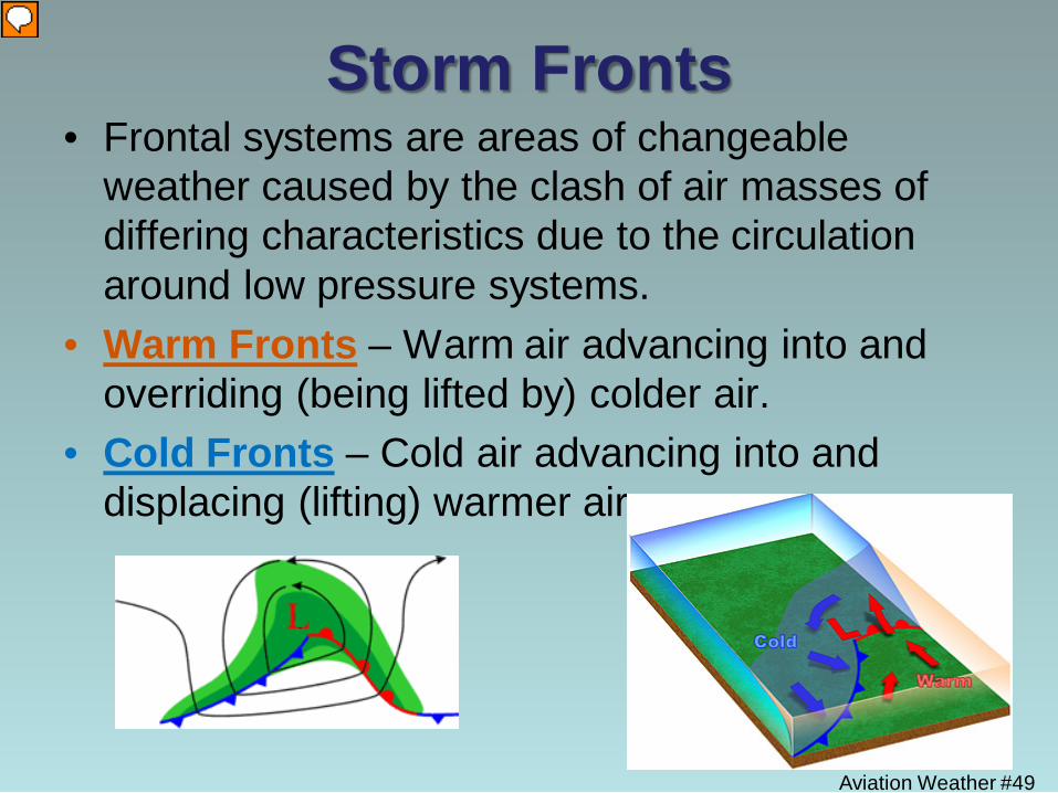
Storm Fronts • Frontal systems are areas of changeable
weather caused by the clash of air masses of differing characteristics due to the circulation around low pressure systems.
• Warm Fronts – Warm air advancing into and overriding (being lifted by) colder air.
• Cold Fronts – Cold air advancing into and displacing (lifting) warmer air.
Aviation Weather #50
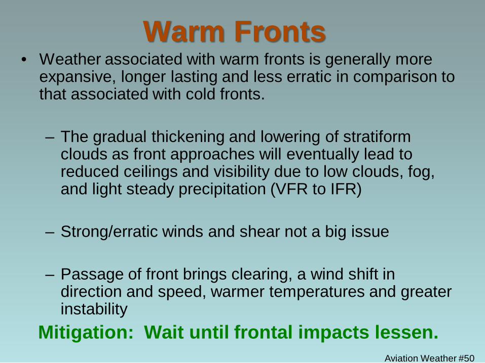
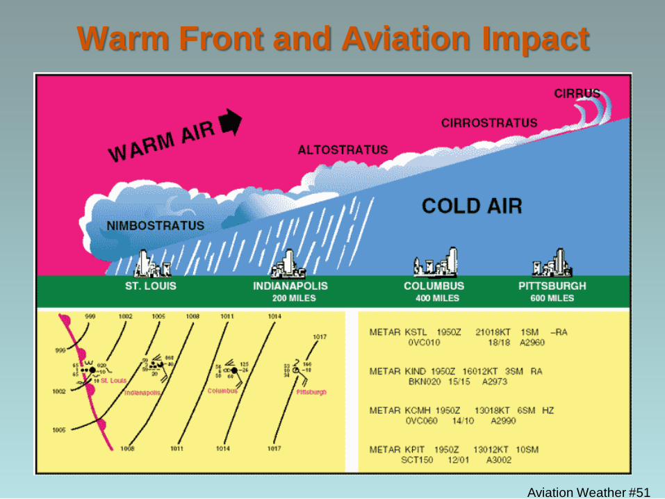
Warm Fronts • Weather associated with warm fronts is generally more
expansive, longer lasting and less erratic in comparison to that associated with cold fronts.
– The gradual thickening and lowering of stratiform
clouds as front approaches will eventually lead to reduced ceilings and visibility due to low clouds, fog, and light steady precipitation (VFR to IFR)
– Strong/erratic winds and shear not a big issue
– Passage of front brings clearing, a wind shift in direction and speed, warmer temperatures and greater instability
Mitigation: Wait until frontal impacts lessen.
Aviation Weather #51
Warm Front and Aviation Impact
Aviation Weather #52
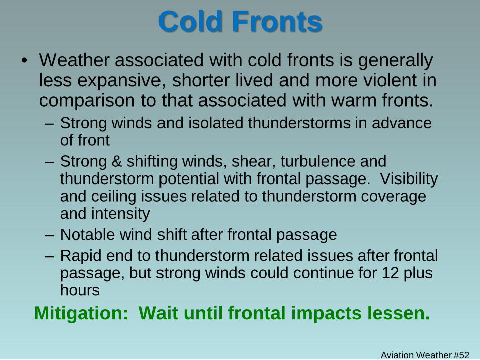
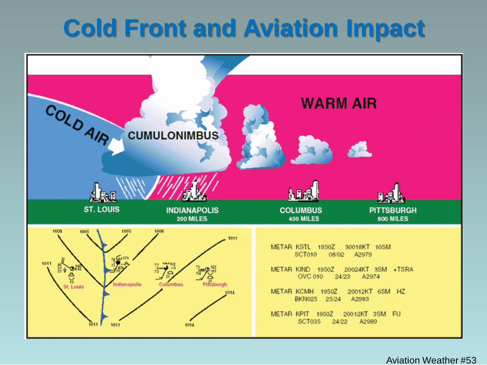
Cold Fronts • Weather associated with cold fronts is generally
less expansive, shorter lived and more violent in comparison to that associated with warm fronts. – Strong winds and isolated thunderstorms in advance
of front – Strong & shifting winds, shear, turbulence and
thunderstorm potential with frontal passage. Visibility and ceiling issues related to thunderstorm coverage and intensity
– Notable wind shift after frontal passage – Rapid end to thunderstorm related issues after frontal
passage, but strong winds could continue for 12 plus hours
Mitigation: Wait until frontal impacts lessen.
Aviation Weather #53
Cold Front and Aviation Impact
Aviation Weather #54
Fire Effect on Weather
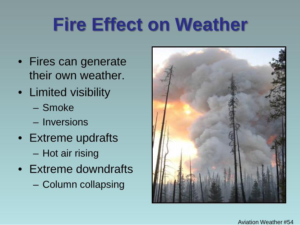
• Fires can generate their own weather.
• Limited visibility – Smoke – Inversions
• Extreme updrafts – Hot air rising
• Extreme downdrafts – Column collapsing
Aviation Weather #55
Fire Effect on Weather
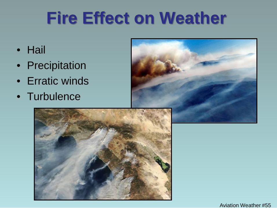
• Hail • Precipitation • Erratic winds • Turbulence
Topographic Influences: Mountains
Aviation Weather #56
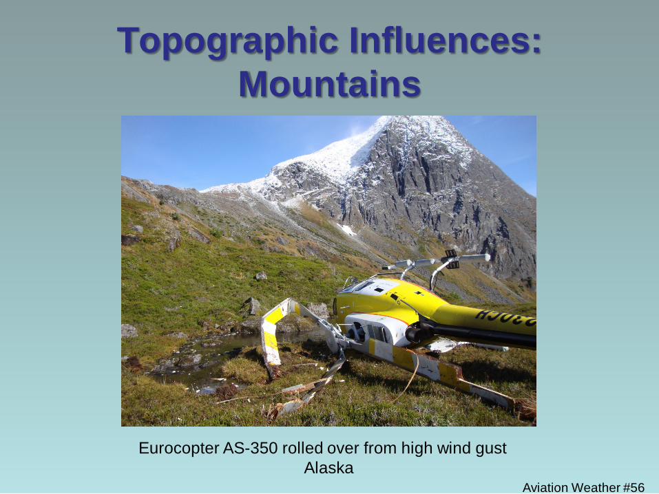
Eurocopter AS-350 rolled over from high wind gust Alaska
Aviation Weather #57
Topographic Influences • Topographic features create and/or modify weather
to produce conditions which can be highly variable in both time and space.
– Mountains – Create their own local weather as well as
substantially modify ambient weather conditions, usually resulting in more erratic winds and also the potential for lower ceilings and visibilities.
– Coastlines – Create local weather conditions associated with the sea breeze and marine layer which have a more profound impact on ceiling and visibilities than on winds.
Aviation Weather #58
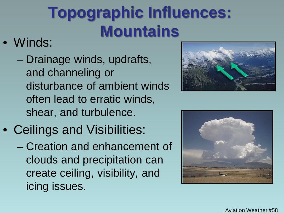
Topographic Influences: Mountains
• Winds: – Drainage winds, updrafts,
and channeling or disturbance of ambient winds often lead to erratic winds, shear, and turbulence.
• Ceilings and Visibilities: – Creation and enhancement of
clouds and precipitation can create ceiling, visibility, and icing issues.
Aviation Weather #59
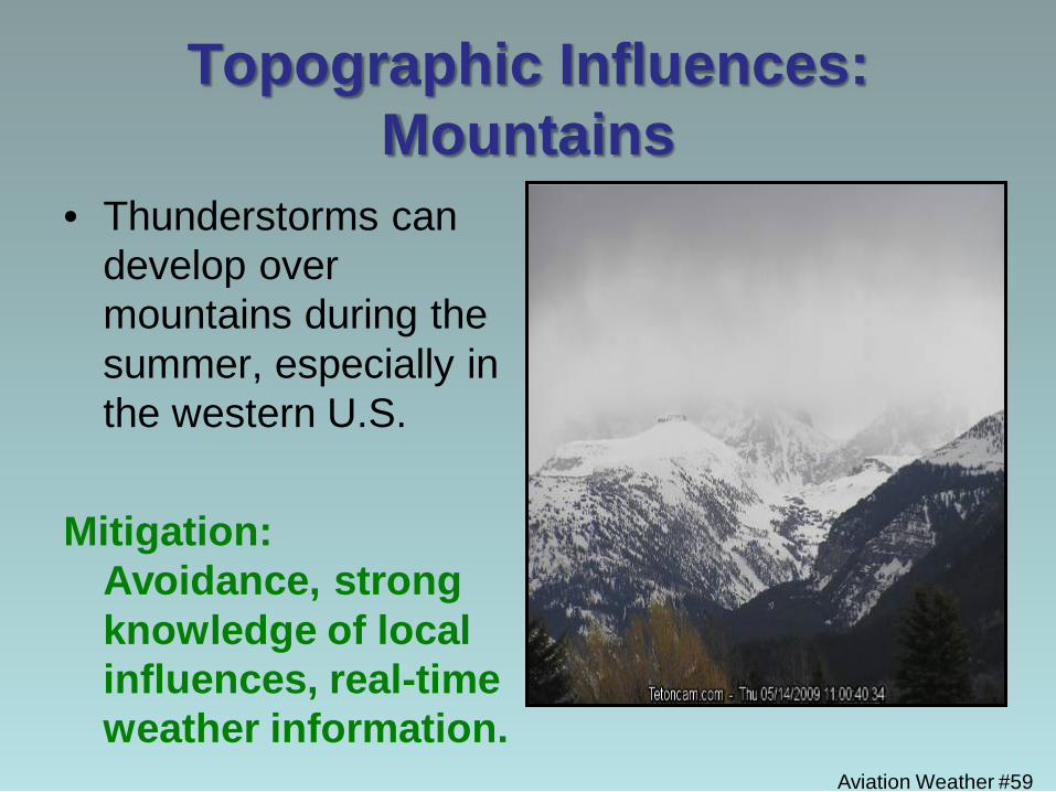
Topographic Influences: Mountains
• Thunderstorms can develop over mountains during the summer, especially in the western U.S.
Mitigation:
Avoidance, strong knowledge of local influences, real-time weather information.
Aviation Weather #60
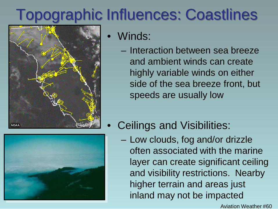
Topographic Influences: Coastlines • Winds:
– Interaction between sea breeze and ambient winds can create highly variable winds on either side of the sea breeze front, but speeds are usually low
• Ceilings and Visibilities:
– Low clouds, fog and/or drizzle often associated with the marine layer can create significant ceiling and visibility restrictions. Nearby higher terrain and areas just inland may not be impacted
Aviation Weather #61
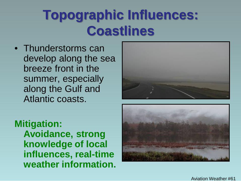
Topographic Influences: Coastlines
• Thunderstorms can develop along the sea breeze front in the summer, especially along the Gulf and Atlantic coasts.
Mitigation:
Avoidance, strong knowledge of local influences, real-time weather information.
Aviation Weather #62
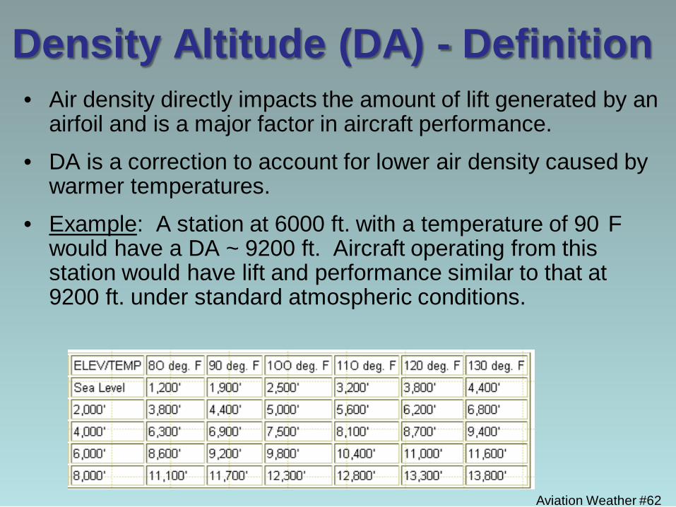
• Air density directly impacts the amount of lift generated by an airfoil and is a major factor in aircraft performance.
• DA is a correction to account for lower air density caused by warmer temperatures.
• Example: A station at 6000 ft. with a temperature of 90
F would have a DA ~ 9200 ft. Aircraft operating from this station would have lift and performance similar to that at 9200 ft. under standard atmospheric conditions.
Density Altitude (DA) - Definition
Aviation Weather #63
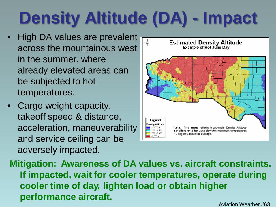
Density Altitude (DA) - Impact • High DA values are prevalent
across the mountainous west in the summer, where already elevated areas can be subjected to hot temperatures.
• Cargo weight capacity, takeoff speed & distance, acceleration, maneuverability and service ceiling can be adversely impacted.
Mitigation: Awareness of DA values vs. aircraft constraints. If impacted, wait for cooler temperatures, operate during cooler time of day, lighten load or obtain higher performance aircraft.
Aviation Weather #64
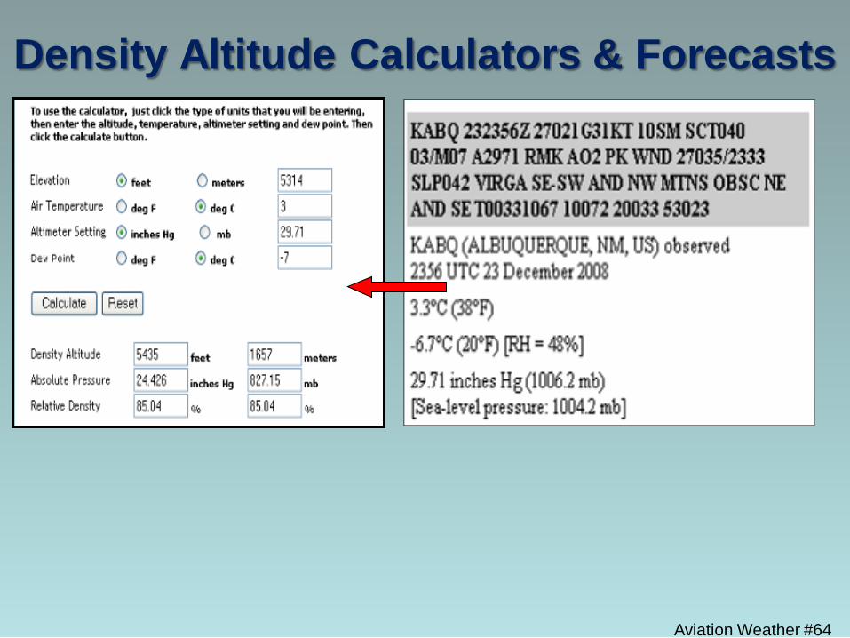
Density Altitude Calculators & Forecasts
Aviation Weather #65
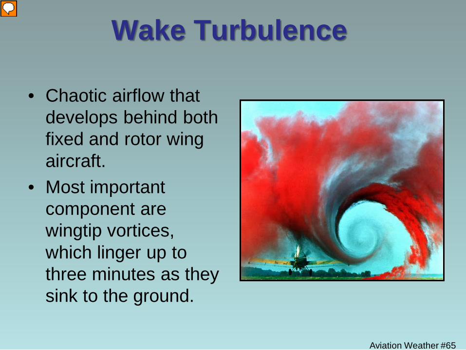
Wake Turbulence
• Chaotic airflow that develops behind both fixed and rotor wing aircraft.
• Most important component are wingtip vortices, which linger up to three minutes as they sink to the ground.
Aviation Weather #66
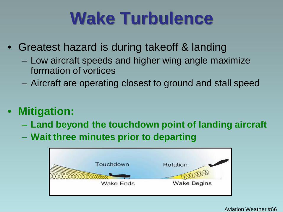
Wake Turbulence • Greatest hazard is during takeoff & landing
– Low aircraft speeds and higher wing angle maximize formation of vortices
– Aircraft are operating closest to ground and stall speed
• Mitigation: – Land beyond the touchdown point of landing aircraft – Wait three minutes prior to departing
Aviation Weather #67
Aviation Weather Resources
• Aviation routine weather reports (METARs) & forecasts (TAFs)
• Remote Automated Weather Stations (RAWS)
• Audible aviation weather service outlets
Aviation Weather #68
Aviation Weather Resources
• Incident Forecasts
• Density Altitude calculators & forecasts
• Aviation Digital Data Service (ADDS) – Radar, satellite, surface & pilot observations – Turbulence, icing and convection advisories – TAFs and METARs
Aviation Weather #69
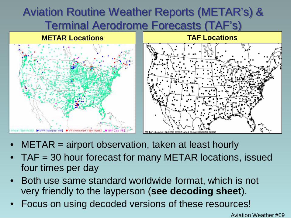
Aviation Routine Weather Reports (METAR’s) & Terminal Aerodrome Forecasts (TAF’s)
• METAR = airport observation, taken at least hourly • TAF = 30 hour forecast for many METAR locations, issued
four times per day • Both use same standard worldwide format, which is not
very friendly to the layperson (see decoding sheet). • Focus on using decoded versions of these resources!
TAF Locations METAR Locations
Aviation Weather #70
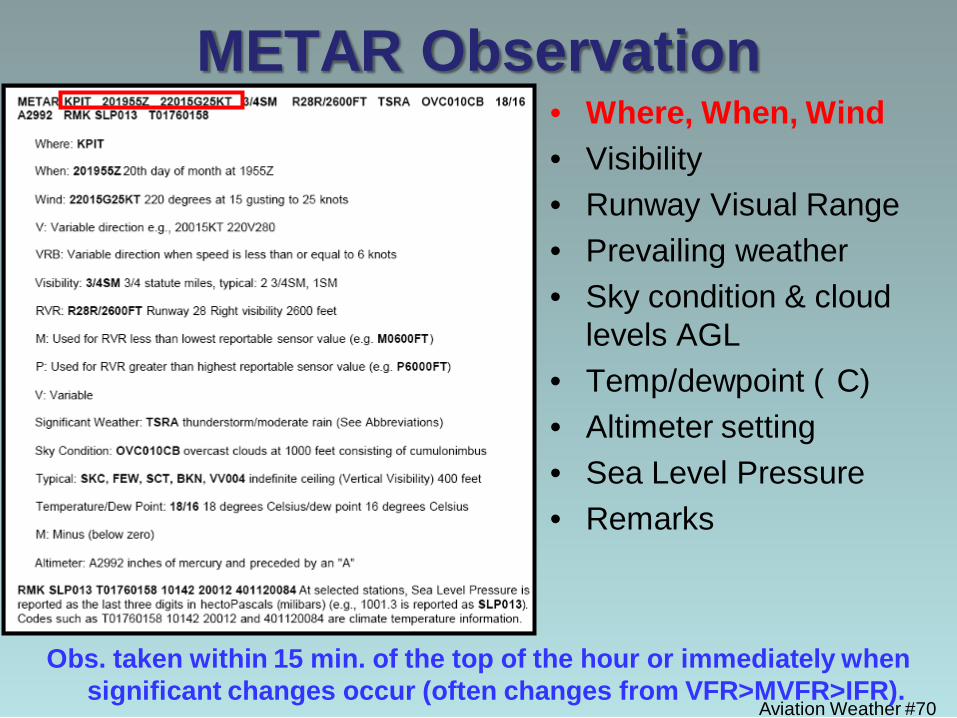
METAR Observation • Where, When, Wind • Visibility • Runway Visual Range • Prevailing weather • Sky condition & cloud
levels AGL • Temp/dewpoint (
C) • Altimeter setting • Sea Level Pressure • Remarks
Obs. taken within 15 min. of the top of the hour or immediately when significant changes occur (often changes from VFR>MVFR>IFR).

Aviation Weather #71
TAF - Terminal Aerodrome Forecast • Where, When, Wind • Visibility • Prevailing weather • Sky condition & cloud
levels AGL • optional: wind shear • Tempo, PROB40 and
PROB30 indicate significant non-prevailing conditions
• Issued every six hours and updated when significant changes occur.
• 5 miles from airport
Aviation Weather #72
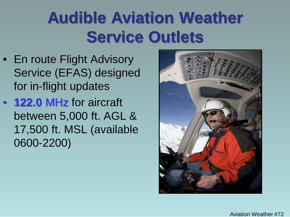
Audible Aviation Weather Service Outlets
• En route Flight Advisory Service (EFAS) designed for in-flight updates
• 122.0 MHz for aircraft between 5,000 ft. AGL & 17,500 ft. MSL (available 0600-2200)
Aviation Weather #73
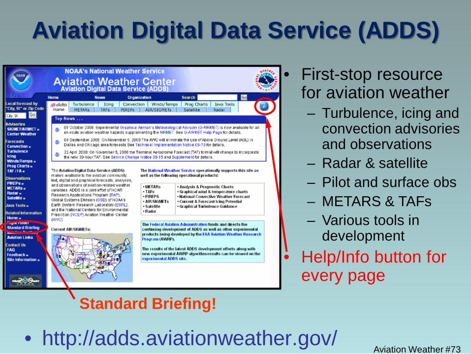
Aviation Digital Data Service (ADDS)
• http://adds.aviationweather.gov/
• First-stop resource for aviation weather – Turbulence, icing and
convection advisories and observations
– Radar & satellite – Pilot and surface obs – METARS & TAFs – Various tools in
development • Help/Info button for
every page Standard Briefing!
Aviation Weather #74
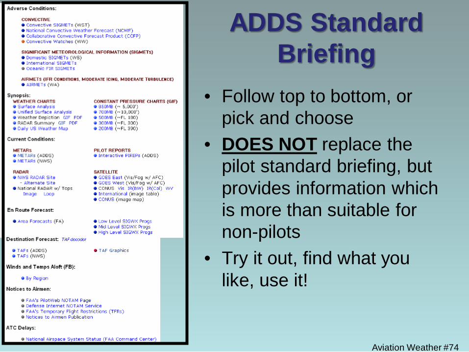
ADDS Standard Briefing
• Follow top to bottom, or pick and choose
• DOES NOT replace the pilot standard briefing, but provides information which is more than suitable for non-pilots
• Try it out, find what you like, use it!
Aviation Weather #75
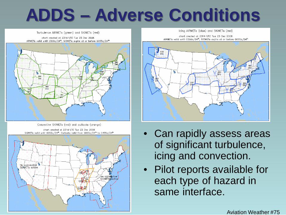
ADDS – Adverse Conditions
• Can rapidly assess areas of significant turbulence, icing and convection.
• Pilot reports available for each type of hazard in same interface.
Aviation Weather #76
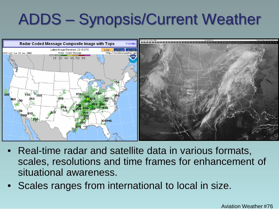
ADDS – Synopsis/Current Weather
• Real-time radar and satellite data in various formats, scales, resolutions and time frames for enhancement of situational awareness.
• Scales ranges from international to local in size.
Additional Aviation Weather Sources
• Gleim Aviation Weather & Weather Services
• Aviation Weather by Peter F. Lester
• Weather Flying by Robert N. Buck
Aviation Weather #77
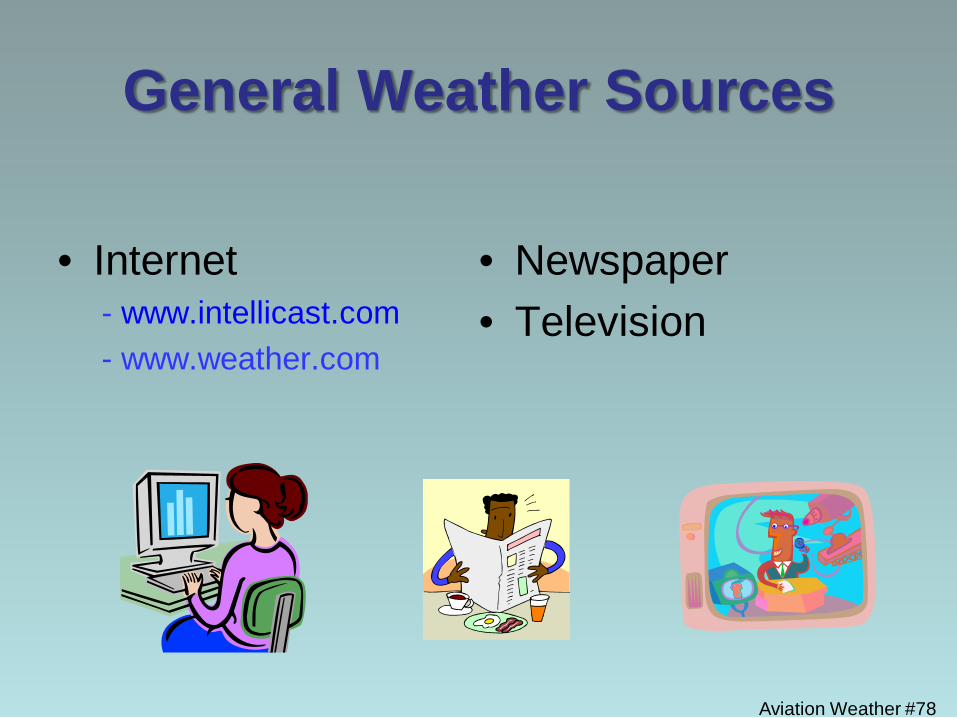
General Weather Sources
• Internet - www.intellicast.com - www.weather.com
• Newspaper • Television
Aviation Weather #78
Flight Planning Concerns
• Time en route
• Fuel planning
• Time on station for mission
Aviation Weather #79
Aviation Weather #80
Summary
• Weather is an obvious and ever-present factor in aviation safety.
• The main factors which cause concern are fairly well identified & predictable, and thus avoidable.
• An array of weather resources are available to identify and predict these factors, giving us the opportunity to take action to mitigate weather-related aviation safety concerns.
References AOPA Weather Wise, “Air Masses and Fronts”
http://flash.aopa.org/asf/wxwise_fronts/wxwise_fronts.cfm? Associated Press (Publisher), & Ockenden, T (Photographer). (2006). BRITAIN
AIRPORT FOG. London, GBR. Retrieved from
http://www.apimages.com/OneUp.aspx?st=k&kw=Tim%20Ockenden&showact=results&sort=date&page=1&intv=None&sh=10&kwstyle=or&adte=1324417111&pagez=60&cfasstyle=AND&rids=e8d47a75581d4a05a66ee7b0ed5f46b3&dbm=PY2006&xslt=1&mediatype=Photo
Clouds. (2010, January 5). Jet Stream-Online School for Weather. The National Weather Service. Retrieved from
http://www.srh.weather.gov/srh/jetstream/synoptic/clouds.htm Da Vinci Picture. (2011). Retrieved from http://witcombe.sbc.edu/water/artleonardo.html
Aviation Weather #81
References FAA-H-8083-25A. (2008). Pilot’s Handbook of Aeronautical Knowledge. Retrieved from
http://www.faa.gov/library/manuals/aviation/pilot_handbook/ FAR/AIM. (2010, August 26). Federal Aviation Regulations and Aeronautical Information Manual (2011 Edition). Newcastle, WA: Aviation Supplies & Academics, Inc. Gleim, I. N., & Gleim, G. W. (2008) Gleim Aviation Weather and Weather Services: The
FAA’s Aviation Weather (AC 00-6A) and Aviation Weather Services (AC 00-45F) Simplified. Gainesville, FL: Gleim Publications, Inc.
Lester, P. F. (1995). Aviation Weather: Englewood, CO: Jeppesen Sanderson, Inc. Lightning. (2010, January 5). Jet Stream-Online School for Weather. The National
Weather Service. Retrieved from http://www.srh.weather.gov/srh/jetstream/lightning/lightning_ intro.htm Aviation Weather #82
References Surface Analysis Chart provided by NOAA National Weather Service
Hydrometeorological Prediction Center. http://www.hpc.ncep.noaa.gov/html/sfc2.shtml
Wake Turbulence Photo. (2011). Retrieved from
http://overtheairwaves.com/vol4_10final.html Weather Photos and Charts. (2006). Retrieved from http://www.free-online-private-pilot -ground-school.com/Aviation-Weather-Principles.html Williams, E. (2011). Aviation Formulary V1.46. Retrieved from http://williams.best.vwh.net/avform.htm
Aviation Weather #83
Course Objectives
Student will be able to: • Identify weather conditions that may adversely
affect the safety of aviation operations.
• Describe mitigations that can be applied when working in unfavorable weather conditions.
• List at least two aviation weather resources that can assist the user in making informed decisions.
Aviation Weather #84


![Vehicular Fog Computing: A Viewpoint of Vehicles as the ...cwc.ucsd.edu/sites/cwc.ucsd.edu/files/Vehicular Fog... · fog computing paradigm [10]–[14]. Specifically, in the fog](https://img.dokumen.tips/doc/110x75/5ece3cb4a160d21f083aea78/vehicular-fog-computing-a-viewpoint-of-vehicles-as-the-cwcucsdedusitescwcucsdedufilesvehicular.jpg)


![[데브루키] FOG](https://img.dokumen.tips/doc/110x75/559c0b481a28ab896a8b476a/-fog.jpg)