Embed Size (px)
Citation preview

December 1999
4-1
Section 4AVIATION WEATHER FORECASTS
Good flight planning involves considering all available weather information, including weather forecasts.This section explains the following aviation forecasts:
1. Aviation Terminal Forecast (TAF)2. Aviation Area Forecast (FA)3. Inflight Aviation Weather Advisories4. Alaska, Gulf of Mexico, and International Area Forecasts (FAs)5. Transcribed Weather Broadcasts (TWEB) Text Products6. Winds and Temperatures Aloft Forecast (FD)7. Center Weather Service Unit (CWSU) Products
Also discussed are the following general forecasts that may aid in flight planning:
1. Hurricane Advisory (WH)2. Convective Outlook (AC)3. Severe Weather Watch Bulletins (WW) and Alert Messages (AWW)
AVIATION TERMINAL FORECAST (TAF)
An Aviation Terminal Forecast (TAF) is a concise statement of the expected meteorological conditionswithin a 5-statute-mile radius from the center of an airport’s runway complex during a 24-hour timeperiod.
The TAFs use the same weather code found in METAR weather reports. Detailed explanations of thecode are found only in Section 2.
The National Weather Service (NWS) requires an airport to have two consecutive METAR observations,not less than 30 minutes apart nor more than 1 hour apart, before a TAF will be issued. After the TAFhas been issued, the forecaster will use all available weather data sources to maintain the TAF. If duringthis time a METAR is missing or part of the METAR is missing, the forecaster can use other weathersources to obtain the necessary data to maintain the TAF. However, if the forecaster feels that the otherweather sources cannot provide the necessary information, the forecaster will discontinue the TAF.
A TAF contains the following elements in the order listed:
1. Type of report2. ICAO station identifier3. Date and time of origin4. Valid period date and time5. Wind forecast6. Visibility forecast7. Significant weather forecast8. Sky condition forecast9. Nonconvective low-level wind shear forecast (optional data)10. Forecast change indicators11. Probability forecast

December 1999
4-2
International and U.S. military TAFs also contain forecasts of maximum and minimum temperature,icing, and turbulence. These three elements are not included in NWS-prepared TAFs. For forecast icingand turbulence, see page 4-23, Inflight Aviation Weather Advisories.
The following paragraphs describe the elements in a TAF report. A sample report will accompany eachelement with the subject element in bold letters.
TYPE OF REPORT
TAFKPIR 111140Z 111212 13012KT P6SM BKN100 WS020/35035KT TEMPO 1214 5SM BR
FM1500 16015G25KT P6SM SCT040 BKN250FM0000 14012KT P6SM BKN080 OVC150 PROB40 0004 3SM TSRA BKN030CBFM0400 14008KT P6SM SCT040 OVC080 TEMPO 0408 3SM TSRA OVC030CBBECMG 0810 32007KT=
The report type header will always appear as the first element in the TAF. There are two types of TAFreports: a routine forecast, TAF; and an amended forecast, TAF AMD. An amended TAF is issuedwhen the forecaster feels the TAF is not representative of the current or expected weather conditions. Anequal sign at the end of the TAF signifies the end of the report.
ICAO STATION IDENTIFIER
TAFKPIR 111140Z 111212 13012KT P6SM BKN100 WS020/35035KT TEMPO 1214 5SM BR FM1500 16015G25KT P6SM SCT040 BKN250 FM0000 14012KT P6SM BKN080 OVC150 PROB40 0004 3SM TSRA BKN030CB FM0400 14008KT P6SM SCT040 OVC080 TEMPO 0408 3SM TSRA OVC030CB BECMG 0810 32007KT=
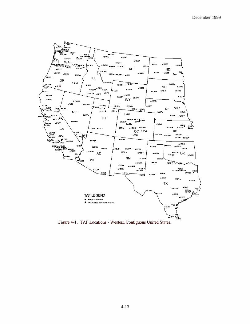
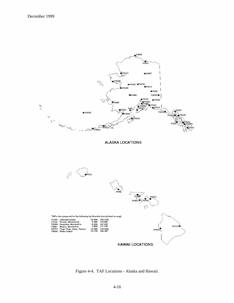
The TAF code uses ICAO four-letter location identifiers as described in Section 2. TAF locations are inFigures 4-1, 4-2, 4-3, and 4-4 located on pages 4-13 through 4-16.
DATE AND TIME OF ORIGIN
TAFKPIR 111140Z 111212 13012KT P6SM BKN100 WS020/35035KT TEMPO 1214 5SM BR FM1500 16015G25KT P6SM SCT040 BKN250 FM0000 14012KT P6SM BKN080 OVC150 PROB40 0004 3SM TSRA BKN030CB FM0400 14008KT P6SM SCT040 OVC080 TEMPO 0408 3SM TSRA OVC030CB BECMG 0810 32007KT=
This element is the date and universal coordinated time (UTC) the forecast is actually prepared. Theformat is a two-digit date and four-digit time followed without a space by the letter Z. Routine TAFs areprepared and filed approximately one-half hour prior to scheduled issuance times.
Examples:111140Z Forecast prepared on the eleventh day of the month at 1140Z.050530Z Forecast prepared on the fifth day of the month at 0530Z.
December 1999
4-3
VALID PERIOD DATE AND TIME
TAFKPIR 111140Z 111212 13012KT P6SM BKN100 WS020/35035KT TEMPO 1214 5SM BR FM1500 16015G25KT P6SM SCT040 BKN250 FM0000 14012KT P6SM BKN080 OVC150 PROB40 0004 3SM TSRA BKN030CB FM0400 14008KT P6SM SCT040 OVC080 TEMPO 0408 3SM TSRA OVC030CB BECMG 0810 32007KT=
The valid period of the forecast is a two-digit date followed by the two-digit beginning and two-digitending hours in UTC. Routine TAFs are valid for 24 hours and are issued four times daily at 0000Z,0600Z, 1200Z, and 1800Z. All ending times throughout the TAF of 00Z are indicated by the number 24.
Examples:111212 Forecast valid from the eleventh at 12Z to the twelfth at 12Z.300024 Forecast valid from the thirtieth at 00Z to the first at 00Z.
Amended, canceled, or delayed forecasts may have valid periods less than 24 hours.
Examples:231512 Forecast valid from the twenty-third at 15Z to the twenty-fourth at 12Z.091006 Forecast valid from the ninth at 10Z to the tenth at 06Z.
For airports with less than 24-hour observational coverage for which part-time terminal forecasts areprovided, the TAF will be valid until the end of the scheduled forecast even if the observations haveceased before that time. AMD NOT SKED (amendment not scheduled) or NIL AMD (no amendment)will be issued after the forecast information. AMD NOT SKED AFT (closing time)Z (amendment notscheduled after [closing time]Z) will be used if the times of the observations are known and judgedreliable. During the time the station is closed and a TAF is issued, there will be no forecast as indicatedby NIL (no TAF) after the valid date and time group. Only after two METARs observations have beendisseminated will a TAF be issued. AMD LTD TO CLD VIS AND WIND (amendment limited toclouds, visibility, and wind) is used at observation sites that have part-time manual augmentation. Thisremark means that there will be amendments only for clouds, visibility, and wind. There will be noamendments for thunderstorms or freezing/frozen precipitation.
WIND FORECAST
TAFKPIR 111140Z 111212 13012KT P6SM BKN100 WS020/35035KT TEMPO 1214 5SM BR FM1500 16015G25KT P6SM SCT040 BKN250 FM0000 14012KT P6SM BKN080 OVC150 PROB40 0004 3SM TSRA BKN030CB FM0400 14008KT P6SM SCT040 OVC080 TEMPO 0408 3SM TSRA OVC030CB BECMG 0810 32007KT=
The surface wind forecast is the wind direction in degrees from true north (first three digits) and meanspeed in knots (last two or three digits if 100 knots or greater). The contraction, KT, denotes the units ofwind speed in knots. Wind gusts are noted by the letter G appended to the mean wind speed followed bythe highest expected gust (two or three digits if 100 knots or greater). Calm winds are encoded as00000KT. A variable wind is encoded as VRB when wind direction fluctuates due to convective activityor low wind speeds (3 knots or less).

December 1999
4-4
Examples:13012KT, 18010KT, 35012G26KT, or VRB16G28KT
VISIBILITY FORECAST
TAFKPIR 111140Z 111212 13012KT P6SM BKN100 WS020/35035KT TEMPO 1214 5SM BR FM1500 16015G25KT P6SM SCT040 BKN250 FM0000 14012KT P6SM BKN080 OVC150 PROB40 0004 3SM TSRA BKN030CB FM0400 14008KT P6SM SCT040 OVC080 TEMPO 0408 3SM TSRA OVC030CB BECMG 0810 32007KT=
The prevailing visibility is forecasted in whole and fractions of statute miles followed by SM to note theunits of measurement. Statute miles followed by fractions of statute miles are separated with a space; forexample, 1 1/2SM. Forecasted visibility greater than 6 statute miles is indicated by coding P6SM. Ifprevailing visibility is 6 statute miles or less, one or more weather phenomena must be included in thesignificant weather forecast. If volcanic ash is forecasted, the visibility must also be forecasted even ifthe visibility is greater than 6 statute miles. Sector or variable visibility is not forecasted.
Examples:1/2SM, 2 1/4SM, 5SM, or P6SM
SIGNIFICANT WEATHER FORECAST
TAFKPIR 111140Z 111212 13012KT P6SM BKN100 WS020/35035KT TEMPO 1214 5SM BR FM1500 16015G25KT P6SM SCT040 BKN250 FM0000 14012KT P6SM BKN080 OVC150 PROB40 0004 3SM TSRA BKN030CB FM0400 14008KT P6SM SCT040 OVC080 TEMPO 0408 3SM TSRA OVC030CB BECMG 0810 32007KT=
The expected weather phenomenon or phenomena are coded in TAF reports using the same format,qualifiers, and phenomena contractions as METAR reports (except UP). (See Section 2.)
Obscurations to vision will be forecasted whenever the prevailing visibility is forecasted to be 6 statutemiles or less. Precipitation and volcanic ash will always be included in the TAF regardless of thevisibility forecasted.
Examples:FM2200 18005KT 1SM BR SKCFM0100 12010KT P6SM -RA BKN020FM1500 22015KT P6SM VA SCT100
If no significant weather is expected to occur during a specific time period in the forecast, the weathergroup is omitted for that time period. However, if after a time period in which significant weather hasbeen forecasted, a change to a forecast of “no significant weather” occurs, the contraction NSW (nosignificant weather) will appear as the weather included in BECMG or TEMPO groups. NSW will notbe used in the initial time period of a TAF or in FM groups.
December 1999
4-5
Example:FM0600 16010KT 3SM RA BKN030 BECMG 0810 P6SM NSW
If the forecaster determines that in the vicinity of the airport there could be weather that impacts aviation,the forecaster will include those conditions after the weather group. The letters VC describe conditionsthat will occur within the vicinity of an airport (5-10 SM) and will be used only with fog, showers, orthunderstorms (FG, SH, or TS).
Examples:P6SM VCFG - fog in the vicinity.5SM BR VCSH - showers in the vicinity .P6SM VCTS - thunderstorms in the vicinity.
SKY CONDITION FORECAST
TAFKPIR 111140Z 111212 13012KT P6SM BKN100 WS020/35035KT TEMPO 1214 5SM BR FM1500 16015G25KT P6SM SCT040 BKN250 FM0000 14012KT P6SM BKN080 OVC150 PROB40 0004 3SM TSRA BKN030CB FM0400 14008KT P6SM SCT040 OVC080 TEMPO 0408 3SM TSRA OVC030CB BECMG 0810 32007KT=
TAF sky condition forecasts use the METAR format described in Section 2. Cumulonimbus clouds (CB)are the only cloud type forecasted in TAFs.
Examples:BKN100, SCT040 BKN030CB, or FEW008 BKN015
When the sky is obscured due to a surface-based phenomenon, vertical visibility (VV) into theobscuration is forecasted. The format for vertical visibility is VV followed by a three-digit height inhundreds of feet. Partial obscurations are not forecasted. Remember a ceiling is the lowest broken orovercast layer or vertical visibility.
Example:VV008
NONCONVECTIVE LOW-LEVEL WIND SHEAR FORECAST (OPTIONAL DATA)
TAFKPIR 111140Z 111212 13012KT P6SM BKN100 WS020/35035KT TEMPO 1214 5SM BR FM1500 16015G25KT P6SM SCT040 BKN250 FM0000 14012KT P6SM BKN080 OVC150 PROB40 0004 3SM TSRA BKN030CB FM0400 14008KT P6SM SCT040 OVC080 TEMPO 0408 3SM TSRA OVC030CB BECMG 0810 32007KT=
A forecast of nonconvective low-level wind shear is included immediately after the cloud andobscuration group when wind shear criteria have been or will be met. The forecast includes the height ofthe wind shear followed by the wind direction and wind speed at the indicated height. Height is given inhundreds of feet above ground level (AGL) up to and including 2,000 feet. Wind shear is encoded withthe contraction WS, followed by a three-digit height, solidus (/), and winds at the height indicated in thesame format as surface winds. The wind shear element is omitted if not expected to occur.
December 1999
4-6
Example:WS020/36035KT
FORECAST CHANGE INDICATORS
TAFKPIR 111140Z 111212 13012KT P6SM BKN100 WS020/35035KT TEMPO 1214 5SM BR FM1500 16015G25KT P6SM SCT040 BKN250 FM0000 14012KT P6SM BKN080 OVC150 PROB40 0004 3SM TSRA BKN030CB FM0400 14008KT P6SM SCT040 OVC080 TEMPO 0408 3SM TSRA OVC030CB BECMG 0810 32007KT=
If a significant change in any of the elements is expected during the valid period, a new time period withthe changes is included. The following change indicators are used when either a rapid, gradual, ortemporary change is expected in some or all of the forecasted meteorological conditions.
From (FM) Group
The FM group is used when a rapid and significant change, usually occurring in less than 1 hour, inprevailing conditions is expected. Appended to the FM indicator is the four-digit hour and minute thechange is expected to begin. The forecast is valid until the next change group or until the end of thecurrent forecast.
The FM group will mark the beginning of a new line in a TAF report. Each FM group shall contain aforecast of wind, visibility, weather (if significant), sky condition, and wind shear (if warranted). FMgroups will not include the contraction NSW.
Examples:FM1500 16015G25KT P6SM SCT040 BKN250FM0200 32010KT 3SM TSRA FEW010 BKN030CB
Becoming (BECMG) Group
The BECMG group is used when a gradual change in conditions is expected over a period not to exceed2 hours. The time period when the change is expected to occur is a four-digit group containing thebeginning and ending hours of the change that follows the BECMG indicator. The gradual change willoccur at an unspecified time within the time period. Only the changing forecasted meteorologicalconditions are included in BECMG groups. Omitted conditions are carried over from the previous timegroup.
Example:FM2000 18020KT P6SM BKN030 BECMG 0103 OVC015
This BECMG group describes a gradual change in sky condition from BKN030 to OVC015. The changein sky conditions occurs between 01Z and 03Z. Refer back to the FM2000 group for the wind andvisibility conditions. The forecast after 03Z will be: 18020KT P6SM OVC015.
December 1999
4-7
Example:FM0400 14008KT P6SM SCT040 OVC080 TEMPO 0408 3SM TSRA OVC030CB BECMG 0810 32007KT=
This BECMG group describes a gradual change in wind direction only beginning between 08Z and 10Z.Refer back to the previous forecast group, in this case the FM0400 group, for the prevailing visibility,weather, and sky conditions. The forecast after 10Z will be: 32007KT P6SM SCT040 OVC080.
Temporary (TEMPO) Group
The TEMPO group is used for temporary fluctuations of wind, visibility, weather, or sky condition thatare expected to last for generally less than an hour at a time (occasional), and expected to occur duringless than half the time period. The TEMPO indicator is followed by a four-digit group giving thebeginning and ending hours of the time period during which the temporary conditions are expected. Onlythe changing forecasted meteorological conditions are included in TEMPO groups. The omittedconditions are carried over from the previous time group.
Example:FM1000 27005KT P6SM SKC TEMPO 1216 3SM BR
This temporary group describes visibility and weather between 12Z and 16Z. The winds and skycondition have been omitted. Go back to the previous forecast group, FM1000, to obtain the wind andsky condition forecast. The forecast between 12Z and 16Z is: 27005KT 3SM BR SKC.
Example:FM0400 14008KT P6SM SCT040 OVC080 TEMPO 0408 3SM TSRA OVC030CB BECMG 0810 32007KT=
This temporary group describes visibility, weather, and sky condition between 04Z and 08Z. The windshave been omitted. Go back to the previous forecast group, FM0400, to obtain the wind forecast.The forecast between 04Z and 08Z is: 14008KT 3SM TSRA OVC030CB.
PROBABILITY (PROB30 or PROB40) FORECAST
TAFKPIR 111140Z 111212 13012KT P6SM BKN100 WS020/35035KT TEMPO 1214 5SM BR FM1500 16015G25KT P6SM SCT040 BKN250 FM0000 14012KT P6SM BKN080 OVC150 PROB40 0004 3SM TSRA BKN030CB FM0400 14008KT P6SM SCT040 OVC080 TEMPO 0408 3SM TSRA OVC030CB BECMG 0810 32007KT=
The probability forecast describes the probability or chance of thunderstorms or other precipitationevents occurring, along with associated weather conditions (wind, visibility, and sky conditions). Theprobability forecast will not be used in the first 6 hours of the TAF.
The PROB30 or PROB40 group is used when the occurrence of thunderstorms or precipitation is in the30% to less than 40% or 40% to less than 50% range, respectively. If the thunderstorms or precipitationchance is greater than 50%, it is considered a prevailing weather condition and is included in thesignificant weather section or the TEMPO change indicator group. PROB30 or PROB40 is followed bya four-digit time group giving the beginning and ending hours of the time period during which thethunderstorms or precipitation is expected.

December 1999
4-8
Example:FM0600 0915KT P6SM BKN020 PROB30 1014 1SM RA BKN015
This example depicts a 30% to less than 40% chance of 1statute mile, moderate rain, and a broken cloudlayer (ceiling) at 1,500 feet between the hours of 10-14Z.
Example:FM0000 14012KT P6SM BKN080 OVC150 PROB40 0004 3SM TSRA BKN030CB
In this example, there is a 40% to <50% chance of visibility 3 statute miles, thunderstorms with moderaterain showers, and a broken cloud layer (ceiling) at 3,000 feet with cumulonimbus between the hours of00-04Z.

December 1999
4-9
EXAMPLES OF TAF REPORTS
TAFKPIR 111140Z 111212 13012KT P6SM BKN100 WS020/35035KT TEMPO 1214 5SM BR FM1500 16015G25KT P6SM SCT040 BKN250 FM0000 14012KT P6SM BKN080 OVC150 PROB40 0004 3SM TSRA BKN030CB FM0400 14008KT P6SM SCT040 OVC080 TEMPO 0408 3SM TSRA OVC030CB BECMG 0810 32007KT=
TAF Aviation terminal forecastKPIR Pierre, South Dakota111140Z prepared on the 11th at 1140Z111212 valid period from the 11th at 1200Z until the 12th at 1200Z13012KT wind 130 at 12 knotsP6SM visibility greater than 6 statute milesBKN100 ceiling 10,000 brokenWS020/35035KT wind shear at 2,000 feet, wind (at 2,000 feet) from 350 at 35 knotsTEMPO 1214 temporary conditions between 1200Z and 1400Z5SM visibility 5 statute milesBR mistFM1500 from 1500Z16015G25KT wind 160 at 15 knots gusting to 25 knotsP6SM visibility greater than 6 statute milesSCT040 BKN250 4,000 scattered, ceiling 25,000 brokenFM0000 from 0000Z14012KT wind 140 at 12 knotsP6SM visibility greater than 6 statute milesBKN080 OVC150 ceiling 8,000 broken, 15,000 overcastPROB40 0004 40% probability between 0000Z and 0400Z3SM visibility 3 statute milesTSRA thunderstorm with moderate rain showersBKN030CB ceiling 3,000 broken with cumulonimbusFM0400 from 0400Z14008KT wind 140 at 8 knotsP6SM visibility greater than 6 statute milesSCT040 OVC080 4,000 scattered, ceiling 8,000 overcastTEMPO 0408 temporary conditions between 0400Z and 0800Z3SM visibility 3 statute milesTSRA thunderstorms with moderate rain showersOVC030CB ceiling 3,000 overcast with cumulonimbusBECMG 0810 becoming between 0800Z and 1000Z32007KT= wind 320 at 7 knots; the equal sign signifies the end of the TAF

December 1999
4-10
TAF AMDKEYW 131555Z 131612 VRB03KT P6SM VCTS SCT025CB BKN250 TEMPO 1618 2SM TSRA BKN020CB FM1800 VRB03KT P6SM SCT025 BKN250 TEMPO 2024 1SM TSRA OVC010CB FM0000 VRB03KT P6SM VCTS SCT020CB BKN120 TEMPO 0812 BKN020CB=
TAF AMD Amended aviation terminal forecastKEYW Key West, Florida131555Z prepared on the 13th at 1555Z131612 valid period from the 13th at 1600Z until the 14th at 1200ZVRB03KT wind variable at 3 knotsP6SM visibility greater than 6 statute milesVCTS thunderstorms in the vicinitySCT025CB BKN250 2,500 scattered with cumulonimbus, ceiling 25,000 brokenTEMPO 1618 temporary conditions between 1600Z and 1800Z2SM visibility 2 statute milesTSRA thunderstorms with moderate rain showersBKN020CB ceiling 2,000 broken with cumulonimbusFM1800 from 1800ZVRB03KT wind variable at 3 knotsP6SM visibility greater than 6 statute milesSCT025 BKN250 2,500 scattered, ceiling 25,000 brokenTEMPO 2024 temporary conditions between 2000Z and 0000Z1SM visibility 1 statute mileTSRA thunderstorms with moderate rain showersOVC010CB ceiling 1,000 overcast with cumulonimbusFM0000 from 0000ZVRB03KT variable wind at 3 knotsP6SM visibility greater than 6 statute milesVCTS thunderstorms in the vicinitySCT020CB BKN120 2,000 scattered with cumulonimbus, ceiling 12,000 brokenTEMPO 0812 temporary conditions between 0800Z and 1200ZBKN020CB= ceiling 2,000 broken with cumulonimbus; the equal sign signifies the end ofthe TAF

December 1999
4-11
TAFKCRP 111730Z 111818 19007KT P6SM SCT030 TEMPO 1820 BKN040 FM2000 16011KT P6SM VCTS FEW030CB SCT250 FM0200 14006KT P6SM FEW025 SCT250 FM0800 VRB03KT 5SM BR SCT012 TEMPO 1012 1/2SM FG BKN001 FM1500 17007KT P6SM SCT025=
TAF Aviation terminal forecastKCRP Corpus Christi, Texas111730Z prepared on the 11th at 1730Z111818 valid period from the 11th at 1800Z until the 12th at 1800Z19007KT wind 190 at 7 knotsP6SM visibility greater than 6 statute milesSCT030 3,000 scatteredTEMPO 1820 temporary conditions between 1800Z and 2000ZBKN040 ceiling 4,000 brokenFM2000 from 2000Z16011KT wind 160 at 11 knotsP6SM visibility greater than 6 statute milesVCTS thunderstorms in the vicinityFEW030CB SCT250 3,000 few with cumulonimbus, 25,000 scatteredFM0200 from 0200Z14006KT wind 140 at 6 knotsP6SM visibility greater than 6 statute milesFEW025 SCT250 2,500 few, 25,000 scatteredFM0800 from 0800ZVRB03KT wind variable at 3 knots5SM visibility 5 statute milesBR mistSCT012 1,200 scatteredTEMPO 1012 temporary conditions between 1000Z and 1200Z1/2SM visibility ½ statute mileFG fogBKN001 ceiling 100 brokenFM1500 from 1500Z17007KT wind 170 at 7 knotsP6SM visibility greater than 6 statute milesSCT025= 2,500 scattered; the equal sign signifies the end of the TAF

December 1999
4-12
TAFKACK 112340Z 120024 29008KT P6SM SKC BECMG 1618 22015KT=
TAF Aviation terminal forecastKACK Nantucket, Massachusetts112340Z prepared on the 11th at 2340Z120024 valid period from the 12th at 0000Z until the 13th at 0000Z29008KT wind 290 at 8 knotsP6SM visibility greater than 6 statute milesSKC sky clearBECMG 1618 becoming between 1600Z and 1800Z22015KT= wind 220 at 15 knots; the equal sign signifies the end of the TAF
TAFKMWH 200535Z 200606 NIL=
TAF Aviation terminal forecastKMWH Moses Lake, Washington200535Z prepared on the 20th at 0535Z200606 valid period from the 20th at 0600Z to the 21st at 0600ZNIL= no TAF; the equal sign signifies the end of the TAF
December 1999
4-13

December 1999
4-14

December 1999
4-15
Figure 4-3. TAF Locations - Guam and Puerto Rico.
December 1999
4-16
Figure 4-4. TAF Locations - Alaska and Hawaii.

December 1999
4-17
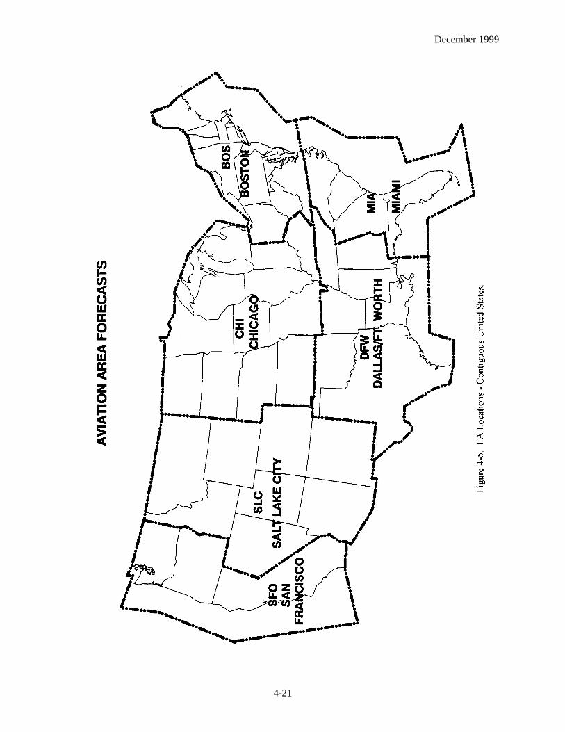
AVIATION AREA FORECAST (FA)
An Aviation Area Forecast (FA) is a forecast of visual meteorological conditions (VMC), clouds, andgeneral weather conditions over an area the size of several states. To understand the complete weatherpicture, the FA must be used in conjunction with the inflight aviation weather advisories. Together, theyare used to determine forecast en route weather and to interpolate conditions at airports for which noTAFs are issued. Figure 4-5 on page 4-21 maps the FA areas. The FAs are issued 3 times a day by theAviation Weather Center (AWC) in Kansas City, Missouri, for each of the 6 areas in the contiguous 48states. The weather forecast office (WFO) in Honolulu issues FAs for Hawaii as shown in Figure 4-6 onpage 4-22. Alaska FA information is on page 4-27. There are also two specialized FAs, one for the Gulfof Mexico and one for international airspace.
This is a partial example of an FA which will be used in this section:DFWC FA 120945SYNOPSIS AND VFR CLDS/WXSYNOPSIS VALID UNTIL 130400CLDS/WX VALID UNTIL 122200...OTLK VALID 122200-130400 OK TX AR TN LA MS AL ANDCSTL WTRS.SEE AIRMET SIERRA FOR IFR CONDS AND MTN OBSCN.TS IMPLY SEV OR GTR TURB SEV ICE LLWS AND IFR CONDS.NON MSL HGTS DENOTED BY AGL OR CIG..SYNOPSIS...LOW PRES TROF 10Z OK/TX PNHDL AREA FCST MOV EWD INTO CNTRL-SWRN
OK BY 04Z. WRMFNT 10Z CNTRL OK-SRN AR-NRN MS FCST LIFT NWD INTO NERN OK-NRN AR XTRM NRN MS BY 04Z.
.S CNTRL AND SERN TX
AGL SCT-BKN010. TOPS 030. VIS 3-5SM BR. 14-16Z BECMG AGL SCT030. 19Z AGL SCT050. OTLK...VFR.
.OKPNHDL AND NW...AGL SCT030 SCT-BKN100. TOPS FL200. 15Z AGL SCT040 SCT100. AFT 20Z
SCT TSRA DVLPG..FEW POSS SEV. CB TOPS FL450. OTLK...VFR.SWRN OK...CIG BKN020. TOPS 050. VIS 3-5SM BR. 14Z AGL SCT-BKN040. 18Z CIG BKN060.
TOPS FL180. 22Z SCT TSRA DVLPG..FEW POSS SEV. CB TOPS ABV FL450. OTLK...VFR.NERN QTR...CIG BKN020 OVC050. VIS 3-5SM NMRS TSRA..FEW POSS SEV. CB TOPS ABV
FL450. 15Z AGL SCT030 SCT-BKN100. TOPS FL250. 18Z AGL SCT040. OTLK...VFR.SERN QTR...AGL SCT-BKN020. TOPS 050. 18Z AGL SCT040. OTLK...VFR..CSTL WTRSLA MS AL WTRS...SCT025 SCT-BKN080. TOPS 150. ISOL -TSRA. CB TOPS FL350. OTLK...VFR.TX WTRS...SCT CI. OCNL SCT030. OTLK...VFR. ....

December 1999
4-18
The FA is comprised of four sections: a communications and product header section, a precautionarystatements section, and two weather sections - a synopsis section and a visual flight rules (VFR)clouds/weather section.
COMMUNICATIONS AND PRODUCT HEADER
The communications and product header identifies the office for which the FA is issued, the date andtime of issue, the product name, the valid times, and the states and/or areas covered by the FA. Thefollowing shows the communications and product header for the example FA shown on page 4-17:
DFWC FA 120945SYNOPSIS AND VFR CLDS/WXSYNOPSIS VALID UNTIL 130400CLDS/WX VALID UNTIL 122200...OTLK VALID 122200-130400 OK TX AR TN LA MS AL ANDCSTL WTRS
In the first line, “DFW” indicates the area for which the FA is valid. The “C” indicates VFR clouds andweather while the FA indicates what type of forecast message it is. The “120945” indicates the date andtime the FA was issued. The next line “SYNOPSIS AND VFR CLDS/WX” states what information iscontained in this forecast message. “SYNOPSIS VALID UNTIL 130400” means the synopsis section ofthe FA is valid until the thirteenth at 0400Z. The “CLDS/WX VALID UNTIL 122200...OTLK VALID122200-130400” statement indicates the forecast section is valid until the twelfth at 2200Z, while theoutlook portion is valid from the twelfth at 2200Z until the thirteenth at 0400Z. “OK TX AR TN LA MSAL AND CSTL WTRS” describes the area for which this FA forecast is valid.
PRECAUTIONARY STATEMENTS
Between the communications/product header and the body of the forecast are three precautionarystatements. (See example FA on page 4-17.) The first statement in the example, “SEE AIRMETSIERRA FOR IFR CONDS AND MTN OBSCN,” is included to alert users that IFR conditions and/ormountain obscurations may be occurring or may be forecasted to occur in a portion of the FA area. Theuser shall always check the latest AIRMET Sierra for the FA area.
The second statement in the example, “TS IMPLY SEV OR GTR TURB SEV ICE LLWS AND IFRCONDS,” is included as a reminder of the hazards existing in all thunderstorms. Thus, thesethunderstorm-associated hazards are not spelled out within the body of the FA.
The purpose of the third statement in the example, “NON MSL HGTS DENOTED BY AGL OR CIG,” isto alert the user that heights, for the most part, are mean sea level (MSL). All heights are in hundreds offeet. For example, “BKN030. TOPS 100. HYR TRRN OBSCD,” means bases of the broken clouds are3,000 feet MSL with tops 10,000 feet MSL. Terrain above 3,000 feet MSL will be obscured. The topsof the clouds, turbulence, icing, and freezing level heights are always MSL.
Heights AGL are noted in either of two ways:
1. Ceilings by definition are above ground. Therefore, the contraction “CIG” indicates above ground. For example, ‘CIG BKN-OVC015,” means that ceilings are expected to be broken to overcast sky cover with bases at 1,500 feet AGL.
2. The contraction “AGL” means above ground level. Therefore, “AGL SCT020” means scattered clouds with bases 2,000 feet AGL.

December 1999
4-19
Thus, if the contraction “AGL” or “CIG” is not denoted, height is automatically above MSL.
SYNOPSIS
The synopsis is a brief summary of the location and movements of fronts, pressure systems, and othercirculation features for an 18-hour period. References to low ceilings and/or visibilities, strong winds, orany other phenomena the forecaster considers useful may also be included. The following synopsis istaken from the example on page 4-17.
SYNOPSIS...LOW PRES TROF 10Z OK/TX PNHDL AREA FCST MOV EWD INTO CNTRL-SWRN OK BY 04Z. WRMFNT 10Z CNTRL OK-SRN AR-NRN MS FCST LIFT NWD INTO NERN OK-NRN AR XTRM NRN MS BY 04Z.
This paragraph states that a low pressure trough at 10Z was over the Oklahoma (OK)/Texas (TX)panhandle area. The area is forecasted to move eastward into central-southwestern OK by 04Z. At 10Z awarm front was located from central OK to southern Arkansas (AR) to northern Mississippi (MS). Thiswarm front is forecasted to lift into northeastern OK, northern AR, to extreme northern MS by 04Z.
VFR CLOUDS AND WEATHER (VFR CLDS/WX)
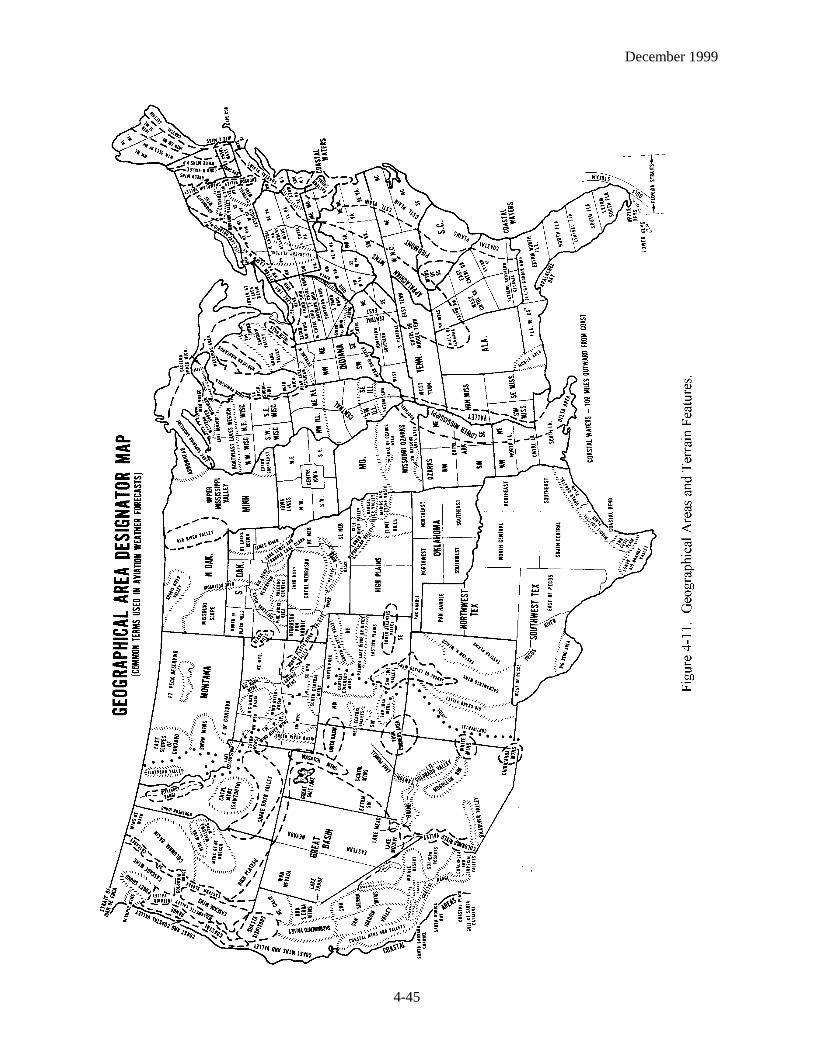
This section contains a 12-hour specific forecast, followed by a 6-hour categorical outlook giving a totalforecast period of 18 hours, and it is usually several paragraphs in length. The breakdown may be bystates or by well-known geographical areas. (See Figure 4-11.) The specific forecast section gives ageneral description of clouds and weather which cover an area greater than 3,000 square miles and aresignificant to VFR flight operations.
Surface visibility and obstructions to vision are included when the forecast visibility is 3 to 5 statutemiles. Precipitation, thunderstorms, and sustained winds of 20 knots or more will always be includedwhen forecasted. The conditional term OCNL (occasional) is used to describe clouds and visibilities thatmay affect VFR flights. It is used when there is a greater than 50% probability of a phenomenonoccurring, but for less than ½ the forecast period. The areal coverage terms ISOL (isolated), WDLYSCT (widely scattered), SCT or AREAS (scattered), and NMRS or WDSPRD (numerous or widespread)are used to indicate the area coverage of thunderstorms or showers. The term ISOL may also be used todescribe areas of ceilings or visibilities that are expected to affect areas less than 3,000 square miles.Table 4-1 defines the areal coverage terms.
Table 4-1 Areal Coverage of Showers and Thunderstorms
Terms Coverage
Isolated (ISOL) Single cells (no percentage)Widely scattered
(WDLY SCT )Less than 25% of area affected
Scattered or Areas(SCT or AREAS)
25 to 54% of area affected
Numerous or Widespread(NMRS or WDSPRD)
55% or more of area affected
December 1999
4-20
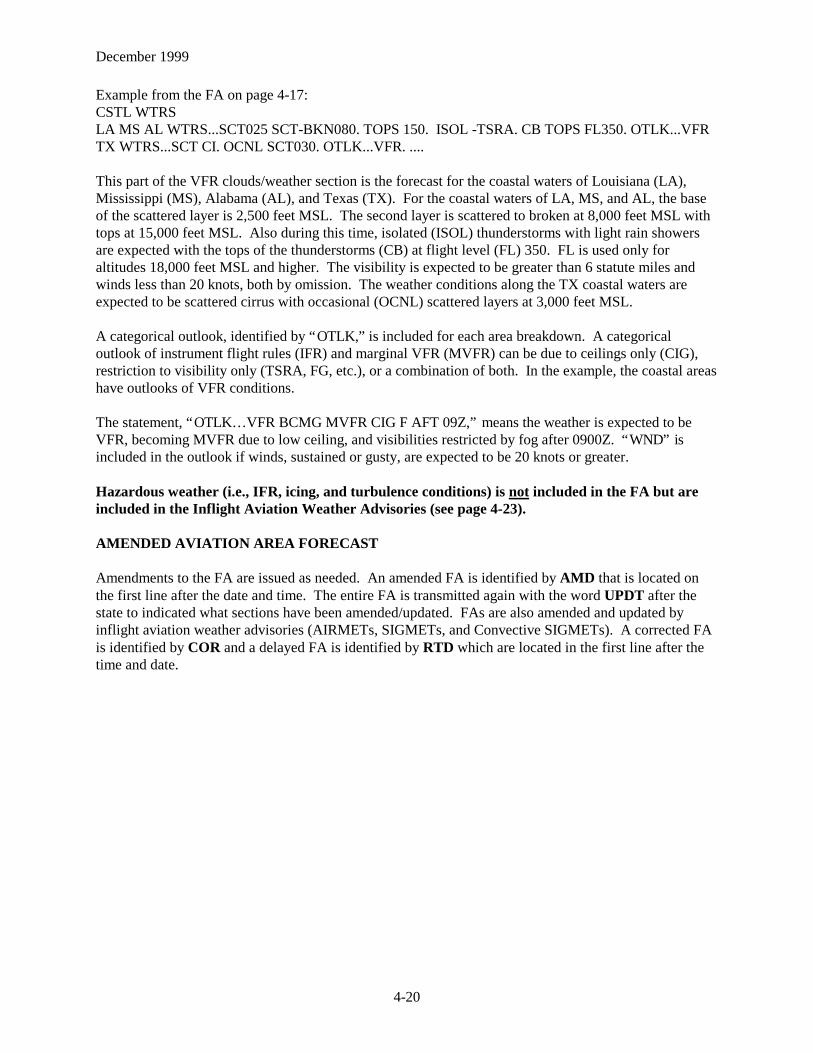
Example from the FA on page 4-17:CSTL WTRSLA MS AL WTRS...SCT025 SCT-BKN080. TOPS 150. ISOL -TSRA. CB TOPS FL350. OTLK...VFRTX WTRS...SCT CI. OCNL SCT030. OTLK...VFR. ....
This part of the VFR clouds/weather section is the forecast for the coastal waters of Louisiana (LA),Mississippi (MS), Alabama (AL), and Texas (TX). For the coastal waters of LA, MS, and AL, the baseof the scattered layer is 2,500 feet MSL. The second layer is scattered to broken at 8,000 feet MSL withtops at 15,000 feet MSL. Also during this time, isolated (ISOL) thunderstorms with light rain showersare expected with the tops of the thunderstorms (CB) at flight level (FL) 350. FL is used only foraltitudes 18,000 feet MSL and higher. The visibility is expected to be greater than 6 statute miles andwinds less than 20 knots, both by omission. The weather conditions along the TX coastal waters areexpected to be scattered cirrus with occasional (OCNL) scattered layers at 3,000 feet MSL.
A categorical outlook, identified by “OTLK,” is included for each area breakdown. A categoricaloutlook of instrument flight rules (IFR) and marginal VFR (MVFR) can be due to ceilings only (CIG),restriction to visibility only (TSRA, FG, etc.), or a combination of both. In the example, the coastal areashave outlooks of VFR conditions.
The statement, “OTLK… VFR BCMG MVFR CIG F AFT 09Z,” means the weather is expected to beVFR, becoming MVFR due to low ceiling, and visibilities restricted by fog after 0900Z. “WND” isincluded in the outlook if winds, sustained or gusty, are expected to be 20 knots or greater.
Hazardous weather (i.e., IFR, icing, and turbulence conditions) is not included in the FA but areincluded in the Inflight Aviation Weather Advisories (see page 4-23).
AMENDED AVIATION AREA FORECAST
Amendments to the FA are issued as needed. An amended FA is identified by AMD that is located onthe first line after the date and time. The entire FA is transmitted again with the word UPDT after thestate to indicated what sections have been amended/updated. FAs are also amended and updated byinflight aviation weather advisories (AIRMETs, SIGMETs, and Convective SIGMETs). A corrected FAis identified by COR and a delayed FA is identified by RTD which are located in the first line after thetime and date.
December 1999
4-21

December 1999
4-22
Figure 4-6. FA Locations - Hawaii.
December 1999
4-23
INFLIGHT AVIATION WEATHER ADVISORIES
Inflight Aviation Weather Advisories are forecasts to advise en route aircraft of development ofpotentially hazardous weather. All inflight aviation weather advisories in the conterminous U.S. areissued by the Aviation Weather Center (AWC) in Kansas City, Missouri. The WFO in Honolulu issuesadvisories for the Hawaiian islands. In Alaska, the Alaska Aviation Weather Unit (AAWU) issuesinflight aviation weather advisories. All heights are referenced MSL, except in the case of ceilings CIG,which indicate AGL.
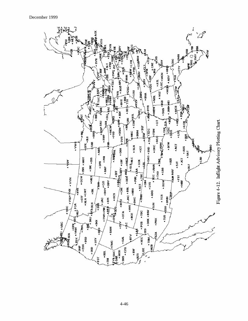
There are three types of inflight aviation weather advisories - the Significant Meteorological Information(SIGMET), the Airman’s Meteorological Information (AIRMET), and Convective SIGMET. All of theseadvisories use the same location identifiers (either VORs, airports, or well-known geographic areas) todescribe the hazardous weather areas (see Figures 4-11 and 4-12 on pages 4-45 and 4-46).
SIGMET (WS)/AIRMET (WA)
SIGMETs/AIRMETs are issued corresponding to the FA areas (see Figures 4-5 and 4-6). The maximumforecast period is 4 hours for SIGMETs and 6 hours for AIRMETs. Both advisories are considered“widespread” because they must be either affecting or be forecasted to affect an area of at least 3,000square miles at any one time. However, if the total area to be affected during the forecast period is verylarge, it could be that in actuality only a small portion of this total area would be affected at any one time.
SIGMET (WS)
A SIGMET advises of nonconvective weather that is potentially hazardous to all aircraft. SIGMETs areunscheduled products that are valid for 4 hours. However, conditions that are associated with hurricanesare valid for 6 hours. Unscheduled updates and corrections are issued as necessary. In the conterminousU.S., SIGMETs are issued when the following phenomena occur or are expected to occur:
1. Severe icing not associated with thunderstorms2. Severe or extreme turbulence or clear air turbulence (CAT) not associated with thunderstorms3. Dust storms or sandstorms lowering surface or inflight visibilities to below 3 miles4. Volcanic ash
In Alaska and Hawaii, SIGMETs are also issued for:
1. Tornadoes2. Lines of thunderstorms3. Embedded thunderstorms4. Hail greater than or equal to ¾ inch in diameter
SIGMETs are identified by an alphabetic designator from November through Yankee excluding Sierraand Tango. (Sierra, Tango, and Zulu are reserved for AIRMETs.) The first issuance of a SIGMET willbe labeled as UWS (Urgent Weather SIGMET). Subsequent issuances are at the forecaster’s discretion.Issuance for the same phenomenon will be sequentially numbered, using the original designator until thephenomenon ends. For example, the first issuance in the Chicago (CHI) FA area for phenomenonmoving from the Salt Lake City (SLC) FA area will be SIGMET Papa 3, if the previous two issuances,Papa 1 and Papa 2, had been in the SLC FA area. Note that no two different phenomena across thecountry can have the same alphabetic designator at the same time.

December 1999
4-24
Example of a SIGMET:BOSR WS 050600SIGMET ROMEO 2 VALID UNTIL 051000ME NH VTFROM CAR TO YSJ TO CON TO MPV TO CARMOD TO OCNL SEV TURB BLW 080 EXP DUE TO STG NWLY FLOW. CONDS CONTG BYD1000Z.
International SIGMET
Some NWS offices have been designated by the ICAO as Meteorological Watch Offices (MWOs).These offices are responsible for issuing International SIGMETs for designated areas that includeAlaska, Hawaii, portions of the Atlantic and Pacific Oceans, and the Gulf of Mexico. The offices whichissue International SIGMETs are the Alaskan Aviation Weather Unit in Anchorage, Alaska (AK);theTropical Prediction Center in Miami, Florida (FL); the WFO in Honolulu, Hawaii (HI); the AviationWeather Center in Kansas City, MO; and the WFO on Guam Island in the Pacific Ocean. TheseSIGMETs are considered “widespread” because they must be either affecting or be forecasted to affectan area of at least 3,000 square miles at any one time. The International SIGMET is issued for 12 hoursfor volcanic ash events, 6 hours for hurricanes and tropical storms, and 4 hours for all other events. Likethe domestic SIGMETs, International SIGMETs are also identified by an alphabetic designator fromAlpha through Mike and are numbered sequentially until that weather phenomenon ends. The criteria foran International SIGMET are:
1. Thunderstorms occurring in lines, embedded in clouds, or in large areas producing tornadoes or largehail
2. Tropical cyclones3. Severe icing4. Severe or extreme turbulence5. Dust storms and sandstorms lowering visibilities to less than 3 miles6. Volcanic ash
Example of an International SIGMET:ZCZC MIASIGA1LTTAA00 KNHC 121600
KZNY SIGMET LIMA 5 VALID 121600/122000 UTC KNHC-
ACT TS OBS BY SATELLITE WI AREA BOUNDED BY 30N69W 31N64.6W 26.4N66.4W27.5N69.4W 30N69W. CB TOPS TO FL480. MOV ENE 15 KT. INTSF.
AIRMET (WA)
AIRMETs (WAs) are advisories of significant weather phenomena but describe conditions at intensitieslower than those which require the issuance of SIGMETs. AIRMETs are intended for dissemination toall pilots in the preflight and en route phase of flight to enhance safety. AIRMET Bulletins are issued ona scheduled basis every 6 hours beginning at 0145 UTC during Central Daylight Time and at 0245 UTCduring Central Standard Time. Unscheduled updates and corrections are issued as necessary. EachAIRMET Bulletin contains any current AIRMETs in effect and an outlook for conditions expected afterthe AIRMET valid period. AIRMETs contain details about IFR, extensive mountain obscuration,turbulence, strong surface winds, icing, and freezing levels.
December 1999
4-25
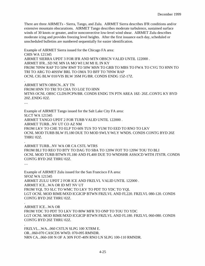
There are three AIRMETs - Sierra, Tango, and Zulu. AIRMET Sierra describes IFR conditions and/orextensive mountain obscurations. AIRMET Tango describes moderate turbulence, sustained surfacewinds of 30 knots or greater, and/or nonconvective low-level wind shear. AIRMET Zulu describesmoderate icing and provides freezing level heights. After the first issuance each day, scheduled orunscheduled bulletins are numbered sequentially for easier identification.
Example of AIRMET Sierra issued for the Chicago FA area:CHIS WA 121345AIRMET SIERRA UPDT 3 FOR IFR AND MTN OBSCN VALID UNTIL 122000 .AIRMET IFR...SD NE MN IA MO WI LM MI IL IN KYFROM 70NW RAP TO 50W RWF TO 50W MSN TO GRB TO MBS TO FWA TO CVG TO HNN TOTRI TO ARG TO 40SSW BRL TO OMA TO BFF TO 70NW RAPOCNL CIG BLW 010/VIS BLW 3SM FG/BR. CONDS ENDG 15Z-17Z..AIRMET MTN OBSCN...KY TNFROM HNN TO TRI TO CHA TO LOZ TO HNNMTNS OCNL OBSC CLDS/PCPN/BR. CONDS ENDG TN PTN AREA 18Z- 20Z..CONTG KY BYD20Z..ENDG 02Z.....
Example of AIRMET Tango issued for the Salt Lake City FA area:SLCT WA 121345AIRMET TANGO UPDT 2 FOR TURB VALID UNTIL 122000 .AIRMET TURB...NV UT CO AZ NMFROM LKV TO CHE TO ELP TO 60S TUS TO YUM TO EED TO RNO TO LKVOCNL MOD TURB BLW FL180 DUE TO MOD SWLY/WLY WNDS. CONDS CONTG BYD 20ZTHRU 02Z..AIRMET TURB...NV WA OR CA CSTL WTRSFROM BLI TO REO TO BTY TO DAG TO SBA TO 120W FOT TO 120W TOU TO BLIOCNL MOD TURB BTWN FL180 AND FL400 DUE TO WNDSHR ASSOCD WITH JTSTR. CONDSCONTG BYD 20Z THRU 02Z.....
Example of AIRMET Zulu issued for the San Francisco FA area:SFOZ WA 121345AIRMET ZULU UPDT 2 FOR ICE AND FRZLVL VALID UNTIL 122000 .AIRMET ICE...WA OR ID MT NV UTFROM YQL TO SLC TO WMC TO LKV TO PDT TO YDC TO YQLLGT OCNL MOD RIME/MXD ICGICIP BTWN FRZLVL AND FL220. FRZLVL 080-120. CONDSCONTG BYD 20Z THRU 02Z..AIRMET ICE...WA ORFROM YDC TO PDT TO LKV TO 80W MFR TO ONP TO TOU TO YDCLGT OCNL MOD RIME/MXD ICGICIP BTWN FRZLVL AND FL180. FRZLVL 060-080. CONDSCONTG BYD 20Z THRU 02Z..FRZLVL...WA...060 CSTLN SLPG 100 XTRM E.OR...060-070 CASCDS WWD. 070-095 RMNDR.NRN CA...060-100 N OF A 30N FOT-40N RNO LN SLPG 100-110 RMNDR.

December 1999
4-26
CONVECTIVE SIGMET (WST)
Convective SIGMETs are issued in the conterminous U.S. for any of the following:
1. Severe thunderstorm due to:a. surface winds greater than or equal to 50 knotsb. hail at the surface greater than or equal to ¾ inches in diameterc. tornadoes
2. Embedded thunderstorms3. A line of thunderstorms4. Thunderstorms producing precipitation greater than or equal to heavy precipitation affecting 40% or
more of an area at least 3,000 square miles
Any convective SIGMET implies severe or greater turbulence, severe icing, and low-level wind shear. Aconvective SIGMET may be issued for any convective situation that the forecaster feels is hazardous toall categories of aircraft.
Convective SIGMET bulletins are issued for the western (W), central (C), and eastern (E) United States.(Convective SIGMETs are not issued for Alaska or Hawaii.) The areas are separated at 87 and 107degrees west longitude with sufficient overlap to cover most cases when the phenomenon crosses theboundaries. Bulletins are issued hourly at H+55. Special bulletins are issued at any time as required andupdated at H+55. If no criteria meeting convective SIGMET requirements are observed or forecasted,the message “CONVECTIVE SIGMET… NONE” will be issued for each area at H+55. Individualconvective SIGMETs for each area (W, C, E) are numbered sequentially from number one each day,beginning at 00Z. A convective SIGMET for a continuing phenomenon will be reissued every hour atH+55 with a new number. The text of the bulletin consists of either an observation and a forecast or justa forecast. The forecast is valid for up to 2 hours.
Example of a convective SIGMET:MKCC WST 251655CONVECTIVE SIGMET 54CVALID UNTIL 1855ZWI ILFROM 30E MSN-40ESE DBQDMSHG LINE TS 15 NM WIDE MOV FROM 30025KT. TOPS TO FL450. WIND GUSTS TO 50 KTPOSS.
CONVECTIVE SIGMET 55CVALID UNTIL 1855ZWI IAFROM 30NNW MSN-30SSE MCWDVLPG LINE TS 10 NM WIDE MOV FROM 30015KT. TOPS TO FL300.
CONVECTIVE SIGMET 56CVALID UNTIL 1855ZMT ND SD MN IA MILINE TS 15 NM WIDE MOV FROM 27020KT. TOPS TO FL380.
OUTLOOK VALID 151855-252255FROM 60NW ISN-INL-TVC-SBN-BRL-FSD-BIL-60NW ISN

December 1999
4-27
IR STLT IMGRY SHOWS CNVTV CLD TOP TEMPS OVER SRN WI HAVE BEEN WARMINGSTEADILY INDCG A WKNG TREND. THIS ALSO REFLECTED BY LTST RADAR AND LTNGDATA. WKNG TREND OF PRESENT LN MAY CONT… HWVR NEW DVLPMT IS PSBL ALGOUTFLOW BDRY AND/OR OVR NE IA/SW WI BHD CURRENT ACT.
A SCND TS IS CONTG TO MOV EWD THRU ERN MT WITH NEW DVLPMT OCRG OVR CNTRLND. MT ACT IS MOVG TWD MORE FVRBL AMS OVR THE WRN DAKS WHERE DWPTS AREIN THE UPR 60S WITH LIFTED INDEX VALUES TO MS 6. TS EXPD TO INCR IN COVERAGEAND INTSTY DURG AFTN HRS.
WST ISSUANCES EXPD TO BE RQRD THRUT AFTN HRS WITH INCRG PTNTL FOR STGRCELLS TO CONTAIN LRG HAIL AND PSBLY DMGG SFC WNDS.
ALASKA, GULF OF MEXICO, AND INTERNATIONAL AREA FORECASTS (FAs)
ALASKA AREA FORECAST (FA)
The Alaska Aviation Weather Unit in Anchorage, Alaska, produces the FA for the entire state of Alaska.The Alaska FA combines the FA, SIGMETs, and AIRMETs into one product. Each FA contains aregional synopsis, 12-hour geographic specific forecasts, and an 18-hour outlook for each geographicarea. Forecast weather elements are sky condition, cloud height, mountain obscuration, visibility,weather and/or obstructions to visibility, strong surface winds (direction and speed), icing, freezing level,and mountain pass conditions. Hazards and flight precautions, including AIRMETs and SIGMETs, maybe found in their respective geographic area. AIRMETs and SIGMETs are also issued as separateproducts.
Partial example of Alaska FA:JNUH FA 191445.EASTERN GULF COAST AND SE AK….AIRMET VALID UNTIL 230300TS IMPLY POSSIBLE SEV OR GREATER TURB SEV ICE LLWS AND IFR CONDS.NON MSL HEIGHTS NOTED BY AGL OR CIG.SYNOPSIS… VALID UNTIL 231500990 MB LOW VCY PACV DRFTG E AND WKN. CDFNT S FM LOW BCMG STNR AND WK ICYBAY SWD BY 15Z. E PACIFIC LOW S 50N MOV N TO 975 MB CNTR 50 SM W PASI AT 15Z WIOCFNT SWD..LYNN CANAL AND GLACIER BAY JB… VALID UNTIL 230900… CLOUDS/WX…… AIRMET MT OBSC… TEMPO MT OBSC INCLDS. NC…SCT030 SCT-BKN050 BKN100 TOP 160. TEMPO HI LYRS TOP FL250. TEMPO BKN030 ISOL-RA. SFC WND S 15 KT G25 KT LYNN CANAL.OTLK VALID 230900-240300… VFR RA. 18Z MVFR CIG RA.PASSES… WHITE AND CHILKOOT… MVFR CIG RASN.… TURB…LYNN CANAL… ISOL MOD TURB BLW 060. ELSW..NIL SIG.… ICE AND FZLVL…TEMPO LGT RIME ICEIC 050-120. FZLVL 030.

December 1999
4-28
Figure 4-7. Alaska Area Forecast Sectors.

December 1999
4-29
GULF OF MEXICO AREA FORECAST
A specialized FA for the Gulf of Mexico is issued by the Tropical Prediction Center in Miami, Florida.The product combines the FA, inflight aviation weather advisories, and marine precautions. This productis intended to support both offshore heliport and general aviation operations. The Gulf of Mexico FAfocuses on an area which includes the coastal plains and coastal waters from Apalachicola, Florida, toBrownsville, Texas, and the offshore waters of the Gulf of Mexico, in an area west of 85W longitude andnorth of 27N latitude. Each section of the FA describes the weather conditions expecting to impact thearea and will include the descriptor none if no significant weather is forecast to occur. Amendments tothis FA are issued the same as amendments to the domestic FAs.
Partial example of Gulf of Mexico FA:FAGX01 KNHC 151030151100Z-152300ZOTLK… 152300Z-161100ZAMDT NOT AVBL 0200Z-1100ZTROPICAL ANALYSIS AND FORECAST BRANCHTROPICAL PREDICTION CENTER MIAMI FLORIDA
GLFMEX N OF 27N W OF 85W… CSTL PLAINS CSTL WTRS AQQ-BRO. HGTS MSL UNLESSNOTED.
TS IMPLY POSS SEV OR GTR TURB… SEV ICE… LOW LVL WS AND STG SFC WND… HIGHWAVES… CIG BLW 010… AND VIS BLW 3SM.
01 SYNS…WK SFC TROUGH FM 31N84W TO 26N88W AT 11Z DRIFTING E THROUGH 23Z. WK HIGHPRES ACRS RMNDER GLFMEX THRU FCST AND OTLK PD.…02 FLT PRCTNS…NONE.…
03 MARINE PRCTNS…NONE.…04 SGFNT CLD/WX…CSTL PLAINS CSTL WTRS BRO-LCH AND OFSHR WTRS W OF 94W… FEW040. OTLK… VFR.…CSTL PLAINS LCH-AQQ…FEW015. OCNL VIS 3-5SM BR. AFT 14Z SCT100. AFT 19Z SCT/BKN020-030 BKN/SCT070-090.WIDELY SCT TSRA/ISOL +TSRA.…05 ICE AND FZ LEVEL BLW 120…NONE. FZ LEVEL ABV 120.…06 TURB BLW 120…NONE.…

December 1999
4-30
07 WND BLW 120…CSTL PLAINS CSTL WTRS LCH-GPT AND OFSHR WTRS 94W-89W… SFC-120 NE-E 10-15 KT.OTLK… NOSIG.…08 WAVES…CSTL WTRS BRO-AQQ… 1-2 FT. OTLK… NOSIG.NNNN
INTERNATIONAL AREA FORECASTS
FAs from the surface to 25,000 feet are also prepared in international format for areas in the AtlanticOcean, Caribbean Sea, and the Gulf of Mexico. Moreover, significant weather forecasts for 25,000 feetto 60,000 feet are prepared in chart form and in international text format for the Northern and Westernhemispheres.
Example of an International FA from the surface to FL250:FANT2 KWBC 091600091800Z TO 100600Z
ATLANTIC OCEAN WEST OF A LINE FROM 40N 67W TO 32N 63W. SFC TO FL250.
SYNOPSIS.RIDGE OVER AREA MOVING TO EAST. FRONTAL SYSTEM MOVING OFF COAST BY 06Z.
SIGNIFICANT CLDS/WX.N OF 34N AND W OF 71W… PATCHES OVC005/015 TOP 030/040 OTHERWISEBKN/OVC015/025 BKN/OVC200/240. BY 06Z INCREASING IMC IN SHRA/TS SPREADINGACROSS AREA FROM WEST. TS TOPS ABOVE 240.
S OF 34N AND W OF 75W… SCT/BKN 015/250. BY 06Z INCREASING IMC IN SHRA/TSSPREADING ACROSS AREA FROM WEST. TS TOPS ABOVE 240.
ELSEWHERE… CLR OCNL SCT015/025. BY 06Z INCREASING BKN080/100.
ICE.FZ LVL 080/090 N SLOPING TO 120/130 S. MOD IN SHRA. SEV IN TS.
TURB.MOD IN SHRA. SEV IN TS.
OUTLOOK.100600Z TO 101800ZFRONT CONTINUING SLOWLY EWD. INCREASING IMC IN SHRA/TS SPREADNG E OVERAREA. SHRA/TS ENDING SW PORTION AFTER FRONTAL PASSAGE.
December 1999
4-31
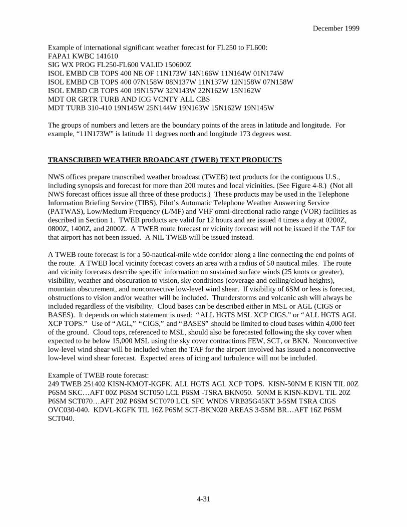
Example of international significant weather forecast for FL250 to FL600:FAPA1 KWBC 141610SIG WX PROG FL250-FL600 VALID 150600ZISOL EMBD CB TOPS 400 NE OF 11N173W 14N166W 11N164W 01N174WISOL EMBD CB TOPS 400 07N158W 08N137W 11N137W 12N158W 07N158WISOL EMBD CB TOPS 400 19N157W 32N143W 22N162W 15N162WMDT OR GRTR TURB AND ICG VCNTY ALL CBSMDT TURB 310-410 19N145W 25N144W 19N163W 15N162W 19N145W
The groups of numbers and letters are the boundary points of the areas in latitude and longitude. Forexample, “11N173W” is latitude 11 degrees north and longitude 173 degrees west.
TRANSCRIBED WEATHER BROADCAST (TWEB) TEXT PRODUCTS
NWS offices prepare transcribed weather broadcast (TWEB) text products for the contiguous U.S.,including synopsis and forecast for more than 200 routes and local vicinities. (See Figure 4-8.) (Not allNWS forecast offices issue all three of these products.) These products may be used in the TelephoneInformation Briefing Service (TIBS), Pilot’s Automatic Telephone Weather Answering Service(PATWAS), Low/Medium Frequency (L/MF) and VHF omni-directional radio range (VOR) facilities asdescribed in Section 1. TWEB products are valid for 12 hours and are issued 4 times a day at 0200Z,0800Z, 1400Z, and 2000Z. A TWEB route forecast or vicinity forecast will not be issued if the TAF forthat airport has not been issued. A NIL TWEB will be issued instead.
A TWEB route forecast is for a 50-nautical-mile wide corridor along a line connecting the end points ofthe route. A TWEB local vicinity forecast covers an area with a radius of 50 nautical miles. The routeand vicinity forecasts describe specific information on sustained surface winds (25 knots or greater),visibility, weather and obscuration to vision, sky conditions (coverage and ceiling/cloud heights),mountain obscurement, and nonconvective low-level wind shear. If visibility of 6SM or less is forecast,obstructions to vision and/or weather will be included. Thunderstorms and volcanic ash will always beincluded regardless of the visibility. Cloud bases can be described either in MSL or AGL (CIGS orBASES). It depends on which statement is used: “ALL HGTS MSL XCP CIGS.” or “ALL HGTS AGLXCP TOPS.” Use of “AGL,” “CIGS,” and “BASES” should be limited to cloud bases within 4,000 feetof the ground. Cloud tops, referenced to MSL, should also be forecasted following the sky cover whenexpected to be below 15,000 MSL using the sky cover contractions FEW, SCT, or BKN. Nonconvectivelow-level wind shear will be included when the TAF for the airport involved has issued a nonconvectivelow-level wind shear forecast. Expected areas of icing and turbulence will not be included.
Example of TWEB route forecast:249 TWEB 251402 KISN-KMOT-KGFK. ALL HGTS AGL XCP TOPS. KISN-50NM E KISN TIL 00ZP6SM SKC… AFT 00Z P6SM SCT050 LCL P6SM -TSRA BKN050. 50NM E KISN-KDVL TIL 20ZP6SM SCT070… AFT 20Z P6SM SCT070 LCL SFC WNDS VRB35G45KT 3-5SM TSRA CIGSOVC030-040. KDVL-KGFK TIL 16Z P6SM SCT-BKN020 AREAS 3-5SM BR… AFT 16Z P6SMSCT040.
December 1999
4-32
Explanation of route forecast:249 - route numberTWEB - TWEB route forecast25 - twenty-fifth day of the month1402 - valid 14Z on the twenty-fifth to 02Z on the twenty-sixth (12 hours)KISN-KMOT-KGFK - route: Williston, North Dakota (ND), to Minot, ND, to Grand Forks, NDRemainder of the message explained: All heights AGL except cloud tops. KISN-50NM E KISN until00Z, visibility greater than 6SM with clear skies. After 00Z, visibility greater than 6SM with scatteredclouds at 5,000 feet AGL. Local areas of visibility greater than 6SM, thunderstorm with light rainshowers, and broken clouds at 5,000 feet AGL. 50 NM E KISN-KDVL (Devil’s Lake, ND) until 20Z,visibility greater than 6SM, scattered clouds at 7,000 feet AGL. After 20Z, visibility greater than 6SM,scattered clouds at 7,000 feet AGL, local surface winds variable at 35 gusting to 45 knots, visibility 3-5SM, thunderstorm with moderate rain showers, overcast ceilings 3,000-4,000 feet AGL. KDVL-KGFKuntil 16Z, visibility greater than 6SM, scattered to broken clouds at 2,000 feet AGL, areas of visibility 3-5SM with mist. After 16Z, visibility greater than 6SM, scattered clouds at 4,000 feet AGL.
An example of TWEB vicinity forecast:431 TWEB 021402 LAX BASIN. ALL HGTS MSL XCP CIGS. TIL 18Z P6SM XCP 3SM BR VLYSBKN020… 18Z-22Z P6SM SCT020 SCT-BKN100… AFT 22Z P6SM SKC.
Explanation of vicinity forecast:431 - TWEB vicinity numberTWEB - TWEB forecast02 - second day of the month1402 - valid 14Z on the second to 02Z on the third (12 hours)LAX BASIN - The weather conditions in the Los Angeles basin until 18Z, visibility greater than 6SMexcept 3SM due to mist in the valleys and broken clouds at 2,000 feet MSL. Between 18Z and 22Z,visibility greater than 6SM and scattered clouds at 2,000 feet AGL; also scattered to broken clouds at10,000 feet MSL. After 22Z, visibility greater than 6SM and sky clear.
A TWEB synopsis forecast is a brief description of the weather systems affecting the route during theforecast valid period. The synopsis describes movement of pressure systems, movement of fronts, upperair disturbances, or air flow.
An example of a TWEB synopsis:BIS SYNS 250820. LO PRES TROF MVG ACRS ND TDA AND TNGT. HI PRES MVG SEWD FMCANADA INTO NWRN ND BY TNGT AND OVR MST OF ND BY WED MRNG.
Explanation of synopsis:BIS - Bismarck, ND, WFO issuing the synopsis and route forecastSYNS - Synopsis for the area covered by the route forecast25 - twenty-fifth day of the month0820 - Valid from 08Z on the twenty-fifth to 20Z on the twenty-fifth (12 hours)The remainder of message explained: Low pressure trough moving across North Dakota today andtonight. High pressure moving southeastward from Canada into northwestern North Dakota by tonightand over most of North Dakota by Wednesday morning.

December 1999
4-33
An example of another TWEB synopsis:CYS SYNS 101402 STG UPSLP WNDS OVR WY TIL 01Z WITH WDSPRD IFR CONDS IN LGT SNAND BLOWING SN. CONDS WL IPV FM N TO S ACRS WY AFT 01Z WITH DCRG CLDS.
Explanation of synopsis:CYS - Cheyenne, WY, WFO issuing the synopsis and route forecastSYNS - Synopsis for the area covered by the route forecast10 - tenth day of the month1402 - Valid from 14Z on the tenth to 02Z on the eleventh (12 hours)The remainder of the message explained: Strong upslope winds over Wyoming until 01Z withwidespread IFR conditions in light snow and blowing snow. Conditions will improve from north to southacross Wyoming after 01Z with decreasing clouds.

December 1999
4-34

December 1999
4-35
WINDS AND TEMPERATURES ALOFT FORECAST (FD)
Winds and temperatures aloft are forecasted for specific locations in the contiguous U.S., as shown inFigure 4-9. The FD forecasts are also prepared for a network of locations in Alaska and Hawaii as shownin Figure 4-10. Forecasts are made twice daily based on the 00Z and 12Z radiosonde data for use duringspecific time intervals.
Below is a sample FD message containing a heading and two FD locations. The heading always includesthe time during which the FD may be used (0500-0900Z in the example) and a notation “TEMPS NEGABV 24000.” Since temperatures above 24,000 feet are always negative, the minus sign is omitted.
Example of FD report:DATA BASED ON 010000ZVALID 010600Z FOR USE 0500-0900Z. TEMPS NEG ABV 24000FT 3000 6000 9000 12000 18000 24000 30000 34000 39000MKC 2426 2726-09 2826-14 2930-21 2744-32 2751-41 275550 276050 731960ABQ 1912+15 1914+07 1917-06 1820-17 172132 171942 192054
Explanation of FD:The data are based on the radiosonde information from the 1st day of the month at 00Z. The second linedescribes the valid time. In this example, the valid time is the 1st at 06Z for use on the 1st between 05-09Z. Temperatures are negative above 24,000 feet. The line labeled “FT” indicates the levels of thewind and temperature data. Through 12,000, feet the levels are true altitude. From 18,000 feet andabove, the levels are pressure altitude. The 45,000-foot and 53,000-foot levels are also available. Thepilot may request these levels from the FSS briefer. A six-digit group shows wind direction, in referenceto true north, wind speed in knots, and temperature in degrees Celsius.
Note the Kansas City, MO (MKC), forecast for 3,000 feet. The group “2426” means the wind is from240 degrees at 26 knots. The first two digits give direction in tens of degrees and the second two digitsare the wind speed in knots. In the MKC forecast, the coded group for 9,000 feet is “2826-14.” Thewind is from 280 degrees at 26 knots and the temperature is negative 14 degrees Celsius. Note in theAlbuquerque (ABQ) 3,000- and 6,000-foot examples that the wind group is omitted. No winds areforecasted within 1,500 feet of station elevation. Also, no temperatures are forecasted for any levelwithin 2,500 feet of station elevation. (See MKC 3000 example.)
If a wind direction is coded between 51 and 86, the wind speed is 100 knots or greater. For example, theMKC forecast for 39,000 feet is “731960.” To decode this, subtract 50 from the wind direction and add100 knots to the wind speed. Thus, the wind direction is from 230 degrees (73-50=23) and the speed is119 knots (100+19=119). The temperature is minus 60 degrees Celsius. If the wind speed is forecastedto be 200 knots or greater, the wind group is coded as 99 knots. For example, “7799” is decoded as 270degrees at 199 knots or greater. When the forecast speed is less than 5 knots, the coded group is “9900”and read, “LIGHT AND VARIABLE.”
Examples of decoding FDs:Coded Decoded9900+00 Wind light and variable, temperature 0 degrees Celsius2707 270 degrees at 7 knots850552 350 degrees (85-50=35) at 105 knots (100+05=105), temperature -52 degrees Celsius

December 1999
4-36
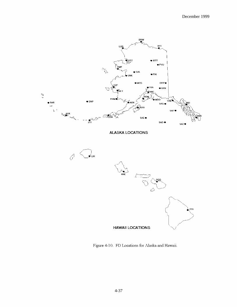
December 1999
4-37

December 1999
4-38
CENTER WEATHER SERVICE UNIT (CWSU) PRODUCTS
Center Weather Service Unit (CWSU) products are issued by the CWSU meteorologists located in theAir Route Traffic Control Centers (ARTCCs). Coordination between the CWSU meteorologist and otherNWS facilities is extremely important since both can address the same event. If time permits,coordination should take place before the CWSU meteorologist issues a product.
METEOROLOGICAL IMPACT STATEMENT (MIS)
A Meteorological Impact Statement (MIS) is an unscheduled flow control and flight operations planningforecast. The MIS can be valid between 2 to 12 hours after issuance. This enables the impact ofexpected weather conditions to be included in air traffic control decisions in the near future. The MISwill be issued when the following three conditions are met:
1. If any one of the following conditions occur, are forecasted to occur, and if previously forecasted, areno longer expected to occur:a. convective SIGMET criteriab. moderate or greater icing and/or turbulencec. heavy or freezing precipitationd. low IFR conditionse. surface winds/gusts 30 knots or greaterf. low-level wind shear within 2,000 feet of the surfaceg. volcanic ash, dust or sandstorm
2. If the impact occurs on air traffic flow within the ARTCC area of responsibility3. If the forecast lead time (the time between issuance and onset of a phenomenon), in the forecaster’s
judgment, is sufficient to make issuance of a Center Weather Advisory (CWA) unnecessary
Example of a MIS:ZOA MIS 01 VALID 041415-041900… FOR ATC PLANNING PURPOSES ONLY…FOR SFO BAY AREADNS BR/FG WITH CIG BLO 005 AND VIS OCNL BLO 1SM TIL 19Z.
This MIS from the Fremont, California (CA), ARTCC is the first issuance of the day. It was issued at1415Z on the fourth and is valid until 1900Z on the fourth. This forecast is for the San Francisco Bayarea. The forecast is of dense fog/mist with ceilings below 500 feet and visibilities occasionally below1SM until 19Z.
Example:ZOA MIS 02 VALID 041650… FOR ATC PLANNING PURPOSES ONLY…FOR SFO BAY AREACANCEL ZOA MIS 01. DNS BR/FG CONDS HAVE IPVD ERYR THAN FCST.
This MIS is from the Fremont, CA, ARTCC and cancels the previously issued MIS. Specifically it statesdense fog/mist conditions have improved earlier than forecasted.

December 1999
4-39
Example:ZID MIS 03 VALID 041200-042330… FOR ATC PLANNING PURPOSES ONLY…FROM IND TO CMH TO LOZ TO EVV TO INDFRQ MOD TURBC FL310-390 DUE TO JTSTR… CONDS DMSHG IN INTSTY AFT 21Z.
This MIS from the Indianapolis, Indiana (IN), ARTCC was issued at 1200Z on the fourth and valid untilthe fourth at 2330Z. This forecast describes an area from Indianapolis, IN, to Columbus, Ohio (OH), toLondon, Kentucky (KY), to Evansville, IN, and back to Indianapolis, IN. The MIS describes frequentmoderate turbulence between flight levels 310-390 caused by the jet stream. Conditions will diminish inintensity after 21Z.
CENTER WEATHER ADVISORY (CWA)
A Center Weather Advisory (CWA) is an aviation warning for use by air crews to anticipate and avoidadverse weather conditions in the en route and terminal environments. The CWA is not a flight planningproduct; instead it reflects current conditions expected at the time of issuance and/or is a short-rangeforecast for conditions expected to begin within 2 hours of issuance. CWAs are valid for a maximum of2 hours. If conditions are expected to continue beyond the 2-hour valid period, a statement will beincluded in the CWA.
A CWA may be issued for the following three situations:
1. As a supplement to an existing inflight aviation weather advisory for the purpose of improving orupdating the definition of the phenomenon in terms of location, movement, extent, or intensityrelevant to the ARTCC area of responsibility. This is important for the following reason. ASIGMET for severe turbulence was issued by AWC, and the outline covered the entire ARTCC areafor the total 4-hour valid time period. However, the forecaster may issue a CWA covering only arelatively small portion of the ARTCC area at any one time during the 4-hour period.
2. When an inflight aviation weather advisory has not yet been issued but conditions meet the criteria based on current pilot reports and the information must be disseminated sooner than the AWC can issue the inflight aviation weather advisory. In this case of an impending SIGMET, the CWA will beissued as urgent (UCWA) to allow the fastest possible dissemination.
3. When inflight aviation weather advisory criteria are not met but conditions are or will shortly be adversely affecting the safe flow of air traffic within the ARTCC area of responsibility.
Example of a CWA:ZME1 CWA 081300ZME CWA 101 VALID UNTIL 081500FROM MEM TO JAN TO LIT TO MEMAREA SCT VIP 5-6 (INTENSE/EXTREME) TS MOV FROM 26025KT. TOPS TO FL450.
This CWA was issued by the Memphis, Tennessee (TN), ARTCC. The 1 after the ZME in the first linedenotes this CWA has been issued for the first weather phenomenon to occur for the day. It was writtenon the eighth at 1300Z. The 101 in the second line denotes the phenomenon number again (1) and theissuance number (01) for this phenomenon. The CWA is until the eighth at 1500Z. The area is boundedfrom Memphis, TN, to Jackson, MS, to Little Rock, AR, and back to Memphis, TN. Within the CWA isan area with scattered VIP 5-6 (intense/extreme) thunderstorms moving from 260 degrees at 25 knots.Tops of the thunderstorms are at FL450.

December 1999
4-40
HURRICANE ADVISORY (WH)
When a hurricane threatens a coastline, but is located at least 300NM offshore, a Hurricane Advisory(WH) is issued to alert aviation interests. The advisory gives the location of the storm center, itsexpected movement, and the maximum winds in and near the storm center. It does not contain details ofassociated weather, as specific ceilings, visibilities, weather, and hazards that are found in the FAs,TAFs, and inflight aviation weather advisories.
Example of a WH:ZCZC MIATCPAT4TTAA00 KNHC 190841BULLETINHURRICANE DANNY ADVISORY NUMBER 13NATIONAL WEATHER SERVICE MIAMI FL4 AM CDT SAT JUL 19 1997
… DANNY STILL MOVING LITTLE… ANY NORTHWARD DRIFT WOULD BRING THE CENTERONSHORE…
HURRICANE WARNINGS ARE IN EFFECT FROM GULFPORT MISSISSIPPI TOAPALACHICOLA FLORIDA. SMALL CRAFT SOUTHWEST OF GULFPORT SHOULD REMAININ PORT UNTIL WINDS AND SEAS SUBSIDE.
AT 4 AM CDT… 0900Z… THE CENTER OF HURRICANE DANNY WAS LOCATED BYNATIONAL WEATHER SERVICE RADAR AND RECONNAISSANCE AIRCRAFT NEARLATITUDE 30.2 NORTH… LONGITUDE 88.0 WEST… VERY NEAR THE COAST ABOUT 25MILES SOUTH-SOUTHEAST OF MOBILE ALABAMA.
DANNY HAS MOVED LITTLE DURING THE PAST FEW HOURS. WHILE SOME ERRATICMOTION CAN BE EXPECTED DURING THE NEXT FEW HOURS… A GRADUAL TURNTOWARD THE NORTHEAST IS EXPECTED TODAY. ON THIS COURSE… THE CENTER ISEXPECTED TO MAKE LANDFALL IN THE WARNING AREA TODAY. HOWEVER ANYDEVIAITON TO THE NORTH OR THE TRACK WOULD BRING THE CENTER ONSHOREWITHIN THE WARNING AREA AT ANYTIME.MAXIMUM SUSTAINED WINDS ARE NEAR 75 MPH WITH HIGHER GUSTS. SOMESTRENGTHENING IS STILL POSSIBLE PRIOR TO LANDFALL. DAUPHIN ISLAND RECENTLYREPORTED GUSTS TO 66 MPH AND THE PRESSURE DROPPED TO 989MB… 29.20 INCHES.
DANNY HAS A RELATIVELY SMALL WIND FIELD. HURRICANE FORCE WINDS EXTENDOUTWARD UP TO 25 MPH FROM THE CENTER AND TROPICAL STORM FORCE WINDSEXTEND OUTWARD UP TO 70 MILES.
LATEST MINIMUM CENTRAL PRESSURE REPORTED BY A RECONNAISSANCE AIRCRAFTWAS 986 MB… 29.11 INCHES.
RADAR SHOWS RAIN BANDS AFFECTING THE AREA FROM SOUTHERN MISSISSIPPI TOTHE FLORIDA PANHANDLE. TOTALS OF 10 TO 20 INCHES… LOCALLY HIGHER… COULDOCCUR NEAR THE TRACK OF DANNY DURING THE NEXT FEW DAYS.
STORM SURGE FLOODING OF 4 TO 5 FEET ABOVE NORMAL TIDES IS POSSIBLE ALONGTHE GULF COAST EAST OF THE CENTER.

December 1999
4-41
Example of WH forecast/advisory:ZCZC MIATCMAT4TTAA00 KNHC 190845HURRICANE DANNY FORECAST/ADVISORY NUMBER 13NATIONAL WEATHER SERVICE MIAMI FL AL04970900Z SAT JUL 19 1997
HURRICANE WARNINGS ARE IN EFFECT FROM GULFPORT MISSISSIPPI TOAPALACHICOLA FLORIDA. SMALL CRAFT SOUTHWEST OF GULFPORT SHOULD REMAININ PORT UNTIL THE WINDS AND SEAS SUBSIDE.
HURRICANE CENTER LOCATED NEAR 30.2 N 88.0 W AT 19/0900Z POSITION ACCURATEWITHIN 30 NM.
PRESENT MOVEMENT NEARLY STATIONARY
ESTIMATED MINIMUM CENTRAL PRESSURE 986 MBMAX SUSTAINED WINDS 65 KTS WITH GUSTS TO 80 KT64 KT 15NE 20SE 0SW 0NW50 KT 20NE 30SE 30SW 0NW34 KT 30 E 60SE 60SW 30NW12FT SEAS 30NE 60SE 60SW 30NWALL QUADRANT RADII IN NAUTICAL MILES
FORECAST VALID 19/1800Z 30.2N 87.4WMAX WIND 70 KT… GUSTS 85 KT64 KT 20NE 20SE 20SW 20NW50 KT 25NE 30SE 30SW 25NW34 KT 30NE 75SE 75SW 30NW
CONVECTIVE OUTLOOK (AC)
A Convective Outlook (AC) is a national forecast of thunderstorms. There are two forecasts: Day 1Convective Outlook (first 24 hours) and Day 2 Convective Outlook (next 24 hours). These forecastsdescribe areas in which there is a slight, moderate, or high risk of severe thunderstorms, as well as areasof general (non-severe) thunderstorms. The severe thunderstorm criteria are: Winds equal to or greaterthan 50 knots at the surface, or hail equal to or greater than ¾ inch in diameter at the surface, ortornadoes. The Refer to the Convective Outlook Chart (Section 12) for risk definitions. Forecastreasoning is also included in all ACs. Outlooks are produced by the Storm Prediction Center (SPC)located in Norman, OK. The times of issuance for Day 1 are 0600Z, 1300Z, 1630Z, 2000Z, and 0100Z.The initial Day 2 issuance is at 0830Z during standard time and 0730Z during daylight time. It isupdated at 1730Z. The AC is a flight planning tool used to avoid thunderstorms.
December 1999
4-42
Example:MKC AC 291435CONVECTIVE OUTLOOK… REF AFOS NMCGPH94O.VALID 291500Z-301200Z
THERE IS A SLGT RISK OF SVR TSTMS TO THE RIGHT OF A LINE FROM 10 NE JAX 35 NNWAYS AGS 15 E SPA 30 NE CLT 25 N FAY 30 ESE EWN.
GEN TSTMS ARE FCST TO THE RIGHT OF A LINE FROM 55 ESE YUM 30 NE IGM 15 S CDC 30SW U24 25 ESE ELY 40 W P38 DRA 50 SW DRA 50 NW NID SAC 30 E ACV 25 E ONP 40 E BLI.
...SEVERE THUNDERSTORM FORECAST DISCUSSION...
.SERN U.S...
COOL FRONT CONTS SC/NC BORDER. VERY MOIST AND UNSTBL AMS ALONG AND S OFFRONT E OF APLCHNS WITH CAPES TO REACH TO 4000 J/KG WITH AFTN HEATING.ALTHOUGH WIND PROFILES ARE WK...COMB OF FRONTAL CNVGNC COUPLED WITH SEABREEZE FRONT WILL INITIATE PULSE SVR TSTMS VCNTY AND S OF FRONT THISAFTN/EVE. PRIMARY SVR EVENTS WILL BE WET DOWNBURST TO PUSH SWD FROMCNTRL RCKYS EWD TO MID ATLC CST. E OF APLCNS FRONT NOW LCTD VCNTY WNDDMG.
...GENERAL THUNDERSTORM FORECAST DISCUSSION...
...GULF CST AREA INTO SRN PLNS...
SFC FNT CURRENTLY LOCATED FM THE CAROLINAS WWD INTO PARTS OF OK WL CONTTO SAG SLOWLY SWD ACRS THE SRN APLCNS/LWR MS VLY THRU THE REMAINDER OFTHE PD. S OF THE BNDRY...A VRY MOIST AMS RMNS IN PLACE AS DWPNTS ARE IN THEMID TO UPR 70S. WHILE SOME CLDNS IS PRESENT ACRS THE AREA...SUF HEATINGSHOULD OCR TO ALLOW FOR MDT TO STG AMS DSTBLZN DURG THE LATE MRNG/ERYAFTN. AS A RESULT...SFC BASED CAPE VALUES SHOULD BE AOA 2000 J/KG THIS AFTN.BNDRYS FM OVERNIGHT CNVTN AS WELL AS SEA BREEZE CIRCULATIONS SHOULD BESUF TO INITIATE SCT TO NMRS TSTMS ACRS THE AREA. MID TO UPR LVL FLOW ISRELATIVELY WK...SO THIS SUG ORGANIZED SVR TSTM ACTVTY IS NOT LIKELY.
SEVERE WEATHER WATCH BULLETINS (WWs) and ALERT MESSAGES (AWWs)
A Severe Weather Watch Bulletin (WW) defines areas of possible severe thunderstorms or tornadoactivity. The bulletins are issued by the SPC in Norman, OK. WWs are unscheduled and are issued asrequired.
A severe thunderstorm watch describes areas of expected severe thunderstorms. (Severe thunderstormcriteria are ¾-inch hail or larger and/or wind gusts of 50 knots [58 mph] or greater.) A tornado watchdescribes areas where the threat of tornadoes exists.
In order to alert the WFOs, CWSUs, FSSs, and other users, a preliminary notification of a watch calledthe Alert Severe Weather Watch bulletin (AWW) is sent before the WW. (WFOs know this product as aSAW).

December 1999
4-43
Example of an AWW:MKC AWW 011734WW 75 TORNADO TX OK AR 011800Z-020000ZAXIS..80 STATUTE MILES EAST AND WEST OF A LINE..60ESE DAL/DALLAS TX/ - 30 NWARG/ WALNUT RIDGE AR/..AVIATION COORDS.. 70NM E/W /58W GGG - 25NW ARG/HAIL SURFACE AND ALOFT..1 ¾ INCHES. WIND GUSTS..70 KNOTS. MAX TOPS TO 450.MEAN WIND VECTOR 24045.
Soon after the AWW goes out, the actual watch bulletin itself is issued. A WW is in the followingformat:1. Type of severe weather watch, watch area, valid time period, type of severe weather possible, watch
axis, meaning of a watch, and a statement that persons should be on the lookout for severe weather2. Other watch information; i.e., references to previous watches3. Phenomena, intensities, hail size, wind speed (knots), maximum CB tops, and estimated cell
movement (mean wind vector)4. Cause of severe weather5. Information on updating ACs
Example of a WW:BULLETIN - IMMEDIATE BROADCAST REQUESTEDTORNADO WATCH NUMBER 381STORM PREDICTION CENTER NORMAN OK556 PM CDT MON JUN 2 1997
THE STORM PREDICTON CENTER HAS ISSUED A TORNADO WATCH FOR PORTIONS OF
NORTHEAST NEW MEXICOTEXAS PANHANDLE
EFFECTIVE THIS MONDAY NIGHT AND TUESDAY MORNING FROM 630 PM UNTILMIDNIGHT CDT.
TORNADOES… HAIL TO 2 ¾ INCHES IN DIAMETER… THUNDERSTORM WIND GUSTS TO 80MPH… AND DANGEROUS LIGHTNING ARE POSSIBLE IN THESE AREAS.
THE TORNADO WATCH AREA IS ALONG AND 60 STATUTE MILES NORTH AND SOUTH OFA LINE FROM 50 MILES SOUTHWEST OF RATON NEW MEXICO TO 50 MILES EAST OFAMARILLO TEXAS.
REMEMBER… A TORNADO WATCH MEANS CONDITIONS ARE FAVORABLE FORTORNADOES AND SEVERE THUNDERSTORMS IN AND CLOSE TO THE WATCH AREA.PERSONS IN THESE AREAS SHOULD BE ON THE LOOKOUT FOR THREATENING WEATHERCONDITIONS AND LISTEN FOR LATER STATEMENTS AND POSSIBLE WARNINGS.
OTHER WATCH INFORMATION… CONTINUE… WW 378… WW 379… WW 380
DISCUSSION… THUNDERSTORMS ARE INCREASING OVER NE NM IN MOISTSOUTHEASTERLY UPSLOPE FLOW. OUTFLOW BOUNDARY EXTENDS EASTWARD INTOTHE TEXAS PANHANDLE AND EXPECT STORMS TO MOVE ESE ALONG AND NORTH OFTHE BOUNDARY ON THE N EDGE OF THE CAP. VEERING WINDS WITH HEIGHT ALONGWITH INCREASGING MID LVL FLOW INDICATE A THREAT FOR SUPERCELLS.

December 1999
4-44
AVIATION… TORNADOES AND A FEW SEVERE THUNDERSTORMS WITH HAIL SURFACEAND ALOFT TO 2 ¾ INCHES. EXTREME TURBULENCE AND SURFACE WIND GUSTS TO 70KNOTS. A FEW CUMULONIMBI WITH MAXIMUM TOPS TO 550. MEANS STORM MOTIONVECTOR 28025.
Status reports are issued as needed to show progress of storms and to delineate areas no longer under thethreat of severe storm activity. Cancellation bulletins are issued when it becomes evident that no severeweather will develop or that storms have subsided and are no longer severe.
When tornadoes or severe thunderstorms have developed, the local WFO office will issue the warningscovering those areas.
December 1999
4-45
December 1999
4-46


![rowdysites.msudenver.edurowdysites.msudenver.edu/~sng1/MTR4500/Brown1986... · (NMC3], viewed in the light Of current Observational and theoretical knowledge Of the windstorm phenomenon,](https://img.dokumen.tips/doc/110x75/5f0e59bb7e708231d43ed1f1/sng1mtr4500brown1986-nmc3-viewed-in-the-light-of-current-observational.jpg)