Embed Size (px)
Citation preview
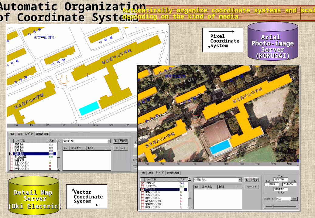
Automatic Organizationof Coordinate SystemsAutomatic Organizationof Coordinate Systems
Arial Photo-image
Server(KOKUSAI)
Arial Photo-image
Server(KOKUSAI)
Automatically organize coordinate systems and scalesdepending on the kind of mediaAutomatically organize coordinate systems and scalesdepending on the kind of media
PixelCoordinateSystem
Vector CoordinateSystem
Detail Map Server
(Oki Electric)
Detail Map Server
(Oki Electric)

The Open GIS Specification ModelTopic 12: The Open GIS Service Architecture
Geospatial Coordinate Transformation Services (GCTS)
Transform geographic coordinate values from one coordinate system to another

Physical Compensation of Physical Compensation of Geospatial ObjectGeospatial ObjectPhysical Compensation of Physical Compensation of Geospatial ObjectGeospatial Object
ApplicationDB Server
(NEC)
ApplicationDB Server
(NEC)
Automatic Compensation of Spatial Object Distortions which happens in composing multiple objects Automatic Compensation of Spatial Object Distortions which happens in composing multiple objects
Example of distortions between building-outlinesof the residential map and the city planning mapThey are compensated and symbolized in orderto adopt thematic maps.
Detail Map Server
(Oki Electric)
Detail Map Server
(Oki Electric)

Example of distortions between building outlinesof the summarized-map and the thematic map.Summarized map does not hold building-outlines, so their locations are not only compensated but also symbolized.
Physical Compensation of Geospatial ObjectPhysical Compensation of Geospatial Object
Automatic Compensation of Spatial Object Distortions which happens in composing multiple objects Automatic Compensation of Spatial Object Distortions which happens in composing multiple objects
ApplicationDB Server
(NEC)
ApplicationDB Server
(NEC)
Summarized Map Server
(PASCO)
Summarized Map Server
(PASCO)

Exploit information available in a Feature orFeature Collection to derive application-oriented quantitative results that are not available from the raw data itself.
Composed of 9 operations
①Buffering to create a proximity zone②Boolean operations to perform binary operations on two or more features③Determine if any features in the Feature Collection obstruct④Compute non-stored geometric properties⑤Exploiting elevation coverages⑥Create geospatial model of one or more related Feature Collections⑦Interpret feature properties⑧Exploiting transportation routes⑨Computing exposure
The Open GIS Specification ModelTopic 12: The Open GIS Service Architecture Feature Analysis Services (FAS)Feature Analysis Services (FAS)

Support creation, quality control methods,analysis, and display of feature collectionsof interest to an end user.
Composed of 5 operations
①Register one feature to another 、 an image, or another data set or coordinate set.②Examines the internal correctness and consistency of features and their properties③Deconflict features by applying④Modify a feature and its description⑤Modify the values of metadata elements (properties) describing a feature
The Open GIS Specification ModelTopic 12: The Open GIS Service Architecture
Geospatial Feature Manipulation Services (GFMS)

Legacy DB1( Residential Map )
Application DB(Disaster Prevention)
Legacy DB2( Summarized Map )
District.TownTall RoadGeneral RoadRailroadWater PartRailway Station BuildingsGovernment officeBuildingsAnnotations
City Bound.Town Bound.BlockRoadRailroadWater Bound.BuildingsCity NamesTown NamesRoad NamesRailroad NamesWater Bound. NamesBuilding NamesAnnotationsSymbolArial Photo-imageSubjects
Major Section Bound.Minor Section Bound.Block Bound. 1RoadRailroadWater Bound. 1Water Bound. 2BuildingsCity & Special Area NamesTown NamesGeneral Building NamesLandmark NamesOther Strings 1Symbol
Compensate the difference between objects which hold a same name but hold different entities.Compensate difference caused from the M-to-N relationships of objects.
Compensate the difference between objects which hold a same name but hold different entities.Compensate difference caused from the M-to-N relationships of objects.
Semantic Compensation of Semantic Compensation of Geospatial ObjectGeospatial ObjectSemantic Compensation of Semantic Compensation of Geospatial ObjectGeospatial Object
ApplicationDB Server
(NEC)
ApplicationDB Server
(NEC)
Detail Map Server
(Oki Electric)
Detail Map Server
(Oki Electric)
Summarized Map Server
(PASCO)
Summarized Map Server
(PASCO)

Modify the characteristics of a feature collection to increase the effectiveness of communication by counteracting the undesirable effects of data reduction
The Open GIS Specification ModelTopic 12: The Open GIS Service Architecture
Feature Generalization Services (FGS)Feature Generalization Services (FGS)

Spatial Information Spatial Information Directory Service Directory Service
CommunityCommunity
GSOTGSOT
GSOTGSOT
Vector Map Vector Map Service Service
CommunityCommunity
GSOTGSOT
Building Building Information Information
Service Service CommunityCommunity
Map Service Map Service CommunityCommunity
GSOTGSOT
GSOTGSOT
National National Numerical Numerical
Map Service Map Service CommunityCommunity
3-D VRML Files
2-D Map Data
Mesh Data
Step1: Retrieval Demand
from Web TerminalRetrieval Condition
・ Search Demand Area・Display Type (3-Dimensional )・ Base Scale …
Step2:Trader Graph Generation
Step3:Transfer SearchProcessing
Step3:Transfer SearchProcessing
Step3:Transfer Search Processing
Position Correction
3-D Process
Scale Conversion
Merg
e
Pro
cessin
g
Step4:Get Retrieval Result
Step5:Display Retrieval Result Adding Optimal Real-time Process to the Retrieval Results
Trader Service ArchitectureTrader Service ArchitectureTrader Service ArchitectureTrader Service ArchitectureDistributed & Cooperative Retrieval of Geo-Spatial Objects based on Trader GraphDistributed & Cooperative Retrieval of Geo-Spatial Objects based on Trader Graph

GSMGSM
Dispatch Spatial Retrieval Func.
Uniquely managed Uniquely managed Spatial and Attribute Spatial and Attribute DataData
Evaluate Terminal
Capability
ORDBMSORDBMS
Active Retrieval Active Retrieval MechanismMechanism
Me
dia
C
on
ve
rsio
n
WWWWWWServerServer
Data Blade orData Cartridge
Image Conversion
Vector Conversion
Feature Conversion
Process flow of GSM’s active retrieval mechanism (in future)If the terminal capability is sent to the GSM, it is evaluated and dispatched spatial retrieval functions, then retrieved data is actively converted into various forms by the media conversion function. This mechanism corresponds with various level of portrayal model.