Embed Size (px)
Citation preview

Master Thesis
Automatic Generation of OpenGIS-compliant
Relational Database from XML Schema
Aivaras Pigaga
Matr. Nr.: 20726
Information and Media Technologies
Technical University of Hamburg-Harburg
Under the supervision of
Prof. Dr. Joachim W. Schmidt
Prof. Dr.-Ing. Erik Pasche
Rainer Marrone
Andreas von Dömming
Hamburg, March 22, 2004

Acknowledgements
Firstly, I wish to express my deep appreciation and sincere thanks to my wife Eleni,
who understood and supported me in all my deeds.
I would like to express my sincere thanks to my advisors Rainer Marrone and
especially Andreas von Dömming who always found time to advice and guide me
during this work.
Many thanks also to my supervisors Prof. Dr. Joachim W. Schmidt and Prof. Dr.-Ing.
Erik Pasche for accepting me to carry out this thesis.


I declare that:
I have carried out this work myself, all literally or content-related quotations from
other sources are clearly pointed out, and no other sources or aids other than the ones
specified are used.
Hamburg, March 2004
Aivaras Pigaga

Automatic Generation of OpenGIS-compliant Relational Database from XML Schema
7
Table of Content
1. Introduction...................................................................................................... 13
1.1. Motivation................................................................................................ 13
1.2. Objectives ................................................................................................ 15
1.3. Structure of the Work ............................................................................... 16
2. Concepts and Technologies .............................................................................. 17
2.1. Model-View-Controller (MVC)................................................................ 17
2.2. XML Schema ........................................................................................... 18
2.3. OpenGIS .................................................................................................. 22
2.4. Summary of the Chapter ........................................................................... 25
3. Model for Relational Database Schema Definition Generation from XML
Schema .................................................................................................................... 27
3.1. Generic Data Importer .............................................................................. 27
3.2. Problem Statement ................................................................................... 30
3.3. Three-Layer Architecture of the Model and Model-View-Controller (MVC)
Design Pattern...................................................................................................... 31
3.3.1. Logic Layer ...................................................................................... 34
3.3.1.1. Model ....................................................................................... 34
3.3.1.2. Container .................................................................................. 37
3.3.2. Data Layer ........................................................................................ 39
3.3.2.1. Mapping Specific XML Schema to Model objects..................... 39
3.3.2.2. Data Type Mapping .................................................................. 44
3.3.2.3. Data Mappers............................................................................ 45
3.3.3. Pseudo-Presentation Layer ................................................................ 49
3.3.3.1. SQL Builders ............................................................................ 49
3.3.3.2. SQL Scripts Generation Process................................................ 51
3.4. Limitations ............................................................................................... 53
3.5. Summary of the Chapter ........................................................................... 54
4. Implementation of the Model ........................................................................... 55
4.1. Technologies Used for the Implementation............................................... 55
4.1.1. Java Programming Language ............................................................ 55
4.1.2. JDBC technology.............................................................................. 55
4.1.3. JDOM............................................................................................... 55
4.2. Implementation Specificities..................................................................... 56
4.3. Example of the Use of the Implemented Model ........................................ 58
4.4. Evaluation of the Implementation ............................................................. 61
4.5. Summary of the Chapter ........................................................................... 61

Automatic Generation of OpenGIS-compliant Relational Database from XML Schema
8
5. Conclusions...................................................................................................... 63
5.1. Summary.................................................................................................. 63
5.2. Outlook .................................................................................................... 64
6. ............................................................................................................................. 68
7. ............................................................................................................................. 83

Automatic Generation of OpenGIS-compliant Relational Database from XML Schema
9
Table Of Appendices
Appendix A. XML Schemas Related to Model......................................................... 67
Appendix B. Instances of XML Schemas Related to Model ..................................... 69
Appendix C. Implementation Related XML Documents........................................... 83
References ............................................................................................................... 89

Automatic Generation of OpenGIS-compliant Relational Database from XML Schema
10
Automatic Generation of OpenGIS-compliant Relational Database from XML Schema
11
Table of Figures
Figure 2.1 Model-View-Controller Design Pattern................................................... 17
Figure 2.2 The Example Dean Schema [GMLv2.1].................................................. 20
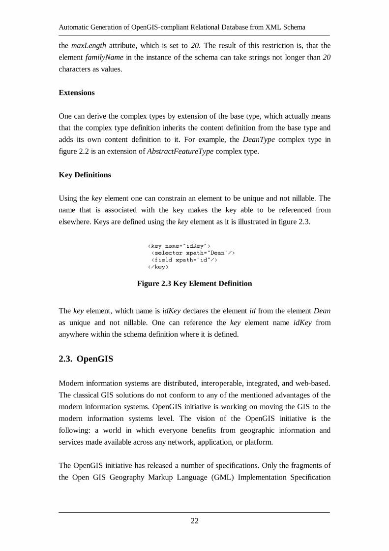
Figure 2.3 Key Element Definition........................................................................... 22
Figure 2.4 Example of a Non-Spatial Feature Dean Definition [GMLv2.1] .............. 24
Figure 2.5 Example of the Geometry Element Declaration [GMLv2.1] .................... 24
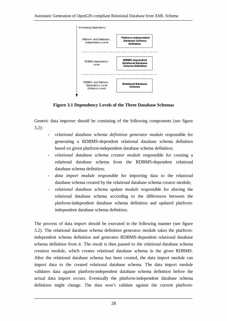
Figure 3.1 Dependency Levels of the Three Database Schemas................................ 28
Figure 3.2 Generic Data Importer (Generic Model) .................................................. 29
Figure 3.3 Generic Data Importer............................................................................. 30
Figure 3.4 Three-Layer Architecture of Relational Database Schema Definition
Generation from XML Schema Model ............................................................. 31
Figure 3.5 Relational Database Schema Generation from XML Schema Process
Activity Diagram.............................................................................................. 32
Figure 3.6 Model for Relational Database Schema Generation from XML Schema.
Class Diagram.................................................................................................. 34
Figure 3.7 Model Class Diagram.............................................................................. 35
Figure 3.8 Container Class Diagram......................................................................... 38
Figure 3.9 Container Activity Diagram .................................................................... 38
Figure 3.10 Elements and Complex Type Definitions Example................................ 40
Figure 3.11 Inline Elements’ and Simple Type Definitions Example ........................ 41
Figure 3.12 The Key Element of the XML Schema Example ................................... 42
Figure 3.13 The XML Schema for the Reserved SQL Keywords.............................. 43
Figure 3.14 The XML Schema for the Mapping of the Data Types........................... 44
Figure 3.15 Data Mappers Class Diagram ................................................................ 46
Figure 3.16 Data Mappers Activity Diagram (Mapping Process).............................. 48
Figure 3.17 SQL Builders Class Diagram................................................................. 50
Figure 3.18 PostgisSQLBuilder Activity Diagram.................................................... 52
Figure 3.19 Typical CREATE TABLE and SELECT AddGeometryColumn() SQL
statements in Postgis SQL ................................................................................ 53
Figure 4.1 The XML Schema for the Configuration File of the Generator ............... 56
Figure 4.2 The XML Schema for the Report File of the Generator........................... 57
Figure 4.3 Example of a Specific XML Schema Document Generated by GeoServer
......................................................................................................................... 60
Figure 4.4 Example of the Relational Database Schema Definition for Postgis
RDBMS Generated by the Generator (RedGenie) ............................................ 61
Figure A.1 The XML Schema for Storing Reserved SQL Keywords ........................ 67
Figure A.2 The XML Schema for Data Type Mapping Definition............................ 67
Figure B.1 The XML Document Defining the Reserved SQL99 Keywords.............. 73
Automatic Generation of OpenGIS-compliant Relational Database from XML Schema
12
Figure B.2 The XML Document Defining the Data Type Mapping from XML Schema
Data Type to Java Data Types .......................................................................... 78
Figure B.3 The XML Document Defining the Data Type Mapping from Java Data
Types to Postgis SQL Data Types .................................................................... 81
Figure C.1 The XML Schema for the Configuration File for the Generator
(RedGenie)....................................................................................................... 83
Figure C.2 The Configuration File for the Generator (RedGenie) ............................ 83
Figure C.3 The XML Schema for the Mapping Process Report Generation .............. 84
Figure C.4 The Report File for the Buenzau_nutzung Relational Database Schema
Definition Generation....................................................................................... 87
Automatic Generation of OpenGIS-compliant Relational Database from XML Schema
13
1. Introduction
Scientific and business communities are generating considerably more data than ever
before. The requirements of distributed information systems like Geographical
Information Systems (GIS), Enterprise Resource Planning systems (ERP) or
Business-to-Business (B2B) solutions grow more complex.
Geographical Information System (GIS) [GIS04] is a geographical data combined
with other geographical information, like maps or photos, about the geographical area.
The different geographical information is usually provided in layers and can be used
for various reasons, like catastrophe management or environmental damage analysis.
Such information usually comes from different sources, is collected using different
methods, and is classified using different classification schemes. It is the case very
often, that the information from one source can only be combined with the
information of another source by putting a lot of manual effort. In other words, there
is a lack of schematic and semantic interoperability.
The agencies and organizations, like Cadastre, Town Planning, or Water Management
agencies, which are actively using GIS solutions, are in need of better schematic and
semantic interoperability on the information management level. Those separate
agencies and organizations have very valuable data, but most often they cannot use it
effectively in the established models, like Rainfall Runoff Model for Flood Risk
Management, for the decision-making, since they lack other data that has been
collected and stored by another agency. So it is needed to search for the solutions to
ease the cooperation between those agencies and organizations. Within the European
Water Framework Directive [WFD03] all agencies related to Water Management
must find a solution for schematic and semantic interoperability issue.
One solution that would help in the discussed matter would be to implement the
services defined in the OpenGIS [OGC04] specifications. The implemented services
could provide the schematic and semantic interoperability between different systems
of the different agencies and organizations and enable building of a common web-
based layer over the existing systems and databases, which would provide everyone
with the information regardless of it source.
1.1. Motivation
Several projects defined within the EU Water Framework Directive are in progress in
the Department of River and Coastal Engineering in Technical University Hamburg-

Automatic Generation of OpenGIS-compliant Relational Database from XML Schema
14
Harburg (TUHH). They are dealing with the issues of connecting the Rainfall Runoff
Model and the Flood Forecast with the geographical data available in the following
agencies in Hamburg Area:
- Behörde für Umwelt und Gesundheit (BUG) – Department of Environment
and Health;
- Behörde für Bau und Verkehr (BBV) – Department of Civil Engineering
and Transport;
- Landesbetrieb für Geoinformation und Vermessung (LGV) – State
Enterprise for Geo-Information and Survey.
The main issue in these projects is the schematic and semantic interoperability of the
geographical information originating from various sources. The department of River
and Coastal Engineering in TUHH is determined to implement the OpenGIS
specifications, since they provide such interoperability, in Java environment. However
the OpenGIS specifications do not address some important issues, which arose during
the implementation of the OpenGIS specification in the Department.
To enable a more dynamic exchange, archiving, and usage of the data, one has to
provide the lacking functionalities for the importing data to the relational databases
without human intervention in creating or altering relational database schemas for it.
Such functionality would automate many tasks, which are normally performed by
humans in distributed information systems. It would enable more dynamic data
managing and archiving processes. In GIS systems, it would enable to create, remove,
or alter geographical features dynamically without the human intervention in editing
the relational database schema.
There are only two commercial and one open source solutions publicly available that
enable the manipulation of the relational database structures dynamically. The
following solutions, which enable such manipulation by supporting the generation of
the relational database schema definition from XML Schema, are currently available:
Oracle has implemented an integrated feature for such process, which is available in
Oracle 9i [ORCL04], XMLSpy [XSPY04] tool has such ability also, and open source
project xsd2db [XSDB04] implements the discussed generation, which is
implemented in .NET environment [NET04].
One can ask the following question. Why is it needed to analyze, design and
implement the solution for a problem, for which there are already several available
solutions? This question can be answered with the following question and answer. Is
there a solution from the above mentioned ones, which is platform- and RDBMS

Automatic Generation of OpenGIS-compliant Relational Database from XML Schema
15
independent? Oracle feature can be used only for the Oracle RDBMS and so it is not
RDBMS-independent. XMLSpy feature can be used only in the environment of the
XMLSpy tool. So it cannot be use as a library or component, which one could
integrate into ones own applications. Both, the Oracle 9i and the XMLSpy features,
are not open source, but high-priced commercial products. The xsd2db tool is slightly
better. It is free, open source product, which supports only several RDBMS now, but
can be easily extended to support any RDBMS. Using its source code, one could reuse
most of it for ones own applications. However, it is based on .NET framework, which
is platform-dependent and is useless in Java-based systems. Moreover, for the
OpenGIS-based projects in the department, there is a need for a component, which
would support the generation of new geographical features defined in Open GIS
[OGC04] Simple Features Specification for SQL [SFSv1.1]. Using such a component
one would be able to create, remove, or alter geographical features dynamically
without any human intervention in editing the relational database schemas in the
persistence layer of the Geographical Information Systems (GIS), which is not only
not available in any implementation of OpenGIS specifications, but also not even
defined in any OpenGIS specification.
There is the lack of a platform-independent component for relational database schema
definition generation from XML Schema, which would be written in Java
environment and would support geographical features as it is defined in Open GIS
Simple Features Specification for SQL [SFSv1.1]. It is intend to fill in this gap with
this thesis.
1.2. Objectives
This thesis concerns itself with the following objectives:
- give an overview of thesis related concepts and technologies: Model-
View-Controller (MVC), XML Schema, OpenGIS Specifications;
- establish a model for generic data importer and relational database schema
definition generation from specific XML Schema;
- implement the established model for relational database schema definition
generation from specific XML Schema;
- evaluate the established model for relational database schema definition
generation from specific XML Schema and its implementation; identify
and point out its limitations;
- summarize the results of this thesis and discuss the outlook on further
development of the established model for relational database schema
definition generation from specific XML Schema and its implementation.
Automatic Generation of OpenGIS-compliant Relational Database from XML Schema
16
1.3. Structure of the Work
In chapter 2 a short introduction to the concepts and technologies used during this
thesis project is provided.
In chapter 3 a detailed description of the design of the relational database schema
generation from specific XML Schema model is provided and the limitations of the
designed model are identified.
In chapter 4 a description of the implementation of the model, which design is
described in chapter 3, and the qualitative evaluation of this implementation are
provided.
In chapter 5 a summary of the results of this thesis and an outlook in possible further
development of the designed model and of the generic data importer is provided.
Automatic Generation of OpenGIS-compliant Relational Database from XML Schema
17
2. Concepts and Technologies
In this chapter the basics of the model-view-controller design pattern will be provided.
The knowledge relevant to this thesis about XML Schema standard, and OpenGIS
specifications will also be provided.
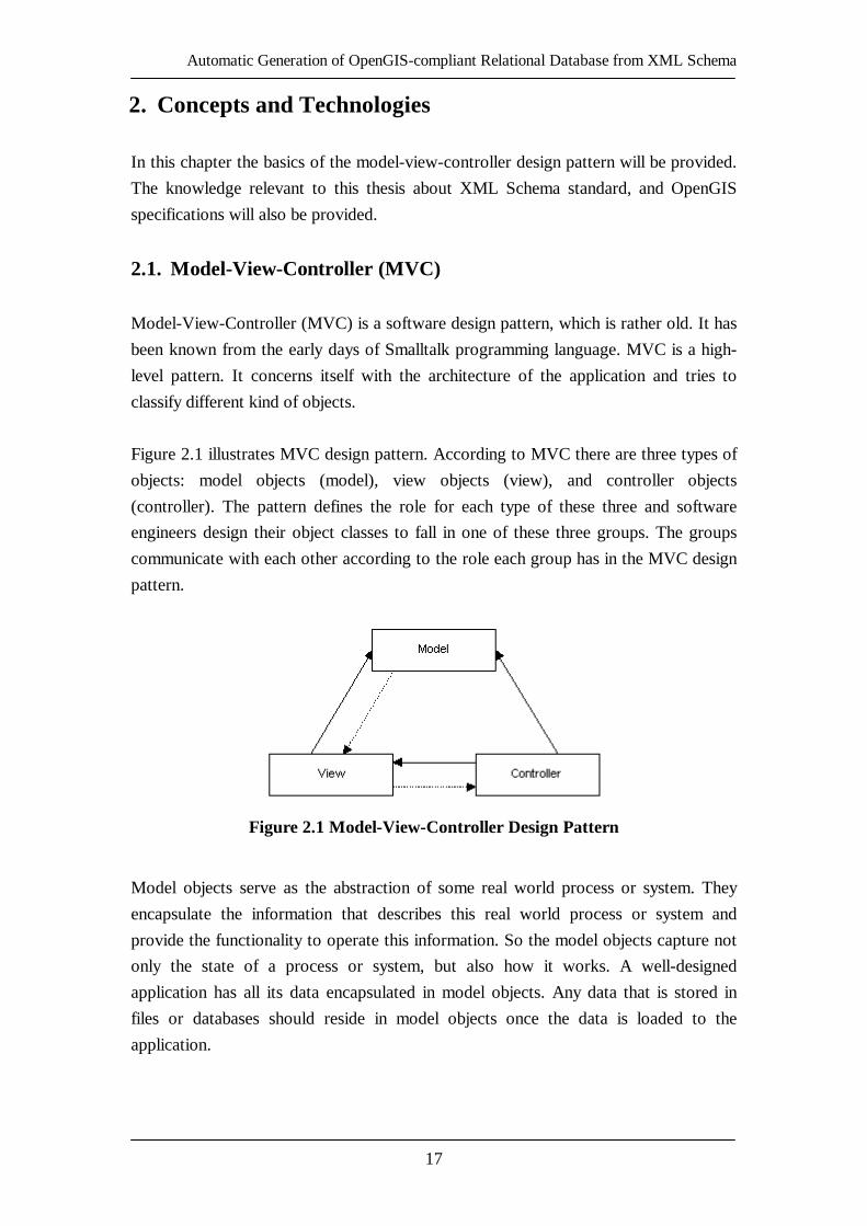
2.1. Model-View-Controller (MVC)
Model-View-Controller (MVC) is a software design pattern, which is rather old. It has
been known from the early days of Smalltalk programming language. MVC is a high-
level pattern. It concerns itself with the architecture of the application and tries to
classify different kind of objects.
Figure 2.1 illustrates MVC design pattern. According to MVC there are three types of
objects: model objects (model), view objects (view), and controller objects
(controller). The pattern defines the role for each type of these three and software
engineers design their object classes to fall in one of these three groups. The groups
communicate with each other according to the role each group has in the MVC design
pattern.
Figure 2.1 Model-View-Controller Design Pattern
Model objects serve as the abstraction of some real world process or system. They
encapsulate the information that describes this real world process or system and
provide the functionality to operate this information. So the model objects capture not
only the state of a process or system, but also how it works. A well-designed
application has all its data encapsulated in model objects. Any data that is stored in
files or databases should reside in model objects once the data is loaded to the
application.

Automatic Generation of OpenGIS-compliant Relational Database from XML Schema
18
View objects know how to display the given data from the application’s model
objects. They should not be responsible for storing the data they are displaying. So the
view objects are responsible for the presentation of the data of from the model objects.
Controller objects act as an intermediary between the application’s view and its model
objects. The logic that controller objects encapsulate is specific to the application.
They are responsible for managing the workflow of the application. For the view
objects they ensure the access to the model objects they need to display. The
controller objects usually notify the view objects when the model objects change their
state.
The three types of objects are separated from each other by abstract boundaries and all
the communication between them is conducted across these boundaries (see figure
2.1). The model is the core of the application and it does not know what kind of views
observe it. The only weak relation that the model might have is the notification of the
views about the change of its state, which could be also done by the controller. By
contrast, the view knows exactly what kind of model does it observe. The view has a
strong relation to the model and it can use all functionality provided by the model. It
might have a weak relation to the controller to submit the requests for information.
The controller has strong relation to both view and the model. Since the controller
defines the behavior of the application, it needs to be able to use the functionalities
provided by both view and model.
Shifting of the application specific code to the controller, the model and view objects
become more general and reusable. Controllers are often the least reusable objects in
an application. The separation of the objects into three types increases the
understandability of the design and the code of the application and ensures easier
extensibility and maintenance of the application.
2.2. XML Schema
XML Schema [XSD04] standard provides the XML constructs to write schemas,
which define the shared vocabularies, the structure of XML documents which use
those vocabularies, and provide links to associate semantics with them. It is an
essential part for XML to reach its full potential. [XSINT01]
The purpose of schema is to define and describe a class of XML documents by using
the constructs provided by XML Schema standard to constrain and document the
meaning, usage, and relationships of the parts of these documents.

Automatic Generation of OpenGIS-compliant Relational Database from XML Schema
19
The XML Schema specification consists of three parts:
- XML Schema Part 1: Structures [XSDp1]. It proposes methods to describe
structure and constraint the content of an XML Document. It also defines
the rules for schema-validation of documents;
- XML Schema Part 2: Datatypes [XSDp2]. It defines a set of simple data
types, which can be associates with XML element types and attributes;
- XML Schema Part 0: Primer [XSDp0]. It explains what schemas are, how
they differ from DTDs, and how one builds a schema.
The introduction on XML Schema based on XML Schema: Primer [XSDp0]
specification part will be provided further in this section. The introduction will be
provided only on the concepts that are relevant to this thesis: element declaration,
complex and simple type definitions, minOccurs and nillable attributes, substitution
groups, extensions, and key definitions. The term schema will be used to refer to
specific XML Schema further in this section. The schema defines the class of
documents and so the term instance document is used to describe an XML document
that conforms to a particular schema.
Complex Type Definitions, Element Declarations
In XML Schema, there is a difference between complex types, which can contain
elements and attributes, and simple types, that do not allow elements or attributes in
their content. In this section the definition of complex types and the declaration of
elements that appear with them will be discussed.
The example of the Dean schema will be used in this section (see figure 2.2).
New complex types are defined by using a complexType element and they normally
contain a set of element declarations. The declaration is not a type itself, but rather an
association of the name of the element and the constraint defined by its type. Elements
are declared using element element. For example, DeanType is defined as a complex
type, and within the definition of DeanType there are four element declarations. So
every element appearing in the instance of the Dean schema whose type is declared to
be DeanType must consist of four elements as it is defined in the Dean schema. These
elements must be called id, familyName, age, and nickName and must appear in the
same sequence in which they are declared in the schema.

Automatic Generation of OpenGIS-compliant Relational Database from XML Schema
20
The Dean element declaration is associated with the complex type DeanType. The
result is, that every appearance of the element Dean in the instance document of the
Dean schema will contain four elements as it is defined by DeanType complex type.
So far the example of the element declaration was discussed which is associated with
an existing type definition. Sometimes is preferable to use an existing element rather
than declare a new one, like it is with one element declaration in DeanType complex
type definition, which references the element declaration age using the attribute ref.
Figure 2.2 The Example Dean Schema [GMLv2.1]
The value of the attribute ref must always reference a global element (the element
declared under the element schema). The result of such element declaration using the
attribute ref is, that the element age may appear in the element, which was associated
with the type DeanType in the instance of the Dean schema.
Substitution Groups
The XML Schema provides the mechanism for elements to substitute the other
elements. More specifically, elements can be assigned to a special group of elements

Automatic Generation of OpenGIS-compliant Relational Database from XML Schema
21
that are substitutable for a particular named element, which is called the head element.
In figure 2.2, an element called Dean is declared and assigned it to a substitution
group whose head element is _Feature. The Dean element can be used any place
where _Feature element can be used. The element is assigned to a substitution group
by setting a substitutionGroup attribute of an element to the name of the head
element.
minOccurs and nillable
The element is required to appear in the instance of the schema if the attribute
minOccurs is set to 1 or more. The nickName element is optional within DeanType,
because the value of the minOccurs attribute in its declaration is set to 0 (see figure
2.2). The default value of minOccurs attribute is 1.
In some cases it is preferable to have the element appearing in the instance of the
schema, but set to the null value. Such cases can be represented using XML Schema’s
nil mechanism, which enables an element to appear with or without a not-nil value.
To declare an element as being able to appear in an instance of the schema carrying
the nil value, one has to set its attribute nillable in the element declaration to true. For
example, the age element is nillable within the DeanType, because its nillable
attribute is set to true.
Simple Types
Some simple types, such as string or decimal, are build in to XML Schema. You can
see all built-in simple types listed in created data type mapping files in appendix B.
There are also other simple types that are derived from the built-in simple types. For
example, the element familyName in the complex type DeanType is declared in the
association with the simple type, which is derived from a built-in simple type string
using a restriction method (see figure 2.2). So new simple types are defined by
deriving them from existing simple types (built-in or derived). In particular, one can
derive a new simple type by restricting the existing simple type. For example,
narrowing its legal range of values or limiting its length. The simpleType element is
used to define the new simple type. The restriction element is used to indicate the
base simple type and to constrain the range of values or its length using different
facets, depending on the simple type: maxLength, minInclusive, maxInclusive,
minExclusive, maxExclusive, pattern, enumeration, etc. For example, the element
familyName declaration in the complex type DeanType is associated with the simple
type, which is the restriction of the integer built-in simple type. It is restricted using
Automatic Generation of OpenGIS-compliant Relational Database from XML Schema
22
the maxLength attribute, which is set to 20. The result of this restriction is, that the
element familyName in the instance of the schema can take strings not longer than 20
characters as values.
Extensions
One can derive the complex types by extension of the base type, which actually means
that the complex type definition inherits the content definition from the base type and
adds its own content definition to it. For example, the DeanType complex type in
figure 2.2 is an extension of AbstractFeatureType complex type.
Key Definitions
Using the key element one can constrain an element to be unique and not nillable. The
name that is associated with the key makes the key able to be referenced from
elsewhere. Keys are defined using the key element as it is illustrated in figure 2.3.
Figure 2.3 Key Element Definition
The key element, which name is idKey declares the element id from the element Dean
as unique and not nillable. One can reference the key element name idKey from
anywhere within the schema definition where it is defined.
2.3. OpenGIS
Modern information systems are distributed, interoperable, integrated, and web-based.
The classical GIS solutions do not conform to any of the mentioned advantages of the
modern information systems. OpenGIS initiative is working on moving the GIS to the
modern information systems level. The vision of the OpenGIS initiative is the
following: a world in which everyone benefits from geographic information and
services made available across any network, application, or platform.
The OpenGIS initiative has released a number of specifications. Only the fragments of
the Open GIS Geography Markup Language (GML) Implementation Specification

Automatic Generation of OpenGIS-compliant Relational Database from XML Schema
23
Version 2.1.2 [GMLv2.1] and the Open GIS Simple Features Specification for SQL
Revision 1.1 [SFSv1.1] relevant to this thesis will be introduced.
The GML specification provides the necessary schemas to define the geographical
features to use them in OpenGIS-compliant systems. There are two major schemas:
geometry schema and feature schema. The geometry schema defines geometries, like
Point, LineString, etc. The feature schema defines the structures to declare features
and defines complex feature types, which contain the regular XML Schema elements
and GML geometries defined in the geometry schema. The Open GIS Simple Features
Specification for SQL defines the standard SQL schema that supports the storage,
retrieval, query, and update of simple features. First the geometry list from the
geometry schema will be provided. Then the feature schema will be introduced.
Finally the list of SQL geometry types will be provided.
Geometries
GML provides geometry elements corresponding to the following geometry classes:
Point, LineString, LinearRing, Polygon, MultiPoint, MultiLineString, MultiPolygon,
and MultiGeometry.
Feature Schema
The feature schema models the geometric properties as association classes that link
features with the geometries. Concrete geometric property types such as
PointProperty constrain the geometry to a particular type, such as Point. There are six
geometric properties defined in the feature schema: PointProperty,
LineStringProperty, PolygonProperty, MultiPointProperty, MultiLineStringProperty,
MultiPolygonProperty. All mentioned geometric properties are the restrictions from
the type GeometryProperty.
Defining Features without Geometries
It is not a high possibility that many features will be defined without geometry
properties using GML. However, to understand better the definition of a feature, a
simple example of a non-spatial feature definition is provided in figure 2.5. The Dean
element’s declaration is associated with a complex type DeanType and is declared as a
substitution to the _Feature element from the elements declared by GML, which
makes the Dean element a feature type element. The DeanType complex type
definition is an extension of a type AbstractFeatureType and it inherits all capabilities

Automatic Generation of OpenGIS-compliant Relational Database from XML Schema
24
from the base class, like the feature’s capability to be identified using fid attribute or
to use a predefined description property to describe the feature. Every feature type
definition must extend the AbstractFeatureType and every feature element declaration
must substitute _Feature element from GML.
Figure 2.4 Example of a Non-Spatial Feature Dean Definition [GMLv2.1]
Defining Features with Geometries
As it is mentioned above, the feature schema provides the pre-defined set of geometry
properties, by which one can relate geometries of a particular type to features. For
example, in figure 2.5 the example is provided where the DeanType feature definition
has a point property type element declaration called deanLocation. The type attribute
of the deanLocation element is set to the PointPropertyType.
Figure 2.5 Example of the Geometry Element Declaration [GMLv2.1]
Every geometry element declaration must be of a type of one of the pre-defined
geometry properties.
SQL Geometry Types
The geometry types supported in SQL, as it is defined in Open GIS Simple Features
Specification for SQL Revision 1.1 [SFSv1.1], are the following: GEOMETRY,
POINT, CURVE, LINESTRING, SURFACE, POLYGON, COLLECTION,
MULTIPOINT, MULTICURVE, MULTILINESTRING, MULTISURFACE, and
MULTIPOLYGON. It might differ from one SQL implementation to another. For
example, in Postgis implementation, only the following SQL geometry types are
supported: POINT, LINESTRING, POLYGON, MULTIPOINT,

Automatic Generation of OpenGIS-compliant Relational Database from XML Schema
25
MULTILINESTRING, MULTIPOLYGON, and additionally
GEOMETRYCOLLECTION, which corresponds to the COLLECTION SQL
geometry type provided by the specification.
2.4. Summary of the Chapter
In this chapter the introduction to the Model-View-Controller design pattern has been
provided. The Model-View-Controller consists of three groups of objects: model,
view, and controller. The introduction to the parts of XML Schema standard relevant
to this thesis has also been provided, namely element declarations, simple and
complex type definitions, element’s attributes nillable and minOccurs, substitution
groups, extensions, and key definitions. Finally the introduction to the thesis relevant
parts of the following two OpenGIS specifications, namely Open GIS Geography
Markup Language (GML) Implementation Specification Version 2.1.2 [GMLv2.1]
and Open GIS Simple Features Specification for SQL Revision 1.1 [SFSv1.1] has
been provided.

Automatic Generation of OpenGIS-compliant Relational Database from XML Schema
26

Automatic Generation of OpenGIS-compliant Relational Database from XML Schema
27
3. Model for Relational Database Schema Definition
Generation from XML Schema
First the introduction to the model of a generic data importer with relational database
schema definition generator will be given. Then the architecture of the relational
database schema definition generation from XML Schema model will be defined. The
overall process within this model will be described. Then the detailed design of the
defined architecture and the detailed processes within the architecture will be defined.
Finally, the limitations of the defined architecture of the model will be identified.
3.1. Generic Data Importer
The following definitions will be used in this section:
- generic data importer is the system responsible for a generation of
relational database schemas and an import of data to those generated
schemas without human intervention in creating or altering those generated
schemas before the actual import of data;
- platform–independent database schema definition is a database schema
definition independent from any database system;
- RDBMS-dependent relational database schema definition is a relational
database schema definition for a specific relational database management
system (RDBMS), e.g. SQL Data Definition Language (DDL) script
[SQL01];
- relational database schema is a relational database table with their
relations and constraints stored in the specific RDBMS on a specific
platform.
For the convenience, the figure 3.1 is provided illustrating the abstraction levels of the
last three definitions provided above. The least dependent schema is the platform-
independent database schema definition, since it does not depend on neither platform
nor database system. The RDBMS-dependent relational database schema definition
depends on the specific RDBMS, but does not depend on the platform. The most
dependent is the instance of the RDBMS-dependent relational database schema
definition. The relational database schema depends on the specific platform and on the
specific RDBMS.
Automatic Generation of OpenGIS-compliant Relational Database from XML Schema
28
Figure 3.1 Dependency Levels of the Three Database Schemas
Generic data importer should be consisting of the following components (see figure
3.2):
- relational database schema definition generator module responsible for
generating a RDBMS-dependent relational database schema definition
based on given platform-independent database schema definition;
- relational database schema creator module responsible for creating a
relational database schema from the RDBMS-dependent relational
database schema definition;
- data import module responsible for importing data to the relational
database schema created by the relational database schema creator module;
- relational database schema update module responsible for altering the
relational database schema according to the differences between the
platform-independent database schema definition and updated platform-
independent database schema definition.
The process of data import should be executed in the following manner (see figure
3.2). The relational database schema definition generator module takes the platform-
independent schema definition and generates RDBMS-dependent relational database
schema definition from it. The result is then passed to the relational database schema
creation module, which creates relational database schema in the given RDBMS.
After the relational database schema has been created, the data import module can
import data to the created relational database schema. The data import module
validates data against platform-independent database schema definition before the
actual data import occurs. Eventually the platform-independent database schema
definition might change. The data won’t validate against the current platform-

Automatic Generation of OpenGIS-compliant Relational Database from XML Schema
29
independent database schema definition any longer. In this case relational database
schema update module must alter the relational database schema, based on the
differences between the current and updated platform-independent database schema
definitions. After the relational database schema has been altered, the data import
module imports the data to the altered relational database schema.
Figure 3.2 Generic Data Importer (Generic Model)
The generic data importer must be platform-, data domain-, and RDBMS-independent
(see figure 3.3). XML [XML04] can be used as a data format. It provides data domain
independence. The system can be then applicable in any domain possible, e.g. it could
archive a procurement process data in a B2B solution or store geographical objects
from GIS system. XML is also platform-independent. The specific XML Schema
[XSD04] can be used as a platform-independent database schema definition.
Moreover, XML technology provides XML data validation against XML Schemas.
For the implementation of components of generic data importer the following
technologies can be used: Java programming language [JAVA04] assuring platform-
independency, JDBC [JDBC04] assuring independency of RDBMS, and the DOM
[DOM04] assuring independency of XML Parser.

Automatic Generation of OpenGIS-compliant Relational Database from XML Schema
30
Figure 3.3 Generic Data Importer
The generic data importer is a collection of complex components. The detailed
analysis of design and implementation of every component of generic data importer
can be separated into several works. In this thesis the design and implementation of
relational database schema definition generator module will be discussed and
analyzed, since it is the least touched topic in scientific and engineering publications.
3.2. Problem Statement
The model for relational database schema definition generation from specific XML
Schema must be established. This model must be extensible, platform- and RDBMS-
independent, and must support OpenGIS-compliant features as it is defined in Open
GIS Simple Features Specification for SQL [SFSv1.1].
The model for relational database schema definition generation from specific XML
Schema must generate SQL DDL scripts, which would define relational database
schema, from a given XML Schema as it is illustrated in figure 3.3.

Automatic Generation of OpenGIS-compliant Relational Database from XML Schema
31
3.3. Three-Layer Architecture of the Model and Model-View-
Controller (MVC) Design Pattern
The architecture of the model for relational database schema definition generation
from specific XML Schema is defined as it is depicted in figure 3.4. To define the
architecture of this model the Three-Layer Architecture [MaHu02] has been used.
Figure 3.4 Three-Layer Architecture of Relational Database
Schema Definition Generation from XML Schema Model
The model depicted in figure 3.4, consist of the following layers: data layer, logic
layer, and pseudo-presentation layer. Each layer addresses different responsibilities:
- data layer is responsible for the functionality of platform-independent
database schema definition by using XML Schema standard [XSD04]. It
also encapsulates the Data Mappers, which are responsible for the
functionality for parsing XML Schema and creating Model objects, which
are defined in logic layer. In other words, it is responsible for mapping the
structure definition from XML Schema to the Model objects;
- logic layer encapsulates the Model objects, which capture the relational
database structure and are the core of the architecture. It also encapsulates
the Container, which contains the Model objects and controls their creation
and access to them. Finally, it encapsulates the Main object, which
controls the process flow and the choice of the SQL Builder, which is
defined in pseudo-presentation layer;

Automatic Generation of OpenGIS-compliant Relational Database from XML Schema
32
- pseudo-presentation layer encapsulates the SQL Builder, which is
responsible for the generation of the RDBMS-specific SQL DDL scripts
from the Model objects.
In the classical three-layer architecture model one finds a presentation layer instead of
the pseudo-presentation layer. However, since the presentation layer does not provide
any presentation layer functionalities in the sense of the classical understanding and
purpose of this layer, but it is still somehow presenting the data from Model objects as
SQL DDL scripts, it is call pseudo-presentation layer in this particular case.
The relational database schema generation from XML Schema process is illustrated in
figure 3.5. The term user will be used for the application, which initiates the process
by passing the XML Schema to the Main object and at the end receives the SQL DDL
script. The process starts with the passing of the XML Schema to the Main object,
which passes it to the Container, which, on his turn, passes it to the Data Mappers.
The Data Mappers parse the XML Schema and create Model objects based on it. The
Container returns the created Model objects to Main object. The Main object chooses
the right SQL Builder based on the initial input from the user. The chosen SQL
Builder builds the RDBMS-specific SQL DDL script based on the created Model
objects. The Main object returns then the created SQL DDL script to the user.
Figure 3.5 Relational Database Schema Generation
from XML Schema Process Activity Diagram

Automatic Generation of OpenGIS-compliant Relational Database from XML Schema
33
The three-layer model was developed also according to a variation of the classical
Model-View-Controller (MVC) pattern [SiSt02] as it is shortly introduced in chapter
2. The following describes the model from the point of view of MVC design pattern:
- controller component. The Main object is getting the input and according
to it chooses the right SQL Builder. It also passes the XML Schema to the
Container, which passes it to the Data Mappers and initiates the creation of
the Model objects. The Container then returns the Model objects to the
Main object. Therefore the Main object with the Container are parts of the
controller component;
- view component. SQL Builder is some kind of view component. SQL
Builder builds the SQL DDL script according to the Model objects. In
other words, it presents the data from Model objects. For the SQL Builder
the term pseudo-view is used, since the SQL Builder does not conform
with the classical understanding of a view component;
- model component. The Model objects capture the structure of the relational
database schema and the Data Mappers define the mapping from XML
Schema structures to the Model objects. Therefore the Model objects with
Data Mappers are parts of model component.
Using three-layer architecture of the model provides the following [MaHu02]:
- easy development and testing;
- scalability;
- easy maintenance;
- better performance, e.g. network load.
Using Model-View-Controller (MVC) pattern provides the following [SiSt02]:
- separation of user input, logic, and presentation logic;
- clean, easy understandable design;
- minimal coupling between components;
- extensibility;
- easy maintenance.
The relational database schema definition generator is designed as it is depicted in the
class diagram in figure 3.6 and described above in this section using figure 3.4 and
figure 3.5. The package model corresponds to the Model definition. The package xml
corresponds to the Data Mappers definition. The package logic corresponds to the
Container definition. The package main corresponds to the Main object definition.
The package sql aggregates all SQL Builder definitions.

Automatic Generation of OpenGIS-compliant Relational Database from XML Schema
34
Figure 3.6 Model for Relational Database Schema
Generation from XML Schema. Class Diagram
3.3.1. Logic Layer
First the Model will be discussed, since it is the core of the relational database schema
definition generator model.
3.3.1.1. Model
The Model is designed as it is depicted in figure 3.7. The Model corresponds to the
generic relational database schema with the support of geometries as it is defined in
Open GIS Simple Features Specification for SQL [SFSv1.1].
In the Model only simple data types are supported. The nested complex data types in
XML Schema corresponds to the user-defined data types in relational database
schema. Relational database schema’s user-defined data types are not supported in the
Model, since, during the time the design of the model was in progress, no
implementation of OpenGIS specifications did support the XML Schema’s nested
complex data types yet. By the end of this thesis period, it was brought to the
attention, that one of the implementations of OpenGIS specifications: namely degree
[DGREE04], has implemented the support of the nested complex types for several
RDBMSs: Postgis, PointDB, MySQL, GMLDB. However, these implementations are

Automatic Generation of OpenGIS-compliant Relational Database from XML Schema
35
not yet stable. So in the Model there is one data type type, namely simple data type,
defined in generic relational database schema and one data type type, namely
geometry data type, defined in OpenGIS Specifications. Therefore two classes are
designed, namely DataType and GeometryType, which extend the abstract class
AbstractDataType with the only property name, which is common for both
extensions. The described hierarchy of three classes captures required data types
structure.
Figure 3.7 Model Class Diagram
The class DataType has the following additional properties: format and size. The
property format is required for the data types, which are specified using patterns or
formats, e.g. DATE can be specified using a pattern “yyyy.mm.dd”. The property size
is required for the data types, which are specified by length in number of characters or
by size in bytes, e.g. the size of VARCHAR can be specified using number of
characters.
The class GeometryType has no additional properties. The class GeometryType has
only the property name, which it inherits from the abstract class AbstractDataType.
In the generic relational database schema there are the following attribute types:
attribute, primary key, and foreign key. The OpenGIS specifications define one more
attribute type, which is geometry. All those four attribute types are defined as classes

Automatic Generation of OpenGIS-compliant Relational Database from XML Schema
36
in the Model, namely Attribute, PrimaryKey, ForeignKey, and Geometry, which
extend the abstract class AbstractAttribute with the only property name, which is
common for all four extensions. The described hierarchy of five classes captures
required attributes structure.
The class Attribute has the following additional properties: condition, defaultValue,
extra, null, unique, type. The property condition captures the generic relational
database schema attribute’s unidirectional constraint, which can be most of the cases
defined using a SQL CHECK clause. The property defaultValue captures the default
value of the generic relational database schema’s attribute. The property extra can be
used for any extra information about the generic relational database schema’s
attribute, e.g. automatic increment. The property null is used when defining if the
generic relational database schema’s attribute can be assigned a null value. The
property unique is used when defining if the generic relational database schema’s
attribute is unique. The property type is defining the data type of the generic relational
database schema’s attribute and it is of a type of the class DataType from the Model.
The class Geometry has the following additional properties: dbName, dimension, srid,
type. All these four properties are required for geometry definition as it is defined in
OpenGIS specifications. The property dbName provides the information about the
specific relational database name for which the geometry is defined. The property
dimension defines if 2- or 3- dimensional geometries will be created and stored in the
relational database schema. The property srid provides the id of the spatial referential
system as it was described in chapter 2, which must be used as a base for the relative
coordinates of the each geometry of this class. The property type is defining the
geometry type of the geometry definition and it is of a type of the class GeometryType
from the Model.
The class PrimaryKey has only one additional property extra, which is used for the
same purpose as the property extra of the class Attribute. It is used for any extra
information about the generic relational database schema’s attribute, e.g. automatic
increment. This particular property is very useful in the case when the generic
relational database schema’s attribute is a primary key.
The class ForeignKey has the following additional properties: foreignTable, null,
onCascade. The property foreignTable is of a type of the class Table and captures the
relation between tables defined in the generic relational database schema. It provides
the name of the table, to which the table, which aggregates this foreign key, has a
relation. The property null is used for the same purpose as the property null of the
Automatic Generation of OpenGIS-compliant Relational Database from XML Schema
37
class Attribute. The property null is used when defining if the generic relational
database schema’s attribute can be assigned a null value. The property onCascade
captures the SQL FOREIGN KEY clause’s part, where one can define the behavior of
the child table’s records, in the case of deletion of the parent table’s record. For
example, one can define the following behavior: if the parent record is deleted all the
child records must be deleted too.
The class Table captures the structure of the table as it is defined in the generic
relational database schema and it has the following properties: name, attributes,
geometries, foreignKeys, and primaryKey. The property attributes is a list of attributes
of a type of the class Attribute. The property geometries is a list of geometries of a
type of the class Geometry. The property foreignKeys is a list of foreign keys of a type
of the class ForeignKey. The property primaryKey is of a type of the class
PrimaryKey. The multiple primary keys are not supported for the sake of simplicity.
The Model is easily extensible. One can add the support for the user-defined data
types and multiple primary keys any time it is necessary by adding the necessary
classes to the Model.
3.3.1.2. Container
The Container aggregates the Model objects and is responsible for controlling the
mapping of the data structures from XML Schema to the Model objects and for
providing the functionality to access the necessary Model objects. The Container is
designed as follows (see figure 3.8):
- ContainerAnchor class defines the functionality for returning the specific
container upon the request of the user component (the component that is
using the object of a type of the class ContainerAnchor). The class
ContainerAnchor creates all containers and can return any container upon
the request;
- TableContainer class is a typical container class, which when instantiated
contains the specific Data Mapper, in this particular case the object of the
type of the class TableMapper, and the list of specific Model objects, in
this particular case the list of objects of the type of the class Table, for
which the contained TableMapper object defines the mapping from XML
Schema. It also provides the functionality for returning necessary Model
objects.

Automatic Generation of OpenGIS-compliant Relational Database from XML Schema
38
Figure 3.8 Container Class Diagram
Normally, for each Model class a container class is defined. However, in this
particular case, the TableMapper instance calls other Data Mappers’ instances, which,
in their turn, call other Data Mappers’ instances and so on. So the whole mapping
process runs through after calling only TableMapper instance.
Since the access to the Model objects and Data Mappers’ functionalities are controlled
through the Container, the Model is strongly decoupled from the rest of the
components. Therefore, when extending the Model, the Data Mappers, or the
Container the other components are not influenced.
Figure 3.9 Container Activity Diagram
The process of creating the Model objects is executed as it is illustrated in figure 3.9.
The user component requests the TableContainer object from ContainerAnchor. The
ContainerAnchor, in his turn, returns the requested TableContainer object. Then the
user component requests the lists of Table objects from the received TableContainer,
which, in his turn, calls the TableMapper object to start the mapping process. The
TableMapper object maps the XML Schema structures to the list of Table objects and
returns this list to TableContainer object. The TableContainer object returns the

Automatic Generation of OpenGIS-compliant Relational Database from XML Schema
39
received list of Table objects to the user component and the process of creating the
Model objects is finished. Each Table object in the received list of Table objects holds
the full information on specific relational database table definition.
3.3.2. Data Layer
As it was mentioned above, the data layer is responsible for the platform-independent
database schema definition. The XML Schema standard is used to define the
platform-independent database schema. The data layer is also responsible for the
functionality for mapping XML Schema structures to Model objects. The Data
Mappers are responsible for it.
3.3.2.1. Mapping Specific XML Schema to Model objects
The mapping of the structures from the specific XML Schema to the Model objects
method has been developed in this thesis. The developed method will be described. In
this method the following XML Schema structures’ definitions [XSDp1] will be used:
element, complex type, and simple type. The method provides the way to map the
nullability. It also provides the way to map between any data types. It is used, in this
particular case, for mapping XML Schema data types to Java data types.
Element, Complex Type, and Simple Type
The definitions of elements in XML Schema correspond to either a relational database
table definition or a relational database table’s column definition. The element, which
type is a complex type, maps always to a relational database table definition. If its
substitution group is _Feature, as it is defined in OpenGIS Geography Markup
Language (GML) Implementation Specification [GMLv2.1], then the relational
database table definition might include a column definition of the geometry type. If it
has no substitution group, then the relational database table definition will not include
a column definition of the geometry type. Please refer to the example in figure 3.10.
The element with the name Pallas is of the PallasType type (the prefix msc6 only
denotes the target namespace of this specific schema). PallasType is a complex type.
Therefore the element Pallas maps the relational database table with the name Pallas.
The definition of the complex type is illustrated in figure 3.10. Complex type can
define a complex content. The defined complex content is an extension of the base of
AbstractFeatureType [GMLv2.1], if the complex type might contain the element
definition of a geometry type. If the complex type does not define the complex content
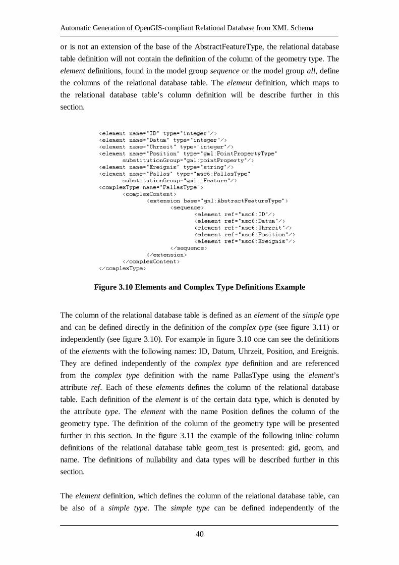
Automatic Generation of OpenGIS-compliant Relational Database from XML Schema
40
or is not an extension of the base of the AbstractFeatureType, the relational database
table definition will not contain the definition of the column of the geometry type. The
element definitions, found in the model group sequence or the model group all, define
the columns of the relational database table. The element definition, which maps to
the relational database table’s column definition will be describe further in this
section.
Figure 3.10 Elements and Complex Type Definitions Example
The column of the relational database table is defined as an element of the simple type
and can be defined directly in the definition of the complex type (see figure 3.11) or
independently (see figure 3.10). For example in figure 3.10 one can see the definitions
of the elements with the following names: ID, Datum, Uhrzeit, Position, and Ereignis.
They are defined independently of the complex type definition and are referenced
from the complex type definition with the name PallasType using the element’s
attribute ref. Each of these elements defines the column of the relational database
table. Each definition of the element is of the certain data type, which is denoted by
the attribute type. The element with the name Position defines the column of the
geometry type. The definition of the column of the geometry type will be presented
further in this section. In the figure 3.11 the example of the following inline column
definitions of the relational database table geom_test is presented: gid, geom, and
name. The definitions of nullability and data types will be described further in this
section.
The element definition, which defines the column of the relational database table, can
be also of a simple type. The simple type can be defined independently of the

Automatic Generation of OpenGIS-compliant Relational Database from XML Schema
41
element’s definition and then referenced using the element’s attribute type. The other
way is to define the simple type in the body of the element’s definition. Such a
definition of the simple type for the element definition name is depicted in figure 3.11.
In the provided example the simple type is a restriction of the XML Schema data type
string.
Figure 3.11 Inline Elements’ and Simple Type Definitions Example
The element definition of the geometry type is recognized by its type attribute. If the
value of the type attribute of the element is from the namespace, under which the
definitions of the geometry types are stored as it is defined in OpenGIS Geography
Markup Language (GML) Implementation Specification [GMLv2.1], this element is
mapped to the column of the geometry type of the specific relational database table.
For instance, the element definition geom in figure 3.11 is mapped to the column of
the Polygon type of the relational database table geom_test. Data type mapping, which
apart from simple data types includes geometry data types, will be explained
explicitly further in this section.
Nullability
The nullability of the element of the complex type is not relevant to this particular
method, since such element maps to the relational database table. The elements of the
simple type, on the other hand, map to the columns of the relational database table.
Therefore the nullability of the elements of the simple type will be discussed.

Automatic Generation of OpenGIS-compliant Relational Database from XML Schema
42
The nullability of the element can be defined using either the attribute minOccurs or
the attribute nillable of the element definition. If the minOccurs attribute is set to ”0”
or the nillable attribute is set to “true”, the corresponding element must be mapped to
the nullable column of the relational database table. In all the other cases the element
must be mapped to the non-nullable column of the relational database table. If neither
the value of the attribute minOccurs nor the value of the attribute nillable is defined,
the corresponding element is mapped to the nullable column of the relational database
table by default.
In figure 3.11 the example of the use of the attributes nillable and minOccurs of the
element definition is provided. After mapping the resulting relational database table
geom_test definition will have the following columns:
- gid – nullable;
- geom – non-nullable;
- name – nullable.
The attribute maxOccurs of the element is not relevant for this particular method.
Primary Key and Foreign Keys
In this particular method the solution to define the primary and foreign keys of the
relational database table is not provided. However, as you could see in the previous
section, the Model, which includes the definition of the primary and foreign keys, is
provided. It is designed in such a manner to ease the future extensions of the relational
database schema definition generation from the specific XML Schema model.
Figure 3.12 The Key Element of the XML Schema Example
Some suggestions regarding the definition of the primary and foreign keys of the
relational database table will be provided. The primary key of the relational database
table can be defined using the key structure of the XML Schema. The example is
provided in figure 3.12. The name of the key element is not relevant to this particular
method. Therefore it is ignored. The selector element using the means of XPath
[XPATHv1] query language provides the information about the complex type
element, which maps to a relational database table, to which the primary key is
defined in this key element. The field element using the means of XPath [XPATHv1]
Automatic Generation of OpenGIS-compliant Relational Database from XML Schema
43
provides the information, which sub-element of the complex type element must be
mapped as a primary key column to the according relational database table. As the
example in figure 3.12 shows, the element gid will be mapped as a primary key
column of the relational database table geom_test.
The issue of foreign key definitions might be slightly more complicated. Therefore it
is suggested to use the XLink [XLINKv1] structures to define links between the
elements and then map it to the foreign key columns of the relational database tables.
More details regarding this issue will not be covered in this thesis.
Naming Issues
There are some naming issues, when using the developed method. The relational
database tables and columns within the table must have unique names. If this is not
preserved during the generation or while defining the specific XML Schema, there
maybe conflicts. The XML Schema preserves the uniqueness of the elements within
the complex type element as long as those elements are in the same namespace. There
also are other naming conventions that might produce conflicts. The issue of the
reserved SQL keywords will be discussed in more detail in the next section.
Reserved SQL Keywords
The XML Schema for the reserved SQL keywords has been defined in this thesis. It
can be used for checking the compatibility of the names of the specific XML Schema
before the generation of the relational database schema definition. If at least one of the
names identify with the reserved SQL keywords, the user receives the warning about
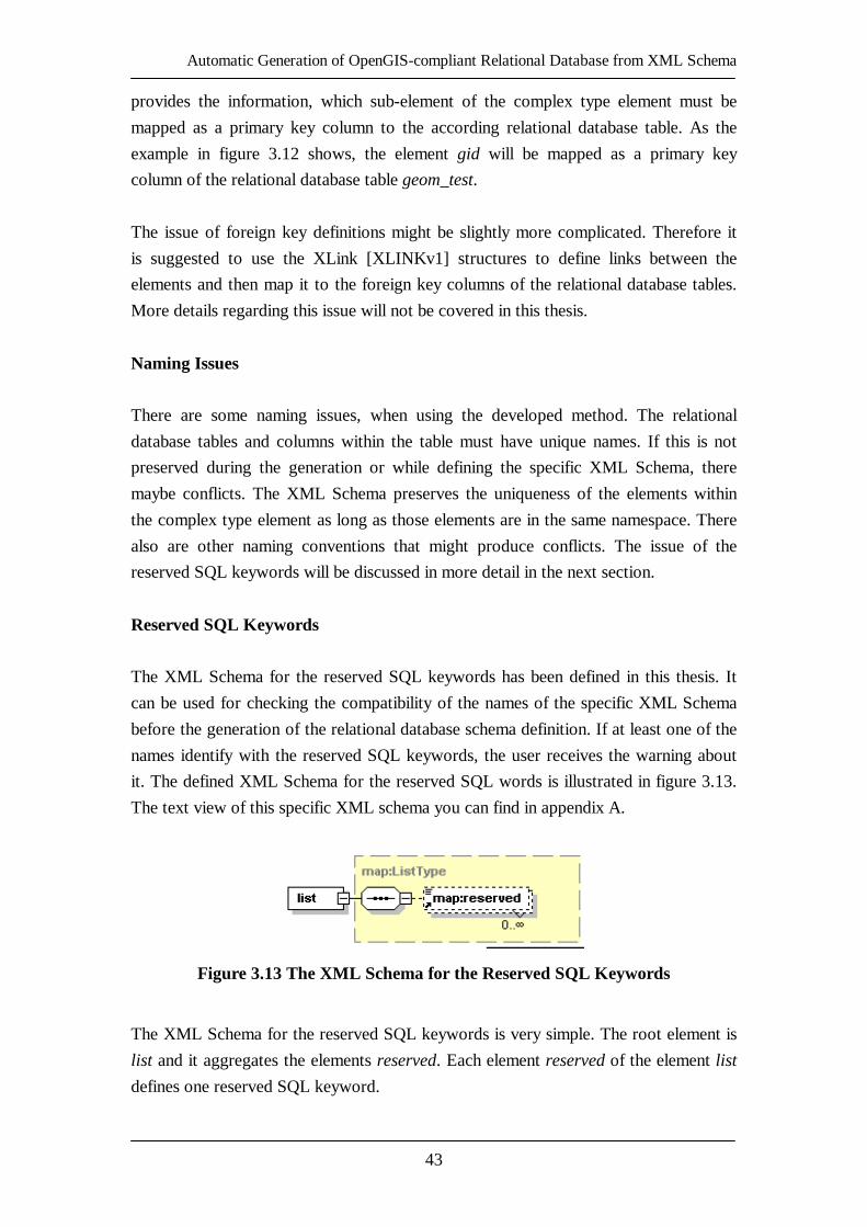
it. The defined XML Schema for the reserved SQL words is illustrated in figure 3.13.
The text view of this specific XML schema you can find in appendix A.
Figure 3.13 The XML Schema for the Reserved SQL Keywords
The XML Schema for the reserved SQL keywords is very simple. The root element is
list and it aggregates the elements reserved. Each element reserved of the element list
defines one reserved SQL keyword.

Automatic Generation of OpenGIS-compliant Relational Database from XML Schema
44
3.3.2.2. Data Type Mapping
The XML Schema for the mapping of any type of data types has been defined in this
thesis. It is illustrated in figure 3.14. The text view of this specific XML schema you
can find in appendix A. The root element mappers aggregates the elements mapping,
sql, and mapper. The elements mapping and sql appear in each instance of this
schema only once. The mapping element defines the mapping direction, namely
schema2java or java2sql. The mapping direction schema2java implies the mapping
from XML schema data types to Java data types. The mapping direction java2sql, on
the other hand, implies the mapping from Java data types to SQL data types. The sql
element is only required when the mapping element takes the value of java2sql and it
provides the RDBMS name to which data types the java data types will be mapped.
Figure 3.14 The XML Schema for the Mapping of the Data Types
The root element mappers also aggregates the elements mapper. Each of the mapper
elements defines the mapping between different data types. For instance, if the
mapping element takes the value of schema2java, then each mapper element will map
one XML schema data type to one Java data type. The element mapper aggregates
one element from and one element to, which hold the data type names. The data type
denoted by the element from will be mapped to the data type denoted by the element
to. For instance, if the mapping element takes the value of schema2java and the one of
the mapper elements’ element from holds the name of the XML schema data type int,
then the element to of this mapper element holds logically the name of the Java data
type int.
Using this XML schema’s instance, all data types of the left side of the mapping
direction can be mapped to all data types of the right side of the mapping direction.
Automatic Generation of OpenGIS-compliant Relational Database from XML Schema
45
The mapping of the geometry data types are also denoted in the instances of this
schema together with the simple data types and in the same manner as simple data
types. For instance, if the element from of a certain mapper element holds the name
PolygonPropertyType of the geometry data type, then the element to of the same
mapper element holds logically the name Polygon of the Java data type.
In the appendix B, one can find the text of XML file defining the mapping from XML
Schema data types to Java data types, which also includes the mapping of the
geometry data types.
3.3.2.3. Data Mappers
Data Mappers module performs the actual XML Schema structures to Model objects
mapping process. The class diagram of this module is depicted in figure 3.15. Each
Model class has its Data Mapper, which performs the mapping of the information
specific to this class from the specific XML schema.
The AbstractMapper class is an abstract class, which captures the common
functionality and stores the common information to all Data Mapper classes. The
AbstractMapper class declares two abstract methods, namely doLoad and load, which
must be implemented in a specific Data Mapper class for the information mapping,
specific to the according Model class. The doLoad method returns the List of objects
of the according Model class resulting after the mapping (refer to figure 3.7). The
load method returns the object of the according Model class resulting after the
mapping (refer to figure 3.7). Each specific Data Mapper class extends the
AbstractMapper class and implements two above mentioned methods.
There are the following Data Mappers defined in the Data Mappers module (see
figure 3.15 and figure 3.7):
- TableMapper class defines the mapping of the information relevant to the
Table class;
- AttributeMapper class defines the mapping of the information relevant to
the Attribute class;
- GeometryMapper class defines the mapping of the information relevant to
the Geometry class;
- PrimaryKeyMapper class defines the mapping of the information relevant
to the PrimaryKey class;
- ForeignKeyMapper class defines the mapping of the information relevant
to the ForeignKey class;

Automatic Generation of OpenGIS-compliant Relational Database from XML Schema
46
- DataTypeMapper class defines the mapping of the information relevant to
the DataType class;
- GeometryTypeMapper class defines the mapping of the information
relevant to the GeometryType class.
Figure 3.15 Data Mappers Class Diagram
To better understand how the Data Mappers work please refer to figure 3.16, which
illustrates the mapping process. The term user will be used in this section to denote
the module, which uses the services provided by Data Mappers module. The mapping
process starts when the user of the Data Mappers module calls the TableMapper’s
doLoad method. The TableMapper takes one of the relational database table
definitions, which are found in the specific XML Schema passed by the user. The
TableMapper maps the name of the relational database table to the according Table
object’s property.
The TableMapper passes all column definitions, found for this specific relational
database table definition, to the AttributeMapper and calls the AttributeMapper’s
doLoad method. For each column definition received, the AttributeMapper maps its
name and nullability to the according Attribute object’s properties. It also passes each
column’s data type name and the data type restriction definitions to the
DataTypeMapper, which maps the data type name and its restriction to the according
DataType object’s properties. Then DataTypeMapper returns the resulting DataType
object to the AttributeMapper. The AttributeMapper includes it into the Attribute
object and puts the Attribute object to the list of the Attribute objects. After all column

Automatic Generation of OpenGIS-compliant Relational Database from XML Schema
47
definitions have been mapped to the Attribute objects and the Attribute objects reside
in the list, the list of the Attribute objects represents all column definitions of the
specific relational database table and is returned by the AttributeMapper to the
TableMapper, where it is saved in the according property of the specific Table object.
The primary key definition of the specific relational database table definition, found in
the specific XML Schema, is then passed to the PrimaryKeyMapper and the
TableMapper calls the load method of the PrimaryKeyMapper. The
PrimaryKeyMapper maps the name of the primary key to the according property of
the PrimaryKey object. This PrimaryKey object is then returned to the TableMapper
by the PrimaryKeyMapper to be saved in the according property of the specific Table
object.
The foreign key definitions of the specific relational database definition, found in the
specific XML Schema, are passed to the ForeignKeyMapper and the TableMapper
calls the doLoad method of the ForeignKeyMapper. For each foreign key definition
for this specific relational database table definition, the ForeignKeyMapper maps the
name of the foreign key and its nullability to the according properties of the
ForeignKey object. The ForeignKeyMapper also maps the referenced table name to
the according property of the ForeignKey object. The specific ForeignKey object is
put to the list of ForeignKey objects. When all ForeignKey objects have been mapped,
the ForeignKeyMapper returns the list of the ForeignKey objects to the TableMapper,
where it is saved in the according property of the specific Table object.
The geometry definitions of the specific relational database definition, found in the
specific XML Schema, are finally passed to the GeometryMapper and the
TableMapper calls the doLoad method of the GeometryMapper. For each geometry
definition of the specific relational database table definition, the GeometryMapper
maps the name of the geometry to the according property of the Geometry object. It
also passes the geometry type name of each geometry declaration to the
GeometryTypeMapper, which maps the geometry type name to the according
GeometryType object’s property. The GeometryTypeMapper returns then the resulting
GeometryType object to the GeometryMapper. The GeometryMapper includes it into
the Geometry object and puts the Geometry object to the list of the Geometry objects.
After all geometry definitions have been mapped to the Geometry objects and the
Geometry objects reside in the list, the list of the Geometry objects represents all
geometry definitions of the specific relational database table and is returned by the
GeometryMapper to the TableMapper, where it is saved in the according property of
the specific Table object.
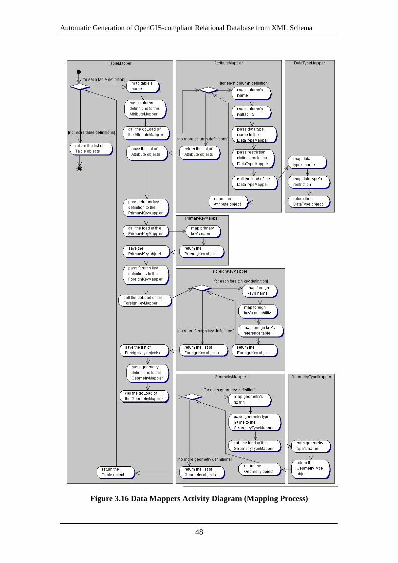
Automatic Generation of OpenGIS-compliant Relational Database from XML Schema
48
Figure 3.16 Data Mappers Activity Diagram (Mapping Process)
Automatic Generation of OpenGIS-compliant Relational Database from XML Schema
49
Finally all properties of the specific Table object are mapped and the TableMapper
puts the resulting Table object to the list of Table objects by. The TableMapper runs
the described mapping process for each relational database table definition found in
the specific XML Schema and all resulting Table objects are at the end put to the list
of the Table objects. When all relational database table definitions has been mapped
to the Table objects and put to the list, the list of Table objects is representing the
specific relational database schema definition in the specific XML Schema and is then
returned to the user for the further use.
The mapping process executed by the Data Mappers module has been described. It is
illustrated in figure 3.16.
3.3.3. Pseudo-Presentation Layer
As it was mentioned above, the Pseudo-Presentation Layer encapsulates SQL
Builders, which are responsible for the generation of the RDBMS-specific SQL DDL
scripts from the Model objects.
3.3.3.1. SQL Builders
The class diagram of the SQL Builders module is provided in figure 3.17. The
interface SQLBuilder is defined, which declares the methods to create SELECT,
INSERT, UPDATE, DELETE, CONSTRAINT, ALTER TABLE, and CREATE
TABLE SQL statements.
The GenericSQLBuilder class implements the SQLBuilder interface and holds the
names of the SQL keywords in its properties, which are most frequently used in the
mentioned SQL statements. The GenericSQLBuilder class defines the way to build
the most generic SQL structures. For example, it defines the concatenation of strings
that hold SELECT block, FROM block, and WHERE block in the SELECT SQL
statement, but it does not define the pattern of how the table names with their aliases
are arranged in the FROM block. The latter task is left for the vendor-specific SQL
Builders.
The AbtractVendorSQLBuilder abstract class extends the GenericSQLBuilder class. It
declares the methods to build the more vendor-specific parts of the SQL statements
like it was described above. It declares abstract methods for building table name
definition, attribute definition, primary key definition, and foreign key definition for

Automatic Generation of OpenGIS-compliant Relational Database from XML Schema
50
the CREATE TABLE SQL statement and table definitions and column definitions for
the SELECT SQL statement. The AbstractVendorSQLBuilder abstract class knows
about the RDBMS vendor type chosen for the mapping and it holds the list of the
reserved SQL keywords. Although the reserved SQL keywords are originally stored
in the XML file, which is an instance of the XML Schema illustrated in figure 3.13,
but the real check of the names used in the relational database table definition is done
in the SQL Builders module by the chosen vendor-specific SQL Builder.
Figure 3.17 SQL Builders Class Diagram
The vendor-specific SQL Builders extend the AbstractVendorSQLBuilder abstract
class and implement all the abstract methods declared in the
AbstractVendorSQLBuilder abstract class. The vendor-specific SQL Builders can also
reload the properties of the GenericSQLBuilder class that differ from the vendor-
specific SQL with the vendor-specific values. The properties of the
GenericSQLBuilder class are inherited by the vendor-specific SQL Builders through
the AbstractVendorSQLBuilder abstract class. This way the vendor-specific parts of
the SQL statements are built in the vendor-specific SQL Builders. In figure 3.17 one
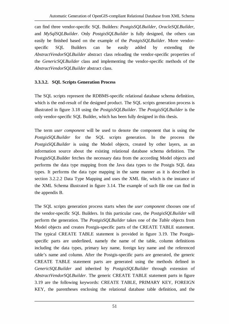
Automatic Generation of OpenGIS-compliant Relational Database from XML Schema
51
can find three vendor-specific SQL Builders: PostgisSQLBuilder, OracleSQLBuilder,
and MySqlSQLBuilder. Only PostgisSQLBuilder is fully designed, the others can
easily be finished based on the example of the PostgisSQLBuilder. More vendor-
specific SQL Builders can be easily added by extending the
AbstractVendorSQLBuilder abstract class reloading the vendor-specific properties of
the GenericSQLBuilder class and implementing the vendor-specific methods of the
AbstractVendorSQLBuilder abstract class.
3.3.3.2. SQL Scripts Generation Process
The SQL scripts represent the RDBMS-specific relational database schema definition,
which is the end-result of the designed product. The SQL scripts generation process is
illustrated in figure 3.18 using the PostgisSQLBuilder. The PostgisSQLBuilder is the
only vendor-specific SQL Builder, which has been fully designed in this thesis.
The term user component will be used to denote the component that is using the
PostgisSQLBuilder for the SQL scripts generation. In the process the
PostgisSQLBuilder is using the Model objects, created by other layers, as an
information source about the existing relational database schema definition. The
PostgisSQLBuilder fetches the necessary data from the according Model objects and
performs the data type mapping from the Java data types to the Postgis SQL data
types. It performs the data type mapping in the same manner as it is described in
section 3.2.2.2 Data Type Mapping and uses the XML file, which is the instance of
the XML Schema illustrated in figure 3.14. The example of such file one can find in
the appendix B.
The SQL scripts generation process starts when the user component chooses one of
the vendor-specific SQL Builders. In this particular case, the PostgisSQLBuilder will
perform the generation. The PostgisSQLBuilder takes one of the Table objects from
Model objects and creates Postgis-specific parts of the CREATE TABLE statement.
The typical CREATE TABLE statement is provided in figure 3.19. The Postgis-
specific parts are underlined, namely the name of the table, column definitions
including the data types, primary key name, foreign key name and the referenced
table’s name and column. After the Postgis-specific parts are generated, the generic
CREATE TABLE statement parts are generated using the methods defined in
GenericSQLBuilder and inherited by PostgisSQLBuilder through extension of
AbstractVendorSQLBuilder. The generic CREATE TABLE statement parts in figure
3.19 are the following keywords: CREATE TABLE, PRIMARY KEY, FOREIGN
KEY, the parentheses enclosing the relational database table definition, and the
Automatic Generation of OpenGIS-compliant Relational Database from XML Schema
52
symbol “;”. After those are generated from the original or reloaded
GenericSQLBuilder’s properties, the Postgis-specific and generic SQL parts are
concatenated in the proper order, as it is depicted in figure 3.19, and the resulting
CREATE TABLE statement is saved in the list of the SQL scripts.
Figure 3.18 PostgisSQLBuilder Activity Diagram
The PostgisSQLBuilder performs the similar procedure with each Geometry object
from the list found in the property geometries of this specific Table object. The typical
resulting SELECT SQL script can be seen in figure 3.19 and it represents the
definition of the 2-dimensional geometry column geom for the relational database test,
relational database table city, in the referential coordinate system identified by id
4326, of the geometry type POLYGON. The underlined part is Postgis-specific and
the keyword SELECT is a generic SQL keyword. After the SELECT SQL statements
defining all geometry columns are generated and put into the SQL scripts list, the
other Table object is taken from available list of Table objects and the described
process of SQL scripts generation is repeated.

Automatic Generation of OpenGIS-compliant Relational Database from XML Schema
53
Figure 3.19 Typical CREATE TABLE and SELECT
AddGeometryColumn() SQL statements in Postgis SQL
After all Table objects from the available list of Table objects are processed, the
resulting list of SQL scripts is returned to the user component for the further use.
3.4. Limitations
There are several limitations of the model for relational database schema definition
generation from XML Schema, which have been identified after the design phase.
They are the following:
- there is no support for defining and mapping the uniqueness of the
relational database table’s column. The support must be provided in the
further development of the model;
- there are only suggestions for the definition and mapping of the primary
and foreign key. This issue must still be analyzed and the solution must be
provided in the further development of the model;
- there is no support for the definition and mapping of the user-defined
types. Such support would require nested complex type handling. The
support must be provided in the further development of the model, since it
is already partially supported in one of the implementations of the
OpenGIS specifications (deegree [DGREE04]);
- the support of new RDBMSs is achieved by extending the
AbstractVendorSQLBuilder abstract class, reloading the differing
properties of the GenericSQLBuilder class, and implementing all abstract
methods of the AbstractVendorSQLBuilder abstract class. Although this is
quite flexible, but these responsibilities could be transferred to XML files.
One could define the syntax of the new vendor-specific SQL as an XML

Automatic Generation of OpenGIS-compliant Relational Database from XML Schema
54
file and in such particular way support the new RDBMS. It must be
considered in the further development of the model.
3.5. Summary of the Chapter
The model of the generic data importer has been introduced. The problem statement
has been provided and the three-layer architecture of the relational database schema
generation from XML Schema model has been defined to solve the provided problem.
The three-layer architecture is consisting from the following layers: data layer, logic
layer, and pseudo presentation layer. The overall process description within the
defined three-layer architecture has been described. The design decisions that have
been taken have been described and the detailed design of each layer of the defined
architecture of the model has been defined. The processes within each layer of the
defined architecture of the model have also been described. Several limitations of the
defined architecture of the model for relational database schema generation from
XML Schema have been identified. They are the following: no support for
uniqueness, primary key, foreign key, user-defined types (nested complex types), and
limited flexibility in extending for the support of new RDBMS.

Automatic Generation of OpenGIS-compliant Relational Database from XML Schema
55
4. Implementation of the Model
The list of technologies that will be used for the implementation of the designed
model for relational database schema generation from XML Schema will be provided
with the short description. The specificities of the implementation of this model will
be also described. The example of using the implemented model will be provided and
the qualitative evaluation of the implementation will be presented.
4.1. Technologies Used for the Implementation
The model for the relational database schema from XML Schema generation was
implemented using Java programming language and JDOM [JDOM04] for Java
representation of the XML document. For the use of the implemented component it is
recommended to plug it into the JDBC [JDBC04] enabled component for the dynamic
creation of the specific relational database schemas in chosen RDBMS.
4.1.1. Java Programming Language
Java programming language allows writing components, which can run on various
platforms, since those programs are run on (interpreted by) the Java Virtual Machine
(Java VM) program. So the Java programming language allows writing platform-
independent components. [JAVA04]
4.1.2. JDBC technology
The JDBC technology is an API that provides the cross-DBMS connectivity to a wide
range of the SQL databases. This technology was not used for the implementation of
the designed model, but it is suggested to plug the implemented component into the
JDBC enabled component for the dynamic creation of the specific relational database
schemas in chosen RDBMS. The JDBC allows arranging the API calls to any
database in the common manner. One can specify the RDBMS by choosing the
RDBMS driver. In combination with the implemented component, JDBC Technology
provides a kind of RDBMS-independency. [JDBC04]
4.1.3. JDOM
The JDOM is a Java representation of the XML document. It represents the XML
document for efficient reading, manipulation, and writing. The JDOM has a
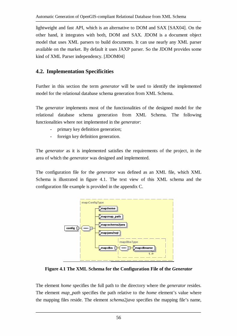
Automatic Generation of OpenGIS-compliant Relational Database from XML Schema
56
lightweight and fast API, which is an alternative to DOM and SAX [SAX04]. On the
other hand, it integrates with both, DOM and SAX. JDOM is a document object
model that uses XML parsers to build documents. It can use nearly any XML parser
available on the market. By default it uses JAXP parser. So the JDOM provides some
kind of XML Parser independency. [JDOM04]
4.2. Implementation Specificities
Further in this section the term generator will be used to identify the implemented
model for the relational database schema generation from XML Schema.
The generator implements most of the functionalities of the designed model for the
relational database schema generation from XML Schema. The following
functionalities where not implemented in the generator:
- primary key definition generation;
- foreign key definition generation.
The generator as it is implemented satisfies the requirements of the project, in the
area of which the generator was designed and implemented.
The configuration file for the generator was defined as an XML file, which XML
Schema is illustrated in figure 4.1. The text view of this XML schema and the
configuration file example is provided in the appendix C.
Figure 4.1 The XML Schema for the Configuration File of the Generator
The element home specifies the full path to the directory where the generator resides.
The element map_path specifies the path relative to the home element’s value where
the mapping files reside. The element schema2java specifies the mapping file’s name,

Automatic Generation of OpenGIS-compliant Relational Database from XML Schema
57
which defines the data type mapping from XML Schema data types to Java data types.
The element java2sql specifies the file name, which holds the reserved SQL keywords
list. The last but not least, the dbs element holds the dbname elements, which specify
the names of the RDBMS, which are supported by the generator. At the same time
each dbname element specifies the mapping file name, which defines the data type
mapping from Java data types to SQL data types of the specific RDBMS.
The extra functionality of the generator was implemented. It generates the report
about the process of the generation. The report XML Schema is illustrated in figure
4.2. The text view of this XML schema and the example of the report file is provided
in the appendix C.
Figure 4.2 The XML Schema for the Report File of the Generator
The report XML Schema’s root element is report, which consists of the sequence of
the table elements. Each table element consists of the following sequence of the
elements: from, to, attribute (multiple appearance), and geometry (multiple
appearance). Element from provides the feature name from the original XML schema.
Element to provides the table name to which the feature name was mapped by the
generator. Each attribute element consists of the following sequence of the elements:
from, to, and dataType. The same sequence of the elements is aggregated by each
geometry element. The geometry elements are optional. The elements from and to

Automatic Generation of OpenGIS-compliant Relational Database from XML Schema
58
from the attribute and geometry elements have the same semantics as the elements
from and to from the element table. The element from provides the pre-generation
name of the attribute or geometry and the element to provides the post-generation
name of the attribute or geometry. The element dataType consist of the following
sequence of the elements: schema, java, and sql. It provides the data type mapping
information. The element schema provides the XML Schema data type name. The
element java provides the Java data type name. The element sql provides the SQL
data type name.
The model for relational database schema generation from XML Schema was
implemented as a component, which can be used as an imported library in the Java
code of ones own application by calling the static method process() of the Main object
providing different parameters, or can be called as a executable providing the
parameters in the command line.
The parameters needed for the generation to be executed are the following:
- the specific XML Schema document from which the relational database
schema must be generated (can be provided as a full path to the file in the
file system from the command line or the java.io.Reader object to the
static process() method of the Main object);
- the RDBMS type, which exact possible values are specified in the
configuration file of the generator under the element dbname: e.g. postgis,
oracle, mysql;
- true if the reserved SQL keywords provided in the specific XML file must
be taken into account, false if not;
- true if the report about the generation process, as it is defined by the report
XML Schema illustrated in figure 4.2, must be generated, false if not;
- the name of the relational database for which the relational database
schema will be created;
- spatial reference system id number (srid). There are many standards and
types of spatial reference systems. One needs to specify, in which spatial
reference system the coordinates of the geometries are provided;
- dimension of the geometries. One needs to specify if the geometries are
provided as 2- or 3-dimentional objects.
4.3. Example of the Use of the Implemented Model
As an example, the specific XML Schema document, generated by the OpenGIS Web
Feature Service (WFS) implementation called GeoServer [GEOS04], will be used.

Automatic Generation of OpenGIS-compliant Relational Database from XML Schema
59
The GeoServer provides the functionality to generate the default specific XML
Schema document from the given data source using the following
DescribeFeatureType [WFSv1.0] request to the GeoServer:
http://troubadix.wb.tu-harburg.de:8180/geoserver/wfs?request=DescribeFeatureType
&typeName=buenz:Buenzau_nutzung.
The GeoServer has generated the XML Schema document, which is depicted in figure
4.3. The original data source was the ESRI Shapefile [SHP98], one of the standard to
store the geographical data (geodata). The document defines the feature
Buenzau_nutzung, which has the following elements:
- the_geom is an element of a geometry type MultiPolygonPropertyType as
it is defined in [SFSv1.1];
- AREA is an element of a simple type double;
- PERIMETER is an element of a simple type double;
- NUTZUNG_ is an element of a simple type int;
- NUTZUNG_ID is an element of a simple type int;
- NS is an element of a simple type int;
- BRD is an element of a simple type int;
- SZENE is an element of a simple type int;
- SPHEROID is an element of a simple type string;
- TKNR is an element of a simple type string;
- NS1 is an element of a simple type int;
- NS2 is an element of a simple type int;
- NS3 is an element of a simple type int;
- NUTZUNG is an element of a simple type string.
All the mentioned elements of the feature Buenzau_nutzung are defined with
attributes nillable set to true and minOccurs set to 0. This specific XML Schema
resides in the file on the files system under the following full path:
/{full_path}/buenzau.xsd.
The generator will be called, which we have named RedGenie (RElational Database
schema GENerator), as an executable from the command line as follows:
java RedGenie.main.Main /{full_path}/buenzau.xsd postgis true true test 31467 2
The parameters have the following meaning accordingly:
- the specific XML Schema resides under /{full_path}/buenzau.xsd;
- generate relational database schema definition for Postgis RDBMS;
- check the keywords of the definition against reserved SQL keywords;
- generate the report file;
- generate the relational database schema definition for database with the
name test;

Automatic Generation of OpenGIS-compliant Relational Database from XML Schema
60
- the coordinates of the geometries are provided in the spatial reference
system, which id is 31467;
- the geometries are 2-dimentional objects;
Figure 4.3 Example of a Specific XML Schema
Document Generated by GeoServer
The generated relational database schema definition is provided in figure 4.4. The
report file is provided in the appendix C. The generated relational database schema
definition’s CREATE TABLE SQL statement defines the relational database table
named Buenzau_nutzung with the columns corresponding to the elements defined in
the specific XML Schema provided in figure 4.3. Each data type was mapped as it
was defined in the data type mapping file for Postgis RDBMS. The contents of this
data type mapping file can be found in appendix B. The geometry column is defined
by relational database schema definition’s SELECT SQL statement, which uses the
function AddGeometryColumn() with the following parameters accordingly: test – the
name of the relational database, for which the geometry column is created,
buenzau_nutzung – the name of the relational database table, for which the geometry
column is created, the_geom – the name of the geometry column, 31467 – the id of

Automatic Generation of OpenGIS-compliant Relational Database from XML Schema
61
the spatial referential system, MULTIPOLYGON – the data type name of the
geometry, 2 – the dimension of the geometry objects.
Figure 4.4 Example of the Relational Database Schema Definition
for Postgis RDBMS Generated by the Generator (RedGenie)
The resulting SQL scripts (see figure 4.4) must be executed in Postgis RDBMS to
create the relational database schema to be able to populate it with data. One can do it
manually, but it is suggested to integrate the generator to ones own application and
execute the resulting SQL scripts using the JDBC technology. This way one would
automate the process of data import to the relational databases by eliminating the
necessity of human intervention to the process of creation of the relational database
schemas.
4.4. Evaluation of the Implementation
The implementation of the generator was successful. All fully designed features of
the model for relational database schema generation form XML Schema were
implemented. The ones not fully designed were also not implemented, namely
primary key definition and foreign key definition generation. So the generator
(RedGenie) is rather precise implementation of the originally designed model for
relational database schema generation from XML Schema.
4.5. Summary of the Chapter
The list of technologies that have been used for the implementation of the designed
model for relational database schema generation from XML Schema has been
provided, namely Java programming language and JDOM. It has been suggested

Automatic Generation of OpenGIS-compliant Relational Database from XML Schema
62
always to use the implemented component together with the JDBC technology, to
automate the data import to the relational databases. The specificities of the generator
have been described. It has been noted, that the functionality of foreign key and
primary key definitions generation was not implemented, since it was not fully
designed. The example of using the generator with the specific XML Schema has
been presented defining the feature Buenzau_nutzung, from which the relational
database schema definition has been successfully created. The evaluation of the
implementation of the generator has been described as rather precise, since all fully
designed functionalities of the original model has been implemented in the generator
(RedGenie).

Automatic Generation of OpenGIS-compliant Relational Database from XML Schema
63
5. Conclusions
5.1. Summary
The structures and the vocabulary relevant to this thesis from XML Schema standard
have been introduced, namely element declarations, simple and complex type
definitions, the attributes nillable and minOccurs of the element declaration,
substitution groups mechanism, extension mechanism, and key definitions. The
geometry and feature schemas defined in Open GIS Geography Markup Language
(GML) Implementation Specification Version 2.1.2 [GMLv2.1] have been introduced
and SQL geometry types defined in Open GIS Simple Features Specification for SQL
Revision 1.1 [SFSv1.1] have been provided.
The requirements for the relational database schema generation from XML schema
model have been formulated and the three-layer architecture for the design of the
mentioned model has been defined. The three layers are the following: data layer,
logic layer, and pseudo presentation layer. The model-view-controller pattern has also
been used for the definition of the architecture. The overall process of the relational
database schema generation from the XML Schema description within the three-layer
architecture has been described and the design decisions have been taken.
Furthermore, the detailed design of each layer of the defined three-layer architecture
of the model has been defined and the processes within each of the layers have been
described. Then several limitations of the defined model have been identified: no
support for the uniqueness of the relational database table’s column, primary key,
foreign key, user-defined types (nested complex types), and limited flexibility in
extending the support to more RDBMSs.
A list and short description of the technologies we have used for the implementation
of the designed model for relational database schema generation from XML Schema
have been provided, namely Java programming language and JDOM. It has been
suggested to use the implemented component together with the JDBC technology, to
automate the data import process to the relational databases. The specific
implementation decisions that have been made during the implementation have been
discussed and it has been noted that the support for foreign and primary key
definitions generation has not been implemented, because of the lack of design. The
example case of the relational database schema generation from the geographical
feature definition Buenzau_nutzung has been presented. The relational database
schema definition has been successfully created by the implemented component.

Automatic Generation of OpenGIS-compliant Relational Database from XML Schema
64
Finally, the implementation has been evaluated as being rather successful, since all
fully designed functionalities have been implemented.
This thesis has shown that there is a lack of components in Java development
environment capable of generic data import to the relational databases with the
relational database schema definition generation from specific XML Schema with a
support for geographical features. One component from such a system has been
designed and implemented, namely a component for OpenGIS-compliant relational
database schema generation from the specific XML Schema. The implemented
component can be used and on demand extended in the projects that are and/or will be
in progress in River and Coastal Engineering Department in Technical University
Hamburg-Harburg.
5.2. Outlook
In the future, the design for the OpenGIS-compliant relational database schema
generation from the specific XML Schema model must be extended towards the
support of the identified limitations. The support for the uniqueness mapping must be
designed as soon as possible. The design of the support for the primary and foreign
key definition generations must be defined on demand, which should increase soon,
since some of the implementations of the OpenGIS specifications are already
announcing the support for the nested complex types. The flexibility regarding the
extension to the support of more RDBMSs is not very limited. The increase of the
flexibility should be considered as “nice to have” feature.
All the future designs should be implemented on the spot for testing and usage.
The report XML document generated by the implemented component can be used and
should be used not only for the overview of the results of the process, but also for the
dynamic configuration of the Geoservices implemented according to OpenGIS
Specifications, e.g. Web Feature Service (WFS) [WFSv1.0]. The mentioned report
XML document contains all necessary information and with the help of XSL
transformations [XSLTv1.0] it can be used for the mentioned configuration.
The other components of the generic data importer described in the introduction of
this thesis should be also implemented, namely relational database schema creation
module, data import module, and relational database schema update module.

Automatic Generation of OpenGIS-compliant Relational Database from XML Schema
65
Automatic Generation of OpenGIS-compliant Relational Database from XML Schema
66

Automatic Generation of OpenGIS-compliant Relational Database from XML Schema
67
Appendix A. XML Schemas Related to Model
Figure A.1 The XML Schema for Storing Reserved SQL Keywords
Figure A.2 The XML Schema for Data Type Mapping Definition

Automatic Generation of OpenGIS-compliant Relational Database from XML Schema
68
6.

Automatic Generation of OpenGIS-compliant Relational Database from XML Schema
69
Appendix B. Instances of XML Schemas Related to Model
<?xml version="1.0" encoding="UTF-8"?>
<map:list xmlns="http://troubadix.wb.tu-harburg.de/map" xmlns:xlink="http://www.w3.org/1999/xlink"
xmlns:map="http://troubadix.wb.tu-harburg.de/map" xmlns:xsi="http://www.w3.org/2001/XMLSchema-instance" xsi:schemaLocation="http://troubadix.wb.tu-harburg.de/map
http://troubadix.wb.tu-harburg.de/map/java2sql.xsd"> <!-- reserved SQL words: as it is given in SQL99 --> <map:reserved>ABSOLUTE</map:reserved>
<map:reserved>ACTION</map:reserved> <map:reserved>ADD</map:reserved> <map:reserved>AFTER</map:reserved>
<map:reserved>ALL</map:reserved> <map:reserved>ALLOCATE</map:reserved> <map:reserved>ALTER</map:reserved>
<map:reserved>AND</map:reserved> <map:reserved>ANY</map:reserved> <map:reserved>ARE</map:reserved>
<map:reserved>ARRAY</map:reserved> <map:reserved>AS</map:reserved> <map:reserved>ASC</map:reserved>
<map:reserved>ASENSITIVE</map:reserved> <map:reserved>ASSERTION</map:reserved> <map:reserved>ASYMMETRIC</map:reserved>
<map:reserved>AT</map:reserved> <map:reserved>ATOMIC</map:reserved> <map:reserved>AUTHORIZATION</map:reserved>
<map:reserved>BEFORE</map:reserved> <map:reserved>BEGIN</map:reserved> <map:reserved>BETWEEN</map:reserved>
<map:reserved>BINARY</map:reserved> <map:reserved>BIT</map:reserved> <map:reserved>BLOB</map:reserved>
<map:reserved>BOOLEAN</map:reserved> <map:reserved>BOTH</map:reserved> <map:reserved>BREADTH</map:reserved>
<map:reserved>BY</map:reserved> <map:reserved>CALL</map:reserved> <map:reserved>CALLED</map:reserved>
<map:reserved>CASCADE</map:reserved> <map:reserved>CASCADED</map:reserved> <map:reserved>CASE</map:reserved>
<map:reserved>CAST</map:reserved> <map:reserved>CATALOG</map:reserved> <map:reserved>CHAR</map:reserved>
<map:reserved>CHARACTER</map:reserved> <map:reserved>CHECK</map:reserved> <map:reserved>CLOB</map:reserved>
<map:reserved>CLOSE</map:reserved> <map:reserved>COLLATE</map:reserved> <map:reserved>COLLATION</map:reserved>
<map:reserved>COLUMN</map:reserved> <map:reserved>COMMIT</map:reserved> <map:reserved>CONDITION</map:reserved>
<map:reserved>CONNECT</map:reserved> <map:reserved>CONNECTION</map:reserved> <map:reserved>CONSTRAINT</map:reserved>
<map:reserved>CONSTRAINTS</map:reserved> <map:reserved>CONSTRUCTOR</map:reserved> <map:reserved>CONTINUE</map:reserved>
<map:reserved>CORRESPONDING</map:reserved>

Automatic Generation of OpenGIS-compliant Relational Database from XML Schema
70
<map:reserved>CREATE</map:reserved> <map:reserved>CROSS</map:reserved>
<map:reserved>CUBE</map:reserved> <map:reserved>CURRENT</map:reserved> <map:reserved>CURRENT_DATE</map:reserved>
<map:reserved>CURRENT_DEFAULT_TRANSFORM_GROUP</map:reserved> <map:reserved>CURRENT_PATH</map:reserved> <map:reserved>CURRENT_ROLE</map:reserved>
<map:reserved>CURRENT_TIME</map:reserved> <map:reserved>CURRENT_TIMESTAMP</map:reserved> <map:reserved>CURRENT_TRANSFORM_GROUP_FOR_TYPE</map:reserved>
<map:reserved>CURRENT_USER</map:reserved> <map:reserved>CURSOR</map:reserved> <map:reserved>CYCLE</map:reserved>
<map:reserved>DATA</map:reserved> <map:reserved>DATE</map:reserved> <map:reserved>DAY</map:reserved>
<map:reserved>DEALLOCATE</map:reserved> <map:reserved>DEC</map:reserved> <map:reserved>DECIMAL</map:reserved>
<map:reserved>DECLARE</map:reserved> <map:reserved>DEFAULT</map:reserved> <map:reserved>DEFERRABLE</map:reserved>
<map:reserved>DEFERRED</map:reserved> <map:reserved>DELETE</map:reserved> <map:reserved>DEPTH</map:reserved>
<map:reserved>DEREF</map:reserved> <map:reserved>DESC</map:reserved> <map:reserved>DESCRIBE</map:reserved>
<map:reserved>DESCRIPTOR</map:reserved> <map:reserved>DETERMINISTIC</map:reserved> <map:reserved>DIAGNOSTICS</map:reserved>
<map:reserved>DISCONNECT</map:reserved> <map:reserved>DISTINCT</map:reserved> <map:reserved>DO</map:reserved>
<map:reserved>DOMAIN</map:reserved> <map:reserved>DOUBLE</map:reserved> <map:reserved>DROP</map:reserved>
<map:reserved>DYNAMIC</map:reserved> <map:reserved>EACH</map:reserved> <map:reserved>ELSE</map:reserved>
<map:reserved>ELSEIF</map:reserved> <map:reserved>END</map:reserved> <map:reserved>EQUALS</map:reserved>
<map:reserved>ESCAPE</map:reserved> <map:reserved>EXCEPT</map:reserved> <map:reserved>EXCEPTION</map:reserved>
<map:reserved>EXEC</map:reserved> <map:reserved>EXECUTE</map:reserved> <map:reserved>EXISTS</map:reserved>
<map:reserved>EXIT</map:reserved> <map:reserved>EXTERNAL</map:reserved> <map:reserved>FALSE</map:reserved>
<map:reserved>FETCH</map:reserved> <map:reserved>FILTER</map:reserved> <map:reserved>FIRST</map:reserved>
<map:reserved>FLOAT</map:reserved> <map:reserved>FOR</map:reserved> <map:reserved>FOREIGN</map:reserved>
<map:reserved>FOUND</map:reserved> <map:reserved>FREE</map:reserved> <map:reserved>FROM</map:reserved>
<map:reserved>FULL</map:reserved> <map:reserved>FUNCTION</map:reserved> <map:reserved>GENERAL</map:reserved>
<map:reserved>GET</map:reserved> <map:reserved>GLOBAL</map:reserved>

Automatic Generation of OpenGIS-compliant Relational Database from XML Schema
71
<map:reserved>GO</map:reserved> <map:reserved>GOTO</map:reserved>
<map:reserved>GRANT</map:reserved> <map:reserved>GROUP</map:reserved> <map:reserved>GROUPING</map:reserved>
<map:reserved>HANDLER</map:reserved> <map:reserved>HAVING</map:reserved> <map:reserved>HOLD</map:reserved>
<map:reserved>HOUR</map:reserved> <map:reserved>IDENTITY</map:reserved> <map:reserved>IF</map:reserved>
<map:reserved>IMMEDIATE</map:reserved> <map:reserved>IN</map:reserved> <map:reserved>INDICATOR</map:reserved>
<map:reserved>INITIALLY</map:reserved> <map:reserved>INNER</map:reserved> <map:reserved>INOUT</map:reserved>
<map:reserved>INPUT</map:reserved> <map:reserved>INSENSITIVE</map:reserved> <map:reserved>INSERT</map:reserved>
<map:reserved>INT</map:reserved> <map:reserved>INTEGER</map:reserved> <map:reserved>INTERSECT</map:reserved>
<map:reserved>INTERVAL</map:reserved> <map:reserved>INTO</map:reserved> <map:reserved>IS</map:reserved>
<map:reserved>ISOLATION</map:reserved> <map:reserved>ITERATE</map:reserved> <map:reserved>JOIN</map:reserved>
<map:reserved>KEY</map:reserved> <map:reserved>LANGUAGE</map:reserved> <map:reserved>LARGE</map:reserved>
<map:reserved>LAST</map:reserved> <map:reserved>LATERAL</map:reserved> <map:reserved>LEADING</map:reserved>
<map:reserved>LEAVE</map:reserved> <map:reserved>LEFT</map:reserved> <map:reserved>LEVEL</map:reserved>
<map:reserved>LIKE</map:reserved> <map:reserved>LOCAL</map:reserved> <map:reserved>LOCALTIME</map:reserved>
<map:reserved>LOCALTIMESTAMP</map:reserved> <map:reserved>LOCATOR</map:reserved> <map:reserved>LOOP</map:reserved>
<map:reserved>MAP</map:reserved> <map:reserved>MATCH</map:reserved> <map:reserved>METHOD</map:reserved>
<map:reserved>MINUTE</map:reserved> <map:reserved>MODIFIES</map:reserved> <map:reserved>MODULE</map:reserved>
<map:reserved>MONTH</map:reserved> <map:reserved>NAMES</map:reserved> <map:reserved>NATIONAL</map:reserved>
<map:reserved>NATURAL</map:reserved> <map:reserved>NCHAR</map:reserved> <map:reserved>NCLOB</map:reserved>
<map:reserved>NEW</map:reserved> <map:reserved>NEXT</map:reserved> <map:reserved>NO</map:reserved>
<map:reserved>NONE</map:reserved> <map:reserved>NOT</map:reserved> <map:reserved>NULL</map:reserved>
<map:reserved>NUMERIC</map:reserved> <map:reserved>OBJECT</map:reserved> <map:reserved>OF</map:reserved>
<map:reserved>OLD</map:reserved> <map:reserved>ON</map:reserved>

Automatic Generation of OpenGIS-compliant Relational Database from XML Schema
72
<map:reserved>ONLY</map:reserved> <map:reserved>OPEN</map:reserved>
<map:reserved>OPTION</map:reserved> <map:reserved>OR</map:reserved> <map:reserved>ORDER</map:reserved>
<map:reserved>ORDINALITY</map:reserved> <map:reserved>OUT</map:reserved> <map:reserved>OUTER</map:reserved>
<map:reserved>OUTPUT</map:reserved> <map:reserved>OVER</map:reserved> <map:reserved>OVERLAPS</map:reserved>
<map:reserved>PAD</map:reserved> <map:reserved>PARAMETER</map:reserved> <map:reserved>PARTIAL</map:reserved>
<map:reserved>PARTITION</map:reserved> <map:reserved>PATH</map:reserved> <map:reserved>PRECISION</map:reserved>
<map:reserved>PREPARE</map:reserved> <map:reserved>PRESERVE</map:reserved> <map:reserved>PRIMARY</map:reserved>
<map:reserved>PRIOR</map:reserved> <map:reserved>PRIVILEGES</map:reserved> <map:reserved>PROCEDURE</map:reserved>
<map:reserved>PUBLIC</map:reserved> <map:reserved>RANGE</map:reserved> <map:reserved>READ</map:reserved>
<map:reserved>READS</map:reserved> <map:reserved>REAL</map:reserved> <map:reserved>RECURSIVE</map:reserved>
<map:reserved>REF</map:reserved> <map:reserved>REFERENCES</map:reserved> <map:reserved>REFERENCING</map:reserved>
<map:reserved>RELATIVE</map:reserved> <map:reserved>RELEASE</map:reserved> <map:reserved>REPEAT</map:reserved>
<map:reserved>RESIGNAL</map:reserved> <map:reserved>RESTRICT</map:reserved> <map:reserved>RESULT</map:reserved>
<map:reserved>RETURN</map:reserved> <map:reserved>RETURNS</map:reserved> <map:reserved>REVOKE</map:reserved>
<map:reserved>RIGHT</map:reserved> <map:reserved>ROLE</map:reserved> <map:reserved>ROLLBACK</map:reserved>
<map:reserved>ROLLUP</map:reserved> <map:reserved>ROUTINE</map:reserved> <map:reserved>ROW</map:reserved>
<map:reserved>ROWS</map:reserved> <map:reserved>SAVEPOINT</map:reserved> <map:reserved>SCHEMA</map:reserved>
<map:reserved>SCOPE</map:reserved> <map:reserved>SCROLL</map:reserved> <map:reserved>SEARCH</map:reserved>
<map:reserved>SECOND</map:reserved> <map:reserved>SECTION</map:reserved> <map:reserved>SELECT</map:reserved>
<map:reserved>SENSITIVE</map:reserved> <map:reserved>SESSION</map:reserved> <map:reserved>SESSION_USER</map:reserved>
<map:reserved>SET</map:reserved> <map:reserved>SETS</map:reserved> <map:reserved>SIGNAL</map:reserved>
<map:reserved>SIMILAR</map:reserved> <map:reserved>SIZE</map:reserved> <map:reserved>SMALLINT</map:reserved>
<map:reserved>SOME</map:reserved> <map:reserved>SPACE</map:reserved>

Automatic Generation of OpenGIS-compliant Relational Database from XML Schema
73
<map:reserved>SPECIFIC</map:reserved> <map:reserved>SPECIFICTYPE</map:reserved>
<map:reserved>SQL</map:reserved> <map:reserved>SQLEXCEPTION</map:reserved> <map:reserved>SQLSTATE</map:reserved>
<map:reserved>SQLWARNING</map:reserved> <map:reserved>START</map:reserved> <map:reserved>STATE</map:reserved>
<map:reserved>STATIC</map:reserved> <map:reserved>SYMMETRIC</map:reserved> <map:reserved>SYSTEM</map:reserved>
<map:reserved>SYSTEM_USER</map:reserved> <map:reserved>TABLE</map:reserved> <map:reserved>TEMPORARY</map:reserved>
<map:reserved>THEN</map:reserved> <map:reserved>TIME</map:reserved> <map:reserved>TIMESTAMP</map:reserved>
<map:reserved>TIMEZONE_HOUR</map:reserved> <map:reserved>TIMEZONE_MINUTE</map:reserved> <map:reserved>TO</map:reserved>
<map:reserved>TRAILING</map:reserved> <map:reserved>TRANSACTION</map:reserved> <map:reserved>TRANSLATION</map:reserved>
<map:reserved>TREAT</map:reserved> <map:reserved>TRIGGER</map:reserved> <map:reserved>TRUE</map:reserved>
<map:reserved>UNDER</map:reserved> <map:reserved>UNDO</map:reserved> <map:reserved>UNION</map:reserved>
<map:reserved>UNIQUE</map:reserved> <map:reserved>UNKNOWN</map:reserved> <map:reserved>UNNEST</map:reserved>
<map:reserved>UNTIL</map:reserved> <map:reserved>UPDATE</map:reserved> <map:reserved>USAGE</map:reserved>
<map:reserved>USER</map:reserved> <map:reserved>USING</map:reserved> <map:reserved>VALUE</map:reserved>
<map:reserved>VALUES</map:reserved> <map:reserved>VARCHAR</map:reserved> <map:reserved>VARYING</map:reserved>
<map:reserved>VIEW</map:reserved> <map:reserved>WHEN</map:reserved> <map:reserved>WHENEVER</map:reserved>
<map:reserved>WHERE</map:reserved> <map:reserved>WHILE</map:reserved> <map:reserved>WINDOW</map:reserved>
<map:reserved>WITH</map:reserved> <map:reserved>WITHIN</map:reserved> <map:reserved>WITHOUT</map:reserved>
<map:reserved>WORK</map:reserved> <map:reserved>WRITE</map:reserved> <map:reserved>YEAR</map:reserved>
<map:reserved>ZONE</map:reserved> </map:list>
Figure B.1 The XML Document Defining the Reserved SQL99 Keywords
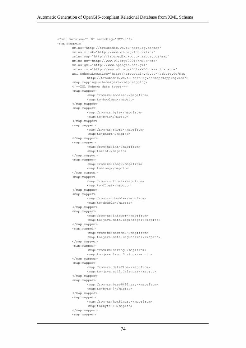
Automatic Generation of OpenGIS-compliant Relational Database from XML Schema
74
<?xml version="1.0" encoding="UTF-8"?> <map:mappers
xmlns="http://troubadix.wb.tu-harburg.de/map" xmlns:xlink="http://www.w3.org/1999/xlink" xmlns:map="http://troubadix.wb.tu-harburg.de/map"
xmlns:xs="http://www.w3.org/2001/XMLSchema" xmlns:gml="http://www.opengis.net/gml" xmlns:xsi="http://www.w3.org/2001/XMLSchema-instance"
xsi:schemaLocation="http://troubadix.wb.tu-harburg.de/map http://troubadix.wb.tu-harburg.de/map/mapping.xsd"> <map:mapping>schema2java</map:mapping>
<!--XML Schema data types--> <map:mapper> <map:from>xs:boolean</map:from>
<map:to>boolean</map:to> </map:mapper> <map:mapper>
<map:from>xs:byte</map:from> <map:to>byte</map:to> </map:mapper>
<map:mapper> <map:from>xs:short</map:from> <map:to>short</map:to>
</map:mapper> <map:mapper> <map:from>xs:int</map:from>
<map:to>int</map:to> </map:mapper> <map:mapper>
<map:from>xs:long</map:from> <map:to>long</map:to> </map:mapper>
<map:mapper> <map:from>xs:float</map:from> <map:to>float</map:to>
</map:mapper> <map:mapper> <map:from>xs:double</map:from>
<map:to>double</map:to> </map:mapper> <map:mapper>
<map:from>xs:integer</map:from> <map:to>java.math.BigInteger</map:to> </map:mapper>
<map:mapper> <map:from>xs:decimal</map:from> <map:to>java.math.BigDecimal</map:to>
</map:mapper> <map:mapper> <map:from>xs:string</map:from>
<map:to>java.lang.String</map:to> </map:mapper> <map:mapper>
<map:from>xs:dateTime</map:from> <map:to>java.util.Calendar</map:to> </map:mapper>
<map:mapper> <map:from>xs:base64Binary</map:from> <map:to>byte[]</map:to>
</map:mapper> <map:mapper> <map:from>xs:hexBinary</map:from>
<map:to>byte[]</map:to> </map:mapper> <map:mapper>

Automatic Generation of OpenGIS-compliant Relational Database from XML Schema
75
<map:from>duration</map:from> <map:to>java.lang.String</map:to>
<!-- weblogic.xml.schema.binding.util.Duration --> </map:mapper> <map:mapper>
<map:from>xs:time</map:from> <map:to>java.util.Calendar</map:to> </map:mapper>
<map:mapper> <map:from>xs:date</map:from> <map:to>java.util.Calendar</map:to>
</map:mapper> <map:mapper> <map:from>xs:gYearMonth</map:from>
<map:to>java.util.Calendar</map:to> </map:mapper> <map:mapper>
<map:from>xs:gYear</map:from> <map:to>java.util.Calendar</map:to> </map:mapper>
<map:mapper> <map:from>xs:gMonthDay</map:from> <map:to>java.util.Calendar</map:to>
</map:mapper> <map:mapper> <map:from>xs:gDay</map:from>
<map:to>java.util.Calendar</map:to> </map:mapper> <map:mapper>
<map:from>xs:gMonth</map:from> <map:to>java.util.Calendar</map:to> </map:mapper>
<map:mapper> <map:from>xs:anyURI</map:from> <map:to>java.lang.String</map:to>
</map:mapper> <map:mapper> <map:from>xs:NOTATION</map:from>
<map:to>java.lang.String</map:to> </map:mapper> <map:mapper>
<map:from>xs:token</map:from> <map:to>java.lang.String</map:to> </map:mapper>
<map:mapper> <map:from>xs:normalizedString</map:from> <map:to>java.lang.String</map:to>
</map:mapper> <map:mapper> <map:from>xs:language</map:from>
<map:to>java.lang.String</map:to> </map:mapper> <map:mapper>
<map:from>xs:Name</map:from> <map:to>java.lang.String</map:to> </map:mapper>
<map:mapper> <map:from>xs:NMTOKEN</map:from> <map:to>java.lang.String</map:to>
</map:mapper> <map:mapper> <map:from>xs:NCName</map:from>
<map:to>java.lang.String</map:to> </map:mapper> <map:mapper>
<map:from>xs:NMTOKENS</map:from> <map:to>java.lang.String[]</map:to>

Automatic Generation of OpenGIS-compliant Relational Database from XML Schema
76
</map:mapper> <map:mapper>
<map:from>xs:ID</map:from> <map:to>java.lang.String</map:to> </map:mapper>
<map:mapper> <map:from>xs:IDREF</map:from> <map:to>java.lang.String</map:to>
</map:mapper> <map:mapper> <map:from>xs:ENTITY</map:from>
<map:to>java.lang.String</map:to> </map:mapper> <map:mapper>
<map:from>xs:IDREFS</map:from> <map:to>java.lang.String[]</map:to> </map:mapper>
<map:mapper> <map:from>xs:ENTITIES</map:from> <map:to>java.lang.String[]</map:to>
</map:mapper> <map:mapper> <map:from>xs:nonPositiveInteger</map:from>
<map:to>java.math.BigInteger</map:to> </map:mapper> <map:mapper>
<map:from>xs:nonNegativeInteger</map:from> <map:to>java.math.BigInteger</map:to> </map:mapper>
<map:mapper> <map:from>xs:negativeInteger</map:from> <map:to>java.math.BigInteger</map:to>
</map:mapper> <map:mapper> <map:from>xs:unsignedLong</map:from>
<map:to>java.math.BigInteger</map:to> </map:mapper> <map:mapper>
<map:from>xs:positiveInteger</map:from> <map:to>java.math.BigInteger</map:to> </map:mapper>
<map:mapper> <map:from>xs:unsignedInt</map:from> <map:to>long</map:to>
</map:mapper> <map:mapper> <map:from>xs:unsignedShort</map:from>
<map:to>int</map:to> </map:mapper> <map:mapper>
<map:from>xs:unsignedByte</map:from> <map:to>short</map:to> </map:mapper>
<map:mapper> <map:from>xs:QName</map:from> <map:to>java.lang.String</map:to>
<!-- javax.xml.namespace.QName --> </map:mapper> <!--GML data types-->
<map:mapper> <map:from>gml:Point</map:from> <map:to>Point</map:to>
</map:mapper> <map:mapper> <map:from>gml:LineString</map:from>
<map:to>LineString</map:to> </map:mapper>
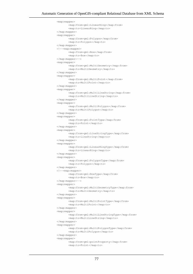
Automatic Generation of OpenGIS-compliant Relational Database from XML Schema
77
<map:mapper> <map:from>gml:LinearRing</map:from>
<map:to>LinearRing</map:to> </map:mapper> <map:mapper>
<map:from>gml:Polygon</map:from> <map:to>Polygon</map:to> </map:mapper>
<!--<map:mapper> <map:from>gml:Box</map:from> <map:to>Box</map:to>
</map:mapper>--> <map:mapper> <map:from>gml:MultiGeometry</map:from>
<map:to>MultiGeometry</map:to> </map:mapper> <map:mapper>
<map:from>gml:MultiPoint</map:from> <map:to>MultiPoint</map:to> </map:mapper>
<map:mapper> <map:from>gml:MultiLineString</map:from> <map:to>MultiLineString</map:to>
</map:mapper> <map:mapper> <map:from>gml:MultiPolygon</map:from>
<map:to>MultiPolygon</map:to> </map:mapper> <map:mapper>
<map:from>gml:PointType</map:from> <map:to>Point</map:to> </map:mapper>
<map:mapper> <map:from>gml:LineStringType</map:from> <map:to>LineString</map:to>
</map:mapper> <map:mapper> <map:from>gml:LinearRingType</map:from>
<map:to>LinearRing</map:to> </map:mapper> <map:mapper>
<map:from>gml:PolygonType</map:from> <map:to>Polygon</map:to> </map:mapper>
<!--<map:mapper> <map:from>gml:BoxType</map:from> <map:to>Box</map:to>
</map:mapper>--> <map:mapper> <map:from>gml:MultiGeometryType</map:from>
<map:to>MultiGeometry</map:to> </map:mapper> <map:mapper>
<map:from>gml:MultiPointType</map:from> <map:to>MultiPoint</map:to> </map:mapper>
<map:mapper> <map:from>gml:MultiLineStringType</map:from> <map:to>MultiLineString</map:to>
</map:mapper> <map:mapper> <map:from>gml:MultiPolygonType</map:from>
<map:to>MultiPolygon</map:to> </map:mapper> <map:mapper>
<map:from>gml:pointProperty</map:from> <map:to>Point</map:to>
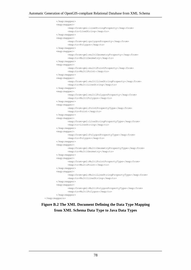
Automatic Generation of OpenGIS-compliant Relational Database from XML Schema
78
</map:mapper> <map:mapper>
<map:from>gml:lineStringProperty</map:from> <map:to>LineString</map:to> </map:mapper>
<map:mapper> <map:from>gml:polygonProperty</map:from> <map:to>Polygon</map:to>
</map:mapper> <map:mapper> <map:from>gml:multiGeometryProperty</map:from>
<map:to>MultiGeometry</map:to> </map:mapper> <map:mapper>
<map:from>gml:multiPointProperty</map:from> <map:to>MultiPoint</map:to> </map:mapper>
<map:mapper> <map:from>gml:multiLineStringProperty</map:from> <map:to>MultiLineString</map:to>
</map:mapper> <map:mapper> <map:from>gml:multiPolygonProperty</map:from>
<map:to>MultiPolygon</map:to> </map:mapper> <map:mapper>
<map:from>gml:PointPropertyType</map:from> <map:to>Point</map:to> </map:mapper>
<map:mapper> <map:from>gml:LineStringPropertyType</map:from> <map:to>LineString</map:to>
</map:mapper> <map:mapper> <map:from>gml:PolygonPropertyType</map:from>
<map:to>Polygon</map:to> </map:mapper> <map:mapper>
<map:from>gml:MultiGeometryPropertyType</map:from> <map:to>MultiGeometry</map:to> </map:mapper>
<map:mapper> <map:from>gml:MultiPointPropertyType</map:from> <map:to>MultiPoint</map:to>
</map:mapper> <map:mapper> <map:from>gml:MultiLineStringPropertyType</map:from>
<map:to>MultiLineString</map:to> </map:mapper> <map:mapper>
<map:from>gml:MultiPolygonPropertyType</map:from> <map:to>MultiPolygon</map:to> </map:mapper>
</map:mappers>
Figure B.2 The XML Document Defining the Data Type Mapping
from XML Schema Data Type to Java Data Types

Automatic Generation of OpenGIS-compliant Relational Database from XML Schema
79
<?xml version="1.0" encoding="UTF-8"?> <map:mappers
xmlns="http://troubadix.wb.tu-harburg.de/map" xmlns:xlink="http://www.w3.org/1999/xlink" xmlns:map="http://troubadix.wb.tu-harburg.de/map"
xmlns:xsi="http://www.w3.org/2001/XMLSchema-instance" xsi:schemaLocation="http://troubadix.wb.tu-harburg.de/map http://troubadix.wb.tu-harburg.de/map/mapping.xsd">
<map:mapping>java2sql</map:mapping> <map:sql>postgis</map:sql> <!--JAVA data types-->
<map:mapper> <map:from>int</map:from> <map:to>INTEGER</map:to>
</map:mapper> <map:mapper> <map:from>short</map:from>
<map:to>SMALLINT</map:to> </map:mapper> <map:mapper>
<map:from>long</map:from> <map:to>BIGINT</map:to> </map:mapper>
<map:mapper> <map:from>float</map:from> <map:to>FLOAT4</map:to>
</map:mapper> <map:mapper> <map:from>double</map:from>
<map:to>FLOAT8</map:to> </map:mapper> <map:mapper>
<map:from>byte</map:from> <map:to>SMALLINT</map:to> </map:mapper>
<map:mapper> <map:from>boolean</map:from> <map:to>BOOLEAN</map:to>
</map:mapper> <map:mapper> <map:from>char</map:from>
<map:to>CHAR</map:to> </map:mapper> <map:mapper>
<map:from>java.lang.Integer</map:from> <map:to>INTEGER</map:to> </map:mapper>
<map:mapper> <map:from>java.lang.Short</map:from> <map:to>SMALLINT</map:to>
</map:mapper> <map:mapper> <map:from>java.lang.Long</map:from>
<map:to>BIGINT</map:to> </map:mapper> <map:mapper>
<map:from>java.lang.Float</map:from> <map:to>FLOAT4</map:to> </map:mapper>
<map:mapper> <map:from>java.lang.Double</map:from> <map:to>FLOAT8</map:to>
</map:mapper> <map:mapper> <map:from>java.lang.Byte</map:from>

Automatic Generation of OpenGIS-compliant Relational Database from XML Schema
80
<map:to>SMALLINT</map:to> </map:mapper>
<map:mapper> <map:from>java.lang.Boolean</map:from> <map:to>BOOLEAN</map:to>
</map:mapper> <map:mapper> <map:from>java.lang.Character</map:from>
<map:to>CHAR</map:to> </map:mapper> <map:mapper>
<map:from>java.lang.String</map:from> <map:to>VARCHAR</map:to> </map:mapper>
<map:mapper> <map:from>java.lang.String[]</map:from> <map:to>TEXT</map:to>
</map:mapper> <map:mapper> <map:from>java.math.BigInteger</map:from>
<map:to>DECIMAL</map:to> </map:mapper> <map:mapper>
<map:from>java.math.BigDecimal</map:from> <map:to>DECIMAL</map:to> </map:mapper>
<map:mapper> <map:from>java.util.Calendar</map:from> <map:to>VARCHAR</map:to>
</map:mapper> <map:mapper> <map:from>java.util.Date</map:from>
<map:to>DATE</map:to> </map:mapper> <map:mapper>
<map:from>byte[]</map:from> <map:to>TEXT</map:to> </map:mapper>
<!--<map:mapper> <map:from>weblogic.xml.schema.binding.util.Duration</map:from> <map:to></map:to>
</map:mapper> <map:mapper> <map:from>javax.xml.namespace.QName</map:from>
<map:to></map:to> </map:mapper>--> <!--GML data types-->
<map:mapper> <map:from>Point</map:from> <map:to>POINT</map:to>
</map:mapper> <map:mapper> <map:from>Polygon</map:from>
<map:to>POLYGON</map:to> </map:mapper> <map:mapper>
<map:from>LineString</map:from> <map:to>LINESTRING</map:to> </map:mapper>
<map:mapper> <map:from>LinearRing</map:from> <map:to>LINESTRING</map:to>
</map:mapper> <map:mapper> <map:from>MultiPoint</map:from>
<map:to>MULTIPOINT</map:to> </map:mapper>
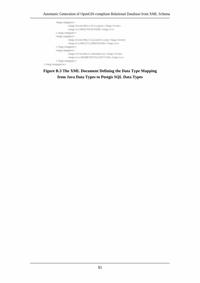
Automatic Generation of OpenGIS-compliant Relational Database from XML Schema
81
<map:mapper> <map:from>MultiPolygon</map:from>
<map:to>MULTIPOLYGON</map:to> </map:mapper> <map:mapper>
<map:from>MultiLineString</map:from> <map:to>MULTILINESTRING</map:to> </map:mapper>
<map:mapper> <map:from>MultiGeometry</map:from> <map:to>GEOMETRYCOLLECTION</map:to>
</map:mapper> </map:mappers>
Figure B.3 The XML Document Defining the Data Type Mapping
from Java Data Types to Postgis SQL Data Types
Automatic Generation of OpenGIS-compliant Relational Database from XML Schema
82
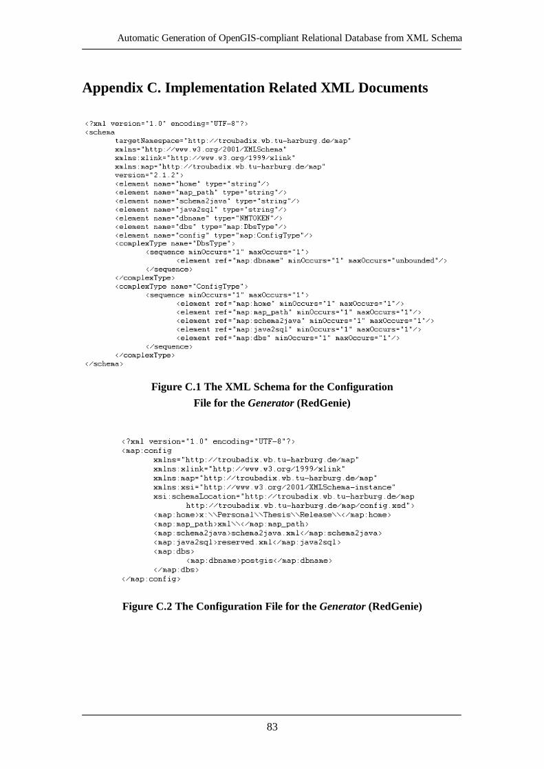
Automatic Generation of OpenGIS-compliant Relational Database from XML Schema
83
7.
Appendix C. Implementation Related XML Documents
Figure C.1 The XML Schema for the Configuration
File for the Generator (RedGenie)
Figure C.2 The Configuration File for the Generator (RedGenie)

Automatic Generation of OpenGIS-compliant Relational Database from XML Schema
84
Figure C.3 The XML Schema for the Mapping Process Report Generation

Automatic Generation of OpenGIS-compliant Relational Database from XML Schema
85
<?xml version="1.0" encoding="UTF-8"?> <report
xmlns=http://troubadix.wb.tu-harburg.de/map xmlns:xlink=http://www.w3.org/1999/xlink xmlns:map=http://troubadix.wb.tu-harburg.de/map
xmlns:xs=http://www.w3.org/2001/XMLSchema xmlns:gml=http://www.opengis.net/gml xmlns:xsi=http://www.w3.org/2001/XMLSchema-instance
xmlns:buenz=http://wb.tuhh.de/buenz xsi:schemaLocation="http://troubadix.wb.tu-harburg.de/map http://troubadix.wb.tu-harburg.de/map/report.xsd">
<table> <from>buenz:Buenzau_nutzung</from> <to>Buenzau_nutzung</to>
<attribute null="true"> <from>buenz:AREA</from> <to>AREA</to>
<dataType> <schema name="xs:double" /> <java name="java.lang.Double" />
<sql name="FLOAT8" /> </dataType> </attribute>
<attribute null="true"> <from>buenz:PERIMETER</from> <to>PERIMETER</to>
<dataType> <schema name="xs:double" /> <java name="java.lang.Double" />
<sql name="FLOAT8" /> </dataType> </attribute>
<attribute null="true"> <from>buenz:NUTZUNG_</from> <to>NUTZUNG_</to>
<dataType> <schema name="xs:int" /> <java name="java.lang.Integer" />
<sql name="INTEGER" /> </dataType> </attribute>
<attribute null="true"> <from>buenz:NUTZUNG_ID</from> <to>NUTZUNG_ID</to>
<dataType> <schema name="xs:int" /> <java name="java.lang.Integer" />
<sql name="INTEGER" /> </dataType> </attribute>
<attribute null="true"> <from>buenz:NS</from> <to>NS</to>
<dataType> <schema name="xs:int" /> <java name="java.lang.Integer" />
<sql name="INTEGER" /> </dataType> </attribute>
<attribute null="true"> <from>buenz:BRD</from> <to>BRD</to>
<dataType> <schema name="xs:int" /> <java name="java.lang.Integer" />
Automatic Generation of OpenGIS-compliant Relational Database from XML Schema
86
<sql name="INTEGER" /> </dataType>
</attribute> <attribute null="true"> <from>buenz:SZENE</from>
<to>SZENE</to> <dataType> <schema name="xs:int" />
<java name="java.lang.Integer" /> <sql name="INTEGER" /> </dataType>
</attribute> <attribute null="true"> <from>buenz:SPHEROID</from>
<to>SPHEROID</to> <dataType> <schema name="xs:string" />
<java name="java.lang.String" /> <sql name="VARCHAR" size="128" /> </dataType>
</attribute> <attribute null="true"> <from>buenz:TKNR</from>
<to>TKNR</to> <dataType> <schema name="xs:string" />
<java name="java.lang.String" /> <sql name="VARCHAR" size="128" /> </dataType>
</attribute> <attribute null="true"> <from>buenz:NS1</from>
<to>NS1</to> <dataType> <schema name="xs:int" />
<java name="java.lang.Integer" /> <sql name="INTEGER" /> </dataType>
</attribute> <attribute null="true"> <from>buenz:NS2</from>
<to>NS2</to> <dataType> <schema name="xs:int" />
<java name="java.lang.Integer" /> <sql name="INTEGER" /> </dataType>
</attribute> <attribute null="true"> <from>buenz:NS3</from>
<to>NS3</to> <dataType> <schema name="xs:int" />
<java name="java.lang.Integer" /> <sql name="INTEGER" /> </dataType>
</attribute> <attribute null="true"> <from>buenz:NUTZUNG</from>
<to>NUTZUNG</to> <dataType> <schema name="xs:string" />
<java name="java.lang.String" /> <sql name="VARCHAR" size="128" /> </dataType>
</attribute> <geometry dbname="test" srid="31467" dimension="2">

Automatic Generation of OpenGIS-compliant Relational Database from XML Schema
87
<from>gml:the_geom</from> <to>the_geom</to>
<geomType> <schema name="gml:MultiPolygonPropertyType" /> <java name="MultiPolygon" />
<sql name="MULTIPOLYGON" /> </geomType> </geometry>
</table> </report>
Figure C.4 The Report File for the Buenzau_nutzung
Relational Database Schema Definition Generation

Automatic Generation of OpenGIS-compliant Relational Database from XML Schema
88
Automatic Generation of OpenGIS-compliant Relational Database from XML Schema
89
References
[XML04] Extensible Markup Language (XML). http://www.w3.org/XML/.
Last visited: March 05, 2004.
[XSD04] XML Schema. http://www.w3.org/XML/Schema.
Last visited: March 12, 2004.
[JDBC04] J2EE JDBC Technology. http://java.sun.com/products/jdbc/.
Last visited: March 15, 2004.
[DOM04] Document Object Model (DOM). http://www.w3.org/DOM/.
Last visited: January 20, 2004.
[XSPY04] XMLSpy 2004. Relational Database Integration.
http://www.altova.com/features_database.html.
Last visited: February 23, 2004.
[ORCL04] XML Technology Center. Oracle Technology Center.
http://otn.oracle.com/tech/xml/index.html
Last visited: February 23, 2004.
[NET04] Microsoft .NET. http://www.microsoft.com/net/.
Last visited: February 23, 2004.
[XSDB04] Project: Manage DB Schema using XSD: Summary. SourceForge.net.
http://sourceforge.net/projects/xsd2db/
Last visited: February 23, 2004.
[JAVA04] Java Technology. Products & Technologies. Sun Microsystems.
http://java.sun.com/.
Last visited: March 15, 2004.
[OGC04] Open GIS Consortium (OGC). http://www.opengis.org/.
Last visited: March 18, 2004.
[SFSv1.1] Open GIS Simple Features Specification for SQL Revision 1.1.
OpenGIS Specification 05/99. Open GIS Consortium, Inc. 1999.
http://www.opengis.org/docs/99-049.pdf
[MaHu02] Matthes, Prof. Dr. Florian. Hupe, Parick. Software Architectures.
Layered Architectures and Persistence Management. Lecture Slides.
STS, TUHH. 2002.
[SiSt02] Singh, Inderjeet. Stearns, Beth. Johnson, Mark. Designing Enterprise
Applications with the J2EE Platform, Second Edition. Addison-Wesley
03/02. Sun Microsystems, Inc. 2002.
[XSDp1] XML Schema Part 1: Structures. W3C Recommendation 05/01. W3C
2001. http://www.w3.org/TR/xmlschema-1/
[GMLv2.1] OpenGIS Geography Markup Language (GML) Implementation
Specification Version 2.1.2. OpenGIS Implementation Specification

Automatic Generation of OpenGIS-compliant Relational Database from XML Schema
90
09/02. OpenGIS Consortium, Inc. 2002.
http://www.opengis.org/docs/02-069.pdf
[XPATHv1] XML Path Language (XPath) Version 1.0. W3C Recommendation
11/99. W3C 1999. http://www.w3.org/TR/xpath
[XLINKv1] XML Linking Language (XLink) Version 1.0. W3C Recommendation
06/01. W3C 2001. http://www.w3.org/TR/xlink/
[DGREE04] Deegree – OpenGIS Specifications implementation initiative. GIS and
Remote Sensing Unit of the Department of Geography, University of
Bonn, and lat/lon. http://deegree.sourceforge.net/
Last visited: February 23, 2004
[SQL01] Melton, Jim. Simon, Alan. SQL:1999 – Understanding Relational
Language Components. Morgan Kaufmann 2001
[JDOM04] JDOM Project. http://www.jdom.org/. Last visited: February 30, 2004
[SAX04] Simple API for XML (SAX). http://www.saxproject.org/.
Last visited: January 20, 2004
[GEOS04] The GeoServer Project. The Open Internet Gateway for Geographic
Data. http://geoserver.sourceforge.net/html/index.php.
Last visited: February 23, 2004
[WFSv1.0] Web Feature Service Implementation Specification Version 1.0.0.
OpenGIS Implementation Specification 09/02. Open GIS Consortium,
Inc. 2002. http://www.opengis.org/docs/02-058.pdf
[SHP98] ESRI Shapefile Technical Description. ESRI White Paper 07/98.
Environmental Systems Research Institute (ESRI), Inc. 1998.
http://www.esri.com/library/whitepapers/pdfs/shapefile.pdf
[WFD03] Introduction to the New EU Water Framework Directive. European
Commission 2003. http://europa.eu.int/comm/environment/water/water-
framework/overview.html
[GIS04] Geographical Information Systems (GIS). http://www.gis.com/.
Last visited: February 30, 2004
[XSINT01] W3C XML Schema Published as a W3C Recommendation. Cover
Pages 05/01. OASIS 2001.
http://xml.coverpages.org/ni2001-05-03-c.html
[XSDp2] XML Schema Part 2: Datatypes. W3C Recommendation 05/01. W3C
2001. http://www.w3.org/TR/xmlschema-2/
[XSDp0] XML Schema Part 0: Primer. W3C Recommendation 05/01. W3C
2001. http://www.w3.org/TR/xmlschema-0/
[XSLTv1.0] XSL Transformations Version 1.0. W3C Recommendation 11/99. W3C
1999. http://www.w3.org/TR/xslt