Embed Size (px)
Citation preview
August 7 Dale ScVice PreThe San14565 VSanta F Bruce DBiologicThe San14565 VSanta F Bill MolleArimol G4173 MaRancho Bill MolleMeadow4173 MaRancho RESPOGROUPARROW Thank ythe Lahocomplet 1. Gene
initiaassudifferbasereconmethwate
7, 2013
hneebergeesident Envnberg GrouValley View e Springs,
D. Eilerts al Service M
nberg GrouValley View e Springs,
er, PresideGroup, Inc. aritime RoaPalo Verde
er, Presidewbrook Cedaritime RoaPalo Verde
NSE TO DP, INC. ANDWHEAD, SA
you for provontan Wateed its revie
eral Comml framework
umption tharent consult
ed upon limnnaissancehods/techniers on the th
r, PG vironmentalp Avenue, SCA 90670
Manager p Avenue, SCA 90670
nt
ad es, CA 902
nt dar, Inc. ad es, CA 902
RAFT SURD MEADOWAN BERNA
viding the Der Board (Ww and has
ment – Watek for fine-tut surface wtant were aited informa
e activities. ques for idehree parcel
Services
uite Z
uite Z
75
75
RFACE WAWBROOK CARDINO CO
raft SurfaceWater Board
the followin
er Board stuning wetlan
water featureaccurate. Uation, none Thereforeentifying thes needs to
ATER DELINCEDAR, INOUNTY, WD
e Water Ded) staff to reng commen
taff found thnd habitat les depicted
Unfortunatee of which w, additionale locations be included
NEATION WNC. PROPEDID NO. 6B
elineation Weview and cnts.
he Draft Woocations, b
d in previouly, the surfa
was obtaine informatioand extent
d in the Fin
WORK PLAERTIES, LAB36C36343
Work Plan (Wcomment. S
ork Plan to based upons submittalace water lo
ed through fn regardingt of all pre-p
nal Work Pla
AN, ARIMOAKE 33
Work Plan)Staff has
be a good the ls preparedocations wefield g project surfan.
OL
) for
d by ere
face

Dale Schneeberger, P.E. - 2 - Bruce D. Eilerts Bill Moller 2. Page 3, Section 1, 1st Paragraph – The historical account provided implies that
there has been little activity since the initial unauthorized surface water impacts in 2011/2012. Water Board staff recommends revising the third sentence of the paragraph to state that the Work Plan is being developed as part of an effort to restore the affected surface waters. The restoration effort has been required through a Cleanup and Abatement Order (CAO) issued by the Water Board and a Notice of Violation issued by the California Department of Fish and Wildlife.
3. Page 3, Section 2.1, 1st Paragraph – Water Board staff finds it acceptable to
identify site conditions existing “before 2011” as “pre-project” conditions for purposes of the Work Plan. However, staff recommends revising the second sentence or Table 1 to indicate that all three parcels have continuously been under the ownership of either Arimol Group, Inc. or Meadowbrook Cedar, Inc. beginning May 31, 2011. As currently presented, it appears that the unauthorized activities discussed in Section 1 were conducted on the parcels when Arimol Group, Inc. and Meadowbrook Cedar, Inc. did not own two of the three parcels, which was not the case.
4. Page 4, Section 2.2, 2nd Paragraph – This paragraph identifies the resources/data
used in the preliminary data gathering and synthesis steps identified in the 1987 Comprehensive Protocols. Water Board staff expects that the following additional resources will also be incorporated into the preparation of the Final Work Plan, or an explanation of why they were not.
a. Water Board staff comments regarding PMC’s April 2012 and July 2012
submittals for the Development Impacts Report and Surface Water Restoration Plan.
b. Historical site surveys performed by Chris Ehe prior to the 2011/2012 surface
water impacts, as discussed by Bill Moller during the June 14, 2013 site visit. These surveys could provide additional critical information regarding the “pre-project” locations and extent of the surface waters on the three parcels.
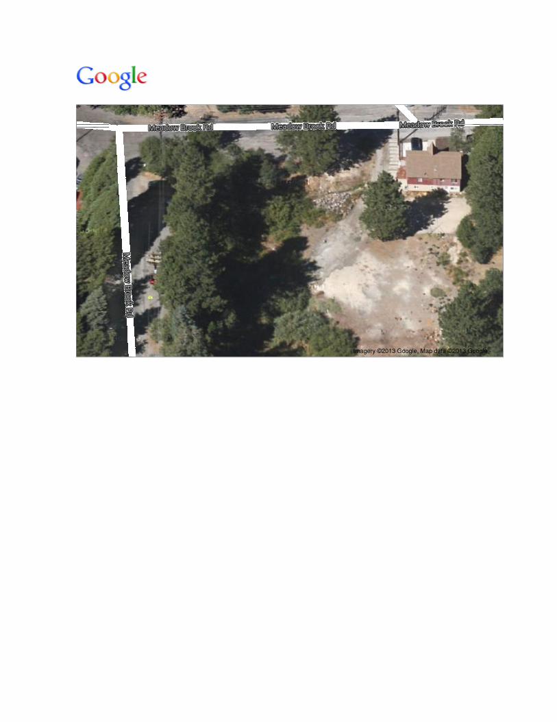
c. Additional aerial photography resources (e.g., Google Earth, Google Maps) that provide improved views of the pre-project and more recent site conditions, compared to the view provided in Figure 1. Water Board staff has enclosed examples of such resources.
5. The possibility of historical surface waters being present beneath the fill materials that pre-date 2011 (the “ball field” area) and the possibility of restoring those surface waters and receiving credit toward mitigation requirements were discussed during the June 14, 2013 site visit. The Draft Work Plan does not include any plans to investigate the conditions beneath these fill materials. While such investigative work could be completed at a later date, Water Board staff recommends that the Final Work Plan include investigative activities to assess the soil and hydrologic conditions beneath these fill materials. Doing so could facilitate making additional progress this fall towards satisfying mitigation requirements.
Dale Schneeberger, P.E. - 3 - Bruce D. Eilerts Bill Moller 6. Pages 4 and 5, Sections 2.2 and 2.2.1 – Statements in the second paragraph of
Section 2.2 and the first paragraph of Section 2.2.1 indicate that the primary purpose of the field work is to better define estimated wetland boundaries. The proposed CAO requires that all pre-project surface waters, not just wetlands, be delineated. Staff expects that the Final Work Plan will identify investigative techniques for delineating the pre-project locations and extent of the springs, creeks, and spring-fed open-water channels that were impacted in 2011 and 2012. Staff suspects that many of the techniques proposed for identifying the wetlands will be effective at identifying the other impacted surface waters.
7. Page 5, Table 2 and Page 6, Figure 1 – The number, locations, and spacing of the
proposed transects does not meet the criteria specified by the Army Corps of Engineers’ 1987 Wetlands Delineation Manual (Section E, pages 61-73). Water Board staff agrees that the Section B protocol is a necessary first step, however, given the extent and nature of the surface water disturbances, it is also necessary to incorporate Sections E and F of the 1987 Wetlands Delineation Manual, in addition to Section 5 of the May 2010 Regional Supplement for Western Mountains. The Draft Work Plan states the purpose of the transects described in Table 2 and illustrated in Figure 1 are to verify the locations depicted in PMC’s April 2012 and July 2012 submittals. However, Water Board staff understands that PMC’s depictions were based upon limited information, none of which was obtained through any field reconnaissance. Therefore, staff does not believe these surface water locations to be “known with some confidence.” Water Board staff has previously provided comments criticizing the limited basis for PMC’s surface water depictions. Staff expects the Final Work Plan to follow Directive C.2 of the proposed CAO, which at a minimum, includes following the protocols described by the applicable portions of Sections E and F of the 1987 Wetlands Delineation Manual, and the applicable sections of the May 2010 Regional Supplement for Western Mountains. Staff is also willing to consider an explanation of why you may believe that portions of the documents referenced by the proposed CAO do not apply and/or why other surface water delineation protocols may be more applicable to the conditions at the three parcels. Additionally, staff understands that it may be necessary to augment what the above-referenced manuals require with some of, if not all, the transects currently shown in Figure 1, in order to fully delineate all the pre-project surface waters on the three parcels.
8. Page 6, Figure 1 – The locations of the north and south springs and associated
open-water channels/flow paths have been a point of dispute, as was discussed during our June 14, 2013 site visit. It is unclear in the Draft Work Plan how you intend to determine the locations, extent, and nature of these surface waters. The pre-project figures staff has enclosed with this letter show the southern spring’s outflow area to broaden out in an easterly direction as it flows towards the creek, rather than a narrow channel as depicted in Figure 1 of the Draft Work Plan. The location and extent of the southern spring’s outflow area shown in staff’s enclosed figures appears to place much of this surface water under the existing home and/or its concrete patio. Staff has yet to see an aerial photo or other figure that clearly

Dale Schneeberger, P.E. Bruce D. Eilerts
- 4-
Bill Moller
depicts the location of the northern spring; however, staff has heard different ideas from different sources. Staff expects the Final Work Plan to clearly describe the methods/techniques you intend to use to identify the actual pre-project locations and extent of both springs and the open-water channels or outflow areas they supported.
9. Page 6, Figure 1-There are two surface water features that flow onto Parcel1: one near the middle of its southern boundary, and a second along its eastern boundary. Both were tributary to the creek that diagonally crosses Parcel1. As depicted in Figure 1, these surface water features are either not shown (southern boundary drainage feature) or are shown to terminate on the site (eastern boundary drainage feature). Water Board staff expects the Final Work Plan to include methodologies/techniques to delineate the pre-project locations and extent of these surface water features.
Water Board staff believes incorporating, staff's expectations and recommendations into the Final Work Plan will result in a successful surface water delineation effort when the Work Plan is implemented. Staff is available to discuss its expectations and recommendations to facilitate your efforts to restore the surface waters on the three parcels.
Please contact Jan Zimmerman at (760) 241-7376 or Scott C. Ferguson at (530) 542-5432, if you have any questions regarding these matters. They will coordinate with other Water Board staff in responding to your questions and comments.
c Curtis, P.E. Acting Assistant Executive Officer
Enclosures: 1) 2) 3) 4)
Cc (w/enclosures):
Google Earth Image (March 21, 2013), Looking North Google Earth Image (March 21, 2013), Looking West Google Maps Image (Pre-project conditions), Looking North Google Maps Image Pre-project conditions), Looking West
Edith Read, PhD/E. Read and Associates, Inc. Scott A. Lane, Lane & McGowan, LLP Joanna Gibson, California Dept. of Fish and Wildlife Shannon L. Pankratz, U.S. Army Corps of Engineers Terri Aahhal, San Bernardino Co., Land Use Services Department Anna Kathryn Benedict, SWRCB, Office of Enforcement Kim Niemeyer, SWRCB, Office of Chief Counsel Patty Z. Kouyoumdjian, Lahontan Regional Water Quality Control Board Doug Smith, Lahontan Regional Water Quality Control Board Richard Booth, Lahontan Regional Water Quality Control Board Jan Zimmerman, Lahontan Regional Water Quality Control Board Lisa Scoralle, Lahontan Regional Water Quality Control Board
SCF/adw/T: Arimoi·Response to Draft Delineation Plan (8·6·2013) File: T:/ Arimoi·Response to Draft Delineation Plan

feet
meters
100
40

feet
meters
100
40

Imagery ©2013 Google, Map data ©2013 Google -
Imagery ©2013 Google, Map data ©2013 Google -


![François Molle G-eau · Guich molle IRD [Sélectionnez la date] G-eau Conflicting Policies: Agricultural Intensification vs. Water Conservation in Morocco François Molle](https://img.dokumen.tips/doc/110x75/5e1aaba4ebdd011d0c4113b9/franois-molle-g-eau-guich-molle-ird-slectionnez-la-date-g-eau-conflicting.jpg)


![4173 7Y07 IELTShbk_body [prf5]](https://img.dokumen.tips/doc/110x75/586cc1fd1a28ab55088bdd04/4173-7y07-ieltshbkbody-prf5.jpg)


![[4173]-101 - Vidyarthiplus](https://img.dokumen.tips/doc/110x75/61d6e0e3f9ec18156175b586/4173-101-vidyarthiplus.jpg)