Embed Size (px)
Citation preview

ATTACHMENTS:Description TypeMinutes of June 22, 2016 MinutesHighway Commissioner's Report ReportTransit Report ReportPlanning and Parks Department Report ReportCost Share Contracts Report
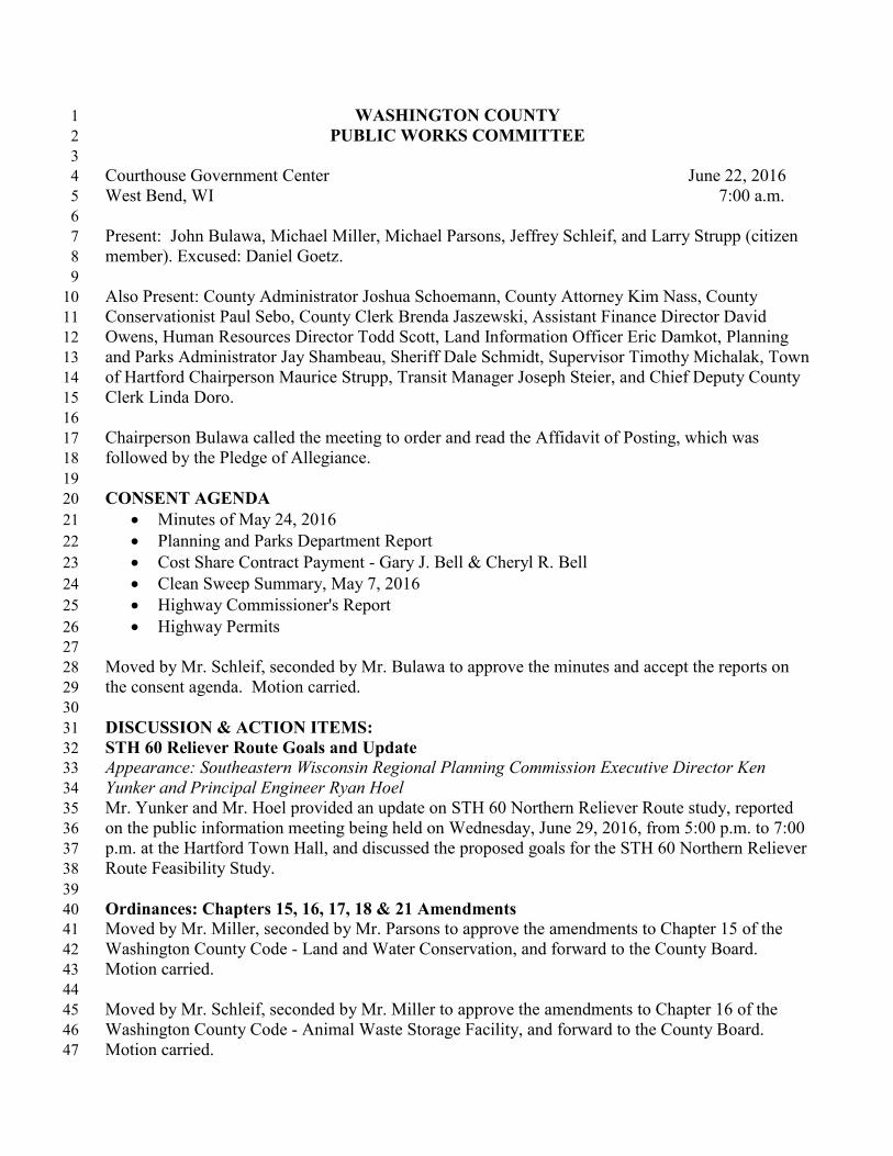
WASHINGTON COUNTY 1 PUBLIC WORKS COMMITTEE 2
3 Courthouse Government Center June 22, 2016 4 West Bend, WI 7:00 a.m. 5 6 Present: John Bulawa, Michael Miller, Michael Parsons, Jeffrey Schleif, and Larry Strupp (citizen 7 member). Excused: Daniel Goetz. 8 9 Also Present: County Administrator Joshua Schoemann, County Attorney Kim Nass, County 10 Conservationist Paul Sebo, County Clerk Brenda Jaszewski, Assistant Finance Director David 11 Owens, Human Resources Director Todd Scott, Land Information Officer Eric Damkot, Planning 12 and Parks Administrator Jay Shambeau, Sheriff Dale Schmidt, Supervisor Timothy Michalak, Town 13 of Hartford Chairperson Maurice Strupp, Transit Manager Joseph Steier, and Chief Deputy County 14 Clerk Linda Doro. 15 16 Chairperson Bulawa called the meeting to order and read the Affidavit of Posting, which was 17 followed by the Pledge of Allegiance. 18 19 CONSENT AGENDA 20
Minutes of May 24, 2016 21 Planning and Parks Department Report 22 Cost Share Contract Payment - Gary J. Bell & Cheryl R. Bell 23 Clean Sweep Summary, May 7, 2016 24 Highway Commissioner's Report 25 Highway Permits 26
27 Moved by Mr. Schleif, seconded by Mr. Bulawa to approve the minutes and accept the reports on 28 the consent agenda. Motion carried. 29 30 DISCUSSION & ACTION ITEMS: 31 STH 60 Reliever Route Goals and Update 32 Appearance: Southeastern Wisconsin Regional Planning Commission Executive Director Ken 33 Yunker and Principal Engineer Ryan Hoel 34 Mr. Yunker and Mr. Hoel provided an update on STH 60 Northern Reliever Route study, reported 35 on the public information meeting being held on Wednesday, June 29, 2016, from 5:00 p.m. to 7:00 36 p.m. at the Hartford Town Hall, and discussed the proposed goals for the STH 60 Northern Reliever 37 Route Feasibility Study. 38 39 Ordinances: Chapters 15, 16, 17, 18 & 21 Amendments 40 Moved by Mr. Miller, seconded by Mr. Parsons to approve the amendments to Chapter 15 of the 41 Washington County Code - Land and Water Conservation, and forward to the County Board. 42 Motion carried. 43 44 Moved by Mr. Schleif, seconded by Mr. Miller to approve the amendments to Chapter 16 of the 45 Washington County Code - Animal Waste Storage Facility, and forward to the County Board. 46 Motion carried. 47

Public Works Committee June 22, 2016 Page 2 of 3
Moved by Mr. Miller, seconded by Mr. Schleif to approve the amendments to Chapter 17 of the 1 Washington County Code - Erosion Control and Stormwater Management, and forward to the 2 County Board. Motion carried. 3 4 Moved by Mr. Parsons, seconded by Mr. Schleif to approve the amendments to Chapter 18 of the 5 Washington County Code - Nonmetallic Mining Reclamation, and forward to the County Board. 6 Motion carried. 7 8 Mr. Strupp was excused at 7:59 a.m. 9 10 Moved by Mr. Schleif, seconded by Mr. Parsons to approve the amendments to Chapter 21 of the 11 Washington County Code - Planning and Parks, including the clarifications discussed, and forward 12 to the County Board. Motion carried. 13 14 Bridge Inspection Memorandum of Understanding (MOU) and Consulting Services 15 Mr. Schoemann discussed entering into an MOU with Ozaukee County to prepare a joint Request 16 for Proposal to contract for bridge inspection services. The Committee requested clarification on the 17 County's portion of the bridge inspection services estimate and impact to the local municipalities. A 18 resolution will be brought back to the Committee. 19 20 Land Information Plan Amendment #1 - On-Line Access to Scanned Documents 21 Moved by Mr. Miller, seconded by Mr. Schleif to adopt Land Information Plan Amendment #1 - 22 On-Line Access to Scanned Documents and increase the 2016 retained fees budget by $16,200 to 23 fund a project to upgrade software that publishes scanned documents to the Internet. Motion 24 carried. 25 26 Ordinance: Staffing Plan Changes - Planning and Parks - Golf and Park Division 27 Moved by Mr. Miller, seconded by Mr. Schleif to amend the ordinance amendment to §7.02 and 28 §7.03 of the Washington County Code relating to the Washington County Staffing Plan - Planning 29 and Parks Department-Golf and Park Division as follows: 1) Page 1, Line 33, change the Golf 30 Course Supervisor position FLSA designation to non-exempt; 2) Page 1, Line 35, change the Park 31 Foreman position FLSA designation to non-exempt; and 3) Page 1, Line 37, retain one full-time 32 Park Supervisor position, Pay Grade 5. Motion carried. 33 34 Moved by Mr. Miller, seconded by Mr. Schleif to approve the ordinance amendment as amended to 35 §7.02 and §7.03 of the Washington County Code relating to the Washington County Staffing Plan - 36 Planning and Parks Department-Golf and Park Division as follows: 1) eliminate the Assistant 37 Administrator for Golf and Parks position, Pay Grade 13; 2) change the Assistant Golf Course 38 Supervisor title to Golf Course Supervisor, increase the Pay Grade from Pay Grade 5 to Pay Grade 39 7, with a FLSA designation of non-exempt; 3) increase the Pay Grade of the Golf Course 40 Superintendent position from Pay Grade 10 to Pay Grade 12; 4) add one full-time Park Foreman 41 position, Pay Grade 7, with a FLSA designation of non-exempt; 5) add one full-time Park 42 Superintendent position, Pay Grade 12; and 6) decrease the full-time Park Supervisor positions from 43 two to one, Pay Grade 5, and forward to the County Board. Motion carried. 44 45

Public Works Committee June 22, 2016 Page 3 of 3
Duties and Responsibilities of the Planning and Parks Department 1 Mr. Shambeau gave an overview of the duties and responsibilities of the Planning and Parks 2 Department. 3 4 Establish Highway Shop and Route Tour Date 5 The Highway Shop and Route Tour is scheduled for Tuesday, July 19, 2016, at 12:30 p.m. 6 7 Resolution: Revised Relocation Order - CTH C (American Eagle Drive to CTH Z) 8 Moved by Mr. Miller, seconded by Mr. Parsons to approve a resolution for a Revised Relocation 9 Order - CTH C (American Eagle Drive to CTH Z), and forward to the County Board. Motion 10 carried. 11 12 Resolution: Resolution Supporting the Wisconsin Department of Transportation Request to 13 Transfer Federal Congestion Mitigation and Air Quality Funds (CMAQ) from the Federal 14 Highway Administration to the Federal Transit Administration 15 Moved by Mr. Schleif, seconded by Mr. Miller to approve a resolution supporting the transfer of 16 CMAQ funds from the Federal Highway Administration to the Federal Transit Administration, and 17 forward to the County Board. Motion carried. 18 19 NEXT MEETING DATE 20 The Public Works Committee will meet on Tuesday, July 19, 2016, at 12:30 p.m. and Wednesday, 21 July 27, 2016, at 7:00 a.m. 22 23 ADJOURNMENT 24 Mr. Bulawa adjourned the meeting at 8:57 a.m. 25 26 27 28
Brenda J. Jaszewski, County Clerk 29

900 Lang Street, West Bend, WI 53090-2666 PHONE (262)335-4435 FAX (262)335-4439
EMAIL [email protected]
TO: Public Works Committee FROM: Scott M. Schmidt, PE, PLS, Highway Commissioner / County Surveyor SUBJECT: Agenda Item - Commissioner Update DATE: July 27, 2016 Staffing:
- One Highway Laborer is retiring August 3, 2016, position posted. - One Highway Laborer is resigning effective July 27, 2016
Construction Projects:
- CTH D Bridge Replacement ½ mile East of Kohlsville; Construction started July 7, completion date September 2, 2016 – CTH D will be closed throughout project.
- Paving Projects on CTH U, CTH D, CTH I, CTH XX, CTH HH substantially completed by June 30th, 2016
Maintenance Projects:
- Deer pick up – state halted pick-up on local roads February 29, working on insurance for contract
- Chip Seal projects completed on CTH Y, CTH Q, CTH M, and STH 83 June 20-24th, 2016.
Equipment: - Bids received July 13th for fork lift - Cab Broom Accident during chip sealing, operator and driver unhurt.
Events:
- Save the dates, Winter Road School January 16-18, 2017; Summer Road School June 5-7, 2017; Winter Road School January 15-17, 2018

Shared Ride Tax¡ Ridersh¡p
201 6
7.5177 734
7 9367.7447.506
000f)
00
46.828
-47.530À.^ A)A
-5,î 40/"
20157.7417 563
I 2107.8897.9468.0037.4367.519A )5)7 5?17 g4'l
-1.17894.358-1 20/"
20147.8057 701I 156I 174ai117.9697.9717.5058.0999,0007 2477 758
1.0799s.536
1 'lo/"
20138.2067 3^7
I 379
7.4447.7377.6437.4648.7327 6637 647
94.457
1 .51694.457
1 ^o/"
20128.0157 957a 5207 7944.2207.4737.1 567.8847.0718,6257 7916 435
92.941
-6.64692.9418.7o/o
20118.1 367 6RR
I 441a 4138_5968.2997.5818.4898.4648.518I 0407 922
99.587
5.60999.587
6.0%
20107.569I.JIZI 6637 6757.5307.8017.6697.6498.1247.9587 739I O89
93-978
3.92793.978
4.4%
20097.6067.0317 8907 5447.3407.5937.5487.1337.6008.0007 3277 399
90.051
-7.97790.051
-8.1o/o
20088.4868.341I ô89a 7?9
7.7438.2707.9378.4669.0987 ?197 3?7
s8.o28
41198.028
O.4Yo
20077.8377.678I 624I OIO8.8798_0207.634
7.9749.1308.107744?
21.77997.61728.7o/6
20065.7075.4326 2q85 7726.4955_8805.9106.9276.5597.4667.152ã ?4û
75 838
5.63975.838
8.Oo/d
20055.7105.8146 417
6.2025.4225.3125.655592961 6558755674
70.l9c
23770.199
0.3olo
20045655588366876099s8665742560555846120600354225256
69.962
6.97169.96211.10/,
2003
49255426s441s3225079514445475226595649705527
7.43762_99114.2o/"
200242364153447646694722443444594499455453364717¿aqq
55.154
2.49455_154
5.5o/o
2001431 639894559419547544454434245884124476243s33I tô
52 26{l
52.26016.1o/o
200034423591400133333581357634003887384542264271381 1
¿5 0ô4
I 08045.OO4
25-3o/o
1999
2458
30382805309731scl30533044327933103262
13 49635.92460.20/"
r99813101 458157515471s171804199217042434249821362449
22.428
22.424
JânrrâruFebruâruMarchAoril
.lune
.lulvAr roilslSêDfembêrOctoberNovemberDecember
TotalR¡ders overorevious vrYTD riderso/n chânoe YTIJ
Yeâr 10 Dâîe r¡dersh¡o cl¡fference between 2015 anri 2016 -858Percent lncrease or Decrease Com the Previous Year
-2.90À2.3o/o
0.20/"
-1.3Yo
-q qo/^
-100 00/.
-lo0 00¿
-100 00/"
-100.00/.-100.0%-100.0%
-0 80/.
-1 .8o/o
2.2o/o
0.4%-2.7Yo-0.3%0.4%
-î 90/"
-7 2o/n
-8.30/.3.20/õ
2.4o/o
-4 goa
4.50/.2.8%
-2.4%-1 .5o/o
7.1%3.0o/o
-1 8.0/"
I 50/"
3 10/"
-4.9o/o
1 .5o/o
2 40À
-7.40/"-6.8%7.5o/o
0.21o-0.4o/o
8.1To-3.1Yo5 60/"
1 204
-1 .60/.
18.8o/o
-'t 50/"
3.50/"
-9.80/o
-7.4o/o
4.4o/o-10.0%
-5.6%-7.1o/o
-1 6 50/"
1 30/"
-3.10/"
-1A.Ao/õ
7 5o/"
2.30/"
9_00/.
9.6%14.2o/o
6.4Yo
-1 .1o/o
11.0o/o4 20/"
7 0.0/"
39ø-2.10/"
-o 50/"
6 80/"
9.80/.1.20/õ
2.6o/o
2.7o/õ
1.60/o
7.2%6.9%
-ô 50/"
5 60/.
9.30/"
-10 40/"
-15 70/"
-2.50/"-13.1o/a
-1O.7o/o
-1.9o/o
-8.7o/ô
-10.1%-10.zo/a
-12.1o/oo 10/"
1.Oo/"
I 30/"
8,60/"
-6 20Â
9.0%-7 .4o/o
-3.5o/o
8.3o/o
4.1o/o6.2Yo
-0.4o/o
-9 70/"
-1 60Â
37.3o/ø41 30/"
37 00
38.80/"36.70;36.4o/o
29.2o/o
19.5o/.21.6Yo22.3%13 40/"
19 30/"
4.1o/o-6 60/"
-1 90/"
4.20/"4.70/"8.4o/o
11.3o/o
22.5o/o
10.6o/0
21.10k21.7o/ol0 00/"
1.OTo
-1 20/"
-4 0.0/"
-1 20/.
5.70/"
-6.2o/o
-5.20Â
1.3o/o
-3.1o/"
2.7o/o
8.4o/oI Oo/"
4.3Yo1Q 50/"
23 20/"
1? 10/"
'l.o,20/"
13.80Â8.90/"
22.8o/o
17 .10k0.80/"
9.1Yo
-4.9%
28.0%18.6%21 )o/"16 50/"
12 70/"
14.Sot
15.50/"
1.11
14.8o/o
I I ô-/ô
5.4Yo
12.8Yo
-1.9%4.10/o
-1 .8o/o
11 30/"
-0 8ol"
-0 50/"
1.80/"
-1.90/"10.40/ô
12.1o/o
8.4%29.7Yo
24.Oo/o
11.1Yo
13.9o/o25 90/"
3? 90/"
24 70Â
28.90/"18,Oo/"
7 .3o/ø
12.7o/o
1.9o/o
-0.9%
50.3%46.1%28.6%
9.7%27 70/"
15 50/"
7 90Á
27 30/"
26.30/"28.9o/a
29.Oo/o
16.8o/o
76.8o/o
bð -b'/ô
97.60/o
96.4o/oA4 9.0/"
71 70/"
58 10/"
78 70/^
25 10Â
31 30/.
55.Oo/ô
33.2o/o
JânFebl\ilarAor
lr rne
h rlv
Ar loSeô1
OctNovDec
1,393,141 Total Rides Ever

Thursday, July 7, 2016
Date by Month lune 2016
Washington County Shared Ride Taxi Ridership RepoftFrom 06/01 120L6 through 06130 120L6
Client TypeJune 2016
Adultch¡ldEA
EN
NEANENStudent
L,46913
1,354L,0783,082
226284
= L9.57o/o
= 0.L7o/o
= I8.04o/o
= L4.36o/o
= 4l.060/o= 3.Oto/o
= 3.78o/o
Transpoft Trips By ïmeJune 2016
O5AM-O6AMO6AM-O7AMOTAM-OBAM
OSAM-O9AM
OgAM-1OAM1OAM-114MlOPM-124M1lAM-12PM12PM-1PM1PM-2PM2PM-3PM3PM.4PM4PM.sPM5PM-6PM6PM-7PM7PM-BPMBPM-gPM9PM-1OPM
= 3.760/o
= 5.96%= 8.06%= 7.14o/o
= 8.29o/o
= 8.93%= 0.69%=6.49%= 6.93%= 6.05%= 11.87o/o
= 8.31o/o
= 6.120/o
= 3.88%= 2.24o/o
= 1.93%= 1.95%= 1.43o/o
28244760s536622670
5248752045489162445929t168L45146ro7
Total 7,506
Pay TypeJune 2016
Adultch¡ldDisabledElderlyStudentTransfers
1,30113
3,2722,337
283300
= L7.33o/o
= 0.17o/o
= 43.59o/o
= 3I.L4o/o
= 3.77o/o
= 4.00o/o
Purposelune 2016
EducationEmploymentMealMedicalPersonalShoppingSocial
0233
3,67445
2åq19
383843
= 0.00%= 3.10o/o
= 48.95o/o
= 0.60%= 30.72o/o
= 0.25o/o
= 5.10o/o
= 11.23o/o
Page 1 of I

Shared Ride Taxi Ridership Comparison ,20t3-20L6L0000
9000
8000
7000
6000
s000
4000
3000
2000
1000
ttop0Ê,
ort
Dec
7647
7758
794t
Nov
7663
7287
752L
-.r.|'---fl -_*
Oct
8732
9000
8252
Sept
7464
8099
75L9
Aug
7643
7505
7436
July
7737
797t
8003
June
7444
7969
7946
7506
-rf-__
May
8238
81LL
7889
7784
-f--
8379
8t74
8210
7936
Apr
:-Tf
Mar
7937
8L56
8337
8351
Feb
7367
770t7563
7734
-.----
Jan
8206
7805
7741
75L7
.2013a2014
f 2015
.20]6
IIrIII-IIII
-I
-II
-T
-I
---IrI-III
-IIIIT
-III
-lITIIITII
-III
-IrIIIIIITITII
-I
IIIIIIIIII
-I
--III
-II
-IIIIIIIIIIIIIITITII¡IIIIIIIII
t-Itl¡IIIIrIIIITTITI¡TI¡Ir-IrrtrlllIIITIIIII¡IIIIIIttItt¡TII
III¡I-¡TIIITIIIIIIII
IIIIIIIIITIIl¡IITIII

2016 Shared Ride Taxi
Shared Ride Taxi Fare Revenues
Shared Ride Taxi St. Bud
Shared Ride Taxi Aurora Medical Foundation
Shared Ride Taxi ADRC Mealsite
Shared Ride Taxi Fare
and Actual FARE Revenue
and Actual FARE Revenue
and Actual FARE Revenue
and Actual FARE Revenue
ProjectedAverage using
precedingmonths
$ 146,000.00$ 292.000.00$ 438,000.00$ 584,000.00$ 730,000.00$ 876,000.00$ 1,022,000.00
1,168,000.00$ 1 ,314,000.00$ 1,460,000.00$ 1,606,000.00$ 1,752,000.00
4.999.92Contract Expenses Year End (Contract Amount from Proiected)
Difference ActualSTS Contract
lnvoice Expenses vsContract Amount
$ (8.032.83)
$ {8.992.02)$ 2,614.37$ 3,153.16$ (1.757.56)
$ (3.780.20)
Total ContractAmount (Not the
Budgeted)
$ 14s,583.34$ 291,166.68$ 436.750.02$ 582.333.36$ 727,916.70$ 873,500.04$ r,0r9,083.38$ 1,164,666.72$ 1,310,250.06$ 1,455,833.40$ 1,601.416.74$ 1,747,000.08
Actual STSlnvoice Expenses
Totaled YTD
$ 137,550.51s 242,174.66$ 439.364.39$ 585,486.52s 726,159.14$ 869,719.84$ 869,719.84$ 869,719.84$ 869,719.84$ 869,719.84$ 869.719.84$ 869.719.84
Actual STSlnvoices per
Month
$ 137.550.51s 144,624.15$ 157.189.73s 146.122.13$ 140.672.62$ 143,560.70$
$
$
$
$
$
Month
JanFebMar\pr
MaYJuneJulyAuqSeptOctNovDec
ProjectedAverage using
precedingmonths
$ (22,200.00)
$ (44,400.00)s 166.600.00)s t88.800.00)s t111.000.00)s t133.200.00)$ t155.400.00)$ (177,600.00)
$ (199,800.00)
$ (222,000.00)
$ (244,200.00)Dec $ $ $
Fare r End from
Difference YTD vs.Budgeted
$ 307.58$ 4,728.41s 5.413.74$ 7.401.32s 11.820.65s 10.623.23
AverageBudgeted Fares
by Month
$ (24,583.33)
$ (49,166.66)
$ (73,749.99)
$ (98,333.32)
$ (122,916.65)$ fi47.499.981$ (172,083.31)
$ (196,666.64)
$ (221,249.971
$ (245,833.30)
$ (270,416.63)
Actual Fares YïD
$ Q4.275.751$ (44.438.25)
$ (68,336.25)
$ (90.932.00)
$ (111,096.00)
$ (136,876.75)
$ (136,876.7s)
$ (136,876.7s)
$ Í36.876.75)$ (136,876.75)
$ Í 36,876.75)
Actual FaresCollected per
Month
$ Q4.275.751$ (20.162.s0)
$ (23.898.00)
$ (22.595.75)
$ (20,r 64.00)$ (25,780.75)
$
$
$
$
$
Month
JanFebMarAprMavJuneJulvAuqSeptOctNov
$ (7.200.00)
ProjectedAverage using
precedingmonths
$ (720.00)
$ (1.440.00)
$ (2.160.00)
s (2.880.00)
$ (3.600.00)
s (4.320.00)
$ (s.040.00)
s (5.760.00)
$ (6.480.00)
s (7.920.00)
$ (8.640.00)
Difference YTD vs.Budgeted
(68.00)$(50.00)$
(120.00)$t70.00)$
2.00$144.00$
AverageBudgeted Fares
by Month
$ (750.00)
$ (1,500.00)
$ (2,250.00)
$ (3.000.00)
$ (3,750.00)
$ (4.500.00)
$ (5.250.00)
$ (6.000.00)
$ (6.750.00)
$ ø.500.00)$ (8.250.00)
$ (9,000.00)
$ (4,356.00)
$ (4,356.00)
$ (4,356.00)
$ (4,356.00)
$ (4,356.00)
YTD
(818.00)$$ í.550.00)$ (2,370.00)
$ (3,070.00)
$ (3.748.00)
$ (4.356.00)
$ (4.356.00)
$ (678.00)
$ (608.00)
$$
$$
$
$
Fare collectedper month
$ (818.00)
$ (732.00)
$ (820.00)
$ (700.00)
Seot
Month
JanFebMarAprMavJuneJulvAuo
OctNovDec
s t3.960.00)s (5.280.00)
$ (1,320.00)s 12.640.001
$ (6,600.00)
$ (7,920.00)
s (9,240.00)
$ (10,560.00)
$ (11,880.00)
$ (13,200.00)
$ (14,520.00)
$ (r 5,840.00)
ProjectedAverage using
precedingmonths
26.34$n*321$
Difference YTD vsBudgeted
1428.98ì$1480.64t$1588.30)$(675.96)$
$ (3,625.02)
$ (4,833.36)
$ (6,041.70)
$ (8.458.38)
$ (10,875.06)
$ (12.083.40)
$ (3,291.74\$ (14.500.08)
AverageBudgeted Fares
by Month
$ (1.208.34)
$ (2.416.68)
$ (7.250.04)
$ (9,666.72)
$ t4.054.00)$ (5.314.00)
$ t6.630.001s t7.926.001s t7.926.001
$ (7,926.00)$ (7.926.001
$ t7.926.001$ t7.926.001$ t7.926.00)
$ (r,r 82.00)$ (2,570.00)
YÏD
s {1.182.001$ (1.388.001
$ (1.484.00)
Fare collectedper month
$ 11.260.00ì$ t1.316.00)$ (1.296.00t
$
$
$
$$
Month
JanFebMarAPrMavJuneJulyAuqSeptOctNovDec
FARE
560.00640.00
1
ProjectedAverage using
precedingmonths
$ (240.00
$ (400.00
s (480.00
$o
$ (720.00
$ (800.00
$ (880.00
{3.30)$20.04$
Difference YTD vs.Budgeted
10.661$2.68$
(13.98)$1.36$
(83.34)$
$ (166.68)
$ (250.02)
$ (333.36)
$ (833.40)$ (750.06)
$ (e16.74)
AverageBudgeted Fares
by Month
$ (416.70)
$ {500.04)$ (583.38)
$ (666.72)
$ (1.000.08
84.00)
80.001
264.00332.00
480.00)480.00)
r 04.uu
420.001
480.00)
480.001480.001480.00)
$$
$
YTD
$$
$
$
$
$
$
$
$
(84.00)$(80.00)$
$ (100.00)(68.00)$(88.00)$(60.00)$
$
$
$$
$
$
Fare collectedper month
Sept
JulvAuq
Month
JanFebMarAprMavJune
OctNovDec
and
ProjectedAverage using
precedingmonths
$ (6.700.00
$ (13,400.00
$ (20,100.00
$ (26.800.00
$ (33.500.00)
$ (40.200.00)
$ (46,900.00)
$ (53,600.00)
$ (60,300.00)
$ (67,000.00)
$ (73,700.00)
Difference YTD vs.Budgeted
$ 1,656.00$ (r,008.00)$ (2,392.00)
$ (5,616.00)
$ (4,760.00)(8,384.00)$
AverageBudgeted Fares
by Month
$ (s,416.00)
$ fi0.832.00)$ {16.248.00)$ (21.664.00)
$ (27.080.0c
$ (32.496.0C
$ (37.912.00)
$ (43.328.00)
$ (48.7,14.00)
$ (54,160.00)
$ (59,576.00)
$ (64,992.00)
YTD
3,760.00)1 1,840.00)8,640.00)
27,280.00131,840.00),ñ aaô nn\/n Qan nnl
40,880.00)40.880.0010.880.00)
40.880.0010.880.001
$
s$$
$
$
$$
$
$$
$
Fare colfectedper month
$ (3.760.00)
$ (8.080.00)
$ (6.800.00)
$ (8.640.00'
$ (4.560.00)
$ (9.040.00t
$$
$
$$
$
Month
JanFebMarAprAav
JuneJulyAuqSeptOctNovDec
RevenueF
projected $actual $
17,252.04

Facility Management Central Fuel Work Sheet
2016 Central Fuel
$ 98,972.08$ 350,000.00$ (251 ,027.92)
$ 15,326.66$ 13,176.22$ 16,363.96$ 16,728.30$ 17,702.94$ 19,674.00$
$$$$
$$ 98,972.08
Yearly Total:2016 Budqeted:
Remaininq Difference YTD:
TotalGallons
8,840.968,976.899,352.598,813.348,567.918,528.73
53,080.42
DieselAMOUNT
$ 2,975.85$ 3,241.73$ 3,370.28$ 3,464.78$ 3,328.85$ 3,737.26$
$$$$$fi 20,118.75
DieselQUANTITY
1,672.62'1,949.38't ,914.09'1,909.78
1,682.461,762.87
10,891.20
UNLEADEDAMOUNT
$ 12,350.81
$ 9,934.49$ 12,993.68$ 13,263.52$ 14,374.09
$ 15,936.74$
$$$$$$ 78,853.33
UNLEADEDQUANTITY
7,168.347,027.517,438.506,903.566,885.456,765.86
42,189.22
MonthJANFEBMARAPRMAYJUNEJULYAUGSEPTOCTNOVDECTOTALS
ProjectedAverage using
previousmonths
$ 16,600.00$ 33,200.00$ 49,800.00$ 66,400.00$ 83,000.00$ 99,600.00$ 1 16,200.00$ 132,800.00$ 149,400.00$ 166,000.00$ 182,600.00$ 199,200.00
Difference YTDvs. Budgeted
$ ( 13.840.01 )
$ (29.830.46)
$ (42.633.17)
$ (55,071.54)
$ (66,535.27)
$ (76,027.94)
Budgeted
$ 29,166.67$ 58,333.34$ 87,500.01
$ I 16,666.68$ 145,833.35$ 175,000.02$ 204,166.69$ 233,333.36$ 262,500.03$ 291,666.70$ 320,833.37$ 350,000.04
YTD
$ 15,326.66$ 28,502.88$ 44,866.84$ 01,595.14$ 79,298.08$ 98,972.08$ 98,972.08$ 98,972.08$ 98,972.08$ 98,972.08$ 98,972.08$ 98,972.08
Actual - Month
$ 15,326.66$ 13,176.22$ 16,363.96$ 16,728.30$ 17,702.94$ 19,674.00$$$$$
$
JANFEBMARAPRMAYJUNEJULYAUGSEPTOCTNOVDEC
VSce0.041ses Year

WCCE Ridership
20167.9238.4648.5238,0737 6597 742
48.384
-53 42144.344-52-70/"
201 5
9.1 068.9009.5669.1757 913a 5328 3137.7798.5159.0657.7387.603
102.205
-a 134102.205
-7.40
24149.7949.5619.7509.809I 0758 953I 1324.4449.24110.0078.1428.43'1
1 10.33S
-5 7281 lo 339
-4.9%
201310.71010.26210.521r 0.3459,9648 680I 242s.4129.25310.5268.7118.441
116.067
-1 1 468116.067
-s.o%
201211 .41711.43611.97211.16411.36410 302I 91210.6909.698I 1 .8'15
s.9007.865
127.535
-16127 535
o.ooa
201110 3749.44511.88310.70210,94911,137I 321
lt48811 .11110.96810.6549.519
127.551
15.848127.551
14 20/"
2010I 0659.50510.31 1
9.4978.8029,1558,669I 0469.6549.8319.4288.740
111.703
5.245111.703
4 90/"
2009I 3499.32010.0209.5388.1 548.7338.5267 A32I 143s 4038.4088.O32
106.458
-4.900106.458
-4.4%
20087 9957.9437.9199.O17
8,9169.64110.6769,53910 724l1 5104.7328.746
1 1 1.358
19.6671 1 1.358
21.4o/o
2007
8,8557.7918.1567.6598.01 1
7.3146.8347.4807 (]43
8 5077.5686.473
s1.691
-3.17891.691-3.3o/o
2006746370128142740879037635726486934744949383066806
s4.869
22.28094.8693O-7o/o
2005
5679547355215887551 5
5136460159007673698072A66538
72.549
18.69472.58934.7%
20043701378548074469408143253978431 5
5252555347664863
53.8S5
19.06953.89554.8o/o
2003
287325182939235523122465266326653206364531043081
34.a26
7.00534.42625.2o/o
240222422056?14?253024351 973235522782353280924362208
27,A21
8.93327,42147.3o/o
2001'1041
9821251131217741 6071607I 831
1742220619391592
10.5418.88816.30/o
2000
1732063175457479777898351001
1015908794
a 347
#REF!4.347
JanuarvFebruarvMarchAnrilMavJuneJulvAuoustSeotemberOctoberNovemberDecember
TotalRiders overprevious yr
Year to f)aieo/"YTD
Yeer to Dete ridershio difference between 2016 and 2015 -4.808
Percent lncrease or Decrease from Year to Year Month2015-2016
-13.O0/.-4.9o/o
-10.9%-12.0%
-3.2%-9.3%
-100 00/"
-100 00/"
-100.0%-100.0%-100.0%-100.0%
2014-2015-7.Oo/.
-6.9%-1.90Â
-6.5%-12.8%-4.7%-9.0%-7 90/"
-7 90/"
-9.40/"-5.Oo/o
-9.8%
2013-2014-8.60/"
-6.80/.-7 .3o/o
-5.2%-8.9%¿.tto
-1.2Yo
-10.3T0
-o 10/"
-4.9oÂ
-6,50/"-o.1ô
2012.2013
-4.60/o
-10 90/"
-12.Oo/"7.3o/o
-6 20Â
-10.30/.
-12.10Â-7 .30/o
-12.3%
-6.8%-12.0%
2011-201210 10/"
21.10/"
o.7./"4.3o/o
-7.s%6.3%
-6.9%-12.7%
7 70/"
-7.10Â
-17.40/"
2010-201114.40
-o 604
15.20/"
12.70/"
24.4o/o
21.6%7.5%
27.0%15.1o/o
11.60/"13 00/"
8.goÂ
2 00/"
2.90Â
-o.40/.
7 .9o/o
4.80/o
I .7o/o
15.5o/o
5.6%4.6%
12.1o/o
8 80/"
2008-2009
17 30/"
26,50/"
5.80/.
-8.50/"-9.4o/o
-20.10Â-17.9o/o
-14.70/o
-18.3o/o
-8.2%
16.9%
2007-2008
31.80/,
56.20/.
27.50/.
52.3%35.3%15.4%35.1%
-9.7%2.O%
-2 90/"
17.704
11.30/
-14.Oo/"
-19.50/.-1O.4o/o
-8.9%-4.9%
2006-2007
18.7o/o
11.1%o ?o/"
3 40/"
1.404
-4.20/"
-5.S%
-8.20/"36.0%14.O%
4.1T0
2005-200655.9%42.4%37.7%30 10/"
45 30/"
42 40/^
48 50/"
26.80Â
52.9o/o
34.4o/o
200+200553.4Yo44.60h23.2%31.7%35.1o/o
18 80/"
15 70/"
36 70/"
46 10/"
25.70/"
2003-200428.8o/o
29.7%63.6%51.2%76.5o/o
75-5o/o
49.4%61.9%63 80/"
52.30
53_50/.
57 -80
2002-200328.1o/o
41.90/"
37.2%r6.8%
24.9%13.1%17 -0%36.3To29 80/"
27.4039.5%
2001-2002'115.40/"
1O9.4o/o
71.2%92-8%37.2%22.8%46.5%24.4o/o
35.1o/o
27.3%25 80/"
38.70/"
2000-2001501.70/"
376.70/"
294.60/o
140.7o/"
125.9o/"
64.5%103.7o/"
119.3%74-0%
117.3%1'13.5o/o
100 50/"
.lanFebMarAorMavJuneJulvAuoSeotOctNovDec
1,364,526 Total Rides

WCCE Ridership Comparison, 2013-20t612,000
11,000
10,000
9,000
8,000
7,000
6,000
5,000
4000
3,000
2,OOO
1,000
0
o
=aÊ
or¡È
--l-Þ-:
December
8,44!
8,43t
7,603
:*-:¡¡-.{==:::.-:::::i:::::-:æ:=
November
8,77L
8,L42
7,738
October
10,526
10,007
9,06s
September
9,253
9,24t
8,515
#G,..,=:=
August
9,4r2
8,444
7,779
July
9,242
9,t32
8,313
June
9680
8,953
8,532
7,742
May
9,964
9,O75
7,9r3
7,659
April
1o,345
9,809
9,175
8,O73
March
lo,52\9,750
9,s66
8,523
February
LO,262
9,s61
8,900
8,464
January
LO,7lO
9,794
9,106
7,923
f 2013
t2014r 2015
.2016

2016 WCCE (Riteway) Operating Expenses
MonthActual Riteway
lnvoices perMonth
Actual RitewayContract lnvoiceExpenses YTD
Amount based on7,900 hrs
Difference ActualRiteway Contractlnvoice Expenses
vs. ContractAmount
ProjectedAverage using
precedingmonths
Jan $ 106,374.33 $ 106,374.33 $ 117 ,841.67 $ (1 1,467.34 $ 1 10,500.00Feb $ 108,960.88 $ 215,335.21 $ 235,683.34 $ (20,348.13) $ 221,000.00Mar $ 1 19,793.96 $ 335,129.17 $ 353,525.01 $ (18,395.84) $ 331,500.00Apr $ 108,885.70 s 444,014.87 $ 471,366,68 $ (27.351.81) $ 442,000.00Mav s 106,748.44 $ 550,763.31 $ 589,208.35 $ (38,445.04) $ 552,500.00June $ 112,686.45 $ 663,449.76 $ 707,050.02 $ 43,600.26) 663,000.00July $ $ 663,449.76 $ 824,891.69 $ 773,500.00Auq $ $ 663,449.76 $ 942,733.36 $ 884,000.00Sept $ $ 663,449.76 $ 1,060,575.03 $ 994,500.00Oct $ $ 663,449.76 $ 1,178,416,70 $ 1 ,105,000 00Nov $ $ 663,449.76 $ 1,296,258.37 $ 1.2'15.500.00
Dec $ $ 663,449.76 $ 1.414,100.04 $ 1,326,000.00
Contract Expenses Year End (Contract Amount from Proiected) $ (88,100.04)
WCCE Fare Revenues
MonthActual FaresCollected per
MonthActual Fares YTD
Budgeted Faresby Month
DifferenceBudgeted vs.
Actual Fares YTD
ProjectedAverage using
precedingmonths
Jan $ (22,345.81) s (22,345.81\ $ (28,802.60) $ 6,456.79 $ (27,000.00)
Feb $ (31,066.78 $ (53,412.59) $ 57.605.20) $ 4,192.61 $ (54,000.00)
Mar $ (23,01 1.41) $ (76,424.00) $ (86,407.80) $ 9,983.80 $ (81,000.00)
Apr $ (26,211.96) $ (102,635.96 $ 115,210.40 s 12,574.44 $ (108,000.00)
Mav $ (36,251.33) $ ( 138,887.29) $ (144,013.00) $ 5,125.71 $ (135,000.00)
June $ (29,682.17) $ ( 168,569.46) $ (172,815.60 $ 4,24614 $ (162.000.00)
Julv $ $ ( 168,569.46) $ (201 ,618.20) $ (189,000.00)
Auq $ $ ( 168,569.46) $ (230,420.80 $ t216.000.00)iept $ $ ( 168.569.46) s (259,223.40\ $ (243,000.00)
Oct $ $ ( 168,569.46) $ (288,026.00) $ 270,000.00)Nov $ s ( 168.569.46) $ (316,828.60) $ (297,000.00)
Dec $ $ ( 168,569.46) $ (345,631.20) $ 324,000,00)
FARE Revenue Year End Difference 21from .20
WCCE Bus Wrap Revenues
MonthCollected per
MonthYTD
Budgeted Faresby Month
DifferenceBudgeted vs. YTD
ProjectedAverage using
precedingmonths
Jan $ (860.00) $ (860.00) $ (916.00) $ 56.00 $ (915.00)
Feb $ 903.00 $ 1,763.00 1.832.00) $ 69.00 $ (1,830.00)
Mar $ (989.00) $ (2,752.00) $ (2,748.00) $ (4.00) $ (2,745.00)
Apr $ 903.00 $ 3,655.00 3.664.00) $ 9.00 $ (3,660.00)
Mav $ (903.00) 4 558 $ (4,580.00) $ 22.00 $ (4,575.00)
June $ (946.00 $ 5,504.00 $ 5,496.00) $ (8.00) $ (5,490.00)
Julv $ $ (5,504.00) $ (6,412.00) $ (6,405.00)
Auq $ $ (5,504.00 $ 7,328.00) $ (7,320.00)
Sept $ $ (5,504.00) $ (8,244.00) $ (8,235.00)
Oct $ $ 5,504.00 9,160.00) $ (9,150.00)
Nov $ 5 504 $ (10,076.00) $ ( 10,065.00)Dec $ $ 5,504.00 10,992.00) $ ( 10,980.00)
Projected (66,456.84)
12.00$FARE Revenue Year E
$$

1
Planning and Parks Department Report
JULY 27, 2016
Planning Division:
Over 120 participants enjoyed the Wild About Parks Event at Ackerman’s Grove on June 25th. See attached sheet.
Working with team of staff to finalize the next Wild About Parks event: o Saturday, August 27, 2016 – Sandy Knoll 9:00 am – 2:00 pm. Activities include a
5K trail run, beach reopening, solar viewing, geocaching, dog agility demo, rocketry demo, guided trail hikes, recreational safety program and nature crafts.
o Currently looking for volunteers to help with the event, please contact me if interested.
Continued work on the Site Redevelopment Program: o Currently managing 12 projects with over 30 properties that have received EPA
Brownfield Assessment funding. o Completed an open records request for one of the EPA funded properties. o Drafted a resolution to apply for further EPA assessment funds.
Completed and printed the Washington County Park and Trail Map. This map identifies all publically accessible land and trails throughout the County.
Gearing up for the Multi-jurisdictional Comprehensive Plan for Washington County: 2050 o Finalized chapter consolidation and incorporation of previous plan amendments. o Finalized contract with SEWRPC for planning services.
Continued assisting the Emergency Management Office in development of the All Hazard Mitigation Plan for Washington County. There is a public meeting on Wednesday, Aug 10th 6:00 – 8:00 pm, Rooms 1113 A & B of the Public Agency Center.
Land and Water Conservation Division:
A model ordinance of the Erosion Control and Stormwater Management Chapter 17, was created and sent to all local governments for their consideration. Staff will be available to assist any community in converting the model for local adoption as well as being available to attend meeting to explain revisions.
Land Use Division:
Sanitary Permit & Shoreland Zoning Permit Revenue and Numbers REVENUE PERMITS
2016 (JAN – JUNE) $83,688.00 (28% +) 204 (19% +) 2015 (JAN – JUNE) $65,385.00 (6% +) 172 (12% +) 2014 (JAN – JUNE) $61,469.00 153

2
Administration Division:
Preparations are starting for the 2017 Planning and Parks Department budget submittal. Office activity is busy due to increased sanitary permit applications and related
processing work. County Park reservations are plentiful, and the on-line reservation system has been very
helpful to customers in reserving their shelters in a convenient, efficient manner.
Please review the Planning and Parks Department report and contact Jay Shambeau
[email protected] 262‐335‐4445 with any concerns.

The beaks and talons raptor program
introduced attendees to a variety of birds and
other animals!
June 25th at Ackerman’s Grove County Park
More than 45 participants of all ages took to the ropes and learned how to tree climb!
Participants in the footgolf putting competition put their best foot forward to attempt
a hole in one!
Edible fires made for a great snack
while learning about
Smokey Bear ‘s 5 rules to
prevent wildfires!
Many participants concluded the evening with s’mores around the campfire and a glow stick hike!

COST SHARE PAYMENT APPROVAL
NAME
PRACTICE CONTRACT/AMENDMENT INFO. PAYMENT INFORMATION
NAME QTY. LOCATION CONTRACTAMT.
CHANGEORDER
NO.
CHANGEORDERAMT.
CURRENTPAYMENT
FINAL(Yr\)
TOTALTO DATE
James D. Stout & MaryD. Stout (Owner/Operator)
50.78 NutrientManagement
35.5Ac. Germantown
Sec. l8
OriginalGrant
ContractApproved12t09/15LWRM
15 04
$994.00 s994.00 N $994.00
*Codes for Contract Numbers reflect Funding Source:LIVRM : Land & Water Resource Management (Department of Agriculture, Trade and Consumer Protection)TRM : Targeted Runoff Management (Department of Natural Resources)LWCD : Land & V[/ater Conservation Stanardship Incentive Program (County)PWP : Priority Watershed Program (Department of Natural Resources)
NOD= Notice of Discharge (Department of Natural Resources)
The Land & Water_Conqe,ryllion Division hereby approves the above cost share contract payment(s).
Signed:
Date:
Checks Payable to; James D. Stout, W204N12079 Goldendale Rd., Richfield, WI 53076

COST SHARE PAYMENT APPROVAL
NAME
PRACTICE CONTRACT/AME¡{DMENT INFO. PAYMENT INFORMATION
NAME QTY. LOCATIONCONTRACT
LCC DATE OFAPPROVAL
CONTRACTAMT.
CTIANGEORDERAMT.
CURRENTPAYMENT
FINAL(Y/N)
TOTALTO DATE
Ronald H. & Diane R.Norman (Owner) Justin S.
Krueger (Operator)
50.78 NutrientManagement
33.5Ac. Germantown
Sec. 18
OriginalGrant
ContractApprovedt2t09nsLWRM-
15 09
$938.00 s938.00 Y $938.00
Justin S. Krueger(Owner/(Operator)
50.78 NutrientManagement
7.3Ac.
Wayne,Sec.6
OriginalGrant
ContractApprovedt2t09n5LWRMt5 10
s204.40 $204.40 Y $204.40
*Codes for Contract Numbers reflect Funding Source:LWRM : Land & Vl/ater Resource Management (Department of Agriculture, Trade and Consumer Protection)TRM : Targeted RunoffManagement (Department of Natural Resources)LIryCD : Land & Ilater Conservation Stø,vardship Incentive Program (County)PWP : Priority Watershed Program (Departmenl of Natural Resources)NOD= Notice of Dßcharge (Department of Natural Resources)
The Land & ffi Division hereby approves the above cost share contract payment(s).
Signed:
Date:
Checl<s Payable to: Justin S. Krueger, 6985 Farm Ln., Allenton,IlI 53002

COST SHARE PAYMEI{T APPROVAL
NAME
PRACTICE CONTRACT/AME¡IDMENT INFO. PAYMENT INFORMATION
NAME QTY. LOCATION CONTRACTAMT.
CHANGEORDERAMT.
CURRENTPAYMENT
FINAL(Y/r9
TOTALTO DATE
Terry J. Spiel(Ow ner/Operator)
RiparianBuffer 2nd
Payment @36%
1,840Ft.
Town ofPolkSec. 5
OriginalGrant
ContractApproved06n0n5LWCD
15 0l
s6,440.00 s2,3 18.40 N $3,348.80
*Codes for Contract Numbers reflect Funding Source:LWRM : Land & VI/ater Resource Management (Department of Agriculture, Trade and Consumer Protection)TRM : Targeted Runoff Management (Department of Natural Resources)LWCD : Land & I4/ater Conservation Stewardship Incentive Program (County)PWP : Priority Watershed Program (Department of Natural Resources)NOD: Notice of Discharge ofNatural Resources)
Division hereby approves the above cost share contract payment(s).
Checl<s Payable to: Terry J. Spiel, 4550 Fontana Rd., West Bend, WI 53095
For Information Only - No Formal Committee Actton Required

ATTACHMENTS:Description TypePBB Quartile 4 Programs - CommitteeReport ReportPBB Quartile 4 Programs - Backup Backup Material

Submit this form in WORD format to [email protected] ONE CALENDAR WEEK PLUS 3 WORK DAYS prior to the Committee meeting WITH the Committee Agenda Preparation Form. Rev. 12/2015
COMMITTEE REPORT
To: Executive Committee Administrative Committee Health, Aging, and Long Term Care Committee Human Services Committee Public Safety Committee Public Works Committee From: Joshua Schoemann, County Administrator Date: July 2016 Re: Priority Based Budgeting – Quartile 4 Program Discussions
DISCUSSION: At present, departments are actively working on responses and approaches to address the lowest scoring, non-mandated programs identified during the County’s priority based budgeting process (see attached list of programs). These responses will be reviewed by administration and certain programs will be identified for further discussion by the respective committee at their July meeting in advance of August budget discussions. The attached list of programs identifies all of the possible programs that could be discussed at the respective committee because we have not yet received or reviewed the responses at the administrative level. Committees may be asked to have specific program/policy discussions. When possible, further program-specific details will be provided in advance of the committee meeting. ATTACHMENTS: List of Quartile 4 (0-2 Mandate Score) Programs by Committee

All Funds, Mandate Score 0‐2, Quartile 4
# Committee Department Division Program Total CostProgram Revenue
Net Costs #ofFTE
9005 Administrative Administration Facilities Delivery Services 30,975 0 30,975 0.5369019 Administrative Administration Facilities Meeting Room Setup 48,155 0 48,155 1.0289025 Administrative Administration Facilities Shipping and Receiving 13,595 0 13,595 0.198
15 Administrative Administration GIS Data Improvement and Acquisition Project Management 0 0 0 0.00016 Administrative Administration GIS Data Integration Project Management 0 0 0 0.00017 Administrative Administration GIS Data Modernization 4,078 0 4,078 0.03018 Administrative Administration GIS District Mapping 8,165 0 8,165 0.08024 Administrative Administration GIS GIS Software Installation/License Management 508 0 508 0.00025 Administrative Administration GIS GIS Technical Support 10,206 0 10,206 0.10030 Administrative Administration GIS Map Preparation 15,309 0 15,309 0.15031 Administrative Administration GIS Misc. Data Mapping 10,206 0 10,206 0.100
9041 Administrative Administration Information Systems Loner and Testing Equipment Inventory Management 53,631 0 53,631 0.0009312 Administrative County Clerk Central Reproductions Department Copy Machine Management 2,892 0 2,892 0.0309314 Administrative County Clerk Central Reproductions Mailing Equipment Maintenance 8,872 0 8,872 0.0269315 Administrative County Clerk Central Reproductions Paper and Stationary Supply Management 22,640 0 22,640 0.050852 Administrative County Clerk County Clerk County Landmarks Administration 1,325 0 1,325 0.010853 Administrative County Clerk County Clerk County Plat Book 2,639 1,420 1,219 0.020854 Administrative County Clerk County Clerk County Youth Government Day 2,605 0 2,605 0.030855 Administrative County Clerk County Clerk Customer Directory and Referrals 48,851 0 48,851 1.456861 Administrative County Clerk County Clerk Election Billing 588 0 588 0.000865 Administrative County Clerk County Clerk Election Worker Training 4,624 0 4,624 0.040866 Administrative County Clerk County Clerk Library Services Board Support 2,085 0 2,085 0.020867 Administrative County Clerk County Clerk Maps Management 3,097 200 2,897 0.020869 Administrative County Clerk County Clerk Notary Public Services 4,818 0 4,818 0.060871 Administrative County Clerk County Clerk Passport Acceptance Agent 18,204 24,000 ‐5,796 0.382876 Administrative County Clerk County Clerk Vending Machine Oversight 2,948 0 2,948 0.030
9323 Administrative County Clerk County Clerk County Directories ‐ In‐House 3,744 0 3,744 0.045804 Administrative County Treasurer County Treasurer Education & Support ‐ Other Municipalities 4,452 0 4,452 0.040
805 Administrative County Treasurer County TreasurerLottery and Gaming Credit Certification and Settlement Management 7,613 0 7,613 0.070
9275 Administrative County Treasurer County Treasurer Annual Treasurer's Report 1,210 0 1,210 0.0109286 Administrative County Treasurer County Treasurer Petty Cash Administration 1,717 0 1,717 0.0209306 Administrative County Treasurer County Treasurer Top 10 Taxpayer Reporting 1,500 0 1,500 0.0109118 Administrative Finance Finance Central Fuel Fund Monitoring and Reporting 1,514 0 1,514 0.0109126 Administrative Finance Finance Image Scanning 20,577 0 20,577 0.1809129 Administrative Finance Finance Interdepartmental IS Billing 12,619 0 12,619 0.120
9135 Administrative Finance FinanceTax Incremental Finance/Tax Incremental District Oversight 1,770 0 1,770 0.010
9136 Administrative Finance Finance Vendor Maintenance & Assistance (a) 6,709 0 6,709 0.060
9137 Administrative Finance Finance Workers Compensation Fund Monitoring and Reporting 1,514 0 1,514 0.0109140 Administrative Finance Purchasing Vendor Maintenance and Assistance 11,042 0 11,042 0.1009143 Administrative Finance Purchasing Vendor Dispute Resolution 4,955 0 4,955 0.0509150 Administrative Finance Purchasing Highway Parts & Material Inventory Management 1,053 0 1,053 0.010

All Funds, Mandate Score 0‐2, Quartile 4
# Committee Department Division Program Total CostProgram Revenue
Net Costs #ofFTE
9152 Administrative Finance Purchasing Highway Equipment Rentals 1,053 0 1,053 0.0109160 Administrative Finance Purchasing Surplus and Auctioning 7,061 0 7,061 0.070349 Administrative History Center History Center Gift Shop Administration 0 0 0 0.000350 Administrative History Center History Center Marketing & Public Relations 3,151 0 3,151 0.000353 Administrative History Center History Center Old Courtroom Rental and Event Hosting 0 0 0 0.000357 Administrative History Center History Center Financial Audit 4,000 0 4,000 0.000
9219 Administrative Human Resources Administration Clerical Pool 4,443 0 4,443 0.020
592 Administrative Register of Deeds Real Property Legal Description Review ‐ Wisconsin Department of Administration 881 0 881 0.010
587 Administrative Register of Deeds Register of Deeds Genealogy Assistance 11,331 0 11,331 0.111596 Administrative Register of Deeds Register of Deeds Notary Public Services 3,035 0 3,035 0.029
620 Administrative Register of Deeds Register of DeedsWebsite Maintenance ‐ Real Estateand Vital Records 4,262 0 4,262 0.050
164 Executive County Attorney Legal COLLECTION ‐ JACKSON SPECIAL ASSESSMENTS 3,051 0 3,051 0.030167 Executive County Attorney Legal COLLECTION ‐ HEALTH INSURANCE SUBROGATION 3,668 0 3,668 0.03096 HALTC ADRC Administration Senior Conference 23,225 20,000 3,225 0.15069 HALTC ADRC ADRC End of Life Specialist Assistance 13,112 0 13,112 0.20054 HALTC ADRC Caregiver Support Caregiver Support Groups 2,710 2,268 442 0.03065 HALTC ADRC Health and Wellness Eat Well Live Strong 203 0 203 0.00058 HALTC ADRC Volunteer Services Companionship 0 13,266 ‐13,266 0.000
831 HALTC Veteran Service Administration Memorial Day Flag Program 19,584 500 19,084 0.160832 HALTC Veteran Service Administration Military Day at County Fair 2,907 500 2,407 0.030834 HALTC Veteran Service Administration Presidential Memorial Certificates 5,016 500 4,516 0.060
843 HALTC Veteran Service Administration Wisconsin Veteran Home Improvement Loan Assistance 0 0 0 0.000
844 HALTC Veteran Service Administration Wisconsin Veteran Personal Loan Program Assistance 0 0 0 0.000359 Human Services Human Services Administration Client Flow and Scheduling 251,578 0 251,578 3.166360 Human Services Human Services Administration Client Intake 100,261 0 100,261 1.336361 Human Services Human Services Administration Client Service Authorizations and Agreements 45,060 0 45,060 0.550
363 Human Services Human Services Administration Patient Accounting Billing and Payment Administration. 265,229 0 265,229 2.900364 Human Services Human Services Administration Private Insurance Claims Administration 20,700 0 20,700 0.200367 Human Services Human Services Administration State Reporting ‐ Electronic Medical Records 89,950 0 89,950 1.150888 Human Services Human Services Behavioral Health Homeless Coalition 0 0 0 0.000
449 Human Services Human Services Economic Support General Cash Assistance ‐ Social Security Applicants 0 0 0 0.000121 Public Safety Clerk of Courts Clerk of Courts Court Tours and Education 3,305 1,193 2,112 0.041123 Public Safety Clerk of Courts Clerk of Courts Assistance to Litigants 391,208 142,661 248,547 5.587
203 Public Safety District Attorney District AttorneySummer Intern Program, pursuant to Wis. Stat. 978.05(8)(b) 6,857 0 6,857 0.090
462 Public Safety Medical Examiner Medical Examiner Livery Service 16,202 0 16,202 0.100723 Public Safety Sheriff's Office Administration Annual Reporting 43,288 0 43,288 0.400725 Public Safety Sheriff's Office Administration Front Counter 120,805 1,500 119,305 1.960729 Public Safety Sheriff's Office Administration Public Information & Media Relations 86,181 0 86,181 0.800

All Funds, Mandate Score 0‐2, Quartile 4
# Committee Department Division Program Total CostProgram Revenue
Net Costs #ofFTE
787 Public Safety Sheriff's Office Public Relations Building Tours 12,693 0 12,693 0.100788 Public Safety Sheriff's Office Public Relations Citizen Ride‐Along 0 0 0 0.000
789 Public Safety Sheriff's Office Public Relations Community Safety & Crime Prevention Presentations 6,569 0 6,569 0.050790 Public Safety Sheriff's Office Public Relations County Fair 21,523 0 21,523 0.100794 Public Safety Sheriff's Office Public Relations Shop with a Cop 12,693 0 12,693 0.100798 Public Safety Sheriff's Office Training College Intern Program 6,882 0 6,882 0.000799 Public Safety Sheriff's Office Training Defibrillator Program 6,882 0 6,882 0.000245 Public Works Highway Administration Land Information Council Liaison 4,111 0 4,111 0.020256 Public Works Highway Engineering/Surveying County Property and ROW Research 2,491 702 1,789 0.010258 Public Works Highway Engineering/Surveying County Facilities Design (Non‐CIP) 0 0 0 0.000
261 Public Works Highway Engineering/SurveyingEngineering and Facilities Planning, Design & Construction 83 0 83 0.000
262 Public Works Highway Engineering/Surveying Engineering Assistance ‐ Intergovernmental 0 0 0 0.000263 Public Works Highway Engineering/Surveying Engineering Assistance ‐ Internal Departments 0 0 0 0.000265 Public Works Highway Engineering/Surveying Engineering Plan Review 0 0 0 0.000275 Public Works Highway Engineering/Surveying Legal Descriptions Review 3,122 0 3,122 0.020473 Public Works Planning and Parks Golf Cash Management and Reporting 23,281 0 23,281 0.252
475 Public Works Planning and Parks GolfGolf Equipment and Fleet Replacement Schedule Management 6,230 0 6,230 0.017
479 Public Works Planning and Parks Golf Golf Course Fleet Maintenance 67,272 0 67,272 0.604481 Public Works Planning and Parks Golf Retail and Deli Inventory Control 21,130 0 21,130 0.280482 Public Works Planning and Parks Golf Irrigation System Operation and Maintenance 57,968 0 57,968 0.385483 Public Works Planning and Parks Golf Golf Course Marketing & Social Media 43,181 1,500 41,681 0.305484 Public Works Planning and Parks Golf Golf Course Mowing 90,739 0 90,739 2.038485 Public Works Planning and Parks Golf Sand Bunker Maintenance 20,169 0 20,169 0.425486 Public Works Planning and Parks Golf Golf Course Grounds Maintenance 35,757 0 35,757 0.417489 Public Works Planning and Parks Golf Golf Staff In‐house Training and Certifications 13,716 0 13,716 0.125490 Public Works Planning and Parks Golf Turf Maintenance 112,438 0 112,438 0.502
520 Public Works Planning and Parks Land & Water Gypsy Moth Suppression Grant Program Administration 0 0 0 0.000
521 Public Works Planning and Parks Land & Water Wildlife Damage & Abatement Program (WDAP) Administration 2,017 24,164 ‐22,147 0.023
526 Public Works Planning and Parks Land & Water Co Department, Agency & Organization Partnering 12,530 500 12,030 0.120540 Public Works Planning and Parks Land & Water State and Local Committee Appointments 8,043 600 7,443 0.080541 Public Works Planning and Parks Land & Water Stewardship Incentive Grant Program 16,747 5,000 11,747 0.200542 Public Works Planning and Parks Land & Water Targeted Resource Management Grant Program 3,478 500 2,978 0.030543 Public Works Planning and Parks Land & Water Total Maximum Daily Load Implementation 9,055 0 9,055 0.090544 Public Works Planning and Parks Land & Water Tree & Prairie Seed Sales Program 58,219 36,500 21,719 0.162468 Public Works Planning and Parks Parks Planning & Parks Marketing & Advertising 6,533 0 6,533 0.052
470 Public Works Planning and Parks Parks Planning & Parks Customer Inquiries and Assistance 12,371 0 12,371 0.162493 Public Works Planning and Parks Parks Construction Management & Inspection 8,024 0 8,024 0.100494 Public Works Planning and Parks Parks Parks Construction Projects 137,710 0 137,710 1.728

All Funds, Mandate Score 0‐2, Quartile 4
# Committee Department Division Program Total CostProgram Revenue
Net Costs #ofFTE
498 Public Works Planning and Parks Parks Fair Park Lawn Mowing and Grass Trimming 45,442 32,510 12,932 0.700503 Public Works Planning and Parks Parks Parks Marketing and Social Media 4,661 0 4,661 0.030504 Public Works Planning and Parks Parks Parks Development Planning 23,664 0 23,664 0.250510 Public Works Planning and Parks Parks In‐house Training and Certification 11,748 0 11,748 0.205
511 Public Works Planning and Parks ParksVolunteer Management ‐ Parks Maintenance and Programming 5,524 0 5,524 0.070
550 Public Works Planning and Parks Planning"Get Moving Washington County" Website Administration 6,314 0 6,314 0.038
551 Public Works Planning and Parks Planning Grant, Contract & MOU Writing, and Management 8,938 0 8,938 0.076552 Public Works Planning and Parks Planning County and Regional Committee Representation 1,519 0 1,519 0.010553 Public Works Planning and Parks Planning Mid‐Kettle Moraine Partnership Liaison 1,519 0 1,519 0.010558 Public Works Planning and Parks Planning Planning and Parks Department Newsletter 4,562 0 4,562 0.043
559 Public Works Planning and Parks PlanningIntergovernmental Advisory Assistance ‐ Planning, Parks and Natural Resources 3,570 0 3,570 0.036
560 Public Works Planning and Parks Planning Interdepartmental Advisory Assistance ‐ Planning 3,548 0 3,548 0.036
561 Public Works Planning and Parks Planning
Southeastern Wisconsin Regional Planning Commission (SEWRPC) Vision 2050 Regional Land Use Plan Committee Liaison 200,019 0 200,019 0.020
567 Public Works Planning and Parks Planning Planning and Parks Department Social Media 2,290 0 2,290 0.015570 Public Works Planning and Parks Planning County Park and Trail Map Oversight 4,388 0 4,388 0.045810 Public Works UW‐Extension 4‐H Youth Development Adult Volunteer Educational Support 42,936 135 42,801 0.300
811 Public Works UW‐Extension 4‐H Youth DevelopmentAgricultural & Industrial Society Partnership (County Fair Support) 20,823 45 20,778 0.200

ATTACHMENTS:Description TypeConditional Use Permit - Hauser ReportConditional Use Permit - Jaeger ReportConditional Use Permit - Gehring ReportSanitary Variance - Enright ReportCTH M Agricultural Access ReportResolution - Brownfields ReportTow Behnd Blower ReportChapter 24 Amendments ReportChapter 24 Amendments - Ordinance OrdinanceChapter 24 Amendments - Code Backup MaterialChapter 12 Amendments ReportChapter 12 Amendments - Ordinance OrdinanceChapter 12 Amendments - Code Backup MaterialChapter 13 Amendments ReportChapter 13 Amendments - Ordinance OrdinanceChapter 13 Amendments - Code Backup MaterialLand Information Plan Amendment #2 -Trimin Migration ReportLand Information Plan Amendment #2 -Trimin Migration Backup Material

Submit this form in WORD format to [email protected] ONE CALENDAR WEEK PLUS 3 WORK DAYS prior to the Committee meeting WITH the Committee Agenda Preparation Form. Rev. 12/2015
COMMITTEE REPORT
To: Public Works Committee From: Jay Shambeau, Administrator & Phil Gaudet, Land Resources Manager - Planning & Parks Department Date: July 27, 2016 Re: Mark Hauser Double J Transport LLC detention basin
POLICY QUESTION: Should the committee approve the conditional use permit for constructing a detention basin for a proposed trucking business. DISCUSSION: Double J Transport is proposing to construct a detention basin to control runoff from a future transport business. The basin edge will be approxiamately 15 feet from the center line of the waterway. There will be more than 15,000 sq. ft of grading within 300 feet of this waterway and therefore the need for a conditional use permit. The detenetion basin and business is along Hwy P in Section 24 in the Town of Polk. FISCAL EFFECT: N/A ATTACHMENTS: Site Plan and air photo map. RECOMMENDATION: The Land Use Division staff recommends approval of the conditional use permit with the condition that erosion control is used between the basin and the waterway. Also, that all DNR approvals are to be obtained.

WASHINGToN CoUNTYwrscoNStN
F''RIDAY. JULY 15.2016 AND \ilEDNESDAY. JULY 20.2016
NOTICE OF PUBLIC HEARING
Notice is hereby given that at a public hearing to be held at a meeting of the Washington CountyPublic V/orks Committee in Room 2024 of the Govemment Center in V/est Bend on V/ednesday,July 27,2016 at 7:00 a.m., there will be heard and considered:
The petition of Mark A. Hauser (Double J. Transport, LLC) for a Conditional Use Permit forexcavating, filling or grading - more than 15,000 square feet (detention pond) in a ShorelandZoning District, location:
Part of the SEY4,Sec.24,Town of Polk
Address: N164 W220 Highway P, Jackson, WI
Dated this l2th day of July,20l6
Washington CountyPlanning and Parks Department
A LEGAL NOTICE
* ME: Hearings will not start prior to their scheduledpublic hearing will not need to arrive at the meeting morestated on this legal notice.
JTS:PJGjw
Public Agency Center - Suite 2300, 333 East \ilashington Street, P. O. Box 2003, West Bend, \ilI 53095-2003Phone: (262)335-4445, Toll Free: 800-616-0446, FAX: (262)335-6868
time. Individualsthan 5 minutes
Jay T. Shambeau, AdministratorPlanning and Parks Dept.
attending thisor to the time
Sysco Dr
Cedar
Pkw
y
Mill RdMill Rd
Sherman Rd
Æ·P£¤45
Conditional UseHauser
Being part of the SE 1/4 ofSection 24, T10 R19,
in the Town of Polk, Washington Co., WI
¬1 inch = 400 feet
0 400 800Feet
Map produced July, 2016 by the GIS Division of Washington County.This information is issued subject to errors and omissions and is notcertified by Washington County.Ortho: Flight date 2015.Parcel data current as of July 2016.
Waterbody
Co. Shoreland Zoning District
Co. Floodplain Zoning District
Co. Wetland Zoning District
All Wetlands - DNR, SEWRPC, Co. or other
Right of Way shaded Section Line
102030
101914101913 102018
101926
101923
101924102019
101925
CedarPkwy
Mill RdMill Rd
May
field
Rd
Sherman Rd
Æ·P£¤45 Location Map
Section 24 Town of Polk

(.D.oUU)
fDo)r)Uô+
Io!rt
Il¡Jô
Il--.,
+(o(o
I
@ÐtO
N(oc{
tOo,otOtJ)
=dcomP(/)o
=<(¡)
If
U)
+)U)
co
Put.gE.(/)o
=Ll-l
O)
rO
UJ-lu2út4tJlzUzËq
ct
l
ls
là
Il,
rNsI tI Cr4t¡ [,lÌ?E ¡ EROSOIÍ^mM¡ ofl Arl
s0¡ l.eE!I Dtfct{ ^9
g{oh¡
20'12ô'lE-L|,fl
!.'-ro'x¿' H'cr¡p stof,r¡ o of.-l/- i"'* üÊ*llriff ¡
r'- ,td
LEGEND:
1.. ,4d 8l llD P|PE
RIM-864.20t0'lE-tôt.92
-t70- - Ð(sTlNG ù|ÀJOR CoMÍOUR.
-688- - PROPOSEO MINOR CONTOUR,
-870- - PRoPOSED MAJoR CONTOUR.
-s07,00 - PRoPoSED sPoT E[-evAÎoN(EDOE oF PA\EI¡ENO
@ -ËrTîÈilrfrED'|NLEr
Q1ôÞV aFl¡tÞ lìÂQTlNñC.
USH ,45'
- Ð(snNc M|NoR CO¡ffouR.
W lE-l!t,.JtE lE-lô9.3+
SÍRUCruRE
I
@
SlRUCruREDlAl¡EtR
qrf Æ{0 ¡lt¡ sLoFÊs s{Al! BE N0 GREAll¡ tHAl{ *1.
þor rì?E B tNt.El pRotEcll(l{ $tar BE tNsl^ll¡Ð tN ÆJ^cEIt oPC¡{ cRAtETNTETS o|JRiNo @ilStRUCnO¡.
NE{AHc^snNo 0ñEQTJtVâ[.8{l
N lE-36t.86
IE-Sf,flTlI¡-ùLY 15 - 26, 201ô
,uLY 2t, - yAY 1, 2017
fAY2-142017
id CURÞ A{O
@
\J.\.. ../'"',. \-----
At¡ dgÎJREED AR€ q EXC€PT StREl PA\/E¡¡e{Î ^l{0
goEtAl¡ ARE S¡ E{A! RECEVE AÍD{ruÍ oF ForrR (4) r{c+rEs 0F roPsotL FEnuEl s¡tD ¡l{D }¡uLcH, Rg¡rfi roN vtttocct R As so${ AFIE lltE DlStuREANc€ As FfiAoltc^¡- l-^ltN AfüAl vilH E 0PE36E rE¡ ûAt{ *t $t^u. BE SttDã) SlH 0l¡S 'Not¡of, HtX m EQUAL
^[ 0Í{n
DtgtuRtÐ ARE S räÁtl BE sEÐdt HtH t¡^Dl¡oil PARKS MX 0R Eoa'tù ÍtrllJRES glAlr B€tN
^ccoRo^ltcE tïtH 8tcÌ0t{ ôlo ç 0,0.f, sPEdFtc lot{s
AN EQU^L AI¡oUNÎ 0F A!{NUAL R\€of,ÆA S{A¡¿ 8E ADoÐ tO IHE t¡l)C SE l¡tXruRE3$tat BE AppuÐ Af lltE RAIE 0F Fouñ (4) P0${0s pa 1,000 sQrJAfü FtEÌ. FEfluã$iÀr EE APPUED A1 ÎtE RAIE 0f FoUR (,+) P0Ur¡03 Ptl t,000 &{,ARE FIE¡, FEnTUER$iar Í81 tHE t¡rNtIUÍ REQr.{RãaÐ{l! lHAt F0(l0* r{ttRo(Þ{, l{ol tE!ñ rHÆ{ l0¡PtiogPltoRtc AqD, N01 t¡ss lHÆr 0¡ P01 st, N01 tEB tHA¡¡ 6l.
t02'-12' tþPE smR* sEltR c t.ot
g76
&
'ft{E cot{IRAcluR s¡t^tt BÈ R€spot{sBtE Fd A s nsF cÌny sr No 0F m^ss 0N arsEÞE AREA!¡ FoR OtE't€ R AF|ER IH€ PRO,ICIS FrlrAL ACCrPr lto¿
vÆoltuM ptntoo FoR SARE s01L 0N sLoFEs > æl Gofi{G lt A sED{r¡o{r BAgN rs 90 DAls
orlctt o{Ecl( $,f,
t '-l *lI il
I\
¡0i ltcout PRorEcroÌ,| ut¿liq¡fl ¡¡A1 FOR CflATNE UN|No.l.AP I¡Af UT{DER UPSIREA¡ 8A¡SA{D SI(x,iI FÁBRIC TIIH þOOfiMEA At,FP001 tNtEtV tS,
ÐAr¡s
SIAOCR .NNTS HIH A DOLû.E
G AND PARKS
DOUBTE .J TRUCKINGGRADING AND EROSION CONTROL PLANDATEDI JUNE 22, 2016
C1 ,2
QUAM ENGINEERING, LLC
@1'15'10 E Worhlngtn Stræt, Sult6 A; wo8t Bnd, Hsconaln 55095
Phonc (2ô2) JJE-6641: ww.quomqqlnccrlno.com

Submit this form in WORD format to [email protected] ONE CALENDAR WEEK PLUS 3 WORK DAYS prior to the Committee meeting WITH the Committee Agenda Preparation Form. Rev. 12/2015
COMMITTEE REPORT
To: Public Works Committee From: Jay Shambeau, Administrator & Phil Gaudet, Land Resources Manager - Planning & Parks Department Date: July 27, 2016 Re: Brian & Tina Jaeger conditional use permit request, Town of Farmington
POLICY QUESTION: Should the committee approve the conditional use permit request for a new home, filling, grading and excavating in a Shoreland Zoning District? DISCUSSION: The Jaeger's are requesting approval of a new home with filling, grading and excavating that will exceed more than 15,000 square feet of area within 300 feet of a County regulated Shoreland Zoning District. The house will be approximately 120 feet from the ordinary highwater mark of the pond that is to the northwest of the home. The pond is located in the North Branch of the Milwaukee River subwatershed. The home will be approximately 100 feet from the wetland. The minimum setback to the pond is 75 feet and to the wetland is 25 feet. The house will be located on the high point of the parcel and will have a steep dropoff towards the pond and also to the southeast towards the wetlands FISCAL EFFECT: N/A ATTACHMENTS: Site plan and air photo map RECOMMENDATION: Land Use Division staff recommend approval of the conditional use permit with the condition that proper erosion control measures are installed before any filling, grading or excavating and maintained until vegetation is established in all soil disturbed areas.

WRSHINcIoN CoUNTYwtscoNStN
TO BE PUBLISHED AS A LEGAL NOTICE IN THE \ilEST BEND NEWS ONFRIDAY. JULY 15. 2016 AND \ilEDNESDAY. JULY 20. 2016
NOTICE OF PUBLIC HEARING
Notice is hereby given that at a public hearing to be held at a meeting of the Washington CountyPublic Works Committee in Room 2024 of the Govemment Center in West Bend on Wednesday,July 27,2016 at7:10 a.m., there will be heard and considered:
The petition of Brian and Tina Jaeger for a Conditional Use Permit for excavating, filling or grading- more than 15,000 square feet (new residence & attached garage) in a ShorelandZoningDistrict,location:
Part of the SEy4, Sec. 19, Town of Farmington
Address: 8173 Hwy. 144, Kewaskum, WI 53040
Dated this l2th day of July, 2016
Washington CountyPlanning and Parks Department
* NOTE: Hearings will not start prior to their scheduled time. Individuals attending thispublic hearing will not need to arrive at the meeting more than 5 minutes prior to the timestated on this legal notice.
JTS:PJGjw
Public Agency Center - Suite 2300, 333 East Washington Street, P. O. Box 2003, West Bend, WI 53095-2003Phone: (262)335-4445, Toll Free: 800-616-0446, FAX: (262) 335-6868
Planning and Parks Dept.. Shambeau, Administrator

ShalomDr
Ann Ct
Elm Tree Dr
RollingRidge Dr
Æ%144
Conditional Use PermitJaeger
Being part of the S 1/2 of the SE 1/4,of Section 19. T12 R20,
Town of FarmingtonWashington Co., WI
®1 inch = 400 feet
0 400 800Feet
Map produced July, 2016 by the GIS Division of Washington County.This information is issued subject to errors and omissions and is notcertified by Washington County.Orthophotography: Flight date 2015.Parcel data current as of July 2016.
Waterbody
Co. Shoreland Zoning District
Co. Wetland Zoning District
All Wetlands - DNR, SEWRPC, Co. or other
Right of Way shaded Section Line
Sout
hVi
ew C
t
A nn
C t
ElmTree Dr
RidgeRd
Fo
rest
ViewRd
Æ·HH
Æ·H
Æ%144Location MapSection 19Town ofFarmington

,/
ested area ls wooded ",/
"e0sy-fl0w" or "infillrolors" downsizing to 2 cells 3'x90' isq.fl eoch cell)(S+O sq,fl, eoch oreo). /
- vòJ
3ts- c-738 Soil(^'t For: Brian
4 cells (2 initiol, 2 replocemenl), 5'x90'=450 sq.ft. eoch (900 sq.ft.
eoch oreo). System elevotions 959.5 ond 956.5.
Town on [ount
th, of
Test Site Pla.n
the SEI+,of Sect on
Tina Jae
19, T12N,
'.-sl
geT
R20t
, h/ srotls ll
Eric,Schmitz Corporalion
\
2334 Slonebridge Circle Unit A
A-I
I
ì
929-
_928
\it\,I l"
}TesL Bend, lTI 53095 Rtrone:(Z0z)ll0-0Oo+
s21-,-)
IWr'tt-ìl (l
www ericschmiLzcorp. com

Submit this form in WORD format to [email protected] ONE CALENDAR WEEK PLUS 3 WORK DAYS prior to the Committee meeting WITH the Committee Agenda Preparation Form. Rev. 12/2015
COMMITTEE REPORT
To: Public Works Committee From: Jay Shambeau, Administrator & Phil Gaudet, Land Resources Manager - Planning & Parks Department Date: July 27, 2016 Re: Gehring View Farms conditional use permit request, Town of Hartford
POLICY QUESTION: Should the committee approve the conditional use permit request for a heifer barn, stormwater detention basin with filling, grading and excavating in a Shoreland Zoning District? DISCUSSION: Gehring View Farms is requesting approval of a new heifer barn, stormwater detention basin with filling, grading and excavating that will exceed more than 15,000 square feet of area within 300 feet of a County regulated Shoreland Zoning District. The heifer barn will be approximately 110 feet from the ordinary highwater mark of the stream (tributary to the Rubicon River) that is south of the barn. The barn will be approximately 40 feet from the wetland. The minimum setback to the stream is 75 feet and to the wetland is 25 feet. A stormwater detention basin will be constructed just south of the heifer barn to contain runoff from the barn area. FISCAL EFFECT: N/A ATTACHMENTS: Site plan and air photo map RECOMMENDATION: The Land Use Division staff recommend approval of the conditional use permit with the condition that erosion control measures be installed before any filling, grading or excavating is started and are maintained until all soil disturbed areas are established in vegetation.
WRstrrrr¡ctoN CouNTywtscoNstN
FRIDAY. JULY 15.2016 AND WEDNESDAY. JULY 20.2016
NOTICE OF PUBLIC HEARING
Notice is hereby given that at a public hearing to be held at a meeting of the Washington CountyPublic V/orks Committee in Room 2024 of the Govemment Center in V/est Bend on V/ednesday,July 27,2016 at7:20 a.m., there will be heard and considered:
The petition of Gehring View Farms for a Conditional Use Permit for excavating, filling or grading
- more than 15,000 square feet (construct heifer barn and stormwater detention basin) in aShoreland Zoning District, location:
Part of the SW %, Sec. 3, Town of Hartford
Address: 4678 State Highway 83 N., Hartford, WI
Dated this l2th day of July,2016
Washington CountyPlanning and Parks Department
* NOTE: Hearings will not start prior to their scheduled time. Individuals attending thispublic hearing will not need to arrive at the meeting more than 5 minutes prior to the timestated on this legal notice.
JTS:PJGjw
Public Agency Center - Suite 2300, 333 East Washington Street, P. O. Box 2003, West Bend, WI 53095-2003Phone: (262) 335-4445, Toll Free: 800-616-0446, FAXI (262'¡ 335-ó868
JayPlanning and Parks Dept.
Administrator

Arthur Rd
St La
wren
ce La
Æ%83
Conditional Use PermitEugene Gehring
Being part of the NW 1/4 of the SW 1/4,of Section 3, T10N R18E.
Town of HartfordWashington Co., WI
®1 inch = 400 feet
0 400 800Feet
Map produced July, 2016 by the GIS Division of Washington County.This information is issued subject to errors and omissions and is notcertified by Washington County.Orthophoto flight date spring 2015.Parcel data current as of July 2016.
Waterbody
Co. Shoreland Zoning District
Co. Floodplain Zoning District
Co. Floodway Zoning District
Co. Wetland Zoning District
All Wetlands - DNR, SEWRPC, Co. or other
Right of Way shaded Primary Environmental Corridor shadedSection Line
Arthur Rd
St Lawrence LaÆ%83Location MapSection 3Town ofHartford

-/
Z-
çfiPL AN V I E'TI SHEE T DRAWN BY: REVISION DATE: I{ASHINGT()N COUNTY
LAND AND TATERCONSERVATION DIVISIONfr E rngtrcrot sr.grtTE 3?t
PItHtr 2T3IESI BEIO,TI 5SE
2æ.3Gt.18æ FAxr26?.3Gi.1171
EUGENE GEHR I NG
HE IFER BARN
CHECK BY: REVISION DATE:
DRAWING DATE: REVISION DATE:

Submit this form in WORD format to [email protected] ONE CALENDAR WEEK PLUS 3 WORK DAYS prior to the Committee meeting WITH the Committee Agenda Preparation Form. Rev. 12/2015
COMMITTEE REPORT
To: Public Works Commitee From: Jay Shambeau-Administrator, Phil Gaudet-Land Resources Manager Date: July 27, 2016 Re: Sanitary Variance Request for Michael Enright-Town of Farmington
POLICY QUESTION: Should the committee approve a sanitary varianace request for a freestall milking parlor barn that will have a bathroom in it. DISCUSSION: The owner wishes to intall a holding tank to receive human waste from a bathroom instead of installing another type of Private Onsite Wastewater System on the property. FISCAL EFFECT: N/A ATTACHMENTS: Site plan and staff report. RECOMMENDATION: Recommend the committee approve the sanitary variance.

Washington CountyPlanning and Parks Department
SANITARY V.ARIANCE STAFF REPORTMICHAEL ENRIGHT
S39O INDIAN LORE RD.TO\ilN OF FARMINGTON
JULY 27,2016
The owner is requesting a sanitary variance for a commercial holding tank as per section 25.13(8) of the Washington County Sanitary Code for the above referenced property. Section 25.13authorizes the Public V/orks Committee to allow holding tanks subject to the regulations of theState concerning size, location and other matters. The holding tank would serve a freestallmilking parlor bam at the above noted address. The holding tank will be used to accept wastefrom a bathroom the owner wishes to install the barn, and will have limited use. The ownerwishes to install a holding tank instead of exploring other options of installing a Private OnsiteWastewater Treatment system. There is a residence on the property and is served by a POV/TSthat was installed in 1991.
The property is in the NWl/4 of section 15, in the Town of Farmington.
No soil test has been conducted on the property.
The owner will have to obtain a Servicing Pumping Contract from a Certified Septage Pumper.
The rü/ashington County Planning & Parks Department would not object to this request becauseof the very limited amount of wastewater that will be generated from just a bathroom.
Public Agency Center - Suite 2300,333 East WashingtonBend, \ilI 53095-2003
Phone: Q62) 335-4445, Toll X'ree: 800-616-0446,
Street, P. O. Box 2003, \Mest
FAX: (262) 33s-6868
Washington Qounty, Wl
Eisenbahn Stats Trail
Stâte Owned
fJ parcer
Parcels to ba R€tired
! cunent Parcel
8r,",l-. night-of-W"y
- L.absl L€ad€r Line
- L¿ndhook
- Meandgr L¡ne
I I PLss Monument
Rivsrs ând Strêâm6
Ll rtooaptain
Floodwåy
Flood Storagô
n Shoreland Distristt-L¡ lntêrmitt€nt Distr¡ct
f I ¡¡¡¡nc o¡str¡cr
Ì* county negulat€d Wotlsndg
n nrw"tr"no.'^' US Highwâys
''"' state Highways
''-' County Highway6
- Local Roads
--'- Railroads
20'1s ortlif hotosraphy
Iil+I
l\E0 100 200 300ft
DISCLAIMER: This map is not guaranteed to boaccurato, conoct, cur¡gnt, or complete and
conclusions drawn sË the rssponsibility of thô
Legend e-i ç t¿

FsB
DsA
CrE
Ww
ThB
BrE2
CkC2
HmC2
CrD2
HmC2
OuC2
RaA
CeC2
BrE2
BnB
HmD2 CeD2
CeD2
HmB2
CeB2
HmC2
CcC2
GP
CeC2
FaA
BsA
FaA
HmB
BrC2
ThB2 ThB2
Highland Dr
Bolto
nville
Rd
Æ·H
Bo
ltonv
ille
Rd
Orc
har
d V
alle
y R
d
Highland Dr
Enright Sanitary Variance
Being part of the NW 1/4 of the NW 1/4 of Section 15 T12 R19,
in the Town of Kewaskum, Washington Co., WI
®1 inch = 200 feet
0 200 400Feet
Prepared on 7/7/2016 by the GIS Division of Washington County.This information is issued subject to errors and omissions and is notcertified by Washington County.Orthophoto source SEWRPC flight date 2015.Parcel data current as of July 2016.
Location MapSection 15Town of Kewaskum
LegendParcel in petition
Waterbody
SSURGO Soils
Right of Way shaded Parcels
Co. NNAG Shoreland Zoning District
All Wetlands - DNR, SEWRPC, Co. or other

Public Works Committee Report To: Public Works Committee
From: Scott M. Schmidt, PE, PLS Highway Commissioner
Date: July 27, 2016
Re: Agenda Item – CTH M: Proposed Agricultural Access
POLICY QUESTION: Should the Public Works Committee approve a variance to the Access Control Policy for the construction of two new points of access to CTH M? DISCUSSION: The applicant requested two new points of access (both field entrances for agricultural purposes) to CTH M for parcel 084700Y; one on the south end utilizing existing frontage on CTH M and the other on the north end pending a change in parcel boundaries that would create new frontage to CTH M. An agricultural residence currently exists between the two proposed points of access at the crest of a hill and serves as the only existing access to the primary parcel of concern. The parcel with the agricultural residence is planned to be subdivided which would eliminate existing access to parcel 084700Y. The current owners of the parcels of concern are related and are working together to generate plans to subdivide and adjust existing parcel boundaries. Proposed plans involve adding a 66’ wide strip of land to the northern boundary of Parcel 084700Y that would create new frontage to CTH M for the parcel – as what currently exists on the southern boundary. The speed limit for this segment of CTH M is 55 miles per hour classifying it as a “Rural CTH”. The Access Policy states, “Access permits shall not be issued where the horizontal distance between accesses on the same side of the CTH would become less than 400 feet on a Rural CTH unless there is no other alternate to providing access to an existing parcel.” There are existing driveways within 70’ on parcels adjacent to both proposed accesses. Given the Rural CTH classification and an estimated average daily traffic count of 1,600 vehicles with more than 25 semi-trailer vehicles per day, the minimum sight distance permitted by policy is 770 feet (975’ desired). Access to CTH M at either the north or south end would require a variance to horizontal distances to other existing driveways on the west side of the roadway and for sight distance requirements. Highway Department staff has conducted sight distance studies for both proposed access locations. The northern access was found to have a greater sight distance (734’) than the southern access (670’) and was deemed to be the safer location for access. COST:

No cost to Washington County. ATTACHMENTS: Aerial photo displaying sight distances from both proposed access locations Sketch of Driveway Scenario Aerial photo displaying parcel boundaries and ownership RECOMMENDATION: A motion to approve a variance to the Access Control Policy for the construction of one new field entrance at the northern end of the property for the benefit of Parcel 084700Y. The variance would grant exception to the Access Control Policy sight distance and horizontal distance requirements. Other provisions for the new access shall include:
The new northern access shall be the only access to CTH M granted for the area encompassed by Parcel 084700Y.
This access shall be used strictly for agricultural purposes. Any change in use, such as residential, shall require a new access permit application and approval of the Highway Commissioner.
A metal culvert (18” diameter, 28’ minimum length, with apron endwalls) shall be installed with its northern end 20’ from the property line of Parcel 084500A.

Æ·M
CAROL FRANKT4_084600Y
33.27ac
CONRAD SCHEUNEMANNT4_086500Z
35.24ac
MICHELE M SCHICKER, CURTIS J SCHICKERT4_087800C
7ac
CURTIS SCHEUNEMANNT4_084800X
26.62ac
MARTIN R CHESAK, SANDRA J CHESAKT4_087600D
7.06ac
KURT L SCHILLER, SUSAN M SCHILLERT4_087600B
4.69ac
ROY SCHACHTSCHNEIDERT4_086400A
3.22ac
NATHAN C SCHEUNEMANNT4_084500A
1.42ac
LOREEN SCHNEIDERT4_087600A
4.69ac
JEFFREY A JOERRES, SARAH G JOERREST4_087600Z
50.06ac
JEFFREY A JOERRES, SARAH G JOERREST4_087500Z
61.89ac
LOREEN SCHNEIDERT4_087800A
0.93ac
LEONA SCHEUNEMANNT4_084700Y
52ac
Attachment __Sight Distances from Proposed Accesses for Parcel T4-084700Y (CTH M)
Site Distance fromNorth Driveway
Looking South: 734'
Crest of Hill
®
NorthEntrance
SouthEntrance
Site Distance fromSouth Driveway
Looking North: 670'
0 200 400100 Feet
Recommendedfor Approval
Recommendedfor Denial

Æ·M
THOMAS R GUYT4_085800F
10.9ac
CAROL FRANKT4_084600Y
33.27ac
CONRAD SCHEUNEMANNT4_086500Z
35.24ac
CURTIS SCHEUNEMANNT4_084800X
26.62ac
ROY SCHACHTSCHNEIDERT4_086400A
3.22ac
CAROL FRANKT4_084600C
34.01ac
NATHAN C SCHEUNEMANNT4_084500A
1.42ac
CONRAD SCHEUNEMANNT4_0866
30ac
LOREEN SCHNEIDERT4_087600A
4.69ac
LOREEN SCHNEIDERT4_087800A0.93ac
LEONA SCHEUNEMANNT4_084700Y
52ac
Attachment __Parcel Boundaries and Ownership
®

A achment to CTH M Access Agenda Item
SKETCH OF DRIVEWAY SCENARIO
ON PARCELS T4‐084800X & T4‐084700Y (View from east at ground level. Drawing not to scale.)
CTH M
CTH
A
E N
EWAR
K D
R
PRO
POSE
D A
CCES
S (A
PPRO
VAL
RECO
MM
END
ED)
PRO
POSE
D A
CCES
S (D
ENIA
L RE
COM
MEN
DED
)
EXISTING ACCESS TO 7501 CTH M
EXISTING ACCESS TO 7617 CTH M
EXISTING ACCESS TO 7535 CTH M
NORTH SOUTH
(NO SIGHT ISSUES TO NORTH)
(NO SIGHT ISSUES TO SOUTH) HILL CREST
PARCEL BOUNDARIES

Submit this form in WORD format to [email protected] ONE CALENDAR WEEK PLUS 3 WORK DAYS prior to the Committee meeting WITH the Committee Agenda Preparation Form. Rev. 12/2015
COMMITTEE REPORT
To: Public Works Committee From: Jay Shambeau, Administrator Deb Sielski, Deputy Administrator Date: July 27, 2016 Re: Consideration of Resolution - Authorization to apply for a U.S. EPA Community-Wide Coalition Assessment Grant for Hazardous Substance & Petroleum Brownfields
POLICY QUESTION: Should the Public Works Committee approve the Draft Resolution to authorize the Planning & Parks Department to apply for a U.S. EPA Community-Wide Coalition Assessment Grant for Hazardous Substance & Petroleum Brownfields? DISCUSSION: In 2014, Washington County was awarded a U.S. EPA Community-Wide Coalition Assessment Grant for Hazardous Substance & Petroleum Brownfields and established a Site Redevelopment Committee (SRC), with representatives from all coalition partners, Economic Development Washington County (EDWC) and complementary organizations to oversee the implementation of the Washington County Site Redevelopment Program (SRP). In 2015, the SRC completed a comprehensive inventory and prioritization of potential redevelopment sites throughout the County to target grant funding and currently, the SRC has allocated nearly 95% of the 2014 U.S. EPA grant. In an effort to effectively redevelop and revitalize brownfield sites throughout the County, the Planning & Parks Department would like to pursue additional U.S. EPA funds to continue conducting environmental site assessments, remedial action plans and reuse/redevelopment planning on inventoried sites. The contract with Stantec Consulting Services, Inc. may be extended by allowing Stantec to develop a FY2017 or FY2018 U.S. EPA Brownfields grant application in partnership with and at no cost to the County and, if awarded, to implement the U.S. EPA Brownfields Grant. . The draft resolution will allow the Planning & Parks Department, with assistance from Stantec Consulting, Inc. to apply for, and if awarded, accept the U.S. EPA Community-Wide Coalition Assessment Grant for Hazardous Substance & Petroleum Brownfields. Although there is no required cost share match for this grant, County and Coalition Partner in-kind services will be leveraged and made part of the cooperative agreement with the U.S. EPA.

Submit this form in WORD format to [email protected] ONE CALENDAR WEEK PLUS 3 WORK DAYS prior to the Committee meeting WITH the Committee Agenda Preparation Form. Rev. 12/2015
FISCAL EFFECT: This grant commits the County to apply for a U.S. EPA Community-Wide Coalition Assessment Grant for Hazardous Substance & Petroleum Brownfields. Although there is no required cost share match for this grant, County and Coalition Partner in-kind services will be leveraged and made part of the cooperative agreement with the U.S. EPA. ATTACHMENTS: 1. 2016 RESOLUTION ## - Draft Resolution - Grant Application - United States Environmental Protection Agency - Community-Wide Coalition Assessment Grant for Hazardous Substance & Petroleum Brownfields 2. Washington County Site Redevelopment Program Fact Sheet RECOMMENDATION: Motion to approve the resolution to authorize the Planning & Parks Department to apply for a U.S. EPA Community-Wide Coalition Assessment Grant for Hazardous Substance & Petroleum Brownfields.

Page 1 of 2
WASHINGTON COUNTY, WISCONSIN 1
2
Date of enactment: __________ 3
Date of publication: __________ 4
5
2016 RESOLUTION ___ 6
7
Grant Application – United States Environmental Protection Agency – Community-Wide 8
Coalition Assessment Grant for Hazardous Substance & Petroleum Brownfields 9
10
WHEREAS, Washington County Code Section 4.27 requires that county grant programs 11
or applications for funds receive prior approval by the County Board of Supervisors; and 12
13
WHEREAS, Washington County seeks to apply for a Community-Wide Coalition 14
Assessment Grant for Hazardous Substance & Petroleum Brownfields for up to $600,000 from 15
the United States Environmental Protection Agency (“U.S. EPA”) for brownfield environmental 16
assessments, remedial action planning and reuse/redevelopment planning; and 17
18
WHEREAS, in 2014 Washington County was awarded a U.S. EPA Community-Wide 19
Coalition Assessment Grant for Hazardous Substance & Petroleum Brownfields and established 20
a Site Redevelopment Committee (SRC), with representatives from all coalition partners, 21
Economic Development Washington County (EDWC) and complementary organizations to 22
oversee the implementation of the Washington County Site Redevelopment Program (SRP) 23
including determining which projects received grant funding; and 24
25
WHEREAS, in 2015, the SRC completed a comprehensive inventory and prioritization 26
of potential redevelopment sites throughout the County to target grant funding and currently, the 27
SRC has allocated nearly 95% of the 2014 U.S. EPA grant; and 28
29
WHEREAS, in an effort to effectively redevelop and revitalize brownfield sites 30
throughout the County, additional U.S. EPA funds are being pursued to continue conducting 31
environmental site assessments, remedial action plans and reuse/redevelopment planning on 32
inventoried sites; and 33
34
WHEREAS, assessing sites for environmental risk and providing redevelopment 35
planning provides another “tool” for successful business development and investment in 36
Washington County; and 37
38
WHEREAS, in 2013 Washington County conducted a qualifications-based procurement 39
(QBS) process and awarded Stantec Consulting Services, Inc. to develop the grant application in 40
partnership with and at no cost to Washington County and subsequently receive the contract to 41
conduct grant implementation; and 42
43

Page 2 of 2
WHEREAS, the contract with Stantec Consulting Services, Inc. may be extended by 1
allowing Stantec to develop a FY2017 or FY2018 U.S. EPA Brownfields grant application in 2
partnership with and at no cost to the County and, if awarded, to implement the U.S. EPA 3
Brownfields Grant without conducting another QBS process; 4
5
NOW, THEREFORE, BE IT RESOLVED by the Washington County Board of 6
Supervisors that the Planning and Parks Department is authorized to apply for, and if awarded, 7
accept the U.S. EPA Community-Wide Coalition Assessment Grant for Hazardous Substance & 8
Petroleum Brownfields described herein. 9
10
BE IT FURTHER RESOLVED that although there is no required cost share match for 11
this grant, County and Coalition Partner in-kind services will be leveraged and made part of the 12
cooperative agreement with the U.S. EPA. 13
14
BE IT FURTHER RESOLVED that the contract with Stantec Consulting Services, Inc. 15
may be extended to develop the grant application at its own risk, in partnership with and at no 16
cost to Washington County and if the grant is awarded, Stantec will receive the contract to 17
conduct the grant implementation. 18
19
BE IT FURTHER RESOLVED that, if the grant is awarded, the Site Redevelopment 20
Committee will continue to oversee the implementation of the Site Redevelopment Program, 21
including determining projects to be grant funded with a portion of funds being allocated to 22
Coalition Partners for specific projects within partnering communities. 23
24
BE IT FURTHER RESOLVED that Economic Development Washington County 25
(EDWC) may assist in the development of the grant application at no cost to Washington County 26
and if the grant is awarded, the EDWC will continue to assist in community outreach and 27
marketing efforts as part of the grant implementation as a subconsultant to Stantec Consulting 28
Services, Inc., and a portion of the grant will reimburse EDWC for these efforts. 29
30
BE IT FURTHER RESOLVED that the Washington County Board of Supervisors 31
hereby authorizes the Planning and Parks Department Administrator to execute any and all 32
documents relating to the grant application, subject to the review and approval of the County 33
Attorney. 34
35
BE IT FURTHER RESOLVED that the County Board Chairperson and County Clerk 36
are authorized to execute the necessary contracts, subject to the review and approval of the 37
County Attorney. 38
39
VOTE REQUIREMENT FOR PASSAGE: Majority 40
41
RESOLUTION SUMMARY: Authorization for the County to apply for a U.S. EPA 42
Community-Wide Coalition Assessment Grant for Hazardous Substance & Petroleum 43
Brownfields. 44
45
46

Page 3 of 2
APPROVED: Introduced by members of the PUBLIC WORKS 1
______________________________ COMMITTEE, as filed with the County Clerk. 2
Kimberly A. Nass, County Attorney 3
Dated_________________________ _____________________________________ 4
Considered_____________________ John Bulawa, Chairperson 5
Adopted_______________________ Public Works Committee 6
Ayes_____ Noes_____ Absent_____ 7
Voice Vote_____________________ 8
9
(This grant commits the County to apply for a U.S. EPA Community-Wide Coalition 10
Assessment Grant for Hazardous Substance & Petroleum Brownfields. Although there is no 11
required cost share match for this grant, County and Coalition Partner in-kind services will be 12
leveraged and made part of the cooperative agreement with the U.S. EPA.) 13

Washington County’s Site Redevelopment Program Selects
First Sites for Assessment and Reuse Planning in 2015-16
Since 2012, Washington County has been proactively working to evaluate and assess sites in need of redevelopment—
commonly referred to as “brownfield” sites. In 2014, the USEPA announced that Washington County was successful in
securing a Countywide Coalition Brownfield Assessment Grant totaling $600,000 to fund a community-wide inventory
and prioritization of sites, perform Phase I and Phase II environmental site assessments on priority sites, complete
remedial action plans and redevelopment plans for select sites and perform community outreach and education.
Between September and December the Site Redevelopment Committee (SRC) and Project Management Team (PMT) kicked off the Site Redevelopment Program (SRP), conducted community outreach, inventoried and prioritized redevelopment sites, and decided where to target the first round of unallocated program funding. All of this hard work is building a reputation for the Site Redevelopment Program as a successful economic development tool focused on long term and practical investments in the prosperity and well-being of Washington County communities through collaboration and teamwork.
Kicking Off the Site Redevelopment Program In late September the SRC gathered at Moraine Park Technical College to launch the SRP. The PMT worked with representatives of the five coalition communities, the County, Economic Development Washington County, and the business community to develop a strategy for selecting and prioritizing redevelopment sites throughout Washington County. The PMT explained the importance of brownfield redevelopment and the resources the program can provide, the necessity of community engagement in the process, and the strategy for developing a lasting site redevelopment program with long term economic, community, and health benefits.
Determining Community Goals for the Program To provide the citizens of Washington County with meaningful input into the site prioritization process and to provide information on the program, the PMT hosted a community input meeting in October. The meeting provided an overview of the program, long term benefits for the County, and gathered input on the community’s priorities for the program. During the meeting small groups collaborated to discuss and
choose their top community priorities around site redevelopment to apply as criteria in the site prioritization process.
Creating an Inventory and Prioritizing the Sites A scoring and ranking system was developed and implemented to provide a road map for the use of grant funds for redevelopment efforts. The SRP now has a catalogued list of sites to target existing funds and any future additional funds for site assessments and redevelopment reuse planning. The ultimate decision on where to spend program funds lies with the SRC in order to allow flexibility in targeting funds to the projects most ready for redevelopment and/or with the greatest need for assistance.
Determining and Selecting the First Sites for Action In December, the Committee selected the top five highest priority redevelopment sites to receive the first round of program funds: Former WB Place Tannery, Hartford, WI. This former tannery site, along the Rubicon River, is currently unoccupied and adjacent to a city park. Initial site
Participants choose their top community priorities at the community input meeting in October 2015. Photo by Vandewalle & Associates.

access and environmental assessment will be conducted to determine more details on the level of potential environmental concern.
Intersection of Highways 60 & 175, Slinger, WI. This area acts as the eastern gateway into the Village of Slinger. The intersection is characterized by an inconsistent land use pattern and several underutilized and aging facilities. This area has a number of industrial and heavy commercial properties with potential need for environmental assessment and planning before redevelopment can occur.
Main and Center Streets, Jackson, WI. This area is a high priority redevelopment project due to its proximity to downtown and the future land use considerations for the area. The Village is interested in exploring area wide opportunities and conceptual redevelopment plans for the corridor. Work will begin in late spring of 2016.
Former Gehl Site, West Bend, WI. Over the last several years the City of West Bend has worked to position the Gehl site for redevelopment. The site is one of the top priority redevelopment areas for the City as it is positioned well for a mix of uses with its proximity to a residential neighborhood and adjacency to downtown West Bend. The City would like to explore redevelopment plans in order to begin connecting the site to the development community.
Saxony Village, Germantown, WI. Currently, the Village of Germantown is working with JBJ Development to develop apartment units on parcels along Main Street. A portion of the site has documented contamination issues currently being remediated. There is a need for some limited and highly targeted assessment on the site to receive final closure from the DNR in order to complete the final construction drawings.
Coalition Member/Projects
Tasks # of
Parcels Funds Allocated Status
City of West Bend Former Bermico Site Phase I ESA 1 $ 10,900.00 Completed
Former Bermico Site Phase II ESA 1 $ 50,000.00 In-progress
Former Blaine Site Phase I ESA 2 $ 6,000.00 Awaiting EPA Eligibility
Former Blaine Site Phase II ESA 2 $ 18,000.00 Awaiting EPA Eligibility
West Bend EDC Site Phase I ESA 1 $ 6,750.00 Near Completion
Former Gehl Site - Cluster H Redevelop Plan N/A $ 18,000.00 Preparing Scope of Work
City of Hartford Northern Bookends Site Phase I ESA 8 $ 10,000.00 Awaiting agreements
Northern Bookends Site Phase II ESA 8 $ 30,000.00 Start When Phase I ESA Done
WB Place Site Phase I ESA 1 $ 6,000.00 Awaiting Agreements
Village of Slinger Former Niphos Coating Site Phase II ESA 1 $ 30,000.00 Near Completion
E.H. Wolf & Sons Site Phase I ESA 2 $ 6,000.00 Awaiting Agreements
E.H. Wolf & Sons Site Phase II ESA 2 $ 35,000.00 Start When Phase I ESA Done
Cluster B - Hwys 175 & 60 Phase I ESA 7 $ 10,000.00 Awaiting Agreements
Cluster B - Hwys 175 & 60 Phase II ESA 7 $ 30,000.00 Start When Phase I ESA Done
Village of Richfield Northeast Corridor Redevelop Plan N/A $ 35,000.00 Near Completion
Northeast Corridor Phase I ESA unknown $ 5,000.00 Start When Planning Done
Village of Jackson Main & Center Streets Redevelop Plan N/A $ 30,000.00 Preparing Scope of Work
Main & Center Streets Phase I ESA unknown $ 10,000.00 Start When Planning Done
Village of Germantown Saxony Village Development Phase I ESA 3 $ 12,000.00 Near Completion
Saxony Village Development Phase II ESA 3 $ 25,000.00 Start When Phase I ESA Done
Projects Funded by the Washington County Site Redevelopment Program
Stay Up-to-Date with the Site Redevelopment Program
Debora Sielski, Washington County Planning and Parks Dept. at (262) 335-4445 or [email protected]
Quarterly SRC meetings are open to the public. The next SRC meeting is scheduled for August of 2016 with meeting agenda posted on the program website at http://www.co.washington.wi.us/srp
Submit this form in WORD format to [email protected] ONE CALENDAR WEEK PLUS 3 WORK DAYS prior to the Committee meeting WITH the Committee Agenda Preparation Form. Rev. 12/2015
COMMITTEE REPORT
To: Public Works Committee From: Jay Shambeau, Administrator and Dave Jahnke, Golf Course Superintendent - Planning and Parks Date: July 27, 2016 Re: Tow Behind Blower Purchase
POLICY QUESTION: Should the committee approve the purchase of an item greater than $2,500, specifically, $6,995 to be paid out of a fixed asset account? DISCUSSION: The Golf Course uses tow behind blowers for clump removal, and divot removal on the range tees and the par 3 tees, and core removal during tee and fairway aeration, and cleaning debris from paths and parking lots. The Parks Division and Highway Department have also utilized these blowers for various projects. The current blowers have been used extensively over the years, and have become unreliable. Play at the Golf Course begins early in the morning. The fairway mowers have to mow when the grass is wet, leaving clumps. To solve the problem, the blowers are attached to the fairway mowers and the clumps are blown away as the mowing is done. This allows the fairway mowers to stay ahead of the golfers, which makes mowing more efficient, and the golfers happier, because they don't have to deal with the noise of the blowers. We need to replace our oldest blower. This will allow the mowing to continue with more limited breakdowns and to give us the option to use a blower for a different tasks at the same time the fairways are being mowed. The new blower will also have features out current blowers don't have, which will allow us to be more efficient in all the jobs for which the blower will be used. FISCAL EFFECT: The hourly staff is only paid when there is work to do. Once the job is done, they can leave. If the mowers break down, we are paying staff to wait while the mowers are being fixed. A more efficient blower means the jobs get done quicker, which saves on personnel time. The use of the blowers in other areas of the County will cut down on equipment rental fees as well.

Submit this form in WORD format to [email protected] ONE CALENDAR WEEK PLUS 3 WORK DAYS prior to the Committee meeting WITH the Committee Agenda Preparation Form. Rev. 12/2015
ATTACHMENTS: N/A RECOMMENDATION: Motion by the Public Works Committee to approve the purchase of the tow behind blower to be paid out of the fixed asset account.
COMMITTEE REPORT
To: Public Works Committee From: Kimberly Nass, County Attorney Date: July 27, 2016 Re: Amendments to Chapter 24 of the Washington County Code
POLICY QUESTION: Should the amendments to Chapter 24 – Land Divisions be approved and advanced to the County Board for consideration? DISCUSSION: Several provisions of Chapter 24 have been removed due to changes in the law (State court decisions) limiting the County's authority to regulate or impose design standards on subdivision plats. In addition to the elimination of several provisions, the terminology in the chapter has been modernized including correcting statutory cross references. COST: N/A ATTACHMENTS: 2016 Ordinance XX – Chapter 24 Amendments and Chapter 24 Redlined RECOMMENDATION: Motion to approve the amendments to Chapter 24 – Land Divisions, and advance the ordinance to the August County Board meeting for consideration.

Page 1 of 1
WASHINGTON COUNTY, WISCONSIN 1
2
Date of enactment: __________ 3
Date of publication: __________ 4
5
2016 ORDINANCE ___ 6
7
AN ORDINANCE to amend Chapter 24 of the Code relating to: Land Divisions. 8
9
The people of the County of Washington, represented in the Board of Supervisors, do ordain 10
as follows: 11
12
SECTION 1. The Washington County Board of Supervisors authorized the preparation 13
of a recodification of the existing Code of Ordinances of Washington County pursuant to 14
§66.0103, Wis. Stats., for purposes of renumbering, revising and adopting ordinances in Chapter 15
24 of the Washington County Code. 16
17
SECTION 2. The Public Works Committee approved the amendments to Chapter 24 of 18
the Washington County Code, attached hereto and incorporated herein by reference. 19
20
SECTION 3. Approving the attached chapter authorizes the necessary, nonsubstantive 21
changes to the text throughout the entire County Code without further County Board action 22
thereby eliminating the need to specifically display each change herein. 23
24
SECTION 4. EFFECTIVE DATE. This ordinance shall become effective upon 25
passage by the Board of Supervisors and publication as provided by law. 26
27
SECTION 5. SUMMARY. Amend Chapter 24 of the Washington County Code of 28
Ordinances. 29
_________________________ 30
VOTE REQUIREMENT FOR PASSAGE: Majority 31
32
APPROVED: Introduced by members of the PUBLIC WORKS 33
______________________________ COMMITTEE, as filed with the County Clerk. 34
Kimberly A. Nass, County Attorney 35
Dated_________________________ _________________________________________ 36
Considered_____________________ John H. Bulawa, Chairperson 37
Adopted_______________________ 38
Ayes_____ Noes_____ Absent_____ 39
Voice Vote_____________________ 40
Countersigned: 41
______________________________ 42
Richard P. Gundrum 43
County Board Chairperson 44
(No fiscal effect.) 45

WASHINGTON COUNTY CODE
CHAPTER 24
LAND DIVISIONS
24.01 INTRODUCTION 24.02 GENERAL PROVISION 24.03 PROCEDURE 24.04 PRELIMINARY PLAT 24.05 FINAL PLAT 24.06 GENERAL REQUIREMENTS AND DESIGN STANDARDS 24.07 REQUIRED IMPROVEMENTS 24.08 VARIANCE AND MODIFICATION 24.09 VIOLATIONS AND PENALTIES 24.10 FEES 24.11 SEVERABILITY 24.12 AMENDMENTS

24 - 1
CHAPTER 24
LAND DIVISIONS 24.01 INTRODUCTION. (1) Authority. This chapter is adopted pursuant to the authority granted by §§59.692(3), 281.35 and 236.45Ch. 236, Wis. Stats. (2)(AM 09-13) Purpose. The purpose of this chapter is to supplement the provisions of Ch. 236, Wis. Stats. and to promote the public health, safety and general welfare of Washington County; to lessen congestion in the streets and highways; to further the orderly layout and use of land; to secure safety from fire, panic and other dangers; to provide adequate light and air; to prevent the overcrowding of land; to preserve and protect the natural resource base to maintain ecological balance, natural beauty and overall quality of life; to identify lands suitable for development and appropriate for preservation; to avoid undue concentration of population; to facilitate adequate provision for transportation, water, sewerage, schools, parks, playgrounds and other public requirements; and, to facilitate the further orderly resubdivision of larger tracts into smaller parcels of land. The provisions of this chapter are made with reasonable consideration, among other things, of the character of the County, with a view of conserving the value of the buildings placed upon the land providing the best possible environment for human habitation, and encouraging the most appropriate use of land throughout the County. (3) Abrogation and Greater Restrictions. It is not the intent of this chapter to repeal, abrogate, annul, impair or interfere with existing rules and regulations governing the subdivision of land; provided, however, that where this chapter is more restrictive, the provisions of this chapter shall govern. (4) Interpretation. The provisions of this chapter shall be minimum requirements and shall be liberally construed in favor of the County and shall not be deemed a limitation or repeal of any other power granted by the Wisconsin Statutes. (5) Non-Liability. Washington County does not guarantee, warrant or represent that only those areas designated as floodplains will be subject to periodic inundation and hereby asserts that there is no liability on the part of the County Board of Supervisors, its agencies or employees for any flood damages, sanitation problems, property damage or structural damage that may occur as a result of or reliance upon or conformance with this chapter. (6) Title. The name of this chapter shall be known and cited as the "Land Division Ordinance for Washington County." 24.02 GENERAL PROVISIONS. (1) Jurisdiction. The jurisdiction of this chapter shall apply to all lands and water within the unincorporated areas of Washington County. Where a town has adopted a subdivision control ordinance, the provisions of this chapter shall apply where they are more restrictive than the town ordinance. , except, in Exceptions: In no instance shall the provisions of this chapter apply to: (a) Transfer of interest in land by will or pursuant to court order. (b) Leases for a term not to exceed 10 years, mortgages or easements.

24 - 2
LAND DIVISIONS 24.02 (c) The sale or exchange of parcels of land between owners of adjoining property, if additional lots are not thereby created and the lots resulting are not reduced below the minimum sizes required by this chapter or other applicable laws or ordinances. (2)(AM 09-13) Compliance. No person, firm or corporation shall divide any lands located within the jurisdictional limits of these regulations which results in a subdivision, minor land division or replat as defined herein; no such subdivision, minor land division or replat shall be entitled to record; and, no street shall be laid out or improvements made to land without compliance with all requirements of this chapter and: (a) All rules and statutes that are reviewed and enforced by the Plat Review Program, Department of Administration including Ch. 236, Wis. Stats. (b) Rules of the State Division of Safety and Building, Department of Commerce,Department of Administration, Division of Plat Review, regulating the lot size and lot elevation of the land to be subdivided if not served by a public sewer and provisions for such service have not been made. (c) Rules of the State Department of Transportation, relating to safety of access and the preservation of the public interest and investment in the highway system, if the land owned or controlled by the subdivider abuts a State trunk highway or connecting street. (d) State Department of Natural Resources Rules setting water and air quality standards, preventing and abating pollution. (e) Duly approved comprehensive plan or comprehensive plan components including zoning ordinances, sanitary codes and all other applicable County and town ordinances including any County or town Construction Site Erosion Control and Stormwater Management ordinance adopted pursuant to §§59.693, or 60.627(2), and 66.1001, Wis. Stats. (3)(AM 01-8)(AM 09-13) Definitions. For the purposes of these regulations, the following terms are defined: (a) "Board of Adjustment." The Washington County Board of Adjustment. (b) "Certified Survey Map." A map of a land split prepared in accordance with §236.34, Wis. Stats. (c) "County." Washington County Planning, Conservation and ParksPublic Works Committee or Washington County Planning and Parks Department. (d) "Cul de sac." A minor street closed at 1 one end with a turnaround provided for vehicles. (e) "Director." Director of Plat Review, Wisconsin Department of Administration.

24 - 3
LAND DIVISIONS 24.02
(f) "Isolated Natural Resource Area." An area between five and 100 acres containing significant remnant natural resources, such as woodlands, wetlands, prairies, and important plant and wildlife habitat, 200 feet in width as delineated and mapped by the Southeastern Wisconsin Regional Planning Commission. (g) "Parkway." A continuous or semi-continuous park or drive, usually along a watercourse or park, where the land is owned or reserved for public or semi-public purposes and having access to it. (h) "Plan Commission." The local town, village or city's planning commission. (i) "Primary Environmental Corridor." A concentration of significant natural resources, such as woodlands, wetlands, prairies, and important plant and wildlife habitat, at least 400 acres in area, at least two miles in length, and at least 200 feet in width as delineated and mapped by the Southeastern Wisconsin Regional Planning Commission. (j) "Replat." The changing of any interior or exterior boundaries of a recorded subdivision plat. (k) "Subdivision." The division of a lot, parcel or tract of land by the owner, any successor in interest or any agent of either where: 1. The act of division creates 5 or more parcels or building sites of 5 acres each or less in area; or 2. Five or more parcels or building sites of 5 acres each or less in area are created by successive division within 5 years. (l) "Submittal." Plats shall be deemed "submitted" to the approving agencies when filed by the subdivider or agent with a Letter of Transmittal, so labeled, indicating the clear intentions to so file, together with any review and recording fees as required by this chapter or local ordinances. The reception date of said plat shall be the physical receipt by the approving authority at its normal place of business evidenced by notation or stamp to that affect. (m) "LWCD." The Land and Water Conservation Division of the Washington County Planning and Parks Department. (4) Dedication and Reservation. In order that adequate open spaces and sites for public uses may be properly located and preserved as the County develops; and in order that the cost of providing the public school, park and recreation sites and facilities necessary to serve the additional number of people brought into the community by subdivision development may be most equitably apportioned on the basis of the additional need created by such developments the following provisions are established: (a) The subdivider shall dedicate an amount of land equal to 1 acre for every 15 dwelling units being proposed. This land being dedicated and its location shall be subject to approval by the County and the town and shall be in a suitable location to fulfill the needs of the

24 - 4
LAND DIVISIONS 24.02 community. Lands unsuitable for residential development may be dedicated to fulfill the above obligation only upon approval by the town and the County. (b) Where a subdivision contains land indicated in whole or in part as a site for a public park, school, recreation area or other public use on an Official Plan of the County or any municipality of the County which has been adopted prior to submission of a preliminary plat for approval, said land shall be dedicated to the municipality in which the land is located in an amount equal to 1 acre of land for every 15 dwelling units. However, where such official plans call for a larger tract of land than would be set aside if the above standard were applied, the subdivider, in lieu of dedicating the land (in excess of 1 acre for every 15 dwelling units shall reserve said land, for acquisition by Washington County or the municipality in which the land is located, for a period not to exceed 3 years. (c) Where a subdivision abuts a public use area such as a park, lake, stream, hunting grounds or any similar type of public recreational area, the subdivider at the option of the County, shall provide a pedestrian access easement at least 20 feet wide connecting such public area with a public street.
If it is deemed to be in the public interest by the County to reserve additional area for proper development of the public access thoroughfare, the subdivider shall reserve for acquisition by the municipality in which the land is located a tract of land adjacent to the thoroughfare which, in the judgment of the County, will adequately serve the public interest. Such tract shall be reserved for a period of 3 years from the date of recordation of the plat and if not acquired within that time, it shall be released for disposal by the owner. (da) Where the proposed division abuts an existing or proposed State, County or Town road, the subdivider shall be required to dedicate any additional lands abutting the road in accordance with the width as required by the County Established Street and Highway Width Map or any other officially approved plan or ordinance in effect with the area. (eb) The dedication of land for public purposes, such as rights-of-way, parks, school sites, easements, becomes effective at the time of approval and recording of the Final Plat. The acceptance of the constructed roadway for maintenance purposes shall be by separate resolution adopted by the municipality in which the plat is located. (f) On sites reserved for eventual public acquisition, no building development is permitted during the period of reservation. The reservation period shall not be longer than 3 years unless arranged otherwise with the subdivider. Land so reserved must be shown on the Final Plat or on the Certified Survey Map. (g) If required by the town board, a fee in lieu of dedication of lands as required above shall be paid to said township. Said township shall keep a separate nonlapsing fund for money so received specifically reserved for park and recreation acquisition and development use in that township. The minimum fee collected shall be $150 per lot. This fee may be increased by an ordinance of the individual town board. Fees shall be collected as follows: 1. Subdivision Plats. Fees must be collected by the township from the subdivider subject to approval by the County of the Final Plat.

24 - 5
LAND DIVISIONS 24.02 (5) Improvements. Prior to approval of the Final Plat or Final Certified Survey Map, the subdivider shall install street and utility improvements and all construction site erosion control and stormwater management measures as required by the town or County ordinance. (6)(AM 09-13) Land Suitability. (a) No land shall be subdivided for residential use which is deemed by the County or the town unsuitable for such use for reason of flooding, inadequate drainage, adverse soil or rock formations, unfavorable topography or any other feature likely to be harmful to the health, safety or welfare of the future residents of the proposed subdivision of the community. In applying the provisions of this section, the County or the town shall, in writing, recite the particular facts upon which it bases its conclusions that the land is not suitable for residential use and afford the subdivider an opportunity to present evidence regarding such unsuitability if he or she so desires. Thereafter, the County or the town may affirm, modify or withdraw its determination of unsuitability. (b) In addition to the above the following criteria is to be adhered to: 1. All lands to be subdivided shall be at least 2 feet above the elevation of the 100 year recurrence interval flood or where such data is not available, 5 feet above the elevation of the maximum flood on record. 2. No building sites shall be created which do not meet the standards as established in Wisconsin Administrative Code Ch. COMM 83DSPS 383 and the Washington County Sanitary Code Ch. 25. (c) Lot areas within 100 feet of an existing or a proposed road centerline shall be presumed unsuitable for development if 80% of the area has 12% slopes or greater or the proposed lot frontage along its road right-of-way line has a vertical change of 6 feet or more in a horizontal distance of 18 feet unless the subdivider's construction and design plans and conservation practice proposals will satisfactorily avoid potential soil erosion and sedimentation problems and otherwise be in compliance with Ch. 17 of this Code or any applicable town Construction Site Erosion Control and Stormwater Management ordinance adopted pursuant to §60.627(2), Wis. Stats. (7) Issuance of Building Permits. No building or occupancysanitary or other County permits shall be issued for erection of a structure on any lot not or of record until all the requirements of this chapter or any other ordinance have been met. (8)(AM 09-13) Highway Access Approval. No subdivision plat, certified survey map or plat of survey shall be approved by the Planning, Conservation and ParksPublic Works Committee until written approval is presented from the public highway authority having jurisdiction (town board, County Highway Commissioner or State Highway DepartmentDepartment of Transportation) indicating that the proposed land division each have a minimum of 66 feet of approved access frontage to a public roadway under that authority's jurisdiction and that each proposed parcel has public roadway access. 24.03 PROCEDURE. (1) Pre-Application. It is recommended that prior to the filing of an application for the approval of a Preliminary Plat, the subdivider consult with the County and the town in order to obtain their adviceguidance and assistance. This consultation is neither formal nor mandatory, but is intended to inform the subdivider of the purpose and objectives of these

24 - 6
regulations, the comprehensive plan or components thereof, and duly adopted plan implementation devices procedures of the County and to otherwise assist the subdivider in planning the development. It is also suggested that the subdivider consult with the authority administering Ch. 17 of this Code to obtain assistance in planning to avoid any conflicts with the provisions of Ch. 17. Subdividers are directed to the provision regarding the preliminary approval letter contained in sub. 17.06(1) of this Code. (2)(AM 09-13)(AM 10-17) Preliminary Plat. (a) Prior to the submittal of a Final Plat, the subdivider shall file a Preliminary Plat and a letter of application with the town clerk along with a sufficient number of copies to be forwarded within 2 days to the followingany agencies involved with reviewing the plat:.
1. Two copies to the State Department of Administration; additional copies to the supplied for retransmission of copies each to the State Department of Transportation if the plat abuts or adjoins a State Trunk Highway or a connecting street and the State Department of Commerce, if the plat is not to be served with municipal sewers, along with the original copy of the percolation results and soil borings. 2. Two copies to any municipality exercising extraterritorial plat jurisdiction pursuant to §§236.02(2), 236.10(1)(B)2 and 236.10(2), Wis. Stats. 3. Six copies to be retained by the town in which the plat is located, along with 2 copies of soil percolation and boring results. 4. Two copies to the County along with 1 copy of soil percolation results and soil borings. 5. One copy to be forwarded to each of the utility companies serving the area. This is to inform the utility companies that there is a pending development in the area. It will be the responsibility of the subdivider and the utility company to arrange for the services needed and their location within the plat. 6. One copy to the LWCD personnel. (b) The State Department of Administration, State Department of Commerceand Washington County shall be hereinafter referred to as objecting agencies. All other reviewing agencies mentioned, exceptting the utility companies, shall be hereinafter referred to as approving agencies. (c) Within 20 days of the date of receiving the copies of the plat, any agency having objecting authority shall notify the subdivider and all approving and other objecting authorities of any objections which it may have, based upon failure of the plat to comply with the statutes or rules which its examination is authorized to cover. If there are no objections, it shall so certify on a copy of the plat and return that copy to the approving authority from which it was received. If any objections are made by an objecting authority, a resubmittal of the Preliminary Plat shall be required with the required corrections noted. Such resubmittal shall be filed as required by sub. 24.03(2)(a) of this chapter and §236.12, Wis. Stats. If the objecting agency fails to act within the established twenty (20) day period, it shall be deemed to have no objection to the plat.

24 - 7
LAND DIVISIONS 24.03 (d) After all objections have been formally removed and the plat is so certified by the objecting authorities, the approving agencies may approve the plat upon compliance with all other rules, regulations or plans which are in effect in the area of the plat. This decision shall be made within ninety (90) days of the date of receiving, unless objections are received from any objecting authority. Failure of the city village, town or the County to act within the prescribed ninety (90) days shall constitute an approval of the plat. (e) Approval of a Preliminary Plat shall not constitute automatic approval of the Final Plat. If the Final Plat is submitted within thirty-six (36) months of the last required Preliminary Plat approval and conforms substantially to the Preliminary Plat layout, the Final Plat may be entitled to approval with respect to such layout unless conditions in the area of the plat have changed substantially to require an alteration to the plat. The Preliminary Plat shall be deemed an expression of approval or conditional approval of the layout submitted and as a guide to the preparation of the Final Plat which will be subject to further consideration by the town and the County at the time of its submission. The Final Plat must be recorded within twelve (12) months after the last approval and thirty-six (36) months from the first approval. (3)(AM 10-17) Final Plat. (a) The subdivider shall prepare a Final Plat and a letter of application in accordance with this chapter and shall file an adequate number of copies of the plat with the town clerk, who shall within 2 days, formally file the plat as follows:in accordance with the procedures set forth in §236.12, Wis. Stats. 1. Two copies to the State Department of Administration; additional copies to be supplied for retransmission to 2 copies each to the State Department of Transportation if the plat abuts or adjoins a State Trunk Highway or a connecting street and the State Department of Commerce if the plat is not to be served with municipal sewers. As an alternative method of filing the Final Plat with the State agencies, the developer may file the original copy directly with the Director of the Plat Review Program, Department of Administration. 2. If the original copy of the plat is filed with the State as mentioned above, copies of the plat will have to be filed with the town clerk and shall be transmitted to the approving agencies and the utility companies as outlined in sub. 24.03(a)2. through 5 of this chapter. This must be done as the State does not transmit copies to the approving agencies. A copy of the final plat shall also be filed with the LWCD personnel. (b) Within twenty (20) days of the date of receiving the copies of the plat, any agency having authority to object shall notify the subdivider and all approving or objecting authorities of any objection it has. If objections are received, it shall be the responsibility of the subdivider to resubmit the plat in accordance with the foregoing procedures. If there are no objections, such fact shall be certified on the face of a copy of the plat and returned to the approving authority from which it was received. The plat shall not be approved or be deemed approved until all objections have been satisfied. If any objecting agency fails to act within the twenty (20) day limit, it shall be deemed to have no objection to the plat.

24 - 8
1. In lieu of the above procedure, the subdivider may submit the original plat to the Director of the Plat Review Program, Department of Administration who shall forward 2 copies each to the agencies authorized to object. 2. The required number of copies shall be made at the subdivider's expense. Within 20 days of the date of receiving the copies of the plat, any agency having authority to object shall notify the subdivider and all agencies having the authority to object, of any objection based upon failure of the plat to comply with the statutes or rules which its examination is authorized to cover. If there are no objections, such fact shall be certified on the face of a copy of the plat and returned to the Director of the Plat Review Program, Department of Administration. After each agency and the Director have certified that they have no objection or that their objections have been satisfied, the Director shall so certify on the face of the plat. If an agency fails to act within 20 days from the date of receipt of copies of the plat, and the Director fails to act within 30 days of receipt of the original plat, it shall be deemed that there are no objections to the plat and, upon demand, it shall be so certified on the face of the plat by the Director. (c) The County and the town shall, within 60 days of the date of submittal of the Final Plat to the approving authorities, approve or reject such plat unless the time is extended by agreement with the subdivider or unless objections have been filed or required improvements not in place or financially guaranteed by the subdivider, or unless required improvements (including streets, ditches, culverts, soil erosion and sedimentation measures) have not been completed to the satisfaction of the town or a financial guarantee for such incomplete improvements which is acceptable to the town has not been executed and posted. The town and County shall examine the Final Plat as to its conformance with the approved Preliminary Plat, this chapter and all ordinances, rules, regulations or other plans which may affect the plat. The Final Plat may constitute only that portion of the approved Preliminary Plat which the subdivider proposes to record at that time. The Final Plat may be rejected if it is not submitted within thirty-six (36) months of the date of the last required approval of the Preliminary Plat. No approval by any approving agency can be granted until all formal objections have been satisfied. Failure of any approving agency to act within 60 days, the time not having been extended and no objections having been filed, shall constitute an approval. The necessary certificates shall also be placed upon the original drawing of the Final Plat and must be signed by all appropriate review agencies prior to recording. (d) The Final Plat shall be recorded in the Register of Deeds office of Washington County in accordance with §236.25, Wis. Stats. Within twelve (12) months after all required certificates are properly executed on the face of said plat, the Washington County Planning and Parks Department shall record said plat at the Register of Deeds office. With submittal of said Final Plat, the subdivider shall include the recording fee which is $25 minimum plus 10 cents per lot for every lot created within the plat over 50. A separate check to the Washington County Register of Deeds shall be filed in the amount of said fee with submittal as per sub. 24.02(3)(j) of this chapter. (4) Replat. When it is proposed to replat a recorded subdivision, or part thereof, the Wisconsin Statutes and the provisions of this chapter shall apply. (5) The failure of any approving or objecting agency to act within the time limits established by this chapter shall not constitute a waiver of the provisions of any County or Town Construction Site Erosion Control and Stormwater Management ordinance adopted pursuant to §§59.693 or 60.627(2), Wis. Stats.

24 - 9
LAND DIVISION 24.04 24.04 PRELIMINARY PLAT. Consistent with the provisions of Ch. 236, Wis. Stats., preliminary plats shall include the following data and format. (1)(AM 99-2)(AM 09-13)(AM 13-33) Plat Data. A Preliminary Plat shall be required for all subdivisions (as defined herein) and shall be based upon a survey by a registered land surveyor and the plat prepared on mylar, velum or paper of good quality at a scale of not less than 200 feet to the inch and shall show correctly on its face the following information: (a) Title under which the proposed subdivision is to be recorded. (b) Location of proposed subdivision by: government lot, quarter section, township, range, County and State. (c) Date, scale, north arrow. (d) Names and address of the owner, subdivider and land surveyor preparing the plat. (e) Land contiguous to the proposed plat owned or controlled by the subdivider shall be included on the Preliminary Plat even though only a portion of said area is proposed for immediate development. (f) The distance and bearing of the exterior boundaries of the proposed subdivision referenced to a corner established in U.S. public land survey and the total acreage encompassed thereby. (g) Contours as vertical intervals of not more than 2 feet. Where ground slopes exceed 10%, 5 foot vertical intervals will be sufficient. Where possible, elevations should be based on mean sea level datum. (h) High-water elevation of all ponds, streams, lakes, flowages and wetlands based upon mean sea level datum. Floodplain and shoreland boundaries shall be delineated and the contour line lying a vertical distance of 2 feet above the elevation of the 100 year recurrence interval flood or, where such data is not available, 5 feet above the maximum flood on record or a known high water elevation. (i) Location and names of any adjacent developments and/or property along with the location, established and existing width of all roads and names of all existing streets, alleys or other public ways, easements, railroad and utility rights-of-way and easements, and all section and quarter section lines in the immediate area of the plat. The type, width and elevation of existing street pavements within or adjacent to the proposed development together with any legally established centerline elevations referred to mean sea level datum. (j) Location, size and invert elevation of any existing sanitary or storm sewers, culverts and drain pipes, the location of manholes, catch basins, hydrants, electric power and telephone poles or underground installations, location and size of any existing water and gas mains within the area of the plat or adjacent thereto. If no sewers, water mains or other utility facilities are located on or immediately adjacent to the tract, the nearest such facilities which might be extended to

24 - 10
serve the tract shall be indicated by their direction and distance from the tract, their size and their invert elevation. (k) Location of all existing property boundary lines, structures, drives, streams or water courses, marshes, rock outcrops, wooded areas, railroad tracks, primary environmental corridors, isolated natural resource areas and other similar significant features within the tract being subdivided or immediately adjacent thereto. (l) The approximate dimensions of all lots, proposed open space dedication, drainageways, or other public use areas such as shopping centers, church sites, group housing or other non-public uses that do not require lotting. (m) Existing zoning on and adjacent to the proposed subdivision along with corporate limit lines, including any airport or transportation related overlay districts. (n) Proposed lake and stream access in the subdivision along with any improvement or relocation of the lake or stream. (o) Soil types, slopes and boundaries as shown on the soil survey maps prepared by the Natural Resources Conservation Service, U.S. Department of Agriculture. (p) Any additional information required by the County or the Town. (q) Plans for soil conservation and erosion control measures such as gutters, ditches, catch basins, storm sewers, culverts, open channels, sediment traps or basins, terraces, water diversions and similar practices, shown with unique symbols and defined in the legend on the Preliminary Plat any measures or practices required by these County or town Construction Site Erosion Control and Stormwater Management ordinance adopted pursuant to §§59.693 or 60.627(2), Wis. Stats. (r) Surface drainage pattern mapping and indication of direction and established peak volume of soil drainage pattern. (s) Following Preliminary Plat approval, detailed construction plans shall be submitted to and reviewed by the LWCD personnel, as to conformance with accepted Natural Resources Conservation Service Standards based on the NRCS Technical Guide, Engineering Field Manual and other accepted Washington County or Natural Resources Conservation Service Standards in accordance with sub. 24.04(2) of this chapter. (2)(AM 01-8) Construction Site Erosion Control and Stormwater Management Plans and Profiles. The subdivider shall prepare and submit soil conservation and erosion control plans and profiles as required in Ch. 17 of this Code or by a town ordinance where a town has adopted a similar ordinance or entered into an intergovernmental agreement with Washington County under §66.0301, Wis. Stats., for ordinance administration services. These plans and profiles shall be approved prior to letting bids and/or any subdivision construction. Compliance with the applicable Construction Site Erosion and Stormwater Management ordinance is subject to the terms and conditions of the applicable ordinance and does not constitute an objection or approval under this chapter.

24 - 11
LAND DIVISION 24.04 (3) Soil Tests. The County may require that borings and soundings be made in specified areas to ascertain subsurface soil, rock and water conditions, including depth to groundwater or bedrock. These provisions may be in addition to the requirements of Wisconsin Administrative Code Ch. COMM 85DSPS 385 and shall be submitted for review with the Preliminary Plat. (4) Protective Covenants. Protective covenants may be required whereby the subdivider intends to regulate land use in the proposed subdivision and otherwise protect the proposed development. (5) Certification. The surveyor preparing the Preliminary Plat shall certify on the face of the plat that it is a correct representation of all existing land division and features and that he or she has fully complied with the provisions of this chapter.
24.05 FINAL PLAT. (1) General. A Final Plat prepared by a registered land surveyor shall be required for all subdivisions. It shall comply in all respects with the requirements of Ch. 236, Wis. Stats. (2)(AM 09-13) Additional Information. The Final Plat shall show correctly on its face, in addition to the information required by Ch. 236, Wis. Stats., and §24.04 of this Chapter, the following: (a) All lands reserved for future public acquisition or reserved for the common use of property owners within the plat shall be adequately identified. (b) Special restrictions as may be required by the Town Board or the County Planning, Conservation and ParksPublic Works Committee. (c) Location of the soil absorption field if it is found that portions of the proposed lots would be unsuitable for a septic systemprivate onsite waste treatment system. (d) Floodplain and shoreland boundaries and the contour line lying a vertical distance of 2 feet above the elevation of the 100 year recurrence interval flood or, where such data is not available, a vertical distance of 5 feet above the elevation of the maximum flood or record. (e) Any additional information required by the Town or the County. (3) Certification and Monumentation. Survey accuracy and monumenting shall comply with §236.15, Wis. Stats. Certification shall be included as required by §236.21, Wis. Stats.; and, in addition, the surveyor shall certify that he or she has fully complied with all the provisions of this chapter. (4) Certificates. All final plats shall provide all the certificates required by §236.25(2)(c) and (d), Wis. Stats.; and, in addition, the surveyor shall certify that he or she has fully complied with all the provisions of this chapter. 24.06 GENERAL REQUIREMENTS AND DESIGN STANDARDS. (1) General. The proposed subdivision shall conform to the provisions of Ch. 236, Wis. Stats.; all applicable

24 - 12
ordinances of the town; and design and construction standards as established by this chapter and/or the town's standards. (2) Street Design. (a) General Consideration. 1. Arrangement. In any new subdivision, the street layout shall conform to the arrangement, width and location indicated on the official map, comprehensive plan, the Established Street and Highway Width Map of Washington County or the component neighborhood development plan of the governmental unit. In areas for which such plans have not been completed, the street layout shall recognize the functional classification of the various types of streets and shall be developed and located in proper relation to existing and proposed streets, to the topography, to such natural features as streams and tree growth, to public convenience and safety, to the proposed use of the land to be served by such streets, and to the most advantageous development of adjoining areas. The subdivision shall be designed so as to provide each lot with satisfactory access to a public street. 2. Construction Standards. All streets to be constructed shall conform to the construction standards as required by the local town board standards. (b) Street Classification. 1. Arterial Streets. Provide for efficient, safe and direct connection to, or separation of, neighborhoods; for circulation to destination outside the residential area. a. Where a subdivision or minor land division abuts or contains an existing or proposed major town or County highway, the town and County may require a frontage road or a non-access reservation along the property contiguous to such highway, or other treatment as may be necessary for adequate protection of residential properties and to separate minor and arterial traffic. b. Where the proposed subdivision or minor land division abuts the arterial street, the width as required on the Established Street and Highway Width Map shall be dedicated. If the division abuts only 1 side of the arterial, one-half of the width as required shall be dedicated. Where the division abuts both sides of the arterial, the entire width as required shall be dedicated. 2. Collector Streets. Provide for circulation to serve local traffic moving between minor streets and arterial streets. 3. Minor Streets. Provide access and service to abutting properties. 4. Culs de Sac. Culs de sac, designed as permanent installations and not to be extended at any time, shall normally not be longer than 1000 feet, except where topographical and particular conditions warrant an extension and will be subject to approval of the commission and the town. The closed end shall have a paved turning diameter of at least 90 feet and a right-of-way diameter of 132 feet. 5. Alleys. Alleys shall be provided in commercial and industrial districts except that the commission may waive this requirement where other provisions are made for service access such as off-street loading and parking adequate for the uses proposed. Alleys shall be prohibited in residential areas unless necessary because of exceptional circumstances. Dead end alleys shall be avoided. Alleys shall have a minimum width of 30 feet.

24 - 13
LAND DIVISIONS 24.06 6. Half-Streets. Half-streets are streets which are only a portion of the required width and are usually platted along property lines. These half-streets shall be prohibited except where it is deemed essential for the reasonable development of the subdivision in conformity with the other requirements of these regulations and where the commission finds it will be practical to require the dedication of the other half when the adjoining property is subdivided, the other half of the street shall be platted within such tract. (c) Width. The right-of-way of all streets shall be no less than 66 feet in width. All arterials and major streets shall comply with the requirements of the Established Street and Highway Width Map of Washington County or other duly approved through road width requirements. (d) Grades. The grades of collector streets shall not exceed 8% while minor streets shall not exceed 12% unless necessitated by exceptional topography and approved by the town. (e) Sight Distances. Proper sight distances must be provided with respect to both horizontal and vertical alignment. Measured along the centerline, 5 feet above grade, this sight distance must be 500 feet for arterials, 300 feet for collectors, and 100 feet for minor streets. (f) Curves. The minimum radii or curvature on the centerline shall be 300 feet for collectors and 100 feet for minor streets. A tangent shall be introduced between reverse curves and shall be at least 100 feet long on collector streets. (2) (g) Street Names. Street names shall be required for all proposed public streets and shall not duplicate or be confused with the name of an existing street within the municipality. Streets that are extensions, or that are proposed to be aligned with existing named streets, must bear the names of these streets. Street signs shall be required at all intersections. Their location and design shall be determined and approved by the town. (3) Intersection Design. (a) Streets shall intersect at right angles and not more than 2 streets shall intersect at 1 point.Intersection design shall be in conformance with the applicable design standards and county, state and federal codes. (ba) Intersections must be approached on all sides by grades not to exceed 4% for a distance of at least 50 feet in length unless exceptional topography would prohibit these grades. (cb) The minimum turning radius at an intersection shall not be less than 40 feet. (dc) Vision triangles providing unobstructed views in both directions perpendicular to the line of sight shall be maintained at all intersections. Measured along the centerline, there shall be a clear sight triangle easement with sides as follows: State and Federal Highways, 250 feet; Arterials, 150 feet; Collectors, 100 feet. No building or obstruction to view is permitted in this triangular area.

24 - 14
LAND DIVISIONS 24.06 (ed) If a proposed street is to enter a town, County or State arterial and it is deemed a hazardous entrance by the governing body having jurisdiction over the road, it will be the responsibility of the subdivider to correct the potential hazard through an agreement with the governing body or else relocate the proposed entrance to a more suitable location. (fe) The following distances between intersections must be observed: 1. Minor and collector streets may not empty into State and Federal highways at intervals less than 1,300 feet and into designated through highways less than 1,000 feet. They shall be in alignment with existing and planned streets entering the above highways from the opposite side. 2. If the intersections on minor and collector streets are not in alignment, the distance between streets opening up on opposite sides of any existing or proposed streets must be at least 150 feet measured along the intersecting centerline. Where the streets enter on the same side, the intersection distance measured from the centerline shall be at least 300 feet. (4) Construction Standards. All streets and roads shall be constructed in conformance with those standards adopted by the town. Where there are no town road standards, the minimum standards of the State Department of Transportation shall apply. Local restrictions may also require the installation and improvement of curbs, sidewalks, gutters, storm drainage, sewers, etc. These improvements shall be constructed in accord with the local requirements. However, no construction shall begin until all approving authorities have approved the Preliminary Plat. (5) Blocks and Lots. (a) The lengths, widths and shapes of blocks shall be determined by: provisions for building sites suitable to meet the needs of the type of use contemplated; zoning ordinance requirements pertaining to lot size and dimensions; needs for convenient access; circulation, control and safety of street traffic; limitation and opportunities of topography. Block lengths shall normally not exceed 2,000 feet, or be less than 600 feet in length. (b) The dimensions of the lots must conform to any applicable zoning ordinance. Corner lots shall be 20% wider than the minimum width as required for lots less than 150 feet in width. Where the required minimum average width of lots is 150 feet or greater, corner lots shall not be required to be increased in width. (c) All lots must abut a public street for at least 50 feet, however, under special conditions a private road may be utilized in accordance with the applicable zoning ordinance. (d) Lot lines shall be at right angles or radial to the street lines. Double frontage shall be avoided except where essential to provide separation of the development from traffic arteries or to overcome particular topographic and orientation disadvantages. Where residential lots abut a railroad right-of-way, arterial highway, commercial or industrial district, additional depth shall be provided for the lot in an amount equal to at least 20% of the minimum depth which would normally be required. All lots shall be designed with a suitable proportion between width and depth. Neither long narrow or wide shallow lots are normally desirable. Depth of lots shall not be less than 150 feet.
24 - 15
LAND DIVISIONS 24.06 (e) Where a tract of land is divided into lots twice or more the minimum required size, or where, in the judgment of the County and town, the subdivided tract may likely be served with municipal sewer, the town and County may require that provision be made for future redivision. (64)(AM 09-13) Easements. (a) Pedestrian easements or dedications, at least 20 feet in width shall be required where deemed necessary to provide access to playgrounds, parks, schools, shopping centers or other community facilities. (b) Utility easements shall be provided as may be deemed necessary by those utility companies having installations in the plat. The utility companies shall review all plats to determine whether easements will be necessary and where they should be required. (c) Where a subdivision is traversed by a drainageway or stream, an adequate easement shall be provided as deemed necessary by the town or County engineer Engineer in those cases where the County Engineer is under contract with the Town for engineering services. The location, width, alignment and improvement of such drainageway or easement shall be subject to approval by the town engineer or the County; and parallel streets or parkways may be required in connection therewith. Where necessary, storm water drainage shall be maintained by landscaped open channels of adequate size and grade to hydraulically accommodate maximum potential volumes of flow, subject to review and approval by the town engineer. Where deemed necessary, the town or the County may require these channels to be enclosed with pipe. (75) Construction Site Erosion Control and Stormwater Management. The subdivider shall comply with any County or town Construction Site Erosion Control and Stormwater Management ordinance adopted pursuant to §§59.693 or 60.627(2), Wis. Stats. Ch. 17 of this Code constitutes the County's Construction Site Erosion and Control and Stormwater Management ordinance.
24.07 REQUIRED IMPROVEMENTS. (1) Survey Monuments. The registered land surveyor shall install survey monuments in accordance with the requirements of §236.15, Wis. Stats.
(2) Required Installation. Prior to final approval by the local municipalitytown, the subdivider will provide and dedicate the following facilities and improvements all of which must be installed or provided for within the time required by the town board.
(a) Construction or installation of improvements shall not commence until the
Preliminary Plat and the construction plans have been approved by all agencies having authority to review the plat. All work or improvements to the subdivision shall also be subject to inspection by the town to determine conformance with any applicable requirements. (ab) Streets graded and surfaced according to the standards of the local municipalitytown along with the street right-of-way as established by this chapter. Where no standards have been adopted, the minimum standards required by the State Department of Transportation shall apply. (bc) Drainage ditches, culverts and such other facilities required by any County or town Construction Site Erosion Control and Stormwater Management ordinance shall be complete as

24 - 16
required in this section and the applicable ordinanceChapter 17 of this Code or the applicable town ordinance. (c) Facilities for distribution of electric, telephone and gas utility service to be located within a residential subdivision shall be installed underground except where the town and the County find that adverse soil conditions or problems of utility distribution make such installation prohibitively expensive or impractical. Transformer junction boxes, meter points or similar equipment may be installed upon the ground surface. Any landscape screening plan required for such aboveground equipment shall be submitted to the utility for approval. (d) Street signs shall be erected by the subdivider at all intersections and shall be of a standard design used by the municipalities. (e) In addition to the requirements of any County or town Construction Site Erosion Control and Stormwater Management ordinance all open cuts of ground shall be seeded or returned in a manner as to prevent excessive water runoff or erosion and sedimentation on adjoining lands. As soon as grading and cutting is complete, the developer shall plant grass, rye or sod in order to reduce excessive erosion and runoff. In no case shall more than 10 acres of soil be exposed at one time, nor any bare soil be left exposed for more than 4 months. (f) In the event the aforesaid facilities and improvements have not been fully installed at the time the plat is submitted to the local municipality for final approval, the subdivider shall file with the local clerk a surety bond or other financial guarantee approved by the town to amply cover the cost of completing said facilities and improvements in an amount deemed adequate by the town. (g) All other improvements to be installed shall be at the direction of the town or in accordance with local ordinances. (h) The adequacy of such facilities and improvements and their proper installation shall be subject to approval of the town prior to approval of the Final Plat. Such approval or recommendation for approval by the town shall be submitted to the County prior to final approval by the County. A letter indicating conformance of all construction which was shown on the acceptable construction plans and profiles as they relate to erosion control and sedimentation measures, shall be required from the LCD personnel prior to town and County approval of any final plat. (i) Construction or installation of improvements shall not commence until the Preliminary Plat and the construction plans have been approved by all agencies having authority to review the plat. All work or improvements to the subdivision shall also be subject to inspection by the town to determine conformance with any applicable requirements.
24.08 VARIANCE AND MODIFICATION. (1)(AM 09-13) General. Where the Board of Adjustment finds that extraordinary hardships may result from strict compliance with these regulations, it may vary the regulations with town board approval, so that substantial justice may be done and the public interest secured, provided that such variation will not have the effect of nullifying the intent and purpose of these regulations and any development plans of any local agency.

24 - 17
LAND DIVISIONS 24.08 (2) Other Conditions. In granting variances and modifications from these regulations, the Board of Adjustment may require such other conditions which will in its judgment secure the objectives of this chapter. (3) Planned Development. The standards and requirements of these regulations may be modified by the commission Public Works Committee in the case of a plan and program for a group housing project, a complete community or a neighborhood unit, which in the judgment of the commissionPublic Works Committee, provides adequate public spaces and improvements for circulation, recreation, light, air and service needs of the tract when fully developed and populated, and which also assures conformity with the zoning regulations of the municipality in which the development occurs.
(4) Variances and Modifications - Erosion and Sedimentation Requirements. Where the Board of Adjustment finds that an extraordinary hardship results from strict compliance with the erosion and sedimentation requirements of this chapter, the Board of Adjustment may vary the regulations, providing that the public interest is secured, substantial justice is done and the spirit and intent of said erosion and sedimentation control provision is preserved.
24.09 VIOLATIONS AND PENALTIES. (1) Violations. It shall be unlawful to build upon, divide, convey, record or monument any land in violation of this chapter of the Wisconsin Statutes, and no person, firm or corporation shall be issued a zoning or building permit authorizing the building upon, or improvement of, any subdivision, minor land division or replat within the jurisdiction of this chapter which is not of record as of the effective date of the original ordinance* until the provisions and requirements of this chapter are fully met. (*ordinance originally adopted June 12, 1972) (2) Penalties. Any person, firm or corporation who fails to comply with the provisions of these regulations shall, upon conviction thereof, forfeit not less than $25 nor more than $200 and the cost of prosecution for each violation, and in default of payment of such forfeiture and costs shall be imprisoned in the County Jail until payment thereof, but not exceeding 30 days. Each day a violation exists or continues shall constitute a separate offense. Compliance therewith may also be enforced by injunctional order at the suit of the County or the owner or owners or real estate within the district affected by the regulations of this chapter, as provided by law.
24.10 FEES. (1) Fees To Be Paid. The subdivider shall pay the County all fees as hereinafter required and at the times specified.
(2)(AM 98-25)(AM 09-13) Preliminary Plat Review Fee. To assist in defraying the costs of review, the subdivider shall (at the time of first request for approval of any preliminary plats) pay a fee established pursuant to sec. 21.02(1)(f) of this Code. A reapplication fee shall be paid at the time of reapplication for approval of any preliminary plat which has previously been reviewed. (3) Improvement Review Fee. The subdivider shall pay a fee equal to the actual cost to the approving authorities for checking and reviewing all improvement plans and specifications.

24 - 18
LAND DIVISIONS 24.10 (4) Inspection Fee. The subdivider shall pay a fee equal to the actual cost to the approving authorities having jurisdiction for such inspection as the approving authorities having jurisdiction deem necessary to assure that the construction of the required improvements is in compliance with the plans, specifications and ordinances of the approving authority having jurisdiction or any other governmental authority. (53)(AM 98-25)(AM 09-13) Final Plat Review Fee. To assist in defraying the costs of review the subdivider shall (at the time of first request for approval of said final plat) pay a fee established pursuant to sec. 21.02(1)(f) of this Code. A reapplication fee shall be paid at the time of a reapplication for approval of any final plat which has previously been reviewed.
(6) Surveying Fee. The subdivider shall pay a fee equal to the actual cost to the approving authority having jurisdiction for all surveying work incurred by the approving authority having jurisdiction in connection with the plat. Surveying work shall include the preparation of construction plans and standard specifications. The approving authority having jurisdiction may permit the subdivider to furnish all, some or part of the required construction plans and specifications, in which case no surveying fees shall be levied for such plans and specifications. Inspection, checking and reviewing work has fees provided for in sub. 24.10(3) of this chapter. (7) Administrative Fee. The subdivider shall pay a fee equal to the cost of any legal, administrative or fiscal work which may be undertaken by the approving authority having jurisdiction in connection with the plat. Legal work shall include the drafting of contracts between approving authorities having jurisdiction and the subdivider.
24.11 SEVERABILITY. The provisions of this chapter are severable, and if for any reason, a clause, sentence, paragraph, section or other part of this chapter should be declared invalid by a court of competent jurisdiction, such invalidity shall not affect other provisions which can be given effect without the invalid provisions.
24.12 AMENDMENTS. (AM 01-8) The Washington County Board of Supervisors may, upon recommendation of the Planning, Conservation and Parks Committee, amend, supplement or repeal any of these regulations after notice and public hearing. (Land Division regulations originally adopted June 12, 1972)

COMMITTEE REPORT
To: Public Works Committee From: Kimberly Nass, County Attorney Date: July 27, 2016 Re: Amendments to Chapter 12 of the Washington County Code
POLICY QUESTION: Should the amendments to Chapter 12 – Highways be approved and advanced to the County Board for consideration? DISCUSSION: Chapter 12 amendments consist of removal of outdated language, statutory updates and the addition of provisions addressing highway access, highway encroachments and damage to mail boxes. COST: N/A ATTACHMENTS: 2016 Ordinance XX – Chapter 12 Amendments and Chapter 12 Redlined RECOMMENDATION: Motion to approve the amendments to Chapter 12 – Highways, and advance the ordinance to the August County Board meeting for consideration.

Page 1 of 1
WASHINGTON COUNTY, WISCONSIN 1
2
Date of enactment: __________ 3
Date of publication: __________ 4
5
2016 ORDINANCE ___ 6
7
AN ORDINANCE to amend Chapter 12 of the Code relating to: Highways. 8
9
The people of the County of Washington, represented in the Board of Supervisors, do ordain 10
as follows: 11
12
SECTION 1. The Washington County Board of Supervisors authorized the preparation 13
of a recodification of the existing Code of Ordinances of Washington County pursuant to 14
§66.0103, Wis. Stats., for purposes of renumbering, revising and adopting ordinances in Chapter 15
12 of the Washington County Code. 16
17
SECTION 2. The Public Works Committee approved the amendments to Chapter 12 of 18
the Washington County Code, attached hereto and incorporated herein by reference. 19
20
SECTION 3. Approving the attached chapter authorizes the necessary, nonsubstantive 21
changes to the text throughout the entire County Code without further County Board action 22
thereby eliminating the need to specifically display each change herein. 23
24
SECTION 4. EFFECTIVE DATE. This ordinance shall become effective upon 25
passage by the Board of Supervisors and publication as provided by law. 26
27
SECTION 5. SUMMARY. Amend Chapter 12 of the Washington County Code of 28
Ordinances. 29
_________________________ 30
VOTE REQUIREMENT FOR PASSAGE: Majority 31
32
APPROVED: Introduced by members of the PUBLIC WORKS 33
______________________________ COMMITTEE, as filed with the County Clerk. 34
Kimberly A. Nass, County Attorney 35
Dated_________________________ _________________________________________ 36
Considered_____________________ John H. Bulawa, Chairperson 37
Adopted_______________________ 38
Ayes_____ Noes_____ Absent_____ 39
Voice Vote_____________________ 40
Countersigned: 41
______________________________ 42
Richard P. Gundrum 43
County Board Chairperson 44
(No fiscal effect.) 45

WASHINGTON COUNTY CODE CHAPTER 12 HIGHWAYS
12.01 COUNTY TRAFFIC SAFETY COMMISSION 12.02 REMOVAL OF U.S. PUBLIC LAND SURVEY CORNERS 12.03 SNOW FENCES 12.04 PLACEMENT OF RURAL MAILBOXES 12.05 CONTROL OF ACCESS TO COUNTY TRUNK HIGHWAYS 12.06 COUNTY AID BRIDGES AND CULVERTS
12.07 COUNTY RIGHT-OF-WAY WIDTH MAP 12.08 HIGHWAY ENCROACHMENTS OR OBSTRUCTIONS

12 - 1
CHAPTER 12 HIGHWAYS
12.01 COUNTY TRAFFIC SAFETY COMMISSION. (1) Creation. There is hereby created a County Traffic Safety Commission, consisting of the County Highway Commissioner or a designated representative, the Sheriff or a designated representative, the County Highway Safety Coordinator, appointed by the County Administrator per §59.54(17)(c), a representative designated by the County Board Chairperson from each of the disciplines of education, medicine and law and 3 representatives involved in law enforcement, highways and highways safety designated by the Secretary of Transportation. The County Board ChairpersonAdministrator may appoint additional persons to serve on the County Traffic Safety Commission for a term not to exceed one year from the date of appointment.
(2) Officers. The Commission members shall annually elect a Chairperson and Secretary of the Commission.
(3) Meetings. The Commission shall develop a meeting schedule and shall meet at least quarterly to review traffic accident data from the County and other traffic safety related matters described in §83.013(1)(a), Wis. Stats.
(4) Duties. The commission is charged with the following responsibilities and duties:
(a) Secure voluntary coordination and reenforcement reinforcement of highway safety activities conducted by the political subdivisions of the County in the functional areas of:
Driver Education Codes and Laws Traffic Courts Alcohol/Drugs in Relation to Highway Safety Identification and Surveillance of Accident Locations Traffic Records Emergency Medical Services Highway Design, Construction and Maintenance Traffic Control Devices Pedestrian Safety Police Traffic Services Debris Hazard Control and Cleanup School Bus Safety
(b) Review and develop a written statement of highway safety needs in the
aforementioned functional areas and develop immediate priorities and long-range goals for highway safety improvements.
(c) Advise the County Board and its various committees on highway safety matters.
(d) Pursuant to §83.013(1)(c), Wis. Stats., File file a report on each meeting with the State Division of Highway Coordination.

12 - 2
(e) Maintain liaison with highway safety programs carried on by the Cities of
West Bend and Hartford and related State functions conducted in the County.
(f) Act as an advisory body to the County Highway Safety Coordinator for the purpose of developing local actions necessary to implementing projects under the Federal Highway Safety Act of 1966.
(g) Cooperate with nonofficial organizations and groups in developing and conducting public information programs directed to highway safety improvements.
(h) Develop procedures for periodic review of local highway safety improvement programs.
(5) Committees. The commission may establish special study groups and subcommittees as may be necessary to meet its responsibilities.
12.02 REMOVAL OF U.S. PUBLIC LAND SURVEY CORNERS. (1) Purpose. Many roads are still being constructed or improved within Washington County, and especially some town roads, without proper All road construction or road improvements in Washington County must give due and proper regard for the preservation and protection of the U.S. Public Land Survey section corners, quarter section corners, and interior corners, and all remaining physical evidence of the correct position of the corners is thereby being rapidlyso as to not be obliterated and or destroyed. The location of all real property boundaries depends ultimately upon the location of these corners, and the accurate retracement of property boundaries will become more and moreincreasingly difficult and expensive as the corners are lost as will the accurate mapping of property boundaries by public agencies and the conduct of engineering surveys for the planning, design and construction of public works.
(2) Perpetuation of Land Marks. No roads, either town, village, city, county, state, or federal shall be constructed, improved or resurfaced, or new roads constructed or surfaced within Washington County without first having the U.S. Public Land Survey section corners, quarter section corners, or interior corners for the sections pertaining to such roads recovered or established by the County Surveyor or any registered surveyor, and these corners are to be referenced by points set outside the limits of construction in such manner that the corners can be accurately reestablished after construction, and a copy of the references shall be presented to the Washington County Surveyor for recording filing in the County courthouseoOffice of the Register of Deeds.
(3) Penalty. Any person who shall violates the provisions of this section shall be subject to a forfeiture not to exceed $250, plus the cost of reestablishing the marker, and in default of payment thereof, to imprisonment in the County jail for a period of not more than one (1) year.
12.03 SNOW FENCES. It shall be unlawful for any person to remove or cause to be removed any snow fence or snow fences erected under the authority and by the direction of the Washington County Highway DepartmentCommissioner.
12.04 PLACEMENT OF RURAL MAILBOXES. (1) Rural mailboxes are prohibited on in the right-of-way of all County trunk highways, except as hereafter provided:

12 - 3
(a) Mailboxes are approved if of the type approved by the United States Postal Service or as previously approved by the PostmasterUnited States Postal Service approved mailboxes.
(b) Newspaper tubes are permitted only if provided by the newspaper or of the type that willnewspaper tubes that present no hazard to the public use of the right-of-way. Where newspaper tubes are used other than those provided by the newspaper, the Highway Commissioner shall have the exclusive authority to approve the newspaper tube. If not approved, the tube must be removed.
(c) A name plate bearing the name and address number of the mailbox holder shall be permitted if of traditional type, subject to the approval of the Highway Commissioner as provided for newspaper tubes.
(d) No other objects of any kind shall be permitted to be attached to the mailbox, newspaper tube or its support. No other objects are permitted in the right-of-way.
(e) The support for the mailbox and newspaper tube shall be constructed so that it will not constitute an undue hazard to public use of the right-of-way. The use of massive supports such as telephone poles, heavy metal posts, concrete posts and similar items are prohibited. The use of objects such as items of farm equipment, milk cans filled with concrete and similar items are prohibited. Any support used must be designed so that if it is struck, it will bend or fall away from the striking vehicle to prevent severe damage to the vehicle or injury to the traveling public. Where possible, all newspaper tubes and mailboxes shall be placed on the same post to avoid unnecessary postsstructures in the right-of-way.
(2) Mailboxes which fail to comply with this section are deemed obstructions and are subject to removal under §86.04, Wis. Stats.
(3) Rural Mailbox Damage. (a) Mailboxes damaged from snow, ice, or slush resulting
from plowing or traffic will not be replaced by Washington County. (b) Mailboxes damaged by contact with County highway maintenance equipment
will be repaired or replaced by the Highway Department under the following circumstances: 1. The equipment operator or Highway Department supervisor confirms
damage by contact of Highway Department equipment. 2. The box and support were in good condition prior to the damage. 3. Highway Department personnel will provide and install a standard
U.S. Postal Service approved mailbox and a wooden 4x4 support. (c) Replacement of failed or deteriorated installations will be the owner's
responsibility. (d) Snow removal at the mailbox area is the resident's responsibility.

12 - 4
(34) Any person who violates sub. (1) above shall forfeit not less than $10 nor more than $200 plus the costs of prosecution.
(45) This section is not intended to be nor shall it be construed to create a duty on the part of Washington County to locate and remove obstructing mailboxes.
12.05 CONTROL OF ACCESS TO COUNTY TRUNK HIGHWAYS. (1)(AM 09-13) The Washington County Highway Public Works Committee and Highway Commissioner are hereby authorized to promulgate rules to regulate and control access to Washington County Highways in order to promote the public safety, convenience, general welfare, and economic viability and to protect the public investment in existing and proposed county highways. These rules shall include the development of County access control and County utility accommodation policies and associated regulations for access to County trunk highways. The design standards underlying the regulations shall promote the orderly and safe movement of vehicles to and from private property in a manner that creates as little interference to through highway traffic as is possible and to control the use of drainage structures and appurtenances as may be necessary to preserve the physical structure of county trunk highways. The design standards may address the development of adjacent bicycle paths, pedestrian paths, and farm friendly design options for rural County highways.
(2)(AM 09-13) Statutory Authorization. This section and the regulations established under
this section are authorized by the provisions of §§59.02, 59.52(24), 59.54(17), 66.1031, 83.025, 83.027, 83.42, 86.07(2), and Ch. 236, Wis. Stats., and Chs. Trans 231, Trans 233 and Trans-RR1, Wis. Admin. Code.
(3) Before any parcel of land abutting a County highway may be divided, the proposer of
the land division must demonstrate to the Highway Commissioner that each proposed parcel has highway access compliant with the County's access policy and §24.02 of this Code.
(34) Maintenance of Regulations. The County Highway Commissioner shall maintain
the official copy of the regulations and shall permit public access to the regulations. Copies of the regulations shall be available to the public for the costs of duplication or such lesser amount as determined by the Commissioner.
(45) Violations. In the case of any violation of this section or the regulations promulgated
under this section, the Commissioner may institute appropriate legal action by referral to the County Attorney. Each day in which a violation continues to exist shall constitute a separate offense. No person shall resist, obstruct or interfere in any way with the Highway Commissioner in the enforcement of this section, or fail to obey the Highway Commissioner's order.
(56) Penalties. Any person found guilty of violating any part of this section or the
regulations promulgated under this section shall be subject to a forfeiture of not less than $10 nor more than $200 for each day for each offense, together with the costs of prosecution, consistent with §1.07 of this Code.
12.06 COUNTY AID BRIDGES AND CULVERTS. (1) Purpose. This section is intended to codify the previous standards of the County Highway Committee adopted on August 20, 1963, and to establish standards and procedures to clarify and expedite County aid bridge and culvert petitions.

12 - 5
(2) Eligibility. All towns within Washington County are eligible to participate in the benefits of this section. Any village having adopted a resolution in accordance with the terms and conditions of §81.38(6)61.48, Wis. Stats., shall become subject to the provisions of this section upon the filing of a certified copy of such resolution with the County Board and subject to approval by a majority vote of the members of the County Board representing towns and participating villages. Any municipality, including cities and villages which has participated in the cost of construction, reconstruction or purchase of any bridge under §§84.11 or 84.12, Wis. Stats., shall become subject to taxation by the County for the construction or repair of bridges within the County under §81.3882.08, Wis. Stats.
(3) Procedure. The following procedure is established for participation in the County aid bridge and culvert program.
(a) For purposes of this section the words "town" and "town board" shall also
apply to a village and village board participating under §81.38(6)61.48, Wis. Stats.
(b) The town board requesting aid under this section shall file a petition with the County Board setting forth the facts regarding the requested bridge or culvert. The town is encouraged to simultaneously file a petition with the County Highway Public Works Committee in order to expedite consideration.
(c) The County Board of Supervisors shall refer the petition to the Highway Public Works Committee for its recommendation, unless the committee's recommendation has already been received. The Highway Public Works Committee shall either:
1. Include the requested bridge or culvert within its next budget proposal for inclusion in the levy, or
2. If the petition is not in order, the Committee shall report said fact to the County Board and to the petitioner specifying the Committee's findings.
(d) Upon order of the County Board Chairperson and County Clerk, the County's share of payment shall be disbursed to the town when the town board and County Highway Public Works Committee have filed a written notice with the County Clerk that the work has been completed and accepted by the Town Board and County Highway Public Works Committee.
(4) Emergency Procedure. Whenever the construction or repair of a bridge or culvert must be made without delay, the town board may file its petition with the County Clerk and County Highway Public Works Committee, setting forth the facts representing the necessity for immediate construction or repairs. The town board and the County Highway Public Works Committee shall make such construction or repairs with the least possible delay. The construction or repair of a bridge or replacement of a culvert performed and accepted pursuant to this subsection shall entitle the town to the same County aid that the town would have been entitled to had it filed its petition with the County Board as provided in this section.
(5) Standards. All bridges and culverts receiving aid under this section shall meet the following minimum standards:

12 - 6
(a) The minimum size eligible for a County aid culvert shall be a 4-foot flat bottom culvert or its equal in cross-section area. The minimum project cost for the construction or repair of bridges, including the extension of bridges or the replacement of culverts shall be $1,500 as provided in §81.38(2)82.08(3), Wis. Stats.
(b) Repairs to existing structures will be eligible for aid only if the repairs would result in an increase of at least 10 years in the predictable life cycle of the structure to be aided, as certified by a professional engineer, and if all other standards are met.
(c) Existing culverts are eligible for total replacement only. No extensions of existing pipes will be aided, nor will existing culverts be resized.
(d) County work crews will perform all work for the installation of bridges and
culverts where deemed appropriate in the discretion of the Highway Public Works Committee and Highway Commissioner.
(e) Any bridge or culvert aided under this section shall meet or exceed the
standards and specifications for the design and construction of bridges and culverts set by the Wisconsin Department of Transportation pursuant to §84.01(23), Wis. Stats.
(f) Where special or unique circumstances exist, a town may request that the Highway Public Works Committee grant a special exception from these standards, with the exception of the standards set by the Department of Transportation. The Highway Public Works Committee shall hear the request for special exception within 14 days of the request. Any aggrieved party may appeal an adverse decision of the Highway Public Works Committee to the full County Board. Appeals must be filed with the County Clerk within 30 days of announcement of the Committee’s decision.
(g) The County Highway Public Works Committee and town board shall have full charge of letting, inspecting and accepting the work, but the town board may delegate the same to the County Highway Public Works Committee.
12.07(CR 09-13) COUNTY RIGHT-OF-WAY WIDTH MAP. Under the statutory
authorization and consistent with the procedures set forth in §66.1031, Wis. Stats., the County Highway Department may create and maintain a County Street and Highway Right-of-Way Width Map. 12.08 HIGHWAY ENCROACHMENTS OR OBSTRUCTIONS. (1) No person shall cause an encroachment upon, under or over County highway right-of-way by any fence, stand, building or any other structure or object, and including encroachments caused by acquisition by the public of new or increased widths of highway right-of-way. Upon determination of the existence of a highway encroachment, the County Highway Commissioner may proceed to have any such encroachment removed in accordance with the procedures specified in §86.04, Wis. Stats. (2) No person shall place or cause to be placed upon a highway any foreign substance which is or may be injurious to any vehicle or part therof.

COMMITTEE REPORT
To: Public Works Committee From: Kimberly Nass, County Attorney Date: July 27, 2016 Re: Amendments to Chapter 13 of the Washington County Code
POLICY QUESTION: Should the amendments to Chapter 13 – Traffic be approved and advanced to the County Board for consideration? DISCUSSION: Chapter 13 of the County Code consists mainly of designating speed zones, location of traffic signs and parking regulations. Provisions have been updated in accordance with the additions and deletions to the County Highway System. Statutory cross references have been checked and updated as necessary. COST: N/A ATTACHMENTS: 2016 Ordinance XX – Chapter 13 Amendments and Chapter 13 Redlined RECOMMENDATION: Motion to approve the amendments to Chapter 13 – Traffic, and advance the ordinance to the August County Board meeting for consideration.

Page 1 of 1
WASHINGTON COUNTY, WISCONSIN 1
2
Date of enactment: __________ 3
Date of publication: __________ 4
5
2016 ORDINANCE ___ 6
7
AN ORDINANCE to amend Chapter 13 of the Code relating to: Traffic. 8
9
The people of the County of Washington, represented in the Board of Supervisors, do ordain 10
as follows: 11
12
SECTION 1. The Washington County Board of Supervisors authorized the preparation 13
of a recodification of the existing Code of Ordinances of Washington County pursuant to 14
§66.0103, Wis. Stats., for purposes of renumbering, revising and adopting ordinances in Chapter 15
13 of the Washington County Code. 16
17
SECTION 2. The Public Works Committee approved the amendments to Chapter 13 of 18
the Washington County Code, attached hereto and incorporated herein by reference. 19
20
SECTION 3. Approving the attached, amended chapter also authorizes the necessary, 21
nonsubstantive changes to the text throughout the entire County Code without further County 22
Board action thereby eliminating the need to specifically display each change herein. 23
24
SECTION 4. EFFECTIVE DATE. This ordinance shall become effective upon 25
passage by the Board of Supervisors and publication as provided by law. 26
27
SECTION 5. SUMMARY. Amend Chapter 13 of the Washington County Code of 28
Ordinances. 29
_________________________ 30
31
VOTE REQUIREMENT FOR PASSAGE: Majority 32
33
APPROVED: Introduced by members of the PUBLIC WORKS 34
______________________________ COMMITTEE, as filed with the County Clerk. 35
Kimberly A. Nass, County Attorney 36
Dated_________________________ _________________________________________ 37
Considered_____________________ John H. Bulawa, Chairperson 38
Adopted_______________________ 39
Ayes_____ Noes_____ Absent_____ 40
Voice Vote_____________________ 41
Countersigned: 42
______________________________ 43
Richard P. Gundrum 44
County Board Chairperson 45
(No fiscal effect.) 46

WASHINGTON COUNTY CODE CHAPTER 13 TRAFFIC
13.01 STATE TRAFFIC LAWS 13.02 OFFICIAL TRAFFIC MAP AND CONTROL DEVICES; PROHIBITED
SIGNS, SIGNALS AND MARKERS 13.03 STOP AND YIELD SIGNS 13.04 SPEED ZONES ON COUNTY TRUNK HIGHWAYS 13.05 RESTRICTIONS ON STOPPING OR PARKING 13.06 PARKING PROHIBITED 13.07 ABANDONED VEHICLES 13.08 SNOWMOBILES 13.09 PENALTY 13.10 ENFORCEMENT

13 - 1
CHAPTER 13
TRAFFIC
13.01 STATE TRAFFIC LAWS. (1) Adopted. Except as otherwise specifically provided in this chapter, the statutory provision in Chs. 340 to 348, Wis. Stats,. describing and defining regulations with respect to vehicles and traffic, exclusive of any provisions therein relating to penalties to be imposed and exclusive of any regulations for which the statutory penalty is a fine or term of imprisonment are hereby adopted and, by reference, made a part of this chapter as if fully set forth herein. Any act required to be performed or prohibited by any statute incorporated herein by reference is required or prohibited by this chapter. Any future amendments, revisions or modifications of the statutes incorporated herein are intended to be made part of this chapter in order to secure uniform State-wide regulation of traffic on the highways, streets and alleys of the State of Wisconsin.
(2) Citing Violations. The appropriate State Statutory section number shall be used when citing a violation of this section of the code.
13.02 OFFICIAL TRAFFIC MAP AND CONTROL DEVICES; PROHIBITED SIGNS, SIGNALS AND MARKERS. (1)(AM 07-7) Duty of the County Highway Commissioner to Erect and Install Uniform Traffic Control Devices. Whenever traffic regulations created by this chapter, including a state traffic regulation, adopted by reference in Sec. 13.01 of this chapter, require the erection of traffic control devices for enforcement, the County Highway Commissioner shall cause to be procured, erected and maintained uniform traffic control devices conforming to the Uniform Traffic Control Device Manual promulgated by the Wisconsin Department of Transportation, giving notice of such traffic regulation to the users of the streets and highways on which such regulations apply. Whenever state law grants discretion to local authorities in erecting or placement of a uniform traffic control device, devices shall be erected in such locations and in such a manner as, in the judgment of the County Highway Commissioner, will carry out the purposes of this chapter and give adequate warning to users of the streets and highways of the County.
(2) Official Traffic Map. (a) Official Traffic Map Established. There is hereby established for Washington County an Official Traffic Map dated December 1, 1998, on which is indicated as of said date all existing stop signs; traffic signals; and yield signs. All such restrictions and limitations set forth on said Official Traffic Map are hereby adopted by reference.
(b) Additions to Map. The County Board may, from time to time, make additions to or deletions from the Official Traffic Map and the County Highway Commissioner shall keep such official Traffic Map current. Every addition to said Official Traffic Map made after December 1, 1998, shall indicate the number of the authorizing resolution and the date the appropriate official traffic control device was erected, and every deletion shall indicate the number of the authorizing resolution.

13 - 2
TRAFFIC 13.02
(c) Map to be Maintained. The Official Traffic Map shall be maintained and displayed available in the office of the County Highway Commissioner. The County Highway Commissioner shall make appropriate authorized changes on said Map within three (3) working days after the appropriate official traffic control device is erected or removed, as the case may be.
(d) Violations Prohibited. When official traffic control devices, giving notice of the restrictions, prohibitions and limitations shown on the Official Traffic Map, are erected and maintained in accordance with the provisions of this section, a violation of the restriction, prohibition or limitation shown on the Official Traffic Map shall be a violation of the provisions of this chapter.
(3)(AM 07-7) Prohibited Signs and Markers in Highways. Except as provided in §86.191(6)(d), Wis. Stats., noNo person or business entity other than an officer authorized by this chapter to may erect and or place within the limits of any street or highway maintained by the County any sign, signal, marker, mark or monument. unless permission is first obtained from the County Highway Commissioner or the State Department of Transportation. Any sign, signal, marker, mark or monument placed or maintained in violation of this subsection shall be subject to removal, as provided in sub. (4) below.
(4) Removal of Unofficial Signs, Signals, Markers and Traffic Control Devices. The County Highway Commissioner may cause to be removed any sign, signal, marker or other device which is placed, maintained or displayed in violation of this chapter or State law. Any charge imposed against premises for removal of a prohibited or illegal sign, signal, marker or device shall be reported by the County Highway Commissioner to the County Board for review and certification at its next regular meeting following the imposition of the charge. Any charge not paid on or before the next succeeding November 15 shall be placed upon the tax roll for collection as other special municipal taxes.
13.03 STOP AND YIELD SIGNS. (1) Designation of Location of Stop Signs and Yield Signs. In the interest of public safety, the County Board, by resolution, has designated the location of stop and yield signs and traffic signals within the County and has ordered the installation of such signs and traffic signals. In addition, the location of such signs is designated on the Official Traffic Map of the County pursuant to sec. 13.02 of this chapter.
(2) Operators to Obey Traffic Control Devices. Every operator of a vehicle approaching an intersection at which an official traffic control device is erected, in accordance with this section, shall obey the direction of such official traffic control device as required by the Wisconsin Statutes incorporated by reference in sec. 13.01 of this chapter. Operators of vehicles approaching a stop sign shall stop before entering a highway as required by §346.46, Wis. Stats. Operators approaching intersections at which a yield sign has been installed shall yield the right-of-way to other vehicles, as required by §346.18(6), Wis. Stats.

13 - 3
TRAFFIC 13.04
13.04 SPEED ZONES ON COUNTY TRUNK HIGHWAYS. (1)(AM 99-23)(AM 02-13)(AM 02-19)(AM 02-22)(AM 03-36)(AM 05-34)(AM 06-9)(AM 06-12)(AM 06-18)(AM 06-25)(AM 07-7)(AM 07-28)(AM 08-11)(AM 09-12)(AM 10-9)(AM 11-14)(AM 12-2) A traffic and engineering investigation having been made where required on the following described highways in Washington County, the maximum permissible speed at which vehicles may be operated on said highways, which speed is herewith established as reasonable and safe pursuant to §349.11, Wis. Stats., shall be as set forth herein and upon the erection of standard signs giving notice thereof. All speed zones are effective in both directions of travel. County Trunk Highway "C," Village of Slinger and Town of Polk:
45 miles per hour from its intersection with State Trunk Highway "60," northerly approximately 1,975 feet to its intersection with Hillside Road.
County Trunk Highway "C," Unincorporated Settlement of Cedar Creek:
25 miles per hour from a point approximately 1,925 feet west of its intersection with County Trunk Highway "Z," easterly to a point approximately 615 feet east of said intersection.
County Trunk Highway "D," Town of Barton:
50 miles per hour from a point approximately 525 feet north of the centerline of Kettle View Drive (south intersection), easterly 8,600 feet to a point approximately 525 feet west of the centerline of Friendly Drive. 45 miles per hour from a point approximately 525 feet west of the centerline of Friendly Drive, southeasterly approximately 6,735 feet to the north right-of-way line of Green Tree Road.
County Trunk Highway "D," Unincorporated Settlement of Kohlsville:
45 miles per hour from a point approximately 1,200 feet west of the centerline of County Trunk Highway WW to a point approximately 1,200 feet east of the centerline of County Trunk Highway WW.
County Trunk Highway "DD," Unincorporated Settlement of Boltonville:
35 miles per hour from its south intersection with State Trunk Highway "28," & "144," northeasterly approximately 1,585 feet to its intersection with County Trunk Highway "X". 25 miles per hour from its intersection with County Trunk Highway "X," northeasterly approximately 1,860 feet to its north intersection with State Trunk Highway "28," & "144".

13 - 4
TRAFFIC 13.04 County Trunk Highway “E,” Town of Hartford: 45 miles per hour from its intersection with County Trunk Highway “K,” easterly
approximately 4,010 feet to its intersection with Kettle Moraine Road. County Trunk Highway "F," Village of Germantown:
30 miles per hour from its intersection with State Trunk Highway "145," easterly approximately 4,100 feet to a point 150 feet east of the Wisconsin Southern Railroad tracks. 45 miles per hour from a point 150 feet east of the Wisconsin Southern Railroad tracks, easterly approximately 9,985 feet to its intersection with County Trunk Highway M.
County Trunk Highway "FD," Town of Polk and Village of Richfield: 40 miles per hour from its intersection with U.S. Highway "I-41," easterly
approximately 2,450 feet to its intersection with U.S. Highway "45". County Trunk Highway "G," Village of Germantown:
45 miles per hour from its intersection with State Trunk Highway "145," northerly approximately 5,325 feet to its intersection with Camelot Drive. 30 miles per hour from its intersection with Camelot Drive, northerly approximately 1,130 feet to its intersection with Rockfield Road. 45 miles per hour from its intersection with Rockfield Road, northerly approximately 2,715 feet to its intersection with Bonniwell Road.
County Trunk Highway "G," Town of Jackson:
45 miles per hour from a point 800 feet south of its intersection with County Trunk Highway "T," northerly to a point approximately 10,522 feet to its intersection with State Trunk Highway "60".
County Trunk Highway "G," City of West Bend, Towns of West Bend and Trenton:
45 miles per hour from a point approximately 2,110 feet south of its intersection with Paradise Drive, northerly to said intersection. 35 miles per hour from its intersection with Paradise Drive, northerly approximately 10,642 feet to its intersection with State Trunk Highway "33".

13 - 5
TRAFFIC 13.04 County Trunk Highway "H," Unincorporated Settlement of Wayne:
30 miles per hour from its intersection with County Trunk Highway "W," easterly to a point approximately 600 feet east of said intersection.
County Trunk Highway "H," Village of Kewaskum:
45 miles per hour from its intersection with Kettle View Drive, easterly to a point approximately 2,065 feet west of its intersection with U.S. Highway "45". 30 miles per hour from a point approximately 2,065 feet west of its intersection with U.S. Highway "45," easterly to said intersection.
County Trunk Highway "H," Unincorporated Settlement of Fillmore:
35 miles per hour from a point approximately 1,230 feet west of the centerline of County Trunk Highway "XX," easterly 5,780 feet to a point approximately 1,925 feet east of the centerline of County Trunk Highway "M". 45 miles per hour from a point approximately 1,925 feet east of the centerline of County Trunk Highway "M," easterly 3,390 feet to the Washington/Ozaukee County Line (also the centerline of Camp Awana Road).
County Trunk Highway “H,” Town of Farmington: 45 miles per hour from its intersection with State Trunk Highway (STH) “144”
easterly to a point 970 feet east of Eagle Ridge Drive.
County Trunk Highway "I," Town of Trenton and City of West Bend:
40 miles per hour from its intersection with County Trunk Highway "G,"North River Road, easterly to a point approximately 6,865 feet from said intersection. 45 miles per hour from a point approximately 6,865 feet east of its intersection with County Trunk Highway "G,"North River Road, easterly to a point 17,055 feet east of said intersection. 30 miles per hour from a point approximately 4,860 feet west of its intersection with County Trunk Highway "M," easterly approximately 1,690 feet to a point approximately 3,170 feet west of said intersection.
45 miles per hour from a point approximately 3,170 feet west of its intersection with County Trunk Highway "M," easterly to said intersection.

13 - 6
TRAFFIC 13.04
County Trunk Highway "K," Town of Hartford and City of Hartford:
45 miles per hour from a point approximately 2,275 feet west of its intersection with Eagle Point Road, northerly to its intersection with State Trunk Highway "60".
County Trunk Highway "K," Unincorporated Settlement of St. Lawrence:
35 miles per hour from a point approximately 1,000 feet west of its intersection with State Trunk Highway "175," easterly to a point approximately 1,165 feet east of said intersection.
County Trunk Highway "M," Village of Germantown:
40 miles per hour from its intersection with County Trunk Highway "F," northerly approximately 5,290 feet to its intersection with Highland Road.
50 miles per hour from its intersection with Highland Road, northerly to a point approximately 2,630 feet north of said intersection.
County Trunk Highway "M," Town of Jackson and Village of Germantown:
45 miles per hour from the Ozaukee/Washington County Line, westerly and northerly approximately 33,465 feet to its intersection with Pleasant Valley Road.
County Trunk Highway "M," Town of Trenton:
35 miles per hour from its intersection with County Trunk Highway "I," northerly approximately 2,425 feet to its intersection with State Trunk Highway "33".
County Trunk Highway "M," Unincorporated Settlement of Fillmore:
35 miles per hour from a point approximately 1,585 feet south of its intersection with County Trunk Highway "H," northerly to said intersection.
County Trunk Highway "MY," Village of Newburg: 25 miles per hour from its intersection with County Trunk Highway "Y," northwesterly approximately 4,590 feet to its intersection with Carmody Court.

13 - 7
TRAFFIC 13.04 County Trunk Highway "N," Town of Hartford:
40 miles per hour from a point approximately 2,540 feet northwest of the centerline of County Trunk Highway "U," easterly approximately 600 feet to a point approximately 1,930 feet northwest of the centerline of County Trunk Highway "U".
County Trunk Highway "NN," Town of West Bend:
45 miles per hour from its intersection with Hillside Drive, northerly approximately 2,567 feet to its west intersection with County Trunk Highway "Z". 45 miles per hour from its east intersection with County Trunk Highway "Z," easterly approximately 11,200 feet to its intersection with County Trunk Highway "P".
County Trunk Highway "O," Town of Erin:
45 miles per hour from the Dodge/Washington County Line, easterly approximately 12,735 feet to its intersection with State Trunk Highway "83".
County Trunk Highway "P," Towns of West Bend, Polk, Jackson, and Village of Jackson:
45 miles per hour from its intersection with State Trunk Highway "145," northerly approximately 36,375 feet to its intersection with Rusco Drive.
County Trunk Highway "PV," Town of Polk: 45 miles per hour from its intersection with U.S. Highway "45," easterly
approximately 2,020 feet to its intersection with County Trunk Highway "P". County Trunk Highway "Q," Town of Lisbon, Town of Merten, Town of Richfield and Town of Erin, Villages of Menomonee Falls and Germantown, Waukesha and Washington Counties:
50 miles per hour from a point approximately 900 feet west of its intersection with St. Augustine Road, easterly approximately 3,288 feet to its intersection with Sherman Road.
45 miles per hour from its intersection with Sherman Road, easterly approximately 2,317 feet to its intersection with Plat Road. 30 miles per hour from its intersection with Plat Road, easterly to a point approximately 2,745 feet west of its intersection with State Trunk Highway "164".

13 - 8
TRAFFIC 13.04 40 miles per hour from a point approximately 2,745 feet west of its intersection with State Trunk Highway "164," easterly to said intersection. 50 miles per hour from its intersection with State Trunk Highway "164," easterly to a point approximately 1,795 feet west of Colgate Road. 30 miles per hour from a point approximately 1,795 feet west of its intersection with Colgate Road, easterly to said intersection. 35 miles per hour from its intersection with State Trunk Highway "175," easterly approximately 14,370 feet to its intersection with State Trunk Highway "145".
County Trunk Highway "S," Town of Kewaskum:
45 miles per hour from a point approximately 2,615 feet north of its intersection with State Trunk Highway "28" northerly 1,000 feet therefore ending at a point approximately 3,615 feet north of said intersection.
County Trunk Highway "S," Village of Kewaskum:
25 miles per hour from its intersection with State Trunk Highway "28," northerly to a point approximately 2,615 feet north of said intersection.
County Trunk Highway "T," Unincorporated Settlement of Kirchhayn, Town of Jackson:
45 miles per hour from County Trunk Highway "G," easterly to a point approximately 2,110 feet west of its intersection with Elm Road. 30 miles per hour from a point approximately 2,110 feet west of its intersection with Elm Road, easterly to a point approximately 685 feet east of said intersection.
County Trunk Highway "U," City of Hartford and Town of Hartford:
45 miles per hour from a point approximately 1,775 feet north of the centerline of State Street, northerly to its intersection with Arthur Road.
County Trunk Highway "W," Unincorporated Settlement of Allenton:
45 miles per hour from its intersection with Hillcrest Road, northerly to a point approximately 1,320 feet south of its intersection with State Trunk Highway "33". 30 miles per hour from a point approximately 1,320 feet south of its intersection with State Trunk Highway "33," northerly to said intersection.

13 - 9
TRAFFIC 13.04 County Trunk Highway "W," Unincorporated Settlement of St. Anthony:
30 miles per hour from a point approximately 525 feet south of its intersection with County Trunk Highway "DW," northerly to a point approximately 925 feet north of said intersection.
County Trunk Highway "W," Unincorporated Settlement of Kohlsville:
25 miles per hour from the intersection with County Trunk Highway "D," northerly to a point approximately 1,000 feet north of said intersection.
County Trunk Highway "W," Unincorporated Settlement of Wayne:
30 miles per hour from a point approximately 790 feet south of its intersection with County Trunk Highway "H," northerly to a point approximately 600 feet north of said intersection.
County Trunk Highway "W," Unincorporated Settlement of St. Kilian:
25 miles per hour from a point approximately 400 feet south of its east intersection with St. Kilian Drive, northerly to said intersection.
County Trunk Highway "Y," Village of Germantown:
35 miles per hour from its intersection with County Trunk Highway "Q," northerly approximately 5,570 feet to its intersection with State Trunk Highway "175". 45 miles per hour from its intersection with State Trunk Highway "175," easterly approximately 3,710 feet to its intersection with U.S. Highway "I-41," and U.S. Highway "45". 40 miles per hour from its intersection with Mequon Road, northerly approximately 6,600 feet to its intersection with Freistadt Road. 45 miles per hour from its intersection with Freistadt Road, northerly approximately 5,280 feet to its intersection with Holy Hill Road.
County Trunk Highway "Y," Village of Newburg: 25 miles per hour from a point approximately 1,320 feet south of State Trunk Highway "33," northerly to said intersection. 25 miles per hour from its intersection with State Trunk Highway "33," northerly approximately 280 feet to its intersection with County Trunk Highway "MY".

13 - 10
TRAFFIC 13.04 County Trunk Highway "Z," Unincorporated Settlement of Cedar Creek:
25 miles per hour from its intersection with County Trunk Highway "C," northerly to a point approximately 1,000 feet north of said intersection.
County Trunk Highway "Z," & "NN," Town of West Bend:
25 miles per hour from its east intersection with County Trunk Highway "NN," northwesterly to a point approximately 6,070 feet northwest of said intersection. 35 miles per hour from a point approximately 6,070 feet northwest of its east intersection with County Trunk Highway "NN" westerly approximately 2,290 feet to its west intersection with County Trunk Highway "NN".
County Trunk Highway "Z," Town of West Bend:
45 miles per hour from its west intersection with County Trunk Highway "NN," northerly approximately 9,126 feet to its intersection with Dunst Drive.
All County Parks:
15 miles per hour on any roadway within the limits of any County Park.
13.05 RESTRICTIONS ON STOPPING OR PARKING. (1) Stopping, Standing or Parking. No person shall park, stop or leave standing any vehicle, whether attended or unattended, upon the roadway of any highway outside a business or residential district when it is practical to park, stop or leave such vehicle standing off the roadway, but even the parking, stopping or standing of a vehicle off the roadway of such highway is unlawful unless the following requirements are met:
(a) An unobstructed lane width of at least 15 feet upon the roadway of such highway must be left opposite such standing vehicle for the free passage of other vehicles. This section shall not apply to buses used exclusively for the transportation of school children when such buses are loading or unloading such children where red flashing signal lights are used.
(b) Such standing vehicle must be capable of being seen by operators of other vehicles from a distance of 500 feet in each direction along such highway.
(2) Vehicles or Equipment Used in Highway Maintenance or Construction Work. The provisions of sub. (1) above also apply to vehicles or equipment used in highway maintenance or construction work unless the nature of the work is such as to require the stopping or standing of the vehicle or equipment on the roadway.
13 - 11
TRAFFIC 13.05
(3) Stopping Prohibited in Certain Specified Places. No person shall stop or leave standing a vehicle, whether attended or unattended and whether temporarily or otherwise, in any of the following places:
(a) Within an intersection.
(b) On a crosswalk.
(c) Between a safety zone and the adjacent curb, or within 15 feet of a point on the curb immediately opposite the end of a safety zone unless a different distance is clearly indicated by an official traffic sign or marker or parking meter.
(d) On a sidewalk or sidewalk area, except when parking in such place is clearly
indicated by official traffic signs or markers or parking meters.
(e) Alongside or opposite any highway excavation or obstruction when such stopping or standing would obstruct traffic or when pedestrian traffic would be required to travel in the roadway.
(f) On the roadway side of any parked vehicle unless double parking is clearly indicated by official traffic signs or markers.
(g) Within 15 feet of the driveway entrance to a fire station or directly across the highway from such entrance.
(h) Upon any portion of a highway where and at the time when stopping or standing is prohibited by official traffic signs indicating the prohibition of any stopping or standing.
(4) Parking Prohibited in Certain Specified Places. No person shall stop or leave any vehicle standing in any of the following places except temporarily for the purpose of and while actually engaged in loading or unloading or in receiving or discharging passengers and while the vehicle is attended by a licensed operator so that it may promptly be moved in case of an emergency or to avoid obstruction of traffic:
(a) In a loading zone.
(b) In an alley in a business district.
(c) Within 10 feet of a fire hydrant, unless a greater distance is indicated by an official traffic sign.
(d) Within 4 feet of the entrance to an alley or a private road or driveway.
(e) Closer than 15 feet to the near limits of a crosswalk.

13 - 12
TRAFFIC 13.05
(f) Upon any portion of a highway where and at the time when parking is prohibited, limited or restricted by official traffic signs.
(5) How to Park and Stop on Streets. Upon streets where stopping or parking is authorized or permitted, a vehicle is not lawfully stopped or parked unless it complies with the following requirements:
(a) Upon a street where traffic is permitted to move in both directions
simultaneously and where angle parking is not clearly designated by official traffic signs or markers, a vehicle must be parked parallel to the edge of the street, headed in the direction of traffic on the right side of the street.
(b) Upon a one-way street or divided street where parking on the left side of the roadway is clearly authorized by official traffic signs or markers, vehicles shall be parked as indicated by such markers.
(c) Upon streets where angle parking is clearly authorized by official traffic signs or markers, vehicles shall be parked at the angle and within the spaces indicated.
(d) In parallel parking, a vehicle shall be parked facing in the direction of traffic with the right wheels within 12 inches of the curb or edge of the street when parked on the right side and with the left wheels within 12 inches of the curb or edge of the street when parked on the left side. In parallel parking, a vehicle shall be parked with its front end at least 2 feet from the vehicle in front and with its rear end at least 2 feet from the vehicle in the rear, unless a different system of parallel parking is clearly indicated by official traffic signs or markers.
(6) Stopping or Leaving a Vehicle Standing. No person shall stop or leave standing
any vehicle in violation of this section.
(7) Other Restrictions on Parking and Stopping. (a) No person shall stop or leave standing any vehicle on the left side of a highway except as provided in sub. (5) above.
(b) No person shall, without the permission of the owner or lessee of any public or private property, leave or park any motor vehicle thereon contrary to a posted sign thereon, if there is in plain view on such property a "No Parking" sign, or a sign indicating limited or restricted parking. Owners or lessees of such property may prohibit parking, may restrict or limit parking and may permit parking by certain persons and prohibit it or limit it as to other persons.
(8) Except for a motor vehicle used by a physically disabled person as defined under §346.503(1), Wis. Stats., no person may park, stop or leave standing in a vehicle, whether attended or unattended and whether temporarily or otherwise, upon any portion of a street, highway, or parking facility reserved by official traffic signs indicating the restriction, for vehicles displaying special registration plates issued under §341.14(1), (1a), (1e), (1m) or (1q), Wis. Stats., or a special identification card issued under §343.51, Wis. Stats., or vehicles registered in another jurisdiction and displaying a registration plate, card or emblem issued by the other jurisdiction which designates the vehicle as a vehicle used by a physically disabled person.

13 - 13
TRAFFIC 13.05
13.06 PARKING PROHIBITED. (1)(AM 99-9)(AM 99-35)(AM 00-8)(AM 01-18)(AM 01-42)(AM 02-5)(AM 05-12)(AM 06-27)(AM 07-7) Except temporarily for the purpose of and while actually engaged in loading or unloading or in receiving or discharging passengers or property and while the vehicle is attended by a licensed operator so that it may be moved promptly in case of an emergency or to avoid obstruction of traffic, no person shall at any time park or leave standing any vehicle, upon any of the following highways or parts of highways: State Trunk Highway "145" and County Trunk Highway "Y":
From the centerline of State Trunk Highway "145," southerly along both sides of Goldendale Road 0.2 of a mile;
From the centerline of Goldendale Road, northerly along both sides of State Trunk Highway "145" 0.2 of a mile;
From the centerline of Goldendale Road, southerly along both sides of State Trunk Highway "145" 0.2 of a mile.
County Trunk Highway "D":
In excess of 4 hours from the centerline of U.S. Highway "I-41," easterly along both sides of County Trunk Highway "D," one mile to its intersection with Beechnut Drive in the Town of Wayne.
County Trunk Highway "G":
From the centerline of County Trunk Highway "I," southerly along both sides of County Trunk Highway "G" for a distance of 0.3 miles.
From the centerline of County Trunk Highway "I," northerly along both sides of County Trunk Highway "G" to the centerline of Redwood Street; From the centerline of Kilbourn Avenue, northerly along the west side of County Trunk Highway "G" to the centerline of State Trunk Highway "33";
From a point 200 feet south of the centerline extended of Gatewood Drive, northerly along the east side of County Trunk Highway "G" to the centerline of State Trunk Highway "33".
From the centerline of Redwood Street, northerly along the east side of County Trunk Highway "G" for a distance of 85 feet.

13 - 14
TRAFFIC 13.06
County Trunk Highway “H” Unincorporated Village of Fillmore:
From the centerline of its intersection with County Trunk Highway “XX” easterly 200 feet and from the centerline of its intersection with County Trunk Highway “M” westerly 200 feet.
County Trunk Highway "K":
Along both sides of County Trunk Highway "K" from the centerline of County Trunk Highway "Q" northerly for a distance of 600 feet.
County Trunk Highway "NN" and County Trunk Highway "Z":
From a point 0.13 of a mile northwesterly of the centerline of the intersection of County Trunk Highway "NN" and "Z," northerly 0.25 of a mile on the east side of County Trunk Highway "NN" and "Z";
From a point 0.13 of a mile Northwesterly of the centerline of the intersection of County Trunk Highway "NN" and "Z" southeasterly 260 feet on the West side of County Trunk Highway "NN" and "Z".
County Trunk Highway "P": From a point 0.5 of a mile south of the centerline of the intersection of County Trunk
Highway "PV" northerly to the centerline of the intersection of County Trunk Highway "NN" along both sides of County Trunk Highway "P".
From a point 265 feet south of the centerline of County Trunk Highway "C" northerly
along the west side of County Trunk Highway "P" for a distance of 265 feet. County Trunk Highway "PV":
Along both sides of County Trunk Highway "PV" for the entire length of the route (U.S. Highway 45 to County Trunk Highway "P"). County Trunk Highway "Q":
From a point 200 feet east of West Lake Lane, easterly 300 feet on the north side of County Trunk Highway "Q".
From a point 550 feet west of the centerline of Pilgrim Road, easterly along the north side of County Trunk Highway "Q" to its intersection with Pilgrim Road.

13 - 15
TRAFFIC 13.06 Along both sides of County Trunk Highway "Q" from the centerline of County Trunk
Highway "K" northeasterly northwesterly for a distance of 600 feet. Along both sides of County Trunk Highway "Q" from the centerline of State Trunk
Highway 145 westerly to the centerline of State Trunk Highway 175. County Trunk Highway "W":
Along both sides of County Trunk Highway "W" from a point 350 feet south of the centerline of County Trunk Highway "H" northerly for a distance of 160 feet. Between the hours of 6:00 a.m. and 6:00 p.m., along the east side of County Trunk Highway "W" from a point 50 feet south of the centerline of County Trunk Highway "H" northerly to the centerline of County Trunk Highway "H".
County Trunk Highway "Y":
On the west side of County Trunk Highway "Y" from a point 1,000 feet south of the centerline of Freistadt Road northerly to Freistadt Road and on the east side of County Trunk Highway "Y" from a point 600 feet south of the centerline of Freistadt Road northerly to Freistadt Road.
All roads within any County Park except where designated.
(2) Registration Record of Vehicle as Evidence. See sec. 13.10(6) of this Chapter.
13.07 ABANDONED VEHICLES. (1) Vehicle Abandonment Prohibited. Pursuant to §342.40, Wis. Stats., no person shall leave unattended any motor vehicle, trailer, semi-trailer or mobile home on any public highway or private or public property, for such time and under such circumstances as to cause the vehicle to reasonably appear to have been abandoned. Except as otherwise provided in this section, whenever any vehicle has been left unattended without the permission of the property owner for more than 48 hours the vehicle is deemed abandoned and constitutes a public nuisance. A motor vehicle shall not be considered an abandoned motor vehicle when it is out of ordinary public view, or when designated as not abandoned by the Sheriff.
(2) Impounding. Any vehicle in violation of this section shall be impounded until lawfully claimed or disposed of under sub. (3) below, except that if it is deemed by the Sheriff that the cost of towing and storage charges for the impoundment would exceed the value of the vehicle, the vehicle may be junked or sold by the Sheriff prior to expiration of the impoundment period upon determination by the Sheriff that the vehicle is not stolen or otherwise wanted for evidence or other reason. All substantially complete vehicles in excess of 19 model years of age shall be disposed of in accordance with sub.(3) below.

13 - 16
TRAFFIC 13.07
(3) Disposal. Any abandoned vehicle shall be impounded at a suitable place of impoundment designated by the Sheriff and disposed of as follows:
(a) The owner of any abandoned vehicle except a stolen vehicle is responsible for the abandonment and all costs of impounding and disposing of the vehicle. Costs not recovered from the sale of the vehicle may be recovered in a civil action by the County against the owner.
(b) Any vehicle which is deemed abandoned by the Sheriff and not disposed of under sub. (2) above shall be retained in storage for a minimum period of 10 days after certified mail notice has been sent to the owner and lienholders of record to permit reclamation of the vehicle after payment of accrued charges. Such notice shall set forth the year, make, model and serial number of the abandoned motor vehicle, the place where the vehicle is being held, and shall inform the owner and any lienholders of their right to reclaim the vehicle. The notice shall state that the failure of the owner or lienholders to exercise their rights to reclaim the vehicle under this section shall be deemed a waiver of all right, title and interest in the vehicle and a consent to the sale of the vehicle. Each retained vehicle not reclaimed by its owner or lienholder may be sold. The Sheriff may dispose of the vehicle by sealed bid or auction sale. At such a sale the highest bid for any such motor vehicle shall be accepted unless the same is deemed inadequate by the Sheriff, in which event all bids may be rejected. If all bids are rejected or no bid is received, the Sheriff may either readvertise the sale, adjourn the sale to a definite date, sell the motor vehicle at a private sale or junk the vehicle. Any interested person may offer bids on each abandoned vehicle to be sold. Upon sale of an abandoned vehicle, the Sheriff shall supply purchaser with a completed form designed by the Department of Motor Vehicles enabling the purchaser to obtain a regular certificate of title for the vehicle. The purchaser shall have 10 days to remove the vehicle from the storage area, but shall pay a storage fee of $5 for each day the vehicle remains in storage after the second business day subsequent to the sale date. Ten days after the sale, the purchaser shall forfeit all interest in the vehicle and the vehicle shall be deemed to be abandoned and may be sold again. Any listing of vehicles to be sold by the Sheriff shall be made available to any interested person or organization which makes a written request for such list. The Sheriff may charge a fee for the list.
(c) Within 5 days after the sale or disposal of the vehicle as provided, the Sheriff shall advise the Department of Motor Vehicles of the sale or disposition on a form supplied by the division.
(4) Penalty. Any individual who violates sub. (1) of this section shall be subject to the forfeiture of not less than $25 nor more than $200, together with costs of prosecution.
13.08 SNOWMOBILES. (1) State Snowmobile Forfeiture Laws Adopted by
Reference. Except as otherwise specifically provided in this section all provisions of Ch. 350, Wis. Stats., describing and defining regulations with respect to snowmobiles for which the penalty is a forfeiture only, including penalties to be imposed and procedure for prosecution, are hereby adopted and by reference made a part of this section as if fully set forth herein. Any act required to be performed or prohibited by any statute incorporated herein by reference is required or prohibited by this section. Any person who shall within Washington County violate any provisions of any statute incorporated herein by reference shall be deemed guilty of an offense under this section.

13 - 17
TRAFFIC 13.08
(2) Penalty. The penalty for violating any provision of this section and provisions of Ch. 350, Wis. Stats., adopted by reference in sub. (1) above shall be a forfeiture and said forfeiture shall conform to forfeitures for violating of the comparable State offense, together with the cost of prosecution imposed as provided by law.
13.09 PENALTY. The penalty for violation of any provision of this chapter shall be a
forfeiture as hereafter provided, together with statutory court costs and penalty assessment, if applicable.
(1) State Forfeiture Statutes. Forfeitures for violation of §§340.01 to 348.28, Wis. Stats., shall conform to the forfeiture permitted to be imposed for violation of the statutes adopted by reference, including any variations or increases for subsequent offenses.
(2) State Fine Statutes. The forfeiture for violation of any statute adopted by reference hereunder for which the penalty is a fine shall not exceed the maximum fine permitted under such statute.
(3)(AM 03-42) Local Regulations. The penalty for violations of sec. 13.03 through 13.08
of this chapter shall be as provided in sec. 1.07 of this Code.
13.10 ENFORCEMENT. (1) Enforcement Procedure. This chapter shall be enforced in accordance with the provisions of §§345.20 to 345.53, and Ch. 799, Wis. Stats.
(2) Duty of Sheriff to Enforce. The Sheriff’s Department shall enforce all the provisions of this chapter.
(3) Uniform Citation. The uniform citation promulgated under §345.11, Wis. Stats., shall be used for all moving and non-moving traffic violations, except parking violations.
(4) Notice of Demerit Points and Receipts. Every officer accepting a stipulation under the provisions of this chapter shall comply with the provisions of §§343.27, 343.28, 345.26(1)(a) and 345.27(2), Wis. Stats.
(54) Parking Citations. Citations for all parking violations under this chapter shall
conform to §345.28, Wis. Stats., and shall permit direct mail payment of the applicable forfeiture to the Sheriff’s Department within 10 days of the issuance of the citation in lieu of a court appearance.
(65) Registration Record of Vehicle as Evidence. When any vehicle is found upon a street, highway or other public right-of-way in violation of any provision of this Code regulating the stopping, standing or parking of vehicles and the identity of the operator cannot be determined, the owner, as shown by the ownership registration of the vehicle supplied by the Wisconsin Department of Transportation, or a comparable authority of any other state, shall be deemed to have committed the violation for purposes of the enforcement of this section and shall be subject to the applicable forfeiture penalty; provided, however, that the defenses defined and described in §346.485(5), Wis. Stats., shall be a defense for an owner charged with such violation.

13 - 18
TRAFFIC 13.10 (76) Traffic Violation and Registration Program. Pursuant to the provisions of
§345.28(4), Wis. Stats., the County elects to participate in the nonmoving traffic violation and registration program of the Wisconsin Department of Transportation and pay the costs established by the Department under §85.13, Wis. Stats.; such costs shall in turn be assessed against persons charged with nonmoving traffic violations. The County Attorney shall be responsible for complying with the requirements set forth in §345.28(4), Wis. Stats.
(87) Deposit Schedule. Every Deputy Sheriff issuing a citation for any violation of this chapter shall indicate on the citation the amount of the deposit that the alleged violator may make in lieu of court appearance. The amount of the deposit shall be determined in accordance with the Wisconsin Judicial Council Bond Schedule or the County Bond Schedule, which are hereby adopted by reference.

Submit this form in WORD format to [email protected] ONE CALENDAR WEEK PLUS 3 WORK DAYS prior to the Committee meeting WITH the Committee Agenda Preparation Form. Rev. 12/2015
COMMITTEE REPORT To: Public Works Committee From: Eric Damkot, LIO Date: July 27, 2016 Re: Land Information Plan Amendment #2 – Trimin Migration
POLICY QUESTION: Should Washington County amend its Land Information Plan to add a project that would migrate Register of Deeds Trimin databases from an AS400/DB2 platform to a Windows/SQL Server platform? Should the 2016 retained fees budget be increased to include this project? DISCUSSION: The Washington County Register of Deeds Office is a long-time Trimin customer. This project would consolidate all Trimin modules installed at Washington County (LandLink, LandShark, LandScan, Lighthouse and Land Notification) in a consistent Windows/SQL Server platform. Currently there is a significant component of the installation on an AS400/DB2 environment. Internal support for AS400 based applications has diminished. The IS Ad-hoc committee approved migrating all AS400 based applications to an on-premise SQL Server environment as a priority for the county. Administrative Services Committee will review this recommendation on 7/21/2016. Migrating the AS400 Trimin modules to their Windows equivalent will put the Register of Deeds in a position that is consistent with county direction. A platform change will also provide for better internal support. The software is used to record, index and make publically available real estate documents. The upgrade will also modernize the software version to match county standards. These factors make the project a candidate for retained fees funding. The windows version of the software is included in the support contract already paid by Register of Deeds. The project budget consists of data migration and configuration services from Trimin plus general SQL Server consulting services. On July 8, 2016 the Land Information Council recommended this project:
Moved by Mr. Schmidt, seconded by Ms. Sielski to adopt ‘Land Information Plan Amendment #2 – Trimin Migration’ and recommend to the Public Works Committee a $12,000 increase to the 2016 Retained Fees Budget to fund a project to migrate the Trimin modules from AS400/DB2 to their Windows/SQL Server equivalents. Motion carried.

Submit this form in WORD format to [email protected] ONE CALENDAR WEEK PLUS 3 WORK DAYS prior to the Committee meeting WITH the Committee Agenda Preparation Form. Rev. 12/2015
The recommended amount includes the originally presented $11,000 project budget plus a $1000 contingency. FISCAL EFFECT: A one-time retained fees expense totaling $12,000 (including a $1000 contingency). ATTACHMENTS: Land Information Plan Amendment #2 – Trimin Migration RECOMMENDATION: Motion to adopt Land Information Plan Amendment #2 – Trimin Migration and increase the 2016 Retained Fees Budget by $12,000 to fund a project to migrate the Trimin modules from AS400/DB2 to their Windows/SQL Server equivalents.

1
Amendment #2: Trimin Migration
Project Description/Goal Upgrade the Trimin software suite used by the Register of Deeds to record, index and make publically available real estate documents. This project would migrate Trimin from AS400/DB2 to Windows/SQL Server.
Business Drivers Washington County IT is standardizing solutions countywide on the SQL Server platform. The Register of Deeds Office would like to continue their relationship with Trimin and be consistent
with county IT direction. Internal support for AS400 based systems has diminished. Improve database back-ups, optimization, etc... processes. Facilitate future integrations by having all land records applications in a SQL Server environment.
Objectives/Measure of Success Eliminate Trimin Modules’ reliance on AS400/DB2. Improved internal support for database administration. Public access to land information is maintained or enhanced. Increased potential for future integrations.
Project Timeframes
Responsible Parties Washington County IS – Server setup, access to servers, firewall configuration, etc… Register of Deeds – Verification of migrated data and testing. Contracted Services – Migration of data, application installation and configuration, verify migrated data, etc…
Estimated Budget Information $6000 Trimin consulting Services $5000 Hardware/software/system level consulting Funding Source WLIP Retained Fees
Amendment Approval xx/xx/xx Land Information Council xx/xx/xx Public Works Committee
Milestone Duration Date Install and configure application, migrate data, go-live
4-8 weeks from project kick-off
2016