Embed Size (px)
Citation preview

Department of the Army Permit Number SAJ-1993-01395 (SP-JPF)
Attachment H

Page 1 of 18
DEED OF CONSERVATION EASEMENT THIRD PARTY BENEFICIARY RIGHTS TO USACE
FOR MOSAIC SOUTH PASTURE EXTENSION ON-SITE AREAS
Prepared by:
Hopping Green & Sams, P.A. Attn: Amelia Savage 119 South Monroe, Suite 300 Tallahassee, FL 32301
Return original or certified recorded document to: Department of Environmental Protection Division of Water Resource Management Mining and Mitigation Program 2600 Blair Stone Road, M.S. 3577 Tallahassee, FL 32399
THIS DEED OF CONSERVATION EASEMENT is given this ____ day of_________________,20___, by S o u t h F t . M e a d e L a n d M a n a g e m e n t , I n c . , a Delaware corporation, ("Grantor") having an address at 3033 Campus Drive, Suite E490, Plymouth, MN 55441 to the State of Florida Department of Environmental Protection (“Grantee") whose address is Department of Environmental Protection, 2600 Blair Stone Road, Mail Station 3577, Tallahassee, Florida 32399-3000. As used herein, the term "Grantor" shall include any and all heirs, successors or assigns of the Grantor, and all subsequent owners of the "Conservation Easement Area" (as hereinafter defined) and the term “Grantee” shall include any successor or assignee of Grantee.
WITNESSETH
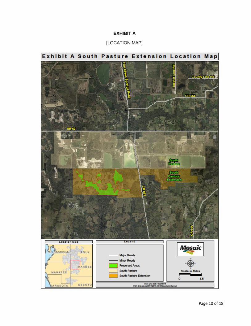
WHEREAS, the Grantor is the fee simple owner subject to the matters described herein of certain lands in Hardee County, Florida, and more specifically described on the location map in Exhibit "A" attached hereto and incorporated herein (the "Property"); and
WHEREAS, Permit No. 0294666-001 (“Permit”) and any modifications thereto
issued by the Grantee authorizes certain activities which could affect wetlands or other surface waters in or of the State of Florida; and
WHEREAS, the U.S. Army Corps of Engineers Permit No. 1993-01395 (“Corps
Permit”) authorizes certain activities in the waters of the United States and requires this site protection instrument over the lands identified in Exhibit B as mitigation for such activities; and
WHEREAS, the Grantor, in consideration of the consent granted by the Permit or
other good and valuable consideration provided to Grantor, is agreeable to granting and securing to the Grantee a perpetual Conservation Easement as defined in Section 704.06, Florida Statutes (F.S.), over the area of the Property described on Exhibit “B” (“Conservation Easement Area”); and

Page 2 of 18
WHEREAS, Grantor grants this Conservation Easement as a condition of the
Permit and the Corps Permit, solely to off-set or prevent adverse impacts to natural resources, fish and wildlife, and wetland functions; and
WHEREAS, Grantor desires to preserve the Conservation Easement Area in
perpetuity in its natural condition, or, in accordance with the Permit and the Corps Permit, in an enhanced, restored, or created condition; and
NOW, THEREFORE, in consideration of the issuance of the Permit and the Corps Permit to construct and operate the permitted activity, and as an inducement to Grantee in issuing the Permit, together with other good and valuable consideration provided to the Grantor, the adequacy and receipt of which are hereby acknowledged, Grantor hereby voluntarily grants, creates, conveys, and establishes a perpetual Conservation Easement for and in favor of the Grantee upon the Conservation Easement Area which shall run with the land and be binding upon the Grantor, and shall remain in full force and effect forever.
The scope, nature, and character of this Conservation Easement shall be as follows:
1. Recitals. The recitals hereinabove set forth are true and correct and are herebyincorporated into and made a part of this Conservation Easement.
2. Purpose. It is the purpose of this Conservation Easement to retain land or waterareas in their existing, natural, vegetative, hydrologic, scenic, open or woodedcondition and to retain such areas as suitable habitat for fish, plants, or wildlife inaccordance with Section 704.06, F.S. Those wetland, stream and upland areasincluded in this Conservation Easement which are to be preserved, enhanced,restored, or created pursuant to the Permit or the Corps Permit (or anymodification thereto) shall be retained and maintained in the preserved,enhanced, restored, or created condition required by the Permit or the CorpsPermit (or any modification thereto). The existing conditions of the ConservationEasement Area are documented in the Baseline Condition Report attached heretoas Exhibit “C” or referenced therein. If any portion of the Conservation EasementArea is enhanced, restored, or created after the date hereof, a revised BaselineCondition Report will be developed by Grantor and approved by the Grantee todocument the enhanced, restored, or created conditions, which approval byGrantee shall not be unreasonably withheld or delayed.
To carry out this purpose, the following rights are conveyed to Grantee by this easement:
a. Upon reasonable notice, to enter upon the Conservation Easement Areaat reasonable times with any necessary equipment or vehicles to inspect,determine compliance with the covenants and prohibitions contained inthis easement, and to enforce the rights herein granted in a manner thatwill not unreasonably interfere with the use and quiet enjoyment of theConservation Easement Area by Grantor at the time of such entry; and
b. To proceed at law or in equity to enforce the provision of this ConservationEasement and the covenants set forth herein, to prevent the occurrence of
Page 3 of 18
any of the prohibited activities set forth herein, and to require the restoration of such areas or features of the Conservation Easement Area that may be damaged by any activity or use that is inconsistent with this Conservation Easement.
3. Prohibited Uses. Except for activities that are permitted or required by the Permit
or the Corps Permit (or any modification thereto) (which may include restoration, creation, enhancement, maintenance, and monitoring activities, or surface water management improvements), any activity on or use of the Conservation Easement Area inconsistent with the purpose of this Conservation Easement is prohibited. Without limiting the generality of the foregoing, the following activities are expressly prohibited in or on the Conservation Easement Area [except as authorized by the Permit or the Corps Permit (or any modification thereof)]:
a. Construction or placing of buildings, roads, signs, billboards or other advertising, utilities, or other structures on or above the ground;
b. Dumping or placing of soil or other substance or material as landfill, or
dumping or placing of trash, waste, or unsightly or offensive materials; c. Removing, destroying or trimming trees, shrubs, or other vegetation, except:
i. The removal of dead trees and shrubs or leaning trees that could
cause damage to property is authorized;
ii. The destruction and removal of noxious, nuisance or exotic invasive
plant species as listed on the most recent Florida Exotic Pest Plant Council’s List of Invasive Species is authorized;
iii. Activities authorized by the Permit or the Corps Permit or described in the Management Plan (if any), or otherwise approved in writing by the Grantee are authorized; and
iv. Activities conducted in accordance with a wildfire mitigation plan
developed with the Florida Forest Service that has been approved in writing by the Grantee are authorized. No later than thirty (30) days before commencing any activities to implement the approved wildfire mitigation plan, Grantor shall notify the Grantee in writing of its intent to commence such activities. All such activities may only be completed during the time period for which the Grantee approved the plan;
d. Excavation, dredging, or removal of loam, peat, gravel, soil, rock, or other
material substance in such manner as to affect the surface;
e. Surface use except for purposes that permit the land or water area to
remain in its natural, restored, enhanced, or created condition;
f. Activities detrimental to drainage, flood control, water conservation, erosion
control, soil conservation, or fish and wildlife habitat preservation including, but not limited to, ditching, diking, clearing, and fencing;
g. Acts or uses detrimental to such aforementioned retention of land or water

Page 4 of 18
areas; and
h. Acts or uses which are detrimental to the preservation of the structural integrity or physical appearance of sites or properties having historical, archaeological, or cultural significance.
4. Grantor's Reserved Rights. Grantor reserves all rights as owner of the
Conservation Easement Area, including the right to engage, or to permit or invite others to engage, in all uses of the Conservation Easement Area that are not prohibited herein and which are not inconsistent with the Permit or the Corps Permit (or any modification thereto), or the intent and purposes of this Conservation Easement. Grantor’s reserved rights specifically include raising, pasturing and grazing of livestock in the Conservation Easement Area, provided those activities are conducted using the best management practices identified in the 2008 Edition of the “Water Quality Best Management Practices for Florida Cow/Calf Operations” manual published by the Florida Department of Agriculture and Consumer Services, Office of Water Quality (DACS-P-01280), for the protection of surface waters, wetlands, and other aquatic resources. The Corps Permit prohibits cattle grazing as a secondary use to aquatic resource mitigation in the Conservation Easement Area unless and until there is a Corps-approved cattle grazing management plan, the Corps has determined that the Grantor has demonstrated that cattle grazing is consistent with the objectives of the compensatory mitigation plan, and the Conservation Easement Area is maintained in accordance with the conditions of the Corps Permit.
5. Rights of the U .S. Army Corps of Engineers (“Corps”). The Corps, as a third-
party beneficiary, shall have the right to enforce the terms and conditions of this Conservation Easement, including: a. The right to take action to preserve and protect the environmental value
of the Conservation Easement Area;
b. The right to prevent any activity on or use of the Conservation Easement
Area that is inconsistent with the purpose of this Conservation Easement, and to require the restoration of areas or features of the Conservation Easement Area that may be damaged by any inconsistent activity or use;
c. The right to enter upon and inspect the Conservation Easement Area in
a reasonable manner and at reasonable times to determine if Grantor or its successors and assigns are complying with the covenants and prohibitions contained in this Conservation Easement Area; and
d. The right to enforce this Conservation Easement Area by injunction or
proceed at law or in equity to enforce the provisions of this Conservation Easement and the covenants set forth herein, to prevent the occurrence of any of the prohibited activities set forth herein, and the right to require Grantor, or its successors or assigns, to restore such areas or features of the Conservation Easement Area that may be damaged by any inconsistent

Page 5 of 18
activity or use or unauthorized activities.
The Grantor, including their successors or assigns, shall provide the Corps at least 60 days advance notice in writing before any action is taken to amend, alter, release, or revoke this Conservation Easement. The Grantee shall provide reasonable notice and an opportunity to comment or object to the release or amendment to the U.S. Army Corps of Engineers. The Grantee shall consider any comments or objections from the U.S. Army Corps of Engineers when making the final decision to release or amend this Conservation Easement.
6. No Dedication. No right of access by the general public to any portion of the
Conservation Easement Area is conveyed by this Conservation Easement.
7. Grantee's and Third Party Beneficiary’s Liability. Grantee’s liability is limited as provided in Subsection 704.06(10) and Section 768.28, F.S. Additionally, Grantee and Third Party Beneficiary shall not be responsible for any costs or liabilities related to the operation, upkeep, or maintenance of the Conservation Easement Area.
8. Enforcement. Enforcement of the terms, provisions and restrictions of this
Conservation Easement shall be at the reasonable discretion of Grantee, and any forbearance on behalf of Grantee to exercise its rights hereunder in the event of any breach hereof by Grantor, shall not be deemed or construed to be a waiver of Grantee's rights hereunder. Grantee shall not be obligated to Grantor, or to any other person or entity, to enforce the provisions of this Conservation Easement.
9. Third Party Beneficiary’s Enforcement Rights. The Third Party Beneficiary of this
Conservation Easement shall have all the rights of the Grantee under this Conservation Easement, including third party enforcement rights of the terms, provisions and restrictions of this Conservation Easement. Third Party Beneficiary’s enforcement of the terms, provisions and restrictions shall be at the discretion of the Third Party Beneficiary, and any forbearance on behalf of the Third Party Beneficiary to exercise its rights hereunder in the event of any breach hereof by Grantor, shall not be deemed or construed to be a waiver of Third Party Beneficiary’s rights hereunder. Third Party Beneficiary shall not be obligated to Grantor, or to any other person or entity, to enforce the provisions of this Conservation Easement.
10. Taxes. When perpetual maintenance is required by the Permit or the Corps
Permit, Grantor shall pay before delinquency any and all taxes, assessments, fees, and charges of whatever description levied on or assessed by competent authority on the Conservation Easement Area, and shall furnish the Grantee with satisfactory evidence of payment upon request.
11. Assignment. Grantee will hold this Conservation Easement exclusively for
conservation purposes. Grantee will not assign its rights and obligations under this Conservation Easement except to another organization or entity qualified to hold such interests under the applicable state laws.

Page 6 of 18
12. Severability. If any provision of this Conservation Easement or the application thereof to any person or circumstances is found to be invalid, the remainder of the provisions of this Conservation Easement shall not be affected thereby, as long as the purpose of the Conservation Easement is preserved.
13. Transfers. Grantor and each of Grantor’s successors in title to the Conservation
Easement Area shall include the book and page of the public records of Hardee County, Florida of this Conservation Easement in each deed or other legal instrument by which Grantor or any such successor in title hereafter transfers any interest in the Conservation Easement Area. However, the failure of Grantor or any such successor in title to comply with this provision shall not impair the validity of this Conservation Easement or limit its enforceability in any way and the terms of this Conservation Easement shall be deemed to be automatically included into such deed or other legal instrument.
14. Written Notice. All notices, consents, approvals or other communications hereunder
shall be in writing and shall be deemed properly given if sent by United States certified mail, return receipt requested, addressed to the appropriate party or successor-in-interest.
15. Modifications. This Conservation Easement may be amended, altered, released or revoked only by written agreement between the parties hereto or their heirs, assigns or successors-in-interest, which shall be filed in the public records in Hardee County, Florida.
16. Recordation. Grantor shall record this Conservation Easement in timely fashion in the Official Records of Hardee County, Florida, and shall rerecord it at any time Grantee may require to preserve its rights. Grantor shall pay all recording costs and taxes necessary to record this Conservation Easement in the public records. Grantor will hold Grantee harmless from any recording costs or taxes necessary to record this Conservation Easement in the public records.
17. Acts Beyond Gran tor’s Control. Nothing contained in this conservation easement
shall be construed to entitle Grantee to bring any action against Grantor for any injury to or change in the Property resulting from natural causes beyond Grantor’s control, including, without limitation, fire, flood storm, and earth movement, or from any necessary action taken by Grantor under emergency conditions to prevent, abate or mitigate significant injury to the Property or to public health, safety or welfare resulting from such causes.
TO HAVE AND TO HOLD unto Grantee forever. The covenants, terms, conditions,
restrictions and purposes imposed with this Conservation Easement shall be binding upon Grantor, and shall continue as a servitude running in perpetuity with the Conservation Easement Area.
Grantor hereby covenants with Grantee that Grantor owns or may claim an interest
in said Conservation Easement Area; that, except for the matters listed on “Exhibit D” attached hereto, the Conservation Easement is free and clear of all encumbrances that are inconsistent with the terms of this Conservation Easement; all mortgages and liens on the Conservation Easement Area, if any, have been subordinated to this Conservation Easement; that Grantor has good right and lawful authority to convey this Conservation Easement; and that it hereby fully warrants and defends record title to the Conservation

Page 7 of 18
Easement Area hereby conveyed against the lawful claims of all persons whomsoever.
Page 8 of 18
IN WITNESS WHEREOF, the Grantor and Grantee have executed this Conservation
Easement on the day and year last below written and intending same to be effective as of the date first set forth above.
GRANTOR:
By:
Herschel E. Morris Vice President, Minerals South Ft. Meade Land Management, Inc., a Delaware corporation
Signed, sealed and delivered in our presence as witnesses:
By: By: (Signature) (Signature)
Name: Name: (Print) (Print)
STATE OF _______________ COUNTY OF _____________
On this day of , 201__, before me, the undersigned notary public, personally appeared Herschel E. Morris, the person who subscribed to the foregoing instrument, as the Vice President, Minerals of South Ft. Meade Land Management, Inc., a Delaware corporation, and he was duly authorized to do so. He is personally known to me or has produced a (state) driver’s license as identification.
IN WITNESS WHEREOF, I hereunto set my hand and official
seal. NOTARY PUBLIC, STATE OF
(Signature)
(Name)
My Commission Expires:

Page 9 of 18
DEPARTMENT OF ENVIRONMENTAL PROTECTION: By:
___________________ Director of Division of Water Resource Management State of Florida Department of Environmental Protection
Signed, sealed and delivered in our presence as witnesses:
By: By: (Signature) (Signature)
Name: Name: (Print) (Print)
STATE OF FLORIDA COUNTY OF LEON
On this___ day of_____________, 201___, before me, the undersigned notary public, personally appeared ________________________ the person who subscribed to the foregoing instrument, as the Director of Division of Water Resource Management, State of Florida Department of Environmental Protection, and he was duly authorized to do so. He is personally known to me or has produced a ___________________ (state) driver’s license as identification.
IN WITNESS WHEREOF, I hereunto set my hand and official seal.
NOTARY PUBLIC, STATE OF FLORIDA
(Signature)
(Name)
My Commission Expires:
Page 10 of 18
EXHIBIT A
[LOCATION MAP]

Page 11 of 18
EXHIBIT B
South Pasture Conservation Easement "A" Legal Description (As Written by SurvTech) A parcel of land lying and being in Section 3, Township 34 South, Range 23 East, Hardee County, Florida, being more particularly described as follows: COMMENCE at a point marking the Northwest corner of Section 3, Township 34 South, Range 23 East, Hardee County, Florida; thence coincident with the North boundary of said Section 3, S 89°46'24" E a distance of 1245.17 feet to the POINT OF BEGINNING; thence continue coincident with the North boundary of said Section 3, S 89°46'24" E a distance of 537.88 feet; thence departing the North boundary of said Section 3, S 11°23'21" W a distance of 149.31 feet; thence S 22°49'36" W a distance of 121.45 feet; thence S 11°36'04" W a distance of 145.08 feet; thence S 01°00'01" W a distance of 147.90 feet; thence S 07°04'46" E a distance of 129.90 feet; thence S 17°43'49" E a distance of 185.04 feet; thence S 21°26'12" E a distance of 300.85 feet; thence S 28°25'09" E a distance of 273.75 feet; thence S 69°50'40" E a distance of 178.59 feet; thence S 52°41'18" E a distance of 34.72 feet; thence S 34°53'31" E a distance of 100.09 feet; thence S 01°54'56" E a distance of 159.73 feet; thence S 50°14'47" E a distance of 26.96 feet; thence S 80°38'35" E a distance of 154.48 feet; thence S 43°13'58" E a distance of 83.76 feet; thence S 14°35'26" E a distance of 64.84 feet; thence S 00°35'02" W a distance of 153.24 feet; thence S 04°15'43" E a distance of 44.01 feet; thence S 29°07'14" E a distance of 38.39 feet; thence N 85°13'58" E a distance of 353.14 feet; thence N 66°33'45" E a distance of 123.90 feet; thence N 79°22'45" E a distance of 124.24 feet; thence N 45°48'01" E a distance of 55.76 feet; thence N 87°40'46" E a distance of 126.15 feet; thence S 81°18'37" E a distance of 155.13 feet; thence S 73°29'24" E a distance of 362.02 feet; thence S 25°25'24" E a distance of 106.77 feet; thence S 09°20'03" W a distance of 117.91 feet; thence S 23°37'51" W a distance of 168.98 feet; thence S 30°29'07" W a distance of 304.65 feet; thence S 00°06'15" E a distance of 140.16 feet; thence S 26°03'54" E a distance of 170.55 feet; thence S 03°05'58" E a distance of 192.83 feet; thence S 12°02'02" W a distance of 714.64 feet; thence S 27°27'32" E a distance of 154.96 feet; thence S 66°31'35" E a distance of 129.84 feet; thence N 79°37'40" E a distance of 48.62 feet; thence N 67°25'23" E a distance of 126.86 feet; thence N 87°19'32" E a distance of 96.81 feet; thence S 45°05'19" E a distance of 270.78 feet; thence S 60°20'21" E a distance of 13.61 feet; thence S 05°01'49" W a distance of 278.43 feet; thence S 78°44'03" W a distance of 92.95 feet; thence S 50°01'51" W a distance of 110.17 feet; thence S 72°27'11" W a distance of 136.70 feet; thence N 87°06'47" W a distance of 204.69 feet; thence S 72°53'59" W a distance of 151.45 feet; thence N 83°34'06" W a distance of 170.96 feet; thence N 49°29'57" W a distance of 130.20 feet; thence N 23°55'39" W a distance of 188.58 feet; thence N 10°56'41" W a distance of 283.70 feet; thence N 40°32'11" W a distance of 162.28 feet; thence N 04°29'38" W a distance of 176.63 feet; thence N 27°41'12" W a distance of 171.22 feet; thence N 03°01'37" W a distance of 125.63 feet; thence N 55°59'48" W a distance of 97.92 feet; thence N 24°58'21" W a distance of 169.45 feet; thence N 59°02'51" W a distance of 133.36 feet; thence N 31°16'24" W a distance of 105.32 feet; thence N 60°26'31" W a distance of 97.93 feet; thence N 81°36'41" W a distance of 337.70 feet; thence N 59°40'33" W a distance of 271.03 feet; thence N 33°33'33" W a distance of 114.18 feet; thence N 15°44'07" W a distance of 99.15 feet; thence N 02°51'04" E a distance of 308.67 feet; thence N 41°20'58" E a distance of 130.83 feet; thence N 61°47'22" E a distance of 192.89 feet; thence N 07°09'22" W a distance of 130.26 feet; thence N 30°03'03" W a distance of 497.20 feet; thence N 79°16'16" W a distance of 56.19 feet; thence S 70°29'09" W a distance of 84.02 feet; thence S 61°34'13" W a distance of 69.92 feet; thence S 87°52'58" W a distance of 110.50 feet; thence N 58°05'50" W a distance of 220.77 feet; thence N 31°19'17" W a distance of 379.53 feet; thence N 11°57'54" W a distance of 118.28 feet; thence N 03°53'19" E a distance of 112.75 feet; thence N 30°26'28" E a distance of 92.06 feet; thence N 67°05'26" E a distance of 67.07 feet; thence S 88°01'45" E a distance of 93.75 feet; thence S 68°26'32"
Page 12 of 18
E a distance of 176.99 feet; thence S 82°34'12" E a distance of 56.72 feet; thence N 69°24'06" E a distance of 46.32 feet; thence N 03°03'38" E a distance of 47.28 feet; thence N 31°33'48" W a distance of 63.61 feet; thence N 01°48'24" E a distance of 135.49 feet; thence N 21°42'22" W a distance of 502.41 feet; thence N 32°08'26" W a distance of 220.93 feet; thence N 01°50'38" W a distance of 128.86 feet to the POINT OF BEGINNING. Containing an area of 4205496.32 square feet, 96.545 acres, more or less.
AND
South Pasture Conservation Easement "B" Legal Description (As Written by SurvTech) A parcel of land lying and being in Sections 1, 2, 3, 10, 11 and 12, Township 34 South, Range 23 East, and Sections 6 and 7, Township 34 South, Range 24 East, Hardee County, Florida, being more particularly described as follows: COMMENCE at a point marking the Northwest corner of Section 3, Township 34 South, Range 23 East, Hardee County, Florida; thence coincident with the North boundary of said Section 3, S 89°46'24" E a distance of 1783.06 feet; thence departing the North boundary of said Section 3, S 11°23'21" W a distance of 149.31 feet; thence S 22°49'36" W a distance of 121.45 feet; thence S 11°36'04" W a distance of 145.08 feet; thence S 01°00'01" W a distance of 147.90 feet; thence S 07°04'46" E a distance of 129.90 feet; thence S 17°43'49" E a distance of 185.04 feet; thence S 21°26'12" E a distance of 300.85 feet; thence S 28°25'09" E a distance of 273.75 feet; thence S 69°50'40" E a distance of 178.59 feet; thence S 52°41'18" E a distance of 34.72 feet; thence S 34°53'31" E a distance of 100.09 feet; thence S 01°54'56" E a distance of 159.73 feet; thence S 50°14'47" E a distance of 26.96 feet; thence S 80°38'35" E a distance of 154.48 feet; thence S 43°13'58" E a distance of 83.76 feet; thence S 14°35'26" E a distance of 64.84 feet; thence S 00°35'02" W a distance of 153.24 feet; thence S 04°15'43" E a distance of 44.01 feet; thence S 29°07'14" E a distance of 38.39 feet; thence N 85°13'58" E a distance of 353.14 feet; thence N 66°33'45" E a distance of 123.90 feet; thence N 79°22'45" E a distance of 124.24 feet; thence N 45°48'01" E a distance of 55.76 feet; thence N 87°40'46" E a distance of 126.15 feet; thence S 81°18'37" E a distance of 155.13 feet; thence S 73°29'24" E a distance of 362.02 feet; thence S 25°25'24" E a distance of 106.77 feet; thence S 09°20'03" W a distance of 117.91 feet; thence S 23°37'51" W a distance of 168.98 feet; thence S 30°29'07" W a distance of 304.65 feet; thence S 00°06'15" E a distance of 140.16 feet; thence S 26°03'54" E a distance of 170.55 feet; thence S 03°05'58" E a distance of 192.83 feet; thence S 12°02'02" W a distance of 714.64 feet; thence S 27°27'32" E a distance of 154.96 feet; thence S 66°31'35" E a distance of 129.84 feet; thence N 79°37'40" E a distance of 48.62 feet; thence N 67°25'23" E a distance of 126.86 feet; thence N 87°19'32" E a distance of 96.81 feet; thence S 45°05'19" E a distance of 270.78 feet; thence S 60°20'21" E a distance of 205.06 feet; thence S 85°09'54" E a distance of 225.97 feet to the POINT OF BEGINNING; thence continue S 85°09'54" E a distance of 42.22 feet; thence S 77°46'00" E a distance of 172.79 feet; thence N 81°10'30" E a distance of 487.50 feet; thence S 87°14'24" E a distance of 381.00 feet; thence S 02°11'50" W a distance of 149.04 feet; thence S 25°47'06" W a distance of 218.07 feet; thence S 04°03'14" E a distance of 93.97 feet; thence S 49°58'18" E a distance of 118.68 feet; thence S 77°30'55" E a distance of 102.36 feet; thence S 41°14'40" E a distance of 135.30 feet; thence S 69°14'02" E a distance of 136.31 feet; thence N 50°48'59" E a distance of 205.57 feet; thence N 38°57'41" E a distance of 351.93 feet; thence N 89°37'18" E a distance of 373.44 feet; thence N 02°37'04" E a distance of 171.52 feet; thence N 88°54'35" E a distance of 194.49 feet; thence S 61°20'44" E a distance of 96.50 feet; thence S 06°43'12" E a distance of 165.29 feet; thence S 05°31'53" W a distance of 307.62 feet; thence S
Page 13 of 18
02°03'49" E a distance of 307.55 feet; thence S 38°58'20" E a distance of 64.12 feet; thence S 61°28'58" E a distance of 63.62 feet; thence N 88°19'01" E a distance of 161.42 feet; thence S 77°48'25" E a distance of 66.06 feet; thence S 64°17'29" E a distance of 164.76 feet; thence S 77°28'17" E a distance of 65.07 feet; thence N 88°22'06" E a distance of 94.95 feet; thence N 69°12'47" E a distance of 92.24 feet; thence S 80°08'11" E a distance of 51.43 feet; thence N 86°17'53" E a distance of 75.35 feet; thence S 88°43'16" E a distance of 60.10 feet; thence S 71°24'56" E a distance of 180.94 feet; thence S 70°53'19" E a distance of 76.31 feet; thence S 79°46'01" E a distance of 80.06 feet; thence S 82°56'47" E a distance of 124.46 feet; thence S 68°20'39" E a distance of 78.14 feet; thence N 48°46'43" E a distance of 146.68 feet; thence N 17°31'45" E a distance of 127.86 feet; thence N 02°45'27" W a distance of 276.14 feet; thence N 43°24'38" E a distance of 248.25 feet; thence N 03°46'52" W a distance of 496.55 feet; thence S 82°00'18" W a distance of 149.62 feet; thence N 83°38'38" W a distance of 96.71 feet; thence N 18°01'08" W a distance of 63.64 feet; thence N 13°29'58" E a distance of 241.51 feet; thence N 76°20'47" E a distance of 220.68 feet; thence N 22°18'50" E a distance of 181.93 feet; thence N 18°50'44" E a distance of 144.63 feet; thence N 00°38'24" E a distance of 85.33 feet; thence N 34°10'27" W a distance of 232.68 feet; thence N 48°08'08" W a distance of 195.03 feet; thence N 27°01'08" W a distance of 332.05 feet; thence N 14°07'11" E a distance of 185.28 feet; thence N 79°06'14" E a distance of 164.24 feet; thence S 50°57'54" E a distance of 70.45 feet; thence N 85°24'31" E a distance of 74.18 feet; thence N 07°23'47" E a distance of 62.46 feet; thence N 13°59'31" W a distance of 82.40 feet; thence N 46°21'11" W a distance of 57.95 feet; thence N 11°36'55" W a distance of 257.11 feet; thence N 03°35'02" E a distance of 194.22 feet; thence N 44°22'41" E a distance of 243.07 feet; thence N 79°03'48" E a distance of 136.39 feet; thence N 49°14'59" E a distance of 385.40 feet; thence N 74°05'39" E a distance of 221.98 feet; thence S 76°23'27" E a distance of 123.75 feet; thence S 70°51'36" E a distance of 95.39 feet; thence S 34°20'11" E a distance of 42.10 feet; thence S 66°07'02" E a distance of 93.95 feet; thence S 84°21'24" E a distance of 102.41 feet; thence S 62°42'51" E a distance of 104.93 feet; thence N 86°30'00" E a distance of 61.79 feet; thence S 17°38'28" E a distance of 410.86 feet; thence S 01°41'35" E a distance of 293.55 feet; thence S 35°32'30" W a distance of 433.36 feet; thence S 85°50'30" W a distance of 143.36 feet; thence N 82°40'40" W a distance of 548.32 feet; thence S 70°59'05" W a distance of 102.22 feet; thence S 53°47'34" W a distance of 111.47 feet; thence S 24°19'14" W a distance of 127.15 feet; thence S 04°15'44" E a distance of 188.00 feet; thence S 05°38'19" W a distance of 287.87 feet; thence S 07°38'18" E a distance of 154.26 feet; thence S 11°27'06" W a distance of 602.42 feet; thence S 01°19'45" E a distance of 134.91 feet; thence S 33°03'52" E a distance of 235.07 feet; thence N 52°43'28" E a distance of 205.10 feet; thence N 04°36'14" E a distance of 87.78 feet; thence N 27°18'37" E a distance of 78.65 feet; thence N 42°11'20" E a distance of 160.72 feet; thence N 61°36'05" E a distance of 281.62 feet; thence N 47°49'24" E a distance of 214.96 feet; thence N 86°49'10" E a distance of 125.70 feet; thence N 86°49'10" E a distance of 83.94 feet; thence S 47°29'05" E a distance of 211.86 feet; thence S 29°15'15" E a distance of 150.49 feet; thence S 09°47'15" E a distance of 100.93 feet; thence S 05°08'21" W a distance of 77.60 feet; thence S 42°44'07" W a distance of 258.69 feet; thence S 04°34'23" W a distance of 149.34 feet; thence S 35°32'55" E a distance of 357.09 feet; thence S 04°56'37" W a distance of 103.56 feet; thence S 45°48'16" W a distance of 151.99 feet; thence S 76°38'11" W a distance of 158.85 feet; thence N 84°26'42" W a distance of 558.67 feet; thence S 77°45'14" W a distance of 524.45 feet; thence S 36°29'22" W a distance of 168.47 feet; thence S 15°00'43" W a distance of 172.39 feet; thence S 01°17'26" W a distance of 390.55 feet; thence S 36°15'25" E a distance of 308.72 feet; thence S 10°22'24" E a distance of 172.22 feet; thence S 77°03'16" E a distance of 334.60 feet; thence N 78°59'45" E a distance of 148.05 feet; thence S 39°14'04" E a distance of 110.85 feet; thence S 21°06'55" W a distance of 228.62 feet; thence S 01°53'19" W a distance of 116.12 feet; thence S 42°53'41" E a distance of 204.48 feet; thence S

Page 14 of 18
12°07'26" W a distance of 316.90 feet; thence S 23°16'53" E a distance of 101.98 feet; thence S 53°17'33" E a distance of 105.12 feet; thence S 88°18'18" E a distance of 246.91 feet; thence N 79°28'59" E a distance of 135.45 feet; thence N 88°39'02" E a distance of 493.60 feet; thence S 66°33'32" E a distance of 222.01 feet; thence S 55°24'17" E a distance of 326.43 feet; thence S 84°45'10" E a distance of 273.53 feet; thence N 87°02'17" E a distance of 158.22 feet; thence N 64°01'55" E a distance of 164.01 feet; thence N 89°10'41" E a distance of 180.56 feet; thence N 77°29'38" E a distance of 133.96 feet; thence N 58°10'42" E a distance of 359.61 feet; thence N 13°58'02" E a distance of 289.14 feet; thence N 02°36'14" W a distance of 204.08 feet; thence N 28°01'22" E a distance of 125.67 feet; thence N 66°50'35" E a distance of 116.42 feet; thence N 33°28'26" E a distance of 319.47 feet; thence N 13°47'53" E a distance of 99.53 feet; thence N 22°02'17" W a distance of 250.78 feet; thence N 29°23'32" W a distance of 472.60 feet; thence N 09°09'05" W a distance of 338.09 feet; thence N 16°09'49" E a distance of 169.39 feet; thence N 32°07'48" E a distance of 165.09 feet; thence N 59°55'54" E a distance of 169.65 feet; thence N 84°59'18" E a distance of 147.94 feet; thence S 68°12'54" E a distance of 199.40 feet; thence S 81°40'02" E a distance of 524.45 feet; thence S 63°51'42" E a distance of 214.39 feet; thence S 47°41'05" E a distance of 462.19 feet; thence S 31°43'12" E a distance of 182.55 feet; thence S 04°58'29" E a distance of 277.59 feet; thence S 43°01'30" E a distance of 156.72 feet; thence S 26°12'19" E a distance of 201.68 feet; thence S 07°27'05" W a distance of 118.91 feet; thence S 42°55'53" W a distance of 167.06 feet; thence S 70°20'09" W a distance of 318.88 feet; thence S 37°48'33" W a distance of 104.90 feet; thence S 32°18'30" E a distance of 59.79 feet; thence S 62°55'22" E a distance of 76.74 feet; thence N 85°21'36" E a distance of 324.68 feet; thence N 82°28'06" E a distance of 433.12 feet; thence S 54°12'07" E a distance of 150.29 feet; thence S 22°32'42" E a distance of 68.68 feet; thence S 05°15'25" W a distance of 666.25 feet; thence S 04°36'37" E a distance of 902.26 feet; thence S 46°12'35" E a distance of 84.06 feet; thence N 56°20'07" E a distance of 262.60 feet; thence N 26°59'12" E a distance of 321.54 feet; thence N 50°30'31" E a distance of 305.48 feet; thence N 73°32'34" E a distance of 87.57 feet; thence N 13°48'07" E a distance of 332.72 feet; thence N 55°11'44" E a distance of 113.37 feet; thence N 77°36'39" E a distance of 153.35 feet; thence N 34°33'18" E a distance of 62.23 feet; thence N 04°32'39" E a distance of 458.17 feet; thence N 19°52'24" W a distance of 204.51 feet; thence N 04°04'25" W a distance of 336.31 feet; thence N 17°38'22" W a distance of 599.85 feet; thence N 35°14'27" W a distance of 350.90 feet; thence N 19°50'44" W a distance of 131.36 feet; thence N 43°42'34" W a distance of 493.72 feet; thence N 12°44'26" W a distance of 554.39 feet; thence N 32°19'31" E a distance of 155.09 feet; thence N 20°25'58" W a distance of 216.76 feet; thence N 58°36'28" W a distance of 321.90 feet; thence N 02°21'57" E a distance of 472.13 feet; thence N 15°49'18" W a distance of 312.06 feet; thence N 12°00'59" E a distance of 1843.51 feet; thence N 78°39'28" E a distance of 227.49 feet; thence N 07°19'35" E a distance of 412.11 feet; thence N 14°18'00" W a distance of 177.62 feet; thence N 42°09'24" W a distance of 250.47 feet; thence N 02°59'13" W a distance of 389.68 feet; thence N 89°26'22" E a distance of 209.29 feet; thence N 89°26'22" E a distance of 179.23 feet; thence S 37°16'43" E a distance of 1074.03 feet; thence S 53°33'34" E a distance of 464.94 feet; thence S 41°43'23" E a distance of 546.69 feet; thence S 60°50'35" E a distance of 368.17 feet; thence S 80°14'18" E a distance of 230.17 feet; thence S 52°41'45" E a distance of 172.47 feet; thence S 75°00'10" E a distance of 175.03 feet; thence S 32°34'52" E a distance of 141.27 feet; thence S 04°24'07" W a distance of 253.42 feet; thence S 22°40'03" E a distance of 439.44 feet; thence S 41°54'04" E a distance of 123.57 feet; thence S 02°28'40" W a distance of 132.60 feet; thence S 14°03'05" W a distance of 195.00 feet; thence S 14°08'17" E a distance of 269.52 feet; thence S 04°06'01" E a distance of 587.35 feet; thence S 14°26'16" W a distance of 330.16 feet; thence S 39°28'36" W a distance of 140.63 feet; thence S 77°46'31" W a distance of 132.56 feet; thence N 85°44'13" W a distance of 230.80 feet; thence N

Page 15 of 18
79°39'12" W a distance of 266.01 feet; thence S 89°40'04" W a distance of 300.08 feet; thence S 44°20'38" W a distance of 101.94 feet; thence S 85°40'33" W a distance of 136.24 feet; thence N 60°23'22" W a distance of 112.80 feet; thence N 31°42'31" W a distance of 133.82 feet; thence N 57°29'45" W a distance of 203.30 feet; thence N 69°36'29" W a distance of 86.04 feet; thence N 86°51'43" W a distance of 174.77 feet; thence S 45°12'02" W a distance of 188.80 feet; thence S 59°37'35" W a distance of 302.98 feet; thence S 08°27'25" W a distance of 480.86 feet; thence S 17°32'48" E a distance of 306.91 feet; thence S 28°45'32" E a distance of 550.04 feet; thence S 16°50'32" E a distance of 169.50 feet; thence S 08°10'33" E a distance of 98.92 feet; thence S 04°55'53" W a distance of 243.53 feet; thence S 07°08'17" E a distance of 487.27 feet; thence S 12°38'01" W a distance of 158.65 feet; thence S 01°15'13" E a distance of 111.28 feet; thence S 23°50'21" E a distance of 289.56 feet; thence S 08°24'23" E a distance of 122.26 feet; thence S 83°59'28" E a distance of 59.83 feet; thence S 19°56'20" E a distance of 55.21 feet; thence N 86°53'37" E a distance of 80.66 feet; thence S 66°07'00" E a distance of 84.92 feet; thence S 43°01'17" E a distance of 59.80 feet; thence S 20°33'11" E a distance of 147.10 feet; thence S 86°07'05" E a distance of 98.94 feet; thence N 86°55'42" E a distance of 156.14 feet; thence N 72°52'41" E a distance of 86.94 feet; thence N 52°48'44" E a distance of 199.24 feet; thence N 76°17'43" E a distance of 182.58 feet; thence N 61°33'33" E a distance of 155.38 feet; thence N 35°15'00" E a distance of 106.73 feet; thence N 66°47'52" E a distance of 770.38 feet; thence S 47°14'28" E a distance of 239.41 feet; thence S 28°19'19" E a distance of 140.08 feet; thence S 87°05'28" E a distance of 363.24 feet; thence N 87°40'46" E a distance of 436.02 feet; thence S 66°09'57" E a distance of 148.29 feet; thence N 67°45'42" E a distance of 285.39 feet; thence S 82°19'05" E a distance of 319.05 feet; thence N 87°29'25" E a distance of 381.28 feet; thence N 63°41'30" E a distance of 129.57 feet; thence N 37°36'28" E a distance of 146.32 feet; thence N 89°29'26" E a distance of 138.84 feet; thence S 07°54'56" E a distance of 661.29 feet; thence S 32°31'45" W a distance of 153.74 feet; thence S 79°18'27" W a distance of 166.19 feet; thence N 49°57'46" W a distance of 217.33 feet; thence N 16°30'26" W a distance of 152.23 feet; thence N 68°16'15" W a distance of 143.27 feet; thence S 52°14'01" W a distance of 197.38 feet; thence S 34°55'21" W a distance of 220.51 feet; thence S 70°05'00" W a distance of 206.62 feet; thence S 85°43'21" W a distance of 456.92 feet; thence N 54°53'24" W a distance of 448.92 feet; thence N 85°03'41" W a distance of 196.20 feet; thence N 55°37'33" W a distance of 119.27 feet; thence S 85°12'59" W a distance of 237.86 feet; thence S 69°11'23" W a distance of 161.95 feet; thence N 87°41'52" W a distance of 743.06 feet; thence S 78°47'31" W a distance of 765.62 feet; thence S 49°17'18" W a distance of 165.95 feet; thence S 00°58'07" E a distance of 271.26 feet; thence S 36°52'13" W a distance of 418.15 feet; thence S 02°20'30" E a distance of 365.45 feet; thence S 18°06'41" E a distance of 150.25 feet; thence S 00°32'24" W a distance of 327.02 feet to a point coincident with the Easterly extension of the North boundary of the South 1/4 of Section 12, Township 34 South, Range 23 East, Hardee County, Florida; thence coincident with said Easterly extension and the North boundary of the South 1/4 of said Section 12, N 89°02'08" W a distance of 5602.67 feet to a point coincident with the North boundary of the South 1/4 of Section 11, Township 34 South, Range 23 East, Hardee County, Florida; thence departing the North boundary of the South 1/4 of said Section 12 coincident with the North boundary of the South 1/4 of said Section 11, N 89°01'48" W a distance of 1730.50 feet; thence departing the North boundary of the South 1/4 of said Section 11, N 20°56'28" E a distance of 162.80 feet; thence N 44°15'45" E a distance of 377.92 feet; thence N 72°53'33" E a distance of 253.99 feet; thence N 31°23'50" E a distance of 22.08 feet; thence N 24°05'31" W a distance of 82.03 feet; thence N 74°05'50" W a distance of 103.39 feet; thence N 27°27'53" W a distance of 244.32 feet; thence N 08°59'00" W a distance of 112.86 feet; thence N 63°37'06" W a distance of 234.80 feet; thence N 49°55'56" W a distance of 156.10 feet; thence N 71°48'45" W a distance of 152.65 feet; thence S 81°52'47" W a distance of 124.70 feet; thence N 85°47'56" W a distance of 99.45 feet; thence N

Page 16 of 18
66°33'25" W a distance of 144.48 feet; thence N 24°00'22" W a distance of 138.03 feet; thence N 15°34'54" E a distance of 176.28 feet; thence N 02°53'53" W a distance of 209.62 feet; thence N 18°47'17" W a distance of 253.58 feet; thence N 43°18'11" W a distance of 260.16 feet; thence N 65°42'50" W a distance of 43.48 feet; thence N 82°12'18" W a distance of 270.20 feet; thence S 86°51'21" W a distance of 77.14 feet; thence S 67°41'57" W a distance of 161.47 feet; thence S 87°54'50" W a distance of 49.95 feet; thence N 63°27'09" W a distance of 130.05 feet; thence N 28°51'20" W a distance of 37.31 feet; thence N 00°54'03" E a distance of 91.31 feet; thence N 30°15'43" E a distance of 144.90 feet; thence N 19°39'59" W a distance of 284.17 feet; thence N 49°10'58" W a distance of 311.49 feet; thence N 67°11'03" W a distance of 359.91 feet; thence N 89°30'38" W a distance of 402.12 feet; thence N 75°00'58" W a distance of 308.96 feet; thence S 73°28'47" W a distance of 137.36 feet; thence S 55°12'08" W a distance of 380.85 feet; thence S 78°29'14" W a distance of 248.36 feet; thence N 71°31'16" W a distance of 134.51 feet; thence N 88°32'19" W a distance of 302.69 feet; thence S 81°10'04" W a distance of 225.74 feet; thence N 76°45'07" W a distance of 147.05 feet; thence N 33°11'03" W a distance of 378.08 feet; thence N 07°54'24" E a distance of 85.95 feet; thence N 20°22'17" E a distance of 234.40 feet; thence N 02°40'54" E a distance of 208.33 feet; thence N 23°09'46" E a distance of 464.74 feet; thence N 13°59'08" W a distance of 343.10 feet; thence N 02°21'15" W a distance of 199.14 feet; thence N 23°37'32" W a distance of 52.72 feet; thence N 05°01'49" E a distance of 383.22 feet to the POINT OF BEGINNING. Containing an area of 43404800.91 square feet, 996.437 acres, more or less.
Date: 8.03.2016

Page 17 of 18
EXHIBIT C
The Baseline Documentation Report, entitled South Pasture Extension Conservation Easement Hardee County, Florida Baseline Condition Report dated July 2016, as amended September 2016 and prepared by Flatwoods Consulting Group, is maintained in the offices of the Florida Department of Environmental Protection and is incorporated by this reference. A copy of the Baseline Documentation Report is available from the Department on request.

Page 18 of 18
EXHIBIT D
[EXISTING TITLE MATTERS] 1. Rights reserved in that certain Warranty Deed recorded in Book 236, Page
689. Note: The right of entry has been extinguished pursuant to Sections 704.05 and 712.04, Florida Statutes.
2. Agreement for Reciprocal Waivers of Setback Requirements recorded February 15, 2006 in Book 698, page 875.

Department of the Army
Permit Number SAJ-1993-01395 (SP-JPF)
Attachment I

Mosaic Fertilizer, LLC
South Pasture Extension Hardee County, FL
August 2016
Year Debit Credit Final Credit
5 Year
Cumulative
Credit
Subtotals
2016 36.39 10.62 -25.77
2017 61.28 0 -61.28
2018 73.01 26.58 -46.43
2019 24.87 0 -24.87
2020 21.60 33.2 11.60 -146.74
2021 16.50 70.42 53.92
2022 6.47 25.66 19.19
2023 8.32 14.29 5.97
2024 5.56 10.52 4.96
2025 6.85 49.36 42.51 -20.19
2026 24.99 0 -24.99
2027 8.19 8.13 -0.06
2028 0.69 11.92 11.23
2029 0 14.59 14.59
2030 19.77 1.59 -18.18 -37.59
2031 0.75 10.38 9.63
2032 0 2.83 2.83
2033 0 0 0.00
2034 0 22.74 22.74
2035 0 2.44 2.44 0.05
Total 315.22 315.27 0.05
0.05
Herbaceous Ledger
Total
G:\projects\2014\2014_0119\docs\July 2016 Submittals\Final Permit Requests\Ledger\Ledger 1 of 3
Attachment I

Mosaic Fertilizer, LLC
South Pasture Extension Hardee County, FL
August 2016
Year Debits Credits Final Credit
5 Year
Cumulative
Credit
Subtotals
2016 49.80 48.70 -1.10
2017 26.12 0 -26.12
2018 25.25 4.03 -21.22
2019 25.35 0 -25.35
2020 18.31 0 -18.31 -92.11
2021 41.56 0 -41.56
2022 3.75 0 -3.75
2023 0.22 0 -0.22
2024 0.35 0 -0.35
2025 4.18 0 -4.18 -142.16
2026 7.37 0 -7.37
2027 0.71 0 -0.71
2028 0 0 0.00
2029 0 0 0.00
2030 1.41 0 -1.41 -151.66
2031 0.56 0 -0.56
2032 0 0 0.00
2033 0 23.66 23.66
2034 0 16.96 16.96
2035 0 0 0.00 -111.59
2036 0 5.36 5.36
2037 0 15.64 15.64
2038 0 3.59 3.59
2039 0 0 0.00
2040 0 0.57 0.57 -85.34
2041 0 38.47 38.47
2042 0 37.66 37.66
2043 0 10.04 10.04
2044 0 0 0.00
2045 0 0 0.00 -0.28
2046 0 0.74 0.74
2047 0 0 0.00
2048 0 0 0.00
2049 0 0.15 0.15 0.60
Total 204.95 205.55 0.60
0.60
Forested Ledger
Total
G:\projects\2014\2014_0119\docs\July 2016 Submittals\Final Permit Requests\Ledger\Ledger 2 of 3

Mosaic Fertilizer, LLC
South Pasture Extension Hardee County, FL
August 2016
Year Debits Credits Final Credit
5 Year
Cumulative
Credit
Subtotals
2016 0 9003.16 9003.16
2017 0 0 0.00
2018 150.75 0 -150.75
2019 0 0 0.00
2020 780.42 0 -780.42 8071.99
2021 229.50 0 -229.50
2022 2861.01 0 -2861.01
2023 2317.47 0 -2317.47
2024 0 0 0.00
2025 1045.13 0 -1045.13 1618.88
2026 1304.82 0 -1304.82
2027 326.32 0 -326.32
2028 2264.69 465.25 -1799.44
2029 602.21 0 -602.21
2030 516.52 1881.9 1365.38 -1048.55
2031 962.28 602.67 -359.62
2032 0 0 0.00
2033 0 908.01 908.01
2034 0 244.15 244.15
2035 0 335.49 335.49 79.48
Totals 13361.14 13440.62 79.48
79.48
Stream Ledger
Total
G:\projects\2014\2014_0119\docs\July 2016 Submittals\Final Permit Requests\Ledger\Ledger 3 of 3


![· 2- 3- 2- 2- 3- Attachment to CERTIFICATE No. Z2 10 09 23220 025 W-H [cm] 200x200x163 h 314x224x205 h 761 h 380x200x48 h 300x300x23 h 200x200x23 h](https://img.dokumen.tips/doc/110x75/5e23b7d28effa92ea95d2424/2-3-2-2-3-attachment-to-certificate-no-z2-10-09-23220-025-w-h-cm-200x200x163.jpg)


![] (03meeb.sz.gov.cn/attachment/0/320/320588/2060002.pdf · h' ákJfi)9 ìfiìho](https://img.dokumen.tips/doc/110x75/5fadb314972ed116957a02b7/-h-kjfi9-fiho.jpg)