Embed Size (px)
Citation preview

8/8/2019 Assessment of Sub-center Development
http://slidepdf.com/reader/full/assessment-of-sub-center-development 1/154
ASSESSMENT OF SUB-CENTER DEVELOPMENT:BATIKENT, ANKARA
A THESIS SUBMITTED TOTHE GRADUATE SCHOOL OF NATURAL AND APPLIED SCIENCES
OFMIDDLE EAST TECHNICAL UNIVERSITY
BY
SERHAT CELEP
IN PARTIAL FULFILLMENT OF THE REQUIREMENTSFOR
THE DEGREE OF MASTER OF SCIENCEINCITY AND REGIONAL PLANNING
INURBAN DESIGN
NOVEMBER 2009
8/8/2019 Assessment of Sub-center Development
http://slidepdf.com/reader/full/assessment-of-sub-center-development 2/154
Approval of the thesis:
ASSESSMENT OF SUB-CENTER DEVELOPMENT:
BATIKENT, ANKARA
submitted by SERHAT CELEP in partial fulfillment of the requirements for the degree of Master of Science in City and Regional Planning Department in Urban Design, Middle
East Technical University by,
Prof. Dr. Canan Özgen _____________________
Dean, Graduate School of Natural and Applied Sciences
Prof. Dr. Melih Ersoy _____________________ Head of the Department, City and Regional Planning
Assoc. Prof. Dr. Baykan Günay _____________________ Supervisor, City and Regional Planning, METU
Examining Committee Members:
Assoc. Prof. Dr. Çağatay Keskinok _____________________ City and Regional Planning Dept., METU
Assoc. Prof. Dr. Baykan Günay _____________________ City and Regional Planning Dept., METU
Assoc. Prof. Dr. Adnan Barlas _____________________
City and Regional Planning Dept., METU
Assist. Prof. Dr. Bahar Gedikli _____________________ City and Regional Planning Dept., METU
Can Kubin, M. Sc. _____________________ Promim Landscape Planning & Urban Design Co. Ltd.
Date: 19 / 11 / 2009
8/8/2019 Assessment of Sub-center Development
http://slidepdf.com/reader/full/assessment-of-sub-center-development 3/154
iii
I hereby declare that all information in this document has been obtained and presentedin accordance with academic rules and ethical conduct. I also declare that, as requiredby these rules and conduct, I have fully cited and referenced all material and resultsthat are not original to this work.
Name, Last Name: Serhat CELEP
Signature:
8/8/2019 Assessment of Sub-center Development
http://slidepdf.com/reader/full/assessment-of-sub-center-development 4/154
iv
ABSTRACT
ASSESSMENT OF SUB-CENTER DEVELOPMENT:BATIKENT, ANKARA
Celep, Serhat
M.S., Department of City and Regional Planning in Urban Design
Supervisor: Assoc. Prof. Dr. Baykan Günay
November 2009, 139 pages
Sub-center formation is closely come out when urban environment started to grow and by
decentralization and sub-urbanization process to lower the congestions and increase the
efficiency in urban life. Besides, by means of rising problems of the growth in an urban area,there emerged the need to share the central activities within the metropolitan region.
The growth followed by creation of new towns in the peripheries. Within that organization of
the city, sub-centers started to appear to share the burden of the city centers. In this study, the
sub-center evolution will be examined with respect to its relationship to urban growth and
development. Hence the sub-center formation will be defined and studied in terms of city
center, neighborhood center and shopping center developments of the settlements.
The criteria on land-use, planning process, design of the built environment, district and
neighborhood centers and policies of revisions in the suburb within world examples will help
the study to develop principles for sub-center formation. This will provide us to build up
some criteria for the central area especially in New Development areas.
8/8/2019 Assessment of Sub-center Development
http://slidepdf.com/reader/full/assessment-of-sub-center-development 5/154
v
After the 1970s, the city of Ankara expanded rapidly and there emerged new development
areas of the metropolitan region in the West Corridor. With respect to these, Ankara is
analyzed with a new urban development area in that corridor called Batıkent. With the help
of discussions and analysis on sub-center formation on smaller plots belonging to private and
a world example of sub-center development produced by the government, design and
planning principles of Sub-center growth and development will be proposed in case of
Batıkent.
Key Words: Sub-center Formation, New Settlement Areas, Town Center, Different Levels of
Central Areas, Batıkent-Ankara
8/8/2019 Assessment of Sub-center Development
http://slidepdf.com/reader/full/assessment-of-sub-center-development 6/154
vi
ÖZ
ALT MERKEZ GELİŞİMİ ÜZER İ NE BİR DEĞERLENDİRME:
BATIKENT ANKARA ÖRNEĞİ
Celep, Serhat
Yüksek Lisans, Şehir ve Bölge Planlama Bölümü, Kentsel Tasar ımTez Yöneticisi : Assoc. Prof. Dr. Baykan Günay
Kasım 2009, 139 sayfa
Alt merkez gelişimi, kentsel çevrenin büyümesiyle ve merkezden uzaklaşma ile alt-
kentleşme sürecinin merkezdeki sorunlar ı azaltma ve kentsel yaşamın etkinliğini artırmaya
yönelik amaçlar ıyla birlikte ortaya çıkmıştır. Kentlerin ve kent merkezlerinin büyüme
problemleri ile birlikte, merkezi alan aktivitelerinin dağılımı ve yeniden dağılımı ihtiyacı konusu ortaya çıkmıştır.
Kentlerdeki büyüme, kent çevrelerinde yeni kentlerin ortaya çıkmasıyla devam etmektedir.
Böyle bir metropoliten kent şemasında, alt-merkezler, kent merkezinin yükünü azaltma
amacı yönünde meydana gelmişlerdir. Bu çalışmada, alt-merkez gelişimi kentsel büyüme ve
gelişmeye ilişkilendirilerek ele alınacaktır. Ayr ıca alt-merkez gelişimi, kent, mahalle
merkezi ve alışveriş merkezi gelişimleriyle birlikte incelenecektir.
Arazi kullanımı, planlama etaplar ı, çevre tasar ımı, bölge ve mahalle merkezleri ve revizyon
politikalar ı ile dünya örneği üzerinden geliştirilen k ıstaslar alt merkez gelişimi açısından
ilkeleri ortaya çıkarmaya yardım edecektir. Bu, çalışmaya özellikle yeni gelişen kent
parçalar ındaki merkezi alan oluşturma ve geliştirme konusunda da k ıstaslar geliştirilecektir.

8/8/2019 Assessment of Sub-center Development
http://slidepdf.com/reader/full/assessment-of-sub-center-development 7/154
vii
Ankara kentinde Batı Koridoru’ndaki yeni gelişme alanlar ı içinde, Batıkent’te bütün bu
özellikler çözümlenmiştir. Özellikle 1970’lerden sonra Ankara’daki hızlı gelişmeyle bu
koridorda yeni kent parçalar ı ortaya çıkmıştır. Alt merkez için yapılan bütün bu tartışma ve
çözümlemeler ve incelenen Dünya örneği sonucunda alt merkez gelişiminin ve büyümesinin
tasar ım ve planlama ilkeleri Batıkent örneğinde ortaya konulmaya çalışılacaktır.
Anahtar Kelimeler: Alt-merkez Gelişimi, Yeni Yerleşim Alanlar ı, Kent Merkezi, Farklı
Kademede Merkezi Alanlar, Batıkent-Ankara

8/8/2019 Assessment of Sub-center Development
http://slidepdf.com/reader/full/assessment-of-sub-center-development 8/154
viii
To my Dad, my Mum and my Brother

8/8/2019 Assessment of Sub-center Development
http://slidepdf.com/reader/full/assessment-of-sub-center-development 9/154
ix
TABLE OF CONTENTS
ABSTRACT............................................................................................................................iv ÖZ ........................................................................................................................................vi TABLE OF CONTENTS........................................................................................................ix LIST OF FIGURES ...............................................................................................................xii LIST OF TABLES.................................................................................................................xv
CHAPTERS
1. INTRODUCTION...........................................................................................................1 1.1. The Aim of the Study .............................................................................................1 1.2. Research Questions ................................................................................................3
2. THE KEY CONCEPTS ................................................................................................11 2.1. Concepts of city center / sub-center development................................................ 11
2.1.1. City center....................................................................................................12 2.1.2. Sub-center....................................................................................................15 2.1.3. Neighborhood center....................................................................................19 2.1.4. Shopping center ...........................................................................................22
2.1.4.1. Regional shopping center.................................................................... 23 2.1.4.2. Town/community shopping center...................................................... 25
2.1.5. Unifunctional center ....................................................................................26 2.1.6. Multifunctional center..................................................................................29
2.2. Summary and Evaluation......................................................................................30 3. HISTORICAL DEVELOPMENT OF SUB-CENTERS............................................... 31
3.1. City center evolution ............................................................................................31 3.2. Analysis of the city centers...................................................................................32 3.3. The problems of the city centers that led to sub-center development .................. 33
3.3.1. Transportation..............................................................................................33 3.3.2. Population....................................................................................................34 3.3.3. Pollution.......................................................................................................35 3.3.4. Housing........................................................................................................35

8/8/2019 Assessment of Sub-center Development
http://slidepdf.com/reader/full/assessment-of-sub-center-development 10/154
x
3.3.5. Sustainability ...............................................................................................35 3.4. Decentralization of city centers ............................................................................36 3.5. The need for suburbs /satellite cities/sub-centers ................................................. 37 3.6. The new city development ideas .......................................................................... 38
3.6.1. Ebenezer Howard-garden city 1900s........................................................... 38 3.6.2. Le Corbusier-the city of tomorrow 1920s.................................................... 41 3.6.3. Frank Lord Wright-Broadacre City 1930s................................................... 42 3.6.4. Evaluation of the utopias in new town developments.................................. 44
4. SUB-CENTER EVOLUTION......................................................................................46 4.1. Sub center evolution and the effects on CBD....................................................... 49 4.2. Sub-center evolution and the relations with CBD ................................................ 50 4.3. The significance of sub-center in Urban Development ........................................ 51 4.4. The challenges of sub-centers...............................................................................52
4.4.1. City centers ..................................................................................................52 4.4.2. Shopping malls ............................................................................................53 4.4.3. Neighborhood centers..................................................................................55
4.5. The factors and criteria generating sub-center...................................................... 55 4.6. World Experience in Sub-Center Development ................................................... 57
4.6.1. Decentralization and Sub-Center Developments in Paris............................ 58 4.6.2. A new town: Cergy-Pontoise, Paris............................................................. 60 4.6.3. Conclusions from World Case..................................................................... 65
5. CBD AND SUB-CENTER DEVELOPMENT IN ANKARA...................................... 67 5.1. CBD development in Ankara ...............................................................................67
5.1.1. Lörcher Plan 1924........................................................................................67 5.1.2. Jansen Plan 1932..........................................................................................68 5.1.3. Yücel-Uybadin Plan 1955-2000 .................................................................. 70 5.1.4. Ankara Metropolitan Plan Office (AMANPB) Plan 1970-1990 ................. 71 5.1.5.
Metu CRP Team Plan of 1985-2015............................................................ 76
5.1.6. Municipality of Ankara Plan 1990-2025 ..................................................... 77 5.1.7. Municipality of Ankara Plan 2003-2023 ..................................................... 79
5.2. Sub-center development in Ankara ...................................................................... 81 5.2.1. Sub-center developments in Collective Housing projects ........................... 85 5.2.2. Other Sub-center developments................................................................... 85 5.2.3. Contemporary Design problems in sub-centers........................................... 87 5.2.4. Expected problems for sub-centers.............................................................. 87
8/8/2019 Assessment of Sub-center Development
http://slidepdf.com/reader/full/assessment-of-sub-center-development 11/154
xi
6. BATIKENT SATELLITE CITY / SUB-CENTER....................................................... 88 6.1. Historical process .................................................................................................88
6.1.1. Planning processes of Batıkent New Settlement area.................................. 88 6.1.1.1. 1990 plan-Master Plan ........................................................................ 89 6.1.1.2. 2023 plan-Master Plan ........................................................................ 90 6.1.1.3. 1/5,000 plans .......................................................................................91 Plan of Bülent Berksan’s Team............................................................................92 Plan of Turgay Ateş’s Team................................................................................. 93 Plan of Suavi Akansel’s Team.............................................................................. 96 Revision of the last plan-1998............................................................................ 101
6.1.2. The Comparison of the Plans..................................................................... 103 6.1.3. The problems of planning process in Batıkent........................................... 106
6.1.3.1. Implementation plan revisions done in Batıkent............................... 108 6.1.3.2. The effects of revisions on center development and housing ........... 113
6.1.4. Sub-center development problems............................................................. 115 6.1.4.1. About land properties........................................................................ 116 6.1.4.2. About the design of the built environs .............................................. 118 6.1.4.3. So called “central area” near metro station ....................................... 120
6.1.5. Neighborhood center developments .......................................................... 122 6.1.6. Shopping Centers in the Metropolitan Region and in the Environment .... 123
7. CONCLUSION...........................................................................................................126 REFERENCES ....................................................................................................................135

8/8/2019 Assessment of Sub-center Development
http://slidepdf.com/reader/full/assessment-of-sub-center-development 12/154
xii
LIST OF FIGURES
FIGURES
Figure 1-1 Central area development of Ankara...................................................................... 5
Figure 1-2 The location of Batıkent.........................................................................................7
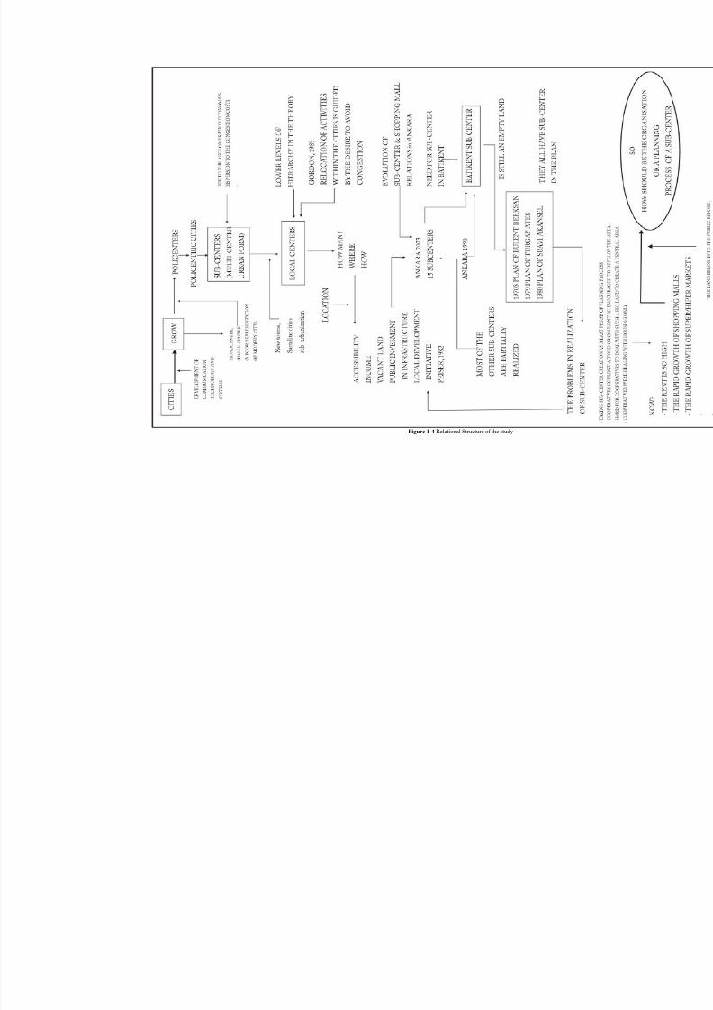
Figure 1-4 Relational Structure of the study..........................................................................10
Figure 2-1 the Structure of the Study.....................................................................................12
Figure 2-2 Schematic view of the CBD and the Sub-center Relations.................................. 16
Figure 2-3 Detailed Schematic view of Sub-center organization with Relations among UrbanUses...............................................................................................................................16
Figure 2-4 Land-use zoning developed by Cadwallader........................................................ 17
Figure 2-5 Principles of Neighborhood Unit and the Center by Clarence Perry ................... 20
Figure 2-6 Neighborhood Unit and the Scheme by Jose Sert ................................................ 21
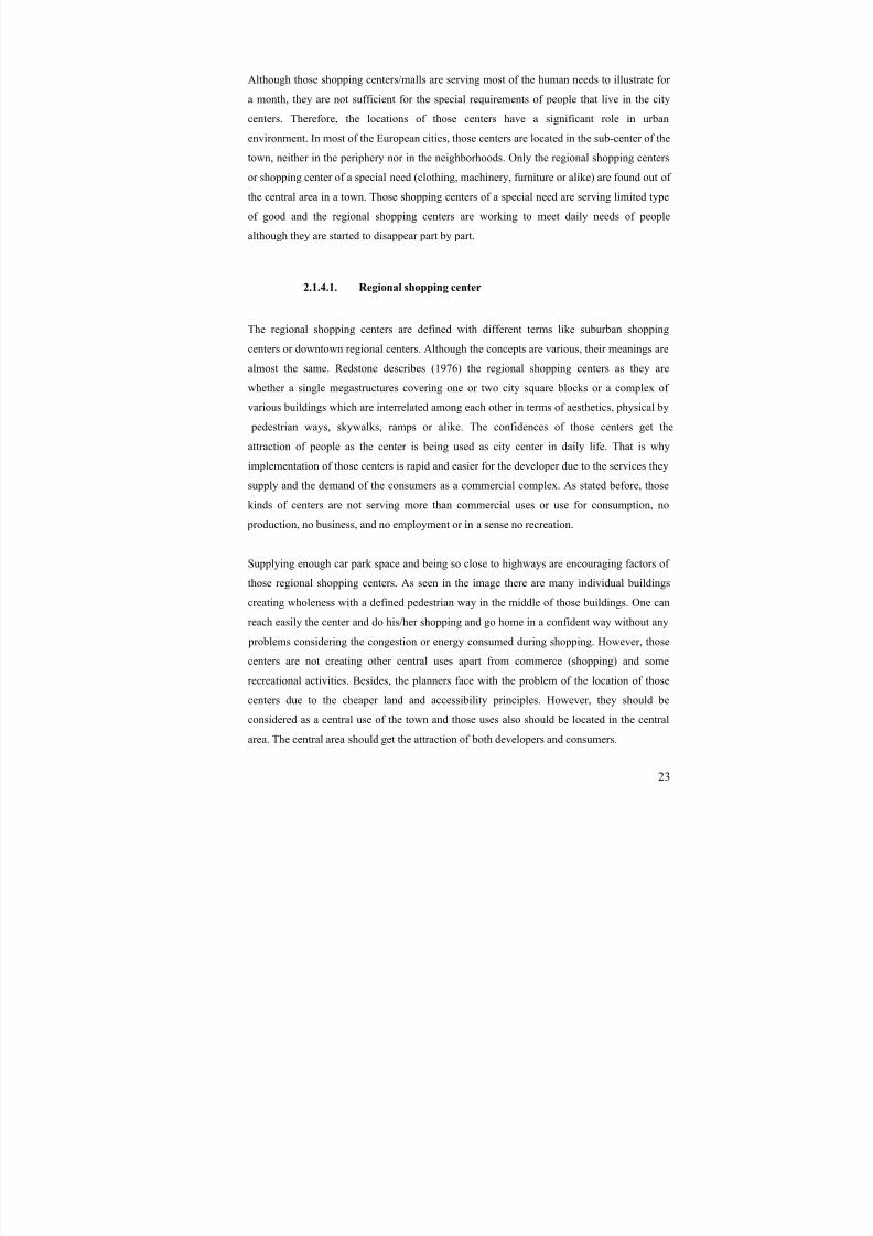
Figure 2-7 Regional Shopping Center in the 1960s, Northgate Center, Seattle..................... 24
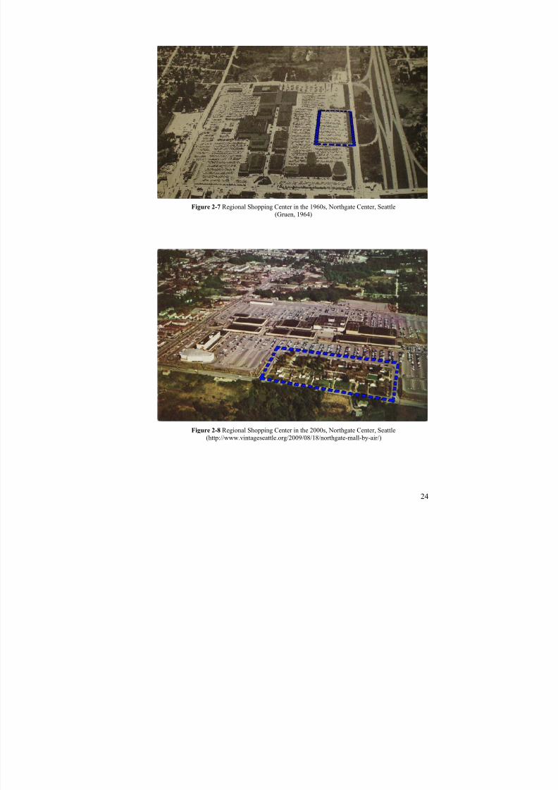
Figure 2-8 Regional Shopping Center in the 2000s, Northgate Center, Seattle..................... 24
Figure 2-9 the Schematic view of the Regional shopping centers ........................................ 25
Figure 2-10 Industrial Center of Wilmington ........................................................................ 27 Figure 2-11 Civic Center of Los Angeles, California............................................................ 27
Figure 2-12 the Schematic view of the Uni-functional centers.............................................. 28
Figure 3-1 the three magnet diagram of Howard .................................................................. 39
Figure 3-2 The garden city diagram of Howard with its center... .......................................... 40
Figure 3-3 The central Paris development scheme of Corbusier .......................................... 42
Figure 3-4 Broadacre City of Wright.....................................................................................43
Figure 4-1 The hierarchy of different orders of settlements, Walter Christaller.................... 47
Figure 4-2 the Relations of Sub-centers in Paris Region with the CBD... ............................. 50
Figure 4-3 The end of Shopping centers................................................................................53
Figure 4-4 the plan and the view of La-Defense, showing pedestrian zones and motorways58
Figure 4-5 Five Sub-centers of Paris Region and the location of Cergy-Pontoise ................ 59
Figure 4-6 Economic majors of Cergy-Pontoise.................................................................... 62
Figure 4-7 The Housing Construction Process of the Conurbation Cergy-Pontoise ............. 63
Figure 4-8 The Development Process of the Conurbation Cergy-Pontoise........................... 64

8/8/2019 Assessment of Sub-center Development
http://slidepdf.com/reader/full/assessment-of-sub-center-development 13/154
xiii
Figure 5-1 1924 Lörcher Plan of Ankara............................................................................... 68
Figure 5-2 1932 Jansen Competition Project Proposal, and the Master Plan ........................ 69
Figure 5-3 1932 Jansen Implementation Plan of Ankara....................................................... 69
Figure 5-4 Yücel-Uybadin Plan of Ankara, showing the future development of the central
area and the city ............................................................................................................ 71
Figure 5-5 1970 Ankara Land-use map showing the existing situation................................. 72
Figure 5-6 the centers of Ankara and the structure of the center in the beginning of 1970s . 73
Figure 5-7 1990 Master Plan of Ankara, showing new settlements in the west corridor ...... 74
Figure 5-8 Structural Plan of Ankara 2015 showing the corridors ........................................ 77
Figure 5-9 2025 plan of Ankara Metropolitan area showing 1990 plan structure ................ 78
Figure 5-10 Spatial organization of non-public services distribution in the core and the
Metropolitan area of Ankara ......................................................................................... 80
Figure 5-11 Spatial organization of public-administrative services distribution in the core and
the Metropolitan area of Ankara ................................................................................... 80
Figure 5-12 Master Plan of Ankara 2023............................................................................... 81
Figure 5-13 15 Sub-centers projected in the 2023 plan ......................................................... 82
Figure 5-14 Structure Developed for the Study area ............................................................. 83
Figure 5-15 Sub-center Proposals in 2023 Ankara Master Plan ............................................ 84
Figure 6-1 Detail view of Batıkent in Metu CRP Team Plan 1985-2015 (left) and
Municipality of Ankara Plan 1990-2025 (right)............................................................ 89
Figure 6-2 Detailed plan view of Batıkent New Settlement area in 1990 plan of Ankara-
1/50,000......................................................................................................................... 89
Figure 6-3 Detailed plan view of Batıkent New Settlement area in 2023 plan of Ankara-
1/25,000......................................................................................................................... 90
Figure 6-4 Batıkent 1/5,000 plan of Bülent Berksan and his team ........................................ 92
Figure 6-5 The central area designed in Berksan Plan........................................................... 93
Figure 6-6 Batıkent 1/5,000 Plan of Turgay Ateş and his team............................................. 93
Figure 6-7 The Sub-center design of the settlement, Batı
kent (Turgay Ateş and his team’sPlan) .............................................................................................................................. 95
Figure 6-8 Batıkent 1/5,000 Plan of Suavi Akansel and his team ......................................... 96
Figure 6-9 Existing Public Services and shopping malls...................................................... 98
Figure 6-10 Four types of center development in the Akansel’s plan ................................. 100
Figure 6-11 The central area in Akansel Plan...................................................................... 100
Figure 6-12 Batıkent 1/5,000 Plan Revision of the last and his team.................................. 102
Figure 6-13 Staging of Turgay Ateş and his team’s Plan of Batıkent.................................. 107

8/8/2019 Assessment of Sub-center Development
http://slidepdf.com/reader/full/assessment-of-sub-center-development 14/154
xiv
Figure 6-14 Staging of Suavi Akansel Plan of Batıkent ..................................................... 107
Figure 6-15 25 District Defined of the Sub-center for Revision Assessments .................... 109
Figure 6-16 North View of the Central Area of Batıkent .................................................... 112
Figure 6-17 East View of the Central Area of Batıkent....................................................... 112
Figure 6-18 An Actual Implementation Plan of the central area, Batıkent.......................... 113
Figure 6-19 The development of Residential & Commercial districts in Cergy Pontoise... 114
Figure 6-20 Streets connecting neighborhood center to town center................................... 118
Figure 6-21 The development of Residential Parcels in Cergy Pontoise............................. 120
Figure 6-22 District center working as a town Center of Batıkent ...................................... 121
Figure 6-23 Close neighborhood centers to sub-center........................................................ 122
Figure 6-24 The Locations of the Existing and Planned / in construction Shopping Centers
..................................................................................................................................... 124

8/8/2019 Assessment of Sub-center Development
http://slidepdf.com/reader/full/assessment-of-sub-center-development 15/154
xv
LIST OF TABLES
TABLES
Table 4-1 Comparison of Town and District centers and Patterns of Batıkent and Cergy .... 66
Table 5-1 Proportions of Sub-center developments in 1990 plan.......................................... 72
Table 5-2 Comparison of Sub-center Development Patterns................................................. 86
Table 6-1 Land-use of Batıkent in the Last Plan ................................................................. 102
Table 6-2 Comparison of the 1/5,000 Plans, Center Design and the Schemes of Batıkent . 104
Table 6-3 Comparison of the 1/5,000 Plans, Center Design and the Schemes of Batıkent
(Continued) ................................................................................................................. 105
Table 6-4 The Plan Revisions of Batıkent and the Uses of the sub-central zone ................ 110
Table 6-5 The comparison of central areas of Batıkent and Cergy-Pontoise....................... 115
Table 6-6 Characteristics of Shopping Centers in Ankara................................................... 123
Table 7-1 Comparison of the Hypotheses and the Indicators of other sub-central
developments with Batıkent ........................................................................................ 127
8/8/2019 Assessment of Sub-center Development
http://slidepdf.com/reader/full/assessment-of-sub-center-development 16/154
1
CHAPTER 1
1. INTRODUCTION
1.1. The Aim of the Study
The major aim of this study is to examine the reasons of the underdevelopment processes of
town centers in sub-urbs in planned urban environment by discussing the relevance of sub-
center formations throughout the theory. This study will be supported by discussing the sub-
center development formations in both planned and spontaneous urban environment in case
of Ankara to understand the relevance of central area developments, due to the fact that
while the spontaneous urban environment in Ankara has a clear sub-centers, the planned
ones could not have it through many years although they exist in their plans.
The sub-centers are the secondary heart of the urban metropolitan areas, considering the
Central Business District (CBD) as a main heart of the whole system. The sub-centers should
be considered as the heart of the close environment and surroundings. That is to say, while
the CBD should be thought as the heart of the whole city, the urb, sub-centers should be
considered as a heart of the town located in. It should be the brain of it and work as heart of
the system. That is why this study will focus on the sub-center development in which it has
not been developed well or could not be developed as it should have been specifically in
planned urban environment.
The problem of the planned urban areas in view of sub-center development specifically in
Ankara is that the plan and the structure of those areas are mainly under-developed or
transformed into dissimilar uses differently as in the plan. At this point, the problem of
planning structure and processes come to the subject. In the case of Ankara, the plan itself
could not be enough to develop the central areas especially in Batıkent, located in the West
Corridor (Batı Koridoru) of Ankara. Although all the plans made for Batıkent includes the
8/8/2019 Assessment of Sub-center Development
http://slidepdf.com/reader/full/assessment-of-sub-center-development 17/154
2
urban uses of sub-centers in the central area, the defined sub-central area is still acting as an
empty land more than 25 years.
This study focuses on the relations between the planned and spontaneous urban environment
with differences of sub-center developments considering the sub-center ingredients with
planning processes. Through this, the problems in sub-center formation, creation, will be
analyzed.
Sub-center development in planned urban environments of Ankara either has not been
realized so far or has been realized physically, but in a different way considering their plan
schemes and organizations. At this point, the problem of the property and the land divisions
in planned areas come to the subject and this is going to be discussed to find a clarification
for the sub-center development in case of Batıkent where the land belongs to the public.
As well as those problems in sub-center formation, the planning problems and the design of
the built environment have also the significant responsibility in non-existence of necessary
sub-centers. The problems of transportation, accessibility, urban elements for the direction in
the town, other infrastructures, huge divergence in types of dwellings and other units, the
problems of serving the land for a limited group, which does not have various kinds of land
scales and variety of lands for a range of capital owners, problem of order in the design of
the built environment, and lacking mixed use order both in building and site scale in the
center move toward to the study as a question and problem to be worked out.
The main aim of this study is to examine the characteristics of sub-center development or
formation in new urban development areas. So-called existing central area will be searched
and examined in terms of design and planning principles. New criteria, characteristics and
ingredients for a sub-center formation will be identified via the critique of the existing
situation considering the planning projects made for the area and the search of successfulexamples in the world case.
- Defining and identifying the center and sub-center approach and its components in
new towns like Batıkent, locating the characteristics of the sub-central areas
- Examining the theories of sub-centers and its relations with the CBD, including the
relations with the environs and other sub-centers

8/8/2019 Assessment of Sub-center Development
http://slidepdf.com/reader/full/assessment-of-sub-center-development 18/154
3
- Observing the relations among the sub-center and other district centers with
neighborhood centers in sub-urb development, identifying the differences or
similarities between the relations of CBD (Ankara) with Sub-center (Batıkent) and
relations of Sub-center (Batıkent) with District centers.
- Defining the difference in development processes of planned, newly developed
towns-artificial development- or process of collective housing areas, spontaneous
city sub-centers-natural development- or regular developed areas with small-private
properties
Through this, sub-center planning criteria for central area development in satellites, in new
planned towns of Ankara will be developed in this study. Especially defining the problems of
sub-center in its planning and intervene process of the land and comparing sub-center
formation in new towns with the world example and other spontaneously developed sub-
centers will help the study getting the conditions or prerequisites for the development of new
sub-centers for its space and plan organization.
1.2. Research Questions
The study aims to find clues for the sub-center development where the development is still
lacking although it is proposed to be there and where they are differently built from the
original plan in planned urban environment.
Sub center development in Ankara still has some problems in itself considering the problems
in the CBD area and the newly developing areas and their relations to the central city.
Therefore, studying the problems of the sub-urbs and their centers, namely sub-centers have
become relevant for the study area. Specifically the problem of non-existence of the sub-urbs
and the sub-centers in newly developing areas that are planned, not spontaneously developed
urban areas has become the matter of the study.
Specifically, in planned urban environments, the sub-center or in a broader sense sub-urb
creation is hardly done, that is it is different from the plan, or it is still lacking due to some
problems in the area of suburb in Ankara. Batıkent, a newly developed town in Ankara with
the help of big public land still lacks a sub-center. The problem of the nonexistence of the
sub-center will be searched due to the property relations in the area. Big lands to develop as
8/8/2019 Assessment of Sub-center Development
http://slidepdf.com/reader/full/assessment-of-sub-center-development 19/154
4
central area are still working as an empty land and the plan itself could not be enough to
build a central area and activities to the site defined in the plan. This research is also going to
be evaluated through the comparison of two newly developed urban environments in Ankara,
Çayyolu and Batıkent. Because, although urban environments are planned in both of the
sites, while the former has started to have a sub-central area in a linear shape by the
transformation of some housing use to commerce or business, the latter still lacks despite
having a central zone in the plan. Here, public property ownership in new urban
development areas becomes as a question to the study. And hence, besides the property
relations, the design of the built environment with the plan’s land use decisions plays an
active role in the creation of the sub-center.
Besides these researches, as Gruen stated, the urban environment works as a human body
and when any one part of the body is lacking it creates diseases in urban life, and in its
functions (1964). The central core area of the urban environment works as a heart of the
whole metropolitan area or of the surroundings in the town. It is therefore the urgent need of
the environment to have a heart and hence the city’s soul and urban spirit . The question of
what kind of heart this should be and what kind of ingredients should include is also
problematic in this study. They will be analyzed from different authors’ perspective that
questions the components of the central area and this will help the study to develop a
problem series in planning processes.
Considering these developments and theories about sub-centralization Ankara case will be
examined. Ankara developed very rapidly after it became capital city with the foundation of
Turkish Republic. With that development, the city became more and more insufficient to its
citizens in terms of services and proximity to the users.
By the rapid growth in Ankara, the central areas started to move or get bigger and bigger.
Considering this development, the problems of transportation, pollution, congestion, andsimilar matters became inevitable in the CBD areas. In addition to these, as population got
higher, more spaces were needed for the central areas.
The central area Ulus became insufficient and a new place K ızılay for the central area of the
city was considered as an alternative in the 1930s. With that, Ankara had a central spine
starting from north (Ulus), to the south (K ızılay) in the 1950s. Most of the administrative and
commercial units started to locate in K ızılay, and it become more attractive for them in terms

8/8/2019 Assessment of Sub-center Development
http://slidepdf.com/reader/full/assessment-of-sub-center-development 20/154
5
of space and proximity to the other housing districts. Ulus and K ızılay started to serve the
districts of central facilities for different social groups. Therefore it divided citizens in terms
of centre use, and that created two separate cities, like in colonial cities, within the same city
(Akçura, 1971, p118). With the development of K ızılay region as a central space for Ankara,
more space and land was needed to develop for business and commerce. After the
transformation of housing areas into commercial or business land use in K ızılay, due to
current demand for those uses, central area moved to Kavaklıdere, Tunalı Hilmi district and
Çankaya as a sub-central zone.
Ulus and K ızılay districts reached almost its final step for commercial and business uses.
They started to have problems in terms of congestion, day and night population, pollution,
transportation, space quality, and similar issues.
Figure 1-1 Central area development of Ankara
8/8/2019 Assessment of Sub-center Development
http://slidepdf.com/reader/full/assessment-of-sub-center-development 21/154
6
For these problems mentioned and their future growth, Ankara needed new centers to be
solutions for them, and moreover the metropolitan region required new towns to provide
effective cultural and social spaces, which were lacking for the whole urban area.
Among those needs of new centers in Ankara, the town of Batıkent was thought as a new
Housing development area in 1970s. In the beginning of the project, Batkent was not a
project of a new city element as a sub-center and therefore was not designed as a satellite
city having a sub-center as a solution to the center’s problems but it was thought to be a
solution to housing need and squatter developments in Ankara.
While the CBDs are the places of main concentration in retail, business, civic services, and
cultural activities (Meyerson, 1963), the sub-centers are also kinds of those places in which
those activities should locate in smaller scales. The reason for Sub-center and sub-urban
development is mainly the decentralization process as the city grows and as the main center
becomes insufficient for all citizens. Sub-centers are formed with site selections for public
institutions, residential settlements, industry, commercial and business development, new
urban development projects, transportation systems, and road infrastructure. Hence, public
and private office requirements, new housing for all different social groups, commerce,
culture, tourism, services and recreation should all be provided in sub-centers.
With the decentralization process in Ankara, Batıkent project was launched in connection
with the development idea in west corridor in Ankara at the end of the 60s. 1990 plan of
Ankara proposed Batıkent housing area with the development of industrial areas in the close
environment of Batıkent called Ostim and İvedik. The project area in a sense was not only
housing but also an industrial zone. Apart from those ideas of working places like industry in
west corridor, Batıkent could not be developed as a Sub-center or a new town in Ankara. But
the area was developed as a solution to Housing need and neglected the Sub-center
development considering the ingredient or characteristics of it. There were not moreemployment centers except for the industry, that is to say the project is lacking the central
area and moreover it is lacking the central land uses and activities.
8/8/2019 Assessment of Sub-center Development
http://slidepdf.com/reader/full/assessment-of-sub-center-development 22/154
7
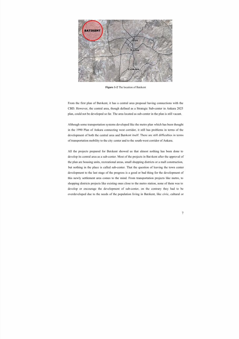
Figure 1-2 The location of Batıkent
From the first plan of Batıkent, it has a central area proposal having connections with the
CBD. However, the central area, though defined as a Strategic Sub-center in Ankara 2025
plan, could not be developed so far. The area located as sub-center in the plan is still vacant.
Although some transportation systems developed like the metro plan which has been thoughtin the 1990 Plan of Ankara connecting west corridor, it still has problems in terms of the
development of both the central area and Batıkent itself. There are still difficulties in terms
of transportation mobility to the city center and to the south-west corridor of Ankara.
All the projects prepared for Batıkent showed us that almost nothing has been done to
develop its central area as a sub-center. Most of the projects in Bat ıkent after the approval of
the plan are housing units, recreational areas, small shopping districts or a mall construction,
but nothing in the place is called sub-center. That the question of leaving the town center development to the last stage of the progress is a good or bad thing for the development of
this newly settlement area comes to the mind. From transportation projects like metro, to
shopping districts projects like existing ones close to the metro station, none of them was to
develop or encourage the development of sub-center, on the contrary they had to be
overdeveloped due to the needs of the population living in Batıkent, like civic, cultural or
8/8/2019 Assessment of Sub-center Development
http://slidepdf.com/reader/full/assessment-of-sub-center-development 23/154
8
commercial, hence, district centers overgrew and this effected the town center development
as well.
Taking all the problems into consideration, Batıkent center, as a part of the capital city, is
not/should not be a district center or a sub-urban shopping center, but it should be a fully
satellite with its own center, having administrative institutions and all those sub-center
characteristics.
In this study, evolution of a new city; Batıkent’s sub-center will be discussed in terms of
planning applications. Conceptual planning and design concepts will also be argued. Factors
and the tools for planning and design of the central area in Bat ıkent will be evaluated. After
this evaluation, a planning program and design applications for the formation of Sub-center
in Batıkent will be proposed.
Within these questions and problems of sub-center growth in new and planned urban
settlements, some hypotheses on Urban Land Use, Transportation, Planning Process,
Property Pattern, Environmental and Metropolitan Area Relations, and Design of the Built
Environment were developed. The six hypotheses related to sub-central development, given
in the following, are tested and evaluated in the case of Batıkent. In addition to this, some
principles are developed and reexamined with the indicators in the case area and world
example as well.
- The first hypothesis is about Urban Land Use, that is; Urban Land uses in sub-
central area of a sub-urban development need to include all the public and common
uses, special unique buildings of a town, and high rise blocks of urban utilities in a
compact form enabling mobility of population in an organic way to form a sub-
center development in the whole settlement.
- The second is about Transportation, that is; There has to be different kinds of
transportation networks and links to CBD both for public and private transportation,
namely for motorways and public transportation networks for the creation and
development of sub-centers. Sustainable transportation systems like pedestrian,
bicycle, public transportation and railway systems has to be encouraged in the
central area to attract people and make them access and use the city center easily and
to improve the nature of the central area.

8/8/2019 Assessment of Sub-center Development
http://slidepdf.com/reader/full/assessment-of-sub-center-development 24/154
9
- The third one is concerning the Planning Process; planning stages of new
development urban areas and sub-urbs with their centers have to be enhanced in
cooperation with the residential area development and central area growth so as to a
create center and therefore activities for citizens and lower the rent in the area and
achieving the solution earlier, forbidding the future problems and the rent matters.
- The forth is regarding the Property pattern; Property pattern of the sub-centers needs
to allow various kinds of capital owners in order to attract and construct the central
uses and therefore develop the city centers. That is to say, different scales of the land
need to be formed for different urban uses and for different scales of capital owners.
- The fifth hypothesis is about the relationship with the other centers and the CBD,
that is; Sub-center has to have one or more units of government or administration of
the town. Besides it has to include headquarters of companies or at least a unit of the
firms as an employment area to have a relation with CBD and other sub-centers in
metropolitan region needed for the creation of sub-center.
- The last hypothesis developed is pertaining to the design of the built environment;
the environment of sub-center need to be designed very carefully in order to provide
direction to the center and to the other district centers and it has to be developed in
order not to create an area where pedestrians cannot access to impose the attributes
of sub-center formation.
These hypotheses are evaluated through Batıkent, case area, Cergy Pontoise, world
experience and some other Sub-centers in Ankara to make a comparison with other new
settlements and spontaneous urban sub-center developments. The principles of these
hypotheses are looked for and searched in the case area. In addition to these the indicatorsare defined and re-examined in these areas to understand whether the settlements meet the
needs for the development of sub-center or not.
8/8/2019 Assessment of Sub-center Development
http://slidepdf.com/reader/full/assessment-of-sub-center-development 25/154
Figure 1-4 Relational Structure of the study
8/8/2019 Assessment of Sub-center Development
http://slidepdf.com/reader/full/assessment-of-sub-center-development 26/154
11
CHAPTER 2
2. THE KEY CONCEPTS
2.1. Concepts of city center / sub-center development
The origin of the city center is based on the antique Greece. Central activity requirementshave existed after human started to settle. Agora is the center of Greek cities locating as the
core of the volumes and center of the building complexes and activities. All the activities
considering politics about the city, religious, commercial and similar facilities were done in
Agora. In the time of Roman cities, Forum was the center of the city. Trade, business,
worships and the justice were realized in that Forum. In the medieval towns, market square
was the center of Middle Ages which was surrounded with church, town hall, some
significant shops, business premises, and some hotels. It was a traditional meeting place for
local people to trade. The market area was developed as Plazas in the following time of renaissance and baroque cities. Today’s cities and centers have almost a part of those
mentioned centers. At least, the city centers of today have the characteristics of those old
center variations. Surely, actual city centers have more of it due to the improvement of the
communication technologies and hence the problems.
Considering the origin and a basis of the city centers, the developing stages of the city
centers mentioned before, it is not hard to deduce that the city core is the concentration of
urban activities surrounded by public uses.

8/8/2019 Assessment of Sub-center Development
http://slidepdf.com/reader/full/assessment-of-sub-center-development 27/154
12
Figure 2-1 the Structure of the Study
2.1.1. City center
There are many definitions of the city center and there are general assumptions of the
centers. They, in most of the definitions, are the places where the most accessible options are
being offered. The centers are generally located at the center of the whole urban area. And
moreover they are the places of concentration of activities and services which are appealing
to the whole community. In this section of the study, although sub-centers are examined in
different, the following, part considering the theory, the city center concept should be
thought, observed and performed as a sub-center, but in a small difference that is to say inscale. Namely, if the city center is serving for the whole metropolitan area, the sub-centers
do it for their environment with a relation to the other sub-centers and towns.
The ingredients of city center to have its namet; it should have had a mixture of commercial,
social, cultural, financial and administrative facilities. Those urban uses are concentrated in
the city centers. Namely, the focus of the mixture of those mentioned activities for the
8/8/2019 Assessment of Sub-center Development
http://slidepdf.com/reader/full/assessment-of-sub-center-development 28/154
13
citizens dealing with or using the area for different types of aims are thought as the center of
the city. It is the place of the center in which communication and transportation technologies
do significantly create a node.
The city center serves intense urban uses in terms of economic functions like commerce,
retail, finance and business. They all supply different kinds of goods and services with a
large range of quality, price and types (Cornier, 1968). While Spreiregen explains the center
having the highest concentration of services for the whole population, he also adds that the
central area have some keys like change and development (1965). Therefore, the central area
should be elastic to develop and change and hence the growth usually has been linear. In the
theory, while some authors concentrate on the parts or ingredients of the central area use,
some other do it not in the function but in the pattern, in the formation and leave the
functions as the concentration of almost all urban activities. They do it considering the core
as it should be a spontaneously developed area with the functions needed by community and
leave other thoughts aside and they do not limit the central area use.
Although some of the definitions identify the center as functions and activities are located in,
some concentrate on the action done in those centers. Aksel (2000), to illustrate, describes
the city centers as they are the places of consumption. All the consumption types from eating
habits to the other cultural traditions are to be found in those areas of urban land. The time
spent in the city center is consumed and therefore it is defined as a consumption place.
However, considering the future growth and development and moreover for the future
generation and formation of the central area, namely to sustain it, it should have a role more
than consumption but also production like working or business. It should have such a task
that the thing done or created in a center could also be consumed both in it and in the
environment and could also be re-done or re-created again in it.
“City centers” are the most interesting parts of the cities where major public buildings andspecial/unique buildings, commercial, administrative and cultural institutions are located in a
space with high rise buildings, dense and mobility of population (Keleş, 1998, p.78). The
basic character and the crucial role of the central areas of the urban environment as
understood from the different definitions, is that being special, compact, namely highly
dense, and concentration of the urban life, movements and facilities.

8/8/2019 Assessment of Sub-center Development
http://slidepdf.com/reader/full/assessment-of-sub-center-development 29/154
14
As mentioned before, the city center works as a heart and somehow as the brain of the
human anatomy addressing and appealing to the whole citizens living around. Moreover, the
city center, town center, should also attract not only the people living in the environment but
also the other people living in other towns and sub-urbs as a second significant attraction.
That is to say, the self-sufficient city will not be totally sufficient but should be integrated to
the whole metropolitan area development and integration.
Moreover, political and administrative elements of the state are concentrated on the center
and that makes it as a symbol of the ideological aspects of the state. It is the place of state
functions and activities in which police stations, educational units, and state offices are
included (Castells, 1977). Considering the utilities of these functions and urban uses, it can
be understood that these are not the places of getting all the attraction of whole community.
These functions can be grouped as working, safety and educational spaces of the urban area,
but for being a city center there should be not only a brain but also the heart of the
hinterland.
Güler (2000) explains the city center, considering the administrative functions of the city,
with the ideas of Chicago School, as a brain of the city in which the decisions that will affect
the whole metropolitan area are taken and that will affect the quality of life with those
decisions. According to this thought, controlling power of the city on the communities is
concentrated on the center by the management units of the industry, communication,
information and state headquarters or offices.
Besides the administration functions of the center, the central areas are also the places of
major concentration for socio-cultural facilities. Tunc (2003) adds that they are the places of
inhabitants who go or visit there for several reasons in any time of the day, and they are the
places of leisure, entertainment and cultural intensification. Therefore, the area of center is
used all day and night. Steele in Tunç explains the central population is the highest daily population within the whole urban area because of those reasons mentioned.
In addition to the fact that different groups of people come and live together, share, and meet
there, and besides their relation networks are high, City centers have a significance duty of
information-knowledge and cultural communication of the citizens (Lefebvre, 1968).
Castells (1977) defines the city center as a ludic nucleus containing highly dense leisure
activities and states the core as the spatial setting of the city lights. Therefore he keeps on,
8/8/2019 Assessment of Sub-center Development
http://slidepdf.com/reader/full/assessment-of-sub-center-development 30/154
15
the core facilities of the town social processes and their inside dynamics. Two critical roles
in an urban system; integrating and symbolic roles are also vital for centers. As some other
authors explained city centers should have the task of creating social unity and within this
duty, they should be concentrated on a social space of people to use.
According to Castells (1977), the activities of the following items should also be
concentrated in the city;
- Exchange
- Distribution
- Administration
- Spreading of information
Those items he explained should be comprehended both in an ordered way and symbolically
organize the conditions of communication among various actors of urban communities in the
core area which are equally accessible for the whole.
2.1.2. Sub-center
The urban land, that supplies socio-cultural facilities as a center qualification and gathers
some of the employment of the main center for not all the citizens living in the city but for
the people living close to the located center and its environments, is called as “sub-center”.
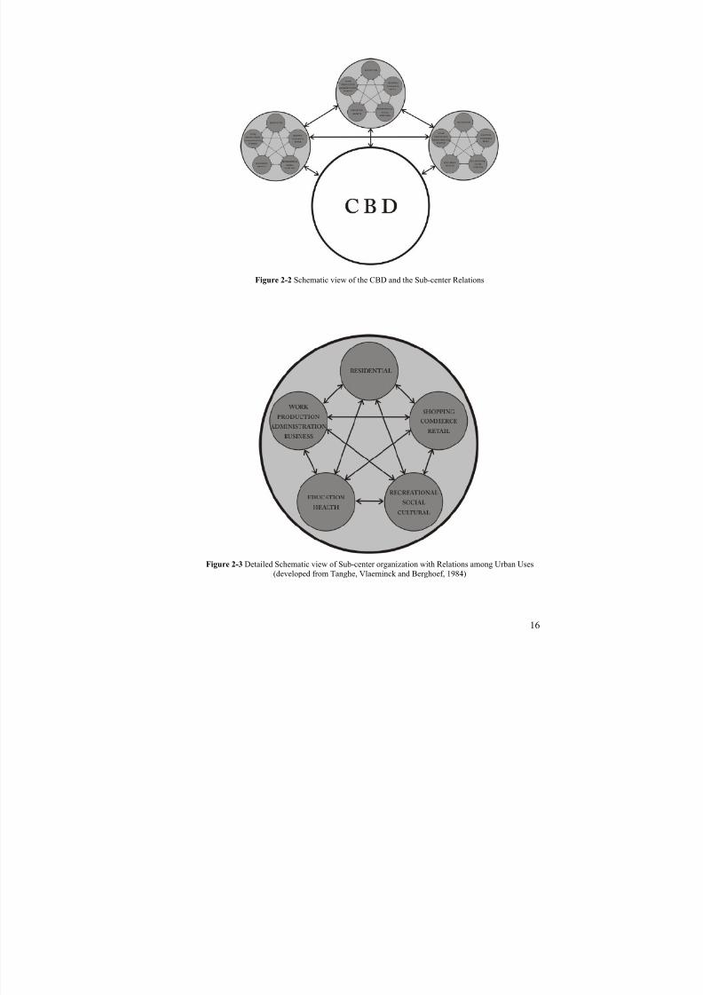
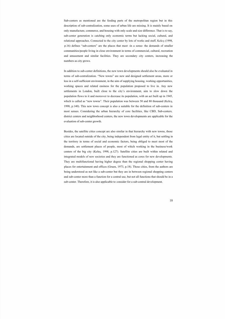
According to Dökmeci and Akkal (1993), the basic factors identifying the sub-centers are the
more dense population in surrounding, employment (workforce) and commercial facilities.
Besides the sub-center definition, the area should be thought as the center or a core of the
surroundings and environment. Therefore the city core definitions are also valid for the sub-
center definitions. Gruen(1964) defines those centers as they are the places of highly
urbanized areas having a complete range of highest productive uses. Moreover, as well as the
business and civic administration it should have the activities of cultural, recreational, social,
spiritual and highly dense and qualified urban residential areas. That is to say having the
unique functions of the hinterland in the town is therefore very significant role of the central
area. If one or more of those functions is lacking in the core, this will create diseases or the
non-existence, non-creation of the central area. Here the role of the planners and
administrative units comes to the stage and decision makers should consider the demand
creation points in the center and should consider locating all of those uses having the organic
and physical relations among each other.
8/8/2019 Assessment of Sub-center Development
http://slidepdf.com/reader/full/assessment-of-sub-center-development 31/154
16
Figure 2-2 Schematic view of the CBD and the Sub-center Relations
Figure 2-3 Detailed Schematic view of Sub-center organization with Relations among Urban Uses(developed from Tanghe, Vlaeminck and Berghoef, 1984)

8/8/2019 Assessment of Sub-center Development
http://slidepdf.com/reader/full/assessment-of-sub-center-development 32/154
17
Sub-centers are not only the densest places of commerce, or employment. They should
provide more of it, like socio cultural activities, recreational activities, or administrative
activities. A sub-center should be a part of the city in general. It should have relations with
the main city center and with other sub-centers. Since the city is not an organism that has
everything inside to live and grow, or as Alexander told “the city is not a tree” (1965) it
should have more of those relations. Creating a sub-center should be thought as taking a part
of the city and putting it somewhere to have some burdens of all. Here “all” is a land use
including not only housing but also uses like administrative units, cultural elements, and
recreational facilities and so on. In all aspects of urban life, sub-centers should supply to its
citizens all central services.
Sub-urban Sub-centers according to Cadwallader (1996) are the centers that are joined CBD
which is the most accessible for the entire urban area. These centers have and produce their
own set of urban land use sectors like Commercial, Manufacturing, and Residential. It is the
place of represented monocentric city structure. The description of the sub-center in his idea
includes also the location of sub-centers by being located near the main motorway
intersections. Transforming a monocentric city into polycentric is explained by the
accumulation of different individual sub-centers. Namely, the sub-center formulation in an
entire urban land is conceptualized by a trade-off between agglomeration economies. He
emphasizes the sub-center generation should be explained by the numerous assessments of
the individual companies and developers.
Figure 2-4 Land-use zoning developed by Cadwallader (Cadwallader, 1996)
8/8/2019 Assessment of Sub-center Development
http://slidepdf.com/reader/full/assessment-of-sub-center-development 33/154
18
Sub-centers as mentioned are the feeding parts of the metropolitan region but in this
description of sub-centralization, some uses of urban life are missing. It is mainly based on
only manufacture, commerce, and housing with only scale and size difference. That is to say,
sub-center generation is catching only economic terms but lacking social, cultural, and
relational approaches. Connected to the city center by lots of works and stuff, Kele ş (1998,
p.16) defines “sub-centers” are the places that meet -in a sense- the demands of smaller
communities/people living in close environment in terms of commercial, cultural, recreation
and amusement and similar facilities. They are secondary city centers, increasing the
numbers as city grows.
In addition to sub-center definitions, the new town developments should also be evaluated in
terms of sub-centralization. “New towns” are new and designed settlement areas, more or
less in a self-sufficient environment, in the aim of supplying housing, working opportunities,
working spaces and related easiness for the population proposed to live in. Any new
settlements in London, built close to the city’s environment, aim to slow down the
population flows to it and moreover to decrease its population, with an act built up in 1945,
which is called as “new towns”. Their population was between 50 and 80 thousand (Keleş,
1998, p.140). This new town concept is also a suitable for the definition of sub-centers in
most senses. Considering the urban hierarchy of core facilities, like CBD, Sub-centers,
district centers and neighborhood centers, the new town developments are applicable for the
evaluation of sub-center growth.
Besides, the satellite cities concept are also similar in that hierarchy with new towns, those
cities are located outside of the city, being independent from legal entity of it, but settling in
the territory in terms of social and economic factors, being obliged to meet most of the
demands, are settlement places of people, most of which working in the business/work
centers of the big city (Keleş, 1998, p.127). Satellite cities are built within related and
integrated models of new societies and they are functioned as cores for new developments.They are multifunctional having higher degree than the regional shopping center having
places for entertainment and offices (Gruen, 1973, p.18). Those cities, from the authors are
being understood as not like a sub-center but they are in between regional shopping centers
and sub-center more than a function for a central use, but not all functions that should be in a
sub-center. Therefore, it is also applicable to consider for a sub-central development.

8/8/2019 Assessment of Sub-center Development
http://slidepdf.com/reader/full/assessment-of-sub-center-development 34/154
19
Lynch states for the urban core facilities that those areas should implicate several
possibilities that are ranging from living, working, servicing and leisure with a highly
concentrated area with a spoke of open spaces. Here he expresses not only functional but
also physical sense. Therefore, he adds that the central area should be demarked and easily
visible containing cluster of skyscrapers or a group of huge and unique urban uses likes
governmental or university (Spreiregen, 1965). Hillier (1999) defines the town center not
much differently from the others but clearly identifies that the center is marked by focal “live
center” of markets and retail, with a quieter districts of administration, business and religion
in close spatial proximity defining the limits of the central area. Differently from other
authors he describes the sub-center or a town center within the space organization. He states
as “focus”, describing the “limits” and mapping the various “functions” in their locations in
the same time. He does not separate but combines these three aspects of planning and space
organization for the formation of the centrality.
2.1.3. Neighborhood center
Neighborhood unit concept and therefore the neighborhood center development term were
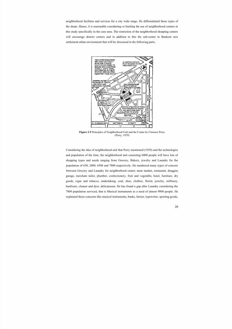
developed by Clarence Perry in the beginning of the 19th century. Perry (1929) improved the
idea of agglomeration of smaller units considering the safety of neighborhood facilities, civic
benefits and moral and social values of the young and therefore the community. Thisagglomeration is composed of elementary school, public playground, and convenient local
shops serving for 5-6,000 citizens where they live in almost 70 hectare area bounded but not
crossed by major highways. The relations in these neighborhood centers will be face to face
relations and nothing more than it in which homogeneity in it is produced. According to
Perry, the automobilization forced the life of neighborhood because the motorways are
cutting the neighborhood into small islands that creates separation. Neighborhood unit is
defined by some principles including the size allowing the elementary school with the
population served. Moreover, the principle of the boundaries is for neighborhood unit by
being surrounded by arterial roads permitting the through traffic. System of parks and
recreational areas are planned in neighborhood unit for the demand of citizens living in as an
open space principle. In addition to these, area for the institutional sites, local shops and
internal street system becomes as principles of creating neighborhood environment.
Moreover, the neighborhood unit concept developer, Perry, built up various use of local
shops that should be located in the neighborhood center. He mentioned both the
8/8/2019 Assessment of Sub-center Development
http://slidepdf.com/reader/full/assessment-of-sub-center-development 35/154
20
neighborhood facilities and services for a city wide range. He differentiated those types of
the shops. Hence, it is reasonable considering or limiting the use of neighborhood centers in
this study specifically in the case area. The restriction of the neighborhood shopping centers
will encourage district centers and in addition to this the sub-center in Batıkent new
settlement urban environment that will be discussed in the following parts.
Figure 2-5 Principles of Neighborhood Unit and the Center by Clarence Perry(Perry, 1929)
Considering the idea of neighborhood unit that Perry mentioned (1929) and the technologies
and population of the time, the neighborhood unit consisting 6000 people will have lots of
shopping types and needs ranging from Grocery, Bakery, jewelry and Laundry for the
population of 650, 2800, 6500 and 7800 respectively. He numbered many types of concern
between Grocery and Laundry for neighborhood center; meat market, restaurant, druggist,
garage, merchant tailor, plumber, confectionery, fruit and vegetable, hotel, furniture, dry
goods, cigar and tobacco, undertaking, coal, shoe, clothier, florist, jewelry, millinery,
hardware, cleaner and dyer, delicatessen. He has found a gap after Laundry considering the
7800 population serviced, that is Musical instruments as a need of almost 9800 people. He
explained those concerns like musical instruments, banks, furrier, typewriter, sporting goods,
8/8/2019 Assessment of Sub-center Development
http://slidepdf.com/reader/full/assessment-of-sub-center-development 36/154
21
and department stores as a city wide activities servicing for 9800, 11000, 20000, 35000,
38000, and 45000 people respectively.
Neighborhood center is a shopping centre typically attached by a supermarket or drugstore
and having a gross leasable area of 4,500 - 9,500 square meters (http://www.creb.com.htm).
According to Kelly (cited in Aksel, 2000) those kinds of shopping centers serve minimum
for 750 families, containing a supermarket, a drugstore and a few service stores. Those
centers supply daily needs of the people living in the environment within the city. It satisfies
day-to-day living requirements of close neighborhood.
Burns states many uses that neighborhood area requires for a healthy urban environment
(1963). Children’s playgrounds, gardens, open spaces for both recreation and social aspect,
public buildings like health and educational activities, smaller shopping areas for daily needs
and public houses, religious structures, meeting rooms and clubs should be located in the
neighborhood centers for daily requirements and for taking the burden of the town center for
those needs. However the mentioned term in the study is a bit different from those
definitions. Neighborhood center is slightly different from neighborhood shopping center.
Neighborhood center in the study used to define the center including neighborhood shopping
center (a building), a space of entertainment or recreation like greenery area (an open space)
and educational building or an area for health services. It is the smaller scale of the district
centers, meeting the daily demand of people both physically and mentally.
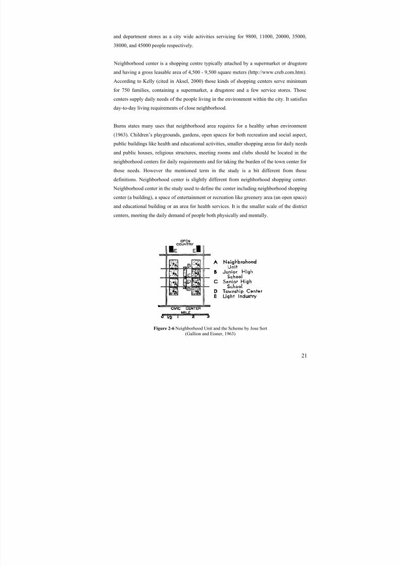
Figure 2-6 Neighborhood Unit and the Scheme by Jose Sert(Gallion and Eisner, 1963)

8/8/2019 Assessment of Sub-center Development
http://slidepdf.com/reader/full/assessment-of-sub-center-development 37/154
22
Neighborhood center or unit concept was also re-evaluated by Jose Sert, having not much
difference than the Perry, but including the relations between the township and the
neighborhood uses. Six to eight Neighborhood units in Sert’s idea form the neighborhood
center with educational uses namely high schools for juniors and seniors (Gallion and Eisner,
1963). He names the township center for the neighborhood center surrounded with a
greenbelt and including a concert hall, a community auditorium, meeting rooms, theaters,
main shopping center, recreation and administrative uses. Moreover, his neighborhood units
include a library, an elementary school, a kindergarten, play-lots, playgrounds, a church, an
emergency clinic and shopping units. His description of those centers and units are like
Neighborhood units equivalent to neighborhood centers, and township centers corresponding
to the district centers evaluated in this study.
2.1.4. Shopping center
“Shopping centers” are the shopping areas in which the needed substances of the families
are sold especially by the monopolized sellers, which are located far away, accessed by
private cars, from the central areas of the cities and which in general have stability (Keleş,
1998, p.16). Shopping centers were developed by the growth of need for car parks with the
improvement in the automobile technology and increase in car use. While large cities have
the CBD as administrative and recreational facilities, smaller cities have central area of
commerce as the main street (Redstone, 1973). Growing demand of car parks and increase in
dissatisfaction due to walking distance for shopping different stuff and having enjoyed at the
same time emerged the shopping centers supplying all those good things under the same roof
in a limited space in urban area, lowering the problems and dissatisfactions of people.
The problem of the shopping centers are that they are working as a sub-center attracting lots
of people for their consumption needs. Moreover, some of them are serving socio-cultural
facilities to attract more people. Considering the urban uses of a sub-center, the shopping
centers are the only a part of an urban center that has commercial or shopping facilities.
Namely, they are the places of consumption and therefore should not be considered as a sub-
center, due to lacking facilities of production, employment and similar services.
8/8/2019 Assessment of Sub-center Development
http://slidepdf.com/reader/full/assessment-of-sub-center-development 38/154
23
Although those shopping centers/malls are serving most of the human needs to illustrate for
a month, they are not sufficient for the special requirements of people that live in the city
centers. Therefore, the locations of those centers have a significant role in urban
environment. In most of the European cities, those centers are located in the sub-center of the
town, neither in the periphery nor in the neighborhoods. Only the regional shopping centers
or shopping center of a special need (clothing, machinery, furniture or alike) are found out of
the central area in a town. Those shopping centers of a special need are serving limited type
of good and the regional shopping centers are working to meet daily needs of people
although they are started to disappear part by part.
2.1.4.1. Regional shopping center
The regional shopping centers are defined with different terms like suburban shopping
centers or downtown regional centers. Although the concepts are various, their meanings are
almost the same. Redstone describes (1976) the regional shopping centers as they are
whether a single megastructures covering one or two city square blocks or a complex of
various buildings which are interrelated among each other in terms of aesthetics, physical by
pedestrian ways, skywalks, ramps or alike. The confidences of those centers get the
attraction of people as the center is being used as city center in daily life. That is why
implementation of those centers is rapid and easier for the developer due to the services they
supply and the demand of the consumers as a commercial complex. As stated before, those
kinds of centers are not serving more than commercial uses or use for consumption, no
production, no business, and no employment or in a sense no recreation.
Supplying enough car park space and being so close to highways are encouraging factors of
those regional shopping centers. As seen in the image there are many individual buildings
creating wholeness with a defined pedestrian way in the middle of those buildings. One can
reach easily the center and do his/her shopping and go home in a confident way without any
problems considering the congestion or energy consumed during shopping. However, those
centers are not creating other central uses apart from commerce (shopping) and some
recreational activities. Besides, the planners face with the problem of the location of those
centers due to the cheaper land and accessibility principles. However, they should be
considered as a central use of the town and those uses also should be located in the central
area. The central area should get the attraction of both developers and consumers.
8/8/2019 Assessment of Sub-center Development
http://slidepdf.com/reader/full/assessment-of-sub-center-development 39/154
24
Figure 2-7 Regional Shopping Center in the 1960s, Northgate Center, Seattle
(Gruen, 1964)
Figure 2-8 Regional Shopping Center in the 2000s, Northgate Center, Seattle(http://www.vintageseattle.org/2009/08/18/northgate-mall-by-air/)

8/8/2019 Assessment of Sub-center Development
http://slidepdf.com/reader/full/assessment-of-sub-center-development 40/154
25
Figure 2-9 the Schematic view of the Regional shopping centers(developed by Serhat Celep, based on the research of the study)
Those centers supply lots of goods and service all centers apart from the CBD. Kelly (cited
in Aksel, 2000) states that those areas are equal to the decentralized downtowns. In a sense,
they offer stuff like sub-centers do. But the idea of similarity of decentralized sub-centers(downtowns) is likely to come from some commercial, entertainment and retailing activities,
but Kelly does not mention other urban uses that should be located in sub-centers.
2.1.4.2. Town/community shopping center
According to Gruen (1973, p. 17-18) shopping center should meet all the necessities of daily
life, but in addition it can also include post office, circulating library, doctor offices, androoms for club activities. To him, shopping becomes a pleasure, recreation rather than a
chore.
In addition to Gruen’s definition, Kelly and Dunne et al (cited in Aksel, 2000), states that
community shopping centers provide a large range of activities and facilities for the sale of
soft or hard materials like clothing or furniture. They need to have professional offices and in

8/8/2019 Assessment of Sub-center Development
http://slidepdf.com/reader/full/assessment-of-sub-center-development 41/154
26
general a bank, serving 15,000 to 30,000 population. Community shopping centers are
considered as the middle centers between the neighborhood centers and regional shopping
centers. Considering planned environment, they serve citizens more than their daily needs as
in neighborhood centers, but also serve less than the sub-center facilities. In this study, in
Batıkent new settlement area, the community shopping centers are described as District
centers considering their characteristics in the following parts. The problem of their level of
services is discussed in the subsequent chapters. The metro station and its environment uses
should be called as Community shopping center in Batıkent case although it works as a sub-
center due to some factors and planning problems that will be criticized later. To illustrate
those town shopping centers in the close environment of Batıkent are Carrefoursa, Optimum,
and Gordion (under construction)
2.1.5. Unifunctional center
Unifunctional centers are the places of the concentration of units of an urban use in a specific
place. Those urban uses can be shopping for shopping center, administration for civic center,
and business for financial center or educational for educational centers. These uses or
activities can also be numbered much, but to understand the characteristics of the sub-center,
it is needed to evaluate each of these one-functioned concentrated urban lands. The problems
and the characteristics of these centers will help the study to make the reason of the
ingredients in the sub-centers clear. In fact these centers defined as uni-functional centers are
not the centers but the concentration of one activity in a specific zone. It is just concentration
or centralization of an activity or facility.
The regional shopping centers are one of the examples of the unifunctional city centers.
Unifunctional centers were born before the regional shopping center and became one of the
biggest reasons causing the collapse of the urban centers. There are few types of
unifunctional city centers and each having one facility demanded and very intense. But for
the urbanism, Gruen states (1973), creating unifunctional centers make contribution to the
downfall of it. Unifunctional centers are characterized with its dominant and very dense
urban uses. Those centers may be Industrial, Civic, Financial, and Cultural, and include Art
and Education rooms, Offices and Church (religious). Creating a center with the districts of
those mentioned activities in unifunctional centers will be more desirable for urbanism.

8/8/2019 Assessment of Sub-center Development
http://slidepdf.com/reader/full/assessment-of-sub-center-development 42/154
27
However, planning those centers as a sub-center in a sense will mostly probably create more
problems for the city and its center.
Industrial centers are created by the management of industrial entrepreneurs with
irremovable distributing personalities by grouping in a space. They may depend on some
specific transportation type to create those centers. They also need employment due to the
working stuff in, and therefore the center needs some other urban services with residences.
Financial centers are agglomeration of banks, stockbrokers, and stock markets in which the
technology is used much as a communication device.
Figure 2-10 Industrial Center of Wilmington(http://www.gfipartners.com)
Figure 2-11 Civic Center of Los Angeles, California (Gruen, 1964)
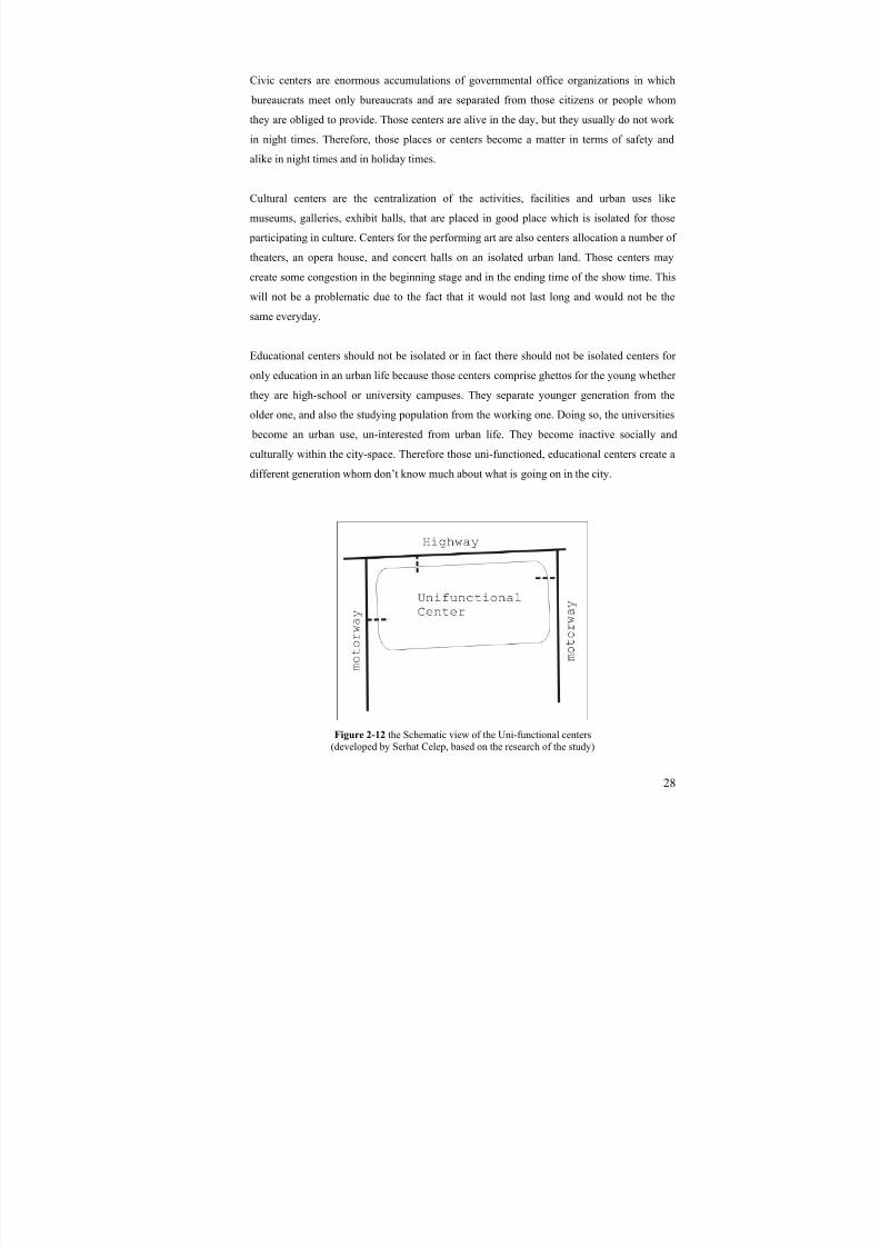
8/8/2019 Assessment of Sub-center Development
http://slidepdf.com/reader/full/assessment-of-sub-center-development 43/154
28
Civic centers are enormous accumulations of governmental office organizations in which
bureaucrats meet only bureaucrats and are separated from those citizens or people whom
they are obliged to provide. Those centers are alive in the day, but they usually do not work
in night times. Therefore, those places or centers become a matter in terms of safety and
alike in night times and in holiday times.
Cultural centers are the centralization of the activities, facilities and urban uses like
museums, galleries, exhibit halls, that are placed in good place which is isolated for those
participating in culture. Centers for the performing art are also centers allocation a number of
theaters, an opera house, and concert halls on an isolated urban land. Those centers may
create some congestion in the beginning stage and in the ending time of the show time. This
will not be a problematic due to the fact that it would not last long and would not be the
same everyday.
Educational centers should not be isolated or in fact there should not be isolated centers for
only education in an urban life because those centers comprise ghettos for the young whether
they are high-school or university campuses. They separate younger generation from the
older one, and also the studying population from the working one. Doing so, the universities
become an urban use, un-interested from urban life. They become inactive socially and
culturally within the city-space. Therefore those uni-functioned, educational centers create a
different generation whom don’t know much about what is going on in the city.
Figure 2-12 the Schematic view of the Uni-functional centers(developed by Serhat Celep, based on the research of the study)
8/8/2019 Assessment of Sub-center Development
http://slidepdf.com/reader/full/assessment-of-sub-center-development 44/154
29
Office centers are created by the concentration of private corporations with the headquarters
and skyscrapers. They usually generate traffic at office opening-closing times and hence
emptiness in the evenings, nights, and holidays. However, for city-center’s to be alive,
livable and active, those centers, employment areas, are needed to be located.
Those listings never end. One can add any kind of use in the city with the concentration of
those in one area of the city. As Gruen describes, amusement centers, restaurant centers,
radio and TV centers, automotive centers, and giant centers like cemeteries can be added to
the list. Moreover, those unifunctional centers can also be unique centers that are accordingly
created owing to the city’s special characteristics and qualities. But inevitably, those
centralization of activities as a unifunctional center will affect urban life and planning.
2.1.6. Multifunctional center
City centers are crucial multifunctional social spaces and precise urban environments in
which social institutions and activities, social communication and contacts are highly dense.
According to Bianchini (cited in Tunc, 2003), city centers are vital parts of the public sphere
as they include most significant civic spaces and buildings, public buildings and open spaces
and because they are places where community events, fairs, street markets and meetings
occur. Bianchini’s approach repeats Lefebvre’s concept of social space which is the space of
social communion with high stages of chance for social relations and the space of daily
experiences.
Gruen explains the multifunctional centers as a building type which in degree, is higher that
the regional shopping centers as he defines.
“…It represents, in fact, the natural and organic organization pattern
which has existed since the founding of human settlements and hasexpressed itself everywhere as the nomadic hunter turned to the
pursuit of agriculture, the activities of craftsmanship and of trade.”(Gruen, 1973, p.96)
He accepts as nothing in the world is something new, and besides, he says those structural
forms have appeared due to the reasons of changing sociological circumstances, and the
scientific technological inventories. The multifunctional centers meet the demand in a certain
old means of life. Close to our date, the multifunctional centers have started to have

8/8/2019 Assessment of Sub-center Development
http://slidepdf.com/reader/full/assessment-of-sub-center-development 45/154
30
problems of overloaded through the amount of vehicles, both parking and traffic. Its humane
activities and facilities and in fact the structure of the system started to go off due to those
problems. Gruen also states that streets, squares, plazas, lanes creating the physical
arrangement of the center became a conflict with the development of contemporary
technology. “Its structures and facilities, usually of old vintage, no longer fulfill the
requirements of "modern living standards." (1973, p.96-97).
2.2. Summary and Evaluation
The centers discussed in previous part are the helper for the place of a sub-center in the
hierarchy of the central settlements. Moreover, by stating the ingredients of a sub-center and
hence, limiting its character considering the CBD or increasing the functions considering thedistrict centers, neighborhood centers and shopping centers has a significant role in defining
the sub-center. Sub-center is needed to be defined with a town center, in fact. Namely, “sub”
in the term sub-center should be considered as identifying only the hierarchy and therefore
not all people use the area as a central activity zone in the metropolitan area. Sub-center and
sub-urb is the town center and the town. That is to say, what is needed in a town or in a city
is also a requirement, but in a smaller scale, namely for sub-citizens. Considering the sub-
center development, it is vital to think through the sub-urb development as a new town
development. Moreover, neighborhood centers and district center helped the study determinethe kind of development needed for, the sub-center should be born in mind.
Types of central area development are listed as City center, sub-center as a secondary center
in metropolitan region, neighborhood center as a third center in sub-center of the town and
shopping centers with other unifunctional centers. Shopping centers are also unifunctional
centers considering the urban use of consumption and in some cases with socio-cultural
urban activities. If Neighborhood centers meet the demand of citizens for a daily life, sub-
centers do it for a week or a month and the CBD does meet the demand of humane activities
for a month or a year if one does not work in CBD. That is to say, the neighborhood center
facilities or district center activities need to be defined clearly and need no to be overloaded
to affect the town center development. If it is not clearly defined, they will develop more due
to the needs of the citizens and the main center of the settlement will be discouraged to
develop. Some uses will start to locate in district centers or in neighborhood centers,
moreover in the CBD although they need to be placed in town centers.

8/8/2019 Assessment of Sub-center Development
http://slidepdf.com/reader/full/assessment-of-sub-center-development 46/154
31
CHAPTER 3
3. HISTORICAL DEVELOPMENT OF SUB-CENTERS
The city center can be described as a place where the most accessible options is included in
and a place where specialized and differentiated working places that serving the highest
number of people, where the activities need to be located together densely in a limited area
due to decision process and related facilities (Akçura, 1971, p.119). However with thedevelopment of many factors containing transportation improvements and growing
displeasure with quality of life in central cities, the sub-urban areas started to emerge and
jobs and people started to move these urban areas. Cadwallader (1996) explains this process
as it is done by cheap governmental loans for housing, created the decentralization process.
As this housing, commercial, and industrial development occurs, many other facilities in
these urban areas became needed for a qualified urban life. Governmental service and
activities (fire and police protection, health services, education, and libraries) were the main
required items in these developments. The development of the central areas and requirement
of new spaces to grow mainly resulted in sub-center generation. That is to say, new centers
were needed with the development of new settlements, new towns. Although this is thought
to be the agglomeration economies, there is understood that there is more of it, like more
social, cultural, recreational and similar aspects of urban life considering the quality and
quantity of urban land to have a better life.
3.1. City center evolution
City centers are the most commonly used and densest urban parts of the city systems. The
development of those places is like a never ending process through urban development. By
this development, the problems and congestions in almost all aspects of urban life and
planning get bigger and bigger. Due to this, the need for new lands for the center or other
lands for the center becomes inevitable. Therefore new types of relations are expected to

8/8/2019 Assessment of Sub-center Development
http://slidepdf.com/reader/full/assessment-of-sub-center-development 47/154
32
occur. Those difficulties in the centers have been developed by the improvement of the
information technology and by the improvement of motorcars use. And hence, the needs for
the new lands for the central area and suburban areas of the cities to share the burden of the
center have born.
Increasing the car ownership and use and the insufficient transportation systems has created
problems in the centers. Therefore, the sub-urban areas have become responsible for the
needs of the citizens living in the environment as the main center started to have problems in
socio-economic aspects of life, such as employment, cultural activities, proximity to the
residential.
3.2. Analysis of the city centers
The facilities that are concentrated on the centers have some commonness in terms of their
qualifications. Retail commercial areas and service types are intended to choose their
location in the center because of the high accessibility possibilities. Lots of costumers
needed activities or commercial facilities like department stores, bigger shops and closed
shopping areas or very specialized shops can last their existing in the central areas. The most
specialized and different services need the biggest number of people as customer and they
can be found in the central area (Akçura, 1971, p.118). The centers do drag the facilities that
needs and have relations among each other. Akçura, moreover, explains these circumstances
due to the fact that those facilities or uses have to be in a space that has close proximity in
physical sense to be aware of the related others.
However, with the development of communication technologies and transportation
developments, this criterion started to melt. On the other hand, this development made
possible to decrease the congestion caused by the concentration of the activities in the same
place, and made possible to decentralize, moreover to separate or to break up the physical
relations in the center. The basis of the sub-center evolution in fact, started in that point of
view.
The crucial goal of the city centers, according to Redstone (1976), is to produce an
environment conductive to an active, satisfying day and night variety of people facilities. To
get this aim, the central area should include activities and structures that attract people also

8/8/2019 Assessment of Sub-center Development
http://slidepdf.com/reader/full/assessment-of-sub-center-development 48/154
33
after working hours. Besides, the diversification of new professions and a raise in
employment opportunities, the diverse residential units for a range of income groups,
provision of pedestrian areas linking the central uses to encourage them get into the central
area and car parks both for public and private developers on or under the ground.
Considering the studied theories and prerequisites of city center, it is adapted that the central
area should have the functions of almost all types of urban uses. To emphasize more on it, as
Burns stated (1963), the following items are numbered for they should be available in the
central zone; The traffic junction point, Shopping spaces, Pedestrian zones and circulation
system, Car parks, Office spaces, Estate agents and furthers who requires lodging on the
ground floor, and properly reside in shopping type floor space, Hotels and Public houses,
Markets, Banks, Post offices, Local government offices, Public Halls, and additionally
religious, social and cultural facility buildings and open spaces, and Residential areas.
Besides, the relations of the town center with the surroundings and other town centers in the
metropolitan area with Metropolitan city center should be thought and created.
3.3. The problems of the city centers that led to sub-center development
In today’s cities the problems of the central areas are arising generally because of the high
concentration of facilities and activities in the center and besides due to the unifunctional
growth in. Many high rise buildings and office blocks are built in the same centers
(centralization of activities in one core) and hence the problems started to emerge due to the
un-development of infrastructure in the same time.
3.3.1. Transportation
As Erpi stated both for the urban settlements and the central areas (1980); the basic problem
in the core area lays in accessibility both in terms of traffic flow of the motorcars and
pedestrians. With the development of industry and machinery the use of cars has rapidly
been increased and therefore new motorways started to build or the existing ones started to
be enlarged. However, this type of solution emerged new problems in the centers. In addition
to these problems, more motorcars started to come to the center and therefore private car
ownership has increased and that made more and more private cars go into the city centers.

8/8/2019 Assessment of Sub-center Development
http://slidepdf.com/reader/full/assessment-of-sub-center-development 49/154
34
Besides, the parking space became insufficient and there were needed more space for
carpark in the central area. Congestions due to the traffic, noise and the gas also started to
emerge.
The city center became dominant in motorways although they are started or are needed to be
encouraged in terms of pedestrianization or as Erpi stated (1980) the segregation of the
traffic flow from the pedestrian flow are needed both in neighborhood units and central
areas. Moreover, the insufficient systems in public transportation also increase the problems
of the center in terms of car usage and pedestrian usage. When it becomes hard to access to
the center, people will tend to have a private car or will use the center less. Therefore it is
vitally significant to develop public transportation system, even in shorter distances for
pedestrians, to encourage the center use.
Sasaki mentioned that the nonmonocentric city structure is allowing the low cost for the
transportation expenses (1990). The monocentric city structure is limited and restrictive in
terms of land-use patterns. However, suburbanization and sub-centralization of firms and
populations, instead of concentrating in CBD, creates savings costs both for land, labor
inputs and therefore transportation costs. Hence, polycentric city structure is supported and
encouraged to emerge. This happens with development of telecommunication technologies
and therefore the decrease in the demand for being close to CBD and by this, the decrease in
trip needs and transportation requirements.
3.3.2. Population
City centers have a vital aim of producing an active space, fulfilling day and night
population in the environment with variety of people playing differently in the center
according to Redstone (1976). To get this, the centers are supposed to consist of activities
and structures that attract people also after working hours. That is to say, central area
population does differ during the day. The day and the night population of the center have
big gap in general. Being the major city center, having administrative, business and alike
activities, has very huge population during the day owing to the fact that they work during
the day. Absence or having little socio-cultural facility areas and residential districts makes
the center low populated during the night time. Not the major city center but the secondary
town centers which are far to the CBD should balance the day and night population. To do
8/8/2019 Assessment of Sub-center Development
http://slidepdf.com/reader/full/assessment-of-sub-center-development 50/154
35
this, mentioned activities which lack much in the major centre, should be located in the town
center. Moreover, the car-pedestrian zone districts should clearly be separated to attract more
people to visit.
3.3.3. Pollution
The single center dominated model of urban system has started to decrease its significance
when the importance to the recently locating company of agglomeration opportunities in the
CBD no longer govern the congestion, pollution, or overcrowding costs associated with
being in city center or when other potentials of greater advantages of agglomeration over
congestion exist elsewhere, namely in sub-urbs and sub-centers (Kumar, 1990). As a
consequence of centralization of lots of activities in the center, it is inevitable pollution to
occur in terms of physical, visual, perceptive and sensitive factors. Having very different
facilities will result in it if there is not clearly separation of motorcars and human and if there
is not enough precautions. Those actions may be locating enough green space, hiding noisy
activities, and so on.
3.3.4. Housing
The provision of housing in the central areas of the urban environment have a vital role due
to the fact that some people want to live in the center or some people who want to
accommodate closer to working space will want to reside in the center. That is also valid for
the differentiation of residential units and for the people who use their home as home-office
(Redstone, 1976). Besides, the housing areas with the centralization of more and more
activities have started to diminish in the centers. Those diminishing process is also due to the
fact that people living in the centers are afraid of the night life and moreover, they may not
find living spaces in the centers without any noise and pollution. Therefore, if no action istaken, people tend to live far to the centers.
3.3.5. Sustainability
With the decentralization process and suburbanization, region has started to have many sub /
secondary central towns as in Paris, Ile de France region. According to Sherlock in 1996
8/8/2019 Assessment of Sub-center Development
http://slidepdf.com/reader/full/assessment-of-sub-center-development 51/154
36
those centers should provide their facilities, accessible on food, with strong communities in
the urban texture of the metropolitan areas. These thoughts have been emerged with the
development of the term “urban village”. Besides, after the sub-centralization and creation of
new towns, the new distinction between CBD and suburb should be replaced by urban
village and counter-urbanization. Creating those centres/nodes on rail network will also
encourage sustainable travel and city development in a sustainable way (Johnson, 1974;
Kumar, 1990). In the creation of new towns of Paris region in 1970s, the idea of agricultural
environment is considered as well. To illustrate, the parks created in new towns became a
habitat for some birds by sustainable town planning and agriculture policies in the town, like
using pesticides by farmers around the town (Charre, 2004; Warnier 2004). Moreover, it is
told that the natural conservation of both the new towns and metropolitan areas is a
fundamental fact for urbanization.
3.4. Decentralization of city centers
Altering economic face of the industrial and post industrial societies, there has been an
increase on contemporary problems as well as the eternal problems. Therefore sub-
urbanization in the decentralization process of the cities became as a solution to those
problems. Twin cities and satellite towns were seen as an answer to that problem. That is to
say, development of alternative growth of the other regions became counter response
(Keskinok, 1990, p.32-33).
Castells (1977) states that the commercial activities and facilities of the city center started to
decentralize since the city started to grow. And hence, the mobility of people started to
enlarge. That is to say, the major city center began losing various numbers of commercial
facilities. Besides, the activities of administration and information in the city center
increased. The process of decentralization of those activities, according to him, could be seen
when the shopping malls and centers started to locate in suburban areas of the metropolitan
region.
When the central agglomeration creates problems and congestion and hence when it
becomes high enough to take care of it, some of the central activities are needed to
decentralize and they will be relocated outsides of the central core. According to Guiliano
and Small (1990), if those agglomerations are too feeble, they will relocate, decentralize to
8/8/2019 Assessment of Sub-center Development
http://slidepdf.com/reader/full/assessment-of-sub-center-development 52/154
37
isolated, locations in the far regions. However, in that decentralization process, if they are
quite strong, they will locate in the secondary central zones and clusters and that are called
sub-centers (Giuliano & Small, 1990, p.3).
3.5. The need for suburbs /satellite cities/sub-centers
In city centers, some activities need to be in close interrelation both in physical and location
terms. In fact, this existing together and having possibility to contact easily in the center
creates obstacles for the central area to grow more in physical formation. This obstacle, as
the city grows, makes the center grow in both vertical and horizontal density. Besides, they
become a barrier for the activities which demands to be in the central zone of the city and
they throw away some other activities located in the center by competition. The reason of
decentralization or breaking out of the residential, extensive industries and depots from the
center is because of these obstacles (Akçura, 1971, p.118-119).
Multifunctional centers in some examples are threatened because they do not meet the
demand of today’s people. Those centers remain operative in central cores of some
settlements. The central activities change according to the people of different countries.
Center for some Australians is the city itself. Therefore their demand for the center gets
higher. In European cities, the city signs on the highways show the inner city, directly to the
center. In London, for example the towns are submitted as a great financial center and it is
used much in a distorted logic. In United States, moreover, the center is known as the CBD.
Therefore, in new towns of United States, the centers become unifunctional, that is the
employment area, especially for white collars (Gruen, 1973).
The creation of sub-centers is related to the suburban growth (suburbanization and de-
centralization). The suburban growth in Europe emerged in the 1950s, with the extension of
green belt idea around the cities. By this, the sub-center development in European cities has
triggered. It has been generally on the rail system by attending specific development points.
In recent years, those points or towns have the characteristics of sub-centers in most of the
cities of Europe (Johnson, 1974). These development plans started with putting forward of
suburban shopping centers. The decentralization process of cities needed it. Newly office
blocks policies and creation of employment sub-centers were defended by administrators
with the help of technology. Therefore we can say that Sub-urbanization and de-
8/8/2019 Assessment of Sub-center Development
http://slidepdf.com/reader/full/assessment-of-sub-center-development 53/154
38
centralization processes had been a reason for the creation of sub – office centers / block and
thus sub-centers, especially with the retail enterprise. Those applications had started with
retails and turned gradually to sub-centralization.
3.6. The new city development ideas
It would be easy to understand and develop a planning and design scheme or principles by
evaluating Sub-center with reference to the ancestors of new city development ideas. The
planning and design problematic for human in each will help us through creating the space
for and in sub-centers. Considering the evolution and existing of sub-centers, one can find
himself on those following development ideas throughout the world. Howard’s idea of
Garden City, Corbusier’s City of Tomorrow, and Wright’s Broadacre City developmentthoughts are going to help for the understanding of needs and requirements in the sense of
central / sub-central areas developments.
3.6.1. Ebenezer Howard-garden city 1900s
The idea that Howard developed through Garden city is mainly based on the reintegration of
urban and rural character with full range of urban development issues. He proposed his ideadue to the fact that people, no matter who they are or in which social group they belong to,
were still migrating or continuing to stream into the already over-crowded cities, from
countryside to the city centers, resulting in depletion of countryside, rural environment
(Legates and Stout, 1998 and Howard, 1902). With the three magnet diagram he has
developed; it is adopted that something in the middle of town and country should be created
with less problems and congestions of negative stuff. He combines the advantages of town
and the benefits of the country by discarding the difficulties of the city life and disadvantages
of the country life. Therefore he defined the town-country and designed the scheme of the garden city, having easy access to any consumption good or any urban use with healthy
urban life by good drainage and infrastructure.
His thoughts attracted enough interest and financial backing to begin Letchworth Garden
City, a suburban garden city in the north of London. Welwyn Garden City, was started after
World War I as a second garden city. His contacts with Hermann Muthesius and Bruno Taut
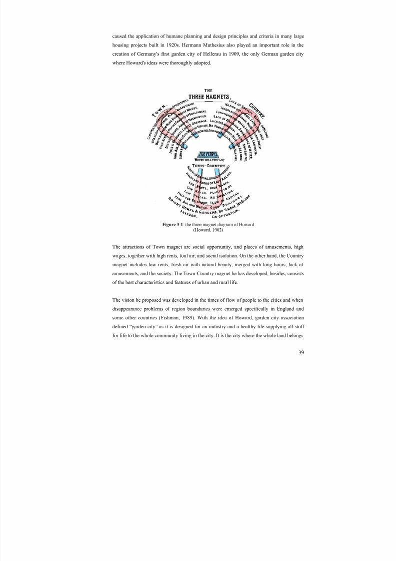
8/8/2019 Assessment of Sub-center Development
http://slidepdf.com/reader/full/assessment-of-sub-center-development 54/154
39
caused the application of humane planning and design principles and criteria in many large
housing projects built in 1920s. Hermann Muthesius also played an important role in the
creation of Germany's first garden city of Hellerau in 1909, the only German garden city
where Howard's ideas were thoroughly adopted.
Figure 3-1 the three magnet diagram of Howard(Howard, 1902)
The attractions of Town magnet are social opportunity, and places of amusements, high
wages, together with high rents, foul air, and social isolation. On the other hand, the Country
magnet includes low rents, fresh air with natural beauty, merged with long hours, lack of
amusements, and the society. The Town-Country magnet he has developed, besides, consists
of the best characteristics and features of urban and rural life.
The vision he proposed was developed in the times of flow of people to the cities and when
disappearance problems of region boundaries were emerged specifically in England and
some other countries (Fishman, 1989). With the idea of Howard, garden city association
defined “garden city” as it is designed for an industry and a healthy life supplying all stuff
for life to the whole community living in the city. It is the city where the whole land belongs
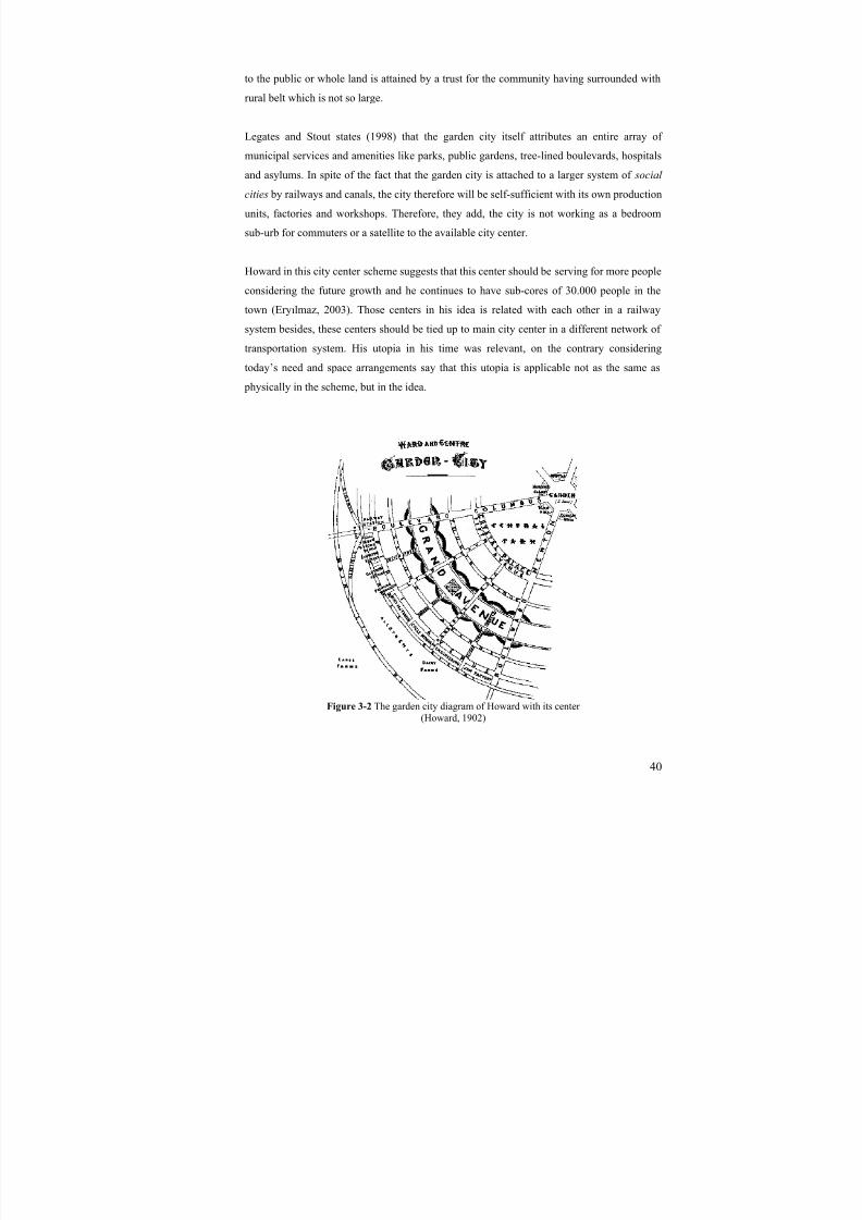
8/8/2019 Assessment of Sub-center Development
http://slidepdf.com/reader/full/assessment-of-sub-center-development 55/154
40
to the public or whole land is attained by a trust for the community having surrounded with
rural belt which is not so large.
Legates and Stout states (1998) that the garden city itself attributes an entire array of
municipal services and amenities like parks, public gardens, tree-lined boulevards, hospitals
and asylums. In spite of the fact that the garden city is attached to a larger system of social
cities by railways and canals, the city therefore will be self-sufficient with its own production
units, factories and workshops. Therefore, they add, the city is not working as a bedroom
sub-urb for commuters or a satellite to the available city center.
Howard in this city center scheme suggests that this center should be serving for more people
considering the future growth and he continues to have sub-cores of 30.000 people in the
town (Eryılmaz, 2003). Those centers in his idea is related with each other in a railway
system besides, these centers should be tied up to main city center in a different network of
transportation system. His utopia in his time was relevant, on the contrary considering
today’s need and space arrangements say that this utopia is applicable not as the same as
physically in the scheme, but in the idea.
Figure 3-2 The garden city diagram of Howard with its center (Howard, 1902)

8/8/2019 Assessment of Sub-center Development
http://slidepdf.com/reader/full/assessment-of-sub-center-development 56/154
41
As adopted from the schemes of Howard’s city, he proposed a center of 5 acre garden that is
surrounded with the Town Hall, Concert and Lecture Hall, Theatre, Library, Hospital and
Museum and Gallery. He tries to bring the community together by putting large public
buildings around the central garden. That is to say the city center is located in an area of
Culture, Philanthropy, Health, and Recreation, Mutual Cooperation, and Civic spirit.
He required the thoughts of setting applied to developments for the working class, who feels
desire, the respite more than the wealthy people. His sketches showed towns built in circle
type grids – starting with a “central park” with residential areas and the networks of the
street system radiating from the central garden. He also proposed that once a town has a
population of 30,000 people, planners should leave it as it is and start a new town with the
next development (http://fthats.files.wordpress.com). This was more of a political concept
than something meant to be constructed to plan, but his understanding of the relationship
between town and country and the community in both still seems relevant.
3.6.2. Le Corbusier-the city of tomorrow 1920s
The city of tomorrow of Corbusier in the early 1920s was planned for contemporary city of
three million people with high rise skyscrapers that are evenly spaced in a park. His futuristic
idea was seen as the prophet of high rise downtown commercialism and command andcontrol bureaucratic states of all political persuasions (Legates and Stout, 1998). His main
mission was to produce a city completely in which man, nature and the machine would be
brought together. His idea discourage the spontaneous urban environment in a sense, because
he believed that the organic city structure belonged to the past, and the modern world cities
should have been designed by the principles of nature, harmony, order and beauty with pure
forms artificially.
According to Fishman (1929), Corbusier idea’s central use were excluding the civic
monument or a cathedral and lacking the symbolic value of a city center, but servicing a
central activity as a place of exchanging ideas, information, talents and joy. His
contemporary city structure consists of skyscrapers in the intersection of superhighways,
subways, access roads, and other small sustainable transportation modes like bicycling and
walking. The skyscrapers in the idea would be working as a brain of the city including
almost all central uses of the urban environment in a concentrated space.
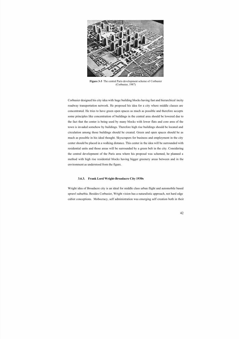
8/8/2019 Assessment of Sub-center Development
http://slidepdf.com/reader/full/assessment-of-sub-center-development 57/154
42
Figure 3-3 The central Paris development scheme of Corbusier
(Corbusier, 1987)
Corbusier designed his city idea with huge building blocks having fast and hierarchical incity
roadway transportation network. He proposed his idea for a city where middle classes are
concentrated. He tries to have green open spaces as much as possible and therefore accepts
some principles like concentration of buildings in the central area should be lowered due to
the fact that the center is being used by many blocks with lower flats and core area of the
town is invaded somehow by buildings. Therefore high rise buildings should be located and
circulation among those buildings should be created. Green and open spaces should be as
much as possible in his ideal thought. Skyscrapers for business and employment in the city
center should be placed in a walking distance. This center in the idea will be surrounded with
residential units and those areas will be surrounded by a green belt in the city. Considering
the central development of the Paris area where his proposal was schemed, he planned a
method with high rise residential blocks having bigger greenery areas between and in the
environment as understood from the figure.
3.6.3. Frank Lord Wright-Broadacre City 1930s
Wright idea of Broadacre city is an ideal for middle class urban flight and automobile based
sprawl suburbia. Besides Corbusier, Wright vision has a naturalistic approach, not hard edge
cubist conceptions. Mobocracy, self administration was emerging self creation both in their

8/8/2019 Assessment of Sub-center Development
http://slidepdf.com/reader/full/assessment-of-sub-center-development 58/154
43
lifestyle and in the urban space that citizens uses (Legates and Stout, 1998). The city is
family based and he created extraordinary housing units that were combined with the nature.
Therefore the idea was condemned as anti-city for some authors.
Figure 3-4 Broadacre City of Wright(Fishman, 1989)
Broadacre City was an urban or suburban development idea futured by Frank Lloyd Wright.
He offered the idea in his article The Disappearing City in 1932. Afterwards, he revealed a
very detailed 3.7 by 3.7 m scale model on behalf of a theoretical 10 km² community. Many
of the building models in the theory were totally new designs by Wright, while others were
refinements of old ones, some of which had been rarely seen.
Gallion and Eisner (1963) state Wright distributed the industrial, commercial, residential,
social and agricultural facilities throughout the city along the railroad. The significant point
in his idea is an acre unit of dwellings, namely production units of self-sufficient city. In
addition to this, Broadacre City, for some authors, was the exact opposite of a city and the
apotheosis of the newly born suburban area shaped through Wright's particular vision. It was
both a planning report and a socio-political system by which each family would be given a
4,000 m² (1 acre/person) plot of land from the federal lands reserves, and a Wright-
conceived the society would be built a new from it. In a sense it was the exact opposite of
transit-oriented development. There is a train station and a few office and apartment
buildings in Broadacre City, but the apartment residents are likely to be a small minority. All

8/8/2019 Assessment of Sub-center Development
http://slidepdf.com/reader/full/assessment-of-sub-center-development 59/154
44
significant transport is done by motor vehicle and the pedestrian can exist safely only within
the boundaries of 4,000 m² plots where most of the population lives.
3.6.4. Evaluation of the utopias in new town developments
As in the idea of the garden city development, the problems of both urban and rural facilities
are discouraged and the good characteristics of life in both are tried to be obtained in a
middle point called town-country by Howard. The development scheme of town-country is a
good example of the sub-center and sub-urb development since it consists of all town
activities in the center with health, administration, production, culture, society, education,
recreation, and housing with agricultural stuff in the periphery with buildings of production,
namely factories and other production places of the town. That is to say, the town-country
has the characteristics of rural areas with self-sufficiency in its own character as a sub-center.
Besides, Corbusier, considering the growth of the town, developed his idea in a compact
sense, which proposes that the city needs more open spaces in two-dimension, so as to have
less trips, less congestions, and less pollution. His proposal, taking the sub-center
development into consideration, says that, concentration of central activities with the
residential developments will help the city both for easiness of movements and accessibility.
Although the landmarking of central uses is not well defined in the area, the center itself hasa good effect in metropolitan region; that is, the area is very recognizable. However, the
buildings should also be differentiated in the sub-center according to their uses. For example,
the administrative buildings should differ from business sectors’ or commercial or residential
structures. Although Wright’s vision is appeared as a rural area, the scheme of the Broadacre
city shows different characteristics of the central area development of a sub-urb. That is to
say, the centralization of all central activities only in one concentrated place will increase the
dissatisfaction there. Moreover, the production of the sub-center as an idea is very
fundamental. Specifically, creating the employment place and therefore a production spacefor a self-sufficient city structure to a limited sense has vital role. It tells that the creation of
different district centers in a sub-center will create better urban environment. Additionally,
the transportation system is fed by some public uses like commercial, social and agricultural
facilities and by some industrial and residential structures which are concentrated on
different locations of the city. Here, the relevance of the dispersed urban centers in sub-urb is
understood as district centers as in the case area of the study.

8/8/2019 Assessment of Sub-center Development
http://slidepdf.com/reader/full/assessment-of-sub-center-development 60/154
45
Table 3-1 Comparison of New Town Development Ideas and Development Schemes(developed by Serhat Celep, based on the research of the study)
Howard’s Garden City scheme
- Centralization of Civic, Socio-cultural and Health uses of the townas a sub-center
- Production functions as a districtcenter in the periphery close to the
production space- Same accessibility level of the
center from residential area- The town surrounded with large
greenery and farming land
Corbusier’s City of Tomorrow scheme
- High rise compact structures in thecenter having all central activities
- Easy access to the center consisting public towers surrounded withresidential area
- The town is surrounded with greenwhich is also included in the centralarea around the towers
Wright’s Broadacre City scheme
- The self-sufficient city structurewith its own production space of acres
- More than one dominantcentralization of civic activities andalso some residents, one is close tothe railway station and tomotorway, the other is centered indifferent location
- No neighborhood centers but, manyother family-based productioncenters
8/8/2019 Assessment of Sub-center Development
http://slidepdf.com/reader/full/assessment-of-sub-center-development 61/154
46
CHAPTER 4
4. SUB-CENTER EVOLUTION
With the development of communication technologies and systems primate cities like Paris,
London, İstanbul, and similar metropolitan regions have grown and developed very rapidly
after the 1950s. The single center of an urban area became insufficient to serve all the
citizens living in. Moreover, as the planners of the Paris region told in Warnier (cited in
Charre, 2004), new towns has started to emerge so as to fight against suburban chaos and the
aphasia of tower blocks in the central areas. Moreover, the monocentric structure was seen as
poor demonstration of modern urban environments. The evidences for those structures were
supported by mainly three empirical evidences in Kumar (1990); the first is negative
exponential density function makes not suitable in monocentric structures and the second is
the inapplicability of limited district hypothesis and finally; with the decentralization of both
people and jobs, various origins were not suitable for only one destination.
Dowal and Treffeisen (1990, cited in Dökmezci and Akkal) state that sub-center is an
outcome of the two sets of forces. Those forces can be said as favoring the concentration
owing to the agglomeration economies and as favoring dispersion because of the congestion
costs. After that movement, most of the metropolitan regions have started to adopt the multi-
center urban development form. For the urban form of sub-central development, Gruen
(1973) developed some schemes and multi-functional urban forms. He states that
multifunctional centers are like an earlier form of sub-center development.
According to the geographer Walter Christaller’s Central Place theory, a hierarchy of the
settlements within the metropolitan area is proposed. Those settlements were seen as growth
centers of the districts. The main center is the historical CBD and below it, there is more of it
in smaller scales and smaller number of activities. Region, town, community and local
centers are composed in the metropolitan area forming the hierarchy of settlements.
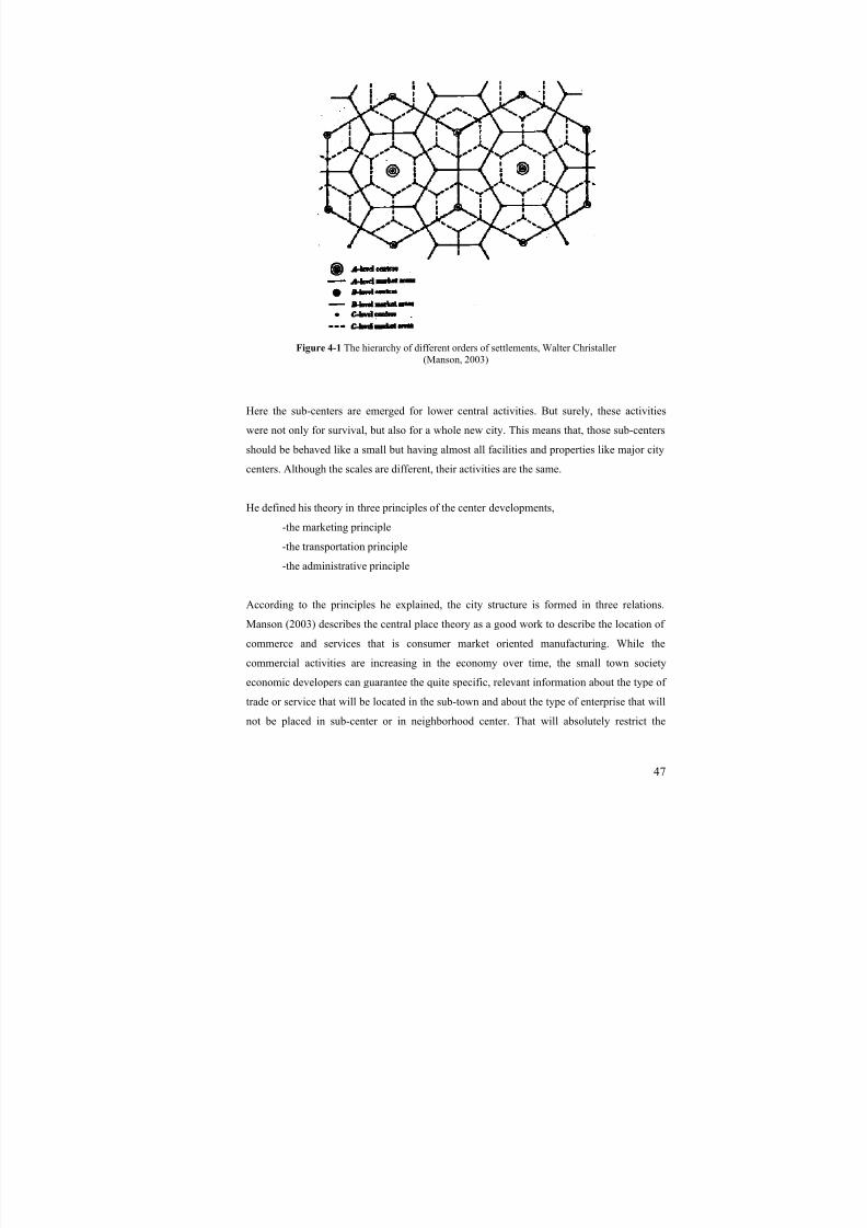
8/8/2019 Assessment of Sub-center Development
http://slidepdf.com/reader/full/assessment-of-sub-center-development 62/154
47
Figure 4-1 The hierarchy of different orders of settlements, Walter Christaller (Manson, 2003)
Here the sub-centers are emerged for lower central activities. But surely, these activities
were not only for survival, but also for a whole new city. This means that, those sub-centers
should be behaved like a small but having almost all facilities and properties like major citycenters. Although the scales are different, their activities are the same.
He defined his theory in three principles of the center developments,
-the marketing principle
-the transportation principle
-the administrative principle
According to the principles he explained, the city structure is formed in three relations.Manson (2003) describes the central place theory as a good work to describe the location of
commerce and services that is consumer market oriented manufacturing. While the
commercial activities are increasing in the economy over time, the small town society
economic developers can guarantee the quite specific, relevant information about the type of
trade or service that will be located in the sub-town and about the type of enterprise that will
not be placed in sub-center or in neighborhood center. That will absolutely restrict the
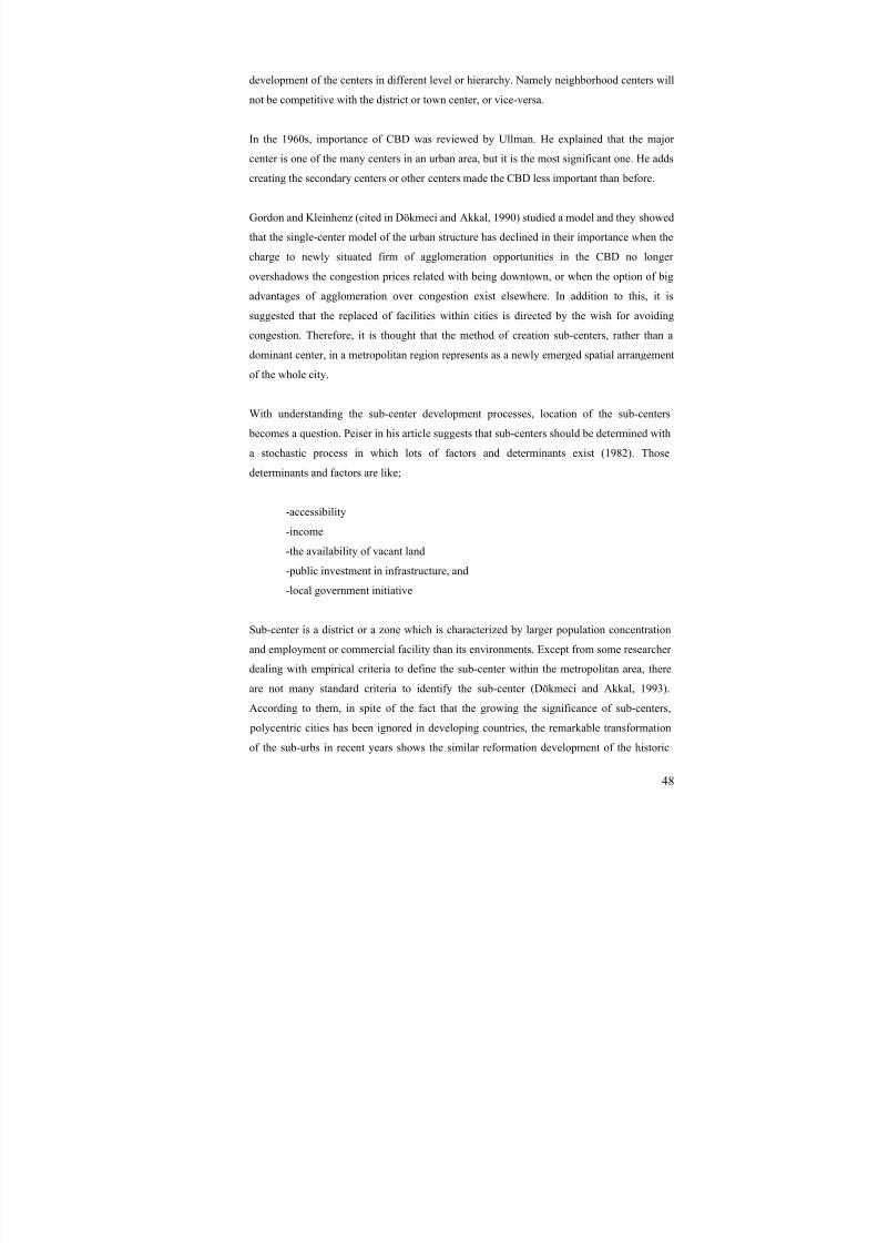
8/8/2019 Assessment of Sub-center Development
http://slidepdf.com/reader/full/assessment-of-sub-center-development 63/154
48
development of the centers in different level or hierarchy. Namely neighborhood centers will
not be competitive with the district or town center, or vice-versa.
In the 1960s, importance of CBD was reviewed by Ullman. He explained that the major
center is one of the many centers in an urban area, but it is the most significant one. He adds
creating the secondary centers or other centers made the CBD less important than before.
Gordon and Kleinhenz (cited in Dökmeci and Akkal, 1990) studied a model and they showed
that the single-center model of the urban structure has declined in their importance when the
charge to newly situated firm of agglomeration opportunities in the CBD no longer
overshadows the congestion prices related with being downtown, or when the option of big
advantages of agglomeration over congestion exist elsewhere. In addition to this, it is
suggested that the replaced of facilities within cities is directed by the wish for avoiding
congestion. Therefore, it is thought that the method of creation sub-centers, rather than a
dominant center, in a metropolitan region represents as a newly emerged spatial arrangement
of the whole city.
With understanding the sub-center development processes, location of the sub-centers
becomes a question. Peiser in his article suggests that sub-centers should be determined with
a stochastic process in which lots of factors and determinants exist (1982). Those
determinants and factors are like;
-accessibility
-income
-the availability of vacant land
-public investment in infrastructure, and
-local government initiative
Sub-center is a district or a zone which is characterized by larger population concentration
and employment or commercial facility than its environments. Except from some researcher
dealing with empirical criteria to define the sub-center within the metropolitan area, there
are not many standard criteria to identify the sub-center (Dökmeci and Akkal, 1993).
According to them, in spite of the fact that the growing the significance of sub-centers,
polycentric cities has been ignored in developing countries, the remarkable transformation
of the sub-urbs in recent years shows the similar reformation development of the historic

8/8/2019 Assessment of Sub-center Development
http://slidepdf.com/reader/full/assessment-of-sub-center-development 64/154
49
western cities with the sub-urban center coming out as a whole original urban form take
over the metropolitan space and economy. That is to say, the sub-center growth is not
significant in terms of physical urban growth but also important as an economic asset of the
metropolitan region.
Apart from theoretical and empirical research on the sub-center development, few studies
were done on sub-center / polycentric model of development. Moreover, study on the spatial
organizations of those centers was insufficient in developing countries. According to
Dökmeci and Akkal (1994), such subjects have not been examined enough in terms of their
transformation process, whether they are unique in the aspects of spatial dynamics or they
represent the earlier steps of their developed counterparts.
Therefore, in this study, the sub-center evolution is going to be examined with its
development process and design schemes. In that part of the study, a few number of sub-
center development throughout the world will be examined and will be studied to take out
some design and planning criteria and principles from those earlier model developments.
4.1. Sub center evolution and the effects on CBD
Sub-center evolution has been thought, as mentioned before, with the decentralization process and the sub-urbanization of the metropolitan area so as to decrease the congestions
and increase the efficiency of urban life.
Sub-centers, one of the first examples appeared in London, started to share the burden of
metropolitan city center, CBD. The idea of sharing the load and troubles and therefore
decreasing them should be done by sharing all kinds of activities from administration to
business and socio-economic facilities.
In other words, if a CBD have lots of private companies and headquarters, the municipality
building or an opera lets say, the sub-centers should also have at least a few of companies
and headquarters and an administrative unit of conurbation with sufficient socio-cultural
activities and facilities including, without doubt, commercial and housing areas. That is to
say sub-centers should include all parts of city centers but in a secondary level.
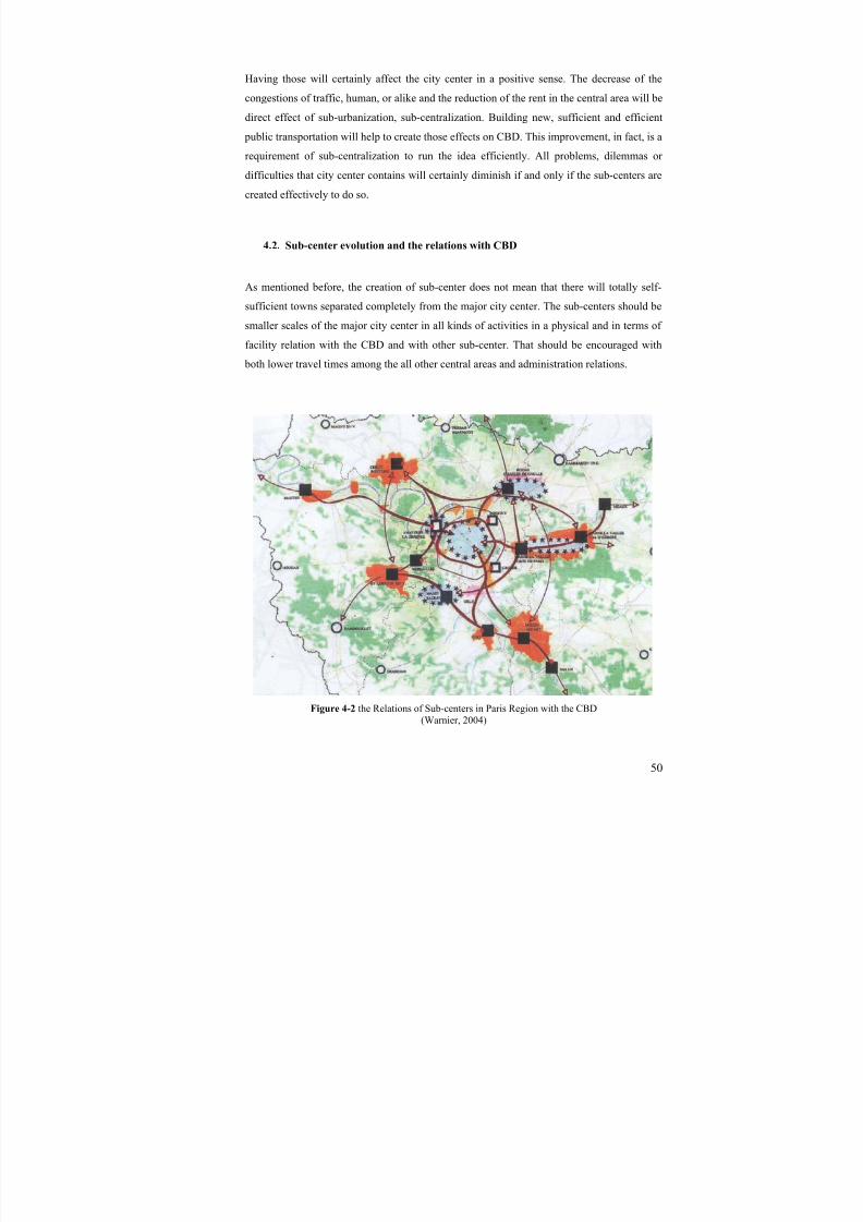
8/8/2019 Assessment of Sub-center Development
http://slidepdf.com/reader/full/assessment-of-sub-center-development 65/154
50
Having those will certainly affect the city center in a positive sense. The decrease of the
congestions of traffic, human, or alike and the reduction of the rent in the central area will be
direct effect of sub-urbanization, sub-centralization. Building new, sufficient and efficient
public transportation will help to create those effects on CBD. This improvement, in fact, is a
requirement of sub-centralization to run the idea efficiently. All problems, dilemmas or
difficulties that city center contains will certainly diminish if and only if the sub-centers are
created effectively to do so.
4.2. Sub-center evolution and the relations with CBD
As mentioned before, the creation of sub-center does not mean that there will totally self-
sufficient towns separated completely from the major city center. The sub-centers should be
smaller scales of the major city center in all kinds of activities in a physical and in terms of
facility relation with the CBD and with other sub-center. That should be encouraged with
both lower travel times among the all other central areas and administration relations.
Figure 4-2 the Relations of Sub-centers in Paris Region with the CBD(Warnier, 2004)

8/8/2019 Assessment of Sub-center Development
http://slidepdf.com/reader/full/assessment-of-sub-center-development 66/154
51
Not all units of administration, to illustrate, but some units of it should be located in sub-
centers so as to create an urban life in those settlements. Having the units of administration
or a municipality, headquarters or units of companies or some socio-cultural facilities and
activity areas should be placed in those sub-centers in order to have physical urban relations.
Christallers’ model of urban structure also tells this relation of sub-centers with other sub-
centers, city center and the smaller centers in the hierarchy of settlements. This relation
should be in terms of physical and organic. The integrated transportation system between
sub-centers and the CBD, the separation of administrative units to create the relation and to
develop the area both in terms of employment and productive services are the basic
indicators of this relational system. Paris region and the sub-center developments as seen in
the scheme show that; the sub-centers are not totally self-sufficient cities in the metropolitan
area, but they have physical and social relations among other sub-centers and with the CBD
as well. Besides, the CBD also have these relations with some of the sub-centers by located
some of the administrative units in these centers. By this, the organic relations among the
secondary centers and the CBD are tried to be formed and lively cities around greater Paris is
tried to build.
4.3. The significance of sub-center in Urban Development
McDonald defines the sub-center as a zone whose employment density is much higher thanall adjustment zones. According to him, gross employment density and employment
population ratio are the finest determinants of the employment sub-center for an urban area
(1987). However this definition does not identify the size of the sub-center covering more
than one zone.
The problems in the urban system in central areas increased and in addition to this, new
problems emerged in city life. The time spent for transportation was started to be thought
very significantly. Because people could not find enough time to reach somewhere. The
reason of it in some aspects was the technological improvements. As it developed, people
could have a more chance to find and do something. When the time spent on doing or
finding or getting something/somewhere has started to get lower and easier on work, people
started to do more of it and therefore more and more of effort was required.

8/8/2019 Assessment of Sub-center Development
http://slidepdf.com/reader/full/assessment-of-sub-center-development 67/154
52
As mentioned, the number of the problems in city life has increased also in terms of
congestion, pollution, and so on. To decrease and eliminate those problems, in its core idea,
sub elements of the urban lands were needed. Therefore, as cities developed and
communication systems improved, polycenters/sub-centers became inevitable. A number of
research and studies has shown that mono centric city structure became insufficient for the
modern world’s requirements. According to those studies single centered city, monocentric
city model was a poor representation of modern cities (Richardson, 1988; Anjomani &
Chineme, 1982; Griffith, 1981; Gordon & Wong, 1985; Kumar, 1990 in Dökmeci and
Akkal, 1993).
4.4. The challenges of sub-centers
Many problems considering the urban growth and development affecting the sub-center
whether positively or negatively is mainly coming from the wrong applications and planning
problems of city center, shopping malls and neighborhood centers.
4.4.1. City centers
In the large metropolitan areas in the world, the concentration of employment andcommercial activities is being challenged by secondary activity centers, namely by sub-
centers. But, in fact, in developing countries, there are also the challenges of the main centers
on sub-centers. Due to having low quality of life and services in other locations of the city,
city centers, offering more and good conditions in terms of infrastructure and socio-spatial
qualities, they form a challenge on creating sub-centers. In addition to this, according to
Dowall and Treffeisen (cited in Dökmeci and Akkal, 1994) studies on urban economics have
mainly centered in residence and firm locations in a poly-centric city structure. On the other
hand, regional scientists have emphasized the circumstances under which secondary centers,sub-centers, are built. However, the city center in some of the developing countries, namely
the city having one dominant center, includes more public uses discouraging the sub-
centralization or sub-urbanization with the investments which are done much on that
dominant center. Specifically in the case area of the study, Ankara has almost all the
administration units which are very close to the CBD, or lined through a main road reaching
8/8/2019 Assessment of Sub-center Development
http://slidepdf.com/reader/full/assessment-of-sub-center-development 68/154
53
the center. Almost no administration unit or similar units of other urban uses that should be
placed in sub-centers are located in defined urban sub-centers.
4.4.2. Shopping malls
Suburban concentration of shopping facilities is the prototypes and forerunners of the
regional shopping center or more importantly, according to Gruen they are forerunners of the
satellite cities. By the time of Gruen, it was a common trend to build a shopping center for a
creation of a sub-center. However, shopping centers especially in developing countries are
thought to be a sub-center itself supplying all types of needs of citizens. But as he told, it is
not used, in general, as a forerunner of sub-center evolution.
Specifically, in Ankara example of shopping center development, they have been located in
the peripheries or in the place of where the accessibility by car is trouble-free considering car
parks, being close to the main motorways and alike. Moreover, the building of shopping
center is being used as a district of central area having almost all kinds of commerce and
social activities.
Figure 4-3 The end of Shopping centers(http://forum.arkitera.com, retrieved in July 2009)
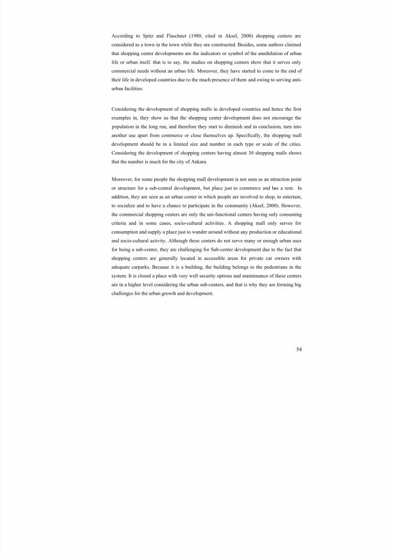
8/8/2019 Assessment of Sub-center Development
http://slidepdf.com/reader/full/assessment-of-sub-center-development 69/154
54
According to Spitz and Flaschner (1980, cited in Aksel, 2000) shopping centers are
considered as a town in the town while they are constructed. Besides, some authors claimed
that shopping center developments are the indicators or symbol of the annihilation of urban
life or urban itself. that is to say, the studies on shopping centers show that it serves only
commercial needs without an urban life. Moreover, they have started to come to the end of
their life in developed countries due to the much presence of them and owing to serving anti-
urban facilities.
Considering the development of shopping malls in developed countries and hence the first
examples in, they show us that the shopping center development does not encourage the
population in the long run, and therefore they start to diminish and in conclusion, turn into
another use apart from commerce or close themselves up. Specifically, the shopping malldevelopment should be in a limited size and number in each type or scale of the cities.
Considering the development of shopping centers having almost 30 shopping malls shows
that the number is much for the city of Ankara.
Moreover, for some people the shopping mall development is not seen as an attraction point
or structure for a sub-central development, but place just to commerce and has a rent. In
addition, they are seen as an urban center in which people are involved to shop, to entertain,
to socialize and to have a chance to participate in the community (Aksel, 2000). However,the commercial shopping centers are only the uni-functional centers having only consuming
criteria and in some cases, socio-cultural activities. A shopping mall only serves for
consumption and supply a place just to wander around without any production or educational
and socio-cultural activity. Although these centers do not serve many or enough urban uses
for being a sub-center, they are challenging for Sub-center development due to the fact that
shopping centers are generally located in accessible areas for private car owners with
adequate carparks. Because it is a building, the building belongs to the pedestrians in the
system. It is closed a place with very well security options and maintenance of these centers
are in a higher level considering the urban sub-centers, and that is why they are forming big
challenges for the urban growth and development.
8/8/2019 Assessment of Sub-center Development
http://slidepdf.com/reader/full/assessment-of-sub-center-development 70/154
55
4.4.3. Neighborhood centers
Meeting the daily requirements of the citizens may prevent them to go into the city center.
The balance between the neighborhood centers and the sub-centers should be designed in
such a manner that they do not take the place of the other.
Perry (1929) states that the neighborhood community and shopping centers should include
nothing more than suitable uses for a neighborhood demand. Community centers mentioned
comprise schools, public libraries and other civic life buildings for the community. Whereas,
the neighborhood shopping center includes the daily needs of the humanbeing stated in the
following; grocery, meat market, restaurant, druggist, garage, merchant tailor, plumber,
confectionery, bakery, fruit and vegetable seller, hotel, furniture seller , dry goods, cigar and
tobacco, undertaking, coal, shoe, clothier, florist, jewelry, millinery, hardware, cleaner and
dyer, delicatessen, laundry, tea room, novelty shop, news-stand, stationery, Electrical
supplies, real estate, barber, beauty shop. In addition to those neighborhood center service
variations, there are also city wide service types that should not be placed in neighborhood
central areas. Those services are stated as musical instrument sellers, banks, furriers,
typewriters, Sporting goods, and Department stores. For today’s technology and considering
today’s development some of those numbered concerns are whether irrelevant or some of
them are combined in one shopping unit. To illustrate, the typewriters with the development
of computer technology have disappeared, and fruit and vegetable sellers or bakeries are
included in groceries.
4.5. The factors and criteria generating sub-center
For some authors the sub-centralization is a need for the employment and economic growth
and therefore need to lower the congestions and problems in central areas. For example,
Giuliano and Small (1990) have the same opinion with some authors generating that not population but more importantly the employment is the key aspect to understand the
formation of sub-centers in the hierarchy of urban centers. Those centers should be found as
a location according to the exceeding gross employment density in a region. They identify
the zone of high density restricting attention to larger centers to exert a potentially important
pressure.
8/8/2019 Assessment of Sub-center Development
http://slidepdf.com/reader/full/assessment-of-sub-center-development 71/154
56
“Within metropolitan areas, the central cities are unable to functionefficiently if they retain their original monocentric spatial structures.Whether as a result of spontaneous market readjustments (i.e. the newlocational or relocational choices of firms and households), or planneddecentralization, or, more usually, a combination of both, the spatialextension of the metropolitan region under conditions of rapid
population growth has been associated with the emergence of at leasta few sub-centers” (Dökmeci and Akkal, 1994)
From the examples and the world models of sub-center developments, it is not difficult to
understand that if an area called sub-center is lacking urban services and areas of
employments, business and administrative units, there will be, without any doubt, a
settlement only for night life and the area at the end will turn into a dormitory town.
Secondly, the settlement should not be specified in one type of urban use including
employment. There should be multi-functional ways of working areas. The center, in addition
to this, should also have multi-functional urban uses.
Furthermore, what generates the land in metropolitan area considering the core and
environments do also generate the land in sub-centers. That is to say, the sub-centers should
be thought as a city in smaller scales of activities and facilities without lacking any of them
that the city has in it.
Cervero (1989, cited in Dökmeci and Akkal, 1994) evaluates lots of ways that "suburban
employment centers" or "activity centers" have been described. Quantities of floor space of
development of different kinds (total, office, or retail), quantity or concentration of
employment, net inflow of morning commuters, and heterogeneity of land uses and similar
criteria are not calculated. But he thinks the concentration of commuting flows in central
area, like having minimum 2000 employment, and 90,000-100,000 square meter office floor
space.
To conclude the sub-center development needs to include almost all urban functions and
activities whether located in the core or in different locations of the town. The following
items are the group of some of the activities generating or factors forming sub-center
formation;
- Commercial, Retail
- Social
- Cultural

8/8/2019 Assessment of Sub-center Development
http://slidepdf.com/reader/full/assessment-of-sub-center-development 72/154
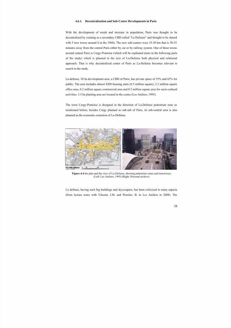
8/8/2019 Assessment of Sub-center Development
http://slidepdf.com/reader/full/assessment-of-sub-center-development 73/154
58
4.6.1. Decentralization and Sub-Center Developments in Paris
With the development of needs and increase in population, Paris was thought to be
decentralized by creating as a secondary CBD called “La Defense” and thought to be shared
with 5 new towns around it in the 1960s. The new sub-centers were 15-30 km that is 30-35
minutes away from the central Paris either by car or by railway system. One of these towns
around central Paris is Cergy-Pontoise (which will be explained more in the following parts
of the study) which is planned in the axis of La-Defense both physical and relational
approach. That is why decentralized center of Paris as La-Defense becomes relevant to
search in the study.
La-defense, 30 ha development area, a CBD of Paris, has private space of 35% and 65% for
public. The area includes almost 8200 housing units (0.5 million square), 2.3 million square
office area, 0.2 million square commercial area and 0.2 million square area for socio-cultural
activities. 3.5 ha planting area are located in the center (Les Ateliers, 1995).
The town Cergy-Pontoise is designed in the direction of La-Defense pedestrian zone as
mentioned before, besides Cergy planned as sub-urb of Paris, its sub-central area is also
planned as the economic extension of La-Defense.
Figure 4-4 the plan and the view of La-Defense, showing pedestrian zones and motorways(Left: Les Ateliers, 1995) (Right: Personal archive)
La defense, having such big buildings and skyscrapers, has been criticized in many aspects
(from lecture notes with Vincent, J.M. and Warnier, B. in Les Ateliers in 2008). The

8/8/2019 Assessment of Sub-center Development
http://slidepdf.com/reader/full/assessment-of-sub-center-development 74/154
59
pedestrian oriented design has made huge open spaces that are in between the huge office
buildings. Feeling of the space conception is in a sense lost in the area. And mainly although
the accessibility of the area is rich enough, it is still criticized. Taking the car underground
passages and parking is thought as a problem for people who want to see the area while
going through the district. Moreover it created the problem of security due to the fact that it
is almost impossible to see a motorcar in La Defense district; all roads are going
underground and cars are being parked there. Moreover, although the area has all types of
public transportation, it lacks main pedestrian way and access by walking. It is really hard to
reach to the district by walk, but apart from it, it is highly accessed.
Paris region in terms of urban development grew at an exponential speed in the1950s and
1960s as a consequence of the increase in the population (the post-war “baby boom”) and the
rural exodus. This growth was not at all well handled, because of the poor living conditions
for the new arrivals, urban poverty (the housing estate phenomenon) and traffic problems.
The capital was overpowering. The government of General De Gaulle decided to take action
by developing a plan for the Paris region. It was completed in 1965 and it was proposed to
relieve congestion in Paris counting five new towns (Cergy-Pontoise, Marne-la-Vallée,
Melun Sénart, Evry, St-Quentin-en-Yvelines), which would be able to provide
accommodation of 500,000 inhabitants by the year 2000 (Forum d’initiatives urbaines,
2008). As told before those policies of new towns around Paris region has been decided in
the 60s due to the fight against the suburban congestion and the aphasia of the tower
buildings.
.
Figure 4-5 Five Sub-centers of Paris Region and the location of Cergy-Pontoise(Warnier, 2004)
8/8/2019 Assessment of Sub-center Development
http://slidepdf.com/reader/full/assessment-of-sub-center-development 75/154
60
These five sub-urbs and their centers are planned in many principles (Association Françaies
des Villes Nouvelles, 1986). The first attitude for the development of those centers is well
served towns. That is to say the towns are well infra-structured, easy accessible for central
Paris both by private and public transportation. The second is creating welcome spaces of
high quality, by which the office spaces and business sectors of high tech companies are
thought. The third is a diversified economy, and hence different kinds of offices and firms
with different sectors like industry, communication, technology, and food industry. The forth
is attracting performing companies. Namely, availability of vacant land to develop further or
existences of an urban land that can be transformed into non-residential urban uses are the
keys for companies as they demand to grow. The fifth is building a great diversity in
lodgings. The combination of different lifestyles for such an urban sub-center was seen as a
prerequisite in the development of Cergy-Pontoise. The sixth is life in the open air , telling
the dense recreational activities and much more green spaces even for urban facilities. And
the final principle is to have a cultural life full of matters. Here, the cultural aspects of an
urban life are considered both in street life and building structures. The monotone structures
are eliminated and artistic and aesthetic landscapes are tried to be encouraged.
4.6.2. A new town: Cergy-Pontoise, Paris
Cergy-Pontoise was created by the state intervention in 1969 so as to host the quick growthof the Parisian agglomeration. In 1970, the project was approved by the administration and
the construction of the town has started immediately in the same year by building up the
Prefecture Building of the town. Afterwards, the construction of commercial center has
started in 1972. Finally in 1980, the operation of central station (RER station, Regional
Express Railway) has started to work. The general proposal when the town was built was
that it should be an independent or even a free entity: contrasting the dormitory towns, it was
to cover a large range of activities and facilities (Forum d’initiatives urbaines, 2008 and
Etablissement Public d’Amenagement de Cergy-Pontoise, 1999). Namely the idea was to
build up new urban centers to ease the pressure on residential and business activities then
concentrated in Paris and to control the development of urban sprawl around the capital.
There are three main principles in creation of Cergy-Pontoise (Charre, 2004). The first is the
development of a multi-nuclear structure, the centre being free from construction. The
second principle lies in the option of planning of overpasses supporting the urban center and
8/8/2019 Assessment of Sub-center Development
http://slidepdf.com/reader/full/assessment-of-sub-center-development 76/154
61
the third is related to the integration of nature as an essential fact for urbanization. Having
employed around 80,000 people, Cergy-Pontoise has various public (% 25 of jobs are
employed) and private (% 75 of jobs are employed) sectors. While the formers are like
Primary sickness benefit office, Child benefit office, French electricity and gas company,
French telecom, post office, a Regional hospital, New town development association,
National job center, the latter sector includes Thomson, Sagem, Renault, Peugeot, 3M,
Siemens, and Bp-Mobil. In addition to those sectors, almost 255,000 square meter
commercial area with a catchment area of 600,000 people with one shopping mall and 200
other shopping units, 25 hotels are located in the town.
From the beginning of the project, the new town was described by the “era of Integrated
Facilities”, like the building of the most important public and administrative facilities before
residential areas were constructed. The first construction built in the new town was the
Prefecture building (the headquarters of the administrative department), the primary symbol
of central government in the regions. According to people, who were in charge of building
the town, there were objectives about the area including urban planning principles into
practice (Forum d’initiatives urbaines, 2008);
- The settlement will be created with personality and a commitment to avoiding uniformity,
therefore the decision to limit each development was up to 600 dwellings;
- Combination of housing and work, and hence bringing businesses, homes and
shops together in a single district (specifically the proposal of setting up a shopping
centre before the housing moved in – named Les Trois Fontaines);
- A town set up with the transport systems- public transportation- of the future and
on the lookout for innovation; (the idea of separating schools into units that are as
small as possible or of paths kept for cyclists);
- taking into account the requirements of the public, particularly in terms of notcreating overly dense shared living areas;
- creating favorable circumstances for car travel and separating vehicle lanes from
pedestrians and cyclists;
The town center was projected with a total break with the surrounding in terms of its design
principles. The sub-center became a symbol of the whole settlement with combination of
different activities.

8/8/2019 Assessment of Sub-center Development
http://slidepdf.com/reader/full/assessment-of-sub-center-development 77/154
62
Apart from the road structure, the pedestrian network which allows inhabitants to access
their homes is linked to the centre via footbridges. In that system of network, pedestrians
never had to meet the vehicles from any residential area till the central area. However, the
highways, the boulevards, are generally on a “nonurban” scale and impracticable for
pedestrians. Moreover, some “internal roads” set aside for pedestrians have fostered the
development of feelings of insecurity. This is in fact due to the fact that the settlement
includes a variety of people in different social and economical status. Besides, separating
vehicle and pedestrian traffic prevents a mix of functions and makes it necessary to build
large car parks in the city centre.
The city of Cergy-Pontoise has responded to its task as a new town by accommodating a
substantial population and presenting a balance between employment and housing. In overall
terms the housing stock is diverse and of good quality, despite of the fact that it is primarily
driven by the need for social housing. Likewise, in general terms, there are lots of public
spaces, which leaves open the possibility of a certain level of densification.
As mentioned before the settlement was very appropriate for the headquarters of the private
companies, offering employment and business owing to the closeness to La-Defense by both
railway and motorway and low land prices and housing opportunities. The administration of
the agglomeration permitted to those buildings. In fact they planned to do it and that made
Cergy-Pontoise livable during the whole day. It is saved from being a dormitory town, by
having multi-functional urban uses both in central area of town and in conurbation.
Figure 4-6 Economic majors of Cergy-Pontoise(Tonetti, 2007)
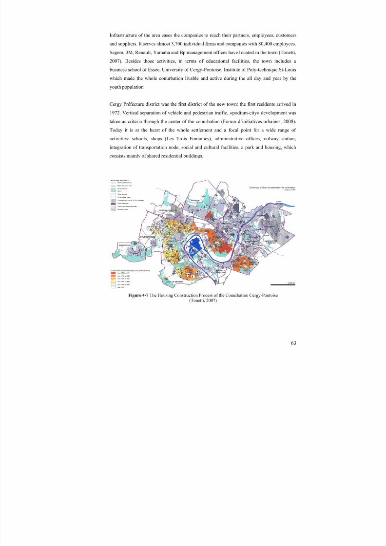
8/8/2019 Assessment of Sub-center Development
http://slidepdf.com/reader/full/assessment-of-sub-center-development 78/154
63
Infrastructure of the area eases the companies to reach their partners, employees, customers
and suppliers. It serves almost 3,700 individual firms and companies with 80,400 employees.
Sagem, 3M, Renault, Yamaha and Bp management offices have located in the town (Tonetti,
2007). Besides those activities, in terms of educational facilities, the town includes a
business school of Essec, University of Cergy-Pontoise, Institute of Poly-technique St-Louis
which made the whole conurbation livable and active during the all day and year by the
youth population.
Cergy Préfecture district was the first district of the new town: the first residents arrived in
1972. Vertical separation of vehicle and pedestrian traffic, «podium-city» development was
taken as criteria through the center of the conurbation (Forum d’initiatives urbaines, 2008).
Today it is at the heart of the whole settlement and a focal point for a wide range of
activities: schools, shops (Les Trois Fontaines), administrative offices, railway station,
integration of transportation node, social and cultural facilities, a park and housing, which
consists mainly of shared residential buildings.
Figure 4-7 The Housing Construction Process of the Conurbation Cergy-Pontoise (Tonetti, 2007)
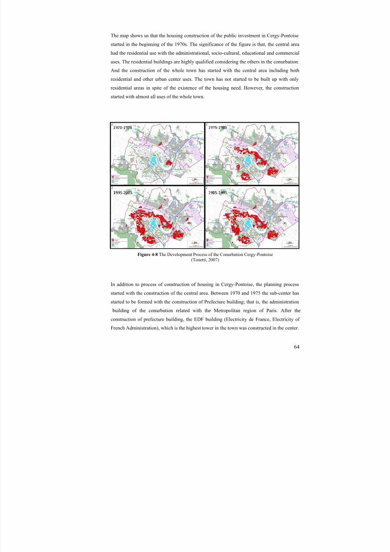
8/8/2019 Assessment of Sub-center Development
http://slidepdf.com/reader/full/assessment-of-sub-center-development 79/154
64
The map shows us that the housing construction of the public investment in Cergy-Pontoise
started in the beginning of the 1970s. The significance of the figure is that, the central area
had the residential use with the administrational, socio-cultural, educational and commercial
uses. The residential buildings are highly qualified considering the others in the conurbation.
And the construction of the whole town has started with the central area including both
residential and other urban center uses. The town has not started to be built up with only
residential areas in spite of the existence of the housing need. However, the construction
started with almost all uses of the whole town.
Figure 4-8 The Development Process of the Conurbation Cergy-Pontoise (Tonetti, 2007)
In addition to process of construction of housing in Cergy-Pontoise, the planning process
started with the construction of the central area. Between 1970 and 1975 the sub-center has
started to be formed with the construction of Prefecture building; that is, the administration
building of the conurbation related with the Metropolitan region of Paris. After the
construction of prefecture building, the EDF building (Electricity de France, Electricity of
French Administration), which is the highest tower in the town was constructed in the center.
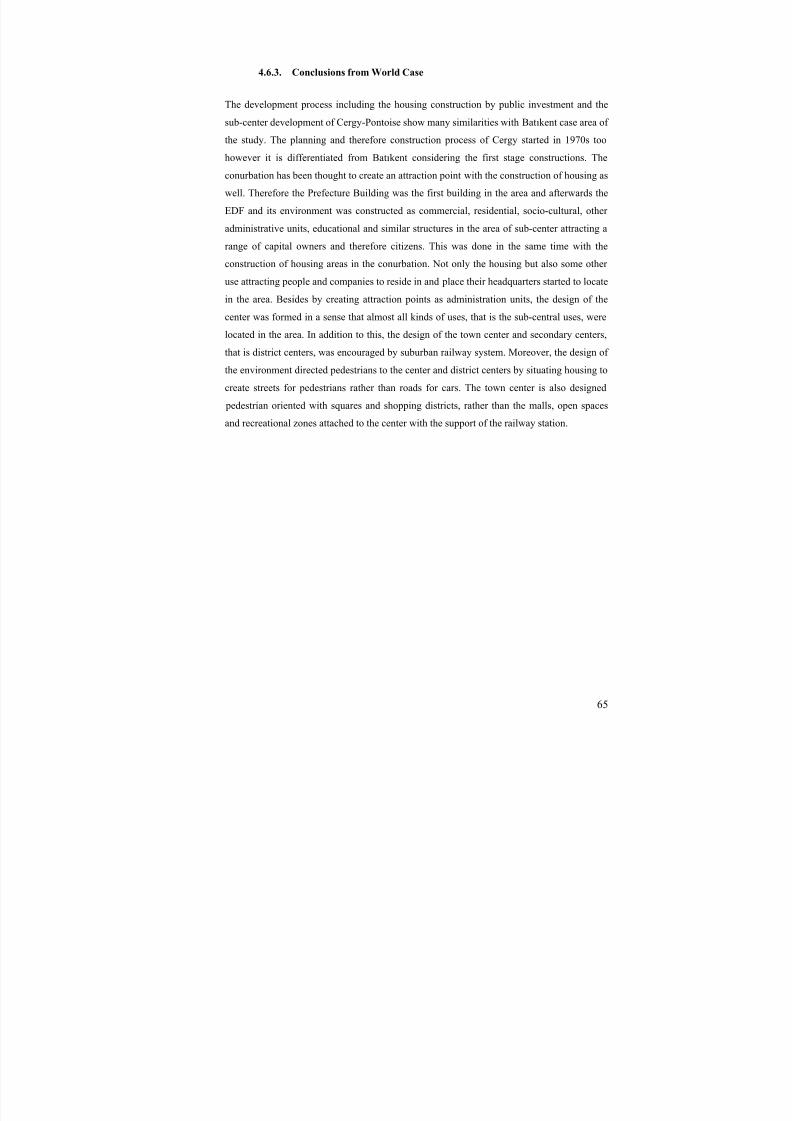
8/8/2019 Assessment of Sub-center Development
http://slidepdf.com/reader/full/assessment-of-sub-center-development 80/154
65
4.6.3. Conclusions from World Case
The development process including the housing construction by public investment and the
sub-center development of Cergy-Pontoise show many similarities with Batıkent case area of
the study. The planning and therefore construction process of Cergy started in 1970s too
however it is differentiated from Batıkent considering the first stage constructions. The
conurbation has been thought to create an attraction point with the construction of housing as
well. Therefore the Prefecture Building was the first building in the area and afterwards the
EDF and its environment was constructed as commercial, residential, socio-cultural, other
administrative units, educational and similar structures in the area of sub-center attracting a
range of capital owners and therefore citizens. This was done in the same time with the
construction of housing areas in the conurbation. Not only the housing but also some other
use attracting people and companies to reside in and place their headquarters started to locate
in the area. Besides by creating attraction points as administration units, the design of the
center was formed in a sense that almost all kinds of uses, that is the sub-central uses, were
located in the area. In addition to this, the design of the town center and secondary centers,
that is district centers, was encouraged by suburban railway system. Moreover, the design of
the environment directed pedestrians to the center and district centers by situating housing to
create streets for pedestrians rather than roads for cars. The town center is also designed
pedestrian oriented with squares and shopping districts, rather than the malls, open spaces
and recreational zones attached to the center with the support of the railway station.
8/8/2019 Assessment of Sub-center Development
http://slidepdf.com/reader/full/assessment-of-sub-center-development 81/154
66
Table 4-1 Comparison of Town and District centers and Patterns of Batıkent and Cergy(Left Column and up to below: Batıkent; Town, Sub-center, District Center)
(Right Column and up to below: Cergy-Pontoise; Town, Sub-center, District Center)
8/8/2019 Assessment of Sub-center Development
http://slidepdf.com/reader/full/assessment-of-sub-center-development 82/154
67
CHAPTER 5
5. CBD AND SUB-CENTER DEVELOPMENT IN ANKARA
The first plan of Ankara was prepared in 1924 by Carl Christoph Lörcher to meet the new
requirements of the city. After becoming the capital of Turkish Republic, evolution of central
area in Ankara was developed by Herman Jansen’s Plan completed in 1932. In the 1950s the
effects of Jansen and Lörcher were continued in the growth of Ankara. In 1955, Nihat Yücel
and Raşit Uybadin developed a plan for Ankara after becoming the fist project selected in the
competition. The central area and Ankara Metropolitan region, afterwards, have been built
up with 1990 plan of Ankara Metropolitan Plan Office (AMANPB in its Turkish
abbreviation) done in 1970. By Middle East Technical University (METU) City and
Regional Planning study team, 2015 Structural plan of Ankara was developed as, in a sense,
a revision/developed version of the plan done before. Following that, Ankara 2025 plan was
developed in 1990 by the Municipality of Ankara under the coordination of Prof. Dr. R.Raci
Bademli. The final and current Master plan of Ankara was done as Ankara 2023 and
approved in 2006.
5.1. CBD development in Ankara
In the 1960s and 1970s, Ankara had a monocentric urban formation which has later changed
to polycentric structure with the development of new settlement projects along the west
corridor. In the meantime, suburban nodes began to emerge as a consequence of growing
distance between the periphery and the core.
5.1.1. Lörcher Plan 1924
In 1924 in the plan of Lörcher, the central area of Ankara was Ulus and the development of
the environment was proposed. K ızılay district’s basis was defined in Lörcher’s Plan. The
plan offered a compact development. The pattern of the south of the railways was defined by
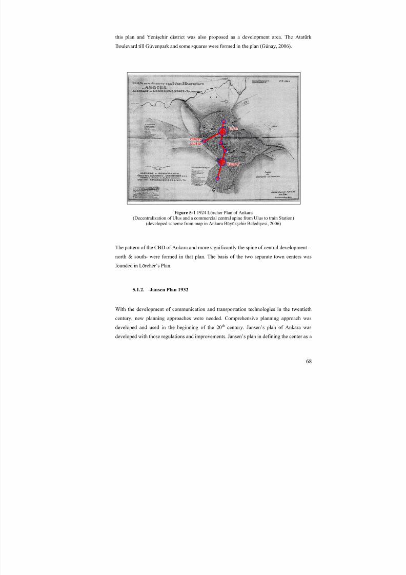
8/8/2019 Assessment of Sub-center Development
http://slidepdf.com/reader/full/assessment-of-sub-center-development 83/154
68
this plan and Yenişehir district was also proposed as a development area. The Atatürk
Boulevard till Güvenpark and some squares were formed in the plan (Günay, 2006).
Figure 5-1 1924 Lörcher Plan of Ankara(Decentralization of Ulus and a commercial central spine from Ulus to train Station)(developed scheme from map in Ankara Büyük şehir Belediyesi, 2006)
The pattern of the CBD of Ankara and more significantly the spine of central development –
north & south- were formed in that plan. The basis of the two separate town centers was
founded in Lörcher’s Plan.
5.1.2. Jansen Plan 1932
With the development of communication and transportation technologies in the twentieth
century, new planning approaches were needed. Comprehensive planning approach was
developed and used in the beginning of the 20th century. Jansen’s plan of Ankara was
developed with those regulations and improvements. Jansen’s plan in defining the center as a
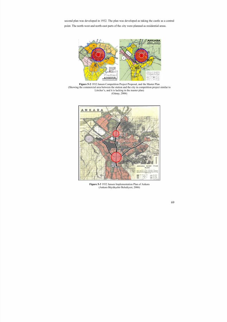
8/8/2019 Assessment of Sub-center Development
http://slidepdf.com/reader/full/assessment-of-sub-center-development 84/154
69
second plan was developed in 1932. The plan was developed as taking the castle as a central
point. The north-west and north-east parts of the city were planned as residential areas.
Figure 5-2 1932 Jansen Competition Project Proposal, and the Master Plan(Showing the commercial area between the station and the city in competition project similar to
Lörcher’s, and it is lacking in the master plan)(Günay, 2006)
Figure 5-3 1932 Jansen Implementation Plan of Ankara(Ankara Büyük şehir Belediyesi, 2006)

8/8/2019 Assessment of Sub-center Development
http://slidepdf.com/reader/full/assessment-of-sub-center-development 85/154
70
The plan of commercial area in the competition design proposal was considering
decentralizing the city in a circular form. The Castle was thought as a central point of the
development in two dimensional views. But Jansen plan that was formed after the
competition showed the spine of Atatürk Boulevard in south and north directions and Ziya
Gökalp Street in west-east directions between Ulus and K ızılay and Yenişehir as a planned
CBD area.
K ızılay district, as a node of those two spines mentioned before, was formed as a CBD
development in Ankara with Jansen plan. With the developments of the ministries in the
south of K ızılay, its development as a center was encouraged and improved.
Moreover, differently from the first project done by Jansen, the spine from Ulus to the
railway station was deleted and the area was used as recreational zone. The commercial
development was planned in K ızılay district. And the basis of the Ministries District was
founded with that plan.
5.1.3. Yücel-Uybadin Plan 1955-2000
The requirements of the new spaces brought about a new plan of Ankara, and in the
competition held, Yücel-Uybadin plan became first. As a central development, Günay (2006)
explains that the plan does not have a policy for the city center. The central area
development was only defined with a boulevard and no other projects for the central area
development were proposed. But for the development of Ankara lots of places around the
center were planned to develop as a housing area. And probably, some other centers of
Ankara considering those housing area developments can be considered as future generations
of new centers (Yenimahalle, Etlik, Keçiören and Aydınlıkevler in the north; Bahçelievler,
Balgat Dikmen, Çankaya, Gaziosmanpaşa, Seyran Bağlar ı and Abidinpaşa in the south).

8/8/2019 Assessment of Sub-center Development
http://slidepdf.com/reader/full/assessment-of-sub-center-development 86/154
71
Figure 5-4 Yücel-Uybadin Plan of Ankara, showing the future development of the central area andthe city
(Günay, 2006)
With the plan of Ankara by Yücel-Uybadin, planned housing areas were in the edges due to
the geomorphologic structure of the area and squatter housing areas had been built up in the
environment of those planned housing areas in the north-east and the south side of the city.
Günay (2006) also mentions that with those developments, urban growth area was limited.
Those squatter housing and planned residential area developments that limit urban growth in
Ankara will probably be the basis of non-development of other central zones in metropolitan
region.
5.1.4. Ankara Metropolitan Plan Office (AMANPB) Plan 1970-1990
Within the 1970 plan prepared by the Ankara Metropolitan Plan Office, it is accepted thatthe core area of the city will be controlled and developed with the policies or criteria/control
mechanism of the previous plan (Yücel-Uybadin Plan). However for the periphery and new
development areas of Ankara, a new plan would be acknowledged. (Günay, 2006)
The sub-centers in the mid 1970s were supplying or having 30 % of the commercial
expenses of the whole metropolitan area. The sum of Ulus and K ızılay was more than twice
in that time with 67 % of the whole. There were 5 sub-centers and those centers were only
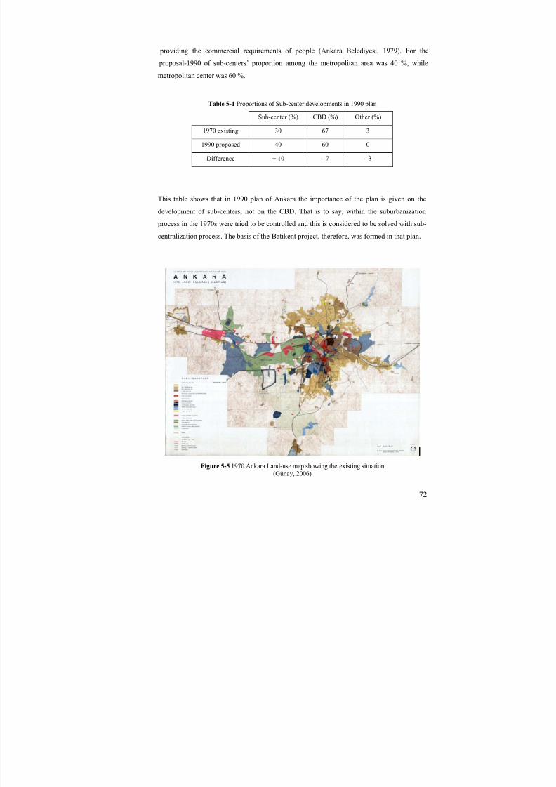
8/8/2019 Assessment of Sub-center Development
http://slidepdf.com/reader/full/assessment-of-sub-center-development 87/154
72
providing the commercial requirements of people (Ankara Belediyesi, 1979). For the
proposal-1990 of sub-centers’ proportion among the metropolitan area was 40 %, while
metropolitan center was 60 %.
Table 5-1 Proportions of Sub-center developments in 1990 plan
Sub-center (%) CBD (%) Other (%)
1970 existing 30 67 3
1990 proposed 40 60 0
Difference + 10 - 7 - 3
This table shows that in 1990 plan of Ankara the importance of the plan is given on the
development of sub-centers, not on the CBD. That is to say, within the suburbanization
process in the 1970s were tried to be controlled and this is considered to be solved with sub-
centralization process. The basis of the Batıkent project, therefore, was formed in that plan.
Figure 5-5 1970 Ankara Land-use map showing the existing situation(Günay, 2006)
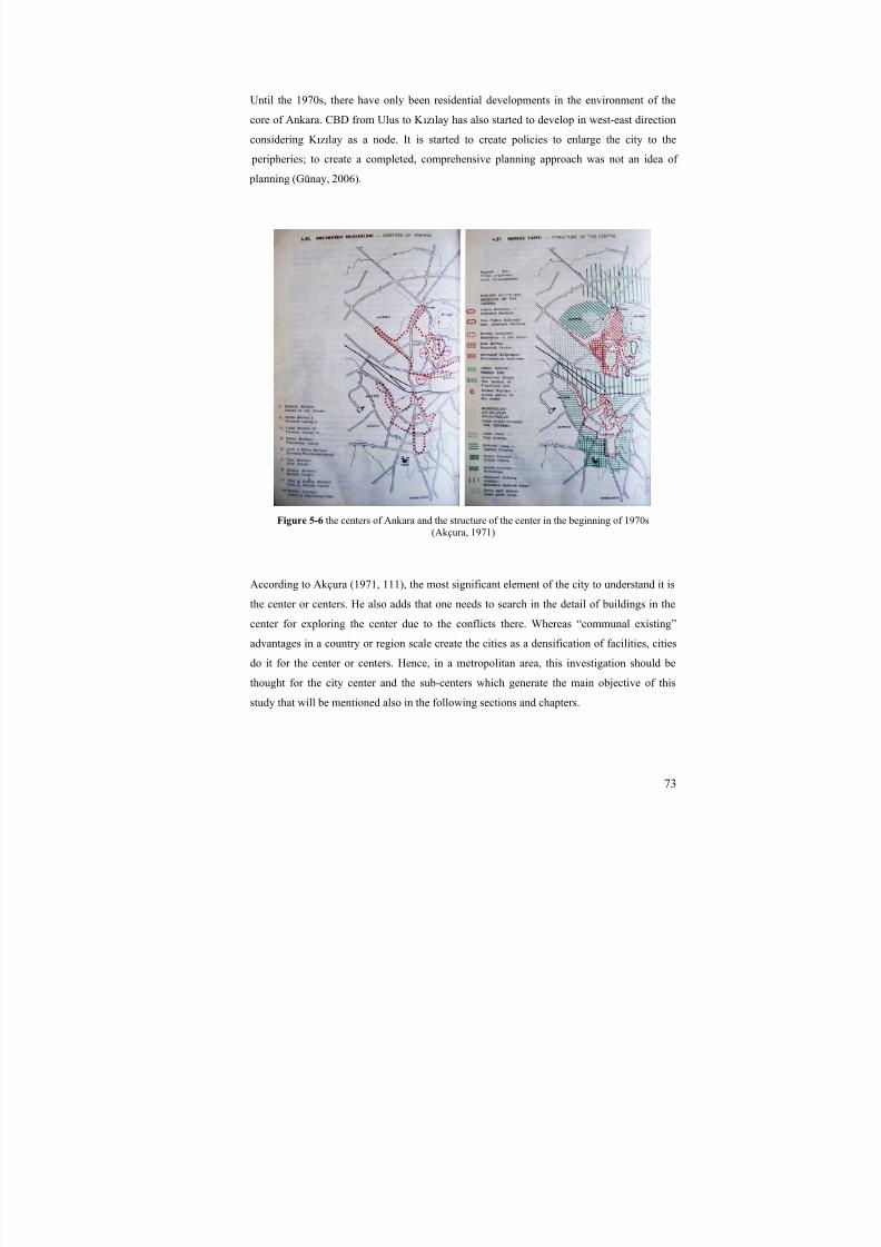
8/8/2019 Assessment of Sub-center Development
http://slidepdf.com/reader/full/assessment-of-sub-center-development 88/154
73
Until the 1970s, there have only been residential developments in the environment of the
core of Ankara. CBD from Ulus to K ızılay has also started to develop in west-east direction
considering K ızılay as a node. It is started to create policies to enlarge the city to the
peripheries; to create a completed, comprehensive planning approach was not an idea of
planning (Günay, 2006).
Figure 5-6 the centers of Ankara and the structure of the center in the beginning of 1970s(Akçura, 1971)
According to Akçura (1971, 111), the most significant element of the city to understand it is
the center or centers. He also adds that one needs to search in the detail of buildings in the
center for exploring the center due to the conflicts there. Whereas “communal existing”
advantages in a country or region scale create the cities as a densification of facilities, cities
do it for the center or centers. Hence, in a metropolitan area, this investigation should be
thought for the city center and the sub-centers which generate the main objective of this
study that will be mentioned also in the following sections and chapters.
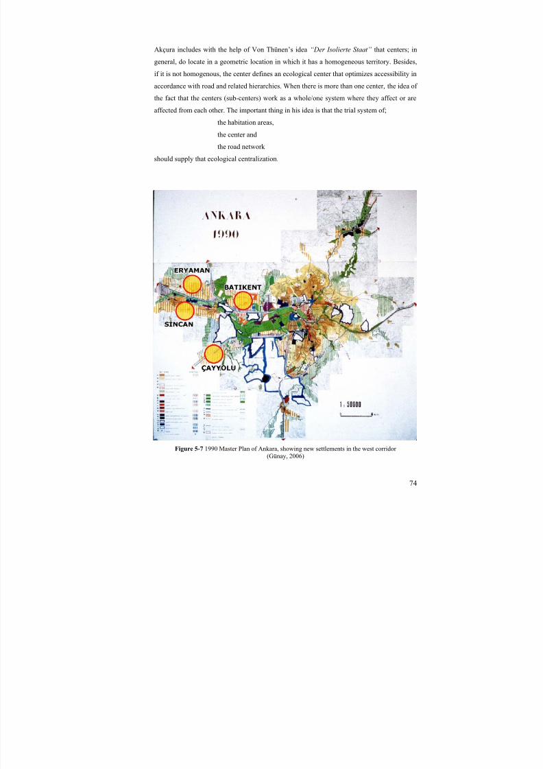
8/8/2019 Assessment of Sub-center Development
http://slidepdf.com/reader/full/assessment-of-sub-center-development 89/154
74
Akçura includes with the help of Von Thünen’s idea “Der Isolierte Staat” that centers; in
general, do locate in a geometric location in which it has a homogeneous territory. Besides,
if it is not homogenous, the center defines an ecological center that optimizes accessibility in
accordance with road and related hierarchies. When there is more than one center, the idea of
the fact that the centers (sub-centers) work as a whole/one system where they affect or are
affected from each other. The important thing in his idea is that the trial system of;
the habitation areas,
the center and
the road network
should supply that ecological centralization.
Figure 5-7 1990 Master Plan of Ankara, showing new settlements in the west corridor (Günay, 2006)

8/8/2019 Assessment of Sub-center Development
http://slidepdf.com/reader/full/assessment-of-sub-center-development 90/154
75
The west corridor of Ankara, firstly in that plan, had started to be built up as a development
zone for Ankara. The first decentralization process of the city center can be considered as
done in 1990 plan. Moreover, CBD development of Ulus and its periphery was considered
and built in the plan. Urban area development reached its last edges in Ankara in the east
part with both planned and squatter housing areas. However, the need for the development
resulted in the development of the west corridor.
In the city center, there have not been created many policies or interpretations to chance or
transform the area. For the central area, with creating regions, some policies were defined by
the planning office and applications were left to the local government.
West corridor in both Istanbul Road and Eskisehir Road Directions was increased in urban
uses, especially in new town settlements. Çayyolu-Ümitköy, Eryaman-Sincan, and Batıkent
districts were the residential areas with their own town centers. Those satellite cities
mentioned in the plan were to meet the increasing demand of housing in Ankara with a
relation to industrial development. Therefore, it is not hard to understand that central district
developments of those areas could not be developed enough as they are developed in their
residential units.
The big public transportation projects were planned to build in the 1990s. The metro project
along the west corridor was thought and encouraged with the development of both housing
and working areas like industry in the plan.
“Batıkent wouldn’t be an alternative of the squatter settlements withinan extensive cooperative process encouraging middle and high-middle classes with infrastructure and land possibilities in anationalized land, locating just next to the core area. Batıkent,
populating 300,000 people, was thought to be a successful project interms of project application and development processes; nevertheless,the created settlement pattern was criticized. The center of the
settlement couldn’t have been formed, and it is assumed that housingstores are staying together but couldn’t create a whole in general. Tosum up, this land part was being applied not for creating a new townidea, but applied with an idea of distributing land to the cooperatives,and it has not yet saved from being artificial.” (Günay, 2006)
The integration of industry and housing areas in 19th and 20th century in Europe with the idea
of creating new focal points has also affected the plan. And new settlements of Sincan,
Aktepe and Batıkent district were developed as with the idea of discouraging the squatter
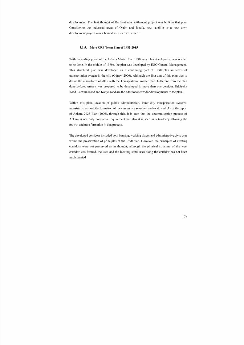
8/8/2019 Assessment of Sub-center Development
http://slidepdf.com/reader/full/assessment-of-sub-center-development 91/154
76
development. The first thought of Batıkent new settlement project was built in that plan.
Considering the industrial areas of Ostim and İvedik, new satellite or a new town
development project was schemed with its own center.
5.1.5. Metu CRP Team Plan of 1985-2015
With the ending phase of the Ankara Master Plan 1990, new plan development was needed
to be done. In the middle of 1980s, the plan was developed by EGO General Management.
This structural plan was developed as a continuing part of 1990 plan in terms of
transportation system in the city (Günay, 2006). Although the first aim of this plan was to
define the macroform of 2015 with the Transportation master plan. Different from the plan
done before, Ankara was proposed to be developed in more than one corridor. Eskişehir
Road, Samsun Road and Konya road are the additional corridor developments to the plan.
Within this plan, location of public administration, inner city transportation systems,
industrial areas and the formation of the centers are searched and evaluated. As in the report
of Ankara 2023 Plan (2006), through this, it is seen that the decentralization process of
Ankara is not only normative requirement but also it is seen as a tendency allowing the
growth and transformation in that process.
The developed corridors included both housing, working places and administrative civic uses
within the preservation of principles of the 1990 plan. However, the principles of creating
corridors were not preserved as in thought; although the physical structure of the west
corridor was formed, the uses and the locating some uses along the corridor has not been
implemented.

8/8/2019 Assessment of Sub-center Development
http://slidepdf.com/reader/full/assessment-of-sub-center-development 92/154
77
Figure 5-8 Structural Plan of Ankara 2015 showing the corridors(Ankara Büyük şehir Belediyesi, 2006)
With the public transportation -metro- suggestion and the multi-corridors proposed, the planhas gone off (Bademli, 2006). For the central or sub-central areas, plan could not be
developed much differently from the plan done before.
Batıkent sub-center, or a new town development at that time, was defined with small center
in the middle in the master plan. However, at the same time, there was also the plan of
Batıkent settlement area. The third planning team for Batıkent had the duty of the
development of the area. That will be discussed in the following part of the study.
5.1.6. Municipality of Ankara Plan 1990-2025
Decentralization process has kept on during the late 1980s and the beginning of the 1990s in
Ankara. While middle and middle-high classes were concentrating on the core area of
conurbation, high classes were hugely started to place in the south-west part. According to
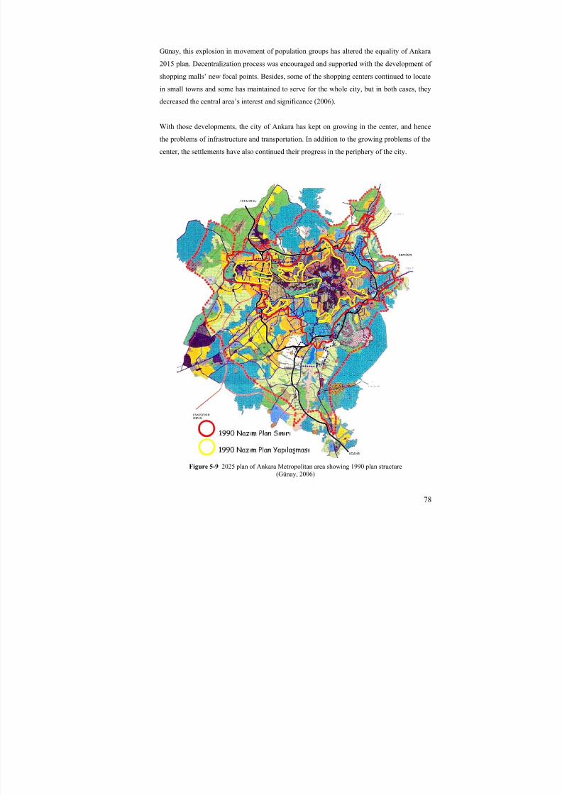
8/8/2019 Assessment of Sub-center Development
http://slidepdf.com/reader/full/assessment-of-sub-center-development 93/154
78
Günay, this explosion in movement of population groups has altered the equality of Ankara
2015 plan. Decentralization process was encouraged and supported with the development of
shopping malls’ new focal points. Besides, some of the shopping centers continued to locate
in small towns and some has maintained to serve for the whole city, but in both cases, they
decreased the central area’s interest and significance (2006).
With those developments, the city of Ankara has kept on growing in the center, and hence
the problems of infrastructure and transportation. In addition to the growing problems of the
center, the settlements have also continued their progress in the periphery of the city.
Figure 5-9 2025 plan of Ankara Metropolitan area showing 1990 plan structure(Günay, 2006)
8/8/2019 Assessment of Sub-center Development
http://slidepdf.com/reader/full/assessment-of-sub-center-development 94/154
79
The plan could not solve the problems of development in Ankara, but the administration and
the municipality needed to accept the speculative developments in the south-west side of
Ankara. The city of Ankara was developing structurally and getting denser in the central area
and spreading more in the peripheries. While this development was encouraging motorways
by enlarging it from the center, the railway system could not be developed and therefore the
problems could not be solved and hence more congestion started to appear inevitably with
the increase of central area use by private cars.
After the plan of 1990, the sub-center development in Batıkent was defined more clearly
with that structure. As seen in the map (figure 2-8), the central area of Bat ıkent settlement
zone is shown as built area of 1990 plan. But apart from only the central area and public use
developments, most of the project was realized as housing.
5.1.7. Municipality of Ankara Plan 2003-2023
The central area development of Ankara was kept on with 2023 plan. In the process of
growth of the center Ulus, Yenişehir, Bakanlık district, K ızılay, Kolej, Tunalı-Kavaklıdere,
Çankaya-Uğur Mumcu spines were expanded as central areas and the major centers of
Ankara. In the plan, centers are considered specifically and developed policies in the name
of “Major Plan of the Centers”. Those mentioned places as CBDs were identified as the focal points of the other centers (sub-centers). In the decentralization process of the center, Major
Plan of the Centers is thought to create solutions to transportation-circulation, car parks-
pedestrian, and functional wholeness.
As seen in the map of the actual situation in terms of non-public urban services, it is easy to
understand that till that time, almost nothing has been done to decentralize or to share the
central activities in Ankara. Starting from the north in the historical center, these activities
only enlarged to the south of Ankara due to the need of space. Specifically, nothing except
for the commercial and some of the office uses of the urban center has been decentralized.
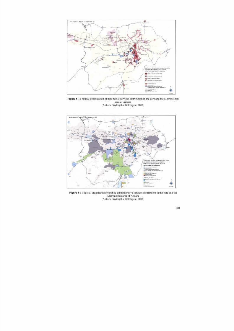
8/8/2019 Assessment of Sub-center Development
http://slidepdf.com/reader/full/assessment-of-sub-center-development 95/154
80
Figure 5-10 Spatial organization of non-public services distribution in the core and the Metropolitanarea of Ankara
(Ankara Büyük şehir Belediyesi, 2006)
Figure 5-11 Spatial organization of public-administrative services distribution in the core and theMetropolitan area of Ankara
(Ankara Büyük şehir Belediyesi, 2006)
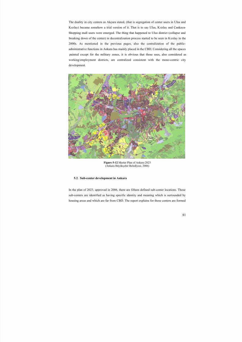
8/8/2019 Assessment of Sub-center Development
http://slidepdf.com/reader/full/assessment-of-sub-center-development 96/154
81
The duality in city centers as Akçura stated, (that is segregation of center users in Ulus and
K ızılay) became somehow a trial version of it. That is to say Ulus, K ızılay and Çankaya-
Shopping mall users were emerged. The thing that happened to Ulus district (collapse and
breaking down of the center) in decentralization process started to be seen in K ızılay in the
2000s. As mentioned in the previous pages, also the centralization of the public-
administrative functions in Ankara has mainly placed in the CBD. Considering all the spaces
painted except for the military zones, it is obvious that those uses, also considered as
working/employment districts, are centralized consistent with the mono-centric city
development.
Figure 5-12 Master Plan of Ankara 2023(Ankara Büyük şehir Belediyesi, 2006)
5.2. Sub-center development in Ankara
In the plan of 2023, approved in 2006, there are fifteen defined sub-center locations. Those
sub-centers are identified as having specific identity and meaning which is surrounded by
housing areas and which are far from CBD. The report explains for those centers are formed

8/8/2019 Assessment of Sub-center Development
http://slidepdf.com/reader/full/assessment-of-sub-center-development 97/154
82
with linear, that is along the road, and/or being compact in itself and transformed to the
central activity area. Those also are the parts of a whole system having relations with the city
center and sharing the burden of it. The report also tells us that the sub-centers will
contribute to the transformation of its environments and they are thought to have a relation
with city center. Those centers should be specifically planned, designed and applied
considering;
-wholeness and balance in functional and structural use
-transportation and pedestrian circulation relations
The sub-centers decided to be projected in 2023 Ankara Plan were;
1. Bahçelievler Sub-center 2. Demetevler Sub-center 3. Çayyolu 8. Cad. Sub-center (planned)4. Turan Güneş, Or-An Sub-center 5. Batıkent Sub-center (planned)6. Eryaman-Göksu Sub-center (planned)7. Pursaklar-Saray Sub-center 8. Siteler Sub-center 9. Hatip Çayı-Mamak Sub-center 10. Natoyolu Sub-center 11. Beytepe Sub-center 12. Tuluntaş Sub-center 13. Sincan-Saraycık Sub-center 14. Etlik Cad.- Ovacık Sub-center and15. Susuz-Yuva Sub-center (planned)
Figure 5-13 15 Sub-centers projected in the 2023 plan(Based on the plan report)

8/8/2019 Assessment of Sub-center Development
http://slidepdf.com/reader/full/assessment-of-sub-center-development 98/154
83
Figure 5-14 Structure Developed for the Study area

8/8/2019 Assessment of Sub-center Development
http://slidepdf.com/reader/full/assessment-of-sub-center-development 99/154
84
Figure 5-15 Sub-center Proposals in 2023 Ankara Master Plan
The map shows the fifteen sub-center development proposed in the plan. While the red areas
with white frames show the exact locations, the other places with black frames show only the
direction of the sub-center with their correct names. The sizes of the areas are not the exact
sizes, but somehow drawn by the explanations in the report.
Among those sub-center developments, almost six of them have already more or less
supplied the central activities and facilities. Those centers are Demetevler, Bahçelievler,
Pursaklar, Sincan, Turan Güneş (Çankaya-Yıldız) and Etlik. Those centers have the similar
characteristics of their pattern, namely they were developed spontaneously through the
private developers. They have a grid and similar type of pattern and street system, having
small implementation plots, that is allowing larger range of capital owner to come there.
However, in Batıkent, Çayyolu, Eryaman and Susuz-Yuva districts, the sub-center
development have still problems of growth. There are many and different reasons for each of
them, however, the common problem is that, the central locations of those new urban
settlements are produced by public, or due to having very big lands discouraged various
kinds of capital owners or developers. Here the problem emerges both from the pattern
created, and the planning faults in terms of staging, design environment or in terms of
revisions on behalf of urban uses which should not be in a sub-center.
8/8/2019 Assessment of Sub-center Development
http://slidepdf.com/reader/full/assessment-of-sub-center-development 100/154
85
5.2.1. Sub-center developments in Collective Housing projects
None of the already developed sub-centers mentioned above are planned sub-centers. They
are all spontaneously developed. The sizes of the plots are smaller considering other public
development areas or new towns like Batıkent and Eryaman and the land on those centers
belongs to private and therefore it is easier to create or build commercial areas because of the
low rent respectively. Besides, Çayyolu district is defined as a sub-center and it is not well-
developed yet in terms of the facilities that it should be a sub-center mentioned in the study,
however the center area is not an empty land as it is in Bat ıkent. The most probable reason
for this is that the area does not belong to the public, but private entrepreneurs have the land
and because it attracts the interest of high classes, the sub-central activities in Çayyolu has
started to develop easily, at least, it has been developed, considering the commercial and the
cultural activities. Batıkent, in the study, is going to be analyzed more. The area is chosen
due to the fact that in the 1970s the plan was made, however, nothing is developed as a sub-
central zone. Batıkent new settlement area was very big project and the first in terms of that
kind of urbanism in Turkey. In addition to this, the area was nationalized and belonged to the
public. With the management of Kent Koop (housing cooperative union), the land was
nationalized for low and middle classes. And the fist aim of the project was to supply
housing for them.
5.2.2. Other Sub-center developments
Apart from Batıkent, Eryaman, and Çayyolu sub-centers, there are many other central area
developments having smaller plots with private entrepreneurs. Bahçelievler, Yıldız, and
Demetevler districts are the basic examples of this kind of development. It is easier to have a
parcel/plot/urban land in central areas when it is smaller considering the price of the land.
Within the decentralization process, some centers were developed as a sub-center like
Bahçelievler, Yıldız or Siteler spontaneously. Those were encouraged by the proximity to
the main center and proximity to big employment areas. Some districts like Demetevler,
Pursaklar or Etlik were developed, although lacking many facilities like socio-cultural or
considering open-spaces, as they area sub-centers, in terms of both commercial uses and
administrative or employment areas they work as sub-center in spite of the fact that they
have poor urban conditions and services. The reason for running as sub-center spontaneously
is mainly laying under the smaller plot system and the high demand of residential for both
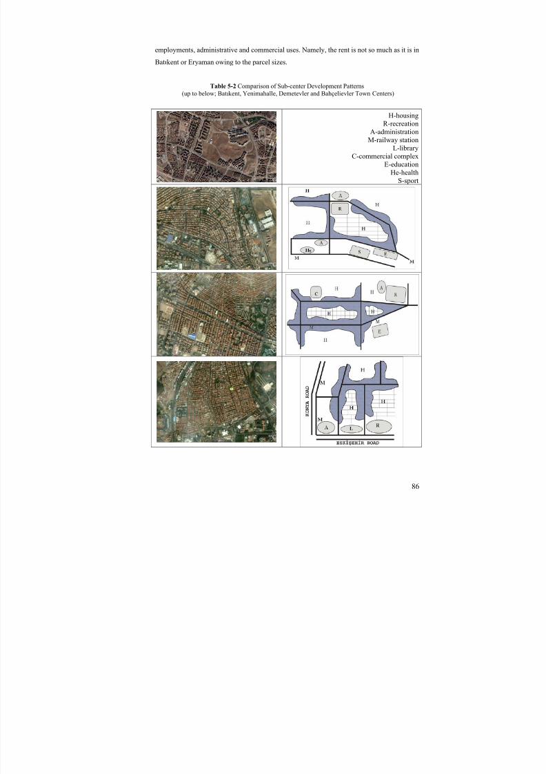
8/8/2019 Assessment of Sub-center Development
http://slidepdf.com/reader/full/assessment-of-sub-center-development 101/154
86
employments, administrative and commercial uses. Namely, the rent is not so much as it is in
Batıkent or Eryaman owing to the parcel sizes.
Table 5-2 Comparison of Sub-center Development Patterns
(up to below; Batı
kent, Yenimahalle, Demetevler and Bahçelievler Town Centers)
H-housingR-recreation
A-administrationM-railway station
L-libraryC-commercial complex
E-educationHe-health
S-sport
8/8/2019 Assessment of Sub-center Development
http://slidepdf.com/reader/full/assessment-of-sub-center-development 102/154
87
5.2.3. Contemporary Design problems in sub-centers
The problem in sub-center creation of Batıkent district is mainly coming from mass public
areas with big plot units. In general, considering centers in Ankara, it is easy to see that sub-central areas have private, smaller property plots. Searching the difference between Bat ıkent
and Eryaman with Demetevler and Yıldız districts can show the reason of it. The reasons of
having problems in the creation of sub-center can be the followings. Poor do not visit center
so frequently, like others do (Alexander, 1965). The problems for “mass housing producers,
like cooperatives do not have the right to built commercial or they are not encouraged to do
it. The reason may also be the lack of need for sub-center in cooperative region in the first
idea of the settlement project as an urgent project. Or the question; in what frequency, people
living in those bigger plots/development areas need sub-centers become as a subject of the
study. Moreover, the problem appears because “Çar şı”s or district centers in Batıkent are
supplying more than it should such as some neighborhood centers, that is “Çar şı”s have
Banks, Cafes, or big department stores that should be located in the town center. In addition
to this, the lack of the idea of pattern in the settlement may create an urban life without a
central use. Comparing the settlement of cooperatives with Demetevler region will probably
answer the question or a matter of the pattern.
5.2.4. Expected problems for sub-centers
The significant matter in big metropolitan areas is that in one sense the vertical hierarchy, the
confusion of the main center and sub-center and in other sense horizontal specialization, the
confusion and mystification owing to the fact that different facilities become dense in
different regions (sub-centers) in the city (Akçura, 1971, p.116-117). According to him, the
important thing is that they all describe one center in terms of physical continuity because
they (smaller centers or sub-centers) do not have physical cuts among each other. The vital
thing is whether different social groups use different centers to buy similar necessities or not.
Here, he mentions the center as a major city center but we can accept this preposition also
for the sub-centers and its relations among each other and with the city center. To him, by
the help of some research of Paris central area, there is not a certain cut between social
classes how the political opposition is important, for their daily life and consumption types in
capitalist countries.

8/8/2019 Assessment of Sub-center Development
http://slidepdf.com/reader/full/assessment-of-sub-center-development 103/154
88
CHAPTER 6
6. BATIKENT SATELLITE CITY / SUB-CENTER
After the 1970s, with the development of central activities in the core of Ankara, Batıkent
settlement started to be thought as one of the secondary core of the metropolitan area which
is on the north side of Istanbul-Ankara motorway. But since then, it has never been
considered or projected as it was in the beginning. Within the policies of 1990 plan, 1034 haarea was going to be nationalized to create a satellite city in the name of Akkondu. In 1975,
200 ha area was nationalized and in 1976 other areas were approved with 1/5,000 plan by
Ministry of Public Works and Housing (İmar İskan Bakanlığı). In 1977 industrial areas
between Batıkent and Istanbul-Ankara motorway have been left out of the planned area. In
that frame of the plan, 200,000 people would settle and 50,000 dwelling units would be
placed.
6.1. Historical process
6.1.1. Planning processes of Batıkent New Settlement area
Including 1990 Master plan, there were four master plans made for Ankara which have
planning decisions for Batıkent District. The first policy to create sub-center in the area was
of 1990 plan prepared in 1970s. The two plans made afterwards have not had much different
affect for the development of the study area. The following schemes from master plans show
the differences. METU CRP team plan prepared in 1985 had corridor systems for the
metropolitan growth of Ankara. The significant difference of this plan is that Bat ıkent
District has become a settlement area which resides in the middle of the two main
motorways. In the same way, the housing areas of this plan are restricted and lower than the
other plans. Municipality of Ankara has prepared a plan for Ankara in 1990 afterwards.
Different from the plan prepared the one before; it has accepted more policies of the master
plan of 1990. The settlement area is larger and more significantly, the core of the settlement

8/8/2019 Assessment of Sub-center Development
http://slidepdf.com/reader/full/assessment-of-sub-center-development 104/154
89
has been defined very clearly on that plan. The motorway is farther and instead there placed
more residential areas. Greenery areas in the plan of Metu Crp team became housing in that
plan due to the requirements of the city. As mentioned, the main contribution of the plan of
the municipality is the visible identification of the sub-center.
Figure 6-1 Detail view of Batıkent in Metu CRP Team Plan 1985-2015 (left) and Municipality of Ankara Plan 1990-2025 (right)
6.1.1.1. 1990 plan-Master Plan
As mentioned before, Batıkent new settlement project was formed in 1990 plan of Ankara
done in 1970s. This plan has the first form of the district by being located so close to
Istanbul-Ankara motorway and the industrial zone of Ostim. As in the Figure 6-2, the newsettlement district has a center in the core point of it. Area is separated from the motorway
by industrial zone as a transition zone to the city. And moreover the settlement is separated
and combined with other new settlement project Eryaman district with a green area having
probably a function in.
Figure 6-2 Detailed plan view of Batıkent New Settlement area in 1990 plan of Ankara-1/50,000(Keskinok, 2006)

8/8/2019 Assessment of Sub-center Development
http://slidepdf.com/reader/full/assessment-of-sub-center-development 105/154
90
6.1.1.2. 2023 plan-Master Plan
The last plan affecting Batıkent region is 2023 plan of Ankara, explaining nothing more than
the other plans made before in any scale as physical development criteria. In the plan report
of 2023, there are 15 defined sub-centers. Batıkent is the densest and the most important
settlement center of the “west corridor” of Ankara (Report of Ankara 2023 Plan). Although
the plan of the center was completed, the structuring/the building process have not started
yet. Moreover, there have been plan revisions in that area in the name of housing. Despite
the fact that Batıkent settlement area needs a sub-center (the last phase of the project should
have been built now), anything considering a central activity or land use could not have been
done yet.
Figure 6-3 Detailed plan view of Batı
kent New Settlement area in 2023 plan of Ankara-1/25,000(Ankara 2023 Plan report)
The report of 2023 plan also includes for Batıkent that it is strictly and immediately needed
to create specific intervention types to realize the structure defined in the plan. The current
situation of the area is only limited to some commercial and service uses. However, no more
activities such as social, cultural, administrative or similar activities and facilities could have
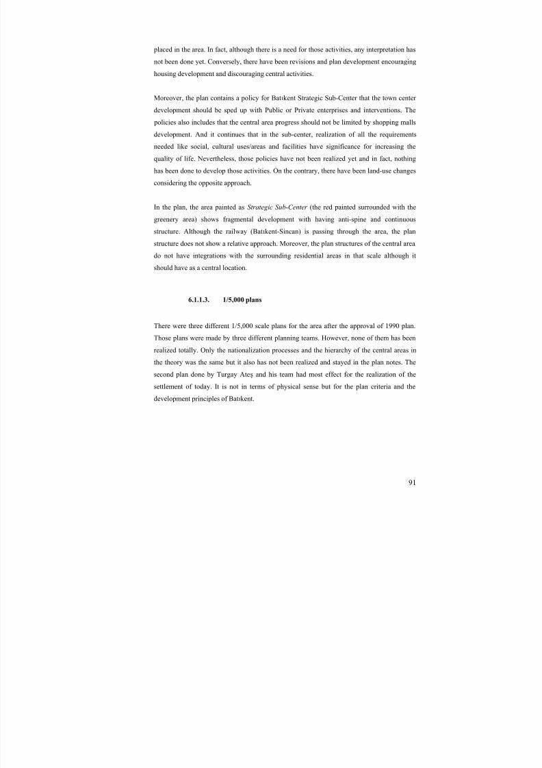
8/8/2019 Assessment of Sub-center Development
http://slidepdf.com/reader/full/assessment-of-sub-center-development 106/154
91
placed in the area. In fact, although there is a need for those activities, any interpretation has
not been done yet. Conversely, there have been revisions and plan development encouraging
housing development and discouraging central activities.
Moreover, the plan contains a policy for Batıkent Strategic Sub-Center that the town center
development should be sped up with Public or Private enterprises and interventions. The
policies also includes that the central area progress should not be limited by shopping malls
development. And it continues that in the sub-center, realization of all the requirements
needed like social, cultural uses/areas and facilities have significance for increasing the
quality of life. Nevertheless, those policies have not been realized yet and in fact, nothing
has been done to develop those activities. On the contrary, there have been land-use changes
considering the opposite approach.
In the plan, the area painted as Strategic Sub-Center (the red painted surrounded with the
greenery area) shows fragmental development with having anti-spine and continuous
structure. Although the railway (Batıkent-Sincan) is passing through the area, the plan
structure does not show a relative approach. Moreover, the plan structures of the central area
do not have integrations with the surrounding residential areas in that scale although it
should have as a central location.
6.1.1.3. 1/5,000 plans
There were three different 1/5,000 scale plans for the area after the approval of 1990 plan.
Those plans were made by three different planning teams. However, none of them has been
realized totally. Only the nationalization processes and the hierarchy of the central areas in
the theory was the same but it also has not been realized and stayed in the plan notes. The
second plan done by Turgay Ateş and his team had most effect for the realization of the
settlement of today. It is not in terms of physical sense but for the plan criteria and the
development principles of Batıkent.

8/8/2019 Assessment of Sub-center Development
http://slidepdf.com/reader/full/assessment-of-sub-center-development 107/154
92
Plan of Bülent Berksan’s Team
Figure 6-4 Batıkent 1/5,000 plan of Bülent Berksan and his team(Keskinok, 2006)
The plan which was made on behalf of the nationalization process was poor in terms of
criteria of different housing type locations, or for an urban development to organize the
space hierarchy principles and define district identifications in such a big place that will be
created by public. In spite of those, the plan had a central design related to the residential
areas with a defined area and having a spine and the character of the heart (Keskinok, 2006).
The plan of the central area of Batıkent settlement shows more character of the center
considering the plan actual now. The heart, the center of Batıkent, has a structure of spine
with arterial roads going through it, not dividing the area or not having congestion but
servicing it. The area is not divided by the roads, but it has a pedestrian integration going
over the car road within the central area. The spine of the heart was located between a sport
facility area (the right point of the center) and probably a place of shopping or similar
activities (the left point of the center). Each side of the central area also encouraged with
pedestrian ways coming from residential districts.
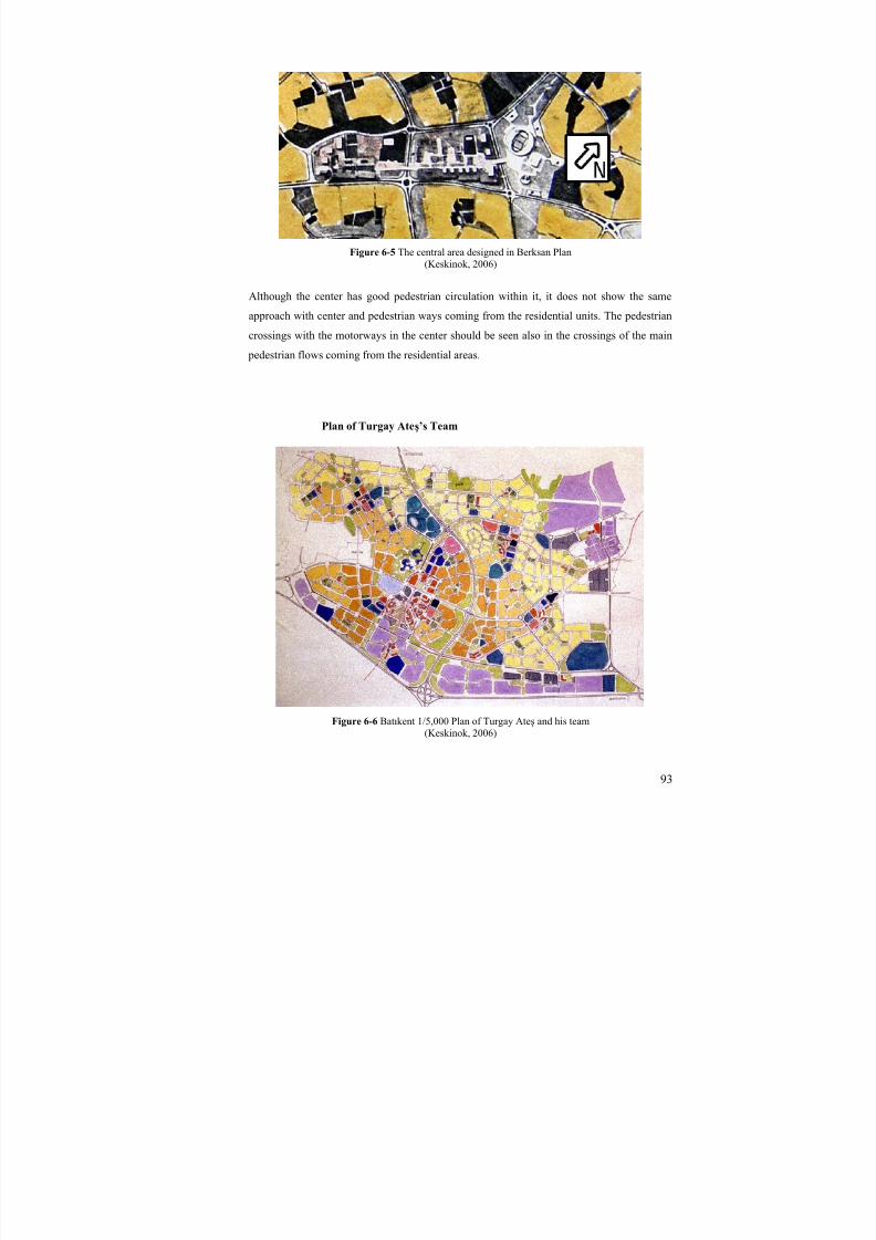
8/8/2019 Assessment of Sub-center Development
http://slidepdf.com/reader/full/assessment-of-sub-center-development 108/154
93
Figure 6-5 The central area designed in Berksan Plan(Keskinok, 2006)
Although the center has good pedestrian circulation within it, it does not show the same
approach with center and pedestrian ways coming from the residential units. The pedestrian
crossings with the motorways in the center should be seen also in the crossings of the main
pedestrian flows coming from the residential areas.
Plan of Turgay Ateş’s Team
Figure 6-6 Batıkent 1/5,000 Plan of Turgay Ateş and his team(Keskinok, 2006)

8/8/2019 Assessment of Sub-center Development
http://slidepdf.com/reader/full/assessment-of-sub-center-development 109/154
94
The plan was formed of different districts. Those districts were defined by units and sub-
units. Space hierarchy was tried to be obtained with the composition of different scales of the
units and with the co-existence of units that had variable technological development
prerequisites. The plan was formed with the smallest unit Housing Environs that are
Cooperatives. The smallest public center was composed of Children play parks, neighbor’s
meeting points, common buildings like heating and laundry buildings and daily shopping
spaces (Keskinok, 2006).
The planning criteria and principles included;
-Pedestrian accessibility
-Walkable town
-Security of pedestrians
-Integration of pedestrian and public transportation
-Pedestrian accessibility to the transportation system
-Road hierarchy
-Residential-working place relations with alternative ways
-Neighborhood units for community integration
-Co-existence of spatial distribution of activities
It is not hard to see that the plan was totally pedestrian oriented. The principles and space
organization can show it us easily. Public transportation network and the metro line thought
in the plan strictly prove the idea of pedestrian town. Moreover the hierarchy of the central
areas is also encouraged this idea. The secondary centers within the Batıkent settlement and
neighborhood centers are good illustrations of the system. Although the main central area of
the settlement are not located in the physical center, the three-secondary centers in the
settlement area located in the east, in the north-east, and north-west side of the main center
will service to the whole area.
Sub-Central area and the neighborhood centers in Batıkent are located in such a spine that
they are encouraged by public transportation and pedestrian system. Motorways in central
area of Batıkent end in carparks by going through the periphery of the center. Transportation
network is formed with public transportation, service and pedestrian system integration.
Pedestrian districts were proposed where commercial and cultural-recreational urban uses
were densified. All the properties of commercial areas in the main centre, neighborhood
center and community center were thought to belong to the public. The hierarchy in service
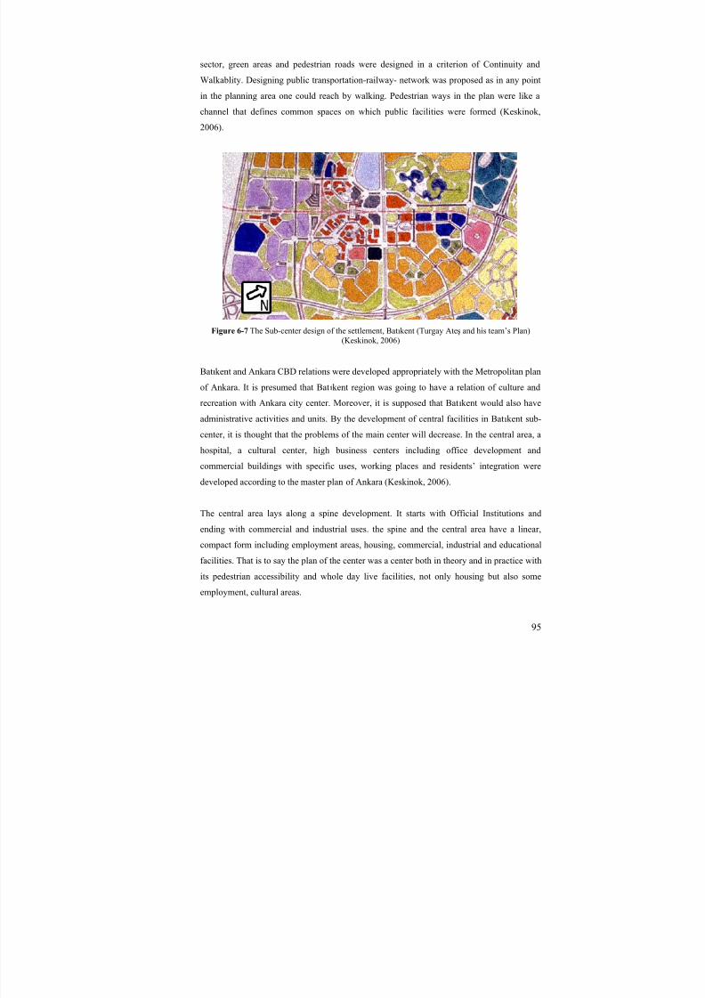
8/8/2019 Assessment of Sub-center Development
http://slidepdf.com/reader/full/assessment-of-sub-center-development 110/154
95
sector, green areas and pedestrian roads were designed in a criterion of Continuity and
Walkablity. Designing public transportation-railway- network was proposed as in any point
in the planning area one could reach by walking. Pedestrian ways in the plan were like a
channel that defines common spaces on which public facilities were formed (Keskinok,
2006).
Figure 6-7 The Sub-center design of the settlement, Batıkent (Turgay Ateş and his team’s Plan)(Keskinok, 2006)
Batıkent and Ankara CBD relations were developed appropriately with the Metropolitan plan
of Ankara. It is presumed that Batıkent region was going to have a relation of culture and
recreation with Ankara city center. Moreover, it is supposed that Batıkent would also have
administrative activities and units. By the development of central facilities in Bat ıkent sub-
center, it is thought that the problems of the main center will decrease. In the central area, a
hospital, a cultural center, high business centers including office development and
commercial buildings with specific uses, working places and residents’ integration were
developed according to the master plan of Ankara (Keskinok, 2006).
The central area lays along a spine development. It starts with Official Institutions and
ending with commercial and industrial uses. the spine and the central area have a linear,
compact form including employment areas, housing, commercial, industrial and educational
facilities. That is to say the plan of the center was a center both in theory and in practice with
its pedestrian accessibility and whole day live facilities, not only housing but also some
employment, cultural areas.
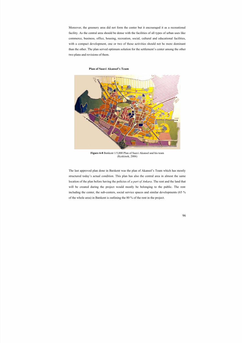
8/8/2019 Assessment of Sub-center Development
http://slidepdf.com/reader/full/assessment-of-sub-center-development 111/154
96
Moreover, the greenery area did not form the center but it encouraged it as a recreational
facility. As the central area should be dense with the facilities of all types of urban uses like
commerce, business, office, housing, recreation, social, cultural and educational facilities,
with a compact development, one or two of those activities should not be more dominant
than the other. The plan served optimum solution for the settlement’s center among the other
two plans and revisions of them.
Plan of Suavi Akansel’s Team
Figure 6-8 Batıkent 1/5,000 Plan of Suavi Akansel and his team(Keskinok, 2006)
The last approved plan done in Batıkent was the plan of Akansel’s Team which has mostly
structured today’s actual condition. This plan has also the central area in almost the same
location of the plan before having the policies of a part of Ankara. The rent and the land that
will be created during the project would mostly be belonging to the public. The rent
including the center, the sub-centers, social service spaces and similar developments (65 %
of the whole area) in Batıkent is outlining the 80 % of the rent in the project.
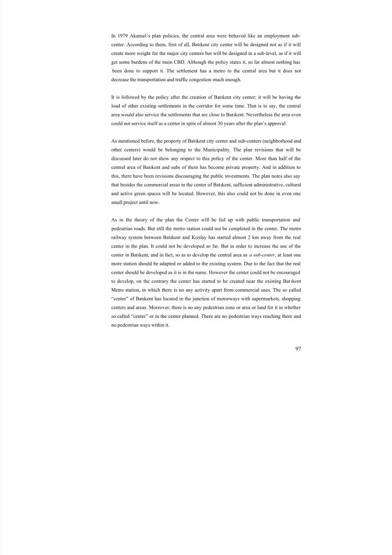
8/8/2019 Assessment of Sub-center Development
http://slidepdf.com/reader/full/assessment-of-sub-center-development 112/154
97
In 1979 Akansel’s plan policies, the central area were behaved like an employment sub-
center. According to them, first of all, Batıkent city center will be designed not as if it will
create more weight for the major city centers but will be designed in a sub-level, as if it will
get some burdens of the main CBD. Although the policy states it, so far almost nothing has
been done to support it. The settlement has a metro to the central area but it does not
decrease the transportation and traffic congestion much enough.
It is followed by the policy after the creation of Batıkent city center; it will be having the
load of other existing settlements in the corridor for some time. That is to say, the central
area would also service the settlements that are close to Batıkent. Nevertheless the area even
could not service itself as a center in spite of almost 30 years after the plan’s approval.
As mentioned before, the property of Batıkent city center and sub-centers (neighborhood and
other centers) would be belonging to the Municipality. The plan revisions that will be
discussed later do not show any respect to this policy of the center. More than half of the
central area of Batıkent and subs of them has become private property. And in addition to
this, there have been revisions discouraging the public investments. The plan notes also say
that besides the commercial areas in the center of Batıkent, sufficient administrative, cultural
and active green spaces will be located. However, this also could not be done in even one
small project until now.
As in the theory of the plan the Center will be fed up with public transportation and
pedestrian roads. But still the metro station could not be completed in the center. The metro
railway system between Batıkent and K ızılay has started almost 2 km away from the real
center in the plan. It could not be developed so far. But in order to increase the use of the
center in Batıkent, and in fact, so as to develop the central area as a sub-center , at least one
more station should be adapted or added to the existing system. Due to the fact that the real
center should be developed as it is in the name. However the center could not be encouragedto develop, on the contrary the center has started to be created near the existing Bat ıkent
Metro station, in which there is no any activity apart from commercial uses. The so called
“center” of Batıkent has located in the junction of motorways with supermarkets, shopping
centers and areas. Moreover, there is no any pedestrian zone or area or land for it in whether
so called “center” or in the center planned. There are no pedestrian ways reaching there and
no pedestrian ways within it.

8/8/2019 Assessment of Sub-center Development
http://slidepdf.com/reader/full/assessment-of-sub-center-development 113/154
98
The plan shows that pedestrian zones will have large places that will be located for
commercial and cultural facilities. So far the commercial side of the policy has been realized
in a sense, but the cultural activity areas could not be realized.
Smaller centers (neighborhood and district centers) should be formed in one level below the
sub-center of Batıkent. In fact those centers have been created in neighborhood scale for
daily needs of the population. But, there could not be built any facility area for weekly or
monthly needs. Therefore people living there started to use the settlement for nothing more
than a dormitory town. In short, the policy of “Çar şı”s that will be built is to meet the
demand of daily needs for 5000 persons-units and this has been realized. But it has done
nothing more than “çar şı”s even in neighborhood centers.
The other policy about the area is that main sub-center of Batıkent will be located where
smaller centers and pedestrian road meet and connect and where public transportation stops
are located and the regional roads are intersected. Apart from the roads intersections, nothing
has been developed in that. In fact, the plan is lacking for main pedestrian flow routes or
spines. If one accepts that the white roads were only for the pedestrians, then, it would be a
bit lot for the area, if not so, there are no pedestrian roads going into the center.
Figure 6-9 Existing Public Services and shopping malls
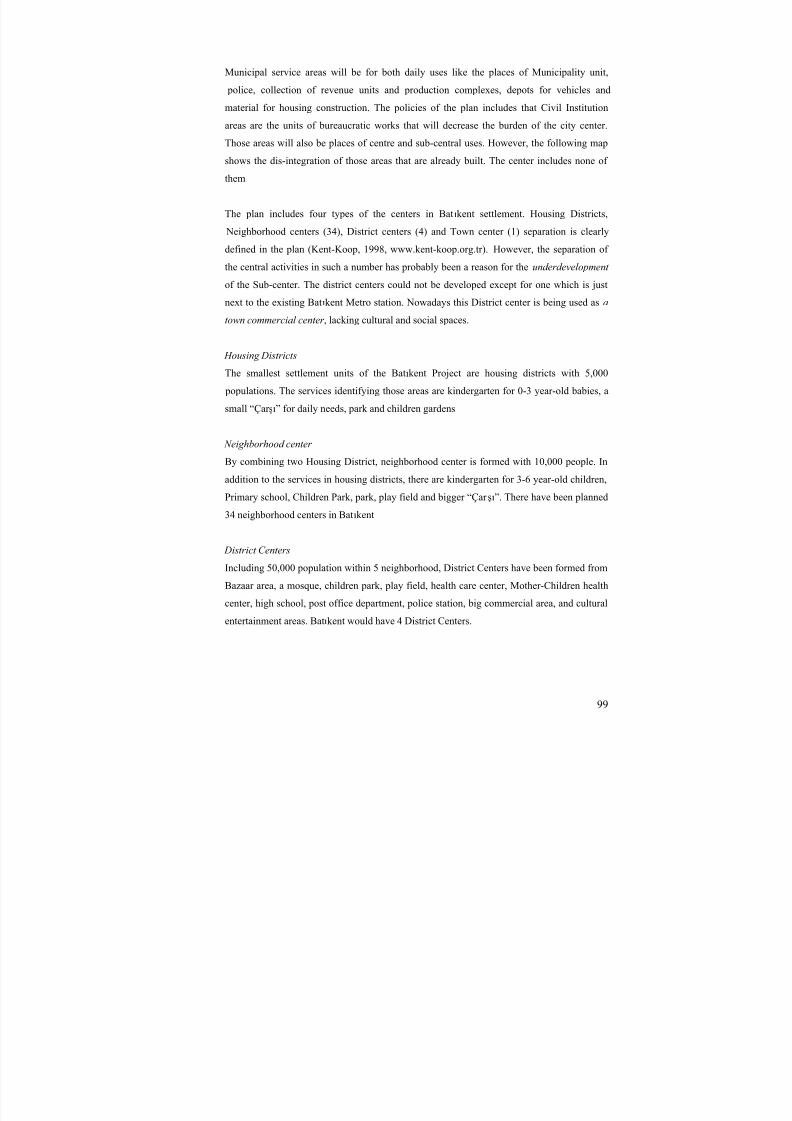
8/8/2019 Assessment of Sub-center Development
http://slidepdf.com/reader/full/assessment-of-sub-center-development 114/154
99
Municipal service areas will be for both daily uses like the places of Municipality unit,
police, collection of revenue units and production complexes, depots for vehicles and
material for housing construction. The policies of the plan includes that Civil Institution
areas are the units of bureaucratic works that will decrease the burden of the city center.
Those areas will also be places of centre and sub-central uses. However, the following map
shows the dis-integration of those areas that are already built. The center includes none of
them
The plan includes four types of the centers in Batıkent settlement. Housing Districts,
Neighborhood centers (34), District centers (4) and Town center (1) separation is clearly
defined in the plan (Kent-Koop, 1998, www.kent-koop.org.tr). However, the separation of
the central activities in such a number has probably been a reason for the underdevelopment
of the Sub-center. The district centers could not be developed except for one which is just
next to the existing Batıkent Metro station. Nowadays this District center is being used as a
town commercial center , lacking cultural and social spaces.
Housing Districts
The smallest settlement units of the Batıkent Project are housing districts with 5,000
populations. The services identifying those areas are kindergarten for 0-3 year-old babies, a
small “Çar şı” for daily needs, park and children gardens
Neighborhood center
By combining two Housing District, neighborhood center is formed with 10,000 people. In
addition to the services in housing districts, there are kindergarten for 3-6 year-old children,
Primary school, Children Park, park, play field and bigger “Çar şı”. There have been planned
34 neighborhood centers in Batıkent
District CentersIncluding 50,000 population within 5 neighborhood, District Centers have been formed from
Bazaar area, a mosque, children park, play field, health care center, Mother-Children health
center, high school, post office department, police station, big commercial area, and cultural
entertainment areas. Batıkent would have 4 District Centers.

8/8/2019 Assessment of Sub-center Development
http://slidepdf.com/reader/full/assessment-of-sub-center-development 115/154
100
Town Center
The town center will be the sub-center of Ankara located in the west corridor. The area for
sub-center development is 110 ha. It will have a service territory of new development of
mass housing areas building in the far west. The center would create an alternative center
designed to decrease the dependence of Ankara city center.
Figure 6-10 Four types of center development in the Akansel’s plan(In order; Housing district, Neighborhood center, District center, Town center-Subcenter)
Keskinok (2006) states that the plan generates some problems in terms of integration of sub-
units with higher units or the whole settlement, continuity in space, and in terms of common
spaces, service supply planning and design problems due to the variable architecture and
housing types. There is no context in the settlement, and that has made integration problems
of high rise and small housing groups or between high dense and low dense areas.
Figure 6-11 The central area in Akansel Plan
8/8/2019 Assessment of Sub-center Development
http://slidepdf.com/reader/full/assessment-of-sub-center-development 116/154
101
Access to the Batıkent town center has problems due to the absence of consistent relations
between the public transportation and space hierarchy. Plan, according to Keskinok (2006),
could not form the central places. They became commercial areas but not a central place.
Due to the dysfunctional places that are not parts of the defined spine, there appeared space
wastes. Urban design process were not thought during the planning process and that made
the dysfunctional spaces with the lacking balance of solid-void, open and mass space
relations, building and street relations. Considering the actual central plan, this scheme
shows more central design applications and principles, although it does not include
pedestrian at its highest degree of design criteria. The central area of Batıkent in that plan
was lacking direction for humans but does it for cars. Moreover, the integration of the
railway system and public transportation is lacking. The stations are not combined to the
system of the center. They should be used more actively. In addition to this the design of the
area does not show the multi-use of space although it should have to attract more and more
people.
Revision of the last plan-1998
The structural system shows much difference than all three plans except for the main
motorways and main urban uses as districts. But the settlement of plots and islands have
almost totally changed and that has created much complicated but having less criteria for the
sub-center development. Plan revisions have increased much on behalf of the rent. The
workspaces and some green areas have changed to housing and commercial areas which
made the area used more like dormitory but not as an employment place. The settlement
became dormitory town by plan revisions after revisions, lacking places and uses of sub-
center in many aspects.
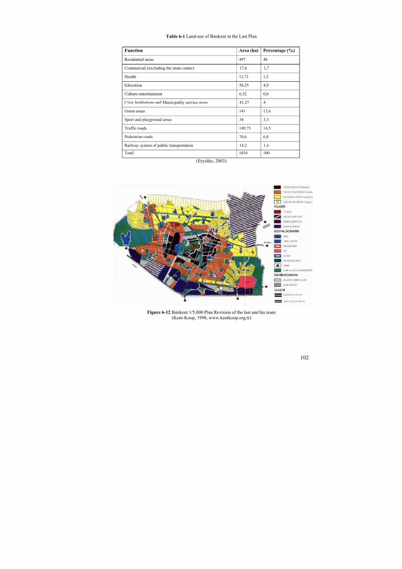
8/8/2019 Assessment of Sub-center Development
http://slidepdf.com/reader/full/assessment-of-sub-center-development 117/154
102
Table 6-1 Land-use of Batıkent in the Last Plan
Function Area (ha) Percentage (%)
Residential areas 497 48
Commercial (excluding the main center) 17,6 1,7Health 11,71 1,2
Education 50,35 4,9
Culture-entertainment 6,52 0,6
Civic Institutions and Municipality service areas 41,27 4
Green areas 141 13,6
Sport and playground areas 34 3,3
Traffic roads 149,75 14,5
Pedestrian roads 70,6 6,8
Railway system of public transportation 14,2 1,4
Total 1034 100
(Eryıldız, 2003)
Figure 6-12 Batıkent 1/5,000 Plan Revision of the last and his team(Kent-Koop, 1998, www.kentkoop.org.tr)

8/8/2019 Assessment of Sub-center Development
http://slidepdf.com/reader/full/assessment-of-sub-center-development 118/154
103
6.1.2. The Comparison of the Plans
Considering the 1/5,000 plans of Batıkent, there are similarities in terms of the hierarchy of
the centers in the town. That is to say, there are the main center, sub-center, district centers
and neighborhood centers, and in some plans, housing district centers are common elements.
The first two plans have neighborhood units and neighborhood centers in addition to district
centers. Those smaller central developments are linked to each other and the main center
with pedestrian roads. On the contrary, the third plan, which is designed by Suavi Akansel
and his team, does not include the pedestrian links between the district centers or the
neighborhood centers and the main center. The third plan, different from the first two, was
designed as car oriented. There are hardly any pedestrian roads or spaces compared to the
first and the second plan. The actual plan which is revised form of the third plan -specifically
the central area- lacks pedestrian access, orientation and pedestrian spaces although it
represents similar hierarchy of settlements.
Those plans differ much among each other considering the residential settlements and their
densities, and their town center plans also vary much from each other. The first two plans
represent a linear central development forming a spine and feeding veins while the last two
plans symbolize a center in an area without spine or defined structure of land uses and
physical structures. Specifically, the actual plan does not figure out a central characteristic intwo dimensions considering the solid-void and the proximity of the uses and physical
structures.
The central zone design of the first plan is seen as collecting the major pedestrian roads to
itself surrounded with the car roads. But the pedestrian and cars are not crossed in the same
level in that plan. The center has a compact and a linear form with a well-defined structure
connected to the town. The second plan’s town center is also in a linear and a compact form
encouraged with the railway system. The third plan however has a spine and a loop for cars.The area is heartened by the railway system, but could not be linked or interrelated to the
environment both physically and relationally. In addition to these, after many revisions the
actual plan showed as the forth plan concentrated with a large green and recreation areas.
The commercial and other central uses are not linked or related to each other without having
a pedestrian roads or spaces except for the green open space. Moreover the residential areas
are not planned as having a central character or qualified as they are in it.

8/8/2019 Assessment of Sub-center Development
http://slidepdf.com/reader/full/assessment-of-sub-center-development 119/154
Table 6-2 Comparison of the 1/5,000 Plans, Center Design and the Schemes of Batıkent
1/5,000 plans Town Center / Sub-center Plans
1
Plan of Bülent Berksan
and his team
2
Plan of Turgay Ateş and his team
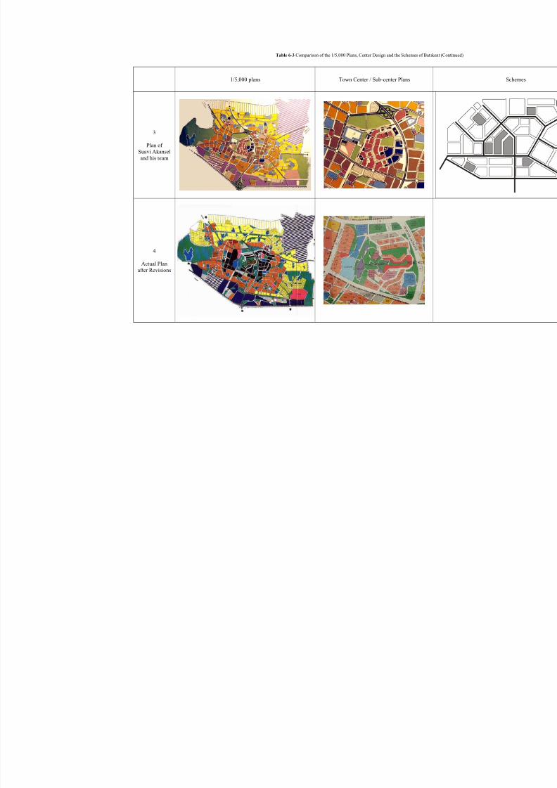
8/8/2019 Assessment of Sub-center Development
http://slidepdf.com/reader/full/assessment-of-sub-center-development 120/154
Table 6-3 Comparison of the 1/5,000 Plans, Center Design and the Schemes of Batıkent (Continued)
1/5,000 plans Town Center / Sub-center Plans
3
Plan of Suavi Akanseland his team
4
Actual Planafter Revisions
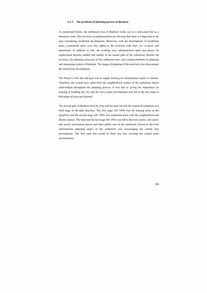
8/8/2019 Assessment of Sub-center Development
http://slidepdf.com/reader/full/assessment-of-sub-center-development 121/154
106
6.1.3. The problems of planning process in Batıkent
As mentioned before, the settlement area of Batıkent works not as a sub-center but as a
dormitory town. The revisions in implementation are showing that there is a huge rent in thearea considering residential development. Moreover, with the development of residential
areas, commercial areas were also added to the revisions with high rise residents and
apartments. In addition to this, the working area, administrative units and places for
employment became smaller and smaller in the master plan of the settlement. Besides the
revisions, the planning processes of the settlement have also created problems in planning
and structuring system of Batıkent. The stages of planning of the area have also discouraged
the central area development.
The Project’s first aim and goal was to supply housing for metropolitan region of Ankara.
Therefore, the central uses, apart from the neighborhood centers of the settlement stayed
undeveloped throughout the planning process. It was due to giving the importance on
housing in building the city and the town center development was left to the last stage in
both plans of Ateş and Akansel.
The second plan of Batıkent done by Ateş and his team has left the central development as a
third stage of the plan structure. The first stage (till 1984) was for housing areas in the
periphery and the second stage (till 1988) was residential areas with the neighborhood and
district centers. The third and the last stage (till 1992) was left to the town center, sub-center,
and social, recreational spaces and other public uses of the settlement. However, the road
infrastructure planning stages of the settlement was encouraging the central area
development. The first road that would be built was also covering the central areas
environments.

8/8/2019 Assessment of Sub-center Development
http://slidepdf.com/reader/full/assessment-of-sub-center-development 122/154
107
Figure 6-13 Staging of Turgay Ateş and his team’s Plan of Batıkent
(Keskinok, 2006)
Suavi Akansel and his team who have done the third plan having four stages have also left
the central development to the last stage. The fist stage of development of the plan as in
Ateş’s plan was left for housing development in the periphery, the same areas as in the plan
before. The staging processes of the plan were so static and composed of the district by
district. This strict idea of staging made the central area development including the district
centers and town center and dense residential areas develop as a last action of the settlement
growth.
Figure 6-14 Staging of Suavi Akansel Plan of Batıkent (Ankara Belediyesi, 1979)
8/8/2019 Assessment of Sub-center Development
http://slidepdf.com/reader/full/assessment-of-sub-center-development 123/154
108
In the world case of this study, Cergy-Pontoise started to be implemented with the
administrative and trade center in the vicinity of a large central park. The central area
included symbolic and functional values at the same time, that is to say, the prefecture
building, High school, swimming pool and ice-skating rink as a symbolic value of the center,
and an overpass separating pedestrian and car traffic encouraging trade. Moreover, the
central area was encouraged and supported by a highway and regional railway line (Jaouen,
2004). Considering the planning process comparing of Cergy-Pontoise and Batıkent shows
us that the central areas of both cities have been thought to be developed in different stages
of planning. They are very different from each other; besides, the central area design
principles and ingredients of the plan are also unlike. That is to say, in the central area of
Cergy-Pontoise was started to develop by the construction of the prefecture building (local
administration building), that means an attraction point was created and therefore some other
uses like headquarters of some companies were attracted by the government and they started
to locate in the new town. With this development, the commercial and other central, public
uses, like theatre, railway station, university and some other socio-cultural buildings were
constructed and people resided in the town were able to use them. People were also
encouraged to reside in the town within these public services constructed in the center. The
central area development was not left to the last stage of the plan, but constructed in the
beginning of the construction period by the public sector and attracted other uses.
6.1.3.1. Implementation plan revisions done in Batıkent
The plans made for Batıkent were not developed to create or form the town center but on the
contrary the plans have been revised on behalf of the rent and therefore the central area
including the working places that are employment areas, were turned into residential or
commercial areas. Revisions of the plans were discouraged with the development of
administrative units and moreover the public and private companies as employment
opportunities. As housing areas started to be more and more dominant in the site, the places
for the other uses started to disappear. That is to say, the central area of Bat ıkent started to
evaporate; hence, it started to lose its identity.
There are 26 defined areas in the town center of Batıkent considering the actual plan of the
settlement. These areas are grouped into different colors in Table 6-4 considering the urban
uses. These areas include the public uses and some other considered as urban activity that

8/8/2019 Assessment of Sub-center Development
http://slidepdf.com/reader/full/assessment-of-sub-center-development 124/154
109
should be located in the central area. The table shows the revisions and therefore the
decrease of public uses in the area and the increase of the residential areas that are not
carefully designed for the sub-center.
Figure 6-15 25 District Defined of the Sub-center for Revision Assessments(Developed from all plan revisions done so far)

8/8/2019 Assessment of Sub-center Development
http://slidepdf.com/reader/full/assessment-of-sub-center-development 125/154
Table 6-4 The Plan Revisions of Batıkent and the Uses of the sub-central zone
Districtno
Final Approved Plan -Suavi Akansel's plan- revision 1Land-use decisions after P
Revisions
1 Sport Health Business school housing housing
2 park high school Health undefined (still health)
3 health education primary school high sch
4 sport education vocational school
5 municipality service administrative administrative
6 municipality service administrative sport
7 housing+commercial housing housing
8 housing+commercial carpark park municipality service
9 housing+commercial cultural recreation housing housing
10 park housing park cultural facility park
11 cultural recreation Tourism School tourism hotel cultural facility area
12 housing+commercial cultural center housing youth center
13 housing+commercial cultural recreation cultural facility area cultural center
14 housing+commercial park cultural recreation sport recreation commercial sport recreat
15 park park sport municipality service
16 housing+commercial islam culture center islam culture center
17 housing+commercial park park
18 housing+commercial park administrative
19 car park Metro station housing housing
20 park sport commercial
21 park road administrative carpark carpark administr
22 municipality service municipality service housing+commercial
23 car park municipality service road park municipality service24 road ceremony area ceremony area
25 district center district center housing+commercial
26 park commercial (terminal) sport park park

8/8/2019 Assessment of Sub-center Development
http://slidepdf.com/reader/full/assessment-of-sub-center-development 126/154
111
Those plan revision table has been developed by the author from the revision maps in the
municipality of Yenimahalle. The problem here is that the revisions have all been made for
search for urban rents on the area. All the production and business or administrative
activities were taken out of the sub-central area. In addition to this, the only developed
structures are those commercial and residential ones and a small park. However no-use
allowing employment could be developed or structured.
Moreover, these revisions decreased the public uses and structures and turned into whether
residential or commercial areas. In addition to this, some other public urban uses like health
or commercial and housing areas turned into only housing, green area or undefined uses.
Besides, the employment areas like administrative or municipality service areas which are
attracting capital owners or private companies were altered as sport areas or green areas or
they were decreased in the central area. The land for only commercial activity is lowered and
the land for only housing activity is increased. That is to say, these actions are all
discouraging the sub-central area development. They are encouraging the opposite, on behalf
of accommodation or recreational use which are not so compatible for the town center
development.
In addition to these, the actual use of the land is still lacking the central activities.
Considering the theories and new town development ideas searched in the previous parts of
the study, the land planned as town center could not be developed as it should have been.
The center should have had more public uses and employment areas to attract people,
nevertheless Batıkent sub-center area could not succeeded it considering the actual use and
development process. The housing and commercial areas were not designed pedestrian
friendly, but designed car-oriented. Additionally, housing areas were designed as they are in
a small neighborhood with large green areas that are surrounded with walls to emphasize that
these areas are belonging to the private uses.

8/8/2019 Assessment of Sub-center Development
http://slidepdf.com/reader/full/assessment-of-sub-center-development 127/154
Figure 6-16 North View of the Central Area of Batıkent
Figure 6-17 East View of the Central Area of Batıkent

8/8/2019 Assessment of Sub-center Development
http://slidepdf.com/reader/full/assessment-of-sub-center-development 128/154
113
6.1.3.2. The effects of revisions on center development and housing
Figure 6-18 An Actual Implementation Plan of the central area, Batıkent(Progressed from all plan revisions done so far)
After all plan revisions, the central area of Batıkent settlement became as a mass considering
residents and housing life. The central activities so far have never been developed or
encouraged. But on the contrary, the revisions have shown that the rent in commercial and
housing or only in housing areas made the decisions change on behalf of the dormitory town.
The central area has lost its identity and gained more housing character. The proportion of
administrative, municipality uses and business sector that is employment zones, in the area
have decreased to a certain level that will not be helpful for the central use and revised to
either commercial or housing.

8/8/2019 Assessment of Sub-center Development
http://slidepdf.com/reader/full/assessment-of-sub-center-development 129/154
114
The whole area, apart from the metro station and some cultural facility areas that are not
built yet although the project’s time has been concluded does not support the sub-central use
of the settlement. Huge green spaces, housing dominance, lack of only commercial, only
administrative or similar complexes, and unfinished metro project are creating the problems
of sub-center evolution. Besides, the area is not accessible from the environment. The
absence of main pedestrian road to the center, the lack of pedestrian only zones in the area
and car dominant design and planning system made the area unusable for human living in
district.
Figure 6-19 The development of Residential & Commercial districts in Cergy Pontoise(The area is a district center of Cergy-Pontoise and the environment of the station, the center, is still in
construction)(Charre, 2003)
The idea of pattern also creates non-humane city center. Including the station, all activity
areas and also residents do not have a pattern of the center. The station is not easily
reachable. It is elevated and located in such a place that it is hardly accessible in terms of
central uses. The area is like separated to two regions by sport and recreation area. Absence
of the heart , the spine and the veins made the central area lacking all humane activities and
highly usable character.
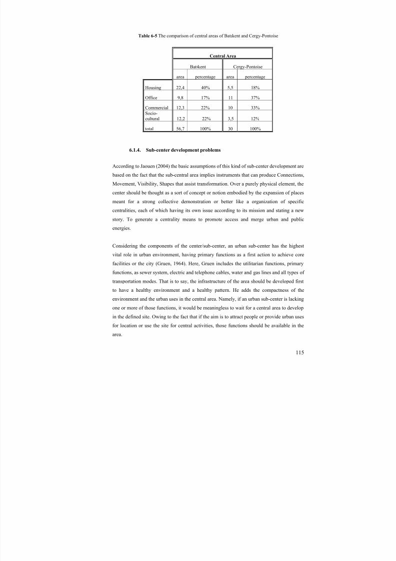
8/8/2019 Assessment of Sub-center Development
http://slidepdf.com/reader/full/assessment-of-sub-center-development 130/154
115
Table 6-5 The comparison of central areas of Batıkent and Cergy-Pontoise
Central Area
Batıkent Cergy-Pontoise
area percentage area percentage
Housing 22,4 40% 5,5 18%
Office 9,8 17% 11 37%
Commercial 12,3 22% 10 33%Socio-cultural 12,2 22% 3,5 12%
total 56,7 100% 30 100%
6.1.4. Sub-center development problems
According to Jaouen (2004) the basic assumptions of this kind of sub-center development are
based on the fact that the sub-central area implies instruments that can produce Connections,
Movement, Visibility, Shapes that assist transformation. Over a purely physical element, the
center should be thought as a sort of concept or notion embodied by the expansion of places
meant for a strong collective demonstration or better like a organization of specific
centralities, each of which having its own issue according to its mission and stating a new
story. To generate a centrality means to promote access and merge urban and public
energies.
Considering the components of the center/sub-center, an urban sub-center has the highest
vital role in urban environment, having primary functions as a first action to achieve core
facilities or the city (Gruen, 1964). Here, Gruen includes the utilitarian functions, primary
functions, as sewer system, electric and telephone cables, water and gas lines and all types of
transportation modes. That is to say, the infrastructure of the area should be developed first
to have a healthy environment and a healthy pattern. He adds the compactness of the
environment and the urban uses in the central area. Namely, if an urban sub-center is lacking
one or more of those functions, it would be meaningless to wait for a central area to develop
in the defined site. Owing to the fact that if the aim is to attract people or provide urban uses
for location or use the site for central activities, those functions should be available in the
area.
8/8/2019 Assessment of Sub-center Development
http://slidepdf.com/reader/full/assessment-of-sub-center-development 131/154
116
One should be attracted to use the central area as mentioned before To do this intensive
urban core uses should also be located in the area. This will make people to come and locate
their functions there. Those functions according to Gruen (1964) are intensive core functions
such as;
- Working
- Dwelling
- Shopping
- Sightseeing
- Participating in
* Civic
* Social
* Cultural
* Recreational
* Spiritual events
Gruen also enlightens that the area should have the highest position in terms of accessibility
and it should have the characteristics of the core terminal facilities and mass transportation
facilities. This means that if a space/place has problems in easiness of access, the area will
not be able to have the opportunity of developing and improving itself as a central quality.
Besides the infrastructure of transportation, the policies and superstructure of accessibility
should be developed and built in the area so that people will go and visit the area and
therefore will demand more consideration for the sub-central activities.
6.1.4.1. About land properties
One of the big urban housing projects in Ankara has started to develop in Çayyolu-Ümitköy
site. Here different from Batıkent project the land owners are not the public or governmental
but private. Therefore it is easier to create a space using for retail activity or building a
structure for commerce considering the public land developments mostly due to the land
speculation.
8/8/2019 Assessment of Sub-center Development
http://slidepdf.com/reader/full/assessment-of-sub-center-development 132/154
117
Since the construction stuff is needed in Çayyolu development region and the construction
belongs to the private entrepreneurs, Çayyolu village has started to be transformed into a
place for selling construction materials. And Property seller offices have started to locate in
the area. That has also attracted and encouraged some other retailing activities in the area
with smaller fixing service activities (Eryıldız, 2003). That is to say, the smaller prototype of
the town center has been triggered and formed. This development is also encouraged by the
linear development through the main road servicing the to project site.
Çayyolu project has been designed part by part (encouraging urban sprawl in itself)
supporting new developments. Consequently, land speculation is heartened by public in
close environment. Eryıldız (2003) also states that due to the fact that the plan were not
developed by public, new settlements started to appear addicted to the city center but far
from it. Owing to the fact that there could not been developed a pedestrian and axis relations
between the center in the plan, district centers, services and green spaces, the space has been
perceived differently from the main purpose of the area by the inhabitants.
“…Freer planning of individual units affected the overall site planning. By 1982small plots were abandoned in favour of planning at a larger scale, with plots of 30,000 to 50,000 square metres, permitting formulation of special projects for each cooperative. In order to increase its design capacity for such large projects,Kent-Koop formed its own planning and architecture agency …” (Pamir, 1988)
Kent Koop was given 28 million dollars in 1980 from the European Re-Settlement Fund but
had some problems in the time of spending it. There were restrictions on time limit. This
funding and the restrictions made some risks on the project. The rapid construction process
has started onwards. This has resulted in the loss of connection among the theory of planning
and design practices. Pamir also states that the financed construction on that big scale project
resulted authorities in to abandon the policy of “alternative to gecekondu housing” and the
following “two-storey, lower middle- and middle-class housing" replica (1988).
Land developers in various ranges need various kinds of scales of the land in the
development area. If a land can not be developed by public investment, the area should be
attracted and encouraged both for public institutions and private companies. Because, as
Segoe stated (cited in Gallion and Eisner, 1963), sub-dividing the land is a matter of profit
to the land developers. On the other hand, the sub-division of the land is a matter of serious
public concern for the community. Besides, the activities created by the private and public
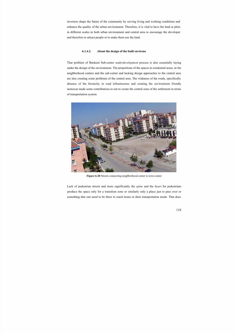
8/8/2019 Assessment of Sub-center Development
http://slidepdf.com/reader/full/assessment-of-sub-center-development 133/154
118
investors shape the future of the community by serving living and working conditions and
enhance the quality of the urban environment. Therefore, it is vital to have the land or plots
in different scales in both urban environment and central area to encourage the developer
and therefore to attract people or to make them use the land.
6.1.4.2. About the design of the built environs
That problem of Batıkent Sub-center underdevelopment process is also essentially laying
under the design of the environment. The proportions of the spaces in residential areas, in the
neighborhood centers and the sub-center and lacking design approaches to the central area
are also creating some problems of the central area. The wideness of the roads, specifically
absence of the hierarchy in road infrastructure and creating the environment friendly
motorcar made some contributions to not to create the central zone of the settlement in terms
of transportation system.
Figure 6-20 Streets connecting neighborhood center to town center
Lack of pedestrian streets and more significantly the spine and the heart for pedestrians
produce the space only for a transition zone or similarly only a place just to pass over or
something that one need to be there to reach home or their transportation mode. That does
8/8/2019 Assessment of Sub-center Development
http://slidepdf.com/reader/full/assessment-of-sub-center-development 134/154
119
not make much sense for the environment to people in terms of an activity area. Therefore,
people tended to use the settlement area for only their dormitory requirement.
“….Early proposals for designing the fifty percent of the project that was not to
be self-built, ranged from attempts at an integrated homogenous vernacular architecture throughout to a heavily detailed extravaganza of high-tech préfabrication. Both of these alternatives were rejected, as was the original 'sitesand services' project, when actual commissions for parts of the site began in1980…While the technology reduced the apparent risk of having to adopt newconstruction skills for each new type of architectural expression, design policyresulted in a pervasive architectural monotony and lack of identity…” (Pamir,1988)
Moreover, the infrastructures for the huge complexes were not available for the time of 1984
and till today. The negative effect of this is still valid for the settlement area. The plan of
Batıkent has not matched with urban design master plan in which cooperatives could findcriteria to built environment and they could find factors to be suitable for the whole plan for
integration. However, it is lacking in a vital sense that almost every housing groups or each
cooperative blocks are completely different from each other. The wholeness of the plan has
not been provided. The obligation to be fast in construction of the site has also resulted in
that congestion in architecture. “Hence, a visual and physical chaos obstructs creation of a
sense of identity with the new environment” (Pamir, 1988).
Pamir also states that the area was planned according to functionalist approach. But the project was disregarded as urban space like meeting places of the people, passageways, or
alike connecting and linking urban features that form the finely-textured shape of urban
environment.
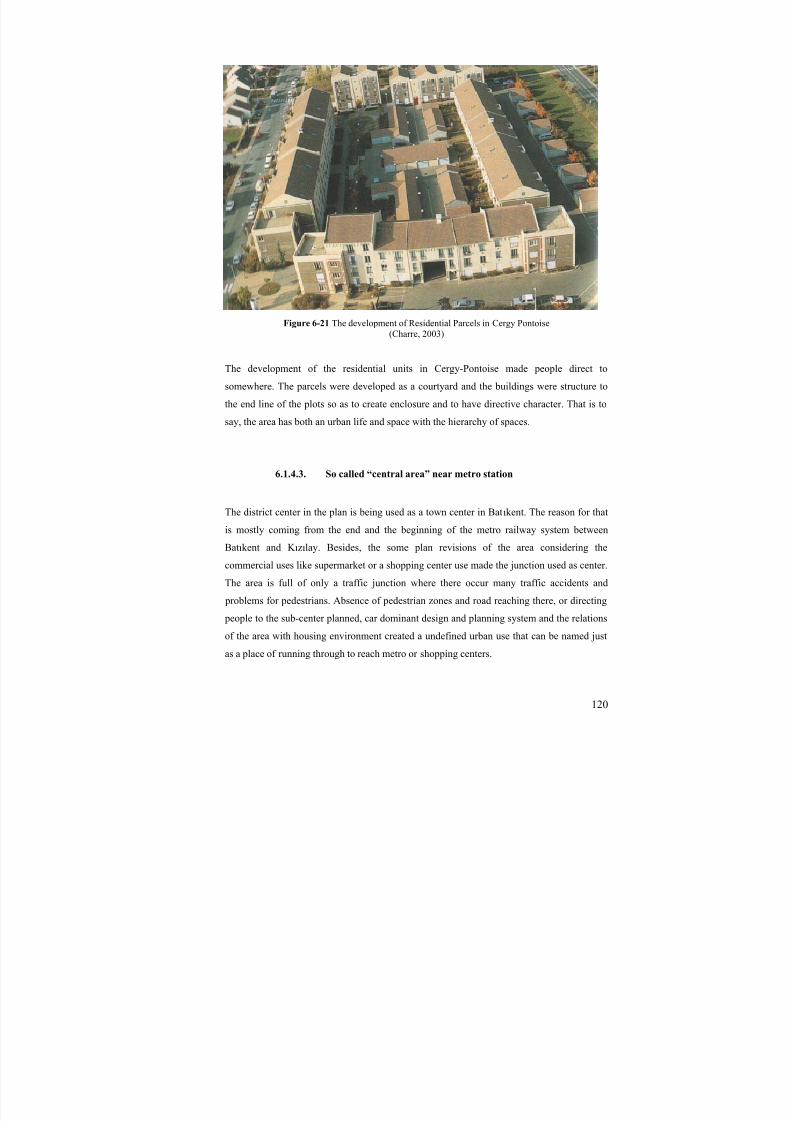
8/8/2019 Assessment of Sub-center Development
http://slidepdf.com/reader/full/assessment-of-sub-center-development 135/154
120
Figure 6-21 The development of Residential Parcels in Cergy Pontoise(Charre, 2003)
The development of the residential units in Cergy-Pontoise made people direct to
somewhere. The parcels were developed as a courtyard and the buildings were structure to
the end line of the plots so as to create enclosure and to have directive character. That is to
say, the area has both an urban life and space with the hierarchy of spaces.
6.1.4.3. So called “central area” near metro station
The district center in the plan is being used as a town center in Batıkent. The reason for that
is mostly coming from the end and the beginning of the metro railway system between
Batıkent and K ızılay. Besides, the some plan revisions of the area considering the
commercial uses like supermarket or a shopping center use made the junction used as center.
The area is full of only a traffic junction where there occur many traffic accidents and
problems for pedestrians. Absence of pedestrian zones and road reaching there, or directing
people to the sub-center planned, car dominant design and planning system and the relations
of the area with housing environment created a undefined urban use that can be named just
as a place of running through to reach metro or shopping centers.
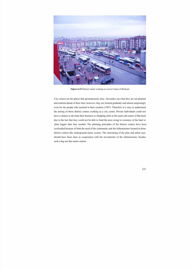
8/8/2019 Assessment of Sub-center Development
http://slidepdf.com/reader/full/assessment-of-sub-center-development 136/154
121
Figure 6-22 District center working as a town Center of Batıkent
City centers are the places that spontaneously arise. Alexander says that they are not plannedand realized ahead of their time; however, they are formed gradually and almost surprisingly
even for the people who assisted in their creation (1987). Therefore it is easy to understand
the arising of those district centers working as a city center. Private individuals could not
have a chance to develop their business or shopping units in the main sub-center of Bat ıkent
due to the fact that they could not be able to fund the area owing to existence of the land or
plots bigger than they needed. The planning principles of the district centers have been
overloaded because of both the need of the community and the infrastructure located in those
district centers like underground metro system. The structuring of the plan and urban usesshould have been done in cooperation with the investments of the infrastructure, besides
such a big one like metro station.
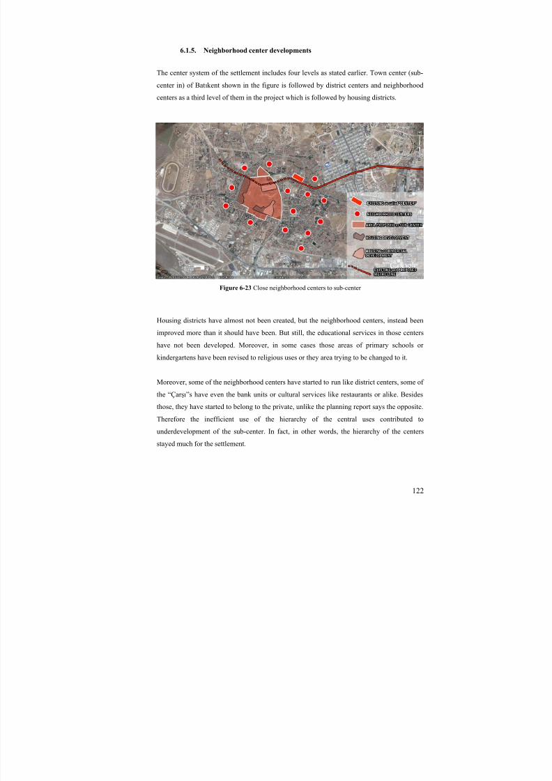
8/8/2019 Assessment of Sub-center Development
http://slidepdf.com/reader/full/assessment-of-sub-center-development 137/154
122
6.1.5. Neighborhood center developments
The center system of the settlement includes four levels as stated earlier. Town center (sub-
center in) of Batıkent shown in the figure is followed by district centers and neighborhood
centers as a third level of them in the project which is followed by housing districts.
Figure 6-23 Close neighborhood centers to sub-center
Housing districts have almost not been created, but the neighborhood centers, instead been
improved more than it should have been. But still, the educational services in those centers
have not been developed. Moreover, in some cases those areas of primary schools or
kindergartens have been revised to religious uses or they area trying to be changed to it.
Moreover, some of the neighborhood centers have started to run like district centers, some of
the “Çar şı”s have even the bank units or cultural services like restaurants or alike. Besides
those, they have started to belong to the private, unlike the planning report says the opposite.
Therefore the inefficient use of the hierarchy of the central uses contributed to
underdevelopment of the sub-center. In fact, in other words, the hierarchy of the centers
stayed much for the settlement.

8/8/2019 Assessment of Sub-center Development
http://slidepdf.com/reader/full/assessment-of-sub-center-development 138/154
123
6.1.6. Shopping Centers in the Metropolitan Region and in the Environment
Shopping malls have a large territory due to the services they provide like service buses to a
range of neighborhoods and settlements, and they provide large car parks. Moreover, they
have transportation opportunities by being close to the motorways with large range of
activities in terms of commerce and shops in the same building. After the mid 1990s, there
has been an increase in the construction of shopping malls in Ankara and now there
are 23 shopping centers and moreover 6 shopping centers are in construction in the
metropolitan region. Although the studies on shopping centers state the opposite,
there is still growing number of these centers in Ankara. Especially after 2000, there
has been a rapid increase in the construction of the shopping malls. And those centers
encouraged private car ownership due to the locations of them, which are placed nextto the highway or where public transportation services are inadequate.
Table 6-6 Characteristics of Shopping Centers in Ankara
Number of shops Opening year Area rentable1 Ankamall-Akköprü 302 2006 1064802 Armada-Söğütözü 161 2002 320003 Panora-Oran 180 2007 800004 Arcadium-Çayyolu 83 2003 150005 Galeria-Ümitköy 103 1995 77716 Antares-Etlik 206 2007 1120007 Ankuva-Bilkent 22 1998 473508 Carrefour-Batıkent 57 2001 157699 Optimum-Eryaman 65 2006 1631410 Kar şıyaka-Demetevler 60 1990s 1600011 Mesa Plaza-Çayyolu 56 1999 1400012 Karum-Çankaya 486 1991 2350013 Atakule-Çankaya 90 1989 1054314 Cepa-Balgat 188 2007 7200015 Planet-Elvankent 40 2005 1200016 FTZ-Keçiören 42 2003 700017 Plaza Avm-Pursaklar 25 2005 650018 Toki Avm- Eryaman 40 2005 1000019 Acity-İstanbul Road 140 2008 2200020 Gordion-Çayyolu 182 2009 5250021 Forum Ankara-Etlik 145 2008 8000022 Minasera-Çayyolu 42 2007 1100023 365-Çankaya 100 2008 40000
In construction24 Mall next to Armada25 Atlantis-Batıkent26 Kentpark-next to Cepa27 Anse-Çayyolu28 Etipark-Etimesgut29 Arena Avm-Konutkent
Total 2815 809,727

8/8/2019 Assessment of Sub-center Development
http://slidepdf.com/reader/full/assessment-of-sub-center-development 139/154
Figure 6-24 The Locations of the Existing and Planned / in construction Shopping Centers

8/8/2019 Assessment of Sub-center Development
http://slidepdf.com/reader/full/assessment-of-sub-center-development 140/154
125
In Batıkent settlement, on the other hand, there are 2 shopping malls; one of them is in
construction in the sub-central zone of it. The other is close to the Istanbul road, to the
periphery of the settlement. In addition to these, in the close environment, there are more
shopping centers attracting citizens living in Batıkent. Optimum, Acity and .Kar şıyaka
shopping centers have an effect on the settlement.
Shopping centers attract the developers and help their environment develop faster, and hence
create big rent in the area where they are placed. Although they look like that they are
sharing the congestion problems of town centers, they, on the contrary, result in the
diminishing of the centers. Considering all these, shopping center development should also
be worked with the development of the town center. In addition to supporting the growth and
development of town center, they create an attraction point for citizens to visit the zone both
for shopping and spending the free time. That is why, deciding the locations of shopping
centers are very vital and their place should be chosen considering the future demand and
growth as well in the area they are set.
8/8/2019 Assessment of Sub-center Development
http://slidepdf.com/reader/full/assessment-of-sub-center-development 141/154
126
CHAPTER 7
7. CONCLUSION
The sub-center developments in new urban settlements arise from different types of
problems with the rapid growth of the technology and therefore the cities. This study
examined the development process and growht of the sub-center formation. There appeared
many circumstances about the urban metropolitan region and close environment of the sub-center development, especially in the new, and planned urban settlements.
After the relevance of the sub-center development through the theory and the examples,
there occurred a need to evaluate the ingredients and therefore the definition of the sub-
center and its development. This study examined these issues, as well and developed a
number of hypotheses and principles of the sub-central development by identifying the
indicators of them in many aspects.
These aspects, from the theory and the case of Batıkent, are as in the following;
Urban Land Use
Transportation
Planning Stages / Process
Property Relations / Patterns
Environmental and Metropolitan Area Relations
Design of the Built Environment
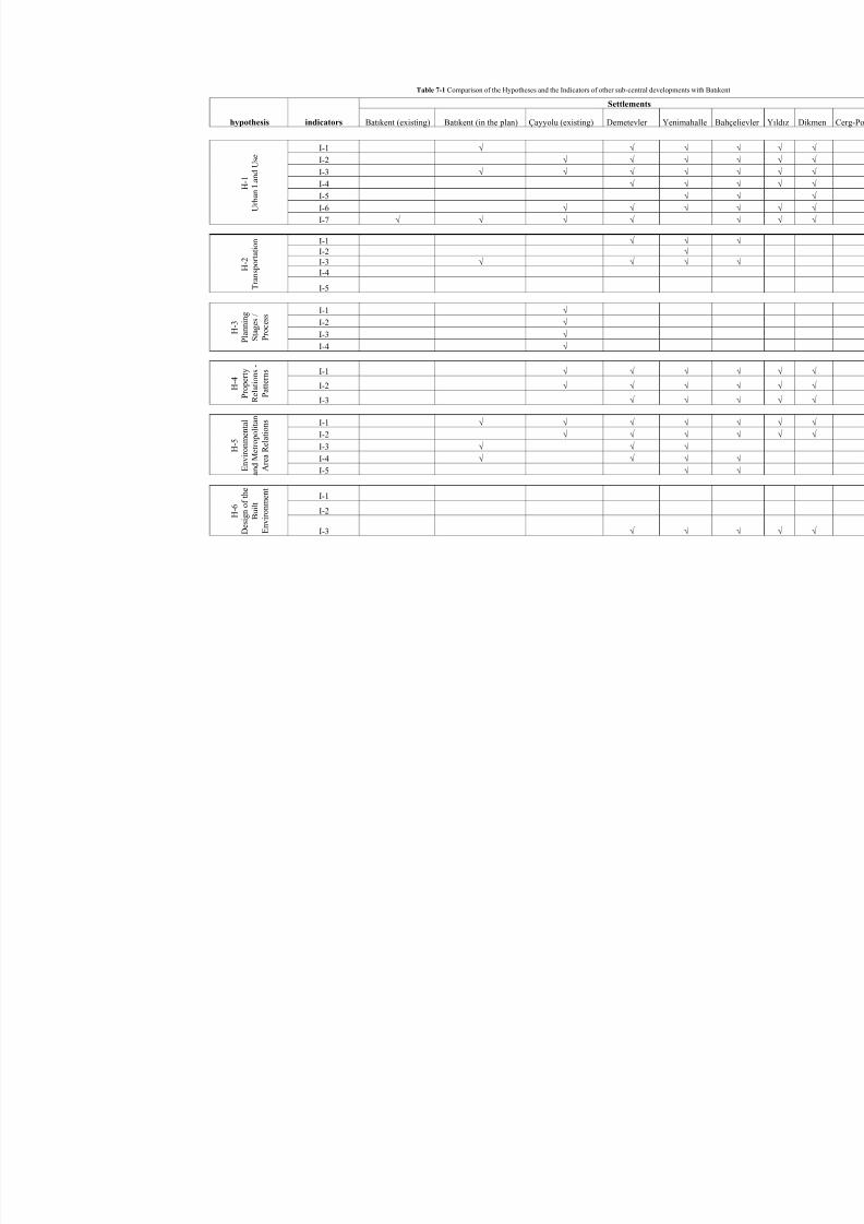
8/8/2019 Assessment of Sub-center Development
http://slidepdf.com/reader/full/assessment-of-sub-center-development 142/154
Table 7-1 Comparison of the Hypotheses and the Indicators of other sub-central developments with Batıkent
Settlements
hypothesis indicators Batıkent (existing) Batıkent (in the plan) Çayyolu (existing) Demetevler Yenimahalle Bahçe
I-1 √ √ √ I-2 √ √ √
I-3 √ √ √ √
I-4 √ √
I-5 √
I-6 √ √ √
H - 1
U r b a n L a n d U s e
I-7 √ √ √ √
I-1 √ √ I-2 √ I-3 √ √ √ I-4 H
- 2
T r a n s p o r t a t i o n
I-5
I-1 √
I-2 √
I-3 √ H - 3
P l a n n i n g
S t a g e s /
P r o c e s s
I-4 √
I-1 √ √ √
I-2 √ √ √ H - 4
P r o p e r t y
R e l a t i o n s -
P a t t e r n s
I-3 √ √
I-1 √ √ √ √
I-2 √ √ √
I-3 √ √ √
I-4 √ √ √ H - 5
E n v i r o n m e n t a l
a n d M e
t r o p o l i t a n
A r e a R
e l a t i o n s
I-5 √
I-1
I-2 H - 6
D e s i g n o f t h e
B u i l t
E n v i r o n m e n t
I-3 √ √

8/8/2019 Assessment of Sub-center Development
http://slidepdf.com/reader/full/assessment-of-sub-center-development 143/154
128
These aspects of the sub-center development are examined through this study and some
inferences that mentioned as the indicators and the principles are deduced through the
developed hypotheses.
Urban Land Use
The first inference is about the Urban Land Use of the sub-center. Urban Land uses in sub-
central area of a sub-urban development need to include all the public and common uses,
special unique buildings of a town, and high rise blocks of urban utilities in a compact form
enabling mobility of population in an organic way so as to form a sub-center development in
the whole settlement (H-1 in Table 7.1). According to this, there emerged some principles
about the land-use development of the area. That is to say, Sub-center area development will
consist of at least one unit or building of following uses;
- Administrative, Civic, State offices
- Business, Finance
- Social
- Cultural
- Production, Manufacture
- Recreation, Entertainment
- Commercial, Retail
- Residential
- Education
- Health
Those facilities will be located in the town center so that the area will have the most
utilization proportion in the whole settlement. And hence the central land will attract almost
all kinds of people ranging from different ages to different jobs they have.
The indications of these principles and the premise are numbered as seven items. The first
indicator (I-1); the central area will have some units of the municipality serving for the town
and territory or any smaller (than the ones in CBD) unit of the administration of the
government. The second (I-2); the private companies or small capital owners will locate their
headquarters or at least one of their units and the forth item represented as indicator (I-3) is;

8/8/2019 Assessment of Sub-center Development
http://slidepdf.com/reader/full/assessment-of-sub-center-development 144/154
129
museum, theatre, cinema, cultural and convention center, hotel, thematic park, municipality
activity/facility area, street or building exhibition and similar uses will be available in the
central area. The forth indicator (I-4); any use or facility area enabling productivity and
hence creating employment like small private companies producing stuff will be able to
place in the central area of the town for an easy access to citizens and customers. Moreover,
that Urban Park, Urban Square, main pedestrian road, thematic park, socio-cultural open
spaces, allotment gardens or buildings, areas for having fun and playing games will be in the
center of people for an easy access and for a healthy urban environment in the center. This
indicator is emerged as the fifth indicator (I-5) in the study. The sixth point (I-6) is that big
and smaller commercial complex or complexes need to have a location in the city core for a
lively environment both at night and in the morning and for a city center activity. The center
should enable a land for various kinds of commercial facilities and various types of capital
owners. And finally the last indicator (I-7) is developed as High rise residential blocks not
excluded from the streets or spaces of the city center, or mixed use urban blocks will be
needed to be placed in the city center for the people who demand the residential in the area.
Transportation
The second inference is about the Transportation of the sub-center. There has to be different
kinds of transportation networks and links to CBD both for public and private transportation,
namely for motorways and public transportation networks for the creation and development
of sub-centers. Sustainable transportation systems like pedestrian, bicycle, public
transportation and railway systems should be encouraged in the central area to attract people
and make them enter and use the city center easily (H-2 in Table 7.1). Consistent with this,
there came out some indicators and principles about the transportation-related improvement
of the area. That is to say, Sub-center area development will need to meet the following
criteria like; Railway systems will support the accessibility and development of the citycenter. Town center will be linked to the other district or neighborhood centers with other
railway or transportation systems. Road network will be designed as supporting the
pedestrian access, and other sustainable transportation network. That is to say transportation
system should enable;
- Accessibility, Easy pedestrian access
- User-friendly transportation systems
8/8/2019 Assessment of Sub-center Development
http://slidepdf.com/reader/full/assessment-of-sub-center-development 145/154
130
- Convenient access to center and from center to other sub-centers in the city and
district centers in the sub-urb.
The indicators of this transportation principle are developed as five articles. The first
indicator (I-1) is that; the center in itself will have main pedestrian road and pedestrian areas
in the spine and in the direction of the spine with lower hierarchical pedestrian roads feeding
the spine in the center, the second indication (I-2); the central area will have a pedestrian
road network itself, besides it will have the network of the town linking the city center with
district centers and neighborhood centers. Those links will also be encouraged by bicycle
roads and systems. That railway system or other sustainable urban transportation system will
be available connecting the CBD with the town center of the sub-urb comes as a third
indicator (I-3), and the forth one (I-4) is the Pedestrian and bicycle roads will be integrated
with the public transportation networks and those areas will be separated from motorways
and car parks. The final item (I-5) listed as transportation principle is that; besides the district
centers and neighborhood centers’ integration to the town center, they will also be integrated
among each other by different types of network systems.
Planning Stages / Process
The third inference is about the Planning Stages or Process of the sub-center. Planning stages
of new development urban areas and sub-urbs with their centers have to be enhanced in
cooperation with the residential area development and central area growth so as to create a
center and therefore activities for citizens and lower the rent in the area and achieving the
solution earlier, forbidding the future problems and the rent matters (H-3 in Table 7.1).
Compatible with this, there appeared four indicators and principles about the Planning
Staging of the area. That is to say, Sub-center quarter progress should meet the following;
while the residential environment is being developed, the central area of the town will also be designed and constructed at the same time. Doing this will prevent over-development of
the district and neighborhood centers in new development zones. As mentioned before, one
of the problems in the non-existence of Batıkent Sub-center arises from the staging of the
planning schemes. The central area structuring in the plans was left to the last stages.
However the question whether it should have been earlier or synchronous with other
developments should have been asked.
8/8/2019 Assessment of Sub-center Development
http://slidepdf.com/reader/full/assessment-of-sub-center-development 146/154
131
The process of growth and development includes the creation of larger structures and
recognizable entities in the central areas. Alexander (1987) states this process is being
realized slowly and the construction of those central structures cannot be totally done by
only one act. Those first structures in his idea are public structures like the main square, the
mall, small grid streets, the great garden, the hotel, the park-pier complex Each of the
structures according to him comes gradually.
One of the four indicators (I-1) of the staging problems is that; the structuring processes of
the housing environment will start hand in hand with the central area development. In
addition to this, the second indicator (I-2) is that the City center organization and
development will be serving when citizens start to reside their units so that they can use the
central area and help the center develop. The third item (I-3) about staging in planning of the
settlements is emerged as the development stage of the central area and it will not be the last
stage of the planning for new development areas, but will start almost in the same time with
other urban uses in the town. That is done, in general, by creating an attraction point or
structure serving a public use in an urban environment. The last indicator (I-4), on the other
hand, is that; almost all types of urban uses in sub-center mentioned before will be working
when the city starts to live, that is to say, when people start to accommodate in the town.
Alexander, in his study of central growth (1987), states that there is a definite natural
background for a central area development. He says that the three stages of the process are
needed for the central area structuring and growth to form the whole, phase one includes the
increment creating a hint of a new central area. And later some other increments pinpoint the
main body of the structure and finally other various additions complete the center.
Considering his process of the central area development, it is easy to adopt it to Bat ıkent.
There should be built a place to show and highlight the entrance of the center as a gate with
an urban use like shopping district or a center. In the second stage, with another public
structure like administrative building, a bank or a hotel will define the structure of the center with identifying the gate and the end point. Thirdly as the last process of the central area
development, there should be some elements like offices, or houses to form the feeling of
whole center, namely to fill the central structure by defining the boundary of the area.
Through this, the area had an activity node to define the space as a central zone. This will
also help to complete the mission of the center as a whole. Moreover, those elements or

8/8/2019 Assessment of Sub-center Development
http://slidepdf.com/reader/full/assessment-of-sub-center-development 147/154
132
increments will help as a hint of the one of the sub-center element like Pedestrian Street, or a
square.
Property Relations / Patterns
The fourth inference is about the Property Relations or Patterns of the sub-center. Property
pattern of the sub-centers need to allow various kinds of capital owners in order to attract
and construct the central uses and therefore develop the city centers. That is to say, different
scales of the land need to be formed for different urban uses and for different scales of
capital owners (H-4 in Table 7.1). According to this, there appeared three indicators and
principles about the Property pattern of the area. That is to say, one type of land permitting
or allocating only big companies or capital owners will not be available in central area,
however various kinds of property scales like big lands used by public sector or big capital
owners, or smaller land patterns attracting smaller capital holder will be available in the
central area of the sub-urb.
The indicators of this hypothesis are listed as three items. The first indicator (I-1) is that,
Existence of various scales of urban land in central areas attracts small companies/firms and
also big capital holders. The second indicator (I-2), on the other hand, is that lands in
different sizes in different locations of the central zone are available both for public and
private sectors which occupies the land as they need and the citizens demanded. The final
indicator (I-3) listed for property relations is cheaper land is available in the central area for
public uses, which does not create much rent or that does not capture much income like
commercial or production areas in the city center.
As Günay states, smaller parts constitute the city and therefore the central area. Fountain,
mosque, coffee shop and similar public spaces built the society and hence the city. Functions
of the central area should not be separated; on the contrary they have an organic relationship
among each other (Günay, 2007). This should be formed by the creation of compact centers
with smaller urban plots allowing different uses, integrating functions in a limited space, as
shopping mall designers did in a sub-central area after the 1970s.
8/8/2019 Assessment of Sub-center Development
http://slidepdf.com/reader/full/assessment-of-sub-center-development 148/154
133
Environmental and Metropolitan Area Relations
The fifth hypothesis developed through the study is about the Environmental and the
Metropolitan Area Relations. That is; Sub-center has to have one or more units of
government or administration of the town. Besides it has to include headquarters of a
companies or at least a unit of the firms as an employment area to have a relation with CBD
and other sub-centers in metropolitan region needed for the creation of sub-center (H-5 in
Table 7.1). The principles of this inference is that the sub-center development and plans will
allow and attract the allocation of the companies and some other civic uses by serving the
different scales of land in the center, by creating an attraction point like a big recreation area
or a big administration unit, such as a municipality or a unit of it or any governmental
building. Besides having these, the transportation and telecommunication infrastructure
network inside the town and between the town and the CBD or other towns will need to be
highly qualified.
There are five indicators numbered for the environmental and metropolitan area relations.
The first of those indicators (I-1) suggests the availability of any governmental or
municipality unit. The second indicator (I-2) states on the other hand, the existence of
different scales of land to allow the capital owners so that a range of different capital owners
can locate there to have relations with the CBD and environment. And the third (I-3) of these
indicators is that good transportation network inside the town allowing citizens to come to
the center easily and therefore to other towns and the CBD is available. The forth indicator
(I-4) includes the railway station connecting the town center to the CBD and other towns in
the metropolitan area. The last indicator of the relations is that a good designed pedestrian
network in the town directing people to the center should be available.
Design of the Built Environment
The final inference is about the Design of the Built Environment. That is to say, the
environment of sub-center needed to be designed very carefully in order to provide direction
to the center and to the other district centers and it has to be developed in order not to create
an area where pedestrian cannot access to impose the attributes of sub-center formation (H-5
in Table 7.1). The principle of the hypothesis is that Pedestrian streets and motorcar roads
will be separated from each other both in the center and in the environment directing them to

8/8/2019 Assessment of Sub-center Development
http://slidepdf.com/reader/full/assessment-of-sub-center-development 149/154
134
the center and district centers. Main pedestrian ways will be created to connect the district
centers with the town and neighborhood centers. Streets should be shaped with the
structures, the buildings, rather than the walls or gardens, in the main pedestrian roads and in
the central area.
Three indicators developed for the design of the built environment for the problems and
confusions of sub-center. The first indicator (I-1) includes a Good designed pedestrian
circulation in the sub-center, separating car and pedestrians while the second indicator (I-2)
is developed as creating a pedestrian friendly sub-center with sustainable transportation
systems, railway, tram, bicycle roads, good and easy to walk pedestrian roads and squares.
Finally the last indicator of design of the built environment (I-3) is stated as Streets
specifically for pedestrians, shaped and formed with the buildings.
There are many problems why Batıkent sub-urb, a new settlement area, has a big hole in the
middle of the town, called sub-center. Besides the problems of the planning and its sub-
principles, it is not hard to say that the problems of the building structures of the central area
are also wrong and are able to be criticized. In addition to those problems mentioned, the
structure of the central area in itself creating problems too.
In addition to those planning principles, considering the successful examples of European
studies mentioned in Paris, many principles both in the planning of the central area of the
town and built environment in the territory (Les Ateliers, 1995) were also developed. It is
mentioned that a fine grain of streets and blocks of 100m to 100m create a narrower,
pedestrian friendly urban spaces. Creating parking spaces underground will make the urban
space in the central area only for pedestrians. That is to say, the idea of streets for pedestrian
is emerged. Buildings on ground are built having clear front doors to address the street,
supporting an active and pleasant street without creating a wall like in case of Batıkent in
cooperative housing settlements. The idea is continued like single buildings per block erodethe street definition and do not make good open space and hence the building environment is
designed accordingly. That is to say, many buildings per block built cut to the side walk
achieve high density and are defined as street wall .

8/8/2019 Assessment of Sub-center Development
http://slidepdf.com/reader/full/assessment-of-sub-center-development 150/154
135
8. REFERENCES
AKÇURA, T., (1971), Ankara: Türkiye Cumhuriyeti’nin Ba şkenti Hakk ında Monografik bir
Tart ı şma, ODTÜ, Mimarlık Fakültesi Yayını, Ankara
Aksel, B. (2000), Is A Commercial Complex An Urban Center? A Case Study: Bilkent
Center , Ankara. Ms Thesis, ODTÜ, Ankara.
Alexander, C., (1965), A City is not a Tree, Architectural Forum, Whitney Publications, Inc
Alexander, C., (1987), A New Theory of Urban Design, Oxford University Press, New York
Ankara Büyük şehir Belediyesi,(2006), 2023 Ba şkent Ankara Nazım İ mar Planı , Plan
Açıklama Raporu, 1/25,000, Ankara
Ankara Belediyesi, (1979), Bat ıkent Politikalar Demeti, Ana Rapor , Ankara Belediyesi Proje
dizisi 1, Kalite Matbası, Ankara
Ankara Belediyesi Planlama Birimi, (1978), Bat ıkent Ucuz Konut Alanı Planlama Raporu,
Ankara Belediyesi, Ankara
Arkitera Forum, Genel Gayrimenkul Konular ı , Bat ık Al ı şveri ş Merkezleri,
http://forum.arkitera.com/genel-gayrimenkul-konulari/19580-alisveris-merkezleri.html,
(retrieved in 21st of July 2009)
Association Françaies des Villes Nouvelles, (1986), New Towns in France, bulletin
d’information no:11, Busagny, Osny
Burns, W. (1963), New Towns for Old , Leonard Hill publication, Great Britain
Cadwallader, M. (1996), Urban Geography an Analytical Approach, Printice Hall, New
Jersey

8/8/2019 Assessment of Sub-center Development
http://slidepdf.com/reader/full/assessment-of-sub-center-development 151/154
136
Castells, M. (1977), The Urban Question A Marxist Approach. London: Edward Arnold
Publishers Ltd.
Charre, A. (2003), Maitrîse D’æuvre Urbaine, La théorie voilée, Pierre Mardaga, Sprimont
Charre, A. (2004), CityLab, Review of Urban Design and Planning , Les ateliers
internationaux de Maitrise d’æuvre urbaine, Cergy-Pontoise
Corbusier, L., (1987), The City of To-morrow and Its Planning , Dower Publication, New
York.
Dökmeci, V., and Berköz, L., (1994), Transformation of Istanbul from a monocentric to a
polycentric city, European Planning Studies, volume 2, issue 2, pages 193 – 205
Dökmeci V., Dülgeroğlu,Y., Akkal, L.B., (1993), İ stanbul Ş ehir Merkezi Transformasyonu
ve Büro Binalar ı, Literatür Yayıncılık, İstanbul
Erpi, F., (1980), A Handbook on Urban Traffic Planning , Middle East Technical University,
Ankara
Eryıldız, S., (2003), Bat ıkent , Türkiye İş Bankası Kültür Yayınlar ı, İstanbul
Etablissement Public d’Amenagement de Cergy-Pontoise, (1999), Cergy-Pontoise, Cergy
Pontoise Cedex
Fishman, R., (1989), Urban Utopias in the Twentieth Century, the MIT Press, London
Forum d’initiatives urbaines, (2008), Taking a Fresh Look at Major Infrastructure Elements
in Urban Environment: Crossing Cergy-Pontoise, Preparatory document, Le Verger, Cergy-
Pontoise
Gallion, A. B. & Eisner, S. (1963) The Urban Pattern, City Planning and Design, Litton
educational publiching, Canada

8/8/2019 Assessment of Sub-center Development
http://slidepdf.com/reader/full/assessment-of-sub-center-development 152/154
137
GFI Partners, GFI Case Studies, http://www.gfipartners.com/images/properties/cs_wilmin-
gton2_big.jpg, (retrieved on 20th of May 2009)
Giuliano, G. & Small, K. A. (1990) Subcenters in the Los Angeles Region, Regional Science
and Urban Economics, volume 21, pages 163 – 182
Gökçe, B. (2000) Ankara Metropoliten Alan Büyükkent Bütünü Merkezler Yapı sı
De ğ erlendirmesi. Ms Thesis, Gazi Üniversitesi, Ankara.
Greene, D.L. (1980), Urban Subcentres: recent trends in urban spatial structure, Growth
and Change, 11, pp. 29-40.
Gruen, V., (1964), The Heart of Our Cities, New York, Simon and Schuster,Inc. Rockfeller
center.
Gruen, V., (1973), Centers for the Urban Environment , New York: Van Nostrand Reinhold
Company.
Güler, E. C. (1990), An Assessment of Inner City Decline In Turkey: A Case Study in Ulus-
Ankara. Ms Thesis, ODTÜ, Ankara.
Günay, B. (2006), Ankara Çekirdek Alanının Olu şumu Ve 1990 Nazım Planı Hakk ında Bir
De ğ erlendirme, printed in Cumhuriyet’in Ankarası, Metu
Günay, B. (2007), Political Background of Urban Design, UD531 Lecture notes, Urban
Design Graduate Program, Metu
Hillier, B. (1999), Centrality as a Process; Accounting for Attraction Inequalities in Deformed Grids, Space Syntax Second International Symposium, V. I., Brasilia
Howard, E., (1902), Garden Cities of Tomorrow, S. Sonnenchein and Co., Ltd., London
Jaouen, M. (2004), The Federative City, CityLab, no.1, Margata, Les ateliers internationaux
de Maitrise d’æuvre urbaine, Cergy-Pontoise
8/8/2019 Assessment of Sub-center Development
http://slidepdf.com/reader/full/assessment-of-sub-center-development 153/154
138
Johnson, J. H. (1974), Suburban Growth, new offices in the suburbs, by P.W. Daniels,
Aberdeen University press.
Keleş, R., (1998), Kentbilim Terimleri Sözlü ğ ü, İmge Kitabevi Yayınlar ı, Ankara
Kent Koop, (1980), Bat ıkent Ana Rapor Politikalar Demeti, Kent Koop yayınlar ı 13, Maya
Matbacılık, Ankara
Kent Koop, Planlama ve Arazi Kullanımı, and Bat ıkent Nazım İ mar Planı ,http://www.kent-
koop.org.tr/projedetay/planlamavearazikullanimi.htm, http://www.kent-koop.org.tr/harita/-
harita.htm, (retrieved on 15th of June 2009)
Keskinok, C. (1990), Urban Development and Architectural Proposal for a Mixed-Use Sub-
center Development for Ankara:Balgat Sö ğ ütözü Subcenter , Ms Thesis in Architecture,
Metu.
Keskinok, Ç. (2006), Ankara Kentinin Planl ı Geli şimi Açı sından Bat ıkent Projesinin Önemi/
Planlama Ve Tasar ım Sürecine İ li şkin Ele ştirel De ğ erlendirme, printed in Cumhuriyet’in
Ankarası, Metu
Kumar, A. (1990), Impact of Technological Developments on Urban Form and Travel
Behaviour , Regional Studies, V.24.2 pp 137-148
Legates, R. & Stout, F. (1998), Early Urban Planning, Selected Essays, V.1
Routledge/Thoemmes press, digital printing in 2006, New York
Les Ateliers, (1995), L’urbanisme de Dalles, Continuites et Reptures, Etablissement public
d’amenagement, Cergy-Pontoise Cedex
Manson, T. (2003), Christaller's Central Place Theory, New Central Place Theory
Explantion document, adapted from http://www.thinkgeography.org.uk/ (retrieved on 5th of
August 2009)
McDonald, John F., (1987), The Identification of Urban Employment Subcenters, Journal of
Urban Economics 21, 242-258.
8/8/2019 Assessment of Sub-center Development
http://slidepdf.com/reader/full/assessment-of-sub-center-development 154/154
Pamir, H., (1988), Bati-Kent New Town, Ankara, MIMAR 28: Architecture in Development,
No:29, p 49-54
Peiser, R.B. (1987) Determinants of Non-Residential Land Values, Journal of Urban
Economics, 22, pp. 340-360
Perry, C. A. (1929) City Planning for Neighborhood Life, Social Forces, Vol. 8, No. 1,
University of North Carolina Press, pp. 98-100
Redstone, L. G. (1973), New Dimensions in Shopping Centers and Stores, McGraw-Hill inc.
USA
Sasaki, K. (1990), The Establishment of a subcenter and urban spatial structure,
Environment and Planning A, V.22, pp 369-383
Spreiregen, P. D., (1965), Urban Design: The Architecture of Town and Cities, McGraw-Hill
Book Company, the american institute of architects, New York
Tanghe, J., Vlaeminck, S. and Berghoef, J., (1984), Living Cities, A Case for Urbanism and
Guidelines for Re-urbanization, Pergamon press, England


