Embed Size (px)
Citation preview

MAIN ENVIRONMENTAL CONSULTANT SRK Consulting
CLIENT: Liesbeek Leisure Properties Trust
Proposed redevelopment of the River Club, Observatory:
Assessment of potential biodiversity impacts - Incorporating the findings of the aquatic ecosystems (rivers and wetlands), botanical, faunal, avifaunal and groundwater
specialists
December 2019
Prepared by Liz Day (PhD; Pr Nat Sci)
Freshwater Consulting cc

Proposed redevelopment of the River Club, Observatory: Specialist Environmental Impact Assessment Report: Biodiversity – aquatic ecosystems, flora and fauna
Page i
The Freshwater Consulting Group Ver 7: Dec 2019
EXECUTIVE SUMMARY
E1 Introduction
This report summarises the findings of the specialist biodiversity assessment of the environmental impacts likely to be associated with the proposed re-development of the River Club, Observatory, by Liesbeek Leisure Properties Trust. The report has been compiled by Freshwater Consulting cc, and integrates the findings of a number of specialists, who provided input into the baseline studies and (where relevant) into the Environmental Impact Assessment component of the study as well. The full specialist reports are provided in appendices to this report, noting that the specialist aquatic ecology report is provided as the main body of the report, into which additional biodiversity components relating to fauna, flora and geohydrology has been inserted. The following specialists provided input into this document:
• Dr Liz Day (freshwater ecologist – rivers and wetlands (Freshwater Consulting cc);
• Mr Marius Burger (faunal specialist);
• Mr Barrie Low (botanical specialist - COASTEC);
• Dr Tony Williams (avifaunal specialist);
• Mr Leon Groenewald (groundwater specialist - SRK).
E2 Important assumptions
The findings of this study are based on a number of important aassumptions that, if unfounded, would require substantial components of these findings to be reconsidered. Key assumptions include:
• The City of Cape Town would be amenable to the changes proposed to the function and management of the natural channel of the Liesbeek River on City land, as part of Alternative 2. The natural channel abuts the River Club site boundary but does not in fact lie within the site;
• The findings of the hydrological study, particularly with regard to the impact of the proposed infill on flooding of the adjacent Raapenberg wetlands, are accurate;
• The development of either alternative, if approved, would be in accordance with the full detailed description of the development as outlined in this report, unless altered by explicit biodiversity mitigation. No items would be excluded from the development, without confirmation from the biodioversity team that they were immaterial to the development outcomes / impacts;
• The additional recommendations included in the report, and intended to improve certainty that the proposed development would be able to achieve its untended ecological benefits, would also be conditions of Authorisation.
E3 Affected natural systems
E3.1 Overview
The River Club site lies in the Salt River catchment (quaternary catchment G22C). The site is highly disturbed, and the botanical specialist noted that it includes no indigenous terrestrial vegetation. It is edged along its eastern and south eastern boundary by the Liesbeek Canal, which lies between the River Club and South African Astronomical Observatory (SAAO) sites, and separates the site along its south eastern boundary from the Raapenberg Wetlands – an important wetland conservation area. The site is bounded to the south by a relatively small parcel of land that is intended in the future to accommodate administrative buildings for the Square Kilometre Array (SKA) programme; to the west by an earth-lined channel referred to in this report as the natural channel of the Liesbeek River, which lies on land owned by the City of Cape Town, between Liesbeek Parkway and the River Club boundary, and to the north by the road reserve for the planned Berkley Road extension, which lies between the River Club boundary and an area of open space extending as far as the lower reaches of the natural Liesbeek River channel. The Black River forms the southern boundary of the site, between the confluence of the Liesbeek Canal and the natural channel of the Liesbeek River (Figure E1).

Proposed redevelopment of the River Club, Observatory: Specialist Environmental Impact Assessment Report: Biodiversity – aquatic ecosystems, flora and fauna
Page ii
The Freshwater Consulting Group Ver 7: Dec 2019
Figure E1
Location of The River Club, Observatory. Site
E3.2 Aquatic ecosystems on and near the site
Condition All of the rivers and their associated riparian wetlands that pass along the site boundaries were assessed as highly transformed from their natural condition, and associated with the following Present Ecological State (PES) (or condition) ratings:
• The Black River: PES Category F, indicative of a system that has undergone Extreme changes from its natural condition, being affected by (amongst others) channelization, long-term inflows of treated and (at times untreated) sewage effluent, major changes in flow regime from a seasonal to a perennial system, nutrient enrichment, largescale loss of indigenous vegetation and invasion by alien aquatic plants;
• The Liesbeek River: o The western channel (natural Liesbeek channel): PES Category E, indicative of a
system that has undergone a Serious change from its natural conditions, with changes in natural river morphology being major contributors to this poor condition rating, along with water quality impacts from urban and suburban landuse, changes in natural flow regime (upstream river flows have been largely diverted away), extensive loss of indigenous vegetation and invasion of the river channel by alien plants. The channel and its vegetated margins are however used by several species of waterfowl, while Giant KIngfishers nest in sections where the bank is vertical. Endemic Cape Galaxias fish occur in the river upstream and may possibly also occur in these reaches;
o The eastern (concrete lined) current channel of the Liesbeek River (Liesbeek canal): PES Category F, indicative of a canalised system that has lost almost all natural stream function;

Proposed redevelopment of the River Club, Observatory: Specialist Environmental Impact Assessment Report: Biodiversity – aquatic ecosystems, flora and fauna
Page iii
The Freshwater Consulting Group Ver 7: Dec 2019
• The Raapenberg wetlands: o These include seasonal clay flats renosterveld wetland, with nine endemic or near-
endemic wetland plant species being associated with them within the adjacent SAAO site alone.
o Water quality assessments and mapping of wetland vegetation indicated that these wetlands are at times highly saline and comprise a mosaic of wetland plant communities, the distribution of which is driven by subtle changes in water depth as well as by salinity.
o The Raapenberg wetlands have also been rated as of importance from an avifaunal perspective, supporting mainly waterfowl and have been identified as providing breeding habitat to endangered Western Leopard Toads;
o PES: Category C;
• Artificial golf course ponds
A number of seasonally to perennially inundated ponds have been created on the golf course. These artificial water features may provide suitable breeding sites for western Leopard Toads and other amphibians, but are easily replaceable habitats, and of low current habitat quality.
Sensitivity
The key biodiversity sensitivities of the River Club and its immediate natural surroundings can be summarised as:
• The Raapenberg wetlands – these wetlands include important remnant seasonal clay flats renosterveld wetland, of high conservation importance, which would be particularly vulnerable to impacts such as increased hydroperiod / prolonged or more frequent wetting;
• The SAAO site includes important Threatened terrestrial renosterveld vegetation (Peninsula Shale Renosterveld) including several endemic and/or red data species;
• The wetlands also support numerous birds as well as amphibians such as endangered western leopard toads – maintenance of habitat quality for indigenous fauna requires maintenance of seasonal flow regimes and inundation patterns, which in turn affect salinity and other water quality issues. The wetlands are thus highly sensitive to:
o Increased flood velocity, frequency, duration, or magnitude (depth);
o Channelisation / drainage of water from the wetlands;
o Diversion of (particularly fresh) water into the wetlands;
o Removal of existing berms / other structures that have “accidentally” protected the wetlands from hydrological and/or water quality impacts associated with the changed hydrology, hydraulics, position and water quality of the Black River
• The Liesbeek Canal is not sensitive as a riverine habitat in its current form;
• The natural channel of the Liesbeek River is disconnected from the Liesbeek River and now functions as a backwater wetland – it does however provide habitat to important bird species and may provide breeding areas to western leopard toads;
• Connectivity across the site, especially from the Raapenberg wetlands across to the natural channel and east-west across the site is important for wetland fauna – in particular western leopard toads;
• Provision of adequate safe, vegetated terrestrial habitat for western leopard toads during their non-breeding season is critically important for the sustainability of this species on and near the site.
E3.3 Integrated botanical and faunal (including avifauna) specialist findings
The terrestrial areas of the site were described as highly disturbed by all specialists, and rated as of no importance from a botanical or avifaunal perspective, although the botanical study indicated that there was a possibility that they could contribute to renosterveld conservation if they were

Proposed redevelopment of the River Club, Observatory: Specialist Environmental Impact Assessment Report: Biodiversity – aquatic ecosystems, flora and fauna
Page iv
The Freshwater Consulting Group Ver 7: Dec 2019
rehabilitated by bringing fill of a shale nature onto the site, with local quarry areas beig suggested as possible suitable donor areas.
With regard to non-avian fauna, the faunal study found:
• 29 indigenous mammal species might occur on the site – their conservation status ranks are all listed as being of Least Concern (LC), with only one species (African Clawless Otter) with a global (IUCN) and regional listing of Near Threatened (NT);
• A total of 32 indigenous reptile species may occur on the River Club grounds – again, the conservation status of these reptiles are almost all listed as being of LC, except for the Cape Dwarf Chameleon which currently is listed as Vulnerable (VU). The latter has been recorded on the grounds of the adjacent South African Astronomical Observatory, and might possibly also occur within the River Club grounds;
• A total of eight indigenous amphibian species may potentially occur on the River Club grounds and immediate surroundings. The conservation status of these amphibians are almost all listed as being of LC, with the notable exception of the Western Leopard Toad (WLT) which is Endangered (EN). The faunal specialist noted that although the presence of an endangered species on the site does not trigger a fatal flaw response in respect of the development intentions, the prevalence of WLTs in this area does call for special considerations to adequately accommodate this species here. The WLT represents the most significant faunal concern in respect of the proposed River Club development intentions. Of relevance to this study is the following:
o The only known WLT breeding sites in the region of the River Club are the wetlands of the Raapenberg Bird Sanctuary / Raapenberg Wetlands and about 1.5 km south-east in the Oude Molen area;
o The WLT population of this specific area appears to be somewhat disjunct and seemingly completely separated from breeding populations further south on the Cape Peninsula;
o The following four components are critical for the viability of any WLT population:
i. Availability of suitable breeding habitat: In this case, the conservation and management of the Raapenberg Wetlands are of outmost importance;
ii. Availability of habitat to provide shelter and food (forage): Enough natural or semi-natural habitat must be available within at least a 2 km radius of breeding habitats to sustain WLT individuals for the non-breeding period (i.e. about 10 months of the year). Such sectors must provide the adequate shelter and foraging requirements to sustain the WLTs until the next breeding season. Thus substantial green belts must remain undeveloped, especially in the areas near to the Raapenberg Wetlands and along the rivers and also within an dispersal corridors;
iii. Availability of dispersal corridors: Multiple dispersal options between breeding habitat and year-round occupancy habitat must be maintained, i.e. barriers must be limited. Connectivity must be maintained between the Raapenberg Wetlands and the river regions to the west, including the area of the former Liesbeek flow, which must either be rehabilitated as an accessible high quality wetland habitat or converted into high quality terrestrial habitat with some pools/ponds that would retain water into the summer and could be used as WLT breeding grounds. One broad (>65 m wide) east/west belt must be established in the northern reaches of the property, and additional minor (>10m wide) east/west corridors must also be created along the northern and southern site boundaries.
iv. Limiting the extent of hazardous features and high-risk areas: Toad exclusion barriers must be erected to prevent/limit toad access to high-risk zones such as roads, large unvegetated areas and various pitfall structures.

Proposed redevelopment of the River Club, Observatory: Specialist Environmental Impact Assessment Report: Biodiversity – aquatic ecosystems, flora and fauna
Page v
The Freshwater Consulting Group Ver 7: Dec 2019
• Mitigation measures implemented for WLTs will by default also serve to mitigate for the other faunal assemblages that are not of significant conservation concern.
E4 The proposed development
Two development alternatives plus the no-development alternative were assessed. The full details of these developments should be accessed in the main biodiversity report, but they both allow for infilling of the existing 1:100 year Liesbeek and Black River floodlines, to create a building platform. The development alternatives comprise:
• Alternative 1 (preferred alternative): This entails rehabilitation of the canal into a more natural, un-lined channel, and the infilling of the natural channel to create a landscaped open space and stormwater swale system;
• Alternative 2: This allows for retention of the canal, with minor landscaping and softening of its edges, and the protection and rehabilitation of the natural channel into an (albeit disconnected and rendered unnatural but still functional) wetland.
The key features of both alternatives that are of importance from a biodiversity perspective (and which were designed largely in discussion with the biodiversity team) comprise inclusion of:
• Ecological corridors, including:
o A wide (ranging from 65 m at its narrowest to 100m wide at its widest point east-west ecological corridor, connecting the Liesbeek Canal / rehabilitated riverine corridor (to the east) and the natural Liesbeek channel / stormwater swale (to the west). This corridor has been designed in terms of both development alternatives for faunal movement through the site – in particular, movement and the provision of high quality terrestrial habitat during non-breeding periods for the western leopard toad. The open space of the ecological corridor would also allow for flood attenuation during periods of high rainfall, as well as perform the function of a landscaped public space on the site
o A minimum 10m wide corridor along the southern (SKA) boundary of the site;
o With the exception of one building on the western corner of the development, a minimum 10m wide corridor between the toe of Berkley Road extension and the building edge – access to the site would be from this new road;
o Provision for at least two culverts under Berkley Road extension to allow for faunal passage into the presently undeveloped open space to the north, between the natural Liesbeek channel and Berkley Road;
o A corridor along the western edge of the site – this area, which presently includes the natural Liesbeek channel, is however treated differently in the two alternatives;
• Various roads and bridges – these were designed to minimise ecological fragmentation, and all roads abutting ecological corridors / rehabilitated areas were designed actively to prevent accessibility by WLTs;
• The development platform – this was designed also to minimise accessibility by small fauna and WLTs in particular;
• A stormwater system, that allows for the creation of WLT breeding ponds;
• Infrastructure such as sewers and water lines.
E5 Key hydrological and geohydrological findings
Crucial findings of other specialist studies that informed the present assessment included:
• The fact that, despite their close proximity to the Liesbeek canal and the Black River, the geohydrological study found that the Raapenberg Wetlands are mainly groundwater-fed, with flow from the two rivers towards the wetlands being minor (and likely to be confined to flood events). The study also noted that the Raapenberg wetlands lie up-gradient of the River Club,

Proposed redevelopment of the River Club, Observatory: Specialist Environmental Impact Assessment Report: Biodiversity – aquatic ecosystems, flora and fauna
Page vi
The Freshwater Consulting Group Ver 7: Dec 2019
and are separated from these wetlands by the Liesbeek Canal, which acts as an hydraulic “buffer” between the River Club and the Raapenberg wetlands. There thus appears to be no connection between shallow groundwater on the River Club site and that on the Raapenberg wetland site appears to exist today, although the systems would have been connected under natural circumstances;
• The specialist hydrological study (Aurecon 2017) findings that:
o Alternative 1: For the 0.5-year and 1-year recurrence interval storm events, only slight increases (1 to 2cm) if any, and in some cases decreases (1 to 2 cm) in water level in the Black and Liesbeek Rivers would occur, with decreases in flood level as a result of increased capacity in the rehabilitated Liesbeek canal. These findings are important, because (at least prior to the ill-considered opening up of a connecting channel into the wetland from the Liesbeek Canal, the wetland is assumed to be hydrologically connected to the Liesbeek Canal at a surface elevation of 2.5m amsl, equating to a recurrence interval of between 0.5 and 1 year. The infilling of the River Club site would thus exert a negligible effect on the hydrological regime of the Raapenberg wetlands, and is not considered a threat in this regard. This compares with the 125mm lowering of the level of inflows and outflows into the wetland as a result of the linking channel, which is likely to exert a significant negative effect on wetland function;
o Alternative 2: Flood changes would also be negligible, although the decrease in flood level resulting from changes in canal capacity would not apply.
E6 Impact assessment findings
Important Note:
During the course of FCG’s involvement in this project, the proposed development footprint and the layouts of both development alternatives underwent a number of changes, largely as a result of extensive, iterative feedback into the project, by biodiversity specialists and other members of the design team. This process resulted in issues such as the avoidance of (ecologically) sensitive areas, the incorporation of ecological setback areas and faunal movement corridors in accordance with biodiversity specialist requirements and the strategic selection of opportunities that would enhance ecosystem function, quality or sustainability, while affording various development opportunities. To some extent, then, the development alternatives considered in this study already include a substantial level of mitigation, and the significance of the impacts considered in this section tend to be positive, or low to medium even without mitigation, despite the scale of development proposed.
Table E1 summarises the assessment of biodiversity impacts associated with the proposed development.
Positive impacts would be associated with improved connectivity between the Raapenberg Wetlands and the site (e.g. as a result of canal rehabilitation) as well as the active establishment of large areas of indigenously vegetated open space corridors and riverine buffer areas.
The only impacts that were considered High (negative) were those associated with potential fatalities to WLTs. Prior to additional mitigation, both Alternatives carried risk in this regard – in the case of Alternative 1 this revolved around increased access by toads to Liesbeek Parkway, while Alternative 2 does not include barriers to toad movements onto the development platform from ecological corridors and open space areas. These potential impacts are however readily mitigable to Low, through design interventions.

Proposed redevelopment of the River Club, Observatory: Specialist Environmental Impact Assessment Report: Biodiversity – aquatic ecosystems, flora and fauna
Page vii
The Freshwater Consulting Group Ver 7: Dec 2019
Table E1
Significance of impacts to natural ecosystems and biodiveristy as a result of the proposed development. See main body of report for detailed impact descriptions
Nature of impact Consequence Probability Signif. Confid.
IMPACTS FROM DESIGN AND LAYOUT
1. Changes in the habitat quality and ecological functioning of the Liesbeek Canal
ALT 1
Without Mitigation High Probable
High
(Pos.) Medium
ALT 2
Without Mitigation Low Possible
Very Low
(Pos.) High
2. Loss of extent of terrestrial habitat for indigenous fauna
Both alternatives
Without Mitigation Low Definite
Low
(Neg.) Medium
With mitigation None recommended
3. Loss / degradation of indigenous floral communities / important floral populations
Both alternatives
Without Mitigation Negligible impact
Both alternatives
With Mitigation Medium Possible
Medium
(Pos.) Medium
4. Changes in faunal connectivity
ALT 1
Without Mitigation Medium Possible
Low
(Neg.) Medium
ALT 2
Without Mitigation Medium Probable
High
(Neg.) Medium
ALT 1
With Mitigation Medium Possible
Low
(Pos.) High
ALT 2
With Mitigation Medium Possible
Low
(Neg.) Medium
5. Increased western leopard toad mortalities
ALT 1
Without Mitigation High Probable
High
(Neg.) Medium
ALT 2
Without Mitigation High Probable
High
(Neg.) Medium
ALT 1
With Mitigation
Medium Possible Low
(Neg.)
Medium
ALT 2
With Mitigation
Medium Possible Low
(Neg.)
Medium
6. Changes in flow regime into the Raapenberg wetlands
ALT 1 and 2
Very Low to Low
Improbable Insignificant to very low
Medium

Proposed redevelopment of the River Club, Observatory: Specialist Environmental Impact Assessment Report: Biodiversity – aquatic ecosystems, flora and fauna
Page viii
The Freshwater Consulting Group Ver 7: Dec 2019
Nature of impact Consequence Probability Signif. Confid.
Without Mitigation (Neg.)
7. Loss and degradation of riverine wetlands along the Black River margins
ALT 1 and 2
Without Mitigation Medium Definite
Medium
(Neg.) Medium
ALT 1 and 2
With mitigation
Very Low Probable Very Low
(Neg.)
Medium
8. Loss and/or changes in wetland habitat quality and availability in the areas of the natural Liesbeek River channel
ALT 1
Without Mitigation Medium Definite
Medium
(Neg.) High
ALT 2
Without Mitigation Low Probable
Low
(Pos.) High
ALT 1
With Mitigation Low Probable
Low
(Neg.) Medium
ALT 2
With Mitigation Low Probable
Low
(Pos.) Medium
CONSTRUCTION PHASE
9. Faunal fatalities (particularly western leopard toads) as a result of construction activities
ALT 1
Without Mitigation Medium Probable
Medium
(Neg.) Medium
ALT 2
Without Mitigation Medium Probable
Medium
(Neg.) Medium
ALT 1
With Mitigation Low Probable
Low
(Neg.) Medium
ALT 2
With Mitigation Low Probable
Low
(Neg.) Medium
10. Water quality and habitat deterioration as a result of diversion of river (Black River and Liesbeek Canal) and wetland (natural Liesbeek channel) flows during construction
ALT 1
Without Mitigation Very low Probable
Very low
(Neg.) Medium
ALT 2
Without Mitigation Very low Probable
Very low
(Neg.) Medium
ALT 1
With Mitigation Very low Probable
Very low
(Neg.) High
ALT 2
With Mitigation Very low Probable
Very low
(Neg.) High
11. Degradation of downstream habitat in the Liesbeek Canal, lower natural Liesbeek channel and Black River resulting from activities other than flow diversion
Both Alternatives
Without Mitigation Medium Probable
Medium
(Neg.) Medium

Proposed redevelopment of the River Club, Observatory: Specialist Environmental Impact Assessment Report: Biodiversity – aquatic ecosystems, flora and fauna
Page ix
The Freshwater Consulting Group Ver 7: Dec 2019
Nature of impact Consequence Probability Signif. Confid.
Both Alternatives
With Mitigation Very Low Probable
Very Low
(Neg.) Medium
12. Disturbance of watercourse bed and banks during infrastructure installation
Both Alternatives Without Mitigation Low Probable Very Low
(Neg.) Medium
Both Alternatives With Mitigation Very Low Probable Very Low
(Neg.) Medium
OPERATIONAL PHASE
13. Degradation of habitat quality or failure to realise opportunities for improved habitat quality and biodiversity conservation / improvement as a result of inadequate or ill-advised channel and open space maintenance activities
Both Alternatives Without Mitigation Medium Probable Medium
(Neg.) Medium
Both Alternatives
With Mitigation
Low to Very Low
Possible
Insignificant to Very low
(Neg.)
Medium
14. Contribution to deterioration of water quality in the Liesbeek and Black Rivers
Both Alternatives
Without Mitigation Medium Probable
Medium
(Neg.) Medium
Both Alternatives
With Mitigation Low Probable
Low
(Neg.) Medium
Table E2 summarises changes in the ecological condition of the aquatic ecosystems on and abutting the site, these being the only natural habitats identified of any ecological significance. The table assumes full implementation of the stated designs and their required mitigation measures, as well as implementation of additional requirements listed in the report that are intended to improve confidence that the development alternatives would inpractice achieve their anticipated outcomes.
Table E2
Summary of anticipated changes in aquatic ecosystem condition assuming full implementation of mitigation measures
System
Condition
Alternative 1 Alternative 2 Current state / No development
alternative
Liesbeek River Canal C F F
Natural channel of the Liesbeek River
Non-existent D E
Raapenberg wetland C C C

Proposed redevelopment of the River Club, Observatory: Specialist Environmental Impact Assessment Report: Biodiversity – aquatic ecosystems, flora and fauna
Page x
The Freshwater Consulting Group Ver 7: Dec 2019
E5 Cumaltive development impacts
The following impacts were identified as of concern:
• Increasing development in the broader TRUP area resulting in loss of open space areas, and thus affecting mainky non-breeding habitat availability for WLTs;
• Increased traffic in the vicinity of the site, resulting in increased WLT mortalities (e.g. at the Observatory Road crossing to Liesbeek Lake from the site).
E7 Impacts associated with the no-development alternative
If neither development alternative was approved and the status quo remained:
• The Liesbeek Canal would remain in situ – but would be likely to require repair in the near future;
• The (natural) Liesbeek channel would remain in situ, and would continue to convey stormwater into the Black River. Ongoing removal of alien vegetation (e.g. water hyacinth) would be required, but the channel might provide breeding habitat to western leopard toads;
• The terrestrial open spaces of the River Club would remain undeveloped and potentially available as non-breeding habitat for western leopard toads – however, ongoing activities associated with the driving range would continue to hamper the ecological wellbeing of this species as would physical barriers to migration such as the Liesbeek Canal.
• The main negative impact associated with the no-development alternative would be the lost opportunity to rehabilitate the Liesbeek Canal. Without development funding, it is extremely unlikely that this bold approach would ever be affordable.
E8 Summary and Conclusions
E8.1 Discussion of alternatives
In the case of the River Club, both terrestrial and natural ecosystems are considered degraded, having suffered a long history of manipulation, including (in the case of aquatic ecosystems) variously, diversion, channelization, fragmentation and canalisation. Terrestrial ecosystems have been assessed by the faunal, avifaunal and botanical specialists as highly altered and affording very low levels of habitat quality. No indigenous flora of any concern was found on the site, although important renosterveld communities including red data species did occur on the adjacent SAAO site and Raapenberg wetlands. These communities were not however considered likely to be affected by development of the River Club site.
Despite the level of infilling that would be associated with development of the site, the adjacent Raapenberg wetlands were shown by the hydrological assessment of Aurecon (2017a) to be unlikely to be impacted by changes in flood height, frequency or duration.
Of the two development alternatives assessed in this study, both would be acceptable from an ecological perspective, and preferable to the no-development alternative, since they both address the key concerns potentially associated with development of the River Club site, namely:
• The potential risks of development to the resilience of important indigenous fauna – in this case, populations of endangered western leopard toads occurring on and adjacent to the site, and requiring safe migration routes through the site as well as access to both breeding and non-breeding habitats;
• The likelihood of impacting negatively on adjacent watercourses and/or wetlands;
• The need to improve ecosystem resilience through rehabilitation and /or remediation activities aimed at improving terrestrial and aquatic (river and wetland) habitat quality.

Proposed redevelopment of the River Club, Observatory: Specialist Environmental Impact Assessment Report: Biodiversity – aquatic ecosystems, flora and fauna
Page xi
The Freshwater Consulting Group Ver 7: Dec 2019
Both development alternatives have furthermore addressed, through a long period of iterative design by the project team as a whole, issues such as ecological connectivity through the site, and both provide terrestrial habitat for western leopard toads, while including structural devices (toad barriers, culverts, landscaped refugia and connecting corridors) to reduce mortalities for this flagship species as well as other fauna on the site, which would be expected in theory to be positively affected by the proposed landscape rehabilitation and remediation activities.
Of the two alternatives, from an ecological perspective, there would however be a very clear preference for selection of Alternative 1. This alternative hinges on the rehabilitation of the currently canalised reaches of the lower Liesbeek River, and the planned creation of an unlined vegetated channel, that has sufficient space to function as a natural river within a broad connecting riverine corridor, to establish adequate longitudinal and lateral linkages into natural areas of the site and the adjacent Raapenberg wetlands, and which would significantly improve faunal connectivity and toad migration routes across the site. Implementation of this alternative would, from a biodiversity and general aquatic ecosystems perspective, be a positive impact, and its implementation is recommended.
This positive outcome has not however been rated as of high significance – this reflects the acknowledged risks of implementation, as well as the impacts to any sensitive natural ecosystems that would be associated with a development of the scale of the proposed River Club development. Against rehabilitation of the canal is also set the infilling and landscaping of the remnant (but historically fragmented and highly altered / diverted) “natural” channel of the Liesbeek River. This loss is considered ecologically acceptable in the context of substantial river rehabilitation, and the proposed development of vegetated swales in landscaped terrestrial areas suitable for colonisation by western leopard toads in their non-breeding season is considered an acceptable use of this space without significant negative biodiversity or other ecological costs.
Alternative 2 would nevertheless provide adequate mitigation against development-associated threats, and would improve the existing (degraded and fragmented) aquatic habitat on the site. Selection of this alternative would however, in this author’s opinion, result in a significant biodiversity opportunity cost that could not be realised in the future once development had occurred. A similar opportunity cost applies to the No Development alternative - without significant development funding, it is extremely unlikely that rehabilitation of the canal would ever be feasible.
E8.2 Approach to increasing certainty of anticipated outcomes
One of the problems in compiling this assessment was, ironically, the degree to which the development layouts had already considered ecological impacts, and addressed and incorporated these in layout and design. While the resultant layouts are thus largely acceptable in their current form, two problems are presented with this approach:
1. Without medium or high negative significance being attached to particular layouts, it is difficult to motivate for the essential inclusion of additional subtle mitigation measures that would improve the final outcomes – this weakens the mitigation requirements;
2. If a layout is approved, there is a risk that some of the essential original mitigation thinking and approaches could be “lost”, as it is not explicitly listed as mitigation.
In this report, these two issues have been addressed by:
• Including requirements for additional control measures (provided in the main body of the report) and aimed at improving uncertainty over the projected outcomes measures to be included in a potential development authorisation;
• Including requirements for the development descriptions included in this report to be considered part of the approved design; and
Including requirements for the authorised (if any) layout to be worked up as a detailed, annotated plan with written dimensions and ecological specifications, to be used as an auditable document going forward.

The Freshwater Consulting Group
i
Freshwater Consulting cc trading as “The Freshwater Consulting Group” (FCG) Members:E Day, JL Ewart-Smith, CD Snaddon, DJ Ollis
Reg. No. 2007/064216/23
Unit F6 Prime Park
Mocke Road Diep River
7945
E-mail: [email protected] VAT No: 444 024 7122
12 November 2017
DECLARATION OF INDEPENDENCE AND EXPERTISE IN THE FIELD OF STUDY I, Elizabeth (Liz) Day as a partner of Freshwater Consulting cc (t/a The Freshwater Consulting Group
/ FCG), hereby confirm my independence as a specialist and declare that I do not have any interest,
be it business, financial, personal or other, in any proposed activity, application or appeal in respect
of which SRK was appointed as environmental assessment practitioner in terms of the National
Environmental Management Act, 1998 (Act No. 107 of 1998), other than fair remuneration for work
performed, specifically in connection with the Environmental Impact Assessment for the proposed
development of the River Club site, Observatory, Cape Town.
______________________________ Full Name: Elizabeth Day Freshwater Consulting cc [email protected] Title / Position: Dr Qualification(s): BA, BSc, BSc Hons, PhD Experience: Over 22 years in freshwater ecosystems, specialising in urban wetlands and watercourses, particularly in the City of Cape Town.
Liz has worked on both the Liesbeek and Black Rivers, has carried out numerous environmental impact assessments of rivers and wetlands in the City, and has been involved in several river rehabilitation projects, including the design of the Sir Lowry’s Pass channel re-alignment, rehabilitation of the Pagasvlei stream (Constantia) and rehabilitation of the Langvlei Canal (Retreat). Liz was also the project leader and lead author on the (2016) Water Research Commission’s publication of The Technical Manual for the Rehabilitation of South African Rivers, including technical guidelines and case studies. Liz has experience in wetland delineation and assessment and in integrating biodiversity specialist reports and concerns.
Registration(s): Member of IAIA; Member of SAIEES; Registered Professional Natural Scientist by
SACNASP (Reg No 400270/08) for fields of Biological Science, Ecological Science and Zoological
Science

Proposed redevelopment of the River Club, Observatory: Specialist Environmental Impact Assessment Report: Biodiversity – aquatic ecosystems, flora and fauna
Page 1
The Freshwater Consulting Group Ver 6: November 2019
TABLE OF CONTENTS Executive Summary i Declaration of Independence and Expertise in the Field of Study xii Table of Contents 1 1 Introduction 1
1.1. Background 1 1.2. Overall terms of reference 1
1.2.1. Overall terms of reference for the inputs into this report 1 1.2.2. Scope of additional studies 2
1.3. Site Location 3 1.4. Report Informants 4 1.5. Limitations and assumptions 4 1.6. Definitions 5
2 Assessment methodologies 6
2.1. Assessment of river and wetland condition 6 2.2. Assessment of sensitivity and conservation importance of rivers and wetlands 6 2.3. Conservation importance 7 2.4. Wetland identification and delineation 8 2.5. Raapenberg wetland survey 9
3 Natural ecosystems in and associated with the study area 10
3.1. Aquatic ecosystems 10 3.1.1. Catchment context 10 3.1.2. Overview of historical changes in river function and alignment 11 3.1.3. Overview of water quality 13 3.1.4. Aquatic ecosystems condition 17 3.1.5. Ecological importance and sensitivity 18 3.1.6. Existing rehabilitation activities along the Black and Liesbeek Rivers 18 3.1.7. Detailed description of aquatic ecosystems on and associated with the site 26 3.1.8. Watercourse classification 40
3.2. Terrestrial vegetation 41 3.3. Fauna on and in the vicinity of the River Club site 44
3.3.1. Fish 44 3.3.2. Birds 44 3.3.3. Mammals 45 3.3.4. Reptiles 46 3.3.5. Amphibians 46
3.4. Summary of key ecological sensitivities 48 3.5. Rehabilitation opportunities 49
3.5.1. Opportunities for renosterveld rehabilitation on the River Club site: 49 3.5.2. Opportunities for faunal conservation / habitat rehabilitation on the site 49 3.5.3. Opportunities for general river and wetland rehabilitation 50
3.6. Opportunities to improve amenity value and public access 51 4 Development proposals for the River CLub 53
4.1. Development overview 53 4.2. Development alternatives 53
4.2.1. Development alternative 1 61 4.2.2. Development alternative 2 62

Proposed redevelopment of the River Club, Observatory: Specialist Environmental Impact Assessment Report: Biodiversity – aquatic ecosystems, flora and fauna
Page 2
The Freshwater Consulting Group Ver 6: November 2019
4.3. Common development aspects 63 5 Assesssment of impacts associated with the proposed developments 78
5.1. Impacts of layout and design 78 5.2. Construction phase impacts 100 5.3. Operational phase impacts 112 5.4. Cumulative impacts 119 5.5. Summary of impacts from a biodiversity perspective 120
6 Additional recommendations to include in development authorisation 122 7 Implications of the proposed development in terms of other legislation 125 8 Monitoring 126 9 Conclusions 127
9.1. Discussion of development alternatives 127 9.2. Increasing the certainty that anticipated outcomes would be achieved 128
10 References 129 Appendices 131 Appendix A: Specialist Botanical report 132 Appendix B: Specialist Faunal report (excluding birds) 177 Appendix C: Specialist Geohydrological report 218 Appendix D: Specialist Avifaunal (bird) report 225 Appendix E: Method for EIS assessment 225 Appendix F: Specialist Impact Assessment Methodology 225 Appendix G: Confirmation of Specialist findings 252

Proposed redevelopment of the River Club, Observatory: Specialist Environmental Impact Assessment Report: Biodiversity – aquatic ecosystems, flora and fauna
Page 1
The Freshwater Consulting Group Ver 6: November 2019
1 INTRODUCTION
1.1. Background
Redevelopment of the River Club, Observatory, is currently being considered by Liesbeek Leisure
Properties Trust, referred to hereafter as “the developer”. SRK Consulting (South Africa) (Pty) Ltd
(SRK) has been appointed by the developer to undertake the Environmental Impact Assessment (EIA)
and associated application processes required for consideration of authorisation of the proposed
activities in terms of (inter alia) the National Environmental Management Act (NEMA) (Act 107 of
1998) and the National Water Act (NWA) (Act 36 of 1998).
Since the River Club site is bounded by both the Liesbeek and the Black Rivers, as well as several
associated wetlands and/or watercourses, Freshwater Consulting cc (t/a/ The Freshwater Consulting
Group / FCG) was appointed by SRK to provide input into the project planning and assessment phases
of the proposed project from a freshwater ecosystems perspective.
In addition, FCG was appointed to integrate the findings of a number of other specialists, whose input
was required to inform and supplement FCG’s overall input, primarily from a biodiversity
perspective. Additional specialists were:
• Mr Marius Burger (faunal specialist)
• Mr Barrie Low (botanical specialist - COASTEC)
• Dr Tony Williams (avifaunal specialist)
• Mr Leon Groenewald (groundwater specialist - SRK)
• 1Dr Lloyd Fisher-Jeffes (hydrological specialist – Aurecon).
The original findings of the above specialists are presented in Appendices A – D, with the exception
of input from the hydrological specialist, which was drawn from the hydrological report (Aurecon
2017a).
1.2. Overall terms of reference
1.2.1. Overall terms of reference for the inputs into this report
FCG’s input into this project had the following overall terms of reference, namely to:
• Describe the existing baseline characteristics of the study area and place this in a regional context;
• Describe opportunities and constraints for the redevelopment of the site,
• Identify and assess potential impacts of the Project and the alternatives, including impacts associated with the construction and operation phases, using SRK’s prescribed impact rating methodology;
• Indicate the acceptability of alternatives and recommend a preferred alternative (if applicable);
• Identify and describe potential cumulative impacts of the proposed development in relation to proposed and existing developments in the surrounding area;
• Recommend mitigation measures to avoid and/or minimise impacts and/or optimise benefits associated with the proposed project; and
• Recommend and draft a monitoring campaign, if applicable.
1 Note that input from this specialist was drawn from the over-arching Aurecon specialist hydrological report, submitted to SRK, as well as from meetings and discussions with the specialist

Proposed redevelopment of the River Club, Observatory: Specialist Environmental Impact Assessment Report: Biodiversity – aquatic ecosystems, flora and fauna
Page 2
The Freshwater Consulting Group Ver 6: November 2019
More specifically, FCG in conjunction with SRK refined these terms of reference as follows, requiring
the specialist to:
• Undertake a desktop study and site survey in order to characterise and delineate wetlands, pans and aquatic ecosystems at and surrounding the Site and assess their function, present ecological state and recommended ecological category
• Place freshwater ecosystems in a regional context;
• Describe wetland dependent fauna and flora species present;
• Map wetlands in terms of their ecological sensitivity and functional value;
• Comment on sensitivity in terms of ecologically important habitats, ecological corridors and linkages with other ecological systems on and adjacent to the site;
• Include the findings of the botanical, faunal, avifaunal and groundwater specialists;
• Assess the significance of the potential direct and indirect impacts of the redevelopment on freshwater ecosystems;
• Identify and describe potential cumulative freshwater ecology impacts resulting from the redevelopment in relation to proposed and existing developments in the surrounding area;
• Recommend mitigation measures to minimise impacts and enhance benefits associated with the redevelopment;
• Address comments by stakeholders relating to freshwater ecology impacts; and
• Identify applicable legislation and/or license/permit applications that may be required in terms of aquatic ecosystems.
Following input from Stakeholders into the Scoping Phase of this project, FCG was also asked to provide input into the control of the invasive alien weed Purple loose-strife (Lythrum salicaria).
1.2.2. Scope of additional studies
Note that the detailed Terms of Reference and Approach to the various studies outlines below are
presented in the studies themselves (see Appendices A – D).
• Faunal study o Conduct a faunal screening study of three vertebrate groups, i.e. mammals, reptiles
and amphibians and comment on their conservation importance, habitat requirements, development sensitivity, and links with adjacent systems.
• Botanical study o Confirm that the River Club site has no indigenous botanical value; o Establish the location, extent and quality of the renosterveld/ sand fynbos on the
adjacent (SAAO) site; prepare a list of species found on the site and establish which Red List species (Moraea aristata and others) occur here;
o Provide an annotated map of this indigenous vegetation and its proximity to the River Club development, in particular those areas abutting the wetland environment;
o Assess potential impacts, if any, on this vegetation based upon impacts articulated in the Biophysical Report. Impacts would include potential loss of species (notably Moraea aristata), indigenous vegetation and terrestrial (dryland) connectivity.
• Geohydrological study o Based on detailed survey information for the site and adjacent watercourses as well
as publically available; desktop information, describe local groundwater hydrology at the site and in adjacent freshwater systems;
o Comment on the degree to which the Raapenberg wetlands are fed by the water table versus floodflows; and

Proposed redevelopment of the River Club, Observatory: Specialist Environmental Impact Assessment Report: Biodiversity – aquatic ecosystems, flora and fauna
Page 3
The Freshwater Consulting Group Ver 6: November 2019
o Comment on potential changes to the groundwater flow regime from developing the River Club (noting that the current elevation of the site will generally be the ground level of a basement of the new proposed development).
• Hydrological assessment o In addition to other aspects of the hydrological specialist study, Aurecon was
requested to address some of the queries / concerns raised by the freshwater specialists (this author) in the project Scoping Study - specifically to model the effect of infilling of the River Club site on the frequency and depth of flooding on the adjacent Raapenberg wetlands. Note however that the available flow data for the Black River proved, in the end, too inaccurate for any value to be attached to such modelling, and an alternative approach was taken instead – see Section 2.5.
• Avifaunal assessment o Conduct a desktop assessment, accompanied by site ground-truthing, to provide
specialist input into the sensitivity of the proposed development from a bird perspective, and consider opportunities and constraints associated with the site, in terms of bird habitat and conservation.
1.3. Site Location
The study area, shown in Figure 1.1, is located in Observatory, Cape Town, and is accessed off
Observatory Road, over the Liesbeek River. It is edged along its eastern and south eastern boundary
by the Liesbeek Canal, which lies between the River Club and South African Astronomical
Observatory (SAAO) sites; to the south by a relatively small parcel of land that is intended in the
future to accommodate administrative buildings for the Square Kilometre Array (SKA) programme;
to the west by an earth-lined channel referred to in this report as the natural channel of the Liesbeek
River, which lies on land owned by the City of Cape Town, between Liesbeek Parkway and the River
Club boundary, and to the north by the road reserve for the planned Berkley Road extension, which
lies between the River Club boundary and an area of open space extending as far as the lower
reaches of the natural Liesbeek River channel, which themselves edge property owned by the
Passenger Rail Association of South Africa (PRASA).
Figure 1.1 Location of The River Club, Observatory. Site boundary outlined in red.

Proposed redevelopment of the River Club, Observatory: Specialist Environmental Impact Assessment Report: Biodiversity – aquatic ecosystems, flora and fauna
Page 4
The Freshwater Consulting Group Ver 6: November 2019
1.4. Report Informants
This report has been informed by the following inputs and/or activities:
• An initial site visit on 29 June 2015, accompanied by Dr Tony Williams (avifaunal specialist), during which time the overall site was assessed and its development opportunities and constraints were workshopped;
• Multiple subsequent site visits for watercourse assessment between June 2015 and November 2017;
• Assessment of the Raapenberg wetlands in September 2017, accompanied by the project hydrologist (Dr Lloyd Fisher-Jeffes, Aurecon and the survey team (Biff Lewis Geomatics) during which time:
o Transects through wetland systems were surveyed, with wetland plant community types being linked to topography and / or depth of inundation;
o Plant communities were identified and described; o Existing impacts to wetland function were noted and (where possible) mapped (e.g.
trenches conveying flows from the Liesbeek River canal into the Raapenberg wetlands);
• Consideration of existing ecological information pertaining to the site, and internal FCG photographs and reports obtained during previous projects carried out in the broader area;
• Perusal of the City of Cape Town’s wetland prioritisation data (Snaddon and Day 2009);
• Assessment of historical aerial imagery for the site;
• Assessment of bacteriological data obtained from the City of Cape Town for sites on the Black and Liesbeek Rivers up to January 2017;
• Overlay of the City of Cape Town’s (2017) wetland delineation data onto GOOGLE imagery for the site and ground-truthing of these data;
• Consideration of the aquatic and botanical specialist findings of the Two Rivers Urban Park (TRUP) project with regard to this site;
• Discussions with local residents with particular interest in the site – Mrs Jean Ramsey in particular provided photographs and commentary on past flood events and the occurrence of western leopard toads on and in the vicinity of the site;
• Numerous iterative discussions with the project team as a whole, and with the biodiversity specialists regarding appropriate mechanisms / layout approaches to address concerns regarding the impacts of the proposed development on aquatic ecosystems and general floral biodiversity on and in the vicinity of the site;
• Incorporation of the relevant findings of the various biodiversity specialists (section 1.1) into a single assessment report;
• Compilation of the present report.
1.5. Limitations and assumptions
The findings of this study are based on a number of important aassumptions that, if unfounded,
would require substantial components of these findings to be reconsidered. Key assumptions
include:
• The City of Cape Town would be amenable to the changes proposed to the function and
management of the natural channel of the Liesbeek River on City land, as part of Alternative 2.
The natural channel abuts the River Club site boundary but does not in fact lie within the site;
• The findings of the hydrological study, particularly with regard to the impact of the proposed
infill on flooding of the adjacent Raapenberg wetlands, are accurate;

Proposed redevelopment of the River Club, Observatory: Specialist Environmental Impact Assessment Report: Biodiversity – aquatic ecosystems, flora and fauna
Page 5
The Freshwater Consulting Group Ver 6: November 2019
• The development of either alternative, if approved, would be in accordance with the full detailed
description of the development as outlined in this report, unless altered by explicit biodiversity
mitigation. No items would be excluded from the development, without confirmation from the
biodioversity team that they were immaterial to the development outcomes / impacts;
• The additional recommendations included in Section 6 of the report, and intended to improve
certainty that the proposed development would be able to achieve its untended ecological
benefits, would also be conditions of Authorisation.
1.6. Definitions
All reference to wetlands and water courses in this document are based on the following definitions
of wetlands and water courses, as stipulated in the National Water Act (NWA) (Act 36 of 1998):
“watercourse'' means - (a) a river or spring; (b) a natural channel in which water flows regularly or intermittently; (c) a wetland, lake or dam into which, or from which, water flows; and (d) any collection of water which the Minister may, by notice in the Gazette, declare to be watercourse, and a reference to a watercourse includes, where relevant, its bed and banks;
“wetland'' means - land which is transitional between terrestrial and aquatic systems where the water table is usually at or near the surface, or the land is periodically covered with shallow water, and which land in normal circumstances supports or would support vegetation typically adapted to life in saturated soil.
1.7. Updates to the specialist reports
During the Public Participation Phase of the Basic Assessment process, concerns were raised that the
Faunal Biodiversity Specialist Reports were outdated, having been compiled in 2017. Both the
avifaunal specialist (Mr Tony Williams) and the herpetologist / other faunal specialist (Mr Marius
Burger) have confirmed that their findings remain relevant.
Confirmation of this is supplied in Appendix G.

Proposed redevelopment of the River Club, Observatory: Specialist Environmental Impact Assessment Report: Biodiversity – aquatic ecosystems, flora and fauna
Page 6
The Freshwater Consulting Group Ver 6: November 2019
2 ASSESSMENT METHODOLOGIES
2.1. Assessment of river and wetland condition
River and wetland condition were assessed using the desk-top Present Ecological State (PES)
methodology, adapted from DWAF (1999). The methodology is based on the rated current attributes
of the river or wetland, which are scored against those of a desired baseline or reference condition,
resulting in the assignment of a wetland to one of six PES categories, as defined in DWAF (1999) and
described in Table 2.1. The methodology is applicable to natural systems only.
Table 2.1 Interpretation of PES score, using the DWAF (1999) methodology.
PES Score Wetland Description PES Category
Comment
> 4 Unmodified or approximates natural condition A Acceptable Condition > 3 <=4 Largely natural with few modifications, minor loss
of habitat B
> 2 <=3 Moderately modified with some loss of habitat C
= 2 Largely modified with loss of habitat and wetland functions
D
> 0 < 2 Seriously modified with extensive loss of habitat and wetland function.
E Unacceptable Condition
0 Critically modified. Losses of habitat and function are almost total, and the wetland has been modified completely.
F
2.2. Assessment of sensitivity and conservation importance of rivers and wetlands
A number of protocols exist for the assessment of river and wetland conservation importance and
condition, with different protocols having been developed for particular wetland types and
conditions, as well as to allow measurement of particular aspects of wetland function, structure or
their value to the management of human socio-economic structures or activities. The assessment
protocols selected have all been developed in South Africa and are currently being used in wetland
assessment here. They aim to provide a measure of either or both the present condition, value and
/ or conservation-worthiness of the wetlands in question.
This report utilised the Ecological Importance and Sensitivity (EIS) methodology developed by DWAF
(1999b and c) to derive EIS ratings for wetlands and rivers. DWAF (1999b) defines the ecological
importance of a river or wetland as an expression of its importance to the maintenance of ecological
diversity and functioning on local and wider scales, while ecological sensitivity (or fragility) refers to
the system’s ability to resist disturbance and its capability to recover from disturbance once it has
occurred (resilience). Both abiotic and biotic components of the system are taken into consideration
in the assessment of ecological importance and sensitivity.
Importantly, it should be noted that EIS ratings are strongly biased towards the potential importance
and sensitivity of particular system as would be expected under unimpaired conditions. This means
that the present ecological state or condition (PES) is generally not considered in determining the
ecological importance and sensitivity per se (DWAF 1999). The following components are considered
in an EIS assessment, namely:

Proposed redevelopment of the River Club, Observatory: Specialist Environmental Impact Assessment Report: Biodiversity – aquatic ecosystems, flora and fauna
Page 7
The Freshwater Consulting Group Ver 6: November 2019
• The presence of rare and endangered species, unique species (i.e. endemic or isolated
populations) and communities, intolerant species and species diversity should be taken into
account for both the instream and riparian components of the river;
• Habitat diversity;
• Biodiversity in its general form;
• The importance of the particular wetland, river or stretch of river in providing connectivity
between different sections of the river;
• The presence of conservation or relatively natural areas along the river section; and
• The sensitivity (or fragility) of the system and its resilience (i.e. the ability to recover following
disturbance) to environmental changes.
The above biotic and abiotic determinants are scored using the table presented in Appendix E, and
the median score is calculated to derive the ecological importance and sensitivity category. These
categories are defined in Table 2.2.
Table 2.2 Ecological importance and sensitivity categories (Table after DWAF 1999)
Ecological
Importance and
Sensitivity
Categories
General Description
Very high
Quaternaries/delineations that are considered to be unique on a national or
even international level based on unique biodiversity (habitat diversity,
species diversity, unique species, rare and endangered species). These
ecosystems (in terms of biota and habitat) are usually very sensitive to flow
modifications and have no or only a small capacity for use.
High
Quaternaries/delineations that are considered to be unique on a national
scale due to biodiversity (habitat diversity, species diversity, unique species,
rare and endangered species). These rivers (in terms of biota and habitat) may
be sensitive to flow modifications but in some cases, may have a substantial
capacity for use.
Moderate
Quaternaries/delineations that are considered to be unique on a provincial or
local scale due to biodiversity (habitat diversity, species diversity, unique
species, rare and endangered species). These rivers (in terms of biota and
habitat) are usually not very sensitive to flow modifications and often have a
substantial capacity for use.
Low/marginal
Quaternaries/delineations that are not unique at any scale. These wetlands
(in terms of biota and habitat) are generally not very sensitive to flow
modifications.
2.3. Conservation importance

Proposed redevelopment of the River Club, Observatory: Specialist Environmental Impact Assessment Report: Biodiversity – aquatic ecosystems, flora and fauna
Page 8
The Freshwater Consulting Group Ver 6: November 2019
In this study, the approach adopted by Ewart-Smith and Ractliffe (2002) was used. This approach
uses a range of criteria to identify conservation importance categories for different wetlands. The
criteria are indicated in Table 2.3.
Table 2.3 Criteria used to assign low, moderate or high conservation importance to wetlands identified in
and associated with the current study area. The highest category applicable to any wetland, based on any one criteria, is the one accorded the wetland as a whole.
Table after Ewart-Smith and Ractliffe (2002).
Low conservation importance: • does not provide ecologically or functionally significant wetland habitat, because of extremely small
size or degree of degradation, and/or • of extremely limited importance as a corridor between systems that are themselves of low
conservation importance.
Moderate conservation importance: • provides ecologically significant wetland habitat (e.g. locally important wetland habitat types),
and/or • fulfils some wetland functional roles within the catchment, and/or • acts as a corridor for fauna and/or flora between other wetlands or ecologically important habitat
types, and/or • supports (or is likely to support) fauna or flora that are characteristic of the region and/or provides
habitat to indigenous flora and fauna, and/or • is a degraded but threatened habitat type (e.g. seasonal wetlands), and/or • is degraded but has a high potential for rehabilitation, and/or • functions as a buffer area between terrestrial systems and more ecologically important wetland
systems, and/or • is upstream of systems that are of high conservation importance.
High conservation importance: • supports a high diversity of indigenous wetland species, and/or • supports, or is likely to support, red data species; supports relatively undisturbed wetland
communities, and/or • forms an integral part of the habitat mosaic within a landscape, and/or • is representative of a regionally threatened / restricted habitat type, and/or • has a high functional importance (e.g. nutrient filtration; flood attenuation) in the catchment, and/or • is of a significant size (and therefore provide significant wetland habitat, albeit degraded or of low
diversity).
2.4. Wetland identification and delineation
DWAF (2005) notes that wetlands must have one or more of the following attributes to classify as
such:
i. Saturated soils within the top 50cm of soil surface;
ii. Wetland (hydromorphic) soils that display characteristics resulting from prolonged
saturation;
iii. The presence, at least occasionally, of water loving plants (hydrophytes.
These criteria were used as the basis on which to identify wetland areas on the site, using a hand-
held auger to allow soil hydromorphic features to be identified.
In practice, the extent of infill on the site meant that augering to identify soil hydromorphic features
was rendered irrelevant in these areas.

Proposed redevelopment of the River Club, Observatory: Specialist Environmental Impact Assessment Report: Biodiversity – aquatic ecosystems, flora and fauna
Page 9
The Freshwater Consulting Group Ver 6: November 2019
2.5. Raapenberg wetland survey
The Raapenberg wetland was identified early on in this study as the most sensitive aquatic ecosystem
in the vicinity of the proposed development, and potentially vulnerable to even slight changes in
flood regime. Initially, the hydrological team was asked to use existing flow data to model such
changes. However, the data were deemed too coarse and unreliable to provide answers at the high
level of confidence required. Instead, the aquatic ecologist (this author), the hydrologist (Dr Lloyd
Fisher-Jeffes) and a team of surveyors surveyed the height of a number of selected points along three
cross-sections that were walked through the wetlands. Points were selected on the basis of
vegetation type, with the purpose of correlating vegetation type / zoning with particular heights.
The known habitat preferences in terms of inundation and drought periods was used to deduce the
current hydrological regime. Plants that had known salinity preferences were also noted, and
deductions about current wetland function were made on this basis. Water level in low points the
wetland was also surveyed, as well as water level in the adjacent Black and Liesbeek Rivers, and
water samples were collected from the Raapenberg Wetland and the Black River, and analysed for
various parameters including electrical conductivity. The latter was measured in situ while other
variables were measured at the UIS laboratory in Johannesburg.
The hydrological specialist used the annotated topographical data from the survey to make
inferences as to the current and likely future recurrence interval and depth of flooding in the
wetlands, and the movement of flow into and out of the wetlands (Aurecon 2017a).
The geohydrological specialist (Appendix C) also referred to these data in his assessment of the likely
influence of groundwater on wetland function.

Proposed redevelopment of the River Club, Observatory: Specialist Environmental Impact Assessment Report: Biodiversity – aquatic ecosystems, flora and fauna
Page 10
The Freshwater Consulting Group Ver 6: November 2019
3 NATURAL ECOSYSTEMS IN AND ASSOCIATED WITH THE STUDY AREA
This section describes aquatic and other habitats of biodiversity significance on and immediately
adjacent to the River Club site itself. It includes excerpts and summaries from the other specialist
reports listed in Section 1.1. The full specialist reports should however be referred to for more
details, as well as for the assumptions and limitations of their assessments.
3.1. Aquatic ecosystems
3.1.1. Catchment context
The River Club site lies in the Salt River catchment, in the Department of Water and Sanitation’s
(DWS) Berg-Olifants Water Management Area (WMA), in quaternary catchment G22C.
The site is bounded by two of the major river systems in this catchment, namely the Liesbeek River
and the Black River (Day and Clark 2012). Of these, the Liesbeek River comprises two channels – an
unlined channel along the western and northern site boundaries, now disconnected from the main
river channel upstream (referred to in this report as the natural channel of the Liesbeek River), and
the mainly canalised portion of the current main stem of the river, that passes along the southern
and south eastern site boundaries (referred to in this report as the Liesbeek Canal). The Black River
forms the eastern site boundary (see Figure 3.1). Both “channels” of the Liesbeek River pass into the
Black River along the River Club site boundary. The Black River passes under a railway bridge
immediately downstream of the site, and is canalised shortly thereafter.
Figure 3.1 The River Club and its environs in the context of rivers and wetlands, as shown in the City of Cape
Town’s (2017) wetland layers (green polygons indicate wetlands)
Downstream of the confluence of the Liesbeek River, the system is referred to as the Salt River Canal,
and passes into the Atlantic Ocean in Table Bay, some 2.2 km downstream of the Salt River bridge.

Proposed redevelopment of the River Club, Observatory: Specialist Environmental Impact Assessment Report: Biodiversity – aquatic ecosystems, flora and fauna
Page 11
The Freshwater Consulting Group Ver 6: November 2019
The 2Raapenberg wetlands lie immediately south of the site, just upstream of the confluence of the
Liesbeek canal with the Black River.
3.1.2. Context in the Western Cape Biodiversity Spatial Plan
Data from the Western Cape Biodiversity Spatial Plan (WCBSP) of Stanvliet et al (2017) shows the
Liesbeek Canal, the Black River, the Raapenberg wetlands and a section of the natural channel of the
Liesbeek River as Protected Areas (see Figure 3.2). They are not however rated as Critical Biodiversity
Areas, Ecological Support Areas or “Other Ecological Support Areas”.
Figure 3.2
River Club site in the context of the Western Cape Biodiversity Spatial Plan of Stanvliet et al (2017
3.1.3. Context in terms of the National Freshwater Ecosystems Priority Area (NFEPA) project
The Liesbeek River as a whole is classified as a Fish Support Area or Fish Corridor (FEPACODE 2) in
the (2011) NFEPA database. Two threatened or near-threatened fish species are listed in this
dataset, namely Cape Kurper (Sandelia capensis) and Galaxias mollus (Galaxias sp. ‘zebratus cf.
Mollus’). Of these, the former is listed as Data Defficient and the latter as Near Threatened (due to
its limited distribution).
See Section 3.3.1 for a discussion of the likely presence of these species in the river reaches abutting
the current study area.
2 Note that the area referred to in this report as the Raapenberg wetlands includes the Raapennnbnmjberg Bird Sanctuary

Proposed redevelopment of the River Club, Observatory: Specialist Environmental Impact Assessment Report: Biodiversity – aquatic ecosystems, flora and fauna
Page 12
The Freshwater Consulting Group Ver 6: November 2019
3.1.4. Overview of historical changes in river function and alignment
Historically, the Black River and its tributaries other than the Liesbeek River were probably seasonal,
draining into the former mudflats and wetlands of the Black River estuary at Paarden Eiland (Day
1997) and linking to the estuarine wetlands and coastal marshes of the Diep and Salt Rivers. These
are described in Brown and Magoba (2009), who also describe the natural course of the lower
Liesbeek River as splitting into two “arms” or channels, one of which flowed directly into the Black
River and the other into the Salt River Lagoon, some distance downstream. The Diep, Salt and Black
Rivers appear to have flowed at least at times into this lagoon as well.
Extensive urbanization of the catchment, canalisation, wetland drainage and industrial development
of Paarden Eiland have effectively led to the complete separation of the Diep River from the Salt
River system and canalisation of the latter effectively constrains any natural tidal flushing of the river
bed and severely alters the ecological functioning of the river;
The Black River itself has also undergone significant changes from its natural function and alignment.
Brown and Magoba (2009) describe it as a seasonal system that rose in the sand dunes of the Cape
Flats. It was associated with extensive wetlands in the area just east of the Observatory – remnants
of these include the Raapenberg wetlands (see Section 3.1.8 (D)) as well as the Vincent Palotti and
Valkenberg wetlands (Turpie 1994). However, construction of Settlers Way and its intersection with
the Black River Parkway required the natural course of the river to be shifted some 100m west, and
the wetlands on the eastern side to be infilled (Brown and Magoba 2009). Work by FCG along the
Black River in the broad vicinity of the present study area has highlighted the presence of deep
organic soils in some of the M5 road reserves and highway off-ramp clover-leaf areas. The presence
of these organic soils, beneath layers of rubble and other fill, supports the idea that the river in these
reaches once comprised broad wetland flats.
The Black River has also undergone substantial changes in flow regime, and it is now a perennial
system, owing much of its volume to effluent from the Athlone and Borchard’s Quarry Waste Water
Treatment Works WWTWs) as well as stormwater inflows. In summer, virtually all of the flows in
the river now comprise sewage effluent and stormwater runoff from the surrounding areas, including
runoff from poorly serviced informal and backyard settlements north of the N2.
Not surprisingly, the high levels of nutrient enrichment in the Black River, coupled with permanent,
slow flowing, deep water have resulted in a proliferation of various exotic aquatic plants in the river.
These include parrot’s feather (Myriophyllum aquaticum) and water hyacinth (Eichhornia crassipes),
although patches of indigenous pondweed (Potamogeton pectinatus) also occur in places in the river
channel. Annual mechanical removal of litter and aquatic plants by the City of Cape Town, mainly to
reduce the risk of flooding in the wet season, perpetuates the steep river banks within these reaches
(Day 2013). Large-scale efforts to remove water hyacinth using manual and mechanical labour have
taken past over the past few years, and the lower reaches of the Black River have been relatively
uninfested over the past two years.
The Liesbeek River is one of the major tributaries of the Black River. It rises as a number of seasonal
to perennial mountain streams on the eastern slopes of Table Mountain, between Kirstenbosch
Botanical Gardens and Rhodes Memorial. As the streams flatten out into their foothill reaches, they
flow through progressively more urbanized areas. Most of the lower reaches of the river
downstream of Kirstenbosch are channelized and/or canalised (i.e. a mixture of concrete and earth

Proposed redevelopment of the River Club, Observatory: Specialist Environmental Impact Assessment Report: Biodiversity – aquatic ecosystems, flora and fauna
Page 13
The Freshwater Consulting Group Ver 6: November 2019
canals), at least as far as the N2 crossing, just upstream of the present site. Between the N2 and the
Observatory Road river crossing (just upstream of the River Club), the Liesbeek River flows within an
unlined channel, but is diverted again into a concrete canal immediately downstream of Observatory
Road, and flows along the River Club boundary.
Aurecon (2017a) provides a series of historical photographs detailing changes in river course in the
lower Liesbeek River since the turn of the 20th Century, and make the point that the present river
channel and canal have both undergone changes from their natural alignment / linkages. Drawing
from information contained in Brown and Magoba (2017), the following changes are most pertinent
to this study:
• Extensive canalisation of the Liesbeek River itself took place between 1942 and 1962, largely
as a response to flooding of rapidly urbanising areas, which encroached into the river
floodplains;
• The “Liesbeek Lake” area of the river (just upstream of Observatory Road and the current
site – Figure 3.1) was created in 1943, as part of a (never-realised) scheme to construct a
boating lake in the river channel, which saw the river diverted into a series of borrow pits
along its margins, to widen it, and the infilling of riparian wetland areas with spoil;
• The channelized (but not canalised) western arm of the Liesbeek River is likely to follow at
least in part the original course of the “arm” of the Liesbeek River that once flowed directly
into the Salt River Lagoon – the channel has however now been diverted sharply into the
Black River – this re-alignment occurred circa 1942;
• The above westerly channel (termed the “natural channel of the Liesbeek River” in this
report) remains a feature between Liesbeek Parkway and the River Club, but is now
physically cut off from the main river channel upstream by Observatory Road. Although a
pipeline under Observatory Road is understood to provide a limited level of connection with
water impounded in a weir upstream of the road, this pipeline appears by all accounts to
have been blocked for several years, and it is assumed that most of the flows in the channel
now comprise stormwater runoff and intercepted subsurface seepage, while the main river
flows pass along the canalised eastern portion.
3.1.5. Overview of water quality
Poor water quality in the Black River is generally considered to be the most significant problem
affecting the river in these reaches from an ecological perspective. A study by the City of Cape Town
(Day and Clark 2012) showed that water quality in the Black River downstream of the N2 bridge was
consistently in a Category F+ (or “Z” Category) – the most impacted category to which river water
quality can be assigned in these river health assessments. High concentrations of orthophosphate
and total ammonia, and low oxygen concentrations were found to be the main contributors to poor
water quality. Blue Science (2016) corroborated these findings.
Water quality in the Liesbeek River, by contrast, tends to be considerably less impacted than in the
Black River, receiving runoff from a catchment dominated by well-serviced residential and
commercial areas, with no sewage works feeding into the system. The river is thus polluted to a
much lesser extent, with the main contaminants being runoff from parking areas and nutrients
seeped from gardens in residential areas. The river was rated in the above study as a Category D in

Proposed redevelopment of the River Club, Observatory: Specialist Environmental Impact Assessment Report: Biodiversity – aquatic ecosystems, flora and fauna
Page 14
The Freshwater Consulting Group Ver 6: November 2019
its reaches just upstream of the Black River (as measured at the Observatory Road crossing at the
River Club entrance), and thus acts to dilute poor water quality in the Black River, at least
downstream of its confluence. Low concentrations of dissolved oxygen primarily drove the Category
D rating with respect to water quality, although orthophosphate concentrations have also been
elevated historically in these reaches (Day and Clark 2012).
Figure 3.3 shows the location of the City of Cape Town’s water quality sampling sites in the Black and
Liesbeek Rivers in the vicinity of the River Club.
Figure 3.3 Water quality sites (prefixed NR) on the Black and Liesbeek Rivers for which microbacteriological data were sourced from the City’s Scientific Services Department, Athlone. Site boundary shown
in red polygon. Note data not available for NR13.
Escherichia coli bacteriological data were sourced from the City of Cape Town by FCG for sites NR06
and NR07 (upstream of the Liesbeek River and downstream of the Elsieskraal Canal, the Vygekraal
Canal and the Athlone WWTW inflows), NR08 on the Liesbeek Canal and NR09 on the Back River
downstream of all of the above inflows. These data have been summarised in Figures 3.3 A-C and
indicate that:
• Bacteriological (specifically E. coli) contamination of the Black River is generally far worse than
in the Liesbeek River (site NR08) which had generally low levels, as shown by the low median and
short range between minimum and maximum readings (Figure 3.4A);
• Up until late 2010, bacterial contamination in the Black River was characterised by multiple
“spikes” showing high bacterial concentrations along the watercourse, with some reflecting
contamination from large spills / loads moving from upstream, and others reflecting localised
point source inflows – spikes at NR07 that do not echo upstream spikes are likely to reflect
contaminated point source inflows – a stormwater pipeline opens into the river just upstream of
this site, discharging stormwater from the Maitland area (Ms Candice Haskins, City of Cape town,
pers. comm. to Liz Day);

Proposed redevelopment of the River Club, Observatory: Specialist Environmental Impact Assessment Report: Biodiversity – aquatic ecosystems, flora and fauna
Page 15
The Freshwater Consulting Group Ver 6: November 2019
• Since 2010, bacterial contamination has reduced substantially in the Black River, attributed both
to the refurbishment of the Athlone WWTW and to the more recent and ongoing construction
of formal, well-serviced housing, without backyard dwellers, in the catchment in the Langa area;
• Periodic spikes in contamination did however continue in the vicinity of reaches represented by
NR07, and appear to indicate recurrent sewage overflows / leaks in the Maitland catchment;
• NR09 downstream of the Liesbeek River confluence also showed periodic spikes – again assumed
to reflect point-source inputs in the river reaches upstream of the monitoring point, and most
likely sewer overflows or pump station failures. It is however assumed that inflows of cleaner
water from the Liesbeek River to some extent diluted such bacterial contamination;
• Despite improved water quality post 2010, Escherichia coli data remained at high levels in the
Black River – and several orders of magnitude above the threshold maximum concentration of
4 000 counts per 100ml considered “Unacceptable” for intermediate contact recreation
purposes, as cited by Day and Clark (2012);
• Even in the Liesbeek River, although bacterial contamination was well below that in the Black
River, bacterial levels in the dataset shown in Figure 3.4C were frequently higher than the
maximum thresholds for intermediate recreation. Elevated bacterial counts occurred mainly
during the winter months, and are assumed to reflect both periodic sewage leaks or overflows
as well as surface wash-off of terrestrial areas contaminated with dog and/or human faeces and
relatively large numbers of homeless people inhabiting and using the river corridor upstream of
the site;
• With the exception of the isolated pointy-source “peaks” described above, some improvement
in bacterial contamination generally occurred in any one monitoring period with distance
downstream of the Raapenberg Bridge, as far as the Salt River Bridge (monitoring point NR09)
immediately downstream of the River Club site. This is attributed to two factors, namely:
o natural recovery in water quality with distance downstream of a source of contamination
– E. coli bacteria, for example, die off rapidly when exposed to sunlight; and
o the dilution effect of inflows from the Liesbeek River, which enters the Black River
between NR07 and NR09;

Proposed redevelopment of the River Club, Observatory: Specialist Environmental Impact Assessment Report: Biodiversity – aquatic ecosystems, flora and fauna
Page 16
The Freshwater Consulting Group Ver 6: November 2019
Figure 3.4 Escherichia coli data for three City of Cape Town monitoring sites in the Black / Liesbeek Rivers
(see Figure 3.3 for locations) between 2006 and 2017. A: All data combined. B: All four sites over the full period. C: Only sites NR08 and NR09 post 2012
2006 2008 2010 2012 2014 2016
Time
-1000000
0
1000000
2000000
3000000
4000000
5000000
6000000
7000000
8000000
9000000
10000000
11000000
Escherichia [coli (counts per 100ml)]
NR06NR07NR08NR09
Escherichia coli
NR06 NR07 NR08 NR09-1000000
0
1000000
2000000
3000000
4000000
5000000
6000000
7000000
8000000
9000000
10000000
11000000
Escherichia [coli (counts per 100ml)]
Median 2 x Std Dev. Min & Max.
Escherichia coli
2012 2013 2014 2015 2016 2017
Time
0
20000
40000
60000
80000
100000
120000
140000
Escherichia [coli (counts per 100ml)]
NR08NR09
Escherichia coli
A.
B.
C.
Threshold of Unacceptable
Water Quality for Intermediate
Contact Recreational Use (City
R-WQI- Day et al 2012)

Proposed redevelopment of the River Club, Observatory: Specialist Environmental Impact Assessment Report: Biodiversity – aquatic ecosystems, flora and fauna
Page 17
The Freshwater Consulting Group Ver 6: November 2019
3.1.6. Aquatic ecosystems condition
Day (2013) provided an update of the Southern Waters (2001) assessment of condition or Present
Ecological State (PES) of both the Liesbeek and the Black Rivers in their reaches in the vicinity of the
River Club, using the approach described in Section 1.9. The following PES categories were accorded
to the rivers:
• The Black River: PES Category F, indicative of a system that has undergone Extreme changes from its natural condition;
• The Liesbeek River: o Western channel past the site (natural Liesbeek channel): PES Category E, indicative
of a system that has undergone a Serious change from its natural conditions, with changes in natural river morphology being major contributors to this poor condition rating, along with water quality, changes in natural flow regime, extensive loss of indigenous vegetation and invasion of the river channel by alien plants, including invasive Purple Loosestrife (Lythrum salicaria);
o 3Eastern (lined) current channel of the Liesbeek River past the River Club (Liesbeek canal): PES Category F, indicative of a canalised system that has lost almost all natural stream function.
These categories are still applicable at the time of this report.
Blue Science (2016) assessed Instream and Riparian Habitat Integrity (another measure of condition),
with compatible results, showing Instream Habitat in the Black and Liesbeek Rivers (natural channel)
to be in a Category D/E and E respectively, but with Riparian Habitat Integrity in a Category F for both
systems, indicating a near complete loss / alteration in indigenous riparian vegetation.River and
wetland importance
The Black River
The Black River has importance as one of the largest and most visible rivers of Cape Town. Its
ecological importance is currently low, given the extent of its degradation, but its rehabilitation
potential is high – if water quality issues were addressed through better servicing and management
of upstream developments, water quality would probably improve rapidly, and in this context,
rehabilitation of the steep-sided river banks and sedimented beds would be readily achievable, albeit
not to natural conditions. Its current importance rests however on its role in stormwater and effluent
conveyance, and its provision of habitat to some birds.
The Liesbeek River
Despite the significant levels of change from its natural condition, and the plethora of management
problems (alien invasives, litter, water quality, abstraction of flows, canalisation) that afflict the
Liesbeek River just upstream of the present study area, in the context of other urban rivers in Cape
Town, the river is considered relatively unimpacted and it has a high rehabilitation potential, at least
in its uncanalised reaches and, downstream of the N2 crossing, in its reaches where riverine wetlands
remain, including the Raapenberg wetlands.
3 Note that this assessment was not included in Day (2013) and was made instead in the current study

Proposed redevelopment of the River Club, Observatory: Specialist Environmental Impact Assessment Report: Biodiversity – aquatic ecosystems, flora and fauna
Page 18
The Freshwater Consulting Group Ver 6: November 2019
The Raapenberg wetlands
These remnant riverine wetlands are considered of high importance in an urban context, where
many of the floodplain and riparian wetlands once associated with foothill and lowland rivers have
been lost to urbanisation, and the Raapenberg wetlands in particular are recognised as an important
breeding site for many duck species. Using the criteria outlined in Table 2.3, the Raapenberg
Wetlands would be rated as of High conservation importance, on the basis that the wetlands:
o Support a high diversity of indigenous wetland species, and o Support red data species; support relatively undisturbed wetland communities, and o Form an integral part of the habitat mosaic within a landscape, and o Aare representative of a regionally threatened / restricted habitat type, and o Are of a significant size (for an urban environment) (and therefore provide significant
wetland habitat, albeit degraded or of low diversity).
The above wetlands are described in more detail in Section 3.1.8 (D).
3.1.7. Ecological importance and sensitivity
Using the methodology outlined in Appendix E, which can be applied to both rivers and wetlands,
• The (lower) Black River has been assigned an Ecological Importance and Sensitivity (EIS) rating
of Low to Moderate;
• The lower (natural) channel of the Liesbeek River has an EIS rating of Moderate to High;
• The Liesbeek Canal has an EIS of Low;
• The Raapenberg wetlands have an EIS of High.
It should be noted that the above EIS ratings have been somewhat artificially applied to the lower
reaches of the Liesbeek River likely to be affected by the proposed development. Blue Science (2016)
assessed an extended section of the lower Liesbeek River including both canalised and uncanalised
reaches and accorded the river as a whole an EIS of Moderate to High and the Black River an EIS of
Moderate to Low.
3.1.8. Existing rehabilitation activities along the Black and Liesbeek Rivers
Consideration of the implications of the proposed River Club upgrade need to take into account
existing rehabilitation and management initiatives along the rivers and wetlands in these areas.
The following initiatives / interventions are understood to focus at least in part on the Black and
Liesbeek Rivers and their associated wetlands:
• The City of Cape Town’s alien clearing teams, who remove litter and alien aquatic vegetation
(mainly water hyacinth – Eichhornia crassipes) from the Black River, using an integrated
approach of mechanical and manual labour;
• The Friends of the Liesbeek River, who participate (and largely drive) litter removal and alien clearing along both rivers, and particularly the Liesbeek River – removal of the alien weed Purple loose-strife (Lythrum salicaria) is particularly challenging (Box 3.1 provides background information and clearing recommendations for this species);
• The Friends of the Liesbeek River who intervened in the channelized Liesbeek River just
downstream of the N2 bridge by breaching the berm and allowing peak flood flows to

Proposed redevelopment of the River Club, Observatory: Specialist Environmental Impact Assessment Report: Biodiversity – aquatic ecosystems, flora and fauna
Page 19
The Freshwater Consulting Group Ver 6: November 2019
dissipate into the adjacent floodplains immediately downstream of the N2 (in the vicinity of
Valkenberg Manor House) and further downstream, into the Raapenberg Wetlands [Note
that the ecological implications of the latter are discussed in Section 3.1.8 D: Raapenberg
Wetlands].
In addition, the Raapenberg Bird Sanctuary forms part of the Two Rivers Urban Park (TRUP). This
wetland is located between the Liesbeek Canal and the Black River, and lies immediately south east
of the River Club.

Proposed redevelopment of the River Club, Observatory: Specialist Environmental Impact Assessment Report: Biodiversity – aquatic ecosystems, flora and fauna
Page 20
The Freshwater Consulting Group Ver 6: November 2019
Box 3.1 Purple loose-strife (Lythrum salicaria) Fact sheet and control methods
This information has been taken largely from USA based control guidelines – and control measures should be considered suggestions rather than tested measures for application in South Africa.
This plant, well-established established in the Liesbeek River, is native to Europe, Asia, Northern Africa and Australia. It is invasive in Canada, U.S.A, West Africa and South Africa, where the only place it has been found thus far is the Liesbeek River (http://www.sanbi.org/information/infobases/invasive-alien-plant-alert/lythrum-salicaria). The plant is described as an erect perennial herb that develops a strong taproot, and may have up to 50 stems arising from its base (https://nas.er.usgs.gov/queries/greatlakes/FactSheet.aspx?SpeciesID=239). It is a wetland plant that grows in a wide variety of habitat types, from fresh to saline, low and high nutrient, sun and shade, calcareous to acid soils and once established it can survive in drier seasonal wetlands. Thompson et al. (1987) estimated that on average, a mature plant produces about 2,700,000 seeds annually. Seeds are relatively long-lived, retaining 80% viability after 2-3 years of submergence (Malecki 1990). In South Africa, invasion by this plant is likely to be mostly by seed distribution, although it also spreads by regrowth from broken off roots and stems (SANBI citation). The plant is problematic because of its ability to outcompete other plants, forming dense homogeneous stands that make river banks inaccessible to small mammals and birds, and removes nesting and resting areas. Control: Five biological control agents (mainly beetle and weevil species) have been developed for use in the control of this plant in the USA and are described as able to suppress weed populations to a nonsignificant level (Rees et al. 1996). No South African biocontrol agents have yet been developed. Other methods of control include:
• Targeted grazing by sheep (Kleppel and LaBarge 2011)
• Revegetation of disturbed riparian sites to prevent purple loosestrife establishment
• Physical removal: 4Most mechanical and cultural attempts to control purple loosestrife are considered ineffective, other than when infestations are very small and localised. In such cases the following should be considered:
o Small infestations and isolated plants should be pulled before seed is set – they are readily identifiable when they are in flower. The entire root system must be removed, but that the roots should not be dug up as that might simply release seeds buried in the soil or produce root fragments that can re-grow. Instead, roots should be carefully teased out using a hand tool, and all plant parts should be bagged to prevent dispersal or resprouting. Follow-up treatments are likely to be required for at least 3 years;
o Frequent cutting of the stems at ground level is also effective but should be continued for several years (Courtney 1997).
o Mowing is generally not effective as it exposes the seed bank. o Fire is not an effective management tool as the dead plants do not burn well;
• Chemical controls: Only herbicides permitted for wetland use may be used to control purple loosestrife. Broadleaf-specific herbicides which do not harm species such as wetland grasses and sedges should be used to prevent the exposure of large areas with a large seedbank. Species specific approaches involving cutting and treating the stems with herbicide are preferred although foliar spray can be used by applying herbicide after the period of peak bloom. Follow-ups would be necessary. In South Africa, no herbicides are registered for this plant, but SANBI (above citation) notes that Seismic, an aquatic friendly systematic glyphosate (approved by the register on a trial basis) has been effective.
4 Ohio EPA 2001 cites a single known exception being cutting followed by flooding – a strategy unlikely to be viable in the Liesbeek River
Purple loose-strife Photo credit: http://www.sanbi.org/information/infobases/invasive-alien-plant-alert/lythrum-salicaria

Proposed redevelopment of the River Club, Observatory: Specialist Environmental Impact Assessment Report: Biodiversity – aquatic ecosystems, flora and fauna
Page 21
The Freshwater Consulting Group Ver 6: November 2019

Proposed redevelopment of the River Club, Observatory: Specialist Environmental Impact Assessment Report: Biodiversity – aquatic ecosystems, flora and fauna
Page 22
The Freshwater Consulting Group Ver 6: November 2019

Proposed redevelopment of the River Club, Observatory: Specialist Environmental Impact Assessment Report: Biodiversity – aquatic ecosystems, flora and fauna
Page 23
The Freshwater Consulting Group Ver 6: November 2019

Proposed redevelopment of the River Club, Observatory: Specialist Environmental Impact Assessment Report: Biodiversity – aquatic ecosystems, flora and fauna
Page 24
The Freshwater Consulting Group Ver 6: November 2019

Proposed redevelopment of the River Club, Observatory: Specialist Environmental Impact Assessment Report: Biodiversity – aquatic ecosystems, flora and fauna
Page 25
The Freshwater Consulting Group Ver 6: November 2019

Proposed redevelopment of the River Club, Observatory: Environmental Impact Assessment: Biodiversity
Page 26
The Freshwater Consulting Group Ver 6: November 2019
3.1.9. Detailed description of aquatic ecosystems on and associated with the River Club site
Site overview
The River Club site itself is a highly disturbed environment, with most of the aquatic ecosystems
assumed to have been associated with this area under natural conditions (i.e. extensive floodplain
wetlands set around and within the broad lowland river channels of the Black and Liesbeek Rivers)
having been diverted, re-aligned, canalised, infilled or drained. Outside of the three channel systems
described in Section 3.2 (the Black, the western (natural) Liesbeek channel and the mainly canalised,
eastern Liesbeek River canal, and the (artificial, isolated) golf course ponds, no wetland ecosystems
remain on the site today.
Hydrology
Berms along the western and eastern channels of the Liesbeek River cut off at least low level floods
from what would have been their natural floodplains – these floodplains have however been largely
infilled on the site itself, although wetland areas do still exist in places along the 5left hand river bank
of the natural river channel. Figure 3.5 shows the extent of inundation of the site and its surrounds
in different flood conditions, illustrating that the only portions of the site that lie above the 1:50 year
floodline are the infilled north eastern portion of the site, and various artificial berms. Large portions
of the site lie within the 1:5 and even 1:2 year floodplains.
Figure 3.5 Existing floodlines of the Black and Liesbeek Rivers in the vicinity of the River Club.
1: 2 year Return Interval (RI) floodlines in blue, 1: 5 RI in yellow; 1:50 year RI shown in red. Data provided by SRK Consulting. Berms along the Liesbeek Canal and natural channel not shown – they
were constructed after this survey was completed (L. Fisher-Jeffes, Aurecon, pers. comm. to Liz Day).
5 By convention, left hand as seen when facing downstream

Proposed redevelopment of the River Club, Observatory: Environmental Impact Assessment: Biodiversity
Page 27
The Freshwater Consulting Group Ver 6: November 2019
Geohydrology
Drawing on the findings of a geotechnical investigation, as well as on water level and Electrical
Conductivity (EC) data from test holes on the site and (where available) from adjacent water bodies,
SRK (2017) provided comment on the linkages between groundwater and surface wetlands on the
River Club and adjacent Raapenberg wetlands. These comments are presented in full with their
supporting data in Appendix C, but those most useful in assisting this specialist in arriving at an
understanding of the role of groundwater in determining aquatic ecosystem function are summarised
as follows:
o Large areas of the River Club site have been infilled (geotechnical data show depth of infilling to some 1.5 to 2 m, underlain by sediments, which are in turn underlain by bedrock (shale)). Measured groundwater levels on the River Club site were mainly at the contact zone between fill and sediments – this reflects the fact that the northern section of the River Club was naturally part of the Raapenberg wetlands prior to construction of the Liesbeek Canal;
o Early summer (January 2015) river water levels were lower than measured groundwater levels on the River Club site, possibly suggesting groundwater flow into the river – although the geohydrological specialist warns that there may be some influence of a deeper aquifer as a result of drilling into the bedrock. This relationship differed from that in the Raapenberg wetlands to the east of the canal, where surveyed data (this study) showed river water levels to be some 150mm higher than wetland water;
o River EC was considerably lower than borehole (7.8-16.3m below ground) and shallower test hole EC on the River Club site. The latter levels were similar to EC measured by FCG in the Raapenberg wetlands, which were also found to be substantially higher than in the river at the time of FCG’s Raapenberg survey in September 2017. It is expected that if there was regular inflow from the rivers to the wetlands that a much lower EC would have been recorded at the wetlands;
o The Raapenberg wetlands are thus assumed to be mainly groundwater-fed - flow from the two rivers towards the wetlands is minor (and likely to be confined to flood events – this author’s interpretation);
o The geohydrological study noted also that, on the basis of measured water level, the Raapenberg wetlands lie up-gradient of the River Club, and are separated from these wetlands by the Liesbeek Canal, which acts as an hydraulic “buffer” between the River Club and the Raapenberg wetlands;
o No connection between shallow groundwater on the River Club site and that on the Raapenberg wetland site appears to exist today, although the systems would have been connected under natural circumstances.
Aquatic ecosystems
This section describes aquatic ecosystems on and abutting the site that are considered potentially
vulnerable to River Club development impacts.
A The “natural” channel of the Liesbeek River past the site
The left hand bank of the channel abuts first Liesbeek Parkway and then, as it swings east and away
from the site, the railway line, meaning that the undeveloped portions of the River Club itself are the
least developed sides of the river, and also the only sides along which there are real opportunities for
channel / wetland rehabilitation. The channel is steep-sided-to-vertical, and its banks on both sides
show signs of recent and probably ongoing disturbance, including raising of the right hand bank in
places, presumably to address flooding of the River Club (see Photos A and Q). Nevertheless, the base

Proposed redevelopment of the River Club, Observatory: Environmental Impact Assessment: Biodiversity
Page 28
The Freshwater Consulting Group Ver 6: November 2019
of the channel supports (patchy) dense stands of Phragmites australis reeds, forming good cover for
water fowl and likely to provide nesting habitat for other birds as well.
The open water habitat was densely invaded with mainly alien aquatic plants at the time of the site
visits, with Commelina benghalensis being one of the more significant invaders (Photo B). Manual
clearing of this plant was being carried out – an approach likely to result in less disturbance to the
adjacent banks than mechanical removal.
Along the south eastern site boundary, the right hand bank steps steeply up to the infilled former
floodplain that lies just north of the River Club boundary – an area that is now subject to litter, minor
dumping and invasion by weedy and /or alien plants, including kikuyu grass (Pennisetum
clandestinum) (Photos C and D).
Mature alien trees line the left hand bank in places, with the main species comprising Manotoka and
Sesbania (Photos E – G). Although both of these are listed alien species in terms of the National
Environmental Management Biodiversity Act (NEMBA) (Act 10 of 2004), they still provide useful
shelter as well as roosting and perching areas for birds (see Appendix C).
In the lower reaches of the channel, the channel is separated from a mixed Phragmites australis and
Typha capensis reedbed by the bermed left hand river bank. This reedbed lies outside of the River
Club boundary, but is considered an important part of the river / wetland system in these reaches,
assumed to comprise a relic of the former more extensive riverine wetlands that wold have occurred
in this now highly altered part of the catchment.
Sensitivity
• The floodplain environment north of the River Club site is considered of extremely low sensitivity from an ecological perspective, with its only present functions being provision of a degree of buffering of the channel from adjacent noise and physical disturbance – such buffering derives only from the physical space provided by this area, and not from any quality of habitat it affords;
• The channel itself currently provides a transformed and disturbed aquatic habitat, which would not be sensitive to slight changes in water quality but which could be affected by significant deterioration in habitat quality (e.g. high nutrient concentrations promoting plant growth and resulting in low oxygen availability, or potential toxins such as unionised ammonia). Such effects would be more significant if these reaches were shown to support indigenous Cape Galaxias fish;
• Although the channel is connected to the Black River and thus eggs and tadpoles would probably be exposed to predation by Carp, Burger (2017) notes that it is at least partially suited as a western leopard toad breeding habitat, and for the purposes of this study it is assumed that they do indeed currently breed there;
• The adjacent reedbed wetlands would be potentially sensitive to even slight changes in flood height, if these resulted in extended deep inundation of wading areas (unlikely) or even periodic inundation of reedbed nesting areas, as a result of elevated flood heights;
• Avian fauna in the channel and reedbed areas may be moderately sensitive to increased disturbance of the site – but discussions with Dr Williams (see Appendix D) suggested that for the most part birds would adjust to increased human proximity, provided that vegetated shelters and habitat quality remained unchanged.
B The mainly canalised eastern channel of the Liesbeek River
This channel conveys most if not all of the flows from the Liesbeek River. It is canalised on both sides
in its reaches immediately downstream of Observatory Road (Photos M – P and R), and is only unlined

Proposed redevelopment of the River Club, Observatory: Environmental Impact Assessment: Biodiversity
Page 29
The Freshwater Consulting Group Ver 6: November 2019
for the last (approximately) 200m of its length upstream of its confluence with the Black River. Within
the canalised section, habitat diversity is low, and the canal provides a generally sterile aquatic
ecosystem, unlikely to support a high diversity of flora and fauna, despite the relatively good water
quality in this river. Although past projects have made recommendations around how to improve
habitat quality, both the availability of space on both sides of the canal (at least initially in its upper
reaches) and high costs have prevented their rehabilitation to date. In places, the existing canal lining
has however collapsed and the exposed earth wall is in danger of erosion and back cutting (Photo P).
Further downstream, the canal gives way to vegetated, albeit still steep banks, lined with Phragmites
australis reeds (right hand bank) and mixed reeds and (mainly alien) trees along the left hand bank.
The left bank (abutting the River Club) has also been bermed along most of its length, presumably to
reduce its flood potential.
On the right hand side of the channel, a low berm, in places lined with metal sheeting, occurs between
the channel and the adjacent Raapenberg Wetlands. At the time of the September 2017 Raapenberg
survey, this berm had been breached and a shallow trench excavated, apparently to allow elevated
river flows into the Raapenberg wetlands. This issue is discussed in more detail in Section D, below:
The Raapenberg Wetlands.
Thereafter, the berm extends along the whole right hand river bank as far as the Black River. The
berm is vegetated with weedy and/or alien vegetation (e.g. Brazilian Pepper trees (Schinus
terebinthifolia), occasional Sesbania punicea, nasturtiums (Tropaeolum sp.), wandering jew
(Commelina benghalensis)), and these give way on the other side of the berm to dense Phragmites
australis reedbed, interspersed with stands of equally dense alien ginger lilies (Heydichium sp. ?).
The Raapenberg wetlands and the Black River reedbeds that lie south of the river are accessible by
non-flying fauna from these river reaches only downstream of where the berm has been breached,
where access up the steep, densely vegetated bank and berm is possible.
Sensitivities
• The canalised portion of the river would have low sensitivity to any activities on the River Club site, unless these produced substantial levels of pollution - this is considered an unlikely outcome of development;
• The short, uncanalised sections of the river in these reaches, which currently offer a better quality of riverine habitat, could be sensitive to development-related activities along its margins, in terms of noise and physical disturbance;
• Avian fauna in the reedbed wetlands are unlikely to be affected by development of the River Club site, given their distance from the site and the fact that they are already in close proximity to the M5 highway and its associated noise;
• Hydrological connectivity from the canal to the Raapenberg wetland is a critically important issue from a biodiversity perspective and one that, if altered, could potentially result in significant degradation of wetland function and structure.
C The Black River
The Black River in its reaches along the site boundary is a degraded environment. The river banks are
lined mainly with alien kikuyu grass and other invasive aliens such as cannas, and are bermed in places.
The opposite (right hand) river bank, abutting the M5, is also sterile, with little marginal vegetation or
use of the floodplain for the creation of wetland habitat. On the River Club site, near the confluence
of the Liesbeek canal, a small treed island has been established in the channel, and both this and the
reedbed along the Liesbeek Canal form the focal area for a bird hide, constructed on the edge of the

Proposed redevelopment of the River Club, Observatory: Environmental Impact Assessment: Biodiversity
Page 30
The Freshwater Consulting Group Ver 6: November 2019
golfing area. The avian specialist describes the small island (referred to as the “palm islet” in his report
(see Appendix D) as one of only two “ patches of habitat currently within the River Club Area that
merit preservation”, the other being the willow trees along the canal, both of which provide day
roosting habitat to Darters and Cormorants.
Sensitivities
The Black River is not considered a sensitive environment, and its degree of ecological impairment means that it presents many opportunities for rehabilitation. Activities that encroached to such a degree that they reduced the quality of habitat between the Liesbeek Canal, Raapenberg Wetlands and the Black River would however be viewed with concern, and would include (unlikely) extended canalisation, channel lining or the establishment of additional alien vegetation.
D The Raapenberg wetlands
Although likely to have extended well north of their present extent prior to excavation of the canal
and infilling of wetlands on the site, the off-channel Raapenberg wetlands now occur only south east
of the site, and are separated from the site by the Liesbeek Canal. Of all the aquatic ecosystems
considered in this assessment, the Raapenberg wetlands are the only ones with significant ecological
value, and are considered by far the most sensitive to changes in flow, hydroperiod, water quality or
fragmentation. They are considered part of the seasonal clay flats renosterveld wetland described in
the specialist botanical report on the SAAO site (see Appendix A), the eastern boundary of which
extends into the Raapenberg wetlands. The latter report listed that nine endemic or near-endemic
wetland plant species within the SAAO site alone – namely Agrostis lachnantha var. lachnantha
vinkagrostis, Bolboschoenus maritimus snygras, Cotula coronopifolia ganskos, Lobelia erinus wild
lobelia, Pauridia capensis geelsterretjie, Sarcocornia cf. capensis seekoraal (new record), Sparaxis
bulbifera fluweelblom, the semi-parasite Thesium funale and Zantedeschia aethiopica arum lily.
The wetlands are considered brackish to saline systems, with late winter 2017 salinities ranging
between 2700 and 2800 mS/m in standing water areas north of the bermed pedestrian pathway
leading to the Black River pedestrian crossing. This accords with their classification by COASTEC (2017)
as shale renosterveld wetlands, with shale usually associated with elevated salt concentrations.
Salinities in the wetlands are generally considerably higher than those in the adjacent Liesbeek Canal
and Black River – EC readings made in September and October 2017 respectively in the southern
Raapenberg wetland pools and the Black River resulted in the following readings:
• Raapenberg Pan: 2840 mS/m; 2800 mS/m
• Black River: 239 mS/m and 270 mS/m.
The exception to this is the section of wetland (labelled “backwater” in Figure 3.6) that lies
immediately south of the bermed access path leading to the M5 and Black River crossings. EC readings
in this water body, which also lay at a level compatible with water levels in the Black River at the same
time, had an EC of 209mS/m in September 2017.

Proposed redevelopment of the River Club, Observatory: Environmental Impact Assessment: Biodiversity
Page 31
The Freshwater Consulting Group Ver 6: November 2019
Figure 3.5 Alignment of surveyed cross-sections through the Raapenberg wetlands. Plant zonation highlighted in Figure 3.6. Numbers 1-4 indicate cross section numbers.
A and B indocate water quality sampling points

Proposed redevelopment of the River Club, Observatory: Environmental Impact Assessment: Biodiversity
Page 32
The Freshwater Consulting Group Ver 6: November 2019
Figure 3.6 Summary of surveyed vegetation zones across wetland. “Pans”vegetated with Sarcoconrnia capensis and (where inundated (Sep 2017)) Bolboschoenus
maritimus and edged by Phragmites australis. Surveyed water levels shown in mamsl. Notes on habitat preferences and depth range are estimates only, derived from FCG observational data over 20 years.

Proposed redevelopment of the River Club, Observatory: Environmental Impact Assessment: Biodiversity
Page 33
The Freshwater Consulting Group Ver 6: November 2019
Figure 3.7 Heights of surveyed vegetation zones across wetland. Colour codes as per Figure 3.6. Levels shown in mamsl

Proposed redevelopment of the River Club, Observatory: Environmental Impact Assessment: Biodiversity
Page 34
The Freshwater Consulting Group Ver 6: November 2019
Raapenberg wetland photos September 2017
Photo S Relatively fresh “backwater” wetland south of berm and pathway (arrowed). Photo T taken
looking north from the path
Photo T Open water in brackish to saline pan just north
of the berm / pathway in Photo S
Photo U Mozaic perennial to seasonal open water
wetland – looking north from Photo T
Photo V Shallow wetland margins suitable for wading
birds – spring 2017
Photo W Standing water in Bolboschoenus maritimus / Phragmites australis wetlands edging dense P.
australis reedbed
Photo X Trench along the “fenced” edge of the SAAO –
purpose of trench assumed to be to convey water from the SAAO boundary to deep water
habitats to the south

Proposed redevelopment of the River Club, Observatory: Environmental Impact Assessment: Biodiversity
Page 35
The Freshwater Consulting Group Ver 6: November 2019
Photo Y Broken canal wall, facing east (downstream)
along Liesbeek canal
Photo Z Trench dug ostensibly to connect Liesbeek River canal water with the Raapenberg wetlands (see
Box 3.2)
Photo AA Grass tussocks creating high lying areas around low pans – tussocks restrict flow but flow past
and over these high points must take place.
Photo AB Edge of Sarcocornia capensis pan
SRK (2017) suggests that these results show little linkage between the river and the main body of the
wetlands (i.e. north of the bermed pathway), with wetland salinity more closely mirroring
groundwater levels (SRK (2017) (Appendix C) cites EC values of 4099, 2985 and 851 mS/m for
boreholes on the River Club site in January 2015). This said, it is also likely that salinity in the wetlands
is strongly influenced by evapo-concentration, resulting in increasingly elevated EC values as surface
waters shrink through evaporation.
Salinity in the “backwater” south of the berm appears to be closely linked to river salinity, and may
reflect inflows at the southern (upstream) end of the wetland, which are blocked from entering the
Raapenberg wetland by the berm. These salinity levels have relevance for the suitability of different
parts of the Raapenberg wetlands as breeding sites for inter alia Western Leopard toads. This issue is
discussed in Section 3.3. The backwater wetland, with its lower salinity and deep, standing water
pools, supports the least diverse and ecologically important wetland habitat, with water hyacinth
(Eicchornia crassipes) growing in the standing water, and dense stands of Phragmites australis edging
the open water area, their extent presumably limited by water depth.
Figure 3.5 shows the alignments of the four cross sections surveyed / walked through the site, while
Figures 3.5 and 3.6 show plant zonation and elevation through the wetlands as measured in these

Proposed redevelopment of the River Club, Observatory: Environmental Impact Assessment: Biodiversity
Page 36
The Freshwater Consulting Group Ver 6: November 2019
cross sections during the ecological and hydrological survey. The overall findings of this survey are as
follows:
• The Raapenberg wetlands comprise a mosaic of different wetland habitats, which range from areas of perennial saturation (mainly in the south of the wetland) through to areas that are seasonally shallowly inundated and dry out in early summer, or areas that are only periodically inundated in flood events, and potentially remain un-inundated for several years consecutively between flood periods – Photos S–AB illustrate the diversity of dominant vegetation communities and habitat types. Of these, the Sarcocornia capensis salt marsh habitat is particularly important, with Sarcocornia spp. salt marsh habitat generally very threatened in the Cape Town urban area, with the only significant patches known to this author occurring in the Westlake wetlands, Lake Michelle and the Diep River estuary salt pans;
• In addition to variation in saturation frequency and duration, there is also considerable variation in the depth of water in different parts of the wetland – at the time of the wetland survey, water depth ranged from pools with 0.5m of standing water to areas that had no standing water at all – such heterogeneity contributes to the diversity of faunal species utilising the wetlands at different times, with swimming waterfowl (e.g. Yellow Billed Ducks) utilising deeper standing water while various waders forage in shallow open pans and damp mud flats;
• Salinity is assumed to be a significant driver of habitat heterogeneity and plant community structure – dense Phragmites australis reedbeds dominate higher areas of the wetland including those closer to the river (Figure 3.7). Since the lower lying areas are within the inundation range for this species, it is assumed that the main control over the spread of P. australis into the open pan habitats is primarily salinity, with P. australis generally not able to tolerate as high a salinity as saltmarsh plants such as Sarcocornia capensis which dominates the open pans. The salinity in these pans is assumed to be higher than in higher-lying areas, as the pans are (a) exposed to the more saline water table and (b). are the area where the effects of evapo-concentration are most likely to be experienced, as water pools in these zones, increasing in salinity as it dries out;
• Areas with standing water in the pans tends to be dominated by Bolboschoenus maritimus – this low-growing sedge usually occurs in fresh to brackish water, but requires shallow inundation for at least a few months in the wet season – hence its occurrence almost wholly in the pans that were inundated in September 2017. These plants require shallow inundation – prolonged deep inundation would result in their disappearance from the system. Similarly, other wetland endemics identified by COASTEC (2017) such as Cotula coronopifolia occur along the damp margins of seasonally shallowly inundated, brackish systems.
Hydrological regime and connectivity
A visual assessment of the wetland showed the following significant controls on wetland drainage:
• A berm that intersects the wetlands from east to west in their southern extent, between the “backwater” area and the seasonal wetland ponds and pans in the north – this berm is fenced, and includes a footpath / cycle track – it appears to act as a control on surface and subsurface flow linkages between the Black River and the Raapenberg wetlands. This might have the effect of increasing wetland salinity in this system over time, if it is not periodically flushed, but it also has the perhaps more important (and opposing) effect of protecting the wetland north of the berm from the water quality and other impacts associated with the Black River;
• An excavated channel along the boundary line of the SAAO – this appears to have been constructed to convey water from north to south through the wetland (it connects to a low lying area just south of the canal), and possibly also to drain the lower boundary area of the SAAO.

Proposed redevelopment of the River Club, Observatory: Environmental Impact Assessment: Biodiversity
Page 37
The Freshwater Consulting Group Ver 6: November 2019
• A recently excavated channel, dug to convey water from the Liesbeek Canal into the Raapenberg wetlands – it is my understanding that this channel was constructed by members of the Friends of the Liesbeek River Society out of a concern that the wetland was getting “too dry” – if successful, it could have profound negative implications for the functioning of the wetland north of the footpath berm, by decreasing salinities and increasing the period and frequency of inundation / saturation (see Box 3.2 in this regard). Aurecon (2017a) assessed the likely effects of the excavated channel on wetland hydrology, and suggested that, prior to the excavation of the channel, the Raapenberg wetland was likely to fill and drain at a river height of 2.5 m amsl, with evaporation drying out much (but not all) of the wetlands thereafter – standing water pools would be expected to last possibly all summer in the lowest lying parts of the site, outside of prolonged drought periods. The excavated channel would however alter this effective filling and draining pattern, so that the wetland would fill at a lower river level and drain to a lower level (2.25m amsl) amounting to a 250mm change in water level in the wetland – Aurecon estimates that the wetland would then hold water for 60days less than prior to excavation of the channel, before evaporation essentially dried it out. The effects of this intervention are likely to include increased frequency of inundation of the wetlands, increased frequency of flushing of water out of the wetland as floodwaters drain out of the wetland and reduced depth and duration of standing water habitat in the wetland. The ecological consequences associated with such change are likely, if the channel remains in place, to include:
o Freshening of the wetland and an associated expansion of Phragmites australis reedbed into the open Sarcocornia capensis pans;
o Loss of open wading areas for birds and their replacement with locally common reedbed;
o Reduced duration of shallow inundation of remaining pans / channels, and thus reduced feeding habitat for birds;
o Reduced extent and duration of open water habitat for waterfowl; o General biodiversity deterioration.
It is ironic that the seasonal salt marshes of the Raapenberg wetlands appear to have been accidentally conserved to date from impacts associated with perenniality and nutrient enrichment of the Black River by the construction of berms along the Black River and Liesbeek Canal, as well as by the infilled pathway leading to the pedestrian bridge over the Black River.
The well-intentioned construction of a trench that would seek to undo such protective function was, in this author’s opinion, ill-advised from an ecological perspective and should be rectified as a matter of urgency.
• A berm along the Black River channel – this is assumed to reduce the frequency of overtopping of flows from the river into the wetland, and thus maintain salinities in the wetland but also potentially trap floodwaters that do overtop the berm, within the wetland area.

Proposed redevelopment of the River Club, Observatory: Environmental Impact Assessment: Biodiversity
Page 38
The Freshwater Consulting Group Ver 6: November 2019
The geohydrological assessment suggests that the Raapenberg wetlands are connected primarily to
the water table, and are not connected to groundwater on the River Club site, downslope. With regard
to surface flows, Aurecon (2017a) suggests on the basis of hydrological modelling, supplemented by
on-site observations and measurements 6that:
• Outside of flood conditions, the water levels in the Black and Liesbeek Rivers are higher than the water levels in the Raapenberg wetlands by approximately +-150mm. This indicates that the wetlands are not, typically, filled with water from the surrounding rivers. Although the hydraulic gradient would normally indicate a flow direction into the wetlands, in fact it
6 This information extracted from Aurecon (2017a) with minimal editing for context
BOX 3.2 Seasonal wetlands - The importance of drying out
Seasonal wetlands are one of the most threatened wetland types in the Western Capes, being vulnerable both to development (they are easily drained / infilled) and to permanent change as a result of receiving too much water, and becoming perennial.
Changes from a system that dries out in summer to one that is permanently inundated or saturated can have profound impacts on biodiversity. Many of the animal species that occur in these wetlands, and sometimes form the foodchain base for wading birds, rely on annual drying out as cues for hibernation / diapause and on flooding / wetting as a cue to emerge. If the wetlands are permanently submerged or even damp / saturated, instead of dry in summer, such cues are lost. The result is that the important ephemeral wetland fauna (much of which is endemic to relatively small areas of the Western Cape) disappear, and give way to common, mainly insect fauna, that would not establish in seasonal systems.
Salt marsh systems such as the Sarcocornia capensis pans at Raapenberg are highly vulnerable to inundation changes. If fresh (e.g. river) water was added to these wetlands, and they became both fresher and wetter than at present, they would be vulnerable to invasion by Phragmites australis or even Typha capensis, resulting in a significant loss of open wading habitat, and an expansion of dense reedbed.
The idea that it is problematic for a seasonal wetland to dry out must therefore be challenged – over inundation / saturation of these systems it is probably a far greater biodiversity threat. Thus efforts to channel river flows into the wetlands are in fact highly undesirable from a biodiversity perspective, and likely to alter salinity and hydroperiod.

Proposed redevelopment of the River Club, Observatory: Environmental Impact Assessment: Biodiversity
Page 39
The Freshwater Consulting Group Ver 6: November 2019
appears that the hydraulic conductivity of the organic matrix that underlies the wetland is equal to or lower than the evaporation rate, and thus connectivity under normal flow conditions appears negligible;
• This said, the part of the wetland south of the footpath extending from Observatory Road towards the M5 appears to be connected to the river system at some point upstream and also has a higher surface water level than the primary wetland that borders the SAAO;
• The Raapenberg wetlands north of the pedestrian berm probably receive inflows from the Liesbeek Canal when the water surface elevation is in the region of +-2.5 mamsl, equating to the wetland filling in a storm with a recurrence interval of between the ½-year and 1-year;
• Once water enters the wetlands, and the wetland is filled to +-2.5 mamsl, it becomes an ineffective flow area, offering limited offline storage (Figure 3.7 after Aurecon 2017a);
• The wetland does not appear to drain below a level of +-2.5 mamsl (the level at which it enters the wetland). This would equate to approximately 1 m of standing water at the deepest points in the wetland;
• This water then probably evaporates over time –evaporation in the suburb of Observatory is estimated at approximately +-1.5m, with rainfall in the region of 600mm. This would suggest that over a typical / average year the water levels would fluctuate in the wetland – but that the wetland would not completely dry out. Aurecon (20127a) notes that if there were successive droughts – as in 2015, 2016, 2017 –the wetland might dry out should there not be a storm of sufficient magnitude to result in flooding into the wetland.
Figure 3.7 Overview of how flow enters and then leaves the Raapenberg wetland (figure after Aurecon 2017a)
Habitat importance
Of the different vegetation types, the open salt marsh pans (Sarcocornia capensis dominated) and the
seasonally inundated Bolboschoenus maritimus marshes are probably the most important from a
conservation perspective, although the biodiversity importance of the Raapenberg wetlands as a
whole really owes itself to the spatial and temporal diversity of habitat types that support a wide range
of indigenous and in many cases locally to regionally endemic fauna and flora.
Of particular significance is the importance of the Raapenberg wetlands from the perspective of their
provision of habitat to a high diversity of birds (mainly waterfowl) as well as for the provision of habitat
for endangered western leopard toad populations (Sclerophrys pantherina) (see avifaunal and faunal
reports in Appendices D and B respectively and further comments in Section 3.3).
Sensitivity
The open salt marsh pans and the shallow seasonally inundated pools and flats of the Raapenberg
wetlands are considered highly sensitive to changes in both hydrology / hydroperiod and salinity (see

Proposed redevelopment of the River Club, Observatory: Environmental Impact Assessment: Biodiversity
Page 40
The Freshwater Consulting Group Ver 6: November 2019
Box 3.2). Activities that increase the volumes, velocities, frequency or duration of flows into the
wetland are likely to bring about changes in current wetland functioning, particularly if such flows are
of lower salinity than the existing wetlands, and thus likely to promote the growth of salt intolerant
species such as Phragmites australis, which would reduce spatial heterogeneity /habitat diversity
considerably.
While it is arguable that the present hydrological regime has been altered from natural, and that
change might be restorative rather than impacting, in the absence of hard evidence as to past wetland
conditions, and given the known importance and present apparent level of sustainable functioning of
the system, it is recommended that no changes in hydroperiod, flow regime or water quality should
be encouraged. It is noted in this regard that even slight changes in flow height might have significant
implications for plant zonation. Figure 5.6 for example shows the difference of only 12cm height
between parts of the Sarcocornia capensis pans and the adjacent Phragmites australis reedbeds, and
a similar range in the southern part of the wetland differentiating between inundated shallow suitable
for waders and dry pans, while a further 20cm depth into the pans makes them (at that time) too deep
for most waders and likely to accommodate swimming ducks only. Such deep pools would, however,
presumably be suitable for breeding western leopard toads, assuming they can tolerate such salinities.
This aspect is discussed in more detail in Section 3.3, as the extent of salinity measured in all areas of
the Raapenberg wetlands outside of the “backwater pool” area appear to be outside of the tolerance
range suggested by M. Burger (faunal specialist) for western leopard toads. Actual predicted
hydrological changes are however described in Section 5.1.7.
The botanical specialist (Coastec 2017 – Appendix A) also stresses the importance of maintaining a
seasonal inundation regime, noting that “If inundation of the rare renosterveld wetlands, particularly
along the SAAO eastern boundary, becomes more perennial, this would compromise this habitat in a
major way and would also impact on efforts to rehabilitate and even augment this habitat”.
E The golf course ponds
A number of seasonally to perennially inundated ponds have been created in the golf course. These
artificial water features have been noted by the faunal specialist (Appendix B) as potentially suitable
breeding sites for western Leopard Toads and other amphibians. They are however easily replaceable
habitats, and little effort has been made in their landscaping / design to replicate natural standing
water habitats in this area.
3.1.10. Watercourse classification
An important aspect of this EIA is the legal classification of different aquatic ecosystems likely to be
affected by implementation of the proposed project. In the present case, the following classifications
have been made, based on the definitions provided in Section 1.6:
o The Black River – a watercourse (a natural channel, albeit diverted and impacted, in which water flows regularly or intermittently);
o Natural channel of the Liesbeek River –the main channel of the Liesbeek River has been diverted into the canal, and the natural channel (which has already been partially diverted from its original alignment), no longer receives flow from the Liesbeek River. Were it not for its wetland character, this would mean that the channel was not in fact a watercourse, as the DWA (2012) policy states that “A channel containing diverted water from an original watercourse, which remains functional” is not considered to be a watercourse, whereas “where a watercourse is canalised in situ or where the original flow path of a watercourse is altered entirely, these waterways are regarded as watercourses”.. However, the point

Proposed redevelopment of the River Club, Observatory: Environmental Impact Assessment: Biodiversity
Page 41
The Freshwater Consulting Group Ver 6: November 2019
is moot, because wetlands are also included in the definition of a watercourse (see Section 1.6), and the natural channel is thus regarded as both a watercourse and a wetland;
o Golf course ponds – these are artificial depressional wetlands and are not regarded as watercourses;
o Raapenberg wetlands: wetlands and watercourses (“wetland, lake or dam into which, or from which, water flows”).
3.2. Terrestrial vegetation
Coastec (2017) (see Appendix A) assessed the terrestrial habitats of the River Club and the adjacent
SAAO site, and derived the map shown in Figure 3.8. The following key information has been drawn
from this work, presented in full in Appendix A.
The River Club site
The River Club site was found to support no terrestrial indigenous plant communities, being located
on old fill material, and its sensitivity to development was deemed negligible from a floral perspective.
The South African Astronomical Observatory (SAAO) site
• The assessment confirmed the presence of Critically Threatened Peninsula Shale Renosterveld
(“renosterveld”) vegetation on this site, albeit in a greatly disturbed condition and soils analysis
confirmed the presence of clay-rich soils, typical of renosterveld;
• The total 9.19 ha SAAO site was mapped as follows (see Figure 3.8 ):
o 3.97 ha alien trees;
o 3.02 ha developed areas;
o 1.40 ha dryland renosterveld;
o 0.8 ha wetland renosterveld vegetation – described in Section 3.1.8 D;
• Most of the natural vegetation is located in the central west, northern and central eastern part of
the site, and is mainly in a poor condition, lacking the shrub layer which is so characteristic of this
vegetation type (Low & Rebelo, 1996);
• Grasses are locally prominent on the site, particularly along the western boundary. Together with
annuals and bulbs, grasses form a key component of renosterveld (Low & Rebelo, 1996);
• 87 indigenous plant species from were recorded dryland habitats, with key dryland renosterveld
species and indicators being: shrubs and climbers - Searsia tomentosa korentebos (new record),
Elytropappus rhinocerotis renosterbos (extremely rare on the site, although dominant in most
renosterveld habitats, especially where there is marked disturbance), Eriocephalus africanus
kapokbos, Otholobium hirtum gryskeurtjie, Olea europaea subsp. africana wild olive, Asparagus
capensis haakdoring; bulbs – Lachenalia mediana, Ornithogalum thyrsoides chincherinchee,
Babiana fragrans bobbejaantjie, Chasmanthe aethiopica suurkanolpypie (new record), 7Moraea
aristata blou-ooguintjie (endemic to the SAAO grounds – Mustart 2010), M.gawleri
renosteruintjie, M.vegeta bruintulp, Sparaxis cf. grandiflora subsp. fimbriata perskalkoentjie,
Watsonia meriana var. meriana rooikanol (new record) and W.spectabilis; annuals – Arctotheca
7 The original distribution of M. aristata was on clay flats and slopes in the Northern Cape Peninsula, between Cape Town and Rondebosch (Goldblatt, 1976 & 1986, in Mustart, 2010). Most of this habitat has been lost to farming and residential development. The role of the SAAO for the conservation of this species is therefore crucial

Proposed redevelopment of the River Club, Observatory: Environmental Impact Assessment: Biodiversity
Page 42
The Freshwater Consulting Group Ver 6: November 2019
calendula gousblom, Dimorphotheca pluvialis witbotterblom and Ursinia anthemoides margriet;
grasses – Ehrharta calycina rooigras and Hyparrhenia hirta thatch grass;
• Red List terrestrial species occurring on the site are: the peas, Indigofera psoraloides (Endangered)
and Podalyria sericea (Near Threatened), the bulbs Lachenalia mediana var. mediana viooltjie
(Vulnerable), Babiana fragrans bobbejaantjie (NT), Xia maculata geelkalossie (NT) and Moraea
aristata blou-ooguintjie (Critically Endangered, endemic to SAAO site);
• Given that the renosterveld habitat at the SAAO is severely disturbed, there is a strong likelihood
that species numbers would be far higher under natural conditions;
• In addition, there is a strong likelihood the renosterveld of the site is quite different from that
of Signal Hill (the north-western limit of Peninsula Shale Renosterveld) - the floristic
differences suggest, perhaps, a different (new?) type of Shale Renosterveld vegetation type
on the SAAO site.
Coastec (2017) also discussed the site in terms of three “conservation” areas designated in the
Observatory Landscape Framework (OLF) after Van der Walt and Strong (2010). Given the context of
the present report in assessing the implications of development on the River Club site for terrestrial
ecosystems, and Coastec (2017)’s conclusion that the proposed development at the River Club is
highly unlikely to impact negatively on the dryland renosterveld vegetation at the SAAO site and the
security of the Critically Endangered Moraea aristata is thus likely assured, provided acceptable
conservation measures are introduced on the SAAO site, no further details regarding the treatment of
the different OLF zones are provided here, although these can be sourced in the specialist report in
Appendix A.

Proposed redevelopment of the River Club, Observatory: Environmental Impact Assessment: Biodiversity
Page 43
The Freshwater Consulting Group Ver 6: November 2019
Figure 3.8 Vegetation of the SAAO site showing the distribution of open and closed (thicket) renosterveld and
wetlands as well as the main clumps of introduced trees. Figure after COASTEC (2017) – see Appendix A.

Proposed redevelopment of the River Club, Observatory: Environmental Impact Assessment: Biodiversity
Page 44
The Freshwater Consulting Group Ver 6: November 2019
3.3. Fauna on and in the vicinity of the River Club site
3.3.1. Fish
The Black River is considered generally poor in indigenous biodiversity, largely as a result of habitat
transformation, ongoing maintenance disturbance as a result of dredging of the channel; invasion by
alien plants of both aquatic and marginal habitats; and poor water quality. Although no quantitative
data had been sourced at the time that this document was produced, two alien fish species are
understood from popular literature and comments by local resident to occur in the Black River, namely
common carp (Cyprinus carpio) and African Catfish (Clarias gariepinus) (Day and Ross-Gillespie 2008).
The considerably less-impacted Liesbeek River is believed to support two indigenous fish species,
namely Cape Kurper (Sandelia capensis) and Cape Galaxias (Galaxias mollus (Galaxias sp. ‘zebratus cf.
Mollus’) (Galaxias zebratus), a Western Cape endemic fish, as well as a more diverse suite of aquatic
macroinvertebrates than those occurring in the Black River (FCG internal data). 8Brown and Magoba
(2009) suggest that, under natural conditions, the Liesbeek River may also have supported endemic
redfin minnows of the genus Pseudobarbus.
The actual likelihood of any of these endemic fish occurring in the natural channel of the Liesbeek in
its reaches past the River Club is however questionable, given both that this channel is largely
disconnected from the upstream river and that water backs up into the channel from the polluted
Black River, presumably also allowing access by alien fish species from this system.
3.3.2. Birds
The following information regarding birds on and in the vicinity of the River Club site has been
summarised from Williams (2015) as presented in full in Appendix D, on the basis of 9two site visits
and extensive literature research:
• The junction of the Liesbeek and Black River channels is a focal point in the wetland systems
of central-north Cape Town. The conjoined Black-Liesbeek River is ecologically linked via Zoar
Vlei to the Diep River system that extends northwards to beyond Malmesbury and includes
the Rietvlei nature reserve, a registered Internationally Important Bird Area (IIBA). The only
other significant wetlands in this central- northern area of Cape Town are at or near the
Century City Intaka Island nature reserve wetlands; a large detention “pond”; and, just east of
Century City, the pan between the N1 and the railway line. The wetland system of southern
Cape Town – based on the False Bay Eco-park (Rondevlei- Seekoevlei-Strandfontein- Sandvlei
and associated streams) is within ready flight distance for most waterbirds that use the
northern Liesbeek-Black-Diep river wetlands;
8These authors also suggest that the longfin eel (Anguilla mossambica) occurred in the Liesbeek system – however, this is considered unlikely , as the distribution of this species is confined to south and east coast rivers flowing into the Indian Ocean, east of Cape Agulhas, and does not include west-coast draining rivers (Skelton 2001). 9 The specialist noted that, in the Western Cape, waterbirds tend to disperse to ephemeral wetlands as soon as winter rains
cause temporary local flooding. Consequently the number and diversity of waterbirds seen during the two (wet season) visits to the River Club are likely to be lower than would occur in the summer when ephemeral wetlands have dried out and waterbirds are restricted to the use of permanent wetland areas such as the river channels around the River Club study area.

Proposed redevelopment of the River Club, Observatory: Environmental Impact Assessment: Biodiversity
Page 45
The Freshwater Consulting Group Ver 6: November 2019
• The current significance of the River Club site for birds resides in the attraction of the
peripheral waterbodies for waterbirds and their sometime use of the banks of the natural
channel of the Liesbeek River abutting the River Club for roosting and/or nesting;
• The majority, 21 of 33 species, of the birds recorded in the two visits were related to wetland
habitats, and these included several species of provincial conservation interest in addition to
the two nationally rated conservation species (Great White Pelican and Greater Flamingos,
both rated as near threatened);
• Greater Flamingos were observed in the Raapenberg wetlands, as well as (at times) in the
Black River channel, where their presence is assumed to be encouraged by the accumulation
of banks of sediment in the river channel, resulting in shallow sandy flats, rich in nutrients and
therefore probably supporting blue green algae and other micro-organisms on which these
birds feed;
• Great White Pelicans are piscivorous and their presence on the Black River and in the natural
channel of the Liesbeek River is probably largely because of the presence of (alien) fish;
• By contrast the immediately adjacent Raapenberg nature reserve, though of a far smaller
area, has a higher value for birds. The birds of greatest interest, and conservation significance,
are waterbirds;
• Waterbird use of the River Club area is heavily influenced by the availability of wetland
habitats in the Raapenberg wetlands. The major drawback of the area for waterbirds, despite
reasonable foraging areas and apparent food availability, is the lack of safe, undisturbed
breeding habitat for the larger species. This situation applies along the greater part of the two
rivers. The nearest significant breeding populations of larger waterbirds are at Intaka Island in
Century City and at Rondevlei, near Grassy Park;
• Despite the poor availability of habitat for birds on the River Club site, its location at the
confluence of the Liesbeek and Black Rivers means that the site has excellent wetland linkages
across the centre-north of the Cape Town metropol;
• In ecological terms the Black River, which is broader and more stable offers the greatest
potential for birds. The Liesbeek canal is sterilized by concrete walls and is richest in terms of
birdlife where the walls give way to “natural” banks near its confluence with the Black River;
• Weak flow in the natural channel of the Liesbeek River has resulted in shallowing and clogging
aquatic plants. These plants inhibit most bird use of the clogged waterbody, although the
steep banks of this channel provide Giant Kingfisher nesting sites;
• Apart from the open water habitats of the river channels, there are few habitat patches of
value for birds within the River Club site itself.
3.3.3. Mammals
The faunal specialist (Burger 2017) provided the following summary information – see Appendix B for
the detailed assessment:
• Most of the larger mammal species that would have occurred naturally on the site have become locally extinct, leaving only a subset of small species that still manage to maintain meagre populations there. The conservation status of these mammals are almost all listed as being of Least Concern (LC), with only one species (African Clawless Otter) with a global (IUCN)

Proposed redevelopment of the River Club, Observatory: Environmental Impact Assessment: Biodiversity
Page 46
The Freshwater Consulting Group Ver 6: November 2019
and regional (Child et al. 2016) listing of Near Threatened (NT). Otter activity has been confirmed from the general region. The River Club itself is however unlikely to have a resident population of otters, but rather a few individuals probably move in and out of this area throughout the year;
• A total of 29 indigenous mammal species may potentially occur on the River Club grounds and immediate surroundings, but the more realistic probable mammal richness here is about 19 or so species;
• The Faunal Importance Assessment (FIA) score for Mammals on the River Club site is considered MODERATE at regional and LOW to MODERATE at national scales;
• The most important consideration in respect of local mammal assemblages is the maintenance and/ or rehabilitation of the ecological integrity of the Liesbeek and Black rivers, including a buffer region along the banks of these rivers and corridors between them.
3.3.4. Reptiles
The faunal specialist also found (see Appendix B for details) that:
o A total of 32 indigenous reptile species could potentially occur on the River Club grounds and immediate surroundings, but a more realistic probable reptile richness would be about 20 species;
o Of these, the conservation status of these reptiles are almost all listed as being of LC, except for the Cape Dwarf Chameleon which currently is listed as Vulnerable (VU). This particular species was recorded on the grounds of the adjacent South African Astronomical Observatory, and it may possibly also occur within the River Club grounds;
o The Faunal Importance Assessment (FIA) score for reptiles in the context of the River Club site is MODERATE at regional and LOW to MODERATE at national scales;
3.3.5. Amphibians
The faunal specialist provided extensive input into the presence and ecological importance of a
number of amphibian species that occur on the site. While these are outlined in full on Appendix B,
the most significant findings are summarised briefly below:
o A total of eight indigenous amphibian species may potentially occur on the River Club grounds and immediate surroundings, but the more realistic probable amphibian richness is about six species;
o The conservation status of these amphibians are almost all listed as being of Least Concern (LC), with the notable exception of the western leopard toad, which is Endangered (EN);
o Even allowing for the presence of a species of conservation concern (SCC) (that is, the western leopard toad), the Faunal Importance Assessment (FIA) score for amphibians in the context of the River Club site is MODERATE at regional and LOW to MODERATE at national scales;
o The following points are highlighted specifically with regard to the presence of western leopard toads on and in the vicinity of the River Club, namely:

Proposed redevelopment of the River Club, Observatory: Environmental Impact Assessment: Biodiversity
Page 47
The Freshwater Consulting Group Ver 6: November 2019
o The only known western leopard toad breeding sites in the region of the River Club are the wetlands of the Raapenberg Bird Sanctuary (RBS), and about 1.5 km south-west in Oud Molen region;
o The western leopard toad population of this specific area (that is, Observatory and surroundings), appears to be somewhat disjunct and seemingly completely separated from western leopard toad breeding populations further south on the Cape Peninsula;
o western leopard toads were found by the faunal specialist within the golf course areas of the River Club, where it is probable that some specimens spend their non-breeding season (M. Burger pers. comm. to Liz Day);
o The following four components are critical for the viability of any western leopard toad population:
o Availability of suitable breeding habitat: In this case, the conservation and management of the Raapenberg wetlands are of utmost importance, as would be the creation of additional western leopard toad breeding habitat (e.g. along the western reaches of the site) in order to improve the resilience of the localised Observatory western leopard toad population;
o Availability of habitat to provide shelter and food (forage): Sufficient natural or semi-natural habitats must be available within at least a 2 km radius of breeding habitats to sustain western leopard toad individuals for the non-breeding period (i.e. about 10 months of the year). Such sectors must provide the adequate shelter and foraging requirements to sustain the animals through until the next breeding season examples of such habitats would include substantial green belts – on the River Club site, examples would include undeveloped corridors between the two rivers and especially in the areas near to the Raapenberg wetlands and the northern sector near the confluence of the rivers, and also within east/west dispersal corridors;
o Availability of dispersal corridors: Multiple dispersal options between breeding habitat and year-round occupancy habitat are critical and barriers to dispersal must be limited. Connectivity must be maintained between the Raapenberg wetlands and the river regions to the west, including the area of the natural Liesbeek channel.
o Limiting the extent of hazardous features and high-risk areas: Toad exclusion barriers to prevent/limit toad access to high-risk zones such as roads, large unvegetated areas (where they would dry out rapidly) and various pitfall structures.
With regard to the presence of breeding populations of western leopard toads in the Raapenberg
wetlands, the Raapenberg wetland survey highlighted a possible anomaly, in that salinity values
measured in early spring in the only standing water areas (see Photo T) in the wetland north of the
footpath at that time (September and October 2017 - 2700 and 2800 mS/m respectively) were
significantly higher than the highest recorded 10salinity (594 mS/m) for water in which breeding
Western leopard toads have been observed (unpublished data from M. Burger, the faunal specialist).
By contrast, the so-called “backwater” wetland (south of the footpath – Photo S), had a salinity of 209
10 Note that electrical conductivity (EC) is used in this study as a surrogate measure for salinity
Western leopard toad (Sclerophrys pantherina): Photo M. Burger

Proposed redevelopment of the River Club, Observatory: Environmental Impact Assessment: Biodiversity
Page 48
The Freshwater Consulting Group Ver 6: November 2019
mS/m, which was well within the known salinity range for breeding toads. These data suggest that
the toads might in fact be breeding in the water body to the south, which is hydraulically connected
to the Black River, rather than the wetlands to the north, which are connected to the water table. It
is however my understanding (based on discussions with M. Burger and with reference to the faunal
report) that breeding choruses from western leopard toads are often heard in the open Sarcocornia
capensis pans immediately in front of the SAAO bird hide (Photo Ab). No standing water remained in
these wetlands in the 2017 site survey, after a particularly poor wet season in the middle of a drought
and it is likely that the pans would have standing water following overtopping of the river channels in
wetter years, or as a result of an elevated wet season water table. Under such conditions, if they were
filled with water from a flood event, their salinity would be likely to be reduced – however, it seems
unlikely that such shallow systems would retain standing water long enough for tadpoles to
metamorphose into toadlets – some three months later. Increasing salinities would also be
experienced in these pans as a result of evapo-concentration, and the presence of Sarcocornia
capensis suggests that salinities are likely to be well above 600 mS/m as the pans dry out.
Further west towards the SAAO boundary, a few deeper trenches / low lying areas that support
Bolboschoenus maritimus vegetation (Photo W) might be fed mainly by river water (artificially diverted
by local communities) and thus provide a better toad breeding habitat – albeit at high plant and
possibly invertebrate biodiversity cost (see Box 3.2).
The above discussion around salinity and breeding habitat is not necessarily of relevance to the EIA
that is the focus of this report. However, it does highlight the need for more detailed assessments of
the Raapenberg wetlands including those south of the berm, during western leopard toad breeding
cycles, and for a long-term salinity assessment of the wetland system, to determine exactly which of
the Raapenberg salt pans and/or peripheral wetlands and “backwater” areas are being utilised as
western leopard toad breeding habitat.
3.4. Summary of key ecological sensitivities
Based on the information provided in the preceding sections, the key biodiversity sensitivities of the
River Club and its immediate natural surroundings can be summarised as:
• The Raapenberg wetlands – these wetlands include important remnant seasonal clay flats
renosterveld wetland, of high conservation importance, which would be particularly
vulnerable to impacts such as increased hydroperiod / prolonged or more frequent wetting;
• The SAAO site includes important Threatened terrestrial renosterveld vegetation (Peninsula
Shale Renosterveld) including several endemic and/or red data species;
• The wetlands also support numerous birds as well as amphibians such as endangered western
leopard toads – maintenance of habitat quality for indigenous fauna requires maintenance of
seasonal flow regimes and inundation patterns, which in turn affect salinity and other water
quality issues. The wetlands are thus highly sensitive to:
o Increased flood velocity, frequency, duration, or magnitude (depth);
o Channelisation / drainage of water from the wetlands;
o Diversion of (particularly fresh) water into the wetlands;

Proposed redevelopment of the River Club, Observatory: Environmental Impact Assessment: Biodiversity
Page 49
The Freshwater Consulting Group Ver 6: November 2019
o Removal of existing berms / other structures that have “accidentally” protected the
wetlands from hydrological and/or water quality impacts associated with the changed
hydrology, hydraulics, position and water quality of the Black River
• The Liesbeek Canal is not sensitive as a riverine habitat in its current form;
• The natural channel of the Liesbeek River is disconnected from the Liesbeek River and now
functions as a backwater wetland – it does however provide habitat to important bird species
and may provide breeding areas to western leopard toads;
• Connectivity across the site, especially from the Raapenberg wetlands across to the natural
channel and east-west across the site is important for wetland fauna – in particular western
leopard toads;
• Provision of adequate safe, vegetated terrestrial habitat for western leopard toads during
their non-breeding season is critically important for the sustainability of this species on and
near the site.
The above issues are considered in assigning significance levels during the Impact Assessments
outlined in Section 5.
3.5. Rehabilitation opportunities
The degraded nature of much of the River Club site means that its development could present
opportunities for rehabilitation / remediation of ecological function, as well as possible negative
impacts. The following rehabilitation opportunities were raised by various biodiversity specialists
during early Opportunities and Constraints analyses – some of these are recommended as
development mitigation or offset activities in Section 5:
3.5.1. Opportunities for renosterveld rehabilitation on the River Club site:
The specialist report (Coastec 2017) identified the following possibilities for augmenting renosterveld
conservation on the River Club site, namely through:
• The establishment and rehabilitation of links north and south of the site along the Black River;
• The use of shale soil and overburden, perhaps from one of the Malmesbury shale aggregate mines
in the Tygerberg, to provide potential additional renosterveld substrate on the River Club site -
this would be an option if infilling of the site is required, as is the case with both development
alternatives considered here;
• The development of a joint initiative between the River Club and the SAAO to extend the area of
dryland renosterveld on both sites.
3.5.2. Opportunities for faunal conservation / habitat rehabilitation on the River Club site
• Birds

Proposed redevelopment of the River Club, Observatory: Environmental Impact Assessment: Biodiversity
Page 50
The Freshwater Consulting Group Ver 6: November 2019
The avifauna specialist report (Appendix D) strongly advocated the inclusion of rehabilitated
wetlands and other areas on the degraded portion of land to the 11north of the River Club site into
development planning, in order to:
o Improve general river and wetland habitat condition and biodiversity, using birds as a biodiversity surrogate;
o Provide an environmental node in this urbanising area, which would attract visitors to the development for bird viewing, allow for environmental education and facilitate the above two objectives.
• Mammals and reptiles
The specialist recommended that a mosaic of green belts/nodes within the proposed
development should be created, in order to maintain a degree of ecological resilience for the
remaining faunal groups. For species like the Cape Dwarf Chameleon for example, the habitat
quality of such ecological nodes could be enhanced to better suit their needs and thus improve
the likelihood of maintaining a sustainable population.
• Amphibians
The existence of as-yet undeveloped and rehabilitable portions of the former floodplain of the Black and Liesbeek Rivers offers opportunities to improve habitat for western leopard toads, during both breeding and non-breeding periods, through the establishment of safe ecological corridors through the site, the provision of appropriately vegetated terrestrial areas, the management of risk to these animals outside of their breeding period and the creation of suitable new breeding ponds / pans - potentially in the floodplain margins, for which rehabilitation has already been recommended.
3.5.3. Opportunities for general river and wetland rehabilitation
The specialist aquatic ecosystems Scoping Report (Day 2016) noted the following rehabilitation
opportunities:
The natural channel of the Liesbeek River
The extent of degradation of the channel, the fact that it has not been lined (i.e. canalised) and the
fact that the floodplain, although infilled, has not yet been developed, mean that the area presents
extensive opportunities for rehabilitation to a point which, while unlikely ever to approach natural
conditions, could provide a substantially better quality of habitat, including improved integration
between permanent aquatic habitat within the channel and floodplain-to-terrestrial habitat.
From a freshwater ecosystem perspective, recommended rehabilitation interventions would include:
• Re-grading of the banks, at least on the right hand side of the river where space permits, to provide a gently sloping bank (no steeper than 1:5 and preferably as flat as 1:7 in places), vegetated with indigenous riverine and wetland vegetation – phasing of rehabilitation activities might be necessary to retain certain habitat types. The landscaping design should allow for slight variation in the position of the toe of the bank with distance along the channel, thus creating slight variation in bank steepness and a more hydraulically diverse marginal area;
• Inclusion of areas of seasonally inundated off-channel zones, along the channel margins, which would mimic more natural floodplain zones;
11 Note that this land was included in the original terms of reference of the avifaunal specialist report. In fact, this land lies outside of the site and other than in terms of a formally agreed on off-site offset, would not be available for use in mitigation requirements

Proposed redevelopment of the River Club, Observatory: Environmental Impact Assessment: Biodiversity
Page 51
The Freshwater Consulting Group Ver 6: November 2019
• Removal of alien vegetation, ideally including the removal of kikuyu grass but in particular (ongoing) removal of Commelina benghalensis, and (phased) removal of woody alien species such as Manotoka, replacing them with indigenous species that can perform the same functions in terms of habitat type (e.g. Milkwood trees (Sideroxylon inerme) and indigenous Willow (Salix mucronata);
• Possible improvement of the left hand river banks by planting the bottom of the bank with soil-stabilising indigenous vegetation; provision of indigenous trees (or dead alien tree stumps) for roosting or perching by birds); retention of stable, but vertical bare banks on the left hand channel, for use by birds that nest in banks (e.g. some kingfishers).
The mainly canalised eastern channel of the Liesbeek River
• The extent of canalisation along the channel limits opportunities for low-cost rehabilitation, without removal of the canal itself. This said, removal of all or sections of the concrete canal, and its replacement with an alternative lined structure (e.g. stepped gabion baskets with allowance for planting, particularly along the lower, wetter steps) would result in a significant improvement in river quality in these reaches, improving ecological connectivity along the marginal vegetation zone. Such measures would need to be informed by input from a hydrologist regarding their implications for flood conveyance. Given that there is already clearly a need to address collapse of sections of the canal (Photo P), such interventions should be designed with a view to improving river habitat and not simply maintaining it;
• An alternative approach would be the removal of the canal altogether and its replacement with a more natural lowland river channel – this would be a major (but highly beneficial) intervention in terms of cost and design.
The Black River
Recommended rehabilitation interventions could include:
• Re-grading of the left hand river bank, to provide a gently sloping bank (no steeper than 1:5 and preferably as flat as 1: 7 in places), vegetated with indigenous riverine and wetland vegetation;
• Inclusion of areas of seasonally inundated off-channel zones, along the channel margins, which would mimic more natural floodplain zones;
• Removal of alien vegetation, ideally including the removal of kikuyu grass, cannas and exotic trees (e.g. Salix babylonica) and replacing the latter with indigenous species that can perform the same functions in terms of habitat type, e.g. Milkwood trees (Sideroxylon inerme) and indigenous Willow (Salix mucronata).
• The opposite side (right hand banks) of the Black River also offers opportunities to rehabilitate / create broad wetland areas along the opposite bank of the river, between the M5 and the river bank;
• In addition, as outlined in the avian report in some detail, the proximity of the various river channels and their associated wetlands to the development area also offers opportunities for the development of an important recreational and ecological amenity area, of enhanced value for bird- and other aquatic ecosystem function and condition, but also offering opportunities for walking trails along the river and improved human connectivity within the Two Rivers Urban Park (TRUP) area.
3.6. Opportunities to improve amenity value and public access
It is also recognised that re-development of the River Club site potentially affords opportunities to
improve connectivity along the Black and Liesbeek Rivers, by tying into existing walking trails. Such
approaches would, if considered further, need to take cognisance of broader community initiatives to
improve community access and amenity value, as well as to ensure that measures included did not

Proposed redevelopment of the River Club, Observatory: Environmental Impact Assessment: Biodiversity
Page 52
The Freshwater Consulting Group Ver 6: November 2019
compromise important ecological issues around habitat quality, rehabilitation and sustainable
management.

Proposed redevelopment of the River Club, Observatory: Environmental Impact Assessment: Biodiversity
Page 53
The Freshwater Consulting Group Ver 6: November 2019
4 DEVELOPMENT PROPOSALS FOR THE RIVER CLUB
During the course of FCG’s involvement in this project, the proposed development footprint and
layout of both development alternatives have undergone a number of changes, largely as a result of
extensive, iterative feedback into the project, by specialists and other members of the design team.
Two development alternatives are being considered, as well as the “no development” / maintain the
status quo alternative.
This section outlines this specialist’s understanding of these alternatives, at the time of this report
compilation. The assessment of impacts to aquatic ecosystems outlined in Section 6 is based wholly
on the premise that this understanding is substantially correct.
4.1. Development overview
Aurecon (2017b) describes the proposed River Club development as comprising approximately 150
000m² of mixed-use development, including retail, office, residential, hotel, community and
institutional uses. Development would occur in 2 precincts, namely:
o Precinct 1, located in the southern portion of the site (between the SKA boundary, the SAAO boundary and natural channel of the Liesbeek River) – if developed this would contain approximately 65 000m² of mixed-use floor space (office, retail, hotel, community and residential) in buildings of between 1-10 storeys; and
o Precinct 2, located in the northern portion of the site (bounded by the natural channel of the Liesbeek River on the PRASA and Liesbeek Parkway edges) – if developed this would accommodate approximately 85 000m² of residential and office floor space in buildings of between 10-12 storeys. Both precincts would be set upon super basements containing parking.
Integral to the above development would be the following components:
o Implementation of the Berkley Road extension, linking Berkley Road (to the east of the site beyond the Black River) with Liesbeek Parkway (to the west) – this would require construction of a bridge over the Black River, as shown in, and a bridge over the natural channel of the Liesbeek River (Figure 4.1);
o Approximately 80 000m² (± 55%) of the site would be raised above the 100-year flood elevation to approximately 7m above mean sea level.
4.2. Development alternatives
The main differences between the two development alternatives shown in Figures 4.1-4.6 revolve
around the proposed treatment of the Liesbeek Canal and the natural channel of the Liesbeek River,
with Alternative 1 allowing for the rehabilitation of the canal into a more natural, un-lined channel,
and the infilling of the natural channel to create a landscaped open space and stormwater swale
system, while Alternative 2 would allow for retention of the canal, with minor landscaping and
softening of its edges, and the protection and rehabilitation of the natural channel into an albeit
disconnected and rendered unnatural but still functional wetland.
Both development alternatives would incorporate a wide (ranging from 65m at its narrowest to 100m
wide at its widest point – T. Florence, Planning Partners, email to Liz Day) ecological corridor that
would extend across the site in an east-west direction between the development parcels of Precinct
1 and Precinct 2, connecting the Liesbeek Canal / rehabilitated riverine corridor (to the east) and the
natural Liesbeek channel / stormwater swale (to the west). This corridor has been designed in terms

Proposed redevelopment of the River Club, Observatory: Environmental Impact Assessment: Biodiversity
Page 54
The Freshwater Consulting Group Ver 6: November 2019
of both development alternatives for faunal movement through the site – in particular, movement
and the provision of terrestrial habitat during non-breeding periods for the western leopard toad. The
open space of the ecological corridor would also allow for flood attenuation during periods of high
rainfall, as well as perform the function of a landscaped public space on the site. Sizing of the corridor
was carried out with input from the wetland ecologist and the faunal specialist.
In addition to the main east-west corridor, the landscape plan also allows for:
• A minimum 10m wide corridor along the southern (SKA) boundary of the site – this would not be
crossed by any roads in terms of the proposed design;
• With the exception of one building on the western corner of the development (15 in Figure 4.1) a
minimum 10m wide corridor between the toe of Berkley Road extension and the building edge –
access to the site would be from this new road;
• Provision for at least two culverts under the road to allow for faunal passage into the presently
undeveloped open space to the north, between the natural Liesbeek channel and Berkley Road;
• A corridor along the western edge of the site – this area, which presently includes the natural
Liesbeek channel, is however treated differently in the two alternatives.

Proposed redevelopment of the River Club, Observatory: Environmental Impact Assessment: Biodiversity
Page 55
The Freshwater Consulting Group Ver 6: November 2019
Figure 4.1 Alternative 1 with open space areas shown in green. Figure as supplied by Planning Partners.
Red circle added to show area where corridor is at its narrowest – and at the widths indicated in Figure 4.2 (Section BB)
Culvert 1
Culvert 2

Proposed redevelopment of the River Club, Observatory: Environmental Impact Assessment: Biodiversity
Page 56
The Freshwater Consulting Group Ver 6: November 2019
Figure 4.2 Alternative 1: Canal rehabilitation layout (Cross section BB in Figure 4.1). Figure as supplied by Planning Partners.
Inset (top): showing flow levels and velocities – section supplied by Aurecon.

Proposed redevelopment of the River Club, Observatory: Environmental Impact Assessment: Biodiversity
Page 57
The Freshwater Consulting Group Ver 6: November 2019
Figure 4.3 Alternative 1: Treatment of the natural Liesbeek River channel area (Cross section AA in Figure 4.1). Figure as supplied by Planning Partners
Alternative 1 showing setbacks from the rehabilitated Liesbeek Canel and the swales along the former river channel. Figure as supplied by Vivid Architects

Proposed redevelopment of the River Club, Observatory: Environmental Impact Assessment: Biodiversity
Page 58
The Freshwater Consulting Group Ver 6: November 2019
Figure 4.4 Alternative 2 with open space areas shown in green. Figure as supplied by Vivid Architects

Proposed redevelopment of the River Club, Observatory: Environmental Impact Assessment: Biodiversity
Page 59
The Freshwater Consulting Group Ver 6: November 2019
Figure 4.5 Alternative 2: Treatment of the natural Liesbeek River channel area. Figure as supplied by Planning Partners
Alternative 1 showing setbacks from the rehabilitated Liesbeek Canel and the swales along the former river channel. Figure as supplied by Vivid Architects
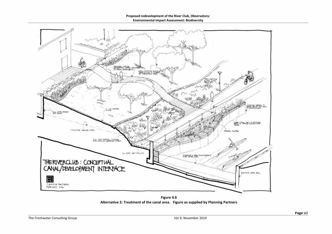
Proposed redevelopment of the River Club, Observatory: Environmental Impact Assessment: Biodiversity
Page 60
The Freshwater Consulting Group Ver 6: November 2019
Figure 4.6 Alternative 2: Treatment of the canal area. Figure as supplied by Planning Partners

Proposed redevelopment of the River Club, Observatory: Environmental Impact Assessment: Biodiversity
Page 61
The Freshwater Consulting Group Ver 6: November 2019
4.2.1. Development alternative 1
This is the developer’s preferred alternative, developed as an iterative process between the
engineering, landscape architect and biodiversity specialists. The treatment of the canal and natural
Liesbeek channel, shown in cross-section in Figures 4.2 and 4.3 can be summarised as follows:
The Liesbeek Canal
The design intention of this measure would be to create a largely unlined (except for the right hand
river bank) river channel that mimics natural lowland river function and has sufficient space to allow
for flooding and channel migration processes that do not result in channel incision or significant
erosion of the riverine corridor or development platform. It is understood on the basis of
conversations with the design engineers for this approach that the space allocation for the
rehabilitated river is sufficient to address these concerns.
The design allows for:
• Removal of the existing left hand wall of the Liesbeek canal and its floor (barring a short
section on the right hand abutting the canal wall;
• Use of stepped gabion baskets to stabilise the right hand canal wall, which abuts the steep
hillslope of the SAAO;
• Provision of sufficient space to allow for the river low flow channel to meander across a
relatively flat, reed-lined bed – it is assumed that the river would form its own channel – a
width of some 10m is assumed for the summer base flows with the Aurecon hydrological
specialists modelling the height of wet season base flows and with an allowance of an
additional 15.2m lateral space to accommodate the estimated height of the 1:1 year return
interval flood, as illustrated in Figure 4.2, and allowing for a slight, low bank, shaped roughly
to a slope of 1:4 to create a slightly elevated floodplain to accommodate within-year floods;
• At the narrowest point in the corridor (circled in Figure 4.2) at the upstream extent of the site,
an ecological buffer area of at least 15m has been allowed upslope from the 1:1 year floodline,
and the landscape intention is to vegetate this with appropriate low-growing vegetation for
the first 7.5m and thereafter to allow for the establishment of vegetation including riparian
trees within the next 7.5m of ecological buffer / corridor;
• A 1m high gabion wall then steps up to a cyclist / pedestrian pathway – the gabion wall is
intended to restrict the passage of fauna such as western leopard toads out of the ecological
corridor and into the development area;
• Upslope from the pedestrian pathway is a further buffer area some 11.5m wide – the
landscape intention here is that the area would be lawned and would permit social uses such
as playing, picnicking, but it would also serve as an additional buffer area;
• The ‘recreational’ buffer area would be edged by a second pedestrian pathway / cycle lane,
abutting the roadway – this path would also be edged on its riverine side by a raised gabion
wall, again intended to discourage access by western leopard toads;
• The above is the narrowest point in the river corridor – Figure 4.1 shows that where there is
more space, both the lower river corridor and the upper recreational corridor vary and widen
as space permits.

Proposed redevelopment of the River Club, Observatory: Environmental Impact Assessment: Biodiversity
Page 62
The Freshwater Consulting Group Ver 6: November 2019
The natural channel of the Liesbeek River
In this alternative, the ecological focus is on rehabilitating the canal to more natural riverine function.
Rehabilitation of the natural channel to riverine function was not deemed feasible, given the extent
of development in the area, which precludes the necessary channel re-alignment to accommodate
more concentrated flows than would have been the case in the past. Connecting the channel with the
channel upstream of Observatory Road was also considered problematic. In this scenario, then, the
following concept would apply (see Figure 4.3):
• Infilling of the channel to create a wide vegetated open space area, with both amenity and
stormwater polishing function, as well as the provision of terrestrial and possibly breeding
season habitat for western leopard toads;
• Stormwater from the site would be piped to the swale, and daylight as open channel
vegetated bioretention swales;
• Allowance has been made for the creation of a few seasonally inundated areas within the
swale, by the placement of low weirs at intervals, behind which water can back up;
• Stormwaterflows that currently enter the channel at a low level from the urban development
to the west of Liesbeek Parkway would be piped under the infilled swale;
• The development side of the swale would step up steeply using gabions, to discourage
western leopard toad passage into the development, and toad barriers would be used as
described for the pathways edging the rehabilitated canal;
• The Liesbeek Parkway side of the swale would slope gently up to a walkway, potentially to be
created along the edge of the road;
• A minimum setback of 10m from the swale was agreed on by the development team – where
the swale is located further from the edge of the site, development could in theory extend to
the edge of the site. This principal was agreed on with the development team, in order to
create additional space along the riverine corridor. The two swale concepts shown in Figure
4.3 illustrate this idea.
4.2.2. Development alternative 2
This alternative (shown in layout form in Figure 4.4) allows for the following treatment of the canal
and natural channel:
The natural channel of the Liesbeek River
This system forms the ecological focus of this alternative, the layout and landscape design of which
allow for improvement of wetland function in this system, by flattening of banks, replanting and the
creation of broad seasonally inundated fringing wetlands and ecological buffers with some amenity
value. The alternative, shown in Figure 4.5, would allow for:
• Grading of the existing right hand channel bank at a grade of 1:5 or flatter, over a width of
about 7.5m, followed by an area of some 7m planted with locally indigenous vegetation with
the emphasis on habitat creation;
• The remainder of the low-lying corridor is shown as an area of about 20m width in which
footpaths / cycle tracks and stormwater detention and treatment can take place;

Proposed redevelopment of the River Club, Observatory: Environmental Impact Assessment: Biodiversity
Page 63
The Freshwater Consulting Group Ver 6: November 2019
• The low-lying area is stepped steeply up to the development platform with gabion baskets.
The Liesbeek Canal
This system is not the focus of ecological improvement in this alternative and the landscape intention
is to provide aesthetic improvement to the canal but not to attempt to improve habitat diversity or
river function. The canal (shown in Figure 4.6) would be treated in this alternative as follows:
• It would be edged by a minimum buffer of 20m between the top of the canal and the hardened
development edge – this area would include paths and cycle tracks and would be planted with
locally indigenous plants;
• The existing gum trees along the canal would be felled and replaced with locally indigenous
plantings including trees;
• A low weir could be introduced to allow for a spread of water across the canal to facilitate
water sports such as canoeing;
• The top of the left hand canal could be pulled back to create planting areas along the top of
the bank.
4.3. Common development aspects
• Raising of the development platform: A large portion of the site is currently likely to be flooded
by storm events with an approximate return interval (RI) of two years (Aurecon 2017a).
Development of the site would require raising of the built environment to levels above the
1:100 year RI. Aurecon (2017b) notes that this would be achieved by imports of substantial
fill material (approximately 220 000m3 ) that would be placed on the built perimeter of the
site, while the central part of the site would be raised with basement structures. The
conservation areas, ecological corridors, Liesbeek canal and natural channel of the Liesbeek
River / open space swales would not be filled but would remain at natural ground level, unless
otherwise required as part of the respective rehabilitation and landscaping programmes for
these areas.
• Construction processes: Due to the shallow groundwater table and poor founding conditions on the site, deep excavations will be avoided where the underlying bedrock is deep below the existing ground level and the water table. Where the bedrock is at relatively shallow depth (on the southern portion of the site ) it may be feasible to excavate down to the bedrock and install one basement level below the existing ground level. Therefore, where the rock is deep, basement structures would be constructed on grade with fill placed around them. Bulk excavation would be limited in most cases to the excavation of 300 to 500 mm of loose topsoil and rubble to be replaced with a 300 mm thick end tipped crushed rock pioneer to create a stable working platform for construction. Where the rock is shallower ( at the southern end of the site) consideration will be given to constructing one of the basements level below the existing ground level. This would entail taking foundations and perimeter walls down to the underlying rock levels. Alternatively, the same procedure can be followed as for basements where the underlying bedrock is deep. [This information courtesy of Zenprop]
• Construction phasing: Figure 4.7 shows the conceptual phasing of construction activities on
the site, with the Berkley Road Bridge over the Black River and onto the site being proposed
as the first construction activity. Activities such as the treatment of the natural river channel
and Liesbeek canal are not shown in this phasing programme. Note however that subsequent

Proposed redevelopment of the River Club, Observatory: Environmental Impact Assessment: Biodiversity
Page 64
The Freshwater Consulting Group Ver 6: November 2019
to initial discussions around project phasing, it was noted by the development team that the
numbered phases shown in Figure 4.7 might not necessarily be consecutive, as they might be
dictated by funding availability. The ecological implications of this are addressed in Section
5.2;
• Stormwater management design:
o Attenuation of peak flows: Aurecon (2017b) notes that application will be made to
the City of Cape Town for a departure from its Management of Urban Stormwater
Impacts Policy with regard to stormwater attenuation, on the grounds that the site is
so low-lying that attenuation will add no significant value;
o Water quality amelioration: The City of Cape Town’s Management of Urban
Stormwater Impacts policy (City of Cape Town 2009) would be implemented, using a
system of vegetated swales (designed for extended detention where necessary) on
the perimeter of the site, underlain by a formalised piped drainage network (Aurecon
2017b). Figure 4.8 illustrates such a swale, after Aurecon (2017b).
• Irrigation water: Aurecon (2017b) notes that the use of treated sewage effluent as well as of
river water for irrigation of landscaped areas has been ruled out, as a result of ecological
concerns regarding its impact on aquatic ecosystems. This issue is not considered further in
this assessment.

Page 65
Figure 4.7 Proposed development phasing. Figure as supplied by Vivid Architects

Page 66
Figure 4.8 Layout of proposed stormwater swales. Figure supplied by Aurecon

Proposed redevelopment of the River Club, Observatory: Environmental Impact Assessment: Biodiversity
Page 67
The Freshwater Consulting Group Ver 6: November 2019
Figure 4.9 Proposed stormwater swale
Figure after Aurecon (2017b), with potential for extended detention if check dams placed along surface of swale
• Sewage conveyance: The following infrastructure, the alignment of which is shown in Figure
4.10) would be required to convey sewage and other waste water from the new development
to an existing municipal discharge point in Station Road (Aurecon 2017b):
o Two new pump stations, one in each Precinct – the pump stations would be located
in plenum chambers in the basements, to contain spillage / leakage and minimise the
chance of its passage into watercourses in the event of malfunction – the sump would
have a 6 hour overflow capacity, after which sewage would pass into the plenum.
Aurecon (2017b) outlines a reaction plan framework in the event of power or pump
failure;
o Two 160mm diameter HDPE rising mains – these would convey sewage from the
pump stations to a break-pressure manhole outside of the site – they would run
mainly in the basements of the built precincts, but would be trenched in for a short
distance between the basements and the property boundary, with a single 160mm
diameter HDPE rising main crossing Liesbeek Parkway to tie into the existing mains,
and gravity feed from here. The east-west ecological corridor and the natural channel
of the Liesbeek River / swale area would be crossed by these pipelines;
• Sewage treatment:
o The City of Cape Town’s Athlone Waste Water Treatment Works would treat effluent
from the site (Aurecon 2017b).
Page 68
Figure 4.10
Layout of proposed sewer. Figure supplied by Aurecon

Page 69
committee_alfr. <[email protected]> Figure 4.11 Layout of proposed water supply pipelines. Figure supplied by Aurecon

Proposed redevelopment of the River Club, Observatory: Environmental Impact Assessment: Biodiversity
Page 70
The Freshwater Consulting Group Ver 6: November 2019
• Potable water supply:
PVC piping would be used to connect the development to an existing main that runs along the edge
of Liesbeek Parkway (Figure 4.11). This pipeline would cross over the (Alternative 1) swale area
abutting Liesbeek Parkway in the south eastern corner of the site, and would also cross through the
ecological corridor, following the alignment of the proposed new road.
• Internal road design to address concerns about Western Leopard Toads : Iterative discussions
took place between the biodiversity specialists (Liz Day and Marius Burger) and the project
engineer and landscape architect (Mr Carshif Talip (Aurecon) and Mr Jaco Jordaan (Planning
Partners), respectively, regarding the need to use engineering and landscape design to
discourage the movement of western leopard toads onto roads and the building platform as
a whole. Figure 4.12 presents the design response to such discussions, with vertical 0.5m
gabion baskets edging the road, presenting a high, steep edge to the soft vegetated swale
below within the open space corridor. This is intended to discourage scaling by these toads,
while access back into the corridor would be facilitated by the lower step up to the top of the
gabion from the pavement side. The swale that abuts the gabion has side slopes of 1:4 on
either side of the swale.
• Bridge design: Major bridge / culvert structures would be constructed at four locations on the
site, as shown in Figure 4.13, and at two minor locations along Berkley Road extension,
namely:
o A bridge over the Black River (Berkley Road extension), constructed on piers as
shown in Figure 4.14 and including the following design elements (both alternatives):
▪ Four piers support the bridge crossing over the river – one of the piers is
located on the top of the river bank itself, with the fill platform extending to
the edge of the pier;
▪ Two 1500mm x 1500 mm box culverts would be constructed on either side of
the crossing, to facilitate faunal passage along the top of the bank, through
the infilled road structure. The culverts would be sited to include an area just
above the 1:50 year floodline;
Figure 4.12 Treatment of roads and crossings to address Western Leoopard Toad safety concerns
Proposed redevelopment of the River Club, Observatory: Environmental Impact Assessment: Biodiversity
Page 71
The Freshwater Consulting Group Ver 6: November 2019
▪ Gabion baskets would be used to line the road edge where the new road ties
into the existing road;
▪ Stormwater outlets channel water from the existing road into the Black River
in unlined grassed channels;
o Two culverts connecting the River Club development side of Berkley Road extension
with the as-yet undeveloped land on the western (PRASA) side of the new road (see
Figure 4.1);
o A series of culverts under the Liesbeek Parkway connecting road (see Figure 4.13)
where it crosses over the ecological open space corridor. These culverts are intended
to allow the passage of both floodflows and small fauna including Western Leopards
Toads under the road (Figure 4.15) and include, over an approximate 90m length of
road:
▪ Two sets of two 1500x600mm culverts;
▪ One set of three 1500 x 1500mm culverts;
▪ Shaping of the ecological corridor up towards the road surface;
o A series of culverts over the northern end of the landscaped swale (Alternative 1) or
the rehabilitated natural Liesbeek channel (Alternative 2), just upstream of where the
channel swings east towards the Black River – these culverts (“Culvert 1” in Figure 4.1
and 4.13) would comprise (see Figure 4.16):
▪ Four 1500 x 1500 mm box culverts, set in the current “low flow”section of the
natural Liesbeek channel;
▪ Edging of the road / pedestrian walkway along the length of the road with
500mm high gabion baskets to limit wetsren leopard toad passage up onto
the road on either side;
It is assumed for purposes of this assessment that the structure would be the
same for both Alternatives 1 and 2, with the dowbnstream end of the
landscaped swale of Alternative 1 being completely accommodated by the
width of the four culverts, but with only part of the downstream end of the
rehabilitated channel of Alternative 2 being spanned by the culverts and the
rest of the channel needing to be filled in at this pinch-point;
o A series of culverts at the Liesbeek Parkway end of the new Liesbeek Parkway
connecting road (“Culvert 2” in Figure 4.1) comprising (see Figure 4.17):
▪ A total of five 1200x600 mm box culverts (three on the right hand side and
two on the left hand side of the channel, facing downstream) and on the
higher ground above the current channel level to allow terrestrial / flood time
faunal connectivity along the landscaped swale (Alternative 1) or
rehabilitated natural channel of the Liesbeek River (Alternative 2);
▪ Three 1200 x 600mm box culverts located in the lower-lying landscaped swale
(Alternative 1) or rehabilitated natural channel of the Liesbeek (Alternative 2)
to convey flows;

Proposed redevelopment of the River Club, Observatory: Environmental Impact Assessment: Biodiversity
Page 72
The Freshwater Consulting Group Ver 6: November 2019
It is again assumed for purposes of this assessment that the structure would
be the same for both Alternatives 1 and 2.

Figu
re 4
.13
Loca
tio
ns
of
the
fou
r p
rop
ose
d b
rid
ges
/ cu
lver
ts o
ver
the
Bla
ck R
iver
, op
en s
pac
e c
orr
ido
r an
d L
iesb
eek
Ch
ann
el (
two
ove
r th
e L
iesb
eek
chan
nel
, co
mp
risi
ng
Ber
kley
Ro
ad e
xten
sio
n (
Cu
lver
t 1)
an
d t
he
Lies
bee
k P
arkw
ay c
ross
ing
(Cu
lver
t 2)
. Fi
gure
su
pp
lied
by
Au
reco
n .
No
te t
hat
th
e s
wal
e w
her
e th
e ex
isti
ng
Lies
bee
k ch
ann
el is
no
w a
pp
lies
to A
lter
nat
ive
1 o
nly
an
d w
ou
ld in
fac
t ex
ten
d a
ll th
e w
ay t
o O
bse
rvat
ory
Ro
ad

Figure 4.14 Design and Layout of proposed Berkley Road bridge over the Black River. Figure supplied by Aurecon
−

Figure 4.15 Design and Layout of proposed bridge / crossing over the open space / ecological corridor.
Figure supplied by Aurecon

Figure 4.16 Design and Layout of proposed Culvert 1 over the natural channel of the Liesbeek River – same design for both alternatives, with the bridge at the downstream end of either
the wetland swale (Alternative 1) or the rehabilitated natural channel of the Liesbeek River (Alternative 2) Figure supplied by Aurecon: March 2018.

Page 77
The Freshwater Consulting Group Ver 6: November 2019
Figure 4.17 Design and Layout of proposed Culvert 2 over the (proposed -Alternative 1) swale area or (Alternative 2) over the rehabilitated natural channel of the
Liesbeek River . Figure supplied by Aurecon: March 2018.
Proposed redevelopment of the River Club, Observatory: Environmental Impact Assessment: Biodiversity
Page 78
The Freshwater Consulting Group Ver 6: November 2019
5 ASSESSSMENT OF IMPACTS ASSOCIATED WITH THE PROPOSED
DEVELOPMENTS
This section describes the implications of the various components of the proposed River Club
development for biodiversity as a whole, including the freshwater ecosystems, terrestrial and aquatic
flora and fauna described in Section 3, using the assessment rating provided by SRK and included in
Appendix F. The various alternatives are assessed formally in Tables 5.1 to 5.15.
During the course of FCG’s involvement in this project, the proposed development footprint and
layout of both development alternatives have undergone a number of changes, largely as a result of
extensive, iterative feedback into the project, by biodiversity specialists and other members of the
design team. This process resulted in issues such as the avoidance of (ecologically) sensitive areas,
the incorporation of ecological setback areas and faunal movement corridors in accordance with
biodiversity specialist requirements and the strategic selection of opportunities that would enhance
ecosystem function, quality or sustainability, while affording various development opportunities. To
some extent, then, the development alternatives considered in this study already include a substantial
level of mitigation, and the significance of the impacts considered in this section tend to be positive,
or low to medium even without mitigation, despite the scale of development proposed.
Such an approach means that, if authorised, the selected development would, from a biodiversity
perspective, potentially not require substantial revising to incorporate additional mitigation
measures. However, the risk of such an approach is that some measures, assumed in assessment to
be part of the planned development, are not explicitly included in the Authorisation. This author has
experience of such projects, where subtle changes in development layout, design and implementation
have significant implications for the end ecological outcome, but are not explicitly addressed in the
mitigation measures, because they were included, but not overtly, in the assessed design.
Fundamental to the present assessment is thus the understanding that the design elements described
in Section 4 and included in the figures of that section are assumed to be explicitly part of any future
development authorisation for the relevant authorisation, unless mitigation measures outlined in this
report require otherwise.
Since mitigation measures mostly revolve around improving the certainty of the positive aspects of
the development outcomes, these are grouped together, as measures required for each phase.
5.1. Impacts of layout and design
The following 15 issues deriving from project layout and design are likely to result in impacts (both
negative and positive) to aquatic ecosystems and/or overall biodiversity:
• Changes in the habitat quality and ecological functioning of the Liesbeek Canal (see section 5.1.1).
• Loss of terrestrial habitat for indigenous fauna (see section 5.1.2).
• Loss / degradation of indigenous floral communities / important floral populations (see section
5.1.3).
• Changes in faunal connectivity (see section 5.1.4).
• Increased western leopard toad mortalities (see section 5.1.5).

Proposed redevelopment of the River Club, Observatory: Environmental Impact Assessment: Biodiversity
Page 79
The Freshwater Consulting Group Ver 6: November 2019
• Changes in flow regime into the Raapenberg wetlands (see section 5.1.6).
• Loss and degradation of riverine wetlands along the Black River margins (see section 5.1.7).
• Loss and/or changes in wetland habitat quality and availability in the areas of the natural Liesbeek
River channel (see section 5.1.8).
• Faunal fatalities (particularly western leopard toads) as a result of construction activities (see
section 5.2.1).
• Water quality and habitat deterioration as a result of diversion of river (Black River and Liesbeek
Canal) and wetland (natural Liesbeek channel) flows during construction (see section 5.2.2).
• Degradation of downstream habitat in the Liesbeek Canal, lower natural Liesbeek channel and
Black River (see section 5.2.3).
• Disturbance of watercourse bed and banks during infrastructure installation (see section 5.2.4).
• Degradation of habitat quality or failure to realise opportunities for improved habitat quality and
biodiversity conservation / improvement as a result of inadequate or ill-advised channel and open
space maintenance activities (see section 5.3.1).
• Contribution to deterioration of water quality in the Liesbeek and Black Rivers (see section 5.3.2).
5.1.1. Changes in the habitat quality and ecological functioning of the Liesbeek Canal
Impact description
• Alternative 1:
In this alternative, the Liesbeek Canal would be rehabilitated into a functional river channel. It would
be edged with gabions on its right hand side, but effectively the canalisation effects (low biodiversity,
low habitat heterogeneity, low ecosystem function) would be lost and the following attributes have
been included in its design:
o A low flow channel with an earth bed, vegetated along its edges with Phragmites australis reedbed and other indigenous plant species typical of lowland rivers in this area – there is likely to be enough low flow in the channel all year round to maintain this as an open channel, although it is possible that reeds may at times close in the channel and periodic maintenance would be required – this is discussed in section 5.3;
o A vegetated high flow channel along the left hand bank – this would grade gently up from the low flow channel and be vegetated with a range of indigenous plant species, but it is likely that Phragmites australis reeds and possibly Typha capensis bulrush would dominate; it is also assumed that the low flow channel would meander across this area, making it a narrower on this side of the channel at times – note that the gabion baskets on the right hand side of the channel would probably be fairly sterile unless adjusted marginally to improve the likelihood of plant establishment. This area would be expected to be inundated during the wet season, with wet season baseflows. If vegetated with sedges and areas of higher spatial diversity than simple reedbed, it would be well-suited for colonisation during periods of inundation by fish larvae and the aquatic larvae and nymphs of various riverine insects, adding substantially to biodiversity;
o A flood channel, likely to be inundated by freshets and small (within-year) floods – this area (some 7m wide) would also be vegetated with indigenous vegetation and would

Proposed redevelopment of the River Club, Observatory: Environmental Impact Assessment: Biodiversity
Page 80
The Freshwater Consulting Group Ver 6: November 2019
provide floodplain habitat to adding birds and other river- associated fauna. It would also play a role in water quality amelioration;
o Less frequent flooding (up to 1:5 year RI) would be expected in the 15m wide (minimum) area extending as far as the gabion lining of the bottom cycle / pedestrian path. This area would provide a measure of ecologically diverse mostly terrestrial habitat, as well as a (similar) extent of lawned recreational area. In sections of the development where there is more open space along the riverine corridor, this area as well as the area above the pathway would be widened (See Figures 4.1 and 4.2);
o The area between the two pedestrian / cycle paths would provide recreational / amenity activities and would be of reduced biodiversity value – it would however provide refuge for mobile terrestrial fauna during periodic big floods, that overtopped the lower pedestrian footpath;
The above changes in river habitat quality are considered positive and would dramatically improve
river habitat in this reach of river, from a PES Category F to at least a Category D and possibly a
PES Category C. There is however only low to medium certainty that a Category C would be
achieved – while no mitigation measures are included here, those outlined Section 5.1.10 aim at
improving this certainty.
• Alternative 2:
Although Alternative 2 includes planting of the upper canal and possible introduction of gabion
planters along the canal margins (assuming these can be accommodated in terms of flow velocities
and flood capacity), such changes would have negligible impact on current (canalised) habitat
quality and ecological functioning.
Table 5.1 provides a more formal assessment of the impacts described above, with and without
mitigation.

Proposed redevelopment of the River Club, Observatory: Environmental Impact Assessment: Biodiversity
Page 81
The Freshwater Consulting Group Ver 6: November 2019
Table 5.1 Significance of changes in the habitat quality and ecological functioning of the Liesbeek Canal
Nature of
impact
Extent of impact
Intensity Duration of
impact Consequence
Probability of
occurrence Signif. Confid.
ALT 1 Without
Mitigation
1 Local
3 High
3 Long term Irreversible
without major effort
7 High
Probable High (Pos.)
Medium
ALT 2 Without
Mitigation
1 Local
1 Low
(negligible)
3 Long term Reversible
5 Low
Possible Very Low
(Pos.) High
Essential mitigation measures:
An Environmental Control Officer (ECO) (or similar designation) with experience in construction work involving or in proximity to freshwater ecosystems must be on site on at least a weekly basis during all works involving canal rehabilitation and /or landscaping of adjacent areas.
5.1.2. Loss of extent of terrestrial habitat for indigenous fauna
Impact description
• Both alternatives:
Both development alternatives would entail the loss of substantial areas of terrestrial habitat which
currently is understood to provide non-breeding habitat for western leopard toads. The faunal
specialist also noted the possible use of the site as habitat for various indigenous small animals
including the dwarf chameleons, noting however that the quality of such habitat is at present poor,
given the dearth of remnant indigenous vegetation on the site and the dominance of mowed grass
and parking areas on the site. While western leopard toads are able to utilise suburban gardens and
other vegetated areas provided that they have adequate cover, the degree of present cover on the
site (e.g. flower beds) is limited, and connectivity to areas with cover is fraught with risk (vehicles,
lawn mowers, golf ball collection vehicles).
Compared to the present situation, and given that the proposed development alternatives would both
include large areas of landscaped open space, with the design intention of the provision of high
quality, safe faunal environments, the loss of degraded terrestrial habitat is considered of low negative
significance, given the improvement in its quality and additional mitigation measures are not required.
The recommended Conditions of Development Authorisation outlined in Section 8 aim however to
maximise the quality of the proposed terrestrial open spaces on the site, from a faunal habitat
perspective.
Table 5.2 provides a more formal assessment of the impacts described above, with and without
mitigation.

Proposed redevelopment of the River Club, Observatory: Environmental Impact Assessment: Biodiversity
Page 82
The Freshwater Consulting Group Ver 6: November 2019
Table 5.2 Significance of loss of terrestrial habitat area for indigenous fauna
Nature of
impact
Extent of impact
Intensity Duration of
impact Consequence
Probability of
occurrence Signif. Confid.
Both alternatives
Without Mitigation
1 Local
1 Low
3 Long term
Irreversible
5 Low
Definite Low
(Neg.) Medium
Essential mitigation measures:
Not Applicable
Additional measures to improve habitat quality
Although not essential, open space terrestrial areas could be rehabilitated to include patches of renosterveld, by
importing soils from disturbed renosterveld sites (e.g. quarries - see Appendix A). It is important that areas thus
planted should be linked to form, as far as possible, continuous corridors linking to the east-west corridors, with
recreational and other pathways meandering through both these and adjacent grassed areas. Ideally, grassed
areas should be limited in this part of the site, which should aim to maximise quality toad habitat.
5.1.3. Loss / degradation of indigenous floral communities / important floral populations
Impact description
• Both alternatives
The botanical specialist (Appendix A) found no areas of any floral importance on the River Club
site, and concluded moreover that the proposed development at this site would be highly unlikely
to impact negatively on the dryland renosterveld vegetation at the adjacent SAAO site, including
the Critically Endangered Moraea aristata populations.
The overall impact of the proposed development to indigenous flora is thus considered negligible.
In the event that the mitigation measures around rehabilitation of terrestrial renosterveld habitat on
the site are included (see Appendix A and Section 3.2), then the impact to indigenous flora would be
considered positive.
Table 5.3 provides a more formal assessment of the impacts described above, with and without
mitigation.
Table 5.3 Significance of Loss / degradation of indigenous floral communities / important floral populations
Nature of
impact
Extent of impact
Intensity Duration of
impact Consequence
Probability of
occurrence Signif. Confid.
Both alternatives
Without Mitigation
Negligible impact
Best practice measures:
i. Actively rehabilitate renosterveld habitat on site by importing shale soil and overburden, perhaps from one of the Malmesbury shale aggregate mines in the Tygerberg, to provide potential additional renosterveld substrate
Both alternatives
With Mitigation
1 Local
2 Medium
3 Long term Reversible
6 Medium
Possible Medium
(Pos.) Medium

Proposed redevelopment of the River Club, Observatory: Environmental Impact Assessment: Biodiversity
Page 83
The Freshwater Consulting Group Ver 6: November 2019
5.1.4. Changes in faunal connectivity
Impact description
Although both alternatives entail development of large areas that currently afford connectivity /
access across most of the site, the quality of such connectivity is poor and fraught with risk to small
fauna (e.g. driving range activities). Both proposed alternatives allow for substantial faunal corridors,
as outlined in Section 4.2, which allow
• Longitudinal links along the canal and natural Liesbeek channel areas,
• East-west links along the eastern and western boundaries and through the centre of the site
• Links under the bridges and roads that would otherwise fragment these corridors.
The following aspects of connectivity are particular to different alternatives:
• Alternative 1:
In addition to provision of the generic corridors outlined above, this alternative would improve
existing faunal connectivity in the following manner:
o Between the SAAO and the site and the Raapenberg wetlands and the site – at present,
the canal affords limited to no connectivity for flightless fauna, as a result of its steep
sides; the rehabilitated Liesbeek Canal would thus extend the zone of connectivity
between the SAAO site and the River Club to the full length of the rehabilitated canal. This
would be a positive outcome, particularly for the conservation of western leopard toads,
the movement of which onto the site would be facilitated by removal of the canal;
o Connectivity between the Raapenberg wetlands, the Black River and the remnant natural
Liesbeek channel and associated stormwater swales would be facilitated by the proposed
east-west corridor across the site – the quality of connectivity would be dependent on the
landscaping details of the corridor;
o Longitudinal connectivity along the lower portion of the rehabilitated canal, below the
lower pathway, would be a significant improvement over current conditions - indigenous
planted, non-lawned areas would be effective at facilitating faunal movement along the
river corridor, linking with the major east-west corridor and providing high quality habitat
for species such as western leopard toads in their non-breeding season in particular;
• Alternative 2:
o The canal in this alternative would offer the same (poor) ecological connectivity as that in
the present situation;
o Connectivity between the Raapenberg wetlands, the Black River and the remnant natural
Liesbeek channel and associated stormwater swales could be facilitated by the proposed
east-west corridor across the site, although the retention of the canal itself would limit
this connection to the unlined lower reaches towards the Black River. The quality of
connectivity in all cases would be dependent on the landscaping details of the corridor.
While the above corridors are substantial and designed to mitigate against habitat fragmentation and
the isolation of faunal populations, some aspects of their design are likely to have a substantial effect

Proposed redevelopment of the River Club, Observatory: Environmental Impact Assessment: Biodiversity
Page 84
The Freshwater Consulting Group Ver 6: November 2019
on their efficacy. Problems with the design of the above roads, bridges and open spaces from a faunal
corridors perspective include:
• The position of culverts in the main (65-100m wide) east-west corridor (Figure 4.15): these are
located in the central part of the corridor. This means that fauna moving along the sides of the
corridor would not find connectivity, and unless the landscaping planting plan actively includes
swathes of cover that guide fauna to zones of connectivity, these culverts might not play as strong
a role in ensuring faunal connectivity as originally planned;
• Connectivity along the northern east-west corridor (along the property boundary abutting Berkley
Road) would be reduced / possibly obstructed at the western end of the corridor, by a pinch-point
at the access to development block 15 (see Figure 4.1) – this apparent “dead end” would make
this corridor highly problematic from a faunal perspective, particularly given its length and overall
narrowness. The corridor would also connect only in two places to the degraded open space and
natural Liesbeek channel north of Berkley Road –given the length of this section of the road (some
550m estimated off GOOGLE imagery), the two connections would be unlikely to provide effective
linkage between the northern and southern sides of the road. This means that the remnant
section of the natural Liesbeek channel would be ecologically isolated between the railway line to
its north and Berkley Road to the south;
• The width of Berkley Road in relation to the width of the culvert – the culverts under Berkley Road
may be too dark to encourage the passage of western leopard toads through the culvert;
• The positioning of the culverts under the road connections that cut across the Berkley Road
corridor appear to be advantageous, in that fauna would be “channelled” along the toe of either
road, towards the culvert. However, where culverts pass under wide roads such as the Berkley
Road extension, the provision of culverts alone may not be sufficient to persuade western leopard
toads to pass through and such corridors might thus be ineffective – this would be a significant
impact, as links north into the (as yet) undeveloped ground north of the River Club extending to
the natural Liesbeek channel, in which the toads may breed, are considered important;
• The southern east-west corridor abutting the SKA boundary is relatively short, making its narrow
width less problematic. The sustainability of this corridor is however likely to be threatened in the
future by development of the SKA site, as it is assumed that the latter would require road access
to the development, making crossing of the corridor inevitable;
• The design of the Berkley Road bridge over the Black River would effectively cut off longitudinal
connectivity along the lower bank and top of bank, as a result of extension of the infilled portion
of the road all the way to the first pier (Figure 4.14). This issue would be problematic to small
fauna traversing this bank area, particularly as the area between the toe of the M5 and the river
is already relatively sterile, with little vegetation cover on the upper bank / floodplain, through
which culverts would afford connectivity;
• The Berkley Road bridge (Culvert 2 – see Figure 4.16) over the natural channel of the Liesbeek
River is also problematic, in that it would allow only up- and downstream connectivity at the level
of the channel itself – this means that aquatic fauna could pass through the culverts but that
terrestrial fauna would be isolated on one side of the road.

Proposed redevelopment of the River Club, Observatory: Environmental Impact Assessment: Biodiversity
Page 85
The Freshwater Consulting Group Ver 6: November 2019
o In the case of Alternative 2 (rehabilitation of the channel) the four culverts as shown
would also require constriction / infilling of the channel at this point, as the culverts do
not extend across the whole channel.
• The ecological significance of the above issues would be greatest in the case of Alternative 2, in
which the rehabilitated natural channel is intended as the focus for ecological improvement /
rehabilitation. In the case of Alternative 1, the onus for rehabilitation and connectivity is mainly
on the rehabilitated canal. The Liesbeek Parkway link bridge (Culvert 2 – Figure 4.17) would
provide better levels of faunal connectivity than Culvert 1, as the former includes five culverts
located above the low flow channel, which would allow terrestrial connectivity. Again, in the case
of Alternative 2, the nevertheless moderate level of fragmentation that would ooccur in an area
intended actively to promote rehabilitation is seen as an opportunity cost. The connectivity
provided by the culverts in terms of Alternative 1, where the focus of ecological rehabilitation is
in the canal, is considered quite adequate.
Essential mitigation measures
The following mitigation measures are considered essential.
Both alternatives
i. The main (65-100m wide) east-west corridor:
a. This area must be landscaped so that it provides wide swathes of indigenous planted
vegetation that ensure continuous vertical cover along the length of the corridor –
preferably on both sides - as a guideline, at least 40% of the main ecological corridor
should be managed as indigenous planted corridor habitat, without lawn or pathways;
b. Efforts must be made to establish renosterveld vegetation in the corridor – ideally,
using recommendations made in the botanical report for the import of soils from
nearby quarries in renosterveld areas – a botanical specialist should be approached
during the design phase for input into appropriate, practically obtainable plant species
for this use;
c. Ideally, an additional culvert should be located on either side of the corridor, so that
these edges do not become closed off;
d. The faunal specialist should have final sign-off on the detailed landscape plan for this
corridor, and input during on-site implementation to ensure that it meets the required
specifications;
ii. The northern east-west corridor:
a. The Berkley Road toe / side slopes should be as steep as possible, in order to reduce
faunal connectivity up to the road and increase open space along the edge of the road;
b. The area between the development edge and the road must be landscaped with
indigenous vegetation, laid out so as to provide a diversity of heights and densities of
plants that will facilitate its role as a corridor;

Proposed redevelopment of the River Club, Observatory: Environmental Impact Assessment: Biodiversity
Page 86
The Freshwater Consulting Group Ver 6: November 2019
c. The pinch-point at the western end of the corridor (development block 15) must be
addressed so that at least 5m open, vegetated space are provided at this point,
widening thereafter to 10m;
d. An additional three culverts should be provided under Berkley Road – one between
each of the access roads onto the site;
e. Consideration should be given to the provision of road grids over the culverts, to let
in light and mitigate against the effects of the width of the road;
iii. The southern east-west corridor:
a. A condition of any future road crossings over this corridor (e.g. associated with SKA
building access) must be the inclusion of bridging or adequately sized culverts to
maintain faunal connectivity – this must be shown on the final layout plan;
b. The area between the development edge and the southern site boundary must be
landscaped with indigenous vegetation, laid out so as to provide a diversity of heights
and densities of plants that will facilitate its role as a corridor;
iv. Berkley Road bridge over the Black River:
a. On the M5 side of the channel (right hand bank):
i. The extent of the fill platform must be pulled back, so that an area of at least
5m from the top of the bank, as well as the river bank itself, is left open,
before the pier;
ii. If required, reno mattresses may be used to stabilise the river bank and top
of bank under the bridge itself, where vegetation might not establish readily.
Such reno would need to be laid at a slope no greater than 1:4 and could if
necessary be edged at the bottom by gabion mattresses provided that no step
greater than 300mm vertical height was created;
iii. The river bank and open vegetated zone must be shaped (graded at 1:4 or
flatter) and planted with appropriate indigenous vegetation along a bank
length of at least 10m up- and downstream of the bridge, and extending to at
least 5m over the top of the bank;
b. On the River Club side of the channel (left hand bank):
i. The extent of the fill platform must be pulled back, so that the bridge spans
the full width of the Black River and its recommended ecological buffer /
setback of 20m, measured from the top of the bank.
Alternative 1
v. The planted swathes through the main east-west corridor and the corridor as a whole must
tie in to the landscaped rehabilitated river corridor, at the level below the lower pedestrian
path – this can be achieved by creating boardwalk-type bridges in places in this section, so
that the east-west and longitudinal corridors connect in as wide an area as possible, while
maintaining human recreational use through these areas and preventing, as far as possible,
faunal access to the development area itself;
Proposed redevelopment of the River Club, Observatory: Environmental Impact Assessment: Biodiversity
Page 87
The Freshwater Consulting Group Ver 6: November 2019
vi. Proposed Berkley Road crossing over the Liesbeek channel (Culvert 1):
a. The crossing must be adjusted to allow for terrestrial faunal connectivity along the
landscaped swale connecting into the remnant section of the natural Liesbeek
channel downstream of the development, by adding at least three similarly sized
(1500 x1500 mm) culverts to the design, located on the terrestrial margins of the
swale. These culverts would need to be located only on the right hand channel
margins (that is, culverts on the steep Liesbeek Parkway side of the channel would not
be necessary or desirable). Inclusion of overhead grids for lighting of the culverts
would be desirable and must be con sidered in final design;
vii. New (southern) culvert over the Liesbeek channel (Culvert 2):
a. The position of the main and minor culverts must be finalised when the location of
the swale (closer or further from the development boundary, as shown in the options
in Figure 4.6) is finalised;
Alternative 2
viii. The planted swathes through the main east-west corridor and the corridor as a whole must
tie in to the landscaped edge / buffer area of the canal – habitat quality of this edge is likely
to be low;
ix. The pathway shown in Figure 4.6 cutting across the buffer area should be raised in places to
allow a 300mm connecting space beneath the pathway, for faunal passage – this could be
achieved by excavating out low points during construction of the pathway / boardwalk;
x. The pathways through the canal buffer area must be designed to prevent toad passage into
the development - toad barriers should be included, and the top of the buffer area should be
edged by a toad-barrier lined pedestrian pathway that is separated from the roadway and
thus the main development, with toad barriers;
xi. Proposed Berkley Road crossing over the natural Liesbeek channel (Culvert 1):
In this alternative, it is particularly important that the rehabilitation potential of the channel
is maximised. The design of the structure must be amended to allow spanning of the river
channel, as has been included in the case of the Black River bridge, with the following essential
design elements included:
i. The bridge must span the full rehabilitated channel and the full buffer width
on the development side of the channel;
ii. Piers may be included in the design to facilitate the required length of span;
iii. Infilling of the buffer to accommodate the road would not be permitted;
Note that inclusion of a bridge rather than a culvert crossing was discussed in project planning
meetings and agreed on in principle for this alternative.
xii. New (southern) Liesbeek Parkway link road over the Liesbeek channel (Culvert 2): Again, as
in the case of Culvert 1, it is particularly important that the rehabilitation potential of the
channel is maximised in this alternative. The proposed design of the structure must thus be

Proposed redevelopment of the River Club, Observatory: Environmental Impact Assessment: Biodiversity
Page 88
The Freshwater Consulting Group Ver 6: November 2019
amended to allow spanning of the river channel, with the following essential design elements
included:
i. The bridge must span the full rehabilitated channel and the full buffer width
on the development side of the channel;
ii. Piers may be included in the design to facilitate the required length of span;
iii. Infilling of the buffer to accommodate the road would not be permitted.
Note that inclusion of a bridge rather than a culvert crossing was discussed in
project planning meetings and agreed on in principle for this alternative.
Table 5.4 provides a more formal assessment of the impacts described above, with and without
mitigation, with relevant mitigation measures repeated in the table for ease of future reference. Note
that the Regional rating for extent takes cognisance of the conservation status of western leopard
toads. The difference in outcomes “with mitigation” between the two alternatives (Low positive in
Alternative 1 and Very Low to Low negative in Alternative 2, really reflects the tremendous
improvement in ecological connectivity that would result from removal of the canal in Alternative 1.

Proposed redevelopment of the River Club, Observatory: Environmental Impact Assessment: Biodiversity
Page 89
The Freshwater Consulting Group Ver 6: November 2019
Table 5.4 Significance of changes in faunal connectivity
Nature of
impact
Extent of impact
Intensity Duration of
impact Consequence
Probability of
occurrence Signif. Confid.
ALT 1 Without
Mitigation
2 Regional
1 Low
3 Long term
6 Medium
Possible Low
(Neg.) Medium
ALT 2 Without
Mitigation
2 Regional
2 Medium
3 Long term
7 High
Probable High
(Neg.) Medium
Both alternatives i. The main (65-100m wide) east-west corridor:
a. This area must be landscaped so that it provides wide swathes of indigenous planted vegetation that ensure continuous vertical cover along the length of the corridor – preferably on both sides;
b. Efforts must be made to establish renosterveld vegetation in the corridor – ideally, using recommendations made in the botanical report for the import of soils from nearby quarries in renosterveld areas – a botanical specialist should be approached during the design phase for input into appropriate, practically obtainable plant species for this use;
c. Ideally, an additional culvert should be located on either side of the corridor, so that these edges do not become closed off;
d. The faunal specialist should have final sign-off on the detailed landscape plan for this corridor, and input during on-site implementation to ensure that it meets the required specifications;
ii. The northern east-west corridor: a. The Berkley Road toe / side slopes should be as steep as possible, in order to reduce faunal
connectivity up to the road and increase open space along the edge of the road; b. The area between the development edge and the road must be landscaped with indigenous
vegetation, laid out so as to provide a diversity of heights and densities of plants that will facilitate its role as a corridor;
c. The pinch-point at the western end of the corridor (development block 15) must be addressed so that at least 5m open, vegetated space are provided at this point, widening thereafter to 10m;
d. An additional three culverts should be provided under Berkley Road – one between each of the access roads onto the site;
e. Consideration should be given to the provision of road grids over the culverts, to let in light and mitigate against the effects of the width of the road;
iii. The southern east-west corridor: a. A condition of any future road crossings over this corridor must be the inclusion of bridging or
adequately sized culverts to maintain faunal connectivity – this must be shown on the final layout plan;
b. The area between the development edge and the southern site boundary must be landscaped with indigenous vegetation, laid out so as to provide a diversity of heights and densities of plants that will facilitate its role as a corridor;
iv. Berkley Road bridge over the Black River: a. On the M5 side of the channel (right hand bank):
i. The extent of the fill platform must be pulled back, so that an area of at least 5m from the top of the bank, and the river bank itself, is left open, before the pier;
ii. If required, reno mattresses may be used to stabilise the river bank and top of bank under the bridge itself, where vegetation might not establish readily. Such reno would need to be laid at a slope no greater than 1:4 and could if necessary be edged at the bottom by gabion mattresses provided that no step greater than 300mm vertical height was created;
iii. The river bank and open vegetated zone must be shaped (graded at 1:4 or flatter) and planted with appropriate indigenous vegetation along a bank length of at least 10m up- and downstream of the bridge, and extending to at least 5m over the top of the bank;
b. On the River Club side of the channel (left hand bank): i. The extent of the fill platform must be pulled back, so that the bridge spans the full
width of the Black River and its recommended ecological buffer / setback of 20m, measured from the top of the bank.
Alternative 1

Proposed redevelopment of the River Club, Observatory: Environmental Impact Assessment: Biodiversity
Page 90
The Freshwater Consulting Group Ver 6: November 2019
v. Proposed Berkley Road crossing over the Liesbeek channel (Culvert 1): The crossing must be adjusted to allow for terrestrial faunal connectivity along the landscaped swale connecting into the remnant section of the natural Liesbeek channel downstream of the development, by adding at least three similarly sized (1500 x1500 mm) culverts to the design, located on the terrestrial margins of the swale. These culverts would need to be located only on the right hand channel margins (that is, culverts on the steep Liesbeek Parkway side of the channel would not be necessary or desirable). Inclusion of overhead grids for lighting of the culverts would be desirable and must be con sidered in final design;
vi. New (southern) culvert over the Liesbeek channel (Culvert 2): The position of the main and minor culverts must be finalised when the location of the swale is finalised;
vii. The planted swathes through the main east-west corridor and the corridor as a whole must tie in to the landscaped rehabilitated river corridor, at the level below the lower pedestrian path – this can be achieved by creating boardwalk-type bridges in places in this section, so that the east-west and longitudinal corridors connect in as wide an area as possible, while maintaining human recreational use through these areas and preventing, as far as possible, faunal access to the development area itself;
Alternative 2
viii. Proposed Culvert 1 and Culvert 2 crossings over the natural channel of the Lesbeek River: The designs of these two crossings must be amended to allow spanning of the river channel, with the following essential design elements included:
a. The bridge must span the full rehabilitated channel and the full buffer width on the development side of the channel;
b. Piers may be included in the design to facilitate the required length of span;
c. Infilling of the buffer to accommodate the road would not be permitted;
ix. The planted swathes through the main east-west corridor and the corridor as a whole must tie in to the landscaped edge / buffer area of the canal – habitat quality of this edge is likely to be low;
x. The pathway shown in Figure 4.6 cutting across the buffer area should be raised in places to allow a 300mm connecting space beneath the pathway, for faunal passage – this could be achieved by excavating out low points during construction of the pathway / boardwalk;
xi. The pathways through the canal buffer area must be designed to prevent toad passage into the development - toad barriers should be included, and the top of the buffer area should be edged by a toad-barrier lined pedestrian pathway that is separated from the roadway and thus the main development, with toad barriers.
ALT 1 With
Mitigation
2 Regional
1 Low
3 Long term
6 Medium
Possible Low
(Pos.) High
ALT 2 With
Mitigation
2 Regional
1 Low
3 Long term
6 Medium
Possible Low
(Neg.) Medium
5.1.5. Increased western leopard toad mortalities
Impact description
The faunal specialist engaged in this project highlighted a number of potential negative impacts to
western leopard toad longevity and thus the sustainability of the populations of this important species
in the Observatory area (see Appendix B). These have been summarised as follows:
• Population fragmentation: this issue has been dealt with under the impact of changes in
ecological connectivity (Section 5.1.4);
• Fatalities associated with roads/vehicles:
The development design for Alternative 1 has been amended already to include measures that
discourage western leopard toads from accessing the built-up components of the
development, and seeks to direct them through and into the rehabilitated and other open
spaces of the development. Provision of toad barriers on the downslope side of both sets of

Proposed redevelopment of the River Club, Observatory: Environmental Impact Assessment: Biodiversity
Page 91
The Freshwater Consulting Group Ver 6: November 2019
pathways through the rehabilitated river corridor (Alternative 1) would prevent toads from
climbing up onto the pathways from below and allow them to get off the pathways and re-
enter the ecological areas from above.
Alternative 2 does not include toad barriers and the landscaped pathways shown in Figure 4.6
would allow ease of access to the busy development to toads. However, access to Liesbeek
Parkway would be limited in Alternative 2, as the existing channel would retain its steep to
vertical banks on the road side.
The following mitigation measures have already been included in the assessed landscaped
plan for both alternatives:
o Provision of culverts beneath all roads passing through / across ecological corridors and
terrestrial habitat;
o Provision of toad “barriers” along the edges of all roads (see Figure 4.12 and 4.154);
These design attributes would significantly lessen the impacts associated with the proposed
development. However, the following risks / design weaknesses are still considered to pose
threats to toads, namely:
▪ The embankment slopes up to the toad barrier at the top of the road, thus
possibly drawing toads upwards towards the top of the slope and the road beyond
– the risk is not therefore wholly negated;
▪ Alternative 1 – the interface between Liesbeek Parkway and the landscaped swale
has been landscaped gently upwards towards Liesbeek Parkway, potentially
allowing toads to move onto this dangerous zone across the full western
boundary – this is likely to increase toad mortalities significantly along this section
of roadway, when compared to the present, given that the current vertically
banked natural Liesbeek channel is likely to act as a significant east-west barrier
to movement off the site and onto Liesbeek Parkway;
• Pitfall fatalities – these are possible in areas of the development where toads may be trapped –
e.g. steep-sided channels, stormwater drains, water features, as well as infrastructure housing
such as telecommunication cable access points / manholes. Falling into such structures may cause
mortalities by means of starvation or dehydration or drowning and it is noted that even very small
Figure 5.1 Detail of proposed toad barrier on roads (taken from Figure 4.15)

Proposed redevelopment of the River Club, Observatory: Environmental Impact Assessment: Biodiversity
Page 92
The Freshwater Consulting Group Ver 6: November 2019
pitfalls can cause toad mortalities – for example, the faunal specialist noted that small plastic
irrigation boxes that were present on the River Club golf course at the time of the 2016 survey
were entrapping and killing toadlets;
• Mortalities associated with harsh terrain - large open (unsheltered) areas such as sports fields,
grassed parks and parking areas could also cause substantial mortalities, as a result of dehydration
and fatigue, for example when thousands of newly metamorphosed toadlets inadvertently arrive
on such terrain. Greater visual exposure to predators such as crows may also be a contributing
factor of toad mortalities under these circumstances.
Such harsh terrain would potentially occur in the grassed expanses between the upper pathway
and the lower pathway of the rehabilitated canal (Alternative 1) and along the ecological corridors
(both alternatives), in the event that these are dominated by lawns rather than indigenous
planting with cover and height;
• Obstructions - Solid brick or concrete walls, or fine mesh fencing and electric fences limit dispersal
options for wandering toads – examples of such could occur in the constricted northern east-west
corridor, already described in Section 5.1.4. In general, however, the proposed development
layout does not include such obstructions in open space areas, other than where deliberately
introduced to prevent western leopard toad access (e.g. toad barriers on road edges).
The above issues might result in negative impacts to western leopard toads. They have
however largely already been considered in the existing design, and compared to the present
situation, where toads are exposed to large areas of hostile space as well as traffic without
any protective interventions, the negative significance of such risks are considered medium at
most, and would have been rated as Low, without the consideration that the scale of
development is likely to increase the frequency / risk of impact.
Essential additional mitigation measures
The following measures, some of which are implicitly if not explicitly already covered to some degree
in the landscape plan, must form part of mitigation requirements:
i. Landscaping of open space areas and corridors must overtly aim to provide a high quality of
cover and refuge for western leopard toads (as well as other indigenous fauna) – the planting
plan must be approved by a botanical specialist and the layout / dimensions of planting areas
in all corridors and open space areas must be approved by the faunal specialist prior to
implementation;
The required measure would need to include a substantial increase of low and medium height
vegetation cover, with mixed plant species so that invertebrate (i.e. western leopard toad
prey) diversity and abundance would be promoted. The more of this type of habitat available
in the area, the greater the prospects for maintaining viable breeding stock in perpetuity.
However, the areas immediately adjacent to toad exclusion barrier walls should not be
vegetated with anything higher than lawn or a very low ground cover, because vegetation
build-up right next to such barrier may allow toads to clamber over. Physical shelters for
western leopard toads should furthermore be integrated within the landscaped/gardened
open space area – the faunal report suggests approaches such as the use of natural logs, or
artificial structures such as pieces of broken pots or ceramic piping cut lengthwise. The

Proposed redevelopment of the River Club, Observatory: Environmental Impact Assessment: Biodiversity
Page 93
The Freshwater Consulting Group Ver 6: November 2019
improved moisture retention abilities of such shelters should be advantageous to western
leopard toads, and their overall survival rate may thus be boosted;
ii. The side slopes of the road across the main ecological corridor should be designed to be as
steep as possible (preferably vertical and stabilised with gabions, stone pitching or similar)
and the open space area below the road should not be landscaped upwards to the road edge.
Toad barriers should be used along the road edge as already included in design, but the base
of the road should be edged by a stormwater drain that slopes gently outward onto the non-
road side and is vertical on the road side edge; planting of the road side slopes should also
aim for maximum sterility – mown grass or lining, to minimise its attractiveness to western
leopard toads and other fauna;
iii. Pitfall-type structures (drains, stormwater canals, channels, water features and all manhole
type structures must overtly be designed to allow toad escape options and limit access;
iv. Where fencing is required on the development or its boundaries, such that it would interfere
with required faunal connectivity, such fencing should be designed such that it does not
restrict the movement of small terrestrial animals – thus 300mm high x 200mm wide access
holes must be created at least every 10m along a length of fence, which should not be
electrified within 300mm of the ground;
v. During the operational phase of the development, extensive education and awareness
campaigns must be launched to raise awareness around the life cycle and conservation status
of western leopard toads, and the rationale behind the protection methods being employed
on the site;
vi. Alternative 1:
a. Connectivity across the landscaped swale to Liesbeek Parkway must be limited to
relatively short areas towards the southern end of the development boundary, if at
all, through the following measures:
i. The existing steep to vertical earth bank, in the area extending from the
proposed Berkley Road extension on the north western corner of the
development (Culvert 1) to the southern side of where the new internal
access road would eventually join up with Liesbeek Parkway (Culvert 2),
should be retained as a steep to vertical sided earth bank – this will reduce
access up this bank by western leopard toads, while retaining the earth bank,
valued as a bird nesting area;
ii. Where the above steep bank is not retained, toad barriers must be installed
on the development side of the Liesbeek Parkway walking / cycling trail, to
reduce toad access over the road but still allow access from the road side onto
the site – such barriers are however shown in concept in Figure 4.16;
iii. Where the walking trail transitions from its position above the vertical earth
bank to its position at the top of the gently sloping banks down to the swale
(i.e. the landscape shown in Figure 4.3), the pathway must remain edged with
a toad barrier – Appendix 2 of the faunal report (see Appendix B of this report)
provides illustrated options for creating such barriers;

Proposed redevelopment of the River Club, Observatory: Environmental Impact Assessment: Biodiversity
Page 94
The Freshwater Consulting Group Ver 6: November 2019
vii. Alternative 2:
a. Pathways / walkways along the canal area should be re-designed so as to prevent, as
far as possible, the passage of western leopard toads into the main development area;
b. The toad barriers along the Liesbeek Parkway pedestrian walkways (Figures 4.16 and
4.17) must be included.
Table 5.5 provides a more formal assessment of the impacts described above, with and without
mitigation.
Table 5.5 Significance of Increased western leopard toad mortalities
Nature of
impact
Extent of impact
Intensity Duration of
impact Consequence
Probability of
occurrence Signif. Confid.
ALT 1 Without
Mitigation
2 Regional
2 Medium
3 Long term
Irreversible
7 High
Probable High
(Neg.) Medium
ALT 2 Without
Mitigation
2 Regional
2 Medium
3 Long term
Irreversible
7 High
Probable High
(Neg.) Medium
i. Landscaping of open space areas and corridors must overtly aim to provide a high quality of cover and refuge for western leopard toads (as well as other indigenous fauna) – the planting plan must be approved by a botanical specialist and the layout / dimensions of planting areas in all corridors and open space areas must be approved by the faunal specialist prior to implementation; The required measure would need to include a substantial increase of low and medium height vegetation cover, with mixed plant species so that invertebrate (i.e. western leopard toad prey) diversity and abundance would be promoted. The more of this type of habitat available in the area, the greater the prospects for maintaining viable breeding stock in perpetuity. However, the areas immediately adjacent to toad exclusion barrier walls should not be vegetated with anything higher than lawn or a very low ground cover, because vegetation build-up right next to such barrier may allow toads to clamber over. Physical shelters for western leopard toads should furthermore be integrated within the landscaped/gardened open space area – the faunal report suggests approaches such as the use of natural logs, or artificial structures such as pieces of broken pots or ceramic piping cut lengthwise. The improved moisture retention abilities of such shelters should be advantageous to western leopard toads, and their overall survival rate may thus be boosted;
ii. The side slopes of the road across the main ecological corridor should be designed to be as steep as possible (preferably vertical and stabilised with gabions, stone pitching or similar) and the open space area below the road should not be landscaped upwards to the road edge. Toad barriers should be used on the road as already included in design, but the base of the road should be edged by a stormwater drain that slopes gently outward on the non-road side and is vertical on the road side edge; planting of the road side slopes should also aim for maximum sterility – mown grass or lining, to minimise its attractiveness to western leopard toads and other fauna;
iii. Pitfall-type structures (drains, stormwater canals, channels, water features and all manhole type structures must overtly be designed to allow toad escape options and limit access;
iv. Where fencing is required on the development or its boundaries, such that it would interfere with required faunal connectivity, such fencing should be designed such that it does not restrict the movement of small terrestrial animals – thus 300mm high x 100mm wide access holes must be created at least every 10m along a length of fence, which should not be electrified within 300mm of the ground;
v. During the operational phase of the development, extensive education and awareness campaigns must be initiated, to raise awareness around the life cycle and conservation status of western leopard toads, and the rationale behind the protection methods being employed on the site;
vi. Alternative 1: a. Connectivity across the landscaped swale to Liesbeek Parkway must be limited to relatively
short areas towards the southern end of the development boundary, if at all, through the following measures:
i. The existing steep to vertical earth bank, in the area extending from the proposed Berkley Road extension on the north western corner of the development to the southern side of where the new internal access road would eventually join up with Liesbeek Parkway, should be retained as a steep to vertical sided earth bank – this

Proposed redevelopment of the River Club, Observatory: Environmental Impact Assessment: Biodiversity
Page 95
The Freshwater Consulting Group Ver 6: November 2019
will reduce access up this bank by western leopard toads, while retaining the earth bank, valued as a bird nesting area;
ii. Toad barriers must be installed on the development side of the Liesbeek Parkway walking / cycling trail, to reduce toad access over the road but allow access from the road side into the site;
iii. Where the walking trail transitions from its position above the vertical earth bank to its position at the top of the gently sloping banks down to the swale (i.e. the landscape shown in Figure 4.3), the pathway must remain edged with a toad barrier – Appendix 2 of the faunal report (see Appendix B of this report) provides illustrated options for creating such barriers;
vii. Alternative 2:
a. Pathways / walkways along the canal area should be re-designed so as to prevent, as far as possible, the passage of western leopard toads into the main development area;
b. The toad barriers along the Liesbeek Parkway pedestrian walkways (Figures 4.16 and 4.17) must be included.
ALT 1 With
Mitigation
2 Regional
1.5 Low
3 Long term
Irreversible
6.5 Medium
Possible Low (Neg.)
Medium
ALT 2 With
Mitigation
2 Regional
1 Low
3 Long term
Irreversible
6 Medium
Possible Low (Neg.)
Medium
5.1.6. Changes in flow regime into the Raapenberg wetlands
Impact description
The aquatic specialist Scoping Report for this project (Day 2016) raised concerns that if infilling of the
River Club site as proposed resulted in even slight increases in the height, frequency or duration of
floods passing into the Raapenberg wetlands, there might be significant ecological effects. The
information presented in this report (see section 3.1.8 Aquatic ecosystems: Raapenberg Wetlands)
confirmed the likely high sensitivity of these systems to changes in flow, particularly if coupled with
increases in low salinity water (e.g. from the Liesbeek River). The likely effects of such changes would
include expansion of low-importance Phragmites australis and even Typha capensis wetland at the
expense of what are assumed to be more natural remnants of past seasonal Renosterveld wetlands,
which have ironically been protected from changes in flow in the Black River through the construction
of berms between it and the adjacent rivers.
While the above issues would be cause for serious concern, the hydrological study of Aurecon (2017a)
found that:
• For 12Alternative 1:
o For the 0.5-year and 1-year recurrence interval storm events, only slight increases (1 to
2cm) if any, and in some cases decreases (1 to 2 cm) in water level in the Black and
Liesbeek Rivers would occur, with decreases in flood level as a result of increased capacity
in the rehabilitated Liesbeek canal. These findings are important, because (at least prior
to opening up of a connecting channel into the wetland by the Friends of the Liesbeek
River (see Section 3.1.8: Raapenberg Wetlands) the wetland was assumed to be
hydrologically connected to the Liesbeek Canal at a surface elevation of 2.5m amsl,
equating to a recurrence interval of between 0.5 and 1 year. The infilling of the River Club
12 Note that the hydrological study focused only on Alternative 1 and did not model changes associated with Alternative 2

Proposed redevelopment of the River Club, Observatory: Environmental Impact Assessment: Biodiversity
Page 96
The Freshwater Consulting Group Ver 6: November 2019
site would thus exert a negligible effect on the hydrological regime of the Raapenberg
wetlands, and is not considered a threat in this regard. This compares with the 125mm
lowering of the level of inflows and outflows into the wetland as a result of the linking
channel, which is likely to exert a significant negative effect on wetland function.
• Alternative 2:
o It is assumed that flood changes would also be negligible, although the decrease in flood
level would not occur.
Essential mitigation measures
No mitigation measures are applicable.
Infilling of the recently constructed linking channel between the Liesbeek Canal and the wetland would
however be strongly recommended.
Table 5.6 provides a more formal assessment of the impacts described above.
Table 5.6 Significance of changes in flow regime into the Raapenberg wetlands
Nature of
impact
Extent of impact
Intensity Duration of
impact Consequence
Probability of
occurrence Signif. Confid.
ALT 1 and 2 Without
Mitigation
1 Local
0.5 Very low
3 Long term
4.5 Very low to
Low Improbable
Insignificant to very low
(Neg.) Medium
Mitigation: Not applicable
5.1.7. Loss and degradation of riverine wetlands along the Black River margins
The proposed Berkley Road Extension bridge over the Black River would result in the definite loss of a
section of fringing Phragmites australis wetlands along the river bank, as a result of the planned road
that would be infilled to the bottom of the river bank (see Figures 4.13 and 5.2). This structure would
result in the following kinds of wetland loss and
degradation, namely:
• Loss of marginal wetland
• Disruption of longitudinal connectivity for terrestrial and semi-aquatic faunal along the river bank and margins (this impact has been dealt with already in Section 5.1.4);
• Disturbance to birds utilising the “palm island” habitat described by the avifaunal specialist as of particular habitat significance because of the roosting habitat it affords to birds, despite the alien nature of the palm itself (Appendix D). The specialist noted however that birds are likely to become rapidly accustomed to increased traffic on roads associated with the development, provided that they themselves were not targeted by any aspects of the development.
Figure 5.2 Encroachment of proposed briudge over
riverine wetlands
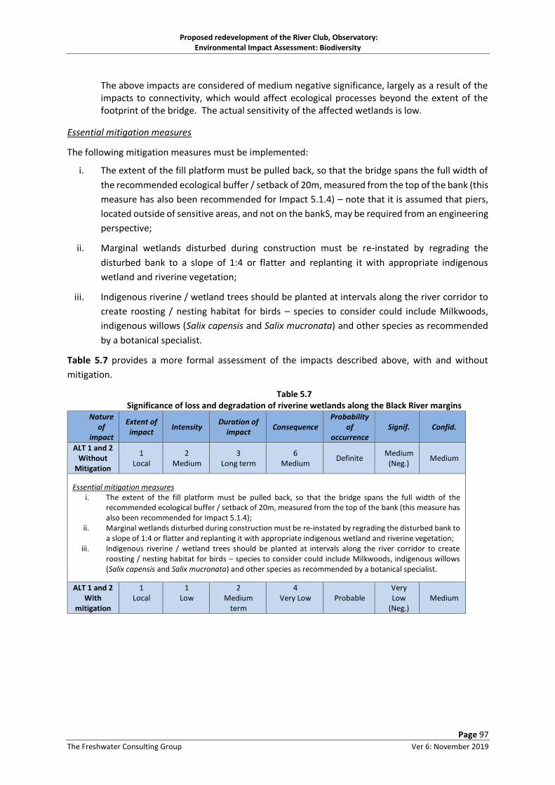
Proposed redevelopment of the River Club, Observatory: Environmental Impact Assessment: Biodiversity
Page 97
The Freshwater Consulting Group Ver 6: November 2019
The above impacts are considered of medium negative significance, largely as a result of the impacts to connectivity, which would affect ecological processes beyond the extent of the footprint of the bridge. The actual sensitivity of the affected wetlands is low.
Essential mitigation measures
The following mitigation measures must be implemented:
i. The extent of the fill platform must be pulled back, so that the bridge spans the full width of
the recommended ecological buffer / setback of 20m, measured from the top of the bank (this
measure has also been recommended for Impact 5.1.4) – note that it is assumed that piers,
located outside of sensitive areas, and not on the bankS, may be required from an engineering
perspective;
ii. Marginal wetlands disturbed during construction must be re-instated by regrading the
disturbed bank to a slope of 1:4 or flatter and replanting it with appropriate indigenous
wetland and riverine vegetation;
iii. Indigenous riverine / wetland trees should be planted at intervals along the river corridor to
create roosting / nesting habitat for birds – species to consider could include Milkwoods,
indigenous willows (Salix capensis and Salix mucronata) and other species as recommended
by a botanical specialist.
Table 5.7 provides a more formal assessment of the impacts described above, with and without
mitigation.
Table 5.7 Significance of loss and degradation of riverine wetlands along the Black River margins
Nature of
impact
Extent of impact
Intensity Duration of
impact Consequence
Probability of
occurrence Signif. Confid.
ALT 1 and 2 Without
Mitigation
1 Local
2 Medium
3 Long term
6 Medium
Definite Medium
(Neg.) Medium
Essential mitigation measures i. The extent of the fill platform must be pulled back, so that the bridge spans the full width of the
recommended ecological buffer / setback of 20m, measured from the top of the bank (this measure has also been recommended for Impact 5.1.4);
ii. Marginal wetlands disturbed during construction must be re-instated by regrading the disturbed bank to a slope of 1:4 or flatter and replanting it with appropriate indigenous wetland and riverine vegetation;
iii. Indigenous riverine / wetland trees should be planted at intervals along the river corridor to create roosting / nesting habitat for birds – species to consider could include Milkwoods, indigenous willows (Salix capensis and Salix mucronata) and other species as recommended by a botanical specialist.
ALT 1 and 2 With
mitigation
1 Local
1 Low
2 Medium
term
4 Very Low
Probable
Very Low
(Neg.)
Medium

Proposed redevelopment of the River Club, Observatory: Environmental Impact Assessment: Biodiversity
Page 98
The Freshwater Consulting Group Ver 6: November 2019
5.1.8. Loss and/or changes in wetland habitat quality and availability in the areas of the natural
Liesbeek River channel
Impact description
• Alternative 1:
The Liesbeek River channel would be filled in in this alternative, resulting in the following changes
in wetland and terrestrial habitat quality and availability:
o Loss of permanent standing water wetland habitat (some 623 m of channel length) associated with the current function of the natural Liesbeek River channel – this habitat may presently be used as a breeding area by western leopard toads and its loss without replacement is assessed as a significant impact;
o The natural channelof the Liesbeek River might also support Cape Galaxias fish, and this alternative would entail some loss of this habitat – however, rehabiloitation of the main canal would in turn provide the vegetated margins required by this species, and loss of some habitat is not considered a severe impact;
o Loss of steep earth river banks potentially used as bird nesting sites (e.g. kingfishers) on the left hand (Liesbeek Parkway side) river bank;
o Loss of wetland amelioration function for stormwater currently discharged into the channel in its upper reaches, to be piped into the lower reaches in this option;
o The creation of shallow swale wetlands (assumed to be <300mm deep) on the infilled area, with the swale discharging into the extant remaining channel downstream of the site. Thesewetlands would be likely to be seasonally inundated for short periods of time only, so allowance has been made for the creation of occasional weirs in the swales to allow longer term ponding of water to create western leopard toad breeding areas. This would also create improved wetland habitat for aquatic insects and other fauna compared to the swales without shallow weirs;
• Alternative 2:
In this alternative, the physical habitat quality and diversity of the channel would be improved
substantially, by reshaping the channel banks and planting them as wide, indigenous vegetated
wetland margins, with improved faunal accessibility in and out of the wetlands. The generous buffer
area (see Figures 4.4 and 4.6) could provide terrestrial areas for Western Leopard toads outside of
their breeding season – there would be less of such areas in this Alternative than in Alternative 1.
Essential mitigation measures
• Alternative 1:
i. Additional artificial wetland ponds, suitable for breeding in by western leopard toads
should be created – at least two such ponds are recommended, roughly sized with
diameters of around 10m. They should be excavated to lie within the summer water
table level or alternatively be lined to retain water, and should be landscaped with
gently sloped sides (1:5 or less steep) and planted with indigenous wetland vegetation
that is connected via planted landscaped swathes to the main east-west faunal
corridors, with plants utilised being indigenous species with a range of textures,
height and densities that can both provide cover and safe movement corridors. Note
that these ponds might alternatively be adapted to tie in with the proposed
stormwater attenuation ponds (Figure 4.17);

Proposed redevelopment of the River Club, Observatory: Environmental Impact Assessment: Biodiversity
Page 99
The Freshwater Consulting Group Ver 6: November 2019
ii. The faunal and wetland specialists should have input into the final sizing and design
of these ponds;
iii. A section of steep earth banks should be retained and developed to facilitate nesting
areas for bank burrowing birds – the avifaunal specialist should be consulted in this
regard – this recommendation has already been made to mitigate against risk of
mortalities to western leopard toads as a result of passage up the otherwise easily
accessible landscaped bank to the busy Liesbeek Parkway;
iv. The swale areas should be planted with appropriate locally indigenous vegetation as
recommended by the botanical and wetland specialists and ideally taking into account
recommendations for the re-establishment of patches of renosterveld, by importing
soils from disturbed renosterveld sites (e.g. quarries - see Appendix A). It is important
that areas thus planted should be linked to form, as far as possible, continuous
corridors linking to the east-west corridors, with recreational and other pathways
meandering through both these and adjacent grassed areas. Ideally, grassed areas
should be limited in this part of the site, which should aim to maximise quality toad
habitat. Artificial shelters for toads (rocks, logs) could also be included to improve
toad habitat;
• Alternative 2:
v. The wetland margins and planted buffer areas for at least 15m from the wetland edge
should be planted with appropriate locally indigenous vegetation as recommended
by the botanical and wetland specialists. It is important that areas thus planted should
be linked to form, as far as possible, continuous corridors linking to the east-west
corridors, with recreational and other pathways meandering through both these and
adjacent grassed areas.
Table 5.8 provides a more formal assessment of the impacts described above, with and without
mitigation.
Table 5.8 Significance of loss and/or changes in wetland habitat quality and availability in the areas of the
natural Liesbeek River channel Nature
of impact
Extent of impact
Intensity Duration of
impact Consequence
Probability of
occurrence Signif. Confid.
ALT 1 Without
Mitigation
1 Local
2 Medium
3 Long term Irreversible
without effort
6 Medium
Definite Medium
(Neg.) High
ALT 2 Without
Mitigation
1 Local
1 Low
3 Long term
5 Low
Probable Low
(Pos.) High
Essential mitigation measures
• Alternative 1: i. Additional artificial wetland ponds, suitable for breeding in by western leopard toads should
be created – at least two such ponds are recommended, roughly sized with diameters of around 10m. They should be excavated to lie within the summer water table level or alternatively be lined to retain water, and should be landscaped with gently sloped sides (1:5 or less steep) and planted with indigenous wetland vegetation that is connected via planted landscaped swathes to the main east-west faunal corridors, with plants utilised being indigenous species with a range of textures, height and densities that can both provide cover and safe movement

Proposed redevelopment of the River Club, Observatory: Environmental Impact Assessment: Biodiversity
Page 100
The Freshwater Consulting Group Ver 6: November 2019
corridors. Note that these ponds might alternatively be adapted to tie in with the proposed stormwater attenuation ponds (Figure 4.17);
ii. The faunal and wetland specialists should have input into the final sizing and design of these ponds;
iii. A section of steep earth banks should be retained and developed to facilitate nesting areas for bank burrowing birds – the avifaunal specialist should be approached to give details in this regard – this recommendation as already been motivated for to mitigate against risk of mortalities to western leopard toads as a result of passage up the otherwise easily accessible landscaped bank to the busy Liesbeek Parkway;
iv. The terrestrial and swale areas should be planted with appropriate locally indigenous vegetation as recommended by the botanical and wetland specialists and ideally taking into account recommendations for the re-establishment of patches of renosterveld, by importing soils from disturbed renosterveld sites (e.g. quarries - see Appendix A). It is important that areas thus panted should be linked to form, as far as possible, continuous corridors linking to the east-west corridors, with recreational and other pathways meandering through both these and adjacent grassed areas. Ideally, grassed areas should be limited in this part of the site, which should aim to maximise quality toad habitat.
• Alternative 2: v. The wetland margins and planted buffer areas for at least 15m from the wetland edge should
be planted with appropriate locally indigenous vegetation as recommended by the botanical and wetland specialists. It is important that areas thus planted should be linked to form, as far as possible, continuous corridors linking to the east-west corridors, with recreational and other pathways meandering through both these and adjacent grassed areas.
ALT 1 With
Mitigation
1 Local
1 Low
3 Long term Irreversible
without effort
5 Low
Probable Low
(Neg.) Medium
ALT 2 With
Mitigation
1 Local
1 Low
3 Long term
5 Low
Probable Low
(Pos.) Medium
5.2. Construction phase impacts
The construction phase of the proposed project is one where the risks of incurring significant damage
that will prevent the realisation of the main biodiversity objectives of this project are highest. This
section identifies and assesses the most relevant potential impacts accruing from the construction
phase.
5.2.1. Faunal fatalities (particularly western leopard toads) as a result of construction activities
The construction phase would result in the construction on and the passage of vehicles through large
areas of terrestrial habitat and in the vicinity of large areas of wetland and other watercourses. It is
inevitable that such activities will result in faunal mortalities, which without any mitigation measures
would be of medium to high negative significance, given the Endangered status of the affected
western leopard toads and the size of the impacted area.
In the event that construction occurred during adult or toadlet migration stages (i.e. around July
through to November / December respectively), the risks of mortalities (e.g. entrapment in
excavations) would be substantially higher, even though most such migrations occur only at night, and
thus after construction activity and vehicle movement would be likely to be vastly reduced.
The proposed construction approach would however be phased, which would afford opportunities to
manage construction impacts such as these. The first phase would be the construction of Berkley
Road and the road across the main ecological corridor, followed by phased construction of Precincts
1 and 2 , but noting that development funding parameters might result in non sequential development
of the phases shown in Figure 4.7.

Proposed redevelopment of the River Club, Observatory: Environmental Impact Assessment: Biodiversity
Page 101
The Freshwater Consulting Group Ver 6: November 2019
Essential mitigation measures
While avoidance of any fatalities to on-site fauna including western leopard toads is not considered
an achievable objective, minimising fatalities by a combination of search and removal and the creation
of safe refugia during construction should be aimed for. The following measures apply (reference to
phases as shown in Figure 4.7):
• Both alternatives
i. Faunal specialist to conduct search and rescue for western leopard toads (and any other small indigenous fauna encountered during this activity) prior to any on-site construction / clearing, with animals thus found being relocated temporarily to the infilled area to the north of the site, abutting the Liesbeek channel. This receiving area must be fenced off from the development site to prevent rescued toads wandering back to site – shade cloth, or windbreak fencing may be used for this purpose, provided that it is regularly inspected for damage / openings. Search and Rescue operations must be overseen by the faunal specialist, and should include record-keeping;
ii. Phase 1 road development:
a. – temporary access roads across the corridor must be raised with pipe culverts so that they don’t threaten faunal use of the corridor during construction;
b. a construction access zone of 15m on either side of the proposed road across the corridor must also be fenced off, with the connecting pipes described above protruding on either side of this fenced off area;
iii. Phase 4 ( as depicted in Figure 4.7) can commence simultaneously with Phase 1, if required, provided other mitigation requirements are met;
iv. Phase 3 construction may not commence until after rehabilitation of the Liesbeek Canal and its buffer area – this is because this zone connects to the Raapenberg wetland toad populations;
v. Commence rehabilitation of the Liesbeek Canal in the first summer after commencement and ensure landscaping is completed in March of the following year so that plants have time to establish before the start of the wet season when the river is vulnerable to erosion;
vi. After canal rehabilitation (defined by completion of initial planting at the end of the first summer after project implementation) the upper end of the planted canal zone (i.e. the top of the 1:100 year floodline) must be fenced, to prevent movement of leopard toads and other fauna into construction sites;
vii. Raapenberg wetland to be fenced off temporarily along the top of the river channel on the right hand bank prior to start of any construction on site, to prevent WLTs passing into the construction zone;
viii. Conduct bulk earthworks, installation of structures (e.g. gabion baskets) and landscaping / planting of the canal and the remnant natural Liesbeek River channel during the dry season only (between January (after Western Leopard Toadlet migration) and May (before major rains) – disturbed areas must be planted prior to the start of the wet season in each case;
ix. Landscape the main east-west recreational buffer area in direct consultation with a faunal specialist;
x. Development of Phase 3 may take place only after completion of the landscaping and planting of the north-south ecological corridor AND the “natural” channel of the Liesbeek River. At this point, the fenced off infill areas north of the site can be opened and connectivity of fauna secluded in these areas restored;

Proposed redevelopment of the River Club, Observatory: Environmental Impact Assessment: Biodiversity
Page 102
The Freshwater Consulting Group Ver 6: November 2019
xi. Infill and rehabilitate the original course of the Liesbeek River in summer, and after the establishment of the main east-west recreational buffer area and the rehabilitated canal corridor only;
xii. Landscape the ecological corridors on the northern and southern property boundaries once the respective development platforms are in place only;
xiii. The Raapenberg wetlands must be managed as a no-go area for all construction vehicles and
personnel throughout the construction period, and should be fenced off at its northern
boundary berm, with wire mesh fencing – such fencing must however include holes sized to
allow faunal passage through the fences, unless otherwise required (e.g. during
rehabilitation of the Liesbeek Canal) – holes 30cm high x 20cm wide at 5 – 10 m intervals
should be created. Alternative approaches such as use of a simple temporary pole fence,
with cross-beams could also be used, as these would allow faunal connectivity – they would
however need adaptation during periods when faunal access needed to be prevented (e.g.
during Liesbeek Canel rehabilitation works);
xiv. A detailed Construction Phase Environmental Management Programme (CEMPr) must be
drawn up, outlining inter alia the required sequence of phased activities – the details of this
plan would require careful input from the biodiversity as well as the civils and landscaping
teams. The measures included in this report as Construction Phase mitigation should be
included in such a document, which should also take cognisance of the additional measures
outlined in Section 6.
• Alternative 1:
xv. During canal rehabilitation, safe faunal connectivity between the open space north of the
site, and the natural Liesbeek channel must be maintained – this can be achieved if the areas
are fenced off together. This measure is important because it means that search and rescued
toads can at least access the natural channel of the Liesbeek River during breeding, and
potentially migrate along the Black River corridor to reach the Raapenberg wetlands;
xvi. Rehabilitation of the Black River corridor (see mitigation in Section 5.1.8) in the vicinity of
the new bridge would need to take place after rehabilitation of the canal, and after
construction of the new proposed Berkley Road bridge, after which this important corridor
would be functional;
xvii. The main east-west ecological corridor must be landscaped during summer (earthworks)
into early winter (planting phase) – commencement of landscaping of this corridor should
take place within one year of completion of landscaping of the rehabilitated Canal. The
rehabilitated corridor must tie into the natural Liesbeek channel area, but should initially be
fenced off from the area, during construction, and allowed rather to link into the
rehabilitated canal corridor, leading to the Raapenberg wetlands. Links between the open
space north of the site and the natural channel area on the site must be closed off with
fencing to prohibit toad passage through this area, prior to the start of construction activities
in the natural channel area;
xviii. Another toad search and rescue would need to take place prior to commencement of infilling
and rehabilitation of the natural Liesbeek channel, with rescued toads being placed in the
rehabilitated east-west corridor (assuming that it is adequately established) or other nearby
suitable safe refugia;

Proposed redevelopment of the River Club, Observatory: Environmental Impact Assessment: Biodiversity
Page 103
The Freshwater Consulting Group Ver 6: November 2019
xix. Infill and rehabilitation of the natural Liesbeek channel should take place in summer, once
the main corridor and rehabilitated river course have been established;
xx. Western leopard toad search and rescues must be conducted prior to construction of any
subsequent phases, with rescued animals placed in the main ecological corridor (assuming
that it is adequately established) or other nearby suitable safe refugia;
xxi. Landscaping of the remaining two minor east-west corridors across the site must take place
once the adjacent development platform is in place – again, the corridors would need search
and rescue activities;
xxii. Both the aquatic specialist and the faunal specialist should have ongoing input into planning and implementation of the construction process, and particularly the phasing of activities and the rationale for connecting and disconnecting different parts of the open space areas to ensure both protection of western leopard toads and allow their safe breeding and migration through the site. The toads would require unrestricted migration and dispersal options between breeding wetlands and shelter/foraging habitats, and protection rom vehicular traffic during the breeding season – but as long as the latter is restricted to daylight hours, this aspect would generally not be an issue (M. Burger, pers. comm.);
xxiii. Canal rehabilitation and creation of the ecological corridor must take place within the first summer after construction commences;
xxiv. Infill and rehabilitation of the natural Liesbeek channel should take place in summer, once
the main corridor and rehabilitated river course have been established, and no longer than
one wet season after completion of the canal and corridor.
• Alternative 2:
In the event that this alternative is authorised, the same activities outlined above would be required,
with the exception that rehabilitation of the natural channel should be prioritised over the minor
beautification activities required for the canal.
Table 5.9 provides a more formal assessment of the impacts described above, with and without
mitigation. The table shows that, without mitigation, both Alternatives are likely to result in fatalities
to western leopard toad populations on the site (as well as other fauna). These impacts are unlikely
to be large-scale and likely to be of medium intensity only, given the proposed phasing plans and the
fact that western leopard toads emerge mainly at night.
With mitigation, the intensity of impact can be reduced, although some level of impact remains
probable.

Proposed redevelopment of the River Club, Observatory: Environmental Impact Assessment: Biodiversity
Page 104
The Freshwater Consulting Group Ver 6: November 2019
Table 5.9 Significance of faunal fatalities (particularly western leopard toads) as a result of construction
disturbance Nature
of impact
Extent of impact
Intensity Duration of
impact Consequence
Probability of
occurrence Signif. Confid.
ALT 1 Without
Mitigation
2 Regional (because of status
of 13WLTs)
2 Medium
2 Medium term –
affecting Endangered
species
6 Medium
Probable Medium
(Neg.) Medium
ALT 2 Without
Mitigation
2 Regional (because of status of WLTs)
2 Medium
2 Medium term –
affecting Endangered
species
6 Medium
Probable Medium
(Neg.) Medium
Essential mitigation measures: Both alternatives i. Faunal specialist to conduct search and rescue for western leopard toads (and any other small
indigenous fauna encountered during this activity) prior to any on-site construction / clearing, with animals thus found being relocated temporarily to the infilled area to the north of the site, abutting the Liesbeek channel. This receiving area must be fenced off from the development site to prevent rescued toads wandering back to site – shade cloth, or windbreak fencing may be used for this purpose, provided that it is regularly inspected for damage / openings. Search and Rescue operations must be overseen by the faunal specialist, and should include record-keeping;
ii. Phase 1 road development: a. – temporary access roads across the corridor must be raised with pipe culverts so that they
don’t threaten faunal use of the corridor during construction – a construction access zone of 15m on either side of the proposed road across the corridor must also be fenced off, with the connecting pipes described above protruding on either side of this fenced off area;
iii. Phase 4 ( as depicted in Figure 4.7) can commence simultaneously with Phase 1, if required, provided other mitigation requirements are met;
iv. Phase 3 construction may not commence until after rehabilitation of the Liesbeek Canal and its buffer area – this is because this zone connects to the Raapenberg wetland toad populations;
v. Commence rehabilitation of the Liesbeek Canal in the first summer after commencement and ensure landscaping is completed in March of the following year so that plants have time to establish before the start of the wet season when the river is vulnerable to erosion
vi. After canal rehabilitation (defined by completion of initial planting at the end of the first summer after project implementation) the upper end of the planted canal zone (i.e. the top of the 1:100 year floodline) must be fenced, to prevent movement of leopard toads and other fauna into construction sites
vii. Raapenberg wetland to be fenced off temporarily along the top of the river channel on the right hand bank prior to start of any construction on site, to prevent WLTs passing into the construction zone
viii. Conduct bulk earthworks, installation of structures (e.g. gabion baskets) and landscaping / planting of the canal and the remnant natural Liesbeek River channel during the dry season only (between January (after Western Leopard Toadlet migration) and May (before major rains) – disturbed areas must be planted prior to the start of the wet season in each case;
ix. Landscape the main east-west recreational buffer area in direct consultation with a faunal specialist; x. Development of Phase 3 may take place only after completion of the landscaping and planting of the
north-south ecological corridor AND the “natural” channel of the Liesbeek River. At this point, the fenced off infill areas north of the site can be opened and connectivity of fauna secluded in these areas restored.
xi. Infill and rehabilitate the original course of the Liesbeek River in summer, and after the establishment of the main east-west recreational buffer area and the rehabilitated canal corridor only
xii. Landscape the ecological corridors on the northern and southern property boundaries once the respective development platforms are in place only
xiii. The Raapenberg wetlands must be managed as a no-go area for all construction vehicles and personnel throughout the construction period, and should be fenced off at its northern boundary berm, with wire
13 WLT = Western leopard toad

Proposed redevelopment of the River Club, Observatory: Environmental Impact Assessment: Biodiversity
Page 105
The Freshwater Consulting Group Ver 6: November 2019
mesh fencing – such fencing must however include holes sized to allow faunal passage through the fences, unless otherwise required (e.g. during rehabilitation of the Liesbeek Canal) – holes 30cm high x 20cm wide at 5 – 10 m intervals should be created. Alternative approaches such as use of a simple temporary pole fence, with cross-beams could also be used, as these would allow faunal connectivity – they would however need adaptation during periods when faunal access needed to be prevented (e.g. during Liesbeek Canel rehabilitation works);
xiv. A detailed Construction Phase Environmental Management Programme (CEMPr) must be drawn up, outlining inter alia the required sequence of phased activities – the details of this plan would require careful input from the biodiversity as well as the civils and landscaping teams. The measures included in this report as Construction Phase mitigation should be included in such a document, which should also take cognisance of the additional measures outlined in Section 6.
Alternative 1: xv. During canal rehabilitation, safe faunal connectivity between the open space north of the site, and the
natural Liesbeek channel must be maintained – this can be achieved if the areas are fenced off together. This measure is important because it means that search and rescued toads can at least access the natural channel of the Liesbeek River during breeding, and potentially migrate along the Black River corridor to reach the Raapenberg wetlands;
xvi. Rehabilitation of the Black River corridor (see mitigation in Section 5.1.8) in the vicinity of the new bridge would need to take place after rehabilitation of the canal, and after construction of the new proposed Berkley Road bridge, after which this important corridor would be functional;
xvii. The main east-west ecological corridor must be landscaped during summer (earthworks) into early winter (planting phase) – commencement of landscaping of this corridor should take place within one year of completion of landscaping of the rehabilitated Canal. The rehabilitated corridor must tie into the natural Liesbeek channel area, but should initially be fenced off from the area, during construction, and allowed rather to link into the rehabilitated canal corridor, leading to the Raapenberg wetlands. Links between the open space north of the site and the natural channel area on the site must be closed off with fencing to prohibit toad passage through this area, prior to the start of construction activities in the natural channel area;
xviii. Another toad search and rescue would need to take place prior to commencement of infilling and rehabilitation of the natural Liesbeek channel, with rescued toads being placed in the rehabilitated east-west corridor (assuming that it is adequately established) or other nearby suitable safe refugia;
xix. Infill and rehabilitation of the natural Liesbeek channel should take place in summer, once the main corridor and rehabilitated river course have been established;
xx. Western leopard toad search and rescues must be conducted prior to construction of any subsequent phases, with rescued animals placed in the main ecological corridor (assuming that it is adequately established) or other nearby suitable safe refugia;
xxi. Landscaping of the remaining two minor east-west corridors across the site must take place once the adjacent development platform is in place – again, the corridors would need search and rescue activities;
xxii. Both the aquatic specialist and the faunal specialist should have ongoing input into planning and implementation of the construction process, and particularly the phasing of activities and the rationale for connecting and disconnecting different parts of the open space areas to ensure both protection of western leopard toads and allow their safe breeding and migration through the site. The toads would require unrestricted migration and dispersal options between breeding wetlands and shelter/foraging habitats, and protection from vehicular traffic during the breeding season – but as long as the latter is restricted to daylight hours, this aspect would generally not be an issue (M. Burger, pers. comm.).
xxiii. Canal rehabilitation and creation of the ecological corridor must take place within the first summer after construction commences
xxiv. Infill and rehabilitation of the natural Liesbeek channel should take place in summer, once the main corridor and rehabilitated river course have been established, and no longer than one wet season after completion of the canal and corridor.
Alternative 2: In the event that this alternative is authorised, the same activities outlined above would be required, with the exception that rehabilitation of the natural channel should be prioritised over the minor beautification activities required for the canal.

Proposed redevelopment of the River Club, Observatory: Environmental Impact Assessment: Biodiversity
Page 106
The Freshwater Consulting Group Ver 6: November 2019
ALT 1 With
Mitigation
2 Regional (because of status
of 14WLTs)
1 Low
2 Medium term –
affecting Endangered
species
5 Low
Probable Low
(Neg.) Medium
ALT 2 With
Mitigation
2 Regional (because of status of WLTs)
1 Low
2 Medium term –
affecting Endangered
species
5 Low
Probable Low
(Neg.) Medium
5.2.2. Water quality and habitat deterioration as a result of diversion of river (Black River and
Liesbeek Canal) and wetland (natural Liesbeek channel) flows during construction
Impact description
Construction of bridges over the Black River and Liesbeek channel / landscaped swale area and
rehabilitation of the Liesbeek Canal (Alternative 1) would all require full or partial diversion of river
and (in the case of the Liesbeek channel) wetland flows. The results of flow diversion would be likely
to include the following:
• Black River impacts: localised temporary loss of riverine habitat would be likely in sections of
the river under active construction, where it is assumed that temporary coffer dams would be
created to allow works in the river to proceed. Given the temporary nature of the impact and
the degraded condition of the affected environment, the impact would be of low significance,
although the system would be vulnerable to more extensive damage in the event of high
flows;
• Liesbeek Canal impacts: wholesale diversion of flows from the Liesbeek canal is assumed to
be required during canal rehabilitation works, and during this period (likely extending over a
few weeks to months) river function in the canal area would be suspended. Given that river
function in the canal is at best limited, this impact is not considered of great significance. In
the event that construction overlaps with storm or floodflows, diversion might however be
ineffective, resulting in damage to landscaped / shaped areas and the passage of volumes of
sediment into the Black River downstream. If even medium sized flood events (0.5 - 1 year
return interval) or greater occurred in the river, the transport of volumes of sediment into the
adjacent Raapenberg wetlands could occur, resulting in degradation of this wetland as a result
of receipt of volumes of sediment. Such events would also increase sedimentation into the
Black River, increasing turbidity and increasing the extent of shallow sand bars (the latter
encourage wading birds such flamingos but have the indirect effect of increasing dredging
frequency in the channel;
• The mechanism of diversion of flows is currently undetermined, and could include diversion
and pumping at the weir, into the former Liesbeek channel, and /or piping or trenching flows
past the proposed rehabilitation course. Of these, the latter would increase flows into the
natural channel on a short term basis, potentially flushing sediment and improving aeration –
14 WLT = Western leopard toad

Proposed redevelopment of the River Club, Observatory: Environmental Impact Assessment: Biodiversity
Page 107
The Freshwater Consulting Group Ver 6: November 2019
this would only be of benefit in the lower reaches, where infilling of the habitat is not already
planned;
• Construction of the road across the open space corridor of the Liesbeek channel is currently
planned for Phase 1 of construction. However, mitigation measures outlined in Section 5.2.1
recommend infilling of the channel (Alternative 1) only after construction of the main east
west corridor and rehabilitation of the canal. Construction of the road crossing through the
channel area is thus problematic and needs to be aligned with other activities (i.e. infilling) in
the channel area.
Essential mitigation measures
The following impact mitigation measures are considered essential from an aquatic ecosystems
perspective:
i. Construction activities involving excavation into any river or canal bed and banks must be
carefully timed so as to take place in the dry season when there should be least risk of
flooding, but ideally also outside of toad migration periods – this means the ideal window
of opportunity is between December and May of any year. The timing of this could be
less restrictive in terms of western leopard toads, provided that adequate measures are
in place to 1) prevent/limit toad mortalities associated with construction activities and
vehicular traffic, 2) maintain toad migration/dispersal corridor options. The details of
such measures would need to be worked out with the faunal specialist, and could include
the creation of toadlet collection traps upslope of the excavated Liesbeek canal, from
where retrieval and relocation can take place;
ii. A comprehensive construction phasing plan must be drawn up, in collaboration with the
faunal and aquatic (river and wetlands) specialists, the civil engineering team, the design
engineers and the landscape team – this would need to be drawn up well in advance of
the start of the project, and should take into account, or effectively mitigate against, the
concerns of the biodiversity specialists;
iii. Detailed method plans for general watercourse construction and flow diversion
approaches must be prepared as part of the detailed design phase of the development,
and these should show how downstream sedimentation and/or turbidity would be
avoided in design;
iv. Allowance must be made for emergency rehabilitation of any aquatic ecosystems that are
accidentally (or otherwise) impacted as a result of flood flows – this would include the
Raapenberg wetlands, in which careful manual removal of sediment may be required
under circumstances where sedimentation from flood damage during construction is
deemed problematic by the aquatic specialist;
v. Deliberate diversion of flow from the Liesbeek canal into the Raapenberg wetlands may
not take place –15the existing channel excavated into the wetland from the canal should
ideally be infilled prior to the start of any construction activities in the canal;
15 Given that the channel lies outside of the proponent’s property and was moreover not constructed by the proponent or the River Club, its removal cannot be a requirement of this project. It is however a strong recommendation that this channel be removed / infilled

Proposed redevelopment of the River Club, Observatory: Environmental Impact Assessment: Biodiversity
Page 108
The Freshwater Consulting Group Ver 6: November 2019
vi. Early establishment of a good quality of plant cover (80% cover by end of first year, with
a high diversity of indigenous plant species, as selected in collaboration with the botanical
and aquatic specialists) is essential in all landscaped open space areas, and particularly so
for those prone to erosion (e.g. wet season channel and edge of low flow channel in the
rehabilitated canal and landscaped swale (Alternative 1) or the remediated Liesbeek
channel (Alternative 2);
vii. Construction of the culverted road crossing over the landscaped swale should be timed to
synchronise with other landscape and construction activities in this area (see Section 5.2.1
mitigation).
Table 5.10 provides a more formal assessment of the impacts described above, with and without
mitigation.
Table 5.10 Significance of water quality and habitat deterioration as a result of diversion of river (Black River
and Liesbeek Canal) and wetland (natural Liesbeek channel) flows during construction Nature
of impact
Extent of impact
Intensity Duration of
impact Consequence
Probability of
occurrence Signif. Confid.
ALT 1 Without
Mitigation
1 Local
2 Medium
1 Short term
4 Very low
Probable Very low
(Neg.) Medium
ALT 2 Without
Mitigation
1 Local
1 Low
1 Short term
3 Very low
Probable Very low
(Neg.) Medium
Essential mitigation measures i. Construction activities involving excavation into any river or canal bed and banks must be carefully
timed so as to take place in the dry season when there should be least risk of flooding, but ideally also outside of toad migration periods – this means the ideal window of opportunity is between December and May of any year. The timing of this could be less restrictive in terms of western leopard toads, provided that adequate measures are in place to 1) prevent/limit toad mortalities associated with construction activities and vehicular traffic and 2) maintain toad migration/dispersal corridor options. The details of such measures would need to be worked out with the faunal specialist, and could include the creation of toadlet collection traps upslope of the excavated Liesbeek canal, from where retrieval and relocation can take place;
ii. A comprehensive construction phasing plan must be drawn up, in collaboration with the faunal and aquatic (river and wetlands) specialists, the civil engineering team, the design engineers and the landscape team – this would need to be drawn up well in advance of the start of the project, and should take into account, or effectively mitigate against, the concerns of the biodiversity specialists;
iii. Detailed method plans for general watercourse construction and flow diversion approaches must be prepared as part of the detailed design phase of the development, and these should show how downstream sedimentation and/or turbidity would be avoided in design;
iv. Allowance must be made for emergency rehabilitation of any aquatic ecosystems that are accidentally (or otherwise) impacted as a result of flood flows – this would include the Raapenberg wetlands, in which careful manual removal of sediment may be required under circumstances where sedimentation from flood damage during construction is deemed problematic by the aquatic specialist;
v. Deliberate diversion of flow from the Liesbeek canal may not take place into the Raapenberg wetlands. The existing channel excavated into the wetland from the canal should ideally also be infilled prior to the start of any construction activities in the canal;
vi. Early establishment of a good quality of plant cover (80% cover by end of first year, with a high diversity of indigenous plant species, as selected in collaboration with the botanical and aquatic specialists) is essential in all landscaped open space areas, and particularly so for those prone to erosion (e.g. wet season channel and edge of low flow channel in the rehabilitated canal and landscaped swale (Alternative 1) or the remediated Liesbeek channel (Alternative 2);
vii. Construction of the culverted road crossing over the landscaped swale should be timed to synchronise with other landscape and construction activities in this area (see Section 5.2.1 mitigation).

Proposed redevelopment of the River Club, Observatory: Environmental Impact Assessment: Biodiversity
Page 109
The Freshwater Consulting Group Ver 6: November 2019
ALT 1 With
Mitigation
1 Local
1 Low
1 Short term
3 Very low
Probable Very low
(Neg.) High
ALT 2 With
Mitigation
1 Local
1 Low
1 Short term
3 Very low
Probable Very low
(Neg.) High
5.2.3. Degradation of downstream habitat in the Liesbeek Canal, lower natural Liesbeek channel
and Black River resulting from activities other than flow diversion
Impact description
Intensive construction activities involving the large-scale, medium term, intensive construction of the
proposed River Club site is realistically likely to result, at least at times, in visible degradation of the
adjacent Black River, Liesbeek canal and natural Liesbeek channel, including any of the following:
• Sedimentation of downstream areas – particularly during dewatering and site excavation activities;
• Passage of cementitious water / sediments into downstream areas – where this results in raising of river water pH, increased ammonia toxicity might occur, given that the Black River tends towards elevated total ammonia concentrations, the toxic (un-ionised ammonia) proportion of which increases with increasing pH, particularly in the pH range > pH=8;
• Other construction-related pollutants including spills of fuels, oils and other materials into the river;
• Physical disturbance of marginal bank habitat as a result of the passage of vehicles through or in proximity of these areas – the Black River wetlands would be vulnerable to such impacts, as would (possibly) the adjacent Raapenberg wetlands;
• Passage of litter and solid waste from the construction site into the river channels;
• Runoff from stockpiles and storage areas into adjacent aquatic ecosystems;
• Erosion of disturbed areas and loss of plants, affecting the intended outcomes of the project, as a result of floods and/or heavy rainfall events during construction phase activities involving earthworks, shaping, early planting or other construction in any of the watercourses.
Essential mitigation measures
i. The detailed Construction Phase Environmental Management Programme (CEMPr) (already
recommended as mitigation) must include measures that:
a. Limit the placement and management of stockpiles and storage areas to areas where
it is not vulnerable to water- or wind-transport into aquatic ecosystems;
b. Define areas for the storage of vehicles, fuel and other building materials within the
development platforms – no stockpile or storage areas are to be allowed within 20m
of the outer edge of any designated buffer area or ecological corridor – the only
exception to the above would be the temporary stockpiling of topsoil, mulch and
plants specifically required for the landscaping of these areas;
c. Include requirements for bunding of fuel storage areas;
d. Specify areas where concrete / cement can be safely stored and / or mixed, in phase
with different development phases on the site;
e. Include temporary sediment stilling ponds on flow pathways from the development
platform;

Proposed redevelopment of the River Club, Observatory: Environmental Impact Assessment: Biodiversity
Page 110
The Freshwater Consulting Group Ver 6: November 2019
f. Outline construction platform access roads, so that ecological corridors and sensitive
areas are not disturbed – access road should be clearly demarcated on site;
ii. Ecological corridors, designated buffer areas and other sensitive areas (e.g. the edge of the
Raapenberg wetlands abutting the site) must be clearly demarcated as no go areas prior to
the start of construction;
iii. The timing of all works involving active disturbance of river beds and /or banks should be
such that the active works take place in the dry season months as far as possible. This will
reduce but not avoid the possibility of damage from floods.
iv. Allowance must be made in project contingency planning for the high likelihood that planted
/ newly landscaped areas might require re-doing, in the event of significant flooding.
v. Allowance must be made for the rehabilitation of any disturbed areas that are part of the
ecological buffers or corridors;
vi. An adequate waste management programme must be developed and implemented,
allowing for regular collection of litter and other waste on site, the provision and
management of adequate temporary toilets on site and the removal and legal disposal of
building waste (e.g. removed sections of the Liesbeek Canal).
Table 5.11 provides a more formal assessment of the impacts described above, with and without
mitigation.
Table 5.11 Significance of Degradation of downstream habitat in the Liesbeek Canal, lower natural Liesbeek
channel and Black River from activities other than flow diversion
Nature of
impact
Extent of impact
Intensity Duration of
impact Consequence
Probability of
occurrence Signif. Confid.
Both Alternatives
Without Mitigation
1 Local
3 High
2 Medium
term
6 Medium
Probable Medium
(Neg.) Medium
Essential mitigation measures: Both Alternatives
i. The detailed Construction Phase Environmental Management Programme (CEMPr) (already recommended as mitigation) must include measures that:
a. Limit the placement and management of stockpiles and storage areas to areas where it is not vulnerable to water- or wind-transport into aquatic ecosystems;
b. Define areas for the storage of vehicles, fuel and other building materials within the development platforms – no stockpile or storage areas are to be allowed within 20m of the outer edge of any designated buffer area or ecological corridor – the only exception to the above would be the temporary stockpiling of topsoil, mulch and plants specifically required for the landscaping of these areas;
c. Include requirements for bunding of fuel storage areas; d. Specify areas where concrete / cement can be safely stored and / or mixed, in phase with
different development phases on the site; e. Include temporary sediment stilling ponds on flow pathways from the development platform; f. Outline construction platform access roads, so that ecological corridors and sensitive areas are
not disturbed – access road should be clearly demarcated on site; ii. Ecological corridors, designated buffer areas and other sensitive areas (e.g. the edge of the Raapenberg
wetlands abutting the site) must be clearly demarcated as no go areas prior to the start of construction; iii. The timing of all works involving active disturbance of river beds and /or banks should be such that the
active works take place in the dry season months as far as possible. This will reduce but not avoid the possibility of damage from floods.

Proposed redevelopment of the River Club, Observatory: Environmental Impact Assessment: Biodiversity
Page 111
The Freshwater Consulting Group Ver 6: November 2019
iv. Allowance must be made in project contingency planning for the high likelihood that planted / newly landscaped areas might require re-doing, in the event of significant flooding.
v. Allowance must be made for the rehabilitation of any disturbed areas that are part of the ecological buffers or corridors;
vi. An adequate waste management programme must be developed and implemented, allowing for regular collection of litter and other waste on site, the provision and management of adequate temporary toilets on site and the removal and legal disposal of building waste (e.g. removed sections of the Liesbeek Canal).
Both Alternatives
With Mitigation
1 Local
1 Low
2 Medium
term
4 Very Low
Probable Very Low
(Neg.) Medium
5.2.4. Disturbance of watercourse bed and banks during infrastructure installation
The proposed development includes sewers, potable water pipelines and likely various
telecommunication and electricity cabling etc. None of these would however be passed directly into
the (rehabilitated) Liesbeek canal or the Black River, but some have been shown (see Section 4) as
passing under or through the landscaped swale / natural Liesbeek channel area.
Passage of services through this area, assuming this happening after infilling and landscaping
(Alternative 1) or after landscaping (Alternative 2) would result in localised, short term disturbance of
aquatic and other habitats with low sensitivity to disturbance. The significance of these impacts
would be low.
Mitigation measures
Best practice measures would need to include rehabilitation of areas disturbed by excavation and
services installation, to pre-disturbance levels or better.
Table 5.12 provides a more formal assessment of the impacts described above, with and without
mitigation.
Table 5.12 Significance of Disturbance of watercourse bed and banks during infrastructure installation
Nature
of impact
Extent of impact
Intensity Duration of
impact Consequence
Probability of
occurrence Signif. Confid.
Both Alternatives
Without Mitigation
1 Local
2 Medium
1 Short term
4 Very Low
Probable Very Low
(Neg.) Medium
Best practice measures Both Alternatives Best practice measures would need to include rehabilitation of areas disturbed by excavation and services installation, to pre-disturbance levels or better.
Both Alternatives
Without Mitigation
1 Local
1 Low
1 Short term
3 Very Low
Probable Very Low
(Neg.) High

Proposed redevelopment of the River Club, Observatory: Environmental Impact Assessment: Biodiversity
Page 112
The Freshwater Consulting Group Ver 6: November 2019
5.3. Operational phase impacts
This section identifies and assesses key operational phase impacts on biodiversity and aquatic
ecosystem functioning that could affect the capacity of the implemented alternative to meet its
expected long-term biodiversity and/or aquatic ecosystem functional objectives.
5.3.1. Degradation of habitat quality or failure to realise opportunities for improved habitat
quality and biodiversity conservation / improvement as a result of inadequate or ill-
advised channel and open space maintenance activities
Problematic maintenance measures would include any of the following activities or outcomes:
• Long-term simplification of planted vegetation swathes through the main ecological corridor
• Grassing the minor (or major) ecological corridors, instead of planting with vertically diverse shrubs and other indigenous vegetation minor (or major)
• Allowing faunal culverts to block, over-grow or be cut off from their linking corridors by waste, vegetation or development edge expansion;
• Expansion of grassed areas into the riverine corridor at the expense of areas of indigenous riverine plantings;
• Re-landscaping / disruption to connecting landscaped swathes intended to provide longitudinal cover and habitat to western leopard toads and other indigenous fauna (e.g. chameleons) – as a guideline, at least 40% of the main ecological corridor should be managed as indigenous planted corridor habitat, without lawn or pathways (see Section 5.1.4 mitigation);
• Encroachment of development activities / impacts into the riverine and landscaped swale (Alternative 1) or remediated Liesbeek channel (Alternative 2) and/or the ecological corridors – examples of encroachment would include increased hardening of these areas, and the establishment of additional paved seating areas or the construction of fences within or through buffer areas;
• Incision and channelization of the low flow channel in the rehabilitated Liesbeek canal as a result of mechanical excavation / removal of reeds and/or sediments from the low flow channel
• Inadequate attention to the ongoing need for removal of alien and other weedy plant species, particularly from recently disturbed / newly established areas. Invasion of river margins by Commelina benghalensis and /or purple loose-strife is a significant risk to the long-term establishment of high quality riverine habitats, and there is a plethora of other alien plants (e.g. nasturtium, morning glory, various woody aliens), that would establish in these areas unless specifically managed. Invasion of the river channel by water hyacinth (Eicchornia crassipes) is also a reality that must be managed on an ongoing basis;
• Access to sensitive areas by increased numbers of people – e.g. Raapenberg wetlands. This impact is unlikely, as the wetland would be separated from the development by the rehabilitated canal (Alternative 1) or the canal (Alternative 2). In the former case, it is however possible that, during low flows, increased informal access to the wetlands could take place, in which case there would be an increase in disturbance of wetland birds, as well as increased trampling and general wetland disturbance;
• Increased disturbance to natural habitats and predation / disturbance of indigenous fauna as a result of increased numbers of domestic dogs and cats in residential and /or recreational areas of the development.
Essential mitigation measures
The following mitigation measures must be applied:
Proposed redevelopment of the River Club, Observatory: Environmental Impact Assessment: Biodiversity
Page 113
The Freshwater Consulting Group Ver 6: November 2019
i. An Operational Phase Environmental Management Programme (OEMPr) must be compiled and used as the framework against which long-term management activities on the future development are planned and implemented;
ii. The OEMPr should draw information and specifications inter alia from the present report; iii. The OEMPr must be compiled inter alia so as to reflect clearly:
a. the ecological / biodiversity issues and objectives inherent in the design and layout of the development;
b. the location, extent and role in the development of ecological corridors, ecological buffer areas and the Liesbeek canal, natural channel / landscaped swale;
c. the sensitivities of these areas; d. the management objectives for all of the above areas; e. acceptable and unacceptable uses and activities in and around these areas;
iv. The OEMPr should include monitoring recommendations (see Section 8); v. The OEMPr should be finalised on completion of the development, but its basis should be
the ecological planning and layout inputs that have informed this assessment; vi. The additional design and implementation measures outlined in Section 6 must be
implemented; vii. The OEMPr should include a detailed annotated plan of the development area, clearly
indicating the position, dimensions and management objectives of the above listed areas; viii. During the detailed design phase of the development, the OEMPr should be reformulated
(with input from the aquatic ecologist and faunal specialist) into a detailed Property Owner Association (or similar designation) Management Guideline, that is legally compliant and that includes clear method statements regarding ecologically acceptable approaches to addressing the following issues, including timing, frequency, methods, and no-go approaches:
a. Clearing of reeds from the low flow channel i. Such activities should always require clearance from an aquatic ecologist
as to need and desirability ii. Reed clearing should be carried out manually in late summer / autumn
and should entail only cutting of reeds close to the ground – just above water level;
iii. Clearing of narrow longitudinal channels should not be permitted, as this would encourage channelization and incision – rather, reeds should be cut across the fill width of the channel – in 10m wide swathes, separated by river lengths of 20-30m if cutting the whole river channel is not feasible; such swathes could be alternated in different sections of the channel in subsequent years;
iv. Cleared reeds should be removed from the channel b. Clearing of water hyacinth from the channel
i. Ideally, removal of this weed should take place at a catchment level – this was achieved by the City in the Lotus River / Zeekovlei catchment with major success, and could be achieved with effort in the Black River / Liesbeek catchment;
ii. Within the river reaches past the River Club site, clearing of hyacinth would need to be managed using manual labour and without intrusion by excavators or other machinery likely to disturb / destroy the landscaped gently graded river margins. Such measures would need to be undertaken in low flow conditions only, when there is safe access into the channel. Although there should be flexibility about the actual removal method, to allow for innovative approaches, water hyacinth could be

Proposed redevelopment of the River Club, Observatory: Environmental Impact Assessment: Biodiversity
Page 114
The Freshwater Consulting Group Ver 6: November 2019
floated up- or downstream in the channel to a single point where there is access from the side, for the collection and removal of the weed. Flotation into the Black River and collection from there could also be considered;
c. Clearing of sediment build-up in the channel i. Sediment removal should not take place more frequently than every five
years, and then only when necessary because of significant loss of channel capacity;
ii. If sediment is cleared, it could be removed mechanically, but the design profile of the channel must be restored, and cleared areas replanted with appropriate indigenous riverine and wetland vegetation, as per the original construction programme;
iii. Sediment clearing may only take place with approval from a river specialist;
d. Maintenance requirements and management objectives for faunal culverts; e. Rules and guidelines around the use and management of buffer areas and
ecological corridors; f. Design guidelines for open space areas, indicating clearly requirements for
ecological connectivity to be created by indigenous planting templates, the extent of such areas required and appropriate access by humans into these areas;
g. Information regarding the design and function of toad barriers; h. Guidelines for the removal of key invasive alien plant species – these would
require updating as new species emerged and new control methods (e.g. biocontrols) are developed –approaches for the control of purple loose strife are outlined in Box 3.1, for information;
i. Access control guidelines should be included, and should consider the need for access to the Raapenberg wetlands to be controlled, while ad hoc access across the Liesbeek canal should ideally not be permitted. This said, the recommendations by the avifaunal specialist (Appendix D) regarding the social, educational and possible conservation benefits of linking urban developments to urban wildfowl areas should be considered. Opportunities to install bird hides and improve on-site bird habitat quality (e.g. perching trees) should be encouraged;
j. Requirements to increase the accessibility of the Raapenberg wetlands for an increased local human population / community would need to be carefully considered, and in the short term it is recommended that the wetland should be protected from such access by a permeable fence, that allowed for the passage of small wetland and wetland-associated fauna (toads, otters, porcupines) through gaps in the fencing, while limiting uncontrolled human access, as well as access by dogs;
k. Given the proximity of the development to a bird sanctuary and breeding areas for endangered fauna, the keeping and exercising of dogs in open spaces should be controlled, so that disturbance to natural fauna and habitats as a result of increased use of these open spaces does not occur. The keeping of cats should ideally be discouraged;
ix. Both the faunal specialist and the aquatic ecologist involved in the evolution of the development layouts assessed in this document should have input into the final OEMPr and the Property Owner Association Management Guideline, to ensure that the intention of the original design is carried through in long-term management;

Proposed redevelopment of the River Club, Observatory: Environmental Impact Assessment: Biodiversity
Page 115
The Freshwater Consulting Group Ver 6: November 2019
x. Allowance must be made for adequate financial and human resources input into the long-term management of open spaces including ecological corridors and recreational and ecological buffer areas, as well as aquatic ecosystems, on a sustainable basis;
xi. The site should be audited at two to three year intervals, to determine the degree to which the design and management objectives of the development from an ecological perspective are being met. Data collected during ongoing monitoring (as recommended in Section 8) should inform these audits, and recommendations for changes in ongoing development management from an ecological perspective.
Table 5.13 provides a more formal assessment of the impacts described above, with and without
mitigation. Arguably, the impacts with mitigation could be viewed as positive compared to present
day levels of function – however, given the scale of development and the inherent risks associated
with long term management, the impacts have been conservatively assessed rather as ”Not
Significant”, with the positive aspects of development already rated in terms of Design (Section 5.1.1).

Proposed redevelopment of the River Club, Observatory: Environmental Impact Assessment: Biodiversity
Page 116
The Freshwater Consulting Group Ver 6: November 2019
Table 5.13 Degradation of habitat quality or failure to realise opportunities for improved habitat quality and biodiversity conservation / improvement as a result of inadequate or ill-advised channel and open
space maintenance activities Nature
of impact
Extent of impact
Intensity Duration of
impact Consequence
Probability of
occurrence Signif. Confid.
Both Alternatives
Without Mitigation
1 Local
2 Medium
3 Long term
6 Medium
Probable Medium
(Neg.) Medium
Essential mitigation measures The following mitigation measures must be applied: xii. An Operational Phase Environmental Management Programme (OEMPr) must be compiled and used as the
framework against which long-term management activities on the future development are planned and implemented;
xiii. The OEMPr should draw information and specifications inter alia from this report; xiv. The OEMPr must be compiled inter alia so as to reflect clearly:
a. the ecological / biodiversity issues and objectives inherent in the design and layout of the development;
b. the location, extent and role in the development of ecological corridors, ecological buffer areas and the Liesbeek canal, natural channel / landscaped swale;
c. the sensitivities of these areas; d. the management objectives for all of the above areas; e. acceptable and unacceptable uses and activities in and around these areas;
xv. The OEMPr should include monitoring recommendations (see Section 8); xvi. The OEMPr should be finalised on completion of the development, but its basis should be the ecological
planning and layout inputs that have informed this assessment; xvii. The additional design and implementation measures outlined in Section 6 must be implemented; xviii. The OEMPr should include a detailed annotated plan of the development area, clearly indicating the position,
dimensions and management objectives of the above listed areas; xix. During the detailed design phase of the development, the OEMPr should be reformulated (with input from
the aquatic ecologist and faunal specialist) into a detailed Property Owner Association (or similar designation) Management Guideline, that is legally compliant and that includes clear method statements regarding ecologically acceptable approaches to addressing the following issues, including timing, frequency, methods, and no-go approaches:
a. Clearing of reeds from the low flow channel i. Such activities should always require clearance from an aquatic ecologist as to need
and desirability ii. Reed clearing should be carried out manually in late summer / autumn and should
entail only cutting of reeds close to the ground – just above water level; iii. Clearing of narrow longitudinal channels should not be permitted, as this would
encourage channelization and incision – rather, reeds should be cut across the fill width of the channel – in 10m wide swathes, separated by river lengths of 20-30m if cutting the whole river channel is not feasible; such swathes could be alternated in different sections of the channel in subsequent years;
iv. Cleared reeds should be removed from the channel b. Clearing of sediment build-up in the channel
i. Sediment removal should not take place more frequently than every five years, and then only when necessary because of significant loss of channel capacity;
ii. If sediment is cleared, it could be removed mechanically, but the design profile of the channel must be restored, and cleared areas replanted with appropriate indigenous riverine and wetland vegetation, as per the original construction programme;
iii. Sediment clearing may only take place with approval from a river specialist; c. Maintenance requirements and management objectives for faunal culverts; d. Rules and guidelines around the use and management of buffer areas and ecological corridors; e. Design guidelines for open space areas, indicating clearly requirements for ecological
connectivity to be created by indigenous planting templates, the extent of such areas required and appropriate access by humans into these areas;
f. Information regarding the design and function of toad barriers;

Proposed redevelopment of the River Club, Observatory: Environmental Impact Assessment: Biodiversity
Page 117
The Freshwater Consulting Group Ver 6: November 2019
g. Guidelines for the removal of key invasive alien plant species – these would require updating as new species emerged and new control methods (e.g. biocontrols) are developed –approaches for the control of purple loose strife are outlined in Box 3.1, for information;
h. Access control guidelines should be included, and should consider the need for access to the Raapenberg wetlands to be controlled, while ad hoc access across the Liesbeek canal should ideally not be permitted. This said, the recommendations by the avifaunal specialist (Appendix D) regarding the social, educational and possible conservation benefits of linking urban developments to urban wildfowl areas should be considered. Opportunities to install bird hides and improve on-site bird habitat quality (e.g. perching trees) should be encouraged;
i. Requirements to increase the accessibility of the Raapenberg wetlands for an increased local human population / community would need to be carefully considered, and in the short term it is recommended that the wetland should be protected from such access by a permeable fence, that allowed for the passage of small wetland and wetland-associated fauna (toads, otters, porcupines) through gaps in the fencing, while limiting uncontrolled human access, as well as access by dogs;
j. Given the proximity of the development to a bird sanctuary and breeding areas for endangered fauna, thekeeping and exercising of dogs in open spaces should be controlled, so that disturbance to natural fauna and habitats as a result of increased use of these open spaces does not occur;
xx. Both the faunal specialist and the aquatic ecologist involved in the evolution of the development layouts assessed in this document should have input into the final OEMPr and the Property Owner Association Management Guideline, to ensure that the intention of the original design is carried through in long-term management;
xxi. Allowance must be made for adequate financial and human resources input into the long-term management of open spaces including ecological corridors and recreational and ecological buffer areas, as well as aquatic ecosystems, on a sustainable basis;
a. The site should be audited at two to three year intervals, to determine the degree to which the design and management objectives of the development from an ecological perspective are being met. Data collected during ongoing monitoring (as recommended in Section 8) should inform these audits, and recommendations for changes in ongoing development management from an ecological perspective.
Both Alternatives
With Mitigation
1 Local
0.5 Very Low
3 Long term
4.5 Low to Very
Low Possible
Insignificant to Very low
(Neg.) Medium
5.3.2. Contribution to deterioration of water quality in the Liesbeek and Black Rivers
Such impacts could be as a result of:
• Pollution of aquatic ecosystems as a result of sewage overflows / leakage: Either of the proposed developments would entail a large-scale increase in sewage loading from this area to the Athlone waste water treatment works, and the associated long-term risk that, at least at times, sewage spills / leakages into the adjacent aquatic ecosystems, either directly or via stormwater runoff, would occur. The development design has however attempted to minimise such risks, through the location of its pump stations in plenum chambers in the basements. Moreover, the new sewer mains from the development would cross through the landscaped swale (Alternative 1) or remediated Liesbeek channel, but not across the Liesbeek canal or Black River, other than in an existing pipeline. These measures should reduce the frequency of impact, as well as the sensitivity of the receiving environment. Nevertheless, when sewage spills do occur, they would be most likely to affect the low-lying main east-west ecological corridor and the swales and artificial wetland ponds in the landscaped swale area (Alternative 1) and the Liesbeek channel (Alternative 2), resulting in the following impacts:
o Nutrient enrichment and organic loading, leading to high biological oxygen demands and potentially resulting in oxygen stress to sensitive aquatic organisms, particularly in hot weather conditions;
o Bacterial contamination of open space areas with aesthetic and human health effects;
• Seepage or runoff from fertilised gardens / open space areas;

Proposed redevelopment of the River Club, Observatory: Environmental Impact Assessment: Biodiversity
Page 118
The Freshwater Consulting Group Ver 6: November 2019
• Stormwater runoff polluted with heavy metals and hydrocarbons from roads and parking areas, as well as from illegal waste discharges into stormwater systems – Aurecon (2017b) outlines however a stormwater management plan that includes the passing stormwater from low flows through stormwater swales and/or enhanced bioretention systems, and into a series of wet ponds located in open space areas;
• Irrigation of private and public open spaces with treated sewage effluent;
• Irrigation of private and public open spaces with domestic grey water;
• Discharges of chlorinated or salt water from swimming pools – chlorine from pool water discharges forms conservative, highly toxic chloramines in water with elevated ammonia concentrations (such as the Black River at times).
Sustained low-level pollution from the above sources would potentially contribute to ongoing eutrophication of the lower Liesbeek River and natural channel downstream of the development, encouraging the growth of aquatic weeds and other vegetation and indirectly increasing the need for maintenance measures associated with high levels of aquatic ecosystem disturbance. While the Black River would show low sensitivity to such impacts, given its current high levels of nutrient concentrations, the discharge of additional pollutants into the river runs counter to the urgent need to improve water quality in this system to more ecologically sustainable levels (i.e. PES Category D or better). Periodic high flows of contaminated water that enter water courses could result in episodes of acute toxicity – such inflows would however be most likely to be associated with sewage leaks / overflows, unless they stemmed from illegal discharges of seriously contaminated water. IN the case of the former, preventative design mitigation measures have already been implemented as far as possible to address and contain pump failure impacts at source, and large scale overflows are considered possible but unlikely to occur at a level where they will cause ecosystem failure.
Essential mitigation measures
i. Treated sewage water should not be used as a source of irrigation water, unless additional
treatment occurs to reduce phosphorus and total ammonia concentrations;
ii. Sewer manholes in all open space areas should be readily visible, so that overflows can be
easily detected and reported.
iii. If greywater irrigation is used, it should not be used within any of the riverine corridor buffer
areas, which are intended to actively protect adjacent watercourses form development-
related impacts;
iv. Swimming pool effluent, if any, must be passed into the sewers and not discharged of
overland, into the water table or into the greywater or stormwater systems;
v. Landscaping of all open space areas and private gardens must use indigenous, waterwise
plants. The planted riverine corridor (Alternative 1) or remediated Liesbeek channel
(Alternative 2) must be planted such that, after the initial establishment phase, irrigation of
planted areas other than lawns is not required – the extent of lawns must be limited as far
as possible to reduce water demand.
Table 5.14 provides a more formal assessment of the impacts described above, with and without
mitigation.

Proposed redevelopment of the River Club, Observatory: Environmental Impact Assessment: Biodiversity
Page 119
The Freshwater Consulting Group Ver 6: November 2019
Table 5.14 Significance of the contribution to the deterioration of water quality in the Liesbeek and Black
Rivers Nature
of impact
Extent of impact
Intensity Duration of
impact Consequence
Probability of
occurrence Signif. Confid.
Both Alternatives
Without Mitigation
1 Local
2 Medium
3 Long term
6 Medium
Probable Medium
(Neg.) Medium
Essential mitigation measures i. Treated sewage water should not be used as a source of irrigation water, unless additional
treatment occurs to reduce phosphorus and total ammonia concentrations; ii. Sewer manholes in all open space areas should be readily visible, so that overflows can be
easily detected and reported. iii. If greywater irrigation is used, it should not be used within any of the riverine corridor buffer
areas, which are intended to actively protect adjacent watercourses form development-related impacts;
iv. Swimming pool effluent, if any, must be passed into the sewers and not discharged of overland, into the water table or into the greywater or stormwater systems;
v. Landscaping of all open space areas and private gardens must use indigenous, waterwise plants. The planted riverine corridor (Alternative 1) or remediated Liesbeek channel (Alternative 2) must be planted such that, after the initial establishment phase, irrigation of planted areas other than lawns is not required – the extent of lawns must be limited as far as possible to reduce water demand.
Both Alternatives
With Mitigation
1 Local
1 Low
3 Long term
5 Low
Probable Low
(Neg.) Medium
5.4. Cumulative impacts
The cumulative effects of development of the River Club site are probably best assessed with regard
to the proposed Two Rivers Urban Park (TRUP) development, which could potentially result in further
loss of open space in the broader TRUP area. This could mean that impacts such as loss of terrestrial
non breeding habitat for western leopard toads could increase in the future making the loss of
terrestrial habitat on the current site more significant. Given the current low quality of such habitat
from a faunal perspective, this point is however debatable, particularly in the context of the
improvement in terrestrial habitat quality aimed at in the landscaping and management of the
ecological corridors through the site. Moreover, in the context of ongoing development, from an
aquatic ecosystems perspective, the proposed development of Alternative 1 would include a
significant positive impact in the form of rehabilitation of a long-canalised river reach. Such
improvements in aquatic ecosystem function and ecological connectivity could offset cumulative
impacts of development in adjacent open space areas.
Increasing development of the surrounding area (e.g. increased traffic including from the planned SKA
office) could arguably also increase pressures on western leopard toads by increasing mortalities on
migrating toads southwards, across Observatory Road and into the open spaces associated with
Valkenberg and the Liesbeek Lake area.
An important strategic means of mitigating such impacts would be for the installation of a wide
pipeline to allow the movement of western leopard toads south, into the open space of Liesbeek Lake
and Valkenberg. Authorities charged with authorising new developments in the area should also be

Proposed redevelopment of the River Club, Observatory: Environmental Impact Assessment: Biodiversity
Page 120
The Freshwater Consulting Group Ver 6: November 2019
cognisant of such cumulative impacts and ensure that such concerns are adequately addressed in
adjacent site development conditions of authorisation, including provision of safe migratory corridors
under roads, and in (ideally) the expansion of the rehabilitated Liesbeek Canal all the way past the SKA
site, as far as Observatory Road.
Impacts associated with the no-development alternative
In the event that the development proposals considered in this report did not take place, it is
assumed that the following factors would be in place:
• The Liesbeek Canal would remain in situ – but would be likely to require repair in the near
future;
• The (natural) Liesbeek channel would remain in situ, and would continue to convey
stormwater into the Black River. Ongoing removal of alien vegetation (e.g. water hyacinth)
would be required, but the channel might provide breeding habitat to western leopard
toads;
• The terrestrial open spaces of the River Club would remain undeveloped and potentially
available as non-breeding habitat for Western Leopard toads – however, ongoing activities
associated with the driving range (e.g. mechanical ball collection and mowing) would
continue to hamper the ecological wellbeing of this species as would physical barriers to
migration such as the Liesbeek Canal.
The main negative impact associated with the no-development alternative would be the lost
opportunity to rehabilitate the Liesbeek Canal. Without development funding, it is extremely unlikely
that this bold approach would ever be affordable.
5.5. Summary of impacts from a biodiversity perspective
This section provides a brief overview of the changes / losses / impacts to natural ecosystems as a
result of implementation of the proposed project alternatives. The information presented here is
intended to inform specific aspects of the NEMA EIA information requirements.
Table 5.15 provides coarse comparisons of changes in different open space / natural areas on the site
in each of the development alternatives. Loss of terrestrial habitat is over-estimated, because it
assumes that the site is currently undeveloped. This issue is not important, as the table clearly shows
that no terrestrial habitat on the site has conservation value (i.e. not rated as terrestrial Critical
Biodiversity Areas (CBAs) or Ecological Support Areas (ESAs)).

Proposed redevelopment of the River Club, Observatory: Environmental Impact Assessment: Biodiversity
Page 121
The Freshwater Consulting Group Ver 6: November 2019
Table 5.15 Summary of impacts from a biodiversity perspective. Areas calculated from development layout
polygons, overlaid into http://www.earthpoint.us/Shapes.aspx. Areas approximated from GOOGLE images only.
Impact Alternative 1 (ha) Alternative 2 (ha) No development alternative (ha)
Loss of terrestrial habitat 8.8 8.8 0
Loss of terrestrial CBA 0 0 0
Loss of terrestrial ESAs 0 0 0
Loss of wetland habitat (TRUP Conservation area)
2.25 0 0
Coarse estimate of areas for rehabilitation of terrestrial, riverine and wetland areas (including some grassed areas)
6.6 (includes riverine corridor with wetland
margins, main east west corridor and swale with
artificial wetlands)
4.3 (mostly wetland and terrestrial areas; no
riverine rehabilitation)
0
Loss of wetland CBAs 0 0 0
Loss of wetland ESAs 0.37 0 0
Table 5.16 summarises likely changes in the ecological condition of the aquatic ecosystems on and
abutting the site, these being the only natural habitats identified of any ecological significance. The
table assumes full implementation of the stated designs and their required mitigation measures, as
well as implementation of additional requirements listed in the report that are intended to improve
confidence that the development alternatives would inpractice achieve their anticipated outcomes.
Table 5.16 Summary of anticipated changes in aquatic ecosystem condition assuming full implementation of
mitigation measures
System
Condition
Alternative 1 Alternative 2 Current state / No development
alternative
Liesbeek River Canal C F F
Natural channel of the Liesbeek River
Non-existent D E
Raapenberg wetland C C C

Proposed redevelopment of the River Club, Observatory: Environmental Impact Assessment: Biodiversity
Page 122
The Freshwater Consulting Group Ver 6: November 2019
6 ADDITIONAL RECOMMENDATIONS TO INCLUDE IN DEVELOPMENT
AUTHORISATION TO ADDRESS UNCERTAINTY OF DEVELOPMENT
OUTCOMES Assuming mitigation measures are applied as recommended in Section 5, the two alternatives both
have the potential to provide an improved quality of aquatic ecosystem, either the rehabilitated canal
(Alternative 1) or the remediated natural Liesbeek channel (Alternative 2). Both include enough space
to provide highly functional faunal corridors and neither would impact negatively on areas of concern
from a floral or faunal perspective, other than with regards to terrestrial, non-breeding habitat for
endangered western leopard toads. Some of this habitat would be lost in both development
alternatives, and a critical component of development design and enhancement mitigation is the
creation of terrestrial habitat that is of a quality that will actively improve the longevity and resilience
of western leopard toad populations on the site.
Allowing for the mitigation measures outlined in this report, both the alternatives would, overall, be
assessed as having a net positive or at least negligible negative biodiversity impact, with alternative 1
being significantly preferred from a biodiversity perspective, because of the tremendous
opportunities for river rehabilitation with which it is associated.
However, there remains a risk that, despite the theoretical evaluations of such positive impacts, the
final outcomes might not in fact be as positive as envisaged. Reasons for this might include:
• Failure in landscaping implementation – many of the design details and some of the mitigation measures outlined in this section rely on the realisation of sometimes quite subtle landscape design aspects, some of which may be lost in translation between the compilation of this report with its design assumptions and mitigation requirements. Another important factor affecting the degree to which the landscape outcomes envisaged in this document can be achieved is the particular skillset and outlook of the final landscaping team utilised for project implementation would be a critical determinant of many of the required ecological outcomes being achieved (e.g. a landscaper proficient at creating park and garden landscapes might not be able to achieve the natural effects along the river channel and ecological corridors that would be required in a rehabilitation project;
• Under-estimating the scale of intervention – the proposed rehabilitation of the Liesbeek Canal and infilling of the natural channel (Alternative 1) would be significant interventions and their successful implementation would depend very much on the adequacy of design details such as provision of a flow corridor of adequate width to contain the river without the need for channel lining, and without creating an unstable eroding environment;
• Under-estimating the construction and long-term operational costs of creating and maintaining function of the planned landscape – without adequate sourcing, establishment and maintenance of sufficient plants in the ecological corridors and rehabilitated riverine or channel areas, these zones would not perform as high quality habitat types.
This issue, although somewhat philosophical, is an important consideration, as it highlights the likely
difference between Alternative 1 achieving a river with a PES of Category D, versus its planned
potential category C class, and between a real improvement in channel habitat quality in Alternative
2, versus superficial landscaping and amelioration.

Proposed redevelopment of the River Club, Observatory: Environmental Impact Assessment: Biodiversity
Page 123
The Freshwater Consulting Group Ver 6: November 2019
The following measures have been recommended to improve the surety of outcomes of the two
alternatives, and where practical, to raise opportunities for implementing more substantial measures
that will improve final ecological function and ecosystem resilience. It is requested that, in addition
to the mitigation measures outlined in Section 5, that these measures be incorporated into any DEADP
Conditions of Authorisation associated with a positive decision for development of either Alternative.
Both alternatives
• In the event that one of the development alternatives is authorised for implementation, a final landscape plan must be drawn up that includes detailed annotations regarding the ecological landscaping requirements, with dimensions and minimum requirements stipulated as far as possible, so that this plan is easily auditable during and after project implementation, and includes all aspects and design assumptions considered important by the biodiversity team – the hydrological specialists should check this plan, to ensure it does not impact unwittingly on additional hydraulic and/or hydrological aspects;
• The appointed landscape team / landscape architects must have a proven ability to create landscapes that adequately mimic natural river and wetland environments, rather than garden / parkscapes;
• The implementing landscape architect / landscaping team must workshop the proposed project biodiversity outcomes, sensitivities and vision with the project design team, including the design landscape architect, the faunal specialist, the botanical specialist and the freshwater ecologist to ensure that there is full understanding of the intended project outcomes;
• A detailed costing must be drawn up prior to commencement of any construction activities, which estimates the likely implementation and operational management costs of the proposed open space areas, including allowance for acquisition and planting and /or nursery propagation of sufficient locally indigenous plants to achieve the required landscaping objectives in these zones – the landscape requirements of either alternative, but Alternative 1 in particular should not be under-estimated;
• Where detailed design phase or even implementation phase changes in authorised design are required in order better to meet the required ecological design objectives of the rehabilitated Liesbeek canal and landscaped stormwater swale (Alternative 1) or the remediated natural channel (Alternative 2) as well as any of the ecological corridors and toad management devices, these should be allowed. This measure is subject however to approval of such changes by the faunal and aquatic ecosystems specialists, noting that it is accepted that a project of this nature would require a degree of design plasticity going forward into, provided that the design objectives from a biodiversity and aquatic ecosystem functional perspective are not compromised by such changes.
• Alternative 1:
Certainty that this alternative would be able to achieve the desirable PES Category C for the Liesbeek canal would be increased greatly by the following additional measures:
i. Reshaping of the earth channel (left hand bank only) downstream of the existing canal
must take place as part of the rehabilitation works, extending all the way to the Black
River. The river bank must be stepped back / graded in line with the rehabilitated profile
upstream, and planted accordingly. This will require removal of existing willow trees
along the river bank, noted as important habitats by the avifaunal specialist (Appendix D)
– these must be replaced with indigenous riverine trees that will supply roosting and /or
nesting areas to riverine birds;

Proposed redevelopment of the River Club, Observatory: Environmental Impact Assessment: Biodiversity
Page 124
The Freshwater Consulting Group Ver 6: November 2019
ii. Reshaping of the Black River (left hand bank) to the aquatic specialist’s specifications –
where banks are considered too steep, allowance must be made for their regarding and
appropriate planting;
iii. Installation of the lower gabion / 300mm reno mattress on the right hand canal wall at a
lower level still, so that the top of the gabion is no higher than the wet season baseflow
level and preferably slightly lower. Such a level would allow for the establishment of
plants such as Palmiet (Prionium serratum) along the edge of the channel, providing a
degree of velocity abatement along the edge of the channel and reducing the otherwise
visual and ecological sterility of this side of the channel. Palmiet currently occurs in the
river in its foothill reaches near Kirstenbosch and is likely to have occurred in the low
salinity lower reaches of the river as well;
iv. Widening of the ecological component of the rehabilitated river profile where possible to
provide a wider riverine corridor with likely greater resilience against flood impacts such
as erosion and more space in which to address these – thus where the open space corridor
opens out e.g. between the two precincts, in the vicinity of the east- west corridor link,
the portion of the corridor vegetated as a natural riverine corridor should be expanded at
least in proportion to the expansion of open space areas, and at least in places, the
indigenous edge should be pulled out as far as the lower pathway. This would also simplify
maintenance of these areas, as the line between the indigenous riverine edge and the
recreational zone would be clearly defined by the pathway;
v. All river shaping and planting activities must have onsite input by the aquatic specialist
/river ecologist and should include on-site inspections / discussions with the faunal
specialist.
• Alternative 2:
Ideally, Alternative 1 should be selected, from a biodiversity and (in particular) the perspective
of improving river function. However, the treatment of the canal in Alternative 2 is
ecologically acceptable, in that it would not change the current status quo of the canal from a
biodiversity perspective, and additional mitigation is not considered essential.

Proposed redevelopment of the River Club, Observatory: Environmental Impact Assessment: Biodiversity
Page 125
The Freshwater Consulting Group Ver 6: November 2019
7 IMPLICATIONS OF THE PROPOSED DEVELOPMENT IN TERMS OF OTHER
LEGISLATION
Development of the River Club would definitely require authorisation in terms of the National Water
Act (NWA) (Act 36 of 1998), given that it would entail clear Section 21c and i water “uses”, defined in
the Act as (21c) impeding or diverting the flow of water in a watercourse and (21i) altering the bed,
banks, course or characteristics of a watercourse. Given the scale of development and the significant
watercourse interventions, it is likely that a full water use licence would be required by the
Department of Water and Sanitation for these activities.
In addition to triggering aspects of the NWA and NEMA, it is noted that re-development of the River
Club precinct would also be likely to trigger local government legislation, including the City of Cape
Town’s (2009) Management of Urban Stormwater Impacts Policy (City of Cape Town 2009a) and its
policy regarding Floodplain and River Corridor Management (City of Cape Town 2009b), and relevant
departments should be consulted in this regard.
Management of listed invasive alien vegetation on the site would also be required in terms of the
National Environmental Management: Biodiversity Act (NEMBA) (Act 10 of 2004).

Proposed redevelopment of the River Club, Observatory: Environmental Impact Assessment: Biodiversity
Page 126
The Freshwater Consulting Group Ver 6: November 2019
8 MONITORING
In the event that the proposed development of the River Club site is approved, the following
monitoring measures are recommended as essential, and the monitoring outcomes should be fed back
into routine site audits, and used to adapt management approaches as necessary.
The monitoring programme should be kept as simple as possible, to reduce costs and ensure rapid
turnover of data. The following aspects are recommended for inclusion:
• Alternative 1: Assessment of improvement in river condition / functioning based on SASS5
bio-assessment results – strictly speaking these assessments assess water quality, but they
are influenced by habitat diversity and as such can provide a gauge of change in the latter –
quarterly assessments are recommended over a period of five years, with pre-development
monitoring required for comparative purposes;
• Western leopard toad monitoring: It is recommended (as per the faunal specialist’s
recommendations) that a western leopard toad management and monitoring programme be
drawn up for the proposed development. Ideally the monitoring should start at least one
breeding season prior to commencing with the construction phase, and continue up until five
breeding seasons after construction has been completed. The main aims of this monitoring
would be to evaluate the success and efficiency of faunal dispersal corridors, ecological
shelter/foraging sectors, new breeding habitat, and the toad-friendly infrastructure.
Monitoring details should be formulated in the detailed design phase of the project, taking
cognisance of the authorised alternative. As part of this monitoring programme, the issue of
salinity and breeding sites in the Raapenberg wetlands (as queried in Section 3.1.8) should
also be investigated;
• Avifaunal monitoring:
Monitoring of bird populations on and associated with the site has been recommended by the
avifaunal specialist, in order to track planned improvement in habitat diversity and quality.

Proposed redevelopment of the River Club, Observatory: Environmental Impact Assessment: Biodiversity
Page 127
The Freshwater Consulting Group Ver 6: November 2019
9 CONCLUSIONS
9.1. Discussion of development alternatives
This report has assessed two development alternatives, both of which would be acceptable from an
ecological perspective, since they both address the key concerns potentially associated with
development of the River Club site, namely:
• The potential risks of development to the resilience of important indigenous fauna – in this
case, populations of endangered western leopard toads occurring on and adjacent to the site,
and requiring safe migration routes through the site as well as access to both breeding and
non-breeding habitats;
• The likelihood of impacting negatively on adjacent watercourses and/or wetlands;
• The need to improve ecosystem resilience through rehabilitation and /or remediation
activities aimed at improving terrestrial and aquatic (river and wetland) habitat quality.
In the case of the River Club, both terrestrial and natural ecosystems are considered degraded, having
suffered a long history of manipulation, including (in the case of aquatic ecosystems) variously,
diversion, channelization, fragmentation and canalisation. Terrestrial ecosystems have been assessed
by the faunal, avifaunal and botanical specialists as highly altered and affording very low levels of
habitat quality. No indigenous flora of any concern was found on the site, although important
renosterveld communities including red data species did occur on the adjacent SAAO site and
Raapenberg wetlands. These communities were not however considered likely to be affected by
development of the River Club site.
Despite the level of infilling that would be associated with development of the site, the adjacent
Raapenberg wetlands were shown by the hydrological assessment of Aurecon (2017a) to be unlikely
to be impacted by changes in flood height, frequency or duration. Ironically, recent interventions by
local community groups aimed at “improving” Raapenberg wetland function by increasing flood
frequency are likely to bring about greater negative effects in terms of decreased salinities and
changes in hydroperiod than the proposed development.
Both development alternatives have addressed, through a long period of iterative design by the
project team as a whole, issues such as ecological connectivity through the site, and both provide
terrestrial habitat for western leopard toads, while including structural devices (toad barriers, culverts,
landscaped refugia and connecting corridors) to reduce mortalities for this flagship species as well as
other fauna on the site, which would be expected in theory to be positively affected by the proposed
landscape rehabilitation and remediation activities.
Of the two alternatives, from an ecological perspective, there would however be a very clear
preference for selection of Alternative 1. This alternative hinges on the rehabilitation of the currently
canalised reaches of the lower Liesbeek River, and the planned creation of an unlined vegetated
channel, that has sufficient space to function as a natural river within a broad connecting riverine
corridor, to establish adequate longitudinal and lateral linkages into natural areas of the site and the
adjacent Raapenberg wetlands, and which would significantly improve faunal connectivity and toad
migration routes across the site. Implementation of this alternative would, from a biodiversity and

Proposed redevelopment of the River Club, Observatory: Environmental Impact Assessment: Biodiversity
Page 128
The Freshwater Consulting Group Ver 6: November 2019
general aquatic ecosystems perspective, be a positive impact, and its implementation is
recommended.
This positive outcome has not however been rated as of high significance – this reflects the
acknowledged risks of implementation, as well as the impacts to any sensitive natural ecosystems that
would be associated with a development of the scale of the proposed River Club development.
Against rehabilitation of the canal is also set the infilling and landscaping of the remnant (but
historically fragmented and highly altered / diverted) “natural” channel of the Liesbeek River. This
loss is considered ecologically acceptable in the context of substantial river rehabilitation, and the
proposed development of vegetated swales in landscaped terrestrial areas suitable for colonisation
by western leopard toads in their non-breeding season is considered an acceptable use of this space
without significant negative biodiversity or other ecological costs.
Alternative 2 would nevertheless provide adequate mitigation against development-associated
threats, and would improve the existing (degraded and fragmented) aquatic habitat on the site.
Selection of this alternative would however, in this author’s opinion, result in a significant biodiversity
opportunity cost that could not be realised in the future once development had occurred. A similar
opportunity cost applies to the No Development alternative - without significant development
funding, it is extremely unlikely that rehabilitation of the canal would ever be feasible.
9.2. Increasing the certainty that anticipated outcomes would be achieved
One of the problems in compiling this assessment was, ironically, the degree to which the
development layouts had already considered ecological impacts, and addressed and incorporated
these in layout and design. While the resultant layouts are thus largely acceptable in their current
form, two problems are presented with this approach:
3. Without medium or high negative significance being attached to particular layouts, it is
difficult to motivate for the essential inclusion of additional subtle mitigation measures that would
improve the final outcomes – this weakens the mitigation requirements;
4. If a layout is approved, there is a risk that some of the essential original mitigation thinking
and approaches could be “lost”, as it is not explicitly listed as mitigation.
In this report, these two issues have been addressed by:
• Including requirements for additional control measures aimed at improving uncertainty over
the projected outcomes measures to be included in a potential development authorisation
(Section 6);
• Including requirements for the development descriptions included in this report (Section 4)
to be considered part of the approved design; and
• Including requirements for the authorised (if any) layout to be worked up as a detailed,
annotated plan with written dimensions and ecological specifications, to be used as an
auditable document going forward.

Proposed redevelopment of the River Club, Observatory: Environmental Impact Assessment: Biodiversity
Page 129
The Freshwater Consulting Group Ver 6: November 2019
10 REFERENCES
Aurecon. 2017a. Investigation into the potential impact of the proposed redevelopment of the River
Club on flooding and flood abatement in the Salt River Catchment. Report for Liesbeek
Leisure Trust Properties. Project number 112405112405112405
Aurecon. 2017b. Redevelopment of the River Club. Civil Engineering Report. Report for Indigo
Properties and Zenprop. Project number 112405112405112405
Bird, M. 2012. Effects of habitat transformation on temporary wetlands in the south western Cape
of South Africa. PhD submitted to the University of Cape Town.
City of Cape Town. 2009a. Policy on minimising the impact of stormwater from urban development
on receiving waters. Roads and Stormwater Department: Catchment, River and Stormwater
Management Branch.
City of Cape Town. 2009b. Floodplain and River Corridor Management Policy. Balancing flood risk,
ecological and socio-economic considerations in developments near watercourses and
wetlands. Roads and Stormwater Department: Catchment, River and Stormwater
Management Branch.
Day, E. (Liz) and B. Clark. 2012. Development of a Water Quality Index and Related Reporting Tools
and Information for Inland and Coastal Waters of the City of Cape Town. Assessment of
historical data. Report to the City of Cape Town’s CSRM Branch.
Department of Water Affairs and Forestry. 1999. Resource Directed Measures for Protection of Water
Resources. Volume 3: River Ecosystems Version 1.0, Pretoria. Resource Directed Measures
for Protection of Water Resources, Pretoria, South Africa.
Department of Water Affairs and Forestry. 2004. Development of a framework for the assessment of
wetland ecological integrity in South Africa. Phase 1: Situation Analysis by MC Uys.
Contributors G Marneweck and P Maseti. Report No. 0000/00/REQ/0904 ISBN No.: 0-621-
35474-0. Resource Quality Services, Department of Water Affairs and Forestry, Pretoria,
South Africa.
Department of Water Affairs and Forestry. 2005. A practical field procedure for identification and
delineation of wetland riparian areas. Department of Water Affairs and Forestry, Pretoria,
South Africa.
Driver, A, Nel, J.L., Snaddon, K., Murray, K., Roux, D., Hill, L., Swartz, E.R., Manuel, J. and Funke, N.
2011. Implementation Manual for Freshwater Ecosystem Priority Areas. WRC Report No.
1801/1/11. ISBN 978-1-4312-0147-1. Pretoria.
Kleynhans, CJ, Thirion, C and Moolman, J (2005). A Level I River Ecoregion classification System for
South Africa, Lesotho and Swaziland. Report No. N/0000/00/REQ0104. Resource Quality
Services, Department of Water Affairs and Forestry, Pretoria, South Africa.
Ollis, D.J., Snaddon, C.D., Job, N.M. & Mbona, N. 2013. Classification System for Wetlands and other
Aquatic Ecosystems in South Africa. User Manual: Inland Systems. SANBI Biodiversity Series
22. South African National Biodiversity Institute, Pretoria

Proposed redevelopment of the River Club, Observatory: Environmental Impact Assessment: Biodiversity
Page 130
The Freshwater Consulting Group Ver 6: November 2019
Snaddon, C. and Day, E. (Liz). 2009. Prioritisation of City Wetlands. Report submitted to The City of
Cape Town. Department of Environmental Resource Management.

Proposed redevelopment of the River Club, Observatory: Environmental Impact Assessment: Biodiversity
Page 131
The Freshwater Consulting Group Ver 6: November 2019
APPENDICES

Proposed redevelopment of the River Club, Observatory: Environmental Impact Assessment: Biodiversity
Page 132
The Freshwater Consulting Group Ver 6: November 2019
APPENDIX A
SPECIALIST BOTANICAL REPORT
Report provided by COASTEC

South African astronomical observatory: vegetation and conservation
133
C O A S T E C COASTAL AND ENVIRONMENTAL CONSULTANTS
BOTANICAL SPECIALISTS ECOLOGICAL ANALYSIS ENVIRONMENTAL MANAGEMENT IMPACT ASSESSMENT
PROPOSED RIVER CLUB DEVELOPMENT:
COMMENT ON POSSIBLE IMPACT ON THE
BOTANY OF THE SOUTH AFRICAN
ASTRONOMICAL OBSERVATORY
A BARRIE LOW
DECEMBER 2016
South African astronomical observatory: vegetation and conservation
134
C O A S T E C COASTAL AND ENVIRONMENTAL CONSULTANTS
BOTANICAL SPECIALISTS ECOLOGICAL ANALYSIS ENVIRONMENTAL MANAGEMENT IMPACT ASSESSMENT
EXECUTIVE SUMMARY A botanical assessment of the South African Astronomical Observatory sites confirmed the presence
of Critically Threatened Peninsula Shale Renosterveld, although greatly disturbed. Soils analysis
confirmed the presence of clay-rich soils, typical of renosterveld. The flora of the site supports some
96 indigenous species.
Mapping of the site showed that renosterveld occupies some 2.2 ha (23.9 %) of the site but that part
of this (0.8 ha) is rare loam or shale wetlands. A simple comparison with the flora of Signal Hill
suggest that this vegetation type is quite different from Peninsula Shale Renosterveld, particularly
with the presence of clay wetlands.
The adjacent River Club site has no indigenous vegetation, being located on old fill material. Impacts
arising from proposed development on River Club site on the dryland vegetation of the SAAO are
deemed to be negligible. However, if local water level and inundation patterns are altered, them
there is a possibility the wetlands along the edge of the SAAO site could become negatively
impacted.
Both the River Club and SAAO sites can play a key role in renosterveld conservation, through
rehabilitating presently disturbed sites on the SAAO property and/ or increasing the extent of
renosterveld by bringing fill of a shale nature in the River Club development.
Three conservation measures are proposed for augmenting renosterveld conservation in the area:
Conservation action 1
Consolidate and revegetate the renosterveld on the SAAO site. Focus should be on the two broad
renosterveld habitats here. Firstly, a specific conservation area needs to be identified on the SAAO
site and protected as part of the SAAO landscape and management plan. In particular, the open
vegetation will need the reintroduction of an emergent shrub layer as a basic minimum intervention,
and which would grade into the existing thicket vegetation.
Conservation action 2
Establish and rehabilitate links to the north and south along the Black River, possibly as part of the
current TRUP study.
Conservation action 3
I understand that the proposed River Club development, if approved, would require the input of
much additional fill. Strategic selection of shale soil and overburden, perhaps from one of the
Malmesbury shale aggregate mines in the Tygerberg, could provide potential additional renosterveld
substrate on the River Club site and would enable the extension of these habitats along the Black
River as well as within the River Club site. A linkage between the two sites should also be
considered, even if the two dryland sites (SAAO and River Club) are connected by a wetland/ riverine
habitat.
Conclusions
The proposed development at the River Club is highly unlikely to impact negatively on the dryland
renosterveld vegetation at the SAAO site. The security of the Critically Endangered Moraea aristata
is thus likely assured, provided acceptable conservation measures are introduced on the SAAO site.
However, impacts on the renosterveld wetlands might be significant if inundation patterns are
altered by the proposed River Club development and present seasonality is compromised.

South African astronomical observatory: vegetation and conservation
135
C O A S T E C COASTAL AND ENVIRONMENTAL CONSULTANTS
BOTANICAL SPECIALISTS ECOLOGICAL ANALYSIS ENVIRONMENTAL MANAGEMENT IMPACT ASSESSMENT
It is strongly recommended that all three conservation options are followed for the SAAO site and
environs, but that efforts at extending the area of dryland renosterveld should be supported by a
joint initiative between the River Club and the Observatory.

South African astronomical observatory: vegetation and conservation
136
C O A S T E C COASTAL AND ENVIRONMENTAL CONSULTANTS
BOTANICAL SPECIALISTS ECOLOGICAL ANALYSIS ENVIRONMENTAL MANAGEMENT IMPACT ASSESSMENT
EXECUTIVE SUMMARY 134 1. INTRODUCTION 139 2. TERMS OF REFERENCE 139 3. METHODS AND APPROACH 139
3.1 Literature review 139
3.2 Field visit 139
3.3 Annotated map 139
3.4 Report 139
4. FINDINGS & DISCUSSION 141 4.1 Geology & soils 141
4.2 Flora 141
4.3 Vegetation 144
4.4 Impacts of proposed River Club development on the renosterveld of the SAAO site161
4.5 Conservation 161
10.1.4. 4.5.1 The Observatory Landscape Framework (OLF) 161 10.1.5. 4.5.2 Context and possible future conservation action 163 10.1.6. Conservation action 1 164 10.1.7. Conservation action 2 164 10.1.8. Conservation action 3 164
5. CONCLUSIONS 168 6. REFERENCES 169 7. ACKNOWLEDGEMENTS 169
FIGURES
Figure 1. Location of the South African Astronomical Observatory
Figure 2. Vegetation of the SAAO site
Figure 3. Conservation areas on the SAAO site
Figure 4. Vegetation and landuse for the River Club and the SAAO site
Figure 5. Original extent of Peninsula Shale Renosterveld
TABLES

South African astronomical observatory: vegetation and conservation
137
C O A S T E C COASTAL AND ENVIRONMENTAL CONSULTANTS
BOTANICAL SPECIALISTS ECOLOGICAL ANALYSIS ENVIRONMENTAL MANAGEMENT IMPACT ASSESSMENT
Table 1. Results of topsoil physical analysis
Table 2. Results from topsoil chemical analysis
Table 3. Extent of natural and alien tree vegetation at the SAAO
Table 4. Extent of natural vegetation and landuse at the River Club and the South African Astronomical
Observatory
PLATES
Plate 1. Cross section of shale geology
Plate 2. Soil surface under renosterveld
Plate 3. Open renosterveld in western part of the SAAO site
Plate 4. Renosterveld thicket along western boundary of SAAO site
Plate 5. The Critically Endangered Moraea aristata blou-ooguintjie
Plate 6. Watsonia meriana var. meriana rooikanol
Plate 7. Otholobium virgatum agdaegeneesbossie in open renosterveld
Plate 8. Passerina corymbosa gonnabas
Plate 9. Elytropappus rhinocerotis renosterbos
Plate 10. Arctotheca calendula gousblom
Plate 11. Hyparrhenia hirta thatch grass
Plate 12. Polygala myrtifolia Septemberbos
Plate 13. Osteospermum monilferum bietou
Plate 14. Olea europaea subsp. africana wild olive
Plate 15. Searsia tomentosa korentebos
Plate 16. Sarcocornia cf. capensis seekoraal
Plate 17. Cotula coronopifolia ganskos
Plate 18. Wetland in north of site
Plate 19. Phragmites australis fluitjiesriet dominated wetland
Plate 20. Fill and golf course on the River Club site
Plate 21. Canalised section of Liesbeek River

South African astronomical observatory: vegetation and conservation
138
C O A S T E C COASTAL AND ENVIRONMENTAL CONSULTANTS
BOTANICAL SPECIALISTS ECOLOGICAL ANALYSIS ENVIRONMENTAL MANAGEMENT IMPACT ASSESSMENT
Plate 22. Uncanalised section of Liesbeek River
Plate 23. Polluted open channel along western boundary of River Club
Plate 24. Renosterveld in north-western part of the SAAO site, looking over the Liesbeek River from
the River Club area

South African astronomical observatory: vegetation and conservation
139
C O A S T E C COASTAL AND ENVIRONMENTAL CONSULTANTS
BOTANICAL SPECIALISTS ECOLOGICAL ANALYSIS ENVIRONMENTAL MANAGEMENT IMPACT ASSESSMENT
1. INTRODUCTION
Redevelopment of the River Club, Observatory, is being considered by the Liesbeek Leisure Club. The
proposal is currently the subject of an environmental impact assessment (EIA) being facilitated by
SRK Consulting.
To date one specialist study has been undertaken for the project, that of an opportunities and
constraints study of freshwater ecosystems present on and adjacent to the property.
During the EIA process several individuals expressed concern about the botany of the River Club site
and whether the proposed development would impact on the terrestrial (i.e. dryland) ecology of the
neighbouring South African Astronomical Observatory grounds.
Coastec was appointed to undertake an assessment to establish whether there might be such
impacts.
Site location is shown in Figure 1.
2. TERMS OF REFERENCE
(i) confirm the River Club has no indigenous botanical value;
(ii) establish the location, extent and quality of the renosterveld on the SAAO property; establish
from the existing species list which are Red List species and which are still likely to occur on
the site, notably Moraea aristata;
(iii) provide an annotated map of this indigenous vegetation and its proximity to the River Club
development, in particular those areas abutting the wetland environment;
(iv) assess potential impacts, if any, on this vegetation based upon impacts articulated in Dr Liz
Day’s report. Impacts would include potential loss of species (notably Moraea aristata),
indigenous vegetation and terrestrial (dryland) connectivity.
3. METHODS AND APPROACH
3.1 Literature review
Available reports on the River Club and SAAO were accessed as were GIS layers of the area
3.2 Field visit
The SAAO and River Club sites were visited on the 13 and 19 October 2016 respectively, where
observations on the flora and vegetation (if present) were made, as well as recording photographic
images; topsoil samples were collected from thicket and open renosterveld in the SAAO site. Soils
were analysed for a suite of physical and chemical parameters at BemLab in Somerset West.
3.3 Annotated map
Annotated maps of the vegetation and landuse of the area were drawn up.
3.4 Report
An illustrated report encapsulating the above was prepared.

South African astronomical observatory: vegetation and conservation
140
C O A S T E C COASTAL AND ENVIRONMENTAL CONSULTANTS
BOTANICAL SPECIALISTS ECOLOGICAL ANALYSIS ENVIRONMENTAL MANAGEMENT IMPACT ASSESSMENT

South African astronomical observatory: vegetation and conservation
141
C O A S T E C COASTAL AND ENVIRONMENTAL CONSULTANTS
BOTANICAL SPECIALISTS ECOLOGICAL ANALYSIS ENVIRONMENTAL MANAGEMENT IMPACT ASSESSMENT
4. FINDINGS & DISCUSSION
4.1 Geology & soils
Mustart (2010) provides details of the geology and soils of the site, and these aspects are
summarised here.
Quoting Van der Walt & Strong (2010), she states that the site is underlain by sediments of the
Malmesbury Group (see Theron, 1984), with a resistant ridge of greywacke and sandstone. Based
upon the soil analysis below (Table 1), I would suggest that the parent material more closely
resembles shale, owing to the moderate clay content and the chemical nature of the soils.
Nevertheless the sandy loams analysed in her study did indicate moderate to slight acidity (pH 4.9 to
6.9), with fairly high levels of silt, and a range in clay from 7 to 9%.
In this study, analytical data from the seven topsoils sampled within the SAAO site are shown in
Tables 1 (physical) and 2 (chemical). Both suites of soils indicate moderate acidity, a function of their
shale origin. There is a difference in texture between the two sites, with the substrate under thicket
more sandy, a probable function of its proximity to the alluvial deposits of the river and wetlands to
the north. The high presence of reasonable amounts of clay is significant as this is a key
characteristic of shale soils, in particular those supporting renosterveld. There is a clear difference
between thicket and open communities, with the former displaying higher amounts of total and Bray
no. 2 Phosphorus (a form of P available to plants), exchangeable cations, carbon and nitrogen.
Cation exchange capacity (CEC) is also higher in the thicket site. Both carbon and nitrogen levels are
generally closely correlated with CEC values, as are total cations. The soils are considered to be of
moderate fertility, a key feature of renosterveld.
4.2 Flora
Indigenous plant species recorded from the SAAO site appear in Appendix 1. This list is due largely to
the efforts of Mary Stobie, wife of one of the earlier Directors, but particularly those of Dr Penny
Mustart, who produced the final compilation. The present studied contributed a further 12 records
for the SAAO site.
Of the 96 indigenous species recorded, 87 are from dryland habitats, with nine endemic or near-
endemic to wetlands. These are: Agrostis lachnantha var. lachnantha vinkagrostis, Bolboschoenus
maritimus snygras, Cotula coronopifolia ganskos, Lobelia erinus wild lobelia, Pauridia capensis
geelsterretjie, Sarcocornia cf. capensis seekoraal (new record), Sparaxis bulbifera fluweelblom, the
semi-parasite Thesium funale and Zantedeschia aethiopica arum lily. Key dryland renosterveld
species and indicators are: shrubs and climbers - Searsia

South African astronomical observatory: vegetation and conservation
142
C O A S T E C COASTAL AND ENVIRONMENTAL CONSULTANTS
BOTANICAL SPECIALISTS ECOLOGICAL ANALYSIS ENVIRONMENTAL MANAGEMENT IMPACT ASSESSMENT
tomentosa korentebos (new record), Elytropappus rhinocerotis renosterbos (extremely rare on the
site, although dominant in most renosterveld habitats, especially where there is marked
disturbance), Eriocephalus africanus kapokbos, Otholobium hirtum gryskeurtjie, Olea europaea
subsp. africana wild olive, Asparagus capensis haakdoring; bulbs – Lachenalia mediana,
Ornithogalum thyrsoides chincherinchee, Babiana fragrans bobbejaantjie, Chasmanthe aethiopica
suurkanolpypie (new record), Moraea aristata blou-ooguintjie (endemic to the SAAO grounds –
Mustart, 2010), M.gawleri renosteruintjie, M.vegeta bruintulp, Sparaxis cf. grandiflora subsp.
fimbriata perskalkoentjie, Watsonia meriana var. meriana rooikanol (new record) and W.spectabilis.
The original distribution of M.aristata was on clay flats and slopes in the Northern Cape Peninsula,
between Cape Town and Rondebosch (Goldblatt, 1976 & 1986, in Mustart, 2010). Most of this
habitat has been lost to farming and residential development. The role of the SAAO for the
conservation of this species is therefore crucial; annuals – Arctotheca calendula gousblom,
Dimorphotheca pluvialis witbotterblom and Ursinia anthemoides margriet; grasses – Ehrharta
calycina rooigras and Hyparrhenia hirta thatch grass.
Red List species occurring on the site are: the peas, Indigofera psoraloides (Endangered) and
Podalyria sericea (Near Threatened), the bulbs Lachenalia mediana var. mediana viooltjie
(Vulnerable), Babiana fragrans bobbejaantjie (NT), Xia maculata geelkalossie (NT),
Table 1. Results of topsoil physical analysis from selected habitats at the South African
Astronomical Observatory. Sa = sand; Lm = loam
Habitat Field label
Bulk
density
(kg/l)
Texture
Classification Clay
(%)
Silt
(%)
Sand
(%)
Open renosterveld
(Conservation Area B1)
SAAO RV1 1.11 13 20 67 SaLm
SAAO RV2 1.12 13 16 71 SaLm
SAAO RV3 1.08 17 18 65 SaLm
SAAO RV4 1.05 15 20 65 SaLm
Mean 1.09 15 19 67
Renosterveld thicket
(Conservation Area B3)
SAAO RG1 0.72 9 8 83 LmSa
SAAO RG2 1.03 7 12 81 LmSa
SAAO RG3 0.98 9 8 83 LmSa
Mean 0.91 8 9 82

South African astronomical observatory: vegetation and conservation
143
C O A S T E C COASTAL AND ENVIRONMENTAL CONSULTANTS
BOTANICAL SPECIALISTS ECOLOGICAL ANALYSIS ENVIRONMENTAL MANAGEMENT IMPACT ASSESSMENT
Table 2. Results of topsoil chemical analysis from selected habitats at the South African Astronomical Observatory. P = phosphorus; cations: Na =
sodium; K = potassium; Ca = calcium; Mg = magnesium; T-value = total cations; C = carbon; N = nitrogen; CEC = cation exchange capacity
Habitat Field label pH Resist-
ance
(ohms)
Total P
(mg/kg)
Bray 2 P
(mg/kg)
Exchangeable cations
(cmol/kg) T-value
(cmol/
kg)
Total C
(%)
Total
N (%) CEC
(cmol/kg) Na K Ca Mg
Open renosterveld
(Conservation Area B1)
SAAO RV1 5.0 1000 208 25 0.30 0.24 6.44 2.19 10.27 3.01 0.211 8.89
SAAO RV2 5.4 1130 242 45 0.27 0.24 8.38 2.15 11.91 3.54 0.276 9.58
SAAO RV3 5.2 740 228 20 0.35 0.31 7.09 2.04 11.02 3.03 0.243 9.69
SAAO RV4 5.2 1020 270 46 0.28 0.39 8.01 2.24 11.85 3.06 0.216 9.94
Mean 5.2 973 237 34 0.30 0.30 7.48 2.16 11.26 3.16 0.237 9.53
Renosterveld thicket
(Conservation Area B3)
SAAO RG1 5.2 1000 407 79 0.75 0.43 14.63 7.37 25.06 8.27 0.863 16.52
SAAO RG2 4.8 1000 196 29 0.39 0.34 6.17 3.32 12.18 4.14 0.314 9.77
SAAO RG3 5.2 890 215 33 0.52 0.21 10.74 5.29 17.92 4.78 0.350 11.61
Mean 5.1 963 273 47 0.55 0.33 10.51 5.33 18.39 5.73 0.509 12.63

South African astronomical observatory: vegetation and conservation
144
C O A S T E C COASTAL AND ENVIRONMENTAL CONSULTANTS
BOTANICAL SPECIALISTS ECOLOGICAL ANALYSIS ENVIRONMENTAL MANAGEMENT IMPACT ASSESSMENT
Moraea aristata blou-ooguintjie (Critically Endangered, endemic to SAAO site), Sparaxis grandiflora
cf. subsp. fimbriata fluweelblom,
As the renosterveld habitat at the SAAO is severely disturbed, there is a strong likelihood that species
numbers would be far higher under natural conditions. Nevertheless several small shale
renosterveld sites in the Tygerberg16 such as Durbanville Nature Reserve (102), Groot Phesantekraal
(101), Hoogekraal (112), Kliprug Farm (117) and Plattekloof Farm (96 species) have similar totals. But
the latter can be as high as 234 (Joostenberg) and 211 species (Kanonberg Farm), presumably in less
disturbed areas and with a more varied habitat.
In addition, there is a strong likelihood the renosterveld of the site is quite different from that of
Signal Hill (the north-western limit of Peninsula Shale Renosterveld). A simple comparative analysis17
of species occurrences between the SAAO and Signal Hill (Joubert & Moll, 1992) sites indicates 48
(i.e. half the SAAO total) are unique to the SAAO site, with the rest shared. Apart from the fact that
several species are wetland endemics, most are dryland, suggesting that the SAAO site is floristically
different from that of Signal Hill (quite likely – the latter is hilly and much drier).
4.3 Vegetation
The original vegetation of the SAAO site was Peninsula Shale Renosterveld (Rebelo et al., 2006),
although most is heavily invaded by both annual and perennial exotic species. Mustart (2010)
provides a summary of the history of vegetation on the site where strong historical emphasis has
been placed on the presence of wild brushwood (i.e. renosterveld) growing on hard clay soils. There
are also records of locals having shown an interest in the rich bulbous flora present on the site.
Figure 2 shows the distribution of vegetation across the SAAO site, mapped from the February 2015
CCT aerial photograph (8 cm resolution), with a summary of extent appearing in Table 3. Alien trees
(3.97 ha) and developed areas (3.02 ha) comprise a total 6.99 ha of the 9.19 ha site, with 2.20 ha
(23.9%) under dryland and wetland renosterveld. Most of the natural vegetation is located in the
central west, northern and central eastern part of the site.
Of note, though, is that most of the renosterveld is in a poor condition, apart from locally, lacking a
shrub layer which is so characteristic of this vegetation type (Low & Rebelo, 1996);
16 Data taken from Wood & Low (1993); Low & Roberts (1998 – 2016) 17 The SaSFlora database (Low & Roberts, 1998 – 2016) has a built-in function to compare selected site floras and to establish floristic uniqueness when comparing sites, in this case two renosterveld habitats

South African astronomical observatory: vegetation and conservation
145
C O A S T E C COASTAL AND ENVIRONMENTAL CONSULTANTS
BOTANICAL SPECIALISTS ECOLOGICAL ANALYSIS ENVIRONMENTAL MANAGEMENT IMPACT ASSESSMENT

South African astronomical observatory: vegetation and conservation
146
C O A S T E C COASTAL AND ENVIRONMENTAL CONSULTANTS
BOTANICAL SPECIALISTS ECOLOGICAL ANALYSIS ENVIRONMENTAL MANAGEMENT IMPACT ASSESSMENT
Table 3. Extent of natural and alien (tree) vegetation at the South African Astronomical
Observatory Description Area (ha)
Alien trees 3.97
Natural vegetation Open renosterveld 1.25 Renosterveld thicket 0.15 Clay wetland 0.55 Loam wetland 0.25 2.20
Developed (buildings, roads, landscaped) 3.02
Total 9.19
grasses are locally prominent, particularly along the western boundary. Together with annuals and
bulbs, grasses form a key component of renosterveld (Low & Rebelo, 1996).
The floristic differences when compared with Signal Hill suggest, perhaps, a different vegetation type
on the SAAO site (why not Cape Flats Shale Renosterveld?!).
Images of the flora and vegetation of the SAAO site are shown in Plates 1 to 16.

South African astronomical observatory: vegetation and conservation
147
C O A S T E C COASTAL AND ENVIRONMENTAL CONSULTANTS
BOTANICAL SPECIALISTS ECOLOGICAL ANALYSIS ENVIRONMENTAL MANAGEMENT IMPACT ASSESSMENT
Plate 1. Cross section of the shale geology of the central ridge. Where shallow, this gives rise to a
Mispah soil form, grading into probable Hutton soil forms where the soil becomes deeper. The
brown colour is primarily due to the presence of clay
Plate 2. Topsoil under open (grassy) renosterveld. Note brown colour (clay) and marked stoniness

South African astronomical observatory: vegetation and conservation
148
C O A S T E C COASTAL AND ENVIRONMENTAL CONSULTANTS
BOTANICAL SPECIALISTS ECOLOGICAL ANALYSIS ENVIRONMENTAL MANAGEMENT IMPACT ASSESSMENT
Plate 3. Open renosterveld in the western part of the SAAO site. Note the dominance of grasses and
absence of emergent shrubs. This is one of the key locations for the Critically Endangered Moraea
aristata blou-ooguintjie
Plate 4. Renosterveld thicket along western boundary of SAAO site, with Searsia glauca
bloukoeniebos prominent

South African astronomical observatory: vegetation and conservation
149
C O A S T E C COASTAL AND ENVIRONMENTAL CONSULTANTS
BOTANICAL SPECIALISTS ECOLOGICAL ANALYSIS ENVIRONMENTAL MANAGEMENT IMPACT ASSESSMENT
Plate 5. The Critically Endangered Moraea aristata blou-ooguintjie. This locally endemic species
owes its high degree of rarity to loss of habitat under residential development between Cape Town
and Rondebosch. The SAAO site is its last known locality. Image supplied by Caroline Voget

South African astronomical observatory: vegetation and conservation
150
C O A S T E C COASTAL AND ENVIRONMENTAL CONSULTANTS
BOTANICAL SPECIALISTS ECOLOGICAL ANALYSIS ENVIRONMENTAL MANAGEMENT IMPACT ASSESSMENT
Plate 6. Watsonia meriana var. meriana rooikanol, a new record for the site and found in the north-
east, in likely damp soils

South African astronomical observatory: vegetation and conservation
151
C O A S T E C COASTAL AND ENVIRONMENTAL CONSULTANTS
BOTANICAL SPECIALISTS ECOLOGICAL ANALYSIS ENVIRONMENTAL MANAGEMENT IMPACT ASSESSMENT
Plate 7. Otholobium virgatum agdaegeneesbossie in open renosterveld (new record)
Plate 8. Passerina corymbosa gonnabas, found in moister renosterveld habitats, but also indicative
of the slightly sandier soils found in the north of the SAAO site (new record)

South African astronomical observatory: vegetation and conservation
152
C O A S T E C COASTAL AND ENVIRONMENTAL CONSULTANTS
BOTANICAL SPECIALISTS ECOLOGICAL ANALYSIS ENVIRONMENTAL MANAGEMENT IMPACT ASSESSMENT
Plate 9. Elytropappus rhinocerotis renosterbos. The only specimen observed on the SAAO site, in
front of the bird hide. This species should be far more common, particularly as it tends to favour
disturbed sites
Plate 10. Arctotheca calendula gousblom, a common annual in renosterveld but not restricted to this
vegetation type

South African astronomical observatory: vegetation and conservation
153
C O A S T E C COASTAL AND ENVIRONMENTAL CONSULTANTS
BOTANICAL SPECIALISTS ECOLOGICAL ANALYSIS ENVIRONMENTAL MANAGEMENT IMPACT ASSESSMENT
Plate 11. Hyparrhenia hirta thatch grass, a common component of renosterveld, particularly in open
parts

South African astronomical observatory: vegetation and conservation
154
C O A S T E C COASTAL AND ENVIRONMENTAL CONSULTANTS
BOTANICAL SPECIALISTS ECOLOGICAL ANALYSIS ENVIRONMENTAL MANAGEMENT IMPACT ASSESSMENT
Plate 12. Polygala myrtifolia Septemberbos. Rare on the site but locally conspicuous as an emergent
shrub in certain renosterveld sites
Plate 13. Osteospermum moniliferum bietou. This is a successful pioneering species in most
vegetation types in the Cape and invades open renosterveld as well as forming part of thicket

South African astronomical observatory: vegetation and conservation
155
C O A S T E C COASTAL AND ENVIRONMENTAL CONSULTANTS
BOTANICAL SPECIALISTS ECOLOGICAL ANALYSIS ENVIRONMENTAL MANAGEMENT IMPACT ASSESSMENT
Plate 14. Olea europaea subsp. africana wild olive in the north of the SAAO site. This species forms a
key component of renosterveld thicket and may attain heights of over 7 m in the Tygerberg
Plate 15. Searsia tomentosa korentebos, a common renosterveld thicket species (new record)

South African astronomical observatory: vegetation and conservation
156
C O A S T E C COASTAL AND ENVIRONMENTAL CONSULTANTS
BOTANICAL SPECIALISTS ECOLOGICAL ANALYSIS ENVIRONMENTAL MANAGEMENT IMPACT ASSESSMENT
Plate 16. Sarcocornia cf. capensis seekoraal (new record) a wetland endemic on clay flats along the
eastern boundary of the SAAO site. These renosterveld wetlands are extremely rare and require
formal protection within a broader SAAO conservation area
Plate 17. Cotula coronopifolia ganskos, a wetland endemic on the eastern clay flats of the SAAO site.
This species is often an indicator of slightly brackish conditions which can be triggered by the
presence of clay-rich substrates

South African astronomical observatory: vegetation and conservation
157
C O A S T E C COASTAL AND ENVIRONMENTAL CONSULTANTS
BOTANICAL SPECIALISTS ECOLOGICAL ANALYSIS ENVIRONMENTAL MANAGEMENT IMPACT ASSESSMENT
Plate 18. Wetland in north of site, with dominance by the sedge Bolboschoenus maritimus snyruigte.
There appears to be a major difference in substrate between this wetland which is more sandy and
its eastern counterpart (see Plate 16, above). Note fringe of introduced and invasive Myoporum
insulare manitoka in distance
Plate 19. Phragmites australis fluitjiesriet dominated wetland on the northern and eastern edges of
the SAAO site. This species reflects a habitat which is constantly inundated and in which there is very
little seasonal variation in water table

South African astronomical observatory: vegetation and conservation
158
C O A S T E C COASTAL AND ENVIRONMENTAL CONSULTANTS
BOTANICAL SPECIALISTS ECOLOGICAL ANALYSIS ENVIRONMENTAL MANAGEMENT IMPACT ASSESSMENT
Plate 20 (top & bottom). Fill and golf course on the River Club site, showing landscape devoid of
indigenous species and presence of exotic (introduced) trees

South African astronomical observatory: vegetation and conservation
159
C O A S T E C COASTAL AND ENVIRONMENTAL CONSULTANTS
BOTANICAL SPECIALISTS ECOLOGICAL ANALYSIS ENVIRONMENTAL MANAGEMENT IMPACT ASSESSMENT
Plate 21. Canalised section of Liesbeek River, forming the eastern boundary of the River Club site.
Canalisation offers very little rehabilitation potential for the river
Plate 22. Uncanalised section of Liesbeek River running along the eastern boundary of the River Club
site. The soft edges of the river provide great potential for rehabilitation to banks with gradual
slopes which provide a better habitat for a suite of species on the river’s edge

South African astronomical observatory: vegetation and conservation
160
C O A S T E C COASTAL AND ENVIRONMENTAL CONSULTANTS
BOTANICAL SPECIALISTS ECOLOGICAL ANALYSIS ENVIRONMENTAL MANAGEMENT IMPACT ASSESSMENT
Plate 23. Polluted open channel along western boundary of the River Club site
Plate 24. Renosterveld in the north-western part of the SAAO site, looking over the Liesbeek River
from the River Club area. A thicket clump in the middle of open renosterveld is clearly evident, as is
the presence of invasive alien trees

South African astronomical observatory: vegetation and conservation
161
C O A S T E C COASTAL AND ENVIRONMENTAL CONSULTANTS
BOTANICAL SPECIALISTS ECOLOGICAL ANALYSIS ENVIRONMENTAL MANAGEMENT IMPACT ASSESSMENT
4.4 Possible impacts of proposed River Club development on the renosterveld of the SAAO
site
Dr Liz Day’s report on the wetlands of the River Club (Day, 2015) says the following: “The Flood
Report of Krige (2015) (in Day, 2015) suggests that infilling of the entire River Club site to the 1:50
year flood level would not affect flooding in adjacent properties. Subsequent discussions with Mr
Krige clarified the fact that infilling of the floodline would have an (as yet) unquantified effect on
floodplain capacity, resulting in likely more rapid inundation of areas below a specified floodline,
during an event of such a magnitude (as a result of reduced storage capacity). It is assumed that, up
to floods of a magnitude at which flows bypass the constricting Salt River bridge, described in Krige
(2015), infilling of the floodplain would also result in increased inundation depth in areas that have
not been infilled”.
There would be no impacts on the dryland renosterveld vegetation at the SAAO site (the water levels
would be constant). However, as articulated by Day (2015) there is possibility that certain wetlands
would be more quickly inundated, along with an increase in inundation depth. This would likely
affect the species composition of localised wetland habitats, where deeper water species such as
Typha capensis bulrush are likely to invade at the expense of those species with a more ephemeral
wetland character. By comparison, the artificial perennial inundation of the Kuils River wetlands has
led to the decline and even loss of certain wetland species in the area (Ninham Shand, 1999; Low,
1998).
If inundation of the rare renosterveld wetlands, particularly along the SAAO eastern boundary,
becomes more perennial, this would compromise this habitat in a major way and would also impact
on efforts to rehabilitate and even augment this habitat.
4.5 Conservation
10.1.1. 4.5.1 The Observatory Landscape Framework (OLF)
The OLF (Van der Walt & Strong, 2010) has designated three conservation areas for the SAAO (Figure
3).
Area A18:
“Area A is mostly cultivated and includes the southwest area around the main entrance, the McClean
Observatory and the old tennis court where different locally indigenous bulbs (e.g. Sparaxis grandiflora
& Lachenalia mediana (Red data listed as Vulnerable), a few annuals (e.g. Ursinia anthemoides) and
herbaceous herbs ( e.g. Pelargonium myrrhifolium) flower in spring under the existing pine and
eucalyptus trees. Moraea aristata does not occur here, but there are bulbs with speckled petals that
Mary Stobie (wife of a previous Director at the SAAO) planted next to the small octagonal garden east
of McClean.
18 taken verbatim from Van der Walt & Strong (2010)

South African astronomical observatory: vegetation and conservation
162
C O A S T E C COASTAL AND ENVIRONMENTAL CONSULTANTS
BOTANICAL SPECIALISTS ECOLOGICAL ANALYSIS ENVIRONMENTAL MANAGEMENT IMPACT ASSESSMENT