Embed Size (px)
Citation preview

Chapter 9Assessing the Shorefast Ice: Iñupiat WhalingTrails off Barrow, Alaska
Matthew L. Druckenmiller, Hajo Eicken, John C. George, and Lewis Brower
Abstract At Barrow, Alaska, local Iñupiat whaling crews annually construct anetwork of seasonal trails through the shorefast ice during the traditional springhunting season. These trails originate at locations along the coast and pass throughdiverse ice features, including ridged and rubbled ice, new and potentially floodedice, and tidal cracks, before terminating at the shorefast ice edge where camps areestablished. The safety of this hunt relies on the careful observation of evolving icecharacteristics from freeze-up onward and the understanding of how the interplaybetween ice dynamics, ice thermal evolution, and ocean and atmospheric processesleads to both stable and dangerous conditions. Partnering with Barrow whalers,a multi-year documentation of whaling trails, alongside a geophysical record ofshorefast ice conditions, provides insight into how Iñupiat hunters monitor thedevelopment of the shorefast ice throughout winter and spring and how individ-ual and community assessments of ice conditions and associated risks, traditionsand knowledge, and personal preference determine trail placement. This contribu-tion also discusses how the documentation of human use of the ice environmentcontributes to integrated observations of Arctic change and adaptation.
Keywords Barrow · Alaska · Iñupiat · Local knowledge · Shorefast seaice · Whaling
Introduction
Along a 35-km stretch of coastline in northernmost Alaska, the Iñupiat Eskimos ofBarrow have hunted the bowhead whale for centuries (Stoker and Krupnik 1993).As the whales migrate northward in spring toward summer feeding waters in theBeaufort Sea, the ocean is covered with sea ice that is continuously responding to
M.L. Druckenmiller (B)Geophysical Institute, University of Alaska Fairbanks, Fairbanks, AK 99775-7320, USAe-mail: [email protected]
203I. Krupnik et al. (eds.), SIKU: Knowing Our Ice,DOI 10.1007/978-90-481-8587-0_9, C© Springer Science+Business Media B.V. 2010
204 M.L. Druckenmiller et al.
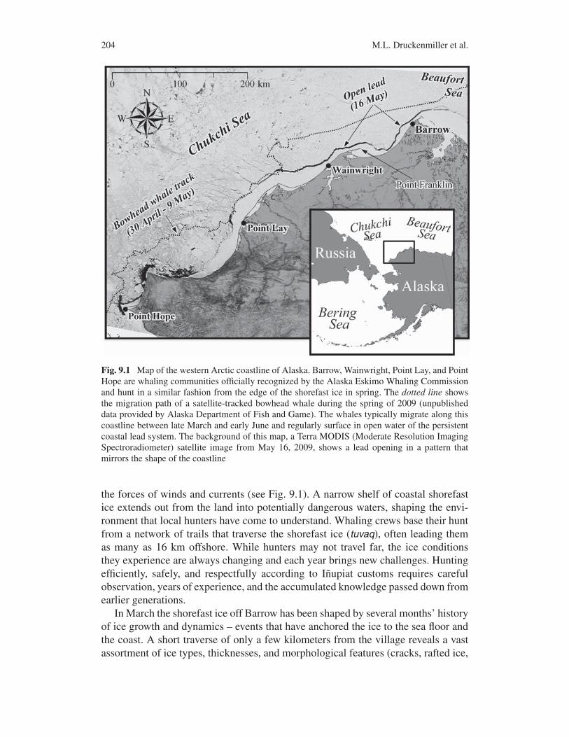
Fig. 9.1 Map of the western Arctic coastline of Alaska. Barrow, Wainwright, Point Lay, and PointHope are whaling communities officially recognized by the Alaska Eskimo Whaling Commissionand hunt in a similar fashion from the edge of the shorefast ice in spring. The dotted line showsthe migration path of a satellite-tracked bowhead whale during the spring of 2009 (unpublisheddata provided by Alaska Department of Fish and Game). The whales typically migrate along thiscoastline between late March and early June and regularly surface in open water of the persistentcoastal lead system. The background of this map, a Terra MODIS (Moderate Resolution ImagingSpectroradiometer) satellite image from May 16, 2009, shows a lead opening in a pattern thatmirrors the shape of the coastline
the forces of winds and currents (see Fig. 9.1). A narrow shelf of coastal shorefastice extends out from the land into potentially dangerous waters, shaping the envi-ronment that local hunters have come to understand. Whaling crews base their huntfrom a network of trails that traverse the shorefast ice (tuvaq), often leading themas many as 16 km offshore. While hunters may not travel far, the ice conditionsthey experience are always changing and each year brings new challenges. Huntingefficiently, safely, and respectfully according to Iñupiat customs requires carefulobservation, years of experience, and the accumulated knowledge passed down fromearlier generations.
In March the shorefast ice off Barrow has been shaped by several months’ historyof ice growth and dynamics – events that have anchored the ice to the sea floor andthe coast. A short traverse of only a few kilometers from the village reveals a vastassortment of ice types, thicknesses, and morphological features (cracks, rafted ice,

9 Assessing the Shorefast Ice 205
etc.). Interpreting the make-up of the ice in terms of safety and ease of travel par-tially determines where the hunters will establish their camps. Understanding whalebehavior and recalling past ice conditions additionally informs the hunters’ strategy.In late March whaling crews begin to move out onto the ice in great numbers. At thistime, the shorefast ice is still evolving, and over the course of the whaling season(mid-April to late May) it deteriorates from its cold winter state. Hunters carefullyassess the evolving conditions in relation to safety, on-ice travel, and successfulhunting.
We observed the location of these trails and spoke with hunters about how iceconditions informed and shaped their hunting and travel decisions during three con-secutive springs, 2007, 2008, and 2009. During this same time various componentsof a geophysical-based ice monitoring system were recording information on shore-fast ice thickness, growth, decay, and deformation. Relating these observations tothose of the hunters has stimulated conversations about the specific ice featuresand processes that the whalers consider important, led to interesting generalizationsabout shorefast ice variability, and provided important considerations for how tomove forward in making scientific observations of sea ice useful to the community.It is our hope that this chapter sheds light on how hunters understand and interactwith sea ice under current climate conditions. Our research also examined the rela-tionships between physical environmental processes, such as those during freeze-upand break-up, and ice characteristics that can be monitored on scales relevant to thecommunity’s use of the ice (Druckenmiller, n.d.).
Throughout this chapter, Iñupiaq terms for sea ice are used to illustrate the diver-sity of the Barrow whalers’ ice terminology and the complexity of their knowledge.Whenever brief definitions (explanations) are offered, they may not capture the fullmeaning of the term attributed by Iñupiat experts.
The Shorefast Ice Environment
Shorefast sea ice is present off Barrow for much of the year, typically betweenNovember and July. Recent research has shown that the ice is forming later in falland breaking up earlier in late spring (Mahoney et al. 2007a) and that multi-yearice is becoming less abundant (Drobot and Maslanik 2003). Scientific predictionsfor a warmer Arctic and further reductions in summer minimum ice extent, andhence multi-year ice area, raise additional concerns for whether or not the “familiar”shorefast ice environment prior to the 1990s will persist. Community observationsalso indicate that sea ice is changing, but these observations are made against adifferent “baseline condition” than the one scientists often use. Hunters understandand observe ice conditions largely in relation to how they and their ancestors haveused the local ice cover for travel and hunting. Each hunter comes to understandthe local environment based on his personal experiences and those of the elders thattaught him. While accounts expectedly vary between men, a basic understandingof the primary factors that shape the local shorefast ice environment is shared by
206 M.L. Druckenmiller et al.
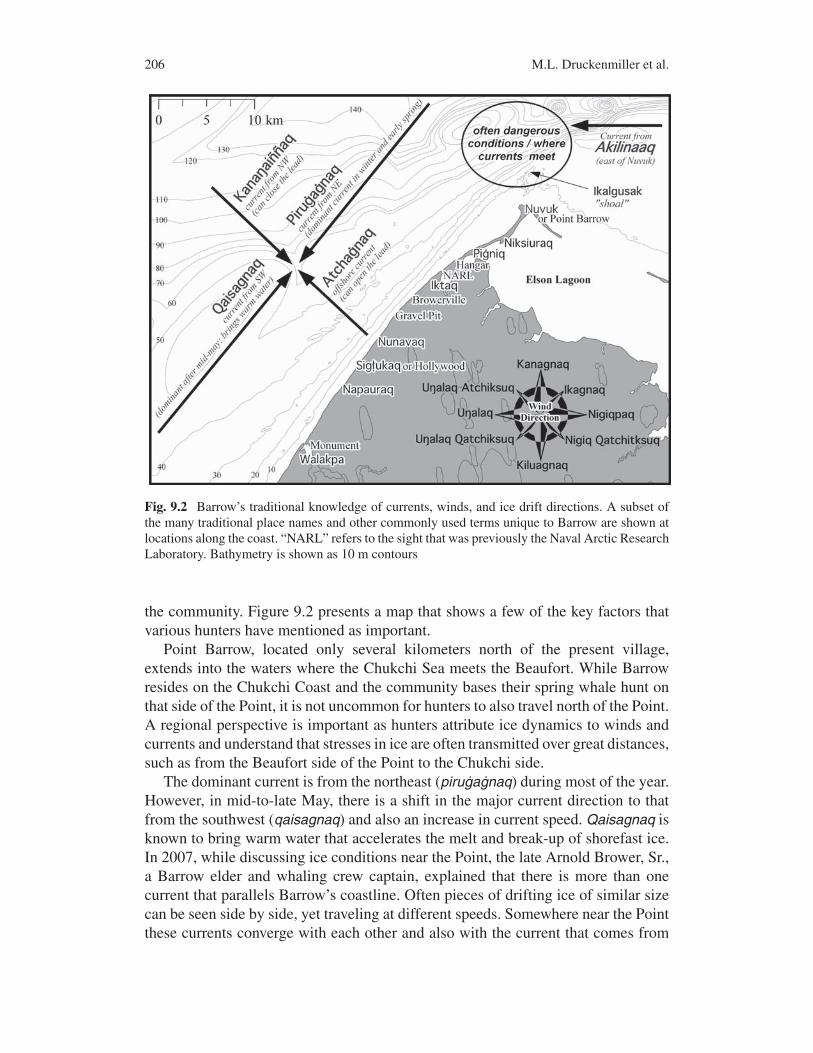
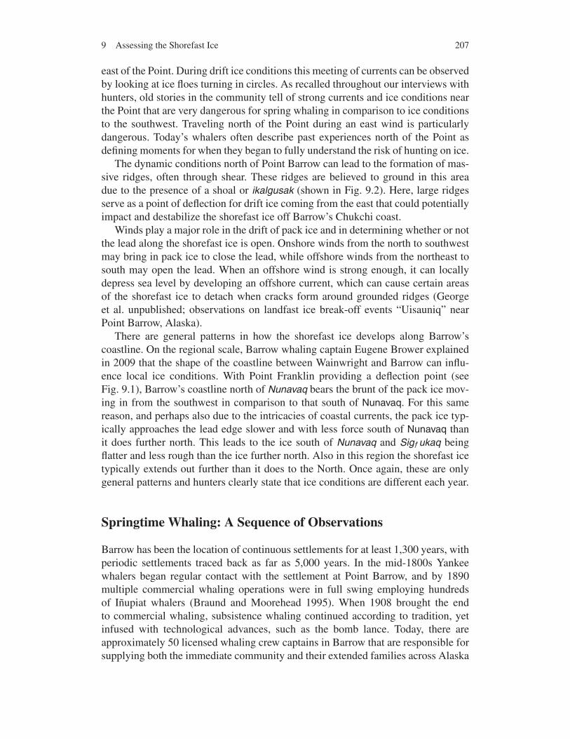
Fig. 9.2 Barrow’s traditional knowledge of currents, winds, and ice drift directions. A subset ofthe many traditional place names and other commonly used terms unique to Barrow are shown atlocations along the coast. “NARL” refers to the sight that was previously the Naval Arctic ResearchLaboratory. Bathymetry is shown as 10 m contours
the community. Figure 9.2 presents a map that shows a few of the key factors thatvarious hunters have mentioned as important.
Point Barrow, located only several kilometers north of the present village,extends into the waters where the Chukchi Sea meets the Beaufort. While Barrowresides on the Chukchi Coast and the community bases their spring whale hunt onthat side of the Point, it is not uncommon for hunters to also travel north of the Point.A regional perspective is important as hunters attribute ice dynamics to winds andcurrents and understand that stresses in ice are often transmitted over great distances,such as from the Beaufort side of the Point to the Chukchi side.
The dominant current is from the northeast (pirugagnaq) during most of the year.However, in mid-to-late May, there is a shift in the major current direction to thatfrom the southwest (qaisagnaq) and also an increase in current speed. Qaisagnaq isknown to bring warm water that accelerates the melt and break-up of shorefast ice.In 2007, while discussing ice conditions near the Point, the late Arnold Brower, Sr.,a Barrow elder and whaling crew captain, explained that there is more than onecurrent that parallels Barrow’s coastline. Often pieces of drifting ice of similar sizecan be seen side by side, yet traveling at different speeds. Somewhere near the Pointthese currents converge with each other and also with the current that comes from
9 Assessing the Shorefast Ice 207
east of the Point. During drift ice conditions this meeting of currents can be observedby looking at ice floes turning in circles. As recalled throughout our interviews withhunters, old stories in the community tell of strong currents and ice conditions nearthe Point that are very dangerous for spring whaling in comparison to ice conditionsto the southwest. Traveling north of the Point during an east wind is particularlydangerous. Today’s whalers often describe past experiences north of the Point asdefining moments for when they began to fully understand the risk of hunting on ice.
The dynamic conditions north of Point Barrow can lead to the formation of mas-sive ridges, often through shear. These ridges are believed to ground in this areadue to the presence of a shoal or ikalgusak (shown in Fig. 9.2). Here, large ridgesserve as a point of deflection for drift ice coming from the east that could potentiallyimpact and destabilize the shorefast ice off Barrow’s Chukchi coast.
Winds play a major role in the drift of pack ice and in determining whether or notthe lead along the shorefast ice is open. Onshore winds from the north to southwestmay bring in pack ice to close the lead, while offshore winds from the northeast tosouth may open the lead. When an offshore wind is strong enough, it can locallydepress sea level by developing an offshore current, which can cause certain areasof the shorefast ice to detach when cracks form around grounded ridges (Georgeet al. unpublished; observations on landfast ice break-off events “Uisauniq” nearPoint Barrow, Alaska).
There are general patterns in how the shorefast ice develops along Barrow’scoastline. On the regional scale, Barrow whaling captain Eugene Brower explainedin 2009 that the shape of the coastline between Wainwright and Barrow can influ-ence local ice conditions. With Point Franklin providing a deflection point (seeFig. 9.1), Barrow’s coastline north of Nunavaq bears the brunt of the pack ice mov-ing in from the southwest in comparison to that south of Nunavaq. For this samereason, and perhaps also due to the intricacies of coastal currents, the pack ice typ-ically approaches the lead edge slower and with less force south of Nunavaq thanit does further north. This leads to the ice south of Nunavaq and Sig ukaq beingflatter and less rough than the ice further north. Also in this region the shorefast icetypically extends out further than it does to the North. Once again, these are onlygeneral patterns and hunters clearly state that ice conditions are different each year.
Springtime Whaling: A Sequence of Observations
Barrow has been the location of continuous settlements for at least 1,300 years, withperiodic settlements traced back as far as 5,000 years. In the mid-1800s Yankeewhalers began regular contact with the settlement at Point Barrow, and by 1890multiple commercial whaling operations were in full swing employing hundredsof Iñupiat whalers (Braund and Moorehead 1995). When 1908 brought the endto commercial whaling, subsistence whaling continued according to tradition, yetinfused with technological advances, such as the bomb lance. Today, there areapproximately 50 licensed whaling crew captains in Barrow that are responsible forsupplying both the immediate community and their extended families across Alaska

208 M.L. Druckenmiller et al.
with food from the bowhead whale. Barrow whalers still use skin boats – umiat(wooden frames covered with bearded seal skins) – and thrive as expert huntersby applying knowledge and skills that have been transmitted across generations forcenturies. The success of the hunt relies on assessing the shorefast ice – one of themore complex, ephemeral terrains on earth.
Evaluating the Ice in Preparation for the Hunt
Even though shorefast ice begins to appear off Barrow in November, Januarythrough March are the major ice-building months. This is the time when hunterscount on heavy pack ice coming in to create ridges. Careful attention is given tohow the different regions of the shorefast ice develop (see Fig. 9.3). First there is theflat ice zone (ignignaq), which is typically either floating or bottom-fast, between theshore and ridges (ivuniq). Second, there is the zone where grounded pressure ridges(kisitchat) develop and provide the anchoring strength. These ridges typically formin shear. Multiple rows of ridges often exist between the ignignaq and any extendedfloating shorefast ice (iiguaq), which is vulnerable to impact by drifting pack ice(George et al. 2004).
Whaling captain Crawford Patkotak explained that you have to observe the icewhile thinking about what happened before. Hunters look for sediment entrained inridges for clues that the ice scraped and grounded to the seabed as it formed. They
Fig. 9.3 Schematic representation of coastal sea ice in the Chukchi Sea off Barrow. Both Englishand Iñupiaq terms for ice structures are given (George et al., 2004). Modified with permission froman illustration by Deb Coccia

9 Assessing the Shorefast Ice 209
examine the ice makeup and question whether the ice near pressure ridges was therewhen the ridge formed or rather came in later. Every attachment represents a point offusion where the ice may break out later in the season. Low winter temperatures areimportant for fusing the ice together. Winter is the time to watch the ice and decidewhere one needs to closely monitor throughout the whaling season. In addition tosafety, hunters also examine the ice to determine the layout of snowmobile trails tobe made from the beach to the open lead (uiñiq).
Building the Ice Trails
The physical process of building trails begins in late March. Both experienced andyoung members of the whaling crews use snowmobiles and ice picks to blaze andcut their trails across the shorefast ice according to a strategy that varies from crewto crew. A range of considerations exists for a whaling captain deciding where toplace his crew’s trail.
Safety and stability. The most important consideration for any whaling captainis the safety of his crew, which includes everyone from the hunters who will campon the ice and pursue the whale to those who will come out to help with butcheringand hauling meat. While every captain will agree that a successful hunt is not worththe loss of human life or of vital whaling equipment, different hunters have varyingperceptions of risk. However, in general, a trail is chosen such that it traverses icethat is well grounded or securely attached to stable ice. Therefore, knowledge of thelocations of cracks and points of attachment is important. It is quite common thatwinter seal hunters, who often travel on foot, provide detailed initial assessments ofice conditions.
Construction effort. Hunters must consider how much work it will take to build atrail. While a trail of several kilometers that connects many flat pans of ice may takeonly a few days work for a few men, a trail of similar length that traverses extremelyrough ice and multiple rows of large ridges may take several weeks. Those crewstaught to go where the ice is rough, thick, and well grounded inevitably accept thatthey will work harder for their trail. It is common for several crews to work togetheron the same trail near the shore. Once the trail nears the edge, however, the crewswill split their efforts to build individual trails that will branch off from the main one.
Navigability and potential for evacuation. It is important to be able to drive asnowmobile quickly along a trail, especially when in need of swift evacuation offthe ice. In consequence, trails are made as straight and as smooth as possible, uti-lizing large interconnected pans of flat ice, and are built wide enough to allow twosnowmobiles to pass each other. When describing these strategies for Wainwrightin the 1960s, Richard Nelson (Nelson 1969) discussed the use of refrozen cracks asa way to efficiently travel through areas of highly deformed sea ice. Trails nearlyalways approach the lead edge perpendicularly to the coast since this represents theshorter distance to land. Alternative evacuation routes are often considered, result-ing in more than one trail leading to the beach or to safer ice. It is in this region ofsafe ice that a crew will often place their na iaqtugvik, which is a place where they
210 M.L. Druckenmiller et al.
store their whaling equipment and camp when waiting for the lead to open or forother favorable conditions.
Ice edge conditions. Conditions at the edge are also critical for a successful hunt.Hunters prefer to find thick heavy ice (or rafted thinner ice) where they can placetheir camp, build a boat launch, and pull up a whale. Hunters indicate that ice thickerthan 1.5 m is needed to haul up a large whale more than 16 m (53 ft) in length.Some prefer to find ridges near the lead that can be used as a perch to watch thewater. Trail building when the lead is closed requires hunters to utilize observationsmade earlier in the season to make predictions for where the edge will be when thelead eventually opens. Even at times when the lead is open, ice conditions are notalways ideal due to unstable or thin add ons (iiguat ; plural form for iiguaq), leavingthe crews in wait for more suitable ice edge conditions to develop.
Proximity to other crews and distance from town. Some crews prefer to hunt inplaces far removed from others as they prefer solitude and because they believe itpromotes self-sufficient hunting practices. When a crew is on their own, they mustfocus on killing the whale with the first strike, as they cannot rely on help fromother crews. Conversely, some crews prefer to remain close to assist each otherwhen needed or to share favorable ice and trail conditions. The price of fuel and thetime it takes to get to a hunting location also play a role in trail placement.
Forecast of late spring conditions. Hunters must consider both the conditions atthe time they build their trail and those that will be encountered toward the endof the season. A trail that crosses large flat pans of thinner ice is at greater risk ofhaving the ice wear dangerously thin once air temperatures warm, snow melts, andthe warm current from the southwest arrives. Some may build trails on top of ridgesand keep on higher elevation ice for as long as possible. The advantage is not onlythat they can see greater distances to landmarks and open water but also because itreduces the likelihood of the trail being eaten away by warm water or snowmobiletraffic. In contrast, other crews may decide to place their trail in the lower elevationice between and throughout ridges since the ridge walls serve as side ramps to thetrail and prevent heavily loaded sleds from tipping.
Bowhead whale behavior. Understanding how the whales behave as they migratealong the ice edge also advises the hunter where to place his camp. When predict-ing where a whale will surface, hunters employ different strategies. Barrow elderWarren Matumeak explained that whales will swim beneath young thin ice, avoid-ing large ridge keels, and will surface in embayments along the edge (ka ik uk)(see Fig. 9.4). “Camping on the north side of these embayments and facing south”(manilinaaq) provides a good place to watch whales coming toward you and a goodplace to launch a skin boat. In turn, iluliaq refers to a location where you have onlya view of whales traveling away. There are also hunters that prefer to place theircamps at points along the ice edge (nuvugaq) since these tend to provide good vis-ibility and access to whales that swim from point to point and bypass embayments.Some hunters have also been taught that the whales are attracted to thick multi-yearice because it is shiny and may also provide feeding advantages. It is believed thatice with deep keels (thick multi-year ice or ridges) causes the water to churn and stirup krill.

9 Assessing the Shorefast Ice 211
Fig. 9.4 Likely path of a bowhead whale as it swims along the ice edge. Ka ik uk is an embay-ment along the ice edge. Nuvugaq is a point of ice extending out from the lead edge. Adapted withpermission from a sketch by Warren Matumeak
Elders’ knowledge. In the end, the decision on where to place an ice trail forspring whaling may most strongly be influenced by tradition and what was taughtby elders. Arnold Brower, Sr., noted that he learned from his elders to hunt in thenorth early in the season before the current from the southwest strengthened, thusminimizing the risk of losing a struck whale that is carried under the ice by thecurrent. When the current intensified in mid-to-late May, he would move his crewto the south. Whaling Captain Nate Olemaun discussed how he was taught that thewaters off Sig ukaq are rich feeding waters and are a good place to see whales. Asnoted earlier, many captains prefer to hunt south of the dangerous and unpredictableconditions north of the Point, despite acknowledging that this is a good place to seewhales.
The trail network built by the Barrow whaling community evolves throughout theseason as ice conditions continuously change and crews move locations. To assist innavigation most crews use distinct markers for their trails, such as painted woodenstakes or flags. Markers often note the crews’ names. Trails are typically referredto by the name of the captain or crew or by the trail’s point of origin, using theplace-names and landmarks shown in Fig. 9.2.
Observations at the Ice Edge
When crews are “along the edge of the ice observing the environment and look-ing for whales” (nipaaq) they must continuously monitor the ice on which they arecamped and the pack ice beyond, both of which are influenced by wind and cur-rent. To monitor the currents, hunters typically drop a sounding line into the water.Barrow whaler Joe Leavitt explained how an increase in a current’s strength starts at

212 M.L. Druckenmiller et al.
the bottom and develops upward over the course of a few days, providing advancednotice of potentially precarious ice conditions. In particular, ice moving againstthe wind is an indication that the current is moving with considerable strength.Currents, especially when bringing in warmer water, can lead to the break-up ofungrounded ridge keels near the edge resulting in the “throwing-up of ice” into thelead (mugaala; see Fig. 9.5), presenting a danger to boats. When the lead is closed,these broken pieces can remain under the ice, only to emerge when the lead reopens.
A “water sky” (a dark band along the horizon that indicates open water; seeFig. 9.6) serves as a way to monitor for incoming pack ice that may present athreat to those at the ice edge. If the dark band begins to disappear, the pack iceis approaching. This is of particular concern when camped on iiguaq. In these con-ditions a whaling crew is forced to retreat to safer ice. When camped on multi-yearice at the lead, encroaching pack ice presents less of a hazard.
It is also important to monitor the current’s strength to avoid striking a whalewhen conditions may prevent the crew from being able to haul it to the ice edge forbutchering. A strong current, especially near the Point, has been known to defeatthe efforts of several boats attempting to haul a single whale to stable shorefast ice.A decision “to launch a boat from the ice edge to go to the whale’s path” (pamiuqtak)must be done only when conditions present an acceptable risk for the entirety of thehunt, which ends when the meat, muktuk, equipment, and people are on safe ice.
Fig. 9.5 Mugaala (“throwing-up of ice”) at the ice edge. Following the opening of the lead aspack ice drifts away, loose pieces of ice detach from ridge keels (or from the bottom of rafted ice)and float up beneath the level ice or into the open water. When such pieces hit the level ice, theycan produce a loud sound that is often misinterpreted by a hunter as a crack forming in the ice.Based on a description provided by Lewis Brower

9 Assessing the Shorefast Ice 213
Fig. 9.6 Dangerous open water on a whaling trail. Such “holes” may be attributed to heavy snow-mobile traffic and warm water melting the ice from beneath. A “water sky” can be seen on thehorizon, indicating an open lead. (Photo: M.L. Druckenmiller)
Monitoring the Shorefast Ice
Hunters carefully watch the shorefast ice along their trail throughout the season.There are several features that they pay particular attention to, such as previouslyidentified cracks, newly formed cracks in the flat thin ice near grounded ridges, andareas where slush ice has been incorporated into the shorefast ice. Barrow whalerLewis Brower told of how his father Arnold Brower, Sr., had taught him to buildsmall handmade rows of compacted snow to perpendicularly extend across cracks sothat fracturing or disturbances to the snow piles would serve to monitor the cracks’activity. Cracks or weak points where new ice has been added to the shorefast icebecome particularly important in determining where the shorefast ice may break-out. Katak, which means “to fall,” is the Iñupiaq term used to describe a suddendrop in sea level where the flat ice near grounded ridges cracks and may lead to abreak-out (George et al. unpublished; Norton 2002).
Another feature that must be monitored is mugaliq, which is slush ice that formsthrough shear and the incorporation of snow. This ice can be found anywherethroughout the shorefast ice zone since it can freeze in place as the shorefast icedevelops and evolves throughout the year. These areas are observed closely sincethey represent a particular danger as spring progresses. When frozenmugaliqwarms

214 M.L. Druckenmiller et al.
it rapidly loses its integrity and acquires a quicksand-like consistency, breaking ina quiet manner. A quiet break-up process is particularly disconcerting to hunterssince they often rely on sounds to warn of potentially threatening conditions, suchas cracking and ridging.
By mid-to-late May, warmer air temperatures and the arrival of the warm currentfrom the southwest escalate the transition of shorefast ice toward increasingly unsafeconditions. The “glue” that is holding the weak areas together begins to release. Oldcracks melt out, and newly formed “cracks open up, never to refreeze” (nutaqqutaq).After the snow melts, trails develop dark areas of water or extremely thin ice, wheresnowmobiles can easily fall through (see Fig. 9.6). Also by this time, the majorityof passing whales become increasingly large and difficult to pull up onto thin iceat the edge. Kasruq (“when one is done with whaling and pulls their gear off theice”) takes place either when Barrow has reached its quota of strikes or when iceconditions are no longer suitable for whaling.
Looking for Old Ice
The retreat and thinning of the Arctic’s perennial ice, observed each September asthe ice extent is at its annual minimum, is a clear indication that conditions in theArctic have changed over the last 40 years. Since 1979 when satellites first beganmonitoring Arctic ice, the extent has declined as much as 10.2% per decade (Comisoet al. 2008). After the mid-1970s, hunters along Alaska’s Chukchi coast also beganobserving that ice conditions, in particular shorefast ice morphology and stability,began to deviate from what was considered normal for prior decades, as reflected indirect observations and elders’ teachings (Norton 2002). In large part, these obser-vations note that multi-year ice, which here refers to ice that has survived at leastone summer’s melt season, is becoming less abundant over the long term. Figure 9.7shows multi-year ice near Point Barrow.
Both hunters and scientists view the presence or absence of multi-year ice asan indicator of change and as proxy for a range of processes related to stabilityand decay of coastal and offshore ice. Scientists view multi-year ice as importantfor regulating the amount of solar energy that enters the ocean over the course ofthe summer and early fall, thus partially controlling the growth conditions for newice in late fall. In the coastal environment, multi-year ice assists in the formationof shorefast ice by providing anchoring points. When winter approaches and theprevailing clockwise circulation pattern in the Beaufort Sea brings multi-year icesouth- and westward, multi-year floes enter the coastal region during a time whenice dynamics and the growth of new ice build shorefast ice. The degree to whichthese processes coincide determines the amount of multi-year ice entrained into theshorefast ice zone.
With perennial ice retreating further to the north and less multi-year ice presentduring fall freeze-up (Maslanik et al. 2007; Nghiem et al. 2007), the period ofstable shorefast ice has grown shorter as well. A widespread concern of the Barrowcommunity is that with the loss of multi-year ice, ice conditions will becomeincreasingly unfamiliar and the hunting season will shorten. In the past, the whaling

9 Assessing the Shorefast Ice 215
Fig. 9.7 Multi-year ice near Barrow. Whaler Roy Ahmaogak is shown standing in front ofpiqaluyuk that grounded near the shoal north of Point Barrow in 2009. Roy stated that “Ten yearsago, the reduction in multi-year ice was not so noticeable. But in recent years we have seen a largedisappearance of multi-year ice. I was surprised to see two-story piqaluyuk north of Nuvuk thisyear.” The lower panel of images presents three QuikSCAT satellite scenes from December 1 of2006, 2007, and 2008 – prior to the whaling seasons discussed later in this chapter. The regionsof ice appearing bright – corresponding to higher radar backscatter – north of Alaska can be inter-preted as multi-year ice. In general, the amount of multi-year ice drifting near Barrow at this timeof year is related to the amount of multi-year ice incorporated into the shorefast ice environment,which forms around this time. (Photo: M.L. Druckenmiller)
season often extended into the month of June, while in recent years the hunt hasconcluded around the third week of May. Crawford Patkotak, for instance, recalledthat in 1987, a year with a lot of heavy multi-year ice off Barrow, his fatherSimeon Patkotak, Sr., landed a 16 m (52 ft) whale on June 15.
Whalers consider the advantages and disadvantages of multi-year ice. Hunters,similar to Arctic engineers, appreciate the physical properties of multi-year ice andunderstand that it possesses greater strength than more saline first-year sea ice, butthat it is also much more brittle and can shatter upon impact or as a result of abuild-up of internal stresses due to surface cooling or heating. When hunters discussmulti-year ice, it is often noted that it is dangerous to camp on for this reason.However, it is also often referred to as a stable platform to base a hunt from at thelead edge. This apparent discrepancy comes from the fact that whalers do not groupall multi-year ice into one class. Ice is not simply first-year ice or multi-year ice. Infact, “multi-year” ice is not a term commonly used by Barrow hunters. Piqaluyuk

216 M.L. Druckenmiller et al.
is the term used to refer to multi-year ice that is salt-free and serves as a preferredsource of drinking water. Large pans of this type of salt-free ice may shatter uponimpact. Tuvagruaq is a large region of old ice (perhaps often “old” first-year iceor second-year ice, and younger than piqaluyuk) that is stable and will not shatter.Some hunters describe tuvagruaq as not only a single type of ice but rather as astable conglomerate of different types, potentially even of piqaluyuk and youngerthin ice. This type of ice, when found along the edge, is resistant to break-out andis suitable for pulling up a heavy whale. However, because of its thickness andassociated freeboard, a ramp (amuaq) must be cut at the edge in order to pull thewhale from the water.
Monitoring and Mapping the Ice Trails
The research presented in this contribution is part of a broader effort to put inplace a coastal sea ice observatory at Barrow that addresses both scientific researchquestions and the information needs of the community and other stakeholders thatconduct activities on sea ice (Druckenmiller et al. 2009; Eicken et al. 2009). A keyaspect of the observatory is to examine how geophysically derived ice thicknessmeasurements and the monitoring of near-shore ice movement and deformation arerelevant to the whaling community’s springtime assessments of ice stability andsafety. A coastal radar mounted on a building that overlooks the shorefast ice wheremany of these trails are located monitors the movement and stabilization of icethroughout the year. Collaboration with hunters and the community has enableddata collection during a time when they are most active on the ice.
Between 2001 and 2006, the North Slope Borough Department of WildlifeManagement maintained periodic records of where and over what types of ice (e.g.,grounded ridges, rubble, flat pans of ice) the community placed ice trails duringspring whaling. After a suggestion that a more thorough and complete mapping ofthe trails take place each spring, we began this effort by mapping the ice trails dur-ing 2007, 2008, and 2009. The trails were traveled by snowmobile with a handheldGarmin GPS (geographic information system) device. Using ArcGIS, a collection ofGIS software products, the tracks were plotted and placed on recent SAR (syntheticaperture radar) satellite images to produce maps for the community. With input fromthe community and iterative improvements, these maps have evolved into a productthat is useful for on-ice navigation, general ice-type discrimination (flat ice versusrough ice), and as a reference for Barrow’s Search and Rescue operations.
With permission from the individual whaling crews, continuous ice thicknessmeasurements were made along most trails using an electromagnetic inductiondevice (Geonics EM31 conductivity meter), which estimates ice thickness by detect-ing the distance between the surface of the ice and the sea water below. This devicewas placed on a large wooden sled and hauled along the trails to provide quick indi-rect measurements (see Fig. 9.8). Measurements are most accurate (to within a fewpercent of total thickness) over un-deformed ice less than 3 m thick as comparedto thicker, rough ice, such as ridges, but still provide detailed information about ice

9 Assessing the Shorefast Ice 217
Fig. 9.8 Snowmobile hauling a sled with the ice survey instruments. Shown here is the EM31 con-ductivity meter that measures ice thickness, a highly accurate differential GPS, and a radar-reflectormast, which allows the measurements to be located in the imagery collected by the coastal radarin downtown Barrow (see Fig. 9.9). The skyline of Barrow can be seen in the distant background.(Photo: M.L. Druckenmiller)
thickness variations across the entire extent of shorefast ice (Haas et al. 1997). Whilethis chapter presents an overview of the data, a specific discussion of how thesemeasurements relate to changing ice conditions and the responses of the huntingcommunity will be discussed in a later contribution.
This is not the first such project to map sea ice travel by high Arctic communi-ties. Other studies have done so (Aporta 2004; Tremblay et al. 2006) and likewisedescribe trail breaking and navigation of these temporary landscapes as requiring anexperienced ability to discern reoccurring environmental patterns.
A Brief Survey of Weather and Ice Conditions During3 Years of Whaling
Each year brings new and unique ice conditions to Barrow, and with each yeara story can be told about how the community interpreted these conditions andresponded during the spring whale hunt. From 2007 to 2009, we visited Barroweach spring to investigate ice conditions, map the ice trails, and speak with hunters.While these years may be characterized as “typical low multi-year ice years,” theinformation presented here places many of the observations made by the communityinto a framework for year-to-year comparison.

218 M.L. Druckenmiller et al.
2007: Successful Whaling on Thin Ice Following a Break-Out
The 2007 whaling season was very successful with Barrow landing 13 whales,including a record number of small juvenile whales, known as ingutuks. The loca-tions where many of the crews chose to hunt demonstrated two important points.First, hunters tolerate ice conditions that may first appear unsafe if other conditions –the wind, currents, and tides – are favorable. The risk associated with specific iceconditions clearly relates to the length of time a hunter may decide to stay on theice in that area. Second, hunters choose their camp locations based on not only iceconditions but also whale behavior.
On March 31, 1 week before crews began constructing their trails, a break-outevent occurred in the shorefast ice off Barrow (see Fig. 9.9). Immediately followingthis event, adjacent first-year ice from south of the location piled up and replaced
Fig. 9.9 Map of the 2007 whaling trails. Many of the trails shown here traversed the region thatexisted in the shorefast ice between break-out events on March 31 and May 28. The backgroundin this image shows a sample radar backscatter image (dark speckles represent ice features) asrecorded during the break-out on May 28. The location of the main trail off Napauraq was hand-drawn after the whaling season ended based on the input from members of the community. The10 kW X-band Furuno marine radar in downtown Barrow is shown in the lower right photo. (Seealso Color Plate 5 on page 474)

9 Assessing the Shorefast Ice 219
the ice that broke out. This ice, despite being quite thin relative to the shorefast iceto the north and possessing few grounded ridges, remained in place throughout theentire whaling season and provided the location where most of Barrow’s whaleswere landed (Druckenmiller et al. 2009). This circumstance may be in part due tothe observation of one hunter that the whales were following the edge of the south-ern lead and overshooting the crews camped at the lead edge further north. Barrowreached its quota on May 25 and the ice broke out again on May 28 at approxi-mately the same location as on March 31. Figure 9.9 shows the area of shorefast icepresent between these break-out events. Also shown in this figure are the trails thattraversed this region and a radar image from the March 31 break-out as recorded bythe Observatory’s coastal radar.
Barrow whaler Joe Leavitt, along with elders Arnold Brower, Sr., andWesley Aiken, observed that this first-year ice was held in place by only a few“key” ridges and that favorable conditions allowed the community to successfullywhale in this area. Except for between May 7 and 13, the wind throughout the sea-son (see Fig. 9.10) allowed the lead to remain open and prevented pack ice fromcolliding with the shorefast ice. Prior to the May 28 break-out, however, the trails in
Fig. 9.10 Winds and air temperature during the 2007, 2008, and 2009 whaling seasons. Winddirection and speed (maximum 2-min readings) and air temperature (daily averages) are denotedby the gray circles and solid lines, respectively. The shaded regions span the wind directions(southwest to north) that tend to close the lead. Data were recorded at the Post-Rogers MemorialAirport and accessed from the National Climate Data Center
220 M.L. Druckenmiller et al.
the south were worn dangerously thin by large amounts of snowmobile traffic andpreviously refrozen cracks began to open, which may have significantly contributedto the second break-out (Druckenmiller et al. 2009). After the trails in the southdeteriorated some crews moved to the trails in the north to take advantage of safeice conditions persisting later into May.
2008: Whaling in the North Long After Southern Trails Deteriorate
During the 2007–2008 ice year, stormy conditions during the period when ice movedin and stabilized along the coast contributed to a rough shorefast ice cover composedof highly deformed thin first-year ice. In some areas, ridges were exceptionally closeto the beach due to the high winds driving these ridges near shore. This was partic-ularly evident off Nunavaq, where some ice had even blown up onto the beach.Whaling captain Harry Brower, Jr., explained that there was a repeated sequenceof ridge building followed by ice coming in to add on that contributed to a roughbut stable ice cover. Brower decided to place his trail off Nunavaq (see Fig. 9.11)because the ice off NARL was too rough.
Cold conditions in early April helped to provide stable shorefast ice at the startof whaling. Similar to 2007, but in stark contrast to 2009, 2008 experienced a dom-inating east wind that kept the lead open (see Fig. 9.10). Most crews encounteredgood conditions in late April and early May allowing Barrow to catch a lot of whalesduring this period. The first whale was landed by Eugene Brower’s Aalaak Crew onApril 26. However, while the east wind tended to keep the lead open, it also pre-sented a hazard – crews pulled off the ice when winds approached 25 mph believingthat such an offshore wind can drop the water level and lead to a break-out as floatingice cracks away from grounded ridges.
Whaling captain Tom Brower III reported that in the first week of April a late-season snowfall, which contrasts with a more firmly packed winter snowfall, led tohazardous conditions. First, the fresh snow served as an insulating layer allowing thewarm currents to more efficiently melt the thin ice from below. Later in May, whenair temperatures increased, the snow quickly melted, which then in turn acceleratedsurface ablation through enhanced solar heating. Crews that were unable to landwhales earlier in the season concentrated at the trails north of Browerville as thoseto the south became dangerous with areas worn thin from snowmobile traffic andwarm water. Brower reported having to abandon their trail off Napauraq in earlyMay only after a few days of heavy use.
Figure 9.11 shows the 2008 trails and where ice thickness measurements weremade during the season. While these data are useful from the standpoint of track-ing long-term trends in the thickness distribution of shorefast ice, it also assists inunderstanding how different types of ice are used by the community. For example,Fig. 9.12 shows the cross-sectional thickness profiles from two trails. The thin iceat the end of Jacob Adams Crew’s trail was chosen for a camp since it was identi-fied as flat ice where whales would be swimming beneath (see Fig. 9.4 and relateddiscussion) and surfacing at the edge. Their crew, among many others, decided this

9 Assessing the Shorefast Ice 221
Fig. 9.11 Map of the 2008 whaling trails. Trails are shown here with ice thickness data over-laid on select trails where measurements were made. The two trails south of Nunavaq werenot fully mapped since they were incomplete at the time of mapping in early to mid-April. Thetrail off Barrow was abandoned before making it to the ice edge. The SAR image, acquired bythe RADARSAT-1 satellite and provided by the Canadian Space Agency and C.E. Tweedie andA.G. Gaylord, is from April 5, 2008. (See also Color Plate 6 on page 475)

222 M.L. Druckenmiller et al.
Fig. 9.12 Cross-sectional ice thickness profiles along two different whaling trails. The 2008 trailsof Roy Anashugak Crew and Jacob Adams Crew were measured on April 5 and 7, respectively(see Fig. 9.11). Labeled features are based on interviews with Jacob Adams, Herman Ahsoak,and Gordon Brower. The level ice in the zones labeled “tuvagruaq” and “sikuliaq” had averagethicknesses of 1.0 and 0.5 m, respectively. The location of the na iaqtugvik, or “safe camp,”is shown for Adams’ trail but was not documented for Anashugak’s trail. Differential GPS wasused to survey the surface elevation and an EM-31 conductivity meter was used to measure icethickness. True thickness is the total thickness of ice above and below the water line, which is atzero. The proportionality between the x and y axes is such that the thickness is emphasized. Ridgethicknesses over 4 m are underestimated by up to 30% due to instrument limitations (Haas 2003)
sikuliaq (young ice formed along the edge of solid ice) was a good place for a camp.However, they reported having to retreat to their na iaqtugvik (safe camp; labeledin Fig. 9.12) multiple times when the west wind brought in the pack ice and whenthe strong east wind threatened to drop sea level and break the extended floatingice from the grounded ice. Significant portions of this sikuliaq broke off followingimpact with pack ice brought in with the west wind on April 25. However, the iceremained safe and allowed several crews to stay camped there. Adams landed a 9 m(30 ft) whale on May 7, just before the remainder of the sikuliaq broke out. Adams

9 Assessing the Shorefast Ice 223
noted that such ice is suitable for pulling up a whale approaching 12 m (40 ft) inlength, but would not be sufficient for a whale of 15 m (50 ft).
By mid-May, crews abandoned Adams’ trail since newly deformed rough iceat the edge prevented easy access to open water. As previously mentioned, manycrews moved to the trails north of Browerville. Older, thicker, and more stable flatice (tuvagrauq) near the edge allowed crews to easily connect these trails togethernear the lead (beyond the last row of ridges) with secondary trails (not shown inFig. 9.11). This enabled hunters to travel between camps without the need to comea long way back toward shore in order to get on another trail. Also, connected trailsalways provide more numerous escape options in the case of dangerous conditions.Unlike the sikuliaq further to the South this tuvagrauq remained in place into lateMay, beyond the end of the whaling season.
2009: West Wind Leads to Unsuitable Ice Edge Conditions
The shorefast ice of 2009 was representative of typical ice conditions in recent yearswith a few noteworthy differences, which are discussed later in this section. OffNARL and Browerville the shorefast ice was heavily ridged and deformed with fewareas of level ice. Despite the near-absence of larger pieces of old ice, it was verystable all the way to the last major row of ridges at about 3 km offshore. The fewscattered pieces of piqaluyuk were landward of already well-grounded ice, provid-ing little service to the crews, other than as a source of drinking water. The last rowof grounded ridges was separated by a system of cracks from the outermost float-ing ice. The ice off Gravel Pit had formed in place and was very flat and thin yetwith no noticeable cracks. Due to the lack of anchored ice, except for a few ridgesclose to shore, the crews in this area were extremely cautious of any drift ice thatapproached. The conditions off Hollywood were similar to those off Gravel Pit – flatice that had mostly formed in place – although many hunters indicated that it wasmore firmly grounded. In this area, notable cracks developed later in the season.The ice off Monument formed a large promontory of shorefast ice (nuvugaqpuk)that extended approximately 11 km offshore (see Fig. 9.13). The distance requiredto reach the edge was one reason crews may have decided against hunting in thisarea, but perhaps the more important reason is that most believed this promontory ofice would eventually collide with pack ice and break away. However, surprisingly,the nuvugaqpuk remained throughout the entire whaling season.
Despite stable conditions along the general extent of the shorefast ice, the packice, winds, and currents never cooperated to make the ice edge suitable for whaling.Tuuq is when the pack ice collides with the shorefast ice edge and acts as a chisel(George et al. 2004). While such events surely present danger to crews camped atthe edge, they are also relied on by hunters to “fix-up” the ice – to thicken thinice through deformation and to rid the edge of dangerous attachments (iiguat). Anideal sequence of events would involve heavy pack ice coming in to “fix-up” the ice,driven by the wind and/or current in such a manner that hunters are able to foresee

224 M.L. Druckenmiller et al.
Fig. 9.13 Map of the 2009 whaling trails. This exact map was provided to the community duringthe whaling season. The SAR image, acquired by the European Remote Sensing satellite ERS-2and provided by the Canadian Space Agency and C.E. Tweedie and A.G. Gaylord, is fromMay 16,2009, just prior to the opening of the lead shown in Fig. 9.1. Various GPS locations are labeled toassist with navigation. Locations are also shown for the camp of the 2009 bowhead whale censusorchestrated by the North Slope Borough’s Department of Wildlife Management and of our sea icemass balance site that measured level ice growth and other variables of interest. (See also ColorPlate 7 on page 476)
9 Assessing the Shorefast Ice 225
the event and pull off the ice. Next, the lead would open to reveal ice edge conditionssuitable for safely hauling up a whale.
Beginning on April 20, just as most crews were finishing their trails, the westwind arrived and dominated throughout the remainder of the whaling season (seeFig. 9.10). The wind-driven pack ice either formed iiguat or on occasion built up amoving one-story high wall of slush ice (mugaliq) along the edge. Especially for thecrews off NARL, iiguat persisted and when one broke off another formed. GordonBrower recalled that in late April his crew was fortunate to be camped on tuvagruaqfor a few days but that the area was still considered unsafe since it was only con-nected to the grounded ice by thin young ice. Many hunters described 2009 as a“waiting game” – waiting for the lead to open or for edge conditions to improve.Most were only camped at the edge for 1 or 2 days and were prepared to run at amoment’s notice. Some hunters never even brought their boats onto the ice.
The year 2009 was also difficult since the mugaliq incorporated within the shore-fast ice never froze solid. Potentially thawing temperatures arrived on April 26,followed by a refreeze and then another thaw later on May 18. Warm weather andthe arrival of warm water (as suggested from interviews with the hunters) led to aquick deterioration of trails and cracks, and in particular to those south of Nunavaq.This sequence of events made the conditions in the South very unsafe. Some crewspulled off the ice as early as May 12 due to these unsafe conditions, but also becausethe larger whales were beginning to move through. Similar to 2007 and 2008, thetrails off NARL and northward remained intact longer than those to the south.
On May 16 a southeast wind opened the lead for a short time (see Figs. 9.1 and9.10) and in the early hours of May 17, ABC Crew (Arnold Brower, Sr., Crew)landed an 8 m ingutuk from trail number one (see Fig. 9.13) and was able to finda pan of tuvagruaq to successfully haul up the whale. Three other crews caughtwhales before May 23 but experienced great difficulty in finding a suitable place tobutcher because of mugaliq at the edge. One whale was struck and butchered at trailone and two were struck from the trails off Hollywood. Of these latter two, one washauled to trail seven and the other to trail four in hopes of finding ice that wouldsupport the weight of the whales and also because the trails off Hollywood werenot safe enough to permit safe passage for the large number of people required tobutcher a whale. Each attempt failed and as the whales were pulled onto the ice, theywould immediately break through. In all three cases they had to cut off the headsof the whales (1/3 of the whale’s body) in the water and anchor it to the ice edge.These poor butchering conditions unfortunately did not allow the crews to retrievethe entirety of the whale meat, and in one case they were only able to collect the skinand blubber (muktuk). Joe Leavitt stated that if heavier ice conditions had existed in2009 butchering all four whales would not have been a problem.
To some members of the community the success of the whale hunt is more thanjust about climate and ice conditions; it is connected to the well-being of the people.Roy Ahmaogak, for instance, said, “One of the most heartbreaking things aboutthis year was that we weren’t given the opportunity to practice traditional whalingbecause of the ice. Barrow and its people have been feuding and bickering at eachother all this last winter. This is the reason we think the ice didn’t go out this year

226 M.L. Druckenmiller et al.
and it stayed closed. This will make us think this coming year that we have to watchour tongue and to watch what we say to people. We are lucky to have two blankettosses this year. It will teach Barrow and people like us.” In the end, Barrow joyouslycelebrated the four caught whales during two Nalukatak. Barrow then set their sightson the non-traditional fall bowhead hunt, which is done in open water with outboardengines and aluminum boats.
Discussion
The initial placement of ice trails is largely in response to ice conditions, tradi-tional practices, and crew preference; however, there seems to be a pattern of thetrails to the south having to be abandoned earlier in the season due to the ice dete-riorating, causing the crews to concentrate at the trails north of town. This is incontrast to that which Arnold Brower, Sr., explained regarding how crews in thepast typically moved south later in the season as currents intensified and condi-tions in the north became dangerous. This raises the question of whether climateand environmental change are impacting how the community uses the ice cover.The seasonal summaries presented here span a 3-year period and accordingly canonly present a brief look at how present climate and ice conditions impact springwhaling.
Changes in shorefast ice characteristics are much more complicated than theobvious reduction in the presence of multi-year ice. During our conversations,Arnold Brower, Sr., and Tom Brower III both noted that shorefast ice prior to the1980s extended much further out, was flatter, and was composed of thicker levelice than today. While detailed analysis of how shorefast ice characteristics havechanged over time is beyond the scope of this chapter, it is clear that changes aretaking place that present a new assortment of challenges for the whaling com-munity. If hunters continue struggling to find sufficiently grounded and stableice, such as the tuvagruaq experienced in 2008, they may increasingly have todeal with the problems encountered in 2007 and 2009 – early spring break-outevents close to shore and ice edge conditions that are not suitable for pulling upa whale.
The presence of mugaliq dominated the observations of hunters in 2009. Thisslush ice, which forms through shear at any time throughout winter or spring, repre-sents a type of ice that lacks the drainage of salt water that typical thermodynamicice production promotes, thus rendering it potentially unstable and responsive toslight changes in temperature. Hunters acknowledged that this ice is common butthat 2009 was remarkable because it was so widespread and air temperatures didnot allow for this ice to retain its integrity late into the season. Coupling thisphenomenon with an understanding that advection of warm water can lead to thedestabilization of shorefast ice by melting grounded ridge keels (Mahoney et al.2007b) and refrozen cracks reveals that shorefast ice as a stable platform for hunt-ing and travel is closely linked not only to climate change but also to weather andoceanographic variability.

9 Assessing the Shorefast Ice 227
Lastly, the summary of how the crews responded to ice conditions during these3 years begs the important question of whether there is a clear and distinguishablelocal zonation of ice conditions along Barrow’s coastline. This topic, worthy of fur-ther investigation, may underscore the fact that Barrow’s ice environment allowsfor understanding not only how ice conditions respond to climate but also to sub-tleties in local and regional conditions, such as bathymetry and coastal currents.This may present an opportunity for scientists to further discover the local expertsea ice knowledge found in Barrow, which likely possesses an intricate understand-ing of the processes that may govern a local zonation of conditions and furtherlead to improved scientific monitoring that is relevant to the community’s activitieson ice.
Conclusions
The Barrow community continues to practice successful traditional spring whalingfrom shorefast ice while making observations that lend a new perspective to under-standing processes that dominate the present-day coastal sea ice environment.Hunters assess shorefast ice in a highly specialized manner as they consider safety,navigation, hunting strategies, and traditional knowledge and practices. Detailedcharacteristics of year-to-year ice conditions, which are unobservable by standardscientific monitoring programs, manifest in impacts to the whaling community.Utilizing the collaborative and experiential (as opposed to experimental) approachpresented here – a type of ethnoglaciology – we are working toward an improvedunderstanding of how to observe the local environment in a manner to track changesimportant to both climate study and the community. This research may ideally beginto illustrate how strategic adaptations in the way the community uses the shorefastice are indicative of and responsive to environmental change.
Mapping Barrow’s ice trails allows us to piece together how ice characteristicsspatially and temporally relate to the community’s use of the ice. These maps areproviding a valuable product to the community while also serving as a useful ref-erence tool for scientists and hunters to communicate across barriers of culture andexperience. It is our hope that this project continues as a long-term monitoring effortto unite advanced scientific instrumentation and expertise, traditional knowledge,and ice use by a modern arctic whaling community.
Acknowledgments This research was made possible with the assistance of several experi-enced Iñupiat whalers: Billy Adams, Jacob Adams, Roy Ahmaogak, Herman Ahsoak, ArnoldBrower, Sr., Eugene Brower, Gordon Brower, Harry Brower, Jr., Lewis Brower, Tom BrowerIII, Jeffrey Leavitt, Joe Leavitt, Warren Matumeak, Ben Nageak, Nate Olemaun, and CrawfordPatkotak. Thanks to Ronald Brower Sr., for reveiewing the use of Iñupiaq terminology. Wewould like to also thank the North Slope Borough Department of Wildlife Management, BarrowArctic Science Consortium, Barrow Whaling Captains Association, and Allison Gaylord and theBarrow Area Information Database. This publication is the result in part of research conductedas part of the Seasonal Ice Zone Observing Network with financial support from the NationalScience Foundation (OPP-0632398), the Oil Spill Recovery Institute, and the Cooperative Institutefor Arctic Research (Project CIPY-34) with funds from the National Oceanic and AtmosphericAdministration (cooperative agreement NA17RJ1224 with the University of Alaska).

228 M.L. Druckenmiller et al.
References
Aporta, C. 2004. Routes, trails and tracks: Trail-breaking among the Inuit of Igloolik. Etudes Inuit28(2): 9–38.
Braund, S.R. and Moorehead, E.L. 1995. Contemporary Alaska Eskimo bowhead whaling vil-lages. In Hunting the Largest Animals: Native Whaling in the Western Arctic and Subarctic.A.P. McCartney (ed.), Edmonton: The Canadian Circumpolar Institute, University of Alberta,pp. 253–279.
Comiso, J.C., Parkinson, C.L., Gersten, R., and Stock, L. 2008. Accelerated decline in the Arcticsea ice cover. Geophysical Research Letters 35: L01703, Doi:10.1029/2007GL031972.
Drobot, S.D. and Maslanik, J.A. 2003. Interannual variability in summer Beaufort Sea ice con-ditions: Relationship to winter and summer surface and atmospheric variability. GeophysicalResearch Letters 108: C7.
Druckenmiller, M.L. (in preparation) Observing Alaska shorefast sea ice from an ice-user’s per-spective: Integrating geophysical and Iñupiat knowledge. Doctoral Thesis, University of AlaskaFairbanks, Fairbanks, Alaska.
Druckenmiller, M.L., Eicken, H., Johnson, M.A., Pringle, D.J., and Williams, C.C. 2009. Towardan integrated coastal sea-ice observatory: System components and a case study at Barrow,Alaska. Cold Regions Science and Technology 56(2–3): 61–72.
Eicken, H., Lovecraft, A.L., and Druckenmiller, M.L. 2009. Sea-ice system services: A frameworkto help identify and meet information needs relevant for Arctic observing networks. Arctic62(2): 119–136.
George, J.C., Huntington, H.P., Brewster, K., Eicken, H., Norton, D.W., and Glenn, R. 2004.Observations on shorefast ice dynamics in Arctic Alaska and the responses of the IñupiatHunting Community. Arctic 57(4): 363–374.
Haas, C. 2003. Dynamics versus thermodynamics: The sea-ice thickness distribution. In SeaIce—An Introduction to Its Physics, Biology, Chemistry and Geology. D.N. Thomas andG.S. Dieckmann (eds.), Oxford: Wiley-Blackwell, pp. 82–111.
Haas, C., Gerland, S., Eicken, H., and Miller, H. 1997. Comparison of sea-ice thickness mea-surements under summer and winter conditions in the Arctic using a small electromagneticinduction device. Geophysics 62(3): 749–757.
Mahoney, A., Eicken, H., Gaylord, A.G., and Shapiro, L. 2007a. Alaska landfast sea ice: Linkswith bathymetry and atmospheric circulation. Journal of Geophysical Research 12: C02001.
Mahoney, A., Eicken, H., and Shapiro, L. 2007b. How fast is landfast ice? A study of the attachmentand detachment of nearshore ice at Barrow, Alaska. Cold Regions Science and Technology 47:233–255.
Maslanik, J.A., Fowler, C., Stroeve, J., Drobot, S., Zwally, J., Yi, D., and Emery, W. 2007.A younger, thinner Arctic ice cover: Increased potential for rapid, extensive sea-ice loss.Geophysical Research Letters 34: L24501, Doi:10.1029/2007GL032043.
Nelson, R.K. 1969. Hunters of the Northern Ice. Chicago and London: The University of ChicagoPress, 429pp.
Nghiem, S.V., Rigor, I.G., Perovich, D.K., Clemente-Colón, P., Weatherly, J.W., and Neumann, G.2007. Rapid reduction of Arctic perennial sea ice. Geophysical Research Letters 34: L19504,Doi:10.1029/2007GL031138.
Norton, D.W. 2002. Coastal sea ice watch: Private confessions of a convert to indigenous knowl-edge. In The Earth Is Faster Now: Indigenous Observations of Arctic Environmental Change.I. Krupnik and D. Jolly (eds.), Fairbanks: Arctic Research Consortium of the United States,pp. 127–155.
Stoker, S.W. and Krupnik, I. 1993. Subsistence whaling. In The Bowhead Whale. J.J. Burns,J.J. Montague, and C.J. Cowles (eds.), Lawrence: Allen Press, pp. 787.
Tremblay, M., Furgal, C., Lafortune, V., Larrivée, C., Savard, J., Barrett, M., Annanack, T.,Enish, N., Tookalook, P., and Etidloie, B. 2006. Communities and ice: Bringing togethertraditional and scientific knowledge. In Climate Change: Linking Traditional and ScientificKnowledge. R. Riewe and J. Oakes (eds.), Winnipeg: Aboriginal Issues Press, University ofManitoba, pp. 289.