Embed Size (px)
Citation preview

Assessing the Rockburn Branch Subwatershed of the Lower Patapsco River for Restoration
Opportunities Prepared for: Howard County, Maryland Department of Public Works Bureau of Environmental Services NPDES Watershed Management Program Prepared by: JoAnna Lessard and Sam Stribling, Tt In cooperation with: Sally Hoyt, Paul Sturm and Emily Corwin, CWP January 23, 2006 Final Draft

ii
Table of Contents
Page EXECUTIVE SUMMARY ...........................................................................................................v SECTION 1: INTRODUCTION ..................................................................................................1 1.1 Background .....................................................................................................................1 1.2 Study Purpose and Scope ...............................................................................................1 1.3 Rockburn Branch Subwatershed Description .............................................................2 1.4 Additional Studies and Technical Information ............................................................2 1.4.1 Impervious Area Assessment ...............................................................................2 1.4.2 Stream Monitoring Study Results .......................................................................3 SECTION 2: PROBLEM IDENTIFICATION...........................................................................7 2.1 Stream Corridor Assessment for Rockburn Branch ...................................................7 2.2 Unified Stream Assessment (USA), Unified Subwatershed and Site
Reconnaissance (USSR) and subwatershed retrofitting evaluations .......................10 2.2.1 Hot Spot Investigations ......................................................................................10 2.2.2 Neighborhood Source Assessment ....................................................................11 2.2.3 Stream Assessment .............................................................................................11 2.2.4 Stormwater Retrofit Inventory...........................................................................11 2.2.5 Project Priority Procedure .................................................................................13 2.2.6 Final Rockburn Branch Project Priority List ...................................................14 SECTION 3: PROJECT DESCRIPTIONS AND RESTORATION RECOMMENDATIONS .....................................................................................17 3.1 Rockburn Branch projects...........................................................................................18 3.2 Next Steps ......................................................................................................................34 SECTION 4: DATA SHEET COPIES.......................................................................................35
4.1 Rockburn Branch Projects Forms ..............................................................................36 4.2 Rockburn Branch Hotspot Investigation Forms........................................................91 4.3 Rockburn Branch Neighborhood Source Assessment Forms...................................95
APPENDIX A SUMMARY TABLES OF THE RESULTS OF THE FIELD
RECONNAISSANCE WORK FOR THE ROCKBURN BRANCH………106

iii
List of Figures Figure Page
1 Locations along the Rockburn Branch where biological and habitat sampling was conducted for the WRAS study. The subwatershed is truncated to the area proximate to the streams sampled……………………………………….. 6
2 Rockburn Branch Subwatershed problem site locations and types from the SCA ........................................................................................................................................9
3 Map of the workgroup project sites and Hotspots for the Rockburn Branch
Subwatershed. Sites are color coded for priority status…………………………16

iv
List of Tables Table Page
1 Impervious area summary results for Lower Patapsco River subwatersheds ..............................................................................................................3
2 Total habitat scoring range for each narrative rating..............................................5 3 Summary of physical habitat scores and narrative ratings for sites within the
Rockburn Branch subwatershed biomonitoring study ............................................5
4 Summary of SCA problem priority areas identified by the workgroup in the Rockburn Branch subwatershed..........................................................................8
5 Summary of hotspot inventories for the Rockburn Branch subwatershed..........10 6 Summary table of neighborhood assessments for behaviors that may be
contributing to stream degradation and recommendations (empty boxes were either not applicable or not evaluated) ...........................................................12 7 Scoring criteria used for project prioritization.......................................................13 8 Cost estimates for each type of project ....................................................................14 9 Summary of Rockburn Branch priority scoring for each project ........................15

v
EXECUTIVE SUMMARY In 2005, Howard County received a Section 319(h) incremental grant, which are funds intended to support development of Watershed Restoration Action Strategies (WRAS) under Section 319 of the Clean Water Act. In response to this grant, Howard County organized a workgroup to develop a WRAS for the Lower Patapsco River watershed. The workgroup selected two subwatersheds of the Lower Patapsco River for additional data collection and analysis, for the development of a detailed subwatershed restoration plan. A Stream Corridor Assessment (SCA) for the Lower Patapsco River watershed was completed in 2002, and this information was used by the workgroup to help with subwatershed selection. The workgroup used information on the number and types (by severity) of various environmental problems, which were identified and mapped as a result of the SCA, as well as information on impervious surface coverage. Based on the SCA information the workgroup was able to get an idea of the spatial distribution of land-use and the different types of environmental problems across the Lower Patapsco River watershed. The workgroup decided to focus on a relatively less developed subwatershed and on a relatively urban/suburban subwatershed for more detailed study. The Patapsco WRAS workgroup selected Rockburn Branch (less developed) and Sucker Branch (urban/suburban) as the two subwatersheds for further assessments. The Rockburn Branch watershed contains low-density residential development, and portions of the Patapsco Valley State Park and Rockburn Branch Park. The Sucker Branch watershed contains high to low-density residential development, with commercial areas along Route 40 and the I-70/MD-29 interchange. Based on the results of the SCA and the priorities set up by the Patapsco WRAS workgroup, field-based watershed-wide reconnaissance was conducted to: 1) evaluate priority stream corridor problem sites (from workgroup), 2) identify opportunities for stormwater retrofits and new stormwater management facilities, 3) evaluate pollution-producing behaviors in individual neighborhoods, 4) identify residential, business, and municipal problem behaviors (targeted for stormwater education and outreach, or enforcement), and 5) perform hotspot investigations. Reconnaissance field work was conducted by staff from Tetra Tech, The Center for Watershed Protection and Howard County. This field work resulted in a list of recommended projects for each subwatershed. This list includes many of the original priority sites targeted by the workgroup, and also includes new sites that were added during the field work. Hot spot inventories and neighborhood assessments were also conducted to highlight behaviors and areas of concern that are likely contributing to water quality and habitat problems for targeted outreach/education efforts. Certain priority problem sites were not recommended for priority project sites because field reconnaissance showed these sites to be less severe or not practical to pursue due to poor access, high cost, or space limitations. Recommended projects to improve stormwater management and stream channel conditions in the Rockburn Branch include buffer restoration, stormwater facility retrofits, installing or improving stormwater facilities in areas currently lacking adequate treatment, and public outreach and education. This report summarizes the field reconnaissance and the preliminary list of restoration recommendations for the Rockburn Branch Subwatershed and should be used in support of WRAS development.

vi
The next steps for plan development need to involve further investigation and prioritization of the restoration projects. The prioritization used for this report was based on fairly generalized information and categorization of each project site that did not include the detailed information needed for actual project implementation planning. This includes more site specific information for calculations of the potential for increased water quality treatment, site specific mapping of landscape engineering opportunities or barriers, cost estimates and funding sources, and community-based barriers to project development. This information should be gathered for targeted sites so that a refined priority list and implementation plan can be developed and the County can move forward into restoration activities. In the meantime, implementation can begin on a number of the other recommendations including enforcement projects, maintenance projects and outreach projects.

1
SECTION 1: INTRODUCTION 1.1 Background The Lower Patapsco River watershed is located in the eastern portion of Howard County and is approximately 37.9 square miles. The Patapsco River corridor is designated a Regional Greenway and the County has already conducted numerous watershed protection and restoration projects within this watershed. In 2005, the County received a Section 319(h) incremental grant to assist in development of a Watershed Restoration Action Strategy (WRAS) for the Howard County portion of the Lower Patapsco River watershed. In response to this grant, Howard County formed the Lower Patapsco WRAS workgroup, referred to as the workgroup, to coordinate development of the WRAS. The workgroup agreed to select two subwatersheds for additional data collection and analysis. Based on information from previous studies the workgroup was able to get an idea of the spatial distribution of land-use and the different types of environmental problems across the Lower Patapsco River watershed. The workgroup decided to focus on a relatively less developed subwatershed and on a relatively urban/suburban subwatershed for additional analysis. The workgroup selected Rockburn Branch (less developed) and Sucker Branch (urban/suburban) as the two subwatersheds for further assessments and development of subwatershed restoration plans. 1.2 Study Purpose and Scope This report identifies watershed restoration opportunities in the Rockburn Branch subwatershed. These opportunities were put through a preliminary prioritization procedure to highlight projects representing best candidates for implementation (Section 3). The final prioritization of projects and future implementation will involve input from community stakeholders and County officials, who will work together to focus on projects with the best cost:benefit ratios. This study builds on past County and State efforts to assess conditions in the Lower Patapsco River watershed, and takes these efforts to the next level by looking at subwatershed-scale conditions and opportunities within the subwatershed, and developing practical implementation plans. The objectives for this report are:
1. Produce subwatershed maps that identify candidate and priority project locations, stream conditions, monitoring locations, conservation areas, land use, ownership, and other pertinent information.
2. Identify the causes of observed problem areas as well as opportunities for correction based on space, access, and cost effectiveness.
3. Recommend potential projects that will address restoration of identified problem areas.

2
1.3 Rockburn Branch Subwatershed Description The Rockburn Branch subwatershed is located in eastern Howard County, and is approximately 5.8 square miles. The watershed contains portions of the Patapsco Valley State Park and Rockburn Branch Park, and approximately 55% of the watershed is in parkland and open space (Figures 1 and 2). The watershed is zoned entirely for low-density residential development. 1.4 Additional Studies and Technical Information Background studies include an impervious coverage assessment and biological monitoring of streams throughout Howard County. Summaries of the findings for these studies are provided in the following subsections to provide additional information about the current conditions of the Rockburn Branch subwatershed. The monitoring data should be used as a baseline to assess restoration effectiveness of implemented projects or to monitor stream condition impacts from future development.
1.4.1 Impervious Area Assessment Urbanization is rapidly increasing across the United States and with it pressure on water resources is also increasing. With increased development comes increased impervious surfaces, which are areas such as roof tops, roads, parking lots, and driveways. The designation as an “impervious” surface indicates that these areas prevent infiltration of water into the underlying soil, a very important process for natural hydrologic cycling. This leads to excessive and often polluted runoff from these increased impervious surfaces that cause water quality degradation and erosion. The extensive hydrologic alteration of watersheds from urbanization is the most difficult impact on water courses to control and correct. Development practices that reduce effective impervious area and include other strategies to protect water quality have been shown to be more effective and less costly than remedial restoration efforts. Impervious area estimates and projections are an effective tool for highlighting areas that are at-risk for aquatic resources degradation or where stream system integrity is likely to decline in the near future if effective planning and management programs are not implemented. An impervious area assessment for Howard County was conducted by dividing the County into 64 subwatersheds ranging in size from 2 to 10 square miles. Based on the level of impervious cover, the subwatersheds were ranked as sensitive, impacted and non-supporting for existing and future conditions. Sensitive watersheds have low levels of impervious cover and are expected to have good to excellent stream conditions. Impacted watersheds have medium levels of impervious cover and are expected to have fair to good stream conditions but show clear signs of degradation. Non-supporting watersheds have high levels of impervious cover and are expected to have poor to fair stream conditions, with significant degradation in aquatic habitat and water quality. The Lower Patapsco River watershed was subdivided into eleven subwatersheds (Table 1). To meet the requirements of the County’s National Pollutant Discharge Elimination System (NPDES) stormwater permit, the County prioritized all subwatersheds for future restoration efforts to improve water quality, based on this impervious area assessment. As shown in Table
3
1, the Rockburn Branch is in the sensitive category and is predicted to be in the impacted category in the future, based on projected development according to current zoning. The projected increase in impervious cover is small, but since the subwatershed is currently on the borderline between the sensitive and impacted categories, this increase will be enough to cause a change in category. Table 1. Impervious area summary results for Lower Patapsco River subwatersheds.
Subwatershed Area (sq.
miles)
% Existing Impervious
Existing Category
% Future Impervious
Future Category
Change % Imp.
Davis Branch Woodstock
4.0 2.5 Sensitive 8.9 Sensitive 6.4
N Br Patapsco to Daniels Mill
4.1 10.7 Impacted 12.9 Impacted 2.2
Sucker Branch 4.2 17.9 Impacted 21.8 Impacted 3.9 Tiber-Hudson 3.0 27.7 Non-
Supporting 31.8 Non-
Supporting 4.1
Bonnie Branch 3.7 11.7 Impacted 18.6 Impacted 6.9 Rockburn Branch
5.8 9.9 Sensitive 11.9 Impacted 2.1
Elkridge 1.8 19.2 Impacted 23.2 Impacted 4.1 Deep Run tribs. 5.2 22.2 Impacted 31.2 Non-
Supporting 9.0
Deep Run on County Line *
0.0 2.2 Sensitive 2.2 Sensitive 0.0
Upper Deep Run 3.0 26.4 Non-Supporting
28.4 Non-Supporting
2.0
Lower Deep Run 3.1 28.2 Non-Supporting
37.0 Non-Supporting
8.8
*Deep Run on County Line is 23 acres or 0.04 square miles and is predominantly within Patapsco Valley State Park. Notes: Sensitive watersheds have impervious cover less than or equal to 10%. Impacted watersheds have impervious cover greater than 10% and less than or equal to 25%. Non-supporting watersheds have impervious cover greater than 25%.
1.4.2 Stream Monitoring Study Results The physical, chemical, and hydrologic characteristics of streams make up the environment in which stream biota live. Since benthic macroinvertebrate (aquatic insect) and fish communities are specifically adapted to those environmental conditions in a stream, physical and chemical changes in streams often result in systematic changes in these communties. Understanding biological responses to environmental change is key to interpreting the results of biological monitoring programs. In 2001, the Howard County Department of Public Works (DPW) Stormwater Management Division (SWMD) initiated biological monitoring for County streams and wadeable rivers on an annual, rotating basin cycle. The primary goal of this program was to assess the current status of the County’s streams and watersheds and to establish a baseline for comparing future assessments. The program was designed to provide assessments at three geographic scales: stream-specific; watershed wide; and after the three-year sampling rotation is complete, county-

4
wide. The Howard County Biomonitoring Program was designed to be comparable with the statewide Maryland Biological Stream Survey (MBSS) conducted by the Maryland Department of Natural Resources (DNR). Along with biological data, physical habitat characteristics and quality were assessed at each sampling location, and are assumed to reflect the results of geomorphic and hydrologic alteration of the stream ecosystem. These changes in habitat, which can be caused by both broad scale landscape runoff or point discharges of stormwater, are recognized as habitat degradation because they reduce the capacity of the stream to support a “healthy biota”. In addition to degraded physical habitat quality, the disruption of natural hydrologic regimes influence the sources of energy, water quality (for example, toxic chemicals, nutrient enrichment, temperature increases, suspended particulates, etc.), and biological interactions (for example, frequency of disease, parasites, nonnative predators or competitors) that often lead to biological degradation of streams. Sampling in Rockburn Branch occurred in March 2005, and was conducted by DNR as part of the services offered under the WRAS grant. The methods used were identical to those used by the Maryland Biological Stream Survey (MBSS). In addition to MBSS protocols, substrate particle size distribution and stream channel cross sectional area were also evaluated. Assessment of physical habitat quality was conducted via combined methods of the MBSS and USEPA’s Rapid Bioassessment Protocols (RBPs). A rating scale based on the latter was assigned to each site, and used categories of: comparable (to a reference stream), supporting, partially supporting, or non-supporting to characterize the habitat quality in each site (Table 2). Rockburn Branch had six sites assessed as partially supporting, and four assessed as non-supporting (Table 3 and Figure 1). These results indicate more degraded conditions than would be expected, based on the impervious area assessment, and indicate that Rockburn Branch is in need of restoration and protective measures. The results of the biological monitoring will be included in a future report, but were not completed for this report.

5
Table 2. Total habitat scoring range for each narrative rating.
Scores Narrative Habitat Rating
Definition
> 180 Comparable Capable of maintaining biological conditions similar to reference streams
150.2 – 179.8 Supporting Habitat of somewhat reduced condition, but often can support reference quality biology
120.2 - 150 Partially Supporting Capable of supporting biological conditions of lower quality than reference conditions
< 120 Non-Supporting Not able to maintain healthy biological conditions
Table 3. Summary of physical habitat scores and narrative ratings for sites within the Rockburn Branch subwatershed from the biomonitoring study.
Station ID
Total Physical Habitat Score
Narrative Habitat Rating
Rock 1 125 Partially SupportingRock 4 123 Partially SupportingRock 6 99 Non SupportingRock 7 149 Partially SupportingRock 10 133 Partially SupportingRock 12 150 Partially SupportingRock 13 80 Non SupportingRock 15 149 Partially SupportingRock 17 44 Non SupportingRock 20 89 Non SupportingMean Score 114 Non Supporting

6
Figu
re 1
. Lo
catio
ns a
long
the
Roc
kbur
n B
ranc
h w
here
bio
logi
cal a
nd h
abita
t sam
plin
g w
as c
ondu
cted
for W
RA
S st
udy.
The
subw
ater
shed
is
trunc
ated
to th
e ar
ea p
roxi
mat
e to
the
stre
ams s
ampl
ed.

7
SECTION 2: PROBLEM IDENTIFICATION This section summarizes the SCA results for the Rockburn Branch subwatershed, and details the study methods and assessment results of the fieldwork to follow up the SCA. The field reconnaissance was based on the project priority list developed by the workgroup. The field work included a Unified Stream Assessment (USA) of the priority sites, Unified Subwatershed and Site Reconnaissance (USSR), and stormwater management retrofitting evaluations. The Rockburn Branch priority problems sites were verified and upland areas were assessed in 2005 as part of this subwatershed study. This work was conducted by field teams from Tetra Tech, Howard County, and the Center for Watershed Protection. 2.1 Stream Corridor Assessment for Rockburn Branch The Maryland Department of Natural Resources and the Howard County Department of Public Works formed a partnership to complete a Stream Corridor Assessment (SCA) survey of the stream network within the South Branch and the Lower North Branch of the Patapsco River watershed within Howard County. Standing alone, the SCA survey is not a detailed scientific evaluation of the watershed. Instead, the SCA survey is designed to provide a rapid overview of the entire stream network to determine the location of potential environmental problems and to collect some basic habitat information about streams. The value of the survey is that it helps in placing individual stream problems into their watershed context and was useful to the Patapsco WRAS workgroup to prioritize future potential restoration projects. The four main objectives of SCA are to provide:
1. A list of observable environmental problems present within a stream system and along the riparian corridor.
2. Sufficient information on each problem in order to make a preliminary determination of the severity of each problem and the probability of correcting them.
3. Sufficient information to prioritize restoration efforts. 4. A quick assessment of both in- and near-stream habitat conditions to make comparisons
among the conditions of different stream segments. The Stream Corridor Assessment fieldwork consisted of walking over 200 miles of stream in the Patapsco Watershed, with fieldwork completed in 2001-2002. The survey teams walked most of the drainage network and collected information on potential environmental problems. Commonly identified problems include: inadequate stream buffers (i.e., areas of no tree or shrub cover, non-native vegetation or a very narrow vegetated buffer), excessive bank erosion (i.e., exposed soil and bank failures), channelized stream sections (i.e., where natural bends have been straightened or disconnected from flood-plain), fish migration blockages (i.e., dams and impoundments), construction in or near the stream, trash dumping sites, any other unusual conditions, and pipe outfalls. In addition, the survey recorded information on the general condition of in-stream and riparian habitats and the location of existing pond sites and potential wetland creation sites. In order to document each potential environmental problem, survey teams collected data, recorded the location, and took a photograph at each of these sites. As an aid to prioritizing future restoration work, field crews rated all problem sites on a scale of 1 to 5 in three categories: 1)

8
how severe the problem was compared to others in its category; 2) how correctable the specific problem was using current restoration techniques; and 3) how accessible the site was for work crews and any necessary machinery. For pond sites, survey teams recorded descriptions of pond type, embankment condition and maintenance, and the presence of eutrophic conditions. In addition, field teams collected descriptive information of both in- and near-stream habitat conditions at representative sites spaced at approximately ½- to 1-mile intervals along the stream. Consistent with the previously described habitat assessment, the results of the SCA for the Rockburn Branch indicated that in-stream habitat has been degraded in this sub-watershed. Primary habitat concerns are embeddedness and sediment deposition, habitat for macroinvertabrates, shelter for fish, velocity and depth regime, channel flow, bank vegetation, and bank condition. Embeddedness and sediment deposition were rated as marginal to poor, indicating a greater-than-natural load of sediment is entering the stream and contributing to the loss of in-stream habitat for fish and macroinvertebrates. Habitat for macroinvertabrates, shelter for fish, velocity, depth regime, channel flow, bank vegetation, and bank condition were all evaluated as suboptimal overall in this subwatershed. Channel alteration and riparian vegetation were generally in optimal condition, but certain sites rated as suboptimal to poor due to localized channel alteration or inadequate buffers. It is clear that the Rockburn Branch waterways have been degraded from the land-use and development history of this subwatershed, but the higher percentage of natural areas has likely allowed for many higher quality areas to persist in this subwatershed. These areas should be targeted for preservation and protection while immediate and intensive restoration actions should be implemented to reverse the degraded conditions where they exist. The workgroup developed the criteria to prioritize problem sites, identified in the SCA surveys, for additional investigation. These criteria were intended to identify those problems that posed the most severe and immediate threats to water quality, and to maximize benefits for water quality and habitat. Criteria were chosen to place an emphasis on problems that could be addressed through the County Capital Budget. The first criteria, was to select sites with exposed pipe, pipe outfall, unusual condition, construction, erosion or inadequate buffer problem types. Further select only those pipe outfall sites with a discharge that have some associated coloration or odor. The second criteria, was to select for only moderate to very severe ranked problems within each type. Erosion sites that threaten infrastructure were included, however, even if they were given a low or minor severity ranking. A summary of identified problems from the Rockburn Branch subwatershed are presented in Table 4 and Figure 2.
Table 4. Summary of SCA problem priority areas identified by the workgroup in the Rockburn Branch subwatershed.
Priority Problem Type Number of SitesErosion 15 Inadequate buffer 10 Exposed Pipe 1 Construction Site 1

9
Figu
re 2
. R
ockb
urn
Bra
nch
Subw
ater
shed
pro
blem
site
loca
tions
and
type
s fro
m th
e SC
A

10
2.2 Unified Stream Assessment (USA), Unified Subwatershed and Site Reconnaissance (USSR) and Subwatershed Retrofitting Evaluations Based on the results of the SCA and the priorities set up by the Patapsco WRAS workgroup, field-based watershed-wide reconnaissance was conducted by Tetra Tech, Center for Watershed Protection and Howard County staff to: 1) evaluate priority stream corridor problem sites (from Workgroup), 2) identify opportunities for stormwater retrofits and new stormwater management facilities, 3) evaluate pollution-producing behaviors in individual neighborhoods, 4) identify residential, business, and municipal problem behavior (targeted for stormwater education and outreach or enforcement), and 5) perform hotspot investigations. All of these surveys were used to develop restoration projects. Copies of the field forms from these surveys are in section 4.
2.2.1 Hot Spot Investigations Potential stormwater pollution sources are called hotspots. Hotspots for the Rockburn Branch were identified via the field reconnaissance at locations such as gas stations, school dumpsters and maintenance storage locations. For each potential hotspot pollution area, a Hotspot Site Investigation was done to assess potential stormwater runoff pollution (Table 5 and Figure 3). Suggested follow-up actions primarily involve owner education on appropriate equipment storage and dumpster management. Table 5. Summary of hotspot inventories for the Rockburn Branch subwatershed.
Hot Spot Site #
Name/Location Operation Description
HS1Rockburn Branch Park Grounds Maintenance Storage Area
Storage of Landscaping and Maintenance
Equipment
Potential hotspot where groundskeeping equipment is stored, maintained, and washed.
HS2Rockburn Elementary Dumpster Area
School Dumpster/Storage Area
Staining from mechanical equipment stored next to dumpsters.
HS3Elkridge Elementary Dumpster Area
School Dumpster/Storage Area
Likely not a hotspot, but would benefit from dumpster management outreach and other educational/demonstration projects.
Rockburn Branch Hotspot Assessments

11
2.2.2 Neighborhood Source Assessment Neighborhoods and apartment complexes in the Rockburn Branch subwatershed were evaluated for pollution producing behaviors. Outreach and education strategies such as lawn care education, downspout disconnection, or raingarden implementation were suggested. In a few cases, structural restoration projects were also suggested. Recommended practices for the assessed neighborhoods are in Table 6. Projects that were developed within the neighborhoods assessed are noted on the table with the project number. Blank boxes are where nothing was noted on those problems within the neighborhood because they were not applicable or not evaluated.
2.2.3 Stream Assessment The Unified Stream Assessment field work targeted problem areas identified by the SCA and prioritized by the workgroup. Erosion, impacted buffer, exposed pipe and construction sites were visited. The unified stream assessment method, which is similar to the SCA methodology, looks at specific impacts and assesses the potential for restoration. For example, an impacted buffer site is assessed based on land ownership, land-use, restorable length and width, accessibility and utility conflicts. Some workgroup priority sites do not have an associated project because this assessment found the impacts to not be as severe as the SCA surveyors determined, the impact was no longer there (for example, construction), or access or other logistical issues made projects infeasible. Identified projects in the stream corridor were prioritized along with those from the hotspot site investigations and retrofit inventory. These projects are listed and described in 2.2.6 and Section 3. The original field sheets are included in Section 4.
2.2.4 Stormwater Retrofit Inventory During the field reconnaissance, stormwater management facilities were investigated and any potential nonresidential and residential stormwater retrofit opportunities to increase water quality treatment, detention, and recharge were described. Each project plan considered opportunities to improve water quality functions on privately-owned land, and on publicly-owned land such as schools and parks. Retrofit options could include disconnecting impervious cover, incorporating sand filters to treat parking lot runoff, applying flow spreaders, and installing grass swales and bioretention areas. These retrofit projects are included in the overall project recommendations section and are noted as “retrofit” sites (Section 2.2.6, Section 3 and in Appendix A).

12
Table 6. Summary table of neighborhood assessments for behaviors that may be contributing to stream degradation and recommendations (empty boxes were either not applicable or not evaluated).
Area Description Structural Retrofit or Stream RepairLawn Care Education
Downspout Disconnect
Rain barrel/ rain gardens
Stream Buffer
Education
Storm Drain
StencilingStreet sweeping Reduced impervious
Driveways
Font HillCollection of old and new homes south of Illchester Rd on Font Rd, Font Ave, Spring Oaks Ln.
no yes, especially new homes possible possible no
GrovemontNew subdivision west of Landing Rd, south of Trinity Preparatory School possible, not priority (RB-32) yes, needed possible, not
prioritypossible, not
priority yes possible, not priority
Large driveways, should promote
reduced driveway width in future.
Illchester WoodsSouth of Illchester Road on Illchester Woods Way. One phase is complete, a second phase is under construction
Stormwater facilities not assessed yes possible, not
prioritypossible, not
priority yes possible, not priority
Rockburn ManorOnly assessed the area off Montgomery Rd and Collett Ct yes, project RB-31 yes - significant yes possible, not
priority yes possible, not priority
Talbots Landing Older homes on large lots. No photos taken No possible, not
priority no possible, not priority
Illchester OaksArea under construction. Off Talbot Landing (No assessment)
No. Under construction at time of visit - sediment basin
appeared effective.
Koffel Court Senior community recently constructed. yes, project RB-14 and 15yes, probably landscaping
companyyes yes
Marshalee Estates
Possibly on site retrofits. No concept developed, but
significant channel erosion downstream
yes yes
Dunteachin Farm/Sunnyfield and Abbeyfield Estates
Collection of old and new homes off Kerger Rd. no yes, needed no possible
Area near James and Kerger streets
Collection of older homes off Kerger and James streets no yes, needed possibly possible, not
priority yes
Montgomery Meadows North
Collection of old and new homes with larger lots no yes, low priority no possible, not
priority
Montgomery Meadows South
Collection of old and new homes with larger lots no no no no
Rockburn TownshipCollection of old and new homes with medium lots no yes, needed no possible, not
priority
Rockburn Branch Recommended Pollution Source Control and Stormwater Management Strategies

13
2.2.5 Project Priority Procedure The process for evaluating and prioritizing the proposed restoration projects involved consideration of all currently available information on each project (i.e., field crew notes and opinions, best professional judgment, and specific sites requested to be included as priority by the county). Several factors are typically considered and weighed when prioritizing and ranking restoration/retrofit projects (Table 7). Scoring for any project should be refined with detailed cost estimates, information on land-owner cooperation, and space and logistical constraints. The actual sites chosen for restoration, therefore, may change when more detailed information becomes available. Table 7. Scoring criteria used for project prioritization. Factor Description Scoring Criteria
Low
2
Medium
1
Cost Based on type of practice. Low: Buffer planting, education, trash clean-up, raingardens Medium: Retrofits, dry ponds, bioretention facilities High: Stormwater planters, underground sand filter, stream daylighting High 0
Highly Feasible 4 Moderately Feasible
1-3 Feasibility High: Public land, enforcement or outreach
Moderate: Private land, but funding available or institutional (3); large property owner (2); small property owner and funding unlikely (1) Low: known uncooperative owner
Low Feasibility 0
None 4 Minor/ unknown 1-3
Physical Constraints
Includes: Other utility conflicts, space limitation, soils, access
Major 0 >5 acres 5 2-5 acres 3-4 0.5-1.9 acres 2 0.1-0.49 acres 1
Water Quality Benefits
How much area is treated?
None 0 Protection provided
2
Channel armored 1
Channel Protection
Will erosive velocities be reduced? Will channel slope be protected?
Not provided 0 Net gain 3 No loss or gain 1-2
Natural Area Impacts
Are existing forest or wetlands impacted? Buffer plantings or any conversion of asphalt to stormwater treatment area would be considered a gain. Net loss 0
Cost scoring were very rough estimates based on average costs per project type from previous reports put out by the Center for Watershed Protection and estimates included in field notes. Costs will be different for each individual project within each type based on size and intensity of the project selected, as many sites included more than one restoration option. Table 8 summarizes average project costs by type. These gross estimates were used for prioritizing projects based on assumed problem severity and project size, but would be significantly different for each individual project when engineering evaluations for site specific issues are considered.

14
Table 8. Cost estimates for each type of project.
2.2.6 Final Rockburn Branch Project Priority List There were 19 projects designated as priority for the Rockburn Branch subwatershed, based on the preliminary ranking system described in Section 2.2.5 and best professional judgement. Table 9 shows a summary of the priority scoring results for each of the projects listed by the workgroup. The Rockburn Branch subwatershed has a large amount of public land, and so the feasibility of many projects was relatively high due to their location on publicly owned parkland. All projects that occur on public land, therefore, were selected as priority, even if the scoring system ranked their total score below other sites (e.g., RB-17). RB-4 was noted as having very difficult access and so was removed from the priority group. All education and outreach projects were also selected as priority regardless of score, since these are low cost projects that could be easily incorporated into a larger county program. Private land projects will have their feasibility depend heavily on land-owner cooperation, and so each of these projects will need to be evaluated further to determine if the project should be the focus of restoration efforts. The final list of 19 priority projects includes: 10 retrofit projects, 5 buffer/bank restoration projects, 2 education/outreach sites and 2 stormwater management facility maintenance projects (Table 9). Pictures and descriptions of all projects from Table 9 are in the project summaries in Section 3. Figure 3 shows the location of each site within the subwatershed.
Project Type Level Average CostStormwater Retrofits Low <$50,000
Medium $50,000 to $200,000High >$200,000
Buffer Restoration Low <$50,000Medium $50,000 to $100,000
High >$100,000Bioinfiltration Cell Construction Low <$50,000
Medium $50,000-$150,000High >$150,000
Dry Swale Construction Low <$50,000Medium $50,000 to $150,000
High >$150,000Bioretention Cell Low <$50,000
Medium $50,000 to $150,000High $150,000-$250,000
RainGarden <$20,000Wetland Construction >$250,000Education/Outreach $10,000Demonstration Retrofits $75,000

15
Table 9. Summary of Rockburn Branch priority scoring for each project. Priority sites are in bold.
Project ID Location Description Ownership Cost FeasibilityPhysical
Constraints
Water Quality Benefits
Channel Protection
Natural Area
Impacts Total CommentsRB - 18 Elkridge Elementary Stormwater Pond Stormwater Retrofit Public 1 4 4 5 2 2 18RB - 33 Radel Lane Stormwater Retrofit Public 1 4 4 5 2 1 17RB - 22 Rockburn Park West Stormwater Retrofit Public 1 4 4 4 2 2 17
RB - 20 Rockburn Elementary Stormwater Pond Maintenance Stormwater pond maint. Public 2 4 4 2 2 2 16
RB - 16 Elkridge Elementary Entrance Parking Lot Stormwater Retrofit Public 1 4 4 3 2 2 16RB - 23 Rockburn Park Outfall Stormwater outfall maint. Public 2 4 4 2 2 2 16RB - 21 Rockburn Park East Stormwater Retrofit Public 1 4 3 4 2 2 16RB - 5 Rockburn Branch Park Stream Crossing #1 Buffer/Bank Restor. Public 2 4 4 2 2 2 16RB - 6 Rockburn Branch Park Stream Crossing #2 Buffer/Bank Restor. Public 2 4 4 2 2 2 16RB - 8 Rockburn Branch Park Trail Erosion Stormwater Retrofit Public 2 4 4 2 2 2 16RB - 1 Kerger Dry Pond Stormwater Retrofit Public 1 4 4 4 2 1 16RB - 14 Impacted Buffer - Old Montgomery Rd Buffer restoration Public 2 4 3 1 2 3 15RB - 19 Rockburn Elementary Parking Lot Retrofit Stormwater Retrofit Public 1 4 4 2 2 2 15RB - 28 Lawyers Hill - SHA Stormwater Retrofit Public 0 4 4 5 2 0 15
RB - 29 Green Valley Place Education/Outreach Private 2 2 4 2 2 3 15 RB-30 in Field Notes
RB - 24 Ilchester Elementary/Middle School Stormwater Retrofit Public 2 4 4 1 2 1 14RB - 31 Rockburn Manor Outfall Education/Outreach Private 2 2 4 2 2 2 14RB - 26 Landing Rd North Buffer restoration Private 1 1 4 2 2 3 13RB - 3 Kerger Road Buffer Revegetation Buffer/Bank Restor. Private 1 3 3 1 2 3 13RB - 7 Pumphouse Stream Buffer Restoration Buffer/Bank Restor. both 1 3 3 2 2 2 13RB - 27 Grace Episcopal Stream Repair Private 0 1 4 3 2 2 12RB - 11 Elibank Drive Buffer Restoration Buffer restoration Private 2 2 3 1 2 2 12RB - 25 Landing Rd South Buffer restoration Private 0 1 4 2 2 3 12
RB - 30 Lawyers Hill Driveway Buffer/Bank Restor. Private 1 1 4 2 2 2 12Flagged as priority (RB-29 in Field Notes)
RB - 17 Elkridge Elementary Buffer/Bank Restor. Public 0 4 2 3 1 1 11
RB - 4 Western Rockburn Branch Park Stream Erosion Buffer/Bank Restor. Public 1 4 0 1 2 3 11 Difficult Access
RB - 2 Dunteachin Storm Drain Retrofit Stormwater Retrofit Private 1 2 2 3 2 1 11RB - 32 Grovemont Ponds Stormwater Retrofit Private 1 1 3 2 2 2 11RB - 15 Old Montgomery Stream Stream Repair Private 0 1 1 4 2 3 11RB - 9 Sunnyfield Outfall Native Species reveg. Private 2 2 4 0 0 1 9RB - 10 Dunteachin Pond Outfall Repair Stormwater Repair Private 2 2 2 1 0 1 8

16
Figu
re 3
. M
ap o
f the
wor
kgro
up p
roje
ct si
tes a
nd H
otsp
ots f
or th
e R
ockb
urn
Bra
nch
Subw
ater
shed
. Si
tes a
re c
olor
cod
ed fo
r pr
iorit
y st
atus
.

17
SECTION 3: PROJECT DESCRIPTIONS AND RESTORATION RECOMMENDATIONS This section describes each site visited during the field reconnaissance, problems encountered at each site, and the recommendations on appropriate follow-up actions for each problem. Recommendations include combinations of education, retrofits, downspout disconnection, buffer restoration, and/or stream bank/channel restoration. All projects shown in Figure 3 are listed and described. Those with “recommendation” in bold and marked with an * are the projects selected as “priority projects” from the priority ranking exercises (Tables 9). Projects are listed in order of project number (not priority).

18
3.1 ROCKBURN BRANCH PROJECTS Kerger Dry Pond (Project - RB – 1) Description: Currently this residential area off Kerger Rd. is bordered by a stormwater wetland and an adjacent dry pond. These two areas do not appear to be hydrologically connected currently.
A) Barrel in front of pond and B) Dry pond next to stormwater wetland *Recommendation: This priority project is an opportunity to retrofit the dry pond and incorporate this area into the existing stormwater wetland facility. Invasive vegetation removal and native plantings along with outreach should be included. This type of program may be well received by the public as there was concern expressed by some residents over trash being dumped in the area of the dry pond and that something would happen to the wetland, while field workers were observing these facilities. Dunteachin Storm Drain Retrofit (Project - RB – 2) Description: Storm drain inlet near residential area has a small pipe discharging to the inlet that appears to be connected to a pump.
A) Stormdrain front view B) Stormdrain side view Recommendation: Address stormdrain connection and retrofit stormdrain into a bioretention facility capable of providing water quality treatment. Maintain the existing structure for overflow control. This project would require coordination between the county and property owners.
A B
A B

19
Kerger Road Buffer Revegetation (Project - RB – 3) Description: The stream bank is eroding due to lack of riparian vegetation to slow runoff and hold soils together.
A) Top view of bank B) Side view of bank
Recommendation: An outreach/education program should be done to try to maintain a no-mow margin along both banks. There is also potential to replant existing turf grass with native riparian vegetation.
Due to setback constraints bank grading, stream repair, and, revegetation are not possible along the entire restoration reach. Western Rockburn Branch Park Stream Erosion (Project - RB – 4) Description: Bank erosion problems were observed along this reach.
A) Fine sediment load and eroding banks along channel B) Another view of eroding banks along channel
Recommendation: Due to access limitations to the erosion site, pursuing upstream volume controls is recommended prior to initiation of stream repair efforts in this area.
A B
A B

20
Rockburn Branch Park Stream Crossing #1 (Project - RB – 5) Description: A trail that crosses the stream, assumed to be used by trail users and mountain bikers, is causing erosion and sedimentation.
A) Bridge and trail crossing B) Close-up of trail crossing. *Recommendation: This priority project is a candidate for bank repair and revegetation. Trail signage and education/outreach that directs traffic to the adjacent bridge rather than through the stream and that incorporates local trail user groups is recommended. This outreach could be a fairly effective means of increasing awareness and interest in stream restoration by people who value the park. Rockburn Branch Park Stream Crossing #2 (Project - RB – 6) Description: Another stream crossing, assumed to be used by trail users and mountain bikers and is also creating sedimentation and erosion problems.
A) View of trail and erosion B) Eroding banks and sediment load *Recommendation: This priority project is also a candidate for bank repair and revegetation. Trail signage and education/outreach that directs traffic to the adjacent bridge rather than through the stream and that incorporates local trail user groups is recommended. This outreach could be a fairly effective means of increasing awareness and interest in stream restoration by people who value the park.
BA
BA

21
Pumphouse Stream Buffer Restoration (Project - RB – 7) Description: Left bank riparian vegetation is limited at this site and there is some landscape debris in the buffer on the right bank.
A) View of turf grass on left bank B) View of stream, and landscaped areas around it Recommendation: One bank is public land and other is private, therefore this project will require cooperation with the landowners to replace existing turf grass with native riparian species and remove landscape debris from banks. Rockburn Branch Park Trail Erosion (Project - RB – 8) Description: Concentrated flow is eroding the trail and stream bank in this area.
A) View of trail. B) View of eroding trail leading to stream *Recommendation: Priority restoration activities include repairing the section of trail where the runoff is eroding it and the downstream channel bank as well. This small-scale project would be ideal for community volunteers and park users.
AB
AB
22
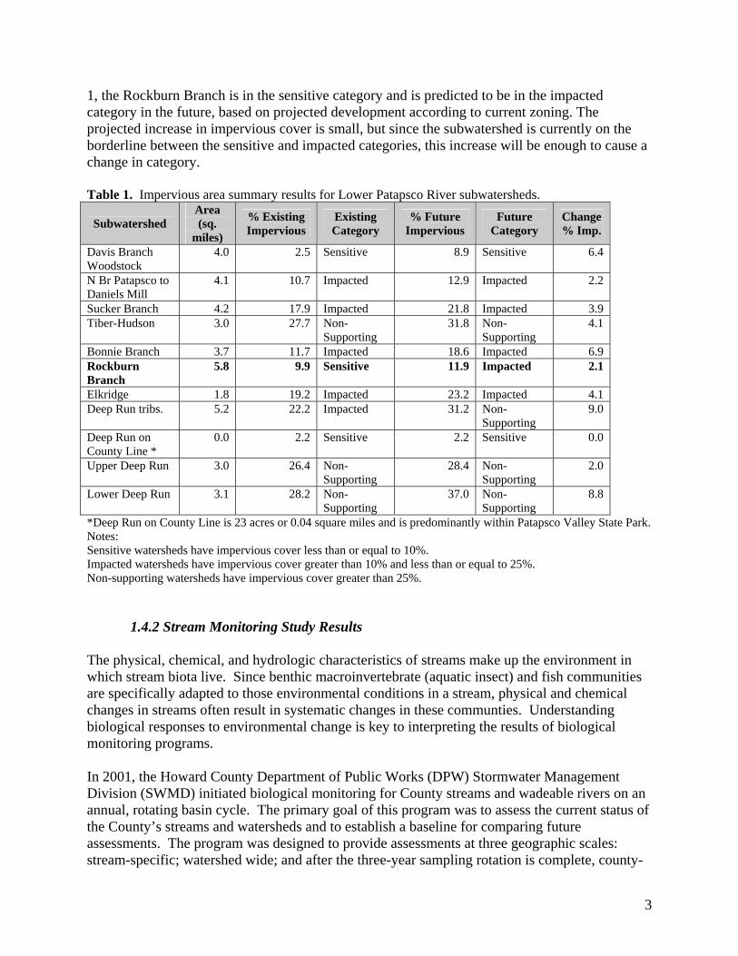
Sunnyfield Outfall (Project - RB – 9) Description: Stormwater management facility dominated by non-native vegetation.
A) View of area with non-native species. B) View of area with more non-native species Recommendation: Removal of non-native species and replanting with native riparian vegetation. This project is well suited for community volunteers or as an education/outreach effort. Dunteachin Pond Outfall Repair (Project - RB – 10) Description: Existing corrugated metal pipe at this outfall shows signs of corrosion and leakage.
A) View of stormwater pond. B) View of corrugated metal pipe at outfall. Recommendation: Repair the metal pipe at the stormwater pond outfall. Also could be a site for non-native vegetation removal and native plantings.
A B
A B

23
Elibank Drive Buffer Restoration (Project - RB – 11) Description: A small tributary that flows north along an agricultural road off Elibank Drive is actively downcutting. The small tributary joins a larger tributary, which is also experiencing active erosion.
A) Public Notice of land to be developed. B) View of eroding bank and areas recommended to be reforested. Recommendation: Stream repair and buffer planting opportunities exist on these tributaries. This area appears be slated for development and may be able to include stream restoration/protection in the plans. At a minimum the floodplain/overbank areas should be protected and actively reforested. The larger tributary is not a good candidate for stream repair due to high, uncontrolled flows from upland areas. The smaller tributary has the potential for repair, however, as the drainage does not appear to extend south of I-95. Belmont Stream Section (Project - RB – 13) Description: Erosion of a tall bank is occurring at a bend in the river. It is unknown if this is a result of past channel modification activities or natural processes from upland run-off. There is evidence of recent buffer reforestation and upland reforestation in this area.
A) View of reforested areas. B) View of eroded tall bank. Recommendation: Natural regeneration of the floodplain areas is feasible if left alone. One mowed area exists upstream of a pond and tributary. The purpose of this area is unknown. No priority recommendations have been set for this project due to difficult access.
A B
A B
24
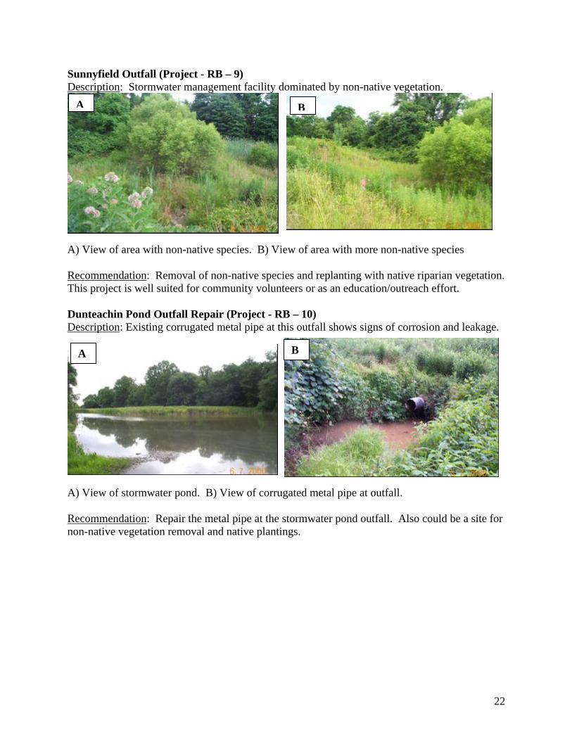
Impacted Buffer - Old Montgomery Rd (Project - RB – 14) Description: This section of stream currently lacks an adequate buffer.
A) View of buffer on public land. B) View of stream with steep banks. *Recommendation: Although a minimal buffer (<10 ft) exists, active replanting of a broader and fully functional buffer on the publicly owned parkland is recommended for this priority project. There may be a utility corridor that would limit the available space, however. Old Montgomery Stream (Project - RB – 15) Description: Active downcutting is occurring in the reach downstream of the sewer crossing. This is likely due to upstream urbanization.
A) View of downcutting. B) View of sewer crossing. Recommendation: On-site retrofits for the upstream neighborhoods are possible, however, road construction may pose a greater threat if this increases runoff to the stream. The sewer crossing also needs additional armoring to stop erosion from undermining and exposing the sewer.
A B
A B

25
Elkridge Elementary Entrance Parking Lot Retrofit (Project - RB – 16) Description: This parking lot near the school entrance drains to two corner curb cuts. The downstream swales are lined with rip rap and meet below the parking lot. These swales join a drainage system collecting runoff from the middle school stormwater management facility. The drainage system is causing downstream erosion and scour.
View of curb on Elkridge Elementary School Parking lot. *Recommendation: Install rain garden/biofilters at two existing curb cuts to provide water quality treatment of parking lot runoff. Investigate the school drainage system and determine if redirection or diversion of runoff is possible at this priority site.
Elkridge Elementary Stream (Project - RB – 17) Description: Stream repair is needed on two channels originating from the Elkridge Elementary School, one from the stormwater management pond the other from the entrance parking lot. Yard waste was dumped into channels and erosion/unstable banks from upstream run-off is also a problem.
A) Stream channel. B) Yard waste dumped into stream. *Recommendation: Priority repair efforts should include removal of yard waste dumped into the channel, upstream stormwater volume controls (see Project RB-16 and 18), bank stabilization, and education/outreach activities.
A B

26
Elkridge Elementary Stormwater Pond (Project - RB – 18) Description: A stormwater treatment facility near the school.
A) View of stormwater pond. B) View of riser structure. *Recommendation: This priority project involves retrofitting the existing stormwater pond to provide additional pre-treatment or increase capacity of the facility, by dredging or retrofit the overflow structure. This will improve treatment of first flush events and provide channel protection. Rockburn Elementary Parking Lot Retrofit (Project - RB – 19) Description: The school has some stormwater treatment but could be used as a demonstration project to increase its effectiveness and local awareness at the same time.
View of parking lot runoff drain and grassy area.
*Recommendation: Priority projects include incorporating bioretention areas into parking lot medians and turnabouts to provide water quality treatment for a dumpster storage area and parking lot runoff. Incorporating native BayScapes plantings as demonstration/educational projects at the entrance to the school property is also recommended.
A B

27
Rockburn Elementary Stormwater Pond Maintenance (Project - RB – 20) Description: The low flow orifice of the detention dry pond is clogged forming a permanent wet pool, but providing minimal volume protection to downstream channels.
A) Overview of extended detention dry pond. B) View of outfall. *Recommendation: Perform maintenance of extended detention dry pond. Rockburn Park East (Project - RB – 21) Description: Treatment of roadway and parking area drainage is not adequate and is causing erosion.
A) View of rip rap channel. B) View of roadway drainage area. *Recommendation: Improve roadway drainage by conducting stormwater runoff to drainage swales. Improve road and parking lot drainage by removing riprap in channel and creating a bioretention facility designed for channel protection and water quality volume.
A B
A B

28
Rockburn Park West (Project - RB – 22) Description: Treatment of roadway and parking area drainage is not adequate.
A) View of entrance road. B) View of parking lot and potential retrofit area. *Recommendation: Provide treatment of roadway runoff by constructing a grassed swale parallel to the entrance road, reforest open areas where not specifically managed as open meadow, replace riprap with native plant material and add rain gardens at parking lot curb cuts. Also propose further study of parking lot use patterns to determine if porous paving alternative is feasible. Rockburn Park Outfall (Project - RB – 23) Description: The outfall culvert here is half filled with sediment.
View of culvert and sediment. *Recommendation: Priority project should be to perform maintenance on the culvert to remove sediment.
B A

29
Ilchester Elementary/Middle School (Project - RB – 24) Description: These schools have a new, well-maintained stormwater management pond. The school campuses provide opportunities for several demonstration projects.
A) View of possible rain garden location. B) View of sunken area where second rain garden could go. *Recommendation: Install rain gardens as educational/demonstration tools in areas adjacent to an accessory building at the elementary school and/or within an open area near the entrance of the middle school. Landing Rd South (Project - RB – 25) Description: The existing buffer is approximately 10' wide along the stream in this section.
Two views of buffer zones. Recommendation: Should be approached as an opportunity to expand forested buffer.
A B

30
Landing Rd North (Project - RB – 26) Description: There is no existing buffer of the stream in this section and the stream is piped until it crosses a power easement.
View of piped stream with no buffer zone.
Recommendation: Suggest a no-mow native vegetation area along stream. Investigate rationale for piping stream to see if potential to remove and restore channel. Grace Episcopal (Project - RB – 27) Description: Run-off flows leave a grass swale and new stormwater mangement facility at Grace Episcopal Church, and return to an asphalt channel along side Landing Road.
A) View of water leaving church. B) View of water running to the stream. Recommendation: With downstream landowner cooperation, it would be possible to re-construct a natural channel from the church to the stream. However, this is a more costly project that would require private land.
A B

31
Lawyers Hill – State Highway Administration (SHA) (Project - RB – 28) Description: SHA property south of I-95 along a tributary presents an opportunity to provide channel protection control. The downstream channel (north of I-95) is experiencing significant erosion.
A) View of buffer area. B) View of culvert under Lawyers Hill Rd. *Recommendation: A priority project would be to divert flows from upstream of Lawyers Hill Road across the forested floodplain area owned by SHA to provide some quantity control. Repair of concrete channel in the SHA right-of-way is also needed. Green Valley Place (Project - RB – 29) Description: Private home where the stream crosses the first driveway in a concrete channel (vehicles drive through channel). The stream is piped under the second driveway and part of the yard. The stream then enters a channel/ditch that is mowed to the bank.
A) View of stream crossing the driveway. B) View of stream in mowed ditch/channel. *Recommendation: Provide education/outreach to the landowner regarding stream buffers. Investigate the exclusion of vehicles driving through the stream, perhaps by placing the stream in a pipe or culvert.
A B
B A

32
Lawyers Hill Driveway (Project - RB – 30) Description: The tributary parallels a driveway off Lawyers Hill Rd. and there is less than 5’ buffer on either side.
A) View of Tributary running underneath a driveway. B) View of Lawyers Hill Rd. Recommendation: The homeowners on either side should be educated about good buffer management. This property was under construction at the time of the DNR SCA. Rockburn Manor Outfall Outreach/Education (Project - RB – 31) Description: The areas downstream of the outlet from this stormwater management facility are
being mowed, and likely fertilized.
A) View of the culvert. B) View of outlet from SWM facility. *Recommendation: A no-mow vegetation is suggested for both outlets. This would require working with the property owner and landscaping company to change the management plan, but is a priority project.
A B
A B

33
Grovemont Ponds Stormwater Retrofit (Project - RB – 32) Description: This is a new subdivision that appears to have dry ponds (possibly infiltration basins). The adjacent homeowner complains of flooding.
A) View of outfall to dry pond 1. B) View of outfall to dry pond 2. Recommendation: Investigate the design of the stormwater management facilities to determine the original design and if maintenance is necessary. Target this area for outreach regarding downspout disconnection and landscaping. Radel Court Stormwater Retrofit (Project - RB – 33) Description: This is an existing stormwater management facility that treats runoff from a residential area.
Picture of the facility
*Recommendation: This is an opportunity to improve the existing facility. Check the inlet for maintenance, improve plantings around the pond and stop mowing so close to the facility.
A B

34
3.2 Next Steps The Rockburn Branch project relied on established protocols for stream, upland and retrofit assessments, as well as qualitative information and best professional judgment for extracting priority sites from this subwatershed. That process made use of previous studies containing information on the general condition of the subwatershed and specific problem areas. The next steps for final project development will require further workgroup and County input, receptiveness of the landowner and community, and detailed cost estimates from stormwater facility experts and/or landscape engineers. In the meantime, implementation can begin on a number of the other recommendations including enforcement projects, maintenance projects and outreach projects. The recommended next steps are as follows:
1. Begin to plan enforcement, maintenance and outreach efforts. 2. Consult with private property owners and community representatives. 3. Conduct more detailed site investigations for identified priority projects. 4. Develop cost estimates and determine funding sources/availability based on information
from #2 and #3. Once these steps are completed and the restoration project list finalized, we recommend that a program be developed that includes a process for monitoring the effectiveness of any restoration activity. Monitoring should include interim goals for restoration engineering success and stormwater management, but must also include final goals for in-stream habitat restoration and improved biological condition. With this process in place Howard County can utilize information on project specific successes and challenges to improve and expand stream restoration efforts throughout the county.

35
SECTION 4: DATA SHEET COPIES Copies of the field forms used for field validations that lead to project descriptions and restoration recommendations are provided in Section 4.1. Copies of each Hotspot investigation (Section 4.2) and Neighborhood Assessments (Section 4.3) forms, which were used to help develop projects are also provided.

36
4.1 Rockburn Branch Projects Forms (available upon request)

91
4.2 Rockburn Branch HotSpot Investigation Forms (available upon request)

95
4.3 Rockburn Branch Neighborhood Source Assessment Forms (available upon request)

106
APPENDIX A
SUMMARY TABLES OF THE RESULTS OF THE FIELD RECONNAISSANCE WORK FOR THE ROCKBURN BRANCH

Appendix A: Summary tables of the results of the field reconnaissance work for the Rockburn Branch
Field PersonnelSite ID Name Project Type Field Forms Description
EMC/KAL/SOProject - RB - 1 Kerger Dry Pond Stormwater Retrofit Retrofit
Opportunity to retrofit dry pond and incorporate the facility into an existing dry pond that is functioning more like stormwater wetland.
EMC/KAL/SO
Project - RB - 2 Dunteachin Storm Drain Retrofit Stormwater Retrofit Retrofit
Address stormdrain connections and retrofit stormdrain into a bioretention facility capable of providing water quality treatment. Maintain existing structure as overflow control.
EMC/KAL/SO
Project - RB - 3 Kerger Road Buffer Revegetation
Buffer Restoration/Bank
StabilizationStream Repair
Potential to replant existing turf grass along banks with native riparian vegetation. Due to setback constraints bank grading, repair, and revegetation is not possible along entire restoration reach.
EMC/KAL/SO
Project - RB - 4 Western Rockburn Branch Park Stream Erosion
Buffer Restoration/Bank
StabilizationStream Repair
Bank erosion observed along proposed restoration reach, though due to access limitations pursuing upstream volume controls is recommended prior to initiation of stream repair efforts.
EMC/KAL/SO
Project - RB - 5 Rockburn Branch Park Stream Crossing #1
Buffer Restoration/Bank
Stabilization
Stream Crossing
Stream crossing, assumed to be used by trail users and mountain bikers, identified as a project candidate for bank repair and revegetation. Incorporating local trail users/groups in proposed project along with trail signage/education outreach recommended
EMC/KAL/SO
Project - RB - 6 Rockburn Branch Park Stream Crossing #2
Buffer Restoration/Bank
Stabilization
Stream Crossing
Stream crossing, assumed to be used by trail users and mountain bikers, identified as a project candidate for bank repair and revegetation. Incorporating local trail users/groups in proposed project along with trail signage/education outreach recommended
EMC/KAL/SO
Project - RB - 7 Pumphouse Stream Buffer Restoration
Buffer Restoration/Bank
StabilizationStream Repair
Left bank and riparian vegetation limited at this site due to landscape management by private landowners. Propose working with landowners to replace existing turf grass with native riparian species and removing landscape debris from banks.
Rockburn Branch Potential Restoration Projects

Appendix A: Summary tables of the results of the field reconnaissance work for the Rockburn Branch
Field PersonnelSite ID Name Project Type Field Forms Description
Rockburn Branch Potential Restoration Projects
EMC/KAL/SO
Project - RB - 8 Rockburn Branch Park Trail Erosion Stormwater Retrofit Retrofit
Repair section of trail where concentrated flow is eroding trail and a downstream channel bank. Small scale project ideal for community volunteers and park users.
EMC/KAL/SO
Project - RB - 9 Sunnyfield Outfall Native Species Revegetation Miscellaneous
Removal of non-native species and replanting with native riparian vegetation proposed at this location where a stream daylights in an open wetland area. This project is well suited for community volunteers or as an education/outreach effort.
EMC/KAL/SOProject - RB - 10 Dunteachin Pond Outfall
Repair Stormwater Repair MiscellaneousRepair of stormwater pond outfall required. Existing corrugated metal pipe shows signs of corrosion and leakage.
SCH/RP
Project - RB - 11 Elibank Drive Buffer Restoration Buffer Restoration Stream Repair
Small tributary flows north along farm road off Eubank drive and is actively downcutting. The small trib joins a larger trib, also experiencing active erosion. Stream repair and buffer planting opporunties exist. This parcel may be slated for development. At a minimum the floodplain/overbank areas should be protected and actively reforested. The larger trib is not a good candidate for stream repair due to high, uncontrolled flows. The smaller trib has the potential for repair, as the drainage does not appear to extend south of I-95.
Project - RB - 12 unused number

Appendix A: Summary tables of the results of the field reconnaissance work for the Rockburn Branch
Field PersonnelSite ID Name Project Type Field Forms Description
Rockburn Branch Potential Restoration Projects
SCH/RP
Project - RB - 13
Belmont Stream Section RCH
No priority recommendations due to difficult access. There is evidence of recent buffer reforestation and
upland reforestation in this area. Natural regeneration of floodplain areas is feasible. One mowed area exists
upstream of the pond and tributary. The purpose of this area is unknown. Erosion of a tall bank is occurring at a bend in the river. It is unknown if this is a result of past
channel modification activities or a natural process.
SCH/RP
Project - RB - 14 Impacted Buffer - Old Montgomery Rd Buffer Restoration IB, Stream
Repair
Minimal buffer (<10 ft) exists. Active replanting of the buffer on the publicly owned parkland is recommended. There may be a utility corridor that would limit the available space.
SCH/RP
Project - RB - 15 Old Montgomery Stream Stream Repair Stream Repair, OT
Active downcutting is occurring in the reach downstream of the sewer crossing. This is likely due to upstream urbanization. On-site retrofits for the upstream neighborhoods are a possibility. The sewer crossing may need additional armorment.
SCH/EMC/MR/KH
Project - RB - 16
Elkridge Elementary Entrance Parking Lot
Stormwater Retrofit Retrofit
Install rain garden/biofilters at two existing curb cuts to provide water quality treatment of parking lot runoff. More detailed information is needed to Investigate the school building storm drain system and determine if disconnection or runoff volume reduction is possible.
SCH/EMC/MR/KH
Project - RB - 17
Elkridge Elementary
Buffer Restoration/Bank
StabilizationStream Repair
Proposed stream repair on two channels originating from the Elkridge Elementary School, one from the stormwater management pond the other from the entrance parking lot. Repair efforts to include removal of yard waste dumped into the channel, upstream stormwater volume controls, bank stabilization, and education/outreach activities.

Appendix A: Summary tables of the results of the field reconnaissance work for the Rockburn Branch
Field PersonnelSite ID Name Project Type Field Forms Description
Rockburn Branch Potential Restoration Projects
SCH/EMC/MR/KH
Project - RB - 18Elkridge Elementary Stormwater Pond
Stormwater Retrofit Retrofit
Retrofit existing stormwater pond to provide additional pre-treatment or increase capacity of facility, by dredging or retrofiting the overflow structure, to improve treatment of first flush events.
EMC/MR
Project - RB - 19
Rockburn Elementary Parking Lot Retrofit
Stormwater Retrofit Retrofit
Incorporate bioretention areas into parking lot medians and turnabouts to provide water quality treatment for a dumpster storage area and parking lot runoff. Propose incorporating a native BayScapes planting plan as demonstration/educational projects at entrance to school property.
EMC/MR
Project - RB - 20 Rockburn Elementary Stormwater Pond Maintenance
Stormwater Pond Maintenance Miscellaneous
Perform maintenance of extended detention dry pond. The low flow orifice is clogged forming a permanent wet pool, but providing minimal volume protection to downstream channels.
EMC/MR
Project - RB - 21
Rockburn Park East
Stormwater Retrofit Retrofit
Improve roadway drainage by conducting stormwater runoff to drainage swales and at one location install a bioretention facility designed for channel protection and water quality volume.
EMC/MR
Project - RB - 22
Rockburn Park West
Stormwater Retrofit Retrofit
Provide treatment of roadway runoff by constructing a grassed swale parallel to the entrance road, reforest open areas where not specifically managed as open meadow, replace riprap with native plant material at parking lot curb cuts. Also propose further study of parking lot use patterns to determine if porous paving alternative is feasible.
EMC/MR Project - RB - 23 Rockburn Park OutfallStormwater Outfall
MaintenanceStormwater
OutfallsRecommend maintenance of culvert half filled with sediment.

Appendix A: Summary tables of the results of the field reconnaissance work for the Rockburn Branch
Field PersonnelSite ID Name Project Type Field Forms Description
Rockburn Branch Potential Restoration Projects
EMC/MR
Project - RB - 24 Ilchester Elementary/Middle School
Stormwater Retrofit RetrofitInstall rain gardens as an educational/demonstration tool on two campuses, possible locations include adjacent to an out building at the elementary school and within an open area near the entrance of the middle school.
SCH/RP Project - RB - 25 Landing Rd South Buffer Restoration IB Existing buffer approx 10' width. Opporunity to expand forested buffer.
SCH/RPProject - RB - 26
Landing Rd North Buffer Restoration IB No existing buffer. Stream is piped, then crosses power easement. Suggest a no-mow native vegetation.
SCH/KH
Project - RB - 27
Grace Episcopal Stream Repair Stream Repair
Flows leave grass swale and new SWM facility at Grace Episcopal and return to asphalt channel along ride. With downstream landowner cooperation, it would be possible to recreate a natural channel from the church to the stream.
SCH/EMC/MR/KH
Project - RB - 28
Lawyers Hill - SHA Stormwater Retrofit Retrofit
Possible to divert flows from upstream of Lawyers Hill Rd across to forested flooplain area owned by SHA to provide some quantity control. Repair of concrete channel in SHA ROW also needed.
SCH/EMC/MR/KH
Project - RB - 29
Green Valley Place
Buffer Restoration/Stream Repair IB
Private home. Stream crosses first driveway in concrete channel (vehicles drive through channel). Stream piped under driveway and part of yard. Stream enters channel/ditch that is mowed to the bank. Possible to add buffer, exclude vehicles from driving through stream.
SCH/EMC/MR/KH
Project - RB - 30
Lawyers Hill Driveway Homeowner Education IB
The tributary parallels a driveway off Lawyers Hill Rd. The homeowners on either side should be educated about good buffer management. This property was under construction at the time fo the DNR SCA.
SCH/KHProject - RB - 31
Rockburn Manor Outfall Outreach/Education OT
The areas downstream of the outlet from the SWM facility is being mowed, and likely fertilized. A no-mowvegetation is suggested.

Appendix A: Summary tables of the results of the field reconnaissance work for the Rockburn Branch
Field PersonnelSite ID Name Project Type Field Forms Description
Rockburn Branch Potential Restoration Projects
SCH/KHProject - RB - 32
Grovemont Ponds Stormwater Retrofit none
This is a new subdivision, but appears to have dry ponds (possibly infiltration basins?). Adajacent homeowner complains of flooding.
KAL/SO
Project - RB - 33
Radel Lane
Stormwater Retrofit Retrofit
Opportunity to improve exisitng facility that drains residential area. There is park land nearby and forest to the east. Recommend checking the outlet maintenance, improve plantings around the pond and stop mowing so close. Public land