Embed Size (px)
Citation preview

Land Contamination & Reclamation, 14 (3), 2006 © 2006 EPP Publications Ltd
DOI 10.2462/09670513.698
Assessing contaminant migration pathways and vertical gradients in a low-permeability aquifer using multilevel borehole systems
Peter Dumble, Max Fuller, Paul Beck and Paul Sojka
AbstractA comparison of groundwater and gas monitoring data is provided between multilevel and conven-tional long-screened boreholes constructed around the perimeter of a closed landfill in the English Midlands. Multilevel boreholes were constructed with up to seven separate sampling ports.
All boreholes were constructed into strata of the Triassic Mercia Mudstone Group, which proved to consist of a succession of well-bedded, weathered mudstone and clay with occasional thin beds of siltstone and sandstone to approximately 30 m depth. These are low-permeability strata which exhibit sufficient fracture permeability to allow groundwater movement. It is suspected that fractures, particularly along bedding planes, provide discrete pathways for both gas and leachate migration from the landfill.
The importance of purging channels prior to sampling both aqueous and vapour phases is empha-sised in order to minimise diffusion biases.
Monitoring records for the multilevel boreholes demonstrate that there are significant vertical differ-ences in groundwater level, and groundwater chemistry. A predominantly downward vertical hydrau-lic gradient is proven in all the multilevel boreholes, with a head difference of up to 5 metres over a vertical distance of 13 metres between uppermost and lowest sampling ports. Chloride concentration in groundwater varies from a background of below 50 mg/L to in excess of 700 mg/L within ports of the same multilevel borehole. Total organic carbon varies vertically from less than 10 mg/L to over 50 mg/L. None of this detail is apparent in data gathered from the adjacent long-screened monitoring boreholes, which in general recorded concentrations which were significantly below the maximum in the neighbouring multilevel.
Key words: borehole, gas, groundwater, landfill, leachate, long-screened, low permeability, methane, Mercia Mudstone, migration, monitoring, multilevel, vertical gradients
INTRODUCTION
The use of long-screened monitoring boreholes can sig-nificantly mask hydraulic and chemical variations that occur naturally over short vertical distances. These issues can be overcome by the use of multilevel sam-pling systems (e.g. CL:AIRE 2002a,b; Beck 2003). Hydraulic and chemical conditions within longer-screened monitoring boreholes can become averaged or biased toward the dominant condition (Martin-Hayden
Received November 2005; revised and accepted April 2006
Peter Dumble,1 Max Fuller,1, 2 Paul Beck3 and Paul Sojka4
1. Waterra (UK) Limited, Unit 4, 179–189 Stratford Road, Soli-hull B90 3AU, UK2. URS Corporation Ltd, 3rd Floor, Minerva House, 29 East Parade, Leeds LS1 5PS, UK3. Formerly with Solinst Canada Ltd, 35 Todd Road, George-town, Ontario L7G 4R8, Canada, now at Jacques Whitford, 7271 Warden Avenue, Markham, Ontario L3R 5X54. Worcestershire County Council, Perry Wood Walk, Worces-ter WR5 1ES, UK
699

Land Contamination & Reclamation / Volume 14 / Number 3 / 2006
and Robbins 1997; Martin-Hayden 2000a,b; Gibs et al. 2000; Sevee et al. 2000; Britt 2005). Vertical flows induced by vertical hydraulic gradients, can cause the re-distribution of contaminants from one vertical zone to another, or can mask thin zones of contamination which become diluted, sometimes to below detection (e.g. Church and Granato 1996; Hutchins and Acree 2000; Elci et al. 2001; Martin-Hayden and Britt 2006). The conditions of ambient flow and contaminant dilu-tion can occur to both groundwater in the saturated zone and soil gas in the unsaturated zone. Under these conditions, it can be difficult to identify contaminant migration pathways with any degree of confidence.
The following case history (after Fuller 2004), pro-vides an example of how multilevel systems used in conjunction with conventional boreholes can improve the understanding of contaminant migration pathways. For the purposes of this paper, the data collected from the multilevel boreholes have been assessed separately and compared to data from the conventional long-screened boreholes. Both sets of boreholes are located on the perimeter of a closed landfill site in Worcester-shire, UK.
SITE DESCRIPTION
The site was originally a clay quarry and brick works which was landfilled from approximately 1965 until 1983. The ratio of household to general industrial waste is estimated from Council records to be approxi-mately 3:1. The depth of waste within the clay pits var-ies from 3 to 12 metres. The whole site was capped
with between 0.75 and 1.5 metres of clay in 1983, with additional soil cover added later to offset settlement. There are no engineered barriers.
The site and surrounding area are underlain by strata of the Triassic Mercia Mudstone Group consisting of weathered red-brown laminated or massive mudstones and clay with occasional thin beds of grey to buff or pink siltstone and sandstone. The Mercia Mudstone Group is over 380 metres thick at the site, and is under-lain by the Bromsgrove Sandstone Formation, which is a major aquifer. Strata dip at approximately 2° to the south-east (Figure 1).
The overall transmissivity of the Mercia Mudstone is low but there is sufficiently high hydraulic conduc-tivity locally to allow groundwater movement along discrete bedding plane fractures, vertical discontinui-ties and through the more permeable siltstone and sand-stone bands.
MONITORING INFRASTRUCTURE
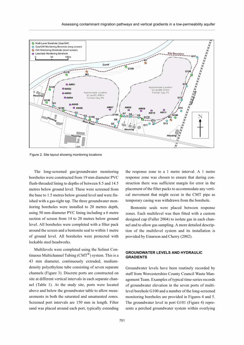
The site has been regularly monitored by Worcester-shire County Council since 1995, using boreholes located on the site perimeter. In March and April 2000, 29 new monitoring boreholes were installed including 16 long-screened gas and groundwater monitoring boreholes, three groundwater monitoring boreholes and ten multilevel monitoring boreholes. The general site layout and location of monitoring boreholes is illustrated in Figure 2 and summary construction details including screen lengths and port elevations are presented in Table 1.
700
Figure 1. Simplified conceptual section
Assessing contaminant migration pathways and vertical gradients in a low-permeability aquifer
Figure 2. Site layout showing monitoring locations
The long-screened gas/groundwater monitoring boreholes were constructed from 19 mm diameter PVC flush-threaded lining to depths of between 8.5 and 14.5 metres below ground level. These were screened from the base to 1.5 metres below ground level and were fin-ished with a gas-tight tap. The three groundwater mon-itoring boreholes were installed to 20 metres depth, using 50 mm diameter PVC lining including a 6 metre section of screen from 14 to 20 metres below ground level. All boreholes were completed with a filter pack around the screen and a bentonite seal to within 1 metre of ground level. All boreholes were protected with lockable steel headworks.
Multilevels were completed using the Solinst Con-tinuous Multichannel Tubing (CMT®) system. This is a 43 mm diameter, continuously extruded, medium-density polyethylene tube consisting of seven separate channels (Figure 3). Discrete ports are constructed on site at different vertical intervals in each separate chan-nel (Table 1). At the study site, ports were located above and below the groundwater table to allow meas-urements in both the saturated and unsaturated zones. Screened port intervals are 150 mm in length. Filter sand was placed around each port, typically extending
the response zone to a 1 metre interval. A 1 metre response zone was chosen to ensure that during con-struction there was sufficient margin for error in the placement of the filter packs to accommodate any verti-cal movement that might occur in the CMT pipe as temporary casing was withdrawn from the borehole.
Bentonite seals were placed between response zones. Each multilevel was then fitted with a custom designed cap (Fuller 2004) to isolate gas in each chan-nel and to allow gas sampling. A more detailed descrip-tion of the multilevel system and its installation is provided by Einarson and Cherry (2002).
GROUNDWATER LEVELS AND HYDRAULIC GRADIENTS
Groundwater levels have been routinely recorded by staff from Worcestershire County Council Waste Man-agement Team. Examples of typical time-series records of groundwater elevation in the seven ports of multi-level borehole G100 and a number of the long-screened monitoring boreholes are provided in Figures 4 and 5. The groundwater level in port G101 (Figure 4) repre-sents a perched groundwater system within overlying
701

702
Land Contamination & Reclamation / Volume 14 / Number 3 / 2006
Conventional Monitoring BoreholesBH Depth Screen Length Groundwater
ElevationChloride Total Organic
CarbonDissolved Methane
metres metres m.AOD mg/l mg/l mg/l No Avg Min Max12.0 9.3 44.1 281 8.5 <0.005 40 0.00 0 014.0 12.0 45.1 513 13.4 2.151 41 49.87 0 7314.0 12.0 45.4 306 23.1 1.792 40 42.26 0 7314.0 12.0 45.3 276 23 1.434 41 2.97 0 30.514.5 12.0 46.2 39 6.7 <0.005 40 0.00 0 0.114.5 12.0 46.8 33 6.8 <0.005 40 0.00 0 014.5 12.0 46.9 51 7.8 <0.005 40 1.77 0 1114.5 12.0 47.1 25 5.6 <0.005 41 15.56 0 43.514.5 12.0 48.7 54 6.9 <0.005 35 0.07 0 0.914.0 12.0 48 - 5.4 <0.005 40 0.00 0 0.114.5 12.0 47.4 93 5.8 <0.005 40 0.00 0 0.18.5 6.0 49.5 20 4.8 <0.005 40 0.00 0 0.1
11.5 9.0 46.8 26 5.7 <0.005 40 1.30 0 5.311.5 7.0 46.5 - - - 40 36.69 0 7511.5 9.0 47.8 83 34.4 1.434 40 62.05 13.5 7611.5 9.0 46 33 14.2 <0.005 39 6.58 0.3 2120.0 6.0 45 719 31.4 <0.005 - - - -20.0 6.0 40.7 269 7.9 <0.005 - - - -20.0 6.0 45.6 36 5.6 <0.005 - - - -
Multi-Level Monitoring BoreholesBH Depth Port Elevation Groundwater
ElevationAverage Hydraulic Gradient
Chloride Total Organic Carbon
Dissolved Methane
metres m.AOD m.AOD m / m mg/l mg/l mg/l No Avg Min MaxG101 46.1 46.9 P - - - 37 0.1 0 0.9G102 43.7 45.1 - - - 37 0.4 0 7.3G103 41.4 44.2 47 11.6 0.108 38 0.2 0 2.9G104 38.9 44.1 232 47.2 0.717 39 0.2 0 1.6G105 36.4 42.9 311 39.2 0.065 39 0.1 0 0.9G106 33.9 40.6 351 44.6 0.05 39 0.2 0 1.1G107 30.7 40.4 363 31.9 <0.005 37 0.1 0 0.7G111 45.8 Dry - - - - 40 28.1 0 66G112 42.8 44.9 - - - 35 5.8 0 34G113 40.3 44.8 80 11.8 <0.005 36 4.3 0 29.5G114 38.1 42.8 206 14.8 0.006 39 3.2 0 21.5G115 34.8 38.8 577 52.5 <0.005 39 2.4 0 19.5G116 32.5 44.6 389 20 0.036 36 4.2 0 20G117 29.4 44.7 85 11.6 0.143 37 3.4 0 23G121 47.0 Dry Dry - - - 40 0 0 0.3G122 44.0 45 - - - 37 0 0 0.3G123 41.5 44.1 254 30 1.434 35 0 0 0.3G124 39.0 44.1 334 37.2 1.792 36 0 0 0.3G125 36.5 43.8 344 34.9 1.075 39 0.3 0 0.8G126 34.0 39.3 518 11.2 <0.005 39 0.5 0 0.9G127 30.5 38.3 646 9.3 <0.005 39 0.7 0.2 1.3G131 48.0 Dry Dry - - - 40 0 0 0G136 45.0 Dry Dry - - - 39 0 0 0G135 42.5 44.4 - - - 37 0 0 0.1G137 32.5 38.7 - - - 38 0 0 0.2G141 50.2 Dry Dry - - - 40 0 0 0.7G146 47.6 Dry Dry - - - 39 0 0 0.1G143 44.8 44.9 - - - 38 0 0 0.1G144 42.0 45 538 10 <0.005 39 0 0 0.1G145 39.3 44.4 447 11.1 <0.005 39 0 0 0.1G142 36.6 44.4 459 9.3 <0.005 36 0 0 0.1G147 33.1 44.5 471 8.6 <0.005 37 0 0 0.1G151 51.5 Dry - - - - 39 32.9 0 65G152 47.8 Dry - - - - 40 47.5 0 68G153 44.8 45.4 - - - 39 22.6 0 60G154 42.5 45.4 311 21.4 1.434 37 23.9 0 60G155 40.4 45.3 331 21.4 2.151 39 20.2 0.2 52.3G156 38.2 45.2 165 13.5 <0.005 38 25.6 1.6 64G157 35.8 45.2 204 16.4 0.358 40 25.6 0.2 60G161 53.1 Dry - - - - 40 0 0 0G162 50.7 Dry - - - - 39 0.3 0 4.6G164 48.3 Dry - - - - 39 0 0 0.1G165 42.8 46.8 69 9 <0.005 40 0 0 0.6G166 40.0 46.7 110 10.5 <0.005 36 0 0 0.7G167 37.1 41.7 305 19.5 <0.005 39 0 0 0.6G171 52.8 Dry Dry - - - 40 0 0 0.1G172 49.9 Dry Dry - - - 39 0 0 0.1G173 47.4 48.1 - - - 39 0 0 0G174 44.9 47.9 61 4.8 <0.005 39 0 0 0G175 42.4 47.3 60 6.2 <0.005 39 0 0 0.1G176 39.8 47.3 142 8 <0.005 39 0 0 0G177 36.2 42.7 - - - 38 0 0 0.1G181 49.1 49 P - - - 40 0 0 0G182 46.4 48.4 - - - 36 0 0 0G183 43.6 47.3 - - - 39 0 0 0G184 40.9 46.4 68 6.9 <0.005 39 0 0 0G185 38.4 46 53 9.8 <0.005 37 0 0 0G186 35.6 45.9 57 11 <0.005 39 0 0 0G187 32.7 45.8 67 6.6 <0.005 39 0 0 0.1G191 46.2 Dry Dry - - - 40 38.6 0 77G192 43.2 46.4 38 11.5 2.151 37 19.8 0 74G193 40.7 46.3 227 38.7 4.301 38 13.5 0 71G194 38.2 46.3 289 47.6 5.018 39 14.2 0 66G195 35.7 46.3 386 52.9 2.151 39 11.8 0 72G196 33.2 45.6 608 42.5 2.867 39 13.9 0 73G197 29.7 45.6 746 24.6 0.502 39 9.7 0 52
Groundwater levels recorded in December 2000 All groundwater samples taken in June / July 2000.P - Perched groundwater Gas results are average of weekly measurements between April 2000 and January 2001"-" No measurement Detection limit of portable gas analyser is 0.1% - reported as 0 for statistical purposes.
Borehole
(Borehole) Multilevel
Port
W3
G17W1W2
G16
(G19
0)(G
130)
G01G02G03G04G05G06G07G08
(G15
0)(G
160)
(G17
0)(G
180)
(G10
0)(G
110)
(G12
0)(G
140)
Groundwater Quality Samples Gas Measurements
Groundwater Quality Samples Gas Measurements
Methane in Air (% by Volume)
Methane in Air (% by Volume)
G09G11G12G13G14G15
19.6
20.4
20.4
-0.36
-0.77
19.6
19.7
19.7
19.9
1.09
19.0
19.5
-0.50
-0.14
19.6-0.57
-0.06
-0.02
-0.89
-0.48
-0.19
Table 1. Summary of monitoring data

Assessing contaminant migration pathways and vertical gradients in a low-permeability aquifer
Figure 3. Cross-section of CMT multilevel tubing
superficial deposits. Ports G102 to G107 are all within the Mercia Mudstone. The data demonstrate a consist-ent seasonal pattern of variation and, apart from in one section of borehole G110, a consistent downward hydraulic gradient sustained throughout the five-year monitoring period. The significant vertical variation in head within each multilevel provides confidence that the ports are hydraulically isolated from each other within the borehole.
Groundwater levels in the selected long-screened and groundwater monitoring boreholes (Figure 5) show a similar seasonal variation to the multilevel records, but with more subdued short-term variations. If the groundwater head data from the conventional boreholes alone were used and no account taken of screen positions, it would probably be concluded that the overall pattern of groundwater flow was north-westerly, with the assumption made that groundwater was moving uniformly within the Mercia Mudstone. A closer examination of heads in relation to screen posi-tion in the long-screened boreholes does however high-light what appear to be anomalously low groundwater levels in boreholes W2 and W3 (Figures 5 and 6).
Figure 6 and subsequent figures are cross-sections drawn around the entire site perimeter to allow compar-ison of data between boreholes. Boundary sections are labelled to help with orientation.
The contoured head data from the multilevel bore-holes (Figure 6) indicate flow paths which have their lowest heads at specific depths in two different loca-tions: (i) the north-western corner of the site, focused
near to the base of the landfill site (boreholes G110, G120 and G130); and (ii) along the south-western boundary of the site at the base of boreholes G160 and G170. The dominant flow path is still north-westerly. These observed hydraulic head patterns could be indic-ative of preferential movement of groundwater along higher-permeability zones, such as bedding plane frac-tures (which dip in the opposite direction to groundwa-ter flow – see Figure 1).
The overall hydraulic gradient(s) in each of the mul-tilevels is given in Table 1. There is considerable varia-tion between multilevels in the magnitude of hydraulic gradients. For example in G100 (Figure 4), the gradient between port G102 and G107 in the Mercia Mudstone is 4.7 m over a distance of 13 m (downward gradient of –0.36). Larger gradients are recorded over shorter intervals (e.g. upward gradient of +1.09 between ports G117 and G115).
GROUNDWATER QUALITY
Groundwater samples were collected during June and July 2000 from all conventional boreholes and the satu-rated ports within the multilevel systems. Sampling methods were undertaken in accordance with best prac-tice (e.g. early drafts of Environment Agency 2003) and all long-screened installations were purged of at least three borehole volumes prior to sampling. This particular purge procedure tends to bias the samples in the long-screened boreholes towards being a flow weighted average over the saturated screen interval of the borehole (e.g. Sevee et al. 2000). Regarding multi-level systems, a thorough purging of each multilevel channel is necessary to ensure that diffusion biases which could occur through the thin polyethylene walls between channels in the CMT tubing are minimized. The issue of diffusion is discussed in Einarson and Cherry (2002). Consequently in the analyses presented below there may potentially be biases arising from dif-fusion.
In order to assess how purging might affect sample concentrations, a simple purging trial was conducted in one of the channels of multilevel borehole G190 (port G195). Samples were taken after removing 0, 1, 3, 5 and 7 channel volumes. Chloride analysis revealed that the analyte concentration changed less than 6% with continued purging after the removal of one borehole
703

704
Land Contamination & Reclamation / Volume 14 / Number 3 / 2006
Figure 4. Multilevel G100: groundwater levels recorded in ports G101 to G107 (April 2000 to September 2005)
36
37
38
39
40
41
42
43
44
45
46
47
48
Jan 2000 Jan 2001 Jan 2002 Jan 2003 Jan 2004 Jan 2005
m.A
OD
G017
W001
G001
W002
Figure 5. Groundwater levels recorded in long-screened monitoring boreholes (April 2000 to September 2005)

Assessing contaminant migration pathways and vertical gradients in a low-permeability aquifer
volume (Table 2). Subsequently a ‘3× channel volume’ purge standard was adopted for these prior to sampling.
Table 2. Comparison of chloride analysis during purging in multilevel borehole G190 (Port G195)
No. of channel volumespurged
Chloride concentration
(mg/L)
% Change in chloride
concentration
0 175
1 402 129
3 385 –4
5 407 6
7 408 <1
Following purging using inertial pumps, samples were collected at a low pumping rate and stored in lab-oratory-supplied containers. Samples were kept at approximately 4°C using ice packs, and were trans-ported the same day to an accredited laboratory. Partic-ular precautions were taken when obtaining groundwater samples for dissolved methane analysis. Channels were first thoroughly purged and pumping rates reduced as much as possible during sampling, to provide a discharge with laminar flow. Sample contain-
ers were filled to overflow and capped immediately to minimise degassing and volatilisation.
Analytical results for three selected determinants: chloride; total organic carbon (TOC); and dissolved methane; are summarised in Table 1 and discussed below.
Chloride distribution
The distribution of chloride within the multilevel bore-holes (Figure 7) illustrates significant vertical variation in concentration. For example in multilevel G190 the chloride concentration varies from 38 mg/L in the high-est saturated port, increasing vertically port by port to a maximum of 746 mg/L in the lowest. Concentrations in the nearest conventional boreholes, G16 and G17, are 83 and 33 mg/L respectively. Both are completed to half the depth of the multilevel, and partly because of this they produce analytical results which are biased towards groundwater quality nearer to the top of the saturated zone. Similar biases are evident between other multilevel and conventional boreholes (Figure 7). Bias in water quality samples from long-screen wells is primarily caused by water entering the borehole from
705
Figure 6. Groundwater levels demonstrating vertical hydraulic gradients

Land Contamination & Reclamation / Volume 14 / Number 3 / 2006
higher inflow zones. At this site these could be the result of a combination of factors, which will vary from borehole to borehole, including the presence of more permeable strata, the effects of ground disturbance immediately adjacent to the landfill areas, and the pres-ence of fewer fractures at depth.
Also significant is the close correlation between chloride distribution and groundwater head in the mul-tilevel boreholes, particularly on the western site boundary. In general, high chloride concentrations are associated with zones of lowest groundwater level. These discrete zones are unrecorded within the conven-tional boreholes.
TOC distributionThe distribution of TOC within the multilevel bore-holes (Figure 8) again illustrates significant vertical variation in concentration, but with higher concentra-tions recorded at shallower depths than the chloride. The variable pattern of TOC distribution provides con-fidence that purging of the channels prior to sampling has minimised any biases arising from diffusion.
In multilevel G190 the maximum TOC concentra-tion of 53 mg/L is recorded in port G195, with concen-trations reducing to 11.5 mg/L at the top of the saturated zone and to 24.6 mg/L in the lowest port. The nearest conventional boreholes, G16 and G17, record concentrations of 34.4 and 14.2 mg/L respectively – again values which are lower than multilevel maxima.
The overall distribution of TOC shows a less imme-diate correlation to head distribution in the multilevels, though there does seem to be some head relationship to concentrations on the western boundary between G120 and G110 which is not apparent in the conventional borehole data.
Dissolved methane distributionA comparison of the distribution of dissolved methane between conventional and multilevel boreholes shows no obvious correlation to groundwater head. There are significant vertical variations in methane concentration observed within individual multilevel installations (e.g. G100, G120, G150 and G190) which give confidence that biases from diffusion have been eliminated by pre-purging. Higher dissolved concentrations are recorded at higher elevations adjacent to the body of the landfill site (Figure 9). There are however some interesting
vertical differences within some of the multilevels. For example, multilevel G190 has a maximum dissolved methane concentration in port G194 of 5.0 mg/L and a minimum of 0.5 mg/L in port G197. The nearest con-ventional boreholes, G16 and G17, record concentra-tions of 1.4 and <0.005 mg/L respectively – again values which are significantly lower than the multilevel maximum.
GAS MEASUREMENTS
All gas measurements were recorded in situ using con-ventional gas-monitoring instrumentation. The gas sampling instrument with self-contained pump draws sample into the unit and gas concentrations are dis-played in real time. Typically, readings gradually increase and then stabilize. The stabilized reading is recorded. In cases where the concentration increases and then decreases, the maximum gas concentration is recorded. This works well within both the conventional long-screened boreholes and the multilevel ports located in the unsaturated zone, where gas can move freely.
Volatile gases, including methane, have the poten-tial to rapidly diffuse through the polyethylene CMT tubing and into adjacent channels. To minimize this potential bias, thorough purging of the channel fol-lowed by sampling (as described above) is recom-mended by the manufacturers. Methodologies are detailed in EPRI (2005).
The gas measurement methodology for multilevel ports submerged below the water table needed to be adapted. Any gases detected in the saturated multilevel channels can be derived from either volatilization of gases dissolved in groundwater or from diffusion of higher concentrations of gas in one or more channels into adjacent channels with zero or lower concentra-tions of gas in the multilevels. Both sources of gas will mix in the channel, though if diffusion is dominant the concentration will tend towards the highest concentra-tion present in any one channel. The actual concentra-tion recorded will depend on the time interval between sampling events – in this case weekly.
Each channel is sealed from air. At the time of sam-pling, the relatively small volume of gas contained in each channel has to be sampled without mixing with air. A 6 mm diameter drop-tube was permanently
706

707
Assessing contaminant migration pathways and vertical gradients in a low-permeability aquifer
Figure 7. Chloride distribution
Figure 8. Total organic carbon distribution

708
Land Contamination & Reclamation / Volume 14 / Number 3 / 2006
Figure 9. Dissolved methane distribution
Figure 10. Hydrocarbon (methane) in air distribution

Assessing contaminant migration pathways and vertical gradients in a low-permeability aquifer
suspended from the gas tap at the wellhead to 1 m above the maximum water level expected in the chan-nel. Immediately prior to sampling, the gas-tight seal was broken to avoid a vacuum during purging. This allowed air to enter the channel from the surface. Gas was then extracted through the drop-tube using the pump on the portable gas analyser. The maximum gas concentrations recorded on the meter were recorded immediately prior to the sample drawn through the drop-tube becoming diluted with atmospheric air.
A statistical summary of methane in air measure-ments recorded weekly between April 2000 and Janu-ary 2001 is given in Table 1. Average values over this period are plotted in cross-sections on Figure 10.
Methane in the unsaturated zoneThe pattern of methane distribution in the unsaturated zone is very similar between both sets of boreholes. However, data from the multilevels shows that despite concerns relating to diffusion, there are significant ver-tical differences in the unsaturated zone (e.g. multilev-els G140 and G150), which are not apparent in the long-screened boreholes (Figure 10).
Methane in the saturated zoneVolatilised methane concentrations cannot be specifi-cally identified by measurement in the conventional long-screened boreholes. In these, volatile compounds released from the groundwater surface will be mixed and diluted into the unsaturated zone gas flow. The multilevel boreholes have the advantage that the ports are completely sealed below groundwater level, so that potentially any gas accumulation within the channel between sampling events will be that volatilised from the associated groundwater. However, this advantage could be biased by diffusion from higher concentra-tions of methane in adjacent channels – particularly those sampling gas in the unsaturated zone. Sampling gas from the headspace in the saturated channels pro-vides a means of evaluating this effect.
The data in Table 1, illustrated in Figure 10, show methane concentrations within the saturated multilevel channels which are, in general, lower than those in the overlying unsaturated zone (e.g. multilevels G110, G150 and G190). In the case of multilevel G150 a max-imum methane concentration of 47.5% v/v was recorded in port G152 located in the unsaturated zone.
A maximum methane concentration of 25.6% v/v was recorded in saturated zone ports G156 and G157, which approximates to 150 mg/L of methane in each channel. However, the dissolved methane in water con-centrations in ports G156 and G157 are <0.005 and 0.358 mg/L respectively. By applying Henry’s Law, even the higher aqueous concentration of 0.358 mg/L would only cause approximately 10 mg/L of methane to partition to the vapour phase in the channel – i.e. 15 times less than that actually recorded. This same rela-tionship is evident in many of the other channels where gas is recorded, leading to the conclusion that diffusion from the unsaturated zone is causing a significant posi-tive bias in the saturated channels.
CONCLUSIONS
A total of 16 long-screened gas and groundwater moni-toring boreholes, three groundwater monitoring bore-holes and ten multilevel monitoring boreholes were installed around the perimeter of a closed landfill to monitor groundwater levels and groundwater quality, allowing comparison of data between conventional long-screened (>6 m) monitoring boreholes and multi-levels which monitored seven discrete (1 m) vertical intervals within a single borehole.
Water-level data from each multilevel show signifi-cant vertical variation, indicating a good hydraulic seal between monitoring ports within each borehole.
In general, water levels from the long-screened boreholes show a similar, albeit subdued, seasonal var-iation to levels from the multilevel boreholes.
Interpretation of groundwater flow directions taken solely from long-screened monitoring boreholes sug-gests a north-westerly flow path across the site. Data from multilevels suggest a more complex flow pattern, with vertical and horizontal flow paths being concen-trated toward discrete horizontal intervals within the Mercia Mudstone. The multilevel boreholes confirm predominantly downward hydraulic gradients across the site, which, while expected, cannot be determined from hydraulic data from the long-screened boreholes.
The distribution of chloride within some multilevel boreholes (e.g. G190) shows significant vertical varia-tion in concentration and maximum values compared to nearby conventional boreholes (e.g. G16 and G17) which appear to show bias towards groundwater
709

Land Contamination & Reclamation / Volume 14 / Number 3 / 2006
quality at the top of the saturated zone. High chloride concentrations in multilevels are often associated with zones of lowest groundwater head. These discrete zones are unrecorded within the conventional long-screened boreholes.
TOC in multilevels show higher maximum readings than in conventional monitoring boreholes, with the highest readings associated with mid-level groundwa-ter heads immediately adjacent to landfill areas. This distribution cannot be determined at all from conven-tional borehole data.
Multilevels allow a simple means of measuring stratification of gas concentrations within the unsatu-rated zone, though careful attention to the process of purging and sampling is needed in order to avoid posi-tive biases from diffusion.
Measurement of methane in the saturated channels of the multilevel systems has demonstrated that diffu-sion biases are probably occurring and creating signifi-cant ambiguity in the interpretation of gas concentrations in the headspace.
Multilevel boreholes provide detailed vertical distri-bution of hydraulic head, groundwater chemistry and unsaturated zone gas concentrations that cannot be resolved using conventional long-screened monitoring boreholes. In this case history, the use of multilevels over conventional long-screen boreholes has provided the Council with a greater degree of confidence in understanding and explaining how and why gas migra-tion can occur in very localised zones within the Mer-cia Mudstone. These data will lead to better targeting of discreet migration pathways that fall outside the zone of existing gas control systems.
For the purposes of this paper, data from the multi-level boreholes have been assessed separately from data from the long-screened boreholes. In practice, data from most site investigations involving multilevels and longer-screened boreholes would be collated together. The greater vertical differentiation possible with multi-levels provides an indication of the degree of uncer-tainty when assessing data from mixed (averaged or biased) samples taken from longer-screened boreholes, particularly in cases where significant vertical hydrau-lic gradients exist.
ACKNOWLEDGEMENTS
This paper has been written incorporating the results of hard work from a large number of individuals to whom the authors are indebted. Our thanks to members of the Waste Management Team at Worcestershire County Council for providing the impetus for this work and for free access to years of monitoring data collected by them; to Liz Perry and other students from the MSc Hydrogeology course at Birmingham University for the initial sampling and monitoring of the multilevels; to Charles Ruxton of Geowater Limited for comment and the basis of Figure 1 from a consultancy report for the site; and to other friends and colleagues who have taken time to read and comment on drafts. In all cases, the opinions and comments expressed in this paper are entirely those of the authors.
REFERENCES
Beck, P. (2003) Use of multilevel systems to support pro-grams to manage contaminated groundwater. Petro Industry News, Annual Buyers Guide, 4 (4), 58–59
Britt, S.L. (2005) Testing the in-well horizontal laminar flow assumption with a sand-tank well model. Ground Water Monitoring and Remediation, 25 (3), 73–81
Church, P.E. and Granato, G.E. (1996) Bias in ground-water data caused by well-bore flow in long-screen wells. Ground Water, 34 (2), 262–273
CL:AIRE (2002a) Site characterisation in support of moni-tored natural attenuation of fuel hydrocarbons and MTBE in a chalk aquifer in Southern England. Contaminated Land: Applications In Real Environment (CL:AIRE), Case Study Bulletin CSB1, 4 pp.
CL:AIRE (2002b) Multilevel sampling systems. Contami-nated Land: Applications In Real Environment (CL:AIRE) Technical Bulletin, TB2, 4 pp.
Einarson, M.D. and Cherry, J.A. (2002) A new multilevel ground water monitoring system using multichannel tubing. Ground Water Monitoring and Remediation, 22 (4), 52–65
Elci, A., Molz, F.J. and Waldrop, W.R. (2001) Implications of observed and simulated ambient flow in monitoring wells. Ground Water, 39 (6), 853–862
Electrical Power Research Institute (EPRI) (2005) Reference Handbook for Site-Specific Assessment of Subsurface Vapor Intrusion to Indoor Air. Document #1008492. EPRI, Califor-nia
710

Assessing contaminant migration pathways and vertical gradients in a low-permeability aquifer
Environment Agency (2003) Guidance on Monitoring of Landfill Leachate, Groundwater and Surface Water. LFTGN02. Environment Agency, Bristol
Fuller, M.T. (2004) Vertical and concentration gradients: assessment with multi-levels. Dissertation for Masters Degree in Contaminated Land Management, University of Nottingham, UK. 72 pp
Gibs, J., Szabo, Z., Inahnenko, T. and Wilde, F. (2000) Change in field turbidity and trace element concentrations during well purging. Ground Water Monitoring and Remedi-ation, 38 (4), 577–588
Hutchins, S.R. and Acree, S.D. (2000) Ground water sam-pling bias observed in shallow, conventional wells. Ground Water Monitoring and Remediation, 20 (1), 86–93
Martin-Hayden, J.M. (2000a) Sample concentration response to laminar wellbore flow: implications to ground
water data variability. Ground Water Monitoring and Reme-diation, 38 (1), 12–19
Martin-Hayden, J.M. (2000b) Controlled laboratory investi-gations of wellbore concentration response to pumping. Ground Water Monitoring and Remediation, 38 (1), 121–128
Martin-Hayden, J.M. and Britt, S.L. (2006) Revealing the black box of ground-water sampling: effects of well-bore flow and mixing during purging. In Proceedings of The 2006 North American Field Conference & Exposition, January 10 to 12, 2006, Tampa, Florida
Martin-Hayden, J.M. and Robbins, G.A. (1997) Plume dis-tortion and apparent attenuation due to concentration averag-ing in monitoring wells. Ground Water, 35 (2), 339–346
Sevee, J.E., White, C.A. and Maher, D.J. (2000) An analysis of low-flow ground water sampling methodology. Ground Water Monitoring and Remediation, Spring 2000, 87–93
711

712