Embed Size (px)
Citation preview

(113 pages)
INTERNATIONAL CIVIL AVIATION ORGANIZATION
ASIA/PACIFIC REGIONAL SIGMET GUIDE
SEVENTH EDITION ― OCTOBER 2019
Note: This edition includes changes agreed for Amendment 78 to Annex 3 (applicable Nov 2018)
(ii)
RECORD OF AMENDMENTS AND CORRIGENDA
Amendments Corrigenda
No. Date of
issue
Date
entered Entered by No.
Date of
issue
Date
entered Entered by
— — — — — — — —

(iii)
TABLE OF CONTENTS
Page
Part 1: Introduction
1.1 General............................................................................................................................... 1-1
Part 2: Responsibilities and coordination
2.1 General............................................................................................................................... 2-1
2.2 Meteorological watch office (MWO) responsibilities ...................................................... 2-1
2.3 Air traffic services (ATS) unit responsibilities .................................................................. 2-3
2.4 Pilot responsibilities .......................................................................................................... 2-3
2.5 Coordination between MWOs and ATS units ................................................................... 2-4
2.6 Coordination between MWOs, VAACs, TCACs and State volcano observatories........... 2-4
Part 3: Procedures for preparation of SIGMET information
3.1 General............................................................................................................................... 3-1
3.2 SIGMET phenomena ......................................................................................................... 3-2
3.3 Allowable abbreviations .................................................................................................... 3-3
3.4 SIGMET structure ............................................................................................................. 3-3
3.5 SIGMET format ................................................................................................................. 3-4
3.5.1 WMO header ........................................................................................................ 3-4
3.5.2 First line of SIGMET ............................................................................................ 3-5
3.5.3 Structure of the meteorological part of SIGMET ................................................. 3-6
3.6 Cancellation of SIGMET ................................................................................................... 3-17
3.7 Amendment/correction of SIGMET .................................................................................. 3-18
3.8 Dissemination of SIGMET ................................................................................................ 3-18
Appendices
Appendix A — SIGMET guidance table: Simplified from Annex 3 Table A6-1 ................... A-1
Appendix B — SIGMET examples ......................................................................................... B-1
Appendix C — SIGMET test procedures ……………………………………... .................... C-1
Appendix D — WMO headings (WMO AHL) for SIGMET bulletins………... .................... D-1
Appendix E — WMO headings for tropical cyclone and volcanic ash advisory bulletins
(FK and FV)………………... ........................................................................ E-1
Appendix F — Asia/Pacific VAAC back-up procedures……………………………... ......... F-1
Appendix G — Tokyo/Darwin VAAC back-up test procedures………………………... ...... G-1
Appendix H — Wellington/Darwin VAAC back-up test procedures……………………... ... H-1
Appendix I — Additional Criteria for Issuance of SIGMET for thunderstorm…………….. I -1
Appendix J — Space Weather Advisories …………………………………...…………….. J -1
Appendix K — Guidelines for Operational SIGMET Coordination……………………….. K - 1
— — — — — — — —

1-1
1. INTRODUCTION
1.1. General
1.1.1. The main purpose of this regional SIGMET guide is to provide guidance for
standardization and harmonization of the procedures and formats related to the
preparation and issuance of aeronautical meteorological information pertaining to
specified en-route hazardous weather, and other phenomena in the atmosphere, which
may affect safety of aircraft operations, known as SIGMET. The guidance is
complementary to Annex 3 to the Convention on International Civil Aviation –
Meteorological Services for International Air Navigation, the Standards and
Recommended Practices (SARPs) contained therein regarding SIGMET, and to the
SIGMET-related provisions in ICAO Regional Air Navigation Plans (ANPs).
1.1.2. The guidance is specifically provided for the provision of SIGMET in traditional
alphanumeric code (TAC) form. As the provision and use of SIGMET data in digital
form (IWXXM XML/GML) is used increasingly across ICAO communications
networks it is expected that the conventions of the digital form will result in more
compliant and less ambiguous SIGMET messages. During the period of transition,
where it is likely that originating MWOs will issue both TAC and digital forms of
SIGMET and until TAC SIGMET is formally retired, it is considered necessary to make
available a guidance document of this form.
1.1.3. ICAO provisions concerning the preparation and issuance of SIGMET information are
primarily contained in:
• Annex 3 - Meteorological Service for International Air Navigation, Part I,
Chapters 3 and 7 and Part II, Appendix 6;
• Annex 11 - Air Traffic Services, Chapter 4, 4.2.1 and Chapter 7, 7.1;
• Regional Air Navigation Plans, Basic ANP, Part VI - Meteorology (MET);
• Regional Air Navigation Plans, Volume II, FASID, Part VI – Meteorology
(MET) FASID, Tables MET 1B, MET 3A and MET 3B;
• Procedures for Air Navigation Services – Air Traffic Management (PANS-
MET, Doc 4444), Chapter 9, 9.1.3.2;
• Regional Supplementary Procedures (Doc 7030), Chapter 6, 6.13.2;
• ICAO Abbreviations and Codes (Doc 8400);
• Handbook on the International Airways Volcano Watch (IAVW) – Operational
Procedures and Contact List (Doc 9766);
• Manual of Aeronautical Meteorological Practice (Doc 8896), Chapters 1 and
4;
• Manual on Coordination between Air Traffic Services, Aeronautical
Information Services and Aeronautical Meteorological Services (Doc 9377).
1.1.4. This regional SIGMET guide is primarily intended to assist meteorological watch
offices (MWOs) in preparing and disseminating SIGMET information in conformance
with the format prescribed in Annex 3. The explanations of the format to be used are
accompanied by examples. The regional SIGMET guide also provides information
regarding the necessary coordination between the MWOs, air traffic services (ATS),
volcanic ash advisory centres (VAACs), tropical cyclone advisory centres (TCACs)
and pilots, and their respective responsibilities.
1.1.5. To support regional management of SIGMET issuance and dissemination, Appendix C
of the regional SIGMET guide contains guidance on the purpose, scope and procedures
for conducting regional SIGMET tests.
2-1
2. RESPONSIBILITIES AND COORDINATION
2.1. General
2.1.1. SIGMET messages provide information on hazardous meteorological and other
phenomena which may affect safety of aircraft operations; hence they are considered a
high priority among other types of meteorological information provided to the aviation
users. The primary purpose of SIGMET is for in-flight service, which requires timely
transmission of the SIGMET messages to pilots by the ATS units and/or through
VOLMET and D-VOLMET. Further information on the responsibilities of each party
involved in the SIGMET process can be found in the Manual on Coordination between
Air Traffic Services, Aeronautical Information Services and Aeronautical
Meteorological Services (Doc 9377).
2.1.2. Airlines are the main users of the SIGMET information. They contribute to the
effectiveness of the SIGMET service through issuance of special air-reports reported
by pilots to the ATS units. Special air-reports are among the most valuable sources of
information for the MWOs in the preparation of SIGMET. The ATS units receiving
special air-reports should forward them to their associated MWOs without delay.
2.1.3. In view of the foregoing, it should be well understood that the effectiveness of the
SIGMET service depends strongly on the level of collaboration between the MWOs,
ATS units, pilots, TCACs, VAACs and State volcano observatories. That is why, close
coordination between these parties, as well as mutual understanding of their needs and
responsibilities are essential for the successful implementation of the SIGMET service.
2.1.4. For the special cases of SIGMET for volcanic ash and tropical cyclones, the MWOs are
provided with advisories from VAACs and TCACs respectively, as designated in the
regional ANPs.
2.1.5. SIGMET is also used for flight planning. This requires global dissemination of
SIGMET through the regional OPMET data banks (RODBs), the Internet-based SADIS
FTP service and the WAFS Internet File Service (WIFS). SIGMET should also be
distributed to the World Area Forecast Centres (WAFCs) London and Washington for
use in the preparation of the significant weather (SIGWX) forecasts.
2.2. Meteorological watch office (MWO) responsibilities
2.2.1. SIGMET is to be issued by the MWO in order to provide timely information on the
occurrence or expected occurrence of specified en-route weather and other phenomena
in the atmosphere affecting the safety of the flight operations in the MWO’s area of
responsibility. SIGMET provides information concerning the location, extent, intensity
and expected evolution of the specified phenomena.
2.2.2. Information about the provision of the SIGMET service, including details on the
designated MWO(s), is to be included in the State’s Aeronautical Information
Publication (AIP) as required by Annex 15 – Aeronautical Information Service,
Appendix 1, GEN 3.5.8.
2.2.3. If a State is temporarily unable to meet its obligations for establishing MWO(s) and for
provision of SIGMET, arrangements have to be made for another State to assume this
responsibility. Such delegation of responsibilities is to be agreed by the meteorological
authority of each State concerned and should be notified by a NOTAM, within the
State’s AIP and in a letter to the ICAO Regional Office concerned.

2-2
2.2.4. The meteorological authority concerned should ensure that the MWO obligations and
responsibilities are clearly defined and assigned to the unit designated to serve the
MWO. Corresponding operational procedures should be established and the
meteorological staff should be trained accordingly.
2.2.5. In preparing SIGMET information MWOs should follow the format prescribed in
Annex 3, Appendix 6, Table A6-1A. Whilst Table A6-1A is the authoritative source,
Appendix A of this regional SIGMET guide, includes an enhanced SIGMET specific
guidance based on Table A6-1A and provides more specific instructions on how
SIGMET should be compiled. The aim is to ensure that SIGMET is produced reliably
and consistently worldwide.
2.2.6. SIGMET must be issued only for those phenomena listed in Annex 3, Appendix 6, 1.1.4
and only when specified criteria for their intensity and spatial extent are met (section
3.2 below refers).
2.2.7. The MWOs should be adequately equipped in order to be able to identify, analyse and
forecast those phenomena for which SIGMET is required. The MWO should make use
of all available sources of information including:
• special air-reports passed to the MWO from ATS (voice communication);
• special air-reports received from automated downlink;
• Numerical Weather Prediction (NWP) data, especially high resolution models
where available;
• meteorological observations, including those from automatic weather stations
and human observers;
• upper wind information;
• information from meteorological satellites;
• weather radar (including Doppler radar);
• State volcano observatories;
• International Atomic Energy Agency (IAEA) through the relevant World
Meteorological Organization (WMO) Regional Specializes Meteorological
Centre (RSMC) for radioactive cloud;
• local knowledge;
• volcanic ash or tropical cyclone advisory messages.
2.2.8. On receipt of a special air-report from the associated ACC or FIC, the MWO shall:
a) issue SIGMET information based on the special-air report; or
b) send the special air-report for onward transmission to MWOs, WAFCs and
other meteorological offices in accordance with regional air navigation
agreement in the case that the issuance of SIGMET information is not
warranted (e.g., the phenomenon concerned is of transient nature).
2.2.9. Appropriate telecommunication means should be available at the MWO in order to
ensure timely dissemination of SIGMET according to a dissemination scheme, which
should include transmission to:
• local ATS users;
• aerodrome MET offices within its area of responsibility, where SIGMET is
required for briefing and/or flight documentation;
• other MWOs in accordance with regional air navigation plans;
• Centres designated for transmission of VOLMET or D-VOLMET where
SIGMET is required for those transmissions;
• responsible ROBEX centres and regional OPMET data bank (RODB). It
should be arranged that, through the ROBEX scheme, SIGMETs are sent to
2-3
the designated RODB in the other ICAO regions, to the WAFCs and to the
SADIS and WIFS providers;
2.2.10. In issuing SIGMET for tropical cyclones or volcanic ash, the MWOs should include as
appropriate the advisory information received from the responsible TCAC or VAAC.
In addition to the information received from the TCAC and VAAC, the MWOs may
use the available complementary information from other reliable sources.
2.3. Air traffic service (ATS) unit responsibilities
2.3.1. Close coordination should be established between the MWO and the corresponding
ATS unit (ACC or FIC) and arrangements should be in place to ensure:
• receipt without delay and display at the relevant ATS units of SIGMET issued
by the associated MWO;
• receipt and display at the ATS unit of SIGMETs issued by MWOs responsible
for the adjacent FIRs/ACCs if these SIGMETs are required according to 2.3.4
below; and
• transmission without delay by the ATS unit of special air-reports received
through voice communication to the associated MWO.
2.3.2. SIGMET information should be transmitted to aircraft with the least possible delay on
the initiative of the responsible ATS unit, by the preferred method of direct transmission
followed by acknowledgement or by a general call when the number of aircraft would
render the preferred method impracticable.
2.3.3. SIGMET information transmitted to aircraft-in-flight should cover a portion of the
route up to two hours flying time ahead of the aircraft. SIGMET should be transmitted
only during the time corresponding to their period of validity.
2.3.4. Air traffic controllers should ascertain whether any of the currently valid SIGMETs
may affect any of the aircraft they are controlling, either within or outside the FIR/CTA
boundary, up to two hours flying time ahead of the current position of the aircraft. If
this is the case, the controllers should at their own initiative transmit the SIGMET
promptly to the aircraft-in-flight likely to be affected. If necessary, the controller should
pass to the aircraft available SIGMETs issued for the adjacent FIR/CTA, which the
aircraft will be entering, if relevant to the expected flight route.
2.3.5. The ATS units concerned should also transmit to aircraft-in-flight the special air-reports
received, for which SIGMET has not been issued. Once a SIGMET for the weather
phenomenon reported in the special air report is made available this obligation of the
ATS unit expires.
2.4. Pilot responsibilities
2.4.1. Timely issuance of SIGMET information is largely dependent on the prompt receipt by
MWOs of special air-reports. It is essential that pilots prepare and transmit such reports
to the ATS units whenever any of the specified en-route hazardous conditions are
encountered or observed.
2.4.2. It should be emphasized that, even when automatic dependent surveillance (ADS) is
being used for routine air-reports, pilots should continue to make special air-reports.
2.4.3. Pilots should compile special air-reports and disseminate to ATS by air-ground data
link as per Annex 3, Appendix 4, 1.2 and Procedures for Air Navigation Services – Air
Traffic Management (PANS-ATM, Doc 4444), 4.12.3.2, or by voice communication as
per Annex 3, Appendix 4, 1.3 and PANS-ATM (Doc 4444), 4.12.3.3.

2-4
Note. ― The MWO will compile special air-reports for uplink as per Annex 3,
Appendix 6, and as reported using the instructions given PANS-ATM, Appendix 1.
2.5. Coordination between MWOs and ATS units
2.5.1. To achieve the best service to aviation and as part of the collaborative decision-making
process, close coordination between the MWO and the ATS units is required. This is
of particular importance for the avoidance of hazardous weather.
2.5.2. A Letter of Agreement between the ATS authority and the meteorological authority is
also recommended (as per Annex 3, 4.2) to outline the responsibilities and coordination
processes between the MWOs and ATS units.
2.6. Coordination between MWOs, VAACs, TCACs and State volcano observatories
2.6.1. Amongst the phenomena for which SIGMET information is required, volcanic ash and
tropical cyclones are of particular importance.
2.6.2. Since the identification, analysis and forecasting of volcanic ash and tropical cyclones
requires considerable scientific and technical resources, normally not available at each
MWO, VAACs and TCACs have been designated to provide volcanic ash advisories
and tropical cyclone advisories respectively to the users and assist the MWOs in the
preparation of SIGMETs for those phenomena. Close coordination should be
established between the MWO and its responsible VAAC and/or TCAC.
2.6.3. Information regarding the VAACs and TCACs areas of responsibility and lists of
MWOs and ACC/FICs to which advisories are to be sent is provided in the regional
ANPs FASID Tables MET 3A and MET 3B. Volcanic ash advisories and tropical
cyclone advisories are required for global exchange through SADIS and WIFS as they
are used by the operators during the pre-flight planning. Nevertheless, it should be
emphasized that SIGMET information is still required especially for in-flight re-
planning. SIGMETs should be transmitted to aircraft-in-flight through voice
communication, VOLMET or D-VOLMET, thus providing vital information for
making in-flight decisions regarding large-scale route deviations due to volcanic ash
clouds or tropical cyclones.
2.6.4. Information from State volcano observatories is an important part of the process for
issuance of volcanic ash advisories and SIGMETs. Information from a State volcano
observatory should be in the form of a Volcano Observatory Notification for Aviation
(VONA) and include information on significant pre-eruption volcanic activity, volcanic
eruptions or the presence of volcanic ash clouds. Guidance including responsibilities
for the issuance of the VONA is given in the Handbook on the International Airways
Volcano Watch (IAVW) – Operational Procedures and Contact List (Doc 9766); the
format of the VONA is given in Appendix E of the Doc 9766.
—————————

3-1
3. PROCEDURES FOR PREPARATION OF SIGMET INFORMATION
3.1. General
3.1.1. SIGMET is intended for transmission to aircraft in flight either by ATC or by VOLMET
or D-VOLMET, and therefore, SIGMET messages should be kept concise. To this end,
SIGMET information is prepared using approved ICAO abbreviations, a limited
number of non-abbreviated words and, numerical values of a self-explanatory nature.
3.1.2. The increasing use of automated systems for handling the aeronautical meteorological
information by the users makes it essential that all types of OPMET information,
including SIGMET messages, are prepared and issued in the prescribed standardized
format. Therefore, the format of the SIGMET message, as specified in Annex 3,
Appendix 6, should be strictly followed by the MWOs.
3.1.3. The MWO should maintain watch over the evolution of the phenomenon for which a
SIGMET has been issued. If the phenomenon persists or is expected to persist beyond
the period of validity of the SIGMET, another SIGMET message for a further period
of validity should be issued with updated information. SIGMETs for volcanic ash and
tropical cyclone should be updated at least every 6 hours, while SIGMET for all other
phenomena should be updated at least every 4 hours.
3.1.4. SIGMET should be promptly cancelled when the phenomenon is no longer occurring
or no longer expected to occur in the MWO’s area of responsibility.
3.1.5. Some SIGMET are generated using information from special air-reports (received by
voice communications or data link (downlink)). The reporting of turbulence and icing
used in special air-reports includes both moderate and severe categories (as per Doc
4444, Appendix 1).
Note. ― Although the categories for the reporting, by pilots, of moderate and severe
turbulence in special air-reports is provided in PANS-ATM (Doc 4444), some pilots report turbulence
as “moderate to severe”. A MWO is then faced with determining which category to use in a special
air-report (uplink) or in a SIGMET message for severe turbulence. Some States elect to treat such
“moderate to severe” observations as ‘severe’ in the context of using the report to prompt the issuance
of a special air-report (uplink) or a SIGMET message.

3-2
3.2. SIGMET phenomena
3.2.1. SIGMET shall only be issued for the phenomena listed in Table 1 below and only using
the abbreviations as indicated.
Phenomena
Abbreviation
Description
OBSC TS Thunderstorms that are obscured by haze or smoke or cannot be
readily seen due to darkness. EMBD TS Thunderstorms that are embedded within cloud layers and cannot
be readily recognized by the pilot in command FRQ TS Frequent thunderstorms where, within the area of thunderstorms,
there is little no separation between adjacent thunderstorms with a
maximum spatial coverage greater than 75%. SQL TS A squall line indicating that a line of thunderstorms with little or
no space between individual cumulonimbus clouds (CB). OBSC TSGR Thunderstorms with hail that are obscured by haze or smoke or
cannot be readily seen due to darkness. EMBD TSGR Thunderstorms with hail that are embedded within cloud layers
and cannot be readily recognized. FRQ TSGR Frequent thunderstorms with hail, within the area of
thunderstorms, there is little or no separation between adjacent
thunderstorms with a maximum spatial coverage greater than 75%. SQL TSGR A squall line indicating that a line of thunderstorms with hail with
little or no space between cumulonimbus clouds (CB). TC A tropical cyclone with a 10 minute mean surface wind speed of
17m/s (34 kt) or more. SEV TURB Severe turbulence referring to:
• low-level turbulence associated with strong surface winds;
• rotor streaming; or
• clear air turbulence, whether in cloud or not in cloud.
Note. ― Turbulence should not be used in connection with
convective clouds. Severe turbulence shall be considered
whenever the peak value of the cube root of EDR exceeds 0.7. SEV ICE Severe icing not associated with convective cloud. SEV ICE
(FZRA)
Severe icing caused by freezing rain and not associated with
convective cloud. SEV MTW Severe mountain wave the accompanying downdraft is 3 m/s (600
ft/min) or more or when severe turbulence is observed or forecast. HVY DS Heavy duststorm where the visibility is below 200 m and the sky
is obscured. HVY SS Heavy sandstorm where the visibility is below 200 m and the sky
is obscured. VA Volcanic ash RDOACT CLD Radioactive cloud
Table 1: SIGMET phenomena abbreviations and descriptions

3-3
3.3. Allowable abbreviations
3.3.1. Abbreviations that can be used in the meteorological section of SIGMET are given in
Table 1 above and in Table 2 below.
Abbreviation Meaning Abbreviation Meaning ABV Above NC No change APRX Approximate or
approximately
NE North-east
AT At (followed by time) NNE North-north-east BLW Below NNW North-north-west BTN Between NM Nautical miles CB Cumulonimbus cloud NO No CLD Cloud NW North-west CNL Cancel or cancelled OBS Observe or observed or
observation E East or eastern longitude PSN Position ENE East-north-east S South or southern latitude ESE East-south-east SE South-east EXER Exercise SFC Surface EXP Expect or expected or
expecting
SSE South-south-east
FCST Forecast SSW South-south-west FIR Flight information region STNR Stationary FL Flight level SW South-west FT Feet TO To INTSF Intensify or intensifying TOP Cumulonimbus cloud top
(height) KM Kilometres W West or western longitude KT Knots WID Width or wide M Metres WKN Weaken or weakening MOV Move or moving or
movement
WNW West-north-west
MT Mountain WSW West-south-west N North or northern latitude Z Coordinated Universal Time
Table 2: SIGMET phenomena abbreviations and descriptions.
3.4. SIGMET structure
3.4.1. A SIGMET message consists of:
- WMO Abbreviated Heading Line (WMO AHL) – all SIGMETs are preceded by
an appropriate WMO AHL;
- First line, containing location indicators of the respective ATS unit and MWO,
sequential number and period of validity;
- SIGMET main body, containing information concerning the observed or
forecast phenomenon for which the SIGMET is issued together with its expected
evolution within the period of validity, and from 7 November 2019; a TEST or
EXERCISE indicator when appropriate;

3-4
3.5. SIGMET format
Note. ― In the following text, square brackets - [ ] - are used to indicate an optional
or conditional element, and angled brackets - < > - for symbolic representation of a variable element,
which in a real SIGMET accepts a discrete numerical value.
3.5.1. WMO header
T1T2A1A2ii CCCC YYGGgg [BBB]
3.5.1.1. The group T1T2A1A2ii is the bulletin identification (WMO AHL) for the SIGMET
message. It is constructed in the following way:
T1T2 Data type designator WS – for SIGMET for phenomena other than volcanic ash
cloud or tropical cyclone
WC – for SIGMET for tropical cyclone
WV – for SIGMET for volcanic ash
A1A2 Country or territory
designators
Assigned according to Table C1, Part II of Manual on the
Global Telecommunication System, Volume I – Global
Aspects (WMO Publication No. 386) ii Bulletin number Assigned on national level according to p 2.3.2.2, Part II of
Manual on the Global Telecommunication System, Volume I
– Global Aspects (WMO Publication No. 386) Table 3: Specification of the WMO Abbreviated Header Line for SIGMET
Note .1 ― Tropical cyclone and volcanic ash cloud SIGMETs will be referred to
hereafter as WC SIGMET (due to the T1T2 section of the WMO AHL being set to WC)
and WV SIGMET (due to the T1T2 section of the WMO AHL being set to WV)
respectively. All other SIGMET types will be referred to by WS (due to the T1T2 section
of the WMO AHL being set to WS).
Note 2. ― WMO AHLs for SIGMET bulletins used by [INSERT REGION NAME]
MWOs are listed in Appendix D to this SIGMET Guide.
3.5.1.2. CCCC is the ICAO location indicator of the communication centre disseminating the
message (this may be the same as the MWO location indicator).
3.5.1.3. YYGGgg is the date/time group; where YY is the day of the month and GGgg is the time
of transmission of the SIGMET in hours and minutes UTC (normally this time is
assigned by the disseminating (AFTN) centre).
Examples:
WSTH31 VTBS 121200
WVJP31 RJTD 010230
WCNG21 AYPY 100600

3-5
3.5.2. First line of SIGMET
CCCC SIGMET [n][n]n VALID YYGGgg/YYGGgg CCCC-
3.5.2.1. The meaning of the groups in the first line of the SIGMET is as follows:
CCCC ICAO location indicator of the ATS unit serving the FIR, UIR or CTA to
which the SIGMET refers SIGMET Message identifier [n][n]n Daily sequence number (see 3.5.2.2) VALID Period of validity indicator YYGGgg/YYGGgg Validity period of the SIGMET given by date/time group of the beginning
and date/time group of the end of the period (see 3.5.2.3) CCCC ICAO location indicator of the issuing MWO - Mandatory hyphen to separate the preamble from the text
Table 4: Elements making up the first line of SIGMET
3.5.2.2. The numbering of SIGMETs starts every day at 0001 UTC. The sequence number
should consist of up to three alphanumeric characters and may be a combination of
letters and numbers, such as:
- 1, 2, …
- 01, 02, …
- A01, A02, …
Examples:
RPMM SIGMET 3 VALID 121100/121700 RPLL-
WSJC SIGMET A04 VALID 202230/210430 WSSS-
Note 1. ― No other combinations should be used, like “CHARLIE 05” or “NR7”.
Note 2. ― Correct numbering of SIGMET is very important since the number is used for reference in
communication between ATC and pilots and in VOLMET and D-VOLMET.
Note 3. ― In accordance with Annex 5 – Units of Measurement to be Used in Air and Ground
Operations, when the validity period begins or ends at midnight, YY should be set for the following day
and GGgg should be '0000'. i.e. SIGMET validity ending at midnight on the 23rd day of the month
should be expressed as '240000'.
Note 4. - The sequence number is the sequence number for all SIGMET messages types (WS, WV and
WC) for one flight information region
3.5.2.3. The following regulations apply when determining the validity period:
- The period of validity of a WS SIGMET should not be more than 4 hours;
- The period of validity of a WC or WV SIGMET should not be more than 6 hours;
- In case of a SIGMET for an observed phenomenon, the filing time (date/time
group in the WMO header) should be the same or very close to the time in the
date/time group indicating the start of the SIGMET validity period;

3-6
- When the SIGMET is issued for a forecast phenomenon:
o the beginning of validity period should be the time of the expected
commencement (occurrence) of the phenomenon in the MWO area of
responsibility;
o the time of issuance of a WS SIGMET should not be more than 4 hours
before the start of validity period (i.e., expected time of occurrence of the
phenomenon); and for WC (tropical cyclone) and WV (volcanic ash)
SIGMET the lead time should not be more than 12 hours.
3.5.2.4. The period of validity is that period during which the SIGMET information is valid for
transmission to aircraft in flight.
Examples:
1) First two lines of a SIGMET for an observed phenomenon:
WSTH31 VTBS 241120
VTBB SIGMET 3 VALID 241120/241500 VTBS–
2) First two lines of a SIGMET for a forecast phenomenon (expected time of
occurrence 1530)
WSSR20 WSSS 311130
WSJC SIGMET 1 VALID 311530/311930 WSSS-
3.5.3. Structure of the meteorological part of SIGMET
3.5.3.1. The meteorological part of a SIGMET for the phenomena consists of elements as shown
in the table below.
Start of the second line of the message
1 2 3 4 5 6
Name of the
FIR/UIR or CTA
(M)
Test or
Exercise (C)
Phenomenon
(M)
Observed or forecast
phenomenon (M)
Location
(C) Level (C)
See
3.5.3.2
See
3.5.3.3
See
3.5.3.4
See
3.5.3.5
See
3.5.3.6
See
3.5.3.7
7 8 9 10 11 12
Movement or
expected movement
(C)
Changes in
intensity
(C)
Forecast
time (C)
TC Forecast
position (C)
Forecast
position (C)
Repetition
of elements
(C)
See
3.5.3.8
See
3.5.3.9
See
3.5.3.10
See
3.5.3.11
See
3.5.3.12
See
3.5.3.13
Table 5: Elements making up the meteorological part of SIGMET.
Note 1) Item 2, ‘Test or Exercise’ element should only be used if the SIGMET message is for TEST or
EXERCISE purposes – see section 3.5.3.3 below for more information.
Note 2) Item 7, ‘Movement or expected movement’ should not be used if the ‘forecast time’ and
‘forecast position’ elements are used.
Note 3) M = inclusion mandatory, part of every message. C = inclusion conditional, include whenever
applicable.

3-7
3.5.3.2. Name of the FIR/UIR or CTA
CCCC <name> FIR[/UIR]
or CCCC <name> CTA
The ICAO location indicator and the name of the FIR/CTA are given followed by the appropriate
abbreviation: FIR, FIR/UIR or CTA. The name may consist of up to 10 characters.
Examples:
VTBB BANGKOK FIR
3.5.3.3. Test or Exercise (applicable 7 Nov 2019]
This field will only be used if the SIGMET message is intended to be used for Test or
Exercise purposes. The omission of this field indicates that the SIGMET is intended
for operational decision making.
When used, the SIGMET message may either end immediately after the word TEST or
abbreviation EXER. Alternatively after the word TEST or abbreviation EXER,
depending on the nature of the test and under most exercise circumstances the SIGMET
message may contain realistic, although not necessarily valid content (the nature of tests
and exercises may require historical data to be used).
3.5.3.4. Phenomenon
The phenomenon description consists of a qualifier and a phenomenon abbreviation. SIGMET should
be issued only for the following phenomena observed and forecast to persist for more than a transitory
period.:
- thunderstorms – if they are OBSC, EMBD, FRQ or SQL with or without hail (GR);
- turbulence – only SEV
- icing – only SEV with or without FZRA
- mountain waves – only SEV
- dust storm – only HVY
- sand storm – only HVY
- radioactive cloud – RDOACT CLD
For volcanic ash SIGMET (WV) only, the following conventions should be used
a) In the case when the eruption is from a previously unknown or un-named volcano.
VA ERUPTION PSN Nnn[nn] or Snn[nn] Ennn[nn] or Wnnn[nn] VA
CLD
b) In the case when the eruption is from a known and named volcano. The name may be up to 10
alphanumeric characters.
VA ERUPTION MT nnnnnnnnnn PSN Nnn[nn] or Snn[nn] Ennn[nn]
or Wnnn[nn] VA CLD
3-8
c) In the case when a region of volcanic ash cloud is known to exist, but the precise origin of its source
is unknown (the ash cloud may be of large horizontal extent, and obscuring the precise vent from which
it emanates, and is otherwise in an area sparse of observation to identify the source).
VA CLD
For tropical cyclone SIGMET (WC) only, the following conventions should be used
a) In the case when the tropical cyclone is known and named. The name may be up to 10 alphanumeric
characters.
TC nnnnnnnnnn PSN Nnn[nn] or Snn[nn] Wnnn[nn] or Ennn[nn]
CB
b) In the case when the tropical cyclone is not yet named.
TC NN PSN Nnn[nn] or Snn[nn] Wnnn[nn] or Ennn[nn] CB
The appropriate abbreviations and combinations, and their meaning are given in Table 1.
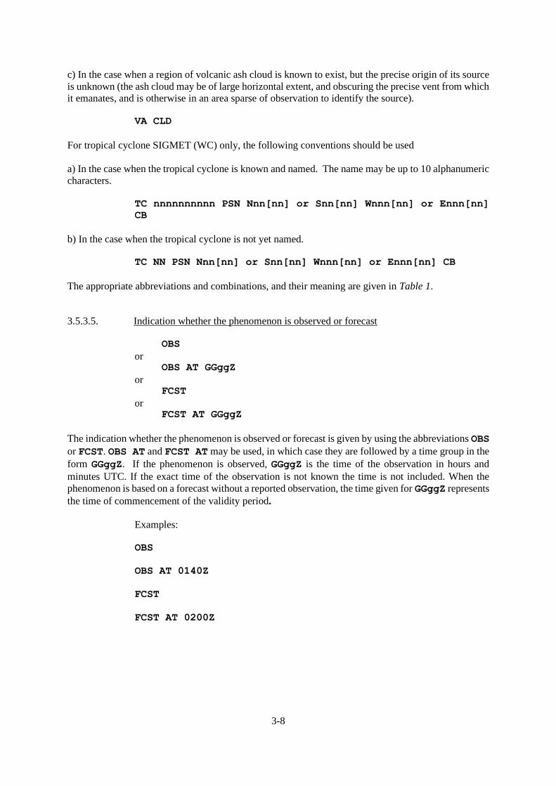
3.5.3.5. Indication whether the phenomenon is observed or forecast
OBS
or OBS AT GGggZ
or FCST
or FCST AT GGggZ
The indication whether the phenomenon is observed or forecast is given by using the abbreviations OBS
or FCST. OBS AT and FCST AT may be used, in which case they are followed by a time group in the
form GGggZ. If the phenomenon is observed, GGggZ is the time of the observation in hours and
minutes UTC. If the exact time of the observation is not known the time is not included. When the
phenomenon is based on a forecast without a reported observation, the time given for GGggZ represents
the time of commencement of the validity period.
Examples:
OBS
OBS AT 0140Z
FCST
FCST AT 0200Z

3-9
3.5.3.6. Location of the phenomenon
The location of the phenomenon is given with reference to geographical coordinates (latitude and
longitude). Latitude and longitude may be reported in degrees, or in degrees and minutes. When
reporting in degrees the format will be Nnn or Snn for latitude, and Ennn or Wnnn for longitude.
When reporting in degrees and minutes the format will be Nnnnn or Snnnn for latitude, and Ennnnn
or Wnnnnn for longitude. The MWOs should try to be as specific as possible in reporting the location
of the phenomenon and, at the same time, to avoid overwhelming the SIGMET with too many
coordinates, which may be difficult to process or follow when transmitted by voice radio.
The following are the possible ways to describe the location of the phenomenon:
1) An area of the FIR defined by a polygon. Minimum 4 coordinates1, and not
normally more than 7 coordinates. This is the format preferred operationally by
users.
Symbolically, this is indicated as:
WI <Nnn[nn]> or <Snn[nn]> <Wnnn[nn]> or <Ennn[nn]> -
<Nnn[nn]> or <Snn[nn]> <Wnnn[nn]> or <Ennn[nn]> -
<Nnn[nn]> or <Snn[nn]> <Wnnn[nn]> or <Ennn[nn]> -
<Nnn[nn]> or <Snn[nn]> <Wnnn[nn]> or <Ennn[nn]> -
<Nnn[nn]> or <Snn[nn]> <Wnnn[nn]> or <Ennn[nn]> -
<Nnn[nn]> or <Snn[nn]> <Wnnn[nn]> or <Ennn[nn]> -
<Nnn[nn]> or <Snn[nn]> <Wnnn[nn]> or <Ennn[nn]>
For example:
WI N6030 E02550 – N6055 E02500 – N6050 E02630 –
N6030 E02550
WI N60 E025 – N62 E027 - N58 E030 - N59 E026 - N60 E025
Note 1. ― The points of a polygon should be provided in a clockwise order, and the end point should
be a repeat of the start point.
Note 2. - The location of phenomenon given at the beginning of the SIGMET is referring to the beginning
of the validity period if the exact time group of Observed or Forecast phenomenon is not included
Use of polygons with complex FIR boundaries.
Annex 3 (19th Edition, July 2016 and 20th Edition, July 2018) specifies that the points of a polygon '...
should be kept to a minimum and should not normally exceed seven'. However, some FIR boundaries
are complex, and it would be unrealistic to expect that a polygon would be defined that followed such
boundaries exactly. As such, some States have determined that the polygon points be chosen in relation
to the complex boundary such that the FIR boundary approximates, but is wholly encompassed by, the
polygon, and that any additional area beyond the FIR boundary be the minimum that can be reasonably
and practically described. Caution should however be exercised in those instances where international
aerodromes are located in close proximity to such a complex FIR boundary. Appendix B provides
examples and advice with regard to describing such areas.
1 Including the last point as a repeat of the first point to explicitly close the polygon
3-10
2a) In a sector of the FIR defined relative to a specified line, or single series of up to
three connected lines, with start and end points on the FIR boundary (or so close
to the FIR boundary so as to leave no doubt that the intent is for the line to connect
to the FIR boundary at that point).
Symbolically this is indicated as:
<N OF> or <NE OF> or <E OF> or <SE OF> or <S OF> or
<SW OF> or <W OF> or <NW OF> LINE <Nnn[nn]> or
<Snn[nn]> <Wnnn[nn]> or <Ennn[nn]> - <Nnn[nn]> or
<Snn[nn]> <Wnnn[nn]> or <Ennn[nn]>
For example:
NE OF LINE N2500 W08700 – N2000 W08300
W OF LINE N20 E042 – N35 E045
2b) In a sector of the FIR defined as being between two lines of latitude, or between
two lines of longitude.
Symbolically this is indicated as:
<N OF> or <S OF> <Nnn[nn]> or <Snn[nn]> AND <N OF> or
<S OF> <Nnn[nn]> or <Snn[nn]>
<W OF> or <E OF> <Wnnn[nn]> or <Ennn[nn]> AND <W OF>
or <E OF> <Wnnn[nn]> or <Ennn[nn]>
Chosen so that the affected area is BETWEEN lines of latitude or BETWEEN
lines of Longitude
For example:
N OF N1200 AND S OF N2530
W OF W060 AND E OF W082
2c) In a sector of the FIR defined as being between two specified lines, or between two
series of up to three connected lines, each with start and endpoints on the FIR
boundary (or start and endpoints so close to the FIR boundary so as to leave no
doubt that the intent is for the line to connect to the FIR boundary at those points).
<N OF> or <NE OF> or <E OF> or <SE OF> or <S OF> or
<SW OF> or <W OF> or <NW OF> LINE <Nnn[nn]> or
<Snn[nn]> <Wnnn[nn]> or <Ennn[nn]> - <Nnn[nn]> or
<Snn[nn]> <Wnnn[nn]> or <Ennn[nn]>[ - <Nnn[nn]> or
<Snn[nn]> <Wnnn[nn]> or <Ennn[nn]>][ - <Nnn[nn]> or
<Snn[nn]> <Wnnn[nn]> or <Ennn[nn]>] AND <N OF> or <NE
OF> or <E OF> or <SE OF> or <S OF> or <SW OF> or <W
OF> or <NW OF> LINE <Nnn[nn]> or <Snn[nn]> <Wnnn[nn]>
or <Ennn[nn]> - <Nnn[nn]> or <Snn[nn]> <Wnnn[nn]> or
<Ennn[nn]> [ - <Nnn[nn]> or <Snn[nn]> <Wnnn[nn]> or
<Ennn[nn]>][ - <Nnn[nn]> or <Snn[nn]> <Wnnn[nn]> or
<Ennn[nn]>]
3-11
For example:
NE OF LINE N2500 W08700 – N2000 W08300 AND SW OF LINE
N2800 W08500 – N2200 W08200
W OF LINE N20 E042 – N35 E045 AND E OF LINE N20 E039 –
N35 E043
2d) In a sector of the FIR defined relative to a line of latitude and a line of longitude
(effectively a quadrant);
Symbolically this is indicated as:
<N OF> or <S OF> <Nnn[nn]> or <Snn[nn]> AND
<E OF> or <W OF> <Wnnn[nn]> or <Ennn[nn]>
For example:
N OF N1200 AND E OF W02530
S OF N60 AND W OF E120
2e) In a sector of the FIR defined relative to a line of latitude or longitude (effectively
a segment), where a coordinate of latitude (or longitude) defines a line, and the
preceding descriptor defines on which side of the line the phenomena is expected
Symbolically, this is indicated as:
<N OF> or <S OF> <Nnn[nn]> or <Snn[nn]> or
<E OF> or <W OF> <Wnnn[nn]> or <Ennn[nn]>
For example:
N OF S2230
W OF E080
3) Defined by a ‘corridor’ of specified width, centred upon a line, of up to three
connected segments, described by;
APRX nnKM WID LINE BTN <Nnn[nn]> or <Snn[nn]>
<Wnnn[nn]> or <Ennn[nn]> - <Nnn[nn]> or <Snn[nn]>
<Wnnn[nn]> or <Ennn[nn]>[ - <Nnn[nn]> or <Snn[nn]>
<Wnnn[nn]> or <Ennn[nn]>][ - <Nnn[nn]> or <Snn[nn]>
<Wnnn[nn]> or <Ennn[nn]>]
or APRX nnNM WID LINE BTN <Nnn[nn]> or <Snn[nn]> <Wnnn[nn]>
or <Ennn[nn]> - <Nnn[nn]> or <Snn[nn]> <Wnnn[nn]> or
<Ennn[nn]>[ - <Nnn[nn]> or <Snn[nn]> <Wnnn[nn]> or
<Ennn[nn]>][ - <Nnn[nn]> or <Snn[nn]> <Wnnn[nn]> or
<Ennn[nn]>]

3-12
For example:
APRX 50KM WID LINE BTN S1500 E07348 – S1530 E07642
4) At a specific point within the FIR, indicated by a single coordinate of latitude and
longitude.
Symbolically, this is indicated as:
<Nnn[nn]> or <Snn[nn]> <Wnnn[nn]> or <Ennn[nn]>
For example:
N5530 W02230
S23 E107
5) Within a specified radius of the centre of a tropical cyclone.
Symbolically, this is indicated as:
WI nnnKM OF TC CENTRE
WI nnnNM OF TC CENTRE
6) Within a specified radius of the location of a radioactive release event.
Symbolically, this is indicated as:
WI nnKM OF <Nnn[nn]> or <Snn[nn]> <Wnnn[nn]> or
<Ennn[nn]>
WI nnNM OF <Nnn[nn]> or <Snn[nn]> <Wnnn[nn]> or
<Ennn[nn]>
For example:
WI 30KM OF N5530 W02230
When detailed information on the release is not available, a radius of up to 30
kilometres (or 16 nautical miles) from the source may be applied; and a vertical
extent from surface (SFC) to the upper limit of the flight information region/upper
flight information region (FIR/UIR) or control area (CTA) is to be applied.
[Applicable 7 November 2019].
7) A reference to the whole FIR, FIR/UIR, or CTA .
Symbolically, this is indicated as:
ENTIRE FIR
ENTIRE UIR
ENTIRE FIR/UIR

3-13
ENTIRE CTA
More detail on reporting the location of the phenomenon is given in the examples provided in Appendix
B to this guide.

3-14
3.5.3.7. Flight level
Symbolically, the options permitted are:
FLnnn
or nnnnM
or [n]nnnnFT
or SFC/FLnnn
or SFC/nnnnM
or SFC/[n]nnnnFT
or FLnnn/nnn
or TOP FLnnn
or ABV FLnnn
or TOP ABV FLnnn or TOP ABV [n]nnnnFT
or TOP BLW FLnnn (only to be used for tropical cyclone)
or nnnn/nnnnM
or [n]nnnn/[n]nnnnFT
or nnnnM/FLnnn
or [n]nnnnFT/FLnnn
In more detail, the location or extent of the phenomenon in the vertical is given by one or more of the
above methods, as follows:
1) reporting at a single flight level
For example: FL320
2) reporting at a single geometric level, in metres or feet
For example: 4500M or 8250FT or 12000FT
3) reporting a layer extending from the surface to a given height in meters, feet or flight
level
For example: SFC/3000M or SFC/9900FT or SFC/11000FT or SFC/FL350

3-15
4) reporting a layer extending from a given FL to a higher flight level
For example: FL250/290
5) reporting a layer where the base is unknown, but the top is given:
For example: TOP FL350
6) reporting phenomenon above a specified flight level, but where the upper limit is
unknown:
For example: ABV FL350
7) reporting phenomenon that has an unknown lower limit, but has an upper limit that
is known to extend above a known flight level:
For example: TOP ABV FL350
8) reporting phenomenon expected between a lower and upper geometric level
expressed in metres or feet:
For example: 3500/9000M or 8000/12000FT or 11000/14000FT
9) reporting phenomenon expected between a lower geometric level expressed in
metres or feet and a higher flight level:
For example: 4000M/FL220 or 6000FT/FL140 or 11000FT/FL190
10) reporting the CB upper limit for tropical cyclone SIGMET
For example: TOP BLW FL450
Additional examples:
EMBD TS … TOP ABV FL340
SEV TURB … FL180/210
SEV ICE … SFC/FL150
SEV MTW … FL090

3-16
3.5.3.8. Movement
Note. ― Footnote 25 to Table A6-1A of ICAO Annex 3 states that “The elements ‘Forecast
Time’ and ‘Forecast Position’ are not to be used in conjunction with the element ‘Movement or
Expected Movement’”.
Rate of movement is indicated in the following way:
MOV <direction> <speed>KMH[KT]
or STNR
Direction of movement is given with reference to one of the sixteen points of compass (N, NNE, NE,
ENE, E, ESE, SE, SSE, S, SSW, SW, WSW, W, WNW, NW, NNW). Speed is given in KMH or KT. The
abbreviation STNR is used if no significant movement is expected.
For example:
MOV NNW 30KMH
MOV E 25KT
STNR
Note – Movement information should not be provided when a forecast position is explicitly given
3.5.3.9. Expected changes in intensity
The expected evolution of the phenomenon’s intensity is indicated by one of the following
abbreviations: INTSF
or WKN
or NC
3.5.3.10. Forecast time
This section is used, with ‘Forecast position’ to explicitly provide a forecast of the position of the
phenomena at the time specified. The format is fixed, and is of the form
FCST AT <GGgg>Z
For example
FCST AT 1600Z
Where the forecast time is the same as the SIGMET validity end time.
Note. ― In accordance with Annex 5 – Units of Measurement to be Used in Air and Ground Operations,
when the validity period ends at midnight, YY should be set for the following day and GGgg should be
'0000'. i.e. SIGMET validity ending at midnight on the 23rd day of the month should be expressed as
'240000'.
3-17
3.5.3.11. TC Forecast position
Only to be used for tropical cyclones, and used to indicate the location of the centre of the tropical
cyclone.
The forecast centre position of a tropical cyclone is given by:
TC CENTRE PSN Nnn[nn] or Snn[nn] Wnnn[nn] or
Ennn[nn]
For example
TC CENTRE PSN N2740 W07345
3.5.3.12. Forecast position of the hazardous phenomenon at the end of the validity period of the
SIGMET message
The available methods of describing the forecast position of the phenomenon in the ‘Forecast position’
section is exactly as detailed in section 0 "Location of the phenomenon" with the addition of :
a) For volcanic ash which is not expected to be present within the FIR at the end of the validity
of the SIGMET, the following is permitted:
NO VA EXP
Note. ― Currently, there is no provision for indicating changes to the levels affected by
phenomena between the initial position and the forecast position. As such, and as per footnote 26 to
Table A6-1A of Annex 3 (19th Edition, July 2016 and 20th Edition, July 2018), it should be assumed
that the levels affected remain the same for both initial and forecast positions. If levels differ
significantly then separate SIGMET should be issued.
3.5.3.13. Repetition of elements (volcanic ash and tropical cyclone SIGMET only)
Elements can be repeated when there are instances of two volcanic ash clouds, or two areas of
cumulonimbus cloud associated with a tropical cyclone.
Note. ― This must not be used for two separate tropical cyclones that are present in a FIR, or
UIR.
With regard to the portrayal of complex volcanic ash events (which implies areas of volcanic ash at
different levels) guidance in this regard is provided in Appendix B, example 9.
With regard to the portrayal of two areas of cumulonimbus clouds associated with a tropical cyclone,
guidance is provided in Appendix B, example 10.
3-18
3.5.4. Cancellation of SIGMET
3.5.4.1. Annex 3, 7.1.2 requires that "SIGMET information shall be cancelled when the phenomena
are no longer occurring or are no longer expected to occur in the area”.
3.5.4.2. As such, it is mandatory for an MWO to cancel any SIGMET that is currently valid but for
which the specified phenomena no longer exists or is expected to exist.
3.5.4.3. The cancellation is done by issuing the same type of SIGMET (i.e. WS, WV or WC) with
the following structure:
- WMO heading with the same data type designator;
- First line, including the next sequence number followed by a new validity period that
represents the remaining time of the original period of validity, and
- Second line, which contains the name of the FIR or CTA, the combination CNL
SIGMET, followed by the sequence number of the original SIGMET and its original
validity period.
3.5.4.4. A cancellation SIGMET should have a unique sequence number, and should follow
the format below.
As an example, an original SIGMET of:
YMMM SIGMET A01 VALID 260300/260700 YPRF-
YMMM MELBOURNE FIR EMBD TS FCST WI S4000 E12000 – S3830 E12200 –
S4200 E12100 – S4000 E12000 TOP FL450 MOV SW 05KT INTSF=
If it were to be cancelled early (i.e. prior to 0700 UTC), then the following would be
appropriate:
YMMM SIGMET A02 VALID 260600/260700 YPRF-
YMMM MELBOURNE FIR CNL SIGMET A01 260300/260700=
Where:
- the sequence number will be the next incrementing, unique sequence number.
- the validity time will be the time remaining between issuance and the end time of the
original SIGMET.
- the sequence number of the original (and to be cancelled) SIGMET shall follow 'CNL
SIGMET '.
- the original validity time of the original (and to be cancelled) SIGMET shall be
included in the message after the reference to the original SIGMET's sequence number.
For SIGMET for volcanic ash only, the following is permitted:
WSAU21 ADRM 202155 YBBB SIGMET E03 VALID 202155/210000 YPDM- YBBB BRISBANE FIR CNL SIGMET E01 202000/210000 VA MOV TO WXYZ
FIR=
3.5.4.5. Where the FIR (WXYZ in the example) into which the volcanic ash has moved is
indicated.
3-19
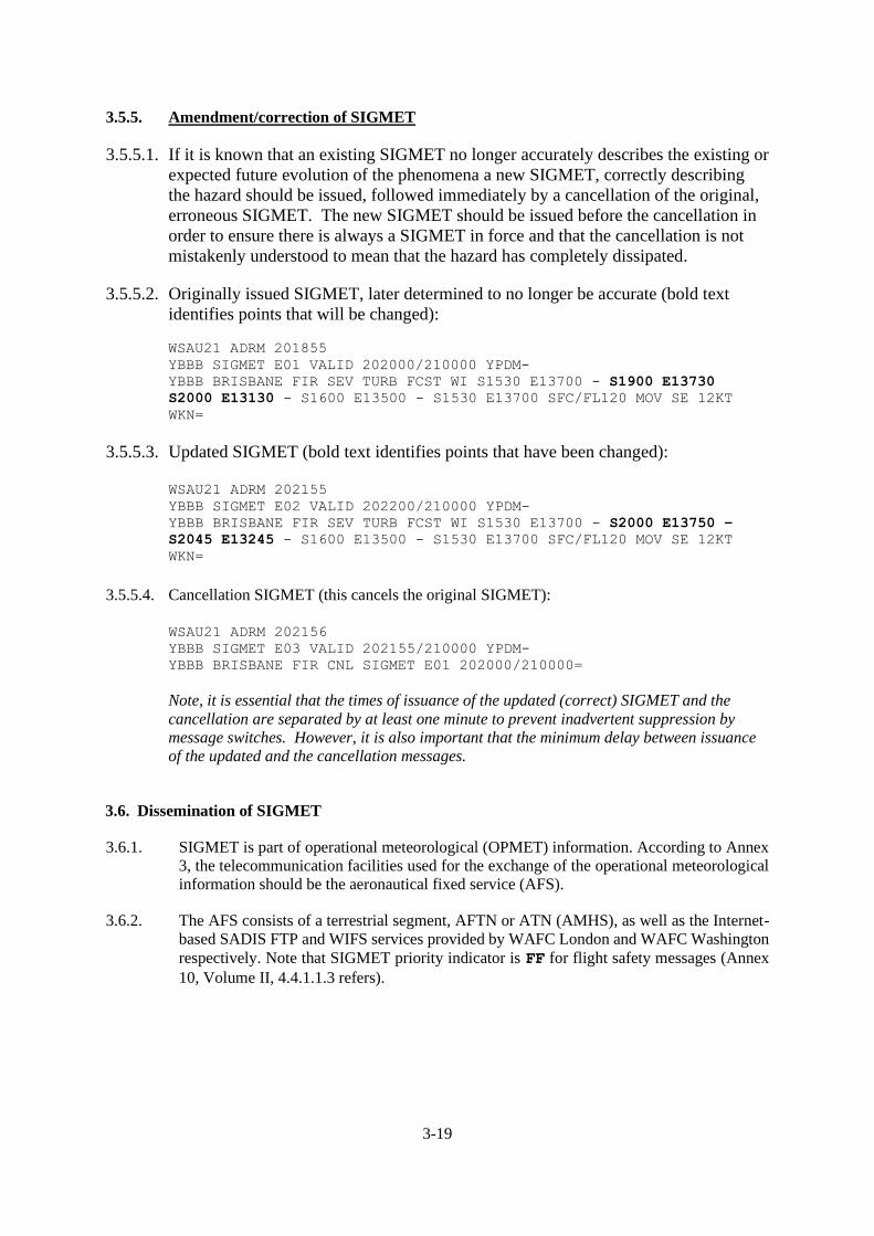
3.5.5. Amendment/correction of SIGMET
3.5.5.1. If it is known that an existing SIGMET no longer accurately describes the existing or
expected future evolution of the phenomena a new SIGMET, correctly describing
the hazard should be issued, followed immediately by a cancellation of the original,
erroneous SIGMET. The new SIGMET should be issued before the cancellation in
order to ensure there is always a SIGMET in force and that the cancellation is not
mistakenly understood to mean that the hazard has completely dissipated.
3.5.5.2. Originally issued SIGMET, later determined to no longer be accurate (bold text
identifies points that will be changed):
WSAU21 ADRM 201855 YBBB SIGMET E01 VALID 202000/210000 YPDM- YBBB BRISBANE FIR SEV TURB FCST WI S1530 E13700 - S1900 E13730
S2000 E13130 - S1600 E13500 - S1530 E13700 SFC/FL120 MOV SE 12KT
WKN=
3.5.5.3. Updated SIGMET (bold text identifies points that have been changed):
WSAU21 ADRM 202155 YBBB SIGMET E02 VALID 202200/210000 YPDM- YBBB BRISBANE FIR SEV TURB FCST WI S1530 E13700 - S2000 E13750 –
S2045 E13245 - S1600 E13500 - S1530 E13700 SFC/FL120 MOV SE 12KT
WKN=
3.5.5.4. Cancellation SIGMET (this cancels the original SIGMET):
WSAU21 ADRM 202156 YBBB SIGMET E03 VALID 202155/210000 YPDM- YBBB BRISBANE FIR CNL SIGMET E01 202000/210000=
Note, it is essential that the times of issuance of the updated (correct) SIGMET and the
cancellation are separated by at least one minute to prevent inadvertent suppression by
message switches. However, it is also important that the minimum delay between issuance
of the updated and the cancellation messages.
3.6. Dissemination of SIGMET
3.6.1. SIGMET is part of operational meteorological (OPMET) information. According to Annex
3, the telecommunication facilities used for the exchange of the operational meteorological
information should be the aeronautical fixed service (AFS).
3.6.2. The AFS consists of a terrestrial segment, AFTN or ATN (AMHS), as well as the Internet-
based SADIS FTP and WIFS services provided by WAFC London and WAFC Washington
respectively. Note that SIGMET priority indicator is FF for flight safety messages (Annex
10, Volume II, 4.4.1.1.3 refers).

3-20
3.6.3. Currently, AFTN links should be used by the MWOs to send the SIGMET, as follows:
- to the adjacent MWOs and ACCs2 using direct AFTN addressing;
- when required for VOLMET or D-VOLMET, SIGMET should be sent to the relevant
centre providing the VOLMET service;
- SIGMET should be sent to all regional OPMET Data Banks (RODB);
- it should be arranged that SIGMET is relayed to the SADIS and WIFS providers for
satellite/public internet dissemination, as well as to the WAFCs London and
Washington, either through the ROBEX scheme, or directly by the issuing MWO;
- SIGMET for volcanic ash should be disseminated to the responsible VAAC.
3.6.4. Through SADIS and WIFS, SIGMET is disseminated to all authorised users. In this way,
SIGMET is available on a global basis, meeting the aeronautical requirements.
— — — — — — — —
2 For this dissemination it is required that SIGMET is available at the ACCs for transmission to aircraft in flight for the route
ahead up to a distance corresponding to two hours flying time.

A- 1
APPENDIX A
ENHANCED SIGMET GUIDANCE TABLE DEVELOPED FROM ANNEX 3 TABLE A6-1A
Note. ― The table below seeks to provide more detailed guidance than that given in Table A6-1A of Annex 3 (19th Edition, July 2016 and 20th Edition,
July 2018). It does this by removing all references to the AIRMET message. Table A6-1A. The table below simplifies the available options and provides more
specific expansion of the symbolic structure of SIGMET messages, with guidance sub-titles where appropriate. It should be noted that Annex 3, Appendix 6,
Table A6-1A remains the authoritative reference.
Ref No.
Element as specified in Chapter 5 and Appendix 6
Detailed Content Expanded symbolic - These ‘expanded’ symbolic representations of the various SIGMET code elements represent the interpretation of Table A6-1A of Annex 3. MWOs are encouraged to align their SIGMETs with the guidelines below.
Examples. These examples of various SIGMET code elements represent the interpretation A6-1A of Annex 3. MWOs are encouraged to align their SIGMETs with the examples below.
1.1 Location indicator of
FIR/CTA (M)1
ICAO location indicator of the ATS unit serving the FIR or CTA to which the SIGMET refers
Nnnn YUCC
2
YUDD2
1.2 Identification (M) Message identification and
sequence number3
SIGMET n
SIGMET nn
SIGMET nnn
SIGMET 1
SIGMET 01
SIGMET A01
1.3 Validity period (M) Day-time groups indicating the period of validity in UTC
VALID nnnnnn/nnnnnn VALID 010000/010400
VALID 221215/221600
VALID 101520/101800
VALID 251600/252200
VALID 152000/160000
VALID 192300/200300
VALID 122200/130400 (6 hour validity applicable
to TC or VA only)
1.4 Location indicator of MWO (M)
Location indicator of MWO originating the message with a separating hyphen
nnnn- YUDO–
2
YUSO–2
1.5 Name of the FIR/CTA (M)
Location indicator and name of the
FIR/CTA4 for which
the SIGMET is issued
nnnn nnnnnnnnnn FIR
nnnn nnnnnnnnnn UIR
nnnn nnnnnnnnnn FIR/UIR
nnnn nnnnnnnnnn CTA
YUCC AMSWELL FIR2
YUDD SHANLON FIR/UIR2
YUDD SHANLON FIR2
YUCC AMSWELL CTA2
1.6 Status indicator
(C)5
Indicator of test or exercise
TEST or EXER
TEST EXER

A- 2
Ref No.
Element as specified in Chapter 5 and Appendix 6
Detailed Content Expanded symbolic - These ‘expanded’ symbolic representations of the various SIGMET code elements represent the interpretation of Table A6-1A of Annex 3. MWOs are encouraged to align their SIGMETs with the guidelines below.
Examples. These examples of various SIGMET code elements represent the interpretation A6-1A of Annex 3. MWOs are encouraged to align their SIGMETs with the examples below.
2.1 Phenomenon (M)6 Description of
phenomenon causing the issuance of SIGMET
OBSC7 TS
OBSC7 TSGR
8
EMBD9 TS
EMBD9 TSGR
8
FRQ10 TS
FRQ10 TSGR
8
SQL11 TS
SQL11 TSGR
8
TC nnnnnnnnnn PSN Nnn[nn] or Snn[nn] Wnnn[nn] or
Ennn[nn] CB
TC NN12 PSN Nnn[nn] or Snn[nn] Wnnn[nn] or Ennn[nn] CB
SEV TURB13
SEV ICE14
SEV ICE (FZRA)14
SEV MTW15
HVY DS
HVY SS
VA ERUPTION PSN Nnn[nn] or Snn[nn] Ennn[nn] or Wnnn[nn]
VA CLD
VA ERUPTION MT nnnnnnnnnn PSN Nnn[nn] or Snn[nn]
Ennn[nn] or Wnnn[nn] VA CLD
VA CLD
RDOACT CLD
OBSC TS
OBSC TSGR
EMBD TS
EMBD TSGR
FRQ TS
FRQ TSGR
SQL TS
SQL TSGR
TC GLORIA PSN N2215 W07500 CB
TC NN PSN S26 E150 CB
SEV TURB
SEV ICE
SEV ICE (FZRA)
SEV MTW
HVY DS
HVY SS
VA ERUPTION PSN N27 W017 VA CLD
VA ERUPTION PSN S1200 E01730 VA CLD
VA ERUPTION MT ASHVAL2 PSN S15 E073 VA CLD
VA ERUPTION MT VALASH2 PSN N2030 E02015 VA CLD
VA CLD
RDOACT CLD
2.2 Observed or forecast phenomenon (M)
Indication whether the information is observed and expected to continue, or forecast
OBS
OBS AT nnnnZ
FCST
FCST AT nnnnZ
OBS
OBS AT 1210Z
FCST
FCST AT 1815Z
A-3
Ref No.
Element as specified in Chapter 5 and Appendix 6
Detailed Content Expanded symbolic - These ‘expanded’ symbolic representations of the various SIGMET code elements represent the interpretation of Table A6-1A of Annex 3. MWOs are encouraged to align their SIGMETs with the guidelines below.
Examples. These examples of various SIGMET code elements represent the interpretation A6-1A of Annex 3. MWOs are encouraged to align their SIGMETs with the examples below.
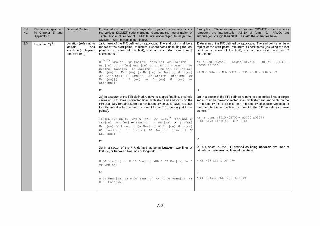
2.3 Location (C)20
Location (referring to latitude and longitude (in degrees and minutes))
1) An area of the FIR defined by a polygon. The end point shall be a repeat of the start point. Minimum 4 coordinates (including the last point as a repeat of the first), and not normally more than 7 coordinates.
WI21, 22
Nnn[nn] or Snn[nn] Wnnn[nn] or Ennn[nn] –
Nnn[nn] or Snn[nn] Wnnn[nn] or Ennn[nn] – Nnn[nn] or
Snn[nn] Wnnn[nn] or Ennn[nn] – Nnn[nn] or Snn[nn]
Wnnn[nn] or Ennn[nn] [- Nnn[nn] or Snn[nn] Wnnn[nn]
or Ennn[nn]] [– Nnn[nn] or Snn[nn] Wnnn[nn] or
Ennn[nn]][ - Nnn[nn] or Snn[nn] Wnnn[nn] or
Ennn[nn]]
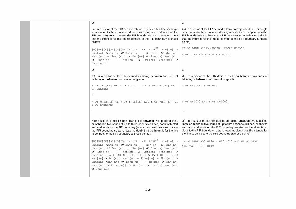
or 2a) In a sector of the FIR defined relative to a specified line, or single series of up to three connected lines, with start and endpoints on the FIR boundary (or so close to the FIR boundary so as to leave no doubt that the intent is for the line to connect to the FIR boundary at those points).
[N][NE][E][SE][S][SW][W][NW] OF LINE21 Nnn[nn] or
Snn[nn] Wnnn[nn] or Ennn[nn] – Nnn[nn] or Snn[nn]
Wnnn[nn] or Ennn[nn] [- Nnn[nn] or Snn[nn] Wnnn[nn]
or Ennn[nn]] [- Nnn[nn] or Snn[nn] Wnnn[nn] or Ennn[nn]]
or
2b) In a sector of the FIR defined as being between two lines of latitude, or between two lines of longitude.
N OF Nnn[nn] or N OF Snn[nn] AND S OF Nnn[nn] or S
OF Snn[nn]
or
W OF Wnnn[nn] or W OF Ennn[nn] AND E OF Wnnn[nn] or
E OF Ennn[nn]
1) An area of the FIR defined by a polygon. The end point shall be a repeat of the start point. Minimum 4 coordinates (including the last point as a repeat of the first), and not normally more than 7 coordinates.
WI N6030 E02550 – N6055 E02500 – N6050 E02630 -
N6030 E02550
WI N30 W067 – N32 W070 – N35 W068 - N30 W067
or 2a) In a sector of the FIR defined relative to a specified line, or single series of up to three connected lines, with start and endpoints on the FIR boundary (or so close to the FIR boundary so as to leave no doubt that the intent is for the line to connect to the FIR boundary at those points).
NE OF LINE N2515 W08700 – N2000 W08330 S OF LINE S14 E150 – S14 E155
or
2b) In a sector of the FIR defined as being between two lines of latitude, or between two lines of longitude.
N OF N45 AND S OF N50
or
W OF E04530 AND E OF E04000

A-4
or
2c) In a sector of the FIR defined as being between two specified lines, or between two series of up to three connected lines, each with start and endpoints on the FIR boundary (or start and endpoints so close to the FIR boundary so as to leave no doubt that the intent is for the line to connect to the FIR boundary at those points).
[N][NE][E][SE][S][SW][W][NW] OF LINE21 Nnn[nn] or
Snn[nn] Wnnn[nn] or Ennn[nn] – Nnn[nn] or Snn[nn]
Wnnn[nn] or Ennn[nn] [- Nnn[nn] or Snn[nn] Wnnn[nn]
or Ennn[nn]] [- Nnn[nn] or Snn[nn] Wnnn[nn] or Ennn[nn]] AND [N][NE][E][SE][S][SW][W][NW] OF LINE
Nnn[nn] or Snn[nn] Wnnn[nn] or Ennn[nn] – Nnn[nn] or
Snn[nn] Wnnn[nn] or Ennn[nn] [- Nnn[nn] or Snn[nn]
Wnnn[nn] or Ennn[nn]] [- Nnn[nn] or Snn[nn] Wnnn[nn]
or Ennn[nn]]
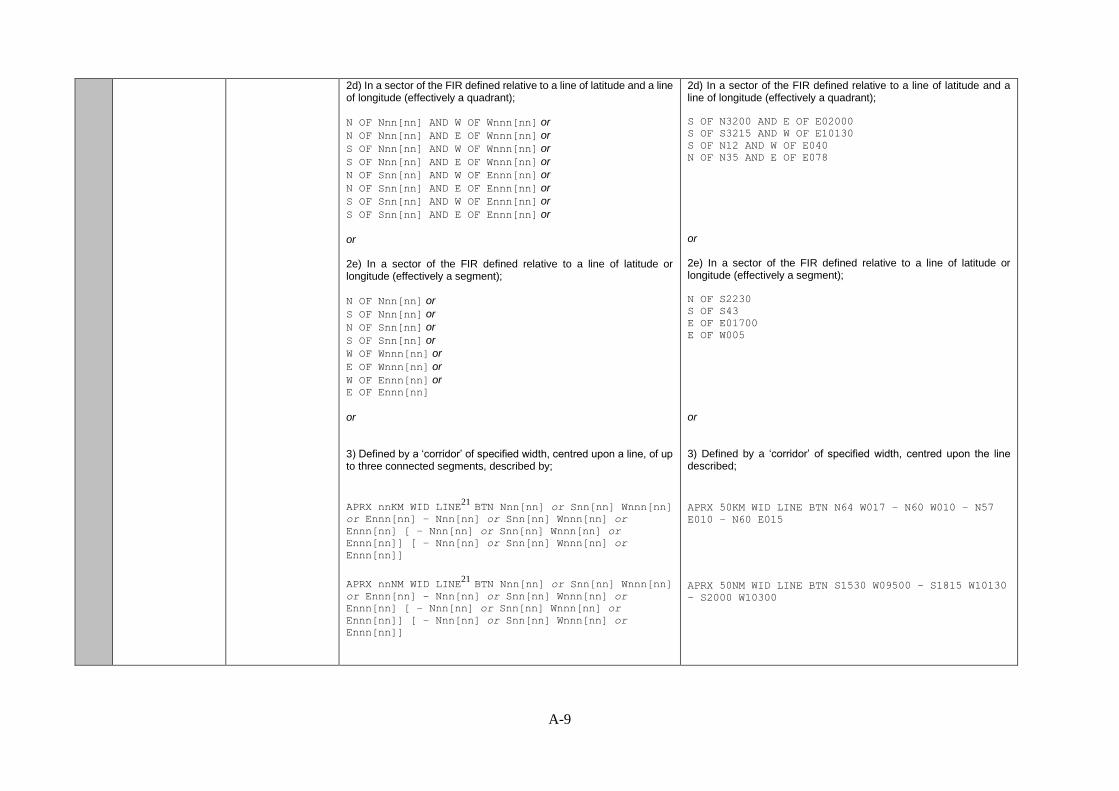
2d) In a sector of the FIR defined relative to a line of latitude and a line of longitude (effectively a quadrant);
N OF Nnn[nn] AND W OF Wnnn[nn] or
N OF Nnn[nn] AND E OF Wnnn[nn] or
S OF Nnn[nn] AND W OF Wnnn[nn] or
S OF Nnn[nn] AND E OF Wnnn[nn] or
N OF Snn[nn] AND W OF Ennn[nn] or
N OF Snn[nn] AND E OF Ennn[nn] or
S OF Snn[nn] AND W OF Ennn[nn] or
S OF Snn[nn] AND E OF Ennn[nn] or
or 2e) In a sector of the FIR defined relative to a line of latitude or longitude (effectively a segment); N OF Nnn[nn] or
S OF Nnn[nn] or
N OF Snn[nn] or
S OF Snn[nn] or
W OF Wnnn[nn] or
E OF Wnnn[nn] or
W OF Ennn[nn] or E OF Ennn[nn]
or
2c) In a sector of the FIR defined as being between two specified lines, or between two series of up to three connected lines, each with start and endpoints on the FIR boundary (or start and endpoints so close to the FIR boundary so as to leave no doubt that the intent is for the line to connect to the FIR boundary at those points).
SW OF LINE N50 W020 – N45 E010 AND NE OF LINE
N45 W020 – N40 E010
2d) In a sector of the FIR defined relative to a line of latitude and a line of longitude (effectively a quadrant);
S OF N3200 AND E OF E02000
S OF S3215 AND W OF E10130
S OF N12 AND W OF E040 N OF N35 AND E OF E078
or 2e) In a sector of the FIR defined relative to a line of latitude or longitude (effectively a segment); N OF S2230 S OF S43 E OF E01700 E OF W005
A-5
or 3) Defined by a ‘corridor’ of specified width, centred upon a line, of up to three connected segments, described by;
APRX nnKM WID LINE21
BTN Nnn[nn] or Snn[nn] Wnnn[nn]
or Ennn[nn] – Nnn[nn] or Snn[nn] Wnnn[nn] or
Ennn[nn] [ – Nnn[nn] or Snn[nn] Wnnn[nn] or
Ennn[nn]] [ – Nnn[nn] or Snn[nn] Wnnn[nn] or
Ennn[nn]]
APRX nnNM WID LINE21
BTN Nnn[nn] or Snn[nn] Wnnn[nn]
or Ennn[nn] – Nnn[nn] or Snn[nn] Wnnn[nn] or
Ennn[nn] [ – Nnn[nn] or Snn[nn] Wnnn[nn] or
Ennn[nn]] [ – Nnn[nn] or Snn[nn] Wnnn[nn] or
Ennn[nn]]
or 4) At a specific point within the FIR;
Nnn[nn] Wnnn[nn] or
Nnn[nn] Ennn[nn] or
Snn[nn] Wnnn[nn] or Snn[nn] Ennn[nn]
or
5) tropical cyclone;
WI nnnKM (or nnnNM) OF TC CENTRE23
6) A cylinder of specified radius; 24
WI nnKM (or nnNM) OF Nnn[nn] or Snn[nn] Wnnn[nn] or
Ennn[nn]
or
or 3) Defined by a ‘corridor’ of specified width, centred upon a line, of up to three connected segments, described by;
APRX 50KM WID LINE BTN N64 W017 – N60 W010 – N57
E010 – N60 E015
APRX 50NM WID LINE BTN S1530 W09500 – S1815 W10130
– S2000 W10300
or 4) At a specific point within the FIR;
N5530 W02230 S12 E177
or
5) tropical cyclone;
WI 400KM OF TC CENTRE
WI 250NM OF TC CENTRE
6) A cylinder of specified radius;
WI 30 KM OF N6030 E02550
WI 50 NM OF S2000 E04000
or

A-6
7) A reference to the whole FIR, FIR/UIR, or CTA
ENTIRE FIR
ENTIRE FIR/UIR
ENTIRE UIR
ENTIRE CTA
7) A reference to the whole FIR, FIR/UIR, or CTA
ENTIRE FIR
ENTIRE FIR/UIR
ENTIRE UIR
ENTIRE CTA
2.4 Level (C)20,24
Flight level or altitude 1) Generic height/range descriptors to be used when 'Location' descriptors above are used.
FLnnn
[n]nnnnFT
nnnnM SFC/FLnnn
SFC/nnnnM
SFC/nnnnFT
SFC/nnnnnFT
FLnnn/nnn
TOP FLnnn
ABV FLnnn
TOP ABV FLnnn
ABV [n]nnnnFT
TOP ABV [n]nnnnFT
nnnn/nnnnM
[n]nnnn/[n]nnnnFT
nnnnM/FLnnn
[n]nnnnFT/FLnnn
or23
TOP BLW FLnnn
or23
TOP ABV FLnnn
1) Generic height/range descriptors to be used when 'Location' descriptors above are used.
FL180
7000FT
10000FT
600M
1200M
SFC/FL070
SFC/9000FT
SFC/10000FT
SFC/2500M
FL050/080
FL310/450
TOP FL390
ABV FL280
ABV 7000FT
TOP ABV FL100
TOP ABV 9000FT
TOP ABV 10000FT
3000M
2000/3000M
8000FT
6000/12000FT
11000/14000FT
2000M/FL150
8000FT/FL190
10000FT/FL250
or 23
TOP BLW FL450
or23
TOP ABV FL360

A-7
2.5 Movement or expected movement
(C)20, 25
Movement or expected movement (direction and speed) with reference to one of the sixteen points of compass, or stationary
MOV[N][NNE][NE][ENE][E][ESE][SE][SSE][S][SSW][SW][W
SW][W][WNW][NW][NNW] nnKMH
or
MOV[N][NNE][NE][ENE][E][ESE][SE][SSE][S][SSW][SW][W
SW][W][WNW][NW][NNW] nnKT
or
STNR
MOV E 40KMH
MOV E 20KT
MOV SE 20KT
STNR
2.6 Changes in intensity
(C)20
Expected changes in intensity
INTSF
or
WKN
or
NC
INTSF
WKN
NC
2.7 Forecast time (C)25
Indication of the forecast time of the phenomena
FCST AT nnnnZ FCST AT 2200Z
FCST AT 0000Z
2.8 TC forecast position
(C)23
Forecast position of TC centre at the end of the validity period of the SIGMET message
TC CENTRE PSN Nnn[nn] or Snn[nn] Wnnn[nn] or Ennn[nn] TC CENTRE PSN N1030 E16015
2.9 Forecast position
(C)20, 25, 26
Forecast position of volcanic ash cloud or other hazardous phenomena at the end of the validity period of the SIGMET message
1) An area of the FIR defined by a polygon. The end point shall be a repeat of the start point. Minimum 4 coordinates (including the last point as a repeat of the first), and not normally more than 7 coordinates.
WI21, 22
Nnn[nn] or Snn[nn] Wnnn[nn] or Ennn[nn] –
Nnn[nn] or Snn[nn] Wnnn[nn] or Ennn[nn] – Nnn[nn] or
Snn[nn] Wnnn[nn] or Ennn[nn] – Nnn[nn] or Snn[nn]
Wnnn[nn] or Ennn[nn] [- Nnn[nn] or Snn[nn] Wnnn[nn]
or Ennn[nn]] [– Nnn[nn] or Snn[nn] Wnnn[nn] or
Ennn[nn]][ - Nnn[nn] or Snn[nn] Wnnn[nn] or
Ennn[nn]]
1) An area of the FIR defined by a polygon. The end point shall be a repeat of the start point. Minimum 4 coordinates (including the last point as a repeat of the first), and not normally more than 7 coordinates.
WI N6030 E02550 – N6055 E02500 – N6050 E02630 -
N6030 E02550
WI N30 W067 – N32 W070 – N35 W068 - N30 W067
A-8
or 2a) In a sector of the FIR defined relative to a specified line, or single series of up to three connected lines, with start and endpoints on the FIR boundary (or so close to the FIR boundary so as to leave no doubt that the intent is for the line to connect to the FIR boundary at those points).
[N][NE][E][SE][S][SW][W][NW] OF LINE21 Nnn[nn] or
Snn[nn] Wnnn[nn] or Ennn[nn] – Nnn[nn] or Snn[nn]
Wnnn[nn] or Ennn[nn] [- Nnn[nn] or Snn[nn] Wnnn[nn]
or Ennn[nn]] [- Nnn[nn] or Snn[nn] Wnnn[nn] or Ennn[nn]]
or
2b) In a sector of the FIR defined as being between two lines of latitude, or between two lines of longitude.
N OF Nnn[nn] or N OF Snn[nn] AND S OF Nnn[nn] or S
OF Snn[nn]
or
W OF Wnnn[nn] or W OF Ennn[nn] AND E OF Wnnn[nn] or
E OF Ennn[nn]
or
2c) In a sector of the FIR defined as being between two specified lines, or between two series of up to three connected lines, each with start and endpoints on the FIR boundary (or start and endpoints so close to the FIR boundary so as to leave no doubt that the intent is for the line to connect to the FIR boundary at those points).
[N][NE][E][SE][S][SW][W][NW] OF LINE21 Nnn[nn] or
Snn[nn] Wnnn[nn] or Ennn[nn] – Nnn[nn] or Snn[nn]
Wnnn[nn] or Ennn[nn] [- Nnn[nn] or Snn[nn] Wnnn[nn]
or Ennn[nn]] [- Nnn[nn] or Snn[nn] Wnnn[nn] or Ennn[nn]] AND [N][NE][E][SE][S][SW][W][NW] OF LINE
Nnn[nn] or Snn[nn] Wnnn[nn] or Ennn[nn] – Nnn[nn] or
Snn[nn] Wnnn[nn] or Ennn[nn] [- Nnn[nn] or Snn[nn]
Wnnn[nn] or Ennn[nn]] [- Nnn[nn] or Snn[nn] Wnnn[nn]
or Ennn[nn]]
or 2a) In a sector of the FIR defined relative to a specified line, or single series of up to three connected lines, with start and endpoints on the FIR boundary (or so close to the FIR boundary so as to leave no doubt that the intent is for the line to connect to the FIR boundary at those points).
NE OF LINE N2515 W08700 – N2000 W08330
S OF LINE S14 E150 – S14 E155
or
2b) In a sector of the FIR defined as being between two lines of latitude, or between two lines of longitude.
N OF N45 AND S OF N50
W OF E04530 AND E OF E04000
or
2c) In a sector of the FIR defined as being between two specified lines, or between two series of up to three connected lines, each with start and endpoints on the FIR boundary (or start and endpoints so close to the FIR boundary so as to leave no doubt that the intent is for the line to connect to the FIR boundary at those points).
SW OF LINE N50 W020 – N45 E010 AND NE OF LINE
N45 W020 – N40 E010
A-9
2d) In a sector of the FIR defined relative to a line of latitude and a line of longitude (effectively a quadrant);
N OF Nnn[nn] AND W OF Wnnn[nn] or
N OF Nnn[nn] AND E OF Wnnn[nn] or
S OF Nnn[nn] AND W OF Wnnn[nn] or
S OF Nnn[nn] AND E OF Wnnn[nn] or
N OF Snn[nn] AND W OF Ennn[nn] or
N OF Snn[nn] AND E OF Ennn[nn] or
S OF Snn[nn] AND W OF Ennn[nn] or
S OF Snn[nn] AND E OF Ennn[nn] or
or 2e) In a sector of the FIR defined relative to a line of latitude or longitude (effectively a segment); N OF Nnn[nn] or
S OF Nnn[nn] or
N OF Snn[nn] or
S OF Snn[nn] or
W OF Wnnn[nn] or
E OF Wnnn[nn] or
W OF Ennn[nn] or E OF Ennn[nn]
or 3) Defined by a ‘corridor’ of specified width, centred upon a line, of up to three connected segments, described by;
APRX nnKM WID LINE21
BTN Nnn[nn] or Snn[nn] Wnnn[nn]
or Ennn[nn] – Nnn[nn] or Snn[nn] Wnnn[nn] or
Ennn[nn] [ – Nnn[nn] or Snn[nn] Wnnn[nn] or
Ennn[nn]] [ – Nnn[nn] or Snn[nn] Wnnn[nn] or
Ennn[nn]]
APRX nnNM WID LINE21
BTN Nnn[nn] or Snn[nn] Wnnn[nn]
or Ennn[nn] – Nnn[nn] or Snn[nn] Wnnn[nn] or
Ennn[nn] [ – Nnn[nn] or Snn[nn] Wnnn[nn] or
Ennn[nn]] [ – Nnn[nn] or Snn[nn] Wnnn[nn] or
Ennn[nn]]
2d) In a sector of the FIR defined relative to a line of latitude and a line of longitude (effectively a quadrant);
S OF N3200 AND E OF E02000
S OF S3215 AND W OF E10130
S OF N12 AND W OF E040 N OF N35 AND E OF E078
or 2e) In a sector of the FIR defined relative to a line of latitude or longitude (effectively a segment); N OF S2230 S OF S43 E OF E01700 E OF W005
or 3) Defined by a ‘corridor’ of specified width, centred upon the line described;
APRX 50KM WID LINE BTN N64 W017 – N60 W010 – N57
E010 – N60 E015
APRX 50NM WID LINE BTN S1530 W09500 – S1815 W10130
– S2000 W10300

A-10
or 4) At a specific point within the FIR;
Nnn[nn] Wnnn[nn] or
Nnn[nn] Ennn[nn] or
Snn[nn] Wnnn[nn] or Snn[nn] Ennn[nn]
or
5) A cylinder of specified radius; 24
WI nnKM OF Nnn[nn] or Snn[nn] Wnnn[nn] or Ennn[nn]
WI nnNM OF Nnn[nn] or Snn[nn] Wnnn[nn] or Ennn[nn]
or
6) A reference to the whole FIR, FIR/UIR, or CTA
ENTIRE FIR
ENTIRE FIR/UIR
ENTIRE UIR
ENTIRE CTA
or
7) No volcanic ash expected27
NO VA EXP
or 4) At a specific point within the FIR;
N5530 W02230 S12 E177
or
5) A cylinder of specified radius;
WI 30 KM OF N6030 E02550
WI 16 NM OF S2000 E04000
or
6) A reference to the whole FIR, FIR/UIR, or CTA
ENTIRE FIR
ENTIRE FIR/UIR
ENTIRE UIR
ENTIRE CTA
or
7) No volcanic ash expected NO VA EXP
3.0
Repetition of
elements (C)28
Repetition of elements included in a SIGMET message for volcanic ash cloud or tropical cyclone
[AND]28 AND

A-11
4.0 Cancellation of
SIGMET (C)29
Cancellation of SIGMET referring to its identification
CNL SIGMET n
nnnnnn/nnnnnn
CNL SIGMET nn
nnnnnn/nnnnnn
CNL SIGMET nnn
nnnnnn/nnnnnn
or
CNL SIGMET n
nnnnnn/nnnnnn VA MOV TO nnnn FIR27
CNL SIGMET nn
nnnnnn/nnnnnn VA MOV TO nnnn FIR27
CNL SIGMET nnn
nnnnnn/nnnnnn VA MOV TO nnnn FIR27
CNL SIGMET 2
102000/110000
CNL SIGMET 12
101200/101600
CNL SIGMET A12
031600/032000
or CNL SIGMET 3
251030/251630 VA MOV TO YUDO FIR
CNL SIGMET 06
191200/191800 VA MOV TO YUDO FIR
CNL SIGMET B10
030600/031200 VA MOV TO YUDO FIR
Table A-1: Expanded SIGMET template

A-12
Footnotes to table: (note, in order to ensure consistency between this document and ICAO Annex 3,
Table 6-1A, any footnote in Table 6-1A that refers to AIRMET only is identified as such below.
1. See 4.1. “Recommendation.— In cases where the airspace is divided into a flight information
region (FIR) and an upper flight information region (UIR), the SIGMET should be identified by
the location indicator of the air traffic services unit serving the FIR. Note.— The SIGMET
message applies to the whole airspace within the lateral limits of the FIR, i.e. to the FIR and to
the UIR. The particular areas and/or flight levels affected by the meteorological phenomena
causing the issuance of the SIGMET are given in the text of the message.”
2. Fictitious location.
3. In accordance with 1.1.3 “The sequence number referred to in the template in Table A6-1A shall
correspond with the number of SIGMET messages issued for the flight information region since
0001 UTC on the day concerned. The meteorological watch offices whose area of responsibility
encompasses more than one FIR and/or control area (CTA) shall issue separate SIGMET
messages for each FIR and/or CTA within their area of responsibility.”
4. AIRMET only – not SIGMET
5. Only used when a message is issued to indicate that a test or exercise taking place. When the
word “TEST” or the abbreviation “EXER” is included, the message may contain information
that should not be used operationally or will otherwise end immediately after the word "TEST".
[Applicable 7 November 2019]
6. As per 1.1.4 “In accordance with the template in Table A6-1A, only one of the following
phenomena shall be included in a SIGMET message, using the abbreviations as indicated below
[list of SIGMET phenomena follows in section 1.1.4 – see section]”
7. In accordance with 4.2.1 a) “obscured (OBSC) if it is obscured by haze or smoke or cannot be
readily seen due to darkness”.
8. In accordance with 4.2.4 “Hail (GR) should be used as a further description of the thunderstorm,
as necessary”
9. accordance with 4.2.1 b) “embedded (EMBD) if it is embedded within cloud layers and cannot
be readily recognized”
10. In accordance with 4.2.2 “Recommendation.— An area of thunderstorms should be considered
frequent (FRQ) if within that area there is little or no separation between adjacent thunderstorms
with a maximum spatial coverage greater than 75 per cent of the area affected, or forecast to be
affected, by the phenomenon (at a fixed time or during the period of validity)”
11. In accordance with 4.2.3 “Recommendation.— Squall line (SQL) should indicate a
thunderstorm along a line with little or no space between individual clouds.”
12. Used for unnamed tropical cyclones.
13. In accordance with 4.2.5 and 4.2.6 “Recommendation.— Severe turbulence (TURB) should
refer only to: low-level turbulence associated with strong surface winds; rotor streaming; or
turbulence whether in cloud or not in cloud (CAT). Turbulence should not be used in connection
with convective clouds.” and “Turbulence shall be considered: a) severe whenever the peak
value of the cube root of EDR exceeds 0.7”
14. In accordance with 4.2.7 “Recommendation.— Severe icing (ICE) should refer to icing in other
than convective clouds. Freezing rain (FZRA) should refer to severe icing conditions caused by
freezing rain”.

A-13
15. In accordance with 4.2.8 “Recommendation.— A mountain wave (MTW) should be
considered: a) severe whenever an accompanying downdraft of 3.0 m/s (600 ft/min) or more
and/or severe turbulence is observed or forecast; and b) moderate whenever an accompanying
downdraft of 1.75–3.0 m/s (350–600 ft/min) and/or moderate turbulence is observed or
forecast.”
16. AIRMET only – not SIGMET
17. AIRMET only – not SIGMET
18. AIRMET only – not SIGMET
19. AIRMET only – not SIGMET
20. In the case of volcanic ash cloud or cumulonimbus clouds associated with a tropical cyclone
covering more than one area within the FIR, these elements can be repeated, as necessary.
21. A straight line is to be used between two points drawn on a map in the Mercator projection or
between two points which crosses lines of longitude at a constant angle.
22. The number of coordinates should be kept to a minimum and should not normally exceed seven.
23. Only for SIGMET messages for tropical cyclones.
24. Only for SIGMET messages for radioactive cloud. When detailed information on the release is
not available, a radius of up to 30 kilometres (or 16 nautical miles) from the source may be
applied; and a vertical extent from surface (SFC) to the upper limit of the flight information
region/upper flight information region (FIR/UIR) or control area (CTA) is to be applied.
[Applicable 7 November 2019].
25. The elements “forecast time” and “forecast position” are not to be used in conjunction with the
element “movement or expected movement”.
26. The levels of the phenomena remain fixed throughout the forecast period.
27. Only for SIGMET messages for volcanic ash.
28. To be used for two volcanic ash clouds or two centres of tropical cyclones simultaneously
affecting the FIR concerned.
29. End of the message (as the SIGMET message is being cancelled).
Additional notes (not specifically identified in footnotes to Table A6-1A):
In accordance with 4.2.9 of Appendix 6 of Annex 3, “Sandstorm/duststorm should be considered: a)
heavy whenever the visibility is below 200 m and the sky is obscured; and b) moderate whenever
the visibility is: 1) below 200 m and the sky is not obscured; or 2) between 200 m and 600 m.” (no
footnote in Annex 3, but this is applicable reference)
— — — — — — — —

B-1
APPENDIX B
SIGMET EXAMPLES
Note. ― The figures used in this appendix are intended simply to clarify the intent of the
SIGMET message in abbreviated plain language, and therefore how each SIGMET should be
constructed by MWOs and also interpreted by users. The figures used are not intended to give guidance
on how a SIGMET in graphical format should be produced.
Examples of ‘WS’ SIGMET. See the sections for SIGMET for volcanic ash only (WV) and SIGMET for
tropical cyclone only (WC) for examples specific to those phenomena.
Contents
General
1) An area of the FIR defined by a polygon.
Use of polygons with complex FIR boundaries.
2a) In a sector of the FIR defined relative to a specified line, or single series of up to three
connected lines, with start and end points on the FIR boundary
2b) In a sector of the FIR defined as being between two lines of latitude, or between two
lines of longitude
2c) In a sector of the FIR defined as being between two specified lines, or between two series
of up to three connected lines, each with start and endpoints on the FIR boundary
2d) In a sector of the FIR defined relative to a line of latitude or longitude (effectively a
segment)
2e) In a sector of the FIR defined relative to a line of latitude or longitude (effectively a
segment)
3) Defined by a ‘corridor’ of specified width, centred upon the line described;
4) At a specific point within the FIR
5) A vertical cylinder of specified radius
6) Covering entire FIR.
7) Additional examples using volcanic ash references applicable to volcanic ash SIGMET
only
8) Additional examples using volcanic ash references applicable to multiple areas in
SIGMET for volcanic ash.
9) Additional example illustrating use of "WI nnnKM (or nnnNM) OF TC CENTRE " in
Tropical Cyclone SIGMET only.
10) Additional examples of SIGMETs relating to ‘concave’ or ‘horseshoe’ shaped FIR
11) Examples for Test and Exercise SIGMETs
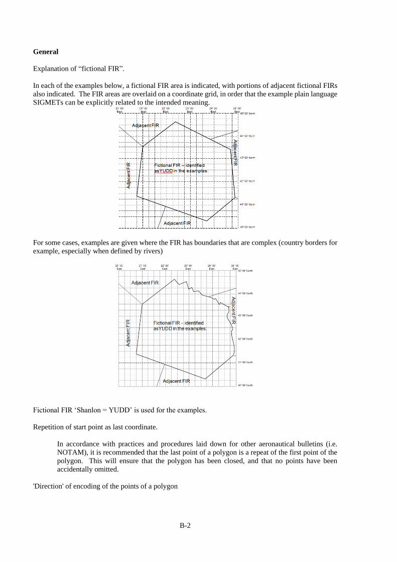
B-2
General
Explanation of “fictional FIR”.
In each of the examples below, a fictional FIR area is indicated, with portions of adjacent fictional FIRs
also indicated. The FIR areas are overlaid on a coordinate grid, in order that the example plain language
SIGMETs can be explicitly related to the intended meaning.
For some cases, examples are given where the FIR has boundaries that are complex (country borders for
example, especially when defined by rivers)
Fictional FIR ‘Shanlon = YUDD’ is used for the examples.
Repetition of start point as last coordinate.
In accordance with practices and procedures laid down for other aeronautical bulletins (i.e.
NOTAM), it is recommended that the last point of a polygon is a repeat of the first point of the
polygon. This will ensure that the polygon has been closed, and that no points have been
accidentally omitted.
'Direction' of encoding of the points of a polygon

B-3
In accordance with practices and procedures laid down for other aeronautical bulletins and
international practice (e.g. BUFR encoding of WAFS significant weather (SIGWX) forecasts),
it is recommended that the points of a polygon are provided in a 'clockwise' sense. This assists
automated systems in determining the 'inside' of polygons.
Use of ‘Expected Movement’ and ‘Forecast Position’/’Forecast Time’.
With applicability of Amendment 77, the ‘Expected Movement’ element of SIGMET should not
be used if the ‘Forecast Position’/’Forecast Time’ element is being used, and vice versa. This is
to prevent duplication at best and inconsistencies at worst.
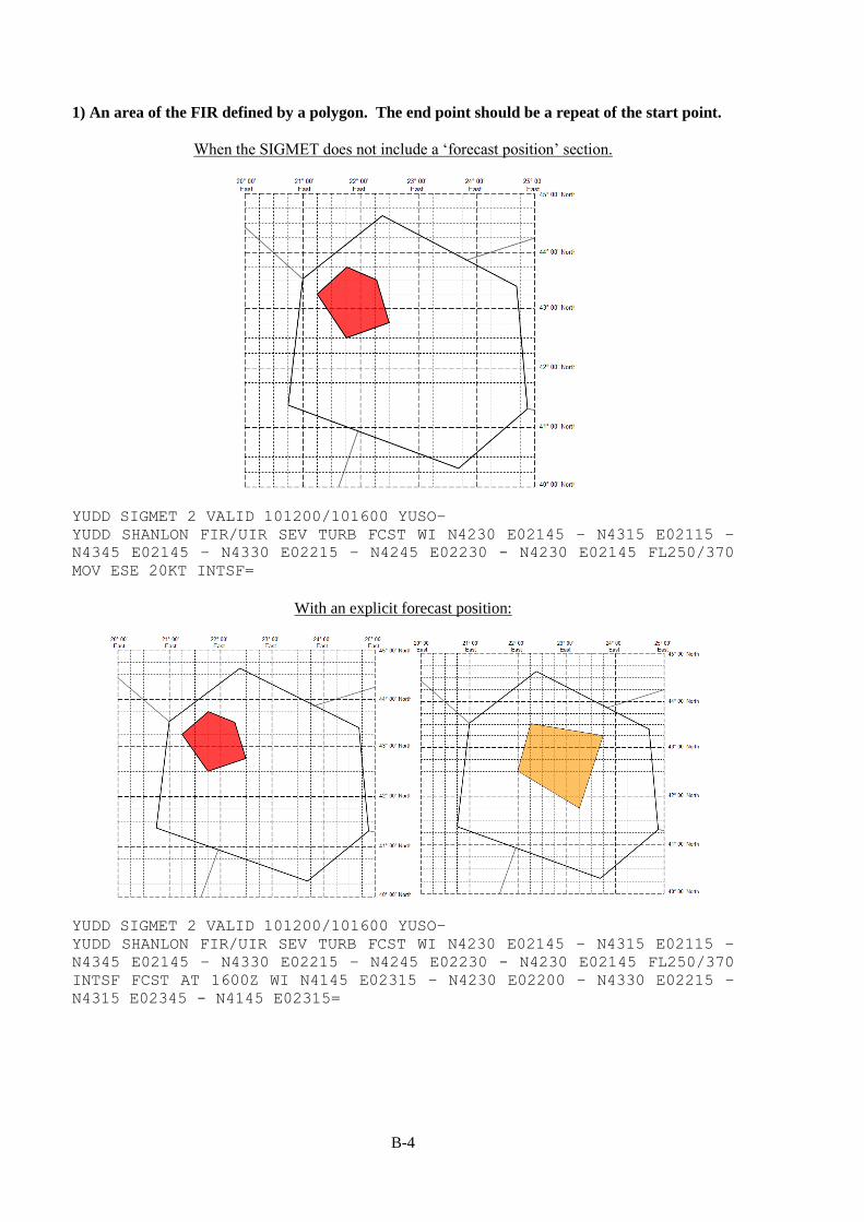
B-4
1) An area of the FIR defined by a polygon. The end point should be a repeat of the start point.
When the SIGMET does not include a ‘forecast position’ section.
YUDD SIGMET 2 VALID 101200/101600 YUSO–
YUDD SHANLON FIR/UIR SEV TURB FCST WI N4230 E02145 – N4315 E02115 –
N4345 E02145 – N4330 E02215 – N4245 E02230 - N4230 E02145 FL250/370
MOV ESE 20KT INTSF=
With an explicit forecast position:
YUDD SIGMET 2 VALID 101200/101600 YUSO–
YUDD SHANLON FIR/UIR SEV TURB FCST WI N4230 E02145 – N4315 E02115 –
N4345 E02145 – N4330 E02215 – N4245 E02230 - N4230 E02145 FL250/370
INTSF FCST AT 1600Z WI N4145 E02315 – N4230 E02200 – N4330 E02215 –
N4315 E02345 - N4145 E02315=

B-5
When the SIGMET does not include a ‘forecast position’ section.
YUDD SIGMET 2 VALID 101200/101600 YUSO–
YUDD SHANLON FIR/UIR SEV TURB FCST WI N4230 E02052 – N4245 E02145 –
N4130 E02200 – N4107 E02130 – N4123 E02045 - N4230 E02052 FL250/370
MOV SE 30KT WKN=
With an explicit forecast position:
YUDD SIGMET 2 VALID 101200/101600 YUSO–
YUDD SHANLON FIR/UIR SEV TURB FCST WI N4230 E02052 – N4245 E02145 –
N4130 E02200 – N4107 E02130 – N4123 E02045- N4230 E02052 FL250/370 WKN
FCST AT 1600Z WI N4230 E02052 – N4145 E02245 – N4045 E02330 – N4040
E02248 – N4123 E02045- N4230 E02052=

B-6
Use of polygons with complex FIR boundaries.
Annex 3 (19th Edition, July 2016 and 20th Edition, July 2018) specifies that the points of a polygon '...
should be kept to a minimum and should not normally exceed seven'. However, some FIR boundaries
are complex, and it would be unrealistic to expect that a polygon would be defined that followed such
boundaries precisely. As such, some States have determined that the polygon points be chosen in relation
to the complex boundary such that the FIR boundary approximates, but is wholly encompassed by, the
polygon, and that any additional area beyond the FIR boundary be the minimum that can be reasonably
and practically described. Caution should however be exercised in those instances where international
aerodromes are located in close proximity to such a complex FIR boundary.
In the examples below, it would not be practical to follow the northeastern boundary of the FIR exactly.
The point close to N4330 E02245 is obviously a 'major' turning point along the FIR boundary, but the
other, numerous and complex turning points can only be approximated when constrained to seven points.
When the SIGMET does not include a ‘forecast position’ section.
YUDD SIGMET 2 VALID 101200/101600 YUSO–
YUDD SHANLON FIR/UIR SEV TURB FCST WI N4315 E02145 – N4445 E02225 –
N4330 E02445 – N4200 E02455 – N4230 E02245 - N4315 E02145 FL250/370
MOV SE 20KT WKN=

B-7
With an explicit forecast position:
YUDD SIGMET 2 VALID 101200/101600 YUSO–
YUDD SHANLON FIR/UIR SEV TURB FCST WI N4315 E02145 – N4445 E02245 –
N4330 E02445 – N4200 E02455 – N4230 E02245- N4315 E02145 FL250/370 WKN
FCST AT 1600Z WI N4300 E02245 – N4415 E02315 – N4322 E02452 – N4155
E02445 – N4215 E02330- N4300 E02245=
2a) In a sector of the FIR defined relative to a specified line, or single series of up to three connected
lines, with start and end points on the FIR boundary (or so close to the FIR boundary so as to leave
no doubt that the intent is for the line to connect to the FIR boundary at that point).
The specified points shall be on the FIR boundary (or so close to the FIR boundary so as to leave no doubt that the intent is for the line to connect to the FIR boundary at that point)
When the SIGMET does not include a ‘forecast position’ section.
YUDD SIGMET 2 VALID 101200/101600 YUSO–
YUDD SHANLON FIR SEV TURB FCST NE OF LINE N4230 E02052 – N4100 E02430
FL250/370 MOV NE 15KT WKN=
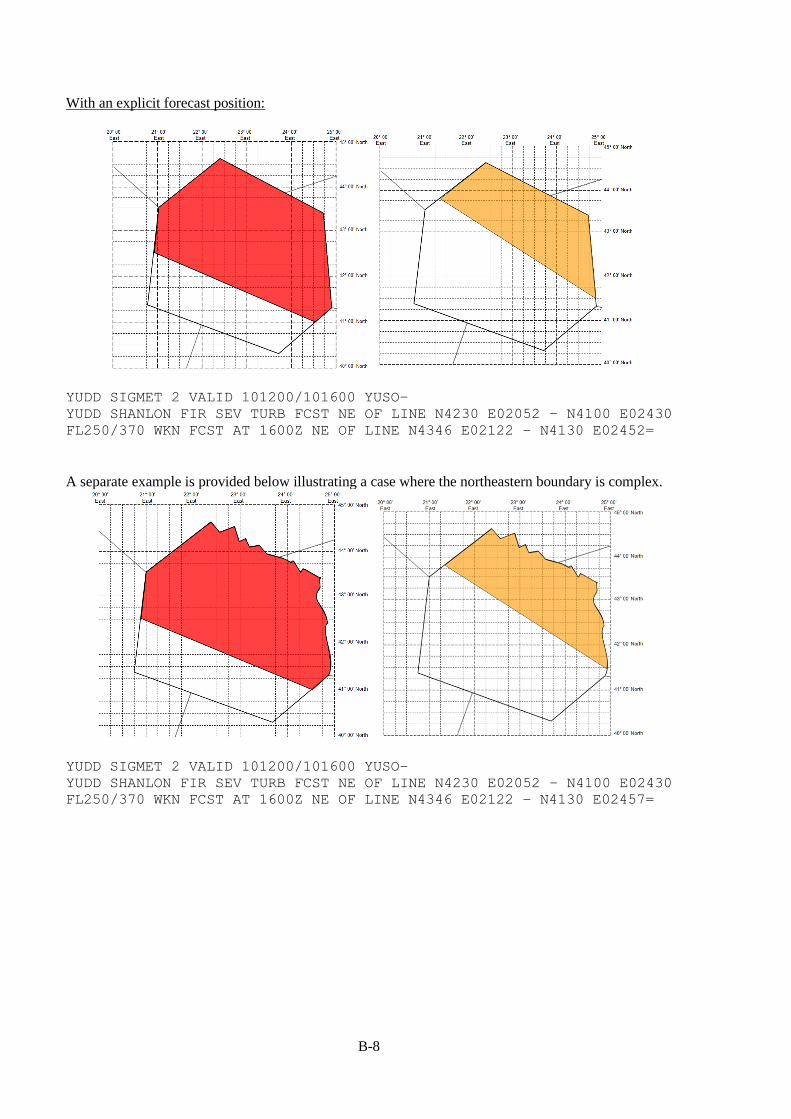
B-8
With an explicit forecast position:
YUDD SIGMET 2 VALID 101200/101600 YUSO–
YUDD SHANLON FIR SEV TURB FCST NE OF LINE N4230 E02052 – N4100 E02430
FL250/370 WKN FCST AT 1600Z NE OF LINE N4346 E02122 – N4130 E02452=
A separate example is provided below illustrating a case where the northeastern boundary is complex.
YUDD SIGMET 2 VALID 101200/101600 YUSO–
YUDD SHANLON FIR SEV TURB FCST NE OF LINE N4230 E02052 – N4100 E02430
FL250/370 WKN FCST AT 1600Z NE OF LINE N4346 E02122 – N4130 E02457=

B-9
For a series of connected lines when the SIGMET does not include a ‘forecast position’ section.
YUDD SIGMET 2 VALID 101200/101600 YUSO–
YUDD SHANLON FIR SEV TURB FCST NE OF LINE N4345 E02115 – N4245 E02145
- N4230 E02315 – N4100 E02430 FL250/370 MOV NE 20KT WKN=
With an explicit forecast position:
YUDD SIGMET 2 VALID 101200/101600 YUSO–
YUDD SHANLON FIR SEV TURB FCST NE OF LINE N4345 E02115 – N4245 E02145
- N4230 E02315 – N4100 E02430 FL250/370 WKN FCST AT 1600Z NE OF LINE
N4411 E02145 – N4255 E02228 - N4228 E02400 – N4145 E02450=

B-10
2b) In a sector of the FIR defined as being between two lines of latitude, or between two lines of
longitude.
When the SIGMET does not include a ‘forecast position’ section.
YUDD SIGMET 2 VALID 101200/101600 YUSO–
YUDD SHANLON FIR SEV TURB FCST N OF N4145 AND S OF N4230 FL250/370 MOV
N 30KT WKN=
With an explicit forecast position:
YUDD SIGMET 2 VALID 101200/101600 YUSO–
YUDD SHANLON FIR SEV TURB FCST N OF N4145 AND S OF N4230 FL250/370 WKN
FCST AT 1600Z N OF N4215 AND S OF N4300=
(similar constructions can be used for specifying areas between lines of longitude)

B-11
2c) In a sector of the FIR defined as being between two specified lines, or between two series of up
to three connected lines, each with start and endpoints on the FIR boundary (or start and
endpoints so close to the FIR boundary so as to leave no doubt that the intent is for the line to
connect to the FIR boundary at those points).
The specified points shall be on the FIR boundary (or so close to the FIR boundary so as to leave no doubt that the
intent is for the line to connect to the FIR boundary at that point)
When the SIGMET does not include a ‘forecast position’ section.
YUDD SIGMET 2 VALID 101200/101600 YUSO–
YUDD SHANLON FIR SEV TURB FCST NE OF LINE N4300 E02057 – N4020 E02340
AND SW OF LINE N4402 E02142 – N4145 E02450 FL250/370 MOV NE 20KT WKN=
With an explicit forecast position:
YUDD SIGMET 2 VALID 101200/101600 YUSO–
YUDD SHANLON FIR SEV TURB FCST NE OF LINE N4300 E02057 – N4020 E02340
AND SW OF LINE N4402 E02142 – N4145 E02450 FL250/370 WKN FCST AT 1600Z
NE OF LINE N4403 E02140 – N4055 E02422 AND SW OF LINE N4437 E02222 –
N4230 E02447=
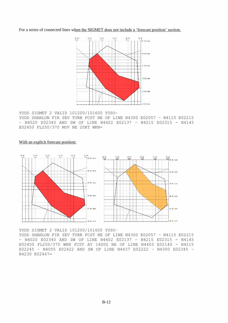
B-12
For a series of connected lines when the SIGMET does not include a ‘forecast position’ section.
YUDD SIGMET 2 VALID 101200/101600 YUSO–
YUDD SHANLON FIR SEV TURB FCST NE OF LINE N4300 E02057 – N4115 E02215
– N4020 E02340 AND SW OF LINE N4402 E02137 – N4215 E02315 - N4145
E02450 FL250/370 MOV NE 20KT WKN=
With an explicit forecast position:
YUDD SIGMET 2 VALID 101200/101600 YUSO–
YUDD SHANLON FIR SEV TURB FCST NE OF LINE N4300 E02057 – N4115 E02215
– N4020 E02340 AND SW OF LINE N4402 E02137 – N4215 E02315 - N4145
E02450 FL250/370 WKN FCST AT 1600Z NE OF LINE N4403 E02140 - N4215
E02245 – N4055 E02422 AND SW OF LINE N4437 E02222 – N4300 E02345 –
N4230 E02447=

B-13
2d) In a sector of the FIR defined relative to a line of latitude and a line of longitude (effectively a
quadrant)
When the SIGMET does not include a ‘forecast position’ section.
YUDD SIGMET 2 VALID 101200/101600 YUSO–
YUDD SHANLON FIR/UIR SEV TURB FCST S OF N4300 AND W OF E02215 FL250/370
MOV S 12KT WKN=
When the SIGMET does include a ‘forecast position'.
YUDD SIGMET 2 VALID 101200/101600 YUSO–
YUDD SHANLON FIR/UIR SEV TURB FCST S OF N4300 AND W OF E02215 FL250/370
WKN FCST AT 1600Z S OF N4215 AND W OF E02215=

B-14
2e) In a sector of the FIR defined relative to a line of latitude or longitude (effectively a segment)
When the SIGMET does not include a ‘forecast position’ section.
YUDD SIGMET 2 VALID 101200/101600 YUSO–
YUDD SHANLON FIR/UIR SEV TURB FCST N OF N43 FL250/370 MOV N 15KT WKN=
When the SIGMET does include a ‘forecast position’ section.
YUDD SIGMET 2 VALID 101200/101600 YUSO–
YUDD SHANLON FIR/UIR SEV TURB FCST N OF N433 FL250/370 WKN FCST AT
1600Z N OF N44=
3 It would be equally valid to use 'N4300'.

B-15
YUDD SIGMET 2 VALID 101200/101600 YUSO–
YUDD SHANLON FIR/UIR SEV TURB FCST N OF N434 FL250/370 WKN FCST AT
1600Z N OF N44=
3) Defined by a ‘corridor’ of specified width, centred upon the line described;
YUDD SIGMET 2 VALID 101200/101600 YUSO–
YUDD SHANLON FIR/UIR SEV TURB FCST APRX 30NM WID LINE BTN N4315 E02100
– N4230 E02215 – N4245 E02345 FL250/370 WKN FCST AT 1600Z APRX 30NM
WID LINE BTN N4230 E02130 – N4200 E02245 – N4145 E02415=
Note: The nature of this option means that, as at N4315 E02100, it is inferred that there is some
encroachment into the neighbouring FIR.
4 It would be equally valid to use 'N4300'.

B-16
4) At a specific point within the FIR;
When the SIGMET does not include a ‘forecast position’ section.
YUDD SIGMET 2 VALID 101200/101600 YUSO–
YUDD SHANLON FIR/UIR SEV TURB OBS N4245 E02230 FL250/370 STNR WKN=
5) A vertical cylinder of specified radius.
Where the surface position at the centre of the cylinder does not change, but the radius increases.
YUDD SIGMET 2 VALID 101200/101600 YUSO–
YUDD SHANLON FIR/UIR RDOACT CLD OBS AT 1150Z WI 30NM OF N2200 W06315
SFC/3000FT NC FCST AT 1600Z WI 45NM OF N2200 W06315=
6) Covering entire FIR.
YUDD SIGMET 2 VALID 101200/101600 YUSO –
YUDD SHANLON FIR/UIR VA CLD FCST AT 1200Z ENTIRE FIR FL250/370 STNR
WKN=
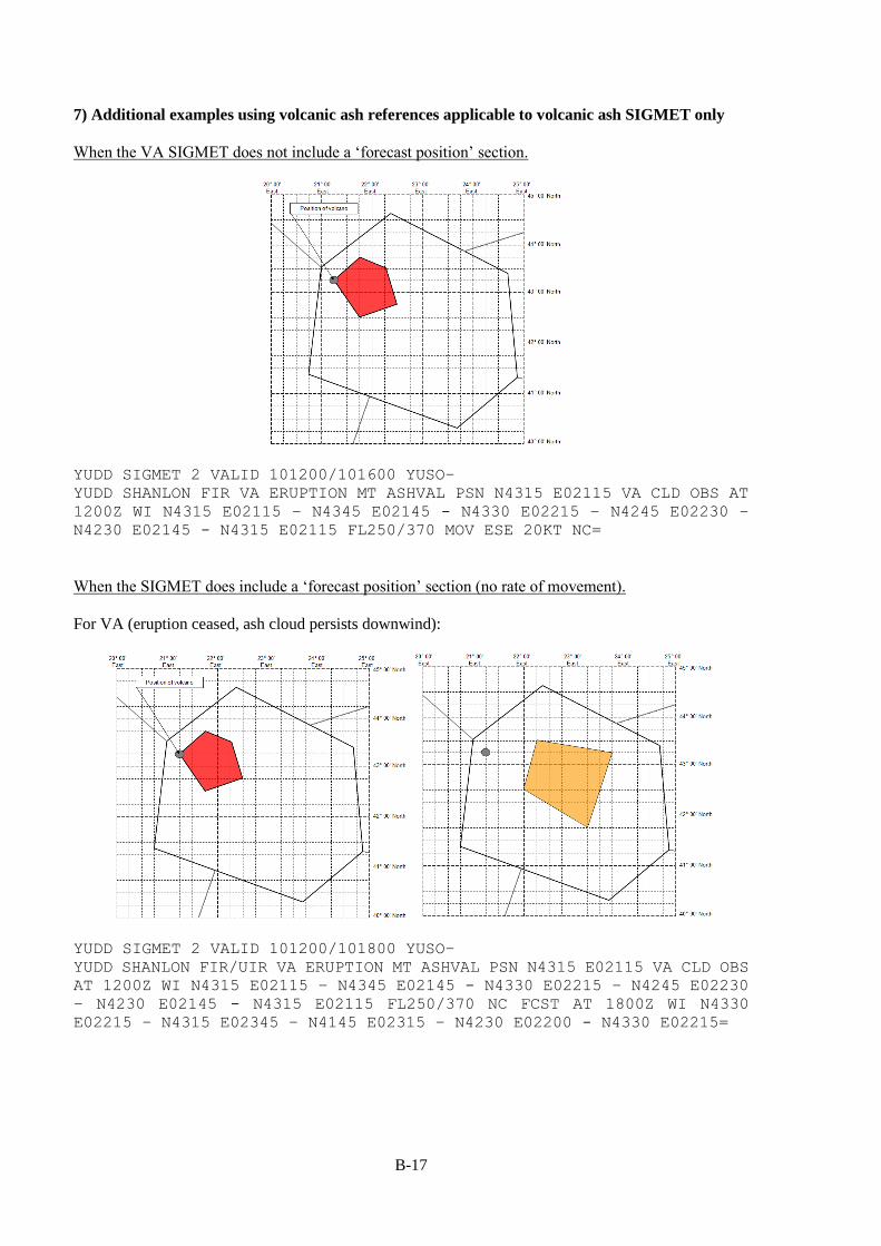
B-17
7) Additional examples using volcanic ash references applicable to volcanic ash SIGMET only
When the VA SIGMET does not include a ‘forecast position’ section.
YUDD SIGMET 2 VALID 101200/101600 YUSO–
YUDD SHANLON FIR VA ERUPTION MT ASHVAL PSN N4315 E02115 VA CLD OBS AT
1200Z WI N4315 E02115 – N4345 E02145 - N4330 E02215 – N4245 E02230 –
N4230 E02145 - N4315 E02115 FL250/370 MOV ESE 20KT NC=
When the SIGMET does include a ‘forecast position’ section (no rate of movement).
For VA (eruption ceased, ash cloud persists downwind):
YUDD SIGMET 2 VALID 101200/101800 YUSO–
YUDD SHANLON FIR/UIR VA ERUPTION MT ASHVAL PSN N4315 E02115 VA CLD OBS
AT 1200Z WI N4315 E02115 – N4345 E02145 - N4330 E02215 – N4245 E02230
– N4230 E02145 - N4315 E02115 FL250/370 NC FCST AT 1800Z WI N4330
E02215 – N4315 E02345 – N4145 E02315 – N4230 E02200 - N4330 E02215=

B-18
For VA (eruption on-going):
YUDD SIGMET 2 VALID 101200/101800 YUSO –
YUDD SHANLON FIR VA ERUPTION MT ASHVAL PSN N4315 E02115 VA CLD OBS AT
1200Z WI N4315 E02115 - N4345 E02145 – N4330 E02215 – N4245 E02230 –
N4230 E02145 – N4315 E02115 FL250/370 NC FCST AT 1800Z WI N4315 E02115
- N4330 E02215 – N4315 E02345 – N4145 E02315 – N4230 E02200 – N4315
E02115=
For VA (eruption ceasing, ash dispersing):
YUDD SIGMET 2 VALID 101200/101800 YUSO–
YUDD SHANLON FIR VA ERUPTION MT ASHVAL PSN N4315 E02115 VA CLD OBS AT
1200Z WI N4315 E02115 - N4345 E02145 – N4330 E02215 – N4245 E02230 -
N4230 E02145 - N4315 E02115 FL250/370 WKN FCST AT 1800Z NO VA EXP=

B-19
For VA (eruption on-going), defining the area affected as a corridor of specified width;
YUDD SIGMET 2 VALID 211200/211800 YUSO –
YUDD SHANLON FIR/UIR VA ERUPTION MT ASHVAL PSN N4330 E02200 VA CLD
FCST AT 1200Z APRX 100KM WID LINE BTN N4330 E02200 – N4315 E02230 –
N4230 E02300 – N4145 E02230 – N4130 E02145 FL310/450 NC FCST AT 1800Z
APRX 100KM WID LINE BTN N4330 E02200 – N4315 E02300 – N4215 E02415 –
N4115 E02400 – N4030 E02315=
8) Additional examples using volcanic ash references applicable to multiple areas in SIGMET for
volcanic ash.
The only way to include a second instance of a volcanic ash cloud in a SIGMET message is to use the
'AND' option after the 'Forecast position' section.
In the example below, two areas of volcanic ash cloud (at different levels) are forecast to move as
described. The normal courier font refers to the northernmost areas of ash, and the italicised font refers
to the southernmost areas of ash during the period. 'AND' is highlighted in bold to identify the separation
of the two features.

B-20
YUDD SIGMET 2 VALID 101200/101800 YUSO –
YUDD SHANLON FIR VA ERUPTION MT ASHVAL PSN N4315 E02115 VA CLD OBS AT
1200Z WI N4315 E02115 – N4345 E02145 N4330 E02215 – N4245 E02230 –
N4230 E02145 - N4315 E02115 FL250/370 NC FCST AT 1800Z WI N4330 E02215
– N4315 E02345 – N4145 E02315 – N4230 E02200 - N4330 E02215 AND WI
N4200 E02115 – N4217 E02130 – N4145 E02200 – N4130 E02130 – N4200
E02115 FL150/300 NC FCST AT 1800Z WI N4200 E02145 – N4145 E02215 –
N4100 E02215 - N4130 E02130 - N4200 E02145=
The above only works if there are two instances of ash at the start and end of the period. If the number
of ash areas is different at the start and end, it is recommended that separate SIGMETs be issued as
necessary.
9) Additional example illustrating use of "WI nnnKM (or nnnNM) OF TC CENTRE " in Tropical
Cyclone SIGMET Only
YUDD SIGMET 2 VALID 101200/101800 YUSO–
YUDD SHANLON FIR TC GLORIA PSN N2200 W06145 CB OBS AT 1200Z WI 75NM OF
TC CENTRE TOP BLW FL500 MOV NW 20KT WKN=
YUDD SIGMET 2 VALID 101200/101800 YUSO–
YUDD SHANLON FIR TC GLORIA PSN N2200 W06145 CB OBS AT 1200Z WI 75NM OF
TC CENTRE TOP BLW FL500 WKN FCST AT 1800Z TC CENTRE PSN N2330 W06315=
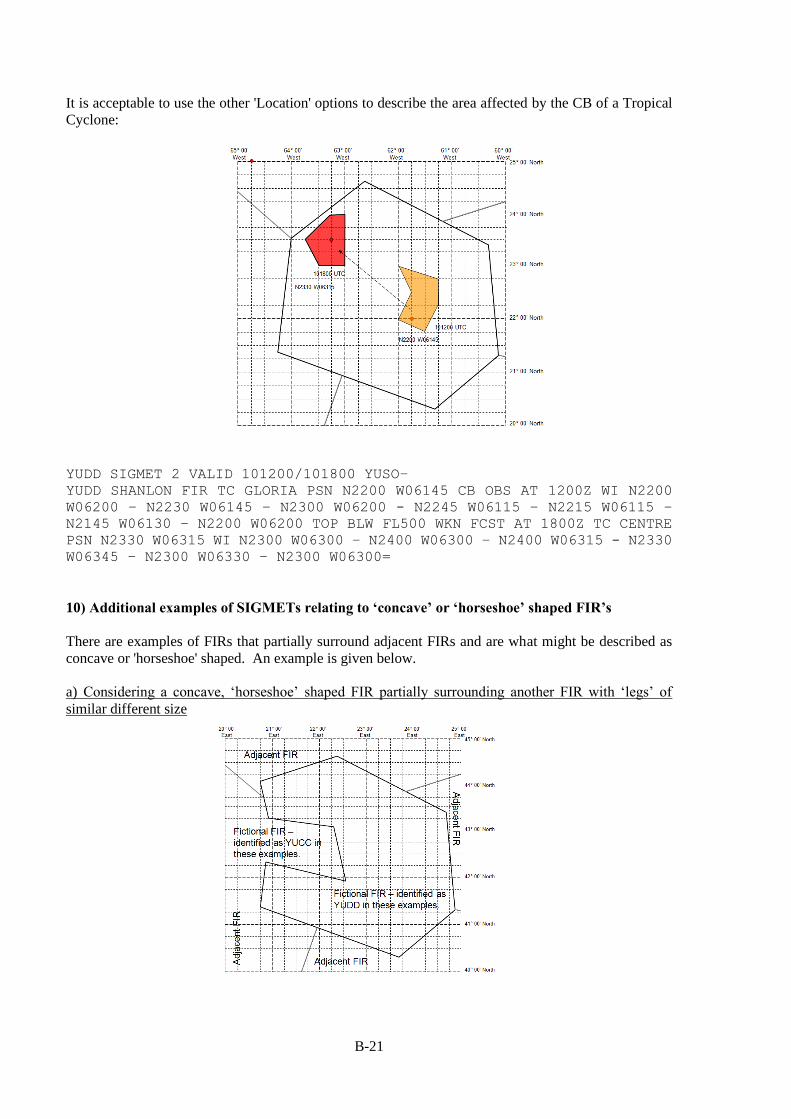
B-21
It is acceptable to use the other 'Location' options to describe the area affected by the CB of a Tropical
Cyclone:
YUDD SIGMET 2 VALID 101200/101800 YUSO–
YUDD SHANLON FIR TC GLORIA PSN N2200 W06145 CB OBS AT 1200Z WI N2200
W06200 – N2230 W06145 – N2300 W06200 - N2245 W06115 – N2215 W06115 –
N2145 W06130 – N2200 W06200 TOP BLW FL500 WKN FCST AT 1800Z TC CENTRE
PSN N2330 W06315 WI N2300 W06300 – N2400 W06300 – N2400 W06315 - N2330
W06345 – N2300 W06330 – N2300 W06300=
10) Additional examples of SIGMETs relating to ‘concave’ or ‘horseshoe’ shaped FIR’s
There are examples of FIRs that partially surround adjacent FIRs and are what might be described as
concave or 'horseshoe' shaped. An example is given below.
a) Considering a concave, ‘horseshoe’ shaped FIR partially surrounding another FIR with ‘legs’ of
similar different size
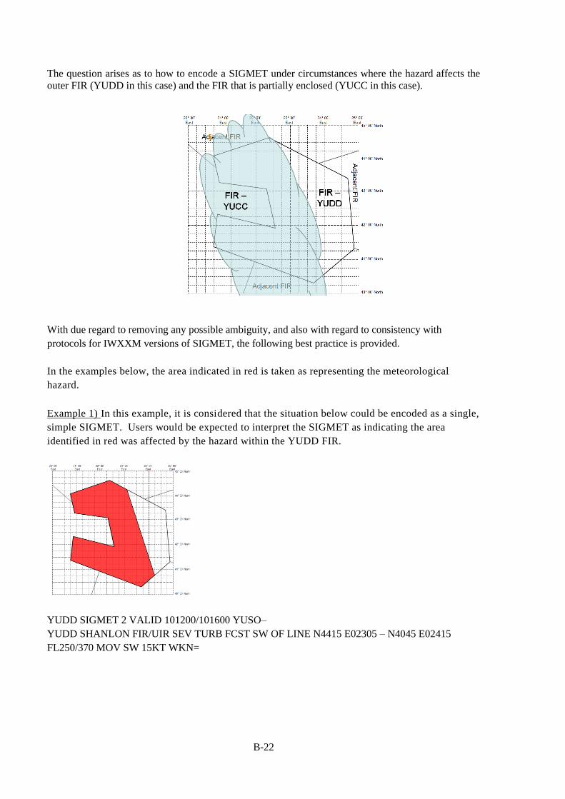
B-22
The question arises as to how to encode a SIGMET under circumstances where the hazard affects the
outer FIR (YUDD in this case) and the FIR that is partially enclosed (YUCC in this case).
With due regard to removing any possible ambiguity, and also with regard to consistency with
protocols for IWXXM versions of SIGMET, the following best practice is provided.
In the examples below, the area indicated in red is taken as representing the meteorological
hazard.
Example 1) In this example, it is considered that the situation below could be encoded as a single,
simple SIGMET. Users would be expected to interpret the SIGMET as indicating the area
identified in red was affected by the hazard within the YUDD FIR.
YUDD SIGMET 2 VALID 101200/101600 YUSO–
YUDD SHANLON FIR/UIR SEV TURB FCST SW OF LINE N4415 E02305 – N4045 E02415
FL250/370 MOV SW 15KT WKN=
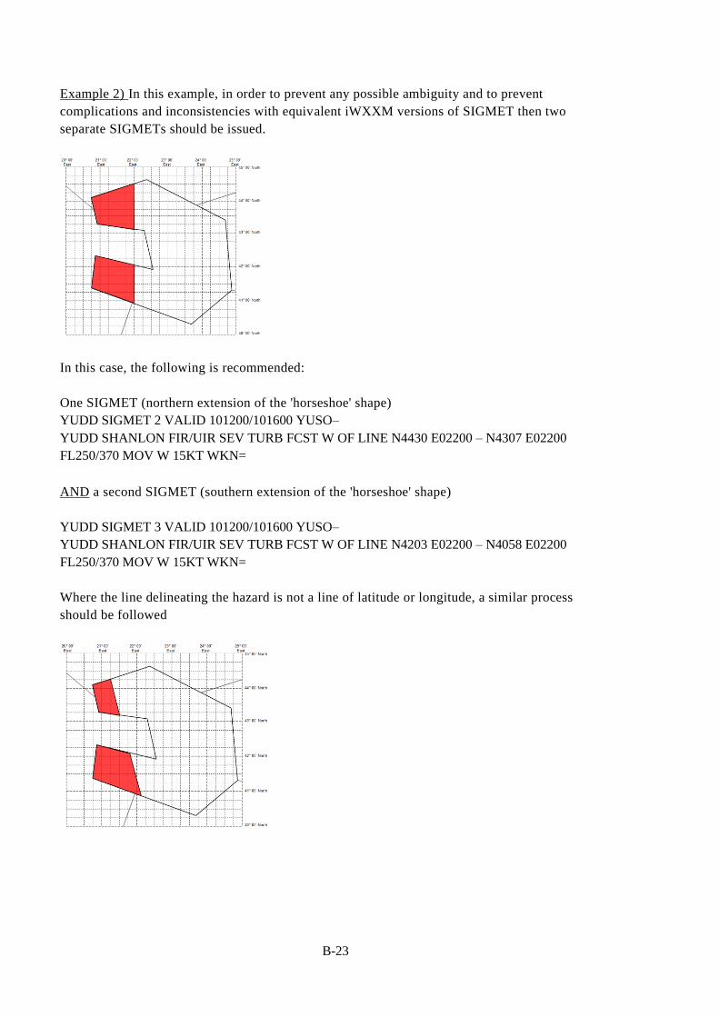
B-23
Example 2) In this example, in order to prevent any possible ambiguity and to prevent
complications and inconsistencies with equivalent iWXXM versions of SIGMET then two
separate SIGMETs should be issued.
In this case, the following is recommended:
One SIGMET (northern extension of the 'horseshoe' shape)
YUDD SIGMET 2 VALID 101200/101600 YUSO–
YUDD SHANLON FIR/UIR SEV TURB FCST W OF LINE N4430 E02200 – N4307 E02200
FL250/370 MOV W 15KT WKN=
AND a second SIGMET (southern extension of the 'horseshoe' shape)
YUDD SIGMET 3 VALID 101200/101600 YUSO–
YUDD SHANLON FIR/UIR SEV TURB FCST W OF LINE N4203 E02200 – N4058 E02200
FL250/370 MOV W 15KT WKN=
Where the line delineating the hazard is not a line of latitude or longitude, a similar process
should be followed

B-24
One SIGMET (northern extension of the 'horseshoe' shape)
YUDD SIGMET 2 VALID 101200/101600 YUSO–
YUDD SHANLON FIR/UIR SEV TURB FCST SW OF LINE N4415 E02115 – N4312 E02130
FL250/370 MOV W 15KT WKN=
AND a second SIGMET (southern extension of the 'horseshoe' shape)
YUDD SIGMET 3 VALID 101200/101600 YUSO–
YUDD SHANLON FIR/UIR SEV TURB FCST SW OF LINE N4205 E02147 – N4052 E02206
FL250/370 MOV W 15KT WKN=
b) Considering a concave, 'horseshoe' shaped FIR partially surrounding another FIR with 'legs' of very
different size.
If the southern 'leg' is expected to be affected during the forecasted validity period, as the
example below then 2 SIGMETs should be issued.
YUDD SIGMET 2 VALID 101200/101600 YUSO–
YUDD SHANLON FIR/UIR SEV TURB FCST AT 1200Z W OF LINE N4416 E02100 – N4307
E02100 FL250/370 WKN FCST AT 1600Z W OF LINE N4427 E02245 – N4252 E02245=
AND a second SIGMET
YUDD SIGMET 3 VALID 101330/101600 YUSO–
YUDD SHANLON FIR/UIR SEV TURB FCST AT 1330Z W OF LINE N4200 E02145 – N4100
E02145 FL250/370 WKN FCST AT 1600Z W OF LINE N4147 E02245 – N4038 E02245=
Note, the validity time (highlighted) of the second SIGMET commences sometime after that of
the first since the southern extension of the horseshoe shape is not as far west.

B-25
If the southern leg of the FIR is not expected to be affected, as in the example below,
Then a single SIGMET could be issued.
YUDD SIGMET 2 VALID 101200/101600 YUSO–
YUDD SHANLON FIR/UIR SEV TURB FCST AT 1200Z W OF LINE N4415 E02100 – N4307
E02100 FL250/370 MOV E 25KT WKN=
However, to remove any possible doubt it is better to include an explicit forecast position,
YUDD SIGMET 2 VALID 101200/101600 YUSO–
YUDD SHANLON FIR/UIR SEV TURB FCST AT 1200Z W OF LINE N4415 E02100 – N4307
E02100 FL250/370 WKN FCST AT 1600Z W OF LINE N4427 E02245 – N4252 E02245=
It should also be noted that in all of these examples relating to concave, horseshoe shaped FIRs,
polygons could also be used to explicitly define the areas affected. The above examples are intended
to show that the principle under such circumstances is that two SIGMETs should be issued. This, as
noted, will prevent ambiguity and will permit straightforward translation of alphanumeric SIGMET
into IWXXM versions of SIGMET.
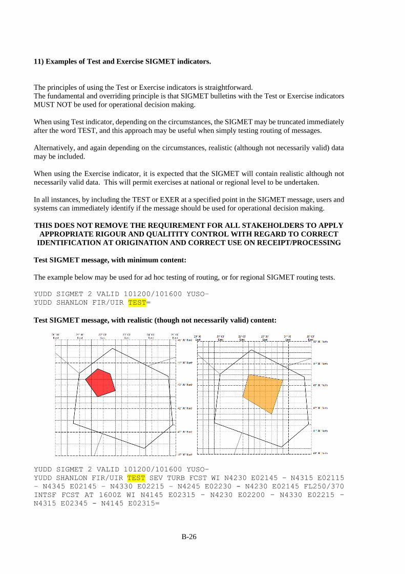
B-26
11) Examples of Test and Exercise SIGMET indicators.
The principles of using the Test or Exercise indicators is straightforward.
The fundamental and overriding principle is that SIGMET bulletins with the Test or Exercise indicators
MUST NOT be used for operational decision making.
When using Test indicator, depending on the circumstances, the SIGMET may be truncated immediately
after the word TEST, and this approach may be useful when simply testing routing of messages.
Alternatively, and again depending on the circumstances, realistic (although not necessarily valid) data
may be included.
When using the Exercise indicator, it is expected that the SIGMET will contain realistic although not
necessarily valid data. This will permit exercises at national or regional level to be undertaken.
In all instances, by including the TEST or EXER at a specified point in the SIGMET message, users and
systems can immediately identify if the message should be used for operational decision making.
THIS DOES NOT REMOVE THE REQUIREMENT FOR ALL STAKEHOLDERS TO APPLY
APPROPRIATE RIGOUR AND QUALITITY CONTROL WITH REGARD TO CORRECT
IDENTIFICATION AT ORIGINATION AND CORRECT USE ON RECEIPT/PROCESSING
Test SIGMET message, with minimum content:
The example below may be used for ad hoc testing of routing, or for regional SIGMET routing tests.
YUDD SIGMET 2 VALID 101200/101600 YUSO–
YUDD SHANLON FIR/UIR TEST=
Test SIGMET message, with realistic (though not necessarily valid) content:
YUDD SIGMET 2 VALID 101200/101600 YUSO–
YUDD SHANLON FIR/UIR TEST SEV TURB FCST WI N4230 E02145 – N4315 E02115
– N4345 E02145 – N4330 E02215 – N4245 E02230 - N4230 E02145 FL250/370
INTSF FCST AT 1600Z WI N4145 E02315 – N4230 E02200 – N4330 E02215 –
N4315 E02345 - N4145 E02315=

B-27
Exercise SIGMET message, with realistic (though not necessarily valid) content:
YUDD SIGMET 2 VALID 101200/101600 YUSO–
YUDD SHANLON FIR EXER SEV TURB FCST NE OF LINE N4345 E02115 – N4245
E02145 - N4230 E02315 – N4100 E02430 FL250/370 WKN FCST AT 1600Z NE OF
LINE N4411 E02145 – N4255 E02228 - N4228 E02400 – N4130 E02450=
The most common, organised Exercise – especially at regional level – is likely to be related to volcanic
ash. On such occasions, 'historical' data is used in order to practice procedures over specific areas.
YUDD SIGMET 2 VALID 101200/101800 YUSO –
YUDD SHANLON FIR EXER VA ERUPTION MT ASHVAL PSN N4315 E02115 VA CLD
OBS AT 1200Z WI N4315 E02115 - N4345 E02145 – N4330 E02215 – N4245
E02230 – N4230 E02145 – N4315 E02115 FL250/370 NC FCST AT 1800Z WI
N4315 E02115 - N4330 E02215 – N4315 E02345 – N4145 E02315 – N4230
E02200 – N4315 E02115=
— — — — — — — —
C-1
APPENDIX C
SIGMET TEST PROCEDURES
CHAPTER 1 ― REGIONAL SIGMET TEST PROCEDURES
1. Introduction
1.1. The Meteorology Divisional Meeting (2002) formulated Recommendation 1/12 b),
Implementation of SIGMET requirements, which called, inter alia, for the relevant planning and
implementation regional groups (PIRGs) to conduct periodic tests of the issuance and reception of
SIGMET messages, especially those for volcanic ash.
1.2. This document describes the procedures for conducting regional SIGMET tests. The test
procedures encompass all the three types of SIGMET, as follows:
• SIGMET for volcanic ash (WV SIGMET);
• SIGMET for tropical cyclone (WC SIGMET); and
• SIGMET for other weather phenomena (WS SIGMET).
1.3. The requirements for dissemination of SIGMET are specified in Annex 3, Appendix 6, 1.2 and
in this guide (Section 3, paragraph 3.6 – 3.6.4).
1.4. Tropical cyclone and volcanic ash cloud SIGMETs will be referred to hereafter as WC SIGMET
(due to the T1T2 section of the WMO AHL being set to WC) and WV SIGMET (due to the T1T2 section
of the WMO AHL being set to WV) respectively. All other SIGMET types will be referred to by WS
(due to the T1T2 section of the WMO AHL being set to WS).
2. Purpose and scope of regional SIGMET tests
2.1. The purpose of the regional SIGMET tests is to check the awareness of participating MWOs of
the ICAO requirements for the issuance of SIGMET and the compliance of the States’ procedures for
preparation and dissemination of SIGMET bulletins with the relevant ICAO Standards and
Recommended Practices (SARPs) and regional procedures.
2.2. An MWO is at liberty to issue SIGMET test messages for local reasons (i.e. testing of local
systems/routing etc.). Whilst such tests may not involve other MWOs or agencies directly, it is
recommended that the general principles of this guide be followed with regard to local, ad hoc testing.
Note: It is recommended that MWO's consider issuing SIGMET test messages following upgrades to
operational SIGMET or dissemination systems.
2.3. Hereafter, references to 'SIGMET tests' or 'tests' should be understood to refer to regional
SIGMET tests.
2.4. The scope of the tests is to check also the interaction (where appropriate, depending on regional
requirements) between the tropical cyclone advisory centres (TCAC) and volcanic ash advisory centres
(VAAC), and the MWOs in their areas of responsibility. Therefore, where the issuance of WC and WV
SIGMET is being tested, the TEST SIGMET messages initiated by the MWO should normally be
triggered by a test advisory issued by the respective TCAC or VAAC.
2.5. The regional OPMET data banks (RODB) will monitor the dissemination by filing all TEST
SIGMETs and advisories and the corresponding reception times. The monitoring results for WC, WV

C-2
and WS SIGMET will be provided in the form of summaries to the SIGMET test focal points given in
section 3.4.3 with a copy to the Regional Office concerned
2.6. A consolidated summary report will be prepared by both the SIGMET test focal points and
submitted to the ICAO regional office concerned. The report will include recommendations for
improvement of the SIGMET exchange and availability. The results of the tests should be reported to
the appropriate regional OPMET bulletin exchange/data management group and MET Sub-group
meetings.
2.7. Participating States, for which discrepancies of the procedures or other findings are identified
by the tests, will be advised by the ICAO Regional Office and requested to take necessary corrective
action.
3. SIGMET test procedures
3.1. Procedures for WC and WV SIGMET tests
3.1.1. Participating units
3.1.1.1. Tropical Cyclone Advisory Centres (TCAC):
Darwin
Honolulu
Miami
Nadi
New Delhi
Tokyo
Réunion
3.1.1.2. Volcanic Ash Advisory Centres (VAAC):
Anchorage
Darwin
Tokyo
Toulouse
Washington
Wellington
3.1.1.3. Regional OPMET Data Banks (RODB):
Bangkok
Brisbane
Nadi
Singapore
Tokyo
3.1.1.4. Meteorological Watch Offices (MWO):
All MWOs listed in FASID Tables MET 3A and MET 3B of the ASIA/PAC Basic
ANP and FASID (Doc 9673), under the responsibility of the corresponding TCACs
and VAACs.
Note: The participation of MWOs of States outside ASIA/PAC region, but listed in
Doc 9673 (FASID Tables MET 3A and MET 3B) should be coordinated through the ICAO
Regional Office concerned.
C-3
3.1.1.5 World Area Forecast Centres (WAFCs):
London
Washington
3.1.2. WV/WC SIGMET test messages
3.1.2.1. On the specified date for the test at 0200UTC the participating VAAC and TCAC should
issue a TEST VA or TC advisory5. To accommodate the MID Region in the WC SIGMET Test, TCAC
New Delhi will issue a TEST TC advisory at 0800 UTC on the specified date for the test only to MWOs
in the MID Region in addition to the 0200 UTC TEST TC advisory issued only to MWOs in the Asia
Pacific Region. The structure of the TEST advisories should follow the standard format given in Annex
3 with indication that it is a test message using the TEST indicator at the appropriate position of the
SIGMET, and as shown in paragraphs 4.1-4.2 of this Appendix.
3.1.2.2. MWOs, upon receipt of the TEST VA or TC advisory, should issue a TEST SIGMET for
volcanic ash (WV) or tropical cyclone (WC), respectively, and send it to all participating RODBs. The
WMO AHL, the first line of the SIGMET, and the FIR reference in the second line of the SIGMET
should be valid entries. The remainder of the body of the message should contain only the specified
'TEST' indicator. TEST SIGMETs should normally have short validity periods (10 minutes), but where
appropriate TEST SIGMET may be issued with validity periods up to the maximum allowed (4 hours
for WS, 6 hours for WC and WV').
3.1.2.3. If the MWO does not receive the TEST VA or TCA advisory within 30 minutes of the
commencement time of the test then they should still issue a TEST SIGMET indicating that the VAA
or TCA was not received. See the examples in 4.3 to 4.5 for an example of the test message.
3.1.2.4. The use of the TEST indicator and the next sequence number will avoid over-writing of
previously issued and valid SIGMETs. To avoid any possible risk of confusion during genuine volcanic
eruptions or tropical cyclone events, then TEST SIGMET for VA or TC should not be sent in the case
where there is a valid SIGMET of the same type for the MWO’s area of responsibility. However, in
this case the responsible MWO should notify the WV/WC SIGMET test focal point as given in 3.4.1.3
so that they can be excluded from the analysis.
3.2. Procedures for WS SIGMET tests
Note. ― The WS SIGMET is initiated by the MWO at the designated time in 3.2.2. It is not
initiated by an advisory as in the WC and WV SIGMET tests.
3.2.1. Participating units
Each Regional Office should develop its own list of participating units, using the template below:
3.2.1.1. Regional OPMET Data Banks (RODB):
Bangkok
Brisbane
Nadi
Singapore
Tokyo
5 Note, although not within the scope of this document, the VA and TC advisory messages also include TEST and EXERCISE
Indicators with effect from Amendment 78. Consult ICAO Annex 3 Table A2-1 and A2-2 accordingly.

C-4
3.2.1.2. Meteorological Watch Offices (MWO):
All MWOs listed in FASID Table MET 1B of ASIA/PAC Basic ANP and FASID
(Doc 9673).
3.2.2. WS SIGMET Test Message
3.2.2.1. The MWOs should issue a TEST SIGMET during the 10-minute period between 0200
UTC and 0210 UTC.
3.2.2.2. The WMO AHL, the first line of the SIGMET, and the FIR reference in the second line
of the SIGMET should be valid. The remainder of the body of the message should contain only the
'TEST' indicator. TEST SIGMETs should normally have short validity periods (10 minutes), but where
appropriate TEST SIGMET may be issued with validity periods up to the maximum allowed (4 hours
for WS, 6 hours for WC and WV'.
3.3. Common procedures
3.3.1. Special procedure to avoid overwriting of a valid WV/WC/WS SIGMET
3.3.1.1. It is vital that the 'TEST' indicator is used to ensure that messages are correctly processed
and not used for operational decision making. Accordingly, the next SIGMET sequence number should
be used.
For example, a SIGMET test is scheduled for 0200 UTC on the 29th. 3 SIGMETs have
already been issued for the FIR since 0001 UTC. The TEST SIGMET is issued as
follows:
WSAU01 YBRF 290200
YBBB SIGMET 4 VALID 290200/290210 YBRF-
YBBB BRISBANE FIR TEST=
3.3.2. The test date and time
3.3.2.1. ICAO Regional Office will set a date and time for each SIGMET test after consultation with
the participating VAACs, TCACs and RODBs. The information about the agreed date and time will be
sent to all States concerned by a State letter and copied to the States’ SIGMET Tests Focal Points.
3.3.2.2. Tests for different types of SIGMET should preferably be conducted on separate dates.
3.3.2.3. SIGMET tests for WC, WV and WS should be conducted at least yearly.
3.3.3. Dissemination of test SIGMETs and advisories
3.3.3.1. All TEST TC/VA advisories should be sent by the TCACs and VAACs to the participating
units, as specified in the Regional Air Navigation Plan. The relevant AFTN addresses should be
identified as part of the Region specific documentation.
3.3.3.2. All TEST SIGMETs should be sent by the MWOs to the participating units, as specified in
the Regional Air Navigation Plan identified by each Regional Office. The relevant AFTN addresses
should be identified as part of the Region specific documentation.
3.3.3.3. RODBs that are nominated as IROGs will relay the test bulletins to their corresponding
IROG.

C-5
3.3.3.4. SIGMET tests should be terminated within 2 hours of the test start time. Exceptionally,
where the test requires SIGMETs to be valid for up to 4 hours, then tests may be extended to a maximum
of 4 hours for WS SIGMET and 6 hours for WC and WV SIGMET.
3.3.4. Coordination with the ATS units
3.3.4.1. MWOs should inform the associated ATS units of the forthcoming SIGMET tests by a
suitable advanced notice.
3.4. Processing of the test messages and results
3.4.1. The RODBs should file all incoming TEST advisories and SIGMETs and perform an analysis
of the availability, timeliness of arrival and the correctness of the WMO bulletin headings. A SIGMET
TEST Summary Table, as shown on page C-9 of this guide, should be prepared by each RODB and sent
to the regional SIGMET test focal point given in section 3.4.3, with a copy to the ICAO Regional Office.
3.4.2. The SIGMET test focal points should prepare the final report of the test and present to the ICAO
Regional Office. A summary report should be submitted to the next regional OPMET bulletin
exchange/data management group and MET Sub-group meetings.
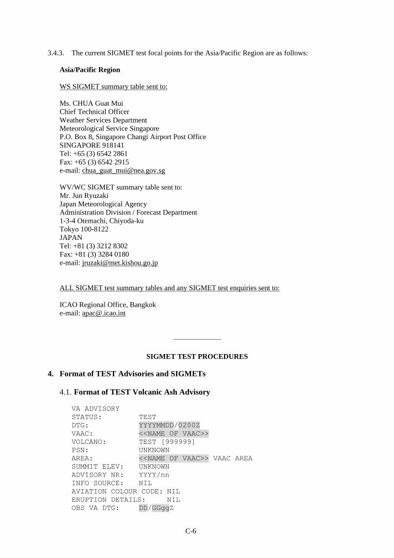
C-6
3.4.3. The current SIGMET test focal points for the Asia/Pacific Region are as follows:
Asia/Pacific Region
WS SIGMET summary table sent to:
Ms. CHUA Guat Mui
Chief Technical Officer
Weather Services Department
Meteorological Service Singapore
P.O. Box 8, Singapore Changi Airport Post Office
SINGAPORE 918141
Tel: +65 (3) 6542 2861
Fax: +65 (3) 6542 2915
e-mail: [email protected]
WV/WC SIGMET summary table sent to:
Mr. Jun Ryuzaki
Japan Meteorological Agency
Administration Division / Forecast Department
1-3-4 Otemachi, Chiyoda-ku
Tokyo 100-8122
JAPAN
Tel: +81 (3) 3212 8302
Fax: +81 (3) 3284 0180
e-mail: [email protected]
ALL SIGMET test summary tables and any SIGMET test enquiries sent to:
ICAO Regional Office, Bangkok
e-mail: [email protected]
——————
SIGMET TEST PROCEDURES
4. Format of TEST Advisories and SIGMETs
4.1. Format of TEST Volcanic Ash Advisory
VA ADVISORY
STATUS: TEST
DTG: YYYYMMDD/0200Z
VAAC: <<NAME OF VAAC>>
VOLCANO: TEST [999999]
PSN: UNKNOWN
AREA: <<NAME OF VAAC>> VAAC AREA
SUMMIT ELEV: UNKNOWN
ADVISORY NR: YYYY/nn
INFO SOURCE: NIL
AVIATION COLOUR CODE: NIL
ERUPTION DETAILS: NIL
OBS VA DTG: DD/GGggZ

C-7
OBS VA CLD: VA NOT IDENTIFIABLE FROM SATELLITE DATA
FCST VA CLD +6 HR: DD/0800Z NO VA EXP
FCST VA CLD +12 HR: DD/1400Z NO VA EXP
FCST VA CLD +18 HR: DD/2000Z NO VA EXP
RMK: THIS IS A TEST VA ADVISORY. MWO SHOULD NOW ISSUE A TEST
SIGMET FOR VA. PLEASE REFER TO THE LETTER FROM ICAO ASIA AND
PACIFIC REGIONAL OFFICE DATED xxxxxxxxxx.
NXT ADVISORY: NO FURTHER ADVISORIES=
4.2. Format of TEST Tropical Cyclone Advisory
TC ADVISORY
STATUS: TEST
DTG: YYYYMMDD/0200Z
TCAC: <<NAME OF TCAC>>
TC: TEST
ADVISORY NR: YYYY/nn (actual number)
OBS PSN: NIL
CB: NIL
MOV: NIL
C: NIL
MAX WIND: NIL
FCST PSN +6HR: NIL
FCST MAX WIND +6HR: NIL
FCST PSN +12HR: NIL
FCST MAX WIND +12HR: NIL
FCST PSN +18HR: NIL
FCST MAX WIND +18HR: NIL
FCST PSN +24HR: NIL
FCST MAX WIND +24HR: NIL
RMK: THIS IS A TEST TC ADVISORY. MWO SHOULD NOW ISSUE A TEST
SIGMET FOR TC. PLEASE REFER TO THE LETTER FROM ICAO ASIA AND
PACIFIC REGIONAL OFFICE DATED xxxxxxxxxx.
NXT MSG: NIL=
4.3. Format of TEST SIGMET for Volcanic Ash
WVXXii CCCC YYGGgg
CCCC SIGMET <<NUMBER>> VALID YYGGgg/YYGGgg CCCC−
CCCC <<NAME>> FIR TEST=
or
WVXXii CCCC YYGGgg
CCCC SIGMET <<NUMBER>> VALID YYGGgg/YYGGgg CCCC−
CCCC <<NAME>> FIR TEST. THIS IS A TEST MESSAGE, PLEASE
DISREGARD. TEST VA ADVISORY NUMBER YYYY/nn RECEIVED FM [name]
VAAC AT YYGGggZ=
or
WVXXii CCCC YYGGgg
CCCC SIGMET <<NUMBER>> VALID YYGGgg/YYGGgg CCCC−
CCCC <<NAME>> FIR TEST. THIS IS A TEST SIGMET, PLEASE
DISREGARD.

C-8
TEST VA ADVISORY NOT RECEIVED FM [name] VAAC=
Examples: WVJP31 RJTD 170205
RJJJ SIGMET Z99 VALID 170205/170215 RJTD-
RJJJ FUKUOKA FIR TEST=
WVJP31 RJTD 170205
RJJJ SIGMET 2 VALID 170205/170215 RJTD-
RJJJ FUKUOKA FIR TEST. THIS IS A TEST SIGMET, PLEASE DISREGARD.
TEST VA ADVISORY NUMBER 2018/01 RECEIVED FM TOKYO VAAC AT
170200Z=
WVJP31 RJTD 170235
RJJJ SIGMET 4 VALID 170205/170215 RJTD-
RJJJ FUKUOKA FIR TEST. THIS IS A TEST SIGMET, PLEASE DISREGARD.
TEST VA ADVISORY NOT RECEIVED FM TOKYO VAAC=
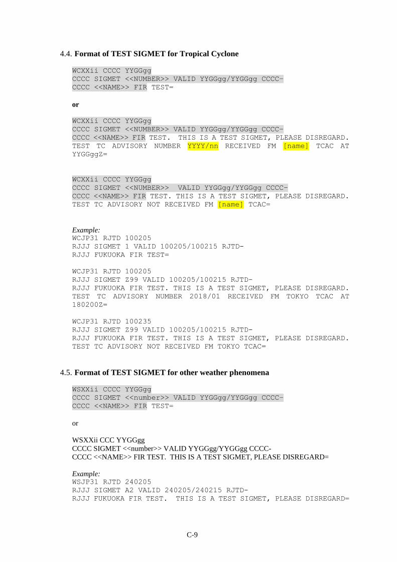
C-9
4.4. Format of TEST SIGMET for Tropical Cyclone
WCXXii CCCC YYGGgg
CCCC SIGMET <<NUMBER>> VALID YYGGgg/YYGGgg CCCC−
CCCC <<NAME>> FIR TEST=
or
WCXXii CCCC YYGGgg
CCCC SIGMET <<NUMBER>> VALID YYGGgg/YYGGgg CCCC−
CCCC <<NAME>> FIR TEST. THIS IS A TEST SIGMET, PLEASE DISREGARD.
TEST TC ADVISORY NUMBER YYYY/nn RECEIVED FM [name] TCAC AT
YYGGggZ=
WCXXii CCCC YYGGgg
CCCC SIGMET <<NUMBER>> VALID YYGGgg/YYGGgg CCCC−
CCCC <<NAME>> FIR TEST. THIS IS A TEST SIGMET, PLEASE DISREGARD.
TEST TC ADVISORY NOT RECEIVED FM [name] TCAC=
Example: WCJP31 RJTD 100205
RJJJ SIGMET 1 VALID 100205/100215 RJTD-
RJJJ FUKUOKA FIR TEST=
WCJP31 RJTD 100205
RJJJ SIGMET Z99 VALID 100205/100215 RJTD-
RJJJ FUKUOKA FIR TEST. THIS IS A TEST SIGMET, PLEASE DISREGARD.
TEST TC ADVISORY NUMBER 2018/01 RECEIVED FM TOKYO TCAC AT
180200Z=
WCJP31 RJTD 100235
RJJJ SIGMET Z99 VALID 100205/100215 RJTD-
RJJJ FUKUOKA FIR TEST. THIS IS A TEST SIGMET, PLEASE DISREGARD.
TEST TC ADVISORY NOT RECEIVED FM TOKYO TCAC=
4.5. Format of TEST SIGMET for other weather phenomena
WSXXii CCCC YYGGgg
CCCC SIGMET <<number>> VALID YYGGgg/YYGGgg CCCC−
CCCC <<NAME>> FIR TEST=
or
WSXXii CCC YYGGgg
CCCC SIGMET <<number>> VALID YYGGgg/YYGGgg CCCC-
CCCC <<NAME>> FIR TEST. THIS IS A TEST SIGMET, PLEASE DISREGARD=
Example: WSJP31 RJTD 240205
RJJJ SIGMET A2 VALID 240205/240215 RJTD-
RJJJ FUKUOKA FIR TEST. THIS IS A TEST SIGMET, PLEASE DISREGARD=

C-10
——————
5. SAMPLE TABLE TO USED BY REGIONAL OPMET DATA BANKS
Name of RODB Tokyo
Date of Test 2011/11/17
Target (VA or TC) VA
VA Advisories (FV)
TTAAii CCCC YYGGgg Received Time(UTC) Comments/Remarks
FVAK23 PAWU 170159 01:59:29
FVAU01 ADRM 170201 02:01:53
FVFE01 RJTD 170200 02:00:09
FVPS01 NZKL 170207 02:08:27
FVXX02 LFPW 170202 02:02:41
FVXX25 KNES 170200 02:02:01
VA SIGMET (WV)
TTAAii CCCC YYGGgg MWO FIR Received Time(UTC) Comments/Remarks
WVAK01 PAWU 170200 PAWU PAZA 02:00:11
WVAU01 ADRM 170201 YDRM YBBB 02:02:04
WVCI31 RCTP 170205 RCTP RCAA 02:04:58
WVCI33 ZBAA 170205 ZBAA ZBPE 02:05:26
WVCI34 ZSSS 170205 ZSSS ZSHA 02:02:34
WVCI35 ZJHK 170201 ZJHK ZJSA 02:03:34
WVCI36 ZUUU 170205 ZUUU ZPKM 02:11:04
WVCI37 ZLXY 170205 ZLXY ZLHW 02:07:44
WVCI38 ZYTX 170205 ZYTX ZYSH 02:01:50
WVCI39 ZWWW 170202 ZWWW ZWUQ 02:02:40
WVCI45 ZHHH 170204 ZHHH ZHWH 02:08:52
WVFJ01 NFFN 170000 NFFN NFFF 02:15:46
WVIN31 VOMM 170201 VOMM VOMF 02:09:57
WVJP31 RJTD 170205 RJTD RJJJ 02:06:24
WVKP31 ZUUU 170206 ZUUU VDPP 02:12:23
WVLA31 VLVT 170200 VLVT VLVT 02:01:03
WVMS31 WMKK 170205 WMKK WBFC 02:04:28
WVPA01 PHFO 170201 PHFO KZAK 02:02:09
WVPH31 RPLL 170210 RPLL RPHI 02:08:43
WVPN01 KKCI 170200 KKCI KZAK 02:00:11
WVRA31 RUCH 170205 RUCH UIAA 02:08:01
WVRA31 RUHB 170206 RUHB UHHH 02:07:57
WVRA31 RUMG 170205 RUMG UHMM 02:08:59
WVRA31 RUPV 170200 RUPV UHMP 02:09:13
WVRA31 RUSH 170205 RUSH UHSS 02:04:22
WVRA31 RUVV 170202 RUVV UHWW 02:03:13
WVRA32 RUPV 170200 RUPV UHMA 02:06:01
WVRA32 RUYK 170207 RUYK UELL 02:07:28
WVRA33 RUHB 170202 RUHB UHBB 02:02:49
WVSR20 WSSS 170205 WSSS WSJC 02:05:38
WVSS20 VHHH 170202 VHHH VHHK 02:03:05
WVTH31 VTBS 170211 VTBS VTBB 02:13:53
WVVS31 VVGL 170200 VVGL VVNB 02:05:06
WVVS31 VVGL 170208 VVGL VVTS 02:14:38

C-11
——————————

D-1
APPENDIX D
WMO HEADINGS (WMO AHL) FOR SIGMET BULLETINS
Used by Asia/Pacific Meteorological Watch Offices
MWO location
ICAO
location indicator
WMO SIGMET Headings FIR/ACC served
Remarks
WS WC WV ICAO
location indicator
1 2 3 4 5 6 7
AFGHANISTAN AFTN not available
KABUL AD OAKB WSAH31 WVAH31 OAKX Headings not confirmed
AUSTRALIA Note: Non-ICAO
location indicators are used in the WMO headings
ADELAIDE/Adelaide
YPRM WSAU21 YMMM APRM
BRISBANE/Brisbane YBRF WSAU21 WCAU01 YBBB ABRF
YMMM
HOBART/Hobart YMHF WSAU21 YMMM
AMHF
MELBOURNE/Melbourne YMRF WSAU21 YBBB AMRF
YMMM
MELBOURNE (WORLD MET CENTRE, BUREAU OF METEOROLOGY)
YMMC YMMC
WSAU21 WVAU01
YBBB YMMM YBBB YMMM
AMMC ADRM
PERTH/Perth YPRF WSAU21 WCAU01 YBBB APRF
YMMM
SYDNEY/Sydney YSRF WSAU21 YBBB ASRF
YMMM
BANGLADESH
DHAKA/Hazrat Shahjalal International Airport
VGHS WSBW20 WCBW20 WVBW20 VGFR
CAMBODIA
PHNOM-PENH/Phnom Penh Intl
VDPP WSKP31 WCKP31 WVKP31 VDPP
CHINA
BEIJING/Capital ZBAA WSCI33 WCCI33 WVCI33 ZBPE
GUANGZHOU/Baiyun ZGGG WSCI35 WCCI35 WVCI35 ZGZU
HAIKOU/Meilan ZJHK WSCI35 WCCI35 WVCI35 ZJSA
CHENGDU/Shuangliu ZUUU WSCI36 WVCI36 ZPKM
XI’AN/Xianyang ZLXY WSCI37 WVCI37 ZLHW
SHANGHAI/Hongqiao ZSSS WSCI34 WCCI34 WVCI34 ZSHA
SHENYANG/Taoxian ZYTX WSCI38 WVCI38 ZYSH
TAIBEI/Taibei Intl RCTP WSCI31 WCCI31 WVCI31 RCAA
URUMQI/Diwopu ZWWW WSCI39 WVCI39 ZWUQ

D-2
MWO location
ICAO location indicator
WMO SIGMET Headings FIR/ACC served
Remarks
WS WC WV ICAO
location indicator
1 2 3 4 5 6 7
WUHAN/Tianhe ZHHH WSCI45 WVCI45 ZHWH
HONG KONG/Hong Kong Intl VHHH WSSS20 WCSS20 WVSS20 VHHK
DEMOCRATIC PEOPLE’S REPUBLIC OF KOREA
SUNAN
ZKPY WSKR31 WCKR31 WVKR31 ZKKP
FIJI
NADI/Nadi Intl NFFN WSFJ01,02,… WCFJ01,02,… WVFJ01,02,… NFFF
FRENCH POLYNESIA
TAHITI/Faaa NTAA WSPF21,22 WCPF21 WVPF21 NTTT
INDIA
KOLKATA VECC WSIN31 WCIN31 WVIN31 VECF
CHENNAI/Chennai VOMM WSIN31 WCIN31 WVIN31 VOMF
DELHI/Indira Ghandi Intl VIDP WSIN31 WCIN31 WVIN31 VIDF
MUMBAI/Chhatrapati Shivaji Intl.
VABB WSIN31 WCIN31 WVIN31 VABF
INDONESIA
JAKARTA/Soekarno-Hatta (Comm Center)
WIII WSID20 WCID20 WVID20 WIIZ
UJUNG PANDANG/Hasanuddin (Comm Center)
WAAA WSID21 WCID21 WVID21 WAAZ
JAPAN
TOKYO (CITY) RJTD WSJP31 WCJP31 WVJP31 RJJJ
LAO PEOPLE’S DEMOCRATIC REPUBLIC
VIENTIANE/Wattay VLVT WSLA31 WCLA31 WVLA31 VLVT
MALAYSIA
SEPANG/KL International Airport
WMKK WSMS31 WCMS31 WVMS31 WBFC WMFC
MALDIVES
MALE/Intl VRMM WSMV31 WCMV31 WVMV31 VRMF
MONGOLIA
ULAAN BAATAR ZMUB WSMO31 WVMO31 ZMUB
MYANMAR
YANGON/Yangon International
VYYY WSBM31 WCBM31 WVBM31 VYYY
NAURU
NAURU ANYN WSNW20 WCNW20 WVNW20 ANAU MWO not established
however
NEPAL
KATHMANDU VNKT WSNP31 WVNP31 VNSM SIGMET currently not issued
NEW ZEALAND
WELLINGTON (Meteorological Office)
NZKL WSNZ21 WCNZ21 WVNZ21 NZZC
WSPS21 WCPS21 WVPS21 NZZO
PAKISTAN
KARACHI/Jinnah Intl OPKC WSPK31 WCPK31 WVPK31 OPKR
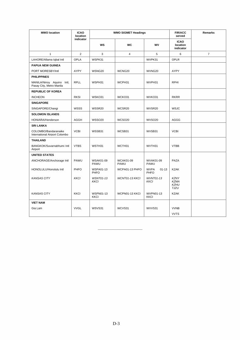
D-3
MWO location
ICAO location indicator
WMO SIGMET Headings FIR/ACC served
Remarks
WS WC WV ICAO
location indicator
1 2 3 4 5 6 7
LAHORE/Allama Iqbal Intl OPLA WSPK31 WVPK31 OPLR
PAPUA NEW GUINEA
PORT MORESBY/Intl AYPY WSNG20 WCNG20 WVNG20 AYPY
PHILIPPINES
MANILA/Ninoy Aquino Intl, Pasay City, Metro Manila
RPLL WSPH31 WCPH31 WVPH31 RPHI
REPUBLIC OF KOREA
INCHEON RKSI WSKO31 WCKO31 WVKO31 RKRR
SINGAPORE
SINGAPORE/Changi WSSS WSSR20 WCSR20 WVSR20 WSJC
SOLOMON ISLANDS
HONIARA/Henderson AGGH WSSO20 WCSO20 WVSO20 AGGG
SRI LANKA
COLOMBO/Bandaranaike International Airport Colombo
VCBI WSSB31 WCSB31 WVSB31 VCBI
THAILAND
BANGKOK/Suvarnabhumi Intl Airport
VTBS WSTH31 WCTH31 WVTH31 VTBB
UNITED STATES
ANCHORAGE/Anchorage Intl PAWU WSAK01-09 PAWU
WCAK01-09 PAWU
WVAK01-09 PAWU
PAZA
HONOLULU/Honolulu Intl PHFO WSPA01-13 PHFO
WCPA01-13 PHFO
WVPA 01-13 PHFO
KZAK
KANSAS CITY
KKCI WSNT01-13 KKCI
WCNT01-13 KKCI WVNT01-13 KKCI
KZNY KZMA KZHU TJZU
KANSAS CITY
KKCI WSPN01-13 KKCI
WCPN01-13 KKCI WVPN01-13 KKCI
KZAK
VIET NAM
Gia Lam VVGL WSVS31 WCVS31 WVVS31 VVNB
VVTS
——————————

APAC Regional SIGMET Guide E-1 Fifth Edition, October 2015
APPENDIX E
WMO HEADINGS FOR TROPICAL CYCLONE AND VOLCANIC ASH ADVISORY
BULLETINS (FK and FV)
Used by Asia/Pacific TCACs and VAACs
Explanation of Table
Col. 1: Name of the TCAC or VAAC
Col 2: ICAO location indicator used by the TCAC or VAAC
Col 3: WMO heading (TTAAii CCCC) of the FK or FV bulletin
Col 4: Remarks (e.g., Area of coverage of the advisory, or any other bulletin-specific
information)
TCAC/VAAC (State)
ICAO location indicator
WMO Heading TTAAii CCCC
Remarks
1 2 3 4
TC Advisories (FK)
Miami (United States)
KNHC FKNT21-24 KNHC
FKPZ21-25 KNHC
Atlantic
For Northeast Pacific to 140W; ii = 21 – 25; up to 5 different bulletins possible at a time according to the number of TCs in the TCAC’s area of responsibility.
Honolulu (United States)
PHFO FKPA21-25 KHFO For North Central Pacific: 140W –
180W;
ii = 21 – 25; up to 5 different bulletins possible at a time according to the number of TCs in the TCAC’s area of responsibility.
New Delhi (India)
VIDP FKIN20 VIDP
FKIN21 VIDP
Bay of Bengal Arabian Sea
Darwin (Australia)
ADRM FKAU01 ADRM FKAU02 ADRM
Area bounded by
0S 125E, 15S 125E, 15S 129E,
40S 129E, 40S 138E, 14S 138E,
10S 141E, 0S 141E, 0S 125E. (Advisories prepared by Darwin)
FKAU03 ADRM FKAU04 ADRM
Area bounded by
0S 141E, 10S 141E, 14S 138E,
40S 138E, 40S 160E, 0S 160E. (Advisories prepared by Brisbane)
FKAU05 ADRM FKAU06 ADRM
Area bounded by
0S 90E, 40S 90E, 40S 129E, 15S
129E, 15S 125E, 0S 125E, 0S
90E. (Advisories prepared by Perth)
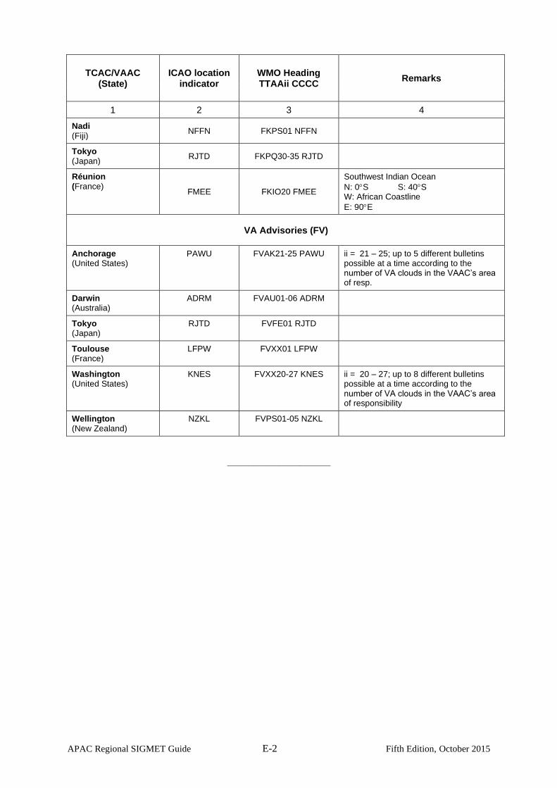
APAC Regional SIGMET Guide E-2 Fifth Edition, October 2015
TCAC/VAAC (State)
ICAO location indicator
WMO Heading TTAAii CCCC
Remarks
1 2 3 4
Nadi (Fiji)
NFFN FKPS01 NFFN
Tokyo (Japan)
RJTD FKPQ30-35 RJTD
Réunion (France)
FMEE FKIO20 FMEE
Southwest Indian Ocean
N: 0S S: 40S W: African Coastline
E: 90E
VA Advisories (FV)
Anchorage (United States)
PAWU FVAK21-25 PAWU ii = 21 – 25; up to 5 different bulletins possible at a time according to the number of VA clouds in the VAAC’s area of resp.
Darwin (Australia)
ADRM FVAU01-06 ADRM
Tokyo (Japan)
RJTD FVFE01 RJTD
Toulouse (France)
LFPW FVXX01 LFPW
Washington (United States)
KNES FVXX20-27 KNES ii = 20 – 27; up to 8 different bulletins possible at a time according to the number of VA clouds in the VAAC’s area of responsibility
Wellington (New Zealand)
NZKL FVPS01-05 NZKL
——————————
APAC Regional SIGMET Guide F-1 Fifth Edition, October 2015
APPENDIX F
ASIA/PACIFIC VAAC BACK-UP PROCEDURES
1. Situations in which Back-up Procedures should be considered
1.1 Situations that may require VAAC responsibilities to be handed over to the back-up
partner include:
- Insufficient VAAC staff resources are available to adequately perform VAAC
duties;
- VAAC forecasters are unable to access the information required to adequately
monitor any volcanic activity;
- The VAAC is unable to generate VAAs;
- The VAAC is unable to disseminate VAAs;
- The VAAC is under threat from an event that may limit its ability to properly
perform its functions in the near future; and
- During any other situation where the VAAC Shift Supervisor considers the VAAC
is unable to properly perform its functions.
2. Actions to be taken by Routine VAAC to initiate handover to Back-up VAAC
2.1 The VAAC Shift Supervisor will request back-up from Back-up VAAC using the
VAAC contact details contained within IAVW Handbook (ICAO Doc. 9766) Table 4-2. Requests are
to be made using the following media in this order:
a. Fax;
b. Telephone; and
c. Email.
2.2 Using the appropriate communications forms, provide detailed information regarding
the following:
a. Expected duration and nature of outage;
b. Current Volcanic Ash Advisories including:
- Volcano names
- Next routine issue times
- Sequence number
- What has been observed on satellite imagery
- What other reports have been received e.g. Volcanological Agency Reports,
AIREPs, ASHTAMs, SIGMETs, phone calls or emails
- Forecast strategy and expected developments; and
c. Other volcanoes of interest including:
- Any volcanoes for which an imminent eruption has been forecast
- Any volcanoes exhibiting elevated levels of activity
- Any recent volcanic activity reports received.
2.3 If possible, provide via email or fax, any information other than listed above that is not
currently available to the Back-up VAAC.
2.4 Maintain a written logbook of actions taken for the duration of the back-up service.
3. Actions to be taken by the Back-up VAAC upon receipt of a back-up request
3.1 Commence satellite monitoring for the Routine VAAC.
APAC Regional SIGMET Guide F-2 Fifth Edition, October 2015
3.2 Send a confirmation message using the appropriate communications forms indicating
whether operational back-up for the Routine VAAC is able to be commenced.
3.3 Continue routine satellite monitoring and issue VAA as required to the relevant AFTN
addresses.
3.4 Send VAA to external users advising of the outage and advising Back-up VAAC
contact details as per appropriate VAA proforma.
3.5 Advise volcanological agencies that new information should be sent directly to the
Back-up VAAC.
3.6 Maintain a written logbook of actions taken for the duration of the back-up service.
4. Actions to be taken by Routine VAAC to resume normal operations
4.1 Commence satellite monitoring for the Routine VAAC.
4.2 Send a notification of intent to resume normal operations to the Back-up VAAC, using
the appropriate communications forms.
4.3 Upon receipt of confirmation from the Back-up VAAC, continue routine satellite
monitoring and issue VAA as required to the appropriate AFTN addresses.
4.4 Issue VAA to external users advising of the resumption of normal operations by the
Routine VAAC as per appropriate VAA pro forma.
4.5 Advise volcanological agencies that information should now be sent directly to the
Routine VAAC.
4.6 Prepare an event report summarizing the significant actions and any other relevant
information contained within the logbooks of the Back-up VAAC and Routine VAAC.
5. Actions to be taken by Back-up VAAC upon receipt of intent to resume normal
operations notification from the Routine VAAC
5.1 Send a confirmation receipt for the intent to resume normal operations notification,
using the appropriate communications forms.
5.2 Using the appropriate communications forms, provide detailed information regarding:
a. Details of current Volcanic Ash Advisories including:
- Volcano names
- Next routine issue times
- Sequence number
- What has been observed on satellite imagery
- What other reports have been received e.g. Volcanological Agency Reports,
AIREPs, ASHTAMs, SIGMETs, phone calls or emails
- Current forecast strategy and expected developments; and
b. Other volcanoes of interest including:
- Any volcanoes for which an imminent eruption has been forecast
- Any volcanoes exhibiting elevated levels of activity
- Any recent volcanic activity reports received.

APAC Regional SIGMET Guide F-3 Fifth Edition, October 2015
5.3 Provide the Routine VAAC with copies of logbooks created by the Back-up VAAC
during the back-up event.
5.4 Cease routine satellite monitoring for the Routine VAAC.
——————————

APAC Regional SIGMET Guide G-1 Seventh Edition, November 2018
APPENDIX G
TOKYO/DARWIN VAAC BACK-UP TEST PROCEDURES
1. Introduction
1.1 The Handbook on the International Airways Volcano Watch (IAVW) — Operational
Procedures and Contact List (Doc 9766) recommends that Volcanic Ash Advisory
Centres (VAACs) should conduct back-up tests at least annually.
1.2 The Tokyo and Darwin VAACs have developed a mutual back-up arrangement that
includes procedures for undertaking a back-up test as described in Doc 9766.
2. Purpose and Scope of VAAC Back-up tests
2.1 The purpose of the VAAC back-up test is to ensure that internal procedures for the handover of
responsibility and the issue of products for the other VAAC’s area of responsibility are robust
and functional.
2.2 The scope of the test also includes checking the dissemination pathways of the volcanic ash
advisory (VAA) messages. However it is not designed to check the issuance of volcanic ash
SIGMET and so there is no requirement to issue test SIGMETs.
3. Back-up test of VAAC Darwin by VAAC Tokyo
3.1 On the specified date for the test, at 0100UTC on VAAC Darwin will request back-up services
from VAAC Tokyo according to internal procedures and using the operational VAAC contact
details contained within the IAVW Handbook (Doc 9766) Table 4-2. VAAC Tokyo will issue a
VAA for commencement of back-up test to participating operational units as per the VAA
example in Attachment 1A (i) and the AFTN addresses in Attachment 2A.
3.2 VAAC Tokyo will issue a VAA for VAAC back-up test to participating operational units as per
the VAA example in Attachment 1A (ii) and the AFTN addresses in Attachment 2A. All
recipients (ACCs/FICs, MWOs, WAFCs and RODBs) of this VAA are requested to respond to
VAAC Darwin using the email address [email protected] and the subject ‘VAA TEST’
with an affirmative or negative response regarding the receipt of the test VAA.
3.3 At 0130UTC VAAC Darwin will notify of intent to resume normal operations to VAAC Tokyo,
and at 0145UTC VAAC Darwin will issue a VAA for cessation of back-up test to participating
operational units as per the VAA example in Attachment 1A (iii) and the AFTN addresses in
Attachment 2A.
3.4 MWOs should NOT issue a test SIGMET at any stage of the test.
4. Back-up test of VAAC Tokyo by VAAC Darwin
4.1 At 0200UTC, the VAAC Tokyo will request back-up services from VAAC Darwin according to
internal procedures and using the operational VAAC contact details contained within the IAVW
Handbook (Doc 9766) Table 4-2. VAAC Darwin will issue a VAA for commencement of back-
up test to participating operational units as per the VAA example in Attachment 1B (i) and the
AFTN addresses in Attachment 2B.
4.2 VAAC Darwin will issue a VAA for VAAC back-up test to participating operational units as per
the VAA example in Attachment 1B (ii) and the AFTN addresses in Attachment 2B. All
APAC Regional SIGMET Guide G-2 Seventh Edition, November 2018
recipients (ACCs/FICs, MWOs, WAFCs and RODBs) of this VAA are requested to respond to
VAAC Tokyo using the email address [email protected] and the subject ‘VAA
TEST’ with an affirmative or negative response regarding the receipt of the test VAA.
4.3 At 0230UTC VAAC Tokyo will notify of intent to resume normal operations to VAAC Darwin,
and at 0245UTC VAAC Tokyo will issue a VAA for cessation of back-up test to participating
operational units as per the VAA example in Attachment 1B (iii) and the AFTN addresses in
Attachment 2B.
4.4 MWOs should NOT issue a test SIGMET at any stage of the test.
5. Back-up test termination and reporting
5.1 At 0300UTC the test will be terminated.
5.2 In case of significant eruption, the test should be ceased.
5.3 During the test each VAAC will maintain a logbook of events and will provide the other VAAC
with a copy.
5.4 Email responses to the VAA for VAAC back-up test will be analyzed by the VAACs. Both
VAACs will analyze the responses to the test VAAs and will present the results to the conjoint
meeting of the Asia/Pacific Meteorological Information Exchange Working Group or an
appropriate expert group (or groups) that may be required to progress International Airways
Volcano Watch (IAVW) related work..

APAC Regional SIGMET Guide G-3 Seventh Edition, November 2018
ATTACHMENT 1A – SAMPLE VAA MESSAGES
(i) VAA for commencement of back-up test; AFTN message from VAAC Tokyo to
operational units in VAAC Darwin area of responsibility:
FF ******** DDHHMM RJTDYMYX
FVAU01 ADRM DDHHMM VA ADVISORY
STATUS: TEST DTG: YYYYMMDD/HHMMZ VAAC: DARWIN VOLCANO: NOTICE 999999 PSN: S8959 E9959 AREA: UNKNOWN SUMMIT ELEV: 9999M ADVISORY NR: YYYY/N INFO SOURCE: NIL AVIATION COLOUR CODE: NIL ERUPTION DETAILS: NIL OBS VA DTG: NIL OBS VA CLD: NIL FCST VA CLD +6HR: NO VA EXP FCST VA CLD +12HR: NO VA EXP FCST VA CLD +18HR: NO VA EXP RMK: VAAC DARWIN AND VAAC TOKYO ARE CONDUCTING A BACK UP TEST NOW.
THIS IS A TEST NOTICE ISSUED BY VAAC TOKYO FOR THE VAAC DARWIN AREA
OF RESPONSIBILITY ANNOUNCING THE START OF BACK UP TEST FOR VAAC
DARWIN BY VAAC TOKYO.
NXT ADVISORY: NO FURTHER ADVISORIES.
(ii) VAA for VAAC back-up test; AFTN message from VAAC Tokyo to operational units in
VAAC Darwin area of responsibility:
FF ******** DDHHMM RJTDYMYX
FVAU01 ADRM DDHHMM VA ADVISORY
STATUS: TEST DTG: YYYYMMDD/HHMMZ VAAC: DARWIN VOLCANO: TEST 999999 PSN: S8959 E9959 AREA: UNKNOWN SUMMIT ELEV: 9999M ADVISORY NR: YYYY/N INFO SOURCE: NIL AVIATION COLOUR CODE: NIL ERUPTION DETAILS: NIL OBS VA DTG: NIL OBS VA CLD: NIL FCST VA CLD +6HR: NO VA EXP FCST VA CLD +12HR: NO VA EXP FCST VA CLD +18HR: NO VA EXP RMK: THIS IS A TEST ADVISORY ISSUED BY VAAC TOKYO FOR THE VAAC DARWIN AREA OF RESPONSIBILITY NORTH OF LATITUDE 20S. PLEASE ACKNOWLEDGE RECEIPT OF THIS ADVISORY BY SENDING AN EMAIL TO
DARWIN.VAAC AT BOM.GOV.AU
NXT ADVISORY: NO FURTHER ADVISORIES.

APAC Regional SIGMET Guide G-4 Seventh Edition, November 2018
(iii) VAA for cessation of back-up test; AFTN message from VAAC Darwin to operational
units in VAAC Darwin area of responsibility:
FF ******** DDHHMM YPDMYMYX
FVAU01 ADRM DDHHMM VA ADVISORY
STATUS: TEST DTG: YYYYMMDD/HHMMZ VAAC: DARWIN VOLCANO: NOTICE 999999 PSN: S8959 E9959 AREA: UNKNOWN SUMMIT ELEV: 9999M ADVISORY NR: YYYY/N INFO SOURCE: NIL AVIATION COLOUR CODE: NIL ERUPTION DETAILS: NIL OBS VA DTG: NIL OBS VA CLD: NIL FCST VA CLD +6HR: NO VA EXP FCST VA CLD +12HR: NO VA EXP FCST VA CLD +18HR: NO VA EXP RMK: VAAC DARWIN AND VAAC TOKYO ARE CONDUCTING A BACK UP TEST NOW.
THIS IS A TEST NOTICE ISSUED BY VAAC DARWIN FOR THE VAAC DARWIN AREA
OF RESPONSIBILITY ANNOUNCING THE END OF BACK UP TEST FOR VAAC DARWIN
BY VAAC TOKYO.
NXT ADVISORY: NO FURTHER ADVISORIES.
(******** Indicates appropriate AFTN addresses as per Attachment 2A)

APAC Regional SIGMET Guide G-5 Seventh Edition, November 2018
ATTACHMENT 1B – SAMPLE VAA MESSAGES
(i) VAA for commencement of back-up test; AFTN message from VAAC Darwin to
operational units in VAAC Tokyo area of responsibility:
FF ******** DDHHMM YPDMYMYX FVFE01 RJTD DDHHMM VA ADVISORY
STATUS: TEST DTG: YYYYMMDD/HHMMZ VAAC: TOKYO VOLCANO: NOTICE 999999 PSN: S8959 E9959 AREA: UNKNOWN SUMMIT ELEV: 9999M ADVISORY NR: YYYY/N INFO SOURCE: NIL AVIATION COLOUR CODE: NIL ERUPTION DETAILS: NIL OBS VA DTG: NIL OBS VA CLD: NIL FCST VA CLD +6HR: NO VA EXP FCST VA CLD +12HR: NO VA EXP FCST VA CLD +18HR: NO VA EXP RMK: VAAC DARWIN AND VAAC TOKYO ARE CONDUCTING A BACK UP TEST NOW.
THIS IS A TEST NOTICE ISSUED BY VAAC DARWIN FOR THE VAAC TOKYO AREA
OF RESPONSIBILITY ANNOUNCING THE START OF BACK UP TEST FOR VAAC
TOKYO BY VAAC DARWIN.
NXT ADVISORY: NO FURTHER ADVISORIES.
(ii) VAA for VAAC back-up test; AFTN message from VAAC Darwin to operational units in
VAAC Tokyo area of responsibility:
FF ******** DDHHMM YPDMYMYX FVFE01 RJTD DDHHMM VA ADVISORY
STATUS: TEST DTG: YYYYMMDD/HHMMZ VAAC: TOKYO VOLCANO: TEST 999999 PSN: S89.59 E99.59 AREA: UNKNOWN SUMMIT ELEV: 9999M ADVISORY NR: YYYY/N INFO SOURCE: NIL AVIATION COLOUR CODE: NIL ERUPTION DETAILS: NIL OBS VA DTG: NIL OBS VA CLD: NIL FCST VA CLD +6HR: NO VA EXP FCST VA CLD +12HR: NO VA EXP FCST VA CLD +18HR: NO VA EXP RMK: THIS IS A TEST ADVISORY ISSUED BY DARWIN VAAC FOR THE VAAC TOKYO AREA OF RESPONSIBILITY. PLEASE ACKNOWLEDGE RECEIPT OF THIS ADVISORY BY SENDING AN EMAIL TO VAAC.TOKYO AT VOLASH.KISHOU.GO.JP
NXT ADVISORY: NO FURTHER ADVISORIES.

APAC Regional SIGMET Guide G-6 Seventh Edition, November 2018
(iii) VAA for cessation of back-up test; AFTN message from VAAC Tokyo to operational units
in VAAC Tokyo area of responsibility:
FF ******** DDHHMM RJTDYMYX
FVFE01 RJTD DDHHMM VA ADVISORY
STATUS: TEST DTG: YYYYMMDD/HHMMZ VAAC: TOKYO VOLCANO: NOTICE 999999 PSN: S89.59 E99.59 AREA: UNKNOWN SUMMIT ELEV: 9999M ADVISORY NR: YYYY/N INFO SOURCE: NIL AVIATION COLOUR CODE: NIL ERUPTION DETAILS: NIL OBS VA DTG: NIL OBS VA CLD: NIL FCST VA CLD +6HR: NO VA EXP FCST VA CLD +12HR: NO VA EXP FCST VA CLD +18HR: NO VA EXP RMK: VAAC DARWIN AND VAAC TOKYO ARE CONDUCTING A BACK UP TEST NOW.
THIS IS A TEST NOTICE ISSUED BY VAAC TOKYO FOR THE VAAC TOKYO AREA
OF RESPONSIBILITY ANNOUNCING THE END OF TEST FOR VAAC TOKYO BY VAAC
DARWIN.
NXT ADVISORY: NO FURTHER ADVISORIES.
(******** Indicates appropriate AFTN addresses as per Attachment 2B)

APAC Regional SIGMET Guide G-7 Seventh Edition, November 2018
ATTACHMENT 2A
AFTN addresses for exchange of VAAC back-up test VAA messages in the VAAC Darwin area of
responsibility
YBZZPUXX (VAAC Darwin)
AGGGZQZX NZKLYMYX VTBSYMYX WBFCZQZX YAMBZGZA YPDNZAZX
AGGHYMYX RJAAJALO VVGLYMYX WBKKYMYX YAMBZTZX YPDNZGZA
AYPMZQZX RJAANCAO VVNBZQZX WBKKZQZQ YBBBVOZM YPDNZTZX
AYPYANGM RJTDYMYX VVTSZQZX WIIFZQZX YBBBZRZA YPRFYMYX
AYPYANGO RKSIYPYX VVTSZRZX WIIIYMYX YBBBZRZB YPRMYMYX
AYPYYMYX RPHIZQZX VYYFZQZX WMFCZQZX YBBBZRZG YPTNZAZX
EGLLSITV RPLLYMYX VYYVYMYX WMKKMASD YBBBZRZX YPTNZGZA
EGZZMASI VHHHCPAO VYYYYMYX WMKKYMYX YBRFYMYX YPTNZTZX
EGZZMPAC VHHHYMYX VYYYZQZX WMKKZQZX YMHFYMYX YSRFYMYX
EGZZVANW VOMFZQZX WAAAYMYX WRRRYNYX YMMLJSTX YSSYQFAM
KLGBPACO VOMMYMYX WAAAZQZX WSJCZQZX YMMMZRZA YSSYWZAX
KWBCYMYX VOMMZQZQ WAAFZQZX WSSSSIAO YMMMZRZB
LSZHSWRW VTBBYPYX WADDYMYF WSSSYMYX YMMMZRZG
NFFNYPYX VTBBZQZX WADDYMYX WSSSYZYK YMMMZRZX
NZAAANZO VTBDYMYX WADDYOYX YAMBZAZX YMRFYMYX

APAC Regional SIGMET Guide G-8 Seventh Edition, November 2018
ATTACHMENT 2B
AFTN addresses for exchange of VAAC back-up test VAA messages in the VAAC Tokyo area of
responsibility
RJTDYMYX (VAAC Tokyo)
CWAOYMYU EGKKVIRW EGLLSITV EGRRYMYX EGZZMASI EGZZVANW
EHAMKLMD EHAMKLMK EHAMKLMW KWBCYMYX NFFNYPYX NZAAANZO
NZKLYMYX PANCYMYX RCTPYMYX RCAAZQZX RKRRZQZX RKSIYMYX
RPHIZRZX RPLLYMYV RPLLYMYX SAZZMAMX UEEEYMYX UEEEZRZX
UELLYMYX UELLZRZX UERRYMYX UERRZRZX UHBBYMYX UHBIYMYX
UHHHYMYX UHHHZRZX UHMMYMYX UHMMZRZX UHNNYMYX UHOOYMYX
UHPPYMYX UHPPZRZX UHSHYMYX UHSSYMYX UHWWYMYX UIAAYMYX
UIAAZRZX UIBBYMYX UIIIYMYX UIIIZRZX UIKKYMYX ULMMYMYX
ULMMZRZX UNKLYMYX UNKLZRZX UUUUYNYX UUUWZDZX VDPPYFYX
VDPPYMYX VDPPZRZX VDPPZTZX VHHHYMYX VLVTYMYX VTBBYPYX
VTBDYMYX VTBSYMYX VVGLYMYX VVNBZRZX VVTSZRZX VYYYYMYX
VYYYZQZX WSJCZRZX WSSSYMYX WSSSYZYX YBBBYPYX YBZZSQJX
YMMLJSTX YPDMYMYX ZBAAYMYX ZBBBYPYX ZGGGYMYX ZHHHYMYX
ZJHKYMYX ZKPYYMYX ZLXYYMYX ZMUBYMYX ZSSSYMYX ZUUUYMYX
ZWWWYMYX ZYTXYMYX

APAC Regional SIGMET Guide G-9 Seventh Edition, November 2018
ATTACHMENT 3
List of States, participating units and tasks required* for VAAC back-up test
STATE UNIT
TYPE LOCATION NAME LOC.
ID. TASK/S
REQUIRED* AFTN
ADDRESS
AUSTRALIA ACC/FIC BRISBANE/BRISBANE INTL YBBN D YBBBZRZA
YBBBZRZB
YBBBZRZG
YBBBZRZX
AUSTRALIA ACC/FIC MELBOURNE ACC/FIC YMMM D YMMMZRZA
YMMMZRZB
YMMMZRZG
YMMMZRZX
AUSTRALIA RODB BRISBANE
(FIR/FIC/ACC/COM/MET/NOF)
YBBB D J YBBBYPYX
AUSTRALIA VAAC DARWIN (REGIONAL
FORECASTING CENTRE)
YPDM A E F H I
M
YPDMYMYX
CAMBODIA ACC/FIC PHNOM PENH VDPP J VDPPZRZX
CAMBODIA MWO PHNOM PENH VDPP J VDPPYMYX
CHINA ACC/FIC TAIBEI CITY/TAIBEI INTL
AP
RCAA J RCAAZQZX
CHINA ACC/FIC HONG KONG FIR VHHK J VHHKZQZX
CHINA ACC/FIC HUHHOT/BAITA ZBHH J ZBHHZQZX
CHINA ACC/FIC HULUNBEIER/HAILAR ZBLA J ZBLAZQZX
CHINA ACC/FIC BEIJING FIR ZBPE J ZBPEZQZX
CHINA ACC/FIC TAIYUAN/WUSU ZBYN J ZBYNZQZX
CHINA ACC/FIC CHANGSHA CITY ZGCS J ZGCSZQZX
CHINA ACC/FIC GUILIN/LIANGJIANG ZGKL J ZGKLZQZX
CHINA ACC/FIC NANNING/WUXU ZGNN J ZGNNZQZX
CHINA ACC/FIC GUANGZHOU FIR ZGZU J ZGZUZQZX
CHINA ACC/FIC WUHAN FIR ZHWH J ZHWHZQZX
CHINA ACC/FIC SANYA FIR/ACC ZJSA J ZJSAZQZX
CHINA ACC/FIC LANZHOU CITY ZLAN J ZLANZQZX
CHINA ACC/FIC LANZHOU FIR ZLHW J ZLHWZQZX
CHINA ACC/FIC XI'AN CITY ZLSN J ZLSNZQZX
CHINA ACC/FIC KUNMING FIR ZPKM J ZPKMZQZX
CHINA ACC/FIC XIAMEN/GAOQI ZSAM J ZSAMZQZX
CHINA ACC/FIC NANCHANG/CHANGBEI ZSCN J ZSCNZQZX
CHINA ACC/FIC SHANGHAI FIR ZSHA J ZSHAZQZX
CHINA ACC/FIC NANJING/LUKOU ZSNJ J ZSNJZQZX
CHINA ACC/FIC HEFEI/XINQIAO ZSOF J ZSOFZQZX
CHINA ACC/FIC QINGDAO/LIUTING ZSQD J ZSQDZQZX
CHINA ACC/FIC JINAN CITY ZSTN J ZSTNZQZX
CHINA ACC/FIC CHONGQING/JIANGBEI ZUCK J ZUCKZQZX
CHINA ACC/FIC CHENGDU CITY ZUDS J ZUDSZQZX
CHINA ACC/FIC URUMQI FIR ZWUQ J ZWUQZQZX
CHINA ACC/FIC URUMQI/DIWOPU ZWWW J ZWWWZQZX
CHINA ACC/FIC HARBIN/TAIPING ZYHB J ZYHBZQZX
CHINA ACC/FIC SHENYANG FIR ZYSH J ZYSHZQZX
CHINA ACC/FIC DALIAN/ZHOUSHUIZI ZYTL J ZYTLZQZX
CHINA MWO TAIBEI CITY/TAIBEI INTL
AP
RCTP J RCTPYMYX
CHINA MWO HONG KONG/INTERNATIONAL VHHH J VHHHYMYX
CHINA MWO BEIJING/CAPITAL ZBAA J ZBAAYMYX
CHINA MWO GUANGZHOU/BAIYUN ZGGG J ZGGGYMYX
CHINA MWO WUHAN/TIANHE ZHHH J ZHHHYMYX
CHINA MWO HAIKOU/MEILAN ZJHK J ZJHKYMYX
CHINA MWO XI'AN/XIANYANG ZLXY J ZLXYYMYX
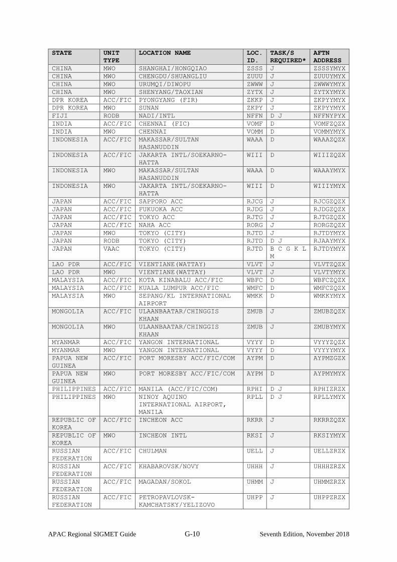
APAC Regional SIGMET Guide G-10 Seventh Edition, November 2018
STATE UNIT
TYPE LOCATION NAME LOC.
ID. TASK/S
REQUIRED* AFTN
ADDRESS
CHINA MWO SHANGHAI/HONGQIAO ZSSS J ZSSSYMYX
CHINA MWO CHENGDU/SHUANGLIU ZUUU J ZUUUYMYX
CHINA MWO URUMQI/DIWOPU ZWWW J ZWWWYMYX
CHINA MWO SHENYANG/TAOXIAN ZYTX J ZYTXYMYX
DPR KOREA ACC/FIC PYONGYANG (FIR) ZKKP J ZKPYYMYX
DPR KOREA MWO SUNAN ZKPY J ZKPYYMYX
FIJI RODB NADI/INTL NFFN D J NFFNYPYX
INDIA ACC/FIC CHENNAI (FIC) VOMF D VOMFZQZX
INDIA MWO CHENNAI VOMM D VOMMYMYX
INDONESIA ACC/FIC MAKASSAR/SULTAN
HASANUDDIN
WAAA D WAAAZQZX
INDONESIA ACC/FIC JAKARTA INTL/SOEKARNO-
HATTA
WIII D WIIIZQZX
INDONESIA MWO MAKASSAR/SULTAN
HASANUDDIN
WAAA D WAAAYMYX
INDONESIA MWO JAKARTA INTL/SOEKARNO-
HATTA
WIII D WIIIYMYX
JAPAN ACC/FIC SAPPORO ACC RJCG J RJCGZQZX
JAPAN ACC/FIC FUKUOKA ACC RJDG J RJDGZQZX
JAPAN ACC/FIC TOKYO ACC RJTG J RJTGZQZX
JAPAN ACC/FIC NAHA ACC RORG J RORGZQZX
JAPAN MWO TOKYO (CITY) RJTD J RJTDYMYX
JAPAN RODB TOKYO (CITY) RJTD D J RJAAYMYX
JAPAN VAAC TOKYO (CITY) RJTD B C G K L
M
RJTDYMYX
LAO PDR ACC/FIC VIENTIANE(WATTAY) VLVT J VLVTZQZX
LAO PDR MWO VIENTIANE(WATTAY) VLVT J VLVTYMYX
MALAYSIA ACC/FIC KOTA KINABALU ACC/FIC WBFC D WBFCZQZX
MALAYSIA ACC/FIC KUALA LUMPUR ACC/FIC WMFC D WMFCZQZX
MALAYSIA MWO SEPANG/KL INTERNATIONAL
AIRPORT
WMKK D WMKKYMYX
MONGOLIA ACC/FIC ULAANBAATAR/CHINGGIS
KHAAN
ZMUB J ZMUBZQZX
MONGOLIA MWO ULAANBAATAR/CHINGGIS
KHAAN
ZMUB J ZMUBYMYX
MYANMAR ACC/FIC YANGON INTERNATIONAL VYYY D VYYYZQZX
MYANMAR MWO YANGON INTERNATIONAL VYYY D VYYYYMYX
PAPUA NEW
GUINEA
ACC/FIC PORT MORESBY ACC/FIC/COM AYPM D AYPMZGZX
PAPUA NEW
GUINEA
MWO PORT MORESBY ACC/FIC/COM AYPM D AYPMYMYX
PHILIPPINES ACC/FIC MANILA (ACC/FIC/COM) RPHI D J RPHIZRZX
PHILIPPINES MWO NINOY AQUINO
INTERNATIONAL AIRPORT,
MANILA
RPLL D J RPLLYMYX
REPUBLIC OF
KOREA
ACC/FIC INCHEON ACC RKRR J RKRRZQZX
REPUBLIC OF
KOREA
MWO INCHEON INTL RKSI J RKSIYMYX
RUSSIAN
FEDERATION
ACC/FIC CHULMAN UELL J UELLZRZX
RUSSIAN
FEDERATION
ACC/FIC KHABAROVSK/NOVY UHHH J UHHHZRZX
RUSSIAN
FEDERATION
ACC/FIC MAGADAN/SOKOL UHMM J UHMMZRZX
RUSSIAN
FEDERATION
ACC/FIC PETROPAVLOVSK-
KAMCHATSKY/YELIZOVO
UHPP J UHPPZRZX

APAC Regional SIGMET Guide G-11 Seventh Edition, November 2018
STATE UNIT
TYPE LOCATION NAME LOC.
ID. TASK/S
REQUIRED* AFTN
ADDRESS
RUSSIAN
FEDERATION
ACC/FIC IRKUTSK UIII J UIIIZRZX
RUSSIAN
FEDERATION
MWO CHULMAN UELL J UELLYMYX
RUSSIAN
FEDERATION
MWO KHABAROVSK/NOVY UHHH J UHHHYMYX
RUSSIAN
FEDERATION
MWO MAGADAN/SOKOL UHMM J UHMMYMYX
RUSSIAN
FEDERATION
MWO PETROPAVLOVSK-
KAMCHATSKY/YELIZOVO
UHPP J UHPPYMYX
RUSSIAN
FEDERATION
MWO IRKUTSK UIII J UIIIYMYX
SINGAPORE ACC/FIC SINGAPORE ACC/FIC WSJC D WSJCZRZX
SINGAPORE MWO SINGAPORE/CHANGI WSSS D WSSSYMYX
SINGAPORE RODB SINGAPORE/CHANGI WSSS D J WSSSYZYX
SOLOMON
ISLANDS
ACC/FIC HONIARA (HENDERSON) AGGH D AGGHYMYX
SOLOMON
ISLANDS
MWO HONIARA (HENDERSON) AGGH D AGGHYMYX
SRI LANKA ACC/FIC KATUNAYAKE/BANDARANAIKE
INTERNATIONAL AIRPORT
COLOMBO
VCBI D VCBIZQZX
SRI LANKA MWO KATUNAYAKE/BANDARANAIKE
INTERNATIONAL AIRPORT
COLOMBO
VCBI D VCBIYMYX
THAILAND ACC/FIC BANGKOK (ACC/FIC/COM
CENTRE)
VTBB D J VTBBYPYX
THAILAND MWO BANGKOK/SUVARNABHUMI INTL
AIRPORT
VTBS D J VTBSYMYX
THAILAND RODB BANGKOK (ACC/FIC/COM
CENTRE)
VTBB D J VTBBYPYX
UNITED
KINGDOM
WAFC UK PDAI (GEN) EGZZ D J EGZZMASI
UNITED
STATES
WAFC WASHINGTON (NWS NATIONAL
MET CENTER), DC.
KWBC D J KWBCYMYX
VIET NAM ACC/FIC HA NOI/NOI BAI
INTERNATIONAL
VVNB D J VVNBZRZX
VIET NAM ACC/FIC HO CHI MINH/TAN SON NHAT
INTERNATIONAL
VVTS D J VVTSZRZX
VIET NAM MWO GIA LAM VVGL D J VVGLYMYX
*Tasks required for VAAC back-up test
TASK ID.
TIME UTC TASK DESCRIPTION
A 0100 VAAC Darwin will request VAAC Tokyo to commence back-up services
B Sequential VAAC Tokyo will issue a VAA (commencement of test) for VAAC Darwin area of responsibility
C Sequential VAAC Tokyo will issue a VAA (test) for VAAC Darwin area of responsibility
D Sequential MWOs/ACCs/FICs in VAAC Darwin area of responsibility and RODBs/WAFCs will respond to VAAC Darwin (using email) to confirm receipt or non-receipt of test VAA issued by Tokyo VAAC for the VAAC Darwin area of responsibility
E 0130 VAAC Darwin will notify VAAC Tokyo of intent to resume normal operations

APAC Regional SIGMET Guide G-12 Seventh Edition, November 2018
TASK ID.
TIME UTC TASK DESCRIPTION
F 0145 VAAC Darwin will issue a VAA (cessation of test) for VAAC Darwin area of responsibility
G 0200 VAAC Tokyo will request VAAC Darwin to commence back-up services
H Sequential VAAC Darwin will issue a VAA (commencement of test) for VAAC Tokyo area of responsibility
I Sequential VAAC Darwin will issue a VAA (test) for VAAC Tokyo area of responsibility
J Sequential MWOs/ACCs/FICs in VAAC Tokyo area of responsibility and RODBs/WAFCs will respond to VAAC Tokyo (using email) to confirm receipt or non-receipt of test VAA issued by VAAC Darwin for the VAAC Tokyo area of responsibility
K 0230 VAAC Tokyo will notify VAAC Darwin of intent to resume normal operations
L 0245 VAAC Tokyo will issue a VAA (cessation of test) for VAAC Tokyo area of responsibility
M 0100 - 0245
VAAC Tokyo and VAAC Darwin will maintain a log of events
——————————
H-1
APPENDIX H
WELLINGTON/DARWIN VAAC BACKUP TEST PROCEDURES
1. Introduction
1.1. The International Airways Volcano Watch Operations Group (IAVWOPSG)
recognized the need for the regular testing of VAAC backup procedures that would ensure the
continuing availability of Volcanic Ash Advices and identify deficiencies in the dissemination
procedures of backup products. Therefore, the second meeting of IAVWOPSG held in Bangkok,
15 to 19 March 2004, adopted Conclusion 2/19, as follows:
Conclusion 2/19 – Inclusion of VAAC backup procedures in Doc 9766
That the Secretariat include in Doc 9766, Handbook on the International Airways
Volcano Watch (IAVW) – Operational Procedures and Contact List, the VAAC
backup procedures agreed by the group.
1.2. Appendix D, paragraph f) of ICAO Doc.9766 - Handbook on International Airways
Volcano Watch (IAVW) states that:
The backup arrangements should be tested at least annually.
1.3. The Wellington and Darwin VAACs have developed a mutual backup arrangement
that includes procedures for undertaking a backup test as described in this document.
2. Purpose and Scope of VAAC Backup tests
2.1. The purpose of the VAAC backup test is to ensure that internal procedures for the
handover of responsibility and the issue of products for the other VAAC’s area of responsibility
are robust and functional.
2.2. The scope of the test also includes checking the dissemination pathways of the
Volcanic Ash Advisory (VAA) messages.
2.3. The test is not designed to check the issuance of Volcanic Ash SIGMET and so there
is no requirement to issue test SIGMETs.
3. Backup test Procedures
3.1. Procedures for Wellington – Darwin VAAC Backup tests
3.1.1. Internal procedures related to handover of responsibility and issuance of VAAs for
the other VAAC’s area of responsibility will be tested and the results included in a final report.
3.2. Procedures for testing the dissemination of backup VAAs

H-2
3.2.1. On the specified date at 0100 UTC VAAC Darwin will request backup services from
VAAC Wellington. VAAC Wellington will issue a test Volcanic Ash Advisory (VAA) for the
Darwin VAAC area of responsibility south of latitude 20S. The message will indicate that it is a
TEST and will follow the format given in Section 4 of these procedures.
3.2.2. Recipients of the message should send a confirmation email to the email address
given in the RMK section of the VAA, including the message text and the time received. If no
VAA is received by 0130 UTC on the specified date, test participants are requested to send an
email advising of negative receipt of the test VAA.
3.2.3. MWOs should NOT issue a test SIGMET.
3.2.4. At 0130 UTC on the specified date, VAAC Darwin will notify VAAC Wellington of
intent to resume normal operations.
3.2.5. On the specified date at 0145 UTC VAAC Wellington will request backup services
from VAAC Darwin. VAAC Darwin will issue a test Volcanic Ash Advisory (VAA) for the
Wellington VAAC area of responsibility. The message will indicate that it is a TEST and will
follow the format given in Section 4 of these procedures.
3.2.6. Recipients of the message should send a confirmation email to the email address
given in the RMK section of the VAA, including the message text and the time received. If no
VAA is received by 0215 UTC on the specified date, test participants are requested to send an
email advising of negative receipt of the test VAA.
3.2.7. MWOs should NOT issue a test SIGMET.
3.2.8. In the event of a major eruption in either area the test may be cancelled.
3.3. Processing of the test results
3.3.1. The participating Asia/Pacific VAACs, in conjunction with the Asia/Pacific Regional
OPMET Databanks (RODBs), will analyse the received responses to the test messages and
present the results to the APANPIRG Meteorology Sub Group (MET SG) or an appropriate
expert group (or groups) that may be required to progress international airways volcano watch
(IAVW) related work.
4. Format of test VAA for Backup Test
4.1. From VAAC Wellington for VAAC Darwin FVAUii ADRM DDHHMM VA ADVISORY STATUS: TEST DTG: YYYYMMDD/HHMMZ VAAC: DARWIN

H-3
VOLCANO: TEST 999999 PSN: N1000 E10000 AREA: UNKNOWN SUMMIT ELEV: 9999M ADVISORY NR: YYYY/N INFO SOURCE: TEST TEST TEST AVIATION COLOUR CODE: NIL ERUPTION DETAILS: TEST TEST TEST OBS VA DTG: DD/HHMMZ OBS VA CLD: WIND FL099/099 VRB/99KT FCST VA CLD +6 HR: DD/HHMMZ NO VA EXP FCST VA CLD +12 HR: DD/HHMMZ NO VA EXP FCST VA CLD +18 HR: DD/HHMMZ NO VA EXP RMK: THIS IS A TEST ADVISORY ISSUED BY WELLINGTON VAAC FOR THE DARWIN VAAC AREA OF RESPONSIBILITY SOUTH OF LATITUDE 20S. PLEASE ACKNOWLEDGE RECEIPT OF THIS ADVISORY BY SENDING AN EMAIL TO DARWIN.VAAC (AT) BOM.GOV.AU. NXT ADVISORY: NO FURTHER ADVISORIES=
4.2 From VAAC Darwin for VAAC Wellington
FVPSii NZKL DDHHMM VA ADVISORY STATUS: TEST DTG: YYYYMMDD/HHMMZ VAAC: WELLINGTON VOLCANO: TEST 999999 PSN: N1000 E10000 AREA: UNKNOWN SUMMIT ELEV: 9999M ADVISORY NR: YYYY/N INFO SOURCE: TEST TEST TEST AVIATION COLOUR CODE: NIL ERUPTION DETAILS: TEST TEST TEST OBS VA DTG: DD/HHMMZ OBS VA CLD: WIND FL099/099 VRB/99KT FCST VA CLD +6 HR: DD/HHMMZ NO VA EXP FCST VA CLD +12 HR: DD/HHMMZ NO VA EXP FCST VA CLD +18 HR: DD/HHMMZ NO VA EXP RMK: THIS IS A TEST ADVISORY ISSUED BY DARWIN VAAC FOR THE WELLINGTON VAAC AREA OF RESPONSIBILITY. PLEASE ACKNOWLEDGE RECEIPT OF THIS ADVISORY BY SENDING AN EMAIL TO VAAC (AT) METSERVICE.COM NXT ADVISORY: NO FURTHER ADVISORIES=
——————————

J-1
APPENDIX I
ADDITIONAL CRITERIA FOR ISSUANCE OF SIGMET FOR THUNDERSTORM
1. Introduction
1.1 As defined in ICAO Annex 3 Appendix 6, SIGMET are required to be issued for
thunderstorms when they are:
(i) obscured with or without hail (OBSC TS /TSGR);
(ii) embedded with or without hail (EMBD TS/TSGR);
(iii) frequent with or without hail (FRQ TS/TSGR); and
(iv) squall line with or without hail (SQL TS/TSGR).
1.2 ICAO Annex 3, Appendix 6 further defines that an area of thunderstorms and
cumulonimbus clouds should be considered:
(i) Obscured (OBSC) if it is obscured by haze or smoke or cannot be readily seen
due to darkness;
(ii) Embedded (EMBD) if it is embedded within cloud layers and cannot be
readily recognized;
(iii) Frequent (FRQ) if within that area there is little or no separation between
adjacent thunderstorms with a maximum spatial coverage greater than 75 per
cent of the area affected, or forecast to be affected, by the phenomenon (at a
fixed time or during the period of validity); and
(iv) Squall line (SQL) should indicate a thunderstorm along a line with little or no
space between individual clouds.
1.3 Some States have developed additional criteria, such as minimum area of coverage of
thunderstorms and minimum length of squall line, for the issuance of SIGMET for
thunderstorms. Examples of additional criteria developed by the Bureau of Meteorology,
Australia (The Bureau) and the Japan Meteorological Agency (JMA) are provided in Section
2 and Section 3 below. Individual States may consider developing additional criteria in
consultation with users.
2. Additional Criteria for Issuance of SIGMET for Thunderstorms Developed by the
Bureau of Meteorology, Australia.
2.1 Minimum area affected:
2.1.1 A minimum area was introduced for the area affected by embedded (EMBD TS)
and frequent (FRQ TS) thunderstorm SIGMETs as follows:
J-2
(i) For areas where low-level area forecasts are valid, EMBD and FRQ TS
should be affecting an area of 3000 NM2 (approximately 1 degree
squared) or more. This covers areas of high-level air traffic movements
and low-level flights; and
(ii) For areas outside of where low-level area forecasts are valid, EMBD and
FRQ TS should be affecting an area of 7200 NM2 (approximately 2 degree
by 1 degree) or more. This covers areas where there are lower air traffic
movements and generally high-level flights with airborne radar to
tactically fly around thunderstorms.
2.2 Definition of “little or no separation”:
2.2.1 When determining if thunderstorms have “little or no separation”, as required for
FRQ and SQL TS SIGMET, the following criterion is used:
(i) The distance between adjacent thunderstorm cells to be applied for
frequent (FRQ TS) and squall line (SQL TS) SIGMETs shall be
approximately 40 NM between identifiable thunderstorm cells.
2.2.2 This criterion is based on the Australian Civil Aviation Safety Authority and the
Federal Aviation Administration recommendations for thunderstorm avoidance which
recommends pilots avoid any thunderstorm identified as severe, or giving an intense
radar echo, by at least 20NM.
2.3 Length of squall line:
2.3.1 When determining if a line of thunderstorms requires a squall line SIGMET, the
following criteria is applied:
(i) A squall line (SQL TS) SIGMET is issued for thunderstorms along a line
of approximately 100 NM or more in length, with little or no separation
between the clouds
3. Additional Criteria for Issuance of SIGMET for Thunderstorms Developed by the
Japan Meteorological Agency.
3.1 FRQ TS
3.1.1 FRQ TS SIGMETs are issued for CB clouds associated with lightning covering
greater than or equal to 50% of the area concerned (CB coverage is greater than or equal
to OCNL). If there are developing CB clouds with their coverage of OCNL, it is
considered they will become FRQ CB. The criteria for minimum size required for
SIGMET issuance are as below;

J-3
(1) Approach control areas around congested airports : 10,000 sq. km (100km x 100km)
(2) Around main air routes in Japan : 22,500 sq.km (150km x 150km)
(3) Other area (oceanic region) : 40,000 sq.km (200km x 200km)
3.2 EMBD TS
3.2.1 The criteria of CB coverage and minimum size for EMBD TS SIGMET are same
as those of FRQ TS. If CB areas are embedded within cloud layers and cannot be readily
recognized, EMBD TS SIGMETs are issued.
3.3 SQL TS
3.3.1 SQL TS SIGMETs are issued for line-shaped CB clouds with length of more than
500km and width of more than 100km.
——————————
J-4
APPENDIX J
SPACE WEATHER ADVISORIES (SWXA)
1. Introduction
1.1 ICAO Annex 3 Amendment 78 (effective November 2018) introduced the provision of
Space Weather Advisories (SWXA) issued by designated Space Weather Centres.
1.2 SIGMETs are not issued for Space Weather. The purpose of this appendix is to provide a
brief description on the SWXA products.
2. Example Space Weather Advisories
Space weather advisory message (GNSS effects)
SWX ADVISORY
DTG: 20161108/0100Z
SWXC: DONLON*
ADVISORY NR: 2016/2
NR RPLC: 2016/1
SWX EFFECT: GNSS MOD
OBS SWX: 08/0100Z HNH HSH E18000 – W18000
FCST SWX +6 HR: 08/0700Z HNH HSH E18000 – W18000
FCST SWX +12 HR: 08/1300Z HNH HSH E18000 – W18000
FCST SWX +18 HR: 08/1900Z HNH HSH E18000 – W18000
FCST SWX +24 HR: 09/0100Z NO SWX EXP
RMK: LOW LVL GEOMAGNETIC STORMING CAUSING INCREASED AURORAL ACT
AND SUBSEQUENT MOD DEGRADATION OF GNSS AVBL IN THE AURORAL ZONE.
THIS STORMING EXP TO SUBSIDE IN THE FCST PERIOD. SEE
WWW.SPACEWEATHERPROVIDER.WEB
NXT ADVISORY: NO FURTHER ADVISORIES
Space weather advisory message (RADIATION effects)
SWX ADVISORY
DTG: 20161108/0000Z
SWXC: DONLON*
ADVISORY NR: 2016/2
NR RPLC: 2016/1
SWX EFFECT: RADIATION MOD
FCST SWX: 08/0100Z HNH HSH E18000 – W18000 ABV FL 350
FCST SWX +6 HR: 08/0700Z HNH HSH E18000 – W18000 ABV FL 350
FCST SWX +12 HR: 08/1300Z HNH HSH E18000 – W18000 ABV FL 350
FCST SWX +18 HR: 08/1900Z HNH HSH E18000 – W18000 ABV FL 350
FCST SWX +24 HR: 09/0100Z NO SWX EXP
RMK: RADIATION LVL EXCEEDED 100 PCT OF BACKGROUND LVL AT FL350 AND
ABV. THE CURRENT EVENT HAS PEAKED AND LVL SLW RTN TO BACKGROUND
LVL. SEE WWW.SPACEWEATHERPROVIDER.WEB
NXT ADVISORY: NO FURTHER ADVISORIES

J-5
Space weather advisory message (HF COM effects)
SWX ADVISORY
DTG: 20161108/0100Z
SWXC: DONLON*
ADVISORY NR: 2016/1
SWX EFFECT: HF COM SEV
OBS SWX: 08/0100Z DAYLIGHT SIDE
FCST SWX +6 HR: 08/0700Z DAYLIGHT SIDE
FCST SWX +12 HR: 08/1300Z DAYLIGHT SIDE
FCST SWX +18 HR: 08/1900Z DAYLIGHT SIDE
FCST SWX +24 HR: 09/0100Z NO SWX EXP
RMK: PERIODIC HF COM ABSORPTION AND LIKELY TO CONT IN THE NEAR
TERM. CMPL AND PERIODIC LOSS OF HF ON THE SUNLIT SIDE OF THE EARTH
EXP. CONT HF COM DEGRADATION LIKELY OVER THE NXT 7 DAYS. SEE
WWW.SPACEWEATHERPROVIDER.WEB
NXT ADVISORY: 20161108/0700Z
*DONLON is a fictitious Space Weather Centre
-------

K-1
APPENDIX K
GUIDELINES FOR OPERATIONAL SIGMET COORDINATION
1. Inconsistencies in SIGMET information issued by different Meteorological Watch Offices
(MWOs) across Flight Information Region (FIR) boundaries pose safety concerns to airspace users.
Improved cross-FIR-boundary coordination and sharing of meteorological (MET) information between
MWOs concerned is necessary to ensure seamlessness in SIGMET information across FIR boundaries.
2. A concerted effort within the MET community to improve operational coordination across FIR
boundaries to provide harmonized MET information for hazardous weather phenomena is of great
benefit to airspace users. To this end, the Asia/Pacific Air Navigation Planning and Implementation
Group (APANPIRG) adopted the following conclusions in 2015 and 2017:
• Conclusion APANPIRG/26/62 – Cross-border MET Collaboration and Coordination
Recognising the presence of SIGMET weather phenomena that straddles across boundaries,
States/Administrations are encouraged to promote cross-border collaboration and
coordination to harmonise the MET products of such phenomena between Meteorological
Authorities to enhance MET support for ATM in the Asia/Pacific Region.
• Conclusion APANPIRG/28/30 – SIGMET coordination in the APAC Region
That, States and Administrations are encouraged to:
a) Participate in cross-FIR-boundary SIGMET coordination on a bilateral or multilateral
basis for seamless hazardous weather information for the benefit of aviation users, as
well as advancing the capabilities of participating MWOs in the issuance of SIGMETs
for cross-border hazardous weather phenomena; and b) Continue to share outcomes from SIGMET coordination activities and consider a step-
by-step integration of SIGMET coordination activities in the region when operationally
ready.
3. In Amendment 78 to ICAO Annex 3 "Meteorological Services for International Air Navigation",
a reference to ICAO Doc. 8896 “Manual of Aeronautical Meteorological Practices” was incorporated,
which provides guidance on coordination between MWOs on a bilateral or multilateral basis to encourage
MWOs to adopt a coordinated approach in SIGMET issuance.
4. This document was developed to provide MWOs with guidelines on SIGMET coordination,
including planning and implementing operationally.
Objectives and Guiding Principles
5. Prior to implementing SIGMET coordination with neighboring MWOs it is important for the
participating MWOs to agree to the following objectives and guiding principles:

K-2
• To share information and enhance coordination between MWOs to ensure seamless MET
information across borders improved quality of SIGMET information; • To undertake effective and efficient coordination between MWOs to avoid any delays.
Coordination should not be conducted at the expense of the quality and timeliness of the
issuance of SIGMET; • To put in place a consultative coordination process to facilitate consensus between
participating MWOs. However, each MWO remains responsible for the SIGMET(s) issued
within their respective area of responsibility (AoR) and in the event that consensus cannot
be reached, each MWO retains the right to adjust parameters and assess SIGMETs in their
AoR; • To ensure subsequent issuance of SIGMETs are in line with the guidance provided
in the "ICAO Asia/Pacific Regional SIGMET Guide" and ICAO Doc 8896 “Manual
of Aeronautical Meteorological Practice”, and complies with relevant provisions on
SIGMET content and issuance in accordance with ICAO Annex 3 on
“Meteorological Service for International Air Navigation”.
Preliminary Requirements
6. Prior to operationalising SIGMET coordination, the following requirements should be
considered.
6.1. Bilateral or multilateral coordination
6.1.1. MWOs should determine whether coordination is required on a bilateral or multilateral
basis.
6.1.2. Bilateral coordination is considered straightforward since consensus is only required
between two MWOs. Interaction with only one MWO may assist with timely issuance
of SIGMETs.
6.1.3. Multilateral coordination is necessary for the issuance of harmonized SIGMETs for
multiple FIRs. However, there may be added complexities arising from diversity of
views in multilateral discussions that may cause issues in reaching consensus.
6.2. Formalizing coordination arrangements
6.2.1. MWOs should formalize operational arrangements for SIGMET coordination to
establish a common understanding on what SIGMET coordination entails. The different
modalities include a Letter of Agreement, the Exchange of Letters or a Memorandum of
Understanding. Such arrangements can be made on a bilateral or multilateral basis,
depending on how coordination is conducted.
6.3. Coordination procedures
6.3.1. MWOs should jointly develop and endorse a set of clear procedures for SIGMET
coordination, which then should be adopted when facilitating SIGMET coordination
process.

K-3
6.3.2. While there are special circumstances for each region (or sub-region) and different
challenges (e.g. availability of communications link, language differences, in-house
processes), procedures that are developed based on commonalities shared amongst the
participating MWOs (e.g. weather pattern and climatology) are the most helpful tools in
overcoming differences and challenges.
6.3.3. Procedures may include methodology of coordination (including common situational
awareness tools), a communications protocol, criterion for issuances, and methodology
for review and evaluation. Each of these is discussed in greater detail in subsequent
sections.
Operational Coordination
7. The aim of SIGMET coordination is to consult with the participating MWOs, exchange content
and reach an agreement.
8. Content to be discussed includes: • vertical extent; • boundaries;
• direction and speed of movement of the SIGMET phenomenon observed, and/or
expected to affect, two or more areas of responsibility.
9. Initiation of SIGMET coordination
9.1. Coordination can be initiated by any of the participating MWOs. However, the following
protocols are recommended:
• When hazardous weather phenomenon warranting a SIGMET is observed or forecast in
an AoR and is expected to move in a direction such that an adjacent FIR(s) may be affected, the
MWO that issued the initial SIGMET should initiate consultation with the neighboring
MWO(s). • When hazardous weather phenomenon warranting a SIGMET is observed or forecast
across FIR boundaries, the MWO with the largest proportion of the hazardous weather
phenomenon in its FIR should initiate consultation with the neighboring MWO(s).
10. Common interface
10.1. It is helpful to have access to a common interface (such as a web application) where
observational and/or Numerical Weather Prediction (NWP) data can be shared to enable
common situational awareness amongst the operational meteorologists. The interface allows
operational meteorologists on duty at each MWO to have a shared view of the weather situation
and prognosis, before coming to a consensus on the area and parameters to be included in the
SIGMET. Hence, graphical presentation of observations, NWP data, and SIGMETs issued on
the common interface would be particularly helpful.
10.2. If a web application is available, the application should be interactive to enable technical

K-4
discussions between MWOs. Therefore, any such tools developed should incorporate
functionalities that would support technical discussions, in graphical, textual and/or verbal form.
Due to this requirement, it is recommended that such tools be the primary mode of
communication between the participating MWOs.
11. Communications protocol
11.1. To ensure effective communication that helps to facilitate discussion whilst arriving at
a consensus in a timely manner it may be necessary to develop a communications
protocol that includes preset syntax, particularly for the most commonly encountered
weather phenomena. Preset syntax can overcome difficulties in communications due to
language differences.
12. Alternative communication modes
12.1. Alternative means of communication for operational coordination can serve as redundancy in
the event of non-availability of the primary mode of communication. Participating MWOs can
use various communication modes, such as telephone and mobile applications (e.g. WhatsApp),
as their common contingency or complementary measure.
12.2. Other channels of communication such as video-conferencing and emails can facilitate more
in-depth discussion on issues outside of operational coordination or for long-lived and
prolonged weather phenomena (e.g. tropical cyclones, sand storms).
13. Establishing what constitutes consensus
13.1. It may be necessary to identify indicators of consensus. These should form part of the
preliminary requirements as agreed by the participating MWOs. This establishes a
common understanding of what constitutes consensus and can help focus consultation
efforts to ensure consensus can be arrived at more often than not.
14. Timeliness in issuance of coordinated SIGMETs
14.1. Certain weather phenomena, such as thunderstorms, can undergo rapid development
and therefore, efficient coordination is critical to ensure coordinated SIGMETs are
issued in a timely manner. Participating MWOs may set time limits for consultation so
that technical discussions do not become so protracted that SIGMET issuance is
delayed. In most cases, discussions should not take longer than 15 minutes to complete.
15. Record of consultation cases
15.1. It is a good practice to log all cases of consultation. Items to log include the date and time of
consultations, whether consensus was reached and the SIGMETs that were issued. For cases
where consensus was not reached reasons should be logged. In case there is not enough time to
log all elements in real time, participating MWOs can log remaining elements post event or log

K-5
only specific cases, such as instances when consensus was not reached.
15.2. Records should be compiled and reviewed regularly to identify difficult cases, common issues
that affect coordination and achieve consensus, etc. This will contribute to continuous
improvement of the coordination procedures and cooperation between MWOs. The records may
also help to highlight important technical issues which may have contributed to difficulties in
SIGMET coordination. This will be discussed in a later section.
Common Technical Difficulties Encountered in SIGMET Coordination
16. Criteria for issuance
16.1. Subjectivity is inherent in weather forecasting and each MWO will have its own analysis tools
and suite of NWP data to be used for analysis, assessment and forecasting. Each operational
meteorologist’s assessment will be informed by his or her own experience and skills. For a given
set of weather conditions and NWP data, the permutation of forecasts that can be issued may
have considerable spread.
16.2. The element of subjectivity is known to affect harmonization of SIGMET information.
Therefore, setting objective criteria for SIGMET issuance can enable consistency in SIGMET
information. The ICAO Asia/Pacific Regional SIGMET Guide provides general guidance,
however, it should be noted that there is no one-size-fits-all guidance. Issuance criteria generally
vary from region to region given that each region has its own unique weather, climate
characteristics and challenges.
16.3. SIGMET coordination initiatives have brought MWOs together to discuss such technical issues
but the problems are often linked to fundamental meteorological science, which require more
focused efforts by the scientific community to resolve. Where appropriate, these issues could
be discussed at relevant ICAO and WMO meetings so that a global perspective can be developed
which in turn can provide useful guidance and standardised procedures for issuance of
coordinated SIGMET. In addition, conducting a stock take of the practices and assessment
methodology amongst the MWOs would help to form the basis for the development of a
common set of criteria for issuance.
17. Harmonization of SIGMET across regions with different weather characteristics
17.1. As the network of MWOs participating in SIGMET coordination expands, the
likelihood of coordination with an MWO with different meteorological characteristics
increases. MWOs will have to factor in the different climatology of the different AoRs
when drawing up coordination procedures. This information should be included in the
preliminary requirements.
Post Event Assessment
18. Regular reviews

K-6
18.1. Post event, offline reviews should be conducted regularly to ensure continuous improvement
is incorporated in the process. For example, regular post event review meetings at the senior
meteorologists / chief meteorologists’ level with input from operational meteorologists can
work on resolving persistent coordination issues and refining procedures, so that the process
becomes more efficient. It also promotes harmonization of SIGMET information when
coordination amongst MWOs becomes more effective. Technical issues hampering consensus
can also be raised for discussions at such fora.
18.2. The MWOs may consider developing case studies based on the findings from the post
review events and use these for further improvements.
19. Evaluation of performance
19.1. Similar to other aviation MET products issued, there is a need to verify the forecast
and evaluate the quality of the product. Participating MWOs are encouraged to conduct
objective verification and evaluation of coordinated SIGMETs issued to measure the
performance of the coordination effort.
20. User / stakeholder feedback
20.1. User feedback is critical in improving the SIGMET product. MWOs participating in
SIGMET coordination should regularly engage users and stakeholders to solicit
feedback on the utility of their SIGMETs, so as to identify areas for improvement.
Verification and evaluation of SIGMET and collection of user feedback should be
conducted within the States' quality management system.
― END ―