Embed Size (px)
Citation preview
Ashland Forest All-LandsRestoration Partnership
Operational ContextAshland Forest All-lands Restoration Initiative (AFARI)
AFARI partners envision a rich and resilient dry-type forest landscape of both open and
complex, closed old-growth habitats, along with thriving oak woodland and prairie in
appropriate settings. The partners are cultivating a community that is deeply invested
in all-lands management, which allows them to proactively engage with wildland fire
for the benefits to sustained ecosystem function, terrestrial and aquatic biodiversity,
and delivery of desired ecosystem services to communities.
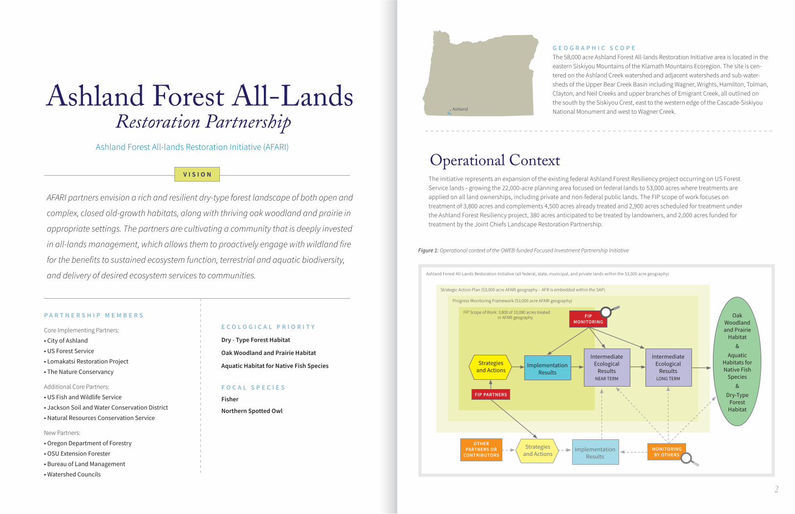
G E O G R A P H I C S C O P EThe 58,000 acre Ashland Forest All-lands Restoration Initiative area is located in the eastern Siskiyou Mountains of the Klamath Mountains Ecoregion. The site is cen-tered on the Ashland Creek watershed and adjacent watersheds and sub-water-sheds of the Upper Bear Creek Basin including Wagner, Wrights, Hamilton, Tolman, Clayton, and Neil Creeks and upper branches of Emigrant Creek, all outlined on the south by the Siskiyou Crest, east to the western edge of the Cascade-Siskiyou National Monument and west to Wagner Creek.
V I S I O N
E C O L O G I C A L P R I O R I T Y
Dry - Type Forest Habitat
Oak Woodland and Prairie Habitat
Aquatic Habitat for Native Fish Species
F O C A L S P E C I E S
Fisher
Northern Spotted Owl
P A R T N E R S H I P M E M B E R S
Core Implementing Partners:
• City of Ashland
• US Forest Service
• Lomakatsi Restoration Project
• The Nature Conservancy
Additional Core Partners:
• US Fish and Wildlife Service
• Jackson Soil and Water Conservation District
• Natural Resources Conservation Service
New Partners:
• Oregon Department of Forestry
• OSU Extension Forester
• Bureau of Land Management
• Watershed Councils
2
Strategiesand Actions
Strategiesand Actions
ImplementationResults
ImplementationResults
Intermediate Ecological
ResultsNEAR TERM
Intermediate Ecological
ResultsLONG TERM
FIP PARTNERS
FIP MONITORING
MONITORING BY OTHERS
OTHER PARTNERS OR
CONTRIBUTORS
Oak Woodland and Prairie
Habitat&
Aquatic Habitats for Native Fish
Species&
Dry-Type Forest
Habitat
FIP Scope of Work: 3,800 of 10,080 acres treated in AFARI geography
Progress Monitoring Framework (53,000 acre AFARI geography)
Strategic Action Plan (53,000 acre AFARI geography – AFR is embedded within the SAP)
Ashland Forest All-Lands Restoration Initiative (all federal, state, municipal, and private lands within the 53,000 acre geography)
Ashland
Figure 1: Operational context of the OWEB-funded Focused Investment Partnership Initiative
The initiative represents an expansion of the existing federal Ashland Forest Resiliency project occurring on US Forest Service lands - growing the 22,000-acre planning area focused on federal lands to 53,000 acres where treatments are applied on all land ownerships, including private and non-federal public lands. The FIP scope of work focuses on treatment of 3,800 acres and complements 4,500 acres already treated and 2,900 acres scheduled for treatment under the Ashland Forest Resiliency project, 380 acres anticipated to be treated by landowners, and 2,000 acres funded for treatment by the Joint Chiefs Landscape Restoration Partnership.
43
A P P R O A C H
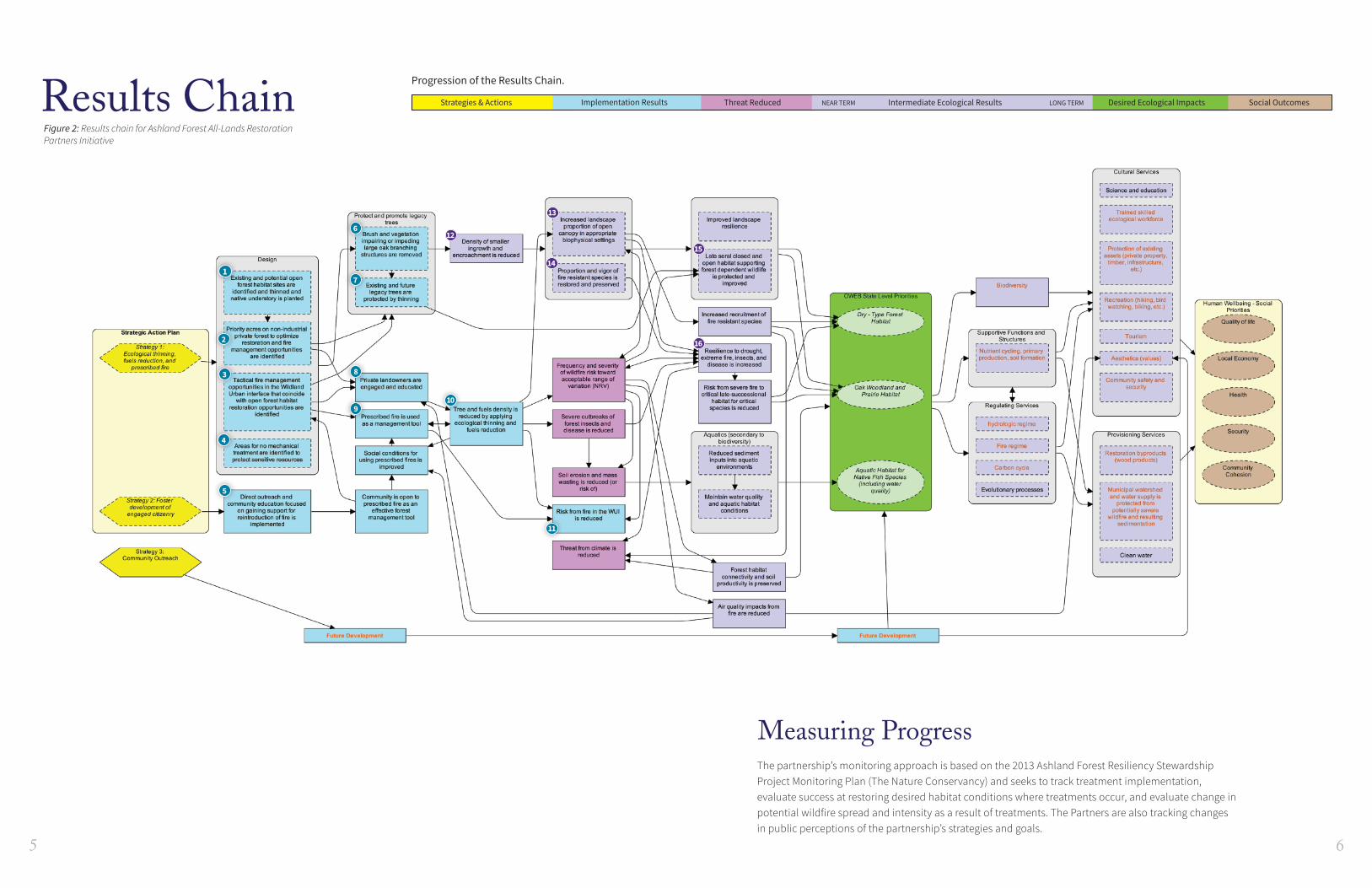
The results chain (Figure 2) articulates the partnership’s theo-ry of change by displaying the relationships between strategies, implementation results, and the intermediate ecological results partners predict will occur in response to strategy implementation that will ultimately lead to restoration of the FIPs ecological priorities.
Numbered results identified in Figure 2 are those the partner-ship has highlighted as part of a monitoring approach. They will allow the partnership to measure progress in both the near (e.g. 6-year FIP timeframe) and long term, and to identify where key uncertainties might exist with regards to confidence of predicted outcomes or relationships between results.
Each numbered implementation result is associated with the corresponding objective in the Strategic Action Plan (Tables 1 and 2). For intermediate ecological results, objectives are included if identified; however, for many ecological results, the degree (and timeframe) to which they will be achieved is not yet well understood. Given this complexity, continued assessment and planning will be required to support development of specific, measureable objectives for the desired ecological outcomes.
The narrative below summarizes the resulting theory of change. Implementation results and ecological results prioritized for monitoring during the six-year FIP timeline are indexed to correspond to the results chain (Figure 2) and measuring progress tables (Tables 1 and 2).
S T R A T E G I E S
The partnership proposes strategies and actions that focus primarily on needed forest thinning and fuels reduction. The work is designed to restore a balance between open and closed forest that approaches a desired range of variability. This will result in fuel conditions and stand composition and structure that mitigate the threat of severe wildfire, and promote low in-tensity fire. The work also reduces density of small trees, which supports growth of old legacy trees of by reducing competition and returns tree vigor and resistance to insects and disease. Successful implementation of strategies will benefit oak and late successional forest dependent wildlife.
2 Foster development of engaged citizenryThe partners will increase community outreach by organizing guided tours, delivering youth education programs, hosting workshops, and coordinating media coverage of their efforts. These outreach efforts educate interested citizens, establish an understanding of the ecological rationale and foundation of the partnership’s strategies, and promote face-to-face op-portunities to ask and answer questions.
Theory of Change.Community outreach and education focused on the benefits of prescribed fire5 will increase public understanding and ex-pand community openness to using prescribed fire as a man-agement tool. An expansion of public openness and support will allow the partnership to more fully act on identifiedopportunities in the wildland urban interface to apply pre-scribed fire treatments9.
1 Ecological thinning, fuels reduction, and prescribed fire
This strategy includes mechanical thinning and fuels reduc-tion and subsequent prescribed burning to reset the stage for beneficial long-term maintenance with controlled fire.
Theory of Change.Thinning in strategically identified and prioritized potential open canopy forest habitat sites1 will result in the removal of vegetation that impedes development of large oaks that typically have wide branches6 and will reduce the density of smaller, understory plants12.
• Strategic thinning will increase the overall proportion of open canopy13 at the landscape scale, increase the recruit-ment and vigor of fire-resistant species14, and increase the resilience of forest ecosystems to drought, extreme fire, insects, and disease.
• These landscape scale results will lead to an overall im-provement of habitat supporting forest dependent wildlife species15.
The process of prioritizing areas with opportunities to optimize restoration and fire management on non-industrial private forests2 results in the engagement and education of private landowners8, and the implementation of actions to reduce fuel density in these areas10.
• These identified fuel-reduction actions in turn will increase the landscape proportion of open canopy13, result in a shift in the frequency and severity of wildfire risk towards an acceptable range of variation16, and reduce risk of fire in the wildland urban interface11.
• The reduction in fuel density will also reduce the occur-rence of severe outbreaks of forest insects and diseases, thereby reducing tree mortality and potential for sediment inputs into aquatic environments from soil erosion and landslides.
The process of identifying forest thinning or fuels reduction treatment sites will also identify areas where no action is needed to protect existing sensitive resources4.The identification of fire management opportunities in the wildland urban interface associated with open forest habitat restoration3 will result in opportunities to use prescribed fire as a tool9 to manage fire risk in these areas11.
Theory of ChangeS I T U A T I O N
A century of fire exclusion and large-tree timber harvest has allowed forests to become uncharacteristically dense, but without the needed natural species diversity at a landscape scale – both of which are important to a healthy forest system. As a result, the forest system is less resilient. In addition, the accumulation of leaf litter on the ground, combined with denser understory in the forest has left the system more prone to higher-intensity, higher-severity, stand-replacing fires.
Without action, fuel loads will continue to accumulate, risk of catastrophic wildfire and associated destruction of natural resources will increase, large tree mortality rates will continue to accelerate and a vital component of the forest ecosystem will be lost. These forests will be replaced by younger, dense,volatile forests that are less resilient to natural disturbances and to anticipated climate change. The overall health of the forest ecosystem – dry-type forest with late-successional wildlife habitat, oak woodlands, and aquatic habitat for native species – will continue to degrade and become increasinglydense, and the remaining open, fire-resistant forest will be compromised by encroachment.
S T R A T E G I E S
Superscript numbers 1-17 can be cross referenced on the Results Chain diagram and the Implementation Progress/Ecological Progress tables on the following pages.
1
12
13
14
15
162
3
4
5
6
7
8
910
11
Results Chain
65
Figure 2: Results chain for Ashland Forest All-Lands Restoration Partners Initiative
Measuring ProgressThe partnership’s monitoring approach is based on the 2013 Ashland Forest Resiliency StewardshipProject Monitoring Plan (The Nature Conservancy) and seeks to track treatment implementation,evaluate success at restoring desired habitat conditions where treatments occur, and evaluate change inpotential wildfire spread and intensity as a result of treatments. The Partners are also tracking changesin public perceptions of the partnership’s strategies and goals.
Strategies & Actions Implementation Results Threat Reduced Intermediate Ecological Results Desired Ecological Impacts Social Outcomes
Progression of the Results Chain.
NEAR TERM LONG TERM
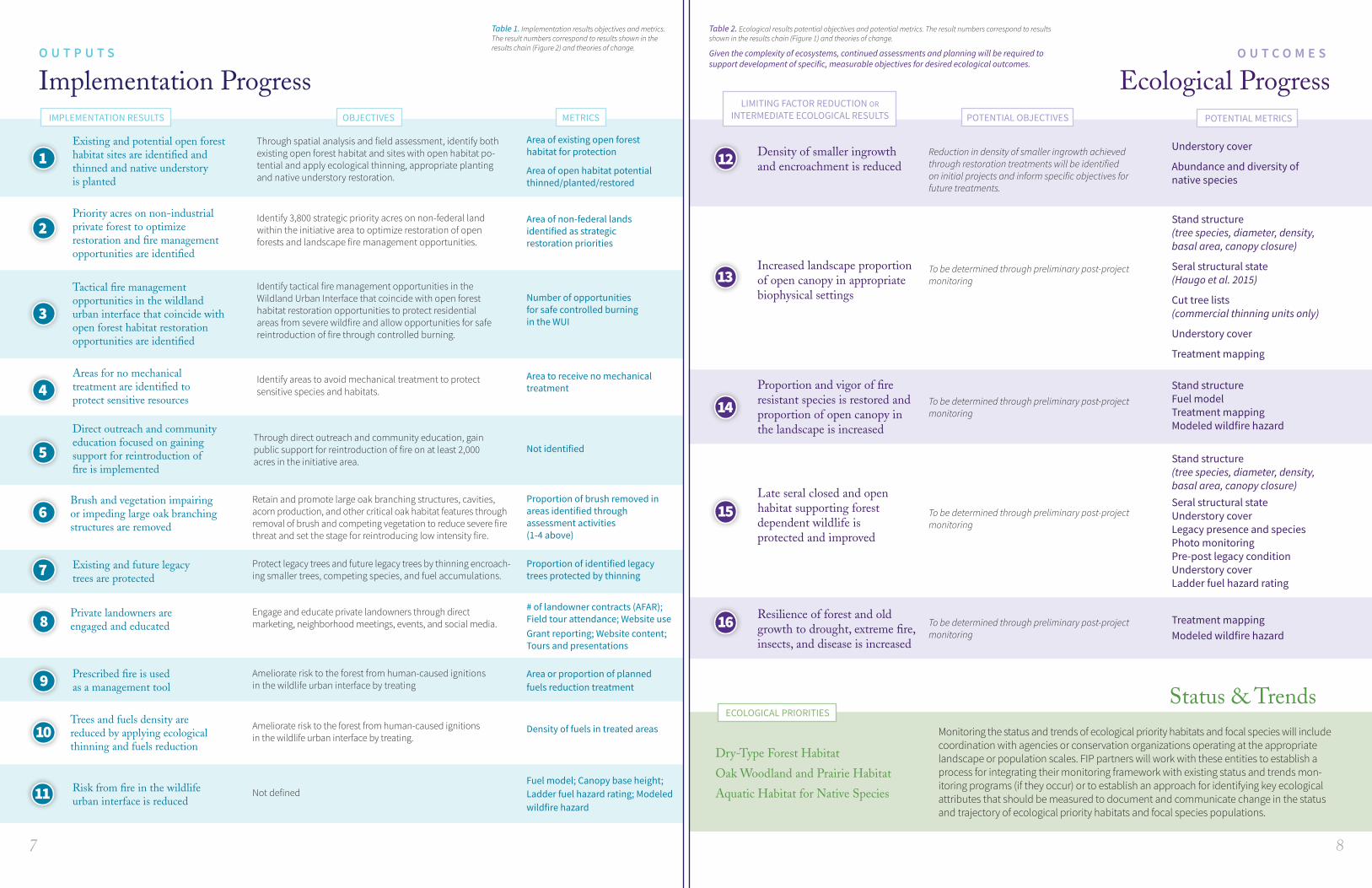
Status & TrendsECOLOGICAL PRIORITIES
Monitoring the status and trends of ecological priority habitats and focal species will include coordination with agencies or conservation organizations operating at the appropriate landscape or population scales. FIP partners will work with these entities to establish a process for integrating their monitoring framework with existing status and trends mon-itoring programs (if they occur) or to establish an approach for identifying key ecological attributes that should be measured to document and communicate change in the status and trajectory of ecological priority habitats and focal species populations.
Dry-Type Forest Habitat
Oak Woodland and Prairie Habitat
Aquatic Habitat for Native Species
87
Identify areas to avoid mechanical treatment to protect sensitive species and habitats.
Identify 3,800 strategic priority acres on non-federal land within the initiative area to optimize restoration of open forests and landscape fire management opportunities.
1
3
5
9
7
2
4
6
8
Implementation Progress Ecological Progress
Existing and potential open forest habitat sites are identified and thinned and native understory is planted
Tactical fire managementopportunities in the wildlandurban interface that coincide with open forest habitat restoration opportunities are identified
Direct outreach and community education focused on gaining support for reintroduction of fire is implemented
Prescribed fire is used as a management tool
Risk from fire in the wildlife urban interface is reduced
Existing and future legacy trees are protected
Priority acres on non-industrial private forest to optimize restoration and fire management opportunities are identified
Areas for no mechanicaltreatment are identified toprotect sensitive resources
Brush and vegetation impairing or impeding large oak branching structures are removed
Private landowners areengaged and educated
Trees and fuels density arereduced by applying ecological thinning and fuels reduction
Area of existing open forest habitat for protection
Area of open habitat potentialthinned/planted/restored
Understory cover
Abundance and diversity of native species
Stand structure (tree species, diameter, density, basal area, canopy closure)
Seral structural state (Haugo et al. 2015)
Cut tree lists (commercial thinning units only)
Understory cover
Treatment mapping
Stand structureFuel modelTreatment mappingModeled wildfire hazard
Stand structure (tree species, diameter, density, basal area, canopy closure)Seral structural stateUnderstory coverLegacy presence and speciesPhoto monitoringPre-post legacy conditionUnderstory coverLadder fuel hazard rating
Treatment mappingModeled wildfire hazard
Number of opportunities for safe controlled burning in the WUI
Not identified
Area or proportion of planned fuels reduction treatment
Fuel model; Canopy base height; Ladder fuel hazard rating; Modeledwildfire hazard
# of landowner contracts (AFAR); Field tour attendance; Website useGrant reporting; Website content;Tours and presentations
Density of fuels in treated areas
Area of non-federal landsidentified as strategic restoration priorities
Area to receive no mechanicaltreatment
Proportion of brush removed inareas identified throughassessment activities (1-4 above)
Proportion of identified legacytrees protected by thinning
Through spatial analysis and field assessment, identify bothexisting open forest habitat and sites with open habitat po-tential and apply ecological thinning, appropriate planting and native understory restoration.
Identify tactical fire management opportunities in the Wildland Urban Interface that coincide with open forest habitat restoration opportunities to protect residential areas from severe wildfire and allow opportunities for safe reintroduction of fire through controlled burning.
Through direct outreach and community education, gain public support for reintroduction of fire on at least 2,000 acres in the initiative area.
Ameliorate risk to the forest from human-caused ignitions in the wildlife urban interface by treating
Not defined
Retain and promote large oak branching structures, cavities,acorn production, and other critical oak habitat features through removal of brush and competing vegetation to reduce severe fire threat and set the stage for reintroducing low intensity fire.
Protect legacy trees and future legacy trees by thinning encroach-ing smaller trees, competing species, and fuel accumulations.
Engage and educate private landowners through directmarketing, neighborhood meetings, events, and social media.
Ameliorate risk to the forest from human-caused ignitions in the wildlife urban interface by treating.
Reduction in density of smaller ingrowth achieved through restoration treatments will be identified on initial projects and inform specific objectives for future treatments.
IMPLEMENTATION RESULTS OBJECTIVES
10
11
13
14
15
16
12 Density of smaller ingrowthand encroachment is reduced
Increased landscape proportion of open canopy in appropriate biophysical settings
Proportion and vigor of fireresistant species is restored andproportion of open canopy in the landscape is increased
Late seral closed and openhabitat supporting forestdependent wildlife is protected and improved
Resilience of forest and oldgrowth to drought, extreme fire,insects, and disease is increased
O U T C O M E SO U T P U T S
Table 1. Implementation results objectives and metrics. The result numbers correspond to results shown in the results chain (Figure 2) and theories of change.
Table 2. Ecological results potential objectives and potential metrics. The result numbers correspond to results shown in the results chain (Figure 1) and theories of change. Given the complexity of ecosystems, continued assessments and planning will be required to support development of specific, measurable objectives for desired ecological outcomes.
POTENTIAL OBJECTIVES
To be determined through preliminary post-project monitoring
To be determined through preliminary post-project monitoring
To be determined through preliminary post-project monitoring
To be determined through preliminary post-project monitoring
METRICSLIMITING FACTOR REDUCTION OR
INTERMEDIATE ECOLOGICAL RESULTS POTENTIAL METRICS