Embed Size (px)
Citation preview

Page 1 of 48
ASELINE DOCUMENTATION REPORT Almy Property
Windmill Hill Farm Little Compton, Rhode Island
Prepared January 2016 By Carol Lynn Trocki
For the Little Compton Agricultural Conservancy Trust
Author’s Signature:
Page 2 of 48
TABLE OF CONTENTS
BASELINE DOCUMENTATION REPORT Almy Property
Windmill Hill Farm Little Compton, Rhode Island
Cover Page 01 Table of Contents 02 Acknowledgement of Conditions 03 Background Information 07 Figure 1. Little Compton Tax Assessor’s Plat 02 15 Figure 2. Survey Plan 16 Figure 3. Location Map 17 Figure 4. Aerial Photo / Property Map 18 Figure 5. Landscape Context Map 19 Figure 6. USGS Topographical Map 20 Figure 7. Soil Survey Map 21 Figure 8. Photo Point Map 22 Photo Point Descriptions 23 Photographs 25 Appendix 1. Author’s Curriculum Vitae 92

Page 3 of 48
ACKNOWLEDGEMENT OF CONDITION STATEMENT BASELINE DOCUMENTATION REPORT
Almy Property Windmill Hill Farm
Little Compton, Rhode Island
The Grantor and the Grantees hereby certify that this Baseline Documentation Report is an accurate representation of the property, described in the Deed to Development Rights (hereinafter referred to as the ‘Premises’), at this time. This Baseline Documentation Report contains the following: Cover Page; Table of Contents; Acknowledgement of Condition Statement; Background Information; Little Compton Tax Assessor’s Plat 02; Survey Plan; Location Map; Aerial Photo / Property Map; Landscape Context Map; USGS Topographical Map; Soil Survey Map; Photo Point Map; Photo Point Description; and Photographs. The Grantors further certify that to the best of the their knowledge, there are no structures or improvements on the Premises other than as described in this Baseline Documentation Report, and no activities are conducted on the Premises which are inconsistent with the terms contained in the Deed to Development Rights. IN WITNESS WHEREOF, the parties have executed this Baseline Documentation Report this ___________ day of _____________________ 2016. WITNESS: WITNESS:
GRANTOR: RICHARD C. ALMY Address: GRANTOR: EDITH E. ALMY Address:

Page 4 of 48
WITNESS: WITNESS: WITNESS:
GRANTEE: LITTLE COMPTON AGRICULTURAL CONSERVANCY TRUST By: Its: Address: GRANTEE: UNITED STATES DEPARTMENT OF AGRICULTURE NATURAL RESOURCES CONSERVATION SERVICE By: Its: Address: GRANTEE: STATE OF RHODE ISLAND AGRICULTURAL LAND PRESERVATION COMMISSION By: Its: Address:

Page 5 of 48
STATE OF RHODE ISLAND COUNTY OF NEWPORT In , on this day of , A.D. 2016, then personally appeared RICHARD C. ALMY, to me known and known by me to be the party executing the foregoing instrument, and he acknowledged said instrument, by him so executed, to be his free act and deed, before me,
Notary Public Printed Name:
My commission expires:
STATE OF RHODE ISLAND COUNTY OF NEWPORT In , on this day of , A.D. 2016, then personally appeared EDITH E. ALMY, to me known and known by me to be the party executing the foregoing instrument, and he acknowledged said instrument, by him so executed, to be his free act and deed, before me,
Notary Public Printed Name:
My commission expires:
STATE OF RHODE ISLAND COUNTY OF NEWPORT In , on this day of , A.D. 2016, then personally appeared , of the LITTLE COMPTON AGRICULTURAL CONSERVANCY TRUST, to me known and known by me to be the party executing the foregoing instrument, and s/he acknowledged said instrument, by him/her so executed, to be his/her free act and deed in his/her said capacity and the free act and deed of said LITTLE COMPTON AGRICULTURAL CONSERVANCY TRUST, before me,
Notary Public Printed Name:
My commission expires:

Page 6 of 48
STATE OF RHODE ISLAND COUNTY OF NEWPORT In , on this day of , A.D. 2016, then personally appeared , of the UNITED STATES DEPARTMENT OF AGRICULTURE NATURAL RESOURCES CONSERVATION SERVICE, to me known and known by me to be the party executing the foregoing instrument, and s/he acknowledged said instrument, by him/her so executed, to be his/her free act and deed in his/her said capacity and the free act and deed of said UNITED STATES DEPARTMENT OF AGRICULTURE NATURAL RESOURCES CONSERVATION SERVICE, before me,
Notary Public Printed Name:
My commission expires:
STATE OF RHODE ISLAND COUNTY OF NEWPORT In , on this day of , A.D. 2016, then personally appeared , of the STATE OF RHODE ISLAND AGRICULTURAL LAND PRESERVATION COMMISSION, to me known and known by me to be the party executing the foregoing instrument, and s/he acknowledged said instrument, by him/her so executed, to be his/her free act and deed in his/her said capacity and the free act and deed of said STATE OF RHODE ISLAND AGRICULTURAL LAND PRESERVATION COMMISSION, before me,
Notary Public Printed Name:
My commission expires:

Page 7 of 48
BACKGROUND INFORMATION BASELINE DOCUMENTATION REPORT
Almy Property Windmill Hill Farm
Little Compton, Rhode Island
Note: This Baseline Documentation Report reflects the condition of the Premises on January 11, 2016. CURRENT LANDOWNER & ORIGINAL GRANTORS Richard C. and Edith E. Almy DATE OF EXECUTION OF DEED TO DEVELOPMENT RIGHTS September 30, 1996 LOCATION OF PROPERTY Street Address: 90A Old Main Road Municipality: Little Compton County: Newport State: Rhode Island Plat/Lot: Portion of Little Compton Tax Assessor’s Plat 02, Lot 1 (Figure 1). PROPERTY DESCRIPTION Acreage: The conservation area totals 33.15 acres; Lot 1 includes a 3.85 acre portion in which development rights were retained (Figure 1, Figure 2). Prior Land Uses: Periodic historic aerial photographs dating back to 1939 show the long agricultural history of the Premises. Early photos show the current conservation area bisected into six separate fields by a number of dividing stonewalls. This configuration was maintained until sometime in the 1980s. In 1959-1961, the Watson Reservoir was constructed adjacent to the Premises by the City of Newport. Current Land Use: The Premises are currently being farmed by Pete Peckham of Ferolbink Farm and are used to grow winter squash, pumpkins, potatoes, and corn. The Premises were protected by a Deed to Development Rights with the Little Compton Agricultural Land Conservancy Trust (LCACT) on September 30, 1996. The USDA Natural Resources Conservation Service provided some of the funding to purchase these rights, giving NRCS a position as a back-up holder. On May 11, 2001 an Agreement & Assignment was executed between the LCACT and the State of Rhode Island Agricultural Land Preservation Commission (ALPC) giving the ALPC a stake in the protection of development rights on the Premises as well. Proposed Future Use: It is the purpose of the Deed to Development Rights to maintain the Premises for agricultural use in perpetuity.

Page 8 of 48
CONSERVATION VALUES Location: The Premises are located east of Old Main Road and west of the Harold E. Watson Reservoir in Little Compton, Rhode Island (Figure 3, Figure 4). The Premises lie within an extensive complex of active agricultural land, with adjacent protected farmland to the north, south, and west (Figure 4, Figure 5). Landscape Context: There are approximately 1,079 acres of conservation land within one mile of the Premises (Table 1, Figure 5).1,2
Table 1. Conservation land within one mile of the Almy Property, Windmill Hill Farm, in Little Compton, Rhode Island as of January, 2016.
Topography: Elevations on the Premises range from approximately 30’ to 18’ above sea level (Figure 6). The highest elevations occur on the northwestern-most portions of the conservation area. On the western half of the Premises, elevations grade gently from north to south. On the eastern half of the Premises they grade more steeply from west to east, directly into Watson Reservoir.
1 RIGIS, 2014. Municipal & Non-Governmental Organization Conservation Lands; locCons14. Rhode Island Geographic Information System (RIGIS) Data Distribution System, URL: http://www.edc.uri.edu/rigis, Environmental Data Center, University of Rhode Island, Kingston, Rhode Island. As amended by CLT, 7/2015. 2 RIGIS, 2014. State Conservation Lands; staCons14. Rhode Island Geographic Information System (RIGIS) Data Distribution System, URL:http://www.edc.uri.edu/rigis, Environmental Data Center, University of Rhode Island, Kingston, Rhode Island.
Conservation Holder Acres State of Rhode Island 646 Little Compton Agricultural Conservancy Trust, State of Rhode Island, and the Natural Resources Conservation Service
191
State of Rhode Island and City of Newport 88 The Nature Conservancy 48 Little Compton Agricultural Conservancy Trust 47 Little Compton Agricultural Conservancy Trust and the Natural Resources Conservation Service
23
The Nature Conservancy and Little Compton Agricultural Conservancy Trust
16
Natural Resources Conservation Service 10 City of Newport and Little Compton Agricultural Conservancy Trust
8
Town of Little Compton 2 GRAND TOTAL 1079

Page 9 of 48
Soils: According to the Rhode Island Soil Survey, the Premises contain five different soil types (Table 1, Figure 7).3
Table 1. Mapped soils on the Almy Property, Windmill Hill Farm. Soil Type
Label
Approx. Acres
Newport silt loam, 3-8% slopes NeB 14.4 Newport silt loam, 0-3% slopes NeA 9.1 Stissing silt loam Se 5.7 Mansfield mucky silt loam Ma 2.2 Pittstown silt loam, 0-3% slopes PmA 1.7
Newport silt loam with 3-8% slopes (NeB) is a gently sloping, well-drained soil found on the sides of drumlins and glacial till plains in southeastern Rhode Island. The permeability of this soil is moderate or moderately rapid in the surface layer and subsoil and slow or very slow in the substratum. Available water capacity is moderate, and runoff is medium. The soil is very strongly acid through medium acid. This soil is suited to community development and cultivated crops; most areas are used for farming. This soil is recognized as a Prime Farmland Soil in the State of Rhode Island. Newport silt loam with 0-3% slopes (NeA) is a nearly level, well-drained soil found on the crests of drumlins and glacial till plains in the southeast part of the State. The permeability of this soil is moderate or moderately rapid in the surface layer and subsoil and slow or very slow in the substratum. Available water capacity is moderate, and runoff is medium. The soil is very strongly acid through medium acid. This soil is suitable for community development and cultivation; most areas used for farming. This soil is recognized as a Prime Farmland Soil in the State of Rhode Island. Stissing silt loam (Se), is a nearly level, poorly drained soil found on glacial upland hills and drumlins in the southeastern part of the State. Slopes range from 0 to 3 percent. The permeability of this soil is moderate in the surface layer and subsoil and slow in the substratum. Available water capacity is moderate, and runoff is slow. This soil has a seasonal high water table near the surface from late fall through spring. The soil is extremely acid through medium acid. The seasonal high water table and the slow permeability in the substratum make this soil poorly suited to community development. This soil is suited to trees, but most areas are cleared and used for pasture. This soil is suited to most types of wildlife habitat. Stissing soils are hydric soils associated with wetlands and are protected from disturbance under state and federal law. This soil is recognized as a Soil of Statewide Importance for Agriculture in the State of Rhode Island. Mansfield mucky silt loam (Ma) is a nearly level, very poorly drained soil found in depressions and small drainageways of drumlins in the southeastern part of the State. The permeability of this soil is moderate in the surface layer and subsoil and slow or very slow in the substratum. Available water capacity is moderate, and runoff is slow. This soil has a seasonal high water table at or near the surface from late fall through midsummer. The soil is extremely acid through medium acid. Wetness makes the soil unsuitable or poorly suited to cultivated crops, to trees, or to wildlife habitat except wetland wildlife habitat. Many areas have water ponded on the surface during wet seasons. This soil is mainly used for 3 RIGIS, 2014. Soils; soils14. Rhode Island Geographic Information System (RIGIS) Data Distribution System, URL: http://www.edc.uri.edu/rigis, Environmental Data Center, University of Rhode Island, Kingston, Rhode Island.

Page 10 of 48
pasture or wetland wildlife habitat. Mansfield soils are hydric soils associated with wetlands and are protected from disturbance under state and federal law. Pittstown silt loam with 0-3% slopes (PmA) is a nearly level, moderately well-drained soil found on the crests of glacial upland hills and drumlins. The permeability of this soil is moderate in the surface layer and subsoil and slow in the substratum. Available water capacity is moderate, and runoff is slow. This soil has a seasonal high water table at a depth of about 20 inches from late fall through mid-spring. The soil is very strongly acid through medium acid. This soil is suited to woodland, but most areas are cleared and used for farming or nursery stock. This soil is recognized as a Prime Farmland Soil in the State of Rhode Island. Agricultural Resources: The Premises have a long history of agricultural use that continues today. The entirety of the Premises are actively cultivated for a variety of crops, including winter squash, pumpkins, potatoes, and corn. Approximately 76% (25.2 acres) of the Premises are classified as Prime Farmland Soil, while an additional 17% (5.7 acres) are recognized a Soils of Statewide Importance for Agriculture. The Premises support a working farm and lie within a complex of actively managed agricultural land, which is recognized as a valuable component of the surrounding landscape.
The Almy Property, Windmill Hill Farm, has a long history of agricultural use. (CLT, 1/11/16)
Water Resources: The Premises are located within a Surface Water Protection Area for the Watson Reservoir, which lies immediately east.4 In addition, the Premises contain approximately eight acres of hydric soil. Groundwater on the Premises is classified as ‘GA’, indicating that groundwater resources are
4 RIGIS, 2002. Surface Water Protection Areas; swatpa. Rhode Island Geographic Information System (RIGIS) Data Distribution System, URL:http://www.edc.uri.edu/rigis, Environmental Data Center, University of Rhode Island, Kingston, Rhode Island.

Page 11 of 48
presumed to be of drinking water quality.5 Residents of the Town of Little Compton rely solely on groundwater to replenish the wells upon which they depend for high quality drinking water.
The Almy Property, Windmill Hill Farm, drains directly to the adjacent Watson Reservoir. (CLT, 1/11/16)
Natural Communities / Wildlife Habitat Resources: The Premises are comprised entirely of open, cultivated agricultural land bound by stone walls overgrown with shrubs and trees. A site visit to the Premises was conducted on January 11, 2016 and the following species were observed:
FLORA (species in bold are listed in the Invasive Plant Atlas of New England catalog and are generally considered to be invasive in the region.6)
American Holly (Ilex opaca) Asian Bittersweet (Celastrus orbiculatus) Autumn Olive (Eleagnus umbellata) Bittersweet Nightshade (Solanum dulcamara) Blackberry (Rubus spp.) Bullbrier (Smilax rotundifolia) Chickweed (Cerastium spp.) Climbing Hempweed (Mikania scandens) Common Milkweed (Asclepias syriaca) Common Privet (Ligustrum vulgare) Common Ragweed (Ambrosia artemisiifolia)
5 RIGIS, 2012. Groundwater Quality Standard; gwqstd12. Rhode Island Geographic Information System (RIGIS) Data Distribution System, URL:http://www.edc.uri.edu/rigis, Environmental Data Center, University of Rhode Island, Kingston, Rhode Island. 6 Invasive Plant Atlas of New England: https://www.eddmaps.org/ipane/Species/

Page 12 of 48
Common Tansy (Tanacetum vulgare) Common Thistle (Cirsium vulgare) Curly Dock (Rumex crispus) Evening Primrose (Oenothera biennis) Field Mustard (Family Brassica) Goldenrod (Solidago spp.) Horse Nettle (Solanum carolinense) Japanese Honeysuckle (Lonicera japonica) Joe-Pye-weed (Eupatorium dubium) Knapweed (Centaurea spp.) Meadowsweet (Spirea alba) Mixed Pasture Grasses (Poaceae Family) Multiflora Rose (Rosa multiflora) Norway Maple (Acer platanoides) Pineapple-weed (Matricaria matricarioides) Pokeweed (Phytolacca americana) Pussy Willow (Salix discolor) Red Maple (Acer rubrum) Shadbush (Amelanchier spp.) Smartweed (Polygonum spp.) Wild Black Cherry (Prunus serotina) Wineberry (Rubus phoenicolasius) Winter Rye (Secale cereal) Winterberry (Ilex verticillata) FAUNA
Birds American Tree Sparrow (Spizella arborea) Blue Jay (Cyanocitta cristata) Canada Goose (Branta canadensis) Dark-eyed Junco (Junco hyemalis) Field Sparrow (Spizella pusilla) Gray Catbird (Dumetella carolinensis) House Sparrow (Passer domesticus) Mourning Dove (Zenaida macroura) Northern Cardinal (Mimus polyglottos) Northern Mockingbird (Mimus polyglottos) Song Sparrow (Melospiza melodia) White-throated Sparrow (Zonotrichia albicollis) Yellow-rumped Warbler (Dendroica coronata) Mammals Eastern Cottontail (Sylvilagus floridanus) Coyote (Canis latrans) White-tailed Deer (Odocoileus virginianus) Insects Praying Mantis (Mantis religiosa)

Page 13 of 48
Only a single site visit was conducted on the Premises in mid-January, therefore, there is a limited likelihood that uncommon species, or species present or visible during other portions of the year could be detected. No rare plant species were observed during the site visit, however, the State’s ‘Christmas Green’s Law’ protects American Holly (Ilex opaca) and Winterberry (Ilex verticillata) from being removed without written permission from the landowner.7 The majority of the plants listed here are common and representative of managed agricultural lands and surrounding hedgerows, including many invasives.
Large numbers of Canada Geese were feeding on the cover crop planted on the
Almy Property, Windmill Hill Farm, Little Compton, RI. (CLT, 1/11/2016) Of the wildlife species observed on the Premises, most are also common and characteristic. However, an especially large variety of sparrows and winter resident birds were feeding and seeking cover in the weedy hedgerows along the northern boundaries of the Premises. Yellow-rumped Warblers (Dendroica coronata) are listed as Species of Greatest Conservation Need in the State of Rhode Island8 though they are common in winter along the coast. No other threatened or endangered species were detected on the Premises. It is very likely that the Premises are used by a wider variety of wildlife species at various times during the year, including migratory and resident birds, small and medium-sized mammals, snakes, and a more diverse array of insects than listed here. Scenic, Historic, Educational, & Recreational Resources: The Premises lie within the Tiverton Main Road Scenic Area as designated by the State of Rhode Island Department of Environmental Management.9 The Premises contain scenic and pastoral views with significant aesthetic value. Frontage along West Main Road and Old Main Road allows for some limited visual access by the public. Historic field stone walls bound the Premises and are recognized as a valuable cultural resource in the area.
7 Section 2-15-12 of the General Laws in Chapter 2-15, Rhode Island General Assembly, 1989. 8 Rhode Island Species of Greatest Conservation Need List, RIDEM 2005. http://www.dem.ri.gov/programs/bnatres/fishwild/pdf/species2.pdf 9 RIGIS, 1989.Scenic Areas of Rhode Island; s44nsv89. Rhode Island Geographic Information System (RIGIS) Data Distribution System, URL:http://www.edc.uri.edu/rigis, Environmental Data Center, University of Rhode Island, Kingston, Rhode Island.

Page 14 of 48
Human-made Features: Human-made features observed on the Premises on January 11, 2016 were limited to the aforementioned fieldstone walls. All agricultural structures, utility poles & line, and gas line markers are located outside the Conservation Area, as delineated on the Survey Plan (Figure 2).

Page 15 of 48
Figure 1. Little Compton Tax Assessor’s Plat 02
Almy Property - Windmill Hill Farm Little Compton, Rhode Island

Page 16 of 48
Figure 2. Survey Plan Map
Almy Property - Windmill Hill Farm Little Compton, Rhode Island

Page 17 of 48
Figure 3.
Location Map Almy Property - Windmill Hill Farm
Little Compton, Rhode Island

Page 18 of 48
Figure 4. Aerial Photo / Property Map
Almy Property - Windmill Hill Farm Little Compton, Rhode Island

Page 19 of 48
Figure 5. Landscape Context Map
Almy Property - Windmill Hill Farm Little Compton, Rhode Island

Page 20 of 48
Figure 6. USGS Topographical Map
Almy Property - Windmill Hill Farm Little Compton, Rhode Island

Page 21 of 48
Figure 7. Soil Survey Map
Almy Property - Windmill Hill Farm Little Compton, Rhode Island

Page 22 of 48
Figure 8a. Photo Point Map
Almy Property - Windmill Hill Farm Little Compton, Rhode Island

Page 23 of 48
Photo Point Descriptions Almy Property - Windmill Hill Farm
Little Compton, Rhode Island
Photo No.
Photo Description
1A Looking S along the portion of Lot 1 where development rights were retained. 1B Looking W along the northern boundary of the Premises, back along the drive towards Old Main
Road. 2A Looking E along the portion of Lot 1 where development rights were retained. 2B Looking S across the Premises. 3A Looking S, across the Premises, along the easternmost boundary of the portion of Lot 1 where
development rights were retained. 3B Looking N along the northernmost portion of the western boundary of the Premises. 3C Looking E across the Premises, towards Watson Reservoir. 4A Looking ENE along the easternmost portion of the northern boundary of the Premises. 4B Looking S along the northernmost portion of the western boundary of the Premises from the
northernmost northwest corner. 4C Looking SE across the Premises from the northernmost northwest corner. 5A Looking WSW along the easternmost portion of the northern boundary of the Premises from just
east of the easternmost northeast corner. 5B Looking SSE along the eastern field boundary that runs just east of the eastern boundary of the
Premises. 5C Looking SW across the northeastern-most portion of the Premises from just east of the
easternmost northeast corner. 6A Looking W into the Premises along the northern boundary of the shrubby rockpile area along the
eastern boundary of the Premises. 6B Looking NNW along the eastern field boundary running just east of the eastern boundary of the
Premises. 6C Looking NW across the northeastern-most portion of the Premises. 7A Looking W into the Premises along the southern boundary of the shrubby rockpile area along the
eastern boundary of the Premises. 7B Looking SSE along the eastern field boundary running just east of the eastern boundary of the
Premises. 7C Looking SW into the southeastern portion of the Premises. 8A Looking NNW along the eastern boundary of the Premises from the southeast corner. 8B Looking WSW along the southern boundary of the Premises from the southeast corner. 8C Looking NW into the southeastern portion of the Premises from the southeast corner. 9A Looking ENE along the southern boundary of the Premises from the three-way stone wall
intersection. 9B Looking WSW along the southern boundary of the Premises from the three-way stone wall
intersection. 9C Looking NNW into the Premises from the three-way stone wall intersection found along the
southern boundary.

Page 24 of 48
10A Looking NNE along the gas line cut out of the Premises from its intersection with the southern boundary.
11A Looking ENE along the southern boundary of the Premises from the southwest corner. 11B Looking NNE along the western boundary of the Premises from the southwest corner. 11C Looking NE across the western portion of the Premises from the southwest corner. 12A Looking SSW along the western boundary of the Premises from the westernmost northwest
corner, near to the drive intersection with Old Main Road. 12B Looking E along the westernmost portion of the northern boundary of the Premises, along the
drive. 12C Looking SE across the westernmost portion of the Premises from the westernmost northwest
corner. 13A Looking SSW down the gas line cut out from the Premises, from the gas line marker along the
drive. 13B Looking W along the drive, back towards Old Main Road. 13C Looking E along the drive, towards Watson Reservoir. 13D Looking SE across the Premises from the gas line marker along the drive. 13E Looking SW across the Premises from the gas line marker along the drive.

Page 25 of 48
Photographs Almy Property - Windmill Hill Farm
Little Compton, Rhode Island
Photo 1A
Looking S along the portion of Lot 1 where development rights were retained. Carol Lynn Trocki, 1/11/2016

Page 26 of 48
Photo 1B
Looking W along the northern boundary of the Premises, back along the drive towards Old Main Road. Carol Lynn Trocki, 1/11/2016
Photo 2A
Looking E along the portion of Lot 1 where development rights were retained. Carol Lynn Trocki, 1/11/2016

Page 27 of 48
Photo 2B
Looking S across the Premises. Carol Lynn Trocki, 1/11/2016
Photo 3A
Looking S, across the Premises, along the easternmost boundary of the portion of Lot 1 where development rights were retained.
Carol Lynn Trocki, 1/11/2016

Page 28 of 48
Photo 3B
Looking N along the northernmost portion of the western boundary of the Premises. Carol Lynn Trocki, 1/11/2016
Photo 3C
Looking E across the Premises, towards Watson Reservoir. Carol Lynn Trocki, 1/11/2016

Page 29 of 48
Photo 4A
Looking ENE along the easternmost portion of the northern boundary of the Premises. Carol Lynn Trocki, 1/11/2016
Photo 4B
Looking S along the northernmost portion of the western boundary of the Premises from the northernmost northwest corner.
Carol Lynn Trocki, 1/11/2016

Page 30 of 48
Photo 4C
Looking SE across the Premises from the northernmost northwest corner. Carol Lynn Trocki, 1/11/2016
Photo 5A
Looking WSW along the easternmost portion of the northern boundary of the Premises from just east of the easternmost northeast corner.
Carol Lynn Trocki, 1/11/2016

Page 31 of 48
Photo 5B
Looking SSE along the eastern field boundary that runs just east of the eastern boundary of the Premises.
Carol Lynn Trocki, 1/11/2016
Photo 5C
Looking SW across the northeastern-most portion of the Premises from just east of the easternmost northeast corner.
Carol Lynn Trocki, 1/11/2016

Page 32 of 48
Photo 6A
Looking W into the Premises along the northern boundary of the shrubby rockpile area along the eastern boundary of the Premises.
Carol Lynn Trocki, 1/11/2016
Photo 6B
Looking NNW along the eastern field boundary running just east of the eastern boundary of the Premises.
Carol Lynn Trocki, 1/11/2016
Page 33 of 48
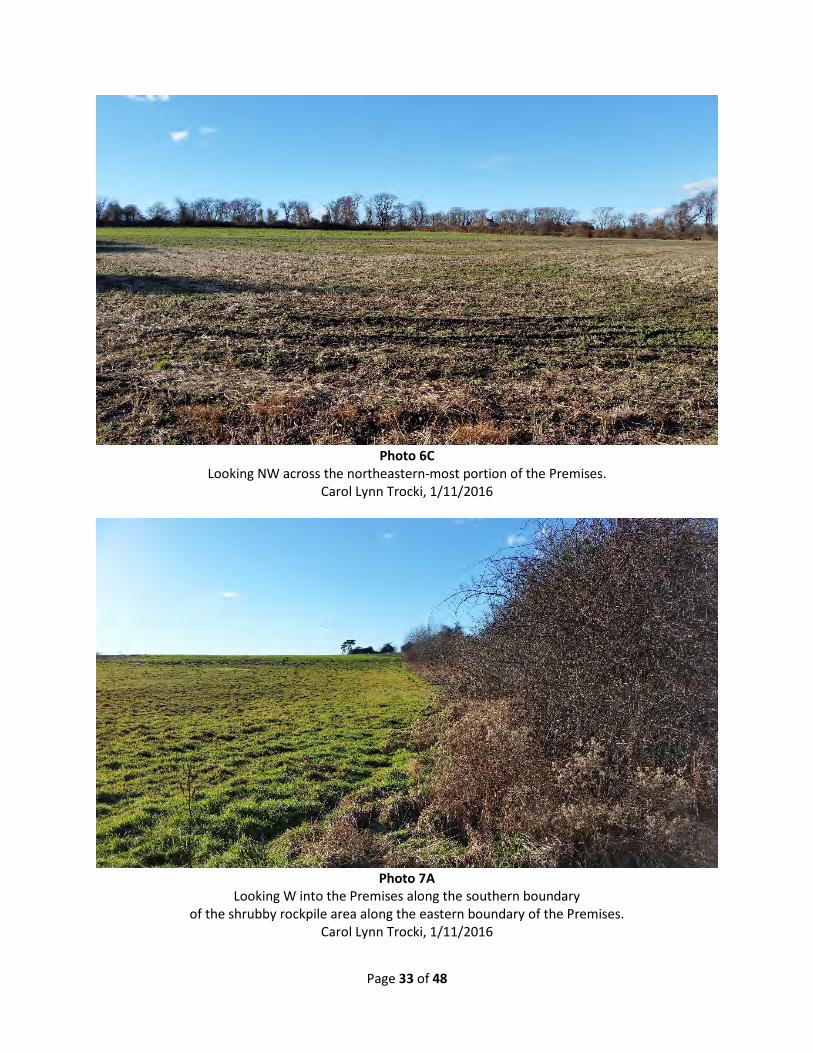
Photo 6C
Looking NW across the northeastern-most portion of the Premises. Carol Lynn Trocki, 1/11/2016
Photo 7A
Looking W into the Premises along the southern boundary of the shrubby rockpile area along the eastern boundary of the Premises.
Carol Lynn Trocki, 1/11/2016

Page 34 of 48
Photo 7B
Looking SSE along the eastern field boundary running just east of the eastern boundary of the Premises. Carol Lynn Trocki, 1/11/2016
Photo 7C
Looking SW into the southeastern portion of the Premises. Carol Lynn Trocki, 1/11/2016

Page 35 of 48
Photo 8A
Looking NNW along the eastern boundary of the Premises from the southeast corner. Carol Lynn Trocki, 1/11/2016
Photo 8B
Looking WSW along the southern boundary of the Premises from the southeast corner. Carol Lynn Trocki, 1/11/2016

Page 36 of 48
Photo 8C
Looking NW into the southeastern portion of the Premises from the southeast corner. Carol Lynn Trocki, 1/11/2016
Photo 9A
Looking ENE along the southern boundary of the Premises from the three-way stone wall intersection. Carol Lynn Trocki, 1/11/2016

Page 37 of 48
Photo 9B
Looking WSW along the southern boundary of the Premises from the three-way stone wall intersection. Carol Lynn Trocki, 1/11/2016
Photo 9C
Looking NNW into the Premises from the three-way stone wall intersection found along the southern boundary.
Carol Lynn Trocki, 1/11/2016

Page 38 of 48
Photo 10A
Looking NNE along the gas line cut out of the Premises from its intersection with the southern boundary. Carol Lynn Trocki, 1/11/2016
Photo 11A
Looking ENE along the southern boundary of the Premises from the southwest corner. Carol Lynn Trocki, 1/11/2016

Page 39 of 48
Photo 11B
Looking NNE along the western boundary of the Premises from the southwest corner. Carol Lynn Trocki, 1/11/2016
Photo 11C
Looking NE across the western portion of the Premises from the southwest corner. Carol Lynn Trocki, 1/11/2016

Page 40 of 48
Photo 12A
Looking SSW along the western boundary of the Premises from the westernmost northwest corner, near to the drive intersection with Old Main Road.
Carol Lynn Trocki, 1/11/2016
Photo 12B
Looking E along the westernmost portion of the northern boundary of the Premises, along the drive. Carol Lynn Trocki, 1/11/2016

Page 41 of 48
Photo 12C
Looking SE across the westernmost portion of the Premises from the westernmost northwest corner. Carol Lynn Trocki, 1/11/2016
Photo 13A
Looking SSW down the gas line cut out from the Premises, from the gas line marker along the drive. Carol Lynn Trocki, 1/11/2016

Page 42 of 48
Photo 13B
Looking W along the drive, back towards Old Main Road. Carol Lynn Trocki, 1/11/2016
Photo 13C
Looking E along the drive, towards Watson Reservoir. Carol Lynn Trocki, 1/11/2016

Page 43 of 48
Photo 13D Looking SE across the Premises from the gas line marker along the drive.
Carol Lynn Trocki, 1/11/2016
Photo 13E
Looking SW across the Premises from the gas line marker along the drive. Carol Lynn Trocki, 1/11/2016
Page 44 of 48
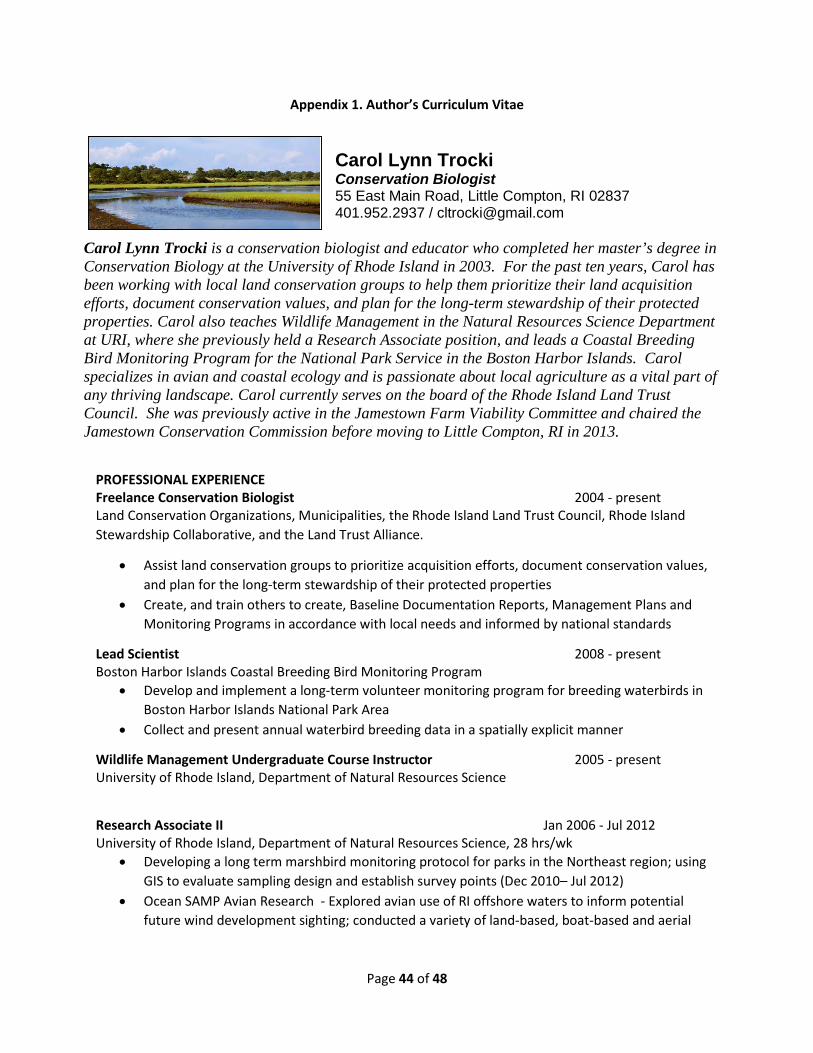
Appendix 1. Author’s Curriculum Vitae
Carol Lynn Trocki Conservation Biologist 55 East Main Road, Little Compton, RI 02837 401.952.2937 / [email protected]
Carol Lynn Trocki is a conservation biologist and educator who completed her master’s degree in Conservation Biology at the University of Rhode Island in 2003. For the past ten years, Carol has been working with local land conservation groups to help them prioritize their land acquisition efforts, document conservation values, and plan for the long-term stewardship of their protected properties. Carol also teaches Wildlife Management in the Natural Resources Science Department at URI, where she previously held a Research Associate position, and leads a Coastal Breeding Bird Monitoring Program for the National Park Service in the Boston Harbor Islands. Carol specializes in avian and coastal ecology and is passionate about local agriculture as a vital part of any thriving landscape. Carol currently serves on the board of the Rhode Island Land Trust Council. She was previously active in the Jamestown Farm Viability Committee and chaired the Jamestown Conservation Commission before moving to Little Compton, RI in 2013.
PROFESSIONAL EXPERIENCE Freelance Conservation Biologist 2004 - present Land Conservation Organizations, Municipalities, the Rhode Island Land Trust Council, Rhode Island Stewardship Collaborative, and the Land Trust Alliance.
• Assist land conservation groups to prioritize acquisition efforts, document conservation values, and plan for the long-term stewardship of their protected properties
• Create, and train others to create, Baseline Documentation Reports, Management Plans and Monitoring Programs in accordance with local needs and informed by national standards
Lead Scientist 2008 - present Boston Harbor Islands Coastal Breeding Bird Monitoring Program
• Develop and implement a long-term volunteer monitoring program for breeding waterbirds in Boston Harbor Islands National Park Area
• Collect and present annual waterbird breeding data in a spatially explicit manner
Wildlife Management Undergraduate Course Instructor 2005 - present University of Rhode Island, Department of Natural Resources Science
Research Associate II Jan 2006 - Jul 2012 University of Rhode Island, Department of Natural Resources Science, 28 hrs/wk
• Developing a long term marshbird monitoring protocol for parks in the Northeast region; using GIS to evaluate sampling design and establish survey points (Dec 2010– Jul 2012)
• Ocean SAMP Avian Research - Explored avian use of RI offshore waters to inform potential future wind development sighting; conducted a variety of land-based, boat-based and aerial

Page 45 of 48
surveys for offshore and coastal bird species; developed spatially explicit density surface models using Program DISTANCE and ArcGIS 9.3 (Jun 2009–Dec 2010)
• Developed a biotic synthesis report for Fire Island National Seashore; provided detailed species and habitat accounts and suggested management recommendations based on best available information and the scientific literature (Jan 2006–Jun 2009)
Contract Biologist 2005-2008 University of Rhode Island, Department of Environmental and Natural Resources Economics
• Worked with area farmers to better understand the effects of hayfield and cattle grazing on grassland nesting birds as part of an innovative experimental market for ecosystem services
• Conducted field surveys of breeding grassland birds on project area farm fields; developed occupancy models to explain the presence and absence of nest territories based on field characteristics and habitat variables
Contract Research Associate 2003-2007 University of Rhode Island, Department of Natural Resources Science
• Developed a coastal breeding bird monitoring protocol for Boston Harbor Islands National Park Area that uses volunteers for implementation (2007) based on inventory work done in 2003 and 2005-7; Conducted mammal, reptile, and amphibian inventory in Boston Harbor Islands National Park Area (2005, 2006)
• Created a spatially explicit grassland bird conservation strategy for Saratoga National Historical Park (2003 - 2005)
• Oversaw breeding season avian monitoring in the Northeast Temperate Network of the National Park Service; managed field crew, created survey protocol documentation, managed data, prepared final maps, report, and database documentation to NPS specifications (2003- 2004)
Avian Ecology Independent Contractor May 2005-2007 United States Environmental Protection Agency, Atlantic Ecology Division
• developed a grid-based model in ArcGIS to examine the spatial correlation of avian population declines and acid and mercury deposition in the eastern U.S.
Contract Biologist Nov 2004-2006 United States Geological Survey, Pawtuxent Wildlife Research Center, Approx 25hrs/wk
• Field sampled medium-sized mammals on Cape Cod National Seashore using a variety of methods for development of a monitoring protocol; established and located sampling points using GPS coordinates output from a stratified random sampling design; developed an occupancy model to assess the effects of various survey techniques and habitat variables
Stewardship / Trail Manager Jan 2004 – Nov 2004 Aquidneck Island Land Trust, Full Time
• Created Baseline Documentation Reports and Management Plans; provided input and support in determining the conservation value of prospective properties; designed and implemented a strategic conservation mapping project to identify conservation priorities on Aquidneck Island
• Stewarded and managed AILT-owned properties and trail projects; conducted annual monitoring visits on all properties, managed volunteer monitoring program, and maintained positive landowner relations
• Obtained an ESRI grant for GIS software for non-profit use; provided supporting maps

Page 46 of 48
Graduate Research Assistant 2001–2004 University of Rhode Island, Department of Natural Resources Science, 25-30 hrs/wk.
• Monitored wading bird use of salt marshes in southern Rhode Island during the breeding and the post-breeding season (2001 and 2002)
• Used photo-interpretation and GIS to create habitat maps of coastal wetland study sites • Acquired complete project funding through competitive small grants for field assistance and
travel • Mentored and supervised undergraduate field research assistants • Provided management recommendations to organizations and agencies interested in preserving
and restoring salt marshes and active agricultural lands for foraging wading bird use
Program Coordinator May 1999 - Jan 2003 University of Rhode Island, Coastal Fellows Program
• Mentored undergraduate research and outreach fellows, developed student opportunities, monitored student progress, and evaluated program success; developed and team-taught an undergraduate seminar in the communication and presentation of scientific research and outreach
Research Assistant May 1999 – Jan 2000 University of Rhode Island, Department of Natural Resources Science
• Conducted shorebird surveys of three coastal ponds in southern Rhode Island • Designed and carried out project protocol to meet Army Corps specifications, with a focus on
habitat use by endangered species • Responsible for data acquisition, entry and analysis, budget tracking, drafting final report and
presentation • Conducted research on avian community structure at a recently restored salt marsh in Galilee,
Rhode Island; Preformed point count surveys, spot-mapping, nest searching, and tracking of color-banded birds throughout the breeding season to correlate bird use to habitat change occurring with restoration
EDUCATION: University of Rhode Island, Kingston, RI Master of Science in Environmental Science, Wildlife and Conservation Biology, 2003 Bachelor of Science, Environmental Science and Management, with highest distinction, 1999 Bachelor of Science, Secondary Science Education, with highest distinction, 1999 COMMUNITY & VOLUNTEER ACTIVITIES: Rhode Island Land Trust Council, Board of Directors, 2011-present Jamestown Conservation Commission, 2004 –2013, Chair 2011-13 Jamestown Farm Viability Committee, 2003 - 2012 Rose Island Lighthouse Foundation, Board of Directors, 2003–09, Board President 2005-09
PUBLICATIONS:
Kristopher J. Winiarski, M. Louise Burt, Eric Rexstad, David L. Miller, Carol L. Trocki, Peter W. C. Paton, and Scott R. McWilliams (2014) Integrating aerial and ship surveys of marine birds into a combined

Page 47 of 48
density surface model: A case study of wintering Common Loons. The Condor: May 2014, Vol. 116, No. 2, pp. 149-161.
Trocki, C. L., B. R. Mitchell, and P. W. C. Paton. 2013. Coastal breeding bird monitoring protocol for Boston Harbor Islands National Recreation Area: 2013 revision. Natural Resource Report NPS/NETN/NRR—2013/646. National Park Service, Fort Collins, Colorado.
Trocki, C. L. 2013. Boston Harbor Islands National Recreation Area coastal breeding bird monitoring: 2012 field season summary. Natural Resource Technical Report NPS/NETN/NRTR—2013/737. National Park Service, Fort Collins, Colorado.
Trocki CL. 2012. Coastal breeding bird monitoring in Boston Harbor Islands National Recreation Area: Northeast Temperate Network 2011 summary report. Natural Resource Technical Report. NPS/NETN/NRTR—2012/595. National Park Service. Fort Collins, Colorado. Published Report-2186044.
Trocki, C. L. 2011. Boston Harbor Islands National Recreation Area coastal breeding bird monitoring: 2010 field season summary. Natural Resource Technical Report NPS/NETN/NRTR—2011/459. National Park Service, Fort Collins, Colorado.
Trocki, C. L., B. R. Mitchell, and P. W. C. Paton. 2011. Coastal breeding bird monitoring protocol for Boston Harbor Islands National Recreation Area: 2011 Revision. Natural Resource Report NPS/NETN/NRR—2011/417. National Park Service, Fort Collins, Colorado.
Trocki CL. 2011. Biotic synthesis of Fire Island National Seashore. National Park Service, Natural Resoucre Program Center. Fort Collins, Colorado. Natural Resource Report. NPS/NCBN/NRR—2011/292. Published Report-2167695.
Trocki, C. L. 2011. Boston Harbor Islands National Recreation Area coastal breeding bird monitoring: 2010 field season summary. Natural Resource Technical Report NPS/NETN/NRTR—2011/459. National Park Service. Fort Collins, CO.
Paton, P., K. Winiarski, C. Trocki, and S. McWilliams. 2010. Spatial Distribution, Abundance, and Flight Ecology of Birds in Nearshore and Offshore Waters of Rhode Island, Interim Technical Report for the Rhode Island Ocean Special Area Management Plan. Rhode Island Coastal Resources Management Council, Providence, RI.
Trocki, C., B. Mitchell, and P. Paton. 2010. Coastal breeding bird monitoring protocol for Boston Harbor Islands National Recreation Area: Northeast Temperate Network. Natural Resource Report NPS/NETN/NRR—2010/176. National Park Service, Fort Collins, Colorado.
Trocki, C. L. 2010. Boston Harbor Islands National Recreation Area coastal breeding bird monitoring: 2009 field season summary. Natural Resource Technical Report NPS/NETN/NRTR—2010/336. National Park Service. Fort Collins, CO.
Trocki, C. L. 2009. Boston Harbor Islands Coastal Breeding Bird Monitoring 2008 Field Season Summary. Natural Resources Report NPS/NETN/NRTR—2009/209. National Park Service. Fort Collins, CO.
Trocki, C. L. 2008. Coastal breeding bird monitoring in the Boston Harbor Islands. Bird Observer 36(6).

Page 48 of 48
Trocki, C. L. and P. C. W. Paton. October 2007. Boston Harbor Islands Coastal Breeding Bird Monitoring 2007 Field Season Summary. Natural Resources Report NPS/NER/NRR—2007/016. National Park Service. Northeast Region. Boston, MA.
Trocki, C. L. and P. C. W. Paton. August 2007. Study Design for Assessing the Effects of Knapweed Control on Grassland Birds at Saratoga National Historic Park. Natural Resources Report NPS/NER/NRR – 2007/015. National Park Service. Northeast Region. Boston, MA.
Trocki, C. L., N. W. Talancy, and P. C. W. Paton. August 2007. An Inventory of Amphibians, Reptiles, Nonvolant Mammals, and Select Bird Species on Islands in Boston Harbor. Technical Report NPS/NER/NRTR – 2007/094. National Park Service. Northeast Region. Boston, MA.
Trocki, C. L. and P. C. W. Paton. 2006. Assessing habitat selection by foraging egrets in salt marshes at multiple spatial scales. Wetlands 26(2):307-312.
Trocki, C. L. and P. C. W. Paton. 2006. Comparison of two foraging habitats used by Glossy Ibis during the breeding season in Rhode Island. Northeastern Naturalist 13(1):93-102.
Paton, P. W. C., R. J. Harris, and C. L. Trocki. 2005. Distribution and Abundance of Birds during the Breeding Season in Boston Harbor. Northeastern Naturalist. 12 (Special Issue 3):145-168.
Trocki, C. L. and P. C. W. Paton. March 2005. Developing a Conservation Strategy for Grassland Birds at Saratoga National Historical Park. Natural Resources Report NPS/NER/NRR—2005/004. National Park Service. Boston, MA.
Trocki, C. L. and P. C. W. Paton. December 2003. Avian Surveys in the Northeast Temperate Network Parks. Technical Report NPS/NER/NRTR – 2005/004. National Park Service. Woodstock, VT.
Trocki, C. L. Patterns of Salt Marsh and Farmland Use by Wading Birds in Southern Rhode Island. Master of Science Thesis – University of Rhode Island. 2003.