Embed Size (px)
Citation preview
ARTICLE IN PRESSS1631-0713(04)00310-4/FLA AID:318 Vol.•••(•••) [DTD5] P.1 (1-19)CRAS2A:m3 v 1.30 Prn:19/11/2004; 10:42 cras2a318 by:violeta p. 1
/
1 49
2 50
3 51
4 52
5 53
6 54
7 55
8 56
9 57
10 58
11 59
12 60
13 61
14 62
15 63
16 64
17 65
18 66
19 67
20 68
21 69
22 70
23 71
24 72
25 73
26 74
27 75
28 76
29 77
30 78
31 79
32 80
33 81
34 82
35 83
36 84
37 85
38 86
39 87
40 88
41 89
42 90
43 91
44 92
45 93
46 94
47
48
n the
l dynam-s; thirdly,alidentifiesof climate
enher partsand, ande,the-od statis-t
turedlocalizedment
ame in all
ntd-e
COR
RE
CTE
D P
RO
OF
C. R. Geoscience••• (••••) •••–•••http://france.elsevier.com/direct/CRAS2A
External geophysics, Climate and Environment
Climate, hydrology, land use, and environmental degradation ilower Rhone Valley during the Roman period
Sander E. van der Leeuw∗, The ARCHAEOMEDES research team1
Department of Anthropology, Arizona State University, PO Box 872402, Tempe, AZ 85287–2402, USA
Received 15 May 2004; accepted 17 October 2004
Written on invitation of the Editorial Board
Abstract
This paper’s aims are three: firstly, to demonstrate the importance of a long-term perspective on socio-environmentaics; secondly, to show the relevance of archaeological data in constructing such a long-term history of such dynamicto illustrate with a case study how one may identify the component processes of environmental change from archaeologicmaterials. Taking the Roman occupation of the middle and lower Rhone Valley as a point of departure, the papersome of the processes of regional environmental change. Firstly, it demonstrates the existence of a regional phasedegradation during the 2nd centuryAD. It is in all probability of anthropogenic origin. This degradation seems to have becaused by widespread deforestation in preparation for intensive cultivation of cereals, wine and olives for export to otof the Roman Empire. Next, it isolates the principal interactions occurring between relief, soils, and water on the one hthe societal dynamics on the other. The location of each settlement is considered representative of an environmental choicmade by its founders at the time the settlement is initiated. These environmental choices, in turn, reflect the perception oflandscape and its resources by the settlers. The principal indicators at our disposal for this studyare the relief, soil, and hydrological maps. They are used as a basis for the calculation of the altitude, slope, orientation, annual solar radiation, exposure tthe prevailing winds, and fertility of the soil of all sites and their environment. Subsequently, preferences are calculatetically based on the 1000-odd settlements concerned. The third part of the paper concernsthe evolution of the sites. It turns outhat the earlier ones are the most successful, in part because theyoccupied the best locations, but also because they structhe landscape and the territory to their advantage, determined the road network, and were the first to lay hands onresources. Eighty percent of the total number of sites is abandoned in less than 200 years. The reasons for that abandonare not to be sought in any kind of environmental degradation, as the proportion of abandoned sites is about the s
* Corresponding author.E-mail address: [email protected](S.E. van der Leeuw).
1 The ARCHAEOMEDES project on the Ancient Middle and Lower Rhone Valley brought together a large number of colleagues in differeconfigurations. Notably, I would like to thank the following for their contributions: Françoise Audouze, Jean-François Berger, François DuranDastès, François Favory, Jean-Luc Fiches, Michiel Gazenbeek, Jean-Jacques Girardot, Hélène Mathian, Laure Nuninger, Thierry Odiot, DenisPumain, Claude Raynaud, Lena Sanders, François-Pierre Tourneux, Philippe Verhagen, and Marie-Pierre Zannier.
UN 95
961631-0713/$ – see front matter 2004 Published by Elsevier SAS on behalf of Académie des sciences.doi:10.1016/j.crte.2004.10.018

ARTICLE IN PRESSS1631-0713(04)00310-4/FLA AID:318 Vol.•••(•••) [DTD5] P.2 (1-19)CRAS2A:m3 v 1.30 Prn:19/11/2004; 10:42 cras2a318 by:violeta p. 2
2 S.E. van der Leeuw, The ARCHAEOMEDES research team / C. R. Geoscience ••• (••••) •••–•••
1 49
2 50
3 51
4 52
5 53
6 54
7 55
8 56
9 57
10 58
11 59
12 60
13 61
14 62
15 63
16 64
17 65
18 66
19 67
20 68
21 69
22 70
23 71
24 72
25 73
26 74
27 75
28 76
29 77
30 78
31 79
32 80
33 81
34 82
35 83
36 84
37 85
38 86
39 87
40 88
41 89
42 90
43 91
44 92
45 93
46 94
47
48
creasinglytoentsast landtime
rsure that itrms
te de laées archéo-s ;.quelques-neux dé-
, commecipalesue habitatressources
ef,,s
rtietaient lesri-essourcesLes raisonsmble plutôtgricultureonomiquessibles. Lau Tricastin,ècle avantultueuse.
t qu’il n’yent qui enAinsi, une
CO
RR
EC
TE
D P
RO
OF
landscapes. Rather, they seem to have to do with a reorganization of the settlement pattern after some 100 years of inintensive agro-industry. This reorganization is triggered by a combination of economic and political events that come closedestabilizing the Empire. Settlement size and accessibility are themain determinants of survival. The exact nature of the evleading up to this re-structuration differs from region to region. In the case of the Tricastin, the Emperor undertook a vreclamation project in the first centuryBC. He used it to retire soldiers from the many legions that were active around theof the birth of Christ. However, the peace of the early decades of the first centuryAD abruptly reduced the number of soldieto be retired. Hence, the orthogonal, Roman drainage system could no longer be maintained sufficiently well, to ensfunctioned correctly. As a result, the surface available for cultivation, and the yield per hectare, fell drastically, and many fawere deserted.To cite this article: S.E. van der Leeuw, The ARCHAEOMEDES research team, C. R. Geoscience ••• (••••). 2004 Published by Elsevier SAS on behalf of Académie des sciences.
Résumé
Climat, hydrologie, exploitation des sols et dégradation de l’environnement dans la basse vallée du Rhône à l’époqueromaine. Les objectifs de cette contribution sont triples : en premier lieu, démontrer l’importance d’une prise en comptrès longue durée quand on étudie des dynamiques socio-environnementales ; ensuite, montrer à quel point les donnlogiques sont en effet capables de nous procurer l’information nécessaire pour reconstituer lalongue durée de ces dynamiqueenfin, illustrer par une étude de cas comment on peut identifier les processus quieffectuent des changements environnementauxEn prenant comme exemple l’occupation romaine de la moyenne et basse vallée du Rhône, cette contribution identifieuns des processus responsables du changement de l’environnement dans la région. En premier lieu, il s’agit de l’existence d’uphase de dégradation climatique au IIe siècle après J.-C. En toute probabilité, cet épisode est d’origine anthropique, dû aforestations importantes qui ont préparé la région pour la production, à l’échelle industrielle, de produits agricolesle blé, le vin et l’huile d’olive, pour l’exportation vers d’autres régions de l’Empire. Ensuite, nous avons isolé les prininteractions entre le relief, les sols et l’eau, d’un côté, et les dynamiques sociétales, de l’autre. La localisation de chaqest considérée comme indiquant un choix fait par ses fondateurs. Ces choix reflètent la perception du paysage et despar les premiers colonisateurs. Les principaux indicateurs que nous avons pour reconstituer ces choix sont les cartes du relides sols et de l’hydrologie. À partir de ces cartes, nous avons calculé l’altitude, la pente, l’orientation, la radiation solairel’exposition aux vents dominants et la fertilité des sols de chaque lieu et de son environnement. Ensuite, nous avons calculé lepréférences de la population de manière statistique, en se basant surun échantillon de presque 1000 sites. La troisième pade l’article concerne l’évolution des habitats. Il s’avère que les premiers habitats établis dans le nouveau territoire éplus résilients. Leurs habitants occupaientles meilleurs sites, et ils avaient eu l’occasion de structurer leur paysage et leur tertoire avant l’arrivée d’autres colonisateurs. En outre, ils construisaient un réseau routier et mettaient la main sur les rlocalisées. Quatre-vingts pour cent des habitats ont été abandonnés moins de deux siècles après leur fondation.pour cet abandon ne sont pas d’ordre environnemental, car leur proportion est la même dans tous les paysages. Il seque ces abandons font partie d’une restructuration du système de peuplement et d’exploitation, après un siècle d’ade plus en plus intensive et commerciale. Cette réorganisation fut déclenchée par une combinaison d’évènements écet politiques qui a ébranlé l’Empire. Les habitats qui ont survécu sont en général les plus grands et les plus accesnature exacte des événements qui ont conduit à ce bouleversement était différente selon les régions. Dans le cas dl’Empereur avait entrepris un vaste projet de défrichement dans cette région dans le quatrième quart du premier siJ.-C. Il servait à procurer un lopin de terre à tous les légionnaires qui atteignaient l’âge de la retraite à cette époque tumUne fois la paix rétablie au début de notre ère, l’afflux de soldats à la retraite s’est arrêté. Une des conséquences fuavait plus assez de main d’œuvre pour maintenir le système orthogonal de drainage romain en l’état. Le délabremétait la conséquence inévitable réduisait fortement la surface cultivable ainsi que le rendement agricole des terres.partie importante des fermes n’était plus rentable, et leurs habitants les ont quittés.Pour citer cet article : S.E. van der Leeuw,The ARCHAEOMEDES research team, C. R. Geoscience ••• (••••). 2004 Published by Elsevier SAS on behalf of Académie des sciences.
Keywords: Environmental degradation; Climate change; Socio-environmental co-evolution; Land abandonment
Mots-clés : Dégradation environnementale ; Changement de climat ; Co-évolution société–environnement ; Abandon des terres
N 95
96
U
ARTICLE IN PRESS
EC
S1631-0713(04)00310-4/FLA AID:318 Vol.•••(•••) [DTD5] P.3 (1-19)CRAS2A:m3 v 1.30 Prn:19/11/2004; 10:42 cras2a318 by:violeta p. 3
S.E. van der Leeuw, The ARCHAEOMEDES research team / C. R. Geoscience ••• (••••) •••–••• 3
1 49
2 50
3 51
4 52
5 53
6 54
7 55
8 56
9 57
10 58
11 59
12 60
13 61
14 62
15 63
16 64
17 65
18 66
19 67
20 68
21 69
22 70
23 71
24 72
25 73
26 74
27 75
28 76
29 77
30 78
31 79
32 80
33 81
34 82
35 83
36 84
37 85
38 86
39 87
40 88
41 89
42 90
43 91
44 92
45 93
46 94
47 95
48 96
t of0 byndasindayng-ap-
co-
nntalns,h is
ithen
georm-
andfewnt;sody-ares toda-toon-ics
inedne
rchrds”
and–ed9).nis,rded
le ifur-of
riesatle
ikeer-nly
utaler-dyceerfor-ano-ent
n-of
m-gedofan-
e-the
hiftust
ap-
ol-ted’-
achtingre,
the
ns,
NCOR
R
1. Introduction: the ARCHAEOMEDES Project
The case study presented in this paper is parthe research undertaken between 1992 and 200a multi-national, multi-disciplinary team on (past apresent) land degradation in the Mediterranean B[24]. Its aim was to better understand present-land degradation in the area by investigating the loterm dynamics of this process from a ‘complex adtive systems’ perspective[13,14,25]that integrates thestudy of the natural and the socio-cultural and enomic dynamics in a single approach2 [20,21].
A major raison d’être for the present study lies ithe fact that most of the research on environmedegradation is concerned with very short time-spaof up to a century at most. As a result, the approacinadequate in a number of different ways:
• degradation is often a long-term process, wslow, cumulative phases, but also with suddaccelerations or decelerations. The typical time-scales of the natural dynamics involved ranfrom thousands of years (tectonics) to fivesix hours (weather patterns). The social dynaics operate on the scale of millennia, centuriesdecades. Measurement and monitoring over ayears, or even a few decades, is thus insufficie
• most processes involve multiple time-scales,that the chances that the same conjunction ofnamics occurs twice or even more frequentlyvery slim indeed. Studying the present amountstudying only one particular instance of degration, while studying the long term allows oneobserve many more in the same geographical ctext, so that one may begin to model the dynaminvolved in more general terms[21];
• as degradation processes are spatially constraby other elements of landscape formation, o
2 Programme initiated in 1992, with the support of DG Reseaof the European Union (as part of the “Climate and natural hazatopic, under RTD Framework III),addressing our“Understandingof Natural and Anthropogenic Causes of Desertification and LDegradation in the Mediterranean Basin” (contracts ENV5V-CT910021, ERBEV5V-CT91–0021, EV5V-CT94–0486), and continuuntil 2000 under RTD Framework IV (contract ENV4-CT95–015We would like to express our heartfelt gratitude to P. BalabaA. Liberatore and, notably, D. Peter for the trust they have accoto our team.
U
TE
D P
RO
OF
needs to understand the landscape as a whoone is to credibly understand the spatial occrence of degradation. The spatial organizationany landscape is the cumulative result of a seof different kinds of dynamics imposed on itdifferent times. A landscape is thus like a multipexposure photograph, or in historical terms, la palimpsest which shows remains of many diffent kinds of dynamics. Hence, landscapes are oexplicable by investigating the very long term;
• investigating degradation in isolation, withoplacing it in the context of wider environmentand social dynamics, is like attempting to undstand the normal functioning of a human boentirely by examining the sick. We need to plathe study of degradation in the context of othphases of landscape formation, such as soilmation, expansion of the vegetation, and humbehavior that does not result in degradation. Ding that on the basis of data concerning the presalone is impossible;
• finally, our investigation should not only be cocerned with change, but also with the changechange – the way in which the dynamics theselves (and not only their results) have chanover time. The rise of urbanism is only onethe manifestations of a balance in which huminduced processes operating on shorter timscales have steadily been gaining ground over(slower) processes occurring in nature. That shas had profound consequences, which we munderstand if we are ever to evaluate what hpened at any specific point in time.
2. Identifying the component processes ofenvironmental change
In the second half of the twentieth century, schars in many countries and disciplines have ‘negotiaa communis opinio that there is a ‘crisis’ in the second and third centuriesAD. But if one looks moreclosely at the arguments, they are different in ecase, describing different phenomena and attributhese to different causes. In a review of the literatuProvost[22] cites as causes fluctuations in climate,exhaustion of soils, the plague, the end of thePax Ro-mana as evidenced by renewed Germanic migratio
ARTICLE IN PRESS
EC
S1631-0713(04)00310-4/FLA AID:318 Vol.•••(•••) [DTD5] P.4 (1-19)CRAS2A:m3 v 1.30 Prn:19/11/2004; 10:42 cras2a318 by:violeta p. 4
4 S.E. van der Leeuw, The ARCHAEOMEDES research team / C. R. Geoscience ••• (••••) •••–•••
1 49
2 50
3 51
4 52
5 53
6 54
7 55
8 56
9 57
10 58
11 59
12 60
13 61
14 62
15 63
16 64
17 65
18 66
19 67
20 68
21 69
22 70
23 71
24 72
25 73
26 74
27 75
28 76
29 77
30 78
31 79
32 80
33 81
34 82
35 83
36 84
37 85
38 86
39 87
40 88
41 89
42 90
43 91
44 92
45 93
46 94
47 95
48 96
rsud-lexin-
ils,mic
om”,
-in
im,em-ifespec-nd
,nsiateoc-
inetes
olu-ur-mnsasl-of
-eseari-tifydere-
of-
oft.
ientr is
on-eg-ichpu-edof
ing
enr andul-d istriodsy beible
le,thesub-ineseil-
enent
theon-
n-o-thely
hole.rtic-rst
enichndgerse ofes
neo-
NCO
RR
the beginnings of Anglo-Saxon piracy, and civil wain Gaul. Others have cited yet different causes, incling massive lead poisoning. By adopting a ‘compadaptive systems’ perspective, and looking at theteraction between geology, climate, hydrology, sovegetation, fauna, human settlement pattern, econoand social dynamics, we have tried to move away frany form of determinism in explaining this “crisisand thus to gain a deeper insight into it.3
In practice, this implies identifying the main components of the complex dynamic that is reflectedthe evolution of the landscape. To achieve that awe have focused on the differences in spatial and tporal scale at which the component processes manthemselves. This has enabled us to identify the restive roles of climate, relief, soils, human land use ahuman settlement pattern.
2.1. Climate and its impact
The Rhone Valley (Fig. 1) stretches north–southand therefore forms a natural transect across the tration zone between the circum–Mediterranean climand more temperate ones. A complicating, and oncasion equilibrating, influence is exerted by the Alpclimate zone to the east of the valley, which oscillawith a different rhythm.
Our first concern has been to reconstruct the evtion of the paleo-climate of the region. For that ppose, we have analyzed around a hundred coluof soil taken from around 40 km of trenches dugpart of various civil engineering projects in the Vadaine (a region on the left bank of the Rhone, southLyon). The full vertical profile of the soil was impregnated with resin, and large thin-sections cut from thsamples. By submitting these thin-sections to a vety of analytical techniques, it was possible to identhe materials involved, as well as the conditions unwhich the different layers of material had been dposited, eroded or transformed into soils[12]. Othertechniques allowed us to identify different remainsthe vegetation (pollen, charcoal), micro-fauna (landsnails, insects) and other indicators of the evolutionthe climatic conditions and the natural environmen
3 For a more ample discussion of the results of the AncRhône Valley part of the ARCHAEOMEDES project, the readereferred to[26].
U
TE
D P
RO
OF
t
-
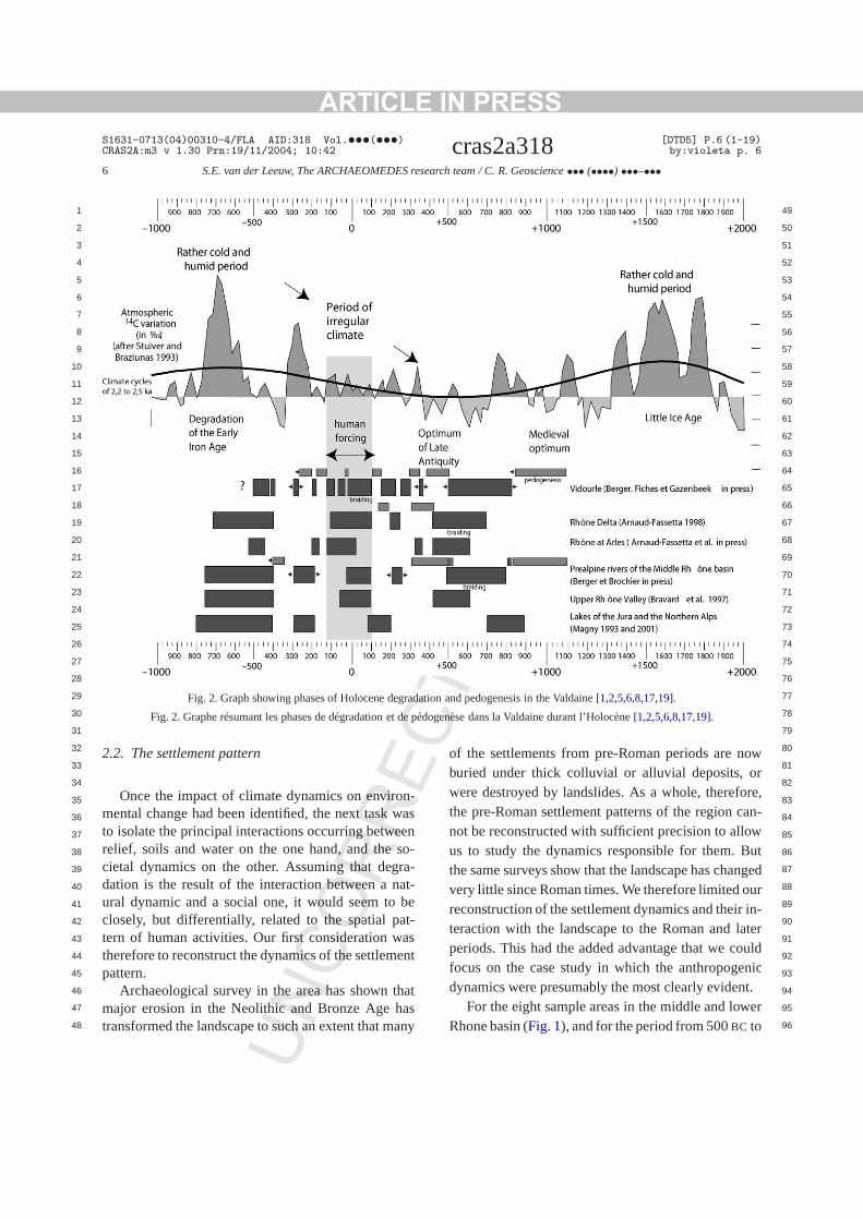
The evidence seems to point to a complex relatiship between changes in climate, variations in the vetation, and human impact on the landscape, in whtime delays and the technical means of human polations play an important role. Our analyses providstrong indications for a number of major phasesdegradation and erosion in the Rhone Valley durthe Holocene (Fig. 2).
For the earlier part of the period, it seems that whagro-pastoral pressure, degradation of the weathedegradation of the vegetation cover all occur simtaneously, the reaction in the sedimentary recoralmost immediate (at the scale of the Holocene). Buwhen they are out of phase, delays appear and peof heavy human pressure on the environment maless visible than one would expect, or become visonly much later.
From the middle Neolithic onwards, for examphuman action gains in importance for the state ofvegetation, and the landscape itself is much moreject to even minor climatic oscillations, notablyhumidity and in seasonal contrast. But because thdynamics are out of phase, they result in several mlennia in which there are important delays betwephases of agro-pastoral pressure on the environm(as registered in the paleo-botanical record) anderosion that is the response of the physical envirment in the appropriate areas.
Towards the end of the period (in the last millenium or two) on the other hand, the different compnent processes are so tightly interconnected thatslightest oscillation in one or the other immediatehas important consequences for the system as a w
Three of the observed erosion episodes are paularly extensive both in space and in time. The fioccurred at the end of the Neolithic (ca. 4000BC), af-ter the first wave of human expansion, which is drivby the introduction of agriculture. The second, whis attributable to a combination of human impact aclimate change, followed at the end of the Bronze A(ca. 2000BC). The third, in the Roman period, occusubsequent to a complete change in the structuragriculture that was initiated around the middle of thfirst millenniumBC with the introduction of new cropand new agricultural techniques.
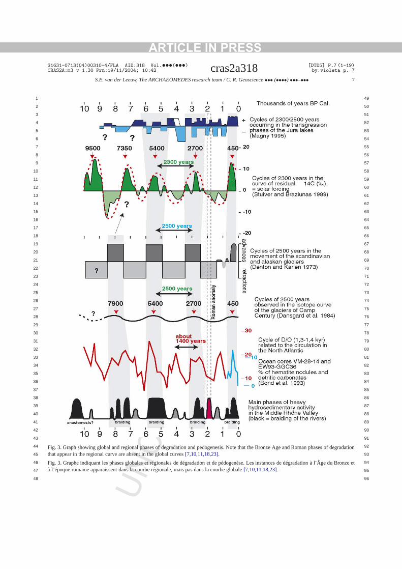
Comparing (cf.Fig. 3) this information with theglobal evolution of climate during the Holocene, oimmediately remarks that the Bronze Age and R
ARTICLE IN PRESSS1631-0713(04)00310-4/FLA AID:318 Vol.•••(•••) [DTD5] P.5 (1-19)CRAS2A:m3 v 1.30 Prn:19/11/2004; 10:42 cras2a318 by:violeta p. 5
S.E. van der Leeuw, The ARCHAEOMEDES research team / C. R. Geoscience ••• (••••) •••–••• 5
1 49
2 50
3 51
4 52
5 53
6 54
7 55
8 56
9 57
10 58
11 59
12 60
13 61
14 62
15 63
16 64
17 65
18 66
19 67
20 68
21 69
22 70
23 71
24 72
25 73
26 74
27 75
28 76
29 77
30 78
31 79
32 80
33 81
34 82
35 83
36 84
37 85
38 86
39 87
40 88
41 89
42
43
44
45
46
47
48
RR
EC
TE
D P
RO
OF
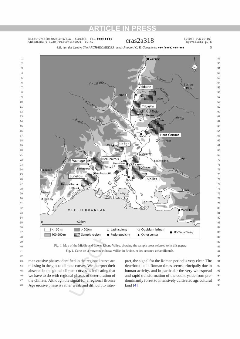
Fig. 1. Map of the Middle and Lower Rhone Valley, showing the sample areas referred to in this paper.
Fig. 1. Carte de la moyenne et basse vallée du Rhône, et des secteurs échantillonnés.
90
91
92
93
94
95
96
areeirthat
ofzeer-
heto
adre-al
NCOman erosive phases identified in the regional curve
missing in the global climate curves. We interpret thabsence in the global climate curves as indicatingwe have to do with regional phases of deteriorationthe climate. Although the signal for a regional BronAge erosive phase is rather weak and difficult to int
U
pret, the signal for the Roman period is very clear. Tdeterioration in Roman times seems principally duehuman activity, and in particular the very widespreand rapid transformation of the countryside from pdominantly forest to intensively cultivated agriculturland[4].
ARTICLE IN PRESSS1631-0713(04)00310-4/FLA AID:318 Vol.•••(•••) [DTD5] P.6 (1-19)CRAS2A:m3 v 1.30 Prn:19/11/2004; 10:42 cras2a318 by:violeta p. 6
6 S.E. van der Leeuw, The ARCHAEOMEDES research team / C. R. Geoscience ••• (••••) •••–•••
1 49
2 50
3 51
4 52
5 53
6 54
7 55
8 56
9 57
10 58
11 59
12 60
13 61
14 62
15 63
16 64
17 65
18 66
19 67
20 68
21 69
22 70
23 71
24 72
25 73
26 74
27 75
28 76
29 77
30 78
31
32
33
34
35
36
37
38
39
40
41
42
43
44
45
46
47
48
TE
D P
RO
OF
Fig. 2. Graph showing phases of Holocene degradation and pedogenesis in the Valdaine[1,2,5,6,8,17,19].
Fig. 2. Graphe résumant les phases de dégradation et de pédogenèse dans la Valdaine durant l’Holocène[1,2,5,6,8,17,19].
EC 79
80
81
82
83
84
85
86
87
88
89
90
91
92
93
94
95
96
n-wasenso-ra-at-be
at-asent
hatasany
oworore,an-
owButngedurin-
aterouldnict.
wer
NCOR
R
2.2. The settlement pattern
Once the impact of climate dynamics on enviromental change had been identified, the next taskto isolate the principal interactions occurring betwerelief, soils and water on the one hand, and thecietal dynamics on the other. Assuming that degdation is the result of the interaction between a nural dynamic and a social one, it would seem toclosely, but differentially, related to the spatial ptern of human activities. Our first consideration wtherefore to reconstruct the dynamics of the settlempattern.
Archaeological survey in the area has shown tmajor erosion in the Neolithic and Bronze Age htransformed the landscape to such an extent that m
U
of the settlements from pre-Roman periods are nburied under thick colluvial or alluvial deposits,were destroyed by landslides. As a whole, therefthe pre-Roman settlement patterns of the region cnot be reconstructed with sufficient precision to allus to study the dynamics responsible for them.the same surveys show that the landscape has chavery little since Roman times. We therefore limited oreconstruction of the settlement dynamics and theirteraction with the landscape to the Roman and lperiods. This had the added advantage that we cfocus on the case study in which the anthropogedynamics were presumably the most clearly eviden
For the eight sample areas in the middle and loRhone basin (Fig. 1), and for the period from 500BC to
ARTICLE IN PRESSS1631-0713(04)00310-4/FLA AID:318 Vol.•••(•••) [DTD5] P.7 (1-19)CRAS2A:m3 v 1.30 Prn:19/11/2004; 10:42 cras2a318 by:violeta p. 7
S.E. van der Leeuw, The ARCHAEOMEDES research team / C. R. Geoscience ••• (••••) •••–••• 7
1 49
2 50
3 51
4 52
5 53
6 54
7 55
8 56
9 57
10 58
11 59
12 60
13 61
14 62
15 63
16 64
17 65
18 66
19 67
20 68
21 69
22 70
23 71
24 72
25 73
26 74
27 75
28 76
29 77
30 78
31 79
32 80
33 81
34 82
35 83
36 84
37 85
38 86
39 87
40 88
41 89
42 90
43 91
44 92
45 93
46 94
47 95
48 96
tion
et
NCOR
RE
CTE
D P
RO
OF
Fig. 3. Graph showing global and regional phases of degradation and pedogenesis. Note that the Bronze Age and Roman phases of degradathat appear in the regional curve are absent in the global curves[7,10,11,18,23].
Fig. 3. Graphe indiquant lesphases globales et régionales de dégradation et de pédogenèse. Les instancesde dégradation à l’Âge du Bronzeà l’époque romaine apparaissent dans la courberégionale, mais pas dans la courbe globale[7,10,11,18,23].
U

ARTICLE IN PRESS
EC
S1631-0713(04)00310-4/FLA AID:318 Vol.•••(•••) [DTD5] P.8 (1-19)CRAS2A:m3 v 1.30 Prn:19/11/2004; 10:42 cras2a318 by:violeta p. 8
8 S.E. van der Leeuw, The ARCHAEOMEDES research team / C. R. Geoscience ••• (••••) •••–•••
1 49
2 50
3 51
4 52
5 53
6 54
7 55
8 56
9 57
10 58
11 59
12 60
13 61
14 62
15 63
16 64
17 65
18 66
19 67
20 68
21 69
22 70
23 71
24 72
25 73
26 74
27 75
28 76
29 77
30 78
31 79
32 80
33 81
34 82
35 83
36 84
37 85
38 86
39 87
40 88
41 89
42 90
43 91
44 92
45 93
46 94
47 95
48 96
on,re
ebantheivepe.nd
andnts
how
l-ofellet-ason-
stepiefndsd aycoschthearly
capeforend-ling
ion,ail-ntsata
, theca.
at-’.areentpo-gy(forim-
tiveddidgi-ifiedin
ntsg a
usttionsvar-iatendor-
heenso,).
ichas-
eryldlo-the
de-0-m
ton
rom
-iation
NCO
RR
600AD,4 we thus proceeded to determine the locatiperiod of occupation, size and function of the (mothan 900) settlements found.
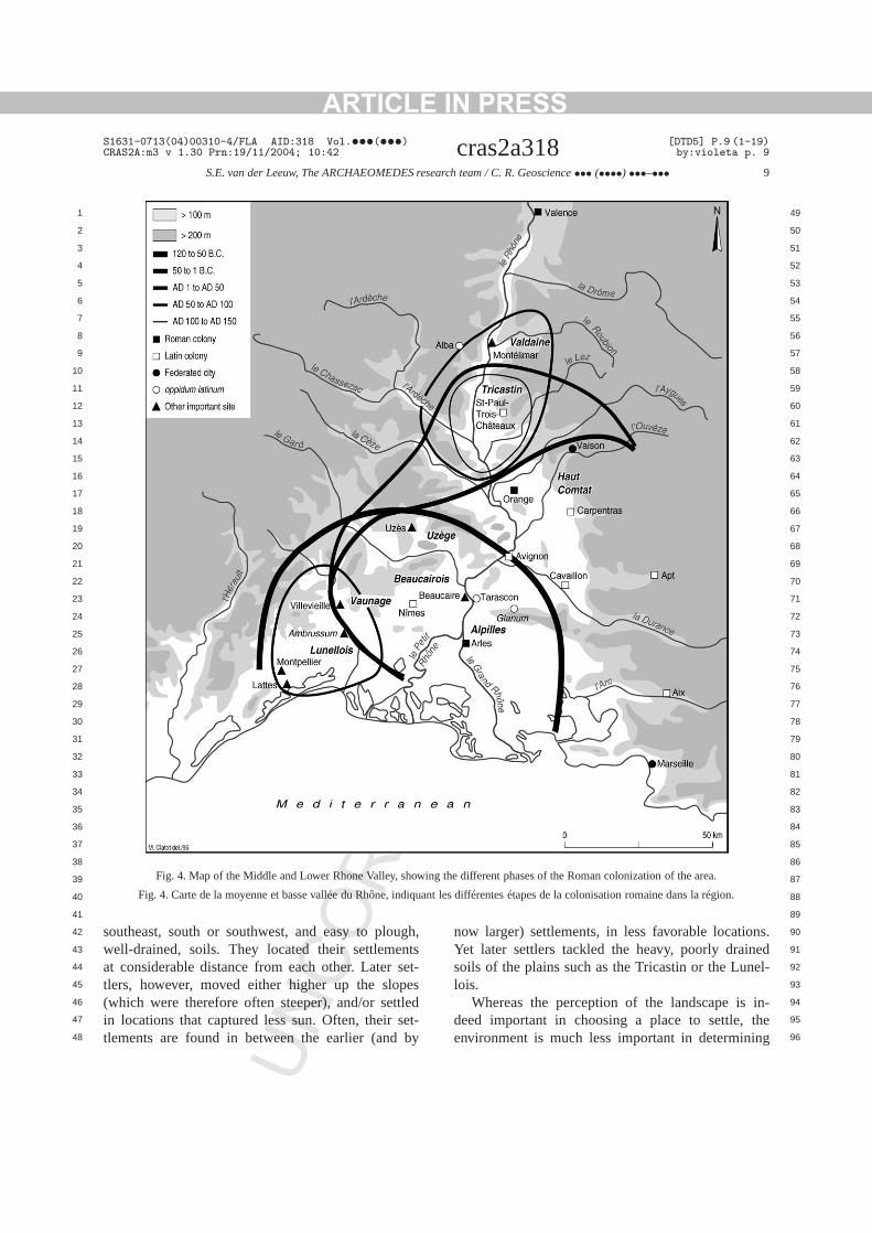
At the regional level, this allowed us to identify thmajor phases of Roman settlement creation and adonment of the area in time and space, while atlocal level it pinpointed the areas of direct intensinteraction between human activity and the landscaThe principal wave of Roman colonization spread lainward from the area around Marseille (Fig. 4), be-tween about 100BC and AD 150 (Fig. 5). Then, thefoundation of new settlements abruptly ceased,over the next two centuries, the number of settlemein use declined. Some of the deserted areas wereever re-settled in the 4th, 5th and 6th centuriesAD.
At the local level, we were able to quantify the reative impact of Roman colonization on the densitysettlements in the different sampling areas, as was to study the spatial configuration of Roman stlements throughout the period. This information wparticularly important when projected against a recstruction of the natural dynamics of the landscape.
2.3. The relief and the soils and their relation to thesettlement pattern
To understand those natural dynamics, the nextwas the reconstruction of the evolution of the relin the area. Normally, such reconstruction demahighly intensive and costly geophysical survey, anhigh density of excavations, if it is to yield trustworthresults. This process takes many years, and theis well beyond the means of a scientific project suas ours. But an extensive archaeological survey ineight sample areas in the 1980’s demonstrated clethat there have been no phases of major landschange since the Roman period. We have thereused a digital elevation model of the present-day lascape in the sample areas as our basis for modethe Roman relief and its derivatives, slope, orientaterodibility, solar radiation, and exposure to the preving winds. Projecting the location of the settlemeonto this model of the landscape provided us with d
4 Later, the number of sample areas was increased to twelveperiod covered to 500BC–present, and the number of sites to2000.
U
TE
D P
RO
OF
-
-
t
concerning a range of aspects of their ‘immediate (nural) environment’ and their (natural) ‘surroundings5
However important, the relief-related aspectsonly part of what constituted the natural environmof the Roman settlements. The other relevant comnents were the hydrology and the soil. The hydrolowas approximated on the basis of modern mapsmajor sources of open water) and remote-sensingages (from which we took measures of the relahumidity of the landscape).6 To map the soils, we useeither modern soil maps or, for areas where thesenot exist, derivatives from the most detailed geolocal maps. In as far as possible, both were reclassaccording to the Roman perception of soils foundColumella and Pliny the Elder.7
Next, we statistically confronted the settlemewith their environment and surroundings. Localizinsettlement somewhere is a choice – and one that mhave been made as a result of a set of observaguided by conceptions and value judgments aboutious aspects of the environment. Hence, a multivartreatment8 of the relationship between settlements atheir environments allowed us to answer two imptant questions:
• Is the environment important in determining tchoice of location of individual settlements whpeople move into un-exploited areas? (And ifwhich aspects of the environment are relevant?
• Is the environment important in determining whsettlements are deserted? (And if so, whichpects of the environment are relevant?).
The answers to these questions differ in a vinteresting way. The initial colonists (who couchoose their location freely) favored shelteredcations on low, gentle slopes oriented towards
5 After appropriate statistical treatment, it was decided totermine the ‘immediate environment’ as the area within a 50radius, and the ‘surroundings’ as the area within a 2-km radius.
6 For this purpose, we projected the infrared signals of a LandsaTM image (indicating the health and density of the vegetation)a SPOT Panchro image (to enhance the resolution). It is far faccurate, but the best we could do at the time.
7 Because Columella’s categorization of soils is rather theoretical, we tested it against Pliny’s use of these categories in assocwith different crops and other plants.
8 In this case ananalyse factorielle des correspondances [3].
ARTICLE IN PRESSS1631-0713(04)00310-4/FLA AID:318 Vol.•••(•••) [DTD5] P.9 (1-19)CRAS2A:m3 v 1.30 Prn:19/11/2004; 10:42 cras2a318 by:violeta p. 9
S.E. van der Leeuw, The ARCHAEOMEDES research team / C. R. Geoscience ••• (••••) •••–••• 9
1 49
2 50
3 51
4 52
5 53
6 54
7 55
8 56
9 57
10 58
11 59
12 60
13 61
14 62
15 63
16 64
17 65
18 66
19 67
20 68
21 69
22 70
23 71
24 72
25 73
26 74
27 75
28 76
29 77
30 78
31 79
32 80
33 81
34 82
35 83
36 84
37 85
38 86
39 87
40 88
41
42
43
44
45
46
47
48
RR
EC
TE
D P
RO
OF
Fig. 4. Map of the Middle and Lower Rhone Valley, showing thedifferent phases of the Roman colonization of the area.
Fig. 4. Carte de la moyenne et basse vallée du Rhône, indiquant les différentes étapes dela colonisation romaine dans la région.
89
90
91
92
93
94
95
96
ugh,ntsset-pestledset-by
ns.edel-
in-theing
NCOsoutheast, south or southwest, and easy to plo
well-drained, soils. They located their settlemeat considerable distance from each other. Latertlers, however, moved either higher up the slo(which were therefore often steeper), and/or setin locations that captured less sun. Often, theirtlements are found in between the earlier (and
U
now larger) settlements, in less favorable locatioYet later settlers tackled the heavy, poorly drainsoils of the plains such as the Tricastin or the Lunlois.
Whereas the perception of the landscape isdeed important in choosing a place to settle,environment is much less important in determin
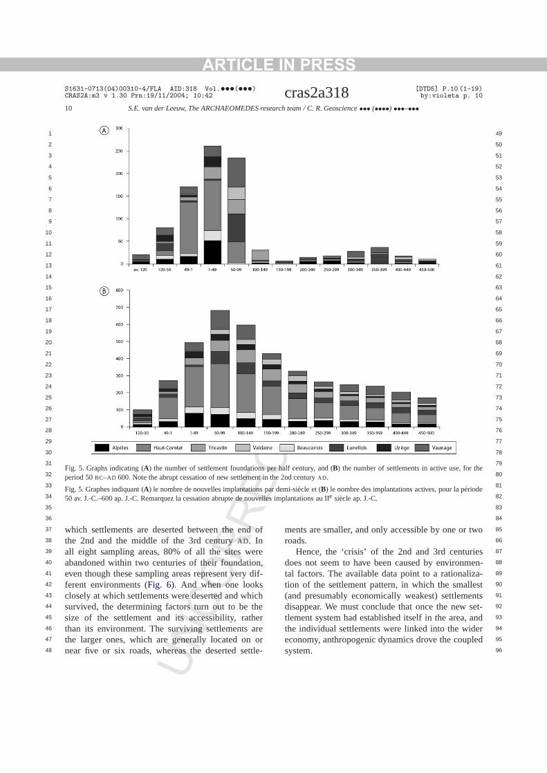
ARTICLE IN PRESSS1631-0713(04)00310-4/FLA AID:318 Vol.•••(•••) [DTD5] P.10 (1-19)CRAS2A:m3 v 1.30 Prn:19/11/2004; 10:42 cras2a318 by:violeta p. 10
10 S.E. van der Leeuw, The ARCHAEOMEDES research team / C. R. Geoscience ••• (••••) •••–•••
1 49
2 50
3 51
4 52
5 53
6 54
7 55
8 56
9 57
10 58
11 59
12 60
13 61
14 62
15 63
16 64
17 65
18 66
19 67
20 68
21 69
22 70
23 71
24 72
25 73
26 74
27 75
28 76
29 77
30 78
31 79
32 80
33 81
34 82
35 83
36
37
38
39
40
41
42
43
44
45
46
47
48
the
de
ECTE
D P
RO
OF
Fig. 5. Graphs indicating (A) the number of settlement foundations per half century, and (B) the number of settlements in active use, forperiod 50BC–AD 600. Note the abrupt cessation of new settlement in the 2nd centuryAD.
Fig. 5. Graphes indiquant (A) le nombre de nouvelles implantations par demi-siècle et (B) le nombre des implantations actives, pour la pério50 av. J.-C.–600 ap. J.-C. Remarquez la cessation abrupte de nouvelles implantations au IIe siècle ap. J.-C.
84
85
86
87
88
89
90
91
92
93
94
95
96
d of
eren,dif-
hichtheherare
orttle-
two
iesen-
za-estntsset-anderled
NCO
RRwhich settlements are deserted between the en
the 2nd and the middle of the 3rd centuryAD. Inall eight sampling areas, 80% of all the sites wabandoned within two centuries of their foundatioeven though these sampling areas represent veryferent environments (Fig. 6). And when one looksclosely at which settlements were deserted and wsurvived, the determining factors turn out to besize of the settlement and its accessibility, ratthan its environment. The surviving settlementsthe larger ones, which are generally located onnear five or six roads, whereas the deserted se
U
ments are smaller, and only accessible by one orroads.
Hence, the ‘crisis’ of the 2nd and 3rd centurdoes not seem to have been caused by environmtal factors. The available data point to a rationalition of the settlement pattern, in which the small(and presumably economically weakest) settlemedisappear. We must conclude that once the newtlement system had established itself in the area,the individual settlements were linked into the wideconomy, anthropogenic dynamics drove the coupsystem.

ARTICLE IN PRESSS1631-0713(04)00310-4/FLA AID:318 Vol.•••(•••) [DTD5] P.11 (1-19)CRAS2A:m3 v 1.30 Prn:19/11/2004; 10:42 cras2a318 by:violeta p. 11
S.E. van der Leeuw, The ARCHAEOMEDES research team / C. R. Geoscience ••• (••••) •••–••• 11
1 49
2 50
3 51
4 52
5 53
6 54
7 55
8 56
9 57
10 58
11 59
12 60
13 61
14 62
15 63
16 64
17 65
18 66
19 67
20 68
21 69
22 70
23 71
24 72
25 73
26
27
28
29
30
31
32
33
34
35
36
37
38
39
40
41
42
43
44
45
46
47
48
or0%
3,dans
DPR
OO
FFig. 6. Graphs showing, for each of ten different kinds of natural environment (Rel 1-10), (A) the number of sites surviving after 1, 2, 3, 4, 5more centuries, and (B) the proportion of such sites among the total number of sites.Note that after some 200 years, in each environment, 8of the new settlements have been abandoned.
Fig. 6. Graphes indiquant, pour une dizaine d’environnements différents (Rel 1-10), (A) le nombre d’implantations qui survivent après 1, 2,4, 5 siècles ou plus, et (B) la proportion de sites que cela représente sur le total. Remarquez que, après 200 ans, 80 % des implantationschaque secteur ont été abandonnées.
EC
74
75
76
77
78
79
80
81
82
83
84
85
86
87
88
89
90
91
92
93
94
95
96
nicralrea
theted
hede’,ul-nre
ine.the
self
in-onmicfor
ern-
ereldlti-shex-
heew
l asak-ac-n
ry)
asee
eex-
es
NCOR
R
2.4. The socio-economic dynamics behindcolonization and settlement desertion
What, then, is the nature of these anthropogedrivers? What causes the ‘boom’ and ‘bust’ of the rueconomy? The answer seems unambiguous: the spof mass-production. The Roman organization ofrural landscape intensifies a change that was initiaa few centuries earlier with the introduction of tMediterranean three-crop agricultural system (baseon wheat, olive and vine). In the Roman rural ‘regimareas that were thus far primarily used for cereal ctivation (i.e. the well-drained light soils in valleys, ofoothills and on the lower slopes of mountains) wenow to a considerable extent devoted to olive and vOur settlement data confirm this, in the sense thatmass of the new early Roman settlements found itin these zones.
Once they had a grip on the area, the Romansvested heavily in the clearing, draining and irrigatiof areas that had so far been marginal to the econosystem. The use of heavy soils requiring drainage
U
TE
d
the cultivation of cereals constituted in fact anothcorollary to the revolution which agriculture was udergoing.
It would seem that the investments required wonly feasible if agro-pastoral activities had a high yiefactor. Thus, many of the areas brought under cuvation by heavy investment were planted with cacrops. The first among these was the vine. Thepansion of the rural wine industry is known from twritten sources (the Roman agronomists mention nvarieties, new techniques and new wines) as welfrom our archaeological data. Several large wine ming installations have been found, with storage capities of up to 2800 hl of wine (!), and the productioof ancient ‘wine bottles’ (amphorae made of pottebecame a truly massive affair[15,16]. We must stressthat such wine production, therefore, is effectivelykind of agro-industry, comparable to some that wein the same area in the 19th and 20th centuries.
But wine is not the only such speculative crop. Walso have evidence for comparable agro-industrialploitation of olive oil, notably many large oil-press
ARTICLE IN PRESS
EC
S1631-0713(04)00310-4/FLA AID:318 Vol.•••(•••) [DTD5] P.12 (1-19)CRAS2A:m3 v 1.30 Prn:19/11/2004; 10:42 cras2a318 by:violeta p. 12
12 S.E. van der Leeuw, The ARCHAEOMEDES research team / C. R. Geoscience ••• (••••) •••–•••
1 49
2 50
3 51
4 52
5 53
6 54
7 55
8 56
9 57
10 58
11 59
12 60
13 61
14 62
15 63
16 64
17 65
18 66
19 67
20 68
21 69
22 70
23 71
24 72
25 73
26 74
27 75
28 76
29 77
30 78
31 79
32 80
33 81
34 82
35 83
36 84
37 85
38 86
39 87
40 88
41 89
42 90
43 91
44 92
45 93
46 94
47 95
48 96
tly,uffscropisthelti-
itasa-iesey
utin
ix--ssmi-ennfor-onesrew
mheandthed.hichon-es-for
inee)apsse.
re-
y-et-
nalon
tes,din
ef-erid-one
ofs of
ep-Ro-undher ofum-
ter-(or
into
chaveas of
olog-owual
tinyndin-
stralur-usc-n-
on.vi-tatusapof a
ingue
NCO
RR
and the storage facilities that go with them. Lasthe many written sources on commerce in foodstmake it very clear that wheat was as much a cashas wine and oil. Although they do not mention thpart of Gaul specifically, there are many areas inregion that were eminently suitable for wheat cuvation, and the region’s proximity to Rome makeshighly probable that at least part of that wheat wexported to the capital. This ‘agro-industrial’ exploittion of such crops tied the region firmly to the vagarof the wider Mediterranean commodities market. Thwere important in the ‘boom’ of the first century, balso contributed to the relative ‘crisis’ that followedthe 2nd and 3rd centuriesAD.
That ‘crisis’ seems to have been triggered by a mture of economic and political events. Political stability came rapidly to anend when Commodus waassassinated on the last day ofAD 192. The decadethat followed witnessed one war after another, culnating in a half-century of unremitting crisis betweAD 235 andAD 284. During that period, the RomaEmpire nearly came to an end. There were botheign and civil wars, which at times followed one upanother almost without interruption. Many provincwere devastated. The army and the bureaucracy gin size, and taxes were increased.
During this period, the whole empire suffered frofiscal devaluation and inflation. The fortunes of tmiddle and lower Rhone area would have waxedwaned, but not necessarily in phase with those ofEmpire as a whole. AfterAD 192, the area suffereconsiderable instabilityfor roughly three decadesThen there were some decades of peace, during wsome return to prosperity was possible within the cstraints of overall economic deterioration. The prence of a frontier garrison meant high demandproducts, with low shipping costs. A general declin the circulation of coins (due to their lack of valuwould have meant reduced prosperity, but perhwithout a great reduction in the intensity of land uBut after the middle of the 3rd centuryAD, economicand political degradation intensified until it was moor less halted by Diocletian (AD 284–305) and Constantine (AD 306–337).
The observed regional ‘crisis’ is part of this dnamic. The abandonment of many outlying, small stlements is part of a reorganization of the regioagricultural exploitation system, which falls back
U
TE
D P
RO
OF
its principal population centers and large rural estathe so-calledlatifundia. That reorganization increasesecurity and efficiency, but also led to an increasethe contract between rich and poor.
It is impossible to survey the exact causes andfects of this downturn at the level of the whole lowRhone region. For that, we have to look at the indivual sample areas. By way of example, we have dso for one of, them, the Tricastin.
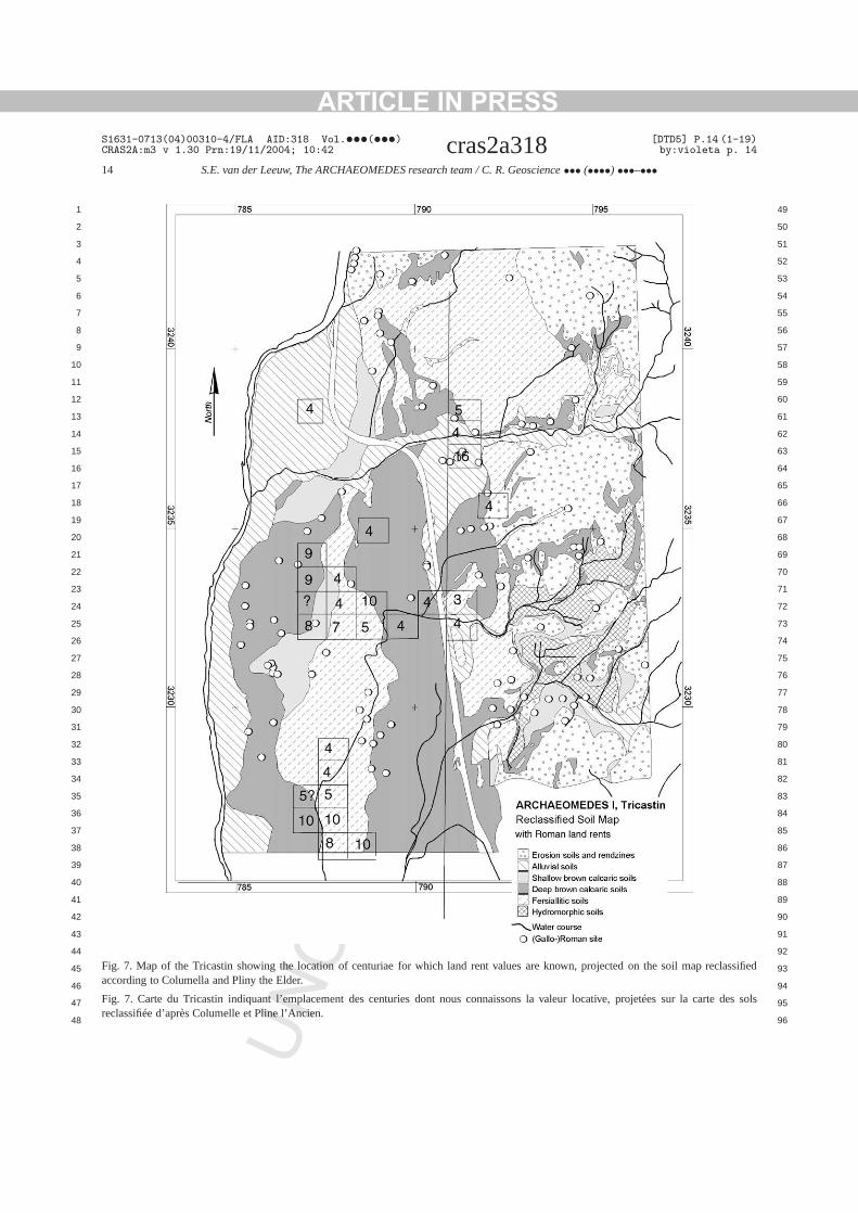
3. A drain too far: the Tricastin
The Tricastin plain alongside the Rhone southValence has been chosen because of its richnesboth written and archaeological data. Quite exctionally, for example, we possess fragments of aman map of the area. Engraved on marble aro77 AD and exhibited in the town of Orange at ttime, it shows the Roman land register, a numbefeatures such as the rivers, and the location of a nber of the plots of 50 hectares (so-calledcenturiae)into which the land was divided. The status characization ranges from whether the land is still landhas been taken back by the river), to the territorywhich it is located. It also includes statements asthe individual who rents the plot, and/or how muland rent he or she pays to the state. But we also hrich archaeological data for the region – in this case,number of excavated settlements and other featurethe Roman landscape, and the results of an archaeical surface survey. Together, they allow us to follthe history of the area’s settlement pattern in the us50-year periods over about 600 years. Thirdly, scruof topographic, geological and hydrological maps aair photographs enabled us to identify the Romanfrastructure on the ground, and to extend the cadaland divisions to those areas for which we have no sviving fragments of the marble map. It also allowedto identify a number of anomalies in that infrastruture, which pointed to the difficulties the Romans ecountered in making the land suitable for exploitati
Before the map was confronted with other edence, a thorough internal critique reassessed its sin Roman land policy. It was established that the membodied an attempt to assess the current statecentury-old development plan that aimed at drainand colonizing the whole plain. The internal critiq
ARTICLE IN PRESS
EC
S1631-0713(04)00310-4/FLA AID:318 Vol.•••(•••) [DTD5] P.13 (1-19)CRAS2A:m3 v 1.30 Prn:19/11/2004; 10:42 cras2a318 by:violeta p. 13
S.E. van der Leeuw, The ARCHAEOMEDES research team / C. R. Geoscience ••• (••••) •••–••• 13
1 49
2 50
3 51
4 52
5 53
6 54
7 55
8 56
9 57
10 58
11 59
12 60
13 61
14 62
15 63
16 64
17 65
18 66
19 67
20 68
21 69
22 70
23 71
24 72
25 73
26 74
27 75
28 76
29 77
30 78
31 79
32 80
33 81
34 82
35 83
36 84
37 85
38 86
39 87
40 88
41 89
42 90
43 91
44 92
45 93
46 94
47 95
48 96
hein-
ibened
ofgon
atantoto
dif-ave
he
inbe-f-
theyedwa-
lableinin
histheandut
hin
icee al
of
in;ntstherd,me
-oftionof
s toim-red.le,truc-tales,m
n-ury(in
sur-estof
val
orytle-age-heos-hegin-atgeadgeally
overdtheol-lar,nesgeat-anstive
ion,
100un-
NCO
RR
also permitted us to roughly outline which parts of tland belonged to each of the three main authoritiesvolved (the Emperor, the colony of Orange or the trof the Tricastini), and which lands had been assigto army veterans for their (active) retirement.
Once this was done, we first tested the validitythe soil categorization scheme we used, by comparinthe soil map with the land rent values mentionedthe Roman map (Fig. 7). The comparison shows ththe land rent values are directly linked to the Romperception of the suitability of the soils accordingColumella and Pliny the Elder. It was also possiblesee how the different large landowners cultivatedferent combinations of soils, and must therefore hhad different exploitation strategies.
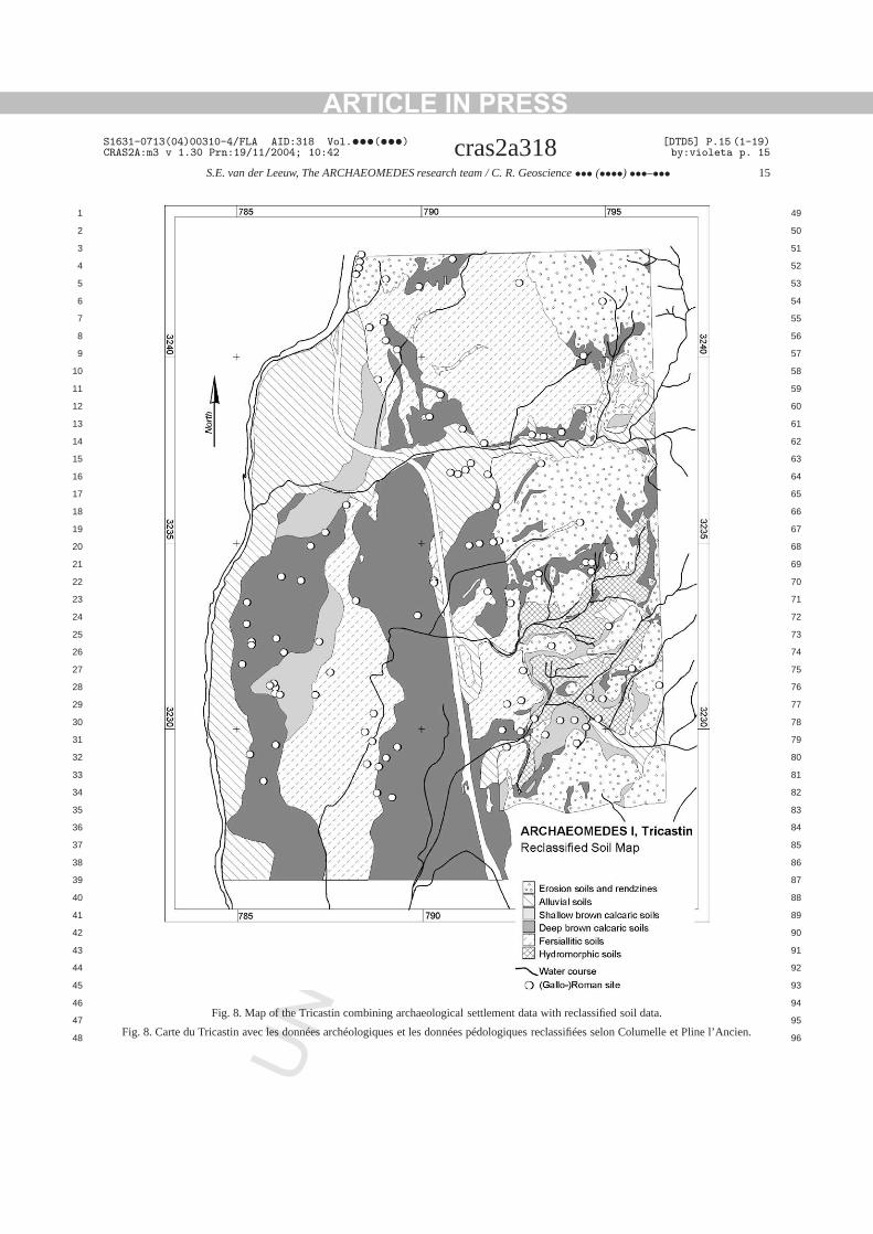
Next, confronting the archaeological data with tRoman map and the soil map (Fig. 8), it was possi-ble to follow different phases in the colonizationthis particular area. Colonization began around theginning of the 1st centuryAD in the southern part othe Rhone plain (possibly because flooding still occurred regularly in the northern part). Around 50AD,the northern part of the valley was also occupied. Inselection of settlement locations, the colonists staas close as possible to the infrastructure (roads,terways and drainage), and chose the best avaisoils according to Columella’s categories. Initially,the Augustan period, 64% of sites in the flood plaare located along boundary roads betweencenturiae,and 70% at less than 2000 m from the river. Tproportion diminishes as we move east, towardsolder terraces (where the landscape is more variedother factors thus affected the choice of location). Bnevertheless, 48% of sites from this period are wit2000 m of the main north–south ‘highway’, theViaAgrippina.
In the middle of the 1st centuryAD, the infrastruc-ture loses its strong influence on settlement chosomewhat – maybe because the best places havready been taken. Settlement develops on soilstype 1. At the beginning of the 2nd centuryAD, col-onization was limited to the northern part of the plathe fact that the landscape filled up with settlemeplayed its own role, as it pushed the settlements furaway from the infrastructure. Finally, in this periothe number of new foundations does for the first tiequal that of the desertions.
U
TE
D P
RO
OF
-
For much of the 2nd centuryAD, desertions predominate. By monitoring the location and naturethese desertions, it was easy to prove that locaplayed no important role and that the large majoritydeserted sites consisted of either ancillary buildinglarger sites, or relatively isolated farms. The mostportant sites are not deserted, but often restructuThis comforts us in our conclusion that on the whothe desertions are tied to a general phase of resturing of agriculture, rather than some environmen‘crisis’. But at the same time, on plateaus and slopmost of the soils show signs of erosion dating frothis period.
All through the third century, the process of abadonment continues, although from the fourth centonwards, other kinds of sites are being foundedthe caves of the Donzère, for example). The mainvivors of this phase of desertion are the five largvillas in the area and the agglomerations, manywhich come to form the nodes of the early mediesettlement system.
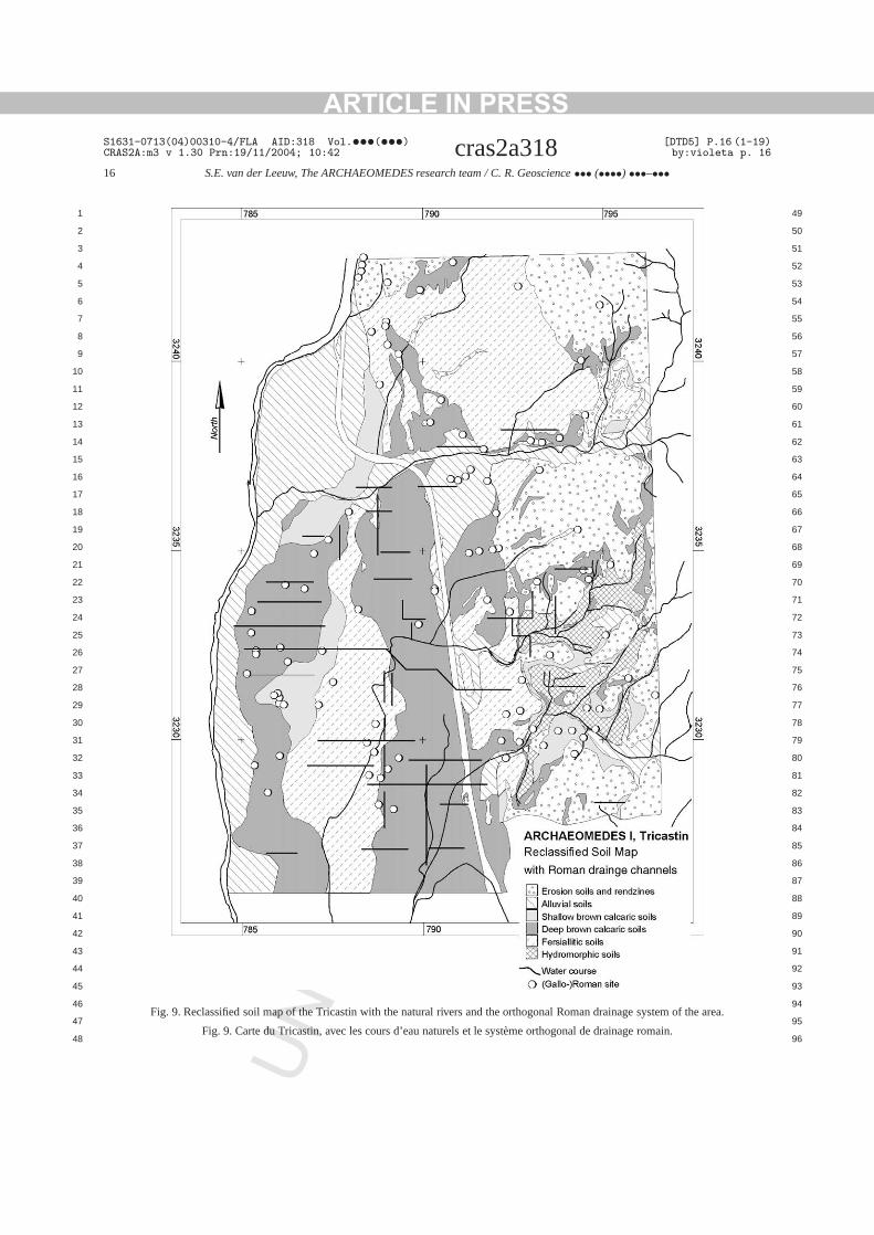
The central problem governing the Roman histof the Tricastin plain, and leading to land and setment abandonment, seems to have been the manment of water. By confronting the Roman map, thydrological map and the air photographs, it was psible to identify a number of the key features of tdrainage system as it was laid out around the bening of our era (Fig. 9). One immediately remarks ththe Roman system relies heavily on artificial drainain either a southerly or a westerly direction, insteof the southwesterly direction of the natural drainasystem. The network was conceived as a hierarchicorganized system to regulate the water balancethe whole plain, collecting it in individual plots anbringing it down to the Rhone. Even the shape ofindividual parcels of land is dependent on the hydrogy. Naturally drained areas are divided into irregusquare to rectangular plots, while poorly drained oare divided into long narrow strips by small drainaditches. But equally important is that, due to the nural situation and to the scale at which the Romconceived it, this drainage system was only effecbecause it linked a very large area.
Between the moment of the system’s conceptin the last quarter of the first centuryBC, and thetime when the colonization ran out of steam someyears later, a number of things had changed. To
ARTICLE IN PRESSS1631-0713(04)00310-4/FLA AID:318 Vol.•••(•••) [DTD5] P.14 (1-19)CRAS2A:m3 v 1.30 Prn:19/11/2004; 10:42 cras2a318 by:violeta p. 14
14 S.E. van der Leeuw, The ARCHAEOMEDES research team / C. R. Geoscience ••• (••••) •••–•••
1 49
2 50
3 51
4 52
5 53
6 54
7 55
8 56
9 57
10 58
11 59
12 60
13 61
14 62
15 63
16 64
17 65
18 66
19 67
20 68
21 69
22 70
23 71
24 72
25 73
26 74
27 75
28 76
29 77
30 78
31 79
32 80
33 81
34 82
35 83
36 84
37 85
38 86
39 87
40 88
41 89
42 90
43 91
44 92
45 93
46 94
47 95
48 96
lassified
sols
NCOR
RE
CTE
D P
RO
OF
Fig. 7. Map of the Tricastin showing the location of centuriae for which land rent values are known, projected on the soil map recaccording to Columella and Pliny the Elder.
Fig. 7. Carte du Tricastin indiquant l’emplacement des centuries dont nousconnaissons la valeur locative, projetées sur la carte desreclassifiée d’après Columelle et Pline l’Ancien.
U
ARTICLE IN PRESSS1631-0713(04)00310-4/FLA AID:318 Vol.•••(•••) [DTD5] P.15 (1-19)CRAS2A:m3 v 1.30 Prn:19/11/2004; 10:42 cras2a318 by:violeta p. 15
S.E. van der Leeuw, The ARCHAEOMEDES research team / C. R. Geoscience ••• (••••) •••–••• 15
1 49
2 50
3 51
4 52
5 53
6 54
7 55
8 56
9 57
10 58
11 59
12 60
13 61
14 62
15 63
16 64
17 65
18 66
19 67
20 68
21 69
22 70
23 71
24 72
25 73
26 74
27 75
28 76
29 77
30 78
31 79
32 80
33 81
34 82
35 83
36 84
37 85
38 86
39 87
40 88
41 89
42 90
43 91
44 92
45 93
46 94
47 95
48 96
NCOR
RE
CTE
D P
RO
OF
Fig. 8. Map of the Tricastin combining archaeological settlement data with reclassified soil data.
Fig. 8. Carte du Tricastin avec les données archéologiques et les données pédologiques reclassifiées selon Columelle et Pline l’Ancien.
U
ARTICLE IN PRESSS1631-0713(04)00310-4/FLA AID:318 Vol.•••(•••) [DTD5] P.16 (1-19)CRAS2A:m3 v 1.30 Prn:19/11/2004; 10:42 cras2a318 by:violeta p. 16
16 S.E. van der Leeuw, The ARCHAEOMEDES research team / C. R. Geoscience ••• (••••) •••–•••
1 49
2 50
3 51
4 52
5 53
6 54
7 55
8 56
9 57
10 58
11 59
12 60
13 61
14 62
15 63
16 64
17 65
18 66
19 67
20 68
21 69
22 70
23 71
24 72
25 73
26 74
27 75
28 76
29 77
30 78
31 79
32 80
33 81
34 82
35 83
36 84
37 85
38 86
39 87
40 88
41 89
42 90
43 91
44 92
45 93
46 94
47 95
48 96
NCOR
RE
CTE
D P
RO
OF
Fig. 9. Reclassified soil map of the Tricastin with the naturalrivers and the orthogonal Roman drainage system of the area.
Fig. 9. Carte du Tricastin, avec les cours d’eau naturels et le système orthogonal de drainage romain.
U
ARTICLE IN PRESS
EC
S1631-0713(04)00310-4/FLA AID:318 Vol.•••(•••) [DTD5] P.17 (1-19)CRAS2A:m3 v 1.30 Prn:19/11/2004; 10:42 cras2a318 by:violeta p. 17
S.E. van der Leeuw, The ARCHAEOMEDES research team / C. R. Geoscience ••• (••••) •••–••• 17
1 49
2 50
3 51
4 52
5 53
6 54
7 55
8 56
9 57
10 58
11 59
12 60
13 61
14 62
15 63
16 64
17 65
18 66
19 67
20 68
21 69
22 70
23 71
24 72
25 73
26 74
27 75
28 76
29 77
30 78
31 79
32 80
33 81
34 82
35 83
36 84
37 85
38 86
39 87
40 88
41 89
42 90
43 91
44 92
45 93
46 94
47 95
48 96
t theby
ated
dset-there ofatesed1stl-f theesd in-
thepedforar-thentsn-uiteThatrallmeco-y on
hedry
ofthen-dy
taler-x-
e inichetalmittheon-stomuthable
ofce.ratelowmicson,. Inentent
set-
hatualnlyneslsoatacy
theghteseessf theere, tor-ob-nd
dosa
therde--sn-arehy
NCO
RR
derstand these, we have to take into account thahydraulic regime of the Rhone itself is governedAlpine climatic circumstances, and that it showedmarked increase in the volume of water transporbetween about 70BC and the 2nd centuryAD. Bythe middle of the 1st centuryAD, this increase causeenough flooding along its banks to decide sometlers to desert their farms. The area inland, on the ohand, is hydraulically speaking at the northern edgthe Mediterranean climate zone. Although its climis more or less stable for most of the period discushere, we observe from around the middle of thecenturyAD a torrentiality and an erosion in the Vadaine and the eastern Tricastin that exceed that oriver valley itself. This minor change in circumstancincreased the pressure on Roman manpower anvestment to maintain control over the land.
If the whole area had been as quickly settled asRoman engineers and emperors had no doubt hothe problem could probably have been dealt withquite some time longer. But the fact that someeas remained unsettled for lack of veterans, and(rationalization-driven) desertion of some settlemeafter the 1st centuryAD, created areas where maitenance was insufficient, so that erosion began qearly and the drainage system became blocked.in turn would have placed more stress on the ovedrainage system. It would progressively have becoless effective, and that would have added to the enomic stresses inherent in the area’s dependencagro-industry, and notablyin the oscillations that itsproduction for a world-market entailed.
In short, it seems that, in the Tricastin plain, t‘crisis’ of the second and third centuries manifesteitself in ways closely linked to the fact that, a centuearlier, the Romans had “gone a drain too far. . . ”.
4. Conclusion
In conclusion, we would like to consider somethe implications of the present study (and others inARCHAEOMEDES Project) for our modern-day evironmental problems and the ways in which we stuthem.
The first of these is the fact that environmenproblems need to be considered in a long-term pspective. Without such a perspective, it would for e
U
TE
D P
RO
OF
,
ample have been impossible to identify the increasthe system’s vulnerability during the Holocene, whresults from the increasing coherence of the sociand environmental dynamics. But even when we liourselves to the Roman Empire, it is clear thatvery early choices often have very substantive csequences centuries later. Thus, the Roman cuto divide the land in square blocks along north–soand east–west axes led ultimately to an unmanagedrainage system in the Tricastin.
Secondly, we wish to stress the importancea multi-scalar approach both in time and in spaThe complex processes involved do indeed opeon many scales at the same time. Rapid and sprocesses are closely linked, and so are local dynaand their regional contexts. In the spatial dimensia regional approach is often particularly appositethe case of water, the whole of the relevant catchmbasin needs to be considered and when settlemdynamics are concerned, the whole of the regionaltlement system.
Another lesson to be learned from this study is tmany so-called “environmental crises” are in actfact just as much societal as environmental. Not oshould we remember that, ultimately, society defiwhat constitutes its environment, and therefore awhat constitute “environmental problems”, but thsuch problems are in effect instances of the inadequof the mechanisms by which societies deal withdynamics of their surroundings. Whereas one miargue for a more distant prehistoric past that thmechanisms were inherently insufficient, that is land less the case in a world where many aspects oenvironment are controlled by society. Of course, thare exceptions: earthquakes, avalanches, tsunamisnados and the like, but most other environmental prlems are the cumulative result of human actions. Awe are now entering a period, the Anthropocene[9], inwhich even the increase in the frequency of tornaand other inclement meteorological phenomena areconsequence of (collective) human behavior.
Indeed, it seems to me that such crises (and oones) could profitably be viewed as “temporary inaquacies of the societal mechanisms to deal with changing circumstances”. Such phases occur in all situationwhere a society interacts for a long time with its evironment. Indeed, it seems as if such instancesa characteristic of human societies’ trajectories. W
ARTICLE IN PRESS
EC
S1631-0713(04)00310-4/FLA AID:318 Vol.•••(•••) [DTD5] P.18 (1-19)CRAS2A:m3 v 1.30 Prn:19/11/2004; 10:42 cras2a318 by:violeta p. 18
18 S.E. van der Leeuw, The ARCHAEOMEDES research team / C. R. Geoscience ••• (••••) •••–•••
1 49
2 50
3 51
4 52
5 53
6 54
7 55
8 56
9 57
10 58
11 59
12 60
13 61
14 62
15 63
16 64
17 65
18 66
19 67
20 68
21 69
22 70
23 71
24 72
25 73
26 74
27 75
28 76
29 77
30 78
31 79
32 80
33 81
34 82
35 83
36 84
37 85
38 86
39 87
40 88
41 89
42 90
43 91
44 92
45 93
46 94
47 95
48 96
n-dso-sepon
stoc-
e-ad
osthatin-rafter
x-f iser,es-ty’s
on-
Al-upley-willus
In-theingeenatb-
s le9 p.vul-ltaarlyce,
er-king
rcel
ent-S.E.r uneEl-
o-oqued.),
bassexudeogie
c-sa-ce)d.),on-24–ier,
rie,rds
365
u,pes
bal
ate984,
eir
r-m-
ndk,
ri-tial(SFInta
iersdes
lèlesises,
il-ions9.
NCO
RR
might that be? As a society interacts with its enviroment according to its world-view, it will rely upon, animpact on, certain aspects of that environment. Theciety’s impact on its environment is therefore in thodomains where the society is the most dependent uthat environment. That is where the society is the movulnerable, and where it finds adapting to changescurring in its environment most difficult. Often, therfore, that is also where it will let things come to a he(a ‘crisis’).
And that leads me to a last point. ‘Crises’ are minevitably triggered by societies, such as our own, tstrive to achieve a certain kind of stability, or sustaability, of its mode of life. Ever since the Victorian e(and maybe long before that) our society hankers aa kind of stability which, to put it simply, does not eist. The concept of “sustainable development” itsela clear expression of that ideal. Continuity is, howevonly achievable by incorporating the changes necsary to maintain the adequacy between the sociedynamics and the natural dynamics of the envirment.
Our societies try to externalize those changes.though that has been a successful strategy for a coof centuries, that has led to our highly technologdependent world, the chances are that approachultimately hit a snag because the problems facingcannot be dealt in the time-frame available to us.deed, it often seems to me that we will not havetime needed for successful scientific capacity-buildand knowledge development on the interface betwthe environmental sciences and the social sciences thwill be essential to solving the environmental prolems of the generation that is currently in school.
References
[1] G. Arnaud-Fassetta, Dynamiques fluviales holocènes dandelta du Rhône, thèse, université Aix–Marseille-1, 1998, 32
[2] G. Arnaud-Fassetta, C. Landuré, Hydroclimatic hazards,nerability of societies and fluvial risk in the Rhone de(Mediterranean France) from the Greek period to the eMiddles Ages, in: E. Fouache (Ed.), International ConferenThe Mediterranean World Environment and History, Univsité Paris-1, Panthéon-Sorbonne, 24–26 avril 2002, WorGroup on Geoarchaeology, Elsevier, 2003, pp. 51–76.
[3] J. Benzecri, Correspondence Analysis Handbook, MaDekker, New York, 1992.
U
TE
D P
RO
OF
[4] J.-F. Berger, F. Favory, T. Muxart, F.-P. Tourneux, Commidentifier, analyser et évaluer les dynamiques d’interactions entre les sociétés et leurs environnements, in: C. Lévèque,van der Leeuw (Eds.), Quelles natures voulons-nous? Pouapproche socio-écologique du champ de l’environnement,sevier, Paris, 2003, pp. 146–184.
[5] J.-F. Berger, J.-L. Brochier, Les apports de la géoarchéolgie à la connaissance des paysages et des climats de l’épmédiévale en moyenne vallée du Rhône, in: O. Maufras (EHabitats, nécropoles et paysages dans la moyenne etvallée du Rhône (VIIe–XVe s.) : conributions des travauarchéologiques sur le tracé du TGV Méditerranée à l’étdes sociétés rurales médiévales, Documents d’Archéolfrançaise, 49 p., 12 fig., 4 tabl. (sous presse).
[6] J.-F. Berger, J.-L. Fiches, M. Gazenbeek, Origin of fluvial flutuations of the River Vidourle and their effect on the organition and evolution of the site of Ambrussum (Hérault, Franbetween the Iron Age and late Antiquity, in: E. Fouache (EInternational Conference, The Mediterranean World Envirment and History, Université Paris-1, Panthéon-Sorbonne,26 avril 2002, Working Group on Geoarchaeology, Elsev2003, pp. 77–108.
[7] G. Bond, W. Broecker, S. Johnsen, J. Mcmanus, L. LabeyJ. Jouzel, G. Bonani, Correlations between climate recofrom North Atlantic sediments and Greenland ice, Nature(1993) 143–147.
[8] J.-P. Bravard, A. Verot-Bourrely, O. Franc, Paléodynamique dsite fluvial de Lyon depuis le Tardiglaciaire, in: J.-P. BravardM. Prestreau (Eds.), Documents d’Archéologie Rhône-Al15, 1997, pp. 177–201.
[9] P.J. Crutzen, E.F. Stoermer, The ‘Anthropocene’, GloChange Newslett. 41 (2000) 12–13.
[10] W. Dansgaard, et al., in: R.E. Taylor, et al. (Eds.), ClimProcesses and Climate Sensitivity, Am. Geophys. Union, 1pp. 228–298.
[11] G.H. Denton, W. Karlen, Holocene climatic variation – thpattern and possible cause, Quat. Res. 3 (1973) 155–205.
[12] P. Goldberg, M.-A. Courty, R.I. McPhail, Soils and Micromophology in Archaeology, Cambridge University Press, Cabridge, 1989.
[13] S.A. Kauffman, The Origins of Order: Self-Organization aSelection in Evolution, Oxford University Press, New Yor1993.
[14] T. Kohler, G. Gumerman, Dynamics in Human and Pmate Societies: Agent-Based Modeling of Social and SpaProcesses, Oxford University Press and Santa Fe InstituteStudies in the Sciences of Complexity), New York and SaFe, 2000.
[15] F. Laubenheimer, Sallèles d’Aude – Un complexe de potgallo-romain : le quartier artisanal, Éditions de la MaisonSciences de l’Homme (Documents d’Archéologie Française26), Paris, 1990.
[16] F. Laubenheimer (Ed.), Vingt ans de recherches à Sald’Aude, Besançon, Presses universitaires franc-comto2000.
[17] M. Magny, Solar influences on Holocene climatic changeslustrated by correlations between past lake-level fluctuatand the atmospheric, 14C record, Quat. Res. 40 (1993) 1–
ARTICLE IN PRESSS1631-0713(04)00310-4/FLA AID:318 Vol.•••(•••) [DTD5] P.19 (1-19)CRAS2A:m3 v 1.30 Prn:19/11/2004; 10:42 cras2a318 by:violeta p. 19
S.E. van der Leeuw, The ARCHAEOMEDES research team / C. R. Geoscience ••• (••••) •••–••• 19
1 49
2 50
3 51
4 52
5 53
6 54
7 55
8 56
9 57
10 58
11 59
12 60
13 61
14 62
15
16
17
18
19
20
21
22
23
24
25
26
27
28
29
30
31
32
33
34
35
36
37
38
39
40
41
42
43
44
45
46
47
48
au
ord
el-8.od-
earvaness7,
ulee
ericThe
and-da-
ffi-.
e,don,
ets sur
S,
[18] M. Magny, Une histoire du climat des derniers mammouthssiècle de l’automobile, Errance, Paris, 1995, 176 p.
[19] M. Magny, Les variations des lacs du Jura et des Alpes du Net leur signification pour une histoire du climat aux IVe et Ve
siècles de notre ère, in : Actes du colloque AGER IV, Montplier, France, avril 1998, APDCA, Antibes, 2001, pp. 357–36
[20] J. McGlade, Archaeology and the ecodynamics of human mified landscapes, Antiquity 69 (1995) 113–132.
[21] J. McGlade, S.E. van der Leeuw, Archaeology and nonlindynamics: new approaches to long-term change, in: S.E.der Leeuw, J. McGlade (Eds.), Archaeology: Time, Procand Structural Transformations, Routledge, London, 199pp. 1–31.
[22] M. Provost, L’Homme et les fluctuations climatiques en Gadans la deuxième moitié du IIe siècle après J.-C., RevuArchéologique 1 (1984) 35–60.
UN
CO
RR
EC
OF
[23] M. Stuiver, T. Braziunas, Ocean, climate and atmosph14CO2: an evaluation of causal and spectral relationship,Holocene 3 (1993) 289–305.
[24] S.E. van der Leeuw, The Archaeomedes Project – Understing the Natural and Anthropogenic Causes of Land Degration and Desertification in the Mediterranean, Office for Ocial Publications of the European Union, Luxemburg, 1998
[25] S.E. van der Leeuw, J. McGlade (Eds.), Archaeology: TimProcess and Structural Transformations, Routledge’s, Lon1997.
[26] S.E. van der Leeuw, F. Favory, J.-L. Fiches, Archéologiesystèmes socio-environnementaux : études multiscalairela vallée du Rhône dans le programme ARCHAEOMEDEMonographies du CRA, CNRS, Valbonne, 2003.
TE
D P
RO 63
64
65
66
67
68
69
70
71
72
73
74
75
76
77
78
79
80
81
82
83
84
85
86
87
88
89
90
91
92
93
94
95
96


![Article in Press - cdn.publisher.gn1.link2018;25(3):[article in press] Article in Press 140 hipertensão descompensada, diabetes descompensado, má formações de segmentos nos 141](https://img.dokumen.tips/doc/110x75/6015d4ddd2e1762737317163/article-in-press-cdn-2018253article-in-press-article-in-press-140-hipertenso.jpg)