Embed Size (px)
Citation preview
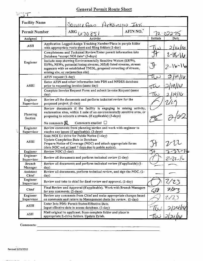
General Permit Route Sheet ·._.,_ • I I ' J
Facility Name cS() l\.. (_( .P G._rLa 10-.r k'D.--v\. r L-l-O ~'1 ( .
Permit Number ARG u·l 0 8:) l AFINNO.* /'J_. fS')J "1'5' Assigned Activity Initials Date
ASII Application Logged/Assign Tracking Number/Place in purple folder
-n..~..J J Lu~_hw with appropriate route sheet and filing folders (1-day)
Completeness and Technical Review/Enter permit information into jt t--t~.)\M Database *except NOI date* (3-days)
Engineer Include map showing Environmentally Sensitive Waters (ERWs,
J1-ESWs, NSWs, potential losing streams, 303(d) listed streams, stream 2-' ~-' \o segments with an established TMDL, proposed rerouting of stream,
mining_ site, or reclamation site)
AFIN request (1-day) --r-V--J 'd /itt /IIJ Enter AFIN and other information into PDS and NPDES database
AS III prior to requesting invoice (same day) I~) ;}/ jq IILP Complete Invoice Request Form and submit Invoice Request (same
. I
day) ~\ :211~/lu Engineer Review all the documents and perform technical review for the /) 7/vj Supervisor proposed project. (1-day)
Review documents if the facility is engaging in mining activity, L/ Planning
reclamation sites, within 1 mile of an environmentally sensitive area, or
~?)_ proposing to relocate a stream. (if applicable) (3-days) e<-Section
No comments ~ Comments emailed D Engineer Review comments from planning section and work with engineer to
Supervisor resolve any issues (if applicable). (3-days) Scan NOI E:/ drive for Public Notice (1-day)
AS III Update Completion Date in Database
)1- y'l.)-1 Prepare Notice of Coverage (NOC) and attach appropriate forms (date NOC out at least 7 days due top_ublic notice).
Engineer Review NOC (1-day) ").}- -v...-v\r-l(p Engineer Review all documents and perform technical review (1-day) (ft z_,G-z~Jl Supervisor Branch Review all documents and perform technical review (if applicable) (1- \.___../ ..------ ------..,
Manager day) Assistant Review all documents, perform technical review, and sign the NOC. (1- - -Chief day) Engineer Review and take to chief for final review and approval. (1-day) ~ Z/~3 Supervisor
Final Review and Approval (if applicable). Worl< with Branch Managers r------7/~3 Chief
for any comments. (2-days) Crft Engineer Review any comments from Chief and make appropriate changes based ./9 Z//Z_) Supervisor on comments and return to Management chain for review. (1-day)
AS III Enter Into PDS: Permit Status/Effective Date. -Yt, 'd/;)4/t(l Input effective date in access database. (1-day) --~-,fLJ
ASII Mail original to applicant. Scan complete folder and place in --rw ,") lY-1 h (jJ appropriate E-drive folders. Update Zylab.
I
Comments: ____________________________________________________________ __
Revised 5/23/2012
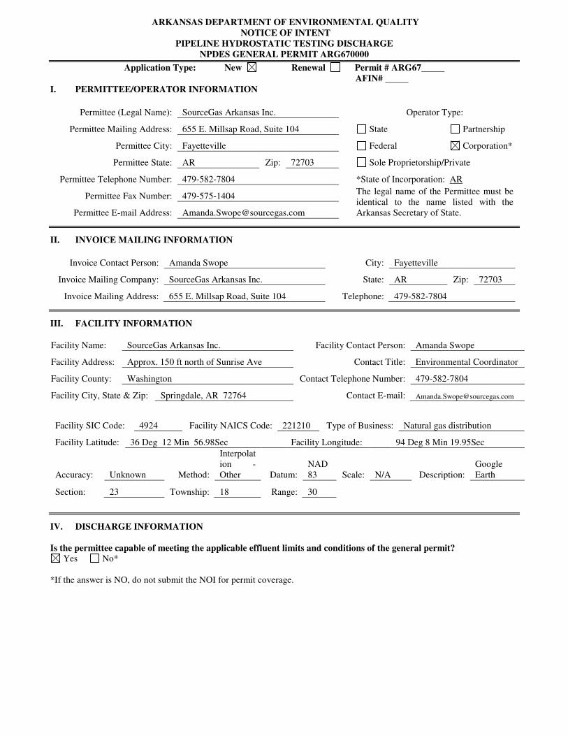
ARKANSAS DEPARTMENT OF ENVIRONMENTAL QUALITY
NOTICE OF INTENT
PIPELINE HYDROSTATIC TESTING DISCHARGE
NPDES GENERAL PERMIT ARG670000
Application Type: New Renewal Permit # ARG67
AFIN#
I. PERMITTEE/OPERATOR INFORMATION
Permittee (Legal Name): SourceGas Arkansas Inc.
Operator Type:
Permittee Mailing Address: 655 E. Millsap Road, Suite 104
State Partnership
Permittee City: Fayetteville
Federal Corporation*
Permittee State: AR Zip: 72703
Sole Proprietorship/Private
Permittee Telephone Number: 479-582-7804
*State of Incorporation: AR
Permittee Fax Number: 479-575-1404 The legal name of the Permittee must be
identical to the name listed with the
Arkansas Secretary of State. Permittee E-mail Address: [email protected]
II. INVOICE MAILING INFORMATION
Invoice Contact Person: Amanda Swope City: Fayetteville
Invoice Mailing Company: SourceGas Arkansas Inc. State: AR Zip: 72703
Invoice Mailing Address: 655 E. Millsap Road, Suite 104 Telephone: 479-582-7804
III. FACILITY INFORMATION
IV. DISCHARGE INFORMATION
Is the permittee capable of meeting the applicable effluent limits and conditions of the general permit? Yes No*
*If the answer is NO, do not submit the NOI for permit coverage.
Facility Name: SourceGas Arkansas Inc. Facility Contact Person: Amanda Swope
Facility Address: Approx. 150 ft north of Sunrise Ave Contact Title: Environmental Coordinator
Facility County: Washington Contact Telephone Number: 479-582-7804
Facility City, State & Zip: Springdale, AR 72764 Contact E-mail: [email protected]
Facility SIC Code: 4924 Facility NAICS Code: 221210 Type of Business: Natural gas distribution
Facility Latitude: 36 Deg 12 Min 56.98Sec Facility Longitude: 94 Deg 8 Min 19.95Sec
Accuracy: Unknown Method:
Interpolat
ion -
Other Datum:
NAD
83 Scale: N/A Description:
Earth
Section: 23 Township: 18 Range: 30

ARG6 70000 Checklist
ARG67 QifSI ~ew 0 Renewal 0 Modification
Permit Fee:"r;tt Disclosure Statement:~ Sec. of State Check:J2(
Does the fa£1i~ have any other NPDES permit: D No DYes: ______ _
4 If Yes, verify any overlapping limits D
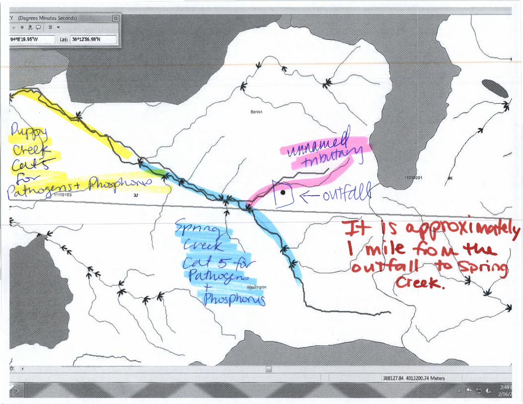
Discharge Path: \An\JG.W\ul ~~V\j-7 Sf?··,ng Cr~ --::r f~A~PY Cr~·~ o~cr;c~ HUC: l)}l0\0~ PlanningSegment:3J -71/11!101& ~\Vtf'
Potential Losing Stream Area: DNa ¥Yes
Natural/Scenic Water: ~No DYes: ________ Distance: ____ _
Extraordinary Resource Water: ~No DYes: Distance: ·~ _ ... InC ~ Ecologically Sensitive Waterbody: D No jtQ_ Yes: \)St\t? ()t.t{L Distance: tv\~((,.--t\II.LtV'- [~~
.A}' ·-t ~ VI 1) 303 (d) list Impaired: D None 1)df,.vc,;i;Y"
.. Category 5- Waterbody: sr (i(\3 Cvu¥-source/Cause: u t'1 ¥:\10 WY11 r~i~;a~ce:Wfh% 11'\11; le , D Category 4a - Waterbody: Source/Cause: Distance: ____ _
Ccli )- f?\Apr'f ~ 10.- . Site ~ap or Schematic diagram.Jsr
~Discharge Location(s)
Volume and Rate of Discharge~ Test Water Source: tg Pipeline/Vessel Condition: D Used ~Virgin Pipe/Vessel Material: --'~""'""""":...J...._-----Typical fluid:~ Corrosion inhibitors: ~o DYes
4 If Yes, MSDS sheets included for every additive?
Date sent to Tech. Services Manager: _____ Response Date: ___ _
p(A_~s -"r rn()~~\:)(V.s
QSLtqe CreJ)L ·fo-f cL tQv~s + f>~·rc::§Sfho~.)
Comments:------------------------------
Check with Enforcement for non-compliance issues: Date Sent 2, l ~;r\ \.P Response Date 2-11-1 l,o
Discharge contains only water used for hydrostatic testing: bit <0.1 mg/1 of chlorine in discharge.Jq
No substances that are not monitored by effluent limits in permit:Jsf
No lubricants with PCBs:~ OtherComments: z:ftfl)') 2-l~.t?-1\e ~~ ~~ ~op:Q-

DocuSign Envelope ID: C165BEE2-84ED-4145-9ACF-9E7E5944224B ARKANSAS DEPARTMENT OF ENVIRONMENTAL QUALITY
NOTICE OF INTENT PIPELINE HYDROSTATIC TESTING DISCHARGE
NPDES GENERAL PERMIT ARG670000
Outfall Number: 1 Stream Segment: 11070200 Hydrologic Basin Code: 3J Outfall Latitude: 36 I o 12 I , Outfall Longitude: 94 I o 8 I , County: Benton Start Date: 2/22/16 End Date: Name of Receiving Stream: Spring Creek Are any of the Receiving Streams on the latest No Clean Water Act section 303 (d) list of impaired waters or have an approved TMDL? If yes, list the Receiving Streams. Estimated Volume of Discharge: 2400 Estimated Rate of Discharge: 0.0024 Source of Test Water: Springdale City Water PipelineN essel: l J Used [8J Virgin l J Other Describe material from which pipeline/vessel was Steel constructed: Type of fluid normally contained/transported Natural Gas through pipe/vessel: Are Corrosion Inhibitors Used?: No Does pipeline use compressor lubricants DYes [8J No containing polychlorinated biphenyls (PCBs)?
Outfall Number: N/A Stream Segment: Hydrologic Basin Code: Outfall Latitude: I o I , Outfall Longitude: I o I ' County: Start Date: End Date: Name of Receiving Stream: Are any of the Receiving Streams on the latest Clean Water Act section 303 (d) list of impaired waters or have an approved TMDL? If yes, list the Receiving Streams. Estimated Volume of Discharge: Estimated Rate of Discharge: Source of Test Water: PipelineN essel: Dosed D Virgin D Other Describe material from which pipeline/vessel was constructed: Type of fluid normally contained/transported through pipe/vessel: Are Corrosion Inhibitors Used?: Does pipeline use compressor lubricants DYes DNo containing polychlorinated biphenyls (PCBs)?
Additional Outfalls can be added using separate attached pages.
WATER DIVISION
I 56.98 119.95
I 2122111
I gallons I MGD
I I
I
I gallons I MGD
5301 NORTHSHORE DRIVE I NORTH LITTLE ROCK, ARKANSAS 72118 PHONE 501-682-0623 IF AX 501-682-0880
www.adeq.state.ar.us -6-
Revised 04124/2012
I" I"
I" I"

DocuSign Envelope ID: C165BEE2-84ED-4145-9ACF-9E7E5944224B ARKANSAS DEPARTMENT OF ENVIRONMENTAL QUALITY
NOTICE OF INTENT PIPELINE HYDROSTATIC TESTING DISCHARGE
NPDES GENERAL PERMIT ARG670000
V. FACILITY PERMIT INFORMATION
NPDES Individual Permit Number (If Applicable): AROO NPDES General Permit Number (If Applicable): ARG
State Construction Permit Number(lf Applicable):
NPDES General Construction Stormwater Permit Number {If Applicable): ---=-ARR=-'-1=-=5'----------------
VI. OTHER INFORMATION:
Additional Location Description
Additional Comments:
Consultant Contact Name:
Consultant Email Address: Consultant Address:
Consultant Phone Number:
City: _____ State: Zip:
Consultant Fax Number: -------------Disclosure Statements:
Arkansas Code Annotated Section 8-1-106 requires that all applicants for the issuance or transfer of any permit, license, certification or operational authority issued by the Arkansas Department of Environmental Quality (ADEQ) file a disclosure statement with their applications. The filing of a disclosure statement is mandatory. No application can be considered complete without one. You must submit a new disclosure statement even if you have one on file with the Department. The form may be obtained from ADEQ web site at: http:llwww.adeg.state.ar.usldisclosure stmt.pdf.
VII. PERMIT REQUIREMENT VERIFICATION
Please check the following to verify completion of permit requirements.
Yes No * If No is answered for any of the questions, then a permit can not be issued!
Submittal of Complete NOI? ~ D Submittal of Required Permit Fee? ~ D Check Number:
Submittal of Site Map? ~ D Submittal of Disclosure Statement? ~ D
WATER DIVISION 5301 NORTHSHORE DRIVE I NORTH LITTLE ROCK, ARKANSAS 72118
PHONE 501-682-0623 IF AX 501-682-0880 www.adeq.state.ar.us
-7-Revised 04/24/2012

DocuSign Envelope 10: C165BEE2-84ED-4145-9ACF-9E7E59442248 ARKANSAS DEPARTMENT OF ENVIRONMENTAL QUALITY
NOTICE OF INTENT PIPELINE HYDROSTATIC TESTING DISCHARGE
NPDES GENERAL PERMIT ARG670000
VIII. CERTIFICATION OF OPERATOR
~(Initial) "I certify that, if this facility is a corporation, it is registered with the Secretary of the State of Arkansas."
f\[f'fL(Initial) "I certify that the cognizant official designated in this Application is qualified to act as a duly authorized representative under the provisions of 40 CFR 122.22(b). If no cognizant official has been designated, I
. understand that the Department will accept reports signed only by the Applicant." ~itial) "I certify under penalty of law that this document and all attachments were prepared under my direction or
supervision in accordance with a system designed to assure that qualified personnel properly gather and evaluate the information submitted. Based on my inquiry of the person or persons directly responsible for gathering the information, the information submitted is, to the best of my knowledge and belief, true, accurate, and complete. I am aware that there are significant penalties for submitting false information, including the possibility of fine and imprisonment for knowing violations."
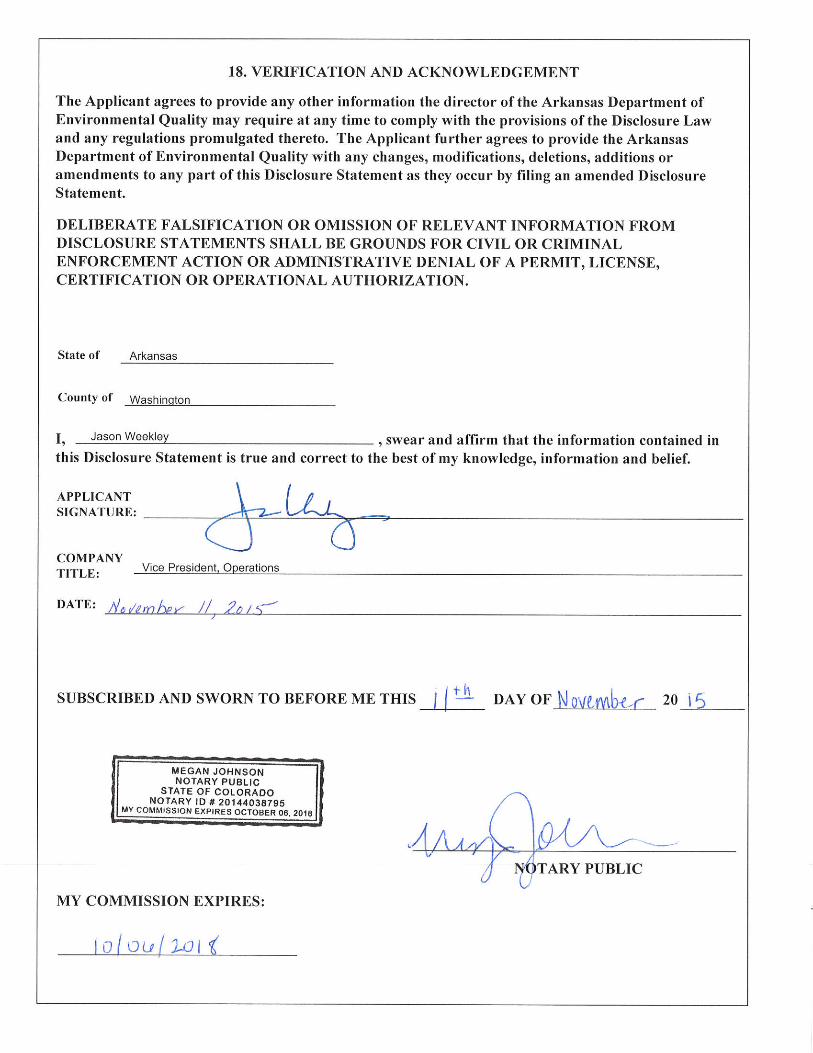
Responsible Official Printed Name: ~I!OO.S!V~\oley
Responsible Official Signature: ~_ ... _JOii __ WeJ.k---'----'--l.'l _____ _
R "bl Offi . 1 E "1 F21AJ.GEF~50E4~. espons1 e 1c1a mm : Jason. [email protected]
Vice President, Operations Title:
Date: -----------------------------2/5/2016
Cognizant Official Printed Name: Title: Environmental Coordinator
Cognizant Official Signature: Date: 2/4/2016
Cognizant Official Email: Telephone: 746BE9DABB8MA8 ...
[email protected] 4 79-582-7804
WATER DIVISION 5301 NORTHSHORE DRIVE /NORTH LITTLE ROCK, ARKANSAS 72118
PHONE 501-682-0623 I FAX 501-682-0880 www.adeq.state.ar.us
-8-Revised 04/24/2012

Temple, Jessica
From: Sent: To: Subject: Attachments:
Swope, Amanda <[email protected]> Thursday, February 18, 2016 10:43 AM Temple, Jessica RE: ARG670851, SourceGas Arkansas Revised page l.pdf
The corrected NOI page is attached. The coordinates are correct, but I don't know the address of the location we are discharging at. I have revised it to be a description. The discharge will only contain water used for hydrostatic testing. We will test the water for chlorine levels before discharging to ensure it is below 0.1 mg/1. If above that level, we will hold the water until levels naturally dissipate. There are no other substances that are not monitored by the effluent limits in the permit.
From: Temple, Jessica [mailto:[email protected]] Sent: Tuesday, February 16, 2016 2:44 PM To: Swope, Amanda Subject: ARG670851, SourceGas Arkansas
*** This email is from an EXTERNAL sender*** Use caution before responding. DO NOT open attachments or click links from unknown senders or unexpected emaiL If this email appears to be sent from a BHC employee or department, verify its authenticity before acting or responding. Contact the Helpdesk with any questions.
Amanda,
The Department is in receipt of the NO I, permit fee, and map for the SourceGas Arkansas project located in Benton County. From the coordinates provided on the NO I, it looks like the outfall is at the corner of Thompson Stand Sunrise Ave. The NOI has your office address in Section Ill, which I don't believe to be correct, especially with these coordinates. Can you please send me (email is fine) the corrected NOI page?
I also need you to confirm the following:
• The discharge will contain only water used for hydrostatic testing
• There will be less than 0.1 mg/1 of chlorine in the discharge
• There are no substances that are not monitored by the effluent limits in the permit
Thanks, Jessica Temple Engineer ADEQ-Office of Water Quality 501-682-0621
This electronic message transmission contains information from Black Hills its affiliate or wh1ch may be confidential or privileged. The information :s intended to be for the use of the individual or named above. you are not the intended be aware the disclosure. distribution or use of the contents of this information is prohibited. If you this electronic transmission in error, please reply to sencer immediately: then this message without copying it or fu1ther reading
1
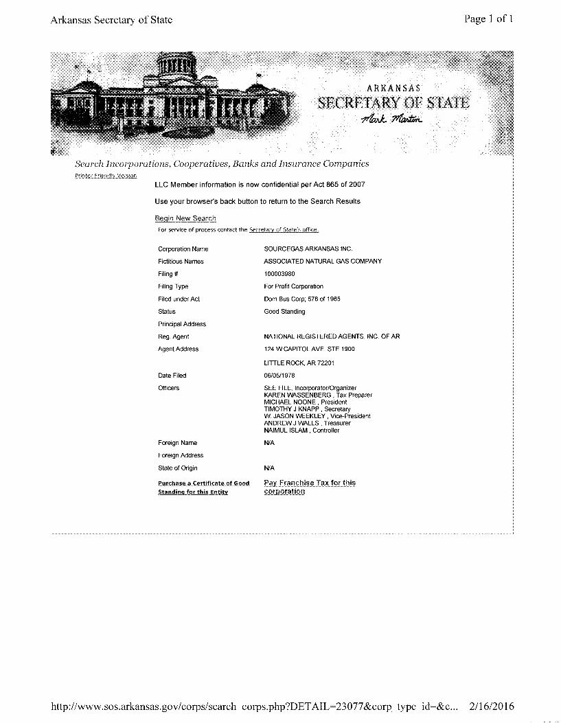
Arkansas Secretary of State Page 1 of 1
ARKANSAS
SECRETARY OF STATE -ttfmJ.. 1'Wn..
Search Incorporations, Cooperatives, Banks and Insurance Companies Printer Friendly VersiorL
LLC Member information is now confidential per Act 865 of 2007
Use your browser's back button to return to the Search Results
Begin New Search
For service of process contact the Secretary of State's office.
Corporation Name
Fictitious Names
Filing#
Filing Type
Filed under Act
Status
Principal Address
Reg. Agent
Agent Address
Date Filed
Officers
Foreign Name
Foreign Address
State of Origin
Purchase a Certificate of Good
Standing for this Entity
SOURCEGAS ARKANSAS INC.
ASSOCIATED NATURAL GAS COMPANY
100003980
For Profit Corporation
Dom Bus Corp; 576 of 1965
Good Standing
NATIONAL REGISTERED AGENTS, INC. OF AR
124 W CAPITOL AVE, STE 1900
LITTLE ROCK, AR 72201
06/05/1978
SEE FILE, Incorporator/Organizer KAREN WASSENBERG , Tax Preparer MICHAEL NOONE , President TIMOTHY J KNAPP , Secretary W. JASON WEEKLEY , Vice-President ANDREW J WALLS , Treasurer NAIMUL ISLAM, Controller
N/A
N/A
P§1Yfr§J!J<?!:l!?~?T?~J9rthi? corporation
http://www. sos.arkansas. gov I corps/ search_ corps. php ?D ET AIL=23 077 &corp_ type_ id=&c... 2/16/20 16
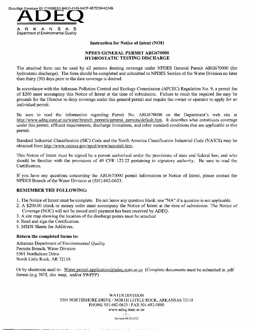
A R K A N S A S Department of Environmental Quality
Instruction for Notice of Intent (NOI)
NPDES GENERAL PERMIT ARG670000 HYDROSTATIC TESTING DISCHARGE
The attached form can be used by all persons desiring coverage under NPDES General Permit ARG670000 (for hydrostatic discharge). The form should be completed and submitted to NPDES Section of the Water Division no later than thirty (30) days prior to the date coverage is desired.
In accordance with the Arkansas Pollution Control and Ecology Commission (APCEC) Regulation No. 9, a permit fee of $200 must accompany this Notice of Intent at the time of submission. Failure to remit the required fee may be grounds for the Director to deny coverage under this general permit and require the owner or operator to apply for an individual permit.
Be sure to read the information regarding Permit No. ARG670000 on the Department's web site at http://www.adeg.state.ar.us/water/branch permits/general permits/default.htm. It describes what constitutes coverage under this permit, effluent requirements, discharge limitations, and other standard conditions that are applicable to this permit.
Standard Industrial Classification (SIC) Code and the North America Classification Industrial Code (NAICS) may be obtained from http://www .census.gov/epcdlwww/naicstab.htm.
This Notice of Intent must be signed by a person authorized under the provisions of state and federal law, and who should be familiar with the provisions of 40 CPR 122.22 pertaining to signatory authority. Be sure to read the Certification.
If you have any questions concerning the ARG670000 permit information or Notice of Intent, please contact the NPDES Branch of the Water Division at (501) 682-0623.
REMEMBER THE FOLLOWING:
1. The Notice of Intent must be complete. Do not leave any question blank; use "NA" if a question is not applicable. 2. A $200.00 check or money order must accompany the Notice of Intent at the time of submission. The Notice of
Coverage (NOC) will not be issued until payment has been received by ADEQ. 3. A site map showing the location of the discharge points must be attached 4. Read and sign the Certification. 5. MSDS Sheets for Additives.
Return the completed forms to:
Arkansas Department of Environmental Quality Permits Branch, Water Division 5301 Northshore Drive North Little Rock, AR 72118
Or by electronic mail to: Water.permit.application(til,adeg.state.ar.us (Complete documents must be submitted in .pdf format (e.g. NOI, site map, and/or SWPPP)
WATER DIVISION 5301 NORTHSHORE DRIVE I NORTH LITTLE ROCK, ARKANSAS 72118
PHONE 501-682-0623 IF AX 501-682-0880 www.adeq.state.ar.us
- 1-Revised 04/24/2012

D""A'D"EQCF-9E7E59442248 A R K A N S A S Department of Environmental Quality
INSTRUCTIONS
I. How to Determine Latitude and Longitude:
If a physical address is known go to www.terraserver-usa.com and proceed with the following steps: 1. Select Advanced Find 2. Select Address 3. Input address 4. Click on Aerial Photo 5. Click on the Info link at the top of the page 6. Note the Latitude and Longitude are in Decimal Coordinates. 7. Go to www.geology.enr.state.nc.us/gis/latlon.html to convert coordinates to Degrees, Minutes, and Seconds.
NOTE: If a physical address does not exist you may find the coordinates in the Legal Description of the property.
II. How to Determine the Accuracy, Method, Datum, Scale, and Description for the Facility/Outfall Latitude and Longitude:
Horizontal Accuracy Measure - This indicates the accuracy, in meters, of the latitude/longitude location, or how close the specific latitude/longitude location is guaranteed to be to the real-world location. It is typically a function of the method used to obtain the latitude/longitude.
Horizontal Collection Method - The text that describes the method used to determine the latitude and longitude coordinates for a point on the earth.
Address Matching-House Number Public Land Survey-Quarter Section Address Matching-Block Face Public Land Survey-Section Address Matching-Street Centerline Classical Surveying Techniques Address Matching-Nearest Intersection Zip Code-Centroid Address Matching-Digitized Unknown Address Matching-Other GPS-Unspecified Census Block-1990-Centroid GPS with Canadian Active Control System Census Block/Group-1990-Centroid Interpolation-Digital Map Source (TIGER) Census Block/Tract -1990-Centroid Interpolation-SPOT Census-Other Interpolation-MSS GPS Carrier Phase Static Relative Position Interpolation-TM GPS Carrier Phase Kinematic Relative Position Public Land Survey-Eighth Section GPS Code (Pseudo Range) Differential Public Land Survey-Sixteenth Section GPS Code (Pseudo Range) Precise Position Public Land Survey-Footing GPS Code (Pseudo Range) Standard Position (SA Oft) Zip+4 Centroid GPS Code (Pseudo Range) Standard Position (SA On) Zip+ 2 Centroid Interpolation-Map Loran C Interpolation-Photo Interpolation -Other Interpolation-Satellite
Horizontal Reference Datum - The code that represents the reference datum used in determining latitude and longitude coordinates.
I Unknown NAD27
I WGS84 NAD83
WATER DIVISION 5301 NORTHSHORE DRIVE I NORTH LITTLE ROCK, ARKANSAS 72118
PHONE 501-682-0623 I FAX 501-682-0880 www.adeq.state.ar.us
-2-Revised 04/24/2012

A R K A N S A S Department of Environmental Quality
Source Map Scale - The scale used to determine the latitude and longitude coordinates.
Not Applicable 1:62,500 Unknown 1:63,000 1:15,840 1:63,350 1:20,000 1:63,360 1:24,000 ( 1" = 2,000') 1:100,000 1:25,000 1:250,000
Reference Point Description - The place for which geographic coordinates were established.
Facility/Station Building Entrance or Street Address Facility Center/Centroid Boundary Point Intake Point Treatment/Storage Point Release Point Monitoring Point Other
III. How to Determine your Hydrologic Basin Code for the Facility/Outfall:
1. Locate the county of your facility on the map on Page 4. 2. Find the numbered segment overlaying the county. For example 2C overlays most of Saline County. 3. Find the Eight Digit Hydrologic Basin Code located inside the numbered segment.
IV. How to Determine your Stream Segment for the Facility/Outfall:
1. Locate the county of your facility on the map on Page 4. 2. Find the numbered Stream Segment overlaying the county. For example 2C overlays most of Saline County.
2C would be the Stream Segment for any facility located within that segment.
V. How to Determine your Ultimate Receiving Waters:
1. Locate the county of your facility on the map on Page 4. 2. Find the numbered segment overlaying the county. For example 2C overlays most of Saline County. 3. Match the number from the segment to one of the numbered Ultimate Receiving Waters. For example: A
facility located in Western Saline County is in segment 2C. The "2" determines that the Ultimate Receiving Water for the project is the Ouachita River.
VI. Signatorv Requirements:
The information contained in this form must be certified by a responsible official as defined in the "signatory requirements for permit applications" (40 CFR 122.22).
Responsible official is defined as follows: Corporation, a principal officer of at least the level of vice president, treasurer Partnership, a general partner Sole proprietorship: the proprietor/owner Municipal, state, federal, or other public facility: principal executive officer, or ranking elected official
WATER DIVISION 5301 NORTHSHORE DRIVE I NORTH LITTLE ROCK, ARKANSAS 72118
PHONE 501-682-0623 IF AX 501-682-0880 www.adeq.state.ar.us
-3-Revised 04/24/2012
--··-------------------
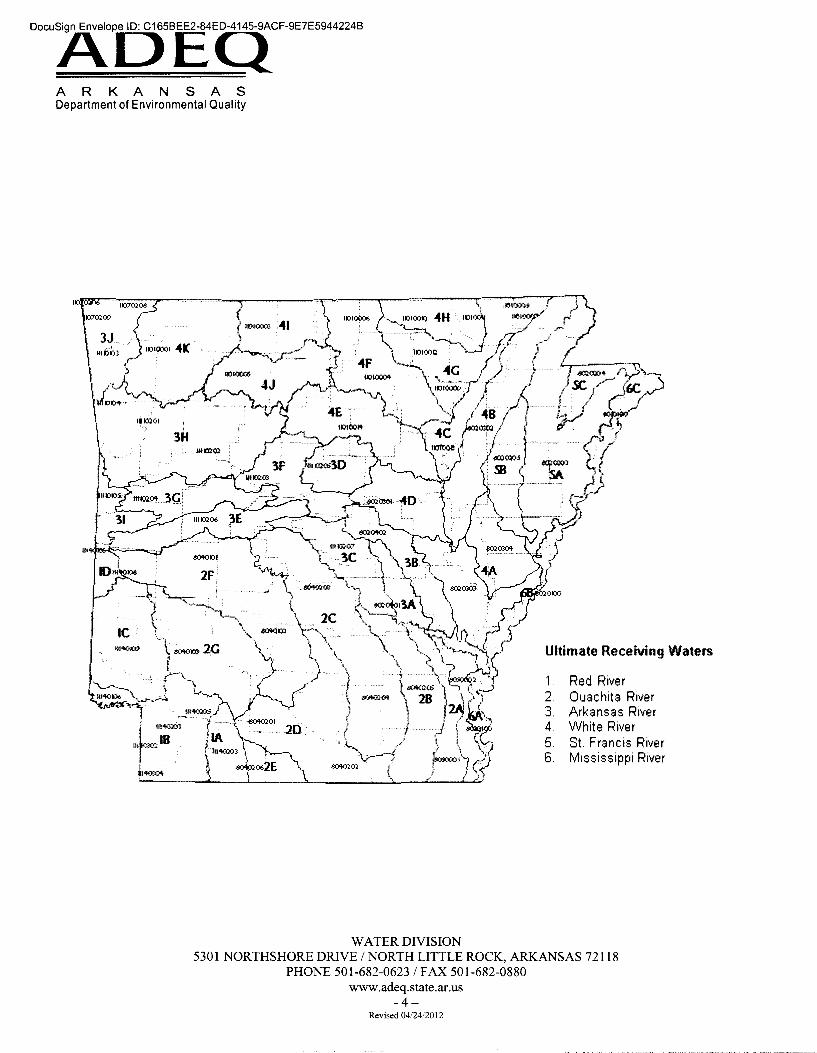
A R K A N S A S Department of Environmental Quality
Ill
l"fo::04
WATER DIVISION
Ultimate Receiving Waters
1 Red River 2. Ouachita River 3. Arkansas River 4 White River 5. St. Francis River 6. Mississippi River
5301 NORTHSHORE DRIVE I NORTH LITTLE ROCK, ARKANSAS 72118 PHONE 501-682-0623 IF AX 501-682-0880
www.adeq.state.ar.us -4-
Revised 04/2412012

I ~ -It) •
ny ~ CAib~ f~_, .. _
phoN_S
~ ;v;;r y