Embed Size (px)
Citation preview

ARIZONA'S CHANGING RIVERS:
HOW PEOPLE HAVE AFFECTED THE RIVERS
Barbara Tellman Richard Yarde Mary G. Wallace
Water Resources Research Center College of Agriculture The University of Arizona March 1997

ANGLO-AMERICANS ARRIVE
The first Anglo-Americans to reach what eventually became Arizona were "mountain men" who came to trap beaver in the 1820s. James Ohio Pattie's company traveled down the Gila in 1824, collecting some 250 pelts. His journals provide much information about the period, although they contain obvious exaggerations. He returned in 1827, concentrating on the San Pedro and Colorado rivers, with a goal of "trapping the rivers clear," or getting all they could. Other trappers who explored Arizona's rivers at this time included Ewing Young in 1830, who sold 1,500 pelts in Santa Fe; Pauline Weaver, who returned as a guide in later years; William Wolfskill; and George Yount. Hat fashions changed from beaver to silk, and by the 1860s beaver populations had recovered on many of the rivers. Their numbers later
Surveyors' party exploring a tributary of the Gila River in 1848.
were reduced again by other human activities, including overgrazing, urbanization and loss of water supplies in the rivers .
After most of present-day Arizona became part of the United States in 1848, more and more American travelers arrived. Many were just passing through on their
"The [Colorado at Yuma] river here is 170 yards in breadth, with a current of about 3 ~ miles an hour. It is crossed by means of a rope suspended from either bank-a mode of travel very disagreeable and somewhat dangerous. Capt. Thorn endeavoring to pass here ... on two log canoes lashed together, was upset, and together with three others, swept down on the current and drowned. " Lorenzo Aldrich, 1849.
AMERICANS ARRIVE
way to the California gold fields. The U.S. -Mexico boundary had to be surveyed, and wagon and later railroad routes had to be mapped. Whereas the Spanish routes tended to be north-south from Mexico, the new American routes most often were east-west, from the East Coast to California.
Travel Routes Travel routes from the earliest historic times to
the present tended to follow a few major routes, avoiding the very great barriers of the White Mountains, the Chiricahua Mountains, the Canyonlands of southern Utah and northern Arizona, and the Apaches. The Colorado River could be crossed in only a few places. Water was necessary, so travelers stayed within one or two days distance of drinking water. In Arizona, rivers
39

were important travel corridors, providing water and food for people and livestock. People ventured into rivers only to cross them, not to travel on them. Instead, they traveled along the river hanks.
The Colorado River formed a harrier to exploration for most of its length in Arizona. Travel through the Grand Canyon by foot or mule was very difficult (although Indians had traveled there for centuries), and boat travel was risky. There were only two good crossing spots to the north-Lee's Ferry and another near what is now the Page area. There were about a dozen ferries and crossing locations around and south of the present Lake Mead down to Yuma. The Colorado River is the only Arizona river ou which hoats regularly traveled-and such travel ceased hy the end of the nineteenth century, except for recreational hoating. Even though travelers no longer are dependent on rivers for drinking water, many of today's major transportation routes, such as I-10, still follow the historic
trails and roads.
To cross the state from the east in the nineteenth century, most travelers either followed the Gila River, entering Arizona about where I-1 0 is today, or they traveled south of the Chiricahua Mountains, crossing
The Great Surveys Surveys to determine the boundary and to establish
wagon roads and railroad routes produced a great deal of useful information about the territory and its vegetation and wildlife, as many of the survey teams included biologists. Captain Sitgreaves sought a road from Zuni to California in 1851. John Bartlett surveyed from southeastern Arizona to California in 1851 and 1852. Lt. Arnie! Whipple surveyed for a transcontinental railroad in northern Arizona in 1853-54. At the same time Andrew Gray surveyed a railroad route along the Gila River.
In 1854-55 Lt. John Parke resurveyed the area along the eastern part of that route. When the U.S. became a territory Lt. Emory's survey in 1855 delineated the boundary. Joseph lves, who had traveled earlier with Whipple, returned in 1858 to survey the lower Colorado River. In 1869, John Wesley Powell made the tlrst of several investigations of the upper Colorado River. The most unusual survey was made by Edward Beale, who traversed northern Arizona in 1858 usi'ng a caravan of camels, to establish a wagon route.
40
"I wi!lr Samuel & James & My wife commenced ro cork an old jlar hoar & by noon we were ready ro cross [rlre Colorado River ar Lees Ferry/. W'lren we /aunclred rhe Boar, My 2 sorrs hesirared ro venrure in such a crcrfr. My wrfe ... Said r!rar She would go over wirlr Me & sreer. 17ren we reached rlre opposite side, rhe {Navajos! Mer us wirh open arms of Friends/rip. ... A.frer Much d(fficulry we Succeeded in gerring rlrem & their luggage over safe. Nexr was r!reir horses which we failed ro swim over afrer 2 trials & nearly upserring rhe Boar . . .. Nixhr fall closed rhe scene. For rlre lasr 3 hours I worked through fever arrd ague & when I reached rhe fire on shore I was so near exhausted rlrar I Staggered . ... "[sic I John Lee , 1872.
the San Pedro River and then traveling up the Santa Cruz River. The southem route was longer than the northern route, hut had the advantage of avoiding much of the Apache danger. A northern route left the New Mexico puehlos and met the Zuni and Little Colorado rivers, then headed west hy either of several routes. Another route skirted
Arizona, going through Utah and down along theVirgin and Colorado rivers.
Travelers adversely affected rivers on the more common trails. Wheeled vehicles rutted the roads, causing gullying and erosion. Firewood
near the stopping places was gathered and trees
were cut. Livestock trampled the shores at water holes and river crossings, especially when many animals traveled together. Livestock also ate whatever vegetation was availahle. This left the river vulnerahle to erosion and more devastating tloods.
In some areas so little vegetation was left near the trails that cattle starved. By the time travelers reached areas with vegetation, their livestock were ready to eat less palatable kinds of plants. When travelers were few and far hetween, or par-ties were small in number, the long-term impacts to rivers were small. On the more-traveled trails. however, the impacts could he significant, espe-cially at major crossing points .
Stagecoach Routes
Stagecoach stops were located where there was adequate water and at comfortahle distances for
travelers and horses. All the stops across Ari-
AMERICANS ARRIVE

"There was a big 7 steel-span bridge across the Gila River six miles up from San Carlos, but travelers from the East could not get up onto it and those from the West could not get off, because the Giln River's trenching had been to dig away the river bank on the east end of the bridge and to flow around it instead of under it." Apache Dancer, May 11, 1979.
zona on the Butterfield route were located by rivers, near springs or near lakes, except one where water had to be hauled in. The most famous stage station was at a spring at Apache Pass, a favorite watering source for Cochise as well as the travelers. The continual use of watercourses by livestock and people had an impact on those watercourses but after the stops were closed, the areas recovered and the long-term impacts were generally minor.
River Crossings Most Arizona rivers were fordable during
most of the year, but could become uncrossable raging torrents at other times. Only the Colorado River could seldom be forded and could be crossed at only a few spots. Enterprising pioneers set up ferry stations at the most desirable sites-Yuma, Lee's Ferry, and several others on the Colorado River, and Hayden's Ferry on the Salt River. Lee's Ferry in northern Arizona was the only feasible river crossing for hundreds of miles. The Yuma crossing was the most contested one, especially when travel to the California gold fields became popular. At least two pitched battles took place. Hayden's crossing over the Salt was principally needed only at flood time, but was essential then.
Railroads Building of the railroads had a much greater
impact on rivers than either trails or stagecoach routes. Lumber was needed for railroad ties and bridges. To provide an incentive for the investment needed, the federal government granted some major cross-country companies alternate sections of land for ten miles on both sides of the track. From these locations lumber and in the early days fuelwood could sometimes be gathered. Trains, however, soon converted to
AMERICANS ARRIVE
coal and later oil. Lumber for ties was usually brought in rather than harvested on site. Most railroad companies later sold their lands for ranching and other purposes.
In order to minimize costs of construction, bridges often were originally built as narrow as feasible, in some cases leaving the channel narrower than was necessary to carry flood flows. Washouts were a serious problem during infrequent floods. The Southern Pacific track along Cienega Creek, for example, had to be rebuilt several times, and finally was moved to higher ground.
The greatest impact of the railroads was in opening up lands that had formerly been inaccessible, such as areas on the Colorado Plateau. When the railroad reached towns such as Tucson or Phoenix, large numbers of people now were
~-.
~
,,lilt~ ~ . \\\I \ \ lfw,_ 1 1 ~J 1 1 ' ' 1 1 'Southern Pacific'~> •
Railroad casa Grande >-_.7 , • ';.- •. ..~I I ~ \ ..
Tucsm '(, ,'
'',1••~··· .... '
Major cross-country railroads.
41

able to reach the area in relative comfort, ami all kinds of materials could be imported and exported. Ranching was initially profitable largely because the beef could be sold in the East. Some communities, such as Casa Grande, developed originally as railroad towns.
Highways Many modern highways approximately follow the old
trails. I-1 0 follows the old trails (north of Apache Pass) along the Gila River west to Casa Grande, with a curve south to Tm:son. I-8 resumes that trail all the way to Yuma. I-19 parallels old trails from Tucson to Nogales. In the north, I-40 follows the routes of trav
elers from Santa Fe west. The old trail around the Guadalupe Mountains east of Douglas has been aban
doned, but parts of it have become highways 80 and 82. Old trails from Prescott west and south and through Wickenburg are now highways. Most of the roads going through Phoenix are recent since the city was not on most older routes. North-south travel from Flagstaff is also relatively recent, as is the Salt River
route through Globe.
Impacts on the Rivers The opening of the West through increasingly mec!Ia
nized transportation had major impacts on Arizona's rivers. From the earliest times travelers and their animals left their marks on the rivers they crossed or trav-
"After a wearisome ride l saw the wagons and the tall cottonwoods (~f the Gila, and when within Ira({ a mile of it, my tired mule smelt the running water. She pricked up her ears, gave one long bray, and made a beeline for the Gila directly through the thick chaparral. I hung on to her back like death to a deceased African and away we went like the wind to the banks (Jf the Gila, inro which she plunged her head and never raised it till her sides were distended like a hogshead . ... There was no checking their impetuosity; some of their riders were left hanging in rlre branches of the rrees, some were thrown, and some were pitched headlong into the water . ... "John Durivage , 1X49.
eled along. Beaver trapping radically affected the rivers by eliminating the many pools behind the
dams. These pools created wildlife habitat and slowed river tlow so that downstream floods were usually minimal. When the dams were eliminated, erosion damage to rivers increased and wildlife habitat was lost. Large numbers of live
stock drastically reduced vegetation in some areas, leading to erosion and more devastating tloods. Probably the greatest impact of improved transportation was to open up the West to large numbers of people who then impacted the rivers in many ways described throughout this book.
The Mormon Battalion
The tirst ~ofticial" American exploration of southern Arizona was led by Philip St. George Cooke, who took an ad hoc U.S. Army battalion of five companies of Mormon volunteers in 1846 from New Mexico to California to create a wagon trail to San Diego. They were also supposed to help consolidate U.S. victories over the Mexicans. Some of our best early descriptions of southeastern Arizona are from that trip. Traveling with the batallion were 36 wives and 54 children.
Cooke and his men made their way through the unknown terrain with the help of local Indians and experienced guides, including Pauline Weaver, who had trapped heaver in Arizona in the 1820s. They traveled the length of the San Pedro River from near the border with Mexico. It was not uncommon for soldiers , Mormons, and early explorers to battle wild cattle as well as Apaches in the San Pedro Valley. After a major battle with a he rd of wild hulls (the only real battle of the journey) Cooke declared that he feared hulls more than Apaches.
The battalion went on to the Santa Cruz River to ensure that Mexican troops vacated the Presidio of Tucson. When they got there, the Mexicans had prudently left for San Xavier and the encounter was peaceful.
After many hardships and adventures, the battalion finally crossed the Colorado River at Yuma. having blazed an important route used by later travelers. Once they reached California the battalion dispersed and many of the soldiers joined the Gold Rush , while others settled in Arizona and elsewhere.
42 c; .. -· '\ r / ·;:::- ~ :v ~~ ,;},t) AMERICANS ARRIVE

VERDE RIVER
The Verde River is one of Arizona's few perennial rivers, still greatly valued for its wildlife, scenic, and recreational features . It has been important to Indian tribes for hundreds of years, and in the pas~ century has served mining, agriculture and ranching needs. More recently tourism and second-home development are occurring along the river. The river also is a water source for the Phoenix urban area.
The River The Verde River begins at Del Rio Springs in the
Chino Valley , high in the mountains of west-central Arizona, and flows south through 150 miles of grasslands, steep canyons and deserts to join the Salt River. Water enters the Verde River from many tributaries , the major ones being Sycamore Canyon, Oak Creek, Beaver Creek, Fossil Creek, the East Verde River, West Verde River and Clear Creek. The river can be conveniently divided into three sections: the Upper Verde and tributaries in sparsely populated areas; the Verde Valley; and the Lower Verde where two major dams exist. The entire watershed covers 6,650 square miles and has 464 miles of perennial streams; 8,280 miles of non-perennial streams; and 8,320 acres of lakes.
The Early Inhabitants The first known people to enter the Verde Valley
between 2,000- 10,000 years ago were nomadic.
" .. . the head of one of the branches of the San Francisco [Verde] River, where beaver dams form a succession of ponds that are Literally filled with fish. On the maps this valley is called Val de Chine (Chino Valley]; here it is called Cienaga. "Joseph P. Allyn, 1866. Val de Chine was named by Whipple for its lush gramma grass, which the Mexicans called "de china. "
Later the Sinagua people inhabited the upper and middle regions of the Verde River, from about 700 A.D. to about 1425 A.D. Some experts think the Ho-hokam either moved in or influenced development of agriculture in the area. The Sinagua also traded with the Anasazi to the north. By 800 they were farming the tops of mesas using dry farming techniques with masonry field houses, rock borders and check dams. They grew corn in the floodplain.
The Palat- kwapi Trail was a !50-mile long major trade route from Sinagua territory to the Colorado Plateau. The Northern Sinagua moved into the Verde Valley from drought-stricken areas in the 14th century. This was the high point of Sinagua civilization. They built Tuzigoot near present-day Clarkdale in the 14th century and other pueblos located about two miles apart on Beaver Creek and Oak Creek, including Montezuma's Castle farther east.
During this time people congregated in fewer large areas and irrigated the floodplains to grow such crops as corn, squash, cotton and tepary beans. They also dry-farmed crops such as agave.
Something happened within a century of these achievements, and by 1425 the Verde Valley was abandoned. The people moved to the northwest- to Anderson Mesa (40 miles southeast of Flagstaff) and maybe to Hopi areas to the north-
VERDE RIVER 1D CCJ 43

east. Why they left is uncertain. Possible reasons include drought (although climate records don't indicate a major change), waterlogging of the soil, warfare, disease, overpopulation, depletion of resources, and loss of trade networks . The amount of irrigated agriculture along the river must have greatly altered the river vegetation and removed quite a hit of water from the river. By the time the first Americans appeared the river had lush riparian vegetation.
Sometime after the Sinagua abandoned the area. nomadic Yavapai and Tonto Apaches moved in and were well established by the time American miners en
tered the territory in the 1860s. Many of these native people practiced simple ditch irrigation and farmed part of the upper Verde tloodplain. The rest of the Upper Verde is said to have been too marshy for agriculture . The Yavapai and Apaches developed rancherias w11ere a few extended families lived, mainly through hunting, gathering and some agriculture.
• • •
Prescott • Fort Whipple
Flagstaff
Tapco Camp Clark Clarkdale
Tuzigoot • Cottonwood Jerome•
• • •
•
Historic sites along the Verde River.
44
"In those days malaria wm· common. Everyone had it in the summer. There were few if any floods, and the Verde Ril'er .1pread out wide, and so shallow you could cross it 011 clumps of grass. Willows and undergrowth were so heavy all over the river hed that the water was forced into standing pools which hred mosquitoes. " Leonora Bristow Lee, 1954.
Spaniards Pass Through The Spaniards had little impact on the Verde
River. Most of the descriptions of their routes are vague, and it is difficult to know just where
they went. In 1582. Espejo described the people of the Verde Valley as having mines, parrots, grapevines, tlax and maize. In 1598, the Onate expedition came through, and the journalist, Farfan, mentioned that the Indians were milling, with shafts 16.5 feet deep. obtaining powdered ores used for coloring. They used beaver pelts fo r clothing, made mescal and grew maize. More than a century passed before the next Spaniard, Valvarde, mentioned Indians who were probably the Yavapai, although he seems not to have gone up the Verde River. Sixty years later Garces left the Colorado River south of Needles and traveled east through "Yabapais" rancherias on his way south and west. Between 1605 and 1850 no foreign expedition entered the Middle Verde Valley. Probably the most lasting impact of the Spanish was the introduction of horses, which changed the lifestyle of the Apaches. Horses made them more mobile and allowed them to roam farther.
American Expeditions Several parties of American trappers hunted
beaver along the Verde River in the 1820s. but while other parts of Arizona were being explored at that time, the Verde Valley was mostly ignored. Sitgreaves came through in 1851 on a survey trip , but may have only reached a tributary. In 1854 Whipple reached the headwaters , while surveying for a railroad. His guide, Leroux returned to the area on his way back east, exploring a little more of the upper Verde . There was little
VERDE RIVER

"[Clarkdale] was laid out then ... on three levels: the top of the hill where the business section, the school and the best houses stood; the second level where the blue-collar workers lived; and the lowest plane, where the Mexican laborers lived . .. Mexican town .. was on the banks of the Verde on that level lower than ours. It was the most human and enchanting place of all, everything he iter skelter, geraniums blooming everywhere. In a way, the residents were the most favorably situated ofus all, sheltered by the native cottonwoods that grew slightly above the willow thickets . ... After a while, a number of strong-minded Gringos decided they would rather live there too, and in the end there was quite a mix down by the river. " Patricia Paylore, 1980.
long-lasting impact from these exploring and trapping parties. The beaver apparently recovered to their former population levels by the time American settlement got underway in the 1860s.
Early American Occupation Americans again entered the Verde Valley-this time
to mine gold, silver, and later copper. From the beginning there were major conflicts between the Yavapai and Apaches accustomed to hunting over a very large region and American settlers who claimed many of the best areas (always near water) for their own. After the Civil War, the military arrived to protect miners and settlers. In 1865 Fort Whipple was established to protect the gold-seekers. The fort became the territo-
rial capital until Prescott was designated the capital.
After much conflict between Americans and Apaches, the military prevailed, and in 1871 the Camp Verde Reservation was established, 40 miles up from Camp Verde, extending for I 0 miles on both sides of the river. The Indians were expected to become agriculturalists but once irrigation became successful in this rich land, American settlers coveted it, and the Yavapai and Apaches were again resettled-this time mostly to the San Carlos Reservation. By the 1880s, war was over and most of the local Indians either had been killed, died of disease or moved to reservations. Farther downstream, Fort McDowell was established in 1865 to protect settlers in the Salt River Valley. After the fort was abandoned in 1890, the area became a Yavapai reservation.
Mining Spanish explorer Espejo reported that the
Indians were mining for colorful minerals in the soil, but he had little interest in those minerals-he was seeking gold or silver. After the California Gold Rush, Americans traveled throughout the West hoping to make another rich strike. After the Verde Valley was conquered, thousands of prospectors moved in. Many surface finds were made, but it was not until 1876 that Morris and Sally Ruffner filed claims on the old Yavapai mines. Although the mines contained gold, silver and copper, the Ruffners did
United Verde mine and smelter at Jerome. (Note that the hill has been denuded of trees.)
VERDE RIVER 45
"In another locality where the flood washed away several acres of a cultivated farm exposing to view a former channel of the river with a stone dam across it, which when first exposed was 4 feet higher than the old channel,built in a straight line across the river, the outer walls of which were laid with immense stones with smaller ones between. Growing over the dam and ditch were great trees over 5 feet in diameter. " Undated letter from John Davis to Sharlot Hall, probably written in 1895.
not have adequate transportation to make mining profitable. James Douglas (who developed the Phelps Dodge copper mines) examined the claim and decided not to buy it. It was not until the late 1880s that industrial giant William Clark decided to buy the mine. The railroad had come to Ash Fork, and Clark saw great possibilities in property at what is now the town of Jerome. To develop these possibilities Clark eventually oversaw the construction not only of huge mining and smelting facilities, but also a railroad and power plants in Fossil Creek.
When it became clear that a new town was needed, Clark bought some ranches along the banks of the Verde River and their water rights and designed Clarkdale as a model planned community. The town was considered an ideal place to live, except for the severe air pollution. Little could grow in the path of the smoke - and much of the vegetation along the hillsides was either killed or stunted. Even though the mine and smelter were closed in 1953, vegetation on the hillsides is still stunted. After the mine and smelter closed, the population decreased, although Jerome and Clarkdale have remained popular tourist destinations.
Long-term mining impacts at the "richest copper mine in North America" were direct changes to the land from the underground and open pit mines and the smelter; elimination of vegetation from fuelwood cutting and air pollution; use of water for the smelting process; changes to Fossil Creek from the power plant; and the impacts of the mining communities themselves on the river. Tailings at Peck's Lake and spots close to the Verde River nearby have destroyed the riverbanks.
46
Agriculture and Grazing
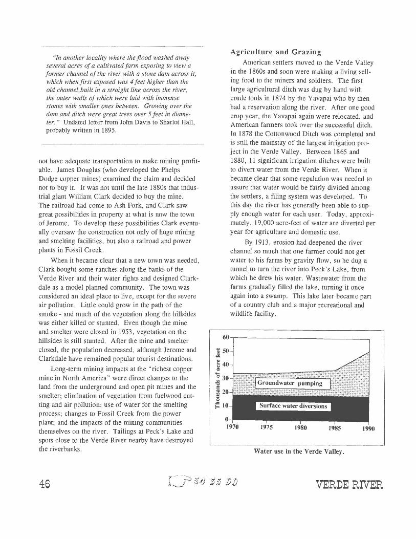
American settlers moved to the Verde Valley in the 1860s and soon were making a living selling food to the miners and soldiers. The first large agricultural ditch was dug by hand with crude tools in 1874 by the Yavapai who by then had a reservation along the river. After one good crop year, the Yavapai again were relocated, and American farmers took over the successful ditch. In 1878 the Cottonwood Ditch was completed and is still the mainstay of the largest irrigation project in the Verde Valley. Between 1865 and 1880, 11 significant irrigation ditches were built to divert water from the Verde River. When it became clear that some regulation was needed to assure that water would be fairly divided among the settlers, a tiling system was developed. To this day the river has generally been able to supply enough water for each user. Today, approximately, 19,000 acre-feet of water are diverted per year for agriculture and domestic use.
By 1913, erosion had deepened the river channel so much that one farmer could not get water to his farms by gravity tlow, so he dug a tunnel to turn the river into Peck's Lake, from which he drew his water. Wastewater from the farms gradually filled the lake, turning it once again into a swamp. This lake later became part of a country club and a major recreational and wildlife facility.
60,---------------------------~
Water use in the Verde Valley.
VERDE RIVER
Below the middle Verde Valley, there is virtually no agriculture until the confluence of the river with the Salt River at the Fort McDowell Indian Reservation. Even here, little agriculture occurs.
Grazing also was an important business in the area since the late 1880s and had the greatest impact on the area in the late 19th century. In some areas overgrazing continues to be a problem, and the spring which forms the headwaters of the Verde River has been impounded as a stock pond.
Water Use The Salt River Project (SRP) holds major water
rights along the Verde River for use in the Phoenix area. This has to some extent assured that large amounts of water are not diverted by upstream users, thereby maintaining river flow. This has, however, also led to conflicts between SRP and the upstream communitie·s. Because there are no unappropriated surface water rights in the Verde Valley, groundwater pumping has become important. Some studies have shown a clear relationship between the groundwater and the surface water in the area, but groundwater pumping does not legally affect surface water rights. Pumping has not severely affected the river, but concerns have been raised about whether flow of water in the river will be reduced as the population expands in the Verde Valley, increasing water use.
Between Cottonwood and the confluence with Oak Creek there is little water left in the river. Ditch companies remove water upstream then return it down-
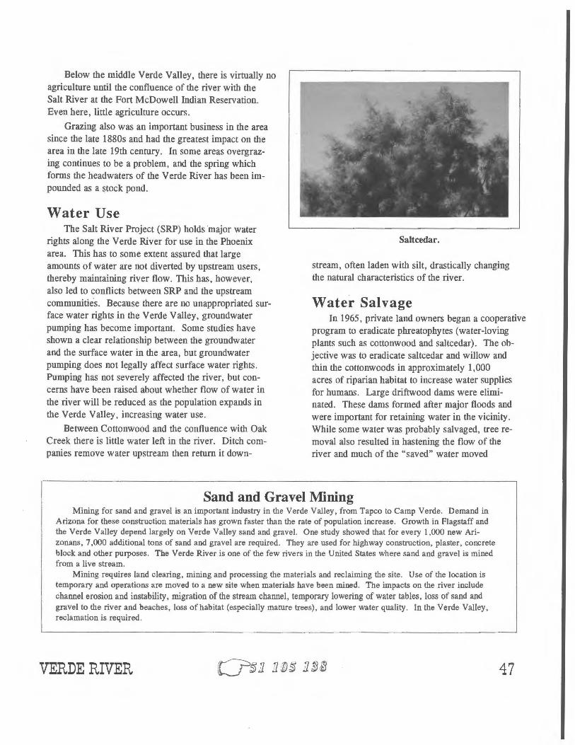
Saltcedar.
stream, often laden with silt, drastically changing the natural characteristics of the river.
Water Salvage In 1965, private land owners began a cooperative
program to eradicate phreatophytes (water-loving plants such as cottonwood and saltcedar). The objective was to eradicate saltcedar and willow and thin the cottonwoods in approximately 1,000 acres of riparian habitat to increase water supplies for humans. Large driftwood dams were eliminated. These dams formed after major floods and were important for retaining water in the vicinity. While some water was probably salvaged, tree removal also resulted in hastening the flow of the river and much of the "saved" water moved
Sand and Gravel Mining Mining for sand and gravel is an important industry in the Verde Valley, from Tapco to Camp Verde. Demand in
Arizona for these construction materials has grown faster than the rate of population increase. Growth in Flagstaff and the Verde Valley depend largely on Verde Valley sand and gravel. One study showed that for every 1,000 new Arizonans, 7,000 additional tons of sand and gravel are required. They are used for highway construction, plaster, concrete block and other purposes. The Verde River is one of the few rivers in the United States where sand and gravel is mined from a live stream.
Mining requires land clearing, mining and processing the materials and reclaiming the site. Use of the location is temporary and operations are moved to a new site when materials have been mined. The impacts on the river include channel erosion and instability, migration of the stream channel, temporary lowering of water tables, loss of sand and gravel to the river and beaches, loss of habitat (especially mature trees), and lower water quality. In the Verde Valley, reclamation is required.
VERDE RIVER 47

downstream. Salvage also caused siltation of the river gravels and spawning beds.
Also in the 1960s the U.S. Forest Service implemented a major watershed clearance project on the Beaver Creek watershed. The plan was to rid the area of trees by mechanical removal as well as the use of herbi-cides. Some of the herbicides used were highly toxic, but the U.S. Forest Service did no monitoring, so longterm impacts on other vegetation, wildlife and humans are unknown. The project was found to have little long-term impact on water supplies downstream, so it was discontinued after more than a decade of effort. No long-term studies of the impacts were conducted.
Dams Small dams have been part of the Verde River for
centuries. Dr. Edgar Mearns described the Verde River in the 1880s. It was "deep, flowed slowly, and was impeded by many beaver dams." Similarly, Mrs.
~~ Flagstaff
cl~l
Prescott
Horseshoe Darn
Twentieth century sites along the Verde River.
48
Year
Population in Yavapai County.
Nick Perkins stated that in the 1890s "the river flowed slowly, impeded by many beaver dams and extensive marshes occupied the floodplains." Prehistoric agricultural practices included check dams in the upper watershed as well as dams in the Verde River itself.
There are few of these smaller dams today, except for beaver dams on some tributaries. Fossil Creek was dammed in 1907 to provide water for power generation, with its entire flow diverted through a flume. Diversion has led to destruction of an unusual travertine formation in the stream. This power plant has since been upgraded and continues to provide power for the area. The impacts of the facility were significant for wildlife and mitigation measures are currently underway, as part of relicensing the facility.
As population and agriculture in the Phoenix area increased, and occasional floods inundated the Salt River Valley, demand arose for water storage and flood protection. Bartlett Dam was finished in 1939 and can impound 178,477 a.f. of water in its 12-mile long lake. Horseshoe Dam, farther upstream, was finished in 1946 and can impound 139,238 a.f. in its five-mile long lake. Both dams are operated by the Salt River Project for water storage, and the lakes are popular recreation sites. The dams are managed to supply downstream water demands, except at flood time. Through a complex arrangement in which Phelps Dodge Corporation helped build Horseshoe Dam, exchanges water with the Salt River watershed, resulting in about 9,000 a. f. of water added to the Lower Verde River.
VERDE RIVER

Recr eation
Cottonwood Ford of the Verde River at Camp Verde about 1890.
The Verde River and some of its tributaries offer important recreational opportunities for Arizona residents. Oak Creek is one of the most popular outdoor areas in the state, both for Arizonans and out-ofstate visitors. Parts of the area, especially in and near Sedona, are popular secondhome areas for people from the Phoenix area. The lower Verde also is a popular river for rafting and canoeing, especially in the section designated "Wild and Scenic." In the more popular recreation areas, the river has been severely impacted by trampling, litter, paving for parking lots and facilities, and water quality problems. Areas with many second homes and tourist facilities are putting
The Granite Reef Diversion Dam is just downstream from the confluence of the Salt and Verde rivers, 32 miles from Phoenix. It was completed in 1908 to provide water for the growing Phoenix area, especially for agriculture. The dam diverts almost a million acrefeet a year into Salt River Project canals. This is virtually all the flow in the river, except at flood time.
Growth of Towns The rapid growth of Prescott and towns in the Verde
Valley (along the upper Verde) has placed strains on water supplies for the Verde River. After slow growth through most of the twentieth century, the Prescott area is one of the fastest growing parts of Arizona. Granite Creek no longer flows through Prescott most of the time. Even the wastewater flow from the Prescott treatment plant no longer flows along the creek to recharge water supplies for agriculture in the valley below. Instead the wastewater now is used on golf courses and is directly recharged. Granite Creek through Prescott now is a park and hiking trail.
Developments in upstream areas, such as in Chino Valley, use groundwater, which appears to be affecting surface water supplies downstream. Demands for water throughout the Verde Valley have grown rapidly and increased use of water in the Prescott area may affect del Rio Springs, an important tributary.
VERDE RIVER
strains on the water supplies.
The Verde River flowing perennially through the Fort McDowell Reservation is another popular recreation area for people from the Phoenix area, for tubing and other water-based activities.
Wildlife Few people have studied wildlife along the
Verde River, and few early travelers wrote about wildlife. Since the Verde River still flows freely for much of its length, changes in wildlife have been less dramatic than on many other Arizona rivers. In areas where cottonwood or sycamore forests prevail, bird life is probably fairly similar to what it was in the past. Bird diversity has been greatly reduced in those areas where saltcedar is the dominant tree or where rivers have lost their cottonwood forest by other means.
Beaver were plentiful when trappers Ewing Young and Kit Carson came through in 1829. There are no beaver on the river today. Otters were reintroduced around 1980 and can be occasionally seen today.
49

Restoration and Preservation The river today includes a few largely unchanged
tributary areas. The best example is Sycamore Creek, now a wilderness area. The Fort McDowell Indian Reservation occupies 24,680 acres along the Verde and Salt rivers. After many years of controversy, the Yavapai and others succeeded in blocking construction of the Orme Dam (a proposed part of the Central Arizona Project) which would have inundated many acres of the reservation and displaced most of the Indians and their agriculture, as well as protected bald eagles. Much of the watershed is managed by the U.S. Forest Service.
A middle portion of the river has been designated as "Wild and Scenic," a federal designation giving it some protection from development. Two large state parks on Oak Creek and two on the Verde River near Cottonwood and Camp Verde offer both protection and extensive recreational opportunities. A restoration project is currently underway at Tavasci Marsh near Clarkdale to restore some valuable wildlife habitat. In the early 1990s, Arizona State Parks facilitated a "Corridor Planning Process" in an attempt to get agreement among residents on managing the river in the Verde Valley. This process was partially successful, and resulted in formation of the Verde Watershed
Association, a group of residents and agency representatives working to preserve the river as well as
human uses of it.
Changes to the River The visitor to Tuzigoot National Monument today
can witness a vivid contrast in human-made change. Looking in one direction from the hilltop ruins, the visitor sees a healthy river with lush riparian vegetation. There is probably considerably more of this vege-
tation than in the heyday of Tuzigoot when much of the land would have been cleared for farming. Turning around, the visitor sees a quite different scene. The valley floor is lined with waste left from twentieth century copper mining. Little or no vegetation grows here.
The river in the upstream areas and some of the tributaries are generally little changed, with the exception of Oak Creek and Fossil Creek. Oak Creek has been facing pressures from tourism and urban development, while Fossil Creek has been changed by stream diversions for the power plant. Historic overgrazing contributed to downcutting of the stream in some of the these areas, making it flow faster and narrower.
Early settlers reported that the Verde Valley had numerous marshes and that the stream was wide and slow-moving and impeded by many beaver dams. Malaria was a serious problem. Today the stream in that area has downcut and flows strongly in the high-water season. Only one marsh remains. Mesquite trees are now common where the marshes once were. The land is intensively used for agriculture and towns. These changes occurred because of loss of beaver, historic overgrazing, urban development, agriculture, water diversion, groundwater pumping and loss of native vegetation.
The 17 miles of river which have become lakes behind dams have completely different vegetation and characteristics from the former unregulated river. Saltcedar has replaced native vegetation. Downstream of the dams, the river at low-water times has only enough water flows to satisfy downstream water demands. This has altered wildlife habitat.
"In February 1957, 82 years to the day from the departure of the Indians, I visited the Camp Verde area to try to locate some of the old sites, but little remains to suggest the hardships encoulltered in the early days. Ha-ka-roo-ya creek has disappeared, and nothing remains but a 'hot spring.' Grief Hill has lost its 'grief.' ... The bend in the river, which was the original site of the agency at Cottonwood, has washed its banks beyond recognition, and the Verde Valley has 'flattened out."' J. Corbusier, 1968.
50 VERDE RIVER