Embed Size (px)
Citation preview

McPhaul Suspension Bridge - Yuma County
B R I D G E S
A R I Z O N A H I S T O R I C B R I D G E I N V E N T O R Y
submitted to:
Arizona Department of Transportation
205 South 17 Avenueth
Phoenix, Arizona 85007
produced by: in association with:
FRASERdesign EcoPlan Associates, Inc.
420 South County Road 23E 701 West Southern Avenue Suite 203
Loveland, Colorado 80537 Mesa, Arizona 85210
January 2008

NPS Form 10-900 OMB No. 10024-0018(Revised March 1992)
United States Department of the Interior
National Park Service
National Register of Historic PlacesMultiple Property Documentation Form
This form is for use in documenting multiple property groups relating to one or several historic contexts. See instructions in How to Complete theMultiple Property Documentation Form (National Register Bulletin 16B). Complete each item by entering the requested information. For additionalspace, use continuation sheets (Form 10-900-a). Use a typewriter, word processor, or computer to complete all items.
New Submission x Amended Submission ____ ____
A. Name of Multiple Property Listing
Vehicular Bridges in Arizona 1880 - 1964
B. Associated Historic Contexts
Vehicular Bridges in Arizona 1860 - 1964
C. Form Prepared By
Clayton B. Fraser, Principalname/title
FRASER design 15 January 2008organization date
5700 Jackdaw Drive 970.669.7969street & number telephone
Loveland Colorado 80537city or town state zip code
D. Certification
As the designated authority under the National Historic Preservation Act, as amended, I hereby certify that this documentation form meets the NationalRegister documentation standards and sets forth requirements for the listing of related properties consistent with the National Register criteria. Thissubmission meets the procedural and professional requirements set forth in 36 CFR Part 60 and the Secretary of the Interior’s Standards for Archeologyand Historic Preservation. ( See continuation sheet for additional comments.)
Signature of certifying official date
State or Federal agency or bureau
I, hereby, certify that this multiple property documentation form has been approved by the National Register as a basis for evaluating related propertiesfor listing in the National Register.
Signature of commenting or other official date

x see continuation sheet
Vehicular Bridges in Arizona 1880 - 1964 Arizona___________________________________________________________________________________ ___________________
Name of Multiple Property Listing State
Table of Contents
Provide the following information on continuation sheets. Cite the letter and the title before each section of the narrative. Assign page numbersaccording to the instructions for continuation sheets in How to Complete the Multiple Property Documentation Form (National Register Bulletin 16B).Fill in page numbers for each section in the space below.
Section Page number
E. Statement of Historic Contexts
1. Introduction 1
2. Bridge Development in America 2
3. Territorial Road and Bridge Construction in Arizona: 1880-1912 8
Figure 1. Solomonville Road Overpass 11
Figure 2. Alchesay Canyon Bridge 13
Figure 3. Black River Bridge 16
Figure 4. Tempe Bridge 17
4. Early State Bridge Construction and Transcontinental Highways: 1912-1920 17
Figure 5. Map of proposed highway system of Arizona, 1912 19
Figure 6. Map of proposed state highways of Arizona, 1916 21
Figure 7. Antelope Hill Bridge 22
Figure 8. Santa Cruz River Bridge 24
Figure 9. Clason’s Guide Map of Arizona, 1918 29
Figure 10. Map of proposed Phoenix-Yuma Highway, 1920 31
Figure 11. Truck pulling train of cars across Gillespie Dam apron, circa 1926 33
Figure 12. Chevelon Creek Bridge 34
Figure 13. Jacks Canyon Bridge 35
Figure 14. Letterhead of Omaha Structural Steel Bridge Company, 1919 37
Figure 15. Canyon Padre Bridge 38
Figure 16. Gila River Bridge 39
Figure 17. Kelvin Bridge 40
Figure 18. Black Gap Bridge 41
Figure 19. Broadway Bridge 42
Figure 20. Cameron Suspension Bridge 43
Figure 21. Yuma Bridge 46
Figure 22. Topock Bridge 47
5. Federal Aid and the Arizona Highway Department in the 1910s and 1920s 47
Figure 23. Old Trails Wash Bridge 50
Figure 24. Granite Creek Bridge 52
Figure 25. Map of state highway system of Arizona, 1920 53
Figure 26. Concho Bridge 54
Figure 27. Cienega Bridge 55
Figure 28. Map of Arizona’s 7 percent system, 1922 57
Figure 29. Map of Arizona highway system, 1932 60
Figure 30. Dead Indian Canyon Bridge 61
Figure 31. Midgley Bridge 62
Figure 32. Mormon Flat Bridge 63
Figure 33. Verde River Bridge 64
Figure 34. Pine Creek Bridge 65
Figure 35. Gillespie Dam Bridge 68
Figure 36. Navajo Bridge 70
Figure 37. Dome (McPhaul) Bridge 71
Figure 38. Mill Avenue Bridge 72

x see continuation sheet
Vehicular Bridges in Arizona 1880 - 1964 Arizona___________________________________________________________________________________ ___________________
Name of Multiple Property Listing State
Section Page number
6. Depression and World War II Bridge Construction: 1933-1945 73
Figure 39. Map of state highway system of Arizona, 1933 75
Figure 40. Salt River Canyon Bridge 76
Figure 41. Winslow Underpass 77
Figure 42. Peoria Underpass 78
Figure 43. Rattlesnake Canyon Bridge 79
Figure 44. Willis Street Bridge 82
Figure 45. Map of state highway system, 1939 84
7. Post-War Construction and the Interstate Highway System: 1945-1964 86
Figure 46. Pinto Creek Bridge 90
Figure 47. Guthrie Bridge 91
Figure 48. Clear Creek Bridge 92
F. Associated Property Types
1. Concrete Arch Bridges 93
Figure 49. Concrete arch bridge diagram 94
Figure 50. Queen Creek Bridge 98
Figure 51. Holbrook Bridge 99
Figure 52. Queen Creek Bridge 100
Figure 53. Fossil Creek Bridge 101
2. Concrete Box Culverts and Slab and Girder Bridges 104
Figure 54. Concrete girder bridge diagram 104
Figure 55. Broadway Bridge 106
Figure 56. Pinal Creek Bridge 107
Figure 57. Tanner Wash Bridge 108
3. Concrete Rigid Frame Bridges 112
Figure 58. Benson Underpass 113
Figure 59. 17 Avenue Underpass 114 th
4 Steel Stringer and Girder Bridges 117
Figure 60. Steel I-beam stringer bridge diagram 118
Figure 61. Dry Wash Bridge 119
Figure 62. Wash Bridge 120
Figure 63. Wickenberg Bridge 121
Figure 64. Benson Bridge 122
5. Steel Truss Bridges 125
Figure 65. Steel truss bridge diagram 126
Figure 66. Truss bridge types 127
Figure 67. Truss bridge types 128
Figure 68. White River Bridge 129
Figure 69. Walnut Canyon Bridge 130
Figure 70. Sanders Bridge 131
Figure 71. Allentown Bridge 132
Figure 72. Park Avenue Bridge 133
Figure 73. Woodruff Bridge 134
Figure 74. Querino Canyon Bridge 135
Figure 75. Cameron Truss Bridge 137

x see continuation sheet
Vehicular Bridges in Arizona 1880 - 1964 Arizona___________________________________________________________________________________ ___________________
Name of Multiple Property Listing State
Section Page number
6. Long-span Steel Arch and Suspension Bridges 139
Figure 76. Steel suspension bridge diagram 139
Figure 77. Topock Bridge 141
Figure 78. Navajo Bridge 142
Figure 79. Cedar Canyon and Corduroy Creek Bridges 143
Figure 80. Cameron Suspension Bridge 144
Figure 81. McPhaul Bridge 145
7. Timber Stringer Bridges 148
Figure 82. Timber stringer bridge diagram 148
Figure 83. Packer Wash Bridge 149
Figure 84. Carrizo Bridge 150
8. Glossary 153
G. Geographical Data 156
H. Summary of Identification and Evaluation Methods 156
(Discuss the methods used in developing the multiple property listing)
I. Major Bibliographical References 220
(List major written works and primary location of additional information: State Historic Preservation Office,
other state agency, federal agency, local government, university, or other, specifying repository.)
Primary Location of Additional Data
State Historic Preservation Office
x Other state agency (Arizona Department of Transportation)
Federal agency
University
Other
Inventory Forms 235
Apache County
Allentown Bridge (ADOT Structure No. 3073) 236
Sanders Bridge (ADOT Structure No. 3074) 240
Querino Canyon Bridge (ADOT Structure No. 8071) 244
Concho Bridge (ADOT Structure No. 8480) 248
Cochise County
Lowell Arch Bridge (ADOT Structure No. 0130) 252
Benson Highway Underpass (ADOT Structure No. 0262) 256
Benson Railroad Underpass (ADOT Structure No. 0264) 260
Benson Bridge (ADOT Structure No. 0350) 264
Leslie Creek Bridge (ADOT Structure No. 8115) 268
Hereford Bridge (ADOT Structure No. 9214) 272
Coconino County
Dead Indian Canyon Bridge (ADOT Structure No. 0032) 276
Navajo Bridge (ADOT Structure No. 0051) 280
Pumphouse Wash Bridge (ADOT Structure No. 0079) 284

x see continuation sheet
Vehicular Bridges in Arizona 1880 - 1964 Arizona___________________________________________________________________________________ ___________________
Name of Multiple Property Listing State
Section Page number
Coconino County (cont.)
Midgley Bridge (ADOT Structure No. 0232) 288
Water Holes Canyon Bridge (ADOT Structure No. 0508) 292
Cameron Truss Bridge (ADOT Structure No. 0532) 296
Glen Canyon Bridge (ADOT Structure No. 0537) 300
Walnut Canyon Bridge (ADOT Structure No. 9225) 304
Cameron Suspension Bridge 308
Canyon Padre Bridge 312
Canyon Diablo Bridge 316
Gila County
Salt River Bridge (ADOT Structure No. 0037) 320
Salt River Canyon Bridge (ADOT Structure No. 0129) 324
Pinto Creek Bridge (ADOT Structure No. 0351) 328
Black River Bridge (ADOT Structure No. 3128) 332
White River Bridge (ADOT Structure No. 3129) 336
Fossil Creek Bridge (ADOT Structure No. 3215) 340
Reppy Avenue Bridge (ADOT Structure No. 8585) 344
Cordova Avenue Bridge (ADOT Structure No. 8586) 348
Inspiration Avenue Bridge (ADOT Structure No. 8587) 352
Keystone Avenue Bridge (ADOT Structure No. 8588) 356
Miami Avenue Bridge (ADOT Structure No. 8589) 360
Broad Street Bridge (ADOT Structure No. 9710) 364
Pinal Creek Bridge (ADOT Structure No. 9711) 368
Graham County
Bylas Bridge (ADOT Structure No. 0498) 372
Safford Bridge (ADOT Structure No. 9333) 376
Greenlee County
Black Jack Canyon Bridge (ADOT Structure No. 0258) 380
Negro Canyon Bridge (ADOT Structure No. 0267) 384
Rattlesnake Canyon Bridge (ADOT Structure No. 0270) 388
Guthrie Bridge (ADOT Structure No. 0352) 392
Packer Wash Bridge (ADOT Structure No. 8142) 396
Goat Camp Canyon Bridge (ADOT Structure No. 8146) 400
Solomonville Rd. Overpass (ADOT Structure No. 8150) 404
Solomonville Rd. Overpass (ADOT Structure No. 8151) 408
Gila River Bridge (ADOT Structure No. 8152) 412
Black Gap Bridge (ADOT Structure No. 8534) 416
Park Avenue Bridge (ADOT Structure No. 9633) 420
Maricopa County
Dry Wash Bridge (ADOT Structure No. 0015) 424
Mormon Flat Bridge (ADOT Structure No. 0026) 428
Fish Creek Bridge (ADOT Structure No. 0027) 432
Lewis and Pranty Ck. Bridge (ADOT Structure No. 0028) 436
Pine Creek Bridge (ADOT Structure No. 0031) 440
Gila Bend Overpass (ADOT Structure No. 0118) 444
Peoria Underpass (ADOT Structure No. 0160) 448

x see continuation sheet
Vehicular Bridges in Arizona 1880 - 1964 Arizona___________________________________________________________________________________ ___________________
Name of Multiple Property Listing State
Section Page number
Maricopa County (cont.)
Wickenburg Bridge (ADOT Structure No. 0161) 452
Boulder Creek Bridge (ADOT Structure No. 0193) 456
Wickenburg Underpass (ADOT Structure No. 0195) 460
Alchesay Canyon Bridge (ADOT Structure No. 1532) 466
17 Avenue Underpass (ADOT Structure No. 7770) 470 th
Gillespie Dam Bridge (ADOT Structure No. 8021) 474
Central Avenue Underpass (ADOT Structure No. 9168) 478
Mill Avenue Bridge (ADOT Structure No. 9954) 482
Mohave County
Arizona Spillway Bridge (ADOT Structure No. 3003) 486
Old Trails Wash Bridge (ADOT Structure No. 8594) 490
London Bridge (ADOT Structure No. 8630) 494
Sand Hollow Wash Bridge (ADOT Structure No. 8662) 498
Old Trails Bridge 502
Navajo County
Side Hill Viaduct (ADOT Structure No. 0145) 506
Winslow Underpass (ADOT Structure No. 0194) 510
Cedar Canyon Bridge (ADOT Structure No. 0215) 514
Winslow Bridge (ADOT Structure No. 0229) 518
Ruby Channel Bridge (ADOT Structure No. 0275) 522
Clear Creek Bridge (ADOT Structure No. 1038) 526
West Carrizo Bridge (ADOT Structure No. 2057) 530
Woodruff Bridge (ADOT Structure No. 8156) 534
St. Joseph Bridge (ADOT Structure No. 8157) 538
Chevelon Creek Bridge (ADOT Structure No. 8158) 542
Tanner Wash Bridge (ADOT Structure No. 8160) 546
East Carrizo Bridge 550
Holbrook Bridge 554
Jacks Canyon Bridge 558
Woodruff Bridge 562
Pima County
Wash Bridge (ADOT Structure No. 1020) 566
Stone Avenue Underpass (ADOT Structure No. 7987) 570
Sixth Avenue Underpass (ADOT Structure No. 7988) 574
Cienega Bridge (ADOT Structure No. 8293) 578
Fourth Avenue Underpass (ADOT Structure No. 8453) 582
Pinal County
Casa Grande Underpass (ADOT Structure No. 0143) 586
Queen Creek Viaduct (ADOT Structure No. 0406) 590
Florence Bridge (ADOT Structure No. 0501) 594
San Tan Canal Bridge (ADOT Structure No. 3164) 598
Sacaton Dam Bridge (ADOT Structure No. 3165) 602
Queen Creek Bridge (ADOT Structure No. 8440) 606
Kelvin Bridge (ADOT Structure No. 8441) 610
Winkelman Bridge (ADOT Structure No. 8442) 614

x see continuation sheet
Vehicular Bridges in Arizona 1880 - 1964 Arizona___________________________________________________________________________________ ___________________
Name of Multiple Property Listing State
Section Page number
Pinal County (cont.)
Devils Canyon Bridge 618
Mineral Creek Bridge 622
Queen Creek Bridge 626
Santa Cruz County
Santa Cruz River Bridge (ADOT Structure No. 8166) 630
Nogales Wash Bridge (ADOT Structure No. 8167) 634
Portrero Creek Bridge (ADOT Structure No. 8171) 638
Yavapai County
Granite Creek Bridge (ADOT Structure No. 0042) 642
Hell Canyon Bridge (ADOT Structure No. 0483) 646
Black Canyon Bridge (ADOT Structure No. 0758) 650
Wilbur Canyon Bridge (ADOT Structure No. 0781) 654
Granite Creek Bridge (ADOT Structure No. 1489) 658
Little Hell Canyon Bridge (ADOT Structure No. 3381) 662
Walnut Grove Bridge (ADOT Structure No. 8227) 666
Verde River Bridge (ADOT Structure No. 8236) 670
Cordes Bridge (ADOT Structure No. 8249) 674
Lynx Creek Bridge (ADOT Structure No. 8256) 678
Broadway Bridge (ADOT Structure No. 8488) 682
Willis Street Bridge (ADOT Structure No. 8550) 686
Walnut Creek Bridge (ADOT Structure No. 8741) 690
Perkinsville Bridge (ADOT Structure No. 9474) 694
Hell Canyon Bridge 698
Yuma County
Ligurta Underpass (ADOT Structure No. 8406) 702
Wash Bridge (ADOT Structure No. 8408) 706
Ligurta Wash Bridge (ADOT Structure No. 8410) 710
Ocean-to-Ocean Bridge (ADOT Structure No. 8533) 714
Antelope Hill Bridge 718
McPhaul Bridge 722
Paperwork Reduction Act Statement: This information is being collected for applications to the National Register of Historic Places to
nominate properties for listing or determine eligibility for listing, to list properties, and to amend existing listings. Response to this request
is required to obtain a benefit in accordance with the National Historic Preservation Act, as amended (16 U.S.C. 470 et seq.).
Estimated Burden Statement: Public reporting burden for this form is estimated to average 120 hours per response including time for
reviewing instructions, gathering and maintaining data, and completing and reviewing the form. Direct comments regarding this burden
estimate or any aspect of this form to the Chief, Administrative Services Division, National Park Service, P.O. Box 37127, Washington, DC 20013-
7127; and the Office of Management and Budget, Paperwork Reductions Projects (1024-0018), Washington, DC 20503.

NPS Form 10-900-a OMB Approval No. 1024-0018(8-86)
United States Department of the Interior
National Park Service
National Register of Historic PlacesContinuation Sheet
section number E page 1
V E H I C U L A R B R I D G E S I N A R I Z O N A
x see continuation sheet
Introduction
1 The Arizona Historic Bridge Inventory, which forms the basis for this Multiple Property
Documentation Form [MPDF], was produced for the Arizona Department of Transportation [ADOT] by
Fraserdesign of Loveland, Colorado, under a subcontract agreement with EcoPlan Associates, Inc., of Mesa,
Arizona. The study was undertaken with the cooperation of the Arizona State Historic Preservation Office.
This inventory is a sequel to an earlier study completed in 1987 by Fraserdesign that focused primarily on
identifying National Register-eligible bridges constructed before 1945. This follow-up study broadened the
scope of work of the original inventory to examine bridges built before 1964. The earlier study culminated
with the production of a National Register Multiple Property Documentation Form entitled “Vehicular Bridges
in Arizona.” This MPDF is intended to function as an amendment to the earlier document.
It is structured in conventional manner, with the Statement of Historic Contexts as Section E, followed by
Associated Property Types as Section F. The former is a narrative discussion of vehicular bridges in Arizona,
organized more-or-less chronologically beginning with early bridge building in America and ending with
construction of the interstate highway network in Arizona. The latter section lists the major structural types
encountered in Arizona, discussing for each its history and aspects of National Register significance and
registration requirements. This discussion of National Register eligibility is exhaustive because, even though
the Historic Bridge Inventory has identified and documented what appear to be Arizona’s NRHP-eligible
structures, other structures may emerge in the future that require evaluation for significance and eligibility.
Section F is followed by Geographical Data (Section G) and a Summary of Identification and Evaluation
Methods (Section H). Section H includes a listing of the 125 eligible and listed structures as well as a
comprehensive listing of all 2,504 structures included in the Inventory. The MPDF concludes with Section I,
which presents a Bibliography of sources used in the Inventory. Section I also contains the inventory forms
for structures identified by the Inventory as NRHP-eligible and -listed. All the sections—including the inven-
tory forms—are numbered sequentially, beginning with this page. The bridges listed in Sections H and I are
organized by structure number within each county.
The bridges identified in the Inventory as NRHP-eligible generally exhibit a degree of historical or technolog-
ical significance that is clearly greater than others within their class or structural type. To maximize the brid-
ges’ interpretive value, premiums have been placed on thorough historical documentation and maintenance
of physical integrity. As discussed in the National Register guidelines given in Bulletin 16, bridges can be
considered eligible for their representation of general trends—either transportation or engineering—or for
their exemplification of outstanding—or at least noteworthy—technological achievement. Many of the struc-
tures listed here have been identified as NRHP-eligible for their well-preserved representation of standard
structural types. Others have been selected as superlative examples (e.g., oldest, longest, best-preserved of
type) of bridge construction in Arizona. The superlative examples have been listed in Section F with each
structural type.

NPS Form 10-900-a OMB Approval No. 1024-0018(8-86)
United States Department of the Interior
National Park Service
National Register of Historic PlacesContinuation Sheet
section number E page 2
V E H I C U L A R B R I D G E S I N A R I Z O N A
x see continuation sheet
Bridge Development in America
2 Bridges, as integral elements of a developing transportation network, have played a piv-
otal part in the development of America. Generally the most sophisticated components of any overland
transportation system, they are also the most prominent. Bridges not only function as gauges of techno-
logical advancement in design and construction, they reflect the tenets, values and ambitions of the people
who erected them. “There can be little doubt that in many ways the story of bridge building is the story of
civilization,” President Franklin Roosevelt stated in 1932. “By it we can readily measure an important part of
a people’s progress.” While descriptive of the United States in general, this was especially true for Arizona,
a state in which overland transportation forms a central historical theme. From the earliest wooden spans
on the territorial toll roads to the later steel trusses and concrete arches on early state routes to the precast
bridges on the interstate highway network, bridges have facilitated, and in some instances created, settle-
ment across the state.
A plethora of bridge forms, variously employing such materials as stone, timber, iron, steel and concrete,
has been developed in America through years of empirical usage. The first wooden bridges were merely
plank structures—the equivalent of a log thrown across a stream. Limited in span to the wooden beam’s
length and carrying capacity, they were used for only the shortest crossings. Without proper support, they
became unduly strained by bending moment forces, leading to structural failure: i.e., the log broke. An
advancement over this was the first significant bridge form used extensively in America, the pier bridge, also
called the pike-and-beam bridge. Another ancient bridge type, it consisted of heavy timber or log stringers
spanning between timber pile bent piers, spaced at intervals of between 10 and 30 feet. In places where
loose or shifting sediment proved unsuitable or was too deep for stone foundations, vertical wooden piles
were driven into the riverbed to support the roadwork and joined to form bents. A variation on the pile de-
sign, the crib bridge, used stacked logs for the piers in lieu of driven piles, often with stone ballast in the piers’
centers. Timber stringer bridges were used extensively throughout America and continue to be commonly
used for minor bridges.
The use of stone as a building material was also transferred to America from Europe. Long known for its
superior compressive strength, stone (or more specifically the mortar joints between the stones) has virtually
no tensile strength and must rely on compressive forces through arching. Although used extensively in
Europe, stone was largely eschewed in this country in favor of timber and was used only marginally for
bridge superstructures. While some stone bridges were built in situations in which strength and permanence
outweighed the importance of initial cost, the use of stone was generally restricted to substructural work.
There its rigidity and resistance to scouring from water made it the preferred material for piers and abut-
ments until the development of concrete early in the 20 century.th

NPS Form 10-900-a OMB Approval No. 1024-0018(8-86)
United States Department of the Interior
National Park Service
National Register of Historic PlacesContinuation Sheet
section number E page 3
V E H I C U L A R B R I D G E S I N A R I Z O N A
David Plowden, Bridges: The Spans of North America ( New York: Viking Press, 1974), 34. Plowden states: “It is1
probable that most literate men among [Americans] were aware of European developments. It is also conceivable,however, that the truss, such an obvious device to anyone familiar with the rudiments of roof framing, may haveevolved independently in America.”
J.A.L. Waddell, Bridge Engineering (London: John Wiley and Sons, 1916), 23-27. 2
x see continuation sheet
Though by far the most common structural type, the timber stringer
bridge was not really very sophisticated. More technologically innovative was a bridge type that has been
termed “primarily an American achievement”—the truss. The introduction of the truss marked the begin-
ning of more involved bridge design in America. As with other structural types, the truss form had been im-
ported from Europe. First employed in ancient Greece and Rome as a roof support, the truss was not for-
mally associated with bridge design in Europe until the Renaissance. But while the first timber trusses were
erected there, the greater development of truss design occurred in America during the 19 century. Be-th 1
tween 1820 and 1850 truss design evolved from empirically based craftsmanship into a science. Several maj-
or truss patents were issued during this period, a fact directly attributable to railroad development and the
concurrent need for bridges of increased strength, capacity and rigidity.
These patents described a wide variety of truss configurations, the Town lattice, Burr arch-truss, bowstring
and Howe being the most commonly employed in timber and iron configurations. By the time that Arizona
began building trusses on its roads in the late 19 century, the number of bridges practically available hadth
been winnowed down considerably to include two basic truss families—the Pratt and the Warren. The Pratt
was more common. Patented in 1844 by Thomas and Caleb Pratt, this truss type featured verticals and upper
chords that acted in compression (that is, the forces pushed inward along the members’ lengths) and diago-
nals and lower chords in tension (the forces tended to pull outward). These were built using a combination
of wood for compression members and iron for tension. Because of their large use of cast or wrought iron
components, which were expensive to manufacture in the mid-19 century, Pratt trusses did not gain wide-th
spread popularity until the 1870s and 1880s, when the improved quality and decreased cost of iron made
feasible the construction of all-metal trusses. The Warren truss was introduced four years after the Pratt by
two British engineers in 1848 and quickly adopted in America. With its web comprised of repetitive triangles,
the W arren in its classic form included only diagonal members (and no verticals) that carried alternating
compressive and tensile forces. Its straightforward design made it a standard form for later all-metal trusses.
The Pratt and Warren became the truss types of choice for bridge engineers in the late 19 and early 20 cen-th th
turies. The Warren featured minor variations in its web configuration and its upper chord shape, but its gen-
eral profile was unmistakable. The basic Pratt design was split into a variety of sub-types—the Parker, with
its polygonal upper chord; the Pennsylvania, so named for its extensive use by the Pennsylvania Railroad;
the Baltimore, used by the B&O Railroad; the Camelback, a Parker variant described by one influential
engineer as “uncompromisingly ugly”; the Kellogg; and the lenticular truss— which as a group constituted
the overwhelming majority of vehicular trusses fabricated in the 19 century. th 2

NPS Form 10-900-a OMB Approval No. 1024-0018(8-86)
United States Department of the Interior
National Park Service
National Register of Historic PlacesContinuation Sheet
section number E page 4
V E H I C U L A R B R I D G E S I N A R I Z O N A
NPS Form 10-900-a OMB Approval No. 1024-0018(8-86)
United States Department of the Interior
National Park Service
National Register of Historic PlacesContinuation Sheet
section number F page 4
V E H I C U L A R B R I D G E S I N A R I Z O N A
Waddell; Donald C. Jackson, Great American Bridges and Dams (Washington, D.C.: Preservation Press, 1988), 28.3
x see continuation sheet
The evolution of truss components and connection methods in America paralleled that of truss design.
Cylindrical pins were first used to connect metal truss members on a Lehigh Valley Railroad bridge in 1859.
Two years later a complementary truss member—the forged iron eyebar—was introduced. Steel eyebars,
made using the Bessemer and open-hearth forging processes, appeared in the 1870s. Pinned connections,
assembled over falseworks in what was termed the “American style” of truss construction, allowed quick
erection, but they lacked rigidity and could loosen from vibrations caused by traffic and wind. Riveting
created stronger, sturdier connections but was not practical in the field before portable riveters became
available in the late 1880s.3
After the turn of the century the pattern was well-set, and no new truss designs of significance were paten-
ted. Truss design was by then a matter of refinement and expansion of existing ideas. The only major
change in truss erection occurred after 1910, when rigid connections began to supercede pinned. Bridge
companies used both structural types—occasionally combining the two on a single structure—during the
transitional period in the early 1910s. By 1920 erection of pin-connected bridges had virtually ceased. Con-
current with this was the emergence of the Warren truss for vehicular use. Pratt trusses were inherently bet-
ter suited to American style pin-connected erection, but Warren trusses proved more difficult to assemble in
the field using pinned connections. When rigid-connected trusses became more feasible in the 1910s, War-
rens came into their own, receiving more widespread acceptance among American bridge engineers.
A lthough the truss received much of the attention from the engin-
eering profession, other types of metal bridges were undergoing simultaneous development in the 19 cen-th
tury. One of these was the girder structure. An elaboration on the simple stringer bridge, with two to six
main spanning beams to which floor beams are attached perpendicularly, the girder form was associated
primarily with railroad construction. The first patent for an all-iron bridge was taken out by August Canfield
in 1833, and as early as 1846 an iron plate girder railroad bridge had been erected. As the cost of wrought
iron decreased, girders began to proliferate during the 1870s and 1880s. With their deep profiles made up of
iron or steel plates to which rolled metal flanges and web stiffeners were riveted, girders were ideally suited
for railroad use because of their inherent rigidity and relative ease of construction.
Their drawbacks were that they weighed more than similar-length trusses and they were typically built in-
shop and hauled and assembled to the sites, limiting their effective span to the length of a railroad flatcar.
Nonetheless, deep-profile girders were used extensively for short- to medium-span railroad bridges from the
1880s to the 1920s. Although roadway girders were also built at that time, they tended to be significantly less
economical than other bridge types and were employed principally for special-use situations such as heavily
trafficked urban bridges and viaducts.

NPS Form 10-900-a OMB Approval No. 1024-0018(8-86)
United States Department of the Interior
National Park Service
National Register of Historic PlacesContinuation Sheet
section number E page 5
V E H I C U L A R B R I D G E S I N A R I Z O N A
NPS Form 10-900-a OMB Approval No. 1024-0018(8-86)
United States Department of the Interior
National Park Service
National Register of Historic PlacesContinuation Sheet
section number F page 5
V E H I C U L A R B R I D G E S I N A R I Z O N A
x see continuation sheet
Two other metal bridge types that received use during the late 19 and early 20 century were suspensionth th
and cantilever bridges. The first suspension bridge in America was erected in 1786; by 1808 over 40 had been
built. Used only intermittently by the railroads due to their inherent lack of rigidity, suspension spans re-
ceived increasing vehicular use through the end of the 19 century and the early 20 century. The Kentuckyth th
River Bridge at Dixville, Kentucky, built in 1876, marked the beginning of long-span modern cantilever
construction. Like the suspension bridge, it is a design that received only limited use in the early 20 century.th
A fter the turn of the century, another structural form—the reinforced
concrete arch—began to receive widespread usage among American engineers. Concrete arches relied
on two ancient technologies—concrete construction and the arch form—to allow a material that ordinarily
acts poorly in tension to carry loads over long spans. Used since ancient times, concrete consists of two
parts—binder (i.e., cement) and filler (which for road work is usually crushed rock, sand or gravel. Essenti-
ally calcium oxide, cement is usually created by burning finely broken limestone. The resulting product is
then mixed with water to form cement, which is either soluble in water (non-hydraulic) or, with the addition
of silica and alumina, impervious to water (hydraulic). Obviously, only hydraulic cement was appropriate
for use in road and bridge work.
If the silica and alumina occurred naturally in the limestone, "natural" cement was created. While sometimes
used for bridge building, natural cement tended to be structurally unpredictable. It was supplanted in the
United States in the 1880s by Portland cement, in which silica and alumina were artificially introduced to
achieve consistent quality. The first use of Portland cement in America is attributed to David O. Saylor, who
patented his own type of Portland cement and built the country’s first cement manufacturing plant near
Copely, Pennsylvania. The first documented use of concrete on an American bridge was the foundation of
the Erie Railroad’s Starrucca Viaduct, completed in 1848. John Goodrich was probably the first in this country
to use concrete in a bridge superstructure in 1871. He was soon followed by others, so that by 1900 some 150
concrete arches had been built in America.
These early structures were built of unreinforced, or mass, concrete. In 1871 W.E. Ward was the first to em-
bed steel bars in a concrete bridge to add tensile strength. By the early 1890s, this technology was being ap-
plied to bridge construction, resulting in the development of several proprietary reinforcement systems. The
type chosen for a structure affected its appearance as well as its strength and bearing characteristics. Re-
gardless of the structural type, quality control continued to be a problem until well into the 20 century, whenth
aggregate was more carefully selected and washed. Ascertaining correct proportions of water, cement and
aggregate was more of an art than a science during concrete’s formative years, and mistakes caused
structural failures. Around 1900 engineers began building ever longer reinforced concrete arch structures,
reaching spans in excess of 250 feet by 1908. Both open- and filled-spandrel concrete arch bridges were
ideally suited for the memorial bridges being erected by cities across the country to replace earlier iron
trusses. As indicated by an article in Engineering Record, the truss was by then considered an eyesore on the
urban landscape:

NPS Form 10-900-a OMB Approval No. 1024-0018(8-86)
United States Department of the Interior
National Park Service
National Register of Historic PlacesContinuation Sheet
section number E page 6
V E H I C U L A R B R I D G E S I N A R I Z O N A
“City Bridges.” Engineering Record, 3 June 1911.4
Plowden, 298.5
x see continuation sheet
There is one feature of city (truss) bridge building that still remains in the dark ages, and engineers ought to give it
more attention. The usual criticism of our public works is that they are needlessly utilitarian and consequently ugly. Now
it must be admitted that an ordinary highway truss bridge is not so charming as a well proportioned masonry arch.4
Aesthetics thus became an important consideration in bridge design and detailing in the 1910s, particularly
for urban structures. To conceal the stark concrete planes of their bridges, engineers often covered them
with façades of real or imitation stone or formed and textured the concrete to resemble coursed masonry.
Ernest Ransome had chosen to disguise the Alvord Lake Bridge, a structure at the forefront of technological
innovation, with a veneer of imitation stone. “As often as not, the results were less pleasing than the struc-
tures they replaced,” David Plowden states. “These bogus structures satisfied the aesthetic requirements of
the turn of the century and cost much less to build than an all-stone bridge, despite the over ornamentation
some of them received.” 5
As they gained experience with the material, bridge designers became more creative. "There is little excuse
for building an ugly concrete bridge," Waddell insisted. While immediately appreciating the arch form in
concrete, the public was initially unimpressed by the sparse look of concrete girder and beam spans. A con-
temporary wrote that "frequent objection has been made to the use of them for the reason that they are not
susceptible to artistic treatment." While the writer maintained that this objection was diminishing, conven-
tional wisdom held that if there had been a popularity contest for bridges in the early 20 century, concreteth
arches would have won hands down.
A fter 1905 concrete bridge construction experienced a marked in-
crease, due largely to the efforts of one engineer, Daniel B. Luten of Indianapolis. Using a series of broadly
stated patents for reinforced concrete arches, Luten largely controlled the concrete bridge industry in Amer-
ica. His lawsuits for patent infringement were routinely upheld in the courts, forcing many arch builders to
pay royalties to Luten. Luten’s arches were innovative. Featuring sometimes highly elliptical profiles, they
were sophisticated in their dependence on steel reinforcing and allowed relatively thin concrete sections at
midspan. Termed Luten arches—or horseshoe arches for their distinctive profile—they were built extensively
from 1905 through the mid-1920s. Luten claimed to have built some 17,000 concrete arches, including several
in Arizona.
Luten’s stranglehold on the industry was finally broken in January 1918 when a Des Moines judge ruled that
the broadly worded patents were invalid. The Iowa location was significant, for the suit challenging Luten’s
patents was initiated by America’s other most significant bridge designer, James B. Marsh of Des Moines. The

NPS Form 10-900-a OMB Approval No. 1024-0018(8-86)
United States Department of the Interior
National Park Service
National Register of Historic PlacesContinuation Sheet
section number E page 7
V E H I C U L A R B R I D G E S I N A R I Z O N A
As quoted in Plowden, 166.6
x see continuation sheet
ruling opened up arch building in the country, and the concrete arch received increased use as a vehicular
bridge type. Marsh himself had patented a reinforced concrete arch design in 1912, called the Marsh, or
rainbow, arch. Marsh arches were essentially steel bridges sheathed in concrete, with the deck carried be-
tween two parallel arches. Costly to construct, they were built sparingly for highway use. None are known
to have been built in Arizona.
The dull color of concrete bridges and the enormity of steel trusses sparked debate within the bridge pro-
fession on aesthetics and scale. To engineers interested in technological achievement, the monumental skel-
etal structures of steel illustrated perfectly the relationship of form and function. Moreover, those such as
Thomas Clarke saw utility and not sculptural art as of primary importance. “Where so many bridges had
to be built in a short period of time, aesthetic considerations are little regarded,” he stated. “Utility alone gov-
erns their design. So long as they are strong enough, few care about how they look.” 6
On the other side were those that held the arch to be the highest form of bridge design. Concrete arches
provided the opportunity for applied ornamentation in the form of incised panels or classical balustrades that
starkly functional trusses did not. Moreover, proponents argued that the arch was structurally superior,
more rigid under traffic and more resistant to flooding. Ultimately, however, the decision to build a concrete
or steel bridge was often an economic one, and in most applications concrete cost more than steel.
A common thread that ran through all the major metal bridge types
was the method of their construction. With the rise of industrialization, the settlement of the West and the re-
sultant proliferation of overland transportation networks, a new industry—bridge fabrication—sprang up
in 19 century America. A number of companies formed after 1850 to fill the demand for roadway and rail-th
road truss bridges. After the Civil War, their numbers jumped from a total of just five to 75 in 1870, 137 in 1890
and almost 200 by 1900. Few civil engineers at the time fully understood stress analysis and truss design,
allowing national firms such as the King Bridge Company and the Wrought Iron Bridge Company to accrue
power in a rapidly expanding market.
These firms often published catalogues of standard structural types and bid competitively on construction
contracts let by the counties and municipalities. Several firms in the Midwest and the Ohio River Valley spe-
cialized in bridge fabrication and erection. Constantly on the road, their salesmen contacted counties where
rapid population growth produced a demand for large numbers of bridges. When an order for a bridge
was received, its components were assembled at the fabrication plant, using iron or steel members rolled in
the immense forges of Pennsylvania or Illinois. Bridge fabricators sometimes erected the parts at the site as
well. Other firms received bridge contracts but were responsible for erection only, purchasing steel super-
structures from fabricators such as the Minneapolis Steel & Machinery Company or the Omaha Structural
Steel Works.

NPS Form 10-900-a OMB Approval No. 1024-0018(8-86)
United States Department of the Interior
National Park Service
National Register of Historic PlacesContinuation Sheet
section number E page 8
V E H I C U L A R B R I D G E S I N A R I Z O N A
x see continuation sheet
I n 1900 the complexion of the industry changed radically. That year fi-
nancier J.P. Morgan created the enormous American Bridge Company by consolidating two dozen smaller
firms, including the Wrought Iron Bridge Company (Canton, OH), the Edge Moor Bridge Works (Wilming-
ton, DE), the Milwaukee Bridge & Iron Works (Milwaukee, WI), the Groton Bridge & Manufacturing Com-
pany (New York, NY) and the Youngstown Bridge Company (Youngstown, OH). This effectively molded
most of the competing firms into one gargantuan company, which then fabricated and erected thousands
of railroad and vehicular bridges across the country. Against this giant of the industry several smaller firms
still managed to compete, mostly from the West and Midwest. These included companies such as the Mis-
souri Valley Bridge & Iron Works (Leavenworth, KS), the Midland Bridge Company (Kansas City, MO), and
the Canton Bridge Company (Canton, OH).
After 1900 the bridge companies had two more decades of intense activity before the industry was again
transformed. Following passage of the Federal Aid Highway Act in 1916, the responsibility for bridge design
generally fell to the state highway departments or to the federal government. While bridge design thus be-
came more centralized, bridge contracting became more localized. National bridge firms offering design/
build services to the counties could no longer remain competitive in this changing market, and an entirely
new group of bridge builders quickly developed. Additionally, the industry transformation marked a shift
from the design of wagon bridges in the 1910s to those intended specifically for automobile use. These two
trends amounted to what was essentially an evolution from 19 century to 20 century practice. th th
As recent as America is in terms of bridge development, Arizona is far younger still. In the 1840s, when most
of the major truss types were invented, Arizona was not even a part of the United States territory. When the
rest of the country was experiencing what was probably the greatest period of roadway bridge construction
in the 1880s and 1890s, Arizona was not yet a member of the union. When Indiana engineer Daniel Luten
patented his first horseshoe arch in 1900, Arizona Territory had built only a few permanent crossings. And
by the time Arizona was admitted as a state in 1912, bridge technology was already well developed in Amer-
ica. Despite this, a number of outstanding bridges have been constructed on Arizona’s roads and highways,
principally by the state highway department. Fortunately, most of the best of these have survived.
Territorial Road and Bridge Construction in Arizona: 1880-1912
3 From 1848, when much of Arizona territory was acquired from Mexico by the Treaty of
Guadalupe, until 1863, with the enactment of the Federal Organic Act that designated the Territory after its
separation from New Mexico, Arizona was crossed by only two major overland routes. Both traversed the
region from east to west and both had been developed by the military. The first wagon road through the
area was built in 1846 as a route between Santa Fe and San Diego. This road, constructed hurriedly by Capt.
Phillip Cooke and the Mormon Brigade during the war with Mexico, entered the territory in the southeast

NPS Form 10-900-a OMB Approval No. 1024-0018(8-86)
United States Department of the Interior
National Park Service
National Register of Historic PlacesContinuation Sheet
section number E page 9
V E H I C U L A R B R I D G E S I N A R I Z O N A
NPS Form 10-900-a OMB Approval No. 1024-0018(8-86)
United States Department of the Interior
National Park Service
National Register of Historic PlacesContinuation Sheet
section number F page 9
V E H I C U L A R B R I D G E S I N A R I Z O N A
x see continuation sheet
corner, extended north to the Gila River and then west to the Yuma Crossing of the Colorado River. Known
as Cooke’s Wagon Road or simply as the Gila Trail because it largely paralleled the Gila River, this southern
route was later made popular by those traveling to California in search of gold.
The northern route followed Lieutenant Edward Beale’s 1857 survey along the 35 parallel for a wagon roadth
between Fort Smith, Arkansas, and the Colorado River. With camels as pack animals, Beale’s troops tra-
versed the region as they charted a wagon road between Fort Defiance in New Mexico Territory to the Colo-
rado River. In 1859 Beale’s expedition returned to construct a 10-foot-wide track, largely by clearing vege-
tation and loose rocks from the route they had scouted two years earlier. Called Beale’s Road, this route was
used by hunters, trappers and military troops before construction of a railroad along the route in 1883. Beale
reflected the prevailing view of the area when he reported back to Congress in 1858: “The region is
altogether valueless. After entering it, there is nothing to do but leave.” Other secondary routes—no more
than trails, really—developed across the region through intermittent use. Road maintenance, such as it was,
was performed on these routes by travelers as the need occurred. Bridges were virtually nonexistent.
At the point where the Gila Trail crossed the Colorado River, John Gallatin built a toll ferry in 1849, supplant-
ing earlier Indian-operated ferries at this point. Louis Jaeger started his own ferry service here a year later,
after the Indians exacted their own toll on Gallatin by scalping him. A settlement called Jaegerville soon de-
veloped on the California side of the ferry. In December 1850 the U.S. Army established a small encamp-
ment, called Fort Yuma, a mile upriver. The town of Colorado City was platted on the Arizona side of the
river four years later. This community changed names three times before its incorporation in 1871 as Yuma.
In addition to its role as a port for riverboats that plied the Colorado River, Yuma served as a funnel for
overland travelers between southern California and the East. Thousands of immigrants traveled westward
on foot, wagons or horseback across the Gila Trail, and the Butterfield Overland Stage followed the trail
through Yuma on its route between St. Louis and San Francisco. The arrival of the Southern Pacific to Yuma,
with the construction of the new railroad bridge over the Colorado, further bolstered the small city’s role as
a Southwestern transportation nexus.
Meanwhile, in the Salt River Valley some 180 miles east, another colony was growing around an agricultu-
rally based economy. The origins of Anglo settlement in central Arizona date from 1867. That year William
John Swilling, flamboyant Confederate army officer, prospector, Indian fighter and entrepreneur, formed
the Swilling Irrigation Canal Company with John Y.T. “Yours Truly” Smith, the post sutler at Fort McDowell.
They opened the Swilling Ditch by clearing an ancient Hohokam Indian canal, supplying water to a
growing number of farms that sprang up along the ditch’s length. Three years after the inception of the
Swilling Ditch, the townsite of Phoenix was platted. Phoenix grew steadily with the rest of the Central Valley
through the 1870s and 1880s. The city’s future as Arizona’s central metropolis was guaranteed when in 1889
the Arizona Territorial Capital was moved to Phoenix from Prescott. Although not directly on the Gila Trail,
Phoenix was close enough to connect it by a relatively short wagon road to the south. The Gila Trail thus
served to link Phoenix with Yuma and points west, and eventually the northern swing through Phoenix be-
came the main line through common use.

NPS Form 10-900-a OMB Approval No. 1024-0018(8-86)
United States Department of the Interior
National Park Service
National Register of Historic PlacesContinuation Sheet
section number E page 10
V E H I C U L A R B R I D G E S I N A R I Z O N A
NPS Form 10-900-a OMB Approval No. 1024-0018(8-86)
United States Department of the Interior
National Park Service
National Register of Historic PlacesContinuation Sheet
section number F page 10
V E H I C U L A R B R I D G E S I N A R I Z O N A
x see continuation sheet
A fter its formation in 1863, the Arizona Territorial Assembly immedi-
ately recognized the need for transportation routes to connect the widely scattered settlements and foster
economic growth. Money for road construction was scarce, however. The First Territorial Assembly did
what government bodies have traditionally done when short of funds themselves: it licensed others to build
the roads and bridges for profit. Privately held toll companies were given exclusive rights to build and ad-
minister toll roads and collect fees based upon predetermined price rates. To raise capital for construction,
they were allowed to issue stock. To protect their investments, the companies were granted franchises for
specified periods of time. In return for these exclusive rights, the territorial auditor collected a part of the gross
proceeds from each road, to be applied to the school fund. During the first legislative session, six toll road
ventures, such as the Santa Maria Toll Road Company and the Arizona-Central Toll Road Company, were
thus chartered, most of which extended from the territorial capital at Prescott.
Toll rates were generally set on a per-mile basis, depending on the mode of transportation. As a free-mar-
ket function, the tolls varied from road to road, but usually reflected the road’s use, location and difficulty of
construction. The acts of incorporation were similarly structured for all toll companies, containing the same
general provisions: Roads were to be completed and improved within a designated period. Water wells
were to be dug and maintained and facilities provided for use by both people and animals. The roads were
to be kept safe and passable. Finally, exclusive rights to maintain the roads and collect tolls would be grant-
ed as long as they did not encroach on other existing toll roads.
The law did little to encourage excellence in road construction, however, and the toll road operators tried to
avoid bridge construction as an unnecessary expense. The bridges that were built rarely lasted beyond the
statutory limits of the franchises. Poorly constructed and unevenly maintained, these rudimentary timber or
masonry structures typically washed out in floods or collapsed under load. Only two such structures from
the territorial period are known to exist still. Both were built in 1907 in Graham (now Greenlee) County on
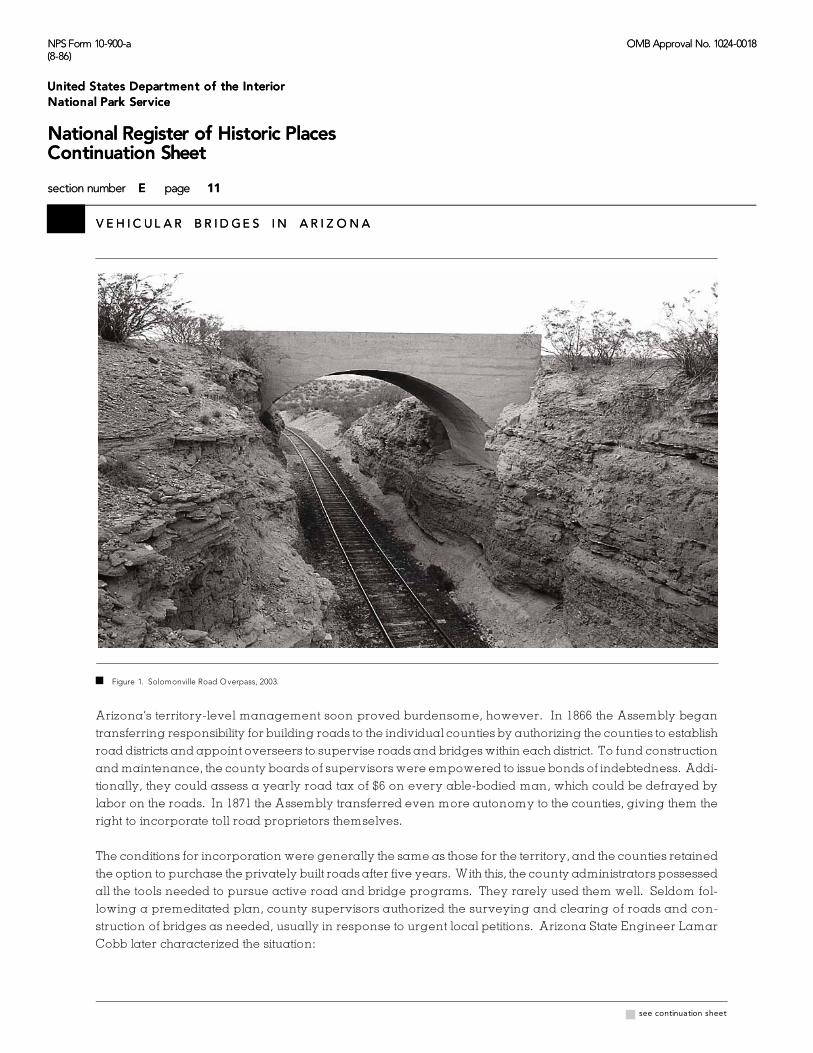
the Clifton-Solomonville Road [see Figure 1]. The Solomonville Road Overpasses [8150 and 8151] are unu-
sual in that they were built to carry wagon traffic over railroads (the earliest datable grade separations in Ari-
zona), they used concrete arch construction, and they were built relatively late in the toll road milieu.
In a region in which government revenues were minimal, toll roads
were generally regarded as a necessary evil, a costly but temporary way to develop a much-needed road
system. But the First Territorial Assembly was also aware of the need for free highways to promote transpor-
tation and settlement. The Assembly tried to legislate a balance between roads built by private capital and
supported by tolls and those over which no tolls could be extracted. To prevent toll operators from monopo-
lizing travel by incorporating every road in the territory, the lawmakers designated several existing roads—
developed solely by prior use—as free routes. This formed the basis for a free-highway network in Arizona,
which subsequent legislatures would expand by incorporating toll road companies and simultaneously
declaring other roads as toll-free.
NPS Form 10-900-a OMB Approval No. 1024-0018(8-86)
United States Department of the Interior
National Park Service
National Register of Historic PlacesContinuation Sheet
section number E page 11
V E H I C U L A R B R I D G E S I N A R I Z O N A
NPS Form 10-900-a OMB Approval No. 1024-0018(8-86)
United States Department of the Interior
National Park Service
National Register of Historic PlacesContinuation Sheet
section number F page 11
V E H I C U L A R B R I D G E S I N A R I Z O N A
x see continuation sheet
F igure 1. Solom onville Road O verpass, 2003.
Arizona’s territory-level management soon proved burdensome, however. In 1866 the Assembly began
transferring responsibility for building roads to the individual counties by authorizing the counties to establish
road districts and appoint overseers to supervise roads and bridges within each district. To fund construction
and maintenance, the county boards of supervisors were empowered to issue bonds of indebtedness. Addi-
tionally, they could assess a yearly road tax of $6 on every able-bodied man, which could be defrayed by
labor on the roads. In 1871 the Assembly transferred even more autonomy to the counties, giving them the
right to incorporate toll road proprietors themselves.
The conditions for incorporation were generally the same as those for the territory, and the counties retained
the option to purchase the privately built roads after five years. With this, the county administrators possessed
all the tools needed to pursue active road and bridge programs. They rarely used them well. Seldom fol-
lowing a premeditated plan, county supervisors authorized the surveying and clearing of roads and con-
struction of bridges as needed, usually in response to urgent local petitions. Arizona State Engineer Lamar
Cobb later characterized the situation:

NPS Form 10-900-a OMB Approval No. 1024-0018(8-86)
United States Department of the Interior
National Park Service
National Register of Historic PlacesContinuation Sheet
section number E page 12
V E H I C U L A R B R I D G E S I N A R I Z O N A
NPS Form 10-900-a OMB Approval No. 1024-0018(8-86)
United States Department of the Interior
National Park Service
National Register of Historic PlacesContinuation Sheet
section number F page 12
V E H I C U L A R B R I D G E S I N A R I Z O N A
Arizona State Engineer, Report of the State Engineer of the State of Arizona: July 1, 1909, to June 30, 1914 (Phoenix:7
Arizona State Press, 1914), 72.
As quoted by Jay J. Wagoner, Arizona Territory 1863-1912: A Political History (Tucson: University of Arizona8
Press, 1970), 239.
x see continuation sheet
Every two years the personnel of the various boards of supervisors is almost completely changed. They go in
imbued with the idea that their predecessors squandered the county road funds and go out with the public equally
confident that they have. With both more or less correct in their opinions, but it has not been the fault of the
supervisors. With county road funds of limited proportions to repair hundreds of miles of road, and with every man
in the county clamoring for work in his locality, it has been next to impossible for them to set aside a sum, in any
amount, for permanent work.7
Maricopa County could afford a degree of road improvement and bridge construction, and in 1877 the Terri-
torial Assembly authorized the county to issue $15,000 in bonds to finance construction of four wagon roads.
In the sparsely populated areas outside of the major cities, however, few vehicular bridges were erected
before the turn of the century. Many of these earliest county-built bridges, like those on the toll roads, tended
more to the flimsy than the substantial. Some consisted of little more than two parallel boards laid across a
streambed to carry the vehicles’ tires. Often made up of wood stringer spans on timber piles or crude con-
crete abutments and piers, these questionable structures failed with distressing regularity. Only a handful
proved more permanent. For longer spans, the counties erected simple kingpost or queenpost pony trus-
ses, with timber compression members and wrought iron tension rods. None is known to have survived.
D uring the 1870s and 1880s, the Territorial Legislature seemed content
to leave road and bridge construction to the individual counties. Between 1877 and 1881 the territory issued
bonds totaling only $70,000 to fund road construction. In an uncharacteristic act of largesse, however, the
Thirteenth General Assembly in 1885 appropriated $15,000 toward construction of a bridge over the Gila Riv-
er at Florence in Pinal County. This, along with a $12,000 appropriation for a wagon road, prompted Terri-
torial Governor Conrad Zulick to comment that the expenditure of funds on road and bridge work repre-
sented a “wanton misappropriation of public funds.” The bridge was constructed that year; in 1905 the legis-8
lature authorized a $19,000 bond issue to fund repairs to the Florence Bridge. But other than these tentative
steps, the territorial government made only minimal impact on overland transportation in Arizona. Indeed,
no territorial organization or staff had even been established to administer roads and bridges.
Construction of the Florence Bridge marked a watershed event in Arizona bridge history. Not only was it the
first wagon bridge undertaken wholly by the territory, it was probably the earliest all-metal wagon truss in
Arizona. The structure consisted of two 180-foot Pratt spans, with an extensive timber trestle over an island
and slough. Consuming 30 tons of iron and 174,000 feet of lumber, the Florence Bridge was soon followed
by other wagon trusses. Apache County built a pinned Pratt truss over Clear Creek south of Winslow. After

NPS Form 10-900-a OMB Approval No. 1024-0018(8-86)
United States Department of the Interior
National Park Service
National Register of Historic PlacesContinuation Sheet
section number E page 13
V E H I C U L A R B R I D G E S I N A R I Z O N A
NPS Form 10-900-a OMB Approval No. 1024-0018(8-86)
United States Department of the Interior
National Park Service
National Register of Historic PlacesContinuation Sheet
section number F page 13
V E H I C U L A R B R I D G E S I N A R I Z O N A
x see continuation sheet
its separation from Apache County in 1895, Navajo County built a Pratt through truss to carry the Winslow-
Holbrook road over Chevelon Creek and another truss over the Little Colorado River. Similarly, Greenlee
County built a four-span Pratt through truss over the Gila River at Duncan to replace an earlier wooden
structure. Virtually all of the early metal trusses built by the counties featured relatively modest dimensions,
standard Pratt configurations and prefabricated, pin-connected detailing. None is known to have survived.
One surviving bridge from the territorial period was constructed, not by the territorial government or by a
county road district, but by the federal government—specifically the U.S. Reclamation Service (USRS, prede-
cessor to the Bureau of Reclamation). In 1902 the USRS began planning a dam over the Salt River, one of
the first dams authorized by Congress under the Newlands Act. The site for what would become the Theo-
dore Roosevelt Dam was located in the mountains east of Phoenix. Before construction could begin on the
immense structure, an access road had to be graded from the railhead at Mesa to the damsite. Routed along
the ancient Apache Trail, the road wound its way through the rugged mountain range. Near its top, on a
switchback curve in Alchesay Canyon, the USRS constructed a modestly scaled concrete arch structure in
1905. The Alchesay Canyon Bridge [1532] is today Arizona’s oldest dateable vehicular bridge [see Figure 2].
F igure 2. Alchesay Canyon Bridge, 2003.

NPS Form 10-900-a OMB Approval No. 1024-0018(8-86)
United States Department of the Interior
National Park Service
National Register of Historic PlacesContinuation Sheet
section number E page 14
V E H I C U L A R B R I D G E S I N A R I Z O N A
NPS Form 10-900-a OMB Approval No. 1024-0018(8-86)
United States Department of the Interior
National Park Service
National Register of Historic PlacesContinuation Sheet
section number F page 14
V E H I C U L A R B R I D G E S I N A R I Z O N A
J.B. Girand, “Arizona Roads,” Arizona, July 1911, 2. Girand continued:9
Nearly one thousand miles of roads have been surveyed and mapped, running through various counties, as fol-lows: Cochise, Gila, Graham, Maricopa, Pima, Pinal, Yavapai and Yuma, and nearly one hundred miles of roadhave been actually built and in use, and in addition thereto, three bridges have been or are being constructed,across the more important streams of the territory. Already scores of letters of praise have been received, com-mending the good work being done, and while as usual, public enterprises of this character meet with opposi-tion, still, as a whole, the better element is body and soul with this work and it will be crowned with success.
x see continuation sheet
A fter the turn of the century, it became apparent that many major
road and bridge projects were beyond the capacity of the individual counties. Further, the counties were
building roads on a piecemeal basis, without regard to the roads in adjacent counties. This tended to create
an uneven patchwork of dissimilar routes, making travel difficult for all but a few destinations. To fund the
development of regional highways, the Territorial Assembly in March 1909 levied a property tax varying
from 5 to 25 mills. (A mill is .001 or 1/1,000th of a dollar; a five mill tax is equivalent to five dollars per one
thousand dollars.) The 5 mill tax was fixed in counties in which no highway work was contemplated, and the
higher rates were applied proportionately to counties in which work was to be undertaken. In force until
June 1912, this tax raised about $519,000.
The Assembly also created the office of the territorial engineer to administer the design and construction of
territorial roads. Appointed by the governor, the position carried a two-year term. J.B. Girand was Arizona’s
first (and only) Territorial Engineer. His staff consisted of a clerk and a draftsman. Soon after his appoint-
ment, Girand began the planning and construction of several territorial highways in Arizona. The strategy
was to link the county seats and more populous towns through a network of graded roads that would vary
in width from 16 to 24 feet according to terrain and traffic. “Inadequate and crude as the law is,” Girand stat-
ed in 1911, “much progress has been made in establishing a system of highways, which, if continued, will
result in this department being the most important of all, from the standpoint of revenue.” In connection9
with this highway construction, Girand supervised construction of a handful of bridges over key crossings
on the territorial network. Curiously, none of these bridges resembled each other even remotely.
One of the first territorial bridges was a replacement structure for the trusses at Florence, built in 1885 and
then rebuilt in 1905. In November 1909 Girand designed a multiple-span, concrete girder structure, submitted
the plans and specifications to the Board of Control and advertised for competitive bids. Five contractors res-
ponded, with proposals ranging from $48,000 to $62,000. Girand then rejected all bids and convinced the
board to build the Florence Bridge using convict labor. With a territorial prison in nearby Florence, the idea
had merit. In March a small force of prisoners began excavating for the foundations. The crew was in-
creased to 36 men in April, when full-scale construction began, and averaged 55 men as the work continued
on the bridge throughout the rest of the year.

NPS Form 10-900-a OMB Approval No. 1024-0018(8-86)
United States Department of the Interior
National Park Service
National Register of Historic PlacesContinuation Sheet
section number E page 15
V E H I C U L A R B R I D G E S I N A R I Z O N A
NPS Form 10-900-a OMB Approval No. 1024-0018(8-86)
United States Department of the Interior
National Park Service
National Register of Historic PlacesContinuation Sheet
section number F page 15
V E H I C U L A R B R I D G E S I N A R I Z O N A
As quoted in Report of the State Engineer of the State of Arizona, 8-9.10
x see continuation sheet
The Florence Bridge was completed in December 1910. In observing the prison laborers, W.A. Crossland
of the Bureau of Public Roads commented:
The convicts are comfortably sheltered, well fed and well treated. Guarded prisoners are kept in barbed wire stock-
ades, under guard when not at work. Work performed by guarded convicts costs probably more than it could be
done by contract, but that prison labor could compete with day labor or force account work. The fact that prison
labor under guard cannot as a rule compete with contract work is due to many reasons. The work must be such as
to require the employment of at least one hundred men to keep the overhead and subsistence charges to a
reasonable minimum...
To sum it all up, the cost of prison labor in small numbers is prohibitive. In forces of approximately one hundred, the
cost (considering efficiency) per working man per day is very nearly the same as is actually paid to the hired laborer,
taking into consideration contractors’ profit from boarding house and commissary. Under favorable conditions,
including continuous employment for long periods at or near the same place, prison labor under guard can compete
with contract work. Under other conditions it is extremely doubtful if it can do so.10
This seemed borne out by the experience on the Florence Bridge. The total construction cost using prison
labor turned out to be only $2,500 less than the lowest contractor’s bid. Girand’s first reinforced concrete arch
was a more modest structure, built in 1911. The year before he had designed the territorial highway between
Bisbee and Douglas, and in June 1911 Girand completed the drawings for a 60-foot arch over Mule Gulch
east of Bisbee. Contractors R. Toohey and Son completed the Lowell Arch Bridge [0130] that December. The
arch still carries traffic on U.S. Highway 80, but in greatly altered form.
What was perhaps the most unusual territorial bridge was not located on a territorial highway at all, but was
built at the request of the U.S. Army on a remote military road. In 1911 the Territorial Assembly funded con-
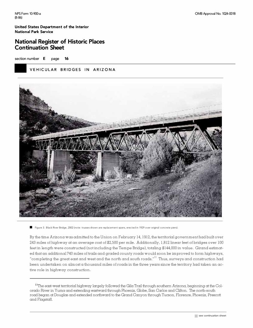
struction of a wagon bridge over the Black River to replace an existing ford near Fort Apache. For the Black
River Bridge [3128] , Girand built two timber/iron Howe deck trusses carried high above the river on tapered
concrete piers [see Figure 3].
During this time Girand surveyed the site for the Fairbank bridge and built three other major structures—a
three-span pinned truss with concrete abutments over the Verde River at Camp Verde, an 80-foot timber
trestle at Hassayampa and a 100-foot timber trestle over Forest Wash—as well as several short-span con-
crete slabs built from standard plans. Without doubt the most spectacular, expensive and important bridge
built by the territorial government, however, was the concrete structure over the Salt River in Tempe. Made
up of eleven open spandrel arch spans, the Tempe Bridge was built by convict labor between 1911 and 1913
[see Figure 4].
NPS Form 10-900-a OMB Approval No. 1024-0018(8-86)
United States Department of the Interior
National Park Service
National Register of Historic PlacesContinuation Sheet
section number E page 16
V E H I C U L A R B R I D G E S I N A R I Z O N A
NPS Form 10-900-a OMB Approval No. 1024-0018(8-86)
United States Department of the Interior
National Park Service
National Register of Historic PlacesContinuation Sheet
section number F page 16
V E H I C U L A R B R I D G E S I N A R I Z O N A
The east-west territorial highway largely followed the Gila Trail through southern Arizona, beginning at the Col-11
orado River in Yuma and extending eastward through Phoenix, Globe, San Carlos and Clifton. The north-southroad began at Douglas and extended northward to the Grand Canyon through Tucson, Florence, Phoenix, Prescottand Flagstaff.
x see continuation sheet
F igure 3. Black River Bridge, 2002 (note: trusses shown are replacement spans, erected in 1929 over orig inal concrete piers).
By the time Arizona was admitted to the Union on February 14, 1912, the territorial government had built over
243 miles of highway at an average cost of $2,500 per mile. Additionally, 1,812 linear feet of bridges over 100
feet in length were constructed (not including the Tempe Bridge), totaling $144,000 in value. Girand estimat-
ed that an additional 740 miles of trails and graded county roads would soon be improved to form highways,
“completing the great east and west and the north and south roads.” Thus, surveys and construction had11
been undertaken on almost a thousand miles of roads in the three years since the territory had taken an ac-
tive role in highway construction.

NPS Form 10-900-a OMB Approval No. 1024-0018(8-86)
United States Department of the Interior
National Park Service
National Register of Historic PlacesContinuation Sheet
section number E page 17
V E H I C U L A R B R I D G E S I N A R I Z O N A
NPS Form 10-900-a OMB Approval No. 1024-0018(8-86)
United States Department of the Interior
National Park Service
National Register of Historic PlacesContinuation Sheet
section number F page 17
V E H I C U L A R B R I D G E S I N A R I Z O N A
Report of the State Engineer of the State of Arizona, 72.12
x see continuation sheet
F igure 4. Tempe Bridge, 1982 (the bridge has since been demolished).
Early State Bridge Construction and Transcontinental Highways: 1912-1920
4 With statehood, the territorial engineer was retitled state engineer and Girand was replaced
by Lamar Cobb. Little else changed, as road construction continued using the same basic administrative pro-
cess. In fact, several road and bridge projects begun under Girand’s administration, including the Tempe
Bridge, were taken over by Cobb without interruption. The major difference lay in the level of activity. Less
than $200,000 were spent on road and bridge construction throughout the territory in the year that Girand
took office. Six years later in 1915, over $500,000 were spent by the counties alone. Despite this progress, the
state’s roads were in dismal condition under the county administration. Arizona ranked last in the nation in
terms of its public road system. Cobb despaired in his first report to the state legislature:
I have been over a great many roads in every county in the state except two, and I have not found a foot of properly
graded and protected mountain road or road in a rolling county that was not constructed under the direction of the
(territorial) engineer department. There are a few miles of graveled road in Graham, about ½ mile in Yuma and several
miles of caliche road in Maricopa. I know of no other improved roads in the state, outside of the cities, towns or special
road districts, though I may have missed a half mile or so elsewhere.12

NPS Form 10-900-a OMB Approval No. 1024-0018(8-86)
United States Department of the Interior
National Park Service
National Register of Historic PlacesContinuation Sheet
section number E page 18
V E H I C U L A R B R I D G E S I N A R I Z O N A
NPS Form 10-900-a OMB Approval No. 1024-0018(8-86)
United States Department of the Interior
National Park Service
National Register of Historic PlacesContinuation Sheet
section number F page 18
V E H I C U L A R B R I D G E S I N A R I Z O N A
Report of the State Engineer, 5-6.13
Ibid., 6.14
x see continuation sheet
In June 1912 the new state legislature passed enabling legislation for the state engineer’s office. Like the terri-
torial law, the state act funded the road and bridge programs through property taxes. The levy was sufficient
to raise $250,000 annually—25 percent to be expended by the state engineer on state highways and the re-
maining 75 percent to be distributed to the counties proportionately to collections. This tax would remain in
effect until the start of federal aid in 1917.
To augment these revenues, the legislature passed the first of a series of acts providing for the licensing and
governing of motor vehicles the following year. The legislature directed Cobb to delineate a network of state
highways encompassing some 1,500 miles of route that would link the major towns [see Figure 5]. Cobb was
cognizant of the need for continuity between his office and the office of the territorial engineer that had pre-
ceded him. In 1914 he wrote:
When this administration assumed office, a tentative State Highway System had been adopted, consisting of a road
from Yuma to Clifton and one from Douglas to the Grand Canyon. The routes selected had become fixed to a
certain extent by the construction of several units of their length and, though not meeting with entire approval, they
had also become fixed in the public mind as the State Highways. It was, therefore, thought best not to make any
changes in their location as it would undoubtedly lead to others by succeeding administrations, resulting in State
Highways “that would start nowhere and end nowhere,” thus defeating one object of the State Road appropriation
– a State system of roads composed of coordinating county units connecting every county seat in the State. The
mileage of roads improved with the State Road Fund is small considering the total mileage of the proposed system
and their completion with the present annual Road Fund is far removed; however, the worst places between counties
and those bearing the greatest amount of traffic are gradually being improved by permanent construction, so, even
without additional means, they will be put in much better condition year by year and some day be completed.
The value of this department to the taxpayers of the State cannot be measured by the roads that have been built
under its administration, for the examples of proper road construction it furnishes in every county is of greatest value
to officials charged with the expenditure of county road funds. The Boards of Supervisors in eight of the fourteen
counties have called upon this office for advice relative to road and bridge construction, four for plans and speci-
fications, and four for our engineers to locate or superintend county road construction covering expenditures of ap-
proximately $100,000. Since the creation of this department, there has been a marked improvement in the type of
road work in every county in the State which is largely attributable to the demonstration work done by this office.13
“This improvement is shown both in location and construction,” Cobb continued, “however, the former,
which is of the greatest importance, has not received the consideration it should have. Few county roads are
now located in natural water courses, grades exceeding 10% are rare and more attention is being given to
protecting ditches and other drainage; However, their drainage openings are as a rule entirely too small, as
for instance a 36 inch culvert to carry the water necessitating a 50 foot railroad bridge.” 14

NPS Form 10-900-a OMB Approval No. 1024-0018(8-86)
United States Department of the Interior
National Park Service
National Register of Historic PlacesContinuation Sheet
section number E page 19
V E H I C U L A R B R I D G E S I N A R I Z O N A
NPS Form 10-900-a OMB Approval No. 1024-0018(8-86)
United States Department of the Interior
National Park Service
National Register of Historic PlacesContinuation Sheet
section number F page 19
V E H I C U L A R B R I D G E S I N A R I Z O N A
x see continuation sheet
F igure 5. M ap of proposed state highway system of Arizona, 1912.

NPS Form 10-900-a OMB Approval No. 1024-0018(8-86)
United States Department of the Interior
National Park Service
National Register of Historic PlacesContinuation Sheet
section number E page 20
V E H I C U L A R B R I D G E S I N A R I Z O N A
NPS Form 10-900-a OMB Approval No. 1024-0018(8-86)
United States Department of the Interior
National Park Service
National Register of Historic PlacesContinuation Sheet
section number F page 20
V E H I C U L A R B R I D G E S I N A R I Z O N A
The Tempe Bridge, later called the Ash Avenue Bridge, carried traffic until completion of the parallel Mill Ave-15
nue Bridge in 1931. Included in the first statewide historic bridge inventory in 1987, it stood abandoned in place until itwas demolished in 1990. Today only the southern abutment of the bridge stands.
Arizona Good Roads Association, Illustrated Road Maps and Tour Book (Prescott: Arizona Good Roads Associa-16
tion, 1913 (Reprint Phoenix: Arizona Highways Magazine, 1978)), 6. The guide continued:
A system of State Highways is now under construction: the counties of Yavapai, Mohave and Coconino areabout to construct good roads within their boundaries with money from county bond issues and cash taxes; andin many parts of Arizona new roads are being located and old highways improved. Therefore, it will be but ashort time until the whole State is gridironed with travelable roads, giving easy and comfortable access to thescenic, agricultural and industrial sections of this rich commonwealth.
x see continuation sheet
During his first two years in office, Cobb undertook several important
road and bridge construction projects. Without question the largest of these was the Tempe Bridge, under
construction when Arizona became a state. Built using prison labor and opened to traffic in September 1913,
it had originally been designed as a nine-span filled spandrel structure, but the design was changed during
the course of construction to eleven open spandrel arches. Its total cost was almost $119,000. Built over the
Salt River at the state’s most heavily trafficked river crossing, the Tempe Bridge was unquestionably Arizo-
na’s most historically important bridge. During this biennium Cobb was also responsible for a number of15
smaller structures totaling 1,608 linear feet for an aggregate cost of $101,000.
In 1913 the Arizona Good Roads Association published the state’s first book of road maps and travel informa-
tion. “At this time, trips to every part of the state are made by automobiles,” the guide stated optimistically,
“and while some difficulties are encountered in the remote sections, principally owing to lack of travel, these
are rapidly being eliminated.” During the 1914-1916 biennium, Cobb continued work on the state’s road and16
bridge system. As delineated by his office in 1916, the state highway system remained essentially unchanged
[see Figure 6]. With the state and the individual counties undertaking the construction, improvements to the
roads were made incrementally in relatively small segments. The principal difference between the entities
lay in the amount of money spent. As funds allocated by the state for road and bridge work increased stead-
ily—from $294,000 in 1912 to $487,000 in 1916—the amount of construction administered by the counties almost
quadrupled from $309,000 to $1.5 million over the same four-year period.
The state engineer’s office was responsible for construction of numerous small-scale drainage structures on
state highways, and for these engineers began developing standard designs for short-span concrete slabs
and box culverts. Cobb undertook more ambitious multiple-span structures as well, concrete girder struc-
tures similar in scale to the Florence and Tempe bridges. The largest bridge built during this period was a
structure over the Gila River on the Phoenix-Yuma Highway in Yuma County. In 1912 Cobb had first sur-
veyed sites at Antelope Hill and the nearby town of Dome and selected the former for a bridge. The next
year his office designed a multiple-span concrete structure comprised of 15 girder spans supported by
massive bullnosed concrete piers. The longest of these spans extended 65 feet; the bridge’s overall length
was almost 1,000 feet, not including the timber trestle approaches on the ends.

NPS Form 10-900-a OMB Approval No. 1024-0018(8-86)
United States Department of the Interior
National Park Service
National Register of Historic PlacesContinuation Sheet
section number E page 21
V E H I C U L A R B R I D G E S I N A R I Z O N A
NPS Form 10-900-a OMB Approval No. 1024-0018(8-86)
United States Department of the Interior
National Park Service
National Register of Historic PlacesContinuation Sheet
section number F page 21
V E H I C U L A R B R I D G E S I N A R I Z O N A
x see continuation sheet
In December Cobb advertised for
competitive bids to build the im-
mense structure. Opting instead to
use prison labor, the state rejected
all bids. Cobb then redesigned
and rebid the project when it be-
came apparent that not enough
prison manpower would be avail-
able. In May 1914 Perry Borchers
was hired to build the bridge. But
Borchers was in over his head. He
began construction in June but
soon defaulted, and after floods
damaged the partially completed
structure that winter, the state once
again undertook the project with
prison laborers. The Antelope Hill
Bridge [abd.] was finally opened to
traffic on August 18, 1915, with a
gala picnic attended by thousands
of well-wishers.
This star-crossed structure began
to fail almost immediately, reveal-
ing a dangerous and expensive
weakness of the state’s large con-
crete spans. These structures were
demonstrably stronger and more
stable under load than their steel
truss counterparts. Their poured-
in-place superstructures could
carry traffic well enough, but their
Figure 6. Map of proposed state highways of Arizona, 1916. substructures proved woefully inad-
equate to withstand the changeable
desert rivers. As a result, the bridges collapsed in whole or in part when the piers toppled over in flood. In
January 1916 floods washed away almost two miles of approach grading and widened the river’s channel
at the north end of the Antelope Hill Bridge by approximately 300 feet. To correct this, the State Legislature
in March 1917 appropriated $50,000 to build an extension onto the north end. The new construction consisted
of five additional concrete girder spans and an extensive timber trestle approach. Completed in autumn
1918, the bridge carried traffic more-or-less as intended until a flood a week after Thanksgiving, 1919, des-
troyed some 500 feet of the north approach and shifted some of the concrete piers on the extension.

NPS Form 10-900-a OMB Approval No. 1024-0018(8-86)
United States Department of the Interior
National Park Service
National Register of Historic PlacesContinuation Sheet
section number E page 22
V E H I C U L A R B R I D G E S I N A R I Z O N A
NPS Form 10-900-a OMB Approval No. 1024-0018(8-86)
United States Department of the Interior
National Park Service
National Register of Historic PlacesContinuation Sheet
section number F page 22
V E H I C U L A R B R I D G E S I N A R I Z O N A
State of Arizona, State Engineer, Fourth Biennial Report of the State Engineer to the Governor of the State of Arizo-17
na: 1918-1920 (Phoenix: Republican Print Shop, 1921), 66-67. Within two years, AHD had rerouted the road to bypass
the Antelope Hill Bridge entirely. The bridge was replaced in 1929 with the Dome Bridge [abd.]. It now stands inruins, with several of its concrete piers and girder spans washed away.
x see continuation sheet
Further flooding three months later dropped about 300 more feet of trestle, the north abutment and the nor-
thernmost girder. Worse, the floodwaters caused several of the piers on the extension, already damaged by
the previous flood, to further shift downstream. “The Antelope Hill Bridge is located at a point where it is
impossible to control the river and keep it under the bridge at any reasonable cost,” complained State Bridge
Engineer Merrill Butler in 1921. “Foundation conditions are bad and a permanent extension would neces-
sarily be long and costly with the strong possibility that the same situation would again develop in a few
years.” Butler concluded prophetically, “The foregoing, together with the apparent need for expensive re-
pairs to two of the existing piers, should mitigate against anything except some form of temporary con-
struction.” [See Figure 7.] 17
F igure 7. Ruin of Antelope H ill Bridge, 2003.

NPS Form 10-900-a OMB Approval No. 1024-0018(8-86)
United States Department of the Interior
National Park Service
National Register of Historic PlacesContinuation Sheet
section number E page 23
V E H I C U L A R B R I D G E S I N A R I Z O N A
NPS Form 10-900-a OMB Approval No. 1024-0018(8-86)
United States Department of the Interior
National Park Service
National Register of Historic PlacesContinuation Sheet
section number F page 23
V E H I C U L A R B R I D G E S I N A R I Z O N A
Fourth Biennial Report of the State Engineer, 68. Like the Antelope Hill Bridge, the Coldwater Bridge was eventu-18
ally abandoned by the highway department as unsalvageable.
x see continuation sheet
A ctually, the Antelope Hill Bridge suffered from at least three major engineering
shortcomings, which combined to make it a maintenance nightmare. First, the bridge was poorly situated
on a sweep of the river that was prone to extensive flooding. Second, the piers were poorly founded on
spread footings instead of driven piles and were provided with insufficient scour protection. Finally, without
shore rectification works to constrict and guide the river, the Gila was allowed to shift channels unchecked,
putting unbearable pressure on the bridge’s north spans and approaches. All these problems could have
been addressed properly during initial construction. Engineers had learned to cope with similar problems
of far greater magnitude on the Missouri River 40 years earlier. But the deceptively placid nature of the Gila
River at normal stage did not prepare the engineers for its radical character change in flood.
Another perennial problem for the state was the Agua Fria River Bridge at Coldwater, built about the same
time as the Antelope Hill Bridge. In 1915 Cobb designed the bridge with 37 concrete girder spans, supported
by concrete column bents. Construction began in December. Three months later, heavy flooding forged
a new channel on the opposite side of an island about 1,000 feet upriver from the bridge site. Rather than re-
design the bridge to accommodate the shift in channel, the engineers continued building it as drawn, now
only over a dry streambed, and attempted to re-divert the river back into its earlier bed by filling the new
channel. When the bridge’s west approach washed out the first winter, the legislature appropriated funds for
reconstruction and channel work. This lasted until the Thanksgiving flood of 1919, when seven spans and
both approaches collapsed. Subsequent floods carried away five additional spans. As the state tried to keep
up with the repairs, the approaches washed away with every flood. “The location and foundation conditions
are both extraordinarily poor,” stated Merrill Butler, “but the bridge is on a main highway, a road of great
economic importance, and in a section where no better site can be found within a reasonable distance.” 18
Cobb and his successors, Thomas Maddock and B.M. Atwood, experienced significant problems with other
multiple-span concrete structures, including the Tempe Bridge and the Florence Bridge. But not all of the
state’s major early spans were structurally suspect. The Santa Cruz Bridge in southern Arizona was com-
paratively trouble-free. In 1915 the Arizona State Legislature appropriated $12,500 from the state’s General
Fund for construction of a major bridge over the Santa Cruz River on the Nogales-Patagonia Highway.
Atwood located the site for this bridge some 5½ miles northwest of Nogales and, because its construction was
contingent on an equal contribution from Santa Cruz County, waited until the county appropriated its share
early in 1916. Atwood then surveyed the site and engineered this concrete deck girder bridge.
With a design similar to the Antelope Hill Bridge, the structure consisted of three 65-foot two-girder spans,
with eight shallower 32-foot spans over the flood plain east of main river channel. The spans were support-
ed by massive concrete piers built with bullnosed ends to withstand flooding on the Santa Cruz. The bridge
featured a concrete deck poured integrally with the girders. This was flanked on both sides by steel pipe
guardrails. Rather than let the bridge’s construction out for competitive bid or bring in prison laborers,
Atwood instead opted to build it using day laborers under state supervision. In May a state work force be-

NPS Form 10-900-a OMB Approval No. 1024-0018(8-86)
United States Department of the Interior
National Park Service
National Register of Historic PlacesContinuation Sheet
section number E page 24
V E H I C U L A R B R I D G E S I N A R I Z O N A
NPS Form 10-900-a OMB Approval No. 1024-0018(8-86)
United States Department of the Interior
National Park Service
National Register of Historic PlacesContinuation Sheet
section number F page 24
V E H I C U L A R B R I D G E S I N A R I Z O N A
The Santa Cruz Bridge carried mainline highway traffic until a route realignment in 1927. It has since functioned19
as a county bridge in unaltered condition.
“New Prizes for Motor Carriage Competitions,” Scientific American 73:40 (20 July 1895).20
x see continuation sheet
gan construction of the bridge under the direction of General Foreman F.W. Haynes. The crew completed
the Santa Cruz Bridge [8166] early the next year for a total cost of about $38,000 [see Figure 8]. 19
F igure 8. Santa Cruz River Bridge, 2002.
When the automobile was introduced in the United States from Eur-
ope, it was generally believed that its widespread adoption would be delayed by the relatively poor condi-
tion of the country’s roads. “Because motor vehicles for common roads are practicable in France and En-
gland, it does not follow that they would be in America,” Scientific American stated in 1895. “The roads in
those countries are almost perfection; but in this country a fairly good road is the exception. . . The roads in
America are not good enough except in certain localities yet to permit of a very rapid development of the
automobile carriage, but their use in great cities is likely to be rapid.” 20

NPS Form 10-900-a OMB Approval No. 1024-0018(8-86)
United States Department of the Interior
National Park Service
National Register of Historic PlacesContinuation Sheet
section number E page 25
V E H I C U L A R B R I D G E S I N A R I Z O N A
NPS Form 10-900-a OMB Approval No. 1024-0018(8-86)
United States Department of the Interior
National Park Service
National Register of Historic PlacesContinuation Sheet
section number F page 25
V E H I C U L A R B R I D G E S I N A R I Z O N A
Colonel Albert A. Pope, “Automobiles and Good Roads,” Munsey’s Magazine 29:168 (May 1903). Pope, a Con-21
necticut coach and bicycle manufacturer, had a vested interest in promoting good roads. He favored electrical pow-er for autos over internal combustion, stating emphatically, “You can’t get people to sit over an explosion!”
x see continuation sheet
The first inventory of American roads, conducted in 1904, revealed that of some 2.1 million miles of roads in
the country only 7 percent had any surfacing at all. Those that had any applied surface were almost all
gravel, and virtually none of America’s roads were sufficient to carry steady motorized traffic. The best
roads were located, naturally enough, in the heavily populated New England and Middle Atlantic states.
The worst were in the South and Midwest, where rain turned the roads into bottomless gumbo. The West,
with its long distances between settlements that required almost universal use of horse-powered travel, of-
fered numerous dirt roads but few that could accommodate automobiles.
Like much of the West, Arizona was slow to embrace the automobile in the early 20 century, largely due toth
the wretched condition of its roads. The first auto in the state was reportedly brought into Tucson by Dr. Hir-
am Fenner around the turn of the century. This was soon followed by cars in Phoenix; by 1913 some 646
vehicles were registered in Maricopa County. As in other states, Good Roads Associations took root in Ari-
zona in the early 1900s, largely driven by recreational bicycle riders. The bicyclists formed clubs, which col-
lectively organized the national League of American Wheelmen [LAW] in 1880.
As one of the leading proponents for good roads in the late 19 century, the league began publishing Goodth
Roads magazine in 1892 with the slogan”Lifting Our People Out of the Mud." That year another group, the
National League for Good Roads [NLGR], formed to give voice to rural farmers and ranchers weary of the
deplorable condition of the nation’s farm-to-market roads. These were joined by the National Good Roads
Association [NGRA] at the turn of the century. Collectively known as good roaders, these groups had or-
ganized to promote better roads in cities, where they were bad enough, and in rural areas, where they were
virtually impassible.
More than any other group in America, the good roaders were responsible— both directly through “Good
Road Days” volunteer construction efforts and indirectly through political lobbying among local and state
officials—for the improvements made in the country’s highways during the formative years. “The good
roads agitation is now on a footing such as it never had in the past,” stated Colonel Albert A. Pope in 1903.
“For this, no doubt, much credit should be given to the various automobile clubs and associations scattered
throughout the country. It was none the less creditable to these bodies that their share in the movement has
been so unobtrusive that now, for the first time, the demand for better highways may be said to be in every
sense a popular one.” 21
The Good Roads Movement was from its inception politically oriented. Good roaders recognized that the
only way to effect wholesale improvements on the nation’s roads was through the government. Partially
in response to their hectoring, the federal government in 1893 established the U.S. Office of Road Inquiry
[ORI] to assess the lamentable condition of the nation’s highways and consider the best strategies for road

NPS Form 10-900-a OMB Approval No. 1024-0018(8-86)
United States Department of the Interior
National Park Service
National Register of Historic PlacesContinuation Sheet
section number E page 26
V E H I C U L A R B R I D G E S I N A R I Z O N A
NPS Form 10-900-a OMB Approval No. 1024-0018(8-86)
United States Department of the Interior
National Park Service
National Register of Historic PlacesContinuation Sheet
section number F page 26
V E H I C U L A R B R I D G E S I N A R I Z O N A
Quoted in John L. Butler, First Highways of America (Iola: Krause Publications, 1994), 59.22
“Good Roads in Arizona.” Arizona, April 1916, 10.23
x see continuation sheet
management. Location of the ORI in the Agriculture Department indicated the rural thrust of the govern-
ment’s response to the good roaders. Though the Office did little more than study the issue of good roads,
its formation marked the first acknowledgment by the federal government of the coming importance of
automobile travel. Gen. Roy Stone, who headed the Office, estimated that the cost to transport goods over
the roads was three times more than it should have been, had the roads been improved. He arrived at this
estimate based on the additional time required to travel the poor roads and the additional wear and tear on
automobiles, wagons and livestock.
President William McKinley referred to the Office in a message to Congress in 1901, when he stated: “There
is a wide-spread interest in the improvement of our public highways at the present time, and the Department
of Agriculture is co-operating with the people in each locality in making the best possible roads.” In 190322
his successor, Theodore Roosevelt, along with Roosevelt’s opponent in the 1904 election, William Jennings
Bryant, attended the National Good Roads Convention in St. Louis. That year the organization managed to
get highway legislation before Congress. The Brownlow-Latimer Federal Good Roads Bill would have in-
volved the federal government in road construction for the first time, had it not been defeated. In subsequent
years the Automobile Club of America and the American Motor League were instrumental in undertaking
ambitious programs to install signboards to warn of dangers along the highways, both through their own
efforts and through lobbying state legislatures.
In 1904 the Office of Road Inquiry initiated what it called its “object-lesson” program, building relatively short
segments of improved roads to demonstrate their utility. ORI representatives would travel to good roads
meetings on “Good Roads Trains”, construct demonstration roads and proselytize for the cause of road
improvement. By 1905 the ORI, renamed the Office of Public Roads, had built almost 40 miles of object lesson
roads in 100 separate projects.
The Good Roaders in Arizona were responsible for the promotion of
road improvement throughout the state, though they tended to concentrate their efforts more in the urban
areas, particularly Phoenix and Tucson. The group’s efforts began to show results in the 1910s with the bitu-
lithic paving and construction of a major multiple-span concrete girder bridge over the Salt River on Central
Avenue in Phoenix. This was followed by smaller-scale paving projects in Tucson, Bisbee and Flagstaff.
“The lesson to be drawn is manifest,” a writer in Arizona magazine stated in 1916. “Good roads do not ‘grow’
in Arizona, nor elsewhere, and the fact that Arizona is getting them is license to regard them as one of our
best and most promising ‘manufactures,’ even though they are not made in a big mill building and sent out
on freight cars. Besides all their virtues in highways there is an economic consideration in the pay rolls they
maintain and the attendant business they develop during construction—home money, paid to home people,
and kept chiefly in home circulation.” 23

NPS Form 10-900-a OMB Approval No. 1024-0018(8-86)
United States Department of the Interior
National Park Service
National Register of Historic PlacesContinuation Sheet
section number E page 27
V E H I C U L A R B R I D G E S I N A R I Z O N A
NPS Form 10-900-a OMB Approval No. 1024-0018(8-86)
United States Department of the Interior
National Park Service
National Register of Historic PlacesContinuation Sheet
section number F page 27
V E H I C U L A R B R I D G E S I N A R I Z O N A
x see continuation sheet
Outside of the major cities, however, the roads and bridges were noticeably less developed. Even the major
routes in the state were little more than wagon tracks, troubled by steep, rocky grades in the mountains and
shifting sand in the desert. In its appropriations for road and bridge construction, the state legislature was
responding not only to requests from its Arizona constituency but to pressure from out-of-state tourists as
well. The Petrified Forest near Holbrook was designated a national monument by President Theodore
Roosevelt in 1906. Grand Canyon National Park was established in 1919 and quickly became one of the
county’s premier scenic attractions. These and a profusion of other sites drew tourists from all directions. In
the late 19 century, visitors had generally arrived aboard trains or stagecoaches. The time and expense ofth
this type of travel limited it generally to only the most well-heeled tourists. This began to change with the ad-
vent of the motorcar, however. Tourism was now within the reach of the middle class. As people gained
more mobility between towns that had previously been isolated, and, perhaps more importantly, as mer-
chants began to gauge the value of the tourists that were taking to the Western roads in cars or motor
coaches, the need for better roads became more urgent.
A dded to this was the movement for transcontinental highways. In
the absence of federal participation in road building, several quasi-public organizations formed to promote
specific transcontinental or transregional routes in the 1910s. Capitalizing on the incipient demand for long-
distance auto travel, these groups sponsored auto reliability contests and focused attention on the poor shape
of the nation’s roads. The most famous of these early proto-highways was the Lincoln Highway, established
in 1912 as America’s first coast-to-coast road between New York and San Francisco. Formed at about the
same time was the National Old Trails Road between Baltimore and Los Angeles. Several other privately
designated highways also took root during this formative period.
By 1922 a myriad of transcontinental highways had been routed across America. Among these were the
Theodore Roosevelt International Highway between Portland, Maine, and Portland, Oregon; the Midland
Trail between Washington, D.C., and Los Angeles; the Old Spanish Trail between Tallahassee and Los An-
geles; and the Dixie Overland Highway between Savannah and San Diego. Additionally, there were num-
erous shorter routes, such as the Blue Pole Highway between Fremont and Chadron, Nebraska; the Mohawk
Trail between Greenfield, Massachusetts, and Schenectady, New York; and the Custer Battlefield Hiway [their
spelling] between Des Moines and Glacier National Park. Most extended east-west, but a few—the Ever-
green Highway between Portland and El Paso; the King of Trails Highway between Winnipeg and Browns-
ville, Texas; the Jackson Highway between Chicago and New Orleans and the Jefferson Highway between
Winnipeg and New Orleans—ran south-north.
These roads were designated, promoted and maintained by local commercial and governmental organi-
zations along their routes. Their sponsoring associations often published trail guides and newsletters extol-
ling the virtues of their particular routes. The trail associations typically marked their routes by painting insig-
nias on posts, rocks, telephone poles, barns or any other roadside object that would stand still. Highways in
name only, these early routes typically followed existing roads, with the level of road maintenance varying

NPS Form 10-900-a OMB Approval No. 1024-0018(8-86)
United States Department of the Interior
National Park Service
National Register of Historic PlacesContinuation Sheet
section number E page 28
V E H I C U L A R B R I D G E S I N A R I Z O N A
NPS Form 10-900-a OMB Approval No. 1024-0018(8-86)
United States Department of the Interior
National Park Service
National Register of Historic PlacesContinuation Sheet
section number F page 28
V E H I C U L A R B R I D G E S I N A R I Z O N A
Quoted by Susan Croce Kelly, Route 66: The Highway and Its People (Norman: University of Oklahoma Press,24
1988), 60-61.
x see continuation sheet
widely from route to route and even from mile to mile on the same route. The named highways often over-
lapped confusedly as they zigzagged across the country. This was especially true in the West, where there
were often several named routes but relatively few route choices available due to the daunting terrain.
Two of these early booster-sponsored highways crossed Arizona [see
Figure 9]. The first of these, the National Old Trails Highway (also called the Santa Fe Highway), followed the
Atchison, Topeka & Santa Fe Railroad—which itself generally followed Beale’s Road—over the width of the
state. Followed by the National Park to Park Highway and later incorporated into Route 66 between Chicago
and Los Angeles, this highway formed the major east-west route across northern Arizona in the 1910s and
1920s. Despite its importance to interstate commerce, the route was “just dirt all through Arizona,” according
to Valentine, Arizona, resident Robert Goldenstein. “A [50-mile] trip to Kingman might take two days if the
washes was running.” The highway entered Arizona from the east at Lupton on the Navajo Indian Reser-24
vation, paralleled the Rio Puerco to Holbrook, and then extended west through Winslow, Flagstaff and King-
man before crossing the Colorado River at Topock.
Similarly, the old Gila Trail—designated as the east-west territorial road and later the primary east-west state
highway—was incorporated into the Pikes Peak Ocean-to-Ocean Highway. All or part of this route was
overlaid in Arizona by other named highways such as the Borderland Route, the Dixie Overland Highway,
the Old Spanish Trail, the Bankhead Highway, the Lee Highway and the Atlantic Pacific Highway. This road,
portions of which were the most heavily trafficked in the state, touched Douglas, Benson, Tucson, Florence,
Phoenix and Yuma on its way across southern Arizona. Towns along the route that had been established
to serve the railroad eventually transformed themselves into highway towns, sprouting motor courts, diners
and service stations to ply the car-bourne trade. Dome, Wellton, Agua Caliente and Buckeye straddled the
road between Yuma and Phoenix. The Plank Road west of Yuma was part of the highway. Comprised of
boards lashed together by cable, this eight-foot-wide road crossed the desert between Yuma and Holtville,
California. The road was built in 12-foot sections to permit quick disassembly and relocation around the
shifting sand dunes. A well-known local landmark, the Plank Road was a latter-day equivalent to the 19th
century corduroy roads built in the upper Midwest.
The Ocean-to-Ocean Highway suffered from the same poor mainten-
ance as the Old Trails Route. Upkeep of the road from Phoenix to Yuma had been shared by Maricopa and
Yuma Counties over the years, with predictably uneven results. Territorial Engineer James Girand had sur-
veyed a 202-mile route between the two cities, with the counties sharing the engineering cost, but had not un-
dertaken any substantial construction on the route. Little changed during the first two years of Lamar Cobb’s

NPS Form 10-900-a OMB Approval No. 1024-0018(8-86)
United States Department of the Interior
National Park Service
National Register of Historic PlacesContinuation Sheet
section number E page 29
V E H I C U L A R B R I D G E S I N A R I Z O N A
NPS Form 10-900-a OMB Approval No. 1024-0018(8-86)
United States Department of the Interior
National Park Service
National Register of Historic PlacesContinuation Sheet
section number F page 29
V E H I C U L A R B R I D G E S I N A R I Z O N A
x see continuation sheet
F igure 9. C lason’s Guide M ap of Arizona, 1918.

NPS Form 10-900-a OMB Approval No. 1024-0018(8-86)
United States Department of the Interior
National Park Service
National Register of Historic PlacesContinuation Sheet
section number E page 30
V E H I C U L A R B R I D G E S I N A R I Z O N A
NPS Form 10-900-a OMB Approval No. 1024-0018(8-86)
United States Department of the Interior
National Park Service
National Register of Historic PlacesContinuation Sheet
section number F page 30
V E H I C U L A R B R I D G E S I N A R I Z O N A
State of Arizona, State Engineer, Second Report of the State Engineer to the State Highway Commission: 1914-15 and25
1915-16 . (Phoenix: The McNeil Company, 1916), 395.
Ibid.26
State of Arizona, State Engineer, Fourth Biennial Report of the State Engineer to the Governor of the State of Arizo-27
na: 1918-1920 (Phoenix: Republican Print Shop, 1921), 56.
x see continuation sheet
tenure as state engineer. In 1914-1915 Yuma County undertook repairs of the highway east of Yuma. At this
time the state undertook construction of the Antelope Hill Bridge. At the same time the Office of Indian Affairs
erected a long-span steel truss that carried the highway over the Colorado River at Yuma. The major river
crossings on the route’s western end had thus been addressed, but the state had yet to make improvements
to the eastern section of the Phoenix-Yuma Highway. In 1914 Cobb commenced work on the section be-
tween Arlington and Agua Caliente, “on account of this section being the worst part of the road.” Highway25
engineers were faced with a choice of courses to take: the southern route through Woolsey Park and Point
of Rocks (which was then in common use), or the northern route by way of Fourth of July Butte and Yellow
Medicine Wash. According to Cobb:
It was found that both routes presented many difficulties and disadvantages. The southern route would have
required a great deal of heavy rock work to get through Woolsey Wash and past the Point of Rocks. It also ran for
many miles through the silt bottom land of Cottonwood Wash and the Gila River—the poorest kind of material for
road purposes— and the outlook for obtaining anything better for surfacing was very discouraging, as there was
nothing suitable that would give a shorter average haul than about ten miles. There were also many large and
unconfined washes to cross. The northern route ran through a somewhat rougher country and was a few miles lon-
ger, but the material was, in the main, of a suitable character for surfacing, and there was a great deal less drain-
age to be looked after. For these reasons it was decided upon as being the one that would prove most economic
eventually.26
Most of the roadwork in this area involved the rugged stretch of the highway between Lowdermilk and
Yellow Medicine Washes. In this three-mile section the crew graded the road and built two small steel brid-
ges. The highway followed the north side of the Gila River all the way from Antelope Hill to Phoenix, thus
avoiding the need to build another costly bridge over the river. In 1915-1916 the highway department built
a multiple-span concrete girder bridge on the highway over the Agua Fria River at Coldwater, and a timber-
pile bridge over the Hassayampa River at the town of Hassayampa. But it became increasingly evident that,
rather than follow north of the Gila, the better route to take would be south of the river, along the original Gila
Trail. “The greater portion of the [northern] route followed the bottom lands along the Gila River and was
on light, silty soil which would have required expensive surfacing,” stated Thomas Maddock in 1920. “The
floods of Thanksgiving, 1919, and those of the latter part of February, 1920, submerged a large portion of the
located line and demonstrated beyond question that this location was not feasible.” Flooding along the27
Gila River had washed out a large portion of the highway between Wellton and Agua Calinete. Moreover,
both the Antelope Hill and the Coldwater Bridges had become an embarrassment to the department,
washing out with almost every major flood.

NPS Form 10-900-a OMB Approval No. 1024-0018(8-86)
United States Department of the Interior
National Park Service
National Register of Historic PlacesContinuation Sheet
section number E page 31
V E H I C U L A R B R I D G E S I N A R I Z O N A
NPS Form 10-900-a OMB Approval No. 1024-0018(8-86)
United States Department of the Interior
National Park Service
National Register of Historic PlacesContinuation Sheet
section number F page 31
V E H I C U L A R B R I D G E S I N A R I Z O N A
Ibid., 78.28
x see continuation sheet
By 1920 the highway department had decided to re-route the road [see Figure 10]. According to Maddock,
“The survey for a complete highway from Phoenix to Yuma has been made. In view of the floods in the
winter of 1919-1920 and the desire of the Yuma Highway Commission to connect with both Phoenix and Ajo,
also in realization of the necessity for a highway from the Capital of the State to Ajo, this survey was run on
the south side of the Gila River from Yuma to Gila Bend, thence in a northerly direction through the area
proposed to be irrigated from the Gillespie Dam, now under construction, and thence to Arlington.” 28
Figure 10. Map of proposed Phoenix-Yum a Highway, 1920
A doption of the southern route meant that the highway would have
to cross the Gila River at some point west of Phoenix. The solution for a Gila River crossing came from an
unlikely source—agriculturalist Frank A. Gillespie. A native of Oklahoma, Gillespie had established the
Gillespie Land and Irrigation Company to acquire thousands of acres of agricultural land between the Gila
River and the town of Gila Bend. The lifeblood of his ranching and farming domain flowed through a system
of irrigation canals branching from the Enterprise Canal, built in 1886. The canal’s headgate was situated on

NPS Form 10-900-a OMB Approval No. 1024-0018(8-86)
United States Department of the Interior
National Park Service
National Register of Historic PlacesContinuation Sheet
section number E page 32
V E H I C U L A R B R I D G E S I N A R I Z O N A
NPS Form 10-900-a OMB Approval No. 1024-0018(8-86)
United States Department of the Interior
National Park Service
National Register of Historic PlacesContinuation Sheet
section number F page 32
V E H I C U L A R B R I D G E S I N A R I Z O N A
The WPA Guide to 1930s Arizona (reprint ed., Tucson: University of Arizona Press, 1989), 218. The Guide29
relates another story about the killing here of a bandit named, ironically, Innocente Valenzuela. Valenzuela and twoaccomplices had murdered and robbed the superintendent of the Vulture Mine, who was on his way to Phoenix. Theposse caught the robbers at the Gila River ford and killed Valenzuela.
Fourth Biennial Report of the State Engineer, 78.30
x see continuation sheet
the Gila River about 45 miles southwest of Phoenix, at a narrow pass between the Buckeye Hills and the Gila
Bend Mountains. Here earlier irrigators had built a diversion dam of earth, rocks and brush to impound
water on the Gila River and divert its flow into the canal. Built in 1894, the Peoria Dam had washed out in 1900
and was replaced in 1906. In place of this latter structure, Gillespie proposed building a substantial concrete
dam. To design the immense structure, he hired former Arizona Territorial Engineer James Girand. Girand
delineated a multiple-arch structure, 1,768 feet in length and 56 feet tall that would span the river at the exist-
ing masonry intake for the canal. Construction commenced in 1919; the Gillespie Dam was completed in
1921 for a cost of about $3 million.
Situated as it was in a relatively constricted stretch of the river, this crossing had long been in use on the old
Gila Trail before the road was rerouted north of the Gila River in the early 1910s. Before the advent of
automobiles, stagecoaches had used the ford south of the present-day dam. In a setup worthy of a bar joke,
the WPA Guide described one perilous crossing at high water:
On one occasion two nuns, a gambler, and a soldier hung on the outside and upstream side of the coach in order
to counterbalance the flood current. As the story goes, this stratagem, plus the driver’s goading of his struggling
horses, the nuns’ praying, the gambler’s cursing, and the soldier’s shouted encouragement, brought the coach
safely to the opposite shore.29
The Arizona Highway Department [AHD] could not rely on the historic ford for use on a major transcon-
tinental route, so engineers had to devise another means to cross the Gila here. A bridge would have been
prohibitively expensive. “We doubt that any bridge crossing of the Gila River,” stated Maddock, “from its
junction with the Salt to its confluence with the Colorado, can be secured for less than between three and four
hundred thousand dollars.” As early as the summer of 1919, Maricopa County had proposed building a30
vehicular bridge across the dam, using the arch piers to support the bridge superstructure. The county
offered to pay $3,300 (later increased to $4,842) to defray the cost of extra foundation piles under the piers of
the dam. The cost of the bridge itself would apparently be borne by the state. The offer was so insignificant
that it received little serious consideration, however, either from the dam company or from the highway
department. It was quickly shelved.
AHD instead opted to build a concrete apron onto the downstream toe of the Gillespie Dam, the construction
of which would cost some $125,000. The apron was built soon thereafter, and autos began driving behind the
dam sometime in 1922. Automobiles could drive over the apron unassisted during low water, but when the
Gila was in full flow, several cars would be chained together in a makeshift train and pulled across the dam
by a truck [see Figure 11]. When the Gila was flooded, traffic across the apron stopped altogether.

NPS Form 10-900-a OMB Approval No. 1024-0018(8-86)
United States Department of the Interior
National Park Service
National Register of Historic PlacesContinuation Sheet
section number E page 33
V E H I C U L A R B R I D G E S I N A R I Z O N A
NPS Form 10-900-a OMB Approval No. 1024-0018(8-86)
United States Department of the Interior
National Park Service
National Register of Historic PlacesContinuation Sheet
section number F page 33
V E H I C U L A R B R I D G E S I N A R I Z O N A
x see continuation sheet
Figure 11. Truck pulling train of cars across G illespie Dam apron, c irca 1926.
D espite their active promotion for their highways, none of the early
highway organizations had the financial wherewithal to undertake actual large-scale construction. Road
and bridge construction in Arizona was still the responsibility of the state and the counties in the 1910s. As
one of the counties through which the Old Trails Highway passed, Navajo County was responsible for main-
tenance of the road under its jurisdiction. The highway entered the county on the east at the Petrified Forest
National Monument and extended westward to Holbrook. From there the route angled northwestward
along the old Beale’s Road past St. Joseph to Winslow. By keeping south of the Little Colorado River, the
road missed the region’s major watercourse, but steep-walled chasms at Clear Creek, Chevelon Creek and
Jacks Canyon southeast of Winslow could not be avoided.
As one of the few existing wagon bridges in the area, the existing Clear Creek Bridge formed a pivotal point
for the highway. The road was routed over the truss erected by Apache County in the 1880s. At Chevelon
Creek, J.B. Girand first surveyed the highway crossing in 1911, at the request of the county. A year later, at
Lamar Cobb’s recommendation, the newly formed state legislature appropriated $5,500 from the state road
fund for construction of a substantial structure there. Cobb delineated a long-span pony truss for the cros-

NPS Form 10-900-a OMB Approval No. 1024-0018(8-86)
United States Department of the Interior
National Park Service
National Register of Historic PlacesContinuation Sheet
section number E page 34
V E H I C U L A R B R I D G E S I N A R I Z O N A
NPS Form 10-900-a OMB Approval No. 1024-0018(8-86)
United States Department of the Interior
National Park Service
National Register of Historic PlacesContinuation Sheet
section number F page 34
V E H I C U L A R B R I D G E S I N A R I Z O N A
x see continuation sheet
sing, and in October 1912 the state contracted with the Missouri Valley Bridge & Iron Works for the bridge.
A Missouri Valley crew began construction late in 1912, pouring concrete abutments onto the solid rock rim
of the canyon. For this crossing, the company engineered a 100-foot-long Warren truss, with rigid con-
nections and polygonal upper chords. In January Cobb approved the truss’s design. In July the bridge was
opened to traffic [see Figure 12].
F igure 12. Chevelon C reek Bridge, 2003.
As the Chevelon Creek Bridge was nearing completion, Navajo County contacted Cobb with a request for
another vehicular bridge over Jacks Canyon about 4½ miles southeast of Winslow. After visiting the site,
Cobb designed a small reinforced concrete slab to span the narrow canyon. That year force account labor-
ers on the state payroll constructed the bridge for a cost of $1,163 [see Figure 13]. The plank formwork was
crude, the design simple and unarticulated, and the guardrails were threaded steel pipes—indicative of the
early construction by an unskilled work crew.

NPS Form 10-900-a OMB Approval No. 1024-0018(8-86)
United States Department of the Interior
National Park Service
National Register of Historic PlacesContinuation Sheet
section number E page 35
V E H I C U L A R B R I D G E S I N A R I Z O N A
NPS Form 10-900-a OMB Approval No. 1024-0018(8-86)
United States Department of the Interior
National Park Service
National Register of Historic PlacesContinuation Sheet
section number F page 35
V E H I C U L A R B R I D G E S I N A R I Z O N A
Quoted by Susan Kelly, 30.31
x see continuation sheet
F igure 13. Jacks Canyon Bridge, 2002 (note: bridge is presently abandoned, with its steel guardrails removed).
D uring the 1913-1914 biennium, Navajo County undertook the con-
struction of 3¾ miles of the Old Trails Highway between the Clear Creek and Chevelon Creek bridges. The
following biennium the county graded and drained another four-mile segment of the road between Wins-
low and Holbrook. Work on the route progressed in this manner over the next few years, as the county
made incremental improvements to the route using state road funds. Navajo, like other Arizona counties,
often put off building bridges at river and stream crossings as long as possible, instead pouring concrete
fords in the streambeds, even on major highways. “That’s where tourists would get into trouble,” stated Hol-
brook mayor Dick Mester of the Old Trails Highway. “They would see water in the dip, and when they tried
to go around the water they would get into quicksand. As long as the water wasn’t rushing or too deep, they
could stay in the concrete and do just fine.”31
Navajo County’s experience typified road and bridge construction in Arizona. Using their share of the State
Road Fund and adding considerable amounts of money from county road funds, the counties were still

NPS Form 10-900-a OMB Approval No. 1024-0018(8-86)
United States Department of the Interior
National Park Service
National Register of Historic PlacesContinuation Sheet
section number E page 36
V E H I C U L A R B R I D G E S I N A R I Z O N A
NPS Form 10-900-a OMB Approval No. 1024-0018(8-86)
United States Department of the Interior
National Park Service
National Register of Historic PlacesContinuation Sheet
section number F page 36
V E H I C U L A R B R I D G E S I N A R I Z O N A
Report of the State Engineer, 13.32
x see continuation sheet
undertaking most of the road work during this period. Many of the bridges in use today on secondary roads
in Arizona were funded and contracted for by the counties as part of their bridge construction programs.
Unlike the state engineer, the counties rarely had the in-house facilities to design major bridges and could
not tap the sizable labor pool in the state’s prisons. Despite their lack of expertise, they rarely relied on the
state for engineering assistance. “Counties do not avail themselves to any great extent of the services of the
State Engineer, AHD engineer W.A. Crossland stated in 1914. “This is due to no disinclination on their part,
but to the fact that the engineer’s organization is limited and he cannot always furnish the assistance re-
quested of him.” Counties, therefore, tended to hire bridge companies or contractors for all but the smallest32
spans.
These firms marketed prefabricated steel structures, built from standard designs and purchased by the coun-
ties through competitive bidding. The steel was produced in the major foundries (Carnegie, Cambria, Lacka-
wanna, Inland) in Illinois and Pennsylvania. The foundries supplied rolled steel parts to fabricators such as
the American Bridge Company of Chicago, the Omaha Structural Steel Works on Nebraska, the Midwest
Steel and Iron Works of Denver or the Phoenix-based Allison Steel Company. These firms in turn marketed
complete, prefabricated trusses to bridge contractors who assembled the superstructures on the sites. Be-
cause the government entities of Arizona contracted for so few steel bridges, no indigenous steel bridge
company of note ever developed. Those few local firms such as S.T. Clark of Bisbee that occasionally built
steel trusses were far more dependent on other forms of contracting. The counties relied heavily upon out-
of-state contractors for both design and construction of their bridges, and most of the major steel spans in the
state were fabricated and built by out-of-state firms.
The same bridge contractors’ names cropped up at almost every county bid letting, as a relatively small
coterie of firms competed for a limited number of commissions. Among the out-of-state bridge companies
active in Arizona during the 1910s and 1920s were the El Paso Bridge and Iron Company (Walnut Grove
Bridge [8227]); the Midland Bridge Company of Kansas City (Allentown Bridge [3073], Cameron Bridge
[abd.]); the Monarch Engineering Company of Denver (Sanders Bridge [3074], Little Hell Canyon Bridge
[abd.]); Missouri Valley Bridge and Iron Works of Leavenworth, Kansas (Chevelon Creek Bridge [8158], Fish
Creek Bridge [0027], Lewis and Pranty Creek Bridge [0028]); Levy Construction Company (Dome Bridge
[abd.]); Kansas City Structural Steel Company (Navajo Bridge [0051], Topock Bridge [abd.]); and the Omaha
Structural Steel Works of Nebraska (Saint Joseph Bridge [8157], Woodruff Bridge [8156], Yuma Bridge [8533;
[see Figure 14]).
Given Arizona’s proximity to southern California, it is surprising that almost all of the contract work went to
bridge companies from the South and Midwest. Although California firms submitted proposals, only one
major bridge, the Winslow Bridge, built in 1916 by Los Angeles-based Mesmer and Rice, was constructed by
a California-based firm. And it was composed of trusses manufactured in Chicago by the American Bridge
Company.

NPS Form 10-900-a OMB Approval No. 1024-0018(8-86)
United States Department of the Interior
National Park Service
National Register of Historic PlacesContinuation Sheet
section number E page 37
V E H I C U L A R B R I D G E S I N A R I Z O N A
NPS Form 10-900-a OMB Approval No. 1024-0018(8-86)
United States Department of the Interior
National Park Service
National Register of Historic PlacesContinuation Sheet
section number F page 37
V E H I C U L A R B R I D G E S I N A R I Z O N A
x see continuation sheet
F igure 14. Letterhead of O maha Structural Steel Bridge Com pany, 1919.
E ach government entity had structural configurations upon which it
relied principally. Counties tended to erect steel trusses and stringers because they could obtain the engin-
eering as part of the bridge solicitation process. The state engineer, like the territorial engineer before, em-
ployed reinforced concrete for a wide range of bridge applications. Concrete has a number of advantages
in Arizona. First, a properly constructed concrete bridge was considered more substantial than a steel or
wooden structure. Concrete was more flood-resistant and more stable under load. Short-span concrete
structures could be built using standard specifications. This allowed a limited staff of engineers to design a
disproportionately large number of drainage structures, badly needed on a rapidly growing road network.
Unlike steel, which had a centralized system of manufacturing and marketing, concrete could be manu-
factured using locally procured materials. Finally, mass concrete technology was more rudimentary than
steel, allowing the state to undertake bridge projects using small-scale contractors or unskilled crews of
convicts or day laborers.
Structures such as the Tempe, Florence, Antelope Hill, Coldwater and Santa Cruz Bridges represented major
technological accomplishments. Most of the earliest concrete bridges in Arizona, however, consisted of rel-
atively modest spans, either simple slab or girder, used singly or in multiple-span iterations. These served
well for minor washes or for rivers with wide flood plains. When the state engineer began planning bridges
for intermediate watercourses and canyons, it became evident that long-span structures would be needed.
Long spans in concrete at that time meant arches. For these earliest structures, Lamar Cobb turned to the
engineering of America’s pre-eminent arch builder of the time, Daniel B. Luten. An Indianapolis engineer,
Luten patented a reinforced concrete arch design in 1900. His distinctively shaped design was so popular
that in the first ten years he built some 4,000 Luten, or horseshoe, arches across America.

NPS Form 10-900-a OMB Approval No. 1024-0018(8-86)
United States Department of the Interior
National Park Service
National Register of Historic PlacesContinuation Sheet
section number E page 38
V E H I C U L A R B R I D G E S I N A R I Z O N A
NPS Form 10-900-a OMB Approval No. 1024-0018(8-86)
United States Department of the Interior
National Park Service
National Register of Historic PlacesContinuation Sheet
section number F page 38
V E H I C U L A R B R I D G E S I N A R I Z O N A
x see continuation sheet
Arizona first associated with Luten in 1913. That year one of Cobb’s assistants surveyed a bridge site over
Canyon Padre, a rock-walled chasm on the Old Trails Highway. Cobb contracted with the Topeka Bridge
and Iron Company, western representative of Luten’s National Bridge Company, for design and construc-
tion of the bridge. Completed in April 1914, the Canyon Padre Bridge [abd.] was a 140-foot arch with a canti-
levered roadway [see Figure 15]. A few months after it was completed, Cobb contracted with Topeka B&I for
design of a second arch span, over Canyon Diablo, also on the Old Trails Highway. Although the drawings
were submitted by Topeka, Luten himself engineered the 128-foot arch. Like the Canyon Padre Bridge, the
Canyon Diablo arch featured a cantilevered roadway with reinforced concrete brackets and parapet walls.
The Canyon Diablo Bridge [abd.] was completed in March 1915 by a local contractor, Thomas Maddock of
Williams. Cobb designed the third arch himself, in consultation with Luten. Intended as a replacement for
an earlier steel truss that had washed away, the Holbrook Bridge [abd.] in Navajo County featured an extra-
ordinarily long 174-foot span length. It was completed in March 1916. The next year Maddock succeeded
Cobb as state engineer.
F igure 15. Canyon Padre Bridge, 2003.
Like Cobb, Maddock soon enlisted the assistance of Topeka B&I for a major highway span, but the circum-
stances this time were quite different. One of the unfinished projects that Maddock inherited from Cobb in-
volved a crossing of the Gila River near Clifton. Maddock designed a steel bridge, but he did not remain state
engineer long enough to see this design executed. Steel shortages caused by World War I drove the price

NPS Form 10-900-a OMB Approval No. 1024-0018(8-86)
United States Department of the Interior
National Park Service
National Register of Historic PlacesContinuation Sheet
section number E page 39
V E H I C U L A R B R I D G E S I N A R I Z O N A
NPS Form 10-900-a OMB Approval No. 1024-0018(8-86)
United States Department of the Interior
National Park Service
National Register of Historic PlacesContinuation Sheet
section number F page 39
V E H I C U L A R B R I D G E S I N A R I Z O N A
x see continuation sheet
of the arch well beyond the budget, however, and the design was scrapped. So was the design for a single
long-span concrete arch. Eventually, the state hired R.V. Leeson, engineer for Topeka Bridge, to design a
two-span Luten arch. The Gila River Bridge [8152] was built by convict labor that year [see Figure 16].
F igure 16. G ila River Bridge, 2003.
Maddock’s successors B.M. Atwood and W.C. Lefebvre, contracted for a handful of other Luten arches in the
state. One four-arch bridge spanned the Verde River at Camp Verde in Yavapai County. Another crossed
the Agua Fria River in Maricopa County. A 100-foot arch spanned Willow Creek in Yavapai County, anoth-
er spanned Silver Creek in Cochise County, and a 120-foot arch spanned Queen Creek in Pinal County. All
but the Queen Creek Bridge [8440] have since been razed. Because Luten arches used a proprietary design,
which was protected vigorously by Daniel Luten and his attorneys, they were perceived as more expensive
than other highway bridge types. For this reason, they were rarely built by Arizona’s individual counties or
municipalities. Two notable exceptions were the Kelvin [8441] and Winkelman [8442] bridges, built under
contract with Pinal County in 1916-1917 [see Figure 17].
Actually, given their scale and technology, the Winkelman and Kelvin structures proved to be bargains,
compared with other, similarly scaled spans. Costing almost $22,000, the 419-foot, four-span Winkelman

NPS Form 10-900-a OMB Approval No. 1024-0018(8-86)
United States Department of the Interior
National Park Service
National Register of Historic PlacesContinuation Sheet
section number E page 40
V E H I C U L A R B R I D G E S I N A R I Z O N A
NPS Form 10-900-a OMB Approval No. 1024-0018(8-86)
United States Department of the Interior
National Park Service
National Register of Historic PlacesContinuation Sheet
section number F page 40
V E H I C U L A R B R I D G E S I N A R I Z O N A
x see continuation sheet
Bridge cost almost a third as the two-span Gila River Bridge and only slightly more than the single-span Hol-
brook Bridge. These figures are even more remarkable given that the Winkelman Bridge was founded on
driven timber piles, more expensive to build than the spread footings of the Holbrook Bridge. The Winkel-
man and Kelvin bridges cost about as much as a four-span through truss built near Winslow by Navajo
County in 1916-1917 and almost half as much as the Santa Cruz Bridge near Nogales. Some of the last Luten
arches built in Arizona were five short-span structures [8585, 8586, 8587, 8588 and 8589] on city streets in
Miami, completed in 1920-1921.
F igure 17. Kelvin Bridge, 2002.
Several of Arizona’s most significant vehicular bridges date from this formative period of state history. The
Chevelon Creek Bridge [8158], a long-span steel truss, and the Jack’s Canyon Bridge [abd.], a rail-top con-
crete slab, were two of the earliest state structures. The Black Gap Bridge [8534; see Figure 18] and the Gila
River Bridge [8152] are both early convict-built structures. The Santa Cruz Bridge [8166] was an outstanding
multiple-span concrete girder structure. Built in 1915 and 1917 respectively, the Broad Street Bridge [8603] in
Globe and the Broadway Bridge [8488; see Figure 19] in Clarkdale are among the state’s oldest dateable con-
crete slab structures.

NPS Form 10-900-a OMB Approval No. 1024-0018(8-86)
United States Department of the Interior
National Park Service
National Register of Historic PlacesContinuation Sheet
section number E page 41
V E H I C U L A R B R I D G E S I N A R I Z O N A
NPS Form 10-900-a OMB Approval No. 1024-0018(8-86)
United States Department of the Interior
National Park Service
National Register of Historic PlacesContinuation Sheet
section number F page 41
V E H I C U L A R B R I D G E S I N A R I Z O N A
x see continuation sheet
F igure 18. Black Gap Bridge, 2002.
The state engineer and the individual counties and municipalities ac-
counted for virtually all of the vehicular bridges in Arizona, but a third entity—or group of entities, actually—
was active in bridge construction as well. The federal government, through the Interior Department, built
several vehicular spans associated with government highway programs. Coming from a variety of bureau-
cratic sources and circumstances, these bridges displayed a wide range of technological expression, some
of which were as esoteric as they were dramatic. The bridges themselves were remarkable enough, but
what was perhaps even more remarkable was the fact that they were built at all. Virtually every major
bridge built by the federal government in Arizona before 1916 required individual Congressional approval.
The federal agency most active in territorial and early state road and bridge construction was the Office of
Indian Affairs [OIA, predecessor to today's Bureau of Indian Affairs] in the Department of the Interior. With
thousands of square miles of land on 19 separate reservations, the OIA was responsible for the infrastructure
of a large part of Arizona. OIA's first major structure spanned the Little Colorado River at the western edge
of the Navajo Indian Reservation. Located about 50 miles north of Flagstaff, the long-span wagon bridge
would link the sprawling Navajo and Hopi reservations with Flagstaff. OIA contracted with the Midland
Bridge Company of Kansas City, Missouri, in 1910 to design and build the structure.

NPS Form 10-900-a OMB Approval No. 1024-0018(8-86)
United States Department of the Interior
National Park Service
National Register of Historic PlacesContinuation Sheet
section number E page 42
V E H I C U L A R B R I D G E S I N A R I Z O N A
NPS Form 10-900-a OMB Approval No. 1024-0018(8-86)
United States Department of the Interior
National Park Service
National Register of Historic PlacesContinuation Sheet
section number F page 42
V E H I C U L A R B R I D G E S I N A R I Z O N A
Directing funds that had been appropriated for Indian support to serve Anglo needs was hardly novel. The Of-33
fice of Indian Affairs had been prey to pork barrel politics since its inception in 1824. Despite occasional efforts by re-formers to clean it up, the Indian Office remained the archetype of government corruption and inefficiency through-out the 19 and early 20 centuries. Although bridge construction did indeed benefit Native Americans, it undoubt-
th th
edly profited the commerce and transportation of Anglos far more. Several exhaustive studies of the Indian Officehave been produced, including Robert M. Utley, The Indian Frontier of the American West: 1846-1890 (Albuquerque:University of New Mexico Press, 1984); Francis Paul Pruscha, The Great Father: The United States Government and
the American Indians (Lincoln, Nebraska: University of Nebraska Press, 1984); and Paul Stuart, The Indian Office:
Growth and Development of an American Institution, 1865-1900 (Ann Arbor, Michigan: UMI Press, 1978).
x see continuation sheet
F igure 19. Broadway Bridge, 2002.
Completed the next year, the Cameron Bridge [priv.] featured a 660-foot suspension span with steel wire
cables and a stiffening truss [see Figure 20]. The Cameron Bridge had a profound impact on the commerce
and transportation of a rugged, remote and isolated section of Arizona. It soon spawned a trading post and
small settlement on its south side and facilitated travel to and from the Navajo Reservation. Perhaps more im-
portant commercially, it carried virtually all freight traffic between Flagstaff and Arizona's northern border.
Inducing the federal government to pay for the territory's internal improvements in the name of Indian ad-
vancement had been the idea of Ralph H. Cameron, Arizona's Territorial Delegate to Congress. As his33
namesake bridge over the Little Colorado was under construction in April 1911, Cameron introduced legis-

NPS Form 10-900-a OMB Approval No. 1024-0018(8-86)
United States Department of the Interior
National Park Service
National Register of Historic PlacesContinuation Sheet
section number E page 43
V E H I C U L A R B R I D G E S I N A R I Z O N A
NPS Form 10-900-a OMB Approval No. 1024-0018(8-86)
United States Department of the Interior
National Park Service
National Register of Historic PlacesContinuation Sheet
section number F page 43
V E H I C U L A R B R I D G E S I N A R I Z O N A
x see continuation sheet
lation in Congress to build two other wagon bridges on the San Carlos Indian Reservation. His bill allotted
$100,000 to pay for steel or concrete structures over the San Carlos and Gila Rivers near the town of San
Carlos, in southeastern Arizona.
F igure 20. Cameron Suspension Bridge, 2002.
Ostensibly, the spans would benefit the Apache Indians by providing all-weather access from the reservation
to the Solomonville-San Carlos Highway, the principal route through the region. But they would also form
a strategic crossing of the Gila River for Anglo travelers along the territorial east-west route. The San Carlos
Bridge, as planned, would combine with the Tempe Bridge under construction over the Salt River and the
proposed Antelope Hill Bridge over the Gila in western Arizona to span the route's three most problematic
crossings. Moreover, it would form the only point between Florence and Duncan at which Anglo freight
wagons could traverse the Gila River on their way to the booming mining district around Globe.
Cameron's bill failed, and he re-introduced it on January 29, 1912, without the appropriation. This too failed.
When Arizona was admitted into the United States two weeks later, Cameron was replaced in Congress by
Carl T. Hayden. Hayden almost immediately resumed his predecessor's quest for bridges. On March 30,
1912, he introduced a bill again directing the Secretary of the Interior to examine suitable sites for the San

NPS Form 10-900-a OMB Approval No. 1024-0018(8-86)
United States Department of the Interior
National Park Service
National Register of Historic PlacesContinuation Sheet
section number E page 44
V E H I C U L A R B R I D G E S I N A R I Z O N A
NPS Form 10-900-a OMB Approval No. 1024-0018(8-86)
United States Department of the Interior
National Park Service
National Register of Historic PlacesContinuation Sheet
section number F page 44
V E H I C U L A R B R I D G E S I N A R I Z O N A
x see continuation sheet
Carlos bridges, as well as a steel span over the Colorado River at the Yuma Indian Reservation. This time,
without the commitment to fund actual construction, the legislation passed. The proposed San Carlos and
Yuma bridges were surveyed late in 1912; the next year Congress approved funds for their construction.
Responsibility for locating and designing the San Carlos Bridge had been delegated to the Indian Office in
Washington, D.C. Rather than place the structure at San Carlos, as had been envisioned in the initial legis-
lation, the agency proposed a location more than twenty miles upriver, at the Naches Siding of the Arizona
& Eastern Railroad near Calva. OIA engineers sited the bridge over a meandering stretch of river bounded
on both sides by earthen banks. The Solomonville-San Carlos Highway paralleled the river on its south side,
as did the tracks of the Arizona & Eastern Railroad. As delineated by OIA in July 1913, the bridge was com-
prised of seven Pratt through truss spans, each extending 138 feet in eight equal-length panels, for an overall
structure length of 980 feet. To fabricate and erect the San Carlos Bridge, OIA contracted with the Midland
Bridge Company, the contractor for the Cameron Bridge. It is unclear whether OIA engineered the trusses
for the San Carlos Bridge or whether Midland was responsible for their design. Based on the generalized
drawings produced by OIA, the agency probably delineated the overall layout and configuration of the
bridge and left the specific truss design and detailing to the bridge company.
Midland riveted the members of the San Carlos Bridge in its Kansas City shops, using steel pieces rolled in
the Pittsburgh mills of the Cambria Iron Works. During the fall of 1913, the firm shipped several carloads of
steel to the site by rail and stored the steel components beside the construction site. Steelworkers then used
a wooden traveler to erect the trusses over traditional timber falseworks. The San Carlos Bridge was report-
ed complete by the end of the year.
Building the San Carlos Bridge proved far easier than keeping it open
to traffic, however. As OIA soon discovered, the Gila River—once called the muddiest river in the world—
had few rivals in the West for its sheer destructiveness. Variously known as the Rio del Nombre de Jesus
(river in the name of Jesus), Rio de los Santos Apostoles (river of the sainted Apostles), Rio de las Balsas (river
of the rafts), Rio del Coral (red river), Brazo de Mirafloras and Gila River (from the Spanish "a steady going
to or from a place"), this storied watercourse had its headwaters in the mountains of western New Mexico.
The Gila entered Arizona from the east at Duncan and disgorged itself from its mountainous canyon before
meandering through Greenlee and Graham Counties. It flowed beneath the San Carlos and Florence Brid-
ges and snaked its way westward through Pinal, Maricopa and Yuma Counties, where it emptied into the
Colorado River immediately upriver from Yuma.
The Gila River was notorious for its radical shifts in character. It could range from barely perceptible trickle
to violent flood and back within a day's time. The river's relatively shallow descent, wide flood plain and
sandy bed permitted fording during low-water stage throughout much of Arizona. But during floods, all traf-
fic across the Gila virtually stopped. The river flooded to some extent almost every year. Monumental
floods, cresting far higher than usual, were logged in 1862, 1869, 1884, 1891 and 1905. Parts of the wagon
bridge at Florence—both the territorial and the state versions—were carried away with almost every flood.

NPS Form 10-900-a OMB Approval No. 1024-0018(8-86)
United States Department of the Interior
National Park Service
National Register of Historic PlacesContinuation Sheet
section number E page 45
V E H I C U L A R B R I D G E S I N A R I Z O N A
NPS Form 10-900-a OMB Approval No. 1024-0018(8-86)
United States Department of the Interior
National Park Service
National Register of Historic PlacesContinuation Sheet
section number F page 45
V E H I C U L A R B R I D G E S I N A R I Z O N A
Fourth Biennial Report of the State Engineer, p. 65.34
Ibid. Instead of re-channeling the river under the bridge, the Indian Office eventually opted to extend the bridge35
over the new channel. OIA reportedly added four 126-foot trusses to the structure's south end to reach the new em-bankment. The San Carlos Bridge was thus put back into service in February 1921. In the mid-1920s, it was madepart of U.S. Highway 180 (later U.S. 70) and placed under the aegis of the state highway department. As traffic alongthe highway increased, the narrow trusses eventually formed a bottleneck. By the mid-1930s the highway depart-ment began planning a new, wider structure to replace the San Carlos Bridge. In 1935 the original bridge was re-placed by the Arizona Highway Department, and four of its truss spans were moved by relief workers and re-erec-ted in the Prescott and Tonto National Forests. The Whispering Pines Bridge in the Tonto National Forest has since
been removed. The two-span Perkinsville Bridge [9474] and the single-span Walnut Creek Bridge [8741] in thePrescott National Forest continue to carry vehicular traffic.
x see continuation sheet
This prompted Arizona Senator Marcus Smith in 1916 to call the hapless structure "a monument to the treach-
ery of the river." During the downpour just before Christmas 1914, the river actually washed away approach-
es on both sides of the concrete structure, isolating it in the middle of the roaring channel.
The Christmas flood of 1914 marked the first major test of the San Carlos Bridge since its completion. The
steel structure itself withstood the high waters, but the river shifted its channel dramatically immediately up-
stream, cutting a 500-foot-wide swath through the south embankment. "The bridge proper was uninjured but
left isolated by lack of facilities to confine the stream," Merrill Butler reported, "permitting the Gila to change
its course and wash around the approach." With the south approach destroyed, the bridge was rendered34
worthless, only a year after its completion.
Owned and maintained by the state, the Florence Bridge was soon repaired. The San Carlos Bridge, on the
other hand, was federal property. Money had been appropriated for the bridge's construction but not its
maintenance and not for rectification works on the Gila. A little more than a year after the flood, Frank Olm-
sted, a Los Angles-based engineer under contract with the Department of the Interior, investigated the site
and recommended that the riverbank be rebuilt to restore the bridge's south approach. But without funds, the
Indian Office could do little to repair the structure. It thus stood abandoned, as the river cut progressively
deeper into the south embankment at each flood. "The usefulness of this particular bridge has been lost to
the community for a period of something over five years because of erratic stream action," Butler wrote in
1920. "Necessity for stream control is, therefore, emphasized in conjunction with bridge construction and
maintenance."35
The proposed bridge over the Colorado River at Yuma had exactly the
opposite problem than the San Carlos Bridge: it proved durable enough once completed but its construction
was plagued with woe. Ostensibly to provide a crossing for the Yuma Indian Reservation across the river
in California, the bridge would also carry the Ocean-to-Ocean Highway as the only bridged crossing of the
Colorado for some 600 miles. In a classic instance of bureaucratic bumbling, Office of Indian Affairs engin-
eers designed the bridge in Washington, DC, without benefit of an on-site visit at Yuma. They delineated a

NPS Form 10-900-a OMB Approval No. 1024-0018(8-86)
United States Department of the Interior
National Park Service
National Register of Historic PlacesContinuation Sheet
section number E page 46
V E H I C U L A R B R I D G E S I N A R I Z O N A
NPS Form 10-900-a OMB Approval No. 1024-0018(8-86)
United States Department of the Interior
National Park Service
National Register of Historic PlacesContinuation Sheet
section number F page 46
V E H I C U L A R B R I D G E S I N A R I Z O N A
x see continuation sheet
long-span, simply supported truss, to be erected using traditional falseworks. What they had not counted on
was the unpredictable nature of the Colorado. After the falsework washed away twice in flash floods, the
contractor devised an alternate erection system. In March 1915 the Ocean-to-Ocean Bridge [8533; see Figure
21]] at Yuma was prefabricated on a barge upriver from the crossing site, floated to the site and lowered onto
the abutments in one breathtaking operation.
F igure 21. Yuma Bridge, 2003.
A s the contractor was struggling to build the Yuma Bridge in 1914, the
Indian Office solicited help from Arizona and California to erect another major span over the Colorado at
Topock. This bridge would carry the Old Trails Highway, Arizona’s other transcontinental route. An extra-
ordinarily graceful span that bears more than passing resemblance to the 1905 Bellows Falls Bridge in
Vermont, the Topock Bridge [priv.] in Mohave County was at the time of its completion in 1916 the lightest
and longest three-hinged steel arch in America [see Figure 22]. Another outstanding bridge built by the
Indian Office was notable for its multiplicity of spans rather than its technological daring. The Sacaton Dam
Bridge [3165] in Pinal County, completed over the Gila River in 1925, consisted of 25 concrete girder spans.
It was at that time exceeded in overall length by only two other vehicular bridges in Arizona.