Embed Size (px)
Citation preview

1
1.0 INTRODUCTION
The Water (Prevention and Control of Pollution) Act, 1974 has been aimed to fulfill the water quality requirement of designated-best-uses of all the natural aquatic resources. Loss of bio-diversity on account of degradation of habitat has become the cause of major concern in recent years. Central Pollution Control Board, while executing the nation wide responsibility for water quality monitoring and management has established water quality monitoring network in the country. The Water Quality Monitoring Network constitutes 784 monitoring stations located on various water bodies all over the country. However, wetland areas have not been included as part of regular water quality monitoring network in the country. Keeping in view the importance of water quality of wetland areas, Central Pollution Control Board has initiated studies on Bio-monitoring of selected wetlands in wildlife habitats of the country. Bio monitoring of wetlands in wild life sanctuaries has been considered as most suitable measure to evaluate the health of wildlife ecosystem. Further, the monitoring of environmental variables will be immensely helpful in protecting and restoring the ecological status in these threatened habitats.
2.0 CPCB’S INITIATIVES FOR BIO-MONITORING OF
WETLANDS
Under the Indo-Dutch collaborative project, the development of bio-monitoring methodology for Indian river water quality evaluation was initiated during 1988. The Central Pollution Control Board carried out a pilot study on the River Yamuna for a selected stretch from Delhi upstream to Etawah downstream. The main objective of this study was to formulate strategic methods, which can be accepted in scientific and legislative framework for water quality evaluation. The application of methodology was undertaken for water quality evaluation of River Tungbhadra, River Chaliyar and the Damodar River.
Subsequently, it was decided in the 42nd Chairmen and Member
Secretaries conference of Pollution Control Boards that the inclusion of biological parameters in the monitoring network of MINARS will enhance the quality evaluation in a cost effective manner. The State Pollution Control Boards were advised to ensure that all the natural aquatic resources should meet the desired quality criteria in terms of physico-chemical and biological parameters.
Since then, CPCB has been exploring the possibilities to introduce bio-
monitoring methodology for water quality evaluation of surface water bodies.

2
The nationwide bio-monitoring programme has been strengthened through following projects undertaken during past few years in collaboration with State Pollution Control Boards, Pollution Control Committees, NGOs, Local authorities and various research organizations.
a) Water quality assessment of raw water intake for drinking water
supply, utilizing artificial substratum for bio-assessment of water bodies.
b) Bio-mapping of Rivers c) Bio-monitoring of surface water bodies existing in problem areas. d) The nationwide project on „Water quality assessment through bio-
monitoring of wetlands in the wild life habitats in India‟ has been initiated by Central Pollution Control Board and as such the State Boards were requested to identify wetlands/ surface fresh water bodies existing in major wild life habitats.
To facilitate the nationwide monitoring network training programmes on
“Bio-monitoring of Water Quality” had been organized for State Pollution Control Boards personnel from time to time, since past several years.
To strengthen the State Pollution Control Board official on scientific
background of the bio-monitoring methodology, on the job trainings were imparted through various on-going and collaborative projects on bio-monitoring.
Central Pollution Control Board (CPCB) during development and
validation of bio-monitoring methodology under the Indo-Dutch Bilateral Programme on bio-monitoring had established the fact that among all the biological components of the aquatic ecosystem, benthic macro-invertebrates are best suitable for biological evaluation of water quality.
Most of these macro- invertebrates particularly insect larvae are aquatic
and share their biological life in fresh water. Their adults fly over for miles together in search of suitable fresh water environment for reproduction, breeding and laying eggs for establishment of biological communities in suitable habitats.
The biological water quality evaluation of water bodies has been
undertaken using Biological Water Quality Criteria (BWQC) by Central Pollution Control Board (Table-1). The abnormal combination of range of saprobic score with diversity score indicates sudden change in environmental conditions. The water quality classes obtained from the biological water quality evaluation, may be interpreted in terms of designated best uses.

3
Table 1: Biological Water Quality Criteria (BWQC)
Taxonomic groups
Range of Saprobic
score
Range of Diversity
Score
Water Quality Characteristics
Water Quality Class
Indicative Colour
Ephemeroptera, Plecoptera, Trichoptera Hemiptera, Diptera
7 and more
0.2-1 Clean A Blue
Ephemeroptera, Plecoptara, Trichoptera, Hemiptera Odonata, Diptera
6-7 0.5-1 Slight Pollution B Light Blue
Ephemeroptera, Plecoptera, Trichoptera, Hemiptera, Odonata,Crustacea, Mollusca, Diptera, Hirudinea, Oligochaeta
3-6
0.3-0.9 Moderate Pollution
C
Green
Mollusca, Hemiptera, Coleoptera, Diptera, Oligochaeta
2-5 0.4 and less
Heavy Pollution D Orange
Diptera, Oligochaeta or No Macro-invertebrates
0-2 0-0.2 Severe Pollution E Red
3.0 BIO-MONITORING OF WETLANDS IN WILD LIFE
HABITATS OF BIRDS SANCTUARIES IN INDIA – CASE
STUDIES
KEOLADEO GHANA NATIONAL PARK, BHARATPUR, RAJASTHAN
Wetlands of Keoladeo Ghana National Park at Bharatpur in Rajasthan State is famous for endangered cranes, the Siberian crane (Crus lucogenanus). The Western population of the Siberian Crane, breeds in the environments of the River Ob (Siberia) and visit to India every year during winter. Keoladeo is named after Keoladeo Shiva temple located inside the bird sanctuary and Ghana means dense forest. Thus, Keoladeo Ghana was the only place in the country where the exotic population of migratory birds regularly used to visit. However, over the last three decades, the cranes visiting Bharatpur have reduced in number from around 200 Nos. in 1964-65 to just four in 1991-92. The duration of these endangered variety of birds to stay in the park has also decreased due to change in habitat conditions. Keoladeo Ghana was developed in a total area of 29 km2 (2900 ha wetland area) and was considered for bird sanctuary in the year 1956 and officially notified as Bird Sanctuary in year 1973. The status of National Park was awarded to Keoladeo Ghana later in the year 1981. National Park was also designated as Ramsar Site - a wetland of international Photographs 1-3

4

5
Photographs 4-6

6
importance under the Ramsar Conventions. This important wetland has also been declared as a World Heritage Site and got distinction of being included under World Heritage Convention. Approximately 375 species of birds could be observed in three different seasons at Keoladeo Ghana National Park. Air quality monitoring station of Mathura Refinery is located in the sanctuary premises.
Table 2: Environmental Problems related to various activities in vicinity of Keoladeo Ghana National Park at Bharatpur (Rajasthan)
S.
No. Location Wetlands/
Bird Sanctuary
Activities Environmental Problems
1. Keoladeo Bird Sanctuary Bharatpur
Ghana Canal
Raw water source of wetlands for Birds Sanctuary
Lack of fresh water flow in Ghana Canal during summers
Excessive growth of weed such as Duckweed and Azola and other macrophytic vegetation
Destruction of feeding habitats.
2. K-Block
L-Block
Keoladeo Bird Sanctuary Bharatpur
Wetlands of Ghana lake
Most of the catchment of wetland is dry during summer leaving habitats for few resident birds. Brick kilns in the vicinity, Tourist activity, grazing animals, Evaporation of water during summers. Drying of wetland plants and Trees, Deforestation, Mathura Refinery in the vicinity of Bharatpur and Mathura.
Drying tree and grasses during summer
Habitat development for animals such as Python.
Loss of Habitat due to lack of fresh water. Profuse growth of weed.
Drying of tree leads to habitat destruction.
Profuse growth of water hyacinth, duckweed and algal growth
Air quality and noise levels in the surrounding.
Fish mortality lead to attraction for scavengers
Refinery & kilns may affect migration of Birds, Danger of fire catch in the wetland area.
Many of birds become victim of the python coming out during winter season.
Table 3: Bio-Monitoring of Wetlands of Keoladeo Ghana National Park, Bharatpur
S.
No.
Wetlands
Wetland Location
Temperature oC
Saprobic score
Diversity Score
BWQC
Biological
Water
Quality
Air Water
1 Ghana Canal)
Keoladeo Bird Sanctuary Bharatpur
28.0 20.5 5.0 0.65 C Moderate Pollution

7
2 Wetland Ghana Lake
K- Block
L-Block
Keoladeo Bird Sanctuary Bharatpur
31.0
19.0
5.0
0.79
C
Moderate Pollution
Photograph 7-9

8
SAMASPUR BIRD SANCTUARY, SAMASPUR LAKE, RAEBARELY,
UTTAR PRADESH
Samaspur Bird Sanctuary is located in Salon block of Raebarely district at a distance of 122 km from Lucknow in Uttar Pradesh. The bird sanctuary is situated on Lucknow-Varanasi Road about 30 km from Raebarely. Bird sanctuary is connected with Samaspur village by Road at 3 km. distance. Samaspur village to salon is 7 km on Salon-Unchahar Road. Bird Sanctuary is spread over an area of 799.371 ha. During winters, bird sanctuary become of special attraction for local resident and groups of migratory birds. In the year 1987, Samaspur lake and other six lakes were declared combinedly as Samaspur Bird sanctuary in order to provide proper conservation to resident and migratory birds. Almost 250 species of resident and migratory birds find shelter at Samaspur Bird sanctuary. The important aquatic birds are, Egrets, Painted stork, Purple Moorhen, Purple Heron, White breasted water hen, Whistling teal, Phaesant Teal, Jacana, Little grebs, Cormorants, Kingfisher, Bronzed winged Jacana, Darter, Cotton Teal, Brahmany kite, Black Drago, Green Bee Eater, Indian Sarus Crane, Pintail etc. The raw water source in the lake is mainly obtained through rainwater harvesting and run off collected through drains from adjoining villages. The outlet of the Samaspur lake joins River Sai. The water depth of Samaspur lake area varies from 0.30 cm to 1 metre. In the deeper region, half of the depth of water body is occupied by the sediments. River Sai Upstream
River Sai Upstream location was selected to compare the water quality of receiving water body after the outlet discharge of Samaspur lake to downstream of River Sai, which originates from Pilibhit district of Uttar Pradesh. After passing through various towns such as Shahjahanpur, Hardoi, Unnao, Rae Bareli and Pratapgarh, River Sai confluences with River Gomti at Jaunpur district of Uttar Pradesh. River Gomti is a major tributary of River Ganga, joining at downstream of Jaunpur. The sampling location for bio-monitoring of River Sai was selected at upstream of Raebarely on Lucknow-Kanpur Road Bridge of NH-25. River Sai is a flowing water body with water depth of approximately 1.5 meter on a clay and muddy substratum. River Sai Downstream
The sampling location on River Sai downstream was selected near Saipul on the
opposite bank of Baba Aughar Ram Ashram at Munshiganj. The sampling location is 8 km away from Raebarely on the way to Samaspur on Lucknow-Varanasi Road. River Sai at downstream receives outlet discharge of Samaspur Bird Sanctuary through a drain at Mannad and another drain passing through Unchahar and Salon Road. The surrounding

9
Photograph 10-12
10
land is a grazing area. The depth of water body ranges from 0.6 to 2 m and the width of river is approximately 35 m.
NAWABGANJ BIRD SANCTUARY, UNNAO, UTTAR PRADESH
Nawabganj Bird sanctuary is situated in Unnao district at 45 km. from Lucknow
and Kanpur on Lucknow-Kanpur National Highway-25. In order to promote proper protection and conservation to the resident and migratory birds, Nawabganj lake and its surrounding area was declared as Nawabganj Bird Sanctuary in the year 1984. Approximately 250 species of resident and migratory birds are found here. The arrival of migratory birds starts from the month of November. The lake is in its behest during the month of December and January. By the end of February, these migratory guests gradually start leaving to their respective destinations. Some resident birds stay here round the year, do nesting and lay eggs. The common aquatic birds inhabiting Nawabganj lake are Open Bill Stork, Painted Stork, White Necked Stork, Black Necked Stork, White Ibis, Glossy Ibis, Black Ibis, Darter, Cormorants, White breasted water hen, Kingfisher, Spot Bill, Spoon Bill, Saras Cranes, Whistling Teal, Phaesant Teal, Jacana, Bronzed winged Jacana, Purple Moorhen, Indian Moorhen, Grebs, Lapwing, Egret, Purple Heron and Pond Heron. Nawabganj Bird sanctuary is spread in an area of 2246 sq. km. The nearest railway station is Kusumbi at a distance of 2 km from Nawabganj. Wetlands of Nawabganj Bird sanctuary was left with a small patches of pools of water in the entire area during summer month at the time of monitoring in July. The raw water for the lake is obtained through rainwater harvesting during monsoon. During summer, the requirement of water for resident birds inhabiting the lake is met through tube well source. The Kaushambi canal located 3 km upstream from the lake is the raw water source for bird sanctuary.
SANDI BIRD SANCTUARY (SANDI LAKE), HARDOI, UTTAR
PRADESH
Sandi Bird Sanctuary is located at a distance of 19 km on Hardoi-Sandi Road in Hardoi district of Uttar Pradesh. Hardoi is 250 km on the way from Delhi and Lucknow. Hardoi can be approached from Kanpur, Farukhabad and Kannuauj. Sandi Bird Sanctuary is 1 km. from Sandi village on Main Road, Nawabganj, near Sandi Police Station Hardoi. Sandi Bird sanctuary was developed in the year 1990 in view to protect the natural habitats and aquatic vegetation for the local residents and migratory birds. The Sandi Bird sanctuary is also known by its ancient name as Dahar Jheel. The lake is spread over 3.0854 square km area. River Garra earlier named as Garun Ganga also located near the sanctuary. Migratory birds rest for sometime in the river front before reaching to Sandi Bird sanctuary. The migratory birds start coming at the beginning of winter in the month of November.

11
Photograph 13-16

12
Photograph 17-19

13
The bird sanctuary acquires its peak habitat during January-February. Some of the birds residing in Sandi Lake are Egrets, Black Drago, Saras Crane, Cattle Egrets etc. At the onset of summer season till March, the migratory birds gradually return back to their native places. At the time of Bio-monitoring during present study in July, the lake was suffering from water scarcity and the entire lake area was reduced to a small pool of 1.0 to 1.25 m depth, with marshy area around. The surrounding land was used for grazing cattle and cultivation.
SUR SAROVAR NATIONAL BIRD SANCTUARY (KEETHAM LAKE),
KEETHAM, AGRA, UTTAR PRADESH
Keetham Lake is situated at a distance of 20 km from Agra city in Uttar Pradesh
and at a distance of 180 km. from Delhi. The entire lake is formed in a catchment area of 7.13 km2. Keetham Lake is linked by Railway track at Keetham Railway Station and it has recently been declared as National Bird Sanctuary in 1991 by U.P. Forest Department and named as Sur Sarovar. Keetham Lake is pentagonal in shape with artificially created islands for shelter and breeding grounds to the migratory birds. More than 106 species of migratory and resident birds are known to have their resting habitats at Sur Sarovar. The important aquatic birds inhabiting Keetham lake are Little Gerbs, Cormorants, Darter, Grey Heron, Purple Heron, Paddy Bird, Cattle Egrets, Large Egrets, Smaller Egrets, Little Egrets, Night Heron, Indian Reef Heron, Black necked Stork, white Ibis, Spon Bill, Greying Goose, Bar headed Goose, Lesser Whistling Teal, Ruddy Shelduck, Pintail, Common Teal, Spot Billed Duck, Gadwall, Wigeon, Shovler and Comb Duck. The riverine belt of River Yamuna surrounds the area of Sur-Sarovar. The raw water for Keetham Lake is obtained from Agra Canal originating from Okhla barrage on River Yamuna in Delhi. At Delhi Agra road, the Agra Canal water is diverted through Jodhpur branch near BMAS Engineering Collage located about 2 km from Keetham.
The climatic conditions of the lake area is typical of Uttar Pradesh plains with hot windy summers and extremely cold winters. The average temperature ranges between 1.5 oC to 49 oC. The monsoon season occurs during July to September. Recently, U.P. Forest Department has created woodlands and developed shallow areas near lake, making it a natural habitat for birds nesting sites. The lake water of Keetham is also used as raw water intake for Mathura Refinery Water Treatment Plant located in vicinity of Keetham Lake. At present the water is chlorinated before use. The entire lake area gets covered by profuse growth of macrophytic vegetation of water hyacinth (Eichornia sp.) and Potamogeton sp. during summers. The water quality of Keetham lake supports wide range of avifauna during winter season.

14
Table 4: Bio-monitoring of Wetlands in selected Bird Sanctuaries in Uttar Pradesh
S. No.
Bird Sanctuaries
Wetlands
Location
Temperature 0C
Saprobic Score
Diversity Score
BWQC Biological water
Quality
Air Water
1. Samaspur Bird Sanctuary
Samaspur Lake
Salon block of Raebarely
35.0 31.5 5.3 0.68 C Moderate Pollution
River Sai Upstream
Upstream of Raebarely at Lucknow-Kanpur Road Bridge on NH25
34.0 31.0 5.55 0.9 C Moderate Pollution
July, 2002 River Sai Downstream
Saipul on Lucknow- Varanasi Road Raebarely
35.0 32.0 5.5 0.69 C Moderate Pollution
2. Nawabganj Bird Sanctuary
July, 2002
Nawabganj Lake
Unnao on Lucknow-Kanpur NH-25
36.0 39.0 5.0 0.06 D Heavy Pollution
3. Sandi Bird Sanctuary
Sandi Lake (Dahar Jheel)
Hardoi, 19 km on Hardoi- Sandi Road
38.0 37.0 2.0 0.25 D Heavy Pollution
July, 2002 River Garrah
Channel goes to Sandi Lake at Sandi, Hardoi
31.0 32.5 5.6 0.75 C Moderate Pollution
4. Sur Sarovar Bird sanctuary
June, 2001
Keetham lake
Keetham, 25 km from Agra on Delhi – Agra Road
30.5 38.0 5.2 0.86 C Moderate Pollution

15
Sur Sarovar
January, 2002
Keetham lake
Keetham, 25 km from Agra on Delhi- Agra Road
23.0 20.0 5.1 0.84 C Moderate Pollution
Table 5: Environmental Problems related to various Activities in Vicinity of Bird
Sanctuaries of Uttar Pradesh
S. No.
Bird Sanctuaries
Wetland Activities Environmental Problems
1. Samaspur Bird Sanctuary
Samaspur Lake
Tourist Resort, Cattle wading, farming, Cultivation, Fishing, Brick industries, water used for drinking purpose by local inhabitant, Drainage discharge. Open defecation on village side of lake
Deforestation
Silting in water and sediment deposition.
Profuse growth of water Hyacinth infesting the sensitive macrophytic vegetation.
Weed infestation
Air quality of surrounding
Burning fuel in the vicinity of Bird sanctuary,
Surface run offs and human influences.
River Sai U/s Construction of Road NH-25, cattle wading, dredging soil, Melon farming, cultivation, open defection on surrounding land. Brick kilns. Deforestation
Silting in water body
Faecal contamination through surface run offs.
Run offs from cultivated lands of surroundings
River Sai D/S Baba Aughar Ram Ashram for Leprosy patient on the bank of River, Outlet discharge of Samaspur lake through drains, sewage and waste water discharge of Raebarely city, open defecation in surrounding lands
Bio-medical waste discharge from Ashram
Profuse growth of Duck weed and water hyacinth due to waste water discharges
Growth of Filamentous algae in River, surface run offs, silting etc.
2. Nawabganj Bird Sanctuary
Nawabganj lake
Heavy vehicular Traffic on NH-25, Grazing animals in the lake area, Use of Ground water in lake catchment area, Tourism, Children Park, Power grid in the vicinity, Brick kilns, Pigs and cattles wading in lake. Social forestry, leather Tanning and vegetable Tanning Industries
Noise and Vehicular emissions
Water quality
Human influences and disturbance to bird habitats. High tension of Power Grid may affect migratory birds, fire forest
Industrial wastewater surface run offs.
Water scarcity
Deforestation, Lack of proper habitat for resident birds during

16
S. No.
Bird Sanctuaries
Wetland Activities Environmental Problems
summers.
3. Sandi Bird Sanctuary
Sandi Lake Railway Track 20 km at Hardoi cultivation, Grazing animals, Residential, Municipal solid waste dumping on roadside along the sanctuary. Surface drainage overflow during monsoon, wood cutting for shops, cattle wading in the lake
Lack of water in lake during summer
Habitat destruction for resident birds, water quality deterioration due to grazing cattles, buffalos etc.
Surface run offs from cultivated lands in lake area, city sewage and municipal waste from Sandi village

17
Photograph 20-23

18
S.
No. Bird
Sanctuaries Wetland Activities Environmental Problems
deforestation, Open defecation, cattle cow dung etc. Brick kiln Industries
Noise levels etc.
4. Keetham- Sur Sarovar Bird Sanctuary
Keetham lake Water Intake for Mathura Refinery Treatment Plant, Chlorination of Intake water, Mathura Refinery on the way to Keetham lake. Railway track, Heavy vehicles on Delhi-Agra Road
Air quality & Noise levels
Excessive growth of water hyacinth and other Macrophytic vegetation
Water loss during summer and effect on water quality
Silting due to deforestation in the area.
WETLANDS OF MANJIRA BARRAGE, SANGAREDDY, ANDHRA
PRADESH
The State of Andhra Pradesh constitute one of the major river systems in India, comprising three major river valleys viz. Godavari, Krishna and Pennar and about 37 medium and minor river systems. The drainage area of Rivers Krishna and Godavari within the State is 1,47,722 km2, which is nearly 64% of total geographical area of the State. The average rainfall in the State is 946 mm derived from both South-West and North-East monsoon. Indian rivers are mainly classified into four groups, Himalayan rivers, the rivers of Deccan plateau, the Coastal rivers, and the drainage originated rivers. All rivers in Andhra Pradesh are basically rain dependent. Some rivers are even dry in summer. Thus rainwater harvesting in barrages across rivers are sole source of fresh waters. Some of these rivers are major wetland site for wild life habitats.
Manjira Barrage is located at Sangareddy near Hyderabad in Andhra Pradesh.
The water body has been identified as one of the major wetland site in the country by Ministry of Environment and Forests. Manjira wild life sanctuary inhabits all kinds of animals including Birds, Reptiles and Mammals. The raw water of Manjira Barrage is used as drinking water source for Hyderabad Metropolitan Water Supply and Sewerage Board Phase II water and Treatment Plant at Kalabgoor. Besides wild life, the water quality supports variety of aquatic fauna and flora. The surrounding land use is agriculture and forest. River Manjira is one of the tributary of largest River Godavari of the Peninsular India. The Godavari basin extends over an area of 3,12,812 km2, which is nearly 10 percent of the total geographical area of the country. The basin lies between East longitudes 73o26‟ and 83o7‟ and North latitudes 16‟16‟ and 22o 36‟ at Decan plateau, and covers large areas in the states of Andhra Pradesh, Madhya

19
Pradesh and Maharashtra in addition to smaller areas in Karnataka and Orissa. River Manjira is an Photograph 24-29

20
important tributary at upstream of Godavari. Among other tributaries, such as the Pranhita, the Indravati and the Sabari joins the River Godavari in its downstream reaches. River Manjira originates from Balaghat Hills near Ahemednagar. After travelling through Latur and Bidar districts, it reaches Medak district in the vicinity of Bolaram and Patancheru near Hyderabad, Andhra Pradesh. Ultimately it drains into River Godavari at Basara, Nizamabad.
WETLANDS OF KOLLERU LAKE, KRISHNA AND WEST GODAVARI
DISTRICTS, ANDHRA PRADESH
The Kolleru lake has been identified as one of the major fresh water wetland site in the districts of Krishna and West Godavari in the State of Andhra Pradesh India. The Kolleru lake and its ecological stretch spreads over about 2,00,000 acres (from 0 to 10 ft. contour M.S.L.) between longitude 81-05‟ and 81-20‟ East and latitudes 16-32‟ and 16-51‟ North in the districts of Krishna and West Godavari. Kolleru Lake is fed directly by two seasonal rivers, the Buameru and Tammileru (East and West branches). Beside almost 30 inflowing drains and channels feed Kolleru Lake with the run off waters. In between Godavari and Krishna deltas, the Kolleru Lake functions as a natural flood balancing reservoir. The deltaic region serves as highly productive, agriculture, fishing and related cottage occupations for the livelihood of local inhabitants. The catchment area of Kolleru Lake stretches over 4763 km2 of upland area. Out of it 1358 km2 of agricultural delta area are mostly cultivated with paddy. Kolleru Lake joins Bay of Bengal on the south-eastern end of the lake through an outlet channel of 62 km of original length known as Upputeru channel. Kolleru lake inhabit wide range of migratory and resident birds. The common aquatic birds observed were Grey Heron, Coot, Purple Heron, Lepwing, Egretrs, Common Teal, Pochard, Cormorants, Pond Heron, Purple Moor Hen, Grey Heron, Teal. Aquaculture and fishing is practiced in the fishponds being fed by direct pumping through Kolleru lake water. During monsoon, the backwaters of sea create serious drainage problems, which cause floods in the towns and cities around the lake.
Table 6: Bio-monitoring of Wetlands of Kolleru Lake in West Godavari Districts
S.
No.
Wetlands
Location on water body/ Wetland
Temperature oC
Saprobic
score
Diversity Score
BWQC
Biological Water
Quality Air Water
1. Circar Channel
Alapadu run off at Wooden Bridge
32.5 31.9 5.1 0.64 C Moderate Pollution
2. Sringavara-pupadu
Confluence of Upputreru drain and Sringavara pupadu drain
29.0 31.5 5.2 0.5 C Moderate Pollution

21
Photograph 30-31

22
S.
No.
Wetlands
Location on water body/ Wetland
Temperature oC
Saprobic
score
Diversity Score
BWQC
Biological Water
Quality Air Water
3. Circar Channel
½ km from wooden Bridge at Alapadu
32.5 31.9 5.3 0.55 C Moderate Pollution
4. Kolleru Lake Kolletikota 34.5 34.0 5.2 0.52 C Moderate Pollution
5. Kolleru lake Pedaedlagadi on Eluru- Kaikaluru Road
32.0 38.0 5.0 0.75 C Moderate Pollution
6. Upputeru outlet Drain
Akiveedu Road Bridge, Vijaywada
31.5 32.0 5.5 0.71 C Moderate Pollution
7. Polaraju Drain
Lokumudy Near Road Bridge
34.5 33.8 5.0 0.50 C Moderate Pollution
8. Chinaedlagadi Drain
Eluru-Kaikaluru Road Kowadalanka Area
34.5 32.0 4.9 0.54 C Moderate Pollution
9. Kolleru lake Pedaedlagadi on Eluru- Kaikaluru Road
32.0 38.0 5.0 0.75 C Moderate Pollution
WETLANDS IN CORINGA WILD LIFE SANCTUARY, EAST
GODAVARI DISTRICT, ANDHRA PRADESH
Coringa wild life sanctuary is part of the Godavari mangroves, declared as a
sanctuary in July 1978 to conserve the mangrove vegetation of the estuary extending in an area of about 235 km2. Coringa sanctuary is located between 16o-30‟ to 17o00‟ N latitudes and 82o-14‟ to 82o-23‟ E longitudes in East Godavari district of Andhra Pradesh. The sanctuary can be visited from Chollangi, Matlapalem or Ramannapalem on Kakinada to Yanam road at about 10-15 km distance from Kakinada.
In Coringa region, the Godavari River divides into two major distributaries at
Dowaliswaram near Rajahmundry. These distributaries are Gautami-Godavari and Vasista-Godavari. The Gautami joins the sea at Kapileswarapuram (Coringa) about 53 km upstream from „Vrudha”. The vast deltaic regions of Krishna and Godavari in Andhra Pradesh support the luxuriant growth of mangroves due to their alluvial rich deposits. Mangroves occur at about 200 km2 area in Krishna and Godavari delta. Two major wild life sanctuaries such as Krishna wild life

23
sanctuary in Krishna delta and Coringa wild life sanctuary in Corangi estuary are located in this region.

24
Table 7: Environmental Problems related to various activities in vicinity of Bird sanctuary of Andhra Pradesh
S.
No. Wild Life Habitats
Wetland/ water bodies
Activities Environmental Problems
1. Coringa Wild life Sanctuary, East Godavari District
River Godavari upstream at Aryapuram Rajahmundry
Drinking water Intake at upstream of this location. Leaf litter, solid waste dumping site on the bank of river, washing ghat, domestic wastewater seapage from residential area. Temple, Domestic & Industrial waste discharge, Nallah channel join at downstream of location
Unhygienic conditions at the site
Water quality deterioration on downstream reaches.
River Godavari downstream at Dowaileswaram
Washing, bathing and religious activities, fishing, Irrigation canal off take, boating etc.
Water quality is subjected to human influences.
2. Coringa wild life Sanctuary
River Corangi Aquaculture, Prawns and fish ponds, Transportation through motor Boats, Nursery of Mangrove forest, Medicinal Plants, Mangrove have been exploited for highly valued products like timber for boat building, Bark for tanning, seeding for wood etc. Mangrove and wetland plants have been used as fodder and fuel by local villagers. Digging channels at 12.5 m. Taking up of large scale afforestation of banks
Silting and sludge deposition in water body,
Profuse growth of water hyacinth & other aquatic weeds due to surface run offs and drainage from surroundings
Surface drainage from Aquaculture and fish ponds using fish food and fertilizers
Noise generated through Motor Boats affect wild life, Birds habitats
Habitat destruction due to deforestation activities
Digging channels near water body enhances silting through run off during high tides.
River Gaderu Fish landing Jetty, commercial fishing, crabs, prawns, shells of molluscs used as raw material for calcium carbide industry etc. Fishermen habitation on the bank, fish ponds, aquaculture, confluence to River Godavari and Bay of Bengal at downstream.
Silting in water body
Salinity intrusion
Solid waste dumping from commercial fishing,
Automobile waste from Motor Boats.
Surface run off and domestic waste
Discharge from Savitri Nagar Village
3. Kolleru wild life Sanctuary, West Godavari
Godavari Canal at Downstream of Hydel project Chettipeta, West Godavari District
Hydel power generation, fishing, irrigation for cultivation all along the canal. The canal water ultimately joins Kolleru
Heavy flow and deep water body
Canal banks are unprotected and open for surface run offs from

25
S. No.
Wild Life Habitats
Wetland/ water bodies
Activities Environmental Problems
District Nanidadavole lake. Bathing, washing activities, Industrial cooling
adjacent cultivated lands.
Artificial substratum of water body.
26
S.
No. Wild Life Habitats
Wetland/ water bodies
Activities Environmental Problems
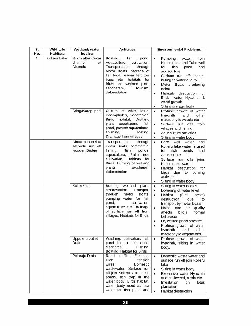
4. Kolleru Lake ½ km after Circar channel at Alapadu
Boating, fish pond, Aquaculture, cultivation, Transportation through Motor Boats, Storage of fish food, prawns fertilizer bags etc. habitats for Birds, on wetland plant saccharam, tourism, deforestation
Pumping water from Kolleru lake and Tube well for fish pond and aquaculture
Surface run offs contri-buting to water quality.
Motor Boats producing noise
Habitats destruction for Birds, water Hyacinth & weed growth
Silting is water body
Sringavarapupadu Culture of white lotus, macrophytes, vegetables, Birds habitat, Wetland plant saccharam, fish pond, prawns aquaculture, finishing, Boating, Drainage from villages.
Profuse growth of water hyacinth and other macrophytic weeds etc.
Surface run offs from villages and fishing,
Aquaculture activities
Silting in water body
Circar channel at Alapadu run off wooden Bridge
Transportation through motor Boats, commercial fishing, fish ponds, aquaculture, Palm tree cultivation, Habitats for Birds, Burning of wetland plants saccharam deforestation
Bore well water and Kolleru lake water is used for fish ponds and Aquaculture
Surface run offs joins Kolleru lake water.
Habitat destruction for birds due to burning activities
Silting in water body
Kolletikota Burning wetland plant, deforestation, Transport through motor Boats, pumping water for fish pond, cultivation, aquaculture etc. Drainage of surface run off from villages. Habitats for Birds
Silting in water bodies
Lowering of water level
Habitat (Bird nests) destruction due to transport by motor boats
Noise and air quality affects bird‟s normal behaviour
Dry wetland plants catch fire
Profuse growth of water hyacinth and other macrophytic vegetations.
Upputeru outlet Drain
Washing, cultivation, fish pond kolleru lake outlet discharge. Fishing, Boating, Habitat for Birds
Profuse growth of water hyacinth, silting in water body.
Polaraju Drain Road traffic, Electrical High tension wires, Domestic wastewater. Surface run off join Kolleru lake. Fish ponds, fish trop in the water body, Birds habitat, water body used as raw water for fish pond and
Domestic waste water and surface run off join Kolleru lake
Silting in water body
Excessive water Hyacinth and duckweed, azola etc.
Infestation on lotus plantation
Habitat destruction

27
S. No.
Wild Life Habitats
Wetland/ water bodies
Activities Environmental Problems
cultivation, Deforestation. Noise levels due to traffic High tension wires prevent proper movement of birds
28
S.
No. Wild Life Habitats
Wetland/ water bodies
Activities Environmental Problems
Compounding of Industrial waste with sewage and agricultural run offs directly joining Kolleru lake.
Abstraction of water for fish pond affects the water level.
Eutrophication
Chinaedlagadi Drain
Drain carrying surface run off and domestic wastewater join Kolleru lake. Road traffic, water abstraction for fish pond, cultivation. Birds habitat, Deforestation, fish trap used in water body
Excessive growth of water hyacinth, Duckweed and other wetland plants
Noise levels affect birds
Silting in water body of Kolleru lake
Water quality deterioration due to abstraction for fish pond
Eutrophication.
Pedaedlagadi Domestic wastewater discharge surface run offs, Boating for transport of construction material, feed and fertilizer for fish and aquaculture. Bird‟s habitats, deforestation traffic, High tension wire (Electrical) on road side.
Silting in water body
Habitat destruction due to noise of traffic
Deforestation
Electrical wires across the roads, water quality deterioration due to surface run offs and excessive growth of water hyacinth, duckweed etc.
Water abstraction for fish ponds affect the water level in wetlands.
5 Manjira Barrage
River Manjira Wild life sanctuary, Raw water intake for Hyderabad Metro water supply and sewerage Board. Phase II water and treatment plant at Kalabgoor. Forestry, Rain water Harvesting, Agriculture, Irrigation, fishing and tourism. Habitat for aquatic fauna and flora.
Lack of water during non-monsoon period,
Deforestation
Silting in water body
Aquatic weed growth
Habitat destruction due to various human influences.
The rich mangroves of Coringa wild life are fed by two important tributaries of Gautami Godavari i.e. River Gaderu and River Corangi, which ultimately drain into Kakinada Bay. The mangrove provides different niches for variety of animal populations such as smooth Indian otters. The sanctuary has an unique distinction of having 18 km. long sand spit in the North Eastern side, where the species of Olive Ridley sea turtle (Endangered species) nests during January-March every year. Apart from these animals, mangroves invariably attract large population of birds, which feed on various organisms inhabiting in the mangrove forest and in the backwaters. During low tide, some of the areas are exposed (elevated mud flats having small fishes, shrimps, molluscs) attracting avifauna for

29
its feed. Over 120 species of birds have been reported so far. The most common variety of avifauna are - Little Egret, Cattle Egret, Pied Kingfisher, Photograph 32-33

30
Small blue kingfisher, Black capped kingfisher, Pond Heron, Reef Heron, Grey Heron, Night Heron, Little stine, Sand piper, Red shrank, Red wattle Lapwing, Pheasant, Flamingos, Seagulls, Purple Heron and Little Cormorants.
Table 8: Bio-Monitoring of Wetland of Coringa Wild Life in East Godavari District of Andhra Pradesh
S. No.
Wetland
Location on water body/ Wetland
Temperature oC
Saprobic score
Diversity Score
BWQC Biological Water Quality
Air Water
1. River Godavari upstream
Arya puram at Raja mundry
29.5 31.0 4.5 0.35 D Highly Polluted
2. River Godavari Downstream
Dowaileswaram 28.5 31.0 4.71 0.47 C Moderate Pollution
3. Godavari Canal
Downstream Hydal Power Plant at Chettipeta
35.5 31.5 6.0 0.44 C Moderate Pollution
4. River Corangi at Lowtide
Ramanapalam East Godavari District
27.5 26.5 5.6 0.31 C Moderate Pollution
5. River Gaderu
Savitri Nagar Yanam
29.0 31.0 6.0 0.48 C Moderate Pollution
WETLANDS OF RIVER YAMUNA, PAKSHI VIHAR AT OKHLA
BARRAGE, DELHI
Delhi is situated on the bank of river Yamuna between latitude 28”23‟17” North - 28o 53‟000 North and 76o50‟24” East-77o20‟37” East. Delhi is the part of Indo-Gangetic Alluvial plains at an elevation ranging from 198 m to 220 m above the mean sea level. The area in Delhi sprawls to an extent of 1488 km2 (148, 300 ha) of terrain. Delhi is surrounded by Uttar Pradesh State on the eastern side and Haryana to the North, South and West. Two major landform systems converge here - the Ganga plain and Ridge. The later is an extension of Rajasthan‟s Aravalli ranges. The major wild life habitats in Delhi are mainly Pakshi Vihar at Okhla Barrage on River Yamuna, Najafgarh Drain. The resident and migratory birds such as Gees, Teal, Coot, Pintail, Spot Bill, Pochard, Surkhab, Wigeon, Pelican, Alwar, Godwall, Malard, Open wild Stork, Cormorant, Sarus crane, Painted Stork, White breasted kingfisher, Bee Eater, Egret, Heron, Purple Moorhen have been observed at these wild life habitats.
River Yamuna near Delhi has been identified as internationally important
wetland, declared as Ramsar Site. Okhla barrage is located near village Madanpur Khadar and Jaitpur, 20 km downstream from Wazirabad Barrage at upstream. At Okhla Barrage the water of River Yamuna is completely blocked and diverted to Agra canal. The Barrage has been constructed in a catchment

31
area of 17930 km2. This portion of the barrage is under control of U.P. Irrigation Department. At this location, River Yamuna receive discharges from various drains such as Maharani Bagh Drain, Tugalakabad Drain and Kalkaji Drain. A portion of River Hindon water from Ghaziabad (U.P) joins upstream Okhla Barrage through Hindon cut. Okhla Pakshi Vihar is situated in Ghaziabad District of Uttar Pradesh on River Yamuna in between Okhla Barrage and Okhla weir. Pakshi Vihar is 3 km from NOIDA in U.P. and 1.5 km from famous Jamia Milia Islamia University. The entire area of Pakshi Vihar was developed in year 1990 and spread to area of 400 hactare. The area is a tourist resort during November to February. Minimum temperature of 5oC and maximum of 47oC has been reported at this place.
Table 9: Bio-Monitoring of Wetlands of River Yamuna, Pakshi Vihar at Okhla Barrage, Delhi
S. No
Wetland
Month/ Year
Temperature oC
Saprobic Score
Diversity Score
BWQC
Biological Water Quality
Air Water
1. Okhla Barrage
November 2001
22.5 24.5 5.2 0.78 C Moderate Pollution
2. Okhla Barrage
December 2001
- - 4.67 0.80 C Moderate Pollution
3. Okhla Barrage
January 2002
23.0 17.0 4.5 0.5 C Moderate Pollution
WETLANDS OF NAJAFGARH DRAIN, CHHAWLA, DELHI
Delhi Tourism Department, Govt. of India, had identified this site for Chhawla
Water World and Ecopark development. However, recently the site has been protected for development of Bird Sanctuary. A number of birds have been observed at the upstream location of Najafgarh drain from Chhawla upto Dhansa regulator. The water level is maintained by the Irrigation and Flood Control, Dept. of Delhi Government. Chhawla is located on Bijwasan-Najafgarh Road at about 10 kilometer from Gurgaon NH-8 on Rajokri crossing. Najafgarh drain receives wastewater from Mundella Drain joining upstream of Chhawla at Kanganheri. Najafgarh drain originates as Dhansa outfall channel from Dhansa regulator located in Dhansa village in South-West of NCT-Delhi near Gurgaon border. Due to storage of water at Dhansa, the water body is stagnant at off take point. The catchment area of Dhansa Regulator/Bund obtains fresh water from drain coming from Jahazgarh Jheel, Sahibi Nadi and Catchment area lying in Lohat and Mundakhera in Gurgaon. Dhansa outfall channel terminates into Najafgarh Jheel. The catchment area of Najafgarh Jheel spreads in Delhi-Gurgaon border located 1-2 km distance from Jhatikra. Najafgarh Jheel is the largest surface water body in Delhi, spread over in an area of 6 km. This natural depression obtains fresh water from west of ridge, north of Karnal and from the catchment area lying in Gurgaon. Najafgarh channel was dug out from the Najafgarh Jheel during the

32
year 1938 joining to the River Yamuna at downstream of Wazirabad barrage. The water quality of Najafgarh drain upto Chhawla supports wide range of aquatic fauna and flora including birds, fishes etc. The water is used for irrigation by direct pumping into adjacent cultivated lands of wheat, vegetables etc. MCD tube well adjacent to Najafgarh drain is used for drinking purpose by BSF colonies. Up to Kakraula regulator, Najafgarh drain receives several outfalls from sewage treatment plant.
Table 10: Bio monitoring of Wetlands of Najafgarh drain in Delhi at Chhawla Eco-Park
S. No.
Wetlands
Location Temperature 0C
Saprobic Score
Diversity Score
BWQC Biological water
Quality
Air Water
1. Najafgarh Drain
Dhansa Regulator at Dhansa village
20.0 15.0 5.26 0.55 C Moderate Pollution
2. Najafgarh Jheel
1 ½ km U/s of Jhatikra on Gurgaon Border
23.0 16.0 5.0 0.22 D High Pollution
3. Najafgarh Drain
Jhatikra on Delhi-Gurgaon Border Near Bridge
23.0 17.0 5.0 0.9 C Moderate Pollution
4. Chhawla Eco-park on Najafgarh Drain
Chhawla, Guest House of Irrigation and Flood Control Department
17.0 23.0 5.3 0.82 C Moderate Pollution
5.
Najafgarh Drain
Goela Dairy Police check Post
19.5 14.5 5.1 0.6 C Moderate Pollution
Kakrola Regulator
22.0 16.0 4.3 0.24 D High Pollution
D/s Uttam Nagar Police Check post
23.0 18.0 4.5 0.25 D High Pollution
33
S. No.
Wetlands
Location Temperature 0C
Saprobic Score
Diversity Score
BWQC Biological water
Quality
Air Water
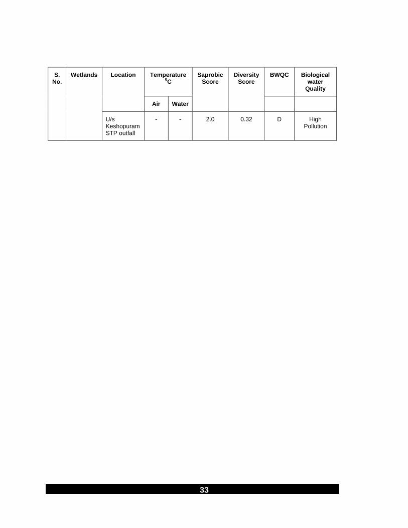
U/s Keshopuram STP outfall
- - 2.0 0.32 D High Pollution

34
S. No.
Wetlands
Location Temperature 0C
Saprobic Score
Diversity Score
BWQC Biological water
Quality
Air Water
D/s Keshopuram STP outfall
24.0 18.0 0.0 0.0 E Severe Pollution
Basaidarapur, Ashok Vihar, Bharat Nagar
- - 0.0 0.0 E Severe Pollution
Najafgarh Drain is canalized after Bharat Nagar upto confluence to River Yamuna at Downstream Wazirabad Barrage .
Table 11: Environmental Problems related to various activities in vicinity of wild
life Habitats in Delhi
S. No.
Wild life Habitat
Wetland/ Location Activities Environmental Problems
1. Pakshi Vihar River Yamuna at Okhla Barrage.
Tourist Resort, Bird watching, fishing, Habitat for migratory birds. Supply of Irrigation water to Agra Canal. Cattle wading, cultivation
Profuse growth of water Hyacinth
Waste water discharge from U.P. and Drains of Delhi
Silting and sludge deposition
Water quality deterioration
2. Chhawla Eco park
Najafgarh Drain at Dhansa Regulator
Run off from Jahazgarh Jheel, Sahibi Nadi and catchment area lying in Gurgaon., grazing, fishing, Origin of Drain No.6 cultivation etc. Cattle wading. Habitat for migratory Birds
Silting, stagnation of water body due to lack of water in the catchment of Dhansa Regulator
Water Hyacinth
Deforestation
Lack of fresh water source during non-monsoon period salinity intrusion
Najafgarh Jheel Cultivation in the adjacent-fields in Gurgaon. Habitat for birds, STP outfall from Haryana, Solid waste dumping, Eichornia and other weed growth. Open defecation, grazing etc. Road Transport
Water quality deterioration
Surface run offs
Noise due to vehicles passing Haryana border
Silting and sludge deposition in water body
Obstruction in flow of water
Absence of desludging & deweeding activity

35
Salinity problem
Water Hyacinth growth

36
Photograph 34-37

37
S.
No. Wild life Habitat
Wetland/ Location Activities Environmental Problems
Najafgarh Drain at Jhatikra
Vehicular activities on Delhi Gurgaon Border, Habitats for birds, grazing, cultivation, Irrigation. Solid waste dumping
Increasing noise levels
Water quality affected due to surface run off
Silting and sludge deposition
Solid waste dumping
Habitat destruction
Salinity problem clogging of drain
Water hyacinth growth
Chhawla Eco park in Najafgarh drain
Eco park development of bird sanctuary by Irrigation and flood Dept. Forestry, vehicle passing through the Road Bridge. Open defecation, solid waste Habitat for Birds scavengers
Silting and sludge deposition
Low flow in water body
Profuse growth of duckweed water hyacinth & macrophytic vegetation.
Clogging of drain obstruct in flow of water
Salinity problem
WETLANDS OF KASHMIR VALLEY (JAMMU & KASHMIR)
The wetlands in Kashmir Valley are of significant importance for sustenance of wide array of bio-diversity inhabiting them. The vast network of fresh water, marshy wetlands and depressions in the valley of Kashmir still possess pre-historic importance. Most of them are of post-glacial age. The high attitude fresh water lakes are fed by snow and rainfed streams, rivulets and rivers originate from mountain system of the great Himalayas on the eastern edge of the Valley and the Pir Panjal range extending along the western and south western parts and mostly located in the centre of valley. The River Jehlum is the source of major wetland of Wullar Lake designated as Ramsar site by Government of India as “Wetland of International Importance”. River Jehlum flowing from south east to north west, is drained during floods into several inland depression. The major wetlands in the valley are Narkara, Hokera, Mirgund, Shallabugh, Hygam, Dal Lake, Manasbal, Wular etc., which provide an extensive over-wintering resorts, excellent cover and safe roosting and feeding grounds to wide and rich variety of geese, ducks and rails which arrive just at the onset of autumn migrating from Palaearctic breeding grounds. The temporary wetlands buffer the permanent bird refuses for a large number of other birds both migratory and residents during summer. They also serve sites for shelter during night feeding on the left over paddy after harvesting. There are several high land lakes fall on to and fro fly-

38
way route of these wintering visitors both at the time of in and outward migration, but their use by these birds is still unknown. The Willow (Salix alba) groves and Popular trees (Populus sp.) extending along the peripheries of wetlands are valuable resources of fuel, fodder, timber and material to the wicker work, besides provide roosting and nesting cover to both land and water birds. The residue of the dead aquatic flora and hydrophytic plants (humus) of the littoral zone provides `Demb‟, which is extensively used for fuel purposes. Intensive harvesting of Typha angustata and Sparganium ramosum for making mats and Pharagmites communis and Nymphoides pellatum for fodder affect the holding capacity of the wetlands, as they provide food and cover niches to the water birds. Floating gardens present in them provide manure rich substratum for vegetation of crops. The geese, ducks and rails are found feeding, dabbling, resting or preening on floating gardens during late winter and early spring. The socio-economic importance of wetland to the people living in the close vicinity are exploitation of water chestnuts (Trapa natans); seeds of several plant species form an important food for the geese, ducks and rails. The wetlands are presently under increasing pressure from over exploitation of resources, conversion to other land uses through drainage/river engineering schemes, fertile farmland or buried under refuse tips, pollution and degradation of catchments. It has greatly affected the population size of several water fowl species and discontinued stopover of many more including Common Cranes (Grus grus) in the valley over the years. The overall water fowl status assessed from valley revealed the Common Teal (Anas crecca) as the most commonest species; Pintail (A. acuta), Mallard (A. platyrhynchos), Gadwall (A. ctripera), Wigeon (A. Penelope) and Coot (Fulica atra) as common, Garganay (Anas guerquedula), Greylag Goose (Anseranser), Shoveller (Anas clypeata), Red Crested Pochard (Netta rufine) and Common Pochard (Tadoma ferruginea), White-eyed Pochard (Aythya nyroca) and Tuffed Duck (A. fuligula) with a vulnerable status. The water fowl census conducted in sixteen wetlands during 1992 was repeated during winter session (September to April) with addition of new areas from time to time, to monitor population fluctuation over the season and population trend over the years, besides to evaluate their status in the valley. These wetlands are weedy and extensive morass, bounded by thick willow (Salix sp.) groves with scattered stands of popular (Populus sp.). Whereas, some water bodies support Apple (Prunus sp.) Orchards as well. A definite type of vegetation ranging from sub-merged, attached, free floating and emergent aquatic vegetation of grasses, herbs, reeds and sedges are found in wetlands. Some of the important species are:

39
Typha angustata Typha laximanii
Phragmites communis Elecharis palustris
Sagittaria Sagitifolia Saccharum spontaneum
Butomus umbellatus Trapa natans
Myriophyllum verticillatum Myriophyllum spicatum
Sparganium ramosum Polygonum sp.
Nymphoides peltatum Potamogeton sp.
Scripus sp. Frimbistylis squarosa
Lemna gibba Lemna minor
Lemna trisulea Spirodella polyrhiza
Alisma plantagoaquatica Menta longifolia etc.
The diverse land use by way of willow/popular plantations, orchards and paddy cultivation fringing the wetlands add food and spatial niches to fragile and productive ecosystem, paving way for rich and varied aquatic as well as terrestrial avifauna species both native and migratory (summer & winter). But the study sites of Hokera, Mirgund, Narkara, Chatlum and Manibugh still continue to be managed for organized shooting from November/December to April, every year, which has now been temporarily stopped for the past few years. Protection to the wetland ecosystem and inhabiting avi-fauna is proposed through identification of adequate protected areas network by upgradation of Hokera as a sanctuary together with declaration of Manibugh – Kranchu, Lasjan, Narkara, Baba Shuku-r-din (Bathi/Raw Kach) as Sanctuaries.
Table 12: Geographical Details of Wetlands in Kashmir Valley
S. No.
Name of wetland
District Altitude MSL
North Latitude
East Longitude
1. Panzipora Pulwama 1,607 330.52‟ 75
0.03‟
2. Manibugh Pulwama 1,607 330.59‟ 74
0.56‟
3. Chatlum Pulwama 1,593 340.01‟ 74
0.56‟
4. Dal Lake Srinagar 1,585 340.05‟ 74
0.50‟
5. Narkara Budgam 1,588 340.02‟ 74
0.45‟
6. Hokera Budgam/Srinagar 1,584 340.05‟ 74
0.40‟
7. Mirgund Badgam 1,583 340.07‟ 74
0.38‟
8. Mirgund Numbal Baramulla 1,632 340.08‟ 74
0.39‟

40
Photograph 38-41

41
The water bodies of Manibugh-Kranchu, Lasjan, Narkara, Hokera and Mirgund sprawl over an area of 0.40 km2, 0.30 km2, 3.25 km2, 13.75 km2 and 4.00 km2 respectively. All these wetlands are characterized by low water level that fluctuates greatly during the year in response to the natural discharge from their sources. Most of the wetlands except Chatlum and Manibugh are surrounded on all sides by paddy fields and excess water from these washes down alongwith various organic and inorganic constituents.
Table 13: Bio-monitoring of wetlands in Bird Sanctuaries of Kashmir Valley
S. No.
Wetlands Location Temperature 0C
Saprobic score
Diversity score
BWQC Biological Water
Quality Air Water
1. Hokersar Zaina Kote Sector 1, NH-1A
29.5 24.5 5.0 0.55 C Moderate Pollution
2. Mirgund Mirgund, Noorabad
26.5 26.5 4.25 0.40 D Heavy Pollution
3. Narkara Nadru Nadru, Army Air Port Road
23.5 25.5 5.33 0.45 C Moderate Pollution
4. Hygam Hygam at Srinagar-Baramulla NH-1A
24.0 25.5 5.5 0.43 C Moderate Pollution
5. Ajas Ajas, Srinagar-Bandipora Road
28.0 30.0 5.66 0.55 C Moderate Pollution
6. Manasbal Manasbal near Kondabal
26.0 25.5 8.0 0.71 A Clean
7. Wullar Haretare 31.0 - 5.6 0.78 C Moderate Pollution
8. Shallabugh Shallabugh, Ganderbal
20.0 12.15 5.3 0.49 C Moderate Pollution
9. Panzipora Kapore, Marhama, Srinagar-Jammu NH-1A
25.0 20.5 5.0 0.33 C-D Moderate to Heavy Pollution
10. Padgampora Pulwama at Pulwama-Avantipora Road
31.0 25.0 3.4 0.84 C Moderate Pollution

42
S. No.
Wetlands Location Temperature 0C
Saprobic score
Diversity score
BWQC Biological Water
Quality Air Water
11. Manibugh Pampore, Galender, NH-1A
28.0 20.0 5.28 0.59 C Moderate Pollution

43
Photograph 42-45

44
S. No.
Wetlands Location Temperature 0C
Saprobic score
Diversity score
BWQC Biological Water
Quality
12. Chatlum Lalpore
Chatlum, NH-1A
25.0 25.0 5.3 0.42 C Moderate Pollution
13. Inner Dal Lake Srinagar 24.0 24.5 4.75 0.46 D Heavy Pollution
14. Nagin Lake Srinagar 24.5 26.0 5.4 0.61 C Moderate Pollution
15. River Sind Mamer, Sonamarg-Srinagar Road
20.0 10.0 0.0 0.0 E
16. River Sind Inner Nullah
Mamer Sonamarg-Srinagar Road
20.0 8.0 5.33 0.19 D Heavy Pollution
17. Thajiwas Glacier
Border of Sonamarg-Leh
10.0 2.0 7.4 0.30 A Clean
18. Dachigam Nullah
Srinagar 27.5 16.0 7.4 0.64 A Clean
Table 14: Environmental Problems related to various activities in vicinity of wildlife of Kashmir Valley
S. No.
Wildlife Habitat Wetland location Activities Environmental Problems
1. Hokersar‟s (Hokera) wetland
Zaina Kote Sector 1, NH-1A
Fish farm, paddy cultivation, willow, popular tree plantation, grazing cattle, forest, Deweeding in wetland, domestic wastewater discharge, cattle farming, open defaecation, captive breeding of Bar headed goose. Over wintering resort for migratory birds.
Hard substraction due to Siltation, profuse weed growth, wild grass, habitat destruction for bird nesting, encroachment of paddy cultivation, water quality due to surface runoffs.
2. Mirgund Srinagar-Gulmarg Road
Mirgund, Noorabad
Paddy cultivation, abstraction of water, cattle wading, grazing, forest of popular tree & willow plantation for cottage industry, human settlement, cultivation of vegetables.
Encroachment of wetland catchment area, low level of water, Siltation, lack of nesting habitats profuse weed growth water quality due to decomposition of macrophytic vegetation.
3. Narkara Nadru Nadru, Army Air Port Road
Paddy cultivations, human settlement, solid waste dumping poaching, reclamation of land for paddy cultivation and vegetable cultivation in catchment, cattle, farming,
Uprooting of tree due to heavy snowfall and rains, Siltation due to flood channel of excessive growth of wild grass, habitat destruction for birds, water quality due to

45
S. No.
Wildlife Habitat Wetland location Activities Environmental Problems
domestic wastewater discharge. Traffic of air and roadways.
surface runoffs. Shrinking of wetland area. Bird hit to aero planes.

46
Photograph 46-48

47
S.
No. Wildlife Habitat Wetland location Activities Environmental Problems
4. Hygam Hygam at Srinagar-Baramulla NH-1A
Residential colonies, Deweeding for cattle feed, illegal occupation by villagers, willow plantation, burning of dried grass, construction of bunds. Abstraction of water. Habitat for migratory birds, over growth of Wapaygrass, drain discharge from Ningli & Balkul nullah.
Shallow water body, Siltation, encroachment by paddy cultivation, lack of nesting habitat, over growth of wapay grass, replacing the fodder grass, tree felling due to heavy snow fall. Fish kills due to eutrophic condition in water body.
5. Ajas Ajas, Srinagar-Bandipora Road
Paddy fields, stone quarry grazing land, traffic adjacent to wetland, deforestation, surface drainage from surrounding and Waniyar nullah, Walnut plantation, Honey Bee cultivation, Brick formation
Low level of water, encroachment by paddy fields, Siltation, water scarcity during summer, lack of habitat for birds, water quality.
6. Manasbal Lake Manasbal near Kondabal
Tourism, boating, fish harvesting, private lotus cultivation, residential activities, stone quarry, lime klin, paddy cultivation, solid waste disposal at amusement park. Surface drainage to lake. Cultivation of Nadru and Euryale ferox salisb (rare aquatic plant).
Water quality, Siltation on the boundries, decomposition of aquatic weeds near residential settlement. Deep-water body profuse macrophytic submerged vegetation. Few benthic macro invertebrate populations.
7. Lake Wullar Haretare Paddy cultivation, willow plantation, fishing, Deweeding encroachment of residential settlement, Kanihome drain discharge, illegal settlement on the bank, cattle forming, temporary bunds, drying of weeds in water body. Silviculture, captive fisheries, water chestnut, lotus rhizome, fish and fodder, egg hatchery of ducks and mass deweeding.
Shrinking of catchment area, Siltation, lowering of depth of water body, water quality due to drain water, development of floating lands, animal mortality due to floods, decomposition of profuse growth of macrophytic vegetation, lack of nesting habitats.
8. Shallabugh Shallabugh, Ganderbal
Cattle wading, Deweeding, fishing, flood water of river Sind joins wetland, drain water discharge from villages willow plantation for cottage sports industry,
Water quality, Siltation, profuse filamentous algal growth, due to willow tree, shrinking in catchment area and development of floating lands, low level of

48
S. No.
Wildlife Habitat Wetland location Activities Environmental Problems
grazing lands, surface runoff.
water, sedimentation.

49
S.
No. Wildlife Habitat Wetland location Activities Environmental Problems
9. Panzipora Kapore, Marhama, Srinagar
Paddy farming, cattle wading, willow & popular tree plantation for cottage industry of Bat making, deforestation, drainage of surface run offs from surrounding, quarries, stone crushing, lime kiln, human settlement, open defaecation. Irrigation canal running parallel, saffron cultivation, cement factory.
Encroachment in catchment area of wetland. Siltation, water quality, water scarcity, profuse duckweed growth, land reclamation for human settlement and cultivation.
10. Padgampora Pulwama-Avantipora Road, Seed Multiplication farm
Seed multiplication farm for cultivation of corn, paddy, cereals, beans and cattle feed seeds, willow plantation, air port, abstraction of water for paddy cultivation using high capacity pump, grazing, open defaecation. Water scarcity, saffron fields, almond cultivation, and cement industry, stone quarry.
Shrinking of catchment area of wetland, water scarcity, development of marshy land habitat destruction, noise levels, Siltation. Bird hit chances due to close vicinity of airport.
11. Manibugh Pampore, Galender, NH-1A
Paddy cultivation, apple, saffron, peas, apricot, maize, cherry, almonds and nuts plantation, willow tree plantation in surrounding, stone quarries, lime kiln, storage of petroleum product, bottling plant in the vicinity, deforestation. Drainage of surface run off.
Encroachment in catchment area, Siltation in wetland, habitat destruction, water quality, and profuse growth of duckweed, high-tension wire across the wetland, soil erosion.
12. Chatlum Lalpore Pampore on NH-1A near Chatlum, Dept. of Fisheries Govt. of India
Fish seed farming, cattle wading, human settlement, cultivation of saffron, maize, vegetables, bottle polythene bags, plastic alongwith solid waste dumping site. Heaps of cow dung used as fuel drain discharge, surface run offs, lotus cultivation.
Water quality of wetland, shrinking of catchment area, Siltation, decomposition of macrophytic vegetation, sedimentation
13. Inner Dal Lake Srinagar Tourism, transport, commercial activity, domestic wastewater discharge, house boats, medical centres, de-
Water quality, shrinking of lake area, Siltation, anaerobic and unhygienic conditions in canal, habitat destruction for fauna and

50
S. No.
Wildlife Habitat Wetland location Activities Environmental Problems
sludging, Deweeding, floating aerators for cleaning, floating gardens,
flora, clusters of houseboats at one place. Heavy Siltation near sluice

51
Photographs 49-51

52
S.
No. Wildlife Habitat Wetland location Activities Environmental Problems
reclamation of land for building construction, vegetable cultivation, electrical power supply, wastewater discharge through canal from Rainawari area, dumping of abandoned house boats, bathing, washing etc. profuse macrophytic vegetation, duckweed etc. construction of radh, formation of dembs.
gate residential area near polluted water body, Deforestation for shikarra industry near lake.
14. Nagin Lake Srinagar, Hazarat Bal, Saderbal, Nagamala and Barhal area
Drinking water source, swimming, tourism, house boats, construction of bridge, waste water discharge of Rainawari area through canal deforestation, cultivation, floating gardens, Amir Khan nullah joining the lake, Transport, cottage industry of mats and ornamental items, construction of radh, dembs.
Development of peat lands, Siltation, profuse weed growth, lack of habitats for birds, water quality.
15. River Sind Inner nullah
Mamer, Sonamarg-Srinagar Road
Turbulent river, Hydro-electric power generation, tourism, construction of cultivated lands, radh.
Sandy substratum of river, Siltation in Inner nullah, domestic waste discharge through surface run offs.
16. Thajiwas Glacier Border of Sonamarg-Leh
Origin of river Sind, Tourism, Transport through horse, pony etc. settlement of army (BSF) forest and Thajwas wildlife.
Horse and cattle dung, open defaecation, solid waste dumping through tourist activities use of polythenes bottles & plastic bags.
17. Dachigam Nullah Srinagar Dachigam National Park, conservation of Hangul Deer endangered sp. Paddy cultivation, water reservoir in the vicinity, fishponds, swimming pool, Dachigam stream is main source of water to Dal lake.
Surface runoffs from Fishpond, swimming pool and cultivated lands.
4.0 BIOLOGICAL WATER QUALITY ASSESSMENT OF
WETLANDS IN BIRD SANCTUARIES
Bio monitoring of water quality was initiated at wetlands/water bodies used for propagation of wildlife and fisheries as one of the important designated best use

53
of the aquatic resources. The wetlands existing in wildlife habitats of most of the Bird sanctuaries demand water quality suitable for highly productive and rich bio-diversity of fauna and flora. In view of protection of rare and endangered/threatened species of migratory and resident birds, the bio-monitoring of water quality was initiated at 42 nos. of wetlands identified in 26 nos. of bird sanctuaries existing in the state of Rajasthan, Uttar Pradesh, Andhra Pradesh, Delhi and Jammu & Kashmir. Wetlands in Bird Sanctuaries include various surface water bodies such as Rivers, Canals, Lakes, Barrages, Drains, Marshes, Beels, Estuaries and Mangroves.
The taxonomic composition of wetlands varied with respect to hydrological
conditions of water bodies such as Rivers, Lakes and Ponds. Most of the wetlands identified in Bird Sanctuaries belonged to the Biological Water Quality Class of `C‟ and `D‟. Classes. `A‟ water quality of clean stretches existed either in the upstream river stretches of wetlands or in very deep-water bodies (Table 14). These stretches are not suitable for bird sanctuaries due to non-availability of sufficient fauna and flora. A total of 15 nos. of families of benthic macro-invertebrates were collected from 3 wetlands of Class `A‟ quality.
None of the wetlands existed in `B‟ class of water quality of BWQC as a result of habitat destruction due to various human activities such as bathing etc.
A maximum of 27 nos. of wetlands supported biodiversity suitable for `C‟ class of water quality (Table 17). Maximum of 43 nos. of benthic macro-invertebrate families (Table 17) have been collected from wetlands of moderately polluted water quality (Class `C‟). There were only 9 nos. of wetlands having water quality with heavy pollution of water quality class `D‟. A total of 27 nos. of families of benthic macro-invertebrates were collected from these wetlands (Table 18). The water quality of 4 nos. of wetlands belonged to class `E‟ of BWQC either due to severe pollution or due to sandy substratum (Table 19).
Table 15: Clean Water (Class `A’) Stretches of Wetlands existing in Bird Sanctuaries
S. No.
State Wetland District/Town/Village
Location of Stretch/Bird Sanctuary
Taxa/Families of Benthic Macro-
invertebrates available from wetlands
1. Jammu & Kashmir
Manasbal Lake Manasbal near Kondabal
Manasbal Lake EPHEMEROPTERA/ Heptageniidae, Leptophlebiidae, Empemerellidae, Baetidae
River Sind Sonamarg 2-3 km upstream of Sonamarg and Leh
TRICHOPTERA/ Leptoceridae, Goeridae,

54
upstream border Thajiwas wildlife sanctuary
Rhyacophillidae, Polycentropodidae

55
S. No.
State Wetland District/Town/Village
Location of Stretch/Bird Sanctuary
Taxa/Families of Benthic Macro-
invertebrates available from wetlands
Dachigam Nullah
Srinagar Dachigam National Park
ODONATA/ Lestidae, Gomphidae, Libellulidae
PLANARIA/ Planariidae
DIPTERA/ Simulidae, Blepharoceridae
HIRUDINEA/ Glossiphonidae
Table 16: Slightly Polluted (Class `B’) Stretches of Wetlands in Bird Sanctuaries
None of the wetlands of Bird Sanctuaries existed in Class `B‟
Table 17: Moderately Polluted (Class C) Stretches of Wetland existing in Bird sanctuaries
S.
No.
State Wetland District/ Town Village
Location of Stretch/ Bird sanctuary
Taxa/families of Benthic Macro-invertebrates
available from wetlands
1. Rajasthan Ghana Canal Bharatpur Keoladeo Bird Sanctuary
EPHEMEROPTERA/ Ephemerellidae, Baetidae
ODONATA/ Lestidae, Gomphidae, Libellulidae, Aeschnidae
MOLLUSCA/ Thiaridae, Lymnaeidae, Viviparidae, Physidae, Unionidae, Planorbidae, Bithynidae, Sphaeriidae, Hydrobiidae
CRUSTACEA/ Asellidae, Atydae, Gammaridae, Paleamonidae, Potamobiidae (Hermit Crab)
Ghana lake Keoladeo Bird Sanctuary K&L Block
2. Andhra Pradesh
River Godavari Upstream
Rajahmundry East Godavari District
Dowaileswaram
3. Andhra Pradesh
River Corangi at Low tide
Ramanapalam East Godavari District
Corangi Wild Life sanctuary
4. Yanam (Pondicherry)
River Gaderu in Coringa Wild life Sanctuary
Savitri Nagar Wooden Bridge Coringa Wild Life Sanctuary
5. Andhra Pradesh
Manjira Barrage
Sangareddy, Hyderabad
Manjira Wild Life Sanctuary
56
S.
No.
State Wetland District/ Town Village
Location of Stretch/ Bird sanctuary
Taxa/families of Benthic Macro-invertebrates
available from wetlands
6. Andhra Pradesh
Godavari Canal
Chettipeta West Godavari Dist.
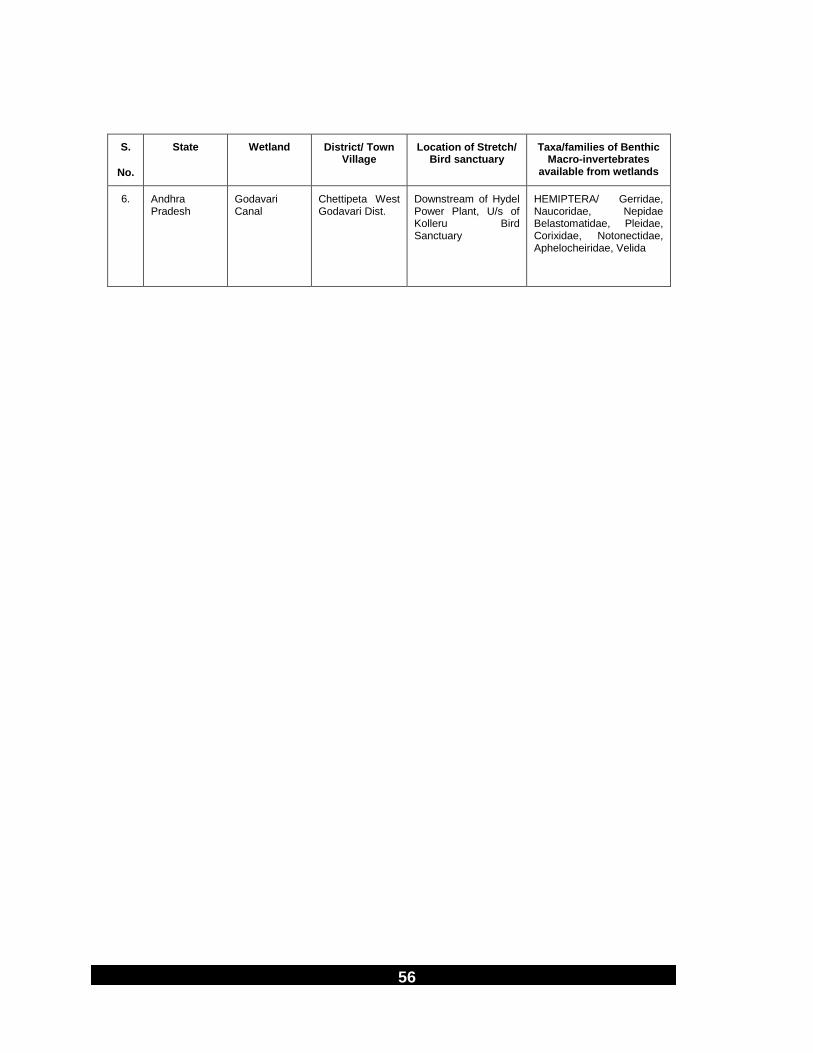
Downstream of Hydel Power Plant, U/s of Kolleru Bird Sanctuary
HEMIPTERA/ Gerridae, Naucoridae, Nepidae Belastomatidae, Pleidae, Corixidae, Notonectidae, Aphelocheiridae, Velida

57
S.
No.
State Wetland District/ Town Village
Location of Stretch/ Bird
sanctuary
Taxa/families of Benthic Macro-invertebrates
available from wetlands
8. Andhra Pradesh
Upputeru outlet Drain of Kolleru lake
Akiveedu at Vijaywada
Near Road Bridge Kolleru Bird Sanctuary
COLEOPTERA/ Gyrinidae, Hydrophilidae, Dytiscidae, Hygrobiidae, Elminthidae
DIPTERA/ Chironomidae, Tipulidae, Syrphidae, Simulidae
PLANARIA/ Planaride
HIRUDINEA/ Glossiphonidae, Erpobdellidea
MEGALOPTERA/Sialidae
OLIGOCHAETA/ Oligochaetes
9. Andhra Pradesh
Polaraju Drain of Kolleru lake
Lokumudy West Godvari District
Near Road Bridge, Kolleru Bird Sanctuary
10. Andhra Pradesh
Chinaedlagadi Drain
Kowadalanka Area, West Godavari Dist
Eluru-Kaikaluru Road, Kolleru Bird Sanctuary
11. NCT Delhi Najafgarh Drain
Dhansa Dhansa Regulator, Najafgarh Jheel
Delhi-Gurgaon Border
Jhatikra Near Road Bridge, Najafgarh Jheel
Delhi Chhawla Chhawla, Guest House of Irrigation and flood control Department, Najafgarh Drain
Goela Khurd Goela Dairy Police check post, Najafgarh Drain
12.
Uttar Pradesh
River Yamuna Delhi Wazirabad water works
Wazirabad Barrage opposite bank at Sonia Vihar
Okhla Barrage Pakshi Vihar
Keetham Lake Keetham (Agra) Delhi-Agra Road, 20 km from Agra City, Sur Sarovar Bird Sanctuary
Samaspur Lake
Raebarely Samaspur Bird sanctuary
River Sai Upstream
Raebarely Lucknow-Kanpur Road Bridge on NH-25 Samaspur Bird sanctuary
River Sai Downstream
Raebarely Saipul on Lucknow- Varanasi Road Samaspur Bird Sanctuary

58
S.
No.
State Wetland District/ Town Village
Location of Stretch/ Bird
sanctuary
Taxa/families of Benthic Macro-invertebrates
available from wetlands
River Garrah Sandi at Hardoi Channel goes to Sandi lake Bird sanctuary
59
S.
No.
State Wetland District/ Town Village
Location of Stretch/ Bird
sanctuary
Taxa/families of Benthic Macro-invertebrates
available from wetlands
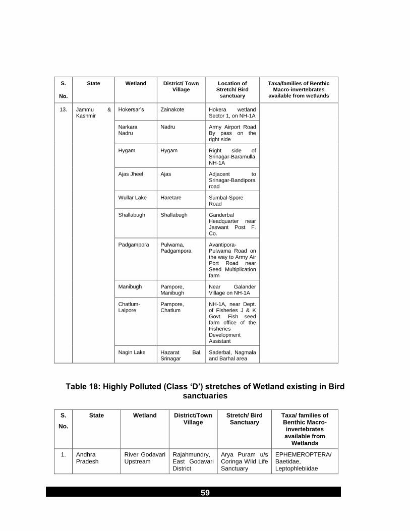
13. Jammu & Kashmir
Hokersar‟s Zainakote Hokera wetland Sector 1, on NH-1A
Narkara Nadru
Nadru Army Airport Road By pass on the right side
Hygam Hygam Right side of Srinagar-Baramulla NH-1A
Ajas Jheel Ajas Adjacent to Srinagar-Bandipora road
Wullar Lake Haretare Sumbal-Spore Road
Shallabugh Shallabugh Ganderbal Headquarter near Jaswant Post F. Co.
Padgampora Pulwama, Padgampora
Avantipora-Pulwama Road on the way to Army Air Port Road near Seed Multiplication farm
Manibugh Pampore, Manibugh
Near Galander Village on NH-1A
Chatlum-Lalpore
Pampore, Chatlum
NH-1A, near Dept. of Fisheries J & K Govt. Fish seed farm office of the Fisheries Development Assistant
Nagin Lake Hazarat Bal, Srinagar
Saderbal, Nagmala and Barhal area
Table 18: Highly Polluted (Class ‘D’) stretches of Wetland existing in Bird sanctuaries
S.
No.
State Wetland District/Town Village
Stretch/ Bird Sanctuary
Taxa/ families of Benthic Macro-invertebrates available from
Wetlands
1. Andhra Pradesh
River Godavari Upstream
Rajahmundry, East Godavari District
Arya Puram u/s Coringa Wild Life Sanctuary
EPHEMEROPTERA/Baetidae, Leptophlebiidae

60
2. Delhi-Gurgaon Border
Najafgarh Jheel
Jhatikra 1½ km upstream of Jhatikra
CRUSTACEA/ Gammaridae

61
S.
No.
State Wetland District/Town Village
Stretch/ Bird Sanctuary
Taxa/ families of Benthic Macro-invertebrates available from
Wetlands
3. Delhi Najafgarh Drain
Kakrola Kakrola Regulator Near Bridge
MOLLUSCA/ Viviparidae, Thiaridae, Planorbidae, Sphaeridae, Lymnaeidae
HEMIPTERA/ Belastomatidae, Corixidae, Notonectidae, Nepidae, Pleidae
COLEOPTERA/ Hydrophilidae, Dytiscidae,
Hygrobiidae, Psephenidae
DIPTERA/Tipulidae, Culicidae, Chironomide, Ephidridae, Blepheroceridae
ODONATA/ Libellulidae, Lestidae,
OLIGOCHAETA/ Oligochaetes
MEGALOPTERA/ Sialidae
HIRUDINEA/ Glossiphonidae
Uttam Nagar Near Uttam Nagar Police check post
Vikas Puri U/s of Pankha Road Drain confluence
4. Uttar Pradesh Nawabganj Lake
Nawabganj in Unnao
Lucknow-Kanpur NH-25 Nawabganj Bird sanctuary
5. Uttar Pradesh Sandi Lake Sandi in Hardoi
19 km on Hardoi Sandi Road Near Sandi Police Station, Sandi Bird sanctuary
6. Jammu & Kashmir
Mirgund, Srinagar
Mirgund, near Noorbad Hyderpura
16 km from Srinagar on Srinagar-Gulmarg Road
Panzipora Kapore, Marhama
Srinagar-Jammu NH-1A towards left turn from Sangam Bridge
Inner Dal Lake Srinagar Adjoining the city of Srinagar, Dal Kutwal upto Watpore area

62
River Sindh Inner nullah u/s to Shallabugh
Mamer Sonamarg
Sonamarg-Srinagar Road
Table 19: Severely Polluted (Class ‘E’) stretches of Wetland existing in Bird
Sanctuary
S. No.
State Wetlands District/Town/Village
Location of stretch/ Bird sanctuary
Taxa/families of Benthic Macro-invertebrate available from Wetlands
1. Delhi Najafgarh Drain
Delhi D/s of Keshopuram STP outfall
No macro-invertebrates recorded.
Basaidarapur behind I & F Control office
Ashok Vihar Near Wazirpur Police Check Post
Bharat Nagar
2. Delhi Najafgarh Drain
Bharat Nagar to confluence to River Yamuna at D/s of Wazirabad Barrage Najafgarh drain is canalized
3. Jammu & Kashmir
Shallabugh, River Sindh d/s
Ganderbal HQ of Shallabugh near Jaswand post F. Company on the way to Shallabugh wetland by boat
No macro invertebrates due to Sandy substratum
River Sindh u/s
Mammar Sonamurg-Srinagar Road
Table 20: Taxonomic Composition of Benthic Macro-invertebrate families of
Wetlands in Bird Sanctuaries
S. Taxa Biological Water Quality Classes of Wetlands
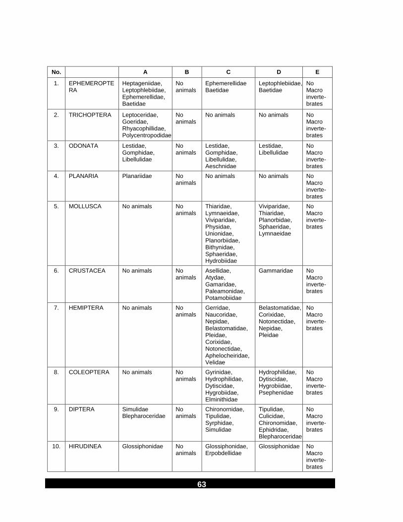
63
No. A B C D E
1. EPHEMEROPTERA
Heptageniidae, Leptophlebiidae, Ephemerellidae, Baetidae
No animals
Ephemerellidae Baetidae
Leptophlebiidae, Baetidae
No Macro inverte-brates
2. TRICHOPTERA Leptoceridae, Goeridae, Rhyacophillidae, Polycentropodidae
No animals
No animals No animals No Macro inverte-brates
3. ODONATA Lestidae, Gomphidae, Libellulidae
No animals
Lestidae, Gomphidae, Libellulidae, Aeschnidae
Lestidae, Libellulidae
No Macro inverte-brates
4. PLANARIA Planariidae No animals
No animals No animals No Macro inverte-brates
5. MOLLUSCA No animals No animals
Thiaridae, Lymnaeidae, Viviparidae, Physidae, Unionidae, Planorbiidae, Bithynidae, Sphaeridae, Hydrobiidae
Viviparidae, Thiaridae, Planorbidae, Sphaeridae, Lymnaeidae
No Macro inverte-brates
6. CRUSTACEA No animals No animals
Asellidae, Atydae, Gamaridae, Paleamonidae, Potamobiidae
Gammaridae No Macro inverte-brates
7. HEMIPTERA No animals No animals
Gerridae, Naucoridae, Nepidae, Belastomatidae, Pleidae, Corixidae, Notonectidae, Aphelocheiridae, Velidae
Belastomatidae, Corixidae, Notonectidae, Nepidae, Pleidae
No Macro inverte-brates
8. COLEOPTERA No animals No animals
Gyrinidae, Hydrophilidae, Dytiscidae, Hygrobiidae, Elminithidae
Hydrophilidae, Dytiscidae, Hygrobiidae, Psephenidae
No Macro inverte-brates
9. DIPTERA Simulidae Blepharoceridae
No animals
Chironornidae, Tipulidae, Syrphidae, Simulidae
Tipulidae, Culicidae, Chironomidae, Ephidridae, Blepharoceridae
No Macro inverte-brates
10. HIRUDINEA Glossiphonidae No animals
Glossiphonidae, Erpobdellidae
Glossiphonidae No Macro inverte-brates

64
S.
No.
Taxa Biological Water Quality Classes of Wetlands
A B C D E
11. MEGALOPTERA No animals No animals
Sialidae Sialidae No Macro inverte-brates
12. OLIGOCHAETA No animals No animals
Oligochaetes Oligochaetes No Macro inverte-brates
Total families 15 0 42 27 0

65
________________________________________________________________________
Published By : Dr. B. Sengupta, Member Secretary, Central Pollution Control Board, Delhi – 32
at ENVIS Centre – 01 Printing Supervision & Layout : P.K. Mahendru, Anamika Sagar and Mohd. Javed
Fax : 91-11-22307079/22304948 EPABX : 22305792, 22302073, 22302856 TELEX : 031-66440 PCON IN
e-mail : [email protected]; Website : www.cpcb.delhi.nic.in Printed at : NISCAIR