Embed Size (px)
Citation preview

Problems of Geophysics in the Canadian ArcticAuthor(s): C. S. Beals, J. H. Hodgson, M. J. S. Innes and R. G. MadillSource: Arctic, Vol. 7, No. 3/4, Arctic Research: The Current Status of Research and SomeImmediate Problems in the North American Arctic and Subarctic (1954), pp. 176-187Published by: Arctic Institute of North AmericaStable URL: http://www.jstor.org/stable/40506624 .
Accessed: 14/06/2014 01:13
Your use of the JSTOR archive indicates your acceptance of the Terms & Conditions of Use, available at .http://www.jstor.org/page/info/about/policies/terms.jsp
.JSTOR is a not-for-profit service that helps scholars, researchers, and students discover, use, and build upon a wide range ofcontent in a trusted digital archive. We use information technology and tools to increase productivity and facilitate new formsof scholarship. For more information about JSTOR, please contact [email protected].
.
Arctic Institute of North America is collaborating with JSTOR to digitize, preserve and extend access to Arctic.
http://www.jstor.org
This content downloaded from 188.72.126.35 on Sat, 14 Jun 2014 01:13:59 AMAll use subject to JSTOR Terms and Conditions

PROBLEMS OF GEOPHYSICS IN THE CANADIAN ARCTIC
C. S. Beals1, J. H. Hodgson2, M. J. S. Innés3, and R. G. Madill4
A part from upper atmospheric studies, which are being dealt with in the ^^ chapter on meteorology, the main Canadian contributions to geophysics in the Arctic have been made in the fields of terrestrial magnetism, gravity, and seismology. Systematic programs of observation have already been initiated in these three fields, and are likely to be expanded in time. Those observations which have been made up to the present, together with some arctic problems for future study, are considered briefly in this article. Meteors, meteorites, and meteorite craters are also discussed because of their geophysical as well as astronomical implications.
Geomagnetism. By R. G. Madill
Arctic North America, containing the north magnetic pole and much of the auroral zone, offers opportunities for research on the earth's magnetic field at high magnetic latitudes which can only be equalled in the far less accessible Antarctic. It is an area where the magnetic declination, or variation, of the compass changes through 360 degrees, the inclination, or dip, reaches its maxi- mum of 90 degrees, and the horizontal force decreases to zero. It is here that changes in the direction and magnitude of the horizontal field reach their greatest values from hour to hour and year to year. It is here, also, that magnetic disturbances are almost continuous along the auroral zone which expands during severe magnetic storms, and seriously affects the magnetic field far south of the Arctic.
The earliest magnetic observations in extreme northern latitudes were made by scientists and navigators during voyages of discovery, particularly in connection with the search for a Northwest Passage, and the attempts to rescue the Franklin expedition (Kane, 1856, pp. 165-6; Ross, 1835, pp. 549-7 1 ; Sabine, 1872, pp. 353-433). Contributions to the study of terrestrial magne- tism in arctic Canada were also made by the International Polar Year expedi- tions of 1882-3 at Fort Rae (Dawson and others, 1886), Kingua Fiord (Giese and others, 1886), and Fort Conger (Greely, 1886), and of 1932-3 at Fort Rae (Stagg, 1934) and Chesterfield Inlet (Davies and Currie, 1939), which studied the daily and annual variations in the earth's magnetic field and the correlation between magnetic storms and aurorae. Important studies of the
-^Dominion Astronomer. 2Chief, Seismology Division, Dominion Observatory. ¿Chief, Gravity Division, Dominion Observatory. *L.hier, Division or oeomagnetism, Dominion Observatory.
176
This content downloaded from 188.72.126.35 on Sat, 14 Jun 2014 01:13:59 AMAll use subject to JSTOR Terms and Conditions

PROBLEMS OF GEOPHYSICS IN THE CANADIAN ARCTIC 177
Fig. 1. Lines of equal magnetic decimation and annual change in northern Canada.
earth's magnetic field in the vicinity of the north magnetic pole were made by Amundsen in 1903-6 (Steen et ai, 1933).
Prior to 1943 regular observations by the Dominion Observatory had extended a network of magnetic stations northwards to include the Yukon and ¿Mackenzie river areas, and such parts of the coasts of Hudson Bay, Hudson Strait, and Baffin, Devon, and Ellesmere islands as could be reached by arctic supply or patrol vessels. Positions at which reliable magnetic observations had been made were very thinly spread over the Arctic, and consequently, magnetic maps did not possess the accuracy required for navigation with any certainty, although they illustrated in a general way the distribution of isogonic lines.
Since 1943 magnetic stations have been established, largely through the aid of the Royal Canadian Air Force, on all main islands of the Arctic Archi- pelago and the contiguous mainland. The stations north of latitude 60 degrees now number more than 500, and completely surround the north magnetic pole area. Information from these well distributed magnetic stations has made it possible to determine the mean position of the magnetic pole with consider- able accuracy, and to construct isomagnetic maps showing lines of equal declination, inclination, and horizontal, vertical, and total force for the entire northern area of Canada (Madill, 1948, 1949). From repeated observations
This content downloaded from 188.72.126.35 on Sat, 14 Jun 2014 01:13:59 AMAll use subject to JSTOR Terms and Conditions

178 PROBLEMS OF GEOPHYSICS IN THE CANADIAN ARCTIC
made at selected magnetic stations, the annual change in the various elements is known with reasonable accuracy. The accompanying declination map, Fig. 1, illustrates present-day knowledge of the earth's magnetic field in the Canadian Arctic.
The value of magnetic results depends not only on the number of stations, and the calibre and training of the observers, but also on the accuracy of equipment. Prior to 1947 no magnetic instruments were available that would give reliable results for both the direction and magnitude in areas of weak horizontal force near the north magnetic pole. However, a new type of magnetometer, designed and constructed by Dominion Observatory personnel, was used for ground survey work in 1947 when the magnetic pole area was surveyed, and proved to be so effective that it has been adopted for magnetic surveys in other parts of Canada as well as in the Arctic. It embodies the saturable core principle, like that used in airborne magnetometers, and operates more rapidly and sensitively than older types of magnetic survey instruments.
The Dominion Observatory has established magnetic observatories at Baker Lake and at Resolute Bay on Cornwallis Island. At both observatories regular measurements of the direction and magnitude of the magnetic field are made and their changes recorded continuously by photographic and electrical variometers. These records have shown that the mean daily range of the magnetic declination at Resolute Bay, which is 120 miles from the magnetic pole, is 7 degrees. The daily variation is much greater in summer than in winter. The maximum range is in June, and amounts to 1 1 degrees 19 minutes, while the minimum range, in December, is 3 degrees 21 minutes. It is clear that these variations are related to the sun's declination. At Baker Lake, which is 650 miles from the magnetic pole, the daily variation is much smaller, ranging from 4 degrees in June to 40 minutes in December.
The magnetic records from these observatories, apart from their import- ance in theoretical research, are of immediate practical value. They furnish data which are necessary for interpreting the short- and long-term movements of the north magnetic pole, and are therefore essential for the construction of magnetic declination maps, since all magnetic meridians radiate from the magnetic pole. Moreover, they provide data which are used in evaluating world-wide disturbances in the ionosphere, and they supply essential infor- mation required in navigation and in the control of airborne magnetic surveys, which are now being carried out.
Although a satisfactory network of magnetic stations has been established, the magnetic survey of arctic North America has not been completed. A much greater density of stations will be required in the future, not only for general mapping, and further geological studies, but also for use in conjunction with airborne surveys searching for economic minerals. The success of air- borne magnetometers in delineating mineralized areas depends directly on eliminating the effects of magnetic disturbances originating on the sun, which cause induced disturbances within the earth's crust. The records from the fixed magnetic observatories are therefore of paramount importance to the geophysical exploration of the Canadian Arctic.
This content downloaded from 188.72.126.35 on Sat, 14 Jun 2014 01:13:59 AMAll use subject to JSTOR Terms and Conditions
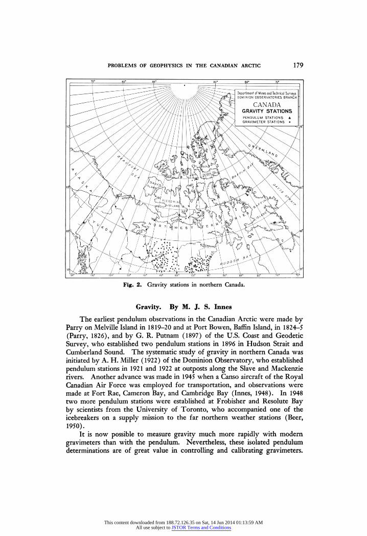
PROBLEMS OF GEOPHYSICS IN THE CANADIAN ARCTIC 179
Fig. 2. Gravity stations in northern Canada.
Gravity. By M, J. S. Innes
The earliest pendulum observations in the Canadian Arctic were made by Parry on Melville Island in 1819-20 and at Port Bowen, Baffin Island, in 1824-5 (Parry, 1826), and by G. R. Putnam (1897) of the U.S. Coast and Geodetic Survey, who established two pendulum stations in 1896 in Hudson Strait and Cumberland Sound. The systematic study of gravity in northern Canada was initiated by A. H. Miller (1922) of the Dominion Observatory, who established pendulum stations in 1921 and 1922 at outposts along the Slave and Mackenzie rivers. Another advance was made in 1945 when a Canso aircraft of the Royal Canadian Air Force was employed for transportation, and observations were made at Fort Rae, Cameron Bay, and Cambridge Bay (Innes, 1948). In 1948 two more pendulum stations were established at Frobisher and Resolute Bay by scientists from the University of Toronto, who accompanied one of the icebreakers on a supply mission to the far northern weather stations (Beer, 1950).
It is now possible to measure gravity much more rapidly with modern gravimeters than with the pendulum. Nevertheless, these isolated pendulum determinations are of great value in controlling and calibrating gravimeters.
This content downloaded from 188.72.126.35 on Sat, 14 Jun 2014 01:13:59 AMAll use subject to JSTOR Terms and Conditions

180 PROBLEMS OF GEOPHYSICS IN THE CANADIAN ARCTIC
In fact, it was for this purpose, and for ensuring uniformity within the North American network of gravity stations, that the Dominion Observatory, in cooperation with United States scientists, recently established a line of precise pendulum stations from Mexico City to Fairbanks, which was completed in 1953.
Gravimeters have been used in northern Canada since 1947, to make about 2,000 gravity determinations at intervals of 10 to 20 miles, of which more than 200 lie north of the tree-line. The Dominion Observatory has made plans to continue this program, and to obtain similar gravity coverage throughout the whole of arctic Canada. The distribution of gravity observations in the Arctic is indicated on Fig. 2.
In 1950 a series of gravimeter measurements was made on the Barnes Icecap of Baffin Island in order to determine the ice thickness on the southeastern lobe of the ice cap (Littlewood, 1952, pp. 118-24). This study, which was carried out on the Arctic Institute's 1950 expedition, revealed interesting possibilities for the gravity method in the study of glaciology.
Seismology. By J. H. Hodgson
Although the first seismograph station in the Canadian Arctic was not installed until 1950, seismological studies of the area have been going on for some fifty years. Because the Canadian Arctic is bounded by European stations on the one side, and United States and Russian stations on the other, any moderate or large earthquakes in the area have been located through the routine operations of international seismology.1 Actually the chief importance of the new Canadian station, which is at Resolute Bay, is in providing more accurate triangulation with any two stations farther south to locate epicentres in the northern hemisphere.
The new seismograph station was installed with this feature as a primary consideration. The original equipment consisted of a short-period Spreng- nether vertical and two long-period Sprengnether horizontal seismographs, which provide an ideal arrangement for the recording of distant earthquakes. After a year's successful operation this equipment was increased and more extensive plans were made. Recently a long-period vertical, loaned by the Lamont Geological Laboratory of Columbia University, has been added to assist in the study of microseisms, and a three-component set of Willmore- Watt instruments may possibly be installed. These instruments will provide improved registration of local earthquakes as well as give additional data on the preliminary phases of distant shocks.
The original instruments were installed on a rock outcrop about 1,000 feet away from the meteorological station, and were connected by cables to the recording unit situated in the camp area (Bremner, 1952). The galvanometers and recorders were mounted on heavy timber cribbing, frozen into the perma- frost, and were sheltered by a double-walled insulated building. This system of mounting proved so successful that experiments using permafrost as a base
^For a list of the principle arctic epicentres see Gutenberg and Richter (1949, p. 209).
This content downloaded from 188.72.126.35 on Sat, 14 Jun 2014 01:13:59 AMAll use subject to JSTOR Terms and Conditions
PROBLEMS OF GEOPHYSICS IN THE CANADIAN ARCTIC 181
for seismometers are now being carried out. A pier has been constructed on pipes driven into the permafrost, the pier being insulated carefully from the frozen ground. The new long-period vertical is at present operating with reasonable satisfaction on this base, and the proposed short-period instrument will be similarly installed.
The records are changed daily, and the readings are transmitted by radio to Ottawa, where they are relayed to the United States Coast and Geodetic Survey in Washington for use in epicentral location. Data are usually available within 24 hours, and the station has proved of considerable value in the inter- national program of locating and studying earthquakes.
A few small local earthquakes have been recorded, but with only a single station in the area it has been impossible to locate their epicentres. Preliminary studies of microseisms have suggested a correlation of microseismic storms with storm centres over the North Atlantic Ocean, but no final conclusion has yet been reached. Finally, the recording of the surface wave Lg, at Resolute Bay, has led the Columbia group under M. Ewing (Oliver et al, 1955) to conclude that the Arctic Archipelago is a part of the North American continental mass.
Arctic problems of the future. By C. S. Beals
The geophysical observations outlined above represent a beginning, in the Arctic, of the kind of systematic geophysical studies which have been carried out in more detail in southern Canada. For the most part, those branches of geophysics which are concerned with the solid earth do not make distinctions of climate or latitude. The Arctic is thus simply one more field to explore, with the proviso that transportation and living conditions are more difficult and expensive than in more southerly regions. This fact holds not only for the type of investigations already mentioned, but for commercial geophysics also. The various gold and base metal discoveries already made in areas like Yellow- knife and Rankin Inlet make it practically certain that other discoveries will eventually be made farther north, and undoubtedly gravity and magnetic methods of geophysical prospecting will be used extensively. It is also known that some of the geology in the arctic islands is favourable for oil, and it will only be a matter of time before the area is fully explored with seismological methods.
Apart from the need to push geophysical exploration northward, there are a few geophysical problems specifically related to the Arctic which result from the rotation of the earth or from accidents of geography. One such problem is the location of the north magnetic pole and the fact that it appears to be moving slowly in a northerly direction. The methods used to locate the pole and to study its motion have been described by Madill (1948). Its present location is in northwestern Prince of Wales Island, and there is evidence that it has moved about 200 miles from a position in Boothia Peninsula, in slightly over a hundred years.
An interesting unsolved problem is the explanation of the position of the north magnetic pole and its counterpart in the southern hemisphere, relative to
This content downloaded from 188.72.126.35 on Sat, 14 Jun 2014 01:13:59 AMAll use subject to JSTOR Terms and Conditions

182 PROBLEMS OF GEOPHYSICS IN THE CANADIAN ARCTIC
the north and south poles of rotation. Modern theories of geomagnetism relate the major portion of the earth's field to its rotation, and it would seem reasonable to expect that the magnetic poles and the poles of rotation would coincide. It is well known, however, that the north magnetic pole is not at the north rotational pole and that a similar situation exists in the southern hemisphere. The fact that this is so constitutes a major problem in world magnetism, and one which concerns the earth as a whole and not merely the arctic regions. Nevertheless, it is a problem which is sharply pointed up by arctic observations, and one which arctic observers of geomagnetism must continue to study until a definite solution is found.
Another problem brought sharply to the fore by arctic observations is the motion of the north magnetic pole. In this connection, it should be pointed out that while most modern arctic observers are convinced that the pole is moving, the values of its position in 1831, given by Ross, and in 1904, by Amundsen, were based on much less adequate information than that of the present day. Modern scientists are grateful to Ross and Amundsen for provid- ing good and reliable observations of great importance, but at the time their work was done, they lacked the modern means of transportation which have made it possible to surround the pole with observations, and so to fix its position with much greater exactness. It would appear, therefore, that a detailed and accurate study of the motion of the north magnetic pole is an arctic problem of the future which will certainly occupy an important place in geomagnetic studies during the next few decades. The cause of the pole's motion is beyond question bound up with the larger problem of the secular changes of the magnetic elements throughout the world, and its solution, if one is possible, will probably be on a world-wide basis. Nevertheless, no study of this matter could be complete without taking into account the arctic data on the motion of the north magnetic pole and on similar phenomena which may be observed in the antarctic regions.
There is still another intriguing problem related to the north magnetic pole which is of major interest to students of geomagnetism. If the earth, as a whole, is treated as a great magnet, the position of the magnetic axis may be derived by mathematical methods, utilizing magnetic observations over the whole surface of the globe. Such a calculation has been made, and the results show that the magnetic axis (which does not pass through the centre of the earth) cuts the earth's surface at a point in northwestern Greenland, some hundreds of miles from the observed position of the north magnetic pole as indicated by the convergence of magnetic meridians in the arctic regions. The fact that these two points do not coincide constitutes a most interesting problem. It is possible that the explanation may be found in the character of the earth's crust or of the earth's deeper layers under the arctic regions. If this is so, it seems likely that additional magnetic, seismic, and gravity observations in the arctic regions may eventually shed light on the problem. And though the magnitude of the program required to establish such a conclusion is beyond the scope of present-day transportation, these difficulties will no doubt be overcome as the Arctic becomes more developed.
This content downloaded from 188.72.126.35 on Sat, 14 Jun 2014 01:13:59 AMAll use subject to JSTOR Terms and Conditions

PROBLEMS OF GEOPHYSICS IN THE CANADIAN ARCTIC 183
Although the major part of the earth's magnetic field has its origin in the planet's deep interior, an important component has its origin in the electric currents of the high upper atmosphere. This atmospheric contribution to the geomagnetic field is strongly influenced by ultraviolet radiation and streams of charged particles from the sun. It is these influences which are largely, if not entirely, the cause of the short-term daily variations in the earth's mag- netism, as well as of the violent and irregular variations known as magnetic storms. In any consideration of the position and the motion of the north magnetic pole these atmospheric phenomena must be taken into account, and it must be acknowledged that present information concerning them is far from complete. Another ten years of observation by the arctic observatories, completely covering at least one cycle of sunspot variation, will probably be required before the character of the short-term geomagnetic variations in the Arctic is completely understood.
The various magnetic problems mentioned above all require for their solution more accurate mapping of the earth's magnetic field in the Arctic than is now available. Even in southern Canada, where there is an extensive road and railway transportation network, the vastness of the country makes it difficult to establish as many ground magnetic stations as are really needed. The use of aircraft to transport ground observers, particularly in Canadian Shield areas, where water landings can be made readily, has considerably improved the situation, but even so, the number of ground stations is too few, and the areas of interpolation are too great to make possible the detailed accuracy in mapping which is desired. Airborne methods of magnetic observ- ing are the obvious solution to this problem. Intensive development in this field has been going on both in Canada and the United States during the past few years, and some results of the United States effort, which included extensive mapping of the Arctic Ocean and adjacent areas, have been pub- lished (Hurwitz, 1953; Schonstedt and Irons, 1953). The Dominion Observ- atory has recently completed an airborne instrument for the simultaneous recording of all magnetic elements, and its first tests included approximately 5,000 miles of flying in the Canadian Arctic. The results of these flights have indicated that the major problems of airborne observational technique have been solved and that, as a consequence, significant progress in our know- ledge of the earth's magnetic field in the Arctic is an immediate prospect.
The fact that the earth is not a true sphere, but a spheroid with an appreci- able flattening at the poles, is of great interest to students of gravity. The actual shape is close to that of an ellipsoid of revolution with certain deviations in the vicinity of latitude 45° N. and S. One of the means of making precise determinations of the shape of the earth is by measurements of gravity. Ordinary geodetic measurements, for example of the number of miles in a degree of latitude at different distances from the pole, indicate that the flatten- ing places the pole some 13 miles nearer the centre of the earth than is the equator. For very precise indications of the form of the geoid (the mathematical figure most nearly approaching mean sea level), gravity measures are necessary. Such observations make it possible to deduce, with greater
This content downloaded from 188.72.126.35 on Sat, 14 Jun 2014 01:13:59 AMAll use subject to JSTOR Terms and Conditions

184 PROBLEMS OF GEOPHYSICS IN THE CANADIAN ARCTIC
accuracy than by any other method, the various undulations of the geoid from the spheroid of reference. Undulations of this kind are produced by variations in the density of topographical features on the earth's surface and similar variations of density deep within the earth's crust, sometimes to a depth of several tens of kilometres. Deviations from the mean density of the crust are especially marked in mountainous regions and over ocean deeps, but they also occur elsewhere, and are important for understanding the equilibrium of the earth's crust, and for determining whether it is rising or sinking.
In order that studies of the earth's form should be complete, a very large amount of additional gravity data is required from the Arctic. Such obser- vations are needed not only over the land areas but also, if possible, over the ocean, especially in the vicinity of the rotational pole. Unfortunately there seems to be little prospect of making gravity observations from the air, or of using present-day instruments with great success on ocean ice. There are certain new types of gravity meters being developed, however, which may eventually make it possible to take accurate gravity measurements on the ice of the Arctic Ocean. If, and when, this development takes place, the Arctic Ocean may actually be better mapped because of its covering of ice, than more southerly and apparently more accessible ocean regions.
Gravity observations are required not only for studying the form of the earth, but also for ascertaining the degree of isostatic equilibrium which prevails throughout the Arctic. Such studies have already been started in the region west of Hudson Bay and in the arctic islands, where there is evidence, in the form of raised beaches and altered shore lines, of considerable uplift since the last glacial age. Those gravity observations which have been made indicate that isostatic equilibrium has already been reached, and that further uplift is unlikely; but these observations are by no means complete, and it is hoped that they may be extended both in latitude and longitude during the next few years. It should be remembered, however, that while isostatic equilibrium in general indicates whether a given area of the earth's surface is rising or falling, it is not an infallible guide. Instances are known of drastic changes of level without obvious geophysical explanation. It is therefore essential that other types of measurement, such as tidal records and accurate levelling over land be made as well, if a sound knowledge of the earth's crust in the Arctic is to be gained.
In the field of seismology, not many problems have yet emerged that relate specifically to the Arctic. There is, however, a definite earthquake belt in the Arctic Ocean extending from the vicinity of Iceland to the mouth of the Lena river in Russia, but the shocks recorded there have not been intense. Earthquakes have also been recorded on the land area to the south of the Mackenzie River delta and in Baffin Bay (Gutenberg and Richter, 1949, pp. 363-78). The fact that these shocks have not been of great intensity, and that they have occurred in areas far from any major settlement has caused them to be of minor interest to seismologists who have still not solved all their problems relating to more seismically active areas farther south. Nevertheless, it may be expected that those arctic areas which have shown signs of activity will eventually be studied in more detail. It is possible that earthquake studies
This content downloaded from 188.72.126.35 on Sat, 14 Jun 2014 01:13:59 AMAll use subject to JSTOR Terms and Conditions

PROBLEMS OF GEOPHYSICS IN THE CANADIAN ARCTIC 185
carried out in these normally quiet areas may give more information about typical earth structure than those which occur in regions where the earth's crust is being subjected to major stresses of the kind which produce large earthquakes.
Another interesting problem of arctic seismology is the manner in which the surface waves of earthquakes are transmitted across the Arctic Ocean, which is shallower than the major oceans. Among the ways in which earthquake waves can be classified, we may here distinguish two main types: (a) those waves that are transmitted directly through the interior of the earth, and (b) those waves which, through their nature, are constrained to follow surface paths. Waves of type (a) have constituted, so far, the main object of seismological research. Their velocities are not dependent on their wave lengths and, in general, they move at higher velocities than type (b). Waves of type (b) are transmitted along the surface of the earth and their velocities are related to their wave lengths, the higher velocities usually being associated with longer wave lengths and vice versa. The relationship between velocity and wave length, however, is very different for continental and ocean paths, so that although the transmission of surface waves along continental paths and the floor of the Pacific Ocean has been studied in detail (Coulomb, 1952), a knowledge of their transmission across the shallower Arctic Ocean should prove interesting and valuable. At present, such a study is rendered difficult by the lack of seismograph stations both on the North American and Eurasian shores, although improvements in transportation, and the development of portable, yet accurate, seismological instruments should eventually make such studies prac- ticable. When these improvements come about, a new approach will be possible to the study of surface waves as well as other problems of arctic seismology.
Both astronomy and geophysics have been involved in certain recent developments in the Arctic connected with meteors, meteorites, and meteorite craters. While some of the solid bodies which enter the earth's atmosphere from outside space reach the ground relatively intact, the vast majority are disintegrated at considerable heights by the intense heat generated by friction with the air. One of the products of such disintegration is meteoric dust, which consists mainly of small spherical particles, probably formed of molten material swept from the hot surfaces of meteors as they move through the atmosphere.1 It is clearly important to distinguish between meteoric particles and those of terrestrial origin. The large ice- and snow-covered areas of the Arctic are very well suited to this purpose, and it is hoped that the collection and analysis of meteoric dust from snow surfaces may take an important place in the work of the increasingly numerous arctic stations.
Of the meteoric bodies large enough to reach the ground, only the larger ones are normally found, since most of the smaller meteorites are either buried in the soil or have become indistinguishable from their surroundings through weathering. An exception is found in those small meteorites which fall on ice
1For a brief description of methods of collecting and analysing meteoric dust see Thomson (1953).
This content downloaded from 188.72.126.35 on Sat, 14 Jun 2014 01:13:59 AMAll use subject to JSTOR Terms and Conditions

186 PROBLEMS OF GEOPHYSICS IN THE CANADIAN ARCTIC
surfaces, and are clearly visible because of their darker colouring. A number of interesting meteorites have already been detected in this way, and it seems likely that when more people are living or travelling in the Arctic, an increas- ing number may come to light. Certainly any piece of rock with no obvious local origin, found on an ice surface, should be examined carefully for a possible meteoric origin.
Another arctic connection with meteoric phenomena is the great Ungava crater,1 northwest of Fort Chimo, which is generally believed to be of meteoric origin (Meen, 1950; Meen and Stewart, 1952). If it is a meteoric crater, it is the largest so far observed on earth, being between two and three miles in diameter. It is now known to be preglacial in age although recent in geological time, and has been little altered by erosion. These factors have given it unusual scientific importance, and it is being studied from several points of view, one of which is a mathematical investigation of the physical mechanism responsible for explosion crater formation. One reason for the great interest in large craters of this kind is their possible relationship with craters on the surface of the moon, which are also believed to have a meteoric origin. Because of its size, the Ungava crater affords by far the best oppor- tunity for comparing terrestrial and lunar craters. It seems likely that at one time the number of craters on the earth and moon was comparable, but that erosion and deposition obliterated almost all traces of the really ancient terrestrial craters, leaving only a few of relatively recent age. Nevertheless, it seems probable that if sufficiently detailed studies were made in remote parts of the Canadian Shield, which has remained free of major geological changes for a very long time, some indication of ancient craters might be found. One circular feature, which may possibly be such a crater, has been discovered in Algonquin Park. But it is also true that on several arctic islands, for example, Ellef Ringnes, Axel Heiberg, and Melville, a number of circular features which were thought at first to have been caused by meteors, later appeared to be due to other causes. In spite of this it is possible that the Arctic may contain some of the most important clues necessary for solving the intriguing puzzle of lunar craters and their relationship to terrestrial phenomena.
*Now officially named New Quebec Crater.
References Beer, M. 1950. "Measurements of gravity in the Canadian Arctic and Greenland".
Cantr. Dom. Obs. Vol. 1, No. 5, pp. 3-9. Bremner, P. C. 1952. The Dominion Observatory seismograph station at Resolute Bay, Northwest Territories". Pubi. Dom. Obs. Vol. 16, No. 2, pp. 63-80. Coulomb, J. 1952. "Love waves of the Queen Charlotte Islands earthquake of August 22,
1949". Bull. Seis. Soc. Amer. Vol. 42, No. 1, do. 29-36. Davies, F. T. and B. W. Currie. 1939. 'Canadian Polar Year expeditions, 1932-33'. Ottawa:
Dept. of Transport, Vol. 2, 185 pp. Dawson, H. P. and others. 1886. 'Observations of the International Polar expeditions,
1882-83, Fort Rae'. London: Eyre and Spottiswoode, 326 pp. Giese, W. and others. 1886. 'Die Beobachtungs-Ergebnisse der deutschen Stationen'.
Berlin: Deutsche Polar-Kommission, lxiv + 737 pp.
This content downloaded from 188.72.126.35 on Sat, 14 Jun 2014 01:13:59 AMAll use subject to JSTOR Terms and Conditions

PROBLEMS OF GEOPHYSICS IN THE CANADIAN ARCTIC 187
Greely, A. W. 1886. Three years of arctic service; an account of the Lady Franklin Bay expedition 1881-84; and the attainment of the farthest north'. New York: C. Scribner, «8 pp. _
Gutenberg, B. and C. F. Richter. 1949. Seismicity of the earth and associated phenomena*. Princeton: Univ. Press, 267 pp.
Innes, M. J. S. 1948. Gravity anomalies in northwestern Canada . Contr. Dom. Obs. Vol. 1, No. 2, pp. 3-7.
Kane, ìl. K. 1856. Arctic explorations: the second Grmnell expedition in search of Sir John Franklin, 1853, '54, 'SS'. Philadelphia: Childs and Peterson, Vol. 1, 464 pp.
Littlewood, C. A. 1952. "Gravity measurements on the Barnes Icecap, Baffin Island". Arctic, Vol. 5, pp. 118-24.
Madill, R. G. 1949. "Declination results at Canadian stations north of latitude 60°N, 1938-47". Pubi. Dom. Obs. Vol. 9, No. 9, pp. 343-52.
1948. The search for the north magnetic pole". Arctic, Vol. 1, pp. 8-18. Meen, V. B. 1950. "Chubb crater, Ungava, Quebec". /. Roy Astro. Soc. Can. Vol. 44,
pp. 169-80. Meen, V. B. and R. A. Stewart. 1952. "Solving the riddle of Chubb crater". Nat. Geogr.
Mag. Vol. 101, pp. 1-32. Miller, A. H. 1922. "Gravity". Pubi. Dom. Obs. Vol. 5, No. 10, pp. 385-409. Oliver, J., M. Ewing, and F. Press. 1955. "Crustal structure of the arctic regions from the
L_ phase". Bull. Geol. Soc. Amer. Vol. 66, pp. 1,063-74. Parry, Sir W. E. 1826. *Journ£d of a third voyage for the discovery of a North-west
Passage'. London: J. Murray, 186 pp. Putnam, G. R. 1898. "Results of pendulum observations made in 1895 and 1896". Kept.
US. Coast and Geodet. Surv. AoDend. 6. dd. 299-313. Ross, Sir John. 1835. Narrative of a second voyage in search of a North-west Passage'. London: A. W. Webster, 740 pp. Sabine, Sir Edward. 1872. "Contributions to terrestrial magnetism". Phil. Trans. Roy.
Soc. Vol. 162, pp. 353-433. Schonstedt, E. O. and H. R. Irons. 1953. "Airborne magnetometer for determining all magnetic components". Trans. Amer. Geoûhvs. Un. Vol. 34. dd. 363-78. Stagg, J. M. 1934. "British Polar Year expedition, Fort Rae, N.W. Canada, 1932-33".
Q. J. Roy. Met. Soc. Vol. 60, No. 256, pp. 253-63. Steen, A. S., N. Russeltvedt, and K. F. Wasserfall. 1933. "The north magnetic pole" in 'Scientific results of the Norwegian arctic expedition in the Gj0a 1903-1906'. Geo-
fysiske Publikasjoner, Vol. 7, pp. 190-205. Thomson, W. J. 1953. "The annual deposit of meteoric dust". Sky and Telescope,
Vol. 12, pp. 147-8.
This content downloaded from 188.72.126.35 on Sat, 14 Jun 2014 01:13:59 AMAll use subject to JSTOR Terms and Conditions