Embed Size (px)
Citation preview

ARCHAEOLOGICAL SURVEY OF THE SEASIDE FARMS TRACT, CHARLESTON COUNTY, SOUTH CAROLINA
. - .- --
~llilk =-I~! 1111 , .. :0/
-~----•.. ---
CHICORA FOUNDATION RESEARCH SERIES 35
.. . .....
ARCHAEOLOGICAL SURVEY OF THE SEASIDE FARMS TRACT, CHARLESTON COUNTY, SOUTH CAROLINA RESEARCH SERIES 35 Natalie Adams Michael Trinkley Chicora Foundation, Inc. P.O. Box 8664 861 Arbutus Drive Columbia, South Carolina 29202 803/787-6910 Prepared For: Mr. Charles Darby, III The Beach Company Charleston, South Carolina 29401 January 1993 ISSN 0882-2042

I question whether even a small percentage of the museums in this country are doing anything more than presiding over the steady deterioration of that which they have been instituted to preserve.
Michael Robbins, 1968 AAM Belmont Report
As the stewards of these collections, [we] must also provide information about the objects in them. Without the ability to manage the documentation of collections, we can articulate very little about their meaning toward an understanding of ourselves and the world in which we live.
statement of the Chair, 1984 AAM Caring for Collections
ii

ABSTRACT
This research examined the history and archaeological resources of a 400 acre tract situated on the marsh edge about two miles northeast of Mount Pleasant in Charleston County, South Carolina. Historically it represents parts of several plantations formed in the mid-eighteenth century and operated into the early twentieth century. Prior to that this portion of Charleston County was used by a variety of Woodland phase Native American groups.
From a management perspective 15 previously unknown archaeological sites were identified by the research and three recorded sites were revisited. All 18 sites were fully recorded and evaluated. The survey work at these 18 sites is supplemented with testing at five, offering preliminary artifact analyses. As a result of this work five archaeological sites (38CH1466, 38CH1471, 38CH1473, 38CH1474, and 38CH1477) are recommended as eligible for inclusion on the National Register of Historic Places. One site, 38CH1475 is recommended as potentially eligible for inclusion on the National Register. These sites should be either avoided by development activities through green spacing or should be subjected to intensive archaeological data recovery.
The three prehistoric Native American sites -- 38CH1466, 38CH1474, and 38CH1475 -- evidence intact shell midden deposits, a previously unrecorded pottery type for the Wando area, and evidence of good faunal preservation. These sites have the potential to make significant contributions to our understanding of Native American lifeways during the period from about 1000 B.C. to A.D. 1000. The new pottery type identified during this project has been termed the Wando Series and is completely described. It is compared to similar pottery reported to have been found in the area.
The three historic sites -- 38CH1471, 38CH1473, and 38CH1477 -- represent the John Whitesides main plantation settlement, the John Whitesides slave settlement, the Moses Whitesides slave settlement. Combined, or individually, these sites provide previously unavailable information on eighteenth century settlement in the Christ Church Parish. Preliminary historical research indicates that the parish plantations maximized their economic potential by exploiting the nearby Charleston market, emphasizing livestock production in the eighteenth and nineteenth centuries and truck farming in the early twentieth century. Research at these plantations will offer a unique opportunity to examine urban/rural contrasts during the eighteenth century.
iii

List of Figures. • List of Tables . • Acknowledgements Introduction . .
Background Goals Cur at ion
TABLE OF CONTENTS
· v · v .vi · 1
Natural Setting. . • . . • . . . . . . . . . . . . . . . . . . . . . . . . • 5 Introduction Physiography Geology and Soils Climate Floristics
Research Strategy and Methods •••••.......••.•........ 12 Introduction Archival Research Field Surveys Excavations Laboratory and Analysis Methods
Prehistoric and Historic Overview ....•........••....... 18 Previous Archaeological Research Archaeological Overview Historic Synopsis
Sites Identified on the Seaside Farms Tract ........•........ 49 Introduction " Identified Sites Summary
Conclusions. . • • . " . . . • . . . . . • • . . . . • . . . . • . • . .75 Prehistoric Sites Historic Sites Recommendations
Sources Cited. . • . . • . • . . . . • • • . . . • . . . . . . • . • . . • .80
iv
LIST OF FIGURES
Figure 1. General vicinity of the Seaside tract. . •• .••.• • 2 2. Transects established for the Seaside survey. .15 3. Synthesis of Woodland Period phases. • • • • . • • • . • • .22 4. Undated plat showing the Thomas Whitesides estate. • .30 5. 1798 plat of the Moses and Charles Whitesides settlements. .31 6. 1804 plat of the Thomas Whitesides settlement. .33 7. Charleston county property map. . . • . . . . . .34 8. Undated sketch of Venning property puchased in 1853. . ..•••• 37 9. 1856 plat of Wagner holdings. . • • • • . . . . • • . .• 38
10. 1863 Map of Charleston and Its Defences ................ 40 11. 1957 plat showing the Confederate earthworks east of Seaside . .41 12. 1917 plat of the Leonard holdings at Seaside. . .45 13. Probable locations of historic sites at Seaside. .48 14. Identified sites at Seaside. •••••. .50 15. Map of 38CH357 •• .... ..•...... .51 16. Map of 38CH1466. .54 17. Map of 38CH1471. • • • • . . •• 58 18. Map of 38CH1473. ••••. ..•.•...•• • •• 62 19. Map of 38CH177, 38CH1474, and 38CH1475 ..••. .66 20. Distribution of Oak Island and Wando pottery. • • • • • . .• 69 21. Artifacts from the Seaside survey. . . . . • • •. 70 22. Map of 38CH14 77. . . . . . • • . . . . . . .. ....•. .72
LIST OF TABLES
Table 1. Sites identified on the Seaside tract ••. 2. Mean ceramic date for 38CH357 .•• 3. Artifacts recovered from 38CH1466. 4. Artifacts recovered from 38CH1467 .•. 5. Artifacts recovered from 38CH1471. 6. Artifact pattern analysis at 38CH1471. 7. Mean ceramic date for 38CH1471 .. 8. Published artifact patterns .....• 9. Artifacts recovered from 38CH1473 .•.
10. Artifact pattern analysis at 38CH1473. 11. Mean ceramic date for 38CH1473 . . 12. Artifacts recovered from 38CH1474 ... 13. Artifacts recovered from 38CH1477 •.. 14. Artifact pattern analysis at 38CH1477. 15. Mean ceramic date for 38CH1477 ...•
v
· .51 · .52 · .55
• • .57 • • • .59
.59
.60
.61
.63
.63
.64
.67
.73
.74
.74

ACKNOWLEDGEMENTS
This work was generously supported by The Beach Company of Charleston, South Carolina. In particular, we would like to thank Mr. Charles Darby, III for his continued pupport both of South Carolina's heritage and of the Foundation. It is a pleasure working with business partners committed to the preservation of our heritage. In addition, we appreciate the support and encouragement of Mr. Scott Parker, ASLA. His constant attention to our needs and interest in the results made the project much more enjoyable. The staff of Sea Side Farms also worked hard to make our research comfortable and productive. Alvin and Calvin Manigault not only helped us understand the recent history of the farm, but also shared their basket making expertise.
This study has also benefitted from the review of the S.C. State Historic Preservation Office staff, particularly Mr. Charlie Hall and Mr. Lee Tippett. We appreciate their continued support and encouragement. We also appreciate the efforts of the SHPO to provide us with copies of management summaries and final reports in the project area. We also wish to thank our colleagues, including Dr. David G. Anderson, Mr. David Jones, Dr. David Lawrence, Mr. Bob Morgan, Dr. Eric Poplin, Mr. Wayne Roberts, Dr. Yin Steponaitis, for their willingness to provide assistance and share information. Ms. Sharon Peckrul and Mr. Keith Derting of the S.C. Institute of Archaeology and Anthropology assisted us with the curation of the collections and recordation of the site forms. Portions of this study were reviewed in-house by Ms. Debi Hacker, Chicora's Conservation Administrator, and we appreciate her assistance and dedication.
As always, the field crew for this project deserve the real credit, since without the effort to locate the sites, none of the more esoteric research would be possible. They persisted through good terrain and bad and our thanks go to Ms. Liz Pinckney, Mr. Neils Taylor, and Ms. Katherine Kelly.
vi


INTRODUCTION
Background
The proposed development project was reviewed by the South Carolina State Historic Preservation Office (SHPO) and an intensive archaeological survey was recommended. Chicora was requested to submit a budgetary proposal for such a survey by Mr. W. Scott Parker, ASLA, as agent for the owner, Mr. Charles Darby, III, Vice President of The Beach Company. A proposal was submitted on September 29, 1992. The investigations proposed by Chicora Foundation were approved by Mr. Darby on October 16, 1992.
The project included five person days of archival research, conducted by Dr. Michael Trinkley at the Charleston County Register of Mesne Conveyances, the Charleston County Public Library, the South Carolina Department of Archives and History, the Thomas Cooper Map Repository, the South Caroliniana Library, and the South Carolina Historical Society. In addition, secondary sources were consulted to place the historic research in a local and regional framework.
Chicora Foundation consulted the statewide archaeological site files and bibliographic files held by the South Carolina Institute of Archaeology and Anthropology. As discussed in more detail below, several archaeological sites had been previously identified in the project area and several studies, primarily associated with the Isle of Palms Connector, were on file. Other pertinent reports, however, were not available from either in the S.c. Institute of Archaeology and Anthropology or the S.C. State Historic Preservation Office. This inability to locate primary documentation hindered our ability to synthesize and integrate past work into this current study. In addition, collections of artifacts and field notes from previously investigated sites could not be located in any of the approved federal repositories in South Carolina.
Chicora Foundation also reviewed the maps of the S.C. Department of Archives and History for information on any National Register sites, structures, or objects in the project area, as well as the results of any previous architectural surveys in the project area. No National Register sites or previous architectural studies were found during this review.
The field investigations were conducted October 19 through October 30 by Ms. Natalie Adams, Ms. Katherine Kelly, Ms. Liz Pinckney, and Mr. Neils Taylor. This field work involved 320 person hours.
The Seaside Farms tract is situated about eight miles northeast of the City of Charleston in Charleston County. The 400 acre tract is bordered to the north by Rifle Range Road, to the west by developed areas of the Seaside Farm tract, to the south by the marsh of Inlet and Swinton Creeks, and to the east by the Isle of Palms Connector, presently under construction (Figure 1).
The tract will be developed for single family residential units and will likely include both a golf course and commercial development. These activities will involve the clearing, grubbing, filling, and grading of roadways. Construction activities will also include the placement of water and sewer lines, underground utilities, disturbance caused by house construction on individual lots, and grading for golf course construction. These activities will result in considerable land alteration with potential damage to archaeological and historical resources which may exist in the project area.
Laboratory and report production were conducted at Chicora's laboratories
1

I\}
1./,"\'
I . ~,~~ \, :':, .. )) . \~'l~
/I . :. :;:>
;--/\ ,,, ~ / '
I'~' / ~
'~~--- ' ~ . ~, " " . ~ "
/ ',; " '6. ,,"I(> '\' '. ') ,<') /
' # r'~ (",,~
" ~\ '\ ,//
f# ';, /'
. /.~ ,~# ", .
'~':::-::::::==::::;:;.~'l
, ~/ ~' -.# .-'
~-- .' ,// # ..
,/' ~i .. ,.(" / ~-;-'" ""==-
\ \ ,
''--~, S,C,';
\ ,,.. If,;. r' I,, ·
QUADRANGLE LOCATiON
~~ /.~ ' / ,? ~ ,/ ~< . ' I': ' a: \ \~ j / ,/ -, ..
J!~'\ ' 0 '\ I"~: ' /..-;,C" \\ ~ h' /. -=--/'. ~, '.; //~" ./ , . < 1/ C~ '\ ~ /",,,,~ "'?'.
Q' • .' ,l"'. ' .... V'." /:c1, ' , co ","11/'" •• ".",,"V"'" ,.~, "// .... .J 7\\ "". ~ ~ " , •• ,~., ..'
.£ '.' ,.P" 1.,-" ' ..' " /-.'\ . ' • • /.... .....' , /'- y. ~.. • • "'.? " •••• ,. \/'< )q" <."f.,' <S ,c.!/ . ~"L ,!.' ~ • " ", v
4 .. r" ~ "f~l -V' /& .. " c'
/)yO> ""..' \;:C}o;/' \; ; '~::·;;r'\·· ,':. ( \ 6;::::j:<r,iicC Y,,/'~
) //.
" .~~ \\ n " 1\" " '\' - /', ' ,,,,j,i-" " " '/' ",' .... / , . Y)' ,\ /I " J\ \ (i:' ". I -, .\.- ,- ',' , ! .. ." ' • . ... ~. ,." ·t \ '.' ". \, \ . \/ •... >;/ . ' , .' jtt!:
. , . o "~ -- ~' _WI . " " "~- --/ .... /' !/ ~ ,\ Jt ' , · . '. 4 ' ' .. ~ . . .+" . • , " . " ' /" , "" .. > ,. ,, ' '. •
)
'- ", " ,"-,00 , I. . !" ... ,. ., /c<=,' ') 0 .~ /)">0\ ,,' . .: ' ; \ ,'." . "h'. .~ J\ jY ,,_,' . I -. //" . " .. ",. , '. • . woo . , .. t " ' " ' , '.
'... • .~.=, .. ~~:, ;;" ,;'" ~~ , ' .~ " ,~i.A.~. )~ . ..a~;,\. " . ,.' """, ' '. f -....; .., . ." ' ,,; ., '':'' "".::~,·;;).f~
Figure 1. Project area in Charleston County, South Carolina.

in Columbia, South Carolina in November and December of 1992. Artifact conservation, necessary for only items from the historic sites, is still ongoing at the Chicora Foundation laboratories under the supervision of Ms. Debi Hacker, Chicora's Conservation Administrator.
Arrangements have been made to curate the collections from these investigations at the South Carolina Institute of Archaeology and Anthropology. Cataloging has been conducted to the facility's standards. All field records are being provided to the institution on pH neutral, alkaline buffered paper and the photographic materials will be processed to archival permanence.
The primary goals of the Seaside Farms survey were, first, to identify the archaeological resources on the tract; and second, to assess the ability of these sites to contribute significant archaeological, historical, or anthropological data. The second goal essentially involves the sites' eligibility for inclusion on the National Register of Historic sites, although Chicora Foundation only provides an opinion of National Register eligibility and the final determination is made by the S.C. SHPO at the South Carolina Department of Archives and History.
Secondary goals were, first, to examine the development of eighteenth and nineteenth century plantations on the tract; second, to examine changing land use by prehistoric people; and third, to examine the relationship between site location, soil types, and topography, expanding the previous work by Brooks and Scurry (1978) and Scurry and Brooks (1980) in the Charleston area and Trinkley (1990c and 1991b) on Spring and Callawassie islands in Beaufort County.
Once identified, all of the sites in the survey area were evaluated for their potential eligibility for inclusion on the National Register of Historic Sites. It is generally accepted that "the significance of an archaeological site is based on the potential of the site to contribute to the scientific or humanistic understanding of the past (Bense et al. 1986:60). Site significance in this survey was initially evaluated on the basis of five archaeological properties: site integrity (which received the heaviest weighting); site clarity; artifactual variety; artifactual quantity (which received the lowest weighting); and site environmental context (Glassow 1977). These qualities stress properties of the archaeological record, rather than a site's ability or potential to assist in providing data to a limited, and possibly transient, research design.
Site integrity is given the greatest importance since without it, interpretation of the archaeological remains will be tenuous. Artifact quantity is considered the least significant of the properties since the quantity of remains will be entirely dependent on the site type and exposure. Sites which were occupied for longer periods, or which reflect a higher status occupation, or which are domestic, will naturally produce artifacts in greater numbers than sites of brief occupation, or sites of low status, or sites which reflect industrial or specialized activities. All of these sites, however, comprise the totality of the human record and must be examined if a synthesis of past lifeways is to be achieved. Likewise, quantity of remains will be affected by the percentage of cleared ground, the length of collecting time, the number of units excavated, and their placement. The remaining characteristics of artifactual variety, site clarity, and environmental context, are of intermediate value.
In addition, we also recognize the importance of evaluating sites for their potential to answer significant and substantive questions. Butler suggests that the only valid measurement of significance must be based on what he calls the "theoretical and substantive knowledge of the discipline" at any particular moment in time (Butler 1987: 821). While the use of this approach over that developed by Glassow (1977) has been suggested, Butler himself acknowledges, "we cannot foresee future research questions, and we may not possess the theory to
3

interpret and understand all that is present" (Butler 1987:822).
At this point in time it seems essential to recognize the importance of asking the right questions at the right sites, not limiting the number of sites at which questions are asked, or limiting the questions to be posed. Clearly, asking the "right questions" at the "right sites" can be difficult and requires an understanding of the "theoretical and substantive knowledge of the discipline" (for a more detailed discussion of these questions, particularly relating to Woodland Period sites, see Trinkley 1990a:30-31).
Rather than posing specific, and again possibly transient, research questions, we have chosen to evaluate the sites against their _ability to address broad themes currently important to archaeological research in South Carolina. Some of these themes are briefly outlined here, while others will be more specifically addressed in the discussion of the various sites.
At a survey level the work to investigate prehistoric and historic site settlement locations is of considerable importance, not only because it has immediate use in directing future survey research, but also because they begin to unravel the underlying rationale for site locations. As research continues it will be possible to develop settlement hypothesis or models which can be used on a regional basis for predicting site locations more accurately.
Relatively little historical archaeology has been conducted in the Christ Church parish and much of that has received very limited professional or public distribution. It is thought that, during the eighteenth century and into the nineteenth century, the "sea shore" plantations in Mount Pleasant were oriented toward ranching and grain production. The Wando River plantations, in contrast, were largely oriented toward rice production, at least through the first quarter of the nineteenth century. The "sea shore" tracts gradually incorporated produce and truck farming, although they continued to have strong market ties to nearby Charleston.
In consequence, the plantations anticipated to be found in the survey area were expected to exhibit a unique and unexplored economic framework. They are not the "traditional" rice or cotton plantations found along the South Carolina coast, but rather represent an economic response to their proximity to Charleston. In addition, some historians suggest that their orientation toward ranching was also in response to the generally low, poorly drained soils of the region. Examination of these plantations and the associated slave settlements may reveal significant material culture differences between them and more traditional rice and cotton plantations.
Curation
Archaeological site forms have been filed with the South Carolina Institute of Archaeology and Anthropology. The field notes, photographic materials, and artifacts resulting from Chicora Foundation's investigations are being curated at the South Carolina Institute of Archaeology and Anthropology using their cataloging system. The artifacts have been cleaned and/or conserved as necessary. Further information on conservation practices may be found in the Research Strategy and Methods section of this report. All original records and duplicate copies were provided to the curatorial facility on pH neutral, alkaline buffered paper and the photographic materials were processed to archival permanence.
4
NATURAL SETTING
Introduction
Recently Hammett (1992) has complained that "environmental 'background'" chapters such this are rarely integrated into research findings. The reason, she suggests, is:
the setting is most often drawn from information about current environmental conditions surrounding the site area, or · from reconstructions based on pollen evidence. These "still-life" reconstructions fail to do justice to the dynamic processes active in any environmental setting (Hammett 1992:1).
Instead Hammett sees a patchy and highly disturbed ecosystem during the prehistoric and historic periods as Native Americans, slaves, and plantation owners initiated and maintained mutualistic relationships with the world around them. It seems that there is little argument with this approach -- certainly the historic documents are replete with references to fire drives, abandoned fields, "old" fields, pathways, trails, and various "wild" plants. There is also evidence of Native American scheduling wherein they took advance of the abundant resources found in different areas at different times. There seems good evidence that Native Americans artificially maintained their landscape just as seriously as did the later planters.
The question remains, however, how environmental "backgrounds" can be integrated into the research conducted. It is tempting to suggest that the use of less "canned" information and more attention to detail would vastly improve the readability of such sections. In fact, this approach might even improve the usefulness of the presented information.
Perhaps the single most significant improvement, on the part of the writer and reader, might be a clearer understanding that the prehistoric and historic environment was dynamic, that in some cases human interaction radically altered the ecosystem, and that often what is seen today is only a faint glimmer of the previous diversity. This is particularly significant to complete our understanding of Native American ecology, since we can rely on the substantial quantity of agricultural texts for a better understanding of eighteenth and nineteenth century historic activities.
Hammett suggests that there were numerous anthropogenic patches in the southeast, including those created by hunting camps, field/gardens, edge areas or meadows, old fields, parklands or orchards, wetlands or marshes, and edges along waterways. Each has not only different characteristics, but was also likely to promote different resources significant to Native American subsistence. Consequently, when an area is described as a "maritime forest," the dynamics of the ecology must be clearly recognized.
Physiography
Charleston County is located in the lowe.r Atlantic Coastal Plain of South Carolina and is bounded to the east by the Atlantic Ocean and a series of marsh, barrier (such as Sullivans Island), and sea islands (Mathews et al. 1980:133). Elevations in the County range from sea level to about 70 feet mean sea level (MSL). The mainland topography, which consists of subtle ridge and bay undulations, is characteristic of beach ridge plains.
Seven major drainages are found in Charleston County. Four of these, the
5
Wando, Ashley, Stono, and North Edisto, are dominated by tidal flows and are saline. The three with significant freshwater flow are the Santee, forming the northern boundary of the County, the South Edisto, forming the southern boundary, and the Cooper, which bisects the county. The distinctions between these rivers were of particular significance to the area planters. The fresh water rivers became areas of extensive tidal rice cultivation. Rice cultivation was tried on the more saline rivers, but with limited success. The Wando River rice planters found early in the nineteenth century that they could not complete with the more favorable resources of rice planters on the Santee or Edisto.
Because of the low topography, many broad, low-gradient interior drains are present as either extensions of the tidal rivers or as flooded bays and swales. These are often seen as small creeks or even as low, poorly drained interior areas. This feature is also known to have been of considerable importance to the area planters. While these low soils were frequently fertile, they had to be drained. Not only did this require constant attention, but it was realized to be unhealthy work.
The survey tract is characterized by elevations ranging from about 5 to 15 feet MSL, with the bulk of the property at or below 10 feet MSL. There is a gradual slope toward the marsh on the southern edge of the tract. The topography is nearly flat with numerous wetlands and low, swampy areas particularly in the southern portion of the tract. There are a variety of ditches throughout the study area and at least some of these are thought to be antebellum in origin. In addition, a berm or dike found along the marsh front dates from at least the late eighteenth century (based on its identification on early plats) and apparently was designed to protect the area from excessively high tides.
Throughout the eighteenth and nineteenth centuries this area of Christ Church Parish was known as the "sea shore," apparently a reference to the broad, flat, sandy marshes fronting the coast ·. Through time there were several "sea shore" plantations, as owners used this term to describe the location of their tracts.
Geology and Soils
Coastal Plain geological formations are unconsolidated sedimentary deposits of very recent age (Pleistocene and Holocene) lying unconformably on ancient crystalline rocks (Cooke 1936; Miller 1971:74). The Pleistocene sediments are organized into topographically distinct, but lithologically similar, geomorphic units, or terraces, parallel to the coast.
The Recent terrace ranges from about sea level to six feet above and occurs along the coast and for a few miles up major streams. Soils are primarily Capers series and Tidal marsh lands. The Pamlico terrace ranges from six to 25 feet above sea level. This terrace includes most of Charleston county. The Talbot terrace ranges from 25 to 42 feet and occurs southeast of Ladson, in parts of the western portion of the county, and along the Berkeley County line from southwest of Wambaw Creek almost to the Wando River (Miller 1971:74).
Another significant aspect of coastal geology to be considered in these discussions is the fluctuation of sea level during the late Pleistocene and Holocene epochs. Prior to 15,000 B.C. there is evidence that a warming trend resulted in the gradual increase in Pleistocene sea levels (DePratter and Howard 1980). Work by Brooks et al. (1989) clearly indicates that there were a number of fluctuations during the Holocene. Their data suggest that as the first Stallings phase sites along the South Carolina coast were occupied about 2100 B.C. the sea level was about 4.2 feet lower than present. Following that period there was a gradual fall in the sea level to about 11.0 feet below current levels by 1850 B.C. Sea levels gradually increased during the Thom's Creek phase to a level within about 2.0 feet of the current stands by 1650 B.C. Following this was a second lowering about 1250 B.C., to a level of 9.7 feet below that of today.
6

The sea level increased through the late Thom's Creek phase to a high about 2.8 feet below modern levels by 1050 B.C. Another low, about 9.7 feet, occurred at 350 B.C. after which the sea levels tend to maintain a gradual rise to their modern levels. Quitmyer (1985) does not believe that the lower sea levels at 2100 B.C. would have greatly altered the estuarine environment, although drops of nearly 10 feet would have reduced available tidal resources and would have affected the overall drainage patterns and soil moisture of coastal sites.
Data from the nineteenth and twentieth centuries suggest that the level is continuing to rise. Kurtz and Wagner (1957:8) report a 0.8 foot rise in charleston, South Carolina sea levels from 1833 to 1903. Between 1940 and 1950 a sea level rise of 0.34 foot was again recorded at Charleston. These data, however, do not distinguish between sea level rise and land surface submergence.
Within the coastal zone the soils are Holocene and Pleistocene in age and were formed from materials that were deposited during the various stages of coastal submergence. The formation of soils in the study area is affected by this parent material (primarily sands and clays), the temperate climate (to be discussed later in this section), the various soil organisms, topography, and time.
The mainland soils are Pleistocene in age and tend to have more distinct horizon development and diversity than the younger soils of the sea and barrier islands. Sandy to loamy soils predominate in the level to gently sloping mainland areas. The island soils are less diverse and less well developed, frequently lacking a well-defined B horizon. Organic matter is low and the soils tend to be acidic. The Holocene deposits typical of barrier islands and found as a fringe on some sea islands, consist almost entirely of quartz sand which exhibits little organic matter. Tidal marsh soils are Holocene in age and consist of fine sands,. clay, and organic matter deposited over older Pleistocene sands. The soils are frequently covered by up to 2 feet of saltwater during high tides. Historically, marsh soils have been used as compost or fertilizer for a variety of crops, including cotton (Hammond 1884:510) and Allston mentions that the sandy soil of the coastal region, "bears well the admixture of salt and marsh mud with the compost" (Allston 1854: 13) .
The Seaside Farms tract is characterized by six soil series: Chipley loamy fine sands which are considered moderately well drained to somewhat poorly drained; Crevasse-Dawhoo complex which are considered excessively drained to very poorly drained; Rutlege loamy fine sands which are poorly drained to very poorly drained; Scranton loamy fine sands which are somewhat poorly drained; Stono fine sandy loams which are considered very poorly drained; and Yonges loamy fine sands which are considered poorly drained (Miller 1971: Maps 45 and 54). Nearly 80% of the soils in the study area are therefore somewhat poorly to poorly drained.
Soil drainage may reasonably be expected to impact prehistoric and historic settlement patterns, as well as cultivation (and hence plantation wealth) during the antebellum period. Plants such as indigo and cotton require well drained soils, while rice requires flooding (and therefore soils capable of holding the water) (Hammond 1884; Hilliard 1984; Huneycutt 1949). A number of period accounts discuss the importance of soil drainage. Seabrook explained:
subsoil so close as to be impervious to water; so that the excess of the rains of winter cannot sink. Nor can it flow off, because of the level surface . . The land thereby is kept thoroughly watersoaked until late in the spring. The long continued wetness is favorable only to the growth of coarse and sour grasses and broom sedge . • . acid and antiseptic qualities of the soil • . . spongelike power to absorb and retain water .•• is barren, (for useful crops) from two causes - excessive wetness and great acidity. The remedies required are also two; and neither alone will be of the least useful effect, with the other also. Draining must remove the
7

wetness - calcareous manures the acidity (Seabrook 1848:37).
Hammond expanded on this, mentioning:
drainage has of necessity always been practiced to some extent. The remarkably high beds on which cotton is planted here, being from 18 inches to 2 feet high, subserve this purpose. The best planters have long had open drains through their fields. These were generally made by running two furrows with a plow and afterwards hauling out the loose dirt with a hoe, thus leaving an open ditch, if it may be so termed, a foot or more in depth (Hammond 1884:509).
While a large portion of the land found on the Seaside Farms tract appears to be unsuitable for most crops, it is clear that adequate drainage could be constructed to make the soils more agriculturally productive. The tract contains a large number of ditches, some of which may have originated in colonial or antebellum periods to drain agricultural fields.
This tract, however, is representative of many Christ Church plantations hampered by low, poorly drained soils that were not conducive to cotton. While it seems that planters in other areas fought with nature in a losing battle to grow cash crops where they could not be expected to produce a reasonable financial return, the "sea shore" plantations moved away from cotton and toward ranching and grain crops. This approach capitalized on the proximity of the Charleston market, reduced the number of slaves (and hence capital investment) necessary, and emphasized a crop (corn) which not only thrived on the low soils but which was .also useful for feeding the livestock. The vast amounts of marsh grass could also be used for forage.
Climate
John Lawson described South Carolina, in 1700, as having "a sweet Air, moderate Climate, and fertile Soil" (Lefler 1967:86). Of course, Lawson tended to romanticize Carolina. In December 1740 Robert Pringle remarked that Charleston was having "hard frosts & Snow" characterized as "a great Detriment to the Negroes" (Edgar 1972: 282), while in May 1744 Pringle states, "the weather having already Come in very hott" (Edgar 1972:685).
The major climatic controls of the area are latitude, elevation, distance from the ocean, and location with respect to the average tracks of migratory cyclones. Charleston County's latitude of places it on the edge of the balmy subtropical climate typical of Florida, further south. As a result, there are relatively short, mild winters and long, warm, humid summers. The large amount of nearby warm ocean water surface produces a marine climate, which tends to moderate both the cold and hot weather. The Appalachian Mountains, about 220 miles to the northwest, block the shallow cold air masses from the northwest, moderating them before they reach the sea islands (Mathews et al. 1980:46).
The average high temperature in the Charleston area in July is 89 degrees. Mills noted:
in the months of June, July, and August, 1752, the weather in Charleston was warmer than any of the inhabitants before had ever experienced. The mercury in the shade often rose above 90°, and for nearly twenty successive days varied between that and 101° (Mills 1972:444) •
Charleston normally experiences a high relative humidity, adding greatly to the discomfort. Pringle remarked in 1742 that guns "sufferr'd with the Rust by Lying so Long here, & which affects any Kind of Iron Ware, much more in this Climate than in Europe" (Edgar 1972:465).
8
The annual rainfall in the Charleston area is 49 inches, fairly evenly spaced over the year. While adequate for most crops, there may be periods of both excessive rain and drought. Mills remarks that the "Summer of 1728 was uncommonly hot; the face of the earth was completely parched; the pools of standing water dried up, and the field reduced to the greatest distress" (Mills 1972:447-448). Another significant historical drought occurred in 1845, affecting both the Low and Up Country.
The annual growing season for Charleston County is 295 days, one of the longest in South Carolina. Along the "sea shore" the close proximity to the water extended this growing season allowing parts of Christ Church to rival the Florida growing season. This mild climate, adequate rainfall, and long- growing season was particularly useful during the late nineteenth century and early twentieth century when the area emphasized truck cropping.
Hilliard (1984) points out that "any description of climate in the South, however brief, would be incomplete without reference" to a meteorological event frequently identified with the region -- the tropical hurricane. Hurricanes occur in the late summer and early fall, the period critical to antebellum cane, cotton, and rice growers. These storms, however, are capricious in occurrence:
in such a case between the dread of pestilence in the city, of common fever in the country, and of an unexpected hurricane on the island, the inhabitants . . . are at the close of every warm season in a painful state of anxiety, not knowing what course to pursue, not what is best to be done (Ramsay, quoted in Calhoun 1983:2).
The coastal area is a moderately high risk zone for tropical storms, with 169 hurricanes being documented from 1686 to 1972 (0.50 per year) .(Mathews et ale 1980:56).
The climate of the Charleston area, regardless of storms, temperature, humidity, or rainfall, was often viewed as harsh and unhealthful, especially for the white population. Mills states:
the numerous swamps, bays, and low grounds which indent the low country, retain the waters that fall in rains; and in consequence of these, occasion thick fogs throughout the night, during the summer months. Under such circumstances it is a matter of little surprise that fevers prevail. • . • The two fevers most dreaded here, are, what are commonly termed the country and yellow fever. The first is peculiar to the country, and to avoid it, the planters are in the habit either of residing in Charleston during the sickly season, or retiring to the Sea Islands or Sand hills. The second belongs exclusively to the city, and is generally fatal to strangers only, who have not, as it is termed, become climatized (Mills 1972:140-144) .
Expounding on the evil of the swamps, Mills also explained:
that to the extensive swamps and stagnant pools, which cover its surface, are we to attribute the cause of our epidemical diseases. The rank luxuriance of vegetation on these waste lands, their perpetual moisture, and the operation of a powerful sun, proquce at certain seasons of the year, in a degree indeed extensive, the rapid decomposition of this vegetable matter: the miasma arising from this decomposition contaminates the surrounding air, which afterwards is wafted by the winds over the country, and poisons, more or less, the whole atmosphere (Mills 1972:462).
9
Floristics
The Charleston County area contains three major ecosystems: the maritime forest ecosystem which consists of the upland forest areas, the estuarine ecosystem of deep water tidal habitats, and the palustrine ecosystems which consist of essentially fresh water, non-tidal wetlands (Sandifer et al. 1980:7-9) •
The maritime forest ecosystem has been found to consist of five principal forest types, including the Oak-Pine forests, the Mixed Oak Hardwood forests, the Palmetto forests, the Oak thickets, and other miscellaneous wooded areas (such as salt marsh thickets and wax myrtle thickets).
In some areas of Oak-Pine forests palmetto becomes an important subdominant. Typically these forests are dominated by the laurel oak with pine (primarily loblolly with minor amounts of longleaf pine) as the major canopy codominant. Hickory is present, although uncommon. Other trees found are the sweet gum and magnolia, with sassafras, red bay, American holly, and wax myrtle found in the understory.
In the Mixed Oak Hardwood forests pine is reduced in import~nce and the laurel oak is replaced by the live oak. Yaupon holly and red bay or magnolia are found in the understory. The Palmetto forests are characterized by open palmetto stands with an understory of wax myrtle, red cedar, yaupon holly, and magnolia. The miscellaneous wooded areas.include wax myrtle thickets found in low .areas behind the dune fields.
Mills, in the early nineteenth century, remarked that:
South Carolina is rich in native and exotic productions; the varieties of its soil, climate, and geological positions, afford plants of rare, valuable, and medicinal qualities; fruits of a luscious, refreshing, and nourishing nature; vines and shrubs of exquisite beauty, fragrance, and luxuriance, and forest trees of noble growth, in great variety (Mills 1972:66).
The loblolly pine was called the "pitch or Frankincense Pine" and was used to produce tar and turpentine; the longleaf pine was "much used in building and for all other domestic purposes;" trees such as the red bay and red cedar were often used in furniture making and cedar was a favorite for posts; and live oaks were recognized as yielding "the best of timber for ship building;" (Mills 1972:66-85). Mills also observed that:
in former years cypress was much used in building, but the difficulty of obtaining it now, compared with the pine, occasions little of it to be cut for sale, except in the shape of shingles; the cypress is a most valuable wood for durability and lightness. Besides the two names we have cedar, poplar, beech, oak, and locust, which are or may be also used in building (Mills 1972:460).
The "Oak and hickory high lands" according to Mills were, "well suited for corn and provisions, also for indigo and cotton" (Mills 1972:443). The value of these lands in the mid-1820s was from $10 to $20 per acre, less expensive than the tidal swamp or inland swamp lands (where rice and, with drainage, cotton could be grown).
The estuarine ecosystem in the vicinity includes those areas of deep-water tidal habitats and adjacent tidal wetlands. Salinity may range from 0.5 ppt at the head of an estuary to 30 ppt where it comes in contact with the ocean. Estuarine systems are influenced by ocean tides, precipitation, fresh water runoff from the upland areas, evaporation, and wind. Estuarine systems are. extremely important to our understanding of both prehistoric and historic
10

occupations because they naturally contain a high biomass (Thompson 1972:9). The estuarine area contributes vascular flora used for basket making, as well as mammals, birds, fish (over 107 species), and shellfish.
While shellfish are only briefly itemized by Mills in the context of a food source, he elaborates in his discussion of building material, observing that:
lime is obtained from burning oyster shells. It makes a very good mortar, where good sharp sand is used, though it is not equal to the stone lime (Mills 1972:460).
while the primary historic use of shellfish may have been for the production of lime, the large numbers of shell middens in coastal area clearly indicate the importance of shellfish in the aboriginal diet (see Trinkley 1991:214-215).
The last environment to be briefly discussed is the freshwater palustrine ecosystem, which includes all wetland ecosystems, such as the swamps, bays, savannas, pocisins, and creeks, where the salinities measure less than 0.5 ppt. These palustrine ecosystems tend to be diverse, although not well studied (Sandifer et al. 1980:295).
A number of forest types may be found in the palustrine areas which would attract a variety of terrestrial mammals. The typical vegetation might consist of red maple, swamp tupelo, sweet gum, red bay, cypress, and various hollies. Also found would be wading birds and reptiles. It seems likely that these freshwater environs were of particular importance to the prehistoric occupants.
11

RESEARCH STRATEGY AND METHODS
Introduction
As previously discussed, the primary goals of the Seaside .tract survey were to identify, record, and assess the significance of archaeological sites within the approximately 400 acre development area. Secondary goals were, first, to examine the development of eighteenth and nineteenth century plantations on the tract; second, to examine changing land use by prehistoric people; and third, to examine the relationship between site location, soil types, and topography, expanding the previous work by Brooks and Scurry (1978) and Scurry and Brooks (1980) in the Charleston area and Trinkley (1990c and 1991b) on Spring and Callawassie islands in Beaufort County. No major analytical hypotheses were created prior to the field work and data analysis, although certain expectations regarding the secondary goals will be outlined in these discussions. The research design proposed for this study is, as discussed by Goodyear et al. (1979:2), fundamentally explorative and explicative.
The previous discussions regarding soils and drainage lead to the conclusion that prehistoric sites will be found in areas of moderately to well drained soils. Previous work, however, has suggested that a few, small prehistoric shell middens will be located on poorly drained soil. Further, previous work suggests that the bulk of the site components will be Middle to Late Woodland, since the high sea level stands during these periods are thought to have restricted the dispersion of resources such as large mammals and forest products. Finally, sites are expected to be small and exhibit low artifact diversity since the use of extractive sites was brief, the sites represent a narrow range of activities, and group size was small (Brooks and Scurry 1978). Previous research has also clearly exhibited a non-random pattern to prehistoric site settlement. Even when vast areas of well drained soils are available for settlement, the sites tend to be found clustered around small tidal inlets and marsh areas (see Scurry and Brooks 1980:77 for Charleston County data, Trinkley 1990c and 1991b for Beaufort County data).
Based on these data, prehistoric sites on the Seaside tract were expected to occur on the marsh front, although the soils (even in that area) are poorly drained. Few prehistoric sites, however, were expected inland, away from marsh or tidal creeks (where the soils are equally poorly drained). This situation was anticipated because of the "edge effect" where a variety of resources are brought into close proximity at the marsh.
Previous work at Spring and Callawassie islands in Beaufort County has developed a scheme of classifying prehistoric sites based on size, features, and relationship to water. Type 1 sites represent fairly small, thin scatters of isolated midden immediately adjacent to the marsh. Type 2 sites consist of larger, more discrete heaps of shell found adjacent to the marsh or a major slough. Type 3 sites consist of shell middens found inland from the water 200 to 800 feet and may be characterized as "inland" in the sense that they are not directly oriented to a single, specific marsh or slough. Type 4 sites lack any evidence of shell midden deposits (see Trinkley 1991b).
This characterization of shell midden sites in the Beaufort area, which has been widely circulated in Chicora Foundation reports and studies, was the first effort to bring some order to the vast number of shell midden sites and was undertaken in response to the view that "small shell middens" could offer no scientific information (see Trinkley 1990b for a more detailed discussion).
12

Recently, this approach has been criticized in study receiving limited circulation as being attribute based (which it is), rather than considering the "source behaviors" (Kennedy and Espendshade 1992). While consideration of the "source behaviors" is certainly to be commended, it seems unlikely that the currently available archaeological research is adequate for such efforts.
For example, while ethnobotanical and faunal studies were being conducted a decade ago (e.g., Trinkley 1981c), such techniques as allometric analysis and seasonal studies of shellfish were just being developed. Detailed analysis of shell weights and the examination of midden species was just beginning. Few studies before about 1989 incorporate the vast analytical power recently available. With this in mind, it seems unreasonable to expect an initial effort to organize shell midden by "types" to integrate "source behaviors," especially when there can be considerable debate regarding the nature and implication of the proposed behaviors. More profitable that creating cognitive syntheses based on very limited data might be the collection of additional data, allowing a better comparative collection for the evaluation of chronological, settlement, and subsistence questions.
Turning to historic site locations, previous research has suggested that the main house or major plantation complex will be situated in areas of "high ground and deep water," which incorporate the positive attributes of well drained soils and immediate access to water transport (Hartley 1984; South and Hartley 1980). As plantation crops and owners changed during the colonial and antebellum periods, it is possible that settlement areas might also change location. Additionally, it might be impossible to locate the plantation complex in an area which was healthful, centrally located, and adjacent to a deep water access. In such cases compromises on the ideal would be made, but the weight given to each of the various attributes is unclear. While the health and well-being of the owner's slave chattel was of considerable concern, slave rows were not commonly situated on the best land, and in some cases were located on very poorly drained soils (Singleton 1980; Zierden and Calhoun 1983).
No "high ground and deep water" areas are found on the Seaside tract. In fact, most of the parcel consists of poorly drained soils. Given these circumstances, the area at first glance would not have been preferred by historic people. Historic research, however, indicates that portions of three plantation complexes were located on the tract. The poorly drained soils there were probably farmed by draining the property with ditches and the planters found crops which could be profitably grown. Historic documentation also reveals that the plantations shared a landing, situated at a sharp bend in a tributary of Inlet Creek. Use of this area required the construction of a causeway. It is also likely that the landing was accessible to shallow draft vessels even at low tide, while larger vessels were required to time their arrival and departure with high tides. Consequently, even less than perfect areas were the location of plantation activities during the eighteenth and nineteenth centuries.
Archival Research
Archival research was conducted by Dr. Michael Trinkley at the Charleston County Register of Mesne Conveyances, the Charleston County Public Library, the South Carolina Department of Archives and History, the South Caroliniana Library, the Thomas Cooper Map Repository, and the South Carolina Historical Society. In addition, secondary sources were consulted to place the historic research in a local and regional framework.
Field Survey
The typical methodology for a compliance survey of a tract such as the Seaside parcel is to establish a systematic intensive survey methodology which examines the entire acreage for archaeological and historical resources. Such an approach, although extremely labor intensive, was used on the tract.
13
Previous regional studies, as well as on-going research, have provided some clear suggestions that high probability areas for prehistoric sites occur on:
• well drained sandy terraces and ridges overlooking interior sloughs and depressions, and
• well drained soils adjacent to the marsh edge.
The Seaside Farms tract contained no areas which fit these descriptions. This, coupled with low, poorly drained soils suggested the probability for prehistoric occupation was low. An exception, however, was a small island of remnant ridge and trough topography in the middle of the marsh. In fact, it is on this island that a prehistoric site (38CH177) had been previously identified. In addition, a small marsh hummock in the eastern portion of the tract contained another previously identified shell midden site (38CH358).
High probability areas for historic sites (as discussed above) are often more difficult to determine, but generally incorporate high, well-drained soils (typically used for main settlements) and areas of in close proximity to the marsh or interior fields (used for slave settlements). More important than this or other models, however, was the historic research. Conducted prior to the field investigation, the historic documents were used to pinpoint the location of the three settlements, as well as several isolated structures. This study, incorporating low ground and dense woods, clearly reveals the utility of intensive historical research prior ~o fieLd surveys.
The initially proposed field methods included an intensive survey of high probability areas including the marsh front area, areas containing the slightly better drained soils, areas containing previously identified sites, and areas suspected to contain archaeological sites based on historical research. Specifically, Chicora Foundation proposed the use of shovel testing on transect lines in order to provide a systematic examination of the vegetated areas. Shovel tests, approximately 1.0 foot square, would be excavated at 100 intervals along transects also placed at 100 foot intervals. All soil would be screened through ~-inch mesh and all recovered cultural materials would be retained, except for shell, brick, and mortar which would be qualitatively assessed and discarded in the field. Individual shovel tests would be flagged so that loci could be relocated should additional investigations be necessary.
If archaeological remains were discovered during the testing operations, the spacing of the tests would be decreased to no greater than 50 feet (both parallel and perpendicular to the original test) in order to better identify the limits of the site. These shovel tests would assist not only in determining site boundpries, but also in determining site integrity, artifact density, and temporal periods of occupation. The field locations were also flagged so that surveyors could locate the sites on development maps. Information would be collected at each identified sites necessary for the completion of S.C. Institute of Archaeology and Anthropology site forms. The site location would be recorded on 7.4' USGS topographic maps and on the development maps. Site forms were completed during the course of the field investigation to ensure that all necessary field data was collected. This survey methodology is consistent with the South Carolina State Historic Preservation Office Guidelines and Standards for Archaeological Investigations.
In addition, Chicora would relocate and assess all previously identified sites . These sites would also be subjected to shovel testing in order to establish site boundaries, site integrity, and assist in collecting temporally diagnostic materials.
Those areas of low archaeological probability would receive less intensive survey, involving a pedestrian survey of open and cleared areas coupled with shovel testing at 200 foot intervals along transects spaced at 200 feet. These
14

shovel tests, and the collection of site data, would otherwise be identical to that used in the remainder of the survey tract.
These field methods were executed with little deviation. In one area along the marsh edge, the shovel test transects were increased from 100 foot to 200 foot interval shovel tests. This decision was made based on the presence of either standing water or excessively wet soils (characterized by black, reduced soil colors; shovel tests that "weep" water upon excavation; and sticky soils that are damp during screening) extending from the marsh to about 400 feet inland. Other wetlands were encountered in the interior portion of the tract in the low probability areas. They contained standing water as well as vegetation typical of wetland areas (such as cat tails and Spartina grass}. These areas were not shovel tested.
The areas chosen for the 5% test were all on the interior of the tract, and were selected as being, intuitively, the "best" or "most likely" of the low probably areas (typically meaning that although inland, the soils were relatively dry and there were some areas of modest elevation). These areas had all been previously surveyed using 200 foot tests on 200 foot transects. The tests involved returning to these areas and conducting tests at 100 foot intervals on transects spaced at 100 feet. The failure to identify sites using the closer interval seems to validate the use of 200 foot transects and the observation that the areas do, in fact, have a low archaeological potential.
The operative definition of a "site" during this study was any area with three or more artifacts within a 25 foot diameter and/or the presence of shell midden deposits. Isolated finds, such as a single sherd, were identified as a site only if they co-occurred with shell midden either on the surface or in shovel tests.
As a result of the survey, a total of 90 formal transects were placed in the study area with a total of 803 shovel tests (see Figure 2). In addition to these shovel tests, several small test units were excavated at several eligible sites. One four by four foot test was placed at 38CH357, two four by four foot tests at 38CH1466, one four by four test at 38CH1471, one four by four foot test at 38CH1473, and one four by four and one two by two foot tests at 38CH1477. These tests were used to better understand site integrity as well as to gain additional information on the sites' potential to address important research questions.
Laboratory and Analysis Methods
The cleaning and cataloging of artifacts was conducted at the Chicora laboratories in columbia in December 1992 . All artifacts except brass specimens were wet cleaned. Brass items were dry brushed and evaluated for further conservation needs. No brass items exhibited active bronze disease and none were, therefore, subjected to electrolytic reduction. None of the ferrous objects recovered during the survey contained any sound metal and no conservation treatments were undertaken.
As previously discussed, the materials have been accepted for curation by the South Carolina Institute of Archaeology and Anthropology and have been cataloged using that institution's accessioning practices. Specimens were packed in plastic bags and boxed. Field notes were prepared on pH neutral, alkaline buffered paper and photographic material were processed to archival standards. All original field notes, with archival copies, are also curated with this facility. All materials have been delivered to the curatorial facility.
Analysis of the collections followed professionally accepted standards with a level of intensity suitable to the quantity and quality of the remains. Prehistoric pottery was classified using common coastal , Georgia and South Carolina typologies (DePratter 1979; Trinkley 1983). The temporal, cultural, and
15

/ II , II
, /j
/ 'l II
'/ 1/
'( 1
"
•
~ ~ ~ C)
~ ~ ~ ~ ~ ~ ~ ~ ~
"
~ •
Figure 2.
---_ ......---\
, \
«>
..,-<f:'-:-/ "-;:" r
Survey t ransects
.. :::
on th e Seaside tract .
16

typological classifications of the historic remains follow Noel Hume (1970), Miller (1980, 1991), Price (1970), and South (1977) .
17

PREHISTORIC AND HISTORIC OVERVIEW
Previous Archaeological Research
Several previous published archaeological studies are available for the Mount Pleasant area of Charleston County to provide background, including Zierden et al. (1986) for Daniels Island, Anderson and Logan (1981) for the Francis Marion Forest, Brooks and Scurry (1978) for the Amoco project in Berkeley County, Scurry and Brooks (1980) for Bellview Plantation on the Wando, Wayne and Dickerson (1990) for Lexington Plantation on the Wando, Trinkley and Tippett (1980) for the Mark Clark expressway corridor, Trinkley (1987a) for Palmetto Grove Plantation west of Boone Hall, Trinkley (1985a) for the Sanders Plantation on the Wando, and Brockington et al. (1985) for additional portions of Sanders Plantation. In addition, Trinkley (1990a) provides a general synthesis of Woodland Period archaeology for the coastal region.
Surprisingly little published archaeology has been conducted in the project area, although the South Carolina Institute of Archaeology and Anthropology site files reveal a number of relatively small, prehistoric sites found almost exclusively adjacent to a creek or swamp environment in the general area. Few sites are found in the interior, away from marsh or freshwater habitats. Most sites, based on the previous studies, are found on excessively to well drained soils, although a few are consistently found in areas which are poorly drained (which suggests that factors other than drainage may occasionally have determined prehistoric settlement locations). Cartographic research in coastal Beaufort County has revealed considerable variability in locations chosen for historic occupation (see Hacker and Trinkley 1992).
An archaeological survey conducted by the South Carolina Department of Highways and Public Transportation for the proposed Isle of Palms Connector identified three sites in the general area (Trinkley 1978b, 1980d):
Site 38CH177 (see also Trinkley and Carter 1974) was described as located on a small hummock. It appeared to represent "a Middle Woodland shell midden disturbed by erosion, tree removal and the construction of a causeway". No assessment of eligibility was provided. In 1977 the site was revisited by Steve Cabaniss who noted that shell midden was exposed in tree falls, that the midden consisted of oyster and clam, and that a number of probable Middle Woodland sherds had been found.
Site 38CH357 was described as being of unknown size situated approximately 500 feet north of the marsh area in an area of better drained Chipley soils. The nearby tenants noted that a previous owner, Mr. Lester A. Wilson, had plowed up large quantities of historic material about 50 years ago. The ceramics noted were Westerwald, Lead Glazed Slipware, Edged Pearlware, Ginger Bottle, plain Pearlware, and Creamware (Trink1ey 1978b).
Site 38CH358 was described as a shell midden about 30 by 30 feet located on a marsh hummock about 300 feet offshore. High tide prevented actual visitation, but tenants on nearby property stated .that they had collected several sherds from the site (Trinkley 1978b) .
Site 38CH357 was recognized as a portion of the Moses Whitesides settlement and although it appeared to be outside the Isle of Palms corridor, Trinkley
18

observed that "historic documents strongly point to a major early eighteenth century plantation settlement in the project corridor" and recommended that the clearing of the corridor be monitored by the highway archaeologist (Trinkley 1980d:4, 6). It appears from the current survey that a portion of the Whitesides settlement was within the Isle of Palms corridor. While efforts to monitor the project area were made by the s.c. Department of Highways and Public Transportation it still seems that a significant portion of the site was damaged (as will be discussed in greater detail in a following section).
During the course of this background research, it became apparent that there is a tremendous amount of additional research in the general area which has never been published or is not widely accessible, including extensive archaeological data recovery excavations conducted in the Molasses Creek in the late 1980s by Robert Johnson Archaeological Consultants, data recovery work by the Highway Department at the Woodland site in the Mount Pleasant area also in the late 1980s, and survey and testing information conducted in the Francis Marion forest over the past several years.
The investigations in the Molasses Creek area have involved a number of sites, including 38CH910, an Early to Middle Woodland phase site. Data recovery excavations were conducted in compliance with a South Carolina Coastal Council Memorandum of Agreement by Robert Johnson Archaeological Consultants in May and June 1987, with a final report planned for June 1989. To date the only information available for this site is a brief management summary (Johnson 1989). The management summary reveals that a series of six radiocarbon dates were obtained for the site, that at least one Middle Woodland structure was encountered, and that a number of features were floated for detailed floral, faunal, and shellfish studies. While not discussed in the management summary, the excavations apparently identified a minority ware evidenced by limestone or shell temper. Since no final report is available, an effort was made to locate field notes and/or artifacts at South Carolina repositories. This effort was unsuccessful.
In 1986 the S.C. Department of Highways and Public Transportation identified site 38CH843 as part of a survey for the widening of u.s. 17/701 in Mount Pleasant. This site was determined eligible in late 1986 and according to the S.C. State Historic Preservation Office, data recovery excavations were conducted. The site is of interest to this project since it was also thought to have produced limestone or shell tempered pottery as a minority ware in a Middle Woodland context. The Highway Department, in response to our inquiry, indicated that there is no time frame established for completing the analysis and producing a report. Field notes and artifacts are apparently maintained by the Highway Department.
There is also the possibility that similar limestone or shell tempered ware was identified during investigations by Brockington Associates at the Palmetto Fort tract, to the northeast of Seaside. Unfortunately, the collections from that project, conducted in 1988, are not curated at either the S.C . Institute of Archaeology and Anthropology or The Charleston Museum. Consequently, the materials were not immediately accessible for examination.
An inquiry to the U.S. Forest service reveals that similar limestone or shell tempered pottery has been found as a minority ware at several sites, including 38BK1015, 38BK1020, 38BKl176, 38CH672, 38CH993, 38CH1047, and 38CH1097 (Robert Morgan, personal communication 1993). We have not, however, identified any studies currently available from that agency which might provide a more detailed discussion of the ware or its dispersion on the Francis Marion Forest.
It is unfortunate that our understanding of the prehistoric period is hampered by the increasingly frequent absence of critical final reports, an inability to locate collections and/or field notes, and an increase in the number of studies which appear as "gray literature" having very limited distribution.
19

While this handicap certainly will be obvious in our discussion of the pottery types identified during the Seaside survey, it is likely to more less obvious, but more damaging in the long-term, to the advancement of South Carolina archaeology . It becomes increasingly difficult to justify "public" archaeology when collections are inaccessible, field records are poorly preserved, and reports are difficult for even fellow professionals to locate.
Archaeological Overview
Paleo-Indian and Archaic Periods
The Paleo-Indian period, lasting from 12,000 to 8,000 B.C . , is evidenced by basally thinned, side-notched projectile points; fluted, lanceolate projectile points; side scrapers; end scrapers; and drill (Coe 1964; Michie 1977; Williams 1968; Goodyear et al. 1989). The Paleo-Indian occupation, while widespread, does not appear to have been intensive. Artifacts are most frequently found along major river drainages, which Michie interprets to support the concept of an economy "oriented towards the exploitation of now extinct mega-fauna" (Michie 1977:124). No Paleo-Indian projectile points, however, have been recovered from the Charleston County area (Michie 1977).
Sea level during much of this period is expected to have been as much as 65 feet lower than present, so many sites may be inundated (Flint 1971). Unfortunately, little is known about Paleo-Indian subsistence strategies, settlement systems, or social organization. Generally archaeologists agree that the Paleo-Indian groups were at a band level of society (see Service 1966), were nomadic, and were both hunters and foragers. While population density, based on the isolated finds, is thought to have been low, Walthall suggests that toward the end of the period, "there was an increase in population density and in territoriality and that a number of new resource areas were beginning to be exploited" (Walthall 1980:30).
The Archaic period, which dates from 8000 to 2000 B.C., does not form a sharp break with the Paleo-Indian period, but is a slow transition characterized by a modern climate and an increase in the diversity of material culture. The chronology established by Coe (1964) for the North Carolina Piedmont may be applied with little modification to the South Carolina coast. Archaic period assemblages are rare in the Sea Island region, although the sea level is anticipated to have been within 13 feet of its present stand by the beginning of the succeeding Woodland period (Lepionka et al. 1983: 10). Brooks and Scurry note that:
Archaic period sites, when contrasted with the subsequent Woodland period, are typically small, relatively few in number and contain low densities of archaeological material. The data may indicate that the inter-riverine zone was utilized by Archaic populations characterized by small group size, high mobility, and wide ranging exploitative patterns (Brooks and Scurry 1978:44).
Alternatively, the general sparsity of Archaic sites in the coastal zone may be the result of a more attractive environment inland adjacent to the floodplain swamps of major drainages. Of course, this is not necessarily an alternative explanation, since coastal Archaic sites may represent only a small segment in the total settlement system.
Early Woodland
The earliest phase of the Woodland period (Figure 3) is called Stallings, after the type site excavated by the Cosgroves in 1929 (Claflin 1931). These "Stallings Island people" produced a rich cultural assemblage of bone and antler work, polished stone items, grooved and perforated "net sinkers" or steatite. disks, stone tools (including projectile points, knives, scrapers, and cruciform
20

drills), and fiber tempered pottery (see also Williams 1968). It was over a decade before the typological significance of the Stallings ware was recognized and a formal type description was offered (Fairbanks 1942; Griffin 1943). The definitive feature of this pottery is its large quantity of fiber, now identified as Spanish Moss (Simpkins and scoville 1981), included in the paste prior to firing.
The elaborate Savannah River drainage sites such as Stallings Island, Fennel Hill, Rabbit Mount, and Bilbo, ,are all characterized by large quantities of either fresh water mussels or tidal oysters, large quantities of artifacts, and abundant features. These middens, however, represent only one aspect of the Stallings settlement system. Another portion of that system- is represented by Stallings sites which evidence little shell. While many of these are sparse scatters, such as Clear Mount (stoltman 1974) and Pinckney Island (Trinkley 1981c), some evidence intensive occupation with features and a rich cultural assemblage, such as the Love (38ALIO; Trinkley 1974) and Fish Haul (38BU805; Trinkley 1986) sites.
At the Fish Haul site a Stallings phase "D"-shaped structure containing about 90 square feet of floor area has been identified (Trinkley 1986:145-147) and Stoltman (1974:51-54) recovered a lean-to structure at Rabbit Mount. The function of essentially non-shell midden sites such as Love and Fish Haul is only partially understood at present, although shellfish seasonality and ethnobotanical studies (Claassen 1986; Lawrence 1986; Trinkley 1986) are beginning to suggest late fall and winter occupation. These may represent early sites when the subsistence base was diffuse, prior to intensive riverine and estuarine exploitation. Alternatively, and more likely, they may represent a seasonal round in the Stallings settlement system. Riverine shellfish may have been gathered in the fall when the Savannah River and its tributaries were low and clear, while other resources away from the river were exploited during the period of high discharge in the late winter and spring (Anderson and Schuldenrein 1985: 13). Additional work within the Savannah drainage is necessary to understand more fully the relationship between large shell middens, dense non-shell upland and coastal sites, and sparse upland and coastal "scatters."
The following Thorn's Creek phase dates as early as 2220±350 B.C. (UGA-584) from Spanish Mount in Charleston County (Sutherland 1974) and continues to at least 935±175 B.C. (UGA-2901), based on a date from the Lighthouse Point Shell Ring, also in Charleston County (Trinkley 1980b:191-192). The Thorn's Creek phase is characterized by an artifact assemblage almost identical to that of Stallings sites. The only major differences include the replacement of fiber tempering with sand, or a clay not requiring tempering, and the gradual reduction of projectile point size.
Thorn's Creek pottery, first typed by Griffin (1945), consists of sandy paste pottery decorated with the motifs common to the Stallings series, including punctations (reed and shell), finger pinching, simple stamping, incising, and very late in the phase, finger smoothed (Trinkley 1980a). Investigations at the Lighthouse Point and Stratton Place shell rings, stratigraphic studies at Spanish Mount and Fig Island, radiocarbon dates from Lighthouse Point and Venning Creek, and the study of surface collections from a number of sites, have suggested a temporal ordering of the Thorn's Creek series. Reed punctated pottery appears to be the oldest, followed by the shell punctated and finger pinched motifs. Late in the Thorn's Creek phase, perhaps by 1000 B.C., there is the addition of Thorn's Creek Finger Smoothed (Trinkley 1983a:44). Vessel forms include deep, straight sided jars and shallow conoidal bowls. Lip treatments are simple, and coiling fractures are common. Firing of the Thorn's Creek vessels is certainly better than that evidenced for Stallings, but there continues to be abundant incompletely oxidized specimens.
Like the Stallings settlement pattern, Thorn's Creek sites are found in a variety of environmental zones and take on several forms. Thorn's Creek sites are
21

South S.C. Central S.C. North S.C. South N.C. North N.C. South Central Northeast N.C. Coastal Coastal Coastal Coastal Coastal N.C. Piedmont Piedmont
Kimbel 'r I Caraway u H r:<: Hillsboro 0 E-< Altamaha Vl H Wachesaw " ::<:
A.D. 1650
Oak Island Colling ton Dan River
~ Irene Pee Dee j c:l Pee Dee 0 Gaston 0 :.: w Onslow Cas hie E-< ..: Savannah Jeremy Uwharrie ...:l
A.D. 1000 N Adams Creek N
~ McClellanville Clements j c:l
8 Mount Pleasant Mount Pleasant ::< Yadkin w St. Catherines ...:l c:l c:l H Hanover )::
300 B.C. Wilmington/Hanover
Badin Vincent
~ Deptford Deptford/Deep Creek
..:
...:l c:l Refuge Deep Creek 0 0 ::< ;>< Thorn's Creek (Thorn's Creek)
~ i'J Stallings (Stallings)
Figure 3. Woodland Period phases in the South Carolina locality.

found throughout the South Carolina Coastal Zone, Coastal Plain, and up to the Fall Line. The sites are found into the North Carolina Coastal Plain, but do not appear to extend southward into Georgia. There appears to be strong concentration of Thorn's Creek sites in the Santee River drainage and the central South Carolina coast (see Anderson 1975:184).
In the Coastal Plain drainage of the Savannah River there is a change of settlement, and probably subsistence, away from the riverine focus found in the Stallings Phase (Hanson 1982:13; Stoltman 1974:235-236). Thorn's Creek sites are more commonly found in the upland areas and lack evidence of intensive shellfish collection. In the Coastal Zone large, irregular shell middens; small middens with only sparse shell; and large "shell rings" are found in the Thorn's Creek settlement system.
Limited testing has been conducted at one small Thorn's Creek non-shell midden on Sol Legare Island (38CH779) in Charleston County, South Carolina (Trinkley 1984). The site evidenced very limited reliance on shellfish and faunal remains, with the bulk of the food remains consisting of large mammals. Excavations also identified a portion of a probable Thorn's Creek post structure situated about 180 feet inland from the marsh edge.
Excavations at other Coastal Zone Thorn's Creek sites includes the work by Sutherland (1973, 1974) at the Spanish Mount shell midden (38CH62). While this work has never been completely published, the site appears to represent a seasonally occupied camp with a diffuse subsistence base, including reliance on shellfish, floral material, fish, and mammals.
By far the most work has been conducted at Thorn's Creek phase shell rings (see Trinkley 1980b, 1985b). These sites are circular middens about 130 to 300 feet in diameter, 2 to 6 feet in height, and 40 feet in width at their bases, with clear interiors. These doughnut-shaped accumulations were formed as small mounds, arranged around an open ground area, and gradually blended together. The ring itself is composed of varying proportions of shell, animal bone, pottery, soil, and other artifacts. These shell rings were apparently mundane occupation sites for fairly large social units which lived on the ring, disposed of garbage underfoot, and used the clear interiors as areas for communal activities. The sites further suggest relatively permanent, stable village life as early as 1600 B.C., with a subsistence base oriented toward large and small mammals, fish, shellfish, and hickory nut resources (Trinkley 1985b).
Following Stallings and Thorn's Creek are the Refuge and Deptford phases, both strongly associated with the Georgia sequence and the Savannah drainage (DePratter 1979; Lepionka et al. 1983; Williams 1968). The Refuge Phase, dated from 1070±115 B.C. (QC-784) to 510±100 B.C. (QC-785), is found primarily along the South Carolina coast from the Savannah drainage as far north as the Santee River (Williams 1968:208). Anderson (1975:184) further notes an apparent concentration of Refuge sites in the Coastal Plain, particularly along the Santee River.
The Refuge series pottery is similar in many ways to the preceding Thorn's Creek wares. The paste is compact and sandy or gritty, while surface treatments include sloppy simple stamped, dentate stamped, and random punctate decorations (see DePratter 1979:115-123; Williams 1968:198-208). Anderson et al. note that these typologies are "marred by a lack of reference to the Thorn's Creek series" (Anderson et al. 1982:265) and that the Refuge Punctate and Incised types are indistinguishable from Thorn's Creek wares. Peterson (1971:153) characterizes Refuge as both a degeneration of the preceding Thorn's Creek series and also as a bridge to the succeeding Deptford series.
It is difficult to reconstruct the subsistence base, although the sites suggest small, seasonal camps for small groups (Trinkley 1982). The settlement fragmentation, which began at the end of the Thorn's Creek phase, around 1000
23

B.C., probably relates to the increase in sea level, from a Thom's Creek phase low of 10 feet below the current high marsh surface at 1200 B.C. to a high of about 3 feet below the current high marsh surface at 950 B.C. (Colquhoun et al. 1980; Brooks et al. 1989). This increasing sea level drowned the tidal marshes (and sites) on which the Thom's Creek people relied. The following Refuge phase evidences the fragmentation necessary when the environment which gave rise to large sedentary populations disappeared. Hanson (1982:21-23), based on Savannah River data, suggests that subsistence stress present during the Thom's Creek phase may have resulted in an expansion of the settlement system into diverse environmental settings. It seems likely, however, that the development of mature, upland tributaries was also essential ingredient in this process (see Sassaman et al. 1989). This same "splintering" is observed on the Sou"th Carolina coast.
The Deptford culture takes its name from the type site located east of Savannah, Georgia, which was excavated in the mid-1930s (Caldwell 1943:12-16). Deptford phase sites are best recognized by the presence of fine to course sandy paste pottery with a check stamped surface treatment. This pottery is typically in the form of a cylindrical vessel with a conoidal base. The flat bottomed bowl with tetrapodal supports found at Deptford sites along the Florida Gulf coast (Milanich and Fairbanks 1980:79) is very rare in South Carolina. other Deptford phase pottery styles include cord marking, simple stamping, a complicated stamping which resembles early Swift Creek, and a geometric stamping which consists of a series of carved triangles or diamonds with interior dots (see Anderson et al. 1982:277-293; DePratter 1979).
The Deptford technology is little better known than that of the preceding Refuge phase. Shell tools are uncommon, bone tools are "extremely rare" (Milanich and Fairbanks 1980:77), and stone tools are rare on Coastal Zone sites. All of this indicates to some researchers that "wood must have been worked into a variety of tool types" (Milanich and Fairbanks 1980:75). One type of stone tool associated with South Carolina Deptford sites is a very small, stemmed projectile point tentatively described as "Deptford Stemmed" (Trinkley 1980c:20-23). This point is the culmination of the Savannah River Stemmed reduction seen in the Thom's Creek and Refuge phases. Also found at Deptford sites are "medium-sized triangular points," probably similar to the YadkinTriangular point (Coe 1964:45, 47, 49; Milanich and Fairbanks 1980:75-76).
Perhaps of even greater interest is the co-occurrence of the larger triangular points (such as Badin and Yadkin) with smaller triangular forms (such as Caraway) traditionally attributed to the Late Woodland and South Appalachian Mississippian periods. This situation has been reported at Coastal Plain sites (Blanton et al. 1986:107), Savannah River sites (Sassaman et al. 1989:157), and Coastal Zone sites (Trinkley 1990a). Blanton et al. (1986) suggest that these point types were used at the same time, but perhaps for different tasks.
The traditional view of an estuarine Deptford adaptation with minor interior occupations must be re-evaluated based on the Savannah River drainage work of Brooks and Hanson (1987) and Sassaman et al. (1989:293-295) who suggest larger residential base camps and foraging zones along the Savannah River, coupled with smaller, household residences and foraging zones in the uplands along small tributaries.
Throughout much of the Coastal Zone and Coastal Plain north of Charleston, a somewhat different cultural manifestation is observed, related to the "Northern Tradition" (e.g., Caldwell 1958). This recently identified assemblage has been termed Deep Creek and was first identified from northern North Carolina sites (Phelps 1983). The Deep Creek assemblage is characterized by pottery with medium to coarse sand inclusions and surface treatments of cord marking, fabric impressing, simple stamping, and net impressing (see Trinkley 1987b). Much of this material has been previously designated as the Middle Woodland "Cape Fear" pottery originally typed by South (1960). The Deep Creek wares date from about 1000 B.C. to A.D. 1 in North Carolina, but may date later in South Carolina,
24
based on two radiocarbon dates of 120±130 B.C. (QC-1358) and A.D. 210±110 (QC-1357). The Deep Creek settlement and subsistence systems are poorly known, but appear to be very similar to those identified with the Deptford phase.
The Deep Creek assemblage strongly resembles Deptford both typologically and temporally. It appears this northern tradition of cord and fabric impressions was introduced and gradually accepted by indigenous South Carolina populations. During this time some groups continued making only the older carved paddlestamped pottery, while others mixed the two styles, and still others (and later all) made exclusively cord and fabric stamped wares.
Middle Woodland
Although the Deptford phase is discussed as part of the Early Woodland, many authors place the phase intermediate between the Early and Middle Woodland (see, for example, Anderson et al. 1982:28, 250). Such an approach is not unreasonable, because Deptford exhibits considerable temporal range and cultural adaptations which are more characteristically Middle Woodland (see also Anderson 1985:53). The Deptford phase, however, is still part of the early carved paddle stamped tradition which is replaced by the posited northern intrusion of wrapped paddle stamping during the Middle Woodland. Clearly the Deep Creek pottery, at the same time period as Deptford, is part of this "Northern Tradition," yet the Deep Creek, on temporal grounds, is considered Early Woodland by Phelps (1983: 17, 29). This is meant simply to indicate that the transition from Early to Middle Woodland is not as clear as one might wish.
The Middle Woodland in South Carolina is characterized by a pattern of settlement mobility and short-term occupation. On the southern coast it is associated with the Wilmington phase, while on the northern coast it is recognized by the presence of Hanover, MCClellanville or Santee, and Mount Pleasant assemblages. Wilmington and Hanover may be viewed as regional varieties of the same ceramic tradition. The pottery is characterized almost solely by its crushed sherd (perhaps with grog as well) t .emper which makes up 30 to 40% of the paste and which ranges in size from 3 to 10 mm. Wilmington was first described by Caldwell and Waring (Williams 1968:113-116) from coastal Georgia work, while the Hanover description was offered by South (1960), based on a survey of the Southeastern coast of North Carolina (with incursions into South Carolina). The Wilmington phase was seen by Waring (Williams 1968:221) as intrusive from the Carolina coast, but there is considerable evidence for the inclusion of Deptford traits in the Wilmington series. For example, Caldwell and McCann (1940:n.p.) noted that, "the Wilmington complex proper contains all of the main kinds of decoration which occur in the Deptford complex with the probable exception of Deptford Linear Checkstamped" (see also 'Anderson et al. 1982: 275). Consequently, surface treatments of cord marking, check stamping, simple stamping, and fabric impressing may be found with sherd tempered paste.
Sherd tempered Wilmington and Hanover wares are found from at least the Chowan River in North Carolina southward onto the Georgia coast. Anderson (1975: 187) has found the Hanover series evenly distributed over the Coastal Plain of South Carolina, although it appears slightly more abundant north of the Edisto River. The heartland may be along the inner Coastal Plain north of the Cape Fear River in North Carolina. Radiocarbon dates for Wilmington and Hanover range from 135±85 B.C. (UM-1916) from site 38BK134 to A.D. 1120±100 (GX-2284) from a "Wilmington House" at the Charles Towne Landing site, 38CH1. Most dates, however, cluster from A.D. 400 to 900; some researchers prefer a date range of about 200 B.C. to A.D. 500 (Anderson et ale 1982:276).
Largely contemporaneous with the sherd tempered wares are what have been termed the Mount Pleasant, McClellanville, and Santee series. The Mount Pleasant series has been developed by Phelps from work along the northeastern North Carolina coast (Phelps 1983:32-35, 1984:41-44) and is a Middle Woodland refinement of South's (1960) previous Cape Fear series. The pottery is
25

characterized by a sandy paste either with or without quantities of rounded pebbles. Surface treatments include fabric impressed, cord marked, and net impressed. Vessels are usually conoidal, although simple, hemispherical, and globular bowls are also present. The Mount Pleasant series is found from North Carolina southward to the Savannah River (being evidenced by the "Untyped Series" in Trinkley 1981c). North Carolina dates for the series range from A.D. 265±65 (UGA-1088) to A.D. 890±80 (UGA-3849). The several dates currently available from South Carolina (such as UGA-3512 of A.D. 565±70 from Pinckney Island) fall into this range of about A.D. 200 to 900.
The McClellanville (Trinkley 1981a) and Santee (Anderson et al. 1982:302-308) series are found primarily on the north central coast of -South Carolina and are characterized by a fine to medium sandy paste ceramic with surface treatment of primarily v-shaped simple stamping. While the two pottery types are quite similar, it appears that the Santee series may have later features, such as excurvate rims and interior rim stamping, not so-far observed in the McClellanville series. The Santee series is placed at A.D. 800 to 1300 by Anderson et al. (1982: 303), while the MCClellanville ware may be slightly earlier, perhaps A. D. 500 to 800. Anderson et al. (1982: 302-304; see also Anderson 1985) provide a detailed discussion of the Santee Series and its possible relationships with the McClellanville Series. Anderson, based on the Santee area data from Mattassee Lake, indicates that there is evidence for the replacement of fabric impressed pottery by simple stamping about A.D. 800 (David G. Anderson, personal communication 1990). This may suggest that MCClellanville and Santee wares are closely related, both typologically and culturally. Also probably related is the little known Camden Series (Stuart 1975) found in the inner Coastal Plain of South Carolina.
The best data concerning Middle Woodland Coastal Zone assemblages comes from Phelps' (1983:32-33) work in North Carolina. Associated items include a small variety of the Roanoke Large Triangular points (Coe 1964:110-111), sandstone abraders, shell pendants, polished stone gorgets, celts, and woven marsh mats. Significantly, both primary inhumations and cremations are known from the Mount Pleasant phase .
Based on work by Rathbun (see Conner 1985 and Hyman 1983) and Trinkley (1991a) it appears that both ossuaries and sand mounds are found along the entire South Carolina coast, although precise dating and thorough understanding of their cultural significance has yet to be achieved. As Wilson notes, "the sand burial mounds . . cannot be associated with anyone prehistoric physical type or aboriginal group," for in North Carolina they are found in the context of probable Iroquoian , Siouan, and Algonquin populations (Wilson 1982:172). The available information, however, suggests a relatively egalitarian society was common to all. Anderson suggests that, "these mound/ossuary complexes appear to represent principal burial areas for local lineages or other currently unrecognized social entities" (Anderson 1985:56).
These Middle Woodland Coastal Plain and Coastal Zone phases continue the Early Woodland Deptford pattern of mobility. While sites are found all along the coast and inland to the Fall Line, shell midden sites evidence sparse shell and artifacts. Gone are the abundant shell tools, worked bone items, and clay balls. Recent investigations at Coastal Zone sites such as 38BU747 and 38BU1214, however, have provided some evidence of worked bone and shell items at Deptford phase middens (see Trinkley 1990a).
In terms of settlement patterns, several researchers have offered some conclusions based on localized data. Michie (l980a:80), for example, correlates rising sea levels with the extension of Middle Woodland shell middens further up the Port Royal estuary. Scurry and Brooks (1980:75-78) find the Middle Woodland site patterning in the Wando River affected not only by the sea level fluctuations, but also by soil types (see also Trinkley 1980b:445-446). They suggest that the strong soil correlation is the result of upland sites having
26

functioned as extraction areas, principally for exploitation of acorns, hickory nuts, and deer. Shell midden sites, they suggest, also represent seasonal camps and therefore exhibit small size, low artifact density, and infrequent reoccupation. Ward's (1978) work in Marlboro County suggests that interior site patterning changed little from the Early to Middle Woodland. Sites continue to be found on the low, sandy ridges overlooking hardwood swamp floodplains, which suggests that while pottery styles changed, site locations, and presumably subsistence, did not (see also Ferguson 1976). Drucker and Anthony's (1978) work in Florence County, South Carolina reveals virtually continuous short-term occupation along the terraces associated with the floodplain of Lynch's Lake. DePratter's work at the Dunlap site, however, suggests that a few, relatively stable villages were present in the Middle Woodland.
Late Woodland and South Appalachian Mississippian
In many respects the South Car.olina Late Woodland may be characterized as a continuation of previous Middle Woodland cultural assemblages. While outside the Carolinas there were major cultural changes, such as the continued development and elaboration of agriculture, the Carolina groups settled into a lifeway not appreciably different from that observed for the previous 500 to 700 years (cf. Sassaman et ale 1989:14-15). This situation would remain unchanged until the development of the South Appalachian Mississippian complex (see Ferguson 1971).
Along the central and northern South Carolina coast, Anderson et al. (1982: 303-304) suggest a continuation of the Santee series into the Late Woodland. The Hanover and Mount Pleasant series may also be found as late of A.D. 1000. Along the southeastern North Carolina coast, South (1960) has defined the Oak Island complex, which is best known for its shell tempered ceramics with cord marked, fabric impressed, simple stamped, and net impressed surface finishes. The phase is briefly discussed by Phelps (1983:48-49), but curiously this manifestation is almost unknown south of the Little River in South Carolina. Very little is known about the northern coastal South Carolina Late Woodland complexes, although sites such as 38GE32 may document the occurrence of village life in the Late Woodland.
The South Appalachian Mississippian is typically characterized by the construction of truncated temple mounds, reliance on cultivated crops, the development of a social elite, .and complicated stamped pottery. The best information for the coastal area comes from the only incompletely reported excavations at the Charles Town Landing site (South 1971). In addition, Anderson (1989) provides an excellent synthesis of Mississippian research in South Carolina, observing that "while we have a fair appreciation for the culmination of the Mississippian in South Carolina, its origins and immediate Woodland antecedents remains largely unknown at the present" (Anderson 1989:114).
Anderson also notes the need for additional research in the area of
relationships between Woodland and Mississippian occupations in South Carolina, particularly the mechanisms bringing about the transition between the seemingly markedly dissimilar forms of social organization and subsistence adaptation (Anderson 1989:113).
While Trinkley (1981b, 1983a, 1983b) has offered a cultural sequence for the Mississippian remains in the coastal area that encompasses the Jeremy, "classic" Pee Dee, "post-classic" Pee Dee, Wachesaw, and Kimbel series, Anderson (1982: 312-319) offers an alternative perspective incorporating Pee Dee and Ashley wares.
Protohistoric
The history of the numerous small coastal Indian tribes is poorly known. As Mooney noted, the co~stal tribes:
27

were of but small importance politically; no sustained mission work was ever attempted among them, and there were but few literary men to take an interest in them. War, pestilence, whiskey and systematic slave hunts had nearly exterminated the aboriginal occupants of the Carolinas before any body had thought them of sufficient importance to ask who they were, how they lived, or what were their beliefs and opinions (Mooney 1894:6).
In truth, our knowledge of these groups has also been limited because too few scholars have taken an active interest in the primary sources and there has been too little desire to evaluate critically the early research by Mooney (1894) and Swanton (1952). For South Carolina Anderson (1989:117-118) briefly notes the current status of ethnohistoric research.
The groups commonly associated with the Charleston County coast, such as the Wando and Sewee, are traditionally thought to be Muskhogean speakers, although little else is known about them (see Waddell 1980). The Sewee have recently been examined in some detail by Trinkley and Wilson (1988) who found that the traditional scenarios may be inadequate to explain the protohistoric settlement along the Carolina coast.
Historic Synopsis
In the past decade a variety of historical summaries for the Charleston area have appeared. All were prepared by thoroughly trained historians, although the purposes and orientations were distinct. Friedlander (in Wheaton et al. 1983: 17-41) views the low country historical development from St. Stephens Parish, north of Charleston, in present-day Berkeley County. Calhoun (in Zierden and Calhoun 1984:26-54) view the historical development of the Charleston area from Charleston and emphasizes the development of the urban city. Scardaville (in Brockington et al. 1985: 30-78) emphasizes the agricultural history of the region, particularly for the postbellum period. -Rather than attempt to recreate a historical summary, we will offer a very brief synthesis of these three sources, emphasizing those areas which may be of particular importance to this study.
English Settlement
The English established the first permanent settlement in what is today South Carolina in 1670 on the west bank of the Ashley River. Like other European powers, the English were lured to the New World for reasons other than the acquisition of land and promotion of agriculture. The Lord Proprietors, who owned the colony until 1719-1720, intended to discover a staple crop who marketing would provide great wealth through the mercantile system.
By 1680 the settlers of Albemarle Point had moved their village across the bay to the tip of the peninsula formed by the Ashley and Cooper rivers. This new settlement at Oyster Point would become modern-day Charleston. The move provided not only a.more healthful climate and an area of better defense, but:
[t]he cituation of this Town is so convenient for public Commerce that it rather seems to be the design of some skillful Artist than the accidental position of nature (Mathews 1954:153).
Early settlers came from the English West Indies, other mainland colonies, England, and the European continent. It has been argued that those from the English West Indies were the most critical to the future of the colony, as they brought with them a strong agrarian concept, involving both staple crops and slave labor (Sirmans 1966).
Early agriculture experiments which involved olives, grapes, silkworms, and oranges were less than successful. While the Indian trade was profitable to many of the Carolina colonists, it did not provide the proprietors with the wealth
28

they were expecting from the new colony. Consequently, the cultivation of cotton, rice, tobacco, and flax were stressed as these were staple crops whose marketing the proprietors could easily monopolize.
Economic Development
Although introduced at least by the 1690s, rice did not become a significant staple crop until the early eighteenth century. At that time it not only provided the proprietors with an economic base the mercantile system required, but it was also to form the basis of South Carolina's plantation system (Carpenter 1973). Overproduction soon followed, with a severe decline in prices during the 1740s. This economic down swing encouraged plante-rs to diversify and indigo was introduced (Honeycutt 1949:33). Indigo complemented rice production since they were grown in mutually exclusive areas. Both, however, were labor intensive and encouraged the large scale introduction of slaves.
Although four counties, Berkeley, Craven, Colleton, and Granville, were created by the Proprietors between 1682 and 1685, the Anglican parishes, established in 1706, became the local unit of political administration. Christ Church, situated immediately east of Charleston and confined by the sea shore on one side and the Wando River on the other, was closely aligned with Charleston throughout its history. While Charleston County was created toward the end of the colonial period in 1768, the division of Christ Church remained a significant social, as well as political, unit into the late nineteenth century.
The early history of the survey tract is still poorly understood, although it is clear that in the late eighteenth century the property was owned by Thomas Whitesides. Upon his death in 1762, Thomas left his wife Sarah a life estate in the plantation as long as she maintained his children, "without charge" and under his name. The plantation lands would be evenly divided among his five sons, Thomas, John, William, Edward, and Moses, while his three daughters would each be given a lump sum of £200 (Charleston County WPA Wills, volume 9, p. 305). The division of Thomas' lands is shown on an undated working plat (McCrady Plat 5590; Figure 4). At that time the high lands accounted for 460 acres and the property had been divided between sons Moses, John, Thomas, and Edward. William, who died only two years after his father, in 1764, is not included on the plat.
In 1798 Joseph Purcell made a plat of the division of lands between Moses and John Whitesides (McCrady Plat 2357; later copied as McCrady Plat 5966; Figure 5). This plat, showing lands situated at the northeastern portion of the property, covers 430 acres, suggesting that the earlier working sketch failed to correctly indicate the involved acreage. Also shown on the Moses Whitesides property is a main settlement consisting of the main plantation house and three out buildings. Associated with this was a slave settlement consisting of two parallel rows of six structures. The John Whitesides plantation included the main settlement with a main house and perhaps four out buildings, a barn, and four slave houses in a single row. The plat also shows a number of fields, indicating that the plantations were active. To the south were additional lands, "belonging to the Estate of Mr. Thomas Whitesides," as shown on the earlier sketch map.
South Carolina's economic development during the pre-Revolutionary War period involved a complex web of interactions between slaves, planters, and merchants. By 1710 slaves outnumbered free people in South Carolina and by the 1730s slaves were beginning to be concentrated on a few, large slave-holding plantations. By the close of the eighteenth century some South Carolina plantations had a ratio of slaves to whites that was 27:1 (Morgan 1977). The Charleston area had a slave population greater than 50% of the total population by 1790. This imbalance between the races, particularly on remote plantations, may have lead to greater "freedom" and mobility (Friedlander in Wheaton et ale 1983:34). By the antebellum period this trend was less extreme.
Scholars have estimated that at the end of the colonial period, over half
29

.. , " .
'-I'
,'/ : ~ .: .
~I
. \".~ . . .. . . : . ..;.,:.. "_._ .. , ...... ~ .... ,'.>r
Figure 4. Undated working plat showing the division of Thomas Whitesides estate (McCrady Plat 5590) .
30

t ~ .
~ ~·I '-'i-to :; ~
\ '
Figure 5. 1798 Purcell plat showing the division of Thomas Whitesides lands between his sons Moses and John Whitesides (McCrady Plat 2357).
31

of eastern South Carolina's white population held slaves, although few held very large numbers. Hilliard (1984:37) indicates that more than 60% of the Charleston slaveholders by 1860 owned fewer than 10 slaves.
From another perspective Zierden and Calhoun note that:
Charleston was the economic, institutional and social center of the surrounding region. The neces"sity of transacting business in Charleston drew planters eager tp transform their crops into cash or goods ... it [was] virtually imperative for a planter interested in society to reside in Charleston at least occasionally (Zierden and Calhoun 1984:36).
They argue that Charleston provided an opportunity for conspicuous consumption, a mechanism which allowed the display of wealth accumulated from the plantation system (with this mechanism continuing through the antebellum period). Scardaville (in Brockington et al. 1985:45) notes that the plantation system which brought prosperity through the export of staple crops also "made the colony •.. highly vulnerable to outside market and political forces."
The most obvious example of this is the economic hardship brought on by the American Revolution. Not only was the Charleston area the scene of many military actions, but Charleston itself was occupied by the British for over 2~ years between 1780 and 1782. The loss of royal bounties on rice, indigo, and naval stores caused considerable economic chaos with the eventual "restructuring of the state's agricultural and commercial base" (Brockington et al. 1985:34).
Antebellum Charleston, Cotton Production, and the Civil War
One means of "restructuring" was the emergence of cotton as the principal cash crop. Although "upland" cotton was available as early as 1733, its ascendancy was ensured by the industrial revolution, the invention of the cotton gin in 1794, and the availability of slave labor. While "Sea Island" cotton was already being efficiently cleaned, the spread of cotton was primarily in the South Carolina interior. consequently, Charleston benefitted primarily though its role as a commercial center.
Between the last decade of the eighteenth century and the first quarter of nineteenth century our understanding of the ownership of the land is confused. The title search reveals that the study tract can be traced back to three lines, one of which covers only a few years. "The lines can be only tentatively tied into the will of Thomas Whitesides or the plats shown as Figures 4 and 5.
In 1804 Jacint Laval, Sheriff, sold what was thought to be 200 acres (but upon survey discovered to be 100 acres) to William Mathews. This property was part of the estate of Thomas Whitesides and the sale was the result of legal action brought by James Bollough (Charleston County RMC, DB M-8, p. 447). The lands sold were bounded to the northeast by lands of Charles Whitesides, to the southwest by lands of Nicholas Vinning, and to the south by the "Sea Shore," or the marshes of what was then called Copahee Sound. Curiously, this dead was not witnessed until 1816, suggesting that it may have served to clear the title at that time. Regardless, Mathews sold the tract, described as containing 166 acres, to Eliza Barksdale the following year (Charleston County RMC, DB U-7, p. 81). At that time a plat was also recorded showing the tract (Figure 6) and revealing it to be the western edge of the Thomas Whitesides estate shown in Figure 5. This plat also reveals what was probably the original Thomas Whitesides settlement, as well as the landing and lime kiln on a branch of what is today Inlet Creek.
After Eliza Barksdale's purchase in 1805, this tract disappears for about 30 years. The confusion regarding this small piece of the Thomas Whitesides property is revealed in a twentieth century reconstruction of plantations which shows part of the Seaside tract extending west into Myrtle Grove (Figure 7).
32

. .
:1fd.~p' J/~r7~)~~d #~~ ~4?
. I .', ,
o 1980
FEET
Figure 6. 1804 Diamond plat of the western edge of Thomas Whitesides plantation showing the Whitesides settlement (Charleston County RMC, DB U-7, p. 81) •
33

w
"'"
3(f)1R
~ '\s ~ ~4-k F\ \
~! OF
Figure 7. Charleston County property map, compiled 1932-1934, showing the project area.

Myrtle Grove was a major plantation of Nicholas Vinning, the patriarch of the Charleston Venning family. The Venning and Whitesides families are connected through the marriage of Moses Whitesides (1763?-1810, son of Thomas Whitesides) to Mary Venning. Unfortunately, no early plat of Myrtle Grove could be identified, although an undated plat (ca. 1793) does show the location of Venning's settlement and other plantations just outside Mount Pleasant (South Carolina Historical Society 33-62-28). The central portion of Myrtle Grove was platted in 1899 (Charleston County PB A, p. 22) and a notation on the plat indicates the main house was in ruins, having burned in 1886. Nicholas Venning, in his 1835 will, established "a Burial place for me and my descendants forever," to be 105 feet square on the "road leading from the Sea Shore to the public Road" (Charleston WPA Wills, volume 40, p. 259). A twentieth century plat was made of the Venning Burial Ground, showing the actual dimensions to be 122 feet by 103 feet surrounded by a ditch and bank (Charleston County PB H, p. 17). In the center of the cemetery was a 40 inch oak, mute testimony to the antiquity of the cemetery. The cemetery is still shown on the USGS map of the area (Figure 1). This is unfortunately all that can could be immediately identified concerning the plantation bordering the Whitesides plantation.
A second line was identified in the sale of 234 acres of high land ("exclusive of a body of sands and marsh") to Elizabeth Pickens by John Walker and Daniel Joy in 1816 (the same year that Mathews deed was witnessed) (Charleston County RMC DB X-8, p. 287). The recital reveals that the deed involved the lands of Charles Whitesides who died without issue. The land apparently went to his widow (Rebecca Whitesides, later Rebecca Dieckert, later Rebecca McKintosh) and his brothers and sisters of half blood (Daniel Joy, William Joy, and Charlotte Joy, later Charlotte Severance).
Elizabeth Pickens, in 1834, sold 500 acres to William Merree (Charleston County RMC DB G-10, p. 113). The recital reveals the property was bounded to the west by Nicholas Venning, to the east by John Whitesides, to the south by the "Sea Shore," and to the north by William Mathews. The dead also reveals that the 500 acres includes the property previously obtained from Walker and Joy, as well as from William Mathews, perhaps reflecting the first line from Laval to Mathews to Eliza Barksdale. Also included was a 33 acre tract obtained from John Johnson in 1822 (Charleston County RMC, DB K-9, p. 159).
In 1845 the executors of William Meree (Merree), John and Thomas Meree, sold the 500 acre parcel to Mrs. Ann Venning (Charleston RMC, DB Q-11, p. 154). This deed reveals that the acreage included "the sands, marsh and Islands on the Sea Shore in from of the settlement of said plantation." This also reveals that the original Thomas Whitesides plantation house was likely still present, perhaps with those of his two sons, Moses and John. The boundaries are the same as the earlier deed from Pickens to Merree.
During this same period the third line of the property, representing the eastern portion of the parcel, was being passed through the Whitesides family. In 1838 Moses Whitesides deeded a 225 acre parcel as a gift to James Daniel Jeffords Whitesides, his son (Charleston County RMC, DB T-10, p. 226). The deed indicates that the tract was purchased by Moses Whitesides from Jack Whitesides. In spite of extensive research, no Jack Whitesides has been identified in the Charleston area, so this may represent an error in the deed preparation (see South Caroliniana Library, 2266). Regardless, the description of the parcel, bounded to the east by Moses Whitesides, to the west by Thomas Meree, to the south by marsh lands, and to the north by William Mathews, reveals that it was situated at the east edge of the study tract. Apparently Moses Whitesides property extended even further to the east.
James Daniel Jefford Whitesides apparently died without heirs in 1852 and the property returned to his father, Moses Whitesides, as well as his sisters, Anne Meree and Elizabeth M.E. Houston (Charleston County RMC, DB X-12, p. 343). Moses sold his portion of the property to T.D. Wagner in 1853, as did Thomas H.
35
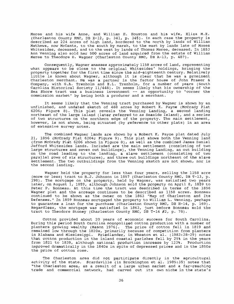
Meree and his wife Anne, and William H. Houston and his wife, Eliza M.E. (Charleston County RMC, DB X-12, p. 341, p. 345). In each case the property is described as 224 acres of high land, bordered to the north by lands of William Mathews, now McCants, to the south by marsh, to the east by lands late of Moses Whitesides, deceased, and to the west by lands of Thomas Meree, deceased. In 1853 Ann Venning also sold her 500 acres of land acquired from the estate of William Meree to Theodore D. Wagner (Charleston County RMC, DB A-13, p. 487).
Consequently, Wagner amasses approximately 1158 acres of land, representing what appears to be close to the original Whitesides' holdings, bringing the property together for the first time since the mid-eighteenth century. Relatively little is known about Wagner, although it is clear that he was a prominent Charleston merchant. He was a partner is the factor house of John Fraser & Company, with G.A. Trenholm and E.L. Trenholm, for a number of years (South Carolina Historical Society 11/448). It seems likely that his ownership of the Sea Shore tract was a business inve'stment -- an opportunity to "corner the commission market" by being both a producer and a merchant.
It seems likely that the Venning tract purchased by Wagner is shown by an unfinished, and undated sketch of 488 acres by Robert K. Payne (McCrady Plat 6206; Figure 8). This plat reveals the Venning Landing, a second landing northeast of the large island (later referred to as Seaside Island), and a series of two structures on the northern edge of the property. The main settlement, however, is not shown, being situated (by reference to other plats) in an area of extensive survey notes.
The combined Wagner lands are shown by a Robert K. Payne plat dated July 21, 1856 (McCrady Plat 6204; Figure 9). This plat shows both the Venning land (from McCrady Plat 6206 shown in Figure 8), as well as the combined James Daniel Jefford Whitesides lands. Included are the main settlement (consisting of two large structures and seven out buildings), the Venning Landing, an out building on the road leading to the landing, a slave settlement (consisting of two parallel rows of six structures), and three out buildings northeast of the slave settlement. The two outbuildings from the Venning sketch are not shown, nor is the second landing .
Wagner held the property for less than four years, selling the 1158 acre (more or less) tract to B.J. Johnson in 1857 (Charleston County RMC, DB T-13, p. 198). The mortgage on the property, held by Wagner, was satisfied two years later, on August 1, 1859, although Johnson sold the property on April 8, 1859 to Peter P. Bonneau. At this time the tract was described in terms of the 1856 Wagner plat and the acreage continues to be described as 1158 acres. Bonneau continued to be shown as the owner on the 1863 "Map of Charleston and Its Defenses." In 1859 Bonneau mortgaged the property to William L. Venning, perhaps to guarantee a loan for the purchase (Charleston County RMC, DB H-14, p. 169). Regardless, the mortgage was satisfied in 1863, just before Bonneau sold the tract to Theodore Stoney (Charleston County RMC, DB T-14 #2, p. 78).
Cotton provided about 20 years of economic success for South Carolina. During this period South Carolina monopolized cotton production with a number of planters growing wealthy (Mason 1976). The price of cotton fell in 1819 and remained low through the 1820s, primarily because of competition from planters in Alabama and Mississippi. Friedlander, in Wheaton et al. (1983:28-29) notes that cotton production in the inland coastal parishes fell by 25% in the years from 1821 to 1839, although national production increase by 123%. Production improved dramatically in the 1840s in spite of depressed prices and in the 1850s the price of cotton rose .
The Charleston area did not participate directly in the agricultural activity of the state. Scardaville (in Brockington et al. 1985:35) notes that "the Charleston area, as a result of a large urban market and a far-reaching trade and commercial network, had carved out its own niche in the state's
36
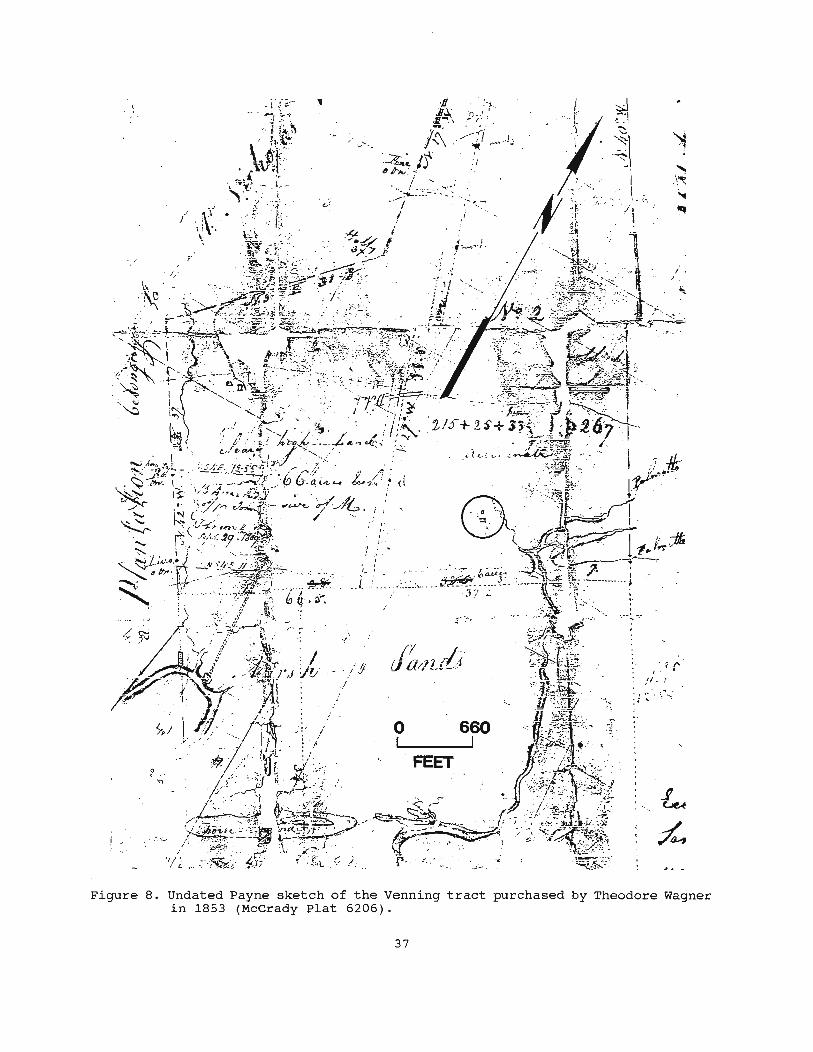
Figure 8. Undated Payne sketch of the Venning tract purchased by Theodore Wagner in 1853 (McCrady Plat 6206).
37

Figure 9. 1856 Payne plat of Theodore Wagner's combined lands (McCrady Plat 6204).
38

economic system." Zierden and Calhoun remark that:
[c]ountry merchants, planters, and strangers "on a visit of pleasure" flocked to Charleston. Planters continued to establish residences in Charleston throughout the antebellum era and "great" planters began to spend increasing amount of time in Charleston (Zierden and Calhoun 1984:44).
In spite of this appearance of grandeur, Charleston's dependence on cotton and ties to an international market created an economy vulnerable to fluctuation over which the merchants and planters had no control.
While the wealthiest farms were those on the sea islands producing cotton (such as Edisto Island where the value of the average plantation was over $44,000), plantations in Christ Church (as well as other inland, non-cotton producing areas) had an average value of around $7,000 (Scardaville in Brockington et ale 1985: 39). Christ Church Parish grew only 1.7% of the district's cotton, although it formed 10.1% of the improved acreage. An examination of the agricultural schedules for the Charleston area in 1850 and 1860 provides evidence for this economic slump. Scardaville (in Brockington et ale 1985:39-40) notes that . produce, farm, and livestock values for Christ Church Parish were below what would be expected and outputs of many crops had decreased over time. But most significantly, rice was no longer an economically significant crop, production dropping by over 81% from 1850 to 1860.
The Christ Church Parish response to the reduction in rice was a shift to ranching and livestock production as a substitute. Between 1850 and 1860 the value of livestock increased by 120%, corn increased by 44%, wool production increased by 126%, and the value of animals slaughtered increased from $0 to over $5,000 (Scardaville in Brockington et ale 1985:41). It seems clear that Christ Church was engaged in a gradual shift from monocropping to truck farming. Its unique location at the doorstep of Mount Pleasant and Charleston allowed Christ Church to focus its agricultural pursuits on the needs of an expanding urban market.
One significant result of these economic realignments was a decline in slave population, although slavery remained an essential institution. The Christ Church families owned an average of 17.1 slaves in 1860 compared to an average of 37.4 held by neighboring st. Thomas and st. Denis Parish families (Scardaville in Brockington et ale 1985:42).
An appropriate summary is provided by Zierden and Calhoun:
[t]he economic decline of Charleston occurred as the city was growing increasingly defensive of its "peculiar institution." The city sullenly withdrew into itself, eschewing the present and glorifying its past. The great fire of 1861 devastated much of downtown Charleston. The War between the States ... set the seal on a social and economic era (Zierden and Calhoun 1984:54).
While the fortifications and numerous battles fought around John's, James, and Folly islands during the Civil War are well known, the other defenses of Charleston are perhaps less understood. One author has suggested that, "it is doubtful if any city in the Confederacy had more or stronger defenses than those around Charleston" (Burton 1970:132). In Christ Church parish, about five miles north of Mount Pleasant, the Confederate forces built a line running from the headwaters of the Wando River to the Atlantic Ocean marshes. This line, shown in Figures 10 and 11 is situated about 0.5 mile northeast of the survey tract. It was terminated at the "sea shore" end with a major fortification.
It wasn't until 1865, "tested." A Union assault
at the very end of the war, that this line was on Bull' s Bay was begun on February 13, although
39
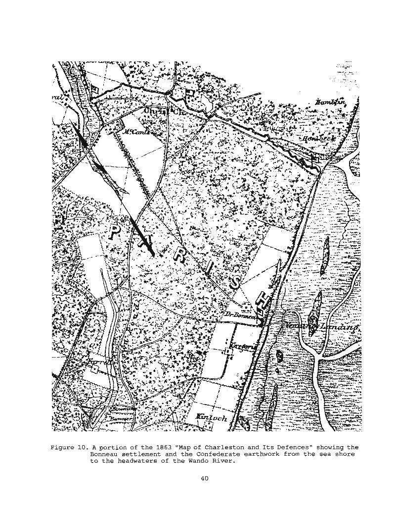
Figure 10. A portion of the 1863 "Map of Charleston and Its Defences" showing the Bonneau settlement and the Confederate earthwork from the sea shore to the headwaters of the Wando River.
40

*" f-'
~-~,b/ ~-
d ';;' , / "'-,t' "'-
.' .' "
/6 3. ~8 Oc,el
o 600 l I
FEET ... _ .. Iu. J •• "6./ ..(,
,., ~ ...L1 ",' ........
.!!!:...!.!..
~
~:£.~.~ I !;~U ~!.!~
(,ruP' H ,.",hA.I/
ptol pC 9 elJrh.,.,( lhc J-:4J'A.,£ z;."e,t ...ril ... ,1~ -tI M'"/U ".,/A _/ MI H~J-I #~ Ch';~,1 C'h.uvlt ~,.,~A, CA.,ks';',. C_,.,yJJ_MC",...h_, C."N/....:..7 I~" . .z. Jl'1t:~~ k/ .. ,y .. PIA /·.n',.J"/SI. 71AI~~"'" _"'-' 6,.. £ ,.,i/,-, /I. /t4'kl: c// 4,.<1/ 4i.",1 ". ~ C.,.., .. ~;fI/ "'-
f'tfn ~"I" 4.,~l; ..kl,AJU,., ~N . .MO'."" ~_,",.N".",,( Mo. ~.,~I' N. JcJ,..-" .JC'./c r· .$00' ?&)?, 4~ J~/r 9, 19S!
Jht. C"r:1 E""ifru 9"'11 &'tC'i b u"""
l ,=",. : 'I"', r.,,,~ :.,,'1 .. (I.~, . , .• i!1>.:th~ :nut " ... ,"U
//:J-t .. ' .: : .:,~~\\~. : [; .~~;~_~: ... l~~.r.~~ : .... . . ' ,. I.. _ ~ 'lOl ::' . • A'..a. '.
~~~~/~.~~:.~~~.~~.~~t .. . ); -" ,.e
, ~ . .&.J~-. "'l"")!!~~fjf~~J.:.IJ!
~.f-'!!J!mJ.i:J.
'-u:~~-:.!!
Figure 11. 1957 plat showing the lower portion of the Confederate earthworks (Charleston County RMC, PB L, p. 65).

weather, poor planning, and shallow water prevented a landing until February 17, when the troops were put ashore at Graham's Creek near Buck Hall Plantation, several miles northeast of the line. It was that same day that Confederate forces retreated from Charleston and the assault on Bull' s Bay accomplished little other preventing the Confederate troops from marching north to Georgetown (Burton 1970:316).
Postbellum Period
After the Civil War Charleston and the surrounding countryside lay in waste. Plantation houses were destroyed, the city was in near ruins, the agricultural base of slavery was destroyed, and the economic system was in-chaos. Rebuilding after the war involved two primary tasks: forging a new relationship between white land owners and black freedmen, and creating a new economic order through credit merchants. General sources discussing the changes in South Carolina include Williamson (1975) and Goldenwieser and Truesdell (1924). Scardaville (Brockington et al. 1985:43-48), however, provides information on the changing labor patterns specifically in the study area.
Theodore Stoney, owner of the Seashore tract, is one of those tragic figures of the late Civil War, early postbellum who is known primarily through a string of bankruptcies, forced sales, and related legal problems (see Charleston RMC, DB G-15, p. 189; DB K-16, p. 202; DB G-15, p. 733; DB C-16, p. 210; DB E-16, p. 317). Throughout most of this period he was a partner of the Stoney, Lowndes & Co., Brokers, with Henry D. Lowndes and T.S. Snowden. In April 1868 Stoney provided Arthur Hammond a large mortgage and by December of that year the u.S. District Court for South Carolina (with a parallel claim in Circuit Court) found him bankrupt. In April 1869 stoney managed to reclaim his Sea Shore tract from the Court, although his other plantations, including the 1602 acre Laurel Hill and the 133 acre Elm Grove plantations, both in Christ Church Parish, were sold in 1872. Stoney again mortgaged the Sea Shore tract in October 1873, only to again be found bankrupt in December 1873. In 1876 the Sea Shore tract was sold to B.H. Rutledge, Receiver of the Estate of Otis Mills (Charleston County RMC, DB X-16, p. 432).
It is likely that Stoney continued to operate the plantation using one of several common forms of tenancy (see Scardaville in Brockington et al. 1985:46). While tenancy was increasing throughout South Carolina during this period, it was increasing at a far greater rate in Christ Church. The number of farm units increased from 810 in 1860 to nearly 2,500 in 1870, an increase of over 207%, more than double the statewide rate. While only about 20% of the farms in South Carolina were under 10 acres, almost half of the farms in Charleston County were that size. In Christ Church Parish over 70% of the farms were under 10 acres in size. Scardaville suggests that, "a larger black population (86.3% in rural Charleston County and only 58.9% statewide) and henceforth more intensive demand for land area might explain the greater division of the land in Charleston" (Brockington et al. 1985:47-48). It has also been suggested that the Christ Church plantation owners were more amenable to renting land to blacks.
The disposition of the property by Rutledge is not clear, but in 1881 Stoney purchased Seaside Plantation from Rosa Bryan, then owner (Charleston County RMC, DB K-18, p. 108). The property is described as bounded to the north by lands of William McCants, to the east by lands of Mr. Corbett, to the west by lands of Mr. Venning, and to the south by the "sound." The property is still described as containing 1158 acres and reference is made to a plat by Robert K. Payne.
Beginning shortly after this purchase, Stoney began to sell small tracts to local blacks, perhaps supporting the idea that Christ Church planters were more willing to integrate the freedmen into the postbellum economy. In 1882 he sold 831. acres to Samual Frazer (Charleston County RMC, DB A-31, p. 90). Additional parcels ranging from 1 to 15 acres were sold through 1896 (Charleston
42

county RMC, DB A-31, p. 143, 160, 229; A-36, p. 70). stoney, however, divested the bulk of the property in two separate sales to H.F.W. Breuer. The first sale, in 1885, was for 372.25 acres of high land and 407 acres of marsh (Charleston County RMC, DB A-31, p. 147). The second, for a total of 236% acres, was in 1886 (Charleston county RMC, DB A-31, p. 259). This second sale was shown on a plat recorded in Berkeley County (Berkeley County RMC, PB A, p. 18). This second transfer was of interior lands, bordered to the south on lands of Breuer.
In spite of his problems, Stoney was apparently an active member in the Christ Church Agricultural Society, organized in 1882. The Society ' s membership, like that of other organizations of the period, consisting of the remnants of the Southern planting aristocracy. The organizations, founded- to encourage and promote the return of the "agrarian south," were concerned with a vast range of issues, including planting practices, the prices offered for various crops, the transportation of crops at reasonable prices on the new railroads, and resolving what were considered constant labor problems.
For example, as late as 1909 the members of the Christ Church Agricultural Society agreed to a list of labor rules, including:
• no laborer shall be taken who is in debt, without payment of such debt.
• no laborer who has been discharged for insubordination shall be taken during the current year or within six months.
• that all tenants shall agree to give there [sic] spare time to their land-lords when called on (South Carolina Historical Society, Christ Church Agricultural Society Minute Book, 34-197)
The society's constant interest in agricultural prices and conditions is shown by a 1902 report:
unusually fine corn crops planted in the parish, and also find the acreage a large one, which gives promise of a large yield. Peas and potatoes have not been neglected and, on the whole, the crops generally are up to the standard. The committee found the asparagus crops in good condition and some of the crops of young asparagus above the average. No complaints were made of rust . . .. Labor is abundant, but getting more and more inefficient each year . Until we cease employing labor that has been discharged for cause, inefficiency, etc . . so long will we make the labor more and more worthless. We pay from 40 to 50 cents per day for our labor and I doubt if, under the best management, we receive 20 to 25 cents value for it . . . . The prices obtained for truck, during the past year have not been remunerative, more stuff being shipped and less money realized; in some instances the falling off amounting to 30 percent (South Carolina Historical Society, Christ Church Agricultural Society Minute Book, 34-197).
As Scardaville notes (Brockington et al. 1985 : 52), it is very difficult to use the agricultural schedules for economic analyses after 1870. The 1880 schedule seriously underrepresents Charleston District, the 1890 schedules were destroyed by fire, all subsequent schedules are provided only on a county level (the individual parish and farm level information being destroyed under authority of Congress), and vital information is missing from the 1900 census. At a countywide level, however, it is clear that between 1870 and 1910 Charleston's agricultural production gradually increased, the labor system stabilized, and prosperity returned.
In terms of relative importance, cotton and livestock were the two most important agricultural activities in Charleston County, followed by truck farming
43
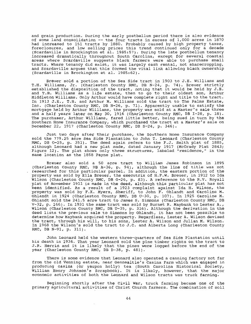
and grain production. During the early postbellum period there is also evidence of some land consolidation -- the four tracts in excess of 1,000 acres in 1870 had increased to 151 tracts by 1880. Probably caused by high property taxes, foreclosures, and low selling prices this trend continued only for a decade (Scardaville in Brockington et al. 1985:57). During the late postbellum tenancy increased dramatically throughout South Carolina, except for several coastal areas where Scardaville suggests black farmers were able to purchase small tracts. Where tenancy did exist, it was largely cash rental, not sharecropping, and Scardaville argues that this formed the vital link allowing black ownership (Scardaville in Brockington et al. 1985:62).
Breuer sold a portion of the Sea Side tract in 1903 to J.E. Williams and T.H. Williams, Jr. (Charleston County RMC, DB N-24, p. 74). Breuer strictly established the disposition of the tract, noting that it would be held by J.E. and T.H. Williams as a life estate, then to go to their oldest son, Arthur Middleton Williams. Only Arthur would have complete right and title to the tract. In 1913 J.E., T.H. and Arthur M. Williams sold the tract to The Palms Estate, Inc. (Charleston County RMC, DB N-26, p. 71). Apparently unable to satisfy the mortgage held by Arthur Wi·lliams, the property was sold at a Master's sale three and a half years later on May 30, 1916 (Charleston County RMC, DB I-28, p. 18). The purchaser, Arthur Williams, fared little better, being sued in turn by the Southern Home Insurance Company, which purchased the tract at a Master's sale on December 22, 1917 (Charleston County RMC, DB S-24, p. 346).
Just two days after their purchase, the Southern Home Insurance Company sold the 779.25 acre Sea Side Plantation to John T. Leonard (Charleston County RMC, DB 0-25, p. 351). The deed again refers to the F.J. Smith plat of 1885, although Leonard , had a new plat made, dated January 1917 (McCrady Plat 2843; Figure 12). The plat shows only three structures, labeled "residence," in the same location as the 1858 Payne plat.
Breuer also sold a 50 acre tract to William James Robinson in 1895 (Charleston County RMC, DB A-36, p. 94), although the line of title was not researched for this particular parcel. In addition, the eastern portion of the property was sold by Ella Breuer, the executrix of H.F.W. Breuer, in 1912 to Ida Wilson (Charleston County RMC, DB G-26, p. 83). A reference to the R.V. Royall plat of November 1911 is made in the deed, although this particular plat has not been identified. As a result of a 1923 complaint against Ida H. Wilson, the property was sold by F.K. Myers, Sheriff, to John F. Ohlandt and Caroline M. Ohlandt in 1924 (Charleston County RMC, DB U-30, p. 107). In 1925 Caroline M. Ohlandt sold the 241.5 acre tract to James S. Simmons (Charleston County RMC, DB V-32, p. 166). In 1931 the same tract was sold by Burnet R. Maybank to Lester A., Wilson (Charleston County RMC, DB U-35, p. 316). Although the derivation in the deed lists the previous sale to Simmons by Ohlandt, it has not been possible to determine how Maybank acquired the property. Regardless, Lester A. Wilson devised the tract, through his will, to his sons, Lester A. Wilson and Julian M. Wilson. In 1968 the Wilson's sold the tract to J.C. and Alberta Long (Charleston County RMC, DB N-91, p. 311).
John Leonard held the western three-quarters of Sea Side Plantation until his death in 1936. That year Leonard sold the pine timber rights on the tract to J.R. Herrin and it is likely that the pines were logged before the end of the year (Charleston County RMC, DB D-38, p. 481).
There is some evidence that Leonard also operated a canning factory not far from the old Venning estate, near Gennealtle's Cas ina Farm which was engaged in producing casina (or yaupon holly) tea (South Carolina Historical Society, William Henry Johnson's Scrapbook). It is likely, however, that the major economic activities of both the Leonard and Wilson tracts was truck farming.
Beginning shortly after the Civil War, truck farming became one of the primary agricultural activities of Christ Church farmers. The combination of soil
44
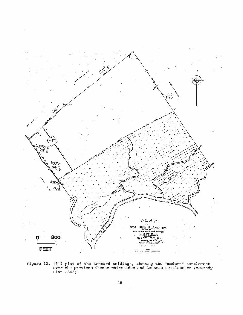
"
"
"r. "
,r 0:-, ,...
" " .- .,
, ",. SEA SIDE PLANTATION
31ITUATCO .". .
""UST ~ "NUS". "'AS COUN'TY.s.c..
o 800 WA...IC!~[ONAItO
.~: "'~u "~:~~
... I __ ---'f. _c .. c • ......... r-- .. ,. WCClt~~-
FEET
Figure 12. 1917 plat of the Leonard holdings, showing the over the previous Thomas Whitesides and Bonneau Plat 2843).
45
"modern" settlement settlements (McCrady
fertility, climate, and proximity gave truck farming an edge in the effort to supply Charleston with produce. As a result many blacks were employed as wage laborers. Produce increased from about one-quarter of the county's agricultural production in 1890 to over three-quarters by 1930 (Scardaville in Brockington et al. 1985:74). Much of this prosperity, however, disappeared during the Great Depression, when trucking in Charleston County declined by 75%.
Upon Leonard's death the property was sold by the Master in response to court action by South Carolina National Bank, who purchased the plantation for $15,000 (Charleston county RMC, DB W-33, p. 291). About a year later, in late 1937, the property was sold to Socarnat Bank Corporation of Delaware for $13,587 (Charleston County RMC, DB S-39, p. 579). It is likely that the property, during the height of the Great Depression, was seen only as dead weight and even taking a loss was better than cont~nuing to pay the taxes. It was during this period that a number of South Carolina plantations were purchased by out-of-state investors. A January 1939 plat (Charleston County RMC, PB E, p. 59) shows the Sea Side tract, including the "settlement" in essentially the same location as that shown on the 1804 Diamond plat, the 1858 Payne plat, and the 1917 plat for John T. Leonard. No other structures or features are shown, and even the causeway to the landing is missing from the plat. The entire Sea Side Plantation, at this time, is shown in fields.
Socarnat Bank Corporation held Sea Side for just over a year before selling it on December 31, 1938 to Mary C. Sottile of Charleston (Charleston county RMC, DB E-40, p. 546). In 1945 Sottile exchanged Sea Side for three lots in the Wagner Terrace Subdivision in Charleston, owned by developer J .C. Long (Charleston County RMC, DB C-46, p. 187). Throughout his long career long, involving the buying and selling of much Charleston property, Long held the Sea Side tract, as well as the Wilson tract to the east. In 1952 he devised a portion of the property including 76.5 acres of high ground and 62 acres of marsh to his wife, Alberta S. Long (Charleston County RMC, DB N-55, p. 611). Because of questions regarding the original deed, the property boundaries were clarified in a 1955 deed (Charleston County RMC, DB B-60, p. 177). The tract included basically the western end of Sea Side, including the residence and Sea Side Island. The plat (Charleston County RMC, PB H, p. 14) showing this tract unfortunately provides few details. It fails to show the main settlement, any roads, or the vegetation on the tract. In fact, the only useful feature is the revelation that there is bank paralleling the marsh, keying in to the presence of a bank on the 1858 Payne plat for Wagner.
In 1962 J.C. Long began the process of developing Sea Side Plantation. A plat drawn May 1962 shows the eastern two-thirds of the tract divided into a series of eight 25 acre strips, allowing a buffer between the proposed development lands and the property given to his wife 11 years earlier (Charleston County RMC, PB P, p. 22). A few months later, in August 1962 Long began the process of divesting himself of the Sea Side tract, selling three lots (numbers 1, 2, and 3) to The Beach Company for $97,500. The Wilson tract, of about 74 acres, was also sold to The Beach Company in 1973 (Charleston county RMC, DB J-103, p. 74). Alberta C. Long sold 219.15 acres to Dieci, Inc. in 1987 (Charleston County RMC, DB N-171, p. 62). Today the survey tract consists of essentially four parcels owned by The Beach Company (139 acres); Dieci, Inc. (486 acres); Longs Seaside Farms (69 acres); and Pastime Amusement Company (45 acres).
Historical Synthesis
The earliest settlement on the tract has not been clearly established, although Moses and John Whitesides had operating plantations at least as early as 1798 when they were drawn by Joseph Purcell (Figure 5). It is also possible that the two main settlements were began shortly before or after the death of Thomas Whitesides in 1762. While no plat has been found which shows the original Thomas Whitesides settlement, the 1804 John Diamond plat (Figure 6) suggests that the plantation settlement was situated at the western edge of the study tract.
46
Historical documents suggest that this plantation may have originated by the early 1750s. Since the Diamond plat fails to identify a slave settlement associated with the main house, it is possible that Thomas Whitesides' slaves lived at either the locat i on of John or Moses ' slave settlement.
While the Thomas Whitesides settlement was shown on the 1804 plat and the 1863 map, indicating a very long occupation span, the John and Moses Whitesides main settlements apparently were not occupied past the early nineteenth century, suggesting that they had a very short occupation span. It is possible that the original settlement was the preferred location because of its proximity to the Inlet Creek landing. In addition, even today the soils in this area tend to be better drained.
The identified plats also reveal the presence of occasional, isolated structures which probably represent utility buildings associated with farming activities. All of the probable structure locations, based on the available historical maps and plats are shown in Figure 13 .
47

~
\.
" \\ \'0
:'-\ .. ~~ \ .
"
! .
. ~·r
\' ..; , '.,',
.. ..... ,
Figure 13. Probable locations of suspected historic sites in the immediate vicinity of the Seaside tract.
48
SITES IDENTIFIED ON THE SEASIDE TRACT
Introduction
As a result of the archaeological survey of the Seaside tract, 15 new sites were identified (Table 1). In addition, sites 38CH177, 38CH3S7, and 38CH3S8 were revisited. Of the 18 sites evaluated, three historic sites (38CH1471, 38CH1473, and 38CH1477) and three prehistoric sites (38CH1466, 38CH1474, and 38CH147S) are recommended as eligible or potentially eligible for inclusion on the National Register (Figure 14).
For the purpose of this study, the operative definition of a "site" was any area with three or more artifacts within a 25 foot diameter and/or the presence of shell midden deposits. Isolated finds, such as a single sherd, were identified as a site only if they co-occurred with shell midden either on the surface or in shovel tests.
This section provides detailed information on each of the archaeological sites identified within the survey area.
Identified Sites
38CH177 was originally identified in 1974 as a disturbed Middle Woodland shell midden located at the end of a causeway to a marsh island (Trinkley and Carter 1974). It was described as located on a small hummock. The site form stated that it appeared to represent "a Middle Woodland shell midden disturbed by erosion, tree removal and the construction of a causeway". No assessment of eligibility was provided. In 1977 the site was revisited by Steve Cabaniss who noted that shell midden was exposed in tree falls, that the midden consisted of oyster and clam, and that a number of probable Middle Woodland sherds had been found.
This site was revisited by Chicora Foundation and a series of four shovel tests were excavated in the site area. Two of the four tests only yielded small amounts of shell. No artifacts were encountered in the subsurface testing, nor were artifacts found on the surface. Based solely on shell scatter (there being no detectable subsurface remains), the site is approximately SO by SO feet in size. The central UTM coordinates are E610780 N3629920 and the soils are Crevasse-Dawhoo complex. Soil profiles indicated 0.5 feet of grayish brown (10YRS/2) sand overlying brownish yellow (10YR6/6) subsoil.
Site 38CH177 is recommended as not eligible for inclusion on the National Register of Historic Places. The site has been extensively disturbed by causeway construction and other earthmoving activities. The inability to identify and recover artifacts during the current work suggests that the site either has been intensively collected over the years or that little of the midden is left. Based on the shovel test data it seems likely that the bulk of this site has been eroded.
38CH357 was originally identified in 1978 as the remains of a historic plantation complex (Trinkley 1978). The site was described as being of unknown size situated approximately 500 feet north of the marsh area. The nearby tenants noted that a previous owner, Mr. Lester A. Wilson, had plowed up large quantities of historic material about 50 years ago. The ceramics noted were westerwald, lead glazed slipware, edged pearlware, ginger bottle, plain pearlware, and creamware (Trinkley 1978). The site location corresponds with an 1798 historic plat showing Moses Whitesides main house complex. The plat shows roads, fence lines, and three structures (Figure 5).
49

U1 o
./ ...... , ....
Figure 14. Location of sites on the survey tract.
.'
..Jl.-
A
~
-"'-
yf f1-"'~
TOI'OtItUHIC "A~
SEASIDE FARMS
.. (~ ,!·.~;l~;:~·.,
Table l. Sites Identified on the Seaside Farms Tract
Site No. Site T:il2e SoiL T:il2e and Drainage Elevation (ft) Size (ft.) EL igibi L it:i 38CH177 MiddLe WoodLand Crevasse-Dawhoo, mixed 5 50 x 50 NE 38CH357 PLantation Main House Scranton, poorLy 7 200 x 2oo? NE 38CH358 No site found 38CH1463 CiviL War? TidaL marsh, poorLy 5 50 x 5000 NE 38CH1464 Unknown Prehistoric Scranton, poorLy 5 50 x 200 NE 38CH1465 Historic Scranton, poorLy 5 25 x 50 NE 38CH1466 MiddLe WoodLand Rut Lege, poorLy 5 250 x 600 E 38CH1467 MiddLe WoodLand Scranton, poorLy 10 75 x 75 NE 38CH1468 Unknown Historic Scranton, poorLy 10 50 x 150 NE 38CH1469 19th Century Scranton, poorLy 10 25 x 25 NE 38CH1470 MiddLe WoodLand ChipLey, mod . weLL/somewhat poorLy 7 25 x 25 NE 38CH1471 PLantation Main House Scranton, poorLy 12 250 x 250 E 38CH1472 19th/20th Century Scranton, poorLy 10 25 x 25 NE 38CH1473 PLantation SLave Row Rut Lege, poorLy 13 250 x 300 E 38CH1474 UID WoodLand Crevasse-Dawhoo, mixed 5 75 x 300 E 38CH1475 Unknown Prehistoric Crevasse-Dawhoo, mixed 5 50 x 200 PE 38CH1476 Dairy Barn Stono, very poorLy 10 100 x 100 NE 38CH1477 PLantation SLave Row Rut Lege, poorLy 5 200 x 200 E
ELigibiLity E = EligibLe, PE = PotentiaLLy ELigibLe, NE = Not ELigibLe
The current survey explored the site with 40 shovel tests at 25 and 50 feet intervals. Of these tests only one yielded cultural remains. Although very few subsurface remains were recovered, a quantity of artifacts were collected in an area of good surface visibility, within 50 feet of a chain link fence bordering the Isle of Palms connector. Unfortunately, part of this area is covered with approximately one foot of spoil from an adjacent ditch associated with the connector. It appears that a portion of the site has been disturbed by the ditch since the spoil contained a sparse amount of surface artifacts.
3
X79 o 0 Q
X 7. 8
PLANTEC 200 o 200 "' 00 - -- -SCALE 1": 200'
CONTOUR INTERVAL ONE FOOT
/ /
x 0
o X 4 .1
o
600 i
Figure 15. Map showing shovel tests and test unit at 38CH357.
51
5 .0

Based on the single positive shovel test coupled with the surface remains the site is believed to be approximately 200 by 200 feet in size. This is only an estimate since the sparsity of the remains prevented clear determination of boundaries. This size is clearly less than that shown by the plat, suggesting that a significant portion of the site is covered by the Isle of Palms Connector. This corresponds to the assessment provided by Trinkley (1980d) during the last Highway Department survey of the proposed Isle of Palms connector.
To better understand site destruction processes. and to gain a larger collection of artifacts a four by four foot unit aligned with magnetic north was excavated at the site. This unit was located approximately 235 feet from an east/west construction road and 100 feet from the chain link fence bordering the Isle of Palms connector. This unit was excavated to a depth of 0.65 feet below ground surface. The top 0.6 feet consisted of very dark gray (10YR3/1) soil overlying dark gray (10YR4/1) soil. No features were noted in the floor of the unit, and only one artifa~t (a Colono ware sherd) dating to .the plantation era was recovered. The remaining artifacts include seven fragments of clear modern glass. Both the profile and the sparse artifact content indicate extensive disturbance of the site in this area.
Surface artifacts consist of five undecorated creamwares, three undecorated pearlwares, one undecorated whiteware, two unidentifiable blue edged white bodied earthenwares, one brown alkaline glazed stoneware, two Colono wares, one aqua bottle glass, and two kaolin pipe bowl fragments. The positive shovel test contained one polychrome handpainted pearlware. Since only 19 artifacts were collected from the site no pattern analysis was performed. Table 2, however, presents the mean ceramic date for the site.
Table 2. Mean Ceramic Date for 38CH357
Ceramic Creamware, undecorated Pearlware, poly hand paint
undecorated Whiteware, undecorated Total
MCD
Mean Date (xi) 1791 1805 1805 1860
18035+10 1803.5
(fi) 5 1 3 1
10
(fi x xi) 8955 1805 5415 1860
18035
The relatively early mean ceramic date corresponds with the historical data which suggests that the plantation main house complex was built between 1762, when Thomas Whitesides willed the property to his son Moses, and 1798, when Joseph Purcell made a plat showing the division of lands between Moses and his brother John. An 1856 plat (Figure 9) continues to illustrate this settlement, suggesting the settlement continued up to the Civil War. Therefore the mean historic date for the settlement would be in the first quarter of the nineteenth century.
The central UTM coordinates for this site are E611520 N3631540 and the soils are Scranton loamy fine sand.
Based on the low quantity of artifacts, the heavy disturbance the site has received through plowing and road construction, and the likelihood that the area identified represents a peripheral area, this site is recommended as not eligible for inclusion on the National Register. It appears that over the years, the site has been extensively collected by the previous owner leaving little evidence that the site ever existed. What was left has apparently been destroyed by the Isle of Palms Connector.
52

38CH358 was originally identified in 1978 (Trinkley 1978) as a shell midden on a marsh hummock. Although not actually visited in 1978 due to high tide conditions, tenants of the nearby property indicated that they had collected several sherds from the island and these ·were observed during that survey.
This hummock, which measures about 30 feet in diameter, was visited during the current study. Three shovel tests were excavated with none yielding artifacts or shell. While this hummock appears to be the one represented on the topographic map as 38CH358, the site has apparently eroded away since initial recordation 14 years earlier. As a result, there is no prehistoric site at 38CH358 and no additional work is recommended at this site.
38CH1463 is located on a series of marsh hummocks from the area of the causeway leading to site 38CH177 to the Isle of Palms Connector. These hummocks include the one containing 38CH358 which was described as a prehistoric shell midden. While examining the marsh area of the tract, these hummocks were found to contain scatters of unmortared brick fragments. Seven shovel tests were excavated on several of these hummocks with none containing artifactual remains (although one unidentified iron item was recovered from the north end of the southern-most hummock).
Based on the shovel tests (which failed to identify any subsurface features) and site configuration (consisting of sparse brick remains on multiple high marsh islands) the site function is unclear. It is possible that the brick scatters are associated with Civil War picketing activities in the area although no diagnostic items were recovered. Figure 10 shows the locations of Confederate earthworks from the sea shore to the headwaters of the Wando River; it is likely that sentry or picket posts were established along the "sea shore" to detect any Union advance on Charleston.
The UTM coordinates are E610620-611720 N3630600-3631320 and the soils are soft tidal marsh. Profiles indicate 0.6 feet of very dark gray (10YR3j1) soil overlying dark gray (10YR4j1) soil.
Site 38CH1463 is recommended as not eligible for inclusion on the National Register. Although the site's purpose is unclear, it is unlikely that excavation can yield information about its function . It should be noted that this "site" is located within the South Carolina Coastal Council's Critical Zone and is therefore unlikely to be impact by any development activities.
38CH1464 is located along the marsh edge just west of a large pond. The site is found within a historic earthen berm and contains the remains of a prehistoric shell midden. A series of five shovel test were excavated at 50 foot intervals along the berm . Three of these tests yielded moderate to dense shell. None contained artifacts. Surface visibility was good in some areas and a collection of two highly eroded prehistoric sherds was made .
The central UTM coordinates are E610840 N3630820 and the soils are Scranton loamy fine sand. Shovel tests were excavated to a depth of 1 foot which revealed disturbed berm soils intermixed with shell. The soil was grayish brown (10YR5j3) in color. The site measures 200 by 50 feet in size.
Site 38CH1464 is recommended as not eligible for inclusion on the National Register. The site has been moved from elsewhere -- possibly the bank of the drainage which was made into a pond, in which case the original site area may now be flooded. Alternatively, the site may have been completely destroyed by the creation of the berm during the eighteenth century. Regardless, this site exhibits no integrity and no further work is recommended .
38CH1465 is found in the same setting as 38CH1464, but is located further east in the area where the pond drains into the marsh. One shovel test was excavated in the berm yielding no subsurface remains . Surface visibility was good
53

and a small, light scatter of brick rubble and shell was noted in a 25 by 50 foot area. Surface collected from the site was one unidentifiable white bodied earthenware, one Thorn's Creek Plain sherd, and one Thorn's Creek Dentate sherd.
The central UTM coordinates are E610940 N3630900 and the soils are Scranton loamy fine sand. The soil profile revealed disturbed berm soils intermixed with shell. The soils were grayish brown (10YR5/3) in color.
Site 38CH1465 is recommended as not eligible for inclusion on the National Register. Like 38CH1464, the site appears to have been moved from elsewhere, probably during the dike construction . No further investigation is warranted at this site .
38CH1466 is located approximately 200 feet east of 38CH1465, behind the earthen berm. The site represents an intact Woodland shell midden site with faunal preservation. A series of 36 shovel tests at 100, 50, and 25 foot intervals were used to explore the site area. Of those tests, 12 (or 33.3%) yielded midden, sherds, and/or bone (Figure 16).
In addition to these shovel tests, two four by four foot test units were excavated to better examine site integrity, temporal affiliation, and artifact quantity and variety. Both units were aligned with magnetic north.
Test Unit 1 was placed just north of a dirt road in an area of dense shell. The midden was found to be 0.6 feet deep and 159 pounds of shell (primarily oyster) was excavated. Profiles revealed that to a depth of 0.6 to 0.65 feet below surface, the soils consisted of shell midden and black (10YR2.5/1) loamy sand overlying brown (10YR4/3) subsoil. Artifacts consisted almost exclusively of prehistoric sherds with a small amount of animal bone.
t{~j: .MIDDEN e· POSITIVE ' o NEGATIVE
200 i
,
o 200 400
SCALE I" = 200' CONTOUR INTERVAL ONE FOOT
Figure 16. Map showing shovel tests and test units at 38CH1466.
54
600 I
o
Test Unit 2 was placed five feet west of Transect 9 Shovel Test 5 which is located adjacent to the berm. Only five pounds of shell was recovered in this vicinity. Profiles indicated that to a depth of 0.7 feet soils are black (10YR2.5/1) in color. Subsoil was very dark grayish brown (IOYR3/2). Artifacts consist of a large number of prehistoric sherds with a few historic remains. The historic remains are probably associated with 38CH1477.
Artifact type Deptford
PLain Cordmarked Check Stamped SimpLe Stamped Fabric Impressed Unidentified
Hanover PLain Cordmarked Check Stamped Fabric Impressed
Santee/McCLeLLanviLLe SimpLe Stamped
Wando Check Stamped
Unidentified sherds Small sherds Orthoquartzite chunks Daub AnimaL bone Lt. OLive bottLe gLass TOTAL
Table 3. Artifacts recovered from 38CH1466
ExpLoratory Surface ShoveL Test T9ST3 T9ST4 T9ST6 T9ST7 T9ST8 T10ST3 T10ST10 TU1 TU2
2 6 4
2
5 1 6 6
3 9
4 12
2 12
5
20
2
4
4 2
21 3 1 2 8 3 2 2
81
11
2 1 1
12
7
1
10 116 56
The artifacts include 252 prehistoric sherds, one orthoquartzite chunk, one piece of daub, nine animal bone fragments, and ten light olive green bottle fragments. As Table 3 indicates, Test Unit 1 (located along the dirt road) contained exclusively Deptford pottery whereas Test Unit 2 (located next to the marsh) contained both Deptford and Hanover as well as Santee/McClellanville pottery.
The 252 prehistoric sherds consist of 87 (34.5%) which are large enough for further analysis. These include 60 Deptford (69.0%), 16 Hanover (18.4%), seven santee/McClellanville (8.0%), two Wando (2.3%), and two unidentifiable (2.3%) sherds.
Deptford pottery is best recognized by the presence of fine to course sandy paste. Surface treatments include cord marking, simple stamping, check stamping, and fabric impressions. Also found are complicated stamping and geometric stamping (Trinkley 1990a). At 38CH1466, Deptford pottery includes 24 (40%) Deptford Plain, eight (13.3%) Deptford Cord Marked, 12 (20%) Deptford Check Stamped, three (5%) Deptford Simple Stamped, two (3.3%) Deptford Fabric Impressed, and 11 (18.3%) eroded Deptford sherds. While the majority of the pottery characteristics were distinctly Deptford, several sherds included fragments of unleached limestone. These occurrences are believed to be either accidental or experimental.
Hanover pottery is a sherd tempered pottery found from south of the Chowan River in North Carolina to north of the Edisto River in South Carolina. Surface treatments of Hanover pottery include cord marking, check stamping, simple stamping, and fabric impressions. Hanover pottery at 38CH1366 include two (12.5%)
55
Hanover Plain, one (6.25%) Hanover Cord Marked, one (6.25%) Hanover Check Stamped, and 12 (75%) Hanover Fabric Impressed.
The Santee (Anderson et al. 1982:302-308) and MCClellanville (Trink1ey 1981a) pottery series are characterized by a fine to medium sandy paste ceramic with surface treatment of primarily v-shaped simple stamping. While the two pottery types are very similar, the Santee series may have later features, such as excurvate rims and interior rim stamping, not found in the MCClellanville series (see Trinkley 1990a). All Santee/McClellanville sherds from 38CH1466 are simple stamped.
A limestone tempered pottery has been found by several archaeologists working in the Mount Pleasant area . Although data recovery has been performed on at least one site (38CH908, Molasses Creek) no final report and no formal type description has been published. We have chosen to tentatively call this pottery Wando since discussions with several colleagues indicate that the type presently appears to be confined to the Wando River basin. A formal description is presented in the discussion of 38CH1474. Two Wando Check Stamped sherds were identified in the collection at 38CH1466.
Other prehistoric artifacts include one chunk of orthoquartzite, one small fragment of daub, and nine fragments of animal bone. Several pieces were large and appear to be deer. Other fragments were relatively small, but some of these are also probably deer. It is of special interest that this site is producing quantities of faunal material.
Ten light olive green bottle fragments were also recovered from the site. Since the site is in close proximity with 38CH1477 (the Moses Whitesides plantation slave row.), these artifacts are believed to be associated with its occupation .
The central UTM coordinates are E611040 N3630980 and the soils are Rutlege loamy fine sand. Based on the shovel tests the site is approximately 250 by 600 feet in size.
Site 38CH1466 is recommended as eligible for inclusion on the National Register. The site represents an intact Middle Woodland shell midden which exhibits faunal preservation, even in !.o-inch screening. Water screening the resultant shell debris (which had already been processed through !.o-inch mesh) revealed the presence of ethnobotanical material. Consequently, it is likely that the site has the potential to further our understanding of prehistoric diet and inter and intra site spatial patterning.
38CH1467 is located along a northwest/southeast running dirt road in the south central portion of the tract. A series of 10 shovel tests were excavated in cardinal directions from the posited center of the site at 25 foot intervals. Of these 10 tests four (40%) were positive. These positive tests consisted primarily of sparse to moderate shell and prehistoric sherds, although one historic artifact was recovered. A total of 11 artifacts were recovered from the site. They include one Santee/McClellanville Cordmarked sherd, three Santee/McClellanville Simple Stamped sherds, two Santee/McClellanville eroded sherds, four small prehistoric sherds, and one wrought nail fragment. The western two-thirds of the site has been badly damaged by ditch construction, but allowed good surface visibility. Several sherds were collected from the surface of this area. Table 4 shows the distribution of artifacts.
The central UTM coordinates are E610780 N3630980 and the soils are Scranton loamy fine sand. The site measures approximately 75 by 75 feet in size. Soil profiles indicate 0 . 8 feet of black (10YR2.5/1) soil overlying dark grayish brown (10YR4/2) subsoil. .
56

Table 4. Distribution of artifacts at 38CH1467
Artifact Surface ST1 ST2 ST3 ST4 Santee/McClellanville
Cordmarked 1 Simple Stamped 3 unidentifiable 2 Small 2 2
Wrought nail fragment 1
Site 38CH1467 is recommended as not eligible for inclusion on the National Register. What appears to be a significant portion of the site has been badly disturbed by ditch construction. Artifacts are sparse in the portion of the site that appears to be still intact. Neither the shovel tests nor the examination of the cut bank of the ditch produced any evidence of features (intact shell midden, shell pits, post holes, or other staining).
38CH1468 is located approximately 200 feet southwest of 38CH1467 on the south side of the drainage ditch and on a northwest/southeast running dirt road. Eight tests were excavated in cardinal directions from the site's posited center point at 25 foot intervals. Of these tests, four (50%) yielded moderate shell or historic artifacts. Surface visibility was good in the dirt road area of the site, but no surface artifacts were encountered. Of the four positive tests only one yielded artifactual remains. This test, located 25 feet east of the central test, yielded one burned white bodied earthenware.
The central UTM coordinates are E610700 N3630980 and the soils are Scranton loamy fine sand. The site measures approximately 50 by 75 feet in size based on shovel testing and surface examination. Soil profiles indicate 0.7 feet of black (10YR2.5/1) soil overlying dark grayish brown (IOYR4/2) subsoil.
38CH1468 is recommended as not eligible for inclusion on the National Register. Despite close interval testing, only one artifact was encountered. Portions of the site have been disturbed by a dirt road as well as logging activities.
38CH1469 is located approximately 400 feet west of the southern tip of the large pond on a north/south running dirt road. The site was originally identified as a surface scatter of late historic remains in a dirt road. Eight shovel tests were excavated in cardinal directions from the site's posited center at 25 foot intervals. None yielded artifactual remains. Surface artifacts consist of three uridecorated whitewares, one white porcelain, two aqua bottle glass fragments, and one light olive green bottle glass fragment. The beginning date of manufacture of whitewares is around 1820 (South 1977:212) and is still being produced. The white porcelain appears to be late and Bartovics (1981) give its date range as 1851 to 1915. As a result, this site may date as early as the last half of the nineteenth century. It appears that this is the area on an undated plat which shows two structures (Figure 8).
The central UTM coordinates are E610640 N3631040 and the soils are Scranton loamy fine sand. The site measures approximately 25 by 25 feet in size. Soil profiles indicate 0.7 feet of black (10YR2.5/1) soil overlying dark grayish brown (10YR4/2) subsoil.
Although this site is thought to be correlated ~ith several structures identified in historical research, it is recommended as not eligible for inclusion on the National Register. No subsurface remains were encountered and the area is badly disturbed by logging activities . However significant the investigation and understanding of these structures might be, this site is no
57

longer capable of answering the necessary research questions. No further work is recommended.
38CH1470 is located on the south shore of the northern tip of the large pond between two dirt roads. The site was initially discovered in a regular transect shovel test as a dense shell midden containing prehistoric sherds. Eight additional tests were excavated in the site area at 25 foot intervals with none yielding more than light shell. The one positive test yielded one Deptford Plain sherd and two small unidentifiable sherds. Surface visibility was moderately good and three small unidentifiable sherds were collected.
The central UTM coordinates are E610000 N3631240 and the soils are Chipley loamy fine sand. The site measures approximately 25 by 25 feet in size. Soil profiles indicate 0.5 feet of very dark gray (10YR3j2) soil overlying yellowish brown (10YR5j4) subsoil. Midden occurred between 0.2 and 0.5 feet in the positive test.
Site 38CH1470 is recommended as not eligible for inclusion on the National Register. Although the midden is intact, it is very small and will probably not yield significant information on prehistoric settlement or diet.
38CH1471 is located 800 feet south of Rifle Range Road and 700 feet west of the Isle of Palms connector in a densely wooded area. Twenty shovel tests were excavated in the site area at 25 foot intervals with four (14.8%) yielding eighteenth century historic remains. Since the site was very densely vegetated no surface collection was possible. However, one creamware sherd was collected from a tree fall. The location of this site corresponds with the 1798 plat showing a main house settlement associated with John Whitesides (Figure 5). This plat shows roads, fences, and six structures including a barn and what is probably a main house.
\
o 200 400
SCALE 1": 200' CONTOUR INTERVAL ONE FOOT
, ...... ......
Figure 17. Map showing shovel tests and test unit at 38CH1471.
58
-
600 i

Artifact Nottingham White saLt gLazed stoneware Creamware, undecorated PearLware, poLy hand painted
bLue hand painted edged undecorated
Burned earthenware, edged undecorated
CoLono ware , Light OLive BottLe GLass CLear BottLe GLass Unidentified naiL fragments SLate fragments 4/64" pipe stem Unidentified iron items SmaLL prehistoric sherds
Table 5. Artifacts from 38CH1471
25' E Tree faLL of Tree faLL
5
2
T52 ST6
T52 ST13
T52 ST15 TU1
1 20
2 3 1 4
5 4 1 4 1 1 6 2
A test unit measuring four by four feet in size was placed approximately 50 feet northeast of Transect 52 Shovel Test 13 (Figure 17). Although no plow scars were noted in the base of the unit (0.9 foot below tfie current ground surface), furrows could be seen on the surface. This would suggest that plowing in this area was very light, perhaps accomplished by a mule. This would also suggest that the disturbance associated with plowing will be relatively minor. The artifacts are summarized in Table 5.
Table 6 shows the artifact pattern given by the 72 historic artifacts for the groups represented, and Table 7 shows the mean ceramic date for the 39 datable ceramics. The mean ceramic date of 1788.7 corresponds well with the historical documentation which indicates that the settlement was probably constructed after Thomas Whitesides willed the property to his son John in 1762, but before the Purcell plat was made in 1798. Apparently the settlement no longer existed by the mid-nineteenth century since it does not show up on an 1856 plat. The artifact pattern does not fall within any published range although it is closest to the Carolina Slave Pattern (Table 8). This pattern may be a result of
Table 6. Artifact Pattern from 38CH1471
Kitchen Group Ceramics Colono ware Glass TOTAL
Architecture Group Unidentified nail fragments TOTAL
Tobacco Group 4/64" pipe stem TOTAL
Activities Group Other (unidentified iron) TOTAL
59
41 12
7 60
4 4
1 1
7
83.3%
5.6%
1.4%
9.7%

Ceramic Nottingham White salt Creamware, Pearlware,
TOTAL
Table 7. Mean Ceramic Date for 38CH1471
Mean Date (xi)
stoneware glazed stoneware undecorated poly hand painted blue hand painted edged undecorated
1755 1758 1791 1805 1800 1805 1805
MCD 69761+39 1788.7
( fi)
5 1
23 2 3 1 4
39
(fi x xi) 8775 1758
41193 3610 5400 1805 7220
69761
the collection technique (shovel testing) and/or the test unit locations.
The typical unit profile indicates 0.9 feet of dark brown (10YR3/3) soil overlying brown (10YR4/3) soil. The central UTM coordinates are E610660 N3632160 and the soils are Scranton loamy fine sand. The site measures approximately 250 by 250 feet in size.
Site 38CH1471 is recommended as eligible for inclusion on the National Register. Although the site has been plowed, plow scars do not appear to penetrate the subsoil. Though artifacts are relatively sparse, the plantation was small and may have been short lived. The site represents an early Sea Shore plantation main house area. This area of Charleston County is developing very quickly and these small plantation sites, with their evidence of economic activity and early ranching in Christ Church Parish, are becoming increasingly scarce. Although larger complexes have been excavated at nearby plantations (such as Lexington and Sanders) they all represent the typical "high ground, deep water" settlements. 38CH1471 is a small, inland plantation, characteristic of a type which has received virtually no attention. Such sites need to be explored to help understand plantation diversity before all evidence of them is lost.
Obviously the preferred alternative is avoidance and green spacing. This approach is potentially cost effective and ensures that the site is available for research in the future. If this approach is not feasible, data recovery is recommended.
38CH1472 is located on the north side of a dirt road approximately 1000 feet northeast of a shed complex. The site was initially discovered in a shovel test containing mortar, two wire nail fragments, and three unidentifiable nail fragments. Seven additional tests at 25 foot intervals were used to explore the site area. None yielded artifactual remains (exclusive of very sparse amounts of brick fragments and mortar).
The central UTM coordinates are E610160 N3631360 and the soils are Scranton fine sandy loam. Profiles indicated that to a depth of 0.7 feet soils were black (10YR2.5/1) in color. Subsoil was very dark grayish brown (10YR3/2). The site measures 25 by 25 feet in size.
Site 38CH1472 is recommended as not eligible for the National Register. Only one of the seven tests yielded subsurface remains (brick fragments and mortar), none of the tests yielded datable artifacts, and no features were encountered. It appears that the site is almost completely destroyed.
38CH1473 is located approximately 800 feet south of Rifle Range Road and 1500 feet west of the Isle of Palms connector. Fifteen shovel tests at 25 and 50
60
Art if act G ro u p
~1tcbeo Arcbltectural Furnitare Arll Clotbloq Personal Tobacco Activities
0'1 f-> -
Sources ,
a Garrol 1982b b Carrot 1982b c Garrol 1982
Table 8. Published Artifact Patterns
RHised Carolina ReT1sed Frontler Carolina Slne Georqia Slue Artifact Pattera! Artifact Patte rob Artifact PatternC Artifact Pattern d
51.8 • 65.0\ 35,5'43.8\ 70,9·84.2\ 20,0 • 25.8\ 25,2 • 31.4\ 41,6'43.0\ 11.8 • 24,8\ 61.9· 73,2\
0,2 • 0,6\ 0,1·1.3\ 0, 1 \ 0,0·0,11 0,1' 0,3\ 1.4·8.9\ 0,1' 0,3\ 0,0' 0,2\ 0,6 • 5,41 0,3'1.6\ 0,3 • 0,8\ 0,3'1.1\ 0,2 • 0,5\ 0,1\ 0, 1 \ 0,1' 0,2\ 1.9 • 13,9\ 1.3·14.0\ 2.4·5.4\ 0.,3, 9,1\ 0,9·1.1\ 0,5' 5,41 0,2' 0,9\ 0,2 • 0.4\
d Sinqleton 1980 e Drucker et aI, 1984,5·47 (DO raaqe ,as proTided, but ·bas beeD
partially recoDstructed for the litcbeo aDd Arcbitecture Groups)
Pledloot Tenantl YeOlaD Artifact Pattere!
45,6\ (40,0 - &1.21) 50,0\ (35,8 • 5&,3\)
o , 4 \
I. 8 \ 0,4\
I. 8 \

\ \~ ~
14?3~
Vi
• POSmVE 0
o tEGATIVE~ :-- 200 o 200 400
'" -- ---~ ~ SCALE I" = 200'
CONTOUR INTERVAL ONE FOOT
"""- """-::::
Figure 18. Map showing shovel tests and test unit at 38CH1473.
-foot intervals were excavated in cardinal directions from the posited center point (Figure 18). Of those 15 tests, ten (67%) were positive. The site was densely vegetated and no surface collection was possible. The location of this site corresponds with the 1798 plat showing a slave settlement associated with John Whitesides and is associated with site 38CH1471 which is the location of the main house. This plat shows one row of four slave houses (Figure 5).
One test unit measuring four by four feet was excavated at Transect 55 Shovel Test 5. No features were noted in the floor of the unit and the profile indicated 1.0 foot of dark brown (10YR3/3) soil overlying brown (10YR4/3) soil. Although no plow scars were noted in the base of the unit (0.9 foot below the current ground surface), furrows could be seen on the surface. This would suggest that plowing in this area was very light, perhaps accomplished by a mule. Table 9 shows the distribution of artifacts recovered from shovel tests and the test unit.
Table 10 presents the artifact pattern for groups represented, and table 11 presents the mean ceramic date for the ten datable ceramics. The artifact pattern falls within the published Carolina Slave pattern (Garrow 1982), although the tobacco category is quite high. Colonowares represent 88.3% of the ceramic collection which is not unusual for an early slave settlement. It should be cautioned that since only ten datable ceramics were recovered, the mean ceramic date may not be "historically" accurate. Also, these ceramics may have been cast offs from the planter and were highly curated. Although the property containing the settlement was not willed to John Whitesides by his father Thomas until 1762, the slave row may have existed before the main house was built. Thomas Whitesides main house, which was willed to his oldest son Thomas, is shown on an 1804 plat (Figure 6) . This plat does not show any associated slave rows. It is
62
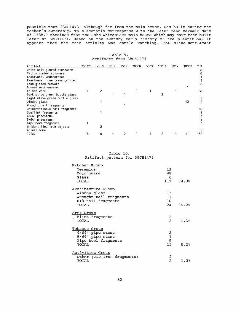
possible that 38CH1473, although far from the main house, was built during the father's ownership. This scenario corresponds with the later mean ceramic date of 1788.7 obtained from the John Whitesides main house which may have been built later at 38CH1471. Based on the sketchy early history of the plantation, it appears that the main activity was cattle ranching. The slave settlement
Table 9. Artifacts from 38CH1473
Artifact T55ST5 25'N 50'N 75'N 100'N 50'5 White saLt gLazed stoneware YeLLow combed sLipware Creamware, undecorated PearLware, bLue trans printed Lead gLazed redware Burned earthenware CoLono ware 7 2 Dark oLive green bottLe gLass Light oLive green bottLe gLass Window gLass 1 Wrought naiL fragments UnidentifiabLe naiL fragments GunfLint fragments 4/64" pipestems 5/64" pipestems pipe bowL fragments Unidentified iron objects 2 AnimaL bone TOTAL 8 6 2
Table 10. Artifact pattern for 38CH1473
Kitchen Group Ceramics Colonoware Glass TOTAL
Architecture Group Window glass Wrought nail fragments ulb nail fragments TOTAL
Arms Group Flint fragments TOTAL
Tobacco Group 4/64" pipe stems 5/64" pipe stems pipe bowl fragments TOTAL
Activities Group Other (UlD iron fragments) TOTAL
63
100' 5 50'W 100'E TU1 2 6 1 1 2
88 2
2 10 2
10 1 3 1 8
5 2 11 132
13 98
6 117 74.0%
13 1
10 24 15 . 2%
2 2 1.3%
3 1 9
13 8.2%
2 2 1.3%
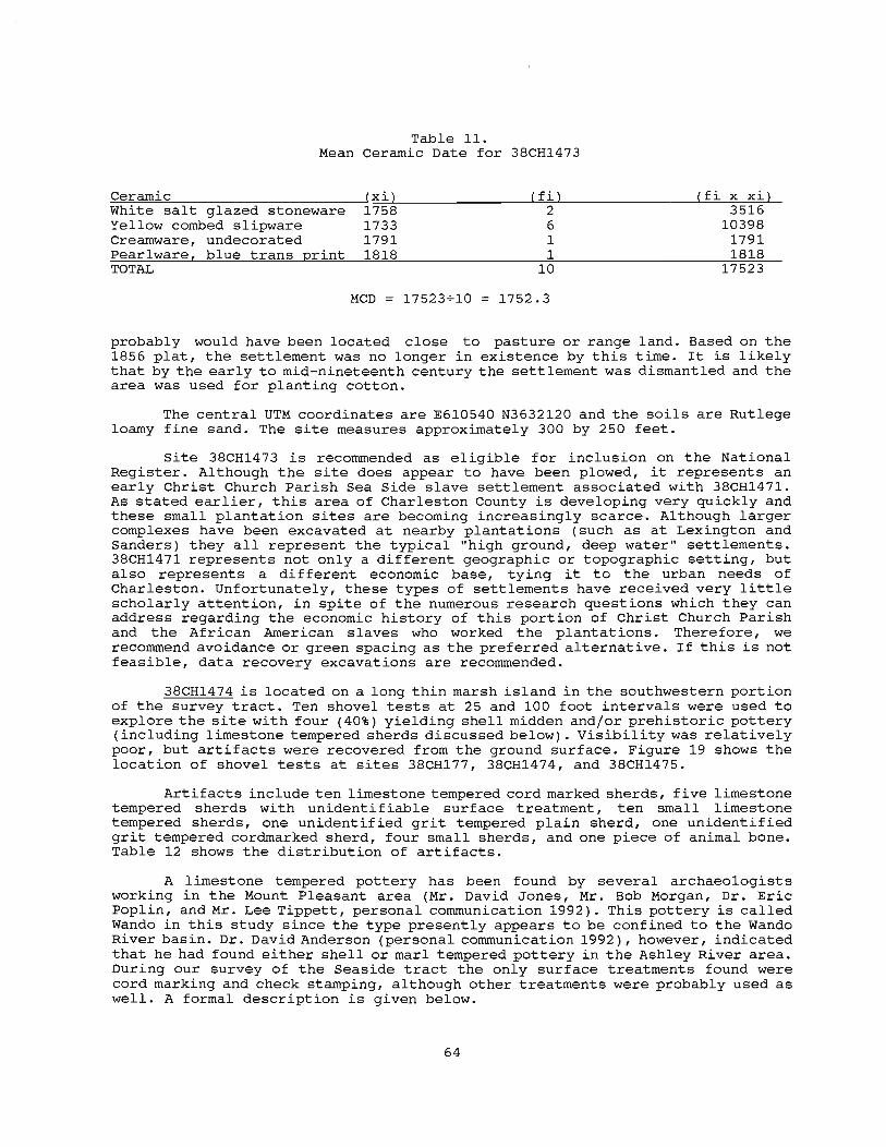
Table 11. Mean Ceramic Date for 38CH1473
Ceramic (xi) (ti) (fi x xi) White salt glazed stoneware 1758 2 3516 Yellow combed slipware 1733 6 10398 Creamware, undecorated 1791 1 1791 Pearlware[ blue trans 2rint 1818 1 1818 TOTAL 10 17523
MCD 17523 .... 10 1752.3
probably would have been located close to pasture or range land. Based on the 1856 plat, the settlement was no longer in existence by this time. It is likely that by the early to mid-nineteenth century the settlement was dismantled and the area was used for planting cotton.
The central UTM coordinates are E610540 N3632120 and the soils are Rutlege loamy fine sand. The site measures approximately 300 by 250 feet.
Site 38CH1473 is recommended as eligible for inclusion on the National Register. Although the site does appear to have been plowed, it represents an early Christ Church Parish Sea Side slave settlement associated with 38CH1471. As stated earlier, this area of Charleston County is developing very quickly and these small plantation sites are becoming increasingly scarce. Although larger complexes have been excavated at nearby plantations (such as at Lexington and Sanders) they all represent the typical "high ground, deep water" settlements. 38CH1471 represents not only a different geographic or topographic setting, but also represents a different economic base, tying it to the urban needs of Charleston. Unfortunately, these types of settlements have received very little scholarly attention, in spite of the numerous research questions which they can address regarding the economic history of this portion of Christ Church Parish and the African American slaves who worked the plantations. Therefore, we recommend avoidance or green spacing as the preferred alternative. If this is not feasible, data recovery excavations are recommended .
38CH1474 is located on a long thin marsh island in the southwestern portion of the survey tract. Ten shovel tests at 25 and 100 foot intervals were used to explore the site with four (40%) yielding shell midden and/or prehistoric pottery (including limestone tempered sherds discussed below). Visibility was relatively poor, but artifacts were recovered from the ground surface. Figure 19 shows the location of shovel tests at sites 38CH177, 38CH1474, and 38CH1475.
Artifacts include ten limestone tempered cord marked sherds, five limestone tempered sherds with unidentifiable surface treatment, ten small limestone tempered sherds, one unidentified grit tempered plain sherd, one unidentified grit tempered cordmarked sherd, four small sherds, and one piece of animal bone . Table 12 shows the distribution of artifacts.
A limestone tempered pottery has been found by several archaeologists working in the Mount Pleasant area (Mr. David Jones, Mr. Bob Morgan, Dr. Eric Poplin, and Mr. Lee Tippett, personal communication 1992). This pottery is called Wando in this study since the type presently appears to be confined to the Wando River basin. Dr. David Anderson (personal communication 1992), however, indicated that he had found either shell or marl tempered pottery in the Ashley River area. During our survey of the Seaside tract the only surface treatments found were cord marking and check stamping, although other treatments were probably used as well. A formal description is given below .
64
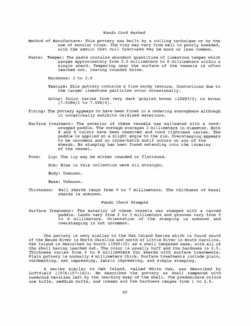
Wando Cord Marked
Method of Manufacture: This pottery was built by a coiling technique or by the use of annular rings. The clay may vary from well to poorly kneaded, with the result that coil fractures may be more or less common.
Paste: Temper: The paste contains abundant quantities of limestone temper which ranges approximately from 0.5 millimeters to 6 millimeters within a single sherd. Tempering near the surface of the vessels is often leached out, leaving rounded holes.
Hardness: 3 to 3.5
Texture: This pottery contains a fine sandy texture. Contortions due to the larger limestone particles occur occasionally.
Color: Color varies from very dark grayish brown (10YR3j2) to brown (7.5YR4j2 to 7.5YRj4).
Firing: The pottery appears to have been fired in a reducing atmosphere although it occasionally exhibits oxidized exteriors.
Surface treatment: The exterior of these vessels was malleated with a cordwrapped paddle. The cordage averages 2 millimeters in diameter. Both Sand Z twists have been observed and cord tightness varies. The paddle is applied at a slight angle to the rim. Overstamping appears to be uncommon and no cross-hatch motif occurs on any of the sherds. No stamping has been found extending into the interior of the vessel.
Form: Lip: The lip may be either rounded or flattened.
Rim: Rims in this collection were all straight.
Body: Unknown.
Base: Unknown.
Thickness: Wall sherds range from 6 to 7 millimeters. The thickness of basal sherds is unknown.
Wando Check Stamped
Surface Treatment: The exterior o.f these vessels was stamped with a carved paddle. Lands vary from 2 to 3 millimeters and grooves vary from 5 to 6 millimeters. Orientation of the stamping is unknown and overstamping is not uncommon.
The pottery is very similar to the Oak Island Series which is found south of the Neuse River in North Carolina and north of Little River in South Carolina. Oak Island is described by South (1960:20) as a shell tempered ware, with all of the shell having leached out. The color is usually buff and the hardness is 2.5. Thickness varies from 6 to 8 millimeters for sherds with surface treatments. Plain pottery is normally 4 millimeters thick. Surface treatments include plain, cordmarking, net impressing, fabric impressing, and simple stamping.
A series similar to Oak Island, called White Oak, was described by Loftfield (1976: 157-163). He describes the pottery as shell tempered with numerous cavities left by the leaching away of the shell. The predominate colors are buffs, reddish buffs, and creams and the hardness ranges from 1 to 2.5.
65

Ln f"-~ rl :I: 0 CO C"')
'0 0 c:: 0 ~ III II)
~
6 ~ f"-
~ ~ rl :I: 0 co
I- ~'/ C"')
0
£ZX 0 0 £C'X
.,. 0 f"-
f"-t.... rl
-~/ :I: 0 0 0 CO
0 C"') N...J
" :; C .j.J
'/ X III PC'X
0 :- 0: 0 W en N wI- .j.J
...JZ en ~- Q) U --.J .j.J CJ) 0: ~
£C' X 5- rl
~~ Q)
> X 0
£'C' ..c:: en
0 ...r 4-1
~ 0
-;J c::
~ 0
• .-1 .j.J III U 0
0 rl 0 N Q)
..c::
.j.J
til c::
• .-1
X ~ 0
[/ ..c:: en
0.. III ~
(j\ rl
Q) \.l
\ ::l til
• .-1
66 r:.

Table 12. Distribution of artifacts at 38CH1474
Artifact ST7 ST8 ST10 ST17 Wando
Cord Marked 1 9 Unidentified 5 Small 10
Unidentified Plain 1 Cord Marked 1 Small 3 1
Animal Bone 1
Thickness varies, but is "very close to 6 millimeters", and surface treatments include plain, cordmarking, net impressing, fabric impressing, and thong-marking. This pottery is found in the same geographical region as Oak Island and has been subsumed under the Oak Island definition (Phelps 1983:48).
The colington series is a Late Woodland/Contact pottery found in the Tidewater region of the North Carolina North Coastal region. Haag (1958:82-87) describes the pottery as shell tempered with a smooth surface having no protrusions of temper. The color is usually a variation of gray. Thickness averages 6 to 7 millimeters and surface treatments include plain, fabric impressing, and simple stamping. The absence of cordmarking strongly suggests that Oak Island and Colington are separate wares. Radiocarbon dates ranging from A.D. 800 to 1650 have been obtained for the pottery (Phelps 1983:36).
A 5% hydrochloric acid solution was used on the Wando pottery temper to test for calcite. The temper reacted to the hydrochloric acid which indicated that it was either limestone or shell. Based on conversations with Dr. Vincas Stephonaitis, who has worked with shell tempered pottery at the Moundville site, it is believed that the pottery is limestone tempered (Dr. Vincas Stephonaitis, personal communication 1992). Using a binocular microscope, the temper and the leached holes were examined. No layering or angularity was noted to indicate shell tempering. All temper was rounded. The Oak Island sherds were also examined. In contrast to the Wando series, the leach holes of the Oak Island pottery were often flat or angular, indicating a difference in the tempering of the two wares. Stephonaitis indicated that heating shell or limestone does not significantly change its structure so that even after firing the two can not be confused.
Calcium carbonate (found as shell or limestone) can greatly influence the use properties of clays. Large pieces may decompose during firing without reacting with the remaining clay constituents. They remain as lumps of calcium oxide, and later are susceptible to expansion (causing the vessel to crack) or deterioration of the product when calcium oxide hydrates in a moist atmosphere (Heron et al. 1965:11). Hydration increases the volume of the material and the particles often exert enough pressure to crumble the vessel (Shepard 1975:30). It is possible that the limestone was heated before it was used as temper. By heating limestone to about 500 0 C it alters irreversibly to calcite . This shift entails an expansion in volume that may cause damage if it were to occur inside the vessel wall during firing. Preheating reduces this risk by allowing the expansion to take place before the limestone is added to the paste (Stephonaitis 1983:20). Smaller fragments of the calcium carbonate can react completely with the clay minerals during firing forming anorthite or wallastonite. These crystalline constituents can actually serve to improve the structure of the pottery. These reaction will lessen the shrinkage occurring during firing (Heron et al. 1965:11).
Based on what appears to be a highly restricted geographic range for
67
limestone tempering, it was originally believed that the materials for pottery making would be locally available. Three geologic formations, the Duplin, santee Limestone and Cooper Marl, may have provided tempering for the pottery since each contains limestone. The Duplin formation is the closest to the project area, and it also contains large amounts of calcites. There are beds on the Cooper River near The Grove and on Goose Creek near Yeamans Hall (Cooke 1936:130). The Santee formation is composed mainly of consolidated but not generally indurated, slightly glauconitic, yellowish-gray calcarenites and calcirudites (limestone) . . The Cooper is a ' sandy calcilutite or calcarenite (limestone). The Santee Limestone accumulated in shallow marine waters whereas the coo"per represents a deeper water marine environment (Heron et al. 1965:22).
The Santee Limestone formation occurs at the surface or at shallow depths in parts of Orangeburg, Bamberg, Calhoun, Clarendon, Dorchester, Berkeley, Williamsburg, and Georgetown counties. Natural exposures of occur only along the shores of Lake Marion, in the sinkholes and streams adjacent to Lake Marion, and along the bluffs of the Santee River in the Jamestown (Berkeley County) area (Heron 1962:9). .
Next to Santee Limestone, Cooper Marl is the highest quality limestone source in the state. It occurs in parts of Allendale, Bamberg, Orangeburg, Dorchester, Berkeley and Charleston counties (Heron 1962:10). The formation was named for a foraminiferal limestone that outcrops near Charleston (Heron 1962:21) •
Although none of these outcrops occur in or near the study area, they are not unreasonably far away. As stated earlier, it appears that the Wando series pottery occurs only in the Wando drainage. Further research may reveal that limestone tempered pottery is found in other areas as well, although the type as a whole is not well represented. It is quite possible that limestone tempering was experimented with, but not preferred because of the cracking and deterioration. problems.
Although similar to Oak Island, all of the Wando pottery is appears to be limestone tempered. While it is possible that the two potteries are related, nothing is known about the temporal context of the Wando series. Oak Island sites have yielded radio carbon dates which attribute them to the Late Woodland and Contact Periods although Loftfield (1979: 58) has obtained radiocarbon dates which push its beginning back to the Middle Woodland.
Figure 20 is a map of the presently known distribution of Wando and Oak Island wares. Since nothing has been published on the occurrence of the limestone tempered Wando Series, knowledge about its distribution is based solely on verbal communications. It must also be cautioned that the authors have not examined the potteries from other sites.
The central UTM coordinates of 38CH1447 are E610660 N3629840 and soils are Crevasse-Dawhoo Complex. Soil profiles indicate 0.8 feet of dark grayish brown (10YR4j2) midden or non-midden soils overlying yellow brown (10YR5j6) subsoil. The site measures 300 by 75 feet in size.
Site 38CH1474 is recommended as eligible for inclusion on the National Register. Intact midden remains and non-midden areas indicate that the site has the potential to answer questions about intra-site spatial patterning. Recent work on Kiawah Island (Trinkley 1991b) has discovered these types of midden sites on Crevasse-Dawhoo complex dune and trough topography. Little is known about how this type of topography affected use of the land. Excavations are needed at ridge and trough sites to better understand these issues of spatial patterning.
In addition, virtually nothing is known about limestone tempered pottery. Although this type of pottery apparently has been documented at the Molasses Creek Site in Mount Pleasant (38CH908), the final data recovery report is not
68

0'1 \0
\ \
(\
~~ v~\~
DISTRIBunON OF OAK ISLAND SERIES
o
MILES
Figure 20. Distribution of Oak Island and Wando wares in South and North Carolina.
60

A c o B
• F
H
E G
o 5 _ __ eM.
K
o M N
L
Figure 21. Artifacts from the Seaside Farms Survey. A) yellow combed slipware; B) westerwald stoneware; C) annular creamware; D and E) hand painted pearlware; F) blue faceted bead; G) type 18 brass button "TREBLE/GILT"; H) Deptford Cord Marked; I) Deptford Check Stamped; J) Deptford Simple Stamped with limestone inclusions; K) Santee/McClellanville Simple Stamped; L) Hanover Fabric Impressed; M) Hanover Check Stamped; N) Wando Cord Marked; and 0) Wando Check Stamped.
70
available from the South Carolina Institute of Archaeology and Anthropology or the South Carolina State Historic Preservation Office (Keith Derting, personal communication 1992; Lee Tippett, personal communication 1992). Efforts to identify the curatorial facility have met with no success -- neither the South Carolina Institute of Archaeology nor The Charleston Museum have the collections from this site (Sharon Pekrul, personal communication 1992; Ron Anthony, personal communication 1992). There are a number of questions surrounding this particular "type" of pottery, including its typological validity, its chronological place, and its cultural significance.
Research at 38CH1474, in the absence of the research at Molasses Creek, can begin to answer a variety of significant questions. In- the presence of comparative research at Molasses Creek, 38CH1474 can serve to verify findings, explore issues, and refine conclusions.
38CH1475 is located approximately 200 feet east of 38CH1474 on the same long, thin marsh island. Six shovel tests at 25 and 100 foot intervals were used to explore the site with three (50%) yielding shell midden. No artifacts were recovered. Surface visibility was poor and no collection was made.
The central UTM coordinates are E610500 N3629720 and soils are CrevasseDawhoo Complex. Soil profiles indicate 0.9 feet of dark grayish brown (10YR4/2) midden soils overlying yellow brown (10YR5/6) subsoil. The site measures 200 by 50 feet in size.
Site 38CH1475 is recommended as potentially eligible for inclusion on the National Register. While no disgnostic artifacts were recovered, the site is similar to other Type 1 prehistoric middens (Trinkley 1990c) found elsewhere. In addition, the site contains intact midden and, due to its proximity to 38CH1474, may be related. The potential eligibility of 38CH1475 -is predicated on its similarity to 38CH1474, the possible spatial continuity, and the ability to refine comparative statements.
38CH1476 is located in the west central portion of the survey tract in a grassy area off a northwest/southeast running dirt road. Based on conversation with local informants, this area contained a dairy which was torn down or removed within the last five years. Investigation of the site revealed areas of "modern" brick scatters with cement mortar. Presently, the site is used as a storage area. Several I-beams and cinder blocks as well as wrought iron decorative items were found on the western edge of the site. Four shovel tests at 50 foot intervals were used to explore the area with only one yielding dense brick rubble.
The central UTM coordinates are E610140 N3631400 and the soils are Stono fine sandy loam. Soil profiles indicate 0.7 feet of black (10YR2. 5/1) soil overlying very dark gray (10YR3/1) subsoil. The site is approximately 100 by 100 feet in size.
Site 38CH1476 is recommended as not eligible for inclusion on the National Register. No subsurface artifacts were recovered and the dairy appears to have been constructed within the last 40 years.
38CH1477 is located on the southern shore of the large pond, flanking a dirt road. A series of 46 shovel tests at 25 foot intervals were used to explore the area with eight (17%) yielding artifacts. Part of the site had been recently disced which provided excellent surface visibility allowing a relatively large surface collection. This site is a slave row associated with Moses Whitesides plantation (38CH357). A 1798 plat shows two rows of three structures (Figure 5).
In addition to the shovel tests, two units were excavated in the site area to better understand integrity (especially given the disparity between the density of artifacts found in shovel tests and those on the surface). Test unit 1 was a two by two foot unit at Transect 4 Shovel Test 6. It was excavated to a
71

depth of 0.5 feet. Soil profiles indicated 0.5 feet of very dark grayish brown (10YR3/2) soil overlying grayish brown (10YR5/2) subsoil. In the center of the unit was a squarish stain about 0.8 feet in diameter which appeared to be a post. Upon excavation, the feature was clearly a tree stain based on the presence of several root stains radiating outward.
Test unit 2 was a four by four foot unit at Transect 4 Shovel Test 5. The unit was excavated to a depth of 0.55 feet. Soil profiles were identical to that at Test Unit 1. At the base of the unit two root stains were identified as well as a larger stain in the south central portion of the unit. This stain measured 1.3 east/west by 1.6 north/south and extending into the south wall. Excavation of this stain yielded only one artifact -- an iron kettle fragment -- and the stain extended 0.4 feet below the base of the unit. It appears to be a portion of a large, shallow pit feature.
Artifacts collected from the surface and subsurface span the eighteenth and the nineteenth centuries, and a small amount of animal bone was recovered from the site. Interestingly, very few colonoware fragments were recovered which may suggest that the slave row was more intensively occupied in the mid-nineteenth century. The distribution of artifacts is shown in Table 13.
The artifact pattern is presented in Table 14 for groups represented and Table 15 shows the mean ceramic date for the 124 datable ceramics. The relatively early mean ceramic date of 1809.3 corresponds with the historical data which suggests that the slave row was built between 1762, when Thomas Whitesides willed the property to his son Moses, and 1798, when Joseph Purcell made a plat showing the division of lands between Moses and his brother John. This date is similar to the 1803.5 date obtained from the main house complex at 38CH357. An 1856 plat (Figure 9) continues to illustrate this settlement.
is
x
I(
Figure 22. Location of shovel tests and test units at 38CH1477.
72
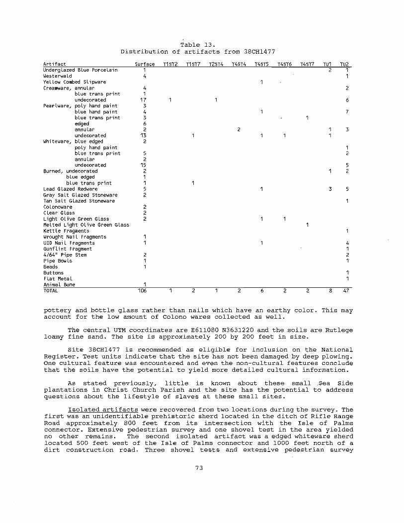
Table 13. Distribution of artifacts from 3SCH1477
Artifact UndergLazed BLue PorceLain WesterwaLd YeLLow Combed SLipware Creamware, annuLar
bLue trans print undecorated
PearLware, poLy hand paint bLue hand paint bLue trans print edged annuLar undecorated
Whiteware, bLue edged poLy hand paint bLue trans print annuLar undecorated
Burned, undecorated bLue edged bLue trans print
Lead GLazed Redware Gray SaLt GLazed Stoneware Tan SaLt GLazed Stoneware Co Lonoware CLear GLass Light OLive Green GLass MeLted Light OLive Green GLass KettLe Fragments Wrought NaiL Fragments UIO NaiL Fragments GunfLint Fragment 4/64" Pipe Stem Pipe BowLs Beads Buttons FLat MetaL AnimaL Bone TOTAL
Surface 1 4
4 1
17 3 4 3 6 2
13 2
5 2
15 2 1 1 5 2
2 2 2
2 1 1
1 106
T1ST2 T1ST7 T2ST4 T4ST4 T4ST5
2
2 2 6
T4ST6 T4ST7
1
2 2
TU1 2
3
8
TU2
2
6
7
3
1 2
5 2
5
4 1 2 1
47
pottery and bottle glass rather than nails which have an earthy color. This may account for the low amount of Colono wares collected as well.
The central UTM coordinates are E6l10S0 N3631220 and the soils are Rutlege loamy fine sand. The site is approximately 200 by 200 feet in size.
Site 38CH1477 is recommended as eligible for inclusion on ~he National Register. Test units indicate that the site has not been damaged by deep plowing. One cultural feature was encountered and even the non-cultural features conclude that the soils have the potential to yield more detailed cultural information.
As stated previously, little is known about these small .Sea Side plantations in Christ Church Parish and the site has the potential to address questions about the lifestyle of slaves at these small sites.
Isolated artifacts were recovered from two locations during the survey. The first was an unidentifiable prehistoric sherd located in the ditch of Rifle Range Road approximately SOO feet from its intersection with the Isle of Palms connector. Extensive pedestrian survey and one shovel test in the area yielded no other remains. The second isolated artifact was a edged whiteware sherd located 500 feet west of the Isle of Palms connector and 1000 feet north of a dirt construction road. Three shovel tests and extensive pedestrian survey
73

yielded no other remains.
Table 14. Artifact Pattern for 38CH1477
Ceramic Underglazed Westerwald
Kitchen Group Ceramics Colonoware Glass Kitchenware TOTAL
Architecture Group Wrought nail fragments UID nail fragments TOTAL
Arms Group Gunflint fragments TOTAL
Tobacco Group 4/64" pipe stems Pipe bowls TOTAL
Activities Group Other (flat metal) TOTAL
Table 15. Mean Ceramic Date for
Mean Date {xil
Blue Porcelain 1730 1738
Yellow Combed Slipware 1733 Creamware, annular 1798
blue trans print 1790 undecorated 1791
Pearlware, poly hand paint 1805 blue hand paint 1800 blue trans print 1818 edged 1805 annular 1805 undecorated 1805
Whiteware, blue edged 1853 poly hand paint 1848 blue trans print 1848 annular 1866 undecorated 1860
TOTAL
MCD 224360~124 =
74
38CH1477
{ fil 4 5 1 6 1
25 3
12 4 6 8
17 2 1 7 2
20 124
1809.3
149 3 7 1
160 92.6%
1 6 7 4.0%
1 1 0.6%
4 2 6 3.4%
1 1 0.6%
fi x xi 6920 8690 1733
10788 1790
44775 5415
21600 7272
10830 14440 30685
3706 1848
12936 3732
37200 224360

CONCLUSIONS
The primary goals of this study were, first, to identify the archaeological resources of the Seaside Farms tract and, second, to assess the ability of these sites to contribute significant archaeological, historical, or anthropological data. The second aspect essentially involves the sites' eligibility for inclusion in the National Register of Historic Places, although Chicora Foundation only provides an opinion of National Register eligibility. These goals were achieved with 15 new sites being identified and three sites being revisited. Two isolated artifacts were also recovered. One of the revisited sites (38CH358) no longer exists and may have been destroyed by erosion. Of the 17 sites, five were recommended as eligible for inclusion on the National Register of Historic Places and one was recommended as potentially eligible.
The secondary goals were, first, to examine the development of eighteenth and nineteenth century plantations on the tract; second, to examine changing land use by prehistoric people; and third, to examine the relationship between site location, soil types, and topography, expanding the previous work by Brooks and Scurry (1978) and Scurry and Brooks (1980) in the Charleston area and Trinkley (1990c and 1991b) on Spring and Callawassie islands in Beaufort County.
Prehistoric Sites
Of the 17 sites identified seven were prehistoric (see Table 1). Of those seven sites, two (38CH1466 and 38CH1474) are recommended as eligible for inclusion on the National Register. One (38CH1475) is recommended as potentially eligible. All of the prehistoric sites are located near water; either the marsh front, tidal extensions of Inlet Creek, or along a drainage which has been dammed to create a pond. Four of the seven sites are located on somewhat poorly to poorly drained soils. The remaining three are located on mixed drainage ridge and trough topography near tidal extensions of Inlet Creek. The Seaside Farms tract contains no well drained soils adjacent to the marsh. In fact, the vast majority (80%) of the soils range from somewhat poorly to very poorly drained.
As Scurry and Brooks (1980:77) have discovered, even when vast areas of well drained soils are available for settlement, sites tend to cluster around small tidal inlets and marsh areas. The Seaside survey suggests that even when well drained soils aren't present, the occurrence of marsh areas and tidal inlets may have been sufficiently attractive to prehistoric groups to cause settlement. This finding dramatically indicates the importance of the coastal marsh to prehistoric groups.
It may be questioned whether the soil drainage today can be extended back in time to a period of lower sea levels. Although sea levels may have an effect on the water table, Edminster and Reeve note that the "ability of soils to transmit water has primary importance in the drainage of ..• lands" (Edminster and Reeve 1957:380). The permeability of most soils is not likely to be altered by sea level changes. Consequently, areas which are poorly drained today were probably equally poorly drained prehistorically.
Apparently, the marsh front of the tract was notoriously bad for flooding, which caused the construction of an earthen berm during the historic period to protect the area from flooding. This being the case, it is likely that 38CH1466 is an extractive site rather than a settlement. Based on the survey findings, the site was used primarily during the Deptford and Hanover phases. The site exhibits excellent integrity and yielded both faunal and ethnobotanical remains. Any future research at 38CH1466 should focus on several issues:
75

• site function;
• intra-site spatial patterning;
• comparative use during the Deptford and Hanover phases; and
• prehistoric diet.
38CH1464 is currently located on the marsh front as well, within the earthen berm, but originally it may have been located along the banks of the drainage which was dredged to build the berm and pond. 38CH1467 and 38CH1468 are small shell middens located next to the drainage.
The most desirable area on the tract for fishing and shell fishing is the ridge and dune island containing 38CH177, 38CH1474, and 38CH1475. Two of these (38CH1474 and 38CH1475) exhibit good integrity and one (38CH1474) yielded a pottery type which has never been formally described. This pottery is a fine paste limestone tempered pottery which exhibit~ some leaching. This pottery is similar to the shell tempered Oak Island wares described by South (1966), but is geographically distinct. Based on conversations with colleagues, this type (called Wando here) appears to be restricted to the Wando River basin. Although data recovery at Molasses Creek (38CH908) reportedly yielded similar pottery, no final report has been written. As a result, 38CH1473, and possibly 38CH1474 (which may be an extension of 38CH1473), obtains a high degree of significance since little is known about the validity of the type, its temporal context, and its geographical extent. Research at 38CH1473 and 38CH1474 should focus on:
• site function;
• inter and intra-site spatial patterning;
• collection of diagnostic artifacts for the Wando phase;
• temporal location of the Wando phase;
• validity of the pottery type; and
• prehistoric diet.
Historic Sites
Turning to the historic settlement expectations, it is observed that this tract offered no area of access to any deep water (see South and Hartley 1981). Eighty percent of the property is somewhat poorly to very poorly drained, so relatively large scale historic occupation could not be anticipated based on geographical factors alone.
Of the 17 sites identified at the Seaside Farms tract ten were historic (see Table 1). Of these ten sites, three (38CH1471, 38CH1473, and 38CH1477) are recommended as eligible for inclusion on the National Register.
Based on pre-field work historical research several historic sites were anticipate and all were located. These sites include the Moses Whitesides main house (38CH357) and slave row (38CH1477), the John Whitesides main house (38CH1471) and slave row (38CH1473), and a cluster of several structures dating to the nineteenth century (38CH1469). A single structure which appears on the 1856 plat, however, was not located. This structure may have been a barn or other utility building, making its archaeological identification difficult.
The John Whitesides settlement yielded eighteenth century dates. The slave row (38CH1473) yielded a mean ceramic date of 1752 and the main house (38CH1471) yield a date of nearly 1789. Although tenuous, it is possible that the slave row
76

is also associated with the older Thomas Whitesides settlement, but continued to be used after John Whitesides built a main house following his father's death in 1762. Alternative explanations for the early date may include the small sample size (ten datable sherds) and also curation of the ceramics with the slave using ware discarded by the planter. Both the main house and slave row are shown on a 1798 plat, but not on the 1856 plat. This suggests that by the mid-nineteenth century the settlement was dismantled. Plow furrows at both main house and slave row indicate that afterwards the area was used for planting, perhaps cotton.
Early nineteenth century dates were obtained at the Moses Whitesides settlement. The slave row (38CH1477) yielded a mean ceramic date of 1809 and the main house (38CH357) yielded a date of 1804. This settlement appears on both the 1798 and the 1856 plats. The sparsity of Colono ware at the slave settlement (less than 2% of the recovered ceramics) suggests that the area may have been more intensively used in the nineteenth century.
other nineteenth century sites include 38CH1469 where undecorated whitewares and late white porcelains suggest a late nineteenth century occupation. 38CH1472 produced wire nails which indicates a late nineteenth/early twentieth century occupation. 38CH1476 is a twentieth century dairy barn.
While the Moses Whitesides settlement is located adjacent to the marsh, the lands are low and it was during its occupation that the earthen berm was built to prevent periodic inundation of the property. The John Whitesides settlement is also located inland on poorly drained soils. It is tempting to suggest that proximity to grazing land was of greater importance than settling on well drained soils. Unfortunately, neither Moses or John passed over well drained soils to locate on the less well drained areas. Both were confronted with inheritance of property that, overall, was poorly drained and which limited their economic as well as settlement options.
This illustrates that a variety of factors affected settlement during the historic period. Concerns over drainage, economic viability, access, proximity to scarce or otherwise significant resources, . and availability of land all had to be weighed. It seems that the decisions may have been highly idiosyncratic, depending on the weight assigned to each concern by the owner. The point, of course, is that the choice of settlement location was not nearly as simple a decision as it has been made to seem.
Nineteenth century maps of the project area show a small cluster of buildings adjacent to the marsh drainage which is today a pond. Identified as site 38CH1469, these may have functioned as a small homestead or as a series of outbuildings located close to a plantation work area. Unfortunately, the site is too heavily damaged to contribute more information .
The Moses Whitesides slave row (38CH1477), and the John Whitesides main house and slave row (38CH1471 and 38CH1473) were recommended as eligible for inclusion on the National Register. The Moses Whitesides main house (38CH357) appears to have been heavily damaged by construction of the Isle of Palms connector. This is unfortunate since, based on interviews in the 1970s, the site contained a large amount of historic materials. Some almost entirely reconstructible vessels were collected by a previous owner. Nonetheless, the three remaining plantation settlements have the potential to address questions relating to seashore plantations and cattle ranching activities during the eighteenth and nineteenth centuries. Research should focus on several issues:
) Euro-American and African-American architecture;
Effects of the economic base of cattle ranching on personal possessions;
) Euro-American and African-American foodways;
77
> Urban/Rural relationships;
and Elite landscape alteration (i.e. construction of gardens and paths) .
Recommendations
Eligible Archaeological Sites
The archaeological sites recommended in this study as eligible for inclusion on the National Register of Historic Places may be either green spaced or subjected to data recovery. Green spacing is recognized as an appropriate, and often cost-effective, mitigation measure for archaeological sites conservation. This procedure involves placing the site aside and protecting it from all future ground disturbing activities in perpetuity. This is usually accomplished by placing a protective covenant on the property or by establishing preservation easements, held by some other organization. Eight recommendations are offered (subject to the review and approval of the State Historic Preservation Office) if green spacing is to be considered:
1. The site is to be physically blocked out in the field with a buffer sufficient to ensure the protection of the archaeological remains;
2. The site should be cleared, by hand, of understory vegetation. No heavy equipment should be used and all cut vegetation should be removed from the s i te area;
3. The area should continue to be clearly defined during all phases of construction. No equipment should be allowed in the site area, or be allowed to use the area as a turn-around. The area should not be used to stockpile supplies, or be otherwise disturbed. All personnel, including contractor's and various subcontractor's personnel, should be strictly prohibited from entering the area. This is particularly important to prevent looting of the site;
4. Any landscaping in the site area should be conducted by hand and ground disturbance should be limited to the upper 0.2 foot of soil. No utilities, including sprinkler lines, should be placed through the site; .
5. If more intensive landscaping is desired, the site should be protected by placing an isolating layer of clean builder's sand over the area. This layer should be at least 0.5 foot thick and it may be appropriate to also use filter cloth between the site and the sand zone. Additional topsoil may then be placed on the sand fill. Landscaping or sprinkler lines should not exceed the depth of the isolating level of top soil and sand;
6 . The property owner should develop a protective easement or covenant assuring the protection of the site area set aside in green spacing and this protection should be in perpetuity; and
7. Appropriate security should be provided to ensure that the site is not vandalized,. looted, or otherwise damaged.
Alternatively, the sites recommended as eligible for inclusion on the National Register of Historic Places can be mitigated through data recovery, or the excavation, analysis, proper curation of recovered remains, and publication of findings. The level of effort at each site should be sufficient to address the research questions previously raised .
78

Potentially Eligible Site
The one archaeological sites identified as potentially eligible may be green spaced in a similar fashion to those recommended as eligible. If this approach is chosen, no additional archaeological research is necessary to determine eligibility.
If green spacing is not possible, or if the property owner prefers to clarify the actual significance of the site, then additional archaeological testing at this site will be necessary. This research should be adequate to clarify the relationship of 38CHl475 to nearby 38CH1474, determining whether there is, in fact, any spatial continuity. In addition, testing should collect information on the temporal period(s) of occupation, with special attention to the presence of Wando Series pottery.
This additional testing, if undertaken, will then be used to recommend the site as either eligible or not eligible. If found eligible by the State Historic Preservation Office, 38CH1475 must be either green spaced or excavated. If found not eligible, no further archaeological investigation or management will be warranted.
79

SOURCES CITED
Allston, R.F.W. 1854 Essay on Sea Coast Crops. A.E. Miller, Charleston.
Anderson, David G. 1975 I nferences from D i str ibu t iona1 St udie s 0 f
Prehistoric Artifacts in the Coastal - Plain of South Carolina. Southeastern Archaeological Conference Bulletin 18:180-194.
1985
1989
Middle Woodland Societies on Atlantic Slope: A View from Carolina. Early Georgia 13:29-66.
the Lower Georgia and
South South
The Mississippian in South Carolina. In Studies in South Carolina Archaeology, edited by Albert C. Goodyear and Glen T. Hanson, pp. 101-132. South Carolina Institute of Archaeology and Anthropology, University of South Carolina, Columbia.
Anderson, David G., Charles E. Cantley, and A. Lee Novick 1982 The Matassee Lake Sites: Archaeological Investigations Along
the Lower Santee River in the Coastal Plain of South Carolina. Commonwealth Associates, Inc., Jackson, Michigan. Submitted to National Park Service, Archaeological Services Branch, Atlanta.
Anderson, David G. and Trish Logan 1981 Francis Marion National Forest: Cultural Resources Overview.
U.S.D.A., Forest Service, Columbia, S.C.
Anderson, David G. and Joseph Schuldenrein (editors) 1985 Prehistoric Human Ecology Along the Upper Savannah River:
Bartovics, Albert 1981
Excavations at the Rucker's Bottom, Abbeville and Bullard Site Groups. Commonwealth Associates, Inc., Jackson, Michigan. Submitted to National Park Service, Archaeological Services Branch, Atlanta.
The Archaeology of Daniels Village: An Experiment in Settlement Archaeology. PhD. dissertation. Brown University.
Bense, Judith A., Hester A. Davis, Lorraine Heartfield, and Kathleen Deagan 1986 Standards and Guidelines for Quality Control in Archaeological
Resource Management in the Southeastern United States. Southeastern Archaeology 5:52-62.
Blanton, Dennis 1986
B., Christopher T. Espenshade, and Paul E. Brockington, Jr. An Archaeological Study of 38SU83: A Yadkin Phase Site in the Upper Coastal Plain of South Carolina. Garrow and Associates, Atlanta. Submitted to South Carolina Department Highways and Public Transportation, Columbia.
Brockington, Paul, Michael Scardaville, Patrick H. Garrow, David Singer, Linda France, and Cheryl Holt 1985 Rural Settlement in the Charleston Bay Area: Eighteenth and
Nineteenth Century Sites in the Mark Clark Expressway Corridor. Garrow and Associates, Inc., Atlanta.
80

Brooks, Mark and 1987
Glen Hanson Late Archaic-Early Woodland Adaptive Stability and Change in the Steel Creek Watershed, South Carolina. Draft ms. on file, Savannah River Archaeological Research Project, South Carolina Institute of Archaeology and Anthropology, University of South Carolina, Columbia.
Brooks, Mark, 1989
D.J. Colquhoun, J.G. Brown, and P.A. Stone Sea Level Change, Estuarine Development and Temporal Variability in Woodland Period Subsistence-Settlement Patterning on the Lower Coastal Plain of South Carolina. In Studies in South Carolina Archaeology, edited by Albert C. Goodyear and Glen T. Hanson, pp. 91-100. Anthropological Studies 9. South Carolina Institute of Archaeology and Anthropology, University of South Carolina, Columbia.
Brooks, Mark and 1978
James D. Scurry
Burton, E. Milby 1971
Butler, William B.
An Intensive Archaeological Survey of Amoco Realty Property in Berkeley County, South Carolina with a Test of Two SubsistenceSettlement Hypotheses for the Prehistoric Period. Research Manuscript Series 147. South Carolina Institute of Archaeology and Anthropology, University of South Carolina, Columbia.
The Seige of Charleston 1861-1865. University of South Carolina Press, Columbia.
1987 Significance and Other Frustrations American Antiquity 52:820-829.
in the CRM Process.
Caldwell, Joseph R. 1943 Cultural Relations of Four Indian Sites of the Georgia Coast.
1958
Unpublished Master's thesis, Department of Anthropology, University of Chicago, Chicago.
Trend and Tradition in the Prehistory of the Eastern United States. Memoirs of the American Anthropological Association 88.
Caldwell, Joseph R. and Catherine McCann 1940 Semi-Annual Report on the Excavations in Chatham County. Ms.
on file, Chicora Foundation, Inc., Columbia.
Calhoun, Jeanne A. 1983 The Scouring Wrath of God: Early Hurricanes in Charleston,
1700-1804. Leaflet 29. The Charleston Museum, Charleston, South Carolina.
Carpenter, James G. 1973 The Rice Plantation Lands of Georgetown County, South Carolina:
Claassen, Cheryl 1986
A Historical Geographic Study. Unpublished M.A. thesis, Department of Geography, University of South Carolina, columbia.
Clam seasonality. In Indian and Freedmen Occupation at the Fish Haul Site (38BU805), Beaufort County, South Carolina, edited by Michael Trinkley, pp. 323-327. Research Series 7. Chicora Foundation, Inc., Columbia.
Claflin, William H. 1931 The Stallings Island Mound, Columbia County, Georgia. Papers
81

Coe, Joffre L. 1964
of the Peabody Museum of American Archaeology and Ethnology 14(1), Harvard University, Cambridge.
The Formative Cultures of the Carolina Piedmont. Transactions of the American Philosophical Society 54(5).
Colquhoun, Donald J. 1969 Geomorphology of the Lower Coastal Plain of South Carolina.
Division of Geology, S.c. State Development Board, Columbia.
Colquhoun, D.J., M.J. Brooks, W.H. Abbott, F.W. Stapor, W.S-. Newman, and R.R. Pardi 1980 Principles and Problems in Establishing a Holocene Sea-Level
Curve for South Carolina. In Excursion on Southeastern Geology:
Conner, Cynthia 1985
Cooke, C. Wythe 1936
The Archaeology-Geology of the Georgia Coast, edited by James D. Howard, Chester B. DePratter, and Robert W. Fray, pp. 143-159. Georgia Department of Natural Resources, Atlanta.
Analysis of the Surface Sherd Collections from 38HR36, A Late Woodland Ossuary Site in Horry County, South Carolina. Ms. on file, South Carolina Institute of Archaeology and Anthropology, University of South Carolina, Columbia.
Geology of the Coastal Plain of South Carolina. Bulletin 867. U.S. Geological Survey, Washington, D.C.
DePratter, Chester B. 1979 Ceramics. In The Anthropology of St. Catherines Island 2. The
Refuge-Deptford Mortuary Complex, edited by David Hurst Thomas and Clark Spencer Larsen, pp. 109-132. Anthropological Papers 56(1). The American Museum of Natural History, New York.
Chester and J.D. Howard DePratter, 1980 Indian Occupation and Geological History of the Georgia Coast:
A 5,000 Year Summary. In Excursions in Southeastern Geology, edited by James D. Howard, Chester B. DePratter, and Robert W. Frey, pp. 1-65. Guidebook 20. Geological Society of America, Atlanta.
Drucker, Lesley and Ronald W. Anthony 1978 An Archaeological Reconnaissance of the Lake
Treatment Improvements Project. Carolina Services, Columbia.
City Wastewater Archaeological
Edgar, Walter B. (editor) 1972 The Letterbook of Robert Pringle. 2 vols. University of South
Carolina Press, Columbia.
Edminster, T.W. 1957
and Ronald C. Reeve Drainage Problems and Methods. In Soil: The Agriculture - 1957, edited by Alfred Stefferud, Government Printing Office, Washington, D.C.
Fairbanks, Charles H.
Yearbook of pp. 378-385.
1942 The Taxonomic Position of Stalling's Island, Georgia. American Antiquity 7:223-231.
Ferguson, Leland G. 1971 South Appalachian Mississippian. Ph. D. Dissertation , University
82

of North Carolina, Chapel Hill. University Microfilms, Ann Arbor.
1976 An Archaeological Survey of a Fall Line Creek: Cane Creek Project, Richland County, South Carolina. Research Manuscript Series 94. South Carolina Institute of Archaeology and Anthropology, University of South Carolina, Columbia.
Flint, Richard F. 1971 Glacial and Quaternary Geology. John Wiley and Sons, New York.
Glassow, Michael A. 1977 Issues in Evaluating the Significance of Archaeological
Resources. American Antiquity 42:413-420.
Goldenweiser, E.A. and Leon E. Truesdell 1924 Farm Tenancy in the United States. Bureau of the Census, U.S.
Department of Commerce, Washington D.C.
Goodyear, Albert C., III, James L. Michie, and Tommy Charles 1989 The Earliest South Carolinians. In Studies in South
Carolina Archaeology, edited by Albert C. Goodyear and Glen T. Hanson, pp. 19-52. South Carolina Institute of Archaeology and Anthropology, University of South Carolina, Columbia.
Goodyear, Albert 1979
Griffin, James B. 1943
1945
Haag, William G. 1958
Hacker, Debi and 1992
Hammett, Julia E. 1992
Hammond, Henry 1884
C., III, John H. House, and Neal W. Ackerly Laurens-Anderson: An Archaeological Study of the Inter-Riverine Piedmont. Anthropological Studies 4. South Carolina Institute of Archaeology and Anthropology, University of South Carolina, Columbia.
An Analysis and Interpretation of the Ceramic Remains from Two Sites Near Beaufort, S.C. Bureau of American Ethnology Bulletin 133:159-167.
Ceramic Collections from Two South Carolina Sites. Papers of the Michigan Academy of Sciences, Arts, and Letters 30:465-476.
The Archaeology of Coastal North Carolina. Coastal Studies Institute and Department of Geography and Anthropology, Louisiana State University.
Michael Trinkley Cartographic Survey of Historic Sites in Beaufort County, South Carolina. Research Series 85. Chicora Foundation, Inc., Columbia.
Ethnohistory of Aboriginal Landscapes in the Southeastern United States. Southern Indian Studies 41:1-50.
Report on Cotton Production of the State of South Carolina. In Report on the Cotton Production in the United States, edited by Eugene W. Hilgard, pp. 451-526. Census Office, Department of the Interior, Washington, D.C.
Hanson, Glen T., Jr. 1982 The Analysis of Late Archaic-Early Woodland Adaptive Change
Along the Middle Savannah River: A Proposed Study. South
83

Hartley, Michael 1984
Carolina Institute of Archaeology and Anthropology Notebook 14:1-38.
The Ashley River: A Study of Seventeenth Century Sites. Research Manuscript 192. South Carolina Institute of Archaeology and Anthropology, Unviversity of South carolina, Columbia.
Heron, S. Duncan, Jr. 1962 Limestone Resources of the Coastal Plain of South Carolina.
Bulletin 28, Division of Geology, State Development Board.
Heron, S. Duncan, Jr., Gilbert C. Robinson, Henry S. Johnson, Jr. 1965 Clays and Opal-bearing Claystones of the South Carolina Coastal
Plain. Bulletin 31, Division of Geology, State Development Board.
Hilliard, Sam B. 1984 Atlas of Antebellum Southern Agriculture. Louisiana State
Huneycutt, Philip 1949
Hyman, Suzanne 1983
Johnson, Robert E.
University, Baton Rouge.
K. The Economics of the Indigo Industry in Unpublished Master's thesis, Department University of South Carolina, Columbia.
South Carolina. of Economics,
Preliminary Inventory and Analysis of Skeletal Material from the Holiday Site. Ms. on file, Department of Anthropology, University of South Carolina, Columbia.
1989 Archaeological Management Summary: Number 3, an Interim Report of Phase III Archaeological Investigations at Molasses Creek Plantation, Charleston County, South Carolina. Florida Archaeological Services, Inc.
Kennedy, Linda 1992
and Christopher Espenshade
Kutz, Herman and 1957
Lawrence, David 1986
Data Recovery Investigations of Four Wilmington Phase Sites: A Study in Middle Woodland Subsistence Strategies, Beaufort County, South Carolina. Brockington and Associates, Atlanta.
Kenneth Wagner Tidal Marshes of the Gulf and Atlantic Coasts of Northern Florida and Charleston, South Carolina. Studies 24. Florida State University, Tallahassee.
Oysters from the Fish Haul Site. In Indian and Freedmen Occupation at the Fish Haul Site (38BU805), Beaufort County, South Carolina, edited by Michael Trinkley, pp. 328-333. Research Series 7. Chicora Foundation, Inc., Columbia.
Lefler, Hugh T. (editor) 1967 Lawson's A New Voyage to Carolina. University of North Carolina
Press, Chapel Hill.
Lepionka, Larry, Donald Colquhoun, Rochelle Marrinan, David McCollum, Mark Brooks, John Foss, William Abbott, and Ramona Grunden 1983 The Second Refuge Site, Location 22 (38JA61), Savannah National
Wildlife Refuge, Jasper County, South Carolina. University of
84

South Carolina, Beaufort. Submitted to National Park Service, Inter-agency Archaeological Services, Atlanta.
Loftfield, Thomas C. 1976 A briefe and true report ... : An Archaeological Interpretation
of the Southern North Carolina Coast. PhD. dissertation, Department of Anthropology, University of North Carolina, Chapel Hill.
1979
Mason, Robert E. 1976
Mathews, Maurice 1954
Excavations at 310n33, a Late Woodland Seasonal Village. Ms. on file, University of North Carolina, Wilmington.
A Historical Geography of South Carolina's Sea Island Cotton Industury. Unpublished Master's thesis, Department of Geography, University of South Carolina, columbia.
A Contemporary View of Carolina in 1680. South Carolina Historical Magazine 55:153-159.
Mathews, Thomas D., Frank W. Stapor, Jr., Charles R. Richter, John V. Miglarese, Michael D. McKenzie, and Lee R. Barclay 1980 Ecological Characterization of the Sea Island Coastal Region
of South Carolina and Georgia, vol. 1. Office of Biological Services, Fish and Wildlife Service, Washington, D.C.
Michie, James L. 1977
1980a
Early Man in South Carolina. Honor's Thesis, Department of Anthropology, University of South Carolina, columbia.
An Intensive Shoreline Survey of Archaeological Sites in Port Royal Sound and the Broad River Estuary, Beaufort County. Research Manuscript Series 167. South Carolina Institute of Archaeology and Anthropology, University of South Carolina, Columbia.
Milanich, Jerald T. and Charles H. Fairbanks 1980 Florida Archaeology. Academic Press, New York.
Miller, E.N. 1971
Miller, George 1980
1991
Mills, Robert 1972
Mooney, James 1894
Morgan, Phillip D.
Soil Survey of Charleston County. United State Department of Agriculture. Soil Conservation Service, Washington, D.C.
Classification and Economic scaling of 19th Century Ceramics. Historical Archaeology 14:1-40.
A Revised Set of CC Index Values for Classification and Economic Scaling of English Ceramics from 1787 to 1880. Historical Archaeology 25:1-25.
Statistics of South Carolina. Reprinted. The Reprint Press, Spartanburg, South Carolina. Originally published 1826, Hurlbut and Lloyd, Charleston, South Carolina.
The Siouan Tribes of the East. Bulletin 22. American Ethnology, Washington, D.C .
Bureau of
1977 The Development of Slave Culture in Eighteenth Century
85
Noel Hume, Ivor 1970
Peterson, Drexel 1971
Phelps, David S. 1983
1984
Price, Cynthia R. 1979
Quitmyer, Irvy 1985
Plantation America. Unpublished Ph.D. dissertation, University College, London.
A Guide to Artifacts of Colonial America. Alfred A. Knopf, New York.
Time and Settlement in the Archaeology of Groton Plantation, South Carolina. Unpublished P.D. dissertation, Department of Anthropology, Harvard University, Cambridge.
Archaeology of the North Carolina Coast and Coastal Plain: Problems and Hypotheses. In The Prehistory of North Carolina: An Archaeological , Symposium, edited by Mark A. Mathis and Jeffrey J. Crow, pp. 1-51. North Carolina Division of Archives and History, Raleigh.
Archaeology of the Tillett Site: The First Fishing community at Wanchese, Roanoke Island. Archaeological Research Report 6. East Carolina University, Greenville, North Carolina.
19th Century Ceramics in the Eastern Ozark Border Region. Monograph Series 1. Center for Archaeological Research, Southwest Missouri University, Springfield.
The Environment of the Kings Bay Locality. In Aboriginal Subsistence and Settlement Archaeology of the Kings Bay Locality, vol. 2, edited by William H. Adams, pp. 73-91-Reports of Investigations 2. Department of Anthropology, University of Florida, Gainesville.
Sandifer, Paul A., John V. Miglarese, Dale R. Calder, John J. Manzi, and Lee A. Barclay 1980 Ecological Characterization of the Sea Island Coastal Region
of South Carolina and Georgia, vol. 3. Office of Biological Services, Fish and Wildlife Service, Washington, D.C.
Sassaman, Kenneth 1989
Scurry, James and 1980
E., Mark J. Brooks, Glen T. Hanson, and David G. Anderson Technical Synthesis of Prehistoric Archaeological Investigations on the Savannah River Site, Aiken and Barnwell Counties, South Carolina. Draft ms. on file, Savannah River Archaeological Research Program, South Carolina Institute of Archaeology and Anthropology, University of South Carolina, Columbia.
Mark Brooks An Intensive Archaeological Survey of the South Carolina State Ports Authority's Bellview Plantation, Charleston, South Carolina. Research Manuscript Series 157. South Carolina Institute of Archaeology and Anthropology, University of South Carolina, Columbia.
Seabrook, Whitemarsh B. 1848 An Essay on the Agricultural Capabilities of South Carolina.
Service, E.R. 1966
John G. Bowman, Columbia.
The Hunters. Prentice-Hall, Englewood Cliffs, New Jersey.
86

Shepard, Anna o. 1975
Simpkins, Dan and 1986
Ceramics for the Archaeologist. Publication 609, Carnegie Institution of Washington, Washington, D.C.
D. scoville Isolation and Identification of Sample of Stallings and Orange Antiquity 51:102-117.
Spanish Moss Fiber from a Series Ceramics. American
Singleton, 1980
Theresa
Sirmans, H. Eugene
The Archaeology of Afro-American Slavery in Coastal Georgia: A Regional Perception of Slave Household and Community Patterns. Ph.D. dissertation, University of Florida, Gainesville. University Microfilms, Ann Arbor.
1966 Colonial South Carolina: A Political History, 1663-1763.
South, Stanley 1960
1971
1977
University of North Carolina Press, Chapel Hill.
An Archaeological Survey of Southeastern North Carolina. Ms. on file, Research Laboratories of Anthropology, University of North Carolina, Chapel Hill.
Archaeology at the Charles Towne Site (38CH1) on Albemarle Point in South carolina. Research Manuscript Series 10. South Carolina Institute of Archaeology and Anthropology, University of South Carolina, Columbia.
Method and Theory in Historical Archaeology. Academic Press, New York.
South, Stanley 1980
and Michael Hartley
Stoltman, James B.
Deep Water and High Ground: Seventeenth Century Low County Settlement. Research Manuscript Series 190. South Carolina Institute of Archaeology and Anthropology, University of South Carolina, Columbia.
1974 Groton Plantation: An Archaeological Study of a South Carolina Locality. Monographs of the Peabody Museum 1, Harvard University, Cambridge.
Stuart, George E. 1975 The Post-Archaic Occupation of Central South Carolina. Ph.D.
dissertation, University of North Carolina at Chapel Hill. University Microfilms, Ann Arbor.
Sutherland, Donald R. 1973 Preliminary Analysis of Ceramic Materials Recovered from the
Spanish Mount site, Edisto Island, S.C. South Carolina Antiquities 5(2):46-50.
1974
Swanton, John R. 1952
Excavations at the Spanish Mount Shell Midden, Edisto Island, S.C. South Carolina Antiquities 6(1):25-36.
The Indian Tribes of North America. Bulletin 145. Bureau of American Ethnology, Smithsonian Institution, Washington, D.C.
Thompson, Morrow B. 1972 What is an Estuary? In Port Royal Sound Environmental Study,
87

Trinkley, Michael 1974
1978a
1978b
1980a
1980b
1980c
1980d
1981a
1981b
1981c
1982
1983a
1983b
1984
1985a
1985b
edited by the s.c. Water Resources Commission, pp. 7-15. state Printing, Columbia.
Report of Archaeological Testing at the Love Site (SoCv240), South Carolina. Southern Indian Studies 25:1-18.
An Archaeological Survey of the Proposed Mark Clark East Corridor, Charleston and Berkeley Counties. South . Carolina Department of Highways and Public Transportation, Columbia.
Isle of Palms Archaeology. In Draft Environmental Impact Statement, Proposed Highway Connector, Isle of Palmes, Charleston County, South carolina, edited by Gene Figg, n.p .• Figg and Muller Engineers, Inc., Tallahassee.
Investigation of the Woodland Period Along the South Carolina Coast. Ph.D. dissertation, University of North Carolina at Chapel Hill. University Microfilms, Ann Arbor.
A Typology of Thom' s Creek Pottery for the South Carolina Coast. South Carolina Antiquities 12(1):1-35.
Additional Investigations at Site 38LX5. South Carolina Department of Highways and Public Transportation, Columbia.
Isle of Palms Connector. Ms. on file, S.C. Department of Highways and Public Transportation, Columbia.
Archaeological Testing of the (38CH260), Charleston County. Columbia.
Walnut Grove Shell Midden U.S.D.A., Forest Service,
McClellanville, Jeremy, Wachesaw, and Catawba Pottery from the Central South Carolina Coast. Council of South Carolina Professional Archaeologists Newsletter 2(2):8-15.
Studies of Three Woodland Period Sites in Beaufort County, South Carolina. South Carolina Department of Highways and Public Transportation, Columbia.
A Summary Report of the Excavations at Alligator Creek, Charleston County, South Carolina. U.S.D.A., Forest Service, Columbia.
Ceramics of the Central South Carolina Coast. South Carolina Antiquities 15:43-53.
The Wachesaw and Kimbel Series. South Carolina Antiquities 15:73-76.
The Archaeology of Sol Legare Island, Charleston County, South Carolina. Research Series 1. Chicora Foundation, Inc., Columbia.
A Historical and Archaeological Evaluation of the Elfe (38BK207) and Sanders (38CH321) Plantations, Berkeley and Charleston Counties, South Carolina. Research Ser ies 5. Chicora Foundation, Inc., Columbia.
The Form and Function of South Carolina's Early Woodland Shell
88

1987a
1987b
1990a
1990b
1991a
Trinkley, Michael 1986
1990c
1991b
Rings. In Structure and Process in Southeastern Archaeology, edited by Roy S. Dickens, Jr. and H. Trawick Ward, p. 102-118. University of Alabama Press, University, Alabama.
An Archaeological Survey of Longpoint Development, Charleston County, South Carolina: Palmetto Grove Plantation. Research Series 8. Chicora Foundation, Inc., Columbia.
Appendix 1. Deep Creek Pottery Type Descriptions. In An Archaeological Study of Willbrook, Oatland, and Turkey Hill Plantations, Waccamaw Neck, Georgetown County, South Carolina, edited by Michael Trinkley, pp. 176-179. Research Series 11. Chicora Foundation, Inc., Columbia.
An Archaeological Context for the South Carolina Woodland Period. Research Series 22. Chicora Foundation, Inc., Columbia.
Management Summary of Archaeological Survey of Kiawah Island, Charleston County, South Carolina. Chicora Research Contribution 60. Chicora Foundation, Inc., Columbia.
Archaeological Test Excavations at 3BCH644, Buck Hall Burial Mound, Francis Marion National Forest, Charleston County, South Carolina. Research Series 25. Chicora Foundation, Inc., Columbia.
(editor) Indian and Freedmen occupation at the Fish Haul Site (3BBUB05), Beaufort County, South Carolina. Research Series 7. Chicora Foundation, Inc., Columbia.
The Second Phase of Archaeological Survey on Spring Island, Beaufort County, South Carolina: Investigation of Prehistoric and Historic Settlement Patterns on an Isolated Sea Island. Research Series 20. Chicora Foundation, Inc., Columbia.
Further Investigations of Prehistoric and Historic Lifeways on Callawassie and Spring Islands, Beaufort County, South Carolina. Research Series 23. Chicora Foundation, Inc., Columbia.
Trinkley, Michael and Jacqueline Carter 1974 Preliminary Survey of the Charleston County, S.C. Coastline.
Trinkley, Michael 1980
Trinkley, Michael 1988
Walthall, John A. 1980
Waddall, Gene 1980
Manuscript on file, Chicora Foundation, Inc., Columbia, S.C.
and Lee Tippett Archaeological Survey of the Proposed Mark Clark Expressway, Final Report, Charleston and Berkeley Counties, S.C. S.C.Department of Highways and Public Transportation, Columbia.
and Jack H. Wilson, Jr. An Archaeological Survey of Wadmacon Island, Georgetown County, South Carolina: Searching for the Elusive Sewee Indians. Research Series 14. Chicora Foundation, Inc., Columbia.
Prehistoric Indians of the Southeast: Archaeology of Alabama and the Middle South. University of Alabama Press, University.
Indians of the South Carolina Lowcountry: 1652-1751. Reprint Press, Spartanburg, South Carolina.
89
Ward, H. Trawick 1978 The Archaeology of Whites Creek, Marlboro County, South
Carolina. Research Laboratories of Anthropology, University of North Carolina, Chapel Hill.
Wayne, Lucy and Martin Dickenson 1990 Four Men ' s Ramble: Archaeology in the Wando Neck, Charleston
County, South Carolina. Southarc, Inc., Gainesville.
Wheaton, Thomas R., Amy Friedlander and Patrick Garrow 1983 Yaughan and Curriboo Plantations: Studies in Afro-American
Archaeology. Soil Systems, Inc., Marietta, -Georgia. Submitted to National Park Service, Archaeological Services Branch, Atlanta.
Williams, Stephen B. (editor) 1968 The Waring Papers: The Collected Works of Antonio J. Waring,
Jr. Papers of the Peabody Museum of Archaeology and Ethnology 58.
Williamson, Joel 1975 After Slavery: The Negro in South Carolina
Reconstruction, 1861-1877. W.W. Norton, New York. During
Wilson, Homes 1982
Hogue
Zierden, Martha 1983
1984
Zierden, Martha 1986
An Analysis of Skeletal Material from Bwo67, Brunswick County, North Carolina. Unpublished Master's thesis, Department of Anthropology, University of North Carolina, Chapel Hill.
and Jeanne Calhoun An Archaeological Assessment of the Greenfield Borrow Pit, Georgetown County. The Charleston Museum, Charleston, South Carolina.
An Archaeological Preservation Plan for Charleston, South Carolina. Archaeological Contributions 8. The Charleston Museum, Charleston.
A., Lesley M. Drucker and Jeanne Calhoun (editors) Home Upriver: Rural Life on Daniel's Island, Berkeley County, South Carolina. Carolina Archaeological Services, columbia and The Charleston Museum, Charleston. Submitted to the S.C. Department of Highways and Public Transportation, Columbia.
90

Archaeological Investigations
Historical Research
Preservation
Education
Interpretation
Heritage Marketing
Museum Support
Programs
Chicora Foundation, Inc. PO Box 8664 ▪ 861 Arbutus Drive Columbia, SC 29202-8664 Tel: 803-787-6910 Fax: 803-787-6910 www.chicora.org