Embed Size (px)
Citation preview

1
DRAFT INTERIM REPORT ON
ARCHAEOLOGICAL DATA RECOVERY
FOR THE UNIVERSITY OF HAWAI`I-MAUI COLLEGE
FIELD SCHOOL AND EXCAVATION AT MOKU`ULA (SIHP #50-50-03-2967)
WAINE`E AHUPUA`A, LĀHAINĀ DISTRICT
MAUI ISLAND
(TMK [2]-4-6-07: Parcel 02)
Prepared at the request of: Shirley Kaha`i
Prepared on behalf of: The Friends of Moku`ula
505 Front Street, Suite 221
Lāhainā, Hawai`i 96761
Prepared By: Sixth Sense Archaeological Consultants, LLC
PO BOX 782
Pu`unēnē, Hawai`i 96784
October
2010
2
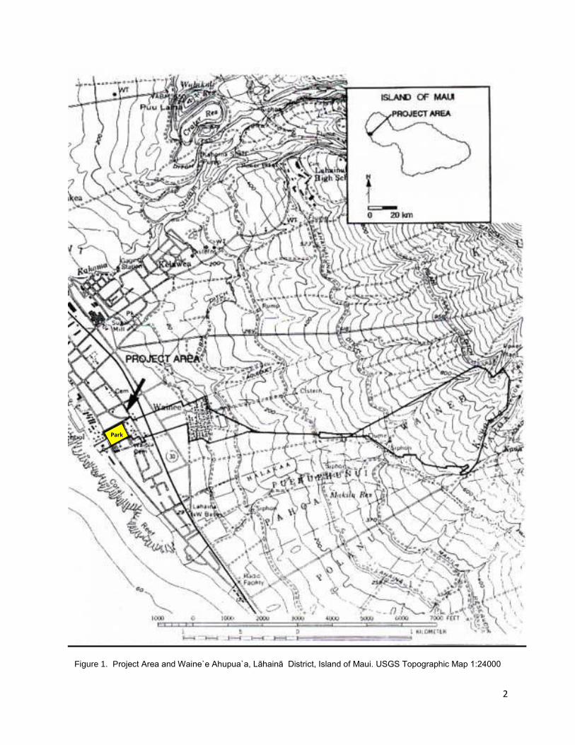
Figure 1. Project Area and Waine`e Ahupua`a, Lāhainā District, Island of Maui. USGS Topographic Map 1:24000
Park

3
INTRODUCTION:
This Interim Report on the data recovery efforts at the site of Moku`ula thus far, has
been prepared at the request of the Friends of Moku`ula, Inc. (FOM) and as part of the
requirements of the State Historic Preservation Division (SHPD) §13-278 “Rules
Governing Standards for Archaeological data Recovery Studies and Reports.”
The Phase I Archaeological Inventory Survey was conducted in 1993 by Bishop
Museum. Based on their Phase I excavation, a Phase II Archaeology Survey at
Moku`ula was conducted in 1999 using geophysical remote sensing to generate a plan
view of the subsurface anomalies and cultural data across the site (Klieger 1999)
focusing on delimiting the boundaries of Moku`ula Island and Loko o Mokuhinia. The
project outlined in the final DRP represents only the initial phase of the data
recovery work necessary to restore Moku`ula .
§13-278-3 – SPECIFIC DATA RECOVERY PLAN GOALS AND OBJECTIVES:
Identify Historic properties to be studied
STUDY AREA: 20°52’24” N – 156°40’39” W The area referred to as “the site” in this
Interim Report is on both the National and State Inventory of Historic Places (SIHP #50-
50-03-2967). Additionally, the royal residence of Kauikeaouli (Kamehameha III) lies
within the Lāhainā Historic District and, as such, is administered by the Maui County
Culture Resource Commission (CRC). The site includes the pre- and post-contact
structures of Moku`ula, Loko o Mokuhinia and Hale Piula (TMK 2-4-6-07: Parcels 01,
02, 35, 36, 38 & 41 and TMK 2-4-02: Parcel 23). Previous excavation units and shovel
test pits were place 10 m apart in an attempt to determine the scope of the site (Bishop
Museum 1993, 1999); the current data recovery efforts build on previously
excavated units N20E26-28 located on TMK 2-4-6-07: Parcel 02.
Located in Lāhainā on the Island of Maui, the site lies near the intersection of Front and
Shaw streets (the original site has been bisected by Front Street) and today, what
remains of the larger site lies under portions of Malu`ulu o Lele and Kamehameha Iki
County Parks. Once a 17+acre well-managed wetland, replete with kalo lo`i and loko
i`a, approximately nine acres remains relatively intact beneath layers of early 20th
century fill. The portion of the site to be affected by this excavation lies under Malu`ulu
o Lele Park. This park is bordered by Mokuhinia Street to the North, Shaw Street to the
South, Front Street to the West and a rock wall belonging to Wai`ola Church to the East
.

4
Figure 2: Ariel photo of Malu`ulu o Lele and Kamehameha Iki County Parks
The project area is relatively flat having an average elevation of 1 meter (3.3ft) AMSL
and the soils underlying the “modern” fill events are Ewa Silty Loam (EaA).
Excavations conducted by Bishop Museum in 1995, uncovered water under the fill
layers which, according to their report, “…seemed to be fresh and abundant” (p. 334).
Of supreme interest to Hawaiians, the archaeological investigation and subsequent
planned restoration of Moku`ula will also be of interest to many non-Hawaiians. Shortly
after the first European contact, whaling ships and other interested parties began
arriving from as far away as Nantucket and the “Venice of the Pacific” soon became
known as “Rotten Row” due to its numerous bars and raucous patrons. Over time the
whaling industry subsided and a new extractive industry took hold – industrial
plantations. Waters were diverted from Lāhainā, in the service of sugar production, and
the Mokuhinia ponds and wetlands became a stagnant breeding ground for newly
introduced mosquitoes. In 1914, plantation managers had the site drained and filled
and this once most sacred site became a baseball diamond for plantation workers.
Archaeological investigations conducted by Bishop Museum in 1993 confirm the
existence of Moku'ula, the royal residences and mausoleum, and Mokuhinia, a large
spring fed natural wetland containing kalo lo`i (taro patches) and loko `ia (fishponds).
Carbon dating of organic materials recovered has revealed some of the earliest
evidence of human habitation in Hawai`i c. 700 AD.

5
Figure 3: The site of Moku`ula and Loko o Mokuhinia (www.mokuula.com)
Identify data needed to address research objectives
Research objectives:
1. What kinds of cultural materials are contained in the two distinct fill levels
capping the site? What can they tell us about early 20th century life in
Lāhainā ?
In a letter dated January 25, 1996 from Don Hibbard (then Administrator at the SHPD)
to Dr. Paul Christian Klieger (then with the Bishop Museum Anthropology Department)
regarding the Historic Preservation Review of a Draft Report on Archaeological
Investigations at Moku`ula (TMK 4-6-07: 1, 2 and 36) he commends their overall efforts
but has legitimate concerns regarding the Post-Contact Artifact Analysis section of the
report (Chapter 9). According to Hibbard,
“This chapter contains plenty of general background information on various
artifact categories and the classification system that was used in the analysis.
However, it lacks any in-depth discussion of artifact occurrences by unit, layer or
level… For example, is there any artifact group that occurred only in fill layers?
Where did the porcelain rice bowl sherds occur in relation to the pearl ware and
the blue-tinted white ware sherds? Is there a discernable pattern in artifacts

6
within the island area vs. the pond sediments? Without some examination of
artifact patterning across the site, it is difficult to determine what, if anything,
these artifacts are telling us about site use during and after Kamehameha III’s
residency.” (SHPD LOG NO: 15946; DOC NO: 9511KD23),
In addition to recovering materials via traditional excavation techniques, this data
recovery plan is specifically designed to address questions raised regarding what – if
anything – artifact patterning within units, layer and/or level can tell us about the use of
the site. By gathering a range of spatial data – including the individual provenience of
each artifact uncovered – we plan to address these questions.
2. How much of the site architecture is in situ (intact) beneath the 1914
cultural fill layers? In what ways can existing architecture inform any
future reconstruction of Moku`ula and Mokuhinia?
This question is in the process of being answered via the systematic removal of the “modern” fill layers and mapping in of all features exposed during the fill removal process. According to the report on the Phase II Archaeological Survey at Moku`ula: King Kamehameha III’s Royal residence, Lāhainā , Maui, prepared for FOM by Dr. Susan Lebo and Dr. P. Christian Klieger in 1999:
“The actual boundaries of the Island of Moku'ula still remain unknown. Insufficient data have been obtained to correlate the nineteenth-century "perimeter" basalt wall with the spatial boundaries of the island. While wall segments were found during Phase I excavations, it is only presumed that such a feature completely encircled the island-in fact, no documents have been found to prove that a wall girdled Moku'ula.
Other pertinent features of the site, such as causeways and holding ponds, have also not been fully identified. The data obtained from historical and archaeological investigations (Phases I and 11) are suggestive, but not definitive. In addition, the island as depicted or described in nineteenth century sources may differ from the archaeological record.”
According to Dr. Susan Lebo, there may be more fishpond walls than previously believed, underscoring the need to continue gathering historic information and archaeological data to create a better understanding of Moku`ula. In the Phase II report, Lebo and Klieger recommend that any Phase III excavations begin and at known wall segments identified in the Phase I AIS, such as those found in N20, E1, and that excavation be used to “…uncover the upper limits of the cultural deposits dating to the 19th century…” (Lebo and Klieger 1999).
The field school efforts follow Dr. Lebo’s suggestion and, after shovel-skimming the post-1993 fill, three new, contiguous 1x1 meter units immediately adjacent to Feature 11 were opened.. As of October 22, 2010 there have been a total of 39, 1 x 1 meter
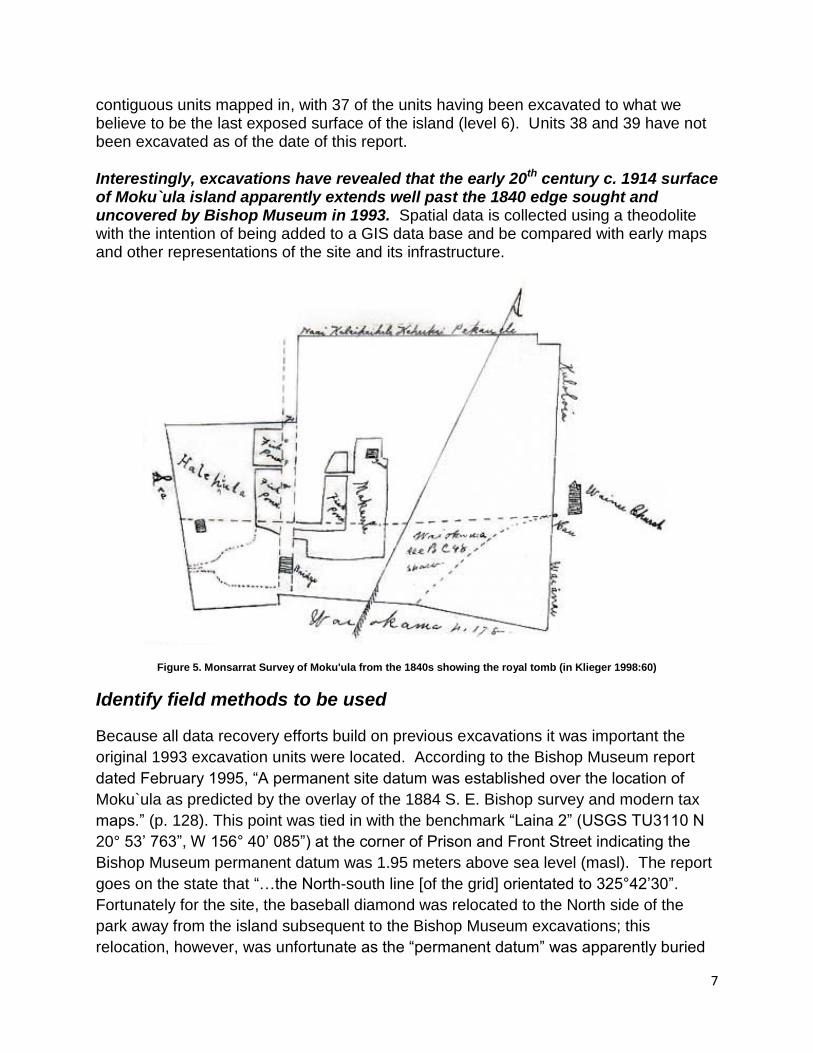
7
contiguous units mapped in, with 37 of the units having been excavated to what we believe to be the last exposed surface of the island (level 6). Units 38 and 39 have not been excavated as of the date of this report.
Interestingly, excavations have revealed that the early 20th century c. 1914 surface of Moku`ula island apparently extends well past the 1840 edge sought and uncovered by Bishop Museum in 1993. Spatial data is collected using a theodolite with the intention of being added to a GIS data base and be compared with early maps and other representations of the site and its infrastructure.
Figure 5. Monsarrat Survey of Moku'ula from the 1840s showing the royal tomb (in Klieger 1998:60)
Identify field methods to be used
Because all data recovery efforts build on previous excavations it was important the
original 1993 excavation units were located. According to the Bishop Museum report
dated February 1995, “A permanent site datum was established over the location of
Moku`ula as predicted by the overlay of the 1884 S. E. Bishop survey and modern tax
maps.” (p. 128). This point was tied in with the benchmark “Laina 2” (USGS TU3110 N
20° 53’ 763”, W 156° 40’ 085”) at the corner of Prison and Front Street indicating the
Bishop Museum permanent datum was 1.95 meters above sea level (masl). The report
goes on the state that “…the North-south line [of the grid] orientated to 325°42’30”.
Fortunately for the site, the baseball diamond was relocated to the North side of the
park away from the island subsequent to the Bishop Museum excavations; this
relocation, however, was unfortunate as the “permanent datum” was apparently buried

8
under several large rocks in the process (Figure 6 – p. 119 of the Bishop Museum’s
Final 1995 report).
Figure 6: To scale map from the Bishop Museum Final Report showing the location of previous excavation units, trenches
and shovel test pits at Moku`ula

9
Figures 7 & 8 USGS Benchmark TU3104 and the flag pole in front of the Old Lahaina Courthouse
Beginning in summer 2009, UH Maui CC students began mapping Moku`ula using a
Topcon GTS-225 laser theodolite electronic measuring device (EDM). In order to attach
the existing modern infrastructure at the site, i.e., tennis courts, restrooms, etc. to the
USGS grid, we set up over USGS benchmark TU3104 N 20° 52’ 293”, W 156° 40’ 688”
Altitude 0, located by the flagpole directly in front of the Old Lahaina Courthouse (figs. 7
& 8) and by back sighting we tied this benchmark to a new “permanent datum” already
in place at the site - a sawn off telephone pole set in cement located on top of the island
(figs. 9 & 10).
Figure 9 UH-Maui CC permanent datum looking South Figure 10 UH-Maui CC permanent datum looking North
10
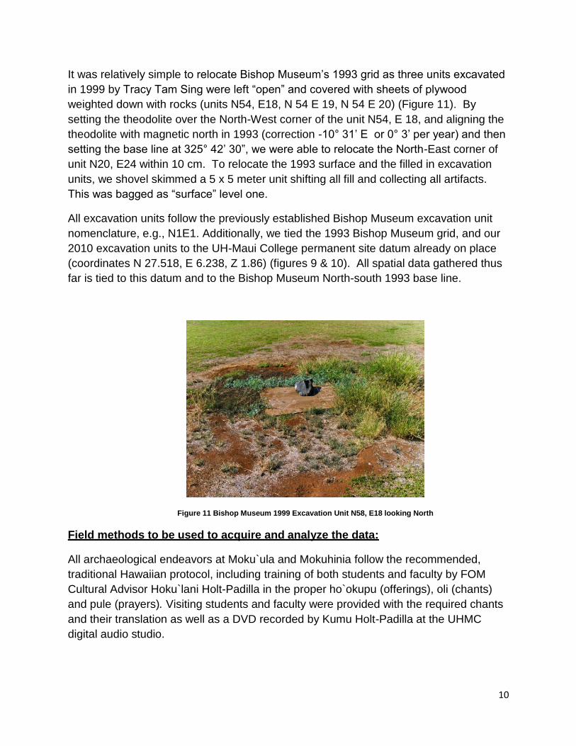
It was relatively simple to relocate Bishop Museum’s 1993 grid as three units excavated
in 1999 by Tracy Tam Sing were left “open” and covered with sheets of plywood
weighted down with rocks (units N54, E18, N 54 E 19, N 54 E 20) (Figure 11). By
setting the theodolite over the North-West corner of the unit N54, E 18, and aligning the
theodolite with magnetic north in 1993 (correction -10° 31’ E or 0° 3’ per year) and then
setting the base line at 325° 42’ 30”, we were able to relocate the North-East corner of
unit N20, E24 within 10 cm. To relocate the 1993 surface and the filled in excavation
units, we shovel skimmed a 5 x 5 meter unit shifting all fill and collecting all artifacts.
This was bagged as “surface” level one.
All excavation units follow the previously established Bishop Museum excavation unit
nomenclature, e.g., N1E1. Additionally, we tied the 1993 Bishop Museum grid, and our
2010 excavation units to the UH-Maui College permanent site datum already on place
(coordinates N 27.518, E 6.238, Z 1.86) (figures 9 & 10). All spatial data gathered thus
far is tied to this datum and to the Bishop Museum North-south 1993 base line.
Figure 11 Bishop Museum 1999 Excavation Unit N58, E18 looking North
Field methods to be used to acquire and analyze the data:
All archaeological endeavors at Moku`ula and Mokuhinia follow the recommended,
traditional Hawaiian protocol, including training of both students and faculty by FOM
Cultural Advisor Hoku`lani Holt-Padilla in the proper ho`okupu (offerings), oli (chants)
and pule (prayers). Visiting students and faculty were provided with the required chants
and their translation as well as a DVD recorded by Kumu Holt-Padilla at the UHMC
digital audio studio.

11
The excavation related activities at Moku`ula began on March 20, 2010 and the data
recovery efforts are still ongoing. In the spring 2010 semester, the class was held every
Saturdays (ending on April 28th ) with a total of 7 students enrolled (FOM Moku`ula staff
also participated in the training).
Dr. Janet Six is the Principal Investigator and is employed as a lecture in anthropology
by UHMC. She is the owner-operator of Sixth Sense Archaeological Consultants LLC,
and a Registered Professional Archaeologist continuously licensed by the State of
Hawai`i DLNR since 2004. She has a Ph.D. in Anthropology from the University of
Pennsylvania and specializes in post-contact or Historical Archaeology in Hawai`i.
Other Key Personnel Involved:
On May 17, the UHMC-NYU joint field school began. This portion of the data recovery
effort ran five days a week for five weeks ending on 6/17. Key personnel for this portion
included: Dr. Pamela Crabtree, Professor, New York University (NYU), Dr. Douglas
Campana, Research Associate NYU, and Kelila Jaffe Ph.D candidate in Anthropology
at NYU. Dr. Crabtree is a renowned archaeo-zoologist (animal bone specialist) and Dr.
Campana is an expert at gathering and displaying spatial data. Ms. Jaffe, holds a
Masters Degree from the University of Auckland, NZ, and has worked extensively on
archaeological sites in Hawai`i and the Pacific, specializing in foodways including
extensive analysis of shell middens. There were four students enrolled in the 6 credit
course.
On July 12th, Dr. Karen Holmberg joined the project for a two week period functioning in
the capacity of Site Supervisor. Dr. Holmberg, then a Post-doc at Brown University, RI,
presently a lecturer in Anthropology at Stanford University, CA, is an expert of the
archeology of volcanoes and has worked at important cultural sites including Pompeii.
Dr. Holmberg was joined onsite by her colleague, J. R. Stok, a Ph.D. candidate in
geology at Brown University who was in the islands conducting research on Hawai`i
Island’s volcanoes. Mr. Stok worked as a crew member on the site from 7/21-7/23.
This portion of the data recovery efforts ended August 6, 2010. The project also
benefited over the summer from the volunteer efforts of UH Hilo graduate, Curtis
Robinson (BA in Anthropology); Oahu CRM archaeology technician Rose Runnion (BA
anthropology) who is presently employed by Cultural Surveys’ Hawai`i Oahu office; and
UHMC student and field school veteran, Joël Yurkanin.
The fall semester class began on August 27, 2010 and is held every Friday from 8:30 to
2: 30 with a total of 12 students (the maximum allowed) currently enrolled. Both Curtis
Robinson and Joël Yurkanin are volunteering their time and expertise to serve as
informal teaching assistants and on site supervisors.
12
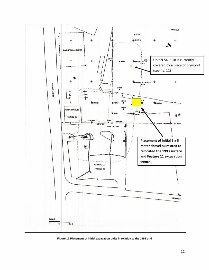
Figure 12 Placement of initial excavation units in relation to the 1993 grid
Placement of initial 5 x 5
meter shovel-skim area to
relocated the 1993 surface
and Feature 11 excavation
trench.
Unit N 54, E 18 is currently
covered by a piece of plywood
(see fig. 11)
13
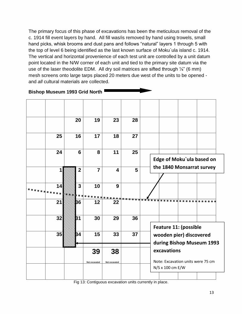
The primary focus of this phase of excavations has been the meticulous removal of the
c. 1914 fill event layers by hand. All fill was/is removed by hand using trowels, small
hand picks, whisk brooms and dust pans and follows “natural” layers 1 through 5 with
the top of level 6 being identified as the last known surface of Moku`ula island c. 1914.
The vertical and horizontal provenience of each test unit are controlled by a unit datum
point located in the N/W corner of each unit and tied to the primary site datum via the
use of the laser theodolite EDM. All dry soil matrices are sifted through ¼” (6 mm)
mesh screens onto large tarps placed 20 meters due west of the units to be opened -
and all cultural materials are collected.
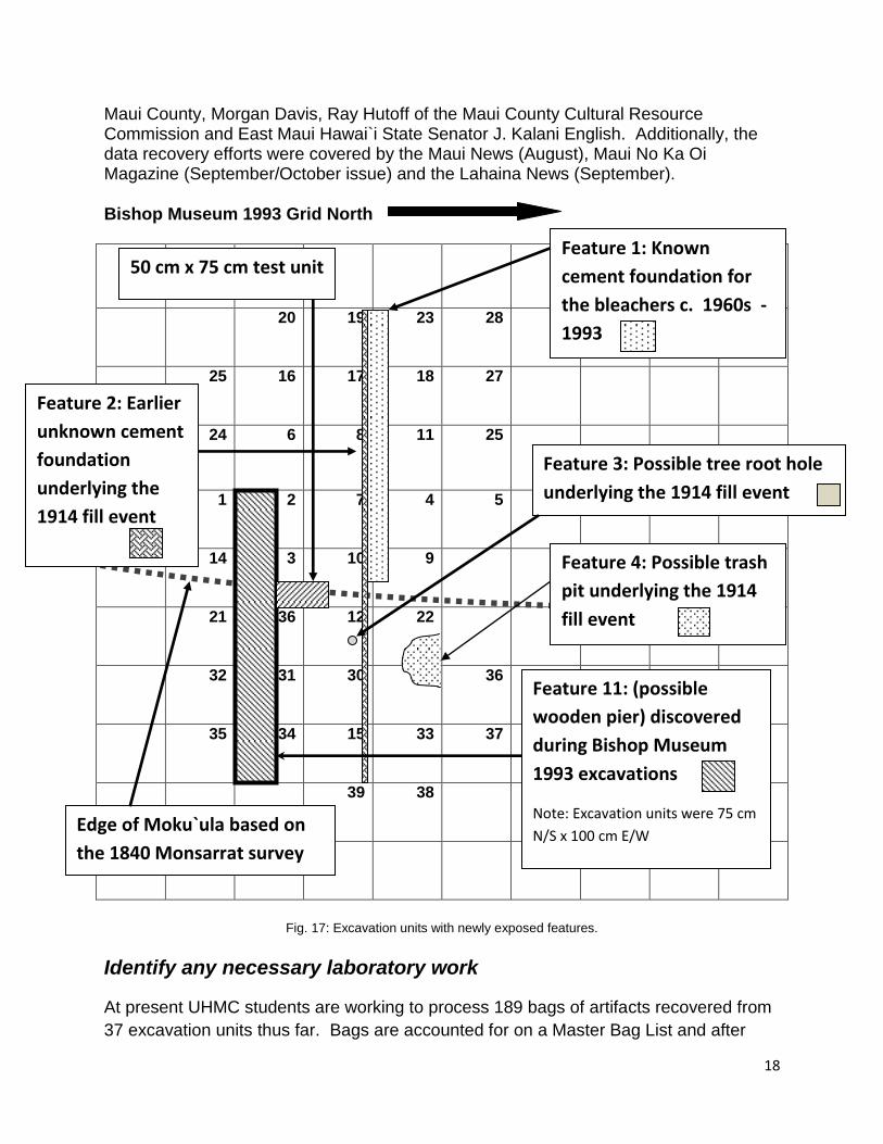
Bishop Museum 1993 Grid North
20 19 23 28
25 16 17 18 27
24 6 8 11 25
1 2 7 4 5
14 3 10 9
21 36 12 22
32 31 30 29 36
35 34 15 33 37
39
Not excavated
38
Not excavated
Fig 13: Contiguous excavation units currently in place.
Edge of Moku`ula based on
the 1840 Monsarrat survey
Feature 11: (possible
wooden pier) discovered
during Bishop Museum 1993
excavations
Note: Excavation units were 75 cm
N/S x 100 cm E/W
14
All recording efforts follow standard archaeological procedures and practice including:
plan view drawings of ground prior to excavation, at the surface of each natural,
stratigraphic layer, and at the base of each unit; all profiles will be drawn for all units
including ones indicating stratigraphic anomalies and/or features; high resolution digital
photographs have been taken in both black and white and color of the opening and
closing surface of each unit, the top of each natural stratigraphic level, and all
anomalies and/or features; the three dimensional piece provenience1 or NEZ (Northing,
Easting and Elevation) of each artifact found in situ are recorded using the theodolite,
while cultural materials (middens, artifacts and ecofacts) recovered in the screens will
be bagged according to the layer and unit recovered for later analysis (fig. 13).
Cultural materials are bagged and have been accessioned onto a master bag list for
tight inventory control. At present, there are 189 bags of artifacts being processed by
UHMC students enrolled in ANTH 210L (Archaeology Laboratory Methods) this fall.
Subsurface features were recorded using sequential numerical designations and are
numbered in the order they are found. Detailed soil/sediment descriptive information,
e.g., Munsell number (color), sand grain size, texture, consistence (dry, wet, moist),
estimated percentage of rock inclusions, boundary topography, and the presence of
natural and/or cultural remains, etc., were recorded for each natural level located within
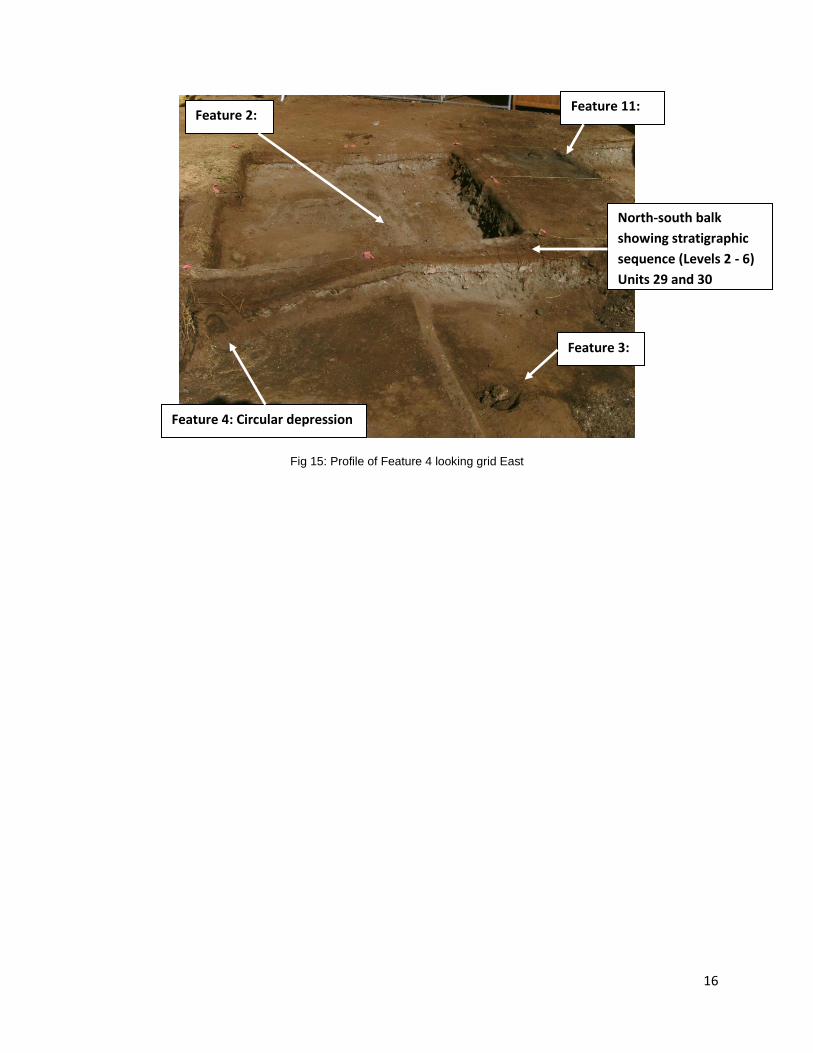
each excavation unit. A total of four new features were discovered
Feature 1: This is a cement foundation and are the remains of the baseball stadium
bleachers which were relocated subsequent to the 1993 excavations (fig. 14).
Feature 2: Is a cement foundation/curbing that parallels, but is not associated with
Feature 1. Feature 2 pre-dates the 1914 fill event, lying beneath level 5 and seems to
be associated with the pre-fill surface of 20th century Moku`ula Island (level 6).
1 1 In North American archaeology, and to a lesser extent in anthropological archaeology throughout the world, the term provenience is used
instead of the more widely used term provenance. Usually the two terms are synonymous; however, some researchers use provenience to refer only to the exact location in a site where an artifact was excavated, in contrast to provenance which includes the artifact's complete documented history. http://en.wikipedia.org/wiki/Provenance.

15
Fig. 14: Close up of approximately a one meter section of Feature 1 and Feature 2
Feature 3: Is a circular feature that appears to be a remnant of a decomposed tree
root/stump. It was excavated separately and yielded no cultural artifacts. At present
the feature is filled with large coral chunks as a precautionary strategy.
Feature 4: Is a circular depression that clearly underlies the 1914 fill. It has modern
artifacts, such as rubber tool handles (possibly a screwdriver or ice pick) and appears to
be a early 20th century trash pit (fig. 15).
Feature 2: the pre-1914
cement curbing/foundation
Feature 1: Known
cement bleacher
foundation
16
Fig 15: Profile of Feature 4 looking grid East
Feature 11:
North-south balk
showing stratigraphic
sequence (Levels 2 - 6)
Units 29 and 30
Feature 2:
Feature 3:
Feature 4: Circular depression
17
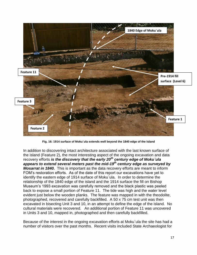
Fig. 16: 1914 surface of Moku`ula extends well beyond the 1840 edge of the Island
In addition to discovering intact architecture associated with the last known surface of the island (Feature 2), the most interesting aspect of the ongoing excavation and data recovery efforts is the discovery that the early 20th century edge of Moku`ula appears to extend several meters past the mid-19th century edge as surveyed by Mosarrat in 1840. This is important as the data recovery efforts are meant to inform FOM’s restoration efforts. As of the date of this report our excavations have yet to identify the eastern edge of 1914 surface of Moku`ula. In order to determine the relationship of the 1840 edge of the island and the 1914 surface the fill on Bishop Museum’s 1993 excavation was carefully removed and the black plastic was peeled back to expose a small portion of Feature 11. The tide was high and the water level evident just below the wooden planks. The feature was mapped in with the theodolite, photographed, recovered and carefully backfilled. A 50 x 75 cm test unit was then excavated in bisecting Unit 3 and 10, in an attempt to define the edge of the island. No cultural materials were recovered. An additional portion of Feature 11 was uncovered in Units 3 and 10, mapped in, photographed and then carefully backfilled.
Because of the interest in the ongoing excavation efforts at Moku`ula the site has had a number of visitors over the past months. Recent visits included State Archaeologist for
Feature 3
Feature 2
Feature 1
Feature 11 Pre-1914 fill
surface (Level 6)
1840 Edge of Moku`ula
18
Maui County, Morgan Davis, Ray Hutoff of the Maui County Cultural Resource Commission and East Maui Hawai`i State Senator J. Kalani English. Additionally, the data recovery efforts were covered by the Maui News (August), Maui No Ka Oi Magazine (September/October issue) and the Lahaina News (September).
Bishop Museum 1993 Grid North
20 19 23 28
25 16 17 18 27
24 6 8 11 25
1 2 7 4 5
14 3 10 9
21 36 12 22
32 31 30 29 36
35 34 15 33 37
39 38
Fig. 17: Excavation units with newly exposed features.
Identify any necessary laboratory work
At present UHMC students are working to process 189 bags of artifacts recovered from
37 excavation units thus far. Bags are accounted for on a Master Bag List and after
Feature 11: (possible
wooden pier) discovered
during Bishop Museum
1993 excavations
Note: Excavation units were 75 cm
N/S x 100 cm E/W
Feature 1: Known
cement foundation for
the bleachers c. 1960s -
1993
Feature 2: Earlier
unknown cement
foundation
underlying the
1914 fill event
Feature 3: Possible tree root hole
underlying the 1914 fill event
Feature 4: Possible trash
pit underlying the 1914
fill event
Edge of Moku`ula based on
the 1840 Monsarrat survey
50 cm x 75 cm test unit

19
processing will be returned to FOM for storage. The vast majority of materials
recovered from the site are non-cultural marine-based life forms, coral, shells, etc.,
deposited on the site as a result of the expansion and dredging of Lahaina Harbor in the
early 20th century. Cultural materials recovered range from beer pull taps and bottle
caps c. 1993 found under the bleacher area to historic ceramics and glass dating to the
time of the 1914 fill event. A comprehensive list of materials recovered will be included
in the Final Report.
Fig 18: UHMC students Ikaika Kapu and Roger Luna excavate the balk between Units 29 and 33
REFERENCES USED:
Klieger, P. Christian. Moku`ula: Maui's Sacred Island. Klieger, P. Christian (1999). Bishop Museum Press, 1999
Lebo, Susan and Klieger, P. C. Phase II Archaeology Survey at Moku`ula: King Kamehameha III’s Royal residence, Lāhainā , Maui, Final Report Prepared by Bishop Museum, 1999


![[REDACTED] FINAL TECHNICAL REPORT, PHASE I (INTENSIVE ... · impacting the site. If avoidance is not feasible, PALrecommendsa Phase III archaeological data recovery program to mitigate](https://img.dokumen.tips/doc/110x75/603cb17f0f2559406913330e/redacted-final-technical-report-phase-i-intensive-impacting-the-site-if.jpg)