Embed Size (px)
Citation preview

ARAGATS STRATOVOLCANO IN ARMENIA – GEOLOGICAL
HISTORY AND SPECIFIC ERUPTION PRODUCTS.
DR. KHACHATUR MELIKSETIAN,
DEPUTY DIRECTOR FOR SCIENCE, HEAD OF LABORATORY OF VOLCANOLOGY,
INSTITUTE OF GEOLOGICAL SCIENCES,
ARMENIAN NATIONAL ACADEMY OF SCIENCES
Make things as simple as possible, but not simpler.
Albert Einstein

WHAT IS VOLCANISM?
Generally speaking volcanism is eruption of molten rocks (lava) onto the
Earth surface through a break in the surface called a vent (volcano or a
fissure)
Volcanic phenomena are the surface manifestations of large scale
geological processes that develop at significant depths within the Earth
over prolonged periods of time.
Pacaya volcano, Guatemala

WHAT CAUSES VOLCANISM?
Volcanism occurs at the boundaries of the Earth's tectonic plates which are
a series of large blocks moving between each other, but also within
tectonic plates (intraplate volcanism)

WHAT CAUSES VOLCANISM IN
OUR REGION?
Volcanism in Armenia, eastern Turkey, north west Iran and south Georgia
is related to collision of Arabia with Eurasia occurred about 25 million
years ago during geological period called Early Miocene. Arabian plate is
still moving to the north, about 20 mm year-1 and this stress causes
volcanism and earthquakes in the entire region

IS VOLCANISM DANGEROUS ?
Violent explosive eruptions are most dangerous ones, for instance
Mount Tambora eruption in Indonesia in 1815 killed 92,000 people. Volcano explosivity index (VEI), or magnitude of this eruption was 7, which is estimated to be equivalent of explosion of 800 megatons TNT)
Famous 79 AD eruption of Mount Vesuvius killed 18,000 people.
Violent explosive eruptions (VEI=6-10) may dramatically affect the climate due to effect of “volcanic” winter. Such an events are abundant in geological history of the Earth. Yellowstone caldera eruption (VEI=10) 650,000 years ago resulted Ice Age on the Earth that lasted until Holocene (11,700 years) when climate become warmer this period is also marked by important event in human prehistory - transition from hunting to early farming in the region of big Near East

A LINK BETWEEN VOLCANISM
AND TEPA-2014 CONFERENCE
Besides conference venue and research center located on Aragats
volcano another link between TEPA-2014 and volcanism is
phenomena known as volcanically induced lightning. Explosive
eruptions usually cause dozens of strong lighting strikes in and
around eruption column. This effect is one of the known
atmospheric phenomena of volcanic eruptions.
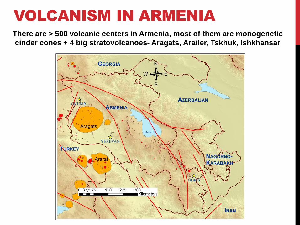
There are > 500 volcanic centers in Armenia, most of them are monogenetic
cinder cones + 4 big stratovolcanoes- Aragats, Arailer, Tskhuk, Ishkhansar
VOLCANISM IN ARMENIA

SPECIFIC FEATURES OF
ARAGATS VOLCANO:
One of the largest volcanoes in the entire region
Aragats and surrounding volcanic plateaus comprise Aragats volcanic
province (AVP), covering an area of 5000 km2
Period of activity of Aragats is more than 1 million years
Last volcanic eruptions took place about 0.5 million years ago
Aragats volcano produced several devastating explosive eruptions
(VEI=5) during it’s activity period (tuffs or ignimbrites)
Estimated total volume of erupted products is about 900 km3

STRUCTURE OF ARAGATS VOLCANO
Aragats volcano appears as an oval shield
Crater of Aragats volcano is surrounded by 4 peaks, northern peak, the highest is 4090 high above the sea level
Glacial activity and related exaration play significant role in the modern landscape of the volcano. Volcano is cut by up to 400 m deep glacial valleys (now river gorges). Crater of volcano is also glaciated and appears as a glacial cirqus.
Geological map of Aragats volcano

ERUPTION PRODUCTS OF
ARAGATS
Lavas erupted from Aragats volcano range in compositions
from basaltic trachyandesites to trachydacites based on total
alkalis vs. silica classification of volcanic rocks.

CURRENT STUDIES OF ARAGATS VOLCANO
We focus on dating of volcanic eruption products, geological mapping,
reconstruction of geologic history of volcano (volcano-stratigraphy)
Geological map of Aragats volcano Stratigraphy of Aragats volcano

AGE OF ERUPTIONS OF ARAGATS DETERMINED
BY K-Ar AND 40
Ar/39
Ar ISOTOPE DATING
METHODS
The earliest volcanism related to Aragats stratovolcano itself is dated to
1,543,000±24,000 years
Youngest volcanic activity for central edifice of Aragats is 520,000 ± 10,000 years
Youngest volcanic activity from side vents (Tirinkatar, Irind, Ashtarak) is dated to
450,000±23,000 years, 490,000±11,000 and 582,000±15,000 respectively.
Plinian fall deposit at Irind volcano, south slopes of
Aragats.
Southern and western summits of Aragats and dacite
dome near the lake

STUDY OF GEOCHEMICAL FEATURES TO RECONSTRUCT ORIGIN
AND SPECIFIC FEATURES OF MAGMA GENERATION AND DEPTHS
BENEATH ARAGATS
Major and trace element geochemistry and
radiogenic isotope geochemistry

IS THERE VOLCANIC HAZARD IN ARMENIA?
Yes there is, since volcanic systems that were active during last
upper Quaternary (last 120,000 years) are considered to be
potentially active, while systems active in Holocene (last 11,700
years) are considered to be active. But Aragats is considered to be
extinct volcano, since last activity is dated to 0.5 million years.
Nazeli volcano, Syunik volcanic upland, 7,350 years old,
dated by He3 cosmogenic isotope dating method.
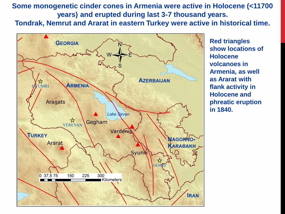
Some monogenetic cinder cones in Armenia were active in Holocene (<11700
years) and erupted during last 3-7 thousand years.
Tondrak, Nemrut and Ararat in eastern Turkey were active in historical time.
Red triangles
show locations of
Holocene
volcanoes in
Armenia, as well
as Ararat with
flank activity in
Holocene and
phreatic eruption
in 1840.

Armenian Nuclear power plant
Dashtakar group of monogenetic volcanoes
Atomakhumb group of monogenetic volcanoes
VOLCANIC HAZARD ASSESEMENT OF
ARMENIAN NUCLEAR POWER PLANT

Distribution of volcanoes in 300 km zone around ANPP
The Armenian Nuclear Power Plant (ANPP) is located in a region of Quaternary (<1.8 Ma) and Holocene-Historical (<11.7 Ka) volcanism. Because of this fact, volcanic hazards potentially exist for facilities at the ANPP site, and these hazards must be evaluated in a quantitative way according to IAEA safety guide SSG-21

• International consortium was founded in 2009 to
assess seismic and volcanic hazards for new nuclear
power station site in Armenia (near existing station)
• Consortium Members:
• Georisk CJSCo, Armenia
• Institute of Geological sciences, Armenia (IGS ANAS)
• University of South Florida, USA
• University of Leeds, UK
• Expert council members – leading seismologists and
volcanologists from USA, France, Italy.

Volcanic hazard assessment • Armenian nuclear power station is first one, for which volcanic
hazards evaluated according to IAEA DS-405 draft safety guide (2011
revision), now accepted as SSG-21 IAEA Safety Guide

Reviews of volcanic hazard assessment of
ANPP by IAEA missions in 2010 and 2011
IAEA review missions recognized volcanic hazard
assessment of Armenian nuclear power plant as an
example work and invited our team members to
develop official IAEA guidelines and technical
documentation for volcanic hazard assessment of
nuclear installations. This work will be published by
the end of this year.

THANK YOU FOR YOUR ATTENTION
Crater of Aragats volcano