Embed Size (px)
Citation preview

APS Freedom to Willis 69kV Power Line Siting Study Open House
Welcome! Please sign in.

• Identify a route alignment for a new 69kV powerline, connecting the new Freedom Substation (located at South Tuthill Road and West Broadway Road) to the Willis Substation (located at South Rainbow Valley Road and West Willis Road)
• Portions of the proposed Project that follow existing 69kV powerlines would be constructed as “double-circuit”, meaning both powerlines (three wires each) would be consolidated onto one transmission structure alignment
• Portions of the proposed Project that follow existing 12kV powerlines would consolidate and “underbuild” the existing 12kV lines onto the new 69kV poles, meaning the 69kV circuit(s) would be on top and the 12kV circuit would be on bottom
• APS is in the early stages of the planning process and is conducting a public siting study and public agency outreach prior to identifying a preferred powerline route
Project Overview

Project Need• Provide additional 69kV power source, allowing the system to serve increased electrical load within existing and new developments of the region
• Improve reliability in the area by adding additional 69kV facilities, strengthening the regional electrical system, and helping to prevent potential outages
Project Description• A new 69kV powerline, up to approximately 12miles in length, from the Freedom Substation (currently under construction) to the existing Willis Substation
• In-Service date of 2022
• A new route will require right-of-way or easement up to 60 feet wide
• Will require construction of new steel monopoles approximately 65 feet tall
□ Portions of the proposed Project that follow existing 69kV and 12kV powerlines would be consolidated onto one transmission structure alignment
Project Need and Description

Service Layer Credits: Sources: Esri, USGS, NOAASource: Esri, DigitalGlobe, GeoEye, Earthstar Geographics, CNES/Airbus DS, USDA, USGS,AeroGRID, IGN, and the GIS User Community
!!!
!
!
!
!
!
!
!
!
!!
!!
!!
!!
!!
! ! ! ! ! !! ! ! ! ! ! ! ! ! ! ! ! ! ! ! ! ! ! !
!!
!!
!!
!!
!!
!!
!!
!!
!!
!!
!!
!!
!!
!!
!!
!!
!!
!!
!!
!!
!!
!!
!!
!!
!!
!!
!!
!!
!!
!!
!!
!!
!
!
!
!
!
!!!!
!
!
!
!
!
!
!
!
!
!
!
!
!
!
!
!
!
!
!
!
!
!
!
!
!
!
!
!
!
!
!
!
!
!
!
!
!
!
!
!
!
!
!
!
!
!
!
!
!
!
!
!
!
!
!
!
!
!
!
!
!
!
!
!
!
!
!
!
!
!
!
!
!
!
!
!
!
!
!
!
!
!
!
!
!
!
!
!
!
!
!
!
!
!
!
!
!
!
!
!
!
!
!
!
!
!
!
!
!
!
!
!
!
!
!
!
!
!
!
!
!
!
!
!
!
!
!
!
!
!
!
!
!!
!
!!!!!!!!!!!!!!
!
!
#0#0
#0
¬«1
¬«2
¬«3
B
C
")85
Narramore Rd
Tuthill Rd203rd Ave
Elliot Rd
Verrado Way
Jackrabbit Trl
Ray Rd
Beloat Rd
Rainbow Valley Rd
Baseline Rd
Buckeye Canal
Broadway Rd
Southern Ave
195th Ave
Airport Rd
Perryville Rd
Dean Rd
Tuthill Rd
WillisSubstation
FreedomSubstation
A
Basemap: Esri, DigitalGlobe, GeoEye,i-cubed, USDA FSA, USGS, AEX,Getmapping, Aerogrid, IGN, IGP,
swisstopo, and the GIS User CommunityMaricopa County, AZ
N:\Projects\53000\53828_APS_Freedom_to_Willis\MXD\Revised 07012019\53828_StudyAreaBaseMap_revised_0701.mxd - Revised by: MDugan 7/1/2019
Freedom to Willis69kV Power Line
Route Alternatives
Municipal BoundariesCity of Buckeye
City of Goodyear0 0.5 1
Miles
0 2,000 4,000Feet
Gila River
Gila River
Waterman Wash
Waterman Wash
PINAL
¬«303
¬«202
MARICOPA
PINAL
YAVAPAI
YUMA
LA PA
Z
§̈¦8
£¤60
§̈¦10
¬«85
§̈¦17
T 1
NR 3 W
T 1
ST 1 N
T 2
S
R 3 W R 2 W
T 2 ST 1 S
R 2 W
Regional Area Map
±
69kV Potential RoutesBlue RouteOrange RouteGreen RouteOption RouteMaricopa County, Arizona
Railroad
Land OwnershipBLM
Private
State
Reference FeaturesStudy Area
Highway
Street
Transmission Facilities#0 Existing Substation
! !
Existing 69kVTransmission Line

ElectricityFrom the Power Plant to the Customer
Power PlantPlant Substation
500kV Transmission Lines
Customer
500kV/230kVSubstation
230kV/69kVSubstation
69kV/12kV(Distribution)Substation
230kVTransmission Lines
69kV Sub-transmission Lines12kV Distribution Lines
(Overhead and Underground)

Double-circuit 69kV with12kV Underbuild Structure
Single-circuit 69kV Structures
Heights and widths may vary according to terrain
Double-circuit 69kV with 12kV Underbuild
Turning Structure
Typical 69kV Structures
Single-circuit 69kV with 12kV under-build structure Double-circuit 69kV with 12kV under-build structure
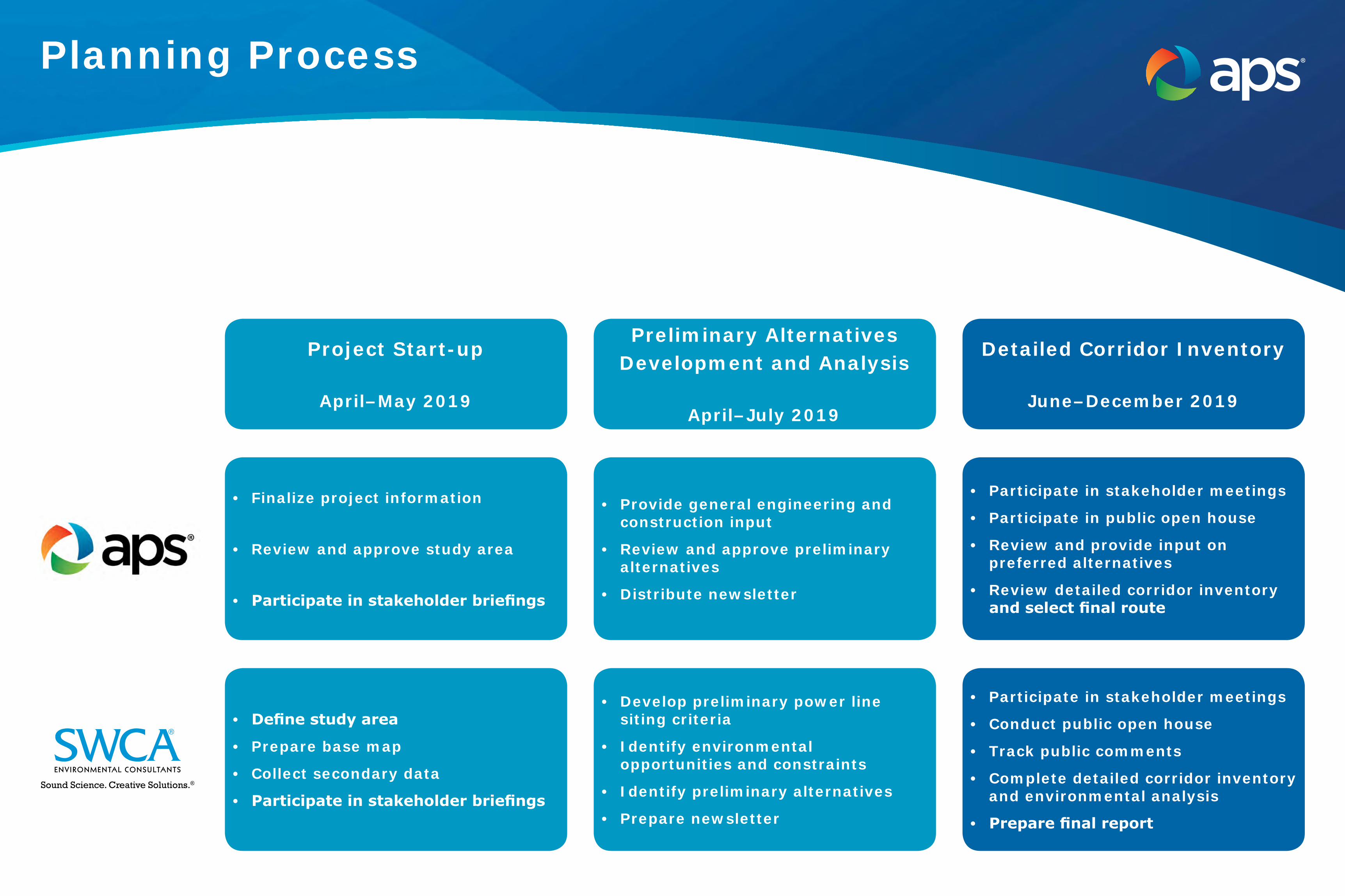
Preliminary Alternatives Development and Analysis
April–July 2019
Detailed Corridor Inventory
June–December 2019
Project Start-up
April–May 2019
• Provide general engineering and construction input
• Review and approve preliminary alternatives
• Distribute newsletter
• Participate in stakeholder meetings
• Participate in public open house
• Review and provide input on preferred alternatives
• Review detailed corridor inventory and select final route
• Finalize project information
• Review and approve study area
• Participate in stakeholder briefings
• Develop preliminary power line siting criteria
• Identify environmental opportunities and constraints
• Identify preliminary alternatives
• Prepare newsletter
• Participate in stakeholder meetings
• Conduct public open house
• Track public comments
• Complete detailed corridor inventory and environmental analysis
• Prepare final report
• Define study area
• Prepare base map
• Collect secondary data
• Participate in stakeholder briefingsSound Science. Creative Solutions.®
Planning Process

Completed
• Initial stakeholder briefings
• Identification of environmental opportunities and constraints
• Initial environmental analysis
• Alternative route identification
Next Steps
• Collect, respond, and document public and stakeholder comments
• Complete detailed analysis and route comparison
• Select final route in late 2019
• Final newsletter to announce selected route
Planning ProcessCompleted Steps and Next Steps

• Identify opportunities and constraints through evaluation of environmental resources within the study area.
• Conduct an analysis of land use and environmental resource sensitivities to construction, operation, and maintenance of the 69kV transmission line.
□ Objectives:
» Minimize impacts to sensitive resource areas: 9 Wildlife habitat 9 Schools 9 Residences
» Maximize siting opportunities: 9 Collocate/parallel existing distribution/transmission lines 9 Road rights-of-way/easements
Preliminary Siting Criteria

OpportunitiesOpportunities Opportunity LevelOverhead Transmission Corridor HighOverhead 12kV Distribution Power Line HighExisting Railroad Crossing HighArterial Roadway HighMinor Roadway ModerateUtility Facility Moderate
Existing Land Use and Visual Resource ConstraintsConstraints Sensitivity LevelRural Residential Zoning HighPlanned Residential Zoning HighPlanned Community Zoning HighSubdivision: Under Construction HighSchool and Education Facilities HighParks HighLandownership: Federal HighLandownership: State HighTransportation: Rail HighFloodplains HighSensitive Wildlife Habitat HighRecreation Areas ModerateOpen Space ModerateCommercial Centers ModeratePublic Buildings and Facilities ModerateTransportation: Road ModerateAgricultural and Dairy LowIndustrial LowMining LowCanal LowUtility Facilities LowLandownership: Private Low
Planned Land Use and Visual Resource ConstraintsConstraints Sensitivity LevelNeighborhood ModeratePlanned Subdivision ModerateMaster Planned Community ModerateScenic Corridor ModerateRecreation Area ModerateTransportation: Proposed Parkway ModerateSchool and Education Facilities ModerateIndustrial LowTransportation: Proposed Highway LowPark LowProposed Open Space LowRural and Low Density Residential LowCommercial LowEmployment LowPublic Space Low
Opportunities & Constraints

Service Layer Credits: Sources: Esri, USGS, NOAASource: Esri, DigitalGlobe, GeoEye, Earthstar Geographics, CNES/Airbus DS, USDA, USGS,AeroGRID, IGN, and the GIS User Community
!!!
!
!
!
!
!
!
!
!
!!
!!
!!
!!
!!
! ! ! ! ! !! ! ! ! ! ! ! ! ! ! ! ! ! ! ! ! ! ! !
!!
!!
!!
!!
!!
!!
!!
!!
!!
!!
!!
!!
!!
!!
!!
!!
!!
!!
!!
!!
!!
!!
!!
!!
!!
!!
!!
!!
!!
!!
!!
!!
!
!
!
!
!
!!!!
!
!
!
!
!
!
!
!
!
!
!
!
!
!
!
!
!
!
!
!
!
!
!
!
!
!
!
!
!
!
!
!
!
!
!
!
!
!
!
!
!
!
!
!
!
!
!
!
!
!
!
!
!
!
!
!
!
!
!
!
!
!
!
!
!
!
!
!
!
!
!
!
!
!
!
!
!
!
!
!
!
!
!
!
!
!
!
!
!
!
!
!
!
!
!
!
!
!
!
!
!
!
!
!
!
!
!
!
!
!
!
!
!
!
!
!
!
!
!
!
!
!
!
!
!
!
!
!
!
!
!
!
!!
!
!!!!!!!!!!!!!!
!
!
#0#0
#0
")85
Narramore Rd
Tuthill Rd203rd Ave
Elliot Rd
Verrado Way
Jackrabbit Trl
Ray Rd
Beloat Rd
Rainbow Valley Rd
Baseline Rd
Buckeye Canal
Broadway Rd
Southern Ave
195th Ave
Airport Rd
Perryville Rd
Dean Rd
Tuthill Rd
WillisSubstation
FreedomSubstation
Basemap: Esri, DigitalGlobe, GeoEye,i-cubed, USDA FSA, USGS, AEX,Getmapping, Aerogrid, IGN, IGP,
swisstopo, and the GIS User CommunityMaricopa County, AZ
N:\Projects\53000\53828_APS_Freedom_to_Willis\MXD\Revised 07012019\53828_StudyAreaBaseMap_Opps_Cons_revised_0701.mxd - Revised by: MDugan 7/1/2019
Freedom to Willis69kV Power Line
Route Opportunities
Municipal BoundariesCity of Buckeye
City of Goodyear0 0.5 1
Miles
0 2,000 4,000Feet
Gila River
Gila River
Waterman Wash
Waterman Wash
T 1
NR 3 W
T 1
ST 1 N
T 2
S
R 3 W R 2 W
T 2 ST 1 S
R 2 W
±
69kV Potential RoutesBlue RouteOrange RouteGreen RouteOption Route
Maricopa County, Arizona
Railroad
Reference FeaturesStudy Area
Highway
Street
Sensitivity LevelHigh
LowOpportunity Corridors
Opportunities
PINAL
¬«303
¬«202
MARICOPA
PINAL
YAVAPAI
YUMA
LA PA
Z
§̈¦8
£¤60
§̈¦10
¬«85
§̈¦17
Regional Area Map
A
B
C
Transmission Facilities#0 Existing Substation
! !
Existing 69kVTransmission Line

Environmental Studies Overview
STUDY TYPE PURPOSE
Land Use Compliance of new 69kV power line with jurisdictional planning guidelines and current and future uses
Visual Consideration of visually sensitive areas and overall visual impact of new 69kV power line
Biological Route selection and design considerations to minimize impacts to sensitive habitat (such as riparian areas along the Gila River) or species (such as Sonoran desert tortoise)
Cultural Route selection and design considerations to minimize impacts to sites of historic or cultural importance
Flood Zones Route selection and engineering considerations of construction and operation of new 69kV power line in areas with a high risk for flooding (such as areas within and adjacent to the Gila River and Waterman Wash)

Siting Considerations
REGULATORYAPPROVALS
LANDAQUISITION
COST
ENGINEERING
ENVIRONMENTAL
PUBLIC COMMENT
COST:The total cost of the project. Costs include permitting, materials, labor, and land rights necessary to construct the project.
ENGINEERING:Constraints that represent challenges for the design and construction of the project. Constraints may include routes that lack access, present challenging terrain, or cross large drainage areas.
ENVIRONMENTAL:Impacts the project may have on environmental conditions including land uses, visual resources, cultural resources, and biological resources.
PUBLIC COMMENT:Comments from effected jurisdictions, agencies, property owners, and residents expressing an opinion for the project to be located along a particular route.
REGULARTORY APPROVALS:The ability of APS to obtain the necessary approvals for the construction project. These approvals can include a variety of permits from federal, state, and local agencies.
LAND AQUISITION:The ability of APS to obtain the necessary land rights (right-of-way) for the safe construction, operation, and maintenance of the project.

Link Comparison
APS Freedom to Willis 69kV Power Line Siting StudyLink Comparison Table
Link ID Land Use Visual ROW Engineering Constructability Overall Compatibility Recommendations
1 Included in route options
2 Included in route options
3 Included in route options
4 Included in route options
5 Included in route options
6 Included in route options
7 Included in route options
8 Included in route options
9 Included in route options
10 Consequential elimination
11 Consequential elimination
12 Consequential elimination
13 Included in route options
14 Included in route options
15 Included in route options
16 Included in route options
17 Included in route options
18 Eliminated
19 Included in route options
20 Included in route options
21 Included in route options
22 Included in route options
23 Eliminated
24 Eliminated
25 Included in route options
26 Eliminated
27 Consequential elimination
28 Included in route options
29 Eliminated
APS Freedom to Willis 69kV Power Line Siting StudyRoute Comparison Table
Route Land Use Visual ROW Engineering ConstructabilityOverall
Compatibility
Blue
Green
Orange
Option A
Option B
Option C
1 2 3 4 5
MOST LEAST
Compatiability Scale
Service Layer Credits: Sources: Esri, USGS, NOAASource: Esri, DigitalGlobe, GeoEye, Earthstar Geographics, CNES/Airbus DS, USDA, USGS,AeroGRID, IGN, and the GIS User Community
!!!
!
!
!
!
!
!
!
!
!!
!!
!!
!!
!!
! ! ! ! ! !! ! ! ! ! ! ! ! ! ! ! ! ! ! ! ! ! ! !
!!
!!
!!
!!
!!
!!
!!
!!
!!
!!
!!
!!
!!
!!
!!
!!
!!
!!
!!
!!
!!
!!
!!
!!
!!
!!
!!
!!
!!
!!
!!
!!
!
!
!
!
!
!!!!
!
!
!
!
!
!
!
!
!
!
!
!
!
!
!
!
!
!
!
!
!
!
!
!
!
!
!
!
!
!
!
!
!
!
!
!
!
!
!
!
!
!
!
!
!
!
!
!
!
!
!
!
!
!
!
!
!
!
!
!
!
!
!
!
!
!
!
!
!
!
!
!
!
!
!
!
!
!
!
!
!
!
!
!
!
!
!
!
!
!
!
!
!
!
!
!
!
!
!
!
!
!
!
!
!
!
!
!
!
!
!
!
!
!
!
!
!
!
!
!
!
!
!
!
!
!
!
!
!
!
!
!
!!
!
!!!!!!!!!!!!!!
!
!
#0#0
#0
³³
³³
³
³
³
³³
³
³
³
³³³
³³
¬«11
¬«12
¬«13
¬«14
¬«15
¬«16
¬«17 ¬«18
¬«19
¬«110
¬«111
¬«112
¬«113
¬«114
¬«115
¬«116¬«117
¬«119¬«120
¬«121
¬«122
¬«125
¬«128
"1"1 "1
"1"1 "1
"1 "1
"1 "1 "1
"1 "1 "1
"1 "1
"1
"1
"1"1
"1
"1"1
"1
¬«118
¬«124 ¬«123
¬«127 ¬«126
¬«129
")85
Narramore Rd
Tuthill Rd203rd Ave
Elliot Rd
Verrado Way
Jackrabbit Trl
Ray Rd
Beloat Rd
Rainbow Valley Rd
Baseline Rd
Buckeye Canal
Broadway Rd
Southern Ave
195th Ave
Airport Rd
Perryville Rd
Dean Rd
Tuthill Rd
WillisSubstation
FreedomSubstation
Basemap: Esri, DigitalGlobe, GeoEye,i-cubed, USDA FSA, USGS, AEX,Getmapping, Aerogrid, IGN, IGP,
swisstopo, and the GIS User CommunityMaricopa County, AZ
N:\Projects\53000\53828_APS_Freedom_to_Willis\MXD\Revised 07012019\53828_StudyAreaBaseMap_LinksConsidered_revised_0701.mxd - Revised by: MDugan 7/2/2019
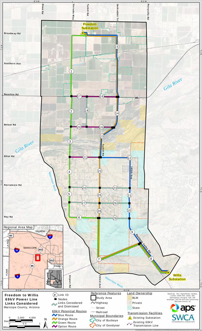
Freedom to Willis69kV Power LineLinks Considered
Municipal BoundariesCity of Buckeye
City of Goodyear0 0.5 1
Miles
0 2,000 4,000Feet
Gila River
Gila River
Waterman Wash
Waterman Wash
T 1
NR 3 W
T 1
ST 1 N
T 2
S
R 3 W R 2 W
T 2 ST 1 S
R 2 W
±69kV Potential Routes
Blue RouteOrange RouteGreen RouteOption Route
Maricopa County, Arizona
Railroad
Land OwnershipBLM
Private
State
Reference FeaturesStudy Area
Highway
Street
³ Nodes# Link ID
Links Consideredand Dismissed
PINAL
¬«303
¬«202
MARICOPA
PINAL
YAVAPAI
YUMA
LA PA
Z
§̈¦8
£¤60
§̈¦10
¬«85
§̈¦17
Regional Area Map
Transmission Facilities#0 Existing Substation
! !
Existing 69kVTransmission Line

Photo Date and Time: May 24, 2019, 10:46 amFocal Length: 50mm
The original photographs were taken at 50mm, then stitched together to create this panorama, resulting in a 125-degree field of view.
View Location: Approximate distance to nearest pole from photo location is 150 feet.
Simulations were prepared using information provided by APS. Pole locations, colors, and heights may be different based on final engineering and design.
Existing Condition View from Rainbow Valley Road looking northwest
Simulated Condition View of the Blue/Orange Routes from Rainbow Valley Road
Freedom to Willis 69-kV Power Line Siting Study | July 2019Simulation from Rainbow Valley Road | Blue/Orange Routes
Viewing Location and Simulated Alternatives
Typical 69kV Structures

Photo Date and Time: May 24, 2019, 11:06 amFocal Length: 50mm
The original photographs were taken at 50mm, then stitched together to create this panorama, resulting in a 125-degree field of view.
View Location: Approximate distance to nearest pole from photo location is 250 feet.
Simulations were prepared using information provided by APS. Pole locations, colors, and heights may be different based on final engineering and design.
Existing Condition View from the intersection of Tuthill Road and Ray Road looking west
Simulated Condition View of the Green Route from the intersection of Tuthill Road and Ray Road
Freedom to Willis 69-kV Power Line Siting Study | July 2019Simulation from the intersection of Tuthill Road and Ray Road | Green Route
Viewing Location and Simulated Alternatives
Typical 69kV Structures

Photo Date and Time: May 24, 2019, 11:24 amFocal Length: 50mm
The original photographs were taken at 50mm, then stitched together to create this panorama, resulting in a 125-degree field of view.
View Location: Approximate distance to nearest pole from photo location is 200 feet.
Simulations were prepared using information provided by APS. Pole locations, colors, and heights may be different based on final engineering and design.
Existing Condition View from the intersection of Tuthill Road and Elliot Road looking north
Simulated Condition View of the Blue and Orange Routes from the intersection of Tuthill Road and Elliot Road
Freedom to Willis 69-kV Power Line Siting Study | July 2019Simulation from the intersection of Tuthill Road and Elliot Road |Blue and Orange Routes
Viewing Location and Simulated Alternatives
Typical 69kV Structures

Typical 69kV Structures
Photo Date and Time: May 24, 2019, 1:17 pmFocal Length: 50mm
The original photographs were taken at 50mm, then stitched together to create this panorama, resulting in a 125-degree field of view.
View Location: Approximate distance to nearest pole from photo location is 200 feet.
Simulations were prepared using information provided by APS. Pole locations, colors, and heights may be different based on final engineering and design.
Existing Condition View from the intersection of MC85 and Verrado Way looking east
Simulated Condition View of the Green Route from the intersection of MC85 and Verrado Way
Freedom to Willis 69-kV Power Line Siting Study | July 2019Simulation from the intersection of MC85 and Verrado Way | Green Route
Viewing Location and Simulated Alternatives

Service Layer Credits: Source: Esri, DigitalGlobe, GeoEye, Earthstar Geographics,CNES/Airbus DS, USDA, USGS, AeroGRID, IGN, and the GIS User Community
!!!
!
!
!
!
!
!
!
!
!!
!!
!!
!!
!!
! ! ! ! ! !! ! ! ! ! ! ! ! ! ! ! ! ! ! ! ! ! ! !
!!
!!
!!
!!
!!
!!
!!
!!
!!
!!
!!
!!
!!
!!
!!
!!
!!
!!
!!
!!
!!
!!
!!
!!
!!
!!
!!
!!
!!
!!
!!
!!
!
!
!
!
!
!!!!
!
!
!
!
!
!
!
!
!
!
!
!
!
!
!
!
!
!
!
!
!
!
!
!
!
!
!
!
!
!
!
!
!
!
!
!
!
!
!
!
!
!
!
!
!
!
!
!
!
!
!
!
!
!
!
!
!
!
!
!
!
!
!
!
!
!
!
!
!
!
!
!
!
!
!
!
!
!
!
!
!
!
!
!
!
!
!
!
!
!
!
!
!
!
!
!
!
!
!
!
!
!
!
!
!
!
!
!
!
!
!
!
!
!
!
!
!
!
!
!
!
!
!
!
!
!
!
!
!
!
!
!
!!
!
!!!!!!!!!!!!!!
!
!
!!
!!
!!
!!
!!
!!
!
!
!
!
!
!
!
!
!
!
!
!
!
!
!
!
!
!
!
!
!
!
!
!
!! ! ! ! ! ! ! ! ! ! ! ! ! ! ! ! ! ! ! ! !
! !! !
! !! !
!!
! !
!
!
!
!
!
!
!
!
!
!
!
!
!
!
!
!
!
!
!
!
!
!
!
!
!
!
!
!
!
!
!
!
!
!
!
!
!
!
!
!
!
!
!
!
!
!
!
!
!
!
!
!
!
!
!
!
!
!
!
!
!
!
!
!
!
!
!
!
!
!
!
!
!
!
!
!
!
!
!
!
!
!
!
!
!
!
!
!
!
!
!
!
!
!
!
!
!
!
!
!
!
!
!
!
!
!
!
!
!
!
!
!
!
!
!
!
!
!
!
!
!
!
!
!
!
!
!
!
!
!
!
!!
!!
!!
!!
!
!
!!
!!
!!
!!
!!
!!!
!!
!!!!
!!!!
!!!!!!!!!!!!!!!!!!!!!!
!
!
!
!
!
!
!
!
!
!
!
!
!
!
!
!
!
!
!
!
!
!
!
!
!!
!!
!!
!!
!!
!!!!!!!!!
!
!
!
!
!
!
!
!!
!!!!!!!!
!
!
!
!
!
!
!
!
!
!
!
!
!
!!!!!!
!
!
!!!!!!
!!!!!
#0#0
#0
")85
Narramore Rd
Tu
thill R
d2
03
rd A
ve
Elliot Rd
Ve
rrad
o W
ay
Jack
rab
bit T
rl
Ray Rd
Beloat Rd
Rainbow Valley Rd
Baseline Rd
Buckeye Canal
Broadway Rd
Southern Ave
19
5th
Ave
Airp
ort R
d
Pe
rryville
Rd
De
an
Rd
Tu
thill R
d
WillisSubstation
FreedomSubstation
Basemap: Esri, DigitalGlobe, GeoEye,i-cubed, USDA FSA, USGS, AEX,Getmapping, Aerogrid, IGN, IGP,
swisstopo, and the GIS User CommunityMaricopa County, AZ
N:\Projects\53000\53828_APS_Freedom_to_Willis\MXD\Revised 07012019\53828_StudyAreaBaseMap_Visual_Blue_0701.mxd - Revised by: MDugan 7/8/2019
Freedom to Willis69kV Power LineSiting Study Area
Blue RouteViewshed
Municipal BoundariesCity of Buckeye
City of Goodyear0 0.5 1
Miles
0 2,000 4,000Feet
Gila River
Gila River
Waterman Wash
Waterm
an Wash
T 1
N
R 3 W
T 1
S
T 1 N
T 2
S
R 3 W R 2 W
T 2 ST 1 S
R 2 W
±Maricopa County, Arizona Railroad
Reference FeaturesStudy Area
Highway
Street
Transmission Facilities#0 Existing Substation
! !
Existing 69kVTransmission Line
ViewshedVisible
Not Visible
! !
69kV Potential RoutesBlue Route
Existing OtherTransmission Line
Service Layer Credits: Source: Esri, DigitalGlobe, GeoEye, Earthstar Geographics,CNES/Airbus DS, USDA, USGS, AeroGRID, IGN, and the GIS User Community
!!!
!
!
!
!
!
!
!
!
!!
!!
!!
!!
!!
! ! ! ! ! !! ! ! ! ! ! ! ! ! ! ! ! ! ! ! ! ! ! !
!!
!!
!!
!!
!!
!!
!!
!!
!!
!!
!!
!!
!!
!!
!!
!!
!!
!!
!!
!!
!!
!!
!!
!!
!!
!!
!!
!!
!!
!!
!!
!!
!
!
!
!
!
!!!!
!
!
!
!
!
!
!
!
!
!
!
!
!
!
!
!
!
!
!
!
!
!
!
!
!
!
!
!
!
!
!
!
!
!
!
!
!
!
!
!
!
!
!
!
!
!
!
!
!
!
!
!
!
!
!
!
!
!
!
!
!
!
!
!
!
!
!
!
!
!
!
!
!
!
!
!
!
!
!
!
!
!
!
!
!
!
!
!
!
!
!
!
!
!
!
!
!
!
!
!
!
!
!
!
!
!
!
!
!
!
!
!
!
!
!
!
!
!
!
!
!
!
!
!
!
!
!
!
!
!
!
!
!!
!
!!!!!!!!!!!!!!
!
!
!!
!!
!!
!!
!!
!!
!
!
!
!
!
!
!
!
!
!
!
!
!
!
!
!
!
!
!
!
!
!
!
!
!! ! ! ! ! ! ! ! ! ! ! ! ! ! ! ! ! ! ! ! !
! !! !
! !! !
!!
! !
!
!
!
!
!
!
!
!
!
!
!
!
!
!
!
!
!
!
!
!
!
!
!
!
!
!
!
!
!
!
!
!
!
!
!
!
!
!
!
!
!
!
!
!
!
!
!
!
!
!
!
!
!
!
!
!
!
!
!
!
!
!
!
!
!
!
!
!
!
!
!
!
!
!
!
!
!
!
!
!
!
!
!
!
!
!
!
!
!
!
!
!
!
!
!
!
!
!
!
!
!
!
!
!
!
!
!
!
!
!
!
!
!
!
!
!
!
!
!
!
!
!
!
!
!
!
!
!
!
!
!
!!
!!
!!
!!
!
!
!!
!!
!!
!!
!!
!!!
!!
!!!!
!!!!
!!!!!!!!!!!!!!!!!!!!!!
!
!
!
!
!
!
!
!
!
!
!
!
!
!
!
!
!
!
!
!
!
!
!
!
!!
!!
!!
!!
!!
!!!!!!!!!
!
!
!
!
!
!
!
!!
!!!!!!!!
!
!
!
!
!
!
!
!
!
!
!
!
!
!!!!!!
!
!
!!!!!!
!!!!!
#0#0
#0
")85
Narramore Rd
Tu
thill R
d2
03
rd A
ve
Elliot Rd
Ve
rrad
o W
ay
Jack
rab
bit T
rl
Ray Rd
Beloat Rd
Rainbow Valley Rd
Baseline Rd
Buckeye Canal
Broadway Rd
Southern Ave
19
5th
Ave
Airp
ort R
d
Pe
rryville
Rd
De
an
Rd
Tu
thill R
d
WillisSubstation
FreedomSubstation
Basemap: Esri, DigitalGlobe, GeoEye,i-cubed, USDA FSA, USGS, AEX,Getmapping, Aerogrid, IGN, IGP,
swisstopo, and the GIS User CommunityMaricopa County, AZ
N:\Projects\53000\53828_APS_Freedom_to_Willis\MXD\Revised 07012019\53828_StudyAreaBaseMap_Visual_Green_0701.mxd - Revised by: MDugan 7/1/2019
Freedom to Willis69kV Power LineSiting Study Area
Green RouteViewshed
Municipal BoundariesCity of Buckeye
City of Goodyear0 0.5 1
Miles
0 2,000 4,000Feet
Gila River
Gila River
Waterman Wash
Waterm
an Wash
T 1
N
R 3 W
T 1
S
T 1 N
T 2
S
R 3 W R 2 W
T 2 ST 1 S
R 2 W
±Maricopa County, Arizona Railroad
Reference FeaturesStudy Area
Highway
Street
Transmission Facilities#0 Existing Substation
! !
Existing 69kVTransmission Line
ViewshedVisible
Not Visible
! !Existing OtherTransmission Line
69kV Potential RoutesGreen Route
Service Layer Credits: Source: Esri, DigitalGlobe, GeoEye, Earthstar Geographics,CNES/Airbus DS, USDA, USGS, AeroGRID, IGN, and the GIS User Community
!!!
!
!
!
!
!
!
!
!
!!
!!
!!
!!
!!
! ! ! ! ! !! ! ! ! ! ! ! ! ! ! ! ! ! ! ! ! ! ! !
!!
!!
!!
!!
!!
!!
!!
!!
!!
!!
!!
!!
!!
!!
!!
!!
!!
!!
!!
!!
!!
!!
!!
!!
!!
!!
!!
!!
!!
!!
!!
!!
!
!
!
!
!
!!!!
!
!
!
!
!
!
!
!
!
!
!
!
!
!
!
!
!
!
!
!
!
!
!
!
!
!
!
!
!
!
!
!
!
!
!
!
!
!
!
!
!
!
!
!
!
!
!
!
!
!
!
!
!
!
!
!
!
!
!
!
!
!
!
!
!
!
!
!
!
!
!
!
!
!
!
!
!
!
!
!
!
!
!
!
!
!
!
!
!
!
!
!
!
!
!
!
!
!
!
!
!
!
!
!
!
!
!
!
!
!
!
!
!
!
!
!
!
!
!
!
!
!
!
!
!
!
!
!
!
!
!
!
!!
!
!!!!!!!!!!!!!!
!
!
!!
!!
!!
!!
!!
!!
!
!
!
!
!
!
!
!
!
!
!
!
!
!
!
!
!
!
!
!
!
!
!
!
!! ! ! ! ! ! ! ! ! ! ! ! ! ! ! ! ! ! ! ! !
! !! !
! !! !
!!
! !
!
!
!
!
!
!
!
!
!
!
!
!
!
!
!
!
!
!
!
!
!
!
!
!
!
!
!
!
!
!
!
!
!
!
!
!
!
!
!
!
!
!
!
!
!
!
!
!
!
!
!
!
!
!
!
!
!
!
!
!
!
!
!
!
!
!
!
!
!
!
!
!
!
!
!
!
!
!
!
!
!
!
!
!
!
!
!
!
!
!
!
!
!
!
!
!
!
!
!
!
!
!
!
!
!
!
!
!
!
!
!
!
!
!
!
!
!
!
!
!
!
!
!
!
!
!
!
!
!
!
!
!!
!!
!!
!!
!
!
!!
!!
!!
!!
!!
!!!
!!
!!!!
!!!!
!!!!!!!!!!!!!!!!!!!!!!
!
!
!
!
!
!
!
!
!
!
!
!
!
!
!
!
!
!
!
!
!
!
!
!
!!
!!
!!
!!
!!
!!!!!!!!!
!
!
!
!
!
!
!
!!
!!!!!!!!
!
!
!
!
!
!
!
!
!
!
!
!
!
!!!!!!
!
!
!!!!!!
!!!!!
#0#0
#0
")85
Narramore Rd
Tu
thill R
d2
03
rd A
ve
Elliot Rd
Ve
rrad
o W
ay
Jack
rab
bit T
rl
Ray Rd
Beloat Rd
Rainbow Valley Rd
Baseline Rd
Buckeye Canal
Broadway Rd
Southern Ave
19
5th
Ave
Airp
ort R
d
Pe
rryville
Rd
De
an
Rd
Tu
thill R
d
WillisSubstation
FreedomSubstation
Basemap: Esri, DigitalGlobe, GeoEye,i-cubed, USDA FSA, USGS, AEX,Getmapping, Aerogrid, IGN, IGP,
swisstopo, and the GIS User CommunityMaricopa County, AZ
N:\Projects\53000\53828_APS_Freedom_to_Willis\MXD\Revised 07012019\53828_StudyAreaBaseMap_Visual_Orange_0701.mxd - Revised by: MDugan 7/1/2019
Freedom to Willis69kV Power LineSiting Study Area
Orange RouteViewshed
Municipal BoundariesCity of Buckeye
City of Goodyear0 0.5 1
Miles
0 2,000 4,000Feet
Gila River
Gila River
Waterman Wash
Waterm
an Wash
T 1
N
R 3 W
T 1
ST 1 N
T 2
S
R 3 W R 2 W
T 2 ST 1 S
R 2 W
±Maricopa County, Arizona Railroad
Reference FeaturesStudy Area
Highway
Street
Transmission Facilities#0 Existing Substation
! !
Existing 69kVTransmission Line
ViewshedVisible
Not Visible
! !Existing OtherTransmission Line
69kV Potential RoutesOrange Route

Service Layer Credits: Sources: Esri, USGS, NOAASource: Esri, DigitalGlobe, GeoEye, Earthstar Geographics, CNES/Airbus DS, USDA, USGS,AeroGRID, IGN, and the GIS User Community
!!!
!
!
!
!
!
!
!
!
!!
!!
!!
!!
!!
! ! ! ! ! !! ! ! ! ! ! ! ! ! ! ! ! ! ! ! ! ! ! !
!!
!!
!!
!!
!!
!!
!!
!!
!!
!!
!!
!!
!!
!!
!!
!!
!!
!!
!!
!!
!!
!!
!!
!!
!!
!!
!!
!!
!!
!!
!!
!!
!
!
!
!
!
!!!!
!
!
!
!
!
!
!
!
!
!
!
!
!
!
!
!
!
!
!
!
!
!
!
!
!
!
!
!
!
!
!
!
!
!
!
!
!
!
!
!
!
!
!
!
!
!
!
!
!
!
!
!
!
!
!
!
!
!
!
!
!
!
!
!
!
!
!
!
!
!
!
!
!
!
!
!
!
!
!
!
!
!
!
!
!
!
!
!
!
!
!
!
!
!
!
!
!
!
!
!
!
!
!
!
!
!
!
!
!
!
!
!
!
!
!
!
!
!
!
!
!
!
!
!
!
!
!
!
!
!
!
!
!!
!
!!!!!!!!!!!!!!
!
!
#0#0
#0
¬«1
¬«2
¬«3
B
C
")85
Narramore Rd
Tuthill Rd203rd Ave
Elliot Rd
Verrado Way
Jackrabbit Trl
Ray Rd
Beloat Rd
Rainbow Valley Rd
Baseline Rd
Buckeye Canal
Broadway Rd
Southern Ave
195th Ave
Airport Rd
Perryville Rd
Dean Rd
Tuthill Rd
WillisSubstation
FreedomSubstation
A
Basemap: Esri, DigitalGlobe, GeoEye,i-cubed, USDA FSA, USGS, AEX,Getmapping, Aerogrid, IGN, IGP,
swisstopo, and the GIS User CommunityMaricopa County, AZ
N:\Projects\53000\53828_APS_Freedom_to_Willis\MXD\Revised 07012019\53828_StudyAreaBaseMap_revised_0701.mxd - Revised by: MDugan 7/1/2019
Freedom to Willis69kV Power Line
Route Alternatives
Municipal BoundariesCity of Buckeye
City of Goodyear0 0.5 1
Miles
0 2,000 4,000Feet
Gila River
Gila River
Waterman Wash
Waterman Wash
PINAL
¬«303
¬«202
MARICOPA
PINAL
YAVAPAI
YUMA
LA PA
Z
§̈¦8
£¤60
§̈¦10
¬«85
§̈¦17
T 1
NR 3 W
T 1
ST 1 N
T 2
S
R 3 W R 2 W
T 2 ST 1 S
R 2 W
Regional Area Map
±
69kV Potential RoutesBlue RouteOrange RouteGreen RouteOption RouteMaricopa County, Arizona
Railroad
Land OwnershipBLM
Private
State
Reference FeaturesStudy Area
Highway
Street
Transmission Facilities#0 Existing Substation
! !
Existing 69kVTransmission Line

Service Layer Credits: Source: Esri, DigitalGlobe, GeoEye, Earthstar Geographics,CNES/Airbus DS, USDA, USGS, AeroGRID, IGN, and the GIS User Community
!!!
!
!
!
!
!
!
!
!
!!
!!
!!
!!
!!
! ! ! ! ! !! ! ! ! ! ! ! ! ! ! ! ! ! ! ! ! ! ! !
!!
!!
!!
!!
!!
!!
!!
!!
!!
!!
!!
!!
!!
!!
!!
!!
!!
!!
!!
!!
!!
!!
!!
!!
!!
!!
!!
!!
!!
!!
!!
!!
!
!
!
!
!
!!!!
!
!
!
!
!
!
!
!
!
!
!
!
!
!
!
!
!
!
!
!
!
!
!
!
!
!
!
!
!
!
!
!
!
!
!
!
!
!
!
!
!
!
!
!
!
!
!
!
!
!
!
!
!
!
!
!
!
!
!
!
!
!
!
!
!
!
!
!
!
!
!
!
!
!
!
!
!
!
!
!
!
!
!
!
!
!
!
!
!
!
!
!
!
!
!
!
!
!
!
!
!
!
!
!
!
!
!
!
!
!
!
!
!
!
!
!
!
!
!
!
!
!
!
!
!
!
!
!
!
!
!
!
!!
!
!!!!!!!!!!!!!!
!
!
#0#0
#0
¬«1
¬«2
¬«3
B
C
")85
Narramore Rd
Tuthill Rd203rd Ave
Elliot Rd
Verrado Way
Jackrabbit Trl
Ray Rd
Beloat Rd
Rainbow Valley Rd
Baseline Rd
Buckeye Canal
Broadway Rd
Southern Ave
195th Ave
Airport Rd
Perryville Rd
Dean Rd
Tuthill Rd
WillisSubstation
FreedomSubstation
A
Basemap: Esri, DigitalGlobe, GeoEye,i-cubed, USDA FSA, USGS, AEX,Getmapping, Aerogrid, IGN, IGP,
swisstopo, and the GIS User CommunityMaricopa County, AZ
N:\Projects\53000\53828_APS_Freedom_to_Willis\MXD\Revised 07012019\53828_StudyAreaBaseMap_CurrentLand_0701.mxd - Revised by: MDugan 7/1/2019
Freedom to Willis69kV Power LineCurrent Land Use
Municipal BoundariesCity of Buckeye
City of Goodyear0 0.5 1
Miles
0 2,000 4,000Feet
Gila River
Gila River
Waterman Wash
Waterman Wash
T 1
NR 3 W
T 1
ST 1 N
T 2
S
R 3 W R 2 W
T 2 ST 1 S
R 2 W
±
69kV Potential RoutesBlue RouteOrange RouteGreen RouteOption RouteMaricopa County, Arizona
Railroad
Reference FeaturesStudy Area
Highway
Street
Map Key
Vacant
Land Use CategoriesSchool
Utilities
Mining
Agriculture
Dairy
Residential - Low Density
Residential - Medium Density
Residential - Under Construction
Transmission Facilities#0 Existing Substation
! !
Existing 69kVTransmission Line

Service Layer Credits: Source: Esri, DigitalGlobe, GeoEye, Earthstar Geographics,CNES/Airbus DS, USDA, USGS, AeroGRID, IGN, and the GIS User Community
!!!
!
!
!
!
!
!
!
!
!!
!!
!!
!!
!!
! ! ! ! ! !! ! ! ! ! ! ! ! ! ! ! ! ! ! ! ! ! ! !
!!
!!
!!
!!
!!
!!
!!
!!
!!
!!
!!
!!
!!
!!
!!
!!
!!
!!
!!
!!
!!
!!
!!
!!
!!
!!
!!
!!
!!
!!
!!
!!
!
!
!
!
!
!!!!
!
!
!
!
!
!
!
!
!
!
!
!
!
!
!
!
!
!
!
!
!
!
!
!
!
!
!
!
!
!
!
!
!
!
!
!
!
!
!
!
!
!
!
!
!
!
!
!
!
!
!
!
!
!
!
!
!
!
!
!
!
!
!
!
!
!
!
!
!
!
!
!
!
!
!
!
!
!
!
!
!
!
!
!
!
!
!
!
!
!
!
!
!
!
!
!
!
!
!
!
!
!
!
!
!
!
!
!
!
!
!
!
!
!
!
!
!
!
!
!
!
!
!
!
!
!
!
!
!
!
!
!
!!
!
!!!!!!!!!!!!!!
!
!
#0#0
#0
¬«1
¬«2
¬«3
B
C
")85
Narramore Rd
Tuthill Rd203rd Ave
Elliot Rd
Verrado Way
Jackrabbit Trl
Ray Rd
Beloat Rd
Rainbow Valley Rd
Baseline Rd
Buckeye Canal
Broadway Rd
Southern Ave
195th Ave
Airport Rd
Perryville Rd
Dean Rd
Tuthill Rd
WillisSubstation
FreedomSubstation
A
Basemap: Esri, DigitalGlobe, GeoEye,i-cubed, USDA FSA, USGS, AEX,Getmapping, Aerogrid, IGN, IGP,
swisstopo, and the GIS User CommunityMaricopa County, AZ
N:\Projects\53000\53828_APS_Freedom_to_Willis\MXD\Revised 07012019\53828_StudyAreaBaseMap_FutureLand_0701.mxd - Revised by: MDugan 7/1/2019
Freedom to Willis69kV Power LineFuture Land Use
Municipal BoundariesCity of Buckeye
City of Goodyear0 0.5 1
Miles
0 2,000 4,000Feet
Gila River
Gila River
Waterman Wash
Waterman Wash
T 1
NR 3 W
T 1
ST 1 N
T 2
S
R 3 W R 2 W
T 2 ST 1 S
R 2 W
±
69kV Potential RoutesBlue RouteOrange RouteGreen RouteOption RouteMaricopa County, Arizona
Railroad
Reference FeaturesStudy Area
Highway
Street
Map Key
Scenic NeigborhoodLarge Lot Residential
Planned DevelopmentsPreliminary Plat
Final Plat
Land Use CategoriesOpen Space
Employment
Rural
Master Planned Community
Neighborhood
Transmission Facilities#0 Existing Substation
! !
Existing 69kVTransmission Line

Service Layer Credits: Sources: Esri, USGS, NOAASource: Esri, DigitalGlobe, GeoEye, Earthstar Geographics, CNES/Airbus DS, USDA, USGS,AeroGRID, IGN, and the GIS User Community
!!!
!
!
!
!
!
!
!
!
!!
!!
!!
!!
!!
! ! ! ! ! !! ! ! ! ! ! ! ! ! ! ! ! ! ! ! ! ! ! !
!!
!!
!!
!!
!!
!!
!!
!!
!!
!!
!!
!!
!!
!!
!!
!!
!!
!!
!!
!!
!!
!!
!!
!!
!!
!!
!!
!!
!!
!!
!!
!!
!
!
!
!
!
!!!!
!
!
!
!
!
!
!
!
!
!
!
!
!
!
!
!
!
!
!
!
!
!
!
!
!
!
!
!
!
!
!
!
!
!
!
!
!
!
!
!
!
!
!
!
!
!
!
!
!
!
!
!
!
!
!
!
!
!
!
!
!
!
!
!
!
!
!
!
!
!
!
!
!
!
!
!
!
!
!
!
!
!
!
!
!
!
!
!
!
!
!
!
!
!
!
!
!
!
!
!
!
!
!
!
!
!
!
!
!
!
!
!
!
!
!
!
!
!
!
!
!
!
!
!
!
!
!
!
!
!
!
!
!!
!
!!!!!!!!!!!!!!
!
!
#0#0
#0
")85
Narramore Rd
Tuthill Rd203rd Ave
Elliot Rd
Verrado Way
Jackrabbit Trl
Ray Rd
Beloat Rd
Rainbow Valley Rd
Baseline Rd
Buckeye Canal
Broadway Rd
Southern Ave
195th Ave
Airport Rd
Perryville Rd
Dean Rd
Tuthill Rd
WillisSubstation
FreedomSubstation
Basemap: Esri, DigitalGlobe, GeoEye,i-cubed, USDA FSA, USGS, AEX,Getmapping, Aerogrid, IGN, IGP,
swisstopo, and the GIS User CommunityMaricopa County, AZ
N:\Projects\53000\53828_APS_Freedom_to_Willis\MXD\Revised 07012019\53828_StudyAreaBaseMap_FloodZone_revised_0701.mxd - Revised by: MDugan 7/1/2019
Freedom to Willis69kV Power Line
Flood Zones
Municipal BoundariesCity of Buckeye
City of Goodyear0 0.5 1
Miles
0 2,000 4,000Feet
Gila River
Gila River
Waterman Wash
Waterman Wash
T 1
NR 3 W
T 1
ST 1 N
T 2
S
R 3 W R 2 W
T 2 ST 1 S
R 2 W
Transmission Facilities#0 Existing Substation
! !
Existing 69kVTransmission Line±
69kV Potential RoutesBlue RouteOrange RouteGreen RouteOption Route
Maricopa County, Arizona
Railroad
Reference FeaturesStudy Area
Highway
Street
Legend
PINAL
¬«303
¬«202
MARICOPA
PINAL
YAVAPAI
YUMA
LA PA
Z
§̈¦8
£¤60
§̈¦10
¬«85
§̈¦17
Regional Area Map
A
B
C
Flood Zones100 Year Flood Zone
500 Year Flood ZoneFloodway within 100Year Flood Zone
Service Layer Credits: Sources: Esri, USGS, NOAASource: Esri, DigitalGlobe, GeoEye, Earthstar Geographics, CNES/Airbus DS, USDA, USGS,AeroGRID, IGN, and the GIS User Community
!!!
!
!
!
!
!
!
!
!
!!
!!
!!
!!
!!
! ! ! ! ! !! ! ! ! ! ! ! ! ! ! ! ! ! ! ! ! ! ! !
!!
!!
!!
!!
!!
!!
!!
!!
!!
!!
!!
!!
!!
!!
!!
!!
!!
!!
!!
!!
!!
!!
!!
!!
!!
!!
!!
!!
!!
!!
!!
!!
!
!
!
!
!
!!!!
!
!
!
!
!
!
!
!
!
!
!
!
!
!
!
!
!
!
!
!
!
!
!
!
!
!
!
!
!
!
!
!
!
!
!
!
!
!
!
!
!
!
!
!
!
!
!
!
!
!
!
!
!
!
!
!
!
!
!
!
!
!
!
!
!
!
!
!
!
!
!
!
!
!
!
!
!
!
!
!
!
!
!
!
!
!
!
!
!
!
!
!
!
!
!
!
!
!
!
!
!
!
!
!
!
!
!
!
!
!
!
!
!
!
!
!
!
!
!
!
!
!
!
!
!
!
!
!
!
!
!
!
!!
!
!!!!!!!!!!!!!!
!
!
#0#0
#0
")85
Narramore Rd
Tuthill Rd203rd Ave
Elliot Rd
Verrado Way
Jackrabbit Trl
Ray Rd
Beloat Rd
Rainbow Valley Rd
Baseline Rd
Buckeye Canal
Broadway Rd
Southern Ave
195th Ave
Airport Rd
Perryville Rd
Dean Rd
Tuthill Rd
WillisSubstation
FreedomSubstation
Basemap: Esri, DigitalGlobe, GeoEye,i-cubed, USDA FSA, USGS, AEX,Getmapping, Aerogrid, IGN, IGP,
swisstopo, and the GIS User CommunityMaricopa County, AZ
N:\Projects\53000\53828_APS_Freedom_to_Willis\MXD\53828_StudyAreaBaseMap_Habitat_revised_0701.mxd - Revised by: MDugan 7/1/2019
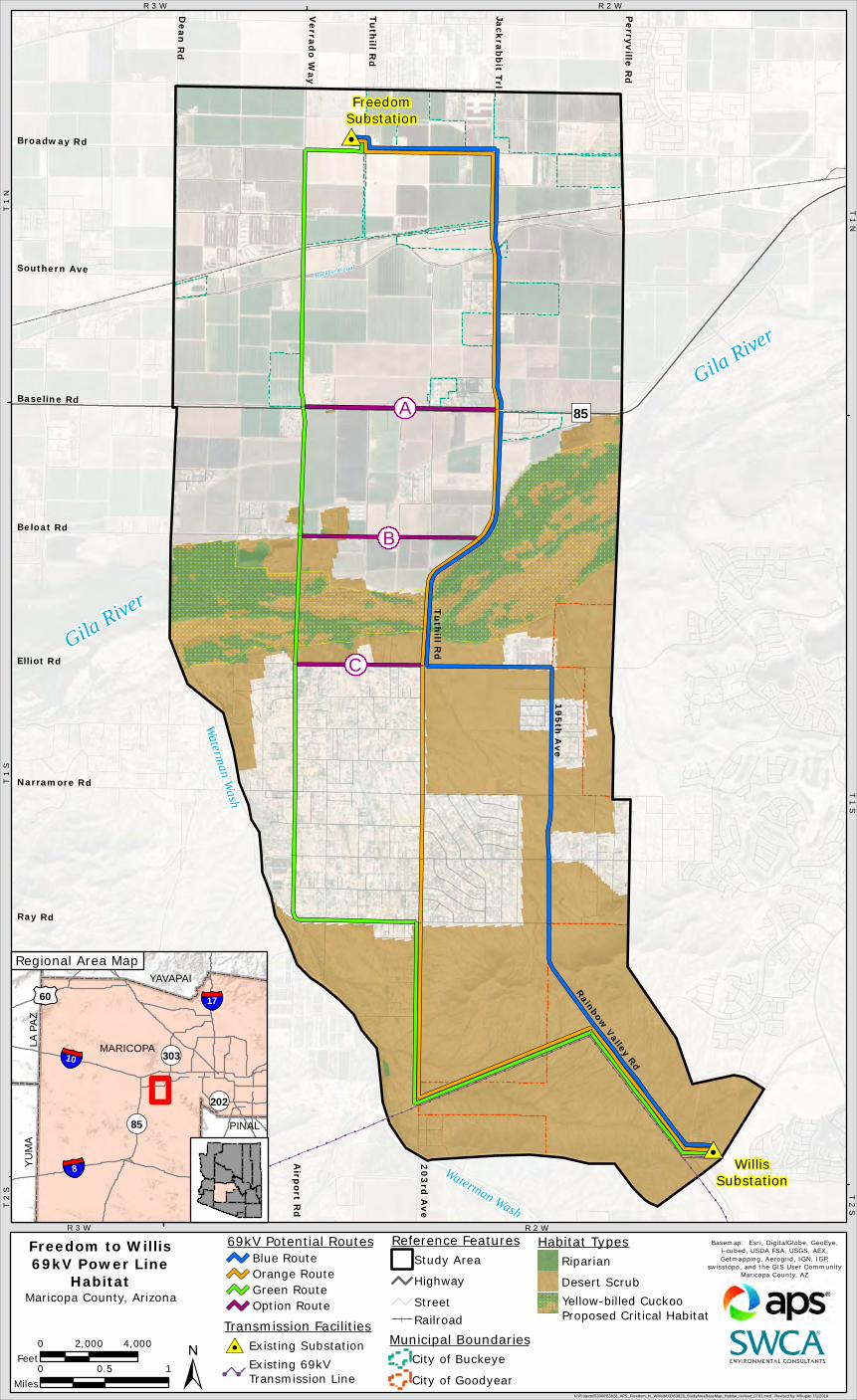
Freedom to Willis69kV Power Line
Habitat
Municipal BoundariesCity of Buckeye
City of Goodyear0 0.5 1
Miles
0 2,000 4,000Feet
Gila River
Gila River
Waterman Wash
Waterman Wash
T 1
NR 3 W
T 1
ST 1 N
T 2
S
R 3 W R 2 W
T 2 ST 1 S
R 2 W
Transmission Facilities#0 Existing Substation
! !
Existing 69kVTransmission Line±
69kV Potential RoutesBlue RouteOrange RouteGreen RouteOption Route
Maricopa County, Arizona
Railroad
Reference FeaturesStudy Area
Highway
Street
Legend
PINAL
¬«303
¬«202
MARICOPA
PINAL
YAVAPAI
YUMA
LA PA
Z
§̈¦8
£¤60
§̈¦10
¬«85
§̈¦17
Regional Area Map
A
B
C
Yellow-billed CuckooProposed Critical Habitat
Habitat TypesRiparian
Desert Scrub

Public and Agency Outreach
• City of Buckeye (April 2019, ongoing)
• City of Goodyear (April 2019, ongoing)
• Maricopa County Planning Department (April 2019, ongoing)
• Maricopa County Department of Transportation (April 2019, ongoing)
• Arizona State Land Department (May 2019, ongoing)
• Project area residents, businesses, and stakeholders, via a project newsletter (June 2019). A newsletter describing the final route selection will be distributed in late 2019.
OUTREACH IS ONGOING THROUGHOUT THE PROCESS

Opportunities for Public Information & Comment
• Fill out and return a comment form tonight• Access electronic comment forms and project updates at www.aps.com/siting (see Freedom to Willis 69kV Power Line Siting Study under Current Siting Projects)
• Submit comments via: □ email to Stephen Eich, APS Siting Consultant, [email protected]
□ by phone at 1-800-680-3484
• Future project newsletters will contain updated information