Embed Size (px)
Citation preview

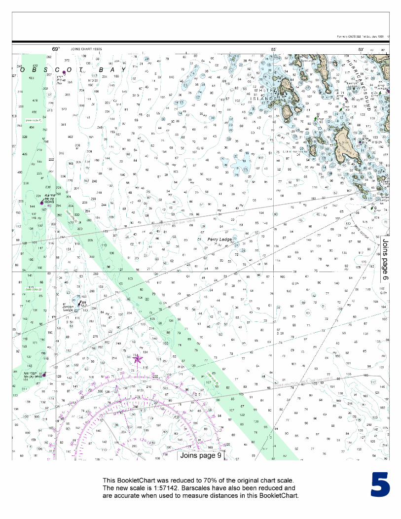
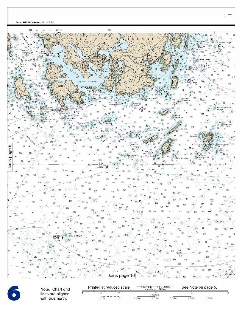
BookletChart™ Approaches to Penobscot Bay NOAA Chart 13303
A reduced-scale NOAA nautical chart for small boaters When possible, use the full-size NOAA chart for navigation.

2
Published by the National Oceanic and Atmospheric Administration
National Ocean Service Office of Coast Survey
www.NauticalCharts.NOAA.gov 888-990-NOAA
What are Nautical Charts?
Nautical charts are a fundamental tool of marine navigation. They show water depths, obstructions, buoys, other aids to navigation, and much more. The information is shown in a way that promotes safe and efficient navigation. Chart carriage is mandatory on the commercial ships that carry America’s commerce. They are also used on every Navy and Coast Guard ship, fishing and passenger vessels, and are widely carried by recreational boaters.
What is a BookletChart?
This BookletChart is made to help recreational boaters locate themselves on the water. It has been reduced in scale for convenience, but otherwise contains all the information of the full-scale nautical chart. The bar scales have also been reduced, and are accurate when used to measure distances in this BookletChart. See the Note at the bottom of page 5 for the reduction in scale applied to this chart.
Whenever possible, use the official, full scale NOAA nautical chart for navigation. Nautical chart sales agents are listed on the Internet at http://www.NauticalCharts.NOAA.gov.
This BookletChart does NOT fulfill chart carriage requirements for regulated commercial vessels under Titles 33 and 44 of the Code of Federal Regulations.
Notice to Mariners Correction Status
This BookletChart has been updated for chart corrections published in the U.S. Coast Guard Local Notice to Mariners, the National Geospatial Intelligence Agency Weekly Notice to Mariners, and, where applicable, the Canadian Coast Guard Notice to Mariners. Additional chart corrections have been made by NOAA in advance of their publication in a Notice to Mariners. The last Notices to Mariners applied to this chart are listed in the Note at the bottom of page 7. Coast Pilot excerpts are not being corrected.
For latest Coast Pilot excerpt visit the Office of Coast Survey website at http://www.nauticalcharts.noaa.gov/nsd/searchbychart.php?chart=13303.
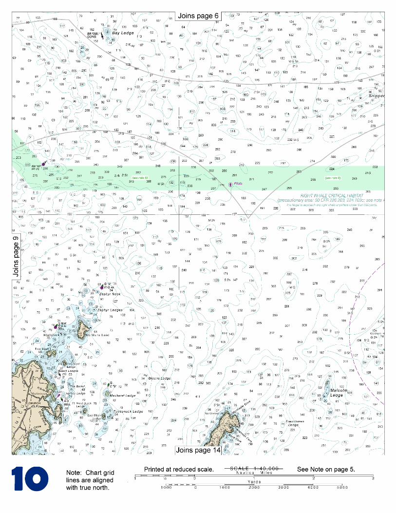
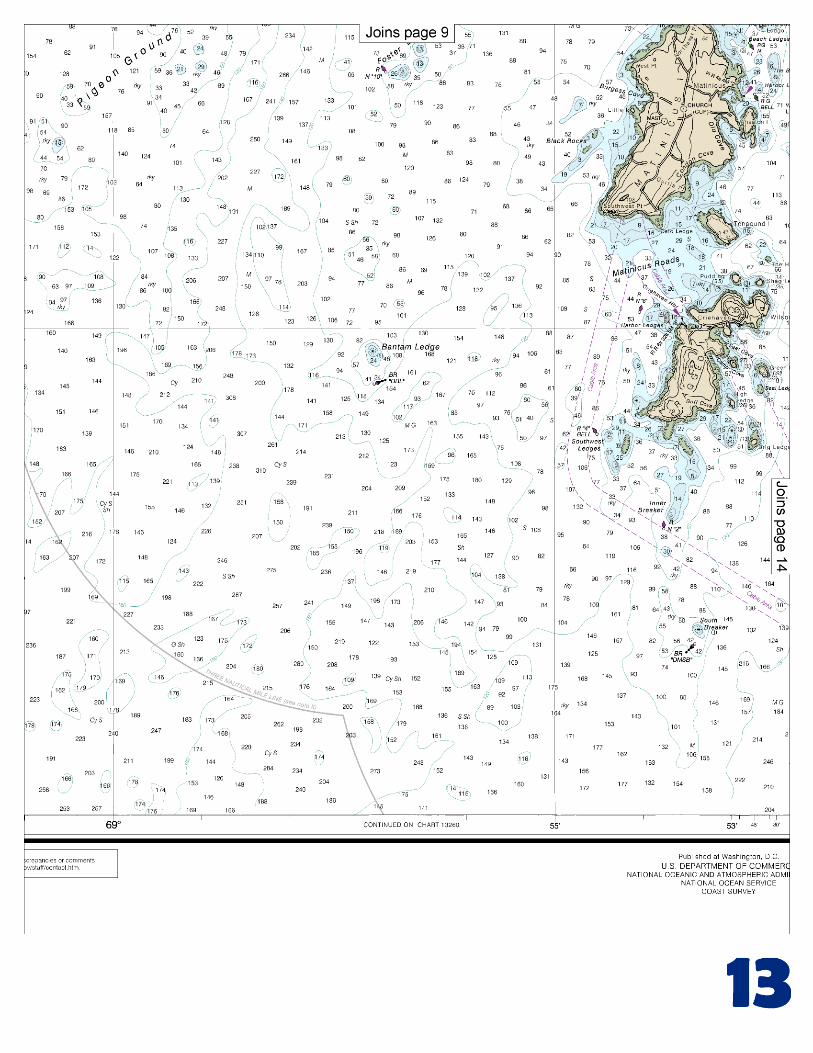
(Selected Excerpts from Coast Pilot) The eastern entrance to Eggemoggin Reach is well marked by Devils Head (44°13.3'N., 68°32.8'W.), a prominent, high, rock bluff on the south end of Hog Island, 2.8 miles west of Pond Island. Off the western entrance are Head of the Cape at the southwest extremity of Cape Rosier, high and thickly wooded; a light on Green Ledge, 1.3 miles south of Head of the Cape; and an abandoned lighthouse tower on Pumpkin Island, 3.6 miles east of
Head of the Cape. Penobscot Bay Recommended Vessel Route.–The U.S. Coast Guard Captain of the Port, Sector Northern New England, in cooperation with the Maine and New Hampshire Port Safety Forum, has established a
Recommended Vessel Route for deep draft vessels entering and departing Penobscot Bay and River. Deep draft vessels are requested to follow the designated routes. These routes were designed to provide safe, established routes for increased deep draft vessels, to prevent the loss of fishing gear placed in the waters in the approaches to Penobscot Bay and River, and to reduce the potential for conflicts between less maneuverable deep draft commercial vessels and all other vessels navigating upon these waters. Vessels are responsible for their own safety and are not required to remain inside the route nor are fisherman required to keep fishing gear outside of the 0.4 mile wide route. Recommended minimum under-keel clearances for Penobscot Bay and River have also been established by the aforementioned group, in order to prevent groundings and to promote safety and environmental security of the waterway resources of Penobscot Bay and River. The group recommends that all entities responsible for safe movement of vessels in and through the waters of Penobscot Bay and River operate vessels in such a manner as to maintain a minimum under-keel clearance of 3 feet between the deepest draft of the vessel and the channel bottom when transiting Penobscot Bay and outer Penobscot River, south of Turtle Head on Islesboro island, and 2 feet when transiting Penobscot River north of Turtle Head, and a minimum under-keel clearance of 1 foot at all berthing areas. Pilotage, Penobscot Bay and River.–Pilotage is compulsory for all foreign vessels, and for U.S. vessels under register in the foreign trade, with a draft of 9 feet or more, entering or departing from any port or harbor within the waters of Penobscot Bay and Penobscot River north of a line drawn from Marshall Point Light at Port Clyde, thence to Matinicus Rock Light, and thence to Western Head, Isle au Haut. (See Coast Pilot for further discussion.) Security Broadcast System, Penobscot Bay.–Penobscot Bay and approaches have an established security communication system in which pilots, masters, and mates of deep-draft commercial vessels utilize VHF-FM channels 13 and 16 for security calls when proceeding between the pilot pickup stations and dock or anchorages at the north end of the bay and river. Dangers.–Seal Island, the easternmost of the islands off Penobscot Bay, is bare, rocky, and 1 mile long. Eastern Ledge, awash at low water on which the sea usually breaks, extends 350 yards off the east end of the island. Three Fathom Ledge, 1.4 miles east-northeast of Seal Island, has been cleared to 16 feet. Gully Ledge, covered 24 feet, is about 650 yards south of Western Head, the westernmost point of the island. Channels.–There are four channels in the approaches to Carvers Harbor. The entrance from southwestward is between Heron Neck Ledge and James and Willies Ledge; from the northwestward through The Reach; from the eastward through the channel between Vinalhaven Island and the islands and ledges south of it; and from the southward west of Colt Ledge and between Arey Ledges and The Breakers. The controlling depth in the entrance channel is 19 feet between Potato Island and Dodge Point on the north side of the entrance to the harbor. Anchorages.–The best anchorage for small craft is reported to be on the east and southeast side of Carvers Harbor; the western side is principally used by commercial craft and fishermen. In October 2003, the harbor had depths of about 11 feet in the center, about 8 to 10 feet along the north and south sides, and about 5.8 feet in the access channel leading to a basin off the town landing at the head; depths of about 1.8 to 5.4 feet were available in the basin.
U.S. Coast Guard Rescue Coordination Center 24 hour Regional Contact for Emergencies
RCC Boston Commander
1st CG District (617) 223-8555 Boston, MA

G
Lateral System As Seen Entering From Seaward on navigable waters except Western Rivers
PORT SIDE ODD NUMBERED AIDS
GREEN LIGHT ONLY FLASHING (2)
PREFERRED CHANNEL NO NUMBERS – MAY BE LETTERED
PREFERRED CHANNEL TO STARBOARD
TOPMOST BAND GREEN
PREFERRED CHANNEL NO NUMBERS – MAY BE LETTERED
PREFERRED CHANNEL TO PORT
TOPMOST BAND RED
STARBOARD SIDE EVEN NUMBERED AIDS
RED LIGHT ONLY FLASHING (2)
FLASHING FLASHING OCCULTING GREEN LIGHT ONLY RED LIGHT ONLY OCCULTING QUICK FLASHING QUICK FLASHING ISO COMPOSITE GROUP FLASHING (2+1) COMPOSITE GROUP FLASHING (2+1) ISO
"1"
Fl G 6s
G "9"
Fl G 4s
GR "A"
Fl (2+1) G 6s
RG "B"
Fl (2+1) R 6s
"2"
Fl R 6s
8
R "8" Fl R 4s
LIGHT
G
C "1"
LIGHTED BUOY
G "5"
GR "U"
GR
C "S"
RG
N "C"
RG "G"
LIGHT
6
R
N "6"
LIGHTED BUOY
R
"2"
CAN DAYBEACON
CAN NUN NUN
DAYBEACON
For more information on aids to navigation, including those on Western Rivers, please consult the latest USCG Light List for your area. These volumes are available online at http://www.navcen.uscg.gov
2
2
C U 5
1


VHF Marine Radio channels for use on the waterways:Channel 6 – Inter-ship safety communications.Channel 9 – Communications between boats and ship-to-coast.Channel 13 – Navigation purposes at bridges, locks, and harbors.Channel 16 – Emergency, distress and safety calls to Coast Guard and others, and to initiate calls to other
vessels. Contact the other vessel, agree to another channel, and then switch.Channel 22A – Calls between the Coast Guard and the public. Severe weather warnings, hazards to navigation and safety warnings are broadcast here.Channels 68, 69, 71, 72 and 78A – Recreational boat channels.
Getting and Giving Help — Signal other boaters using visual distress signals (flares, orange flag, lights, arm signals); whistles; horns; and on your VHF radio. You are required by law to help boaters in trouble. Respond to distress signals, but do not endanger yourself.
EMERGENCY INFORMATION
Distress Call Procedures
• Make sure radio is on.• Select Channel 16.• Press/Hold the transmit button.• Clearly say: “MAYDAY, MAYDAY, MAYDAY.”• Also give: Vessel Name and/or Description;Position and/or Location; Nature of Emergency; Number of People on Board.• Release transmit button.• Wait for 10 seconds — If no responseRepeat MAYDAY call.
HAVE ALL PERSONS PUT ON LIFE JACKETS!
This Booklet chart has been designed for duplex printing (printed on front and back of one sheet). If a duplex option is not available on your printer, you may print each sheet and arrange them back-to-back to allow for the proper layout when viewing.
QR
Quick ReferencesNautical chart related products and information - http://www.nauticalcharts.noaa.gov
Interactive chart catalog - http://www.charts.noaa.gov/InteractiveCatalog/nrnc.shtmlReport a chart discrepancy - http://ocsdata.ncd.noaa.gov/idrs/discrepancy.aspx
Chart and chart related inquiries and comments - http://ocsdata.ncd.noaa.gov/idrs/inquiry.aspx?frompage=ContactUs
Chart updates (LNM and NM corrections) - http://www.nauticalcharts.noaa.gov/mcd/updates/LNM_NM.html
Coast Pilot online - http://www.nauticalcharts.noaa.gov/nsd/cpdownload.htm
Tides and Currents - http://tidesandcurrents.noaa.gov
Marine Forecasts - http://www.nws.noaa.gov/om/marine/home.htm
National Data Buoy Center - http://www.ndbc.noaa.gov/
NowCoast web portal for coastal conditions - http://www.nowcoast.noaa.gov/
National Weather Service - http://www.weather.gov/
National Hurrican Center - http://www.nhc.noaa.gov/
Pacific Tsunami Warning Center - http://ptwc.weather.gov/
Contact Us - http://www.nauticalcharts.noaa.gov/staff/contact.htm
NOAA’s Office of Coast Survey The Nation’s Chartmaker
For the latest news from Coast Survey, follow @NOAAcharts
NOAA Weather Radio All Hazards (NWR) is a nationwide network of radio stations broadcasting continuous weather information directly from the nearest National Weather Service office. NWR broadcasts official Weather Service warnings, watches, forecasts and other hazard information 24 hours a day, 7 days a week. http://www.nws.noaa.gov/nwr/